Making Space for The Centre for Sustainable Communities University of Hertfordshire College Lane Hatfield Hertfordshire AL10 9AB UK
|
|
|
- Rosamond Cameron
- 5 years ago
- Views:
Transcription
1 Susan Parham and Ben McCabe 2016 First published in Great Britain in 2016 by University of Hertfordshire Making Space for The Centre for Sustainable Communities University of Hertfordshire College Lane Hatfield Hertfordshire AL10 9AB UK Printed in Great Britain by Henry Ling, Dorchester, DT1 1HD Food in Hatfield susan parham & ben mccabe making space for food in hatfield 1
2 Contents List of figures 3 Acknowledgements 3 Executive summary 4 1 Introduction Aims of the research project 1.1 Project aims and background Research issues and opportunities Methods used to undertake the research Structure of this report 7 2 Food research context 2.1 Introducing the literature review Food-growing in cities Declining urban food-growing The sustainability and health case for urban food-space Emergence of an urban agriculture movement Hertfordshire s productive urban history Approaches to food-centred urban retrofitting Rich urban context of the allotment Food-centred space as public and institutional policy Research context in review 16 3 Hatfield An historic, spatial and consultative analysis in food terms 3.1 Analysing Hatfield as a food-space Hatfield s historic and contemporary context food implications Old Hatfield as a food-space Historical development of the New Town food implications Food and the New Town today place-making aspects Contemporary place-making proposals to renew Hatfield food-related points Hatfield s population profile food implications Points from stakeholder engagement 28 4 Baseline analysis of the food system in Hatfield 4.1 Introducing the analysis Farming, orchards, allotments and gardens Food-distribution landscape Food retailing and food markets Eating and drinking out and institutional food-spaces Food waste and compost Food-related community programmes 36 5 Developing food-retrofitting scenarios 5.1 Overview the process of developing food-focused design scenarios Retrofitting food retailing White Lion Square and High Street, Hatfield town centre Reimagining for food Salisbury Square, Old Hatfield Allotment regeneration Feather Dell Front-yard farm food-growing retrofit scenario in the New Town St Peter s Close Retrofitting an under-used open space for a food garden Pond Croft Retrofitting scenario for an inter-campus foodway Retrofitting an ornamental business-park landscape Bishop s Square Orchard retrofitting de Havilland Grange Potager garden retrofitting Mill Green, North Hatfield Compost infrastructure retrofitting Designing for food waste 50 6 Project results: next steps 52 Appendices 53 Endnotes 55 References 60 2 xxxxxxxxxxxxxxxxxxxxxxxx
3 Figures 2.1 The rural-urban transect The growth of Old and New Hatfield Hatfield s road structure Design visualisation of Hatfield town centre retrofit Visualisation of High View district centre renewal possibilities Map of current food-buying and food-growing spaces in Hatfield Map of food-retail centres in Hatfield Map of potential food-centred intervention examples Reconnecting the town centre High street retrofit Edible-urbanism scenario for Salisbury Square Detail of edible planting at Salisbury Square Food landscape between Old Hatfield and A1000 roadway Further details of the edible-urbanism approach for Salisbury Square and environs Reviving mid-block allotments in the New Town Feather Dell Community food garden in style of a front-yard farm St Peter s Close Community food garden retrofit scenario Pond Croft Neighbourhood-level community food garden retrofit Aerial view of Pond Croft Scenario for an inter-campus foodway overview of sections Scenario for an inter-campus foodway Stages A and B Scenario for an inter-campus foodway proposed Section B Business park allotments and community food gardens Storage sheds and beehives de Havilland Grange community orchard A potager garden in Mill Green. Birdseye view of the hamlet site Potager garden in Mill Green Detailed drawing of a potager garden in Mill Green Composting infrastructure scenario 51 Acknowledgements This research project was made possible by the generosity of a major donor to fund the research work process, and a second donor, Welwyn Hatfield District Council, to fund this report publication. We are also grateful to the Prince s Foundation for Building Community and, in particular, Dr Matthew Hardy, for supporting the outposting of a Graduate Fellow from the Foundation to undertake the research. We want to acknowledge and thank the Climate Change Alliance (as the Local Strategic Partnership is known) for sponsoring this project through the Task and Finish group hosted by the University. A further thank you is due to Mr Anthony Downs of Gascoyne Cecil Estates for kindly allowing us to include edible urbanism ideas for Salisbury Square and Mill Green as part of the exhibition of proposals for the renewal of Salisbury Square in Old Hatfield in For a substantial commitment of both time and expertise, a particular thank you to Councillor Lynne Sparks of Welwyn Hatfield Borough Council (WHBC), as well as to Hatfield Town Council and WHBC staff involved in landscape ecology, planning and health. Gratitude is also due for the commitment, time, insight, resources and understanding of departmental staff at the University of Hertfordshire; in particular, Dr Stephen Boffey, and Sarah Elvins and Jane Housham of UH Press whose editorial and publishing input helped bring this research to publication. making space for food in hatfield 3
4 Executive summary This document was written by Susan Parham and Ben McCabe. It describes the process and findings of a food-related project undertaken at the Centre for Sustainable Communities at the University of Hertfordshire. The research was conceived and directed by Dr Parham, while the research fieldwork was undertaken over twelve months in by Research Fellow Ben McCabe, out-posted at the University as part of his MA in Sustainable Urbanism at the Prince s Foundation for Building Community. The report was drafted by the two authors and completed by Dr Parham while the illustrations and maps were prepared by Ben McCabe (the maps based on an open-source mapping base). The research explores some of the ways people, food and the built environment interconnect in the village (the Old Town) and New Town of Hatfield. It is intended to act as a resource for thinking about the design and retrofit of more food-centred space and thus a more sustainable food system more broadly. This encompasses aspects of food-growing spaces, food-distribution arrangements, shopping and eating spaces, and the treatment of food waste. The project came about through hosting a Task and Finish group for the Welwyn Hatfield District Council Climate Change Alliance (the name given to the Local Strategic Partnership). The remit for the group was to look at carbon-reduction opportunities and food was proposed as a means for exploring this in a number of settings in both Old and New Hatfield. It was envisaged that design and planning ideas for food produced through the project might be useful for other neighbourhoods and towns too. The main points from the analysis are as follows: The Hatfield area has a very long history of food production as a largely rural area with a strong local food system, as well as supplying London and other places with food. Hatfield village worked for many centuries as a coherent foodscape in a productive rural setting but this coherence was disrupted by spatial-design changes related to the development of the New Town. The New Town was designed according to principles common to postwar architecture, with a town centre and district centres that were modelled on mid-twentieth-century shopping malls, a generous green landscape and some allotment spaces, but many of these urban elements have not worked as well as intended and are among the factors that have led to a need for town-wide renewal. The New Town has seen a series of proposals to improve its centres and neighbourhoods, and the research finds that food could be an important part of such renewal encompassing food-growing, fooddistribution, retailing, shopping, eating and cleaning up from its town centre to its rural edges. The research argues that transect-based approaches, which help repair areas as places for people, can help retrofit or renew parts of the town. As explained in more detail later in the report, transect approaches are about designing places for a range of conditions from city to country, urban and semi-urban, through semi-rural to rural. The research includes a number of scenarios for design interventions along the food chain in the New Town. Some are relatively straightforward, others are transitional proposals while more fundamental place-shaping problems are sorted out, and a few are more radical. In each case these are to some extent ideas that challenge existing unsustainable urban forms. These scenarios include: reviving the market square and town-centre high street ; revived allotment areas and community orchards in residential neighbourhoods and edge-of-town locations; an urban foodway linking the two university campuses; more food-focused business-park landscapes; and composting facilities for Hatfield neighbourhoods. It also proposes edible urbanism ideas for the renewed Salisbury Square in Old Hatfield, and potager gardens in the local hamlet of Mill Green. This project does not suggest one size fits all solutions to food and urbanism issues in Hatfield. Instead the intention has been to offer a contribution towards designing more sustainable places. By focusing on food-centred space, the ideas here can help generate an improved urban realm that helps achieve carbon reduction and also supports social inclusion and resilience. 4 executive summary
5 1 Introduction Aims of the research project 1.1 Project aims and background aims of the project This document describes a recent food-related research project, Making Space for Food in Hatfield, undertaken by Susan Parham and Ben McCabe at the University of Hertfordshire in , written up in and reported on here. The research report explores some of the ways food and the built environment interconnect in both Old and New Hatfield. It considers how food-focused design scenarios might help support a sustainable local food system and contribute to making a more liveable place in a largely New Town context. The research from which this report is drawn was applied in nature. It is intended to act as a practical resource for thinking about the design and retrofitting (of which more below) of more food-centred space. It is thus a contribution to both a more sustainable food system and liveable place not only in Hatfield but potentially in other urban settings too. The ideas reported on here encompass aspects of food-growing spaces, food-distribution arrangements, retail and consumption environments and the treatment of food waste in a range of contexts, from the town centre to the urban periphery and rural surrounds. the local and wider background This research project came about through the Centre for Sustainable Communities at the University of Hertfordshire hosting a Task and Finish group for the Welwyn Hatfield District Council Climate Change Alliance (the Local Strategic Partnership). The Group remit was to look at carbon-reduction opportunities and food was proposed by Dr Parham as a means of doing that in a number of settings around Hatfield which had been identified as under-utilised, dysfunctional, leftover or moribund in food terms. The overarching aim of the project was to explore food-growing, distribution, retail, consumption and treatment of food waste in Hatfield in particular, with the objective of defining ways that space could be retrofitted to be more food-centred. These would be encapsulated in a series of visual scenarios of food-centred space across the town. The research was framed theoretically by design ideas about place-retrofitting current in the urbanism literature and practice, including those which specifically focus on food-centred urban repair. 1 Methodologically, the researchers wished to develop a research focus and process which maximised research impact in regard to such scenario building. To do that we engaged with stakeholders about the idea of food-centred urbanism through meetings and interviews, and by offering design-based ideas which responded to local concerns about food (as well as opportunities in relation to food). While no wide claims for the generalisability of the research findings were made, it was envisaged that design ideas and scenarios produced through the project might also be useful in a wider set of places with twentieth-century place-shaping arrangements. This would be especially relevant for other post-war neighbourhoods and towns looking at ways to lower their carbon production, improve their local food system and contribute to liveability for residents. the wider backdrop Part of the wider backdrop to the project is the sharp rise in interest in the ways that health and place interconnect. 2 The research context is dealt with in detail in the next section, but it is worth saying here that it has become increasingly clear that planning and design can have substantial impacts on both obesity and food poverty on the one hand and sustainable, inclusive food systems on the other. Within a context provided by the crisis of so-called globesity identified by the World Health Organisation, 3 a strong strand in discussions in this area is about the creation of obesogenic environments that are instrumental in causing this situation. 4 The obesogenicity of an environment has been defined as the sum of influences that the surroundings, opportunities, or conditions of life have on promoting obesity in individuals or populations. 5 There is substantial although contested evidence that suggests there is a link between the built environment, physical activity, obesity and chronic disease. 6 hatfield s food and health profile Like many areas in the UK, a significant proportion of the population of Welwyn Hatfield Borough are categorised as obese (around 20 per cent); levels of physical activity fall below the national average, and there is projected to be a 15 to 16 per cent increase in the number of people over the age of 65 living in the borough by These demographic changes are likely to have health effects that intertwine with how food-spaces in Hatfield are planned and designed. This project s researchers therefore wanted to take an applied look at how food-related design actions could help to limit or ameliorate such linkages where they are adverse ones, and instead make the interplay between food and place much more positive. It is argued that well making space for food in hatfield 5
6 planned and designed areas have the potential to mitigate some of the potentially negative structural effects related to population profile and change. A focus on excellent walkability and good public transport; ample, affordable food-retail provision in local areas including robust food markets; good-quality open spaces and play areas; enhanced food-growing opportunities; and the general visual enhancement of the built environment through food-centred retrofitting could all play a part. The research did not, however, suggest one size fits all solutions to food and urbanism issues in Hatfield or seek to discourage imaginative alternative proposals. Instead the intention was to make a modest contribution towards a more sustainable place that, by increasing food resilience to deal with shocks including climate change and poverty, could also generate an improved urban realm, work toward carbon reduction and make the place more healthful for its residents. 1.2 Research issues and opportunities research areas as initially proposed The specific research areas that the project initially intended to focus on were: Exploring methods for making Hatfield s public spaces and streets more foodfriendly through growing opportunities within the existing and proposed built fabric Developing capacity for community orchards, including as an educational opportunity for children in relation to food Supporting interest in allotment-based food-growing in Hatfield and exploring opportunities for a student/staff allotment area on the university campus Exploring opportunities to enhance and build on existing food-centred assets such as the local town-centre market place and related food shops Proposing food-centred designs that could be considered as scenarios in the future development and renewal of Hatfield Exploring ways to connect with local stakeholders, such as community-based and charitable organisations which tackle food poverty and improve foodgrowing and cooking skills. food retrofitting opportunities identified at the outset of the research The researchers were keen to identify food retrofitting opportunities all along the food chain, from food-growing through distribution to retailing, consumption, socalled waste and clean up. This was a very broad potential field for research activity and implied a need to focus in on priorities for the work, given the time and resources available. Following initial scoping and analysis of the current food situation in Hatfield, and discussions with stakeholders to test initial assumptions, the research focus was narrowed down to a number of specific areas for attention. These included: An analysis of food-growing opportunities in Hatfield and the exploration of barriers to the uptake of such opportunities we heard there was a desire to grow food but there were various physical, social and economic barriers to doing so Food-related ways to respond to the perceived lack of a vibrant high street with a constituent gap in local food-retailing opportunities in line with concerns raised by local stakeholders Ways to make more effective use in food terms of the abundance of underutilised green space and moribund allotment areas in the town throughout stakeholder discussions it became clear that these spaces could potentially lend themselves to more local food-growing and social and recreational uses. 1.3 Methods used to undertake the research mix of methods used The methods used to undertake the research were both social-science- and designbased. The project started with a desk-based literature review and scoping exercise to give a broad contextual overview of Hatfield and its associated food situation and issues. Time was spent on examining local, current national and global debates about food and urbanism. A seminar was held to enable wider local discussion of the issues, and stakeholder interviews were also then carried out. Qualitative analysis of issues raised by stakeholders in relation to the local food system and food issues was undertaken. Areas of Hatfield identified as of particular interest for project work were mapped accordingly. Potential design-based solutions were explored wherever these were thought to be appropriate to contribute positively to food-related issues locally. 6 introduction
7 concept design development Concept designs for food scenarios were developed further and either shared with local community groups or exhibited publicly where there was an opportunity to do so. For example, due to working with Gascoyne Cecil, a development company active in the local area, the researchers were able to include edible-urbanism design ideas in an exhibition of proposals for the redesign and renewal of Salisbury Square in Old Hatfield. 1.4 Structure of this report Following this introduction to the research, subsequent sections deal with the research context for retrofitting for food, the Hatfield Old and New Town context people, place and food and findings from initial analysis and the stakeholder engagement process. The main body of the report also comprises detailed food-retrofit ideas based on our analysis of research data and is illustrated with scenario drawings. Finally, the report ends with some thoughts in conclusion. Endnotes and references provide details of academic and policy sources used. making space for food in hatfield 7
8 2 Food research context 2.1 Introducing the literature review The research was framed by an in-depth literature review and key points from this work are outlined below. The focus of the literature review was on food-growing but we were also mindful of the possibilities in the local food system for retrofitting activities related to other kinds of food-spaces, including town squares and retail markets. This section starts with a discussion of food-growing as a very long-established urban practice, before moving on to its decline in the twentieth century, the sustainability and health case for urban food-space, the resurgence of urban agriculture and the approaches to urban retrofitting with a food focus that underpin this research. 2.2 Food-growing in cities food-growing as an ancient urban practice Growing food in urban green spaces has an extremely long history. 8 With the rise of farming, settled communities evolved in places including Mesopotamia, Egypt and India. Between 3,500 and 3,000bc some Neolithic villages began to transform into so-called agro-urban cities on alluvial plains. One of the requirements for this urban revolution was the production and storage of surplus food. 9 Archeological evidence shows granaries, specialist shops, houses focused on productive courtyards, and the presence of animal husbandry in urban areas. 10 Perishable crops were best located close to where they would be consumed to ensure food supplies. In Classical cities, productive land uses including urban gardens, allotments, orchards, market gardens, vineyards and bee-keeping spaces surrounded cities and were interwoven with them. 11 Such productive interplay was equally evident in the Middle Ages, with patches of green being used for urban fruit-and-vegetable gardens and cattle-grazing. 12 Towns were economic and cultural catalysts and were ready markets for local agricultural products of a predominantly agrarian society. 13 Food production took on specific spatial forms, including the domestic kitchen garden; houses were interspersed with gardens, orchards, paddocks and farm-yards and individuals cultivated strips in the town fields and grazed animals along riverside pastures. 14 A food surplus became available to towns with their steadily growing populations of non-agricultural specialists. 15 There was agricultural innovation and urban development in the early modern period and in response to the industrial revolution but the most radical changes to the Hatfield area came with the twentieth century. twentieth-century decline and recent revival in food-growing In the twentieth century traditional food practices and infrastructure declined in many urban places as we dramatically altered the way cities were shaped. However, today, in the early twenty-first century, there is a reappraisal of the importance of urban foodgrowing and protecting or rejuvenating food-space. 16 This is broadly driven in developed countries by sustainability concerns and in the developing world by issues of food resilience. 17 In non-western cities, meanwhile, urban food-growing practice has persisted over time, with food security at the heart of this activity. 18 In certain places in the first world, too, urban and peri-urban agriculture are still an important source of food. In France, for instance, in the late 1990s, over 20 per cent of fruit and vegetables consumed were thought to be grown in family plots, with just over half of households owning a potager (kitchen garden) and two-thirds of these gardens including some vegetables. 19 In Moscow, around 80 per cent of the population was reported in the late 1990s to be involved in some level of food-growing. 20 In the early 2000s between every second and third suburban household in Australia grew some of its own food. 21 In relation to more organised urban farming an estimated 33% (696,000) of the two million farms in the United States are located within metropolitan areas. These farms produce 35% of all the country s crops and livestock sales. 22 For planners and urban designers, the spatial qualities that support productive city form are of particular interest Declining urban food-growing a western problem? Urban food production, in the west at least, appeared to be in a state of decline across the latter part of the twentieth century and this has become a significant sustainability problem for, and in, many modern cities. 24 Over the course of the twentieth century green areas were increasingly seen as sites for leisure and consumption rather than food-growing. There has been less perceived need to locate productive food-space close by living areas and people may also have become disconnected from food production as far fewer work directly in this sector than in earlier times. With many people suffering from the problem of time poverty, 25 food-growing is one of the activities that has diminished. While urban culture seems increasingly distanced from food, it is worth remembering that the way food-growing is organised in times 8 food research context
9 of national emergency demonstrates it is possible to reconnect urban space and food both rapidly and broadly. Wartime examples of productive space included allotments and verge-planting in the UK where people were urged to dig for victory, as well as jardins ouvriers in France 26 and victory gardens in the USA and Canada. Some 40 per cent of fresh vegetables consumed by Americans in wartime were supplied by twenty million small gardens. 27 our view of cities divorced from food Predominantly, though, it seems we see cities and their surrounding regions as not really about nature. This means that cities and towns are not necessarily understood as likely sites for food-growing. 28 To expand cities we have often built over the open spaces needed for private vegetable gardens and commercial market gardens. Public green space is rarely used for food growing and is also energy-profligate because of the high financial and ecological costs of management and maintenance. Periurban areas around cities have traditionally been very rich food landscapes but today agricultural production technologies used for urban-fringe production can be wasteful, polluting and unsustainable. 29 There is a sense that views about urban landscapes have become detached from ecological needs. 30 Cities have increasingly become pedigree landscapes stressing horticultural management, rather than relying on earlier ecological traditions expressed in locationspecific built forms and open spaces. 31 In design terms, we have produced in many places a sterile, food-free environment. This is evident in a variety of open spaces: turfed parks, hard-paved streets, vacant plots, industrial zones, areas for waste disposal and other miscellaneous spaces. 32 Urbanists argue that current agricultural systems are unsustainable for urban dwellers for some of the reasons touched on above. 33 Certain forms of urban space-shaping are implicated in the loss of agricultural land on the urban fringe and in the production of urban spaces within cities that are mostly food-free. These space-shaping approaches have, in turn, distanced people in cities from the immediacy of food production. In the post-war urban world of the United States, for instance, the following is noted and it is relevant to UK experience as well: Growing fruit and vegetables was no longer work of community-minded individuals and families on small local farms, but endeavours better suited to corporate-owned, factory-like agribusiness in more distant parts of the country The sustainability and health case for urban food-space how food-growing connects to sustainability The sustainability (and carbon reduction) case for urban food-growing and space to grow food in is increasingly cogent. Urban agriculture reduces the production of embodied energy (the energy that goes into making agricultural products) currently associated with conventional agriculture. It also has benefits in relation to reduction in greenhouse-gas emissions and waste production, improvements in air quality and biodiversity, and numerous social and economic advantages in relation to seasonality and local consumption. The need to focus on these sustainability benefits has been sharpened by climate change, and the increased challenges this brings in relation to food resilience and security. This means that food is a key resource within an approach in which the basic principle of sustainable development is that buildings and settlements should use resources at sustainable rates and avoid polluting their own or the global backyard. 35 Some of this has been conceptualised in work on foodsheds, that is, the geographic area from which a population derives its food supply, 36 which are discussed in more detail later in the report. It is also explored through so-called ecological footprints, which WWF defines as the impact of human activities measured in terms of the area of biologically productive land and water required to produce the goods consumed and to assimilate the wastes generated. More simply, it is the amount of the environment necessary to produce the goods and services necessary to support a particular lifestyle. 37 Other researchers have looked at a bioregional basis for food production (that is, regions based on their natural characteristics). obesogenic environments This sustainability analysis also has a health focus, as food-growing and healthy cities are increasingly seen as interdependent and needing coordinated action. 38 Such approaches, however, are not necessarily foregrounding thinking about designing and planning places to best support urban food-growing and agriculture. 39 A welcome exception is the increasing theoretical and applied interest in the relationship between neighbourhood food environments, 40 obesogenic environments 41 and food deserts, 42 which have been defined as urban areas where it is difficult to buy affordable or good-quality fresh food. The socio-demographic effects include increasing levels of child and adult obesity, diabetes, early deaths from lifestyle factors and problems of food poverty. making space for food in hatfield 9
10 Although some have challenged the existence of such spatial linkages, 43 it seems likely on the balance of the evidence that very large-scale, industrialised and vertically integrated modern food-growing, distribution and retailing arrangements are increasingly contributing to food deserts. 44 Work in this area is one of the developing intersection points between health-focused urban research and analysis of city design and planning in relation to food-growing and consumption. The sustainability case for remaking the urban food system is reinforced by the issue of food security. Even in countries which are largely food-secure at present, it is thought that the most excluded people will be worst affected through climate change and variability in food supply. 45 Yet urban food-growing is, or at least until recently, was often not an issue on the urban planning, development and/or policy agenda. 46 This is linked to the fact that, as described above, food-growing may not be regarded as an appropriate urban activity. 47 reconnecting food and cities Fortunately, there has been quite a bit of work trying to reconnect food production and cities with both practical schemes and theoretical ideas being developed over the course of the last fifty years. This has occurred through the actions of individual households, but also in the counter-cultural urban-farming movements of the 1960s and 1970s when interest in community farms took off. From the 1990s there were proposals for gastronomic design and planning strategies for cities tied to more convivial green space 48 and a growth of interest in so-called edible landscapes and edible cities in which plants for eating replace ornamental ones. 49 There are relatively current calls for agricultural urbanism and what are called Continuous Productive Urban Landscapes (CPULs) 50 that seek to re-engineer urban form to more productive ends as in work on food transects. 51 One of their originators, André Viljoen, explains that the Continuous Productive Urban Landscape (CPUL) is a design concept advocating the coherent introduction of interlinked productive landscapes into cities as an essential element of sustainable urban infrastructure. Central to the CPUL concept is the creation of multi-functional open urban space networks, including urban agriculture, that complement and support the built environment. 52 At a practical level there has also been a revival of specific urban growing forms and practices such as allotment-holding, urban orchards, bee-keeping, animal-raising and foraging, documented in a large number of accounts from different places Emergence of an urban agriculture movement urban agriculture as a critique of the food system In the 1990s and 2000s, the focus of research and urban food practice has been on a holistic and critical analysis, and in some cases rejection of the current mainstream food system. This has resulted in increasing attention on urban food resilience in the face of issues including food scares, unethical production, anxieties about foodindustry monopolisation, rising food poverty and sharpening climate-change effects. It is increasingly understood that urban agriculture can be part of a conscious urban design-and-planning strategy, decoupled from unsustainable growth and instead tied to an urban greening paradigm. In recent years, renewed interest in urban agriculture in the western world has emerged from a variety of directions. Among other justifications, urban foodgrowing is presented as a healthful pursuit supporting individual wellbeing and a way of avoiding pesticide-ridden commercial crops. It is also seen as reflecting broader concerns for the sustainability and resilience of cities, and enhancing food security for individuals on low incomes. 54 The revival in the popularity of allotments, for example, is a response to issues including concerns about food safety, globalisation, food miles, food quality, increased urbanisation and climate change. 55 urban agriculture proposals and projects Recent urban-agriculture proposals can be seen as an alternative to and a practicebased critique of mainstream commercial food-growing arrangements. A vast range of urban food projects, schemes, networks and strategies are coming both from urban governments and from city- and town-dwellers themselves. 56 Public networks of foodgrowing opportunities on under-utilised public (and private) land are increasingly seen as feasible. 57 This is done to: realize the environmental, economic, and equitable benefits of a more local system of agriculture... in and among the places we pass by daily on our way to work, home, school, commerce, and recreation. 58 In Canada and the United States, by the early 2000s, it was reported that: seemingly everywhere, cities were forming food-policy councils; community gardens were multiplying; and municipal governments were voting on whether to allow households to keep a few urban chickens or a beehive; or to permit 10 food research context
11 commercial farming to coexist with other commercial pursuits in their cities. 59 There has also been an increasing focus on urban food-growing schemes and supportive policies in the UK in a range of cities, towns and villages. For example, Capital Growth, a partnership in London between the public sector and community groups, supports food-growing opportunities, training and education. It has campaigned to grow a million meals for London and developed a Space Finder through which people can find local food-growing spaces and opportunities. 60 Opportunities for urban food production are available at a range of spatial scales, from private gardens, through productive streets, to public and community gardens, allotments, city orchards and urban farms. 61 Urban dwellers have the chance to consider the food-growing potential of plants in all of a city s public spaces: fruit trees and shrubs along streets and in medians; orchards in parks; herbs and vegetables in planters located on plazas and sidewalks in our commercial areas; and roof top agriculture, to name a few. 62 Interest in urban food-growing has seen a focus on settings such as old industrial regions where a plethora of small-scale schemes encompass community gardens, vacant lot plantings and re-use of blighted or abandoned land. Proponents have explored actions from front-yard farms to edible estates, 63 community gardens, food-foraging, orchards, guerrilla gardening, 64 food networks and crop swaps (where people barter their crop surpluses), and even whole-town approaches to foodgrowing as in Incredible Edible Todmorden in West Yorkshire. 65 Often these spatial interventions have an overt focus on community support and resilience in the face of food poverty, while wider benefits to wellbeing are also noted. 2.6 Hertfordshire s productive urban history hertfordshire as a food-rich environment in the long term The idea of consciously building in food-space when designing a new city or town is not something that just sprang up in the post-war period. Historically, as a largely rural county, Hertfordshire has a rich tradition of vernacular food-space over its history: in and around its Roman towns, centred on its medieval market towns and its many villages and hamlets. Settlements were always intricately connected to food production, distribution, manufacturing and consumption at a variety of scales. In Section 3 we delve in more detail into this context specifically in Hatfield. garden cities as consciously planned food-spaces More recently, food-conscious town design has featured strongly as part of the county s twentieth century Garden Cities and, to some extent, its New Towns. As many are aware, Ebenezer Howard s 1898 book, Tomorrow: A Peaceful Path To Real Reform, proposed Garden Cities based on the three magnets of town, country and town-country, in which all the advantages of the most energetic town life, with all the beauty and delight of the country, may be secured in perfect combination. 66 Garden City designs based on Howard s proposals were produced in the first instance by Barry Parker and Raymond Unwin at Letchworth, north of London. These offered their inhabitants the possibility of suburban-living densities, with areas for housing and industry around a cultural and social centre, encircled by a productive agricultural green belt. In developing the Garden City concept, Howard particularly focused on the critical role of local food-growing and buying in the Garden City itself and more commercially in a surrounding agricultural belt, in making a well-functioning city economically, socially and environmentally. 67 The scale Howard advocated for such food-centred satellite towns was of settlements similar in size (in population terms) to Hatfield today. Socialised food features proposed by Howard included some of the houses having common gardens and co-operative kitchens. 68 He envisaged the improvement of land not in use for building so that fruit trees could be planted or a dairy set up. 69 The Garden City programme also proposed allotment areas around settlement edges, within a broader productive agricultural periphery that would return both food and farm-rental income to the town, as well as dealing with its food waste. These ideas were not entirely new; they owed a debt to nineteenth-century utopian settlement models including Charles Fourier s proposed phalanstère and Godin s familistère at Guise in France (which was actually built), as well as the workers model villages of Cadbury s Bournville, Sir Titus Salt s Saltaire and the Lever brothers Port Sunlight, among others in the UK. However, Howard s integration of food into both his Garden City vision and his practical plans was notably holistic. 70 the development of new towns as food-spaces a less holistic approach The post Second World War period saw the planning and design of a number of New Towns in Hertfordshire, including Hatfield. These also had a utopian cast but have been judged much more harshly as to whether they have created successful living environments than were the Garden Cities that preceded them. All the New Towns making space for food in hatfield 11
12 built in Hertfordshire integrated food-space into masterplans to some degree. Their design antecedents went back to pre-war planning and design models including the 1920s neighbourhood unit which was based on separating pedestrian and car traffic. Examples of food-space that was built into the New Towns included allotments designed into the centre of some housing blocks (so-called mid-block allotments) and strong ideas about how to make food-shopping spaces more practical and pleasant by pedestrianising them, following American shopping-mall models, and arranging car parking around their edges. However, these postwar design approaches proved to have shortcomings in food terms for reasons that Sections 4 and 5 explore in some depth. These difficulties related to the unintended effects on food of car-focused design, including the shift to weekly supermarket shopping, which meant the more local centres were underused and went into decline. It also related to largely unsuccessful experimental techniques for place shaping, particularly for town and neighbourhood centres, along the lines pioneered in American suburban shopping centres and malls. For the purposes of this research, New Towns today offer a substantial number of underutilised or leftover spaces resulting from their original planning and design that in turn create urban retrofitting design possibilities. 2.7 Approaches to food-centred urban retrofitting what is retrofitting? Theorists working in urban biodiversity, sustainable cities and urban design are increasingly tying together ideas about food-centred productivity with reshaping urban built form. 71 Some of this work has been undertaken as what has been called sprawl repair. 72 As sprawl repair practitioners say, sprawl is a pattern of growth characterized by an abundance of congested highways, strip shopping centers, big boxes, office parks, and cul-de-sac subdivisions all separated from each other in isolated, singleuse pods. 73 Hatfield has most of these conditions embedded in its design including in relation to food. The sprawl repairers seek to retrofit places through a series of physical design changes, transforming fragmented and inefficient development into complete communities that are liveable and robust 74 Sprawl repair thus helps to improve places social, environmental and economic vibrancy. This is done using design approaches based on urbanism principles including human scale, mixed land use, compact urban form, and spatial enclosure to form pleasant public spaces that work as outdoor rooms. Some of the core principles are listed and explained in the box opposite which is drawn from work by the UK s Academy of Urbanism. drawing on landscape character Some designers have sought to use existing landscape character and features as a basis for more sustainable urban form with a food focus. For example, they have used the rediscovery of rural grids and watercourses to form the physical design and landscape basis for remaking suburbia as more sustainable urbanism, including building in more urban agriculture. 75 This landscape-character-led approach seems particularly relevant in a largely rural county such as Hertfordshire. In this research we took the view that looking sustainably at how food and a place like Hatfield interconnect means thinking about Hatfield as part of what s called a bioregion (as mentioned earlier a region defined by its natural characteristics). It means thinking about city form in relation to natural processes, and looking at ways to interconnect the place and its landscape context and opportunities in much more resilient ways. 76 urban agriculture to deal with urban decline and shrinking cities In other places both in the UK and elsewhere, urban agriculture is also being seen as a way of responding to aspects of urban decline and shrinkage in population or to other negative indicators of economic and social health. This has famously occurred in the shrinking city of Detroit in the United States. 77 In Detroit, residents have not only got involved in unbuilding (about a third of the city s housing stock was demolished between ) but also in the city-wide garden and urban agriculture movement. 78 However, as Hatfield shows, shrinkage can have other dimensions besides the sheer reduction in physical area of a city or town. In our work on Hatfield s food system, for example, we identified that the way the town is developing shows both growth and shrinkage indicators. These are not about town area (as a place the town is physically getting a bit bigger) but in the social and economic lives of its residents. Some people who work and live in Hatfield are experiencing the town as economically expanding as they have good jobs and reasonable quality housing. Conversely, others are still suffering the effects of post-industrial decline with the loss of the town s major industry and don t have well paid employment or in some cases good quality places to live. For this latter group, who feature on the Index of Deprivation, Hatfield may feel like a place where their life chances, including in relation to affordable food of a reasonable standard, are shrinking. 79 In this context the town s food system can be viewed as a potential asset both socially and 12 food research context
13 Principles of Urbanism Vibrant streets and spaces, defined by their surrounding buildings and with their own distinct character, should form a coherent interconnected network of places that support social interaction and display a hierarchy of private, commercial and civil functions. There must be a permeable street network with pedestrian priority that gives maximum freedom of movement and a good choice of means of transport. Essential activities must be within walking distance and there should be a concentration of activity around meeting places. Places must provide a diversity of functions, tenure, facilities and services; have a mix of building designs and types; and include a variety of appropriately scaled districts and neighbourhoods. The pedestrian environment should be closely associated with active frontages at street level and there should be an appropriate intensity of use in all areas at all times. The design of spaces and buildings should be influenced by their context and seek to enhance local character and heritage whilst simultaneously responding to currentday needs, changes in society and cultural diversity. The public realm and civil institutions must be supported and protected by sound and inclusive processes that respond to the local community and changing economic and social conditions. New and existing places must respect, enhance and respond to their local topography, geology and climate and connect to the natural environment within and around them. Urban parks and other landscaped areas should provide space for recreation, encourage biodiversity and help support a balanced environment. New urban forms should be capable of adaptation over time to meet changing needs and to promote the continued use of existing resources, including the built environment. The built environment must seek to minimise the use of carbon-based products, energy and non-renewable resources. (Source: Academy of Urbanism, environmentally. Food-based retrofitting activity (as explored through this research) is argued to be a method by which to help support people who are being economically excluded and thus may have fallen into food poverty as a result. remaking places in food-friendly ways In their seminal design text, A Pattern Language, Christopher Alexander and his co-authors offer notably holistic proposals for remaking cities and towns in ways sympathetic to food-growing. 80 They argue for close connections to green space and a series of patterns for urban gardening that echo in spatial terms the kitchen gardens of traditional cities (those cities largely designed before the twentieth century), and include terraces and embankments on which to plant vegetables and orchards, wild gardens, garden walls, trellised walks, greenhouses, garden seats, and vegetable gardens. 81 The designers are very conscious that these productive spaces can (and should) be very beautiful and robust over the long term. In the early twenty-first century, issues of urban food security are sharpening interest in the possibilities for the design of such convivial green space. 82 Among conceptual approaches that focus on urban food-growing, and make explicit its connections with landscape ecology, is that of the previously mentioned CPULs which seek to insert an unbroken chain of productive open spaces across cities and towns. 83 These CPULs link urban and rural space and provide opportunities for urban food-growing from inner cities all the way to urban-fringe locations. They can be developed at a range of scales and in a wide variety of forms. 84 In the last few years, in an effort to tackle town design that has allowed no place for food production, there have been proposals that planners and architects have the opportunity to bring back what years of irresponsible practices have taken away through food-focused design and planning. 85 Examples such as those below are being used to integrate food production and food access into urban and neighbourhood plans, and include both individual domestic and communityscale interventions. 86 These include rooftop and private gardens, greenhouses, community gardens, orchards, aquaculture and farms, and include opportunities for reusing compostable material to make soil. 87 agrarian urbanism and the transect Andrés Duany, who is a leading international designer and theorist on place-making, meanwhile, suggests employing a holistic design and economic model of agrarian urbanism in which urban and rural society is involved with food in all its aspects: making space for food in hatfield 13

14 organizing, growing, processing, distributing, cooking and eating it. 88 In this model, the physical pattern of the settlement supports the workings of an intentional agrarian society. 89 The model includes saving existing farmland, cultivating land within existing cities and suburbs, and allowing urban working farms. Rather than situating this as some kind of nostalgic return to traditional (often backbreaking) agricultural labour, Duany instead argues for design and process that are a pragmatic response to present difficult urban conditions. 90 This has a particular Hertfordshire connection: agrarian urbanism would learn from successful place-making examples including Garden Cities. It would also employ modern management practices to be profitable, popular and reproducible. 91 Duany s design arguments are in part based on the idea of the rural-to-urban transect, a concept which he pioneered. 92 In the transect, a complex spatial design configuration of conditions range from city to country, urban and semi-urban, through semi-rural to rural, and suggest particular forms of urbanity with intensity generally decreasing with distance from the city centre. 93 This is, of course, diagrammatic rather than showing specific spatial conditions, allowing for diversity related to the landscape in which any transect approach is applied. Duany provides a short history of the transect, defining it as a natural law, that is, a principle derived from the observation of nature by right reason and thus ethically binding in human society, that is discernible from ancient settlement patterns onwards. 94 From its antecedents in Patrick Geddes work, through Ian McHarg s 1969 Design with Nature to Alexander et al. (1977) in A Pattern Language, the transect has now emerged in a refined conceptual form. 95 The transect: has heretofore been understood as an ordering system deploying a geographic gradient to arrange the sequence of natural habitats. This conception proved to be extensible to the human habitat, as every component of urbanism also finds a place within a continuous rural-to-urban gradient... Beyond being a system of classification, the transect has the potential to become an instrument of design. The correlation of the various specialized components by a common rural-to- Figure 2.1 The rural-urban transect (Source: Duany Plater-Zyberk and Company) 14 food research context
15 urban continuum provides the basis for a new system of zoning, one that creates complex, contextually resonant natural and human environments Rich urban context of the allotment allotments in hatfield The allotment is a food-centred form with a significant history in the UK. Baseline research undertaken at the start of the project demonstrates that while a substantial number of allotments are available in Hatfield in theory, in practice they have in some cases ceased to function. Demand for them is lower in comparison with higher uptake in nearby Welwyn Garden City, and massive over-subscription in other areas, such as London. The research explores how allotments might be revived in Hatfield s New Town and village context and looks at this in relation to the wider history and contemporary practice of allotment-holding. As a result of European cities history of allotment-garden provision since the nineteenth century, many cities have extensive allotment-garden holdings, 97 yet allotment spaces may still be seen by some designers as simply leftovers from wartime or postwar austerity and viewed as semi-derelict eyesores. 98 In the New Towns context allotment spaces were sometimes built in to housing blocks, and some are still there, tucked in behind the houses at the centre of a number of blocks. Indeed, in Hatfield they present a mixed picture: some are very well used and managed, others are overgrown, and some are not used at all. Changing social mores and economic forces in relation to food more broadly play a part in this situation. Allotment researchers note that in the post-war era: The original logic for providing and protecting this land was rooted in the poverty of manual workers over a century ago, however, and while allotments still provide for subsistence needs in many deprived communities, here as elsewhere the availability of cheap supermarket foods and the claims of work time and alternative leisure time pursuits have undermined the demand for allotments. 99 Successful allotment design and retrofitting of abandoned or under-utilised allotments in New Towns offers a unique opportunity to contribute to a productive and aesthetically satisfying urban landscape. In retrofitting terms, allotments can be designed in as part of the CPULs mentioned earlier. 100 Neighbourhood designers say that allotment revival in such a context could help in delivering sustainability to neighbourhoods, especially in their greening, health, social inclusion and foodgrowing opportunities for low-income and elderly people. 101 On this basis, it is suggested that food-growing should be part of the urban designers checklist of good urban form, critical to balancing private and public accessibility and use. 102 Designers skills could make allotments more open and more widely valued green space, through designs which encourage and enhance the gaze, stimulating the viewer to ponder the merits of buying a fork and joining in, while protecting crops and property from misadventure with softened but appropriate security, and integrate the loose-fit character of new allotments into wider design schemes. 103 Within this research, the perspective is that such approaches would be good to pursue in themselves and can also be connected to design for community gardens within businesspark landscapes and in relation to community orchards. A well-designed allotment area could include shelter belts (lines of trees used to mitigate windy weather effects), a sustainable urban drainage scheme (known as an SUD), a wildlife garden and balancing pond, community composting, a community garden, a community orchard, and pedestrian and cyclist cut-throughs. 104 A current proposal for a new Garden Village on the north-western edge of Hatfield, Stanborough Garden Village, includes a substantial allotment area. This would be used for food production for the Garden Village and fits into ideas discussed earlier about agrarian urbanism and the transect. It would also act as a landscape buffer between the village and the existing settlement to its east. 2.9 Food-centred space as public and institutional policy and practice putting food-centred space into planning and place-design policy Design and planning for urban food-growing is increasingly recognised as a legitimate policy matter for local authorities as well as for institutions such as universities. Urban food-growing fits within both wider urban-sustainability initiatives and those focused on food resilience and conviviality. 105 There are a number of examples in the academic and policy literature showing how planning authorities can reconnect to food-centred design and planning. 106 In the UK, existing food-growing spaces (and further opportunities for creating them) have started to be reflected in food strategies, plans, policies and design guides from national, regional, city and local governments and parish councils. This is also occurring in planned New Towns and metropolitan spaces elsewhere. For example, in making space for food in hatfield 15
16 the planned city of Almere in the Netherlands, designers have proposed an entirely new growing zone adjoining the town, with one intention being to reintegrate foodgrowing into Dutch city life. 107 There are also several food-growing policy initiatives in the United States and Australia that are worth learning from, including the City of Seattle Municipal Plan of 2005 which recommends an increase in number of gardens city-wide as well as a target of one community garden for each 2,500 households located within designated villages throughout the city. 108 The City of Cleveland meanwhile has developed scenarios for Re-Imagining a More Sustainable Cleveland. These cover productive food landscapes, land-banking, the development of urban garden zoning and a strong focus on a range of urban agricultural interventions backed by policy, regulatory and financing instruments. 109 In parts of Cleveland where it seems unlikely housing will be developed and the land may lie unused, urban agriculture is seen as a way to improve both urban sustainability and social resilience. In this context urban agriculture has been endorsed by city authorities because they see it as both offering productive, environmentally friendly use of land which would otherwise be wasted, and public benefits to the community including mitigating food deserts. In fact, urban gardening has been zoned into the city s planning code to ensure permanent rather than just interim use. 110 In the very different context of the metropolitan area of Melbourne, Australia, there has been a very ambitious attempt to develop a policy for Food Sensitive Planning and Urban Design across the entire city-region. This encompasses a range of urban food-growing opportunities within a sustainable city framework and fits within a transect-led approach. 111 Yet as an understanding of the fit between urban space, sustainability and food resilience has grown, the burgeoning urban agriculture movement has taken off. Connections between personal and societal health and food are also becoming clearer. There are an increasing number of design approaches to repair urban space to be more food friendly, as well as design opportunities for interweaving food production and consumption into urban space based on transect ideas. Hertfordshire as a county has a rich food history. Food and urban space have been closely connected in both traditional and newer planned town forms. While New Towns like Hatfield currently have problems in the way food is spatially organised, they also present considerable possibilities to design in more food-centred space of benefit to individuals and communities. Those possibilities are the focus of scenariobased proposals in Section 5 of this report. Before that, in the next part of the research report (Section 3), an in-depth baseline analysis of the research setting is presented to underpin these applied ideas Research context in review Growing food in cities is an ancient practice. People have almost always lived close to where their food is grown. This has reflected resource constraints: until the twentieth century it was acknowledged that the local supply of food mattered. Food-growing and eating were not just born of necessity, though, but in many cases were sources of pleasure and enhancement of the convivial green space of the town. 112 However, in many western cities and towns, by the mid to late twentieth century these realities no longer seemed to apply especially on the food-production side. Growing food close to living space no longer appeared necessary for health, sustainability or economic necessity. Such spaces in cities and towns often dwindled and interest in food production seemed likewise to decline. 16 food research context

17 3 Hatfield An historic, spatial and consultative analysis in food terms 3.1 Analysing Hatfield as a food-space In this section the focus of the discussion is on the local context for the food retrofitting work. The section sketches areas including history, demography, economy, design and planning, and the food system. This section provides some background to Hatfield as a place in order to highlight aspects of its urban development that are relevant to retrofitting it for food. This acts as a baseline for analysis of the fieldwork results from the study. Along with the more theoretical material in Section 2 above, this data helps to frame the retrofitting proposals outlined in Section 5 of the report. 3.2 Hatfield s historic and contemporary context food implications As noted earlier, Hatfield s built environment consists mainly of the historic Old Town and the post-war New Town. There is also a Garden Village on the northern edge of the New Town developed in the mid 1930s. Around Hatfield there is a mixed agricultural and forested landscape, along with green-belt areas and other planned twentieth-century settlements including Welwyn Garden City, Stevenage New Town, the historic market town of St Albans, and a number of smaller rural villages and hamlets. Areas to the north west of the town have a level topography dominated by arable cropping. In this area is a large business park of warehouse and IT back-office developments built on Hatfield s former aerodrome site. Hatfield s eastern urban fringe meanwhile is surrounded by the parkland of Hatfield House, while South Hatfield is edged by arable farmland mixed with smaller urban settlements such as North Mymms, Roestock and Colney Heath. Figure 3.1 This series of maps shows the growth of Old and New Hatfield over the course of the 20th and 21st centuries making space for food in hatfield 17
18 3.3 Old Hatfield as a food-space tracing hatfield s food history Historically, Hatfield s settlement dates back at least to Saxon times although earlier settlement and the discovery of flints in the district suggests Stone Age habitation. 113 The first written records comprise an ad 970 charter in which Edgar, King of England, gave Hatfield to the Bishop of Ely. 114 The parish was mentioned in Domesday Book and was a small market town with two water mills. 115 The local area has always been largely agricultural, serving both local and London markets, so food was central to Hatfield s prosperity. Farming land was carved out of the local woodland, with large town fields shared between local villagers into long cultivatable strips. 116 An annual four-day fair and a weekly market may have started in the 1200s. The main road to Hatfield from London is thought to have had three different routes. 117 Traces of a Roman road have been found but more substantial remnants of a road through Hatfield Park show a road closed in In Tudor times, a moderately good road led from London to Hatfield but what was then known as the Great North Road was no more than a twisting and ill-maintained route north of that point. 118 By more modern times, Hatfield s economic roots came to lie in the importance of its position on the Great North Road, making it a nodal point on one of the most significant access routes from London to the North. The Old Palace built by Cardinal Morton was completed in 1497 and Hatfield House itself in 1611 (pulling down three sides of the Old Palace). Home to the Cecil family, Hatfield House remains one of the great houses of England. With the Cecil family came the development both of Old Hatfield and the surrounding agricultural landscape. The Old Town developed near the gates of Hatfield House to service the estate, and examples of town houses and streetscapes from the fifteenth century onwards are still well represented. 119 Urban development was extended just before the arrival of the Great Northern Railway in the mid-nineteenth century. 120 In the eighteenth century, the area became well known for barley production and brewing. 121 Brewing was undertaken from around 1660 until 1920, when the Hatfield Brewery closed. The town thrived in the nineteenth century. 122 With the arrival of the Great Northern Railway in 1850, a station was built close to Hatfield House while the Great North Road was moved further away from the mansion. 123 The railway allowed greater connection to London to develop and led to both urban and rural changes to the local food system: The coming of the railway changed life in Hatfield by forming a close tie with London. Farmers benefitted by rapid and comparatively cheap travel for their animals and produce. Dairy farms began to develop within easy reach of the station, and rows of houses at Gracemead and Beaconsfield Road were built for railway workers. 124 For the first half of the twentieth century Old Hatfield retained its prosperous role but by the second half of the century it was affected by a number of transport and development changes, some of which undercut its previously coherent spatial character and affected its accessibility. As the Old Hatfield Community Forum notes: Throughout the 20th century Hatfield grew rapidly. Modern residential and commercial buildings were developed between the historic village centre and the railway station during the 60s and 70s, with further office development and a car park being built alongside the A1000. These developments, including the closing of Salisbury Square to traffic, transformed Old Hatfield s frontage to the A1000 and shielded much of the village s historic architecture. Redevelopment of the railway station and modifications to the A1000, including a poor footpath connection and the flow of high speed traffic on the road between the station and the town centre, also made Old Hatfield less accessible to the casual visitor. 125 the old hatfield charrette The Forum points out that the Old Town was effectively severed from the New Town by the A1000 roadway and the railway lines. The demolition of some of the Old Town s original buildings in 1968 to accommodate the new public space of Salisbury Square, based on designs by Maxwell Fry, did not create a successful place over the medium term. Partly because of the poor quality and functioning of various sites within Old Hatfield after they had been disrupted by these postwar changes, and its poor links to the station and New Town, in 2008 Gascoyne Cecil ran a charrette (a community-based, design-focused engagement process) to look at planning and retrofitting in Old Hatfield. 126 The purpose of the charrette was to give the residents of Old Hatfield the opportunity to discuss the problems which the town faces, such as lack of parking, poor quality shopping, open spaces which are neither alluring nor effective, and to consider ways in which the problems could be solved, or at least reduced, and the town might be rejuvenated. 127 Its results formed the basis of a range of redevelopments to help retrofit the town which are now either underway or completed with new infill housing, revived 18 an historic, spatial and consultative analysis in food terms
19 streetscapes, architectural interventions, a redesigned town square, sustainable energy arrangements for new dwellings, and much better linkage to the railway station for which the charrette proposed a well-designed redevelopment scheme. The charrette process established five principles for any new development, and while these were not explicitly about food, they do constitute a food-friendly transect-based approach: To improve general vitality and commercial activity in Old Hatfield, taking into account the experience of residents, business occupiers and tourists To identify general redevelopment measures for land adjacent to Old Hatfield and Hatfield station To specify general urban-design measures to improve vitality of more recentlybuilt parts of Old Hatfield, including Salisbury Square To propose ways of improving accessibility, traffic circulation and routing both within Old Hatfield itself and between Old Hatfield and the railway station, aimed at encouraging pedestrian and retail activity To make provision for car parks and car-parking facilities for both local vehicles and visiting vehicles whilst maintaining the local aesthetic. 128 A number of the design proposals being instituted, including the redesign and renewal of Salisbury Square have very positive food implications. The revived square will bring in food shops to what will become an attractive and busy market place enclosed by mixed-use buildings with human-scaled, active ground-floor frontages. The charrette work also laid the foundation for the subsequent comprehensive renewal of Hatfield station (including for new food-space in the station building), which has now been largely completed Historical development of the New Town food implications the design of the new town considered in food terms The development of Hatfield New Town was both a continuation of urbangrowth trends in the area and a significant break with the traditional village and pre-war past in terms of its planned development, design approach, architecture and resultant urban form. In the first half of the twentieth century, Hatfield had continued to expand, especially in response to the arrival of the de Havilland Aircraft Company in the 1930s (later taken over by Hawker Siddeley): a poorly planned scattering of new factories built from 1934 onwards... was to be turned into a town. 130 A point that emerges from the development of the New Towns was that food was not given the same level of detailed consideration as it had been in Howard s ideas for earlier Garden Cities. The development of the post-war New Towns, including Hatfield, was undertaken with astonishing speed in the aftermath of the Second World War. 131 Yet, the development of Hatfield as a New Town is also a story of disparity between intention and achievement. 132 It was made possible by the passing of the 1945 New Towns Act by the incoming Labour government, which proposed the massive undertaking of creating such towns by way of taxpayer-funded New Town Corporations. 133 These towns were to be built by dedicated development corporations, receiving loans from the government to get construction underway, to be repaid at current rates of interest. 134 Although nearby Stevenage was the first New Town (designated in 1946), Hatfield was not far behind, designated a New Town in June 1948 by order of the Minister for Town and Country Planning, Lewis Silkin. Hatfield would be a new planned town, located outside London, insulated by a greenbelt landscape, with a proposed eventual population of 25,000. Hatfield s New Town designation was the result of a wider political and planning process before and during the Second World War which identified that there would be a great need for new housing following the war. There was an influential view pre-war that some housing should be at lower densities than London s traditional and often rundown stock. It was thought sensible to decant populations from London to places designed at lower densities. This population shifting would also allow London to be redesigned at lower densities, with many more high-rise buildings in green parks (following in the footsteps of Le Corbusier s ideas) and large-scale superblock areas divided by high-speed highways. Abercrombie s 1943/44 Greater London Plan entailed provision for eight New Towns to be built twenty to thirty-five minutes from London and separated from the capital by the green belt. 135 new town masterplanning principles a very limited food focus The creation and development of Hatfield New Town was part of a highly ambitious planning and building programme by which New Towns sought to address housing shortages, stimulate economic growth and create balanced communities through mixed tenure housing and mixed industry. 136 The spatial thinking that led to the New Towns was reflected in specific masterplanning principles that could be seen in making space for food in hatfield 19
20 the way Hatfield was shaped and thus how it operates as a place today, including in relation to food. These principles encompassed: Segregation of home and work Opportunity to enjoy open-air exercise and nature Privacy for the individual family Some measure of community life Two-storey houses with private gardens Largely dependent on motor transport, ideally the private car 137 new town neighbourhood units where did food fit in? Hatfield New Town was built between the start of the 1950s and the 1960s. In design terms its layout was influenced by techniques which sought to separate out motorised and pedestrian movement and focus local areas into neighbourhoods divided by road systems prioritising car journeys. These neighbourhoods were conceived as dormitory places to live, predominantly in family homes in a green but not especially foodproductive landscape. Its post-war Modernist-inspired planning layouts owed a debt to new place-design approaches from the USA and Scandinavia and celebrated its expectations for a technologically based future rather than a food-related past: in the era defined by the arrival of cars and television... Each town was truly a product of its time: designed according to the latest ideas of urbanism, adapted to modern realities, and aiming to solve problems that had become intractable in Britain s older towns and cities. They broke with the past, rejecting traditional street and building layouts in favour of experimental new design ideas. They responded to the view that the old, historic urban form was failing in the face of technological change. 138 Building work began in 1950, and by 1965 the Government had established the Commission for New Towns, effectively taking over from the previous Development Commission. The Commission for New Towns had reduced powers (such as Compulsory Purchase), and local committees were established to manage the housing stock. By 1977, the target population figure for the initial New Towns was reached, with Hatfield having a population of 26,000, and the Commission for New Towns was dissolved, with the New Town housing stock being transferred to Hatfield Council. Even within the New Towns themselves design changes were apparent between the earliest Mark 1 New Towns, which had walkable aspects, and the later iterations, as at Milton Keynes, which were unambiguously centred on motorised transport. In Hatfield, spatial design into neighbourhood units (mentioned above) was inspired by the work of Clarence Perry in the 1920s whereby a few thousand dwellings each were arranged around local shops and schools. The Radburn layout developed by Clarence Stein in the 1929 Masterplan for Radburn in New Jersey in the United States were equally influential. These saw houses having one face to a vehicle road and another to separate pedestrian-pathway networks including through a series of underpasses. the legacy of these design ideas in food terms The overall approaches to accessibility, despite their supposedly traffic-limiting pedestrian routes, tended to create problematic conditions from which Hatfield, like many other New Towns, continues to suffer in food terms. Both its town centre and its neighbourhood centres currently experience a degree of dysfunction as places to buy food, eat and drink, and enjoy convivial interaction with others: The ubiquitous urban features of the latter part of the twentieth century multilane highways, multi-story car parks, shopping malls, high-rise housing all made their first appearance in Britain via the New Towns Programme... The impact of ring roads, one-way systems, roundabouts and underpasses has led to towns suffering from a breakdown in circulation of human movement, affecting the economic life of town centres. 139 Land values in locations like Hatfield were lower than in London so it was possible to institute very low housing densities and include substantial green areas in the town and around the edge as green belt. Neighbourhoods in the town were defined as superblocks separated by major roads, and copious green space was laid out along road verges and between dwellings themselves, within a series of cul-de-sacs and closes. The expansive parks and gardens in and around the New Towns were one of their most attractive features to those moving in from bomb-scarred London where a lack of green space, high housing densities and squalid conditions had made such access difficult for working-class residents. 140 Housing blocks were sometimes designed with mid-block allotment spaces tucked in behind the dwellings and accessed through narrow openings in the street frontages. In general, however, the open green areas of the town were not conceived or designed as productive foodspaces but as ornamental, municipal landscaping or more park-like space. 20 an historic, spatial and consultative analysis in food terms
21 The preference for lower housing densities related to ideas about the need for separate family homes noted above. There was also the sense that with a green belt surrounding the town, copious green space along major roads used to make superblocks, and a lot of semi-public green space within the various neighbourhoods themselves, residents of New Towns like Hatfield would benefit from much more light, space and healthy air, even if private garden space in which food could be grown was highly constrained. Thus, although the design of New Towns like Hatfield owes a debt to early Garden City principles, for example in terms of concern for building a series of largely self-contained and healthful settlements, the urban-design shaping and the relationship to food was much less closely intertwined with the local food system than it was in the Garden City. social improvement instead of food-space? Direct references to the New Town as food-space are sparse: however New Town ideology was strongly connected to attitudes about social improvement to be achieved through Modernist built form. Thus, in new planned early-to-mid-century developments (as at the celebrated Kensal House flats in London), the ideal, progressive new dwelling was very much predicated on notions of healthy living, including the provision of allotments. 141 However, in Hatfield, as noted, this played out through ideas about neighbourhood units and overall movement arrangements in ways that undercut rather than supported a rich food culture. the food implications of post-industrial decline in hatfield As was the case in a number of other New Towns, Hatfield s economic health was predicated on assumptions about the ongoing presence of large-scale, local manufacturing industry in the town. It was expected that those living in the New Town who could be employed would also most probably work there, largely within the aerospace industry. Hatfield was, in fact, selected as a potential New Town location in part because of the de Havilland aircraft factory being a ready source of employment for incoming residents. When the aerospace industry in Hatfield closed down in the early 1990s this was a serious blow to local employment and post-industrial decline hit the local population extremely hard. Among some Hatfield residents today this remains an important factor in relatively high levels of poverty overall and specifically food poverty. The post-industrial decline suffered by the town was to some extent redressed by the growth of both the University and business-park sectors in the town. In the 1990s a very large business park was established on the north-western side of the town, making use of land now left over following the loss of the aerospace industry locally. The business park houses a number of large-scale businesses which employ over 10,000 people 142, while the University has around 2,800 staff and more than 25,000 students, of whom around 3,500 live on campus. 143 The business park can be defined as a kind of pastoral capitalism landscape of low-rise, discrete buildings in impeccably planted areas. 144 In food retrofitting terms, urban designers taking a transect-led approach suggest that business parks are among those developments that require attention to become sustainable areas of towns: Mono-functional commercial developments (industrial, business, retail, leisure, office or science parks), are clusters of low-density facilities that in recent years have formed drive-in estates cut-off from their surroundings. They remain one of the most problematic challenges for urban designers concerned with creating integrated mixed developments. 145 In food terms the business park is both a location for large-scale food distribution services but also in other ways something of a food desert for those who work there or visit it. We return to this landscape in Section 5 where food-retrofit scenarios for the business park are proposed to ameliorate some of the food effects which are associated with its very large scale, its sprawling design and its car-dependent, largely food-free character. 3.5 Food and the New Town today place-making aspects food in today s new town understood in place terms To date New Towns in the UK have housed over two million people and the building programme was undoubtedly a remarkable post-war achievement. However, Areas in which the new towns were initially seen as successful are now being questioned as many experience deprivation, high levels of unemployment and housing need. 146 There are a number of built-form and housing-quality issues, including housing estates with poor amenities and car-dependent design. As explored in this section, this has a range of food-related effects but these were not generally identified as specific points in the analyses of new towns strengths and weaknesses. At the same time, these more general arguments do have food aspects implicit in the critique: making space for food in hatfield 21
22 The cause of many of these issues is attributed to layout, construction and designs that were seen as innovative at the time of the new towns building. Non-standard building materials have reached the end of their lives, spaces that were intended to facilitate social interaction and a sense of community resulted in a lack of privacy and increased fear of crime. Although each of the new towns have fared slightly differently, these are problems common to many of them. 147 One of the areas in which food issues particularly come to the fore is in relation to the town centre. The centre includes a range of retail units, a market space and some institutional buildings. Its design echoes the approach employed at Stevenage town centre, which owes a great deal to architectural design preferences of the post-war period. In such centres, retail buildings were focused on pedestrianised shopping space arranged as inward-focused malls, with car parking to the outer edge (a design pioneered in Victor Gruen s highly influential Southdale Centre in Edina, Minnesota in the USA). The development of such centres also coincided with a shift to supermarket-based consumption, so instead of being organised as a traditional high street or series of human-scaled blocks with small food shops and a weekly market, the spaces were designed to facilitate a weekly supermarket shop by car. Hatfeld s town centre was developed as a kind of hybrid with both a shopping mall design centred on a pedestrianised walkway between shops and supermarkets, but also offering space for a weekly food market. Later redevelopment of Hatfield town centre reinforced its supermarket orientation through the building of a big box supermarket with associated larger-scale car parking, effectively imposing a suburban retailing spatiality on the town centre. Instead of consolidating the town centre as the primary shopping place for the town, a large supermarket was built on the northern edge of town and in 1991 the Galleria outlet mall was opened on a bridge spanning the A1 motorway and this offered a further inward-facing big box shopping mall with substantial parking, although its food-spaces were limited to cafes and restaurants. 148 Given its difficulties as a food place today, there is a retrofit proposal for the town-centre market place in Section 5. It should be noted that the proposals outlined in the Hertfordshire Charrette of 2008, which showed how big box wrapping and capping could be undertaken, act as a framework for this scenario. 149 new town car access and food Hatfield s design and spatial arrangement of the road, rail, public transport and walking networks has some implications along the food chain from production, through distribution, to retailing, consumption and waste which are spelled out below. The A1 motorway runs through part of and beneath the remainder of Hatfield by way of the Hatfield Tunnel. The town is situated close to the M25 and is on the route of the Great North Road (the A1000), once the main access route from the north into London. The M25 provides convenient access to both Gatwick and Heathrow Airports by car and bus. Hatfield is also well-served by secondary road links, as the New Town was built to reflect expectations about the predominance of car use. The ease of travel by car, however, has downsides for other road users pedestrians, cyclists and bus passengers and these flow-on effects are explored below in relation to food-related journeys in the town. The town s very car-dominated movement structure, for example, has had implications, including the perceived need for large amounts of parking space and for the way the town centre and other areas are shaped as food-spaces. As explored more broadly in Section 2, like other New Towns, Hatfield s neighbourhoods were designed to accommodate an expected post-war rise in car ownership and a shift away from public transport, cycling and walking. It used techniques developed in the 1920s to give the road system a hierarchy between major roads and more minor local ones, ending in cul-de-sacs. It featured the separation of vehicle and pedestrian paths, sometimes employing underpasses and railed-off footpaths as part of the design. The results of this pattern have been largely negative in their food effects, and we focus on this in Sections 4 and 5. The town centre has very substantial car-parking space: at Link Drive, Queensway and Lemsford Road, although perceptions that car parking is inadequate have been noted locally. Ease of parking continues to be seen as a fundamental requirement, reflecting the implicit assumption that unconstrained car access should be the norm for food shoppers, and in 2012 the Borough Council explained in its review of town-centre parking that: The primary concern for the council is to maintain the town centre as a shopping location and to enable people that wish to use the town for shopping and leisure purposes to be able to do so with minimum bother. Waiting restrictions are being introduced to prevent people from parking all day in some of the car parks, and so that prime parking locations are reserved for people wanting to shop in the town centre. 150 There is also ample car-parking provision at the Galleria mall (another car-focused development), as well as at Bishop s Square and in other parts of the business park which likewise focus on easy car-based access, and at park-and-ride car parks serving the College Lane and de Havilland University of Hertfordshire campuses. 22 an historic, spatial and consultative analysis in food terms
. This is in line with wider policy perspectives and should help support foodspace in the town.")
23 The University s travel-planning staff work on these issues and the recent Hatfield 2030 renewal framework appears to take a rather more nuanced approach to caraccess provision than perhaps has been the norm to date (of which more later in this section). This is in line with wider policy perspectives and should help support foodspace in the town. In a transitional phase, as urban areas in the UK undertake more mode-shifting activity to mitigate climate-change effects from car use, many of these hard-surfaced parking areas could be adapted with interstitial orchard planting or edible carpet planting to offset surface-drainage problems created by this form of development. In this way they could help mitigate Hatfield s overly large carbon footprint. We return to this point in Section 5. Figure 3.2 Hatfield s road structure: a post-war road hierarchy approach favouring journeys by car the railway station and food In food terms work on improving the local railway station infrastructure seems to be further advanced in supporting a robust local food and place approach than does the town s relationship to cars. Hatfield station is on the East Coast railway line and there are very good north-south rail services but no east-west ones from the town. A planned east-west light rail between Watford and St Albans, which would have improved Hatfield s connections to this traditional market town, was mooted but has not been developed. Local landowners in the region have argued that Hatfield would be a very appropriate link in a more extensive east-west light rail or busway provision and would improve access to shops including food ones: A light rail link or guided busway spanning the Council s three growth corridors offers the potential for sustainable growth by connecting the economies of these major towns. The populations quality of life can also be improved by removing barriers to movement and minimising the length and times of journeys to work, to shops, to school, leisure and other activities. 151 Comprehensive redevelopment of Hatfield station and environs as a rail and bus interchange has recently been completed, as noted earlier. The groundwork for this was laid by the excellent design work already done in the Hertfordshire Guide to Growth (2008), the Old Hatfield Charrette (2008) and the Mill Green Charrette (2011) to explore growth scenarios and specific site retrofits for different parts of the town and its rural edges. Over time, station renewal should result in improved food facilities at the station and has begun a proper pedestrian linkage to Salisbury Square in Old Hatfield, now itself being redeveloped as a food-focused space, briefly reviewed above and about which more in Section making space for food in hatfield 23
24 Numerous bus services are provided locally by UNO, the University-owned bus company, as well as by other bus operators. The University is very active in helping people to undertake active travel from cars to other modes that create fewer emissions and help combat obesity. For example, it has recently started an electricvehicle hire scheme and a bike hire scheme locally. food and walking in the new town Pedestrian routes in Hatfield are quite well-connected but they are not always particularly legible to the user. Additionally, in keeping with the design principles that inform the town s spatiality, pedestrian paths are in some places unrelated to or actively closed off from the most direct routes to key food sites. There are odd gaps in the path network where cul-de-sac ends are cut off from other parts of the pedestrian path system. Local pedestrians have established informal pathways reflecting such desire lines but these are of poor quality and often steep and inaccessible to anyone other than the very mobile. Pedestrian routes also include a number of secluded, grade-separated underpasses at key intersections on major streets, including Queensway. On the major roads traffic speeds are very high and this sometimes coincides with places where pedestrians are also forced to share narrow pavement space with cyclists. All these features make journeys on foot sometimes substantially longer and less safe-feeling than they need be, as pedestrians must navigate these barriers. This all undermines easy food access for shoppers and those wanting to eat out and drink in the town centre and elsewhere. These issues are particularly marked in the area around the town centre and in roads near the A1(M), where high levels of vehicle pollution add to challenging pedestrian environments, such as for those trying to access the town-centre supermarket from university halls of residence. Pedestrian routes are also somewhat user-unfriendly for those navigating a way between the two university campuses, between Hatfield Old Town and New Town, or walking near the New Town s edges. In the analysis in Section 5 related to the town-centre food scenario it is noted that the placement of traffic barriers and pedestrian guard rails along town-centre routes such as those at Queensway and the Great North Road reduces pedestrian movement to and between Hatfield s food retailers and town market and may be deterring visitors on foot to the town centre, thus undercutting moves away from obesogenic environments. This inaccessibility was identified and retrofitting proposals to address these problems were offered in 2008 s Hertfordshire Guide to Growth. Work is underway to improve signage around the town to support walking. Again, the recent Hatfield 2030 engagement process highlighted the shortcomings of the footpath system in Hatfield as a significant issue. It proposed a range of measures to support walking in the town, including removing underpasses and emphasising key walking routes much more effectively than at present. These kinds of interventions should be helpful in food terms as they will allow easier walking access to food shops and other food-spaces, while a fresh look at the Guide to Growth proposals would be timely to provide a coherent masterplan for such retrofitting. This is a point we return to in Section 5 s analysis. food and cycling in the new town The town caters to a limited extent for local and inter-town cyclists (including the longer distance Alban Way which goes to St Albans). The design approach employed for cyclist provision goes against best practice by forcing cyclists and walkers to share what are often (or when shared then become) quite narrow pathways. The cycle paths are also hard to understand as they shift between such shared provision and on-road provision on roads where traffic speeds are often high. Similarly to walking paths, the secluded, unlit nature of some paths and the requirement to navigate the steep descent to the underpasses beneath roundabouts such as at Cavendish Way and Woods Avenue, and the closing off of some obvious path-connection points, add to difficulties for cyclists. It is noted in this analysis that these issues are likely to undercut wider take-up of more active travel including cycle-based food journeys which would otherwise have helped combat obesogenic environments and food poverty in the new town. This is discussed in Section 5. food and green space in the new town Finally in this section it is worth noting that green space in the town has been used to help reinforce the neighbourhood-unit spatial model. This features separation between housing and other land uses, and focuses on semi-public rather than private garden space. Today it largely consists of hedging, ornamental planting, some trees and large swathes of under-utilised managed grass: a landscape legacy which has been continued in new housing, business and university developments to the west of the town centre. The business park, in particular, as noted earlier, uses ornamental planting predominantly as a private landscape-setting device rather than to encourage access and use as a social or food-space. At the same time the abundant green space in the town offers food-related retrofitting opportunities discussed later in the report. 24 an historic, spatial and consultative analysis in food terms

25 3.6. Contemporary place-making proposals to renew Hatfield food-related points renewal initiatives in hatfield Since the early 2000s there have been a range of initiatives looking at ways to renew and repair the town s urban fabric where this has been identified as problematic. These projects have been more or less conscious of food as an issue to be considered although none has had an in-depth food analysis or a central focus on food. At the same time, food-related problems mostly seen as related to food retailing have been identified and food-related proposals have been part of the redevelopment proposal mix in each case. hertfordshire charrette/hertfordshire guide to growth (2008) One of the best-thought-through initiatives in spatial-design terms was the scenario-based work developed through the Hertfordshire Charrette of Documented in the previously noted Hertfordshire Guide to Growth (2008) the work showed excellent visualisations of area-based renewal in a range of contexts, including for Hatfield town centre, using retrofitting principles within a transect approach (as outlined in Section 2). These proposals had some positive food-related implications. They would have re-established a human-scaled traditional block structure, an enclosed market square, wrapping of the big box supermarket to help increase the fine grain of shops at ground floor level, reduced in area coverage the overly intrusive and land-hungry car parking and hidden this behind liner buildings, established a pedestrian-focused street pattern of streets with good height-to-width ratios, and easy pedestrian linkages to surrounding areas. 153 The proposals are shown in Figure 3.3. That cohesive, food-friendly design approach was not followed in the town centre redevelopment plans that were then drawn up. 154 These brought some new mixed-use buildings to the eastern part of the town centre, but retained much of the Modernist-style pedestrian-mall design, the spatial dominance of the large supermarket and car park, a down-at-heel market space, a very confused pedestrian environment and substantial severance from surrounding areas, with town-centre building backs fronting onto surrounding streets in an unsightly way, and retaining pedestrian access arrangements in and out of the town centre that were difficult and pathways unclear. Figure 3.3 Design visualisation of Hatfield town centre retrofit (Source: The Hertfordshire Guide to Growth, 2008) portas pilot food analysis Subsequently, various attempts to renew the town centre have been initiated over recent years, including with large-scale development companies. In 2012, Hatfield was one of fifteen UK towns to receive Portas Pilot funding (so-called as it related to work undertaken by Mary Portas to advise the UK government on high-street revitalisation) to assist in reviving its town centre. 155 Hatfield was the only New Town to be selected and focused its efforts on creating a new community hub in the town centre. In addition, at the time the research began in 2013, the Hatfield Town Team planned to provide opportunities for start-up businesses and entrepreneurs, including in relation to food, in the form of pop-up stalls to showcase their new enterprises. At that time (2013) the eastern end of Hatfield town centre was also undergoing a mixed-use redevelopment in partnership with the Homes and Communities Agency (HCA) and St Modwen, the regeneration company. It was expected that this would strengthen food-retail opportunities in the town centre, act as a backdrop to the weekly town market and monthly farmers market and help to re-establish Hatfield town centre as the focus of the local community. making space for food in hatfield 25

26 hatfield 2030 new town renewal framework food analysis Most recently the town embarked on an ambitious consultative project to explore renewal opportunities for the New Town, dubbed Hatfield The Foreword to the resulting Hatfield New Town Renewal Framework points out that Hatfield faces challenges, partly as a by-product of its pioneering change and growth, with a housing stock of similar age and type, unsympathetic road orientation and an outdated town centre. 157 It reports community views that the town centre offer needs to be improved, with a greater variety and quality of shops, a better food and drink offer and enhanced public spaces. 158 Thus, Hatfield town centre, in particular, needs major investment, with its 1950s structure needing remodelling. Following recent initial investment, a long term strategy is needed to realise a major transformation to re-establish its role as a focus for civic life and community services, complemented by retail and leisure and underpinned by increased urban living. 159 Proposals for town renewal, which are intended to complement the existing Welwyn Hatfield Borough Council Local Plan Town Centre Strategy, include a long term strategy for the regeneration of Hatfield town centre which will include the delivery of a substantial number of new homes. 160 The argument made in the proposals is that with more residents in the town centre this will support more food-and-drink-related land uses. The Framework also makes detailed proposals for redeveloping the High View neighbourhood centre in south Hatfield, originally designed in the 1950s and also known as Hilltop shops, and today agreed to be in serious need of renewal. 161 As with the town centre, this is not the first attempt at renewal here nor the first visualisation of what might be possible. A scenario for its renewal was included in the Hertfordshire Guide to Growth (see Figure 3.4) and reviewed in the Hertfordshire Guide to Growth Five Years On. In 2011 the local authority published a Supplementary Planning Document (SDP) for High View. However, food received only a very passing mention, with proposals for the existing convenience store to be replaced by a new foodstore and the pub redeveloped. The Renewal Framework noted this previous work, stating that the council had adopted a masterplan SPD for the regeneration of High View in 2011 which set out a new vision for the centre and provided a clear framework for bringing about major modernising change to the benefit of local residents and businesses. This Figure 3.4 Visualisation of High View district centre renewal possibilities (Source: The Hertfordshire Guide to Growth, 2008) includes the provision of around 100 new homes, redevelopment and reprovision of the existing shopping parade, provision of new healthcare services, improved vehicular and pedestrian access and the potential redevelopment of the public house. 162 The artist s impression of a redeveloped High View shows it following principles of traditional urbanism at considerable variance to the place-making approach that permeates the New Town and shaped its previous design. The birdseye view drawing included in the design guidance for the site visualises a kind of scenario for the district centre of a properly enclosed outdoor room with a good height-to-width ratio making it a more appealing place to visit, much more in keeping with the transect-based approach proposed through the Hertfordshire Guide to Growth of 2008 and the Old Hatfield Charrette of Instead of retaining the post-war shopping-mall model, it shows continuous frontages of vertical mixed-use buildings with active groundfloor land uses giving on to the street which includes wide pedestrian space, a narrow carriageway and formal urban rather than park-like landscaping. These buildings are built up to the street alignment on either side of the road to create a human-scaled space, with a sufficient sense of enclosure to create a series of outdoor rooms. More broadly, the 2016 Framework notes that Hatfield has a polycentric retail structure (including for food) although this does not seem to relate to established urban-design principles: these would seek to build in appropriately sized catchments for local food-shopping that make such places within a five-minute walk of home, an historic, spatial and consultative analysis in food terms
27 propose curtailing business- and retail-park-type developments, 164 and to reduce out-of-town shopping, because these spatial forms do not contribute to sustainable development. Instead of discussing such a ped-shed basis for polycentrism, the Framework seems to infer that an outlet mall and out-of-town shopping serve functions of equivalent value and utility as the town centre: Hatfield s New Town layout means that it is polycentric with a number of centres playing different but important roles. This includes the town centre, Old Hatfield, the Galleria regional shopping centre and Oldings Corner out of town retail park. 165 There seems to be a failure to identify the sustainability shortcomings of this retail structure, including in food terms a structure that is the legacy of some arguably questionable locational decisions made in the past, which have embedded a car-based food retailing model onto the town and its edges, and made walkable access to foodshopping difficult and convoluted. Apart from some references to food in Hatfield town centre and High View, and the welcome proposal to look at ways of reducing car parking (spatial area coverage) in the town centre, the Framework does not engage with the potential for food-conscious renewal in any other area of Hatfield. Nor does it mention abandoned and under-utilised food-spaces such as mid-block allotments, areas that are possibly food deserts or at least significantly under-serviced in food terms locally such as the business park and some local and district centres that could be considered to be both very poorly designed and located such as Parkhouse Court on the western side of the town. This has sprawl-based design and sits outside a walkable pedestrian catchment for most residents on the northwestern part of the town. The town centre s market place meanwhile is identified in the Framework as an opportunity site for high-density residential development. It is unclear if the market place, as a prime but underdeveloped food-space asset for the town, would be retained and renewed as proposed in the scenarios below. proposals for stanborough garden village and symondshyde village The other recent initiatives worth mentioning contextually here are the significantly more food-conscious proposals for a number of new places on the edge of or close to Hatfield, including Stanborough Garden Village 166 and Symondshyde Village to the north west of the town. 167 These have been proposed by landowners Gascoyne Cecil. Both of these sites have been included in the local authority s recently released Emerging Core Strategy. For the Stanborough Garden Village proposal there is a range of features sympathetic to food-space. For example, the intention is that existing allotments in the area where Stanborough is proposed to be built would be expanded to provide a 70m tranche of further allotments and/or green space east of Green Lanes. 168 Similarly, for Symondshyde Village, a little further out from Hatfield s urban periphery, what is effectively a catchment-based approach to meeting local food-and-drink needs is argued for: In order that Symondshyde becomes a true community, it must have and be able to support a range of community facilities there is also space for civic and community buildings and a village street with opportunities for cafes, small shops, and, of course, pubs. It is designed to meet the needs of 1,100 housing units, accommodating the necessary number of people to sustain these shops and enterprises [C]ommunity allotments bring more opportunities for social contact and diminish chances for social isolation Hatfield s population profile food implications hatfield s demography In the earlier parts of this section we explored the research site in relation to the place-shaping context, contemporary situation and future proposals in food terms. Now we consider the demography of Hatfield in relation to food. Important themes include poverty, social exclusion and obesity levels, all of which have significant food implications that could be positively affected by food retrofitting. Today Hatfield sits within both the Hatfield Town Council and Welwyn Hatfield Borough Council areas and is also subject to Hertfordshire County Council input in areas including highways planning and provision. Its population of 29,616 is spread across 11,713 households. 170 Life expectancy in the borough is higher than the national average, at years for males and 83.1 for females (the national averages being 78.3 and 82.3 years respectively). The borough has a population density of 7.53 persons per hectare, 172 which is twice the national average of 3.77 persons per hectare. Certain areas within Hatfield have been identified in the Index of Multiple Deprivation (IMD 2010). Hatfield Central Ward, which covers Hatfield town centre and the area to its north-west, for example, falls within the most deprived 20 per cent of LSOAs (geographical units used for statistical purposes) in England. At the same time, Welwyn Hatfield as a local authority area has a higher proportion of residents employed in managerial capacities, associate professional and technical making space for food in hatfield 27
28 occupations than in lower skilled employment. 173 Workers in the borough earn more per week than the Hertfordshire average. This may be a reflection of the high levels of commuting into London for work. The number of residents claiming jobseeker s allowance in the borough (2.5%) is lower than the UK average. 174 The health of Welwyn Hatfield s population is generally better than the England average although road injuries and road deaths are higher than the England average, 175 coupled with less than one adult in twelve being physically active. In the broader Hertfordshire area nearly 21 per cent of all adults are obese, increasing the risk of heart disease, diabetes and high blood pressure, while 17 per cent of Hertfordshire schoolchildren in Year Six are also obese. It can be inferred from these statistics that such issues are also present within Hatfield. Tackling obesity is one of Hertfordshire s Health and Wellbeing Strategy Priority Areas 176 across all age groups and the Welwyn Hatfield Sport and Physical Activity Alliance (WHSPAA) works to improve the levels of physical activity in the area. 177 Overall the picture is mixed, as is the population profile in Hatfield, with evidence of deprivation, poverty and obesity for some as well as others on higher than average incomes and with good levels of education, employment and life expectancy. This is likely to mean that access to good quality food varies considerably between Hatfield residents with consequent inequalities in social and health outcomes. 3.8 Points from stakeholder engagement stakeholder interviews and fieldwork discussions Part of the baseline research was focused on engaging with stakeholders about their aspirations for the town in food terms. This helped determine priorities for some of the design-led responses. We spoke to people in the town centre (food shoppers, weekly and farmers market visitors and food retailers) on a number of fieldwork visits and also undertook interviews with community-based organisations. The main food topic that those we consulted wanted to discuss was the future of the town centre. There was also some interest in allotments. The following sub-section summarises findings in this area. town-centre food renewal As noted above, parts of the town centre were undergoing redevelopment when we carried out the fieldwork phase of the research, and the centre had received some Portas Pilot funding, but few we spoke to were aware of that initiative. Some of the key findings from retailers are that speciality food stores have opened in the town centre to cater for the student population and for workers coming to the area as a result of the employment offered at Hatfield business park. A number of speciality food retailers have started trading and are importing foodstuffs from Poland and Pakistan among other places. For example, a Polish delicatessen is located on the edge of the market square area where a twice-weekly market and a monthly farmers market are held. Food retailers would like to attract more of the town s student population to their stores. the farmers market Head counts indicated that the farmers market has low customer numbers, and mostly from an older demographic of retired townsfolk. It was noted from observations that younger people do meet at times when the farmers market is operating but it may be that they are congregating in the area in any case rather than visiting the market itself. They tend to visit the fast-food restaurants around the periphery of the market square or congregate on the stairways which give access to first-floor shops and services on two edges of the square space. food-retail mix When asked about where they purchase the bulk of their food, those interviewed in the town centre offered mixed responses. Interviewees stated that their inclination to purchase local food was almost entirely cost-dependent. The majority said they choose hypermarkets and supermarkets simply for reasons of economy. Almost half of those interviewed said that they buy food at the town market as well, but not as regularly. the market as social public space Feedback from market users also indicates that, being outside, being able to sit down and having different people at each stall are all perceived as benefits of buying food from the town market. nature of the town centre Stakeholders report a feeling that the town centre could be improved aesthetically and have more retail options. Some typical comments include the following: 28 an historic, spatial and consultative analysis in food terms
29 It would be nice if the building work was complete, and the empty buildings filled. It s important to maintain what is already here (Local resident, market square) It s fine, if it were just cleaned up and made [to] look a little better (Young mother, town centre) There are buildings going up and others coming down, but the place should look nicer (Local man, White Lion Square) There should be more activities for students and jobs for students (International student, town centre) It s depressing it could be nicer, it was a nice place once (Retired local woman, town centre) allotments Although there are food-growing opportunities in Hatfield through various allotment schemes, these are not operating at full capacity. Hatfield s allotments are generally very discreetly located within urban blocks with very limited access points, and some stakeholders were not aware of the range and locations of allotments available. Student representatives were interested in collaborating with the local community in using the allotments to grow their own food while studying at the University of Hertfordshire as a means of eating healthily, increasing local social integration, learning new skills and keeping fit through gardening. It is worth noting that since the research fieldwork was completed the new students accommodation at the College Lane campus has been completed and allotments are included in the design. Some of those interviewed already have an allotment. However, when asked about their own food-growing capacity, most people with whom this was raised said that they either did not have the time or were afraid of committing to an allotment. summary From this initial engagement the researchers identified a number of potential actions to retrofit Hatfield for food-growing, and some design-based solutions suggested were: Enhancing and increasing existing allotment spaces Incorporating spaces with a food-growing focus into both the existing Old Town and the New Town centres as well as in proposed new developments Potential food-retailing enhancements in the town centre s existing foodspaces Food-growing spaces at the university campuses A child-centred food-growing space such as an urban orchard Design ideas for composting infrastructure to help the local food-waste system More discussion about designing for food making space for food in hatfield 29
30 4 Baseline analysis of the food system in Hatfield 4.1 Introducing the analysis nature of the food-system analysis Hatfield s place-making, demography and food-spaces all contribute to the kind of food system experienced by residents, workers, students and visitors to the town. This section presents baseline food-system analysis of Hatfield, by looking at aspects of food along the food chain: peri-urban and urban agriculture, food distribution and processing, food retailing and shopping, eating and drinking out, consumption at home, and food waste and clean up. As is shown below, the baseline research into Hatfield s current food system was undertaken through both desk research and by way of the fieldwork methods of semi-structured interviews and observations. There were certain areas of evidence we were not able to obtain and we note these gaps, and aspects where we have made tentative assumptions and the basis for doing so. hatfield and the modern food system Analysis of Hatfield shows that the town operates largely within the conventions of the modern food system, and thus shares characteristics with many places in the developed world. 178 The town s foodshed is at a larger-than-local scale. It is not predominantly tied to Hatfield s immediate geographical area and food-production sub-region, although there is agriculture around Hatfield. At the same time the food system does demonstrate some evidence of the existence of Alternative Food Networks (these are often known by the acronym AFNs), which bypass conventional production, distribution and retailing arrangements. These alternative food networks are expressed locally in Hatfield through farmers markets, farm shops and non-commercial or artisan food production. 179 However, our analysis suggests that Hatfield primarily fits within a system of large-scale, industrialised food production from a very large foodshed, and this is similarly reflected in retailing and consumption arrangements. 4.2 Farming, orchards, allotments and gardens farming aspects of the food system Hatfield New Town and Old Hatfield have a range of agricultural production around the edges of the urban settlement, much of it within green-belt areas. As noted in the local authority s shared green-belt review of 2013, although the term food is not noted in the document, it does say: Countryside characteristics are generally strong across the Green Belt in the study area as agriculture is the main land use. Undulating open arable farmland, characterised by medium to large sized fields, is most common across the Green Belt and between settlements. Pastoral farmland is more common close to settlement edges on smaller field patterns, which display a greater sense of enclosure due to boundary planting. 180 A fairly recent landscape-character assessment, undertaken as part of collecting evidence for Welwyn Hatfield s green-belt review noted above, suggests that the edge of Hatfield encompasses arable farmland, pasture and some horticultural space to the north-west, medium-scale arable farming to the west/south west, and farming with parkland trees, as well as dairy farming, to the east. 181 In a number of cases a pre-eighteenth-century field pattern with hedgerows is still in evidence and the study suggests that for parts of the edge of Hatfield the aim should be to restore mixed livestock/arable farming where possible. Generally, however, crops and produce from local farming are not being processed, distributed or bought in Hatfield, except to an extent at the farmers market and at Hatfield House which has a home farm. 182 urban agriculture As already noted, the New Town part of the settlement has a wealth of green space, although mostly of a rather indeterminate kind. Meanwhile, local trees are understood to be valuable and the local authority runs a Tree Warden Scheme. 183 There are few formal parks or gardens but many green spaces, which could in theory offer opportunities for urban agriculture. Some of the town s green spaces are ecologically sensitive areas, including the meadowlands at de Havilland Grange to the north west of the town centre, Ellenbrook Fields on the former aeronautical site and Hazel Grove on the College Lane campus. 184 orchards Across the east of England and in Hertfordshire there is renewed interest in orchards, 185 and this connects to wider urban-agriculture and social-inclusion perspectives in which urban orchards are being mooted by those interested in renewing the urban food system as a valuable addition to edible urbanism. 186 In Hatfield this is evident in relation to orchard space in the town as well as in the 30 baseline analysis of the food system
31 surrounding countryside. Hatfield has two community orchards within the town s built-up area. It is argued that orchards offer excellent foraging opportunities for urban dwellers who can pick their own fruit and improve diet and health in an accessible and affordable way that mitigates food poverty and food deserts. 187 At the research level, the University of Hertfordshire led a research project with an emphasis on citizen science in relation to Hatfield s orchards: the Open Air Laboratory (OPAL Project), exploring orchard ecology from 2007 to The orchards in Hatfield are managed by the local authority, which is actively planting more with the aim of providing easily accessible fruit in every council ward. In Hatfield these orchards are at Comet Way (at the rear of Talbot Road) and Alban Way (at Branch Close, Ground Lane and Foxhollows). 189 The local authority is keen to increase such community orchard provision and has a number of aims for the orchards, namely to: Plant and cultivate local and unusual varieties of fruit Make the orchards open and free for the public to enjoy Encourage community involvement or community activities such as open-air plays, picnics or fêtes Encourage opportunities for learning new skills like pruning and grafting Encourage wildlife to inhabit the area, especially pollinators, mosses and lichens Provide an educational resource for local schools and an open-air classroom Use them as a meeting place for local events such as Apple Day, May Day and Wassailing Raise awareness of orchard projects Promote the health benefits of eating fruit, pickling and tasting new fruits Raise awareness of where fruit comes from and how it grows Encourage people to plant fruit trees in their own gardens. 190 allotments Allotments are the other semi-public food-production spaces within the town, and Hatfield is well served with allotment spaces for individual growing of food. As noted in Section 2, allotments are experiencing a resurgence of interest and there is considerable capacity in Hatfield to absorb this renewed interest. There are a number of local-authority and community-led allotment areas such as those at Briar s Wood, Haven Close, Bullrush Close, Badger Way, Briar s Close, Hillcrest, Firs Close, Feather Dell, Hawthornes, Newstead, Deerswood Avenue, Broom Close, Martin Close, Swallow Gardens, Dove Court, Raven Court, and Haseldine Meadows. As well as growing vegetables, with permission, allotment holders can grow fruit trees and keep chickens and rabbits on these plots and are encouraged to collect rainwater. As it stands, there are vacant plots in Hatfield s allotments 191 so the level of productivity has at least the potential to increase. Fieldwork at the town centre and discussions with the Council suggested that a small number of town residents grow their own produce through allotment schemes overseen by the Borough Council. private gardens One conclusion from reviewing the low-density fabric of the New Town is that there are some food-growing opportunities in private garden space. At the same time, the post-war space-shaping of the town s green areas has emphasised shared semi-public green space over private gardens, so capacity is lower than it would be in conventional pre-war suburbs. Like private garden space elsewhere, it is to be expected that private gardens in Hatfield are also increasingly used as leisure rather than production space, 192 again constraining growing capacity in sheer area terms. Vegetable growing by individuals in private gardens remains at least a potential source of urban food production and the local authority offers advice on how to make use of homeproduction opportunities while waiting for an allotment to become available, so the assumption seems to be that such productivity would be an interim activity for those on allotment waiting lists rather than a goal in itself. 193 Within the scope of the project we were unable to define how much produce is being grown in private gardens in Hatfield or the reasons for growing or not growing your own food. This remains an unknown quantity but would be a worthwhile focus for research to gather evidence of actual and potential productivity. It would, for example, be possible to undertake a Geographic-Information-System (GIS) based green audit of private green space similar to that we previously undertook in relation to an edible urbanism project in London. 194 This would help define the quantity of potential production space that exists in the town s private gardens, prior to exploring the gap between potential and actual food-growing within a retrofit context. making space for food in hatfield 31
32 4.3 Food-distribution landscape the changing food-distribution picture Urban economists have noted the development of large-scale distribution landscapes around British cities and towns, as transformations such as just in time methods (receiving goods only when they are needed in the production process) and economies of scale from extremely large facilities have become ubiquitous in food and other distribution networks. 195 The growth of such a distribution landscape, facilitated by the business park on the former aerodrome site on the north-western side of the town, can be seen in Hatfield. Hatfield s business park is home to both distribution and customer fulfilment centres for food and other products. Businesses based here include the very large dairy company, Arla, 196 and the online grocer, Ocado, but these service a much wider spatial area than the town itself. For example, Ocado handles customers orders at a 23-acre, 1.2m sq. ft. dedicated fulfilment centre, the largest of its kind in the world, based in Hatfield, Hertfordshire. This Customer Fulfilment Centre, or CFC, is capable of handling the same order volume as 25 supermarkets Supporting the CFC is a network of six regional distribution centres ( spokes ) and a 75-strong fleet of single and double decker LGVs. Across the six spokes Ocado operates a fleet of over 600 specially-designed delivery vans. Combined, this infrastructure enables Ocado to reach 66% of the UK. 197 The company says that this makes it not only one of a kind in the UK but much more sustainable than a traditional supermarket-based retailer. Shorter supply chains and bio-diesel delivery vans replace a large number of car trips to the supermarket. It argues that it is not reliant upon a network of large chain of superstores. One of Ocado s founding principles is to avoid the bricks and mortar approach because it generates much higher food waste, significantly increased emissions (banks of open fridges and freezers, for example) and congestion whilst using precious land in or near towns and city centres Ocado s carbon footprint was independently audited by carbon consultancy Greenstone in 2008 and This confirmed that each Ocado delivery has a lower overall environmental impact than walking to a local supermarket. 198 While the town is thus a major food-distribution locus, with the exception of locally grown produce sold at Hatfield Farmers Market, it seems likely that the vast majority of food distributed from Hatfield is neither grown nearby nor sold there. Rather, we surmise from the way that such distribution landscapes operate (as far as we are able to tell from the scant information offered by company websites) that most food distributed in Hatfield is imported into the town from other parts of the UK or from sources abroad, and distributed to a much wider area than the town by way of central distribution centres. Some of it may go to Hatfield but much of it goes elsewhere. We believe this would be a fruitful area for primary evidence gathering and analysis as our data is thin and there seems to be little on business parks as foodspaces in the academic literature Food retailing and food markets food retailing supermarkets When it comes to retailing, as elsewhere in the UK, the retailing aspects of the food system in Hatfield are dominated by supermarkets, although Hatfield does also have a number of smaller food shops in the town centre and in neighbourhood centres and parades of shops. The largest supermarket is an Asda big box store, described as a superstore 200 and located in the town centre. It is popular with both the town s long-term residents and its university student population. According to its website, the store offers foods including a rotisserie, organic products, a fish counter, a pizza counter, a bakery counter, a deli counter and Halal foods. The car-based nature of its retailing fits within a conventional superstore model, 201 is demonstrated by its size, internal configuration, location as a big box in a very large car park, and reflected in its food services which now respond to online shopping transformations: We ve made shopping even more convenient with our new Click and Collect service order online and pick it up when you re on your way home. Simply collect it from the car park we ll even put it in your car for you! 202 The town centre also contains an Iceland frozen-foods store and a smaller convenience store badging itself as a supermarket. There is edge-of-town supermarket provision at a Tesco Extra supermarket on the Great North Road on the northern side of Hatfield, as well as a smaller Co-op food store on Bishop s Rise (a street in the southern part of the town close to the College Lane campus), a Budgen s supermarket in the Parkhouse area on the western side of the town, and 32 baseline analysis of the food system

33 a number of convenience stores in local centres, including High View (also known as Hilltop) in south Hatfield, as noted in Section 3. Food-retail coverage is spatially uneven across the town. The map below plots the local retail across the town and shows that there is provision at a small scale; however, for many residents access to the weekly shop is outside a walkable catchment for food shopping, which is symptomatic of the dominance of a car-focused, coarse-grained food system. It may also reflect a practice of redlining a term which refers to the practice in which supermarkets are reluctant to site stores in certain lower-income areas which they effectively put a red line around. 203 Car-oriented consumption patterns are clearly privileged. This is reflected in the retailing dominance of the very-large-floor-plate Asda superstore as well as the out-of-town Tesco supermarket provision on the edge of Hatfield. Both are surrounded by very large car-parking areas and are open for twenty-four hours a day for at least some of the week. These suggest that Hatfield is experienced as a predominantly car-based food-shopping environment, so that those without access to cars are significantly disadvantaged. The smaller neighbourhood centres in the town which are within walkable catchments for more residents have mixed but relatively poor food-retail provision. food shops Hatfield town centre also contains a number of speciality food retailers, including bakeries and corner shops, Polish delicatessens and Asian food shops, trading close to the existing market square, which, as noted in Section 3, is defined as a development opportunity site in the recent Hatfield 2030 Renewal Framework. As well as grocery and delicatessen items, the Polish and Asian food shops offer some fresh fruit and vegetables. These serve diverse cultures represented in Hatfield, including members of the university student population, those employed in local construction and service industries and at Hatfield business park. food markets A traditional twice-weekly food market and a monthly farmers market are both held in the town centre. The food market has been operating for many years, while the local authority notes in relation to the more recently established farmers market (started in 1999), that it has an explicit aim to bring consumers and producers together and so reduce the distance food travels between farm and shop 204 : Figure 4.1 Map of current food-buying and food-growing spaces in Hatfield. Note that in some cases these are cafes and restaurants as in the Galleria outlet mall rather than a broader range of foodbuying opportunities making space for food in hatfield 33
34 The Hatfield Farmers and Craft Market is held on the first Saturday of every month (except January) and is open from 8:30am-1pm. There are over 30 stalls with a varied mix of seasonal fruit and veg, meats, fish, cheese, pies, pickles, cakes, plants and crafts all directly from local growers and producers. Stall holders may sell only what they grow or make themselves and every stall is run by the producer, their family or regular staff who should be able to answer any questions you may have about the produce. There are also craft stalls offering a wide range of different products. 205 Both the weekly market and the farmers market have scope to become busier, and in interviews conducted in the town centre, of which more in Section 5, interviewees said that there are local expectations that the vibrancy of both will be greatly enhanced by proposed regeneration and redevelopment. Hatfield House also runs a farmers market from its Stable Yard, with its website noting that: Our regular Farmers Market held in Stable Yard selling fine ales, meat, savoury condiments, jams & chutneys, artisan cheese, rustic bread, homemade cakes and biscuits, local honey/honey products from Hatfield Park and seasonal vegetables. A delight for the foodies amongst us Eating and drinking out and institutional food-spaces eating and drinking out Hatfield does not have a particularly highly developed range of places for those wanting to go out to eat and drink something that can be argued is connected both to its low density and land-use-separating spatiality and to levels of social and economic disadvantage which constrain disposable incomes for discretionary expenditure. There are cafes, bakeries, restaurants and fast-food outlets in the area surrounding Hatfield market place and in other parts of the town centre. The observations reinforced the point that the town centre (and other parts of the town) offer lots of opportunities to buy convenience meals and fast food from shops and in at least one case from a stall outside the Town Inn. The Galleria outlet mall includes a number of (mostly chain) restaurants, fast-food outlets and cafes for shoppers and cinema-goers. There are individual restaurants at and close by the Parkhouse Square area in the western part of Hatfield. There are also a number of modest chain hotels with some food services including a Premier Inn, a Mercure, a Ramada and a Travelodge, and a more upmarket hotel dining room at Beale s Hotel near the Parkhouse area. There are a number of local pubs dotted around the town, including the Town Inn in the centre and various public houses in local neighbourhoods such as the Harrier in south Hatfield, and Harpsfield Hall, a new Wetherspoon s close to the business park, located next to a carpark in the Parkhouse area. Old Hatfield, meanwhile, has a number of local pubs, two Indian restaurants, and the Coach House restaurant (part of Hatfield House s ensemble of buildings). The current revival and retrofitting of Salisbury Square is very much focused on establishing a fine grain of active land uses and frontages to the new square. It will bring a range of new food shops and cafes to this civic space but no specific information about these is yet available. institutional food services and spaces Other food provision is related to large employers and educational institutions. For example, the University of Hertfordshire campuses each have on-site food services run through Food Hertfordshire which is owned by the University of Hertfordshire. 207 Food Hertfordshire provides good quality, reasonably priced catering services in two large refectories (described as restaurants) at the university s two campuses (College Lane and de Havilland) and seeks to source food locally wherever possible. These restaurants are open to anyone who wants to eat there and observations show that they draw students, staff, university visitors and business-park employees. Food Hertfordshire also runs other food outlets, including shops, cafe bars and delis, as well as catering services supplying university meetings and events. 208 business park food As noted earlier, the Hatfield business park appears to be something of a food desert for its tenants. It is not clear whether any of the firms occupying large buildings in the park run their own canteens or staff dining rooms (attempts to find out proved unsuccessful). It is notable that the business-park management cites as eating/drinking opportunities for the enormous park as a whole, the Tesco superstore, a District Centre and the Galleria and Costa Coffee cafe, all off-site, suggesting food options are extremely limited in the park itself. For example, field observations show that in the Bishop s Square area of the business park at least one individual office building which houses university staff has a small-scale coffee bar on the ground floor run by Food Hertfordshire, selling drinks and sandwiches, biscuits, pastries and some fruit. 34 baseline analysis of the food system
 employees and in the latter, those who live there, they may share a lack of food access, albeit for")
35 It has already been noted that the business-park and low-income areas of the town might be considered to be very different parts of the food system. However, in terms of the food quality and affordability experienced by (in the former case) employees and in the latter, those who live there, they may share a lack of food access, albeit for different reasons. In the business park s case, it is tentatively concluded that the problems with access to affordable, healthy, fresh food, mean that they demonstrate Figure 4.2 Map of food retail outlets in Hatfield the spread of shops and other food services is shown with no hierarchy some food-desert characteristics. Their highly car-dependent, very coarse-grained design in which different land uses are a long way away from each other (a form of sprawl) in turn means they have obesogenic environment features, with apparently few healthy food options in walkable range. 4.6 Food waste and compost compost services in hatfield There is increasing recognition that the way the modern food system is organised is a major contributor to climate-changing carbon production and that this unsustainable situation must be addressed by altering attitudes and behaviours. The idea of waste in relation to food is being reconsidered. 209 Is edible food that cannot be sold for whatever reason really waste? In Hatfield these insights are being reflected in local-authority requirements and the policies and practices of institutions such as the university as well as private firms and individuals. The majority of green and food waste collected from households and food businesses in the town is removed for processing and composting. Figures for brown-bin refuse collection in the borough stand at an average of over 1000 tonnes per month, with the composted product being given away locally to residents and distributed to local farmers. 210 There is also some local composting at private-garden scale. Local food retailers argue that they are minimising wastage through price-reduction strategies so that consumers buy products that would otherwise go into the waste stream. However, current critiques of food retailers practices note that waste is artificially created by methods employed at production and distribution stages when various perfectly edible foodstuffs are deemed unsaleable due to characteristics including their shape or surface blemishes. Despite often being defined as reflecting consumer demand, this is in fact a situation over which retailers who now often own or influence supply chains from primary production onwards have a great deal of control, making decisions about what food goes forward into retail stores and what is disposed of prior to that. As well as the wastage in this area there are linked affordability issues as the requirement for perfect -looking vegetables and fruit may make products more expensive than they otherwise would be. In the Hatfield context, the Central Ward (town centre) is defined as a deprived area in the Indices of Multiple Deprivation 2010, 211 and retailers report high sales of reduced-priced food. At the time that fieldwork was being conducted, retailers within the borough making space for food in hatfield 35
36 were also donating food to the foodbank then in operation in the town centre, a development that reflected the growth of local food poverty. 4.7 Food-related community programmes range of urban agriculture programmes Hatfield has a number of community, local authority and university-based programmes in food-growing, preparation and recycling. There is the previously mentioned allotment provision and allotment associations, with allotments sites managed by Welwyn Hatfield Borough Council, including a new site at Haven Close. There are also other urban-agriculture projects. One is the Hertfordshire Orchard Initiative, for example, which aims to maintain the remaining Hertfordshire orchards, promote orchard conservation and also to create new orchards. In doing so, the Initiative wants to encourage greater appreciation of the heritage of Hertfordshire fruits in an advisory role whilst maintaining a database of sites and cultivars. horticultural programmes Founded by Isabel Barnes, Waste Not, Want Not is a horticulture based social enterprise and community interest company which uses horticulture as a therapeutic tool to assist in helping homeless people, ex-addicts, ex-offenders, socially excluded, people with mental health issues and depression and those recovering from a life crisis. 212 It offers free horticultural advice from their Learning Garden site in the north car park of the Galleria, reusing discarded plants in the process. academic programmes The University of Hertfordshire is active in a number of ways in relation to food. As well as the projects already noted, it has recently established a Centre for Agriculture, Food and Environmental Management (CAFEM). It has identified a food champion who is leading the university work on this research theme. 213 A number of centres for research at the university deal with different aspects of food, including food and urbanism, food and garden cities, food and health, food and heritage, obesity and retailing, securing food production, crop protection, eating and school, the Mediterranean diet, and coffee. food skills and food poverty During the fieldwork a number of projects and initiatives were identified relating to food skills and food poverty. Among these were a cooking skills programme for older children, and interested groups taught baking and cooking skills at Mill Green Museum (close to Hatfield). The Mill still produces its own flour and operates historic food courses. These are advertised on the local authority s website. 214 In 2013 the de Havilland Community Group, in conjunction with Paradigm Housing Group s Community Engagement Fund, opened a community cafe at the Foyer in Hatfield (part of a high rise housing block) which offered a space for socialising as well as teaching food-preparation skills. 215 Also at the time the research fieldwork was being undertaken, a Trussell Trust foodbank was established in Hatfield town centre to assist people experiencing temporary food poverty, reflecting rising need. In 2016 the Trussell Trust website shows a foodbank in Welwyn Garden City as its only Welwyn- Hatfield foodbank baseline analysis of the food system

37 5 Developing food-retrofitting scenarios 5.1 Overview process of developing food-focused design scenarios As can be seen from the discussion in previous sections, the baseline research and analysis of Hatfield s food situation yielded a large number of potential places in which retrofitting action could be taken. This would be in keeping with ideas outlined in Section 3 (spatial design) and to ameliorate issues identified in Sections 3 and 4 (food-system characteristics). the scope of possibilities for retrofit The research identified the issue of low-density leftover or under-utilised green space which, paradoxically, can also be seen as one of the town s key strengths for food-growing. This low-density built environment means that there is (at least in theory) space to grow, compost, retail and distribute food by low-carbon means. Hatfield New Town, by design, has ample empty ornamental green spaces which lend themselves to cultivation opportunities and localised organic-waste composting. For instance, proposals for revived market spaces in the New Town town centre and edible landscapes in public spaces such as Salisbury Square in Old Hatfield offer scope for improved walkability, more social activities and local food markets, as well as supporting an increased sense of place and generating a destination area for local food-retailing activities. criteria for the retrofitting scenarios The baseline research findings suggested that Hatfield could benefit from a series of design interventions in various specific foodscapes from centre to periphery to support food-growing and edible landscaping. A long list of such places stemming from the research findings was identified and from that the researchers decided to concentrate on a series of ten specific retrofit scenarios for different places in and around the town to showcase aspects of retrofitting and repair along the food chain. The map (Figure 5.1) shows where six of the scenarios are focused. The kinds of spaces chosen were intended to model different aspects of sprawl-repair retrofitting centred on food within a transect-led approach. The questions that emerged in developing the shortlist of sites included: Does each scenario tell us something important in sustainability terms about repairing food-space in Hatfield and beyond? Figure 5.1 Map of some potential food-centred intervention examples from peri-urban areas through local neighbourhoods to the town centre making space for food in hatfield 37
38 Does the scenario include elements which are innovative or that challenge existing business as usual arrangements and assumptions about future development in food terms? Is the scenario something that could be done in a community-centred way and make a very positive impact? Will the scenario make a difference to quality of life for people who are disadvantaged or excluded by current food arrangements? Will the scenario show by example a different way to undertake urban shaping that relates to principles of sustainable development? Could the scenario be a transitional retrofit while more substantial action is taken to repair dysfunctional planning and design? Can the scenario help to influence, shape or challenge current specific planning and renewal policies, strategies and masterplans to make them better in food terms? Can the scenario make an impact in any of these ways in the short and medium term? Can partners be found who might take up these ideas and work on them in an applied way? The next stage, therefore, was to define, develop and draw up some representative examples of urban food-growing for various sites along the food chain: from urban town centres to the lower-density largely residential edge of Hatfield and villages in the area, and mostly - but not always - for urban food-growing. The ten design scenarios are for: Food-focused town-centre market place and shops in Hatfield New Town Edible urbanism planting scheme in the revitalised Salisbury Square in Old Hatfield Revitalisation of abandoned mid-block allotments in residential neighbourhoods Front-yard farming in semi-public green spaces in residential neighbourhoods Vegetable-growing plots in under-utilised park-space garden plots Community orchard development in residential neighbourhoods and edge-oftown locations Community gardens and allotments in the business park An urban foodway linking the two university campuses Potager gardens in the local hamlet of Mill Green Generic composting facilities for Hatfield neighbourhoods The remainder of Section 5 describes and illustrates the series of design scenarios. 5.2 Retrofitting food retailing White Lion Square and High Street, Hatfield town centre overview The town centre area was designed according to post-war norms regarding shopping centres and pedestrian malls mentioned earlier. The town centre s very large supermarket faces onto a large car park and is at one end of a hard-to-navigate set of pedestrian spaces between rows of smaller shops. In Hatfield s case the centre area is also dominated by two high-rise buildings on Goldings Crescent and Queensway which are linked to the formal town centre by a pedestrian path and car park. There is a crossing point over one of Hatfield s main roads, Queensway into the railed-off market square. This is not a traditional town square. Instead it is a rather awkward space to one side of the main pedestrian shopping area with its other side, railed off from the adjoining road, with no footpath to that edge. retrofitting ideas The proposals seek ways to improve connections into the town centre, and then to make parts of the town centre itself work better as a location for convivial, foodcentred life in Hatfield. The scenario takes note of the very well-resolved retrofitting design proposals for this area in the previously discussed Hertfordshire Guide to Growth of It expands the food focus implied by those proposals. To describe this in a little more detail, regeneration of the town-centre area next to the farmers market and town market could, for example, improve opportunities for local food retailing and increase sense of place in the town centre. This would in turn improve 38 developing food-retrofitting scenarios

39 the quality of the town centre for long-term residents, the large student population and visitors to the town. This could also support the catalytic work of the Hatfield 2030 Renewal Framework in generating a destination high street, including improved food choice through the retailing of local food alternatives. design details As part of the retrofitting design, the large roundabout on the Queensway road (with its ancillary subterranean pedestrian tunnels at the Queensway and Woods Avenue junction), is removed. The junction is returned to a layout in keeping with the Manual for Streets. 217 Bringing pedestrian activity back to street level helps make a safer, more pleasant environment for all road users and physically re-engages people with the market square. In this scenario, the large expanse of car park between Link Drive and Queensway is removed to provide an urban linkage between Wood Vale, Wood Close and Link Close and the town centre and market square. A public park with edible landscaping elements is proposed between Goldings Tower and the former car park to act as a community focus adjoining the market square. Currently there is poor public-seating provision for residents, and a recreational park would serve this need. Goldings Tower has a noticeable lack of garden space for residents, and a small green space overlooked by the proposed new buildings creates a safe food-friendly area for users to enjoy. Figure 5.2 Reconnecting the place: a scenario for community garden and green connections to the town centre Goldings Tower and car-park area Similarly, the proposals for the market square and high street recognise that when people are using the town centre, it is important to retain them there, to add social vibrancy and boost the local economy. The scenario envisages a fine grain of active uses at ground-floor level, helping to enclose the spaces as a series of outdoor rooms and offering opportunities for food shops, cafes, restaurants, pubs and bars. Stall structures are provided for micro food businesses and pop-ups and there is space for food trucks. Attractive benches offer places to sit and contemplate the scene. 5.3 Reimagining for food Salisbury Square, Old Hatfield overview One of the two scenarios that focuses on settlement areas outside the New Town but affected by it, relates to Salisbury Square, Hatfield village s main square. The square s landowners ran an exhibition of proposals for the detailed redesign of the square as part of the redevelopment process underway (of which more below). They very kindly allowed some of the retrofitting scenarios to be presented to the local community in that exhibition. This scenario was therefore one that was able to be tested to some extent in a public-engagement process and with developers of actual places in Hatfield. Feedback was very positive. Salisbury Square sits diagonally opposite Hatfield Railway Station, which is one of the busiest stations in Hertfordshire. Any discussion of the Salisbury Square food scenario needs to explain the relationship to the railway station and Hatfield New Town. As noted earlier, the Old Hatfield Charrette (which led on from 2008 s Hertfordshire Charrette which was documented in the Hertfordshire Guide to Growth) came up with some excellent proposals for renewing the nearby railway station according to principles of sustainable place-making. The Old Hatfield Charrette masterplan proposed developing Hatfield station as a TOD (transport oriented development) and making excellent connections to the Old and New Town, especially for walkers. The station is most closely physically connected to the Old Town part of Hatfield and so proposals for connecting the station as a TOD to Salisbury Square, the village s main public space, were especially important. Station redevelopment has recently been completed except for the convenience food shops and cafe, for which there is provision in the renewed building. Improvements include the renewal and extension of the station building, a paved forecourt, a new railway making space for food in hatfield 39

40 coherent urban structure, including a thriving fine-grained high street built up over many centuries, was seriously disrupted and replaced with a square which has never worked effectively. Proposals to remake the square and re-establish at grade, clear connections to the station and other parts of Old Hatfield were developed through the Old Hatfield Charrette. The proposals are intended to make it a vibrant centre and proper outdoor room for the village, including bringing in new residential development that will help enclose the square, and a more food-centred design and land uses with new food (and other) businesses. This redevelopment is now underway as planning consent has been granted for the redevelopment and landscaping of Salisbury Square, with the restoration of direct traffic into the square from the A1000 road for the first time since retrofitting ideas It is expected that with the opening up of easy-to-use pedestrian links between a much more pleasant station and square there will be much higher footfall into Figure 5.3 A scenario encompassing food stalls, food pop-ups and street furniture to create a vibrant outdoor room focusing on food Hatfield New Town town centre high street development bridge and lift to link platforms, a new bus and taxi interchange, substantial bicycleparking facilities, electric-vehicle charging points, traffic-light-controlled pedestrian crossings, tree planting and other landscaping, and a new multi-storey car park. Some of the most critical elements for the area in food terms are the improvements to connectivity between Hatfield Old Town and the railway station by demolishing the underpass between them (under the A1000 road), narrowing the road to give cues to drivers to slow down to a more appropriate speed, and relocating all pedestrian movement to street level instead of hiding it in a damp, gloomy and unsafe-feeling underpass. Turning to Salisbury Square itself, this space needed substantial renewal to repair the problems caused by the imposition of post-war planning and design as part of the New Town construction. At that time road layouts were shifted and the village s Figure 5.4 Edible-urbanism scenario for Salisbury Square in Old Hatfield 40 developing food-retrofitting scenarios
 and food landscape between Old Hatfield and A1000 roadway (right) Salisbury Square, which will in turn support new food shops, cafes and a food")
41 Figures 5.5 and 5.6 Detail of edible planting in car-parking area (left) and food landscape between Old Hatfield and A1000 roadway (right) Salisbury Square, which will in turn support new food shops, cafes and a food market. The renewal and redesign of Salisbury Square offered the opportunity to think about a scenario in which an edible urbanism approach could be taken to public-realm improvements. The scenario therefore proposes elements such as productive plantings that can be foraged, as well as outdoor seating to help enhance the square as a place to enjoy. design details It is proposed in this scenario that landscaping of the square could incorporate fruit trees, replacing ornamental plantings. Fruit harvests could be foraged by residents and visitors. Such planting could also be used in an interspersed way in the proposed carparking facilities. As well as soft areas for planting, we envisage using paving materials such as stone setts which allow water drainage between them. This would ameliorate the now well-recognised problems of hard-paved areas in towns and the need for better urban drainage. 219 These plantings would soften the hard surfacing and act as an attractive food-centred landscape between Salisbury Square and the A1000. As the surface gradient from the A1000 to Salisbury Square is significant, additional tree planting would benefit surface-water drainage off the A1000 and the hard surfaces of the proposed development. Given that Salisbury Square s future function is as a village square, it is appropriate that it is designed as a largely paved urban space rather than as a lawn-based garden or park an approach that has proved unsuccessful in its recent past. Such sett-based hard paving still allows for drainage but offers a suitable surface for community food events such as food markets, outdoor cafe dining and pub visits. This is shown in the scenario, as are pollarded-lime palisades to help reinforce urban structure and enclosure, and as a reference to the arboricultural heritage of the nearby Hatfield making space for food in hatfield 41
 The proposed edible arbour in the square House gardens. The strong lines of these lime trees would contribute to a semi-formal sense of place within the square, which is currently lacking.")
42 Figures 5.7 Further details of the edible-urbanism approach for Salisbury Square and environs. (left) The green walls proposal. (centre) Interspersed planting in the car-parking area. (right) The proposed edible arbour in the square House gardens. The strong lines of these lime trees would contribute to a semi-formal sense of place within the square, which is currently lacking. The addition of a fountain a traditional feature in many town squares would further identify Salisbury Square as being the centre and heart of Old Hatfield. There is provision for small-delivery access around the periphery of the square as has been traditionally the case in public squares. This is unlike the backs servicing in the New Town centre which blights the roads around it. There is also a requirement for a universal access ramp between the south front commercial units proposed in the redesigned square. In our edible-urbanism scenario this ramp could include an arbour of productive trees as a kind of mini-community orchard, with this food-growing device stitching the blocks of the development together and providing shelter to seated users beneath. The south-eastern junction corner of the square has potential for a raised growing bed with in-built seating to catch evening sunlight and access alleys from the west of the square could have green-planted walls to create cohesion between disparate building styles. These green alleys would frame glimpses of the square and also highlight the permeability of the square. Bicycle storage racks could be provided to the north and south of the square, with increased seating to encourage greater public use of the square. There is also scope for planting of espaliers on south-facing screen walling to the north of Salisbury Square. These would produce fruit crops and soften the hard lines of the walling facing the pedestrian walkways. 5.4 Allotment regeneration at Feather Dell overview Moving out from scenarios which focus on town and village centres, the next three scenarios relate to food-growing and related food-centred spatial-design opportunities in the neighbourhood areas of the New Town. The first of the three deals with the potential to design in allotment-space regeneration. retrofitting ideas As documented in Section 4, the research found that although in Welwyn Garden City allotments are well used, in nearby Hatfield within the same local government area, there is considerably lower uptake of existing allotment sites. Stakeholders said they would like more allotment provision. Issues include the landlocked nature of a number of existing allotment areas, some of which are now without access to water facilities on site. There are mid-block allotment areas, which were seen to be a positive 42 developing food-retrofitting scenarios


43 element when New Towns were being shaped as a series of neighbourhood units but which in Hatfield have fallen into disuse. In this scenario one of these is brought back into use. design details We focused the first of these neighbourhood scenarios on one of these mid-block examples, the Feather Dell area of New Hatfield. In this scenario allotments are reimagined with increased physical access to them, a centralised, communal space, as well as separate growing plots and water access on site. While the design scenario does not deal directly with the social and cultural reasons that may be influencing allotment disuse, it can help to improve infrastructure and access with better physical design. The design envisages allotment holders and potentially visitors to the allotments sharing this central communal area, with fruit trees and storage facilities, and this space at its heart reflecting the allotment area s role as social space. In this case, the allotments are overlooked by housing on all sides, which may make them a safer and more secure environment than isolated plots on the urban fringe, as well as being protected from weather elements by the surrounding built fabric. Figure 5.9 Community food garden in style of a front-yard farm street-level view, St Peter s Close 5.5 Front-yard farm food-growing retrofit scenario in the New Town St Peter s Close overview A second example of potential food-growing design retrofit focuses on St Peter s Close. The Close represents a typical New Town typology of terraced housing fronting on to a broad, publicly accessible pathway with lawn areas to each side. These green spaces feel neither fully public nor really private and are found all across the New Town. They function as a landscape device, largely with ornamental planting designed for looking at, rather than use. retrofitting ideas and design details In keeping with the front-yard farm initiatives mentioned at 2.5, 220 the design of communal food-growing space would be to the front of each house and thus would still offer residents privacy in their larger back gardens. The individual plots to the front of the terraces could form individual food-growing plots that would also constitute part of a larger overall food-producing community garden. Figure 5.8 Scenario for reviving mid-block allotments in the New Town allotment regeneration example at Feather Dell making space for food in hatfield 43


44 5.6 Retrofitting an under-used open space for a food garden Pond Croft overview The third of the allotment-style retrofits is for an expanse of green space around a pond in Hatfield New Town: Pond Croft, close to the town centre. In this scenario it is suggested that the area could be retrofitted to include some food-growing capacity. retrofitting ideas As shown in Figures 5.10 and 5.11, the scenario envisages food plots, garden shelters and tool stores located where housing fronts on to the Croft, with front gardens extended on to the green space. design details The design includes a food-growing activity area for children, areas with raised garden beds offering easier access to older growers, and potentially a communal food waste and green space composting area. The pond space, which has an important SUDs ( sustainable urban drainage ) function, would be cleaned and retained, with naturalised banks for ecological preservation. Raised planters could be located on the north-west side to capture morning to late-evening light, while a small pavilion with integrated amphitheatre seating could add to the green s social life. Swathe-planting could be replaced with fruit bushes such as gooseberries or currant plants, with adjoining streetscapes equally benefitting from fruit-tree planting. The all-weather hard-landscaping of pathways using setts or similar across the Croft would also make the space more accessible. Figure 5.10 Community-food-garden retrofit scenario at Pond Croft 5.7 Retrofitting scenario for an inter-campus foodway overview The idea for retrofitting an intercampus foodway arose from analysis of the sprawl problems created for pedestrians by the place design currently dominating the area between the two campuses of the University. This is currently a very car- and heavy vehicle-dominated road network and an edible landscaping pathway would create a strong visual and sensory streetscape for pedestrians and cyclists. In this scenario Figure 5.11 Neighbourhood-level community-food-garden retrofit aerial view of Pond Croft 44 developing food-retrofitting scenarios
.")
45 the primary food-related intention is to retrofit the current pathway to include some edible plantings for the simple pleasure of looking at and smelling them while en route. It may be that such planting can offer foraging opportunities where the pollution level is low enough to make that practicable (ie away from the main road that crosses the A1 bridge). However we are mindful that it will not be clear how far high levels of particulates travel in this area so care would be needed in relation to this aspect. Such planting can also help reconnect pedestrians with urban agricultural possibilities in the town, even if pollution issues mean that this remains at a somewhat symbolic level. The secondary intention is to use such an approach to turn this rather problematic and under-used pedestrian connection into the route of choice for those moving between the two campuses, and to model this kind of edible streetscaping for other sites and road conditions in Hatfield. The current route between the campuses has been mapped and subdivided into smaller key design elements. It is worth saying a little about the baseline conditions which underpin this scenario. The University of Hertfordshire has two main campuses in Hatfield, which are separated by the A1 motorway and related roads. These are the main College Lane campus in the south part of the town and the more recently developed de Havilland campus to the west of the town centre, built on former aerodrome land. They are around 1.4 kilometres apart according to Google maps. One of the aims of the project research is to ameliorate a relatively poor pedestrian environment for journeys between the campuses through emphasising its potential food connections. The University runs an inter-campus and park and ride bus shuttle service for students driving to the university. However, this bus does not set down at the near side of the de Havilland campus so is less accessible for those working in the University s buildings in Bishop s Square, nearby. With substantial car parking provided close to university buildings on both campuses, staff tend to drive between the campuses rather than actively travelling by walking or taking the shuttle bus. Students are more likely to walk from student accommodation or other university buildings as they do not have such unconstrained car access. The foodway proposed here would be part of efforts to encourage a shift towards a more sustainable way of getting between the two campuses and would be for the benefit of students, staff, local residents and other visitors. retrofitting ideas The foodway is designed as a retrofitting scenario in four spatial parts, as shown in Figure The retrofitting ideas are a response to the existing pedestrian Figure 5.12 Scenario for an inter-campus foodway - overview of the sections environment, which is described below in a little more detail. It can be seen that this has emerged as a result of decisions taken about the road system taking priority over creating places for people, in direct contradiction of the road hierarchy established in the Manual for Streets. 221 Currently, the pedestrian routes are disjointed. In some parts of the route the walking environment feels unpleasant and possibly dangerous making space for food in hatfield 45


46 due to proximity to a road designed as a motorway spillover, where cars drive at excessive speeds on an over-engineered road with significantly too much capacity built into it for the observable conditions. Given traffic speeds, controlled road crossings are needed, but at key points are missing or are convoluted and time consuming, such as pedestrians having to deal with as many as four discrete sets of pedestrian crossings to cross intersections. Railed off areas add to a degree of severance in the area in front of Bishop s Square. Here, as well as in front of the Galleria and the A1 motorway bridge, and along toward the juncture with the Cavendish Way/College Lane roundabout, the route presents particularly unpleasant walking spaces for all these reasons. In certain places pedestrians have instituted informal desire line pathways and this relates to the discussion at 3.5 where the design background to this kind of place-shaping is explored and its food ramifications identified. These informal, more direct pathways can be seen in the unplanned footpaths which have developed close to the Cavendish Way/College Lane roundabout. Here pedestrians have carved out a path near to the town s bowling green and across part of the indeterminate green space along College Lane that separates it from the motorway. design details The first stage (A) of the design suggests the planting of fruit and nut trees along Mosquito Way and St Albans Road West, in the area fronting the de Havilland campus. The de Havilland campus is relatively new in construction and extra treeplanting would help to settle the site into its surroundings. The roadways have a flat topography so further planting would mitigate wind effects on site between buildings. The traffic flow along Mosquito Way can be heavy as it serves a large housing area and Hatfield business park; therefore extra planting would reduce the visual impact on these roadways. The second stage (B) entails the pedestrian retreatment of the B6426 road in front of the Galleria shopping centre. This bridge road straddles the entrance to the Hatfield Tunnel on the A1 motorway. The bridge serves multiple lanes of vehicle traffic, a cycle route, a drop-off point for the shopping centre, bus stops and pedestrian paths and crossing points. Possible food-focused design solutions for the bridge involve consideration of the weight on top of the bridge structure. A large volume of traffic passes beneath the bridge, so, given the points made about poor air quality above, in Figure 5.13 Scenario for an inter-campus foodway stages A and B Figure 5.14 Scenario for an inter-campus foodway proposed section B 46 developing food-retrofitting scenarios
 proposed is the planting of the interior of the roundabout at College Lane with deciduous sweet chestnut.")
47 this instance it is considered best simply to replace some of the tired planting in front of the Galleria building with perennial herb planting. The third treatment (C) proposed is the planting of the interior of the roundabout at College Lane with deciduous sweet chestnut. This would serve to reduce the speed of traffic descending Bishop s Rise towards the roundabout as drivers would not be able to predict oncoming traffic on the B6426 road. Collected leaf debris could be composted locally, perhaps to replenish nutrients on the planted areas of the motorway bridge. During the darker winter months, there would be little light obstruction due to the deciduous planting, thereby thawing the roadway more quickly in icy weather. The fourth design treatment (D) covers the green space in front of Hatfield Tennis and Bowling Club Green on College Lane. Pedestrians have created their own footpath route over this area, and it would be possible to formalise this with a path of setts as the uneven and muddy area can become treacherous in wet weather. There are already large trees on site, and it is proposed to retain these but to reduce the areas of grass. These naturally shady areas could instead be planted with wild garlic and rhubarbs that could spread beneath the dappled canopy. As this area currently has established tree growth, it may lend itself to permaculture-appropriate planting; that is, planting where nature is used as a model for food growth. 222 The pedestrian route continues along College Lane past suburban housing before arriving at the green areas along the western frontages of the campus. It is proposed to plant avenues of fruit trees along the part of the road that gives onto the housing. Within the campus s own green spaces there are tree plantings, therefore a repetition of floor planting of natural indigenous edible plants is recommended. While such a scheme cannot alter the fundamental path system problems which have been built into this part of the New Town, a foodway may be able to ameliorate some of these effects as a kind of transitional form of sprawl repair. It will certainly make walking more pleasant in the short to medium term, and will be more sustainable than at present. This scenario is envisaged as an interim measure prior to designing in the more substantial road-system changes that are clearly needed here. Over the longer term food-planting could be an important part of the boulevard scheme that is needed on parts A and B of the route, which would include the long mooted east-west light rail or a busway and be in line with design guidance for such spaces. 5.8 Retrofitting an ornamental business-park landscape Bishop s Square overview Earlier in this report we explored issues relating to both the production and consumption of food in the specific context of the New Town business park. This scenario for retrofitting the sterile business-park landscape is one of the more radical proposals in the series. It challenges the norms of business-park design and planning in which the landscape is treated as an ornamental setting, where access to green space which looks public but is in fact private is controlled and its use is tightly circumscribed. The landscape character is of plantings shielding streets and car parks, with occasional places where landscaping functions as a kind of smallscale parkland to be viewed, walked or sat in, as at Bishop s Square. As far as could Figure 5.15 Business park allotments and community food-garden visualisation making space for food in hatfield 47

48 be identified, there is no productive planting or space given over to fruit-, vegetableor herb-growing. It should be noted that a design scenario which considers food consumption within business parks could also be undertaken to good effect, but is not included here. Our context is the mainstream design advice that business, retail and industrial parks are not adequately contributing to sustainable urban development (as discussed and footnoted at 4.5) and should over time be curtailed as an urban form. Again, as for the foodway, such a food-growing scenario might well be conceived as part of a transitional stage for retrofitting this sprawl condition. The longer term objective would be a more fundamental redevelopment of such urban spaces as proper parts of the urban fabric, following established urbanism principles, avoiding the current sprawl-based design, and building food into the place-making. Figure 5.16 Business park allotments and community food-garden visualisation. Detailed view with storage sheds and beehives retrofitting ideas The retrofit scenario proposed here is for allotment and community-garden spaces designed into the lawn-based Bishop s Square area of the Hatfield Business Park. This part of the park has more grass than the remainder of the business park, making it an easier site to reconfigure than some others. However, other parts of the business park also have very substantial landscaped areas and streetscapes that could be given over to food production to some extent and this could be done in line with other large-scale ornamental vegetable gardens. The enormous potager garden at Villandry in France 223 is one example and that at Bosmelet in Normandy 224 another. There is also opportunity to plant the car-parking areas surrounding the buildings and develop growing beds on the roofs of office buildings, as in a project previously contributed to by one of the report authors. 225 design details In this case, the allotment scenario is designed to make productive use of a rather sterile, expensive-to-maintain landscape, create the opportunity to grow food, offer the chance to engage in physical activity and potentially increase workplace food resilience if produce is used in business-park cafes, and in any canteens and restaurants which may exist now or could be developed in the future. Surplus food could complement lunchtime menus and food waste could be composted on site. It is imagined that the growing spaces could incorporate a number of shelters and a place removed from office environments of benefit to physical and mental health. 226 The fishponds could be retained with native fish species replacing ornamental koi. The perimeters of the area could also be planted to offer more privacy from the main roadways encompassing the west, south and east boundaries of the site. The addition of pathways, garden huts and allotment plots would also make the green areas more interesting to walk to on arrival and departure from work for the users. Some staff might even want to spend time before or after work at the allotment gardens as a local social and food-growing space to enjoy, and also as a way in which to avoid traffic rush hours on the A1 motorway, A1057 and Comet Way. Finally, the scenario envisages that changing the private green spaces of the business park away from a manicured and sterile landscaping plan to an embedded food-growing scheme would create more of a sense of place in the business park. 48 developing food-retrofitting scenarios

49 5.9 Orchard retrofitting scenario de Havilland Grange overview The next scenario moves outward to look at potential food-space on the edge of the town. The role of urban orchards was discussed in 2.7, 2.8 and 4.2 above, both in general terms and in relation to the New Town setting in particular. The upshot of that analysis is that community orchards are a productive form of urban agriculture, which should be built into urban space where that can be achieved, and this is already something the local authority is keen to support. retrofitting ideas In this scenario the idea is to develop a new community orchard in a suitable location on the edge of the built-up area of Hatfield. The site focused on is de Havilland Grange, a publicly accessible meadowland to the north west of the town centre, situated between housing developments and open lands on the edge of Hatfield. The back gardens of some of the housing at de Havilland Grange give directly onto the adjoining meadowlands. design details An orchard plantation between the housing development and the farmlands would soften the landscaping on the site, supplementing the existing tree cover. Planting could represent heritage fruit varieties from Hertfordshire and produce could be foraged (and/or distributed in a more organised way) and enjoyed by local residents and community groups Potager garden retrofitting Mill Green, North Hatfield overview The last of the place-based scenarios again moves outward to the rural surrounds of Hatfield. The term potager (French for kitchen garden) is used here because it is redolent of the rustic kitchen gardens traditionally found in small settlements in France and the UK. Small-scale food-growing spaces very much focused on the needs of the domestic cook seem a good fit for the more rural spaces still to be found round the edges of Hatfield. Figure 5.17 de Havilland Grange community orchard scenario retrofitting ideas The scenario is for a potager garden in Mill Green, a hamlet that lies just to the north of Hatfield. It is separated from both Old Hatfield and the New Town by the A414 and A1000 roads. At the heart of Mill Green lies the historic former estate mill and a small enclave of housing in a semi-rural setting. It is envisaged in this scenario that the design could be centred on an ornamental arrangement of working allotments in the manner of a French potager or kitchen garden. design details Potential development sites at Mill Green would enclose the allotments, placing them at the centre of this small community. The allotments could have a formal layout of individual plots, separated by hedging, to create a cohesive aesthetic. Existing trees making space for food in hatfield 49


50 would be retained as part of the natural integrity of the site. The central area of the allotment garden could be given over to a shared orchard, with interspersed seating, creating a gathering place for users. The formal structure and design of the hedging would enhance the garden over the winter months and between growing seasons. To the west, the site could become less manicured, opening into a series of semi-wooded walks along the millraces and the existent riverside footpaths. Walkways to the west of the allotments would enhance the natural amenity of the millraces and water courses by being more accessible to local residents. Composting of garden waste could be carried out to the rear of the adjoining garaging to the south. For aesthetic cohesiveness, garden sheds could be designed as small pavilions, shared between allotment users Compost infrastructure retrofitting Designing for food waste Figure 5.18 A potager garden in Mill Green. Birdseye view of the hamlet site overview Unlike all the other retrofitting scenarios proposed in Section 5, this final scenario is not place specific but thematic in nature. It is extremely evident that for sustainability Figure 5.19 Scenario for a potager garden in Mill Green Figure 5.20 Detailed drawing of a potager garden in Mill Green 50 developing food-retrofitting scenarios

51 reasons composting of food and green waste needs to become as universal as possible. In line with the waste hierarchy that starts with prevention, emphasises re-use and recycling and moves on where necessary to other recovery or disposal as a last resort, composting at various scales is needed. 227 The local authority within which Hatfield sits undertakes a substantial amount of composting itself and supports improvements to uptake from household level upwards. 228 retrofitting ideas Nearly all green waste is removed from Hatfield by road transport, and the development of a more localised scheme could offer twofold benefits. First, less waste would leave the town, with nutrients replaced locally according to the principles of permaculture where outputs become inputs. To accomplish this, a patent wastecomposting system could be used in housing areas and operate for the communal benefit of local green spaces, including increasingly productive food-spaces. Although this may not be feasible in the town centre for food retailers, it could significantly reduce the carbon footprint of waste collection in the town if adopted for neighbourhood areas. design details The design for this piece of composting infrastructure works through the insertion of food waste at the top level, with rotary handles to churn the waste as it breaks down through aerobic respiration processes. The modular design can increase capacity as needed. Figure 5.21 Composting infrastructure scenario making space for food in hatfield 51
52 6 Project results: Next steps It is intended that the research contribute to thinking about a sustainable local food system in Hatfield. The baseline research and the design-based scenarios illustrated here might also offer useful ideas towards retrofitting other places, including similar New Towns. Specifically, the analysis of the current food situation and the foodcentred design scenarios could be taken into account in the policies, strategies and masterplans for future development and redevelopment of areas of Hatfield, and potentially reinforce local food resilience, sustainability and liveability. As we have tried to demonstrate, this can occur along the food chain and in a variety of spatial loci including the town centre, the village centre, district and neighbourhood centres, neighbourhood areas and streetscapes, the business park and the university campuses, edge-of-town food-retailing areas and peri-urban hamlets. The rejuvenation of the town centre as the economic, social and food centre of Hatfield, for example, presents a potential turning point for the future of food-space in the town that could help allow for more small, independent retailers and a revived market square. Edible landscaping ideas could reinforce the already sophisticated renewal of Hatfield Old Town which is currently undergoing a sensitive redevelopment process centred around a revived Salisbury Square. This renewal programme promises to dramatically improve Hatfield Village as a food-space in retailing, social and landscape terms, including its connections to Hatfield station, one of the key gateways to both the Old and New Towns. The more urban character of the proposed built-form and streetscape treatments in the town squares (Old and New Towns) will underpin places for pedestrians and help support cafes with frontages onto the relevant squares. In both the New Town town centre and Old Hatfield redevelopment area there is potential for provision of productive planting in allotments, community gardens and orchards. Opportunities for more local food-growing in such under-utilised public and transitional green spaces and in community orchards are strongly identified through the research. Many of these spaces not only offer opportunities for food-growing but could also become more enjoyable and healthful places in which to spend time. The same is true of the newer office and institutional developments around Hatfield business park and the de Havilland campus. The scenarios show how food-growing could form part of the business-park landscape and an attractive pedestrian-focused foodway linking the University s two campuses. Proposals for localised food-waste composting, could, in future, provide a more sustainable alternative to existing wastetreatment arrangements. Some of these scenarios are ends in themselves working within or tweaking the existing built fabric. Others are offered as transitional arrangements or as the early stages of more substantial changes that need to be made to urban infrastructure. In each case the proposals are conceived of as part of sprawl repair within a transectbased design approach to make the town more liveable, more sustainable and more food-focused over time. We hope that the ideas in this research are a useful, interesting and sometimes challenging addition to applied research in an area that is vital for a sustainable, resilient future. 52 project results


53 Appendix I Portion of edible urbanism ideas display board presented as part of public consultation on the future of Salisbury Square making space for food in hatfield 53


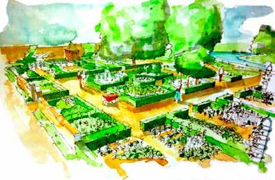

54 Appendix II Display boards on edible urbanism retrofitting presented as part of public consultation on Mill Green 54 appendices
Healthy communities and new towns February 22 nd 2017
 Healthy communities and new towns February 22 nd 2017 Dr Susan Parham Head of Urbanism, University of Hertfordshire Academic Director, International Garden Cities Institute Principles for health and place
Scottish Natural Heritage. Better places for people and nature
 Scottish Natural Heritage Better places for people and nature Contents Summary... 3 SNH approach... 5 Place-making in policy and practice... 6 Developing the contribution of the natural heritage to place-making...
Create Policy Options Draft Plan Plan Approval. Public Consultation Events. Phase 2
 Background Grandview-Woodland Community Plan In the spring of 2012, the City of Vancouver embarked on a comprehensive community planning program in the Grandview-Woodland neighbourhood. The process has
Welcome. /The Design Companion 4. /Planning London 7. /Getting Homes Built 8. /Transport & Streets 10. /Tech & The City 12
 Welcome With the draft publication of the London Plan and the Mayor s Transport Strategy (MTS) this year s events programme will examine both documents in detail with a wide range of seminars, debates
Valuing Historic Places
 Valuing Historic Places Introduction Historic buildings and places have played an increasingly central role in the delivery of a range of public benefits, including education, economic development, sustainable
COMMUNITY GROWN FOOD IN WALES
 COMMUNITY GROWN FOOD IN WALES 2012 1 EXECUTIVE SUMMARY This executive summary provides an overview of research carried out by the WRO between July 2010 and December 2011 to investigate activities relating
Institute Response to Design Guidelines: Design Quality and Housing Choice
 Institute Response to Design Guidelines: Design Quality and Housing Choice The Australian Institute of Landscape Architects South Australian Chapter (AILA SA) is pleased to provide a response on the Draft
Enabling a resilient future: exploring the leadership and governance of urban design
 Enabling a resilient future: exploring the leadership and governance of urban design ulster.ac.uk Mura Quigley BSc (Hons) PGDip MSc PhD Student & Teaching Fellow Ulster University Presentation Outline
ROCHFORD LOCAL DEVELOPMENT FRAMEWORK: Sustainability Appraisal/ Strategic Environmental Assessment. Rochford Core Strategy Preferred Options Document
 ROCHFORD LOCAL DEVELOPMENT FRAMEWORK: Sustainability Appraisal/ Strategic Environmental Assessment Non Technical Summary Rochford Core Strategy Preferred Options Document October 2008 SUSTAINABILITY APPRAISAL
GREEN INFRASTRUCTURE PLANNING GUIDE
 GREEN INFRASTRUCTURE PLANNING GUIDE Authors: C Davies, R MacFarlane, C McGloin, MRoe. Abbreviation Green Infrastructure is frequently abbreviated to as GI and Green Infrastructure Planning as GIP. Contents
PUBLIC REALM STRATEGY
 CONSULTATION DRAFT PUBLIC REALM STRATEGY Trenchard Street & Frogmore Street City Design Group Place Directorate Public Realm Strategy Trenchard Street & Frogmore Street Contents 1. Introduction 2. Understanding
The Charter of European Planning BARCELONA 2013
 The Charter of European Planning BARCELONA 2013 The Vision for Cities and Regions Territoires of Europe in the 21st Century ECTP-CEU (The European Council of Spatial Planners Le Conseil Européen des Urbanistes)
Our City Centre is a vibrant, creative and welcoming destination, with a modern business, cultural, shopping, leisure and residential offer
 3. Sheffield in 2034 Our City sits at the heart of a strong, distinctive and internationally successful City Region economy which supports innovation and enterprise Our City Centre is a vibrant, creative
Cotswolds AONB Landscape Strategy and Guidelines. June 2016
 Cotswolds AONB Landscape Strategy and Guidelines June 2016 Cotswolds AONB Landscape Strategy and Guidelines Introduction The evolution of the landscape of the Cotswolds AONB is a result of the interaction
2.0 Strategic Context 4
 2.0 Strategic Context 4 2.1 The Area Action Plan is a non-statutory plan, which forms a corporate policy document, expressing particular issues and areas of concern while also providing a vision for the
A DRAFT ALLOTMENT POLICY FOR STIRLING COUNCIL
 DRAFT Stirling Council Allotment Policy Appendix 1 A DRAFT ALLOTMENT POLICY FOR STIRLING COUNCIL - 2010 1 Introduction 1.1 Allotments are an important asset, providing a wide range of benefits to both
Sustainability Statement. Whitby Business Park Area Action Plan
 Sustainability Statement Whitby Business Park Area Action Plan November 2014 Contents Page 1. Introduction 1 2. Scoping 3 3. Sustainability Appraisal of Options 6 4. Assessment of Draft Area Action Plan
Title: A comparison between rural and urban permaculture projects
 Title: A comparison between rural and urban permaculture projects Introduction: I have visited four rural permaculture projects so far, and only one urban project. The Concrete Garden has therefore been
Innovative Solutions for Cities Sustainable Development
 23 Issue 13 January 2016 Innovative Solutions for Cities Sustainable Development Eng. Nadine Chahine Bitar Founder Place Making Turning urban spaces into places Email: nadine@placemakingme.com In resolution
13 THORNHILL YONGE STREET STUDY IMPLEMENTATION CITY OF VAUGHAN OPA 669 AND TOWN OF MARKHAM OPA 154
 13 THORNHILL YONGE STREET STUDY IMPLEMENTATION CITY OF VAUGHAN OPA 669 AND TOWN OF MARKHAM OPA 154 The Planning and Economic Development Committee recommends the adoption of the recommendations contained
Oxford Green Belt Study. Summary of Final Report Prepared by LUC October 2015
 Oxford Green Belt Study Summary of Final Report Prepared by LUC October 2015 Project Title: Oxford Green Belt Study Client: Oxfordshire County Council Version Date Version Details Prepared by Checked by
OUR AREA SECTION 02 I NEXT PAGE. 2.1 This section sets the scene in regard to the role of the Legacy Corporation and the baseline
 7 ADOPTED LOCAL PLAN SECTION 02 2.1 This section sets the scene in regard to the role of the Legacy Corporation and the baseline position of the Local Plan. It sets out the historical context and current
Northern Territory Compact Urban Growth Policy
 Northern Territory Compact Urban Growth Policy A Reference Policy Document to clause 2.7 (Reference to Policy) of the NT Planning Scheme May 2015 Table of Contents 1 Policy Setting... 3 1.1 Context for
Rochford District Council Allocations Development Plan Document: Discussion and Consultation Document Sustainability Appraisal
 Option SWH1 Balanced Communities Option SWH1 1 To ensure the delivery of high quality sustainable communities where people want to live and work Will it ensure the phasing of infrastructure, including
Recent UN and EU Sustainable Development Policies (Post 2015): What challenges for city planning and governance
: What challenges for city planning and governance") Recent UN and EU Sustainable Development Policies (Post 2015): What challenges for city planning and governance Europe at a crossroads: the challenge for future sustainable development 20 July 2016 Roudaina
Recent UN and EU Sustainable Development Policies (Post 2015): What challenges for city planning and governance Europe at a crossroads: the challenge for future sustainable development 20 July 2016 Roudaina
What does food sensitive planning mean and why is it important?> 2. Some background on your project (FSPUD)> 3. Some international examples of food
> 3. Some international examples of food") What does food sensitive planning mean and why is it important?> 2. Some background on your project (FSPUD)> 3. Some international examples of food sensitive planning 6 th October (if you 2011 use any>
What does food sensitive planning mean and why is it important?> 2. Some background on your project (FSPUD)> 3. Some international examples of food sensitive planning 6 th October (if you 2011 use any>
The Hadean-Creation studio.
 Residential Designing Spring 2016 The Hadean-Creation studio. We provide sustainable and ethical responses to the client s brief by adding value and empowering a sense of pride and ownership. Hadean-Creation
CHAPTER 5: GUIDING PRINCIPLES
 CHAPTER 5: GUIDING PRINCIPLES The following 10 principles were developed based on public consultation, planning policy and the background analysis conducted during Phase 1. The Guiding Principles significantly
Neighbourhood Planning Local Green Spaces
 Neighbourhood Planning Local Green Spaces Introduction... 2 1. Why green space is important... 4 2. Neighbourhood plans and green space... 6 3. Evidence... 8 Statutory designations... 9 Green space audit...
CITY VIEW OBJECTIVES
 SECTION 2: CITY VIEW OBJECTIVES CONTENTS 2.1 Introduction 1 2.2 Strategic Direction 1 2.3 The City View Resource Management Issues for the City 1 2.4 The Goal 3 2.5 The City View Objectives 3 Palmerston
Cambie Corridor Planning Program Phase Two Draft Plan. Standing Committee on City Services and Budgets May 5, 2011
 Cambie Corridor Planning Program Phase Two Draft Plan Standing Committee on City Services and Budgets May 5, 2011 Cambie Corridor Program Terms of Reference approved July 2009 Land Use Transportation Energy
Western City District What we heard
 What we heard Vision to 2056 and Priorities Governance and implementation Infrastructure and funding The protection of the natural landscape including biodiversity and the Metropolitan Rural Area for food
1Planning. Approach. Part I Chapter 1: Planning Approach
 1Planning Approach Part I Chapter 1: Planning Approach 1 Planning Approach page 5 1Planning Approach The preparation of the Master Plan constitutes a unique opportunity to reflect collectively on the
Draft Eastern District Plan
 Draft Eastern District Plan Submission_id: 31238 Date of Lodgment: 13 Dec 2017 Origin of Submission: Online Organisation name: Turrulla Gardens Pty Ltd C/- Mecone Organisation type: Industry First name:
LEICESTER WATERSIDE. A submission to Blueprint by...
 LEICESTER WATERSIDE A submission to Blueprint by... THIS IS NOT A MASTERPLAN The brief asks us to demonstrate our approach to the site rather than to prepare a masterplan. While they may look like one,
Local Growth Planning in North Central Green Line Communities
 2018 April 30 Page 1 of 6 EXECUTIVE SUMMARY This report outlines a high-level scope for local growth planning for north central Green Line communities. The catalyst for this review is the significant investments
section 3: Vision, Values and Goals
 Vision, Values and Goals 3 2041 Vision: Victoria is an urban sustainability leader inspiring innovation, pride and progress towards greater ecological integrity, livability, economic vitality, and community
Design Guidance. Introduction, Approach and Design Principles. Mauritius. November Ministry of Housing and Lands. .. a
 sig evelo r D Mauritius s. Utilities.. Individu a s. er itects.to ls chpers.po e Public. T. h rban D Sc U e me Promot e h ners. A Design Guidance o.h Planne rs n w iticians r l useholde National Development
Appendix A: Retail Planning Assessment
 Rotherham Town Centre Masterplan Appendix A: Retail Planning Assessment 139 Appendix A Rotherham Town Centre Masterplan Retail Planning Background and Policy Context 1. Introduction 1.1 The Masterplan
Page 1 of 19 URBAN DESIGN FRAMEWORK FOR BOLTON STREET WATERFORD
 Page 1 of 19 URBAN DESIGN FRAMEWORK FOR BOLTON STREET WATERFORD 1.0 Introduction: The relocation of the City Council stores and depot from Bolton Street creates an exciting opportunity for development
PLACE WORKSHOP REPORT. A+DS SNH sustainable placemaking programme
 PLACE briefing WORKSHOP REPORT A+DS SNH sustainable placemaking programme INTRODUCTION This report summarises the outcome of a Scottish Natural Heritage workshop on placemaking which was held on Wednesday
SUSTAINABLE URBAN DEVELOPMENT AND COHESION POLICY EUROPEAN COMMISSION. Urban Policy within the framework of EU Cohesion Policy
 Urban Policy within the framework of EU Cohesion Policy 2007-2013 16/09/2007 SUSTAINABLE URBAN DEVELOPMENT AND COHESION POLICY 2007-2013 Marco Orani European Commission Directorate General for 1 SUSTAINABLE
Writtle University College Policy & Principles for Sustainable Development
 Writtle University College Policy & Principles for Sustainable Development P.R.Hobson & A. Perera Preface As a higher education institute with a specialist provision in land-based studies, Writtle University
Response to the London Bridge Area Vision and Site Allocations within the New Southwark Plan
 1 Melior Place London SE1 3SZ 020 7407 4701 teamlondonbridge.co.uk info@teamlondonbridge.co.uk 28 April 2017 Response to the London Bridge Area Vision and Site Allocations within the New Southwark Plan
Excellencies, Dear colleagues from other agencies and organizations, Ladies and Gentlemen,
 Address by Dr Mechtild Rossler Deputy Director of UNESCO s World Heritage Centre The UNESCO Recommendation on the Historic Urban Landscape on the occasion of the European Heritage Heads Forum Leuven, Belgium,
Building with nature
 Building with nature Prioritising ecology and biodiversity for better buildings and cities Executive Summary May 2018 National Strategic Sponsor Research and evidence demonstrating the positive impacts
The role of urban mobility in (re)shaping cities
shaping cities") The role of urban mobility in (re)shaping cities Mr. Andre Dzikus Urban Basic Services Branch Coordinator www.unhabitat.org Structure 1) Urbanisation - Challenges 2) Mobility shaping the city 3) Mobility
The role of urban mobility in (re)shaping cities Mr. Andre Dzikus Urban Basic Services Branch Coordinator www.unhabitat.org Structure 1) Urbanisation - Challenges 2) Mobility shaping the city 3) Mobility
OUR GREATER SYDNEY A metropolis of three cities. OVERVIEW. connecting people. DRAFT Greater Sydney Region Plan
 OUR GREATER SYDNEY 2056. A metropolis of three cities. OVERVIEW. connecting people. DRAFT Greater Sydney Region Plan October 2017 This document is an overview of the draft Greater Sydney Region Plan. To
The Dreispitz in Basel / Switzerland: New economy on old sites
 The Dreispitz in Basel / Switzerland: New economy on old sites 1. Introduction At 50.000m 2 Dreispitz is currently the largest and most ambitious development project in Basel, the second biggest town in
Chapter 2: OUTLINE PLANNING APPLICATION PROPOSALS. A New Garden Neighbourhood Matford Barton 17
 Chapter 2: OUTLINE PLANNING APPLICATION PROPOSALS A New Garden Neighbourhood Matford Barton 17 2.1. SUMMARY AND STATUS OF THE PROPOSALS 2.1.1. The parameter plans and associated wording in this chapter
Eastern City District Plan
 OUR GREATER SYDNEY 2056 Revised Draft Eastern City District Plan OVERVIEW Bayside Burwood Canada Bay City of Sydney Inner West Randwick Strathfield Waverley Woollahra Snapshot of the Eastern City District
London Urban Agriculture Strategy [DRAFT: May 5, 2017]
![London Urban Agriculture Strategy [DRAFT: May 5, 2017]](/thumbs/80/81613739.jpg "London Urban Agriculture Strategy [DRAFT: May 5, 2017]") London Urban Agriculture Strategy [DRAFT: May 5, 2017] Whatever the scale backyard, balcony, and beyond urban agriculture helps bring communities together, and offers many social, economic, environmental,
London Urban Agriculture Strategy [DRAFT: May 5, 2017] Whatever the scale backyard, balcony, and beyond urban agriculture helps bring communities together, and offers many social, economic, environmental,
4- PA - LD - LIVELY DOWNTOWN. LD - Background
 4- PA - LD - LIVELY DOWNTOWN LD - Background The downtown has been the service centre for the community since the city s inception and the area continues to supply people with their personal services,
The Fairfield Partnership Vision for North-East Elsenham
 The Fairfield Partnership Vision for North-East Elsenham August 2009 Frequently Asked Questions Who is The Fairfield Partnership? The Fairfield Partnership is a joint venture between Marchfield Developments
1 Introduction. Chapter. In this chapter:
 Chapter 1 Introduction In this chapter: 1.1 A Snapshot of the Region 1.2 Towards a Sustainable Region 1.3 The Provincial Context 1.4 Purpose and Organization The Regional Municipality of York Official
01 Welcome. Why are we here?
 01 Welcome Why are we here? In July 2014 GreenSquare unveiled its plans for 1500 homes to the local community providing much needed houses during the first half of the Stroud District Local Plan period.
QUEENSTOWN LAKES DISTRICT COUNCIL SUBDIVISION DESIGN GUIDELINES
 Attachment C: Draft QLDC Subdivision Design Guidelines QUEENSTOWN LAKES DISTRICT COUNCIL DESIGN GUIDELINES A DESIGN GUIDE FOR AND DEVELOPMENT IN THE URBAN ZONES QUEENSTOWN OFFICE 10 Gorge Road Queenstown
Access Management: An Overview
 Figures 1-5 Below Evolution of development along a highway. In the early stages, land along the road is used for farming with little traffic generated. As time passes, the highway corridor becomes a de
CITY CENTRE REGENERATION STRATEGY AND INVESTMENT PLAN QUESTIONNAIRE
 CITY CENTRE REGENERATION STRATEGY AND INVESTMENT PLAN QUESTIONNAIRE Q1 Principle of preparing a Regeneration Strategy and Investment Plan a) Please indicate below if you support the principle of preparing
The Gwennap Parish Vision Statement
 QUICK GUIDE What is a Neighbourhood Development Plan? Ultimately it is a document used by developers or anyone wishing to submit a planning application that describes the vision, strategy, plans, regeneration,
Schedule of Planning Applications Committee Date: 23 May Reference: 06/17/0726/F Parish: Hemsby Officer: Mr J Beck Expiry Date:
 Schedule of Planning Applications Committee Date: 23 May 2018 Reference: 06/17/0726/F Parish: Hemsby Officer: Mr J Beck Expiry Date: 22-05-2018 Applicant: Proposal: Site: Mr Gillett Change of use to the
Urban Design Brief. Watson Parkway North & Watson Road North Guelph, Ontario. Prepared by Coletara Development
 Urban Design Brief Watson Parkway North & Watson Road North Guelph, Ontario Prepared by Coletara Development December, 2013 Urban Design Brief, Coletara Development 1 Introduction This Urban Design Brief
UDF PLANS AND GUIDELINES
 UDF PLANS AND GUIDELINES 5 Land Use Land Use Development Plan Plan no. 3 Land Use Development Mixed Use Retail / Leisure Residential Civic and Institutional Proposed Zoning Table Development Edges Plan
Hobart A Strategic Framework
 Hobart 2025 A Strategic Framework Adopted by the Hobart City Council 15 October 2007 Table of Contents Introduction...2 Vision and Future Directions...3 FD1 Offers opportunities for all ages and a city
TD571. New Nomads Short-term opportunities for long-term local effect
 New Nomads Short-term opportunities for long-term local effect La Corrèze: Developing potentials SHARING A VISION ON A REGIONAL SCALE: SHARING RESOURCES ON AN INTERCOMMUNAL SCALE. La Corrèze is a territory
Davis Landscape Architecture. Davis. Landscape Architecture
 23a Iliffe Yard, London, SE17 3QA, UK +44 (0)20 7277 1035 mail@davisla.com www.davisla.com Practice Overview We are a design led London based practice that prides itself on the delivery of schemes that
LEIPZIG CHARTER on Sustainable European Cities
 LEIPZIG CHARTER on Sustainable European Cities PAGE 1 PREAMBLE The LEIPZIG CHARTER on Sustainable European Cities is a document of the Member States, which has been drawn up with the broad and transparent
Welcome to the Oakridge Centre Open House
 Welcome to the Oakridge Centre Open House Why is the City hosting this event? This open house is to inform you of a rezoning application submitted to the City of Vancouver to amend the existing CD-1 (Comprehensive
elbridge Core Strategy
 C elbridge Core Strategy Celbridge is designated as a Moderate Growth Town in the RPGs. The County Development Plan reinforces this designation in its settlement strategy. Moderate Growth Towns within
South District What we heard
 What we heard Vision to 2056 and Priorities Governance and implementation Infrastructure and funding Feedback supported: The vision for a metropolis of three cities, but emphasised the importance of infrastructure
Scotland s Landscape Charter
 Scotland s Landscape Charter The Scottish Landscape Forum Foreword Scotland s landscapes, which are renowned throughout the world, show the imprint of countless generations of Scots who have shaped this
RURAL ZONE - POLICY. Rural Zone Policy. Issue: Rural Environment. Ruapehu District Plan Page 1 of 8
 Rural Zone Policy RU2 RURAL ZONE - POLICY RU2.1 Introduction The natural resources of the rural environment in the Ruapehu District provide the basis for the existing and potential character, intensity
Local Development Plan for Glasgow
 Local Development Plan for Glasgow Forbes Barron Head of Planning & Building Control Services Context and Process for LDP NPF 3 Principles An 80% reduction in emissions by 2050. Achieving the aims of the
POLICY BRIEFING The Natural Choice: Securing the Value of Nature - Government White Paper on the environment
 The Natural Choice: Securing the Value of Nature - Government White Paper on the environment Date: 14 June 2011 Author: Steven Bland, LGiU Associate Overview White paper at a glance Number of individual
SECTION ONE: INTRODUCTION. introduction
 introduction 1 INTRODUCTION Since it was first established in 1843 as a trading post for the Hudson s Bay Company, Victoria has evolved into a Provincial capital city that is recognized across Canada and
Draft Western District Plan
 Powered by TCPDF (www.tcpdf.org) Draft Western District Plan Submission_id: 31440 Date of Lodgment: 15 Dec 2017 Origin of Submission: Online Organisation name: Goodman Property Services Australia Pty Ltd
CHAPTER 3 VISION, GOALS, & PLANNING PRINCIPLES. City of Greensburg Comprehensive Plan. Introduction. Vision Statement. Growth Management Goals.
 CHAPTER 3 VISION, GOALS, & PLANNING PRINCIPLES Introduction The Greensburg Comprehensive Plan is intended as a working community document. A combination of long and short-term goals, this document is intended
Appendix 1 Structure plan guidelines
 Appendix 1 Structure plan guidelines This appendix forms part of the regional policy statement [rps]. 1.1. Introduction Structure plans are an important method for establishing the pattern of land use
THAT the attached Terms of Reference for the Thornhill Centre Street Study be approved.
 COMMITTEE OF THE WHOLE AUGUST 18, 2003 THORNHILL CENTRE STREET STUDY PLANNING FILE: 15.92 Recommendation The Commissioner of Planning recommends: THAT the attached Terms of Reference for the Thornhill
The Strategies for an Urban Regeneration
 The Strategies for an Urban Regeneration Regenerating post-industrial cities An Urban Manifesto in nine recommendations by Professor Steffen Lehmann Introduction Cities are facing huge challenges and the
Welcome to our exhibition
 Welcome to our exhibition housing development A46 Wildmoor Alcester Road Canal Quarter A422 Town Centre housing development Warwickshire-based IM Properties, one of the UK s largest privately owned property
1.0 Purpose of a Secondary Plan for the Masonville Transit Village
 Report to Planning and Environment Committee To: Chair and Members Planning & Environment Committee From: John M. Fleming Managing Director, Planning and City Planner Subject: Masonville Transit Village
Euston Area Plan - Examination: Statement in response to the Inspector s Matters, Issues and Questions
 1 Euston Area Plan - Examination: Statement in response to the Inspector s Matters, Issues and Questions Sydney and London Properties Limited June 2014 2 3 This document is the Statement in response to
EXTRACT FROM THE CUDDINGTON NEIGHBOURHOOD PLAN The Policies
 EXTRACT FROM THE CUDDINGTON NEIGHBOURHOOD PLAN The Policies Environment and Landscape Policy 1 - Landscape Setting Development should respect and wherever possible enhance the landscape setting of Cuddington
Wollondilly Resilience Network (WReN) Inc. Comments on the Draft South West District Plan
 Inc. Comments on the Draft South West District Plan") Wollondilly Resilience Network (WReN) Inc. Comments on the Draft South West District Plan March 2017 About WReN Wollondilly Resilience Network (WReN) Inc. is a not for profit community association based
Wollondilly Resilience Network (WReN) Inc. Comments on the Draft South West District Plan March 2017 About WReN Wollondilly Resilience Network (WReN) Inc. is a not for profit community association based
Horticulture. the School of Horticulture 77. (with Minor Award) 80. FdSc Horticulture. FdSc Green Space Management 80. Therapeutic Horticulture 81
 80. FdSc Horticulture. FdSc Green Space Management 80. Therapeutic Horticulture 81") School of Horticulture ABOUT THE SCHOOL OF HORTICULTURE 74 Minor award OPTIONS Offered by the School of Horticulture 77 BSc (Hons) Horticulture 78 BSc (Hons) Horticulture (with Minor Award) 78 FdSc Horticulture
School of Horticulture ABOUT THE SCHOOL OF HORTICULTURE 74 Minor award OPTIONS Offered by the School of Horticulture 77 BSc (Hons) Horticulture 78 BSc (Hons) Horticulture (with Minor Award) 78 FdSc Horticulture
STATEMENT OF OBJECTION TO THE PROPOSED DEVELOPMENT OF LAND AT CHURCH CLIFF DRIVE FILEY
 STATEMENT OF OBJECTION TO THE PROPOSED DEVELOPMENT OF LAND AT CHURCH CLIFF DRIVE FILEY You will be aware that Scarborough borough council have adopted a new local plan that includes land at Church Cliff
The Lincolnshire Master Gardener Programme
 Growing Food growing for health and wellbeing The Lincolnshire Master Gardener Programme Lincolnshire Growing Case Study area: and well-being This series of Growing case studies provide examples of projects
38 Queen s University Campus Master Plan Part 1
 38 Queen s University Campus Master Plan Part 1 46 The Campus at the City Scale Chapter 4 The Campus at the City Scale 39 Queen s is an urban University centrally located in Kingston. Decisions made by
Highland Council Allotment Policy
 Highland Council Allotment Policy 1. Introduction 1.1 Allotment gardening offers the benefit of a healthy lifestyle all year round that is active, sustainable and socially inclusive. The Highland Council
Landscape Architecture & Urban Design
 Landscape Architecture & Urban Design Delivering excellence in the built environment What we do Landscape architecture Urban design Masterplanning Public consultation Design briefs Design codes Conservation
Planning Policy and Land Use: Hosted by Dearne Valley Green Heart NIA and Barnsley MBC - March 2013
 Planning Policy and Land Use: Hosted by Dearne Valley Green Heart NIA and Barnsley MBC - March 2013 The Second Nature Improvement Area Best Practice Network Event Barnsley Metropolitan Borough Councillor
North District What we heard
 What we heard Vision to 2056 and Priorities Governance and implementation Infrastructure and funding The vision for a metropolis of three cities, and the 30 minute city. Feedback emphasised: That for the
AGENDA ITEM: 8 Page nos
 AGENDA ITEM: 8 Page nos. 16-18 Meeting Date 1 st December 2004 Subject Report of Summary Regeneration and Development Scrutiny Committee Design Codes - Background Material Scrutiny Officer One of the four
Central City District What we heard
 What we heard Vision to 2056 and Priorities Governance and implementation Infrastructure and funding The vision for a metropolis of three cities, and the 30 minute city. Feedback requested: Clearer communication
WOKING DESIGN SUPPLEMENTARY PLANNING DOCUMENT (SPD)
") Agenda Item No. 5 EECUTIVE - 15 JANUARY 2015 Executive Summary WOKING DESIGN SUPPLEMENTARY PLANNING DOCUMENT (SPD) The report outlines the various responses to the consultation on the Design Supplementary
Agenda Item No. 5 EECUTIVE - 15 JANUARY 2015 Executive Summary WOKING DESIGN SUPPLEMENTARY PLANNING DOCUMENT (SPD) The report outlines the various responses to the consultation on the Design Supplementary
(Y)OUR BROOMIELAW SUMMARY DOCUMENT
OUR BROOMIELAW SUMMARY DOCUMENT") (Y)OUR BROOMIELAW SUMMARY DOCUMENT Glasgow City Centre District Regeneration Frameworks Broomielaw District August 2018 Broomielaw District Regeneration Framework as defined in Glasgow City Centre Strategy
(Y)OUR BROOMIELAW SUMMARY DOCUMENT Glasgow City Centre District Regeneration Frameworks Broomielaw District August 2018 Broomielaw District Regeneration Framework as defined in Glasgow City Centre Strategy
Municipal Development Plan 2013
 UNIQUELY STONY PLAIN: Municipal Development Plan 2013 Quick Reference Guide What is a Municipal Development Plan (MDP)? The Town s highest-level planning document Sets the long-term vision and key themes
4 Sustainability and Growth Management
 4 Sustainability and Growth Management Introduction Traditionally, has assumed growth and development with limited consideration for the long-term negative social, environmental or economic impacts on
URBAN REGENERATION IN THE UK. Second Edition ANDREW TALLON. R Routledge. Taylor & Francis Group LONDON AND NEW YORK
 URBAN REGENERATION IN THE UK Second Edition ANDREW TALLON R Routledge Taylor & Francis Group LONDON AND NEW YORK THE Contents Acknowledgements List of Illustrations xiii xiv SECTION I - CONTEXT FOR URBAN