Street & Number: Kerrville-Rosemark Road; , 8736 Rosemark Road
|
|
|
- Roberta Jacobs
- 5 years ago
- Views:
Transcription
1 National Park Service National Register of Historic Places Registration Form This form is for use in nominating or requesting determinations for individual properties and districts. See instructions in National Register Bulletin, How to Complete the National Register of Historic Places Registration Form. If any item does not apply to the property being documented, enter "N/A" for "not applicable." For functions, architectural classification, materials, and areas of significance, enter only categories and subcategories from the instructions. 1. Historic name Other names/site number Name of related multiple property listing 2. Location N/A N/A (Enter N/A if property is not part of a multiple property listing) Street & Number: Kerrville-Rosemark Road; , 8736 Rosemark Road City or town: Rosemark State: TN County: Shelby Not For Publication: 3. State/Federal Agency Certification Vicinity: As the designated authority under the National Historic Preservation Act, as amended, I hereby certify that this X nomination request for determination of eligibility meets the documentation standards for registering properties in the National Register of Historic Places and meets the procedural and professional requirements set forth in 36 CFR Part 60. In my opinion, the property X meets does not meet the National Register Criteria. I recommend that this property be considered significant at the following level(s) of significance: national statewide X local Applicable National Register Criteria: X A B X C D Signature of certifying official/title: State Historic Preservation Officer, Tennessee Historical Commission State or Federal agency/bureau or Tribal Government Date In my opinion, the property meets does not meet the National Register criteria. Signature of Commenting Official: Date Title: State of Federal agency/bureau or Tribal Government 1
2 4. National Park Service Certification I hereby certify that this property is: entered in the National Register determined eligible for the National Register determined not eligible for the National Register removed from the National Register other (explain:) Signature of the Keeper Date of Action 5. Classification Ownership of Property (Check as many boxes as apply.) Category of Property (Check only one box.) Private X Building(s) Public Local X District X Public State Site Public Federal Structure Object Number of Resources within Property (Do not include previously listed resources in the count) Contributing Noncontributing 34 7 buildings 0 0 sites structures 3 0 objects Total Number of contributing resources previously listed in the National Register 0 2
3 6. Function or Use Historic Functions (Enter categories from instructions) DOMESTIC: single dwelling, multiple dwelling COMMERCE: store, mill RELIGION: religious facility AGRICULTURE: animal facility, agricultural outbuilding EDUCATION: school SOCIAL: meeting hall INDUSTRY: cotton gin, communications facility Current Functions (Enter categories from instructions) DOMESTIC: single dwelling, multiple dwelling COMMERCE: office building, store RELIGION: religious facility AGRICULTURE: animal facility, agricultural outbuilding EDUCATION: school SOCIAL: meeting hall INDUSTRY: communications facility 7. Description Architectural Classification (Enter categories from instructions.) LATE VICTORIAN: Queen Anne EARLY 20 th CENTURY: Gothic Revival, Bungalow/Craftsman, Minimal Traditional, Commercial Style OTHER: agriculture related Materials: (enter categories from instructions.) Principal exterior materials of the property: Brick, concrete, stone, weatherboard, asbestos, vinyl, metal Narrative Description Rosemark, Tennessee, population 2,315 in 2010, is located in northeastern section of Shelby County, near the Tipton County line. The community is centered on the intersection of Rosemark Road and Kerrville- Rosemark Road. The Austin-Peay Highway, located at the edge of the historic district, is a major highway for the community. Although once a thriving agricultural crossroads, the community largely functions as a bedroom community for Memphis. The historic district is made up of forty-one parcels, thirty-five containing resources. Thirty of those thirtyfive have contributing primary resources. There are twenty-four houses, two churches, two industrial structures, and eight community buildings (stores, schools, bank, masonic lodge, and utility) in the district. The majority of the buildings in the district were built before Rosemark experienced its greatest growth before 1920 and that is reflected in the fact that fourteen houses, one community building and one church date to the period before Five houses and six community buildings (church, school, lodge, commercial, utility, and industrial) date from the period , reflecting a second phase of building activity in the community. Of the ninety-five total resources, seventy-two are contributing: thirty-four contributing buildings, thirty-five contributing structures, and three contributing objects. 3
4 Of the domestic architecture, the bungalow is the most dominant form of architecture in the historic district. Other domestic architectural styles include Queen Anne, side-gable cottages, Minimal Traditional cottages, and an English Cottage Revival dwelling. The average parcel size is acres. The rural nature of the historic district is still apparent. Several houses retain barns as outbuildings. At least two dwellings retain a farm office as one of the outbuildings. The Moore Brothers Gin and the Moore Brothers Warehouse are extant on the landscape and stand as reminders of the agribusinesses that dominated the landscape. Several barns remain extant in the district, including one of the few remaining cotton barns in Shelby County, located at 8683 Rosemark Road. Kerrville-Rosemark Road Kerrville-Rosemark Road (c. 1927) 8501 Kerrville-Rosemark Road is a 2.00-acre parcel with a primary contributing dwelling and three contributing outbuildings. The dwelling is a two-story building with a concrete block foundation, an exterior of weatherboard, a side-gable composite-shingle roof with two projecting front gables and two exterior end brick chimneys. The dwelling faces north and has a symmetrical three bay façade a central entrance bay and flanking window bays. The central entrance bay consists of a single-leaf wood panel door shielded by a metal-and-glass storm door. A central gabled portico covers the entrance and is supported by two square wood columns. Concrete steps lead up to the concrete floor of the portico. The flanking window bays each have one-over-one, double-hung metal sash windows in the first and second floors. The first floor windows are slightly larger. Fixed shutters flank all windows. (contributing building) Well House. At the rear of the dwelling is a well house with a composite-shingle side-gable roof, exposed rafter tails, weatherboard siding, and a single-light, three-panel wood door, c (contributing structure) Garage. Just southwest of the dwelling is a c detached two-car garage with a compositeshingle shed roof, vinyl siding, a five-panel wood door, and two metal garage doors. The siding and garage doors date to c A small shed-roof carport supported by simple square wood posts has been added to the west side of the garage. (contributing structure) Barn. A c barn with vertical board walls and a raised-seam metal gable roof is located south of the home and is set back from the main domestic complex. It has a central double-door vertical board entrance on both the east and west elevations. A small hay opening is located just above the doors on the west elevation. (contributing structure) Kerrville-Rosemark Road (c. 1912) 8502 Kerrville-Rosemark Road is a 2.45-acre parcel with a primary contributing dwelling and three contributing structures. The dwelling is a one-story bungalow with minimal Colonial Revival influences. It features a continuous brick foundation, narrow weatherboard siding, a composite-shingle hipped roof with exposed rafter tails, and two interior brick chimneys. The dwelling faces south and contains three symmetrical bays-a central entrance bay and flanking window bays. A clipped-gable portico with a concrete 4
5 floor and two square wood posts is centered on the façade. The house is currently undergoing renovation. At present, the door is a replacement fifteen-light wood door and the flanking windows are paired replacement single-light casement windows. Although some elements have been replaced, the house retains its historic form and character as a vernacular farmhouse. (contributing building) Well House. Located directly behind the house is a concrete block well house with a metal shed roof and a vertical board door, c (contributing structure). Storage Shed. Attached to the well house is a metal storage shed with a composite shingle gable roof and a vertical board door, c (contributing structure). Privy. Set within the tree line behind the house is a c privy with vertical board walls, a vertical board door, and a raised-seam metal roof. (contributing structure) Kerrville-Rosemark Road (c. 1915) 8536 Kerrville-Rosemark Road is a 3.51-acre parcel with a primary contributing dwelling, three contributing structures, and two non-contributing structures. The dwelling is a one-and-one-half story bungalow with a continuous concrete block foundation, an exterior clad with synthetic siding, and a clipped-gable compositeshingle roof with flared eaves. A recessed three-quarter porch on the south façade wraps around to the east elevation. It has a concrete floor and is supported by six round wood columns. The westernmost bay of the façade contains a three-over-one, double-hung wood sash window flanked by non-functioning shutters. East of that bay and within the recessed porch is a single-leaf entrance door shielded by a metal storm door. Just east of that door on the porch façade is a pair of one-over-one, double-hung wood sash windows flanked by non-functioning shutters. Set back within the ell of the porch is a second single-leaf door shielded by a metal storm door. A shed-roof dormer with a set of three single-light windows is centered on the facade. A metal carport is attached to the east side of the house and dates to c (contributing building) Garage. Just northeast of the dwelling is a detached aluminum garage with a front-gable compositeshingle roof, c (non-contributing structure, due to date of construction) Storage Shed. A concrete block storage shed sits directly behind the house. It has a front-gable composite-shingle roof with exposed rafter tails, c (contributing structure) Equipment shed. Located northwest of the dwelling is an open shed with a raised-seam metal shed roof supported by wood posts. The shed roof has exposed wood rafters, c (contributing structure) Storage Building. West of the dwelling and set apart from the main domestic complex is a storage building with a side gable roof, aluminum siding, a projecting gabled entry, and double metal doors flanked by six-over-six double-hung sash windows, c (non-contributing structure, due to date of construction) 5
6 Kerrville-Rosemark Road (c. 1918) 8554 Kerrville-Rosemark Road is a 0.9-acre parcel with one non-contributing primary dwelling and one noncontributing outbuilding. The south-facing dwelling is a one-story bungalow with a continuous concrete bock foundation, an exterior clad in synthetic siding, and a composite shingle gable roof. The original front porch was enclosed in the late 20 th century and now forms the façade of the dwelling. The entrance is toward the western end of the façade and is a single-leaf door shielded by a metal storm door. A concrete stoop leads up to the door. Windows flank the door: a pair of one-over-one, double-hung metal sash windows on the west and a single one-over-one, double-hung metal sash window on the east. Toward the eastern end of the façade is a pair of larger one-over-one, double-hung metal sash windows. The windows and doors date to the enclosure of the porch in the late 20 th century. A metal stovepipe extrudes from the roof. A metal carport was attached to the west side of the home c The dwelling retains much of its historic form, but the replacement materials and enclosure of the front porch detract from the historic character of the home. (non-contributing building due to alterations) Garage. A c two-car garage is located to the northeast of the dwelling. (non-contributing structure, due to date of construction) 5A Kerrville-Rosemark Road (c. 1912) 8562 Kerrville-Rosemark Road is a 0.73-acre parcel with one contributing primary dwelling and one contributing outbuilding. The home faces south and is a one-story prow house with a continuous concrete block foundation, asbestos shingle cladding, and a cross-gable composite shingle roof. A full-front porch wraps halfway around the east and west elevation. The porch has a concrete floor and is accessed via a set of central concrete steps with metal handrails. The porch has a hipped roof and is supported on wrought iron posts (c. 1950). The façade consists of five symmetrical bays: three on the center projecting portion and one setback bay on either side. The central bay contains a single-leaf entrance door shielded by a wrought iron storm door. Each of the other four bays contains a single three-over-one, double-hung wood sash window. (contributing building) Well House. Northwest of the dwelling is a brick well house with a front-gable asphalt roof and unknown foundation, c (contributing structure) 5B. Kerrville-Rosemark Road This 0.73-acre parcel is agricultural land associated with 8562 Kerrville-Rosemark Road (5A). No extant structures are present Kerrville-Rosemark Road (c. 1947) 8583 Kerrville-Rosemark Road is a 1.00-acre parcel with one contributing primary dwelling. The northfacing dwelling is a one-and-one-half story Minimal Traditional style house with a continuous concrete block foundation, vinyl siding, and a side gable raised-seam metal roof. The north façade consists of three asymmetrical bays an off-center entrance bay flanked by window bays. A gabled portico with a concrete floor and wrought iron posts covers the entrance. The single-leaf, wood-panel door is shielded by a wrought 6
7 iron storm door. The eastern window bay contains a pair of one-over-one, double-hung wood sash windows with metal storm windows. The western bay contains a single identical window. A c two-car garage with vinyl siding and a raised-seam metal roof is attached to the rear of the dwelling. It is setback from the original structure and does not detract from the historic character. (contributing building) 7A Kerrville-Rosemark Road (c. 1912) 8591 Kerrville-Rosemark Road is a 1.04-acre parcel with one contributing primary dwelling, five contributing structures, two contributing objects, and two non-contributing structures. It is associated with a larger agricultural lot to the rear that expands toward the east and west. The home is a one-story dwelling with a stone pier foundation and concrete block infill, weatherboard siding and a side gable composite shingle roof. The dwelling faces north and has a full-front hipped-roof porch. The porch has a concrete floor and was screened c A set of concrete block steps with metal handrails leads up to the screen door of the porch. Within the porch is the asymmetrical three-bay façade a central entrance bay and flanking window bays. The entrance bay has a wood-panel door with a metal-and-glass storm door. The flanking window bays each have a pair of six-over-six, double-hung wood sash windows. (contributing building) Well House. Behind the house sits a brick well house with a side gable composite shingle roof and a plain wood door, c (non-contributing structure due to date of construction) Garage. Also behind the house is a c garage with a front gable raised-seam metal roof and exposed rafter tails. The walls are covered with raised-seam metal panels. A pair of large metal garage entrance doors is located in the gable end. (contributing structure) Fuel Tank. A c metal fuel tank historically associated with the property is also behind the house. (contributing object) Fuel Tank. A second c metal fuel tank is partially buried behind the house. (contributing object) Privy. A c privy with a raised-seam metal shed roof and vertical board siding is located behind the house in the treeline. (contributing structure) Storage Shed. A c storage shed with a raised-seam metal shed roof, exposed rafter tails, a mixture of wood and aluminum siding, and a vertical board door is located toward the rear of the property. (contributing structure) Chicken Coop. Within the tree line behind the house is a collapsed wood chicken coop (noncontributing structure, due to condition) Stock Barn. A c stock barn with a raised-seam metal gable roof and board-and-batten siding is located within the trees behind the house. (contributing structure) 7
8 Slaughterhouse. Also within the trees behind the house is a c slaughterhouse with a metal gable roof, exposed rafter tails, and metal siding. (contributing structure) 7B. Kerrville-Rosemark Road This is a acre agricultural parcel associated with 8591 Kerrville-Rosemark Road (7A). No extant structures are present. 8A Kerrville-Rosemark Road (1918, 1954) First Presbyterian Church 8582 Kerrville-Rosemark Road is a 1.46-acre parcel with a contributing church building, one contributing structure, and one non-contributing structure. The First Presbyterian Church building is a one-story brick Gothic Revival church with a triple-gable raised-seam metal roof, a continuous concrete block foundation and an interior brick chimney. The building was originally constructed in 1918 with two separate single-leaf doors flanking a center window; however, the building s façade was reconfigured to its current double-leaf entrance flanked window bays in The south façade consists of three bays which consist of a large gabled central entrance bay flanked by gabled window bays. A one-story flat-roof porch is centered on the façade. It is supported by round wood posts and is accessed via a set of brick steps. The double-door entrance consists of three-panel wood doors with five-light sidelights, a five-light transom, and single-light corner lights. Above the porch on the central bay is a Gothic arched stained glass window. In the attic level of the central bay is a stained glass rose window set within a rectangular surround. Flanking the central bay of the façade are slightly setback window bays. Each window bay contains a pair of multi-light stained glass, double-hung wood sash windows topped with a Gothic arched stained-glass window. A barrier-free ramp is located along the east elevation and obscures the cornerstone, which is inscribed First Presbyterian Church (contributing building) Sign. In front of the building is a wrought iron sign reading Rosemark First Presbyterian Church US, c (contributing object) Play Structure. A wood play structure is located behind the building, c (non-contributing structure, due to date of construction) 8B Kerrville-Rosemark Road 8602 Kerrville-Rosemark Road is a 0.72-acre vacant lot associated with First Presbyterian Church, 8582 Kerrville-Rosemark Road (8A). 8C. Kerrville-Rosemark Road This is a acre vacant lot associated with First Presbyterian Church, 8582 Kerrville-Rosemark Road (8a) 1 Jon P. McCalla, ed., An Illustrated History of the People And Towns of Northeast Shelby County and South Central Tipton County (Millington, Tennessee: Historic Archives of Rosemark and Environs, 2010),
9 Kerrville-Rosemark Road (c. 1925) 8605 Kerrville-Rosemark Road is a acre parcel with one contributing primary dwelling. The dwelling is a one-story bungalow with a concrete block foundation, weatherboard cladding, a front gable composite shingle roof with exposed rafter tails and an exterior brick chimney. On the north façade is a full-front porch with a concrete floor, a hipped roof, exposed rafter tails and a small central projecting gable. Square wood columns support the porch which is accessed via a set of concrete steps with a wood handrail. Within the porch is the three-bay façade a central entrance bay and flanking window bays. The central wood-panel door is shielded by a wrought iron storm door. The eastern window bay contains a single, three-over-one, double-hung wood sash window; the western window bay contains a pair of identical windows. A small c addition extends from the west elevation of the home. It has a concrete block foundation, weatherboard cladding, a side gable composite shingle roof with exposed rafter tails, and a multi-light, wood, fixed windows. A second late-20 th century addition is attached to the southeast corner of the house. It has a concrete block foundation, weatherboard cladding, and a front gable composite shingle roof. The addition is setback and clearly distinguished from the main house. (contributing building) Kerrville-Rosemark Road (c. 1912) 8620 Kerrville-Rosemark Road is a acre parcel with one contributing primary dwelling and one noncontributing outbuilding. The dwelling is a one-story bungalow with a stone pier and concrete block infill foundation, an exterior of synthetic siding, and a hipped-with-cross-gable composite shingle roof. The south façade contains two bays of paired one-over-one, double-hung wood sash windows. Decorative scalloped trim in the shape of non-functioning blinds surrounds the windows on the south façade. The entrance to the home is located on the east elevation facing the driveway. Covering the single-leaf entrance is a stoop porch with a gable roof supported by curved wooden brackets. Attached to the rear of the dwelling is a small addition (date unknown) with a rear shed-roof porch. (contributing building) Garage. Just northeast of the dwelling is a c detached garage with vertical board siding and a composite shingle gable roof. On the north end of the garage are two metal overhead doors. (noncontributing structure, due to date of construction) Kerrville-Rosemark Road (c. 1957) 8627 Kerrville-Rosemark Road is a 1.01-acre parcel with one primary contributing dwelling and two noncontributing outbuildings. The dwelling is a one-story ranch dwelling with a brick foundation, walls primarily covered in brick, and a composite shingle multi-hipped roof. The north façade is divided into three sections. The easternmost section contains two window bays, each with paired two-over-two double-hung, wood sash windows with fixed wood shutters. The central section is slightly set back and consists of three bays: the easternmost bay is an eight-light, one-panel wood door sheltered by a small shed-roof stoop porch with wrought iron posts and a poured concrete floor; the central bay contains a two-over-two, double-hung wood sash window with fixed shutters; the western bay contains a smaller two-over-two, double-hung wood sash window with fixed shutters. Vertical board siding covers the walls in the upper half of this section. The westernmost garage section of the dwelling is covered in vertical board siding and is setback from the central section. In the eastern end of this section are paired two-over-two, double-hung wood sash windows. The western half of this section includes the larger overhead garage door. (contributing building) 9
10 Storage shed. A small c storage shed is located behind the house. (non-contributing structure, due to date of construction) Storage shed. A second small c storage shed is also located behind the house. (noncontributing structure, due to date of construction) Kerrville-Rosemark Road (c. 2000) 8621 Kerrville-Rosemark Road is a acre parcel with one non-contributing primary dwelling. The house is a c two-story Neo-Traditional brick home with a multi-gable roof and multi-light windows. It is set back from the road in a manner inconsistent with the historic character of the district. (non-contributing building, due to date of construction) 13A Kerrville-Rosemark Road (c. 1956) 8659 Kerrville-Rosemark Road is a acre parcel with one contributing primary dwelling and two contributing structures. The dwelling is a one-story Ranch style home with a brick foundation, walls covered with brick and board-and-batten siding, a composite shingle side gable roof, and an interior brick chimney. The north elevation has an asymmetrical four bay façade three bays of windows and one bay is a door. The easternmost bay has paired two-over-two, double-hung wood sash windows with metal storm windows. West of that bay is the entrance bay with a three-panel wood door shielded by a metal-and-glass storm door. Board-and-batten siding is located in the upper two-thirds of this bay. West of the entrance bay is a window bay with a set of nine fixed windows arranged in a 3x3 pattern. The westernmost bay has a single two-overtwo, double-hung wood sash window shielded by a metal storm window. (contributing building) Garage. A 1938 detached single-car garage with an attic apartment is located southwest of the dwelling. It has a composite shingle pyramid roof, exposed rafter tails, weatherboard siding, a woodpanel door shielded by a wood frame screened door, and a concrete block foundation. The interior has beaded-board walls. (contributing structure) Well House. A 1938 well house sits directly behind the house and has a composite shingle pyramid roof, a wood door, and concrete block walls. (contributing structure) 13B. Kerrville-Rosemark Road This is a 0.88-acre vacant parcel associated with 8659 Kerrville-Rosemark Road (13A). No extant resources are present Kerrville-Rosemark Road (c. 1917) 8685 Kerrville-Rosemark Road is a 1.35-acre parcel with one contributing primary dwelling and one contributing secondary dwelling. The north-facing main dwelling is a one-and-one-half-story Craftsman style bungalow with a continuous stone foundation, an exterior of weatherboard, a side gable composite shingle roof with wood carved brackets, and an exterior end brick chimney. The weatherboards are horizontal with narrow weatherboards on the top portion of each elevation and wider weatherboards in the 10
11 bottom portion. A white wood sill course runs along each elevation just below the window line and divides the two types of weatherboards. A full-front porch wraps from the north façade around the east elevation. The rear half of the east elevation porch is screened. A stone balustrade runs along the porch, and square wood posts are set atop the balustrade to support the roof. The porch retains its original wood floor. Concrete steps at the western end of the façade lead up to the porch. Four asymmetrical bays are set within the porch on the façade. Three of the bays are in the western half of the façade: a central entrance bay with a twelve-light, one-panel wood door flanked by single six-over-six, double-hung wood sash windows. On the eastern end of the porch façade is a pair of six-over-six, double-hung wood sash windows. Centered above the façade is a wide shed-roof dormer with three sets of triple six-light wood casement windows. The exterior retains the majority of its original materials. The interior is also remarkably intact. The home still retains its original hardware on doors and windows and original china bathroom fixtures. (contributing building) Servant dwelling. A c domestic servant dwelling is located to the rear of the house. It sits on a pier foundation and has a gable-on-hip composite shingle roof. The walls are clad in weatherboard similar to the main house: wider weatherboards in the lower portion and narrow weatherboards in the upper portion, divided by a wood sill course. It has a wooden carport addition with lattice sides and a metal roof (c. 1960). (contributing building) Kerrville-Rosemark Road 8727 Kerrville-Rosemark Road is a acre vacant lot at the corner of Kerrville-Rosemark Road and Rosemark Road. No extant resources are present Kerrville-Rosemark Road (c. 1960) Millington Telephone Company building 8741 Kerrville-Rosemark Road is a 0.12-acre parcel with one contributing building and one contributing structure. The Millington Telephone Company building is a one-story brick utility building with a flat asphalt roof. The north facade has two bays, both containing single-leaf metal doors. Each door has a concrete stoop. The words Millington Telephone Company are attached to the façade. (contributing building) Signal Tower. A metal telephone signal tower is located on the roof of the building, c (contributing structure) Kerrville-Rosemark Road (c. 1934) 8760 Kerrville-Rosemark Road is a 1.2-acre parcel with one contributing primary dwelling and two contributing structures. The dwelling is a one-story bungalow with a concrete block foundation, weatherboard cladding, a composite shingle front gable roof, exposed rafter tails, and an interior brick chimney. The south façade has three asymmetrical bays an off-center entrance bay flanked by window bays. The entrance bay contains a fifteen-light wood door. The two window bays each have a three-overone, double-hung wood sash window with decorative wood shutters. A half porch shelters the eastern half of the façade. Square wood posts on brick piers support the gable roof of the porch. The porch has exposed 11
12 rafter tails and the gable field is clad in weatherboard. The porch floor is poured concrete. (contributing building) Garage. A c detached single-car garage with a second story storage space is located behind the house. It has a composite shingle front gable roof with weatherboard siding and a small door for access to the storage area. (contributing structure) Well house. A c well house sits behind the house and has a composite shingle shed roof, weatherboard siding, a wood door, and a concrete foundation. (contributing structure) Rosemark Road Rosemark Road (c. 1912) 8519 Rosemark Road is a acre parcel with one contributing primary dwelling, two contributing structures, and two non-contributing structures. The dwelling is a one-and-one-half story Folk Victorian house with a brick pier foundation with brick infill, weatherboard cladding, a pyramidal with cross gable composite shingle roof, and two interior brick chimneys. A shed-roof porch wraps around the wings and central portion of the dwelling. The southern end of the porch has been screened. The porch roof is supported on round tapered wood posts. It has a wood balustrade with simple wood balusters and an original wood floor. The porch is accessed via a set of off-center brick steps with a wood balustrade and square balusters. The façade is divided into three sections: a northern projecting gable section, a central entrance section, and a southern setback wing. The north section has a central one-over-one, double-hung wood window with fixed wood shutters. The central entrance section contains a single-light wood door with a single-light transom. The south wing of the dwelling includes the screened portion of the front porch. A screen door on the northern end of this section leads onto the screened porch. A one-over-one, double-hung wood sash window and a single-light wood door are located within the porch. (contributing building) Well House. A c well house sits behind the house and has a composite shingle gable roof, concrete block walls, and a wood door. (contributing structure) Garage. To the northwest of the house is a c one-car garage with a concrete foundation, weatherboard cladding, and a composite shingle gable roof. (contributing structure) Storage shed. A c storage shed is located behind the house. It has a composite shingle gambrel roof with vertical board siding and double doors. (non-contributing structure, due to date of construction) Storage shed. A second c storage shed is located behind the house. It has a composite shingle gambrel roof with vertical board siding and double doors. (non-contributing structure, due to date of construction) 12
13 Rosemark Road (c. 1930) 8531 Rosemark Road is a acre parcel with one contributing primary dwelling, one contributing secondary dwelling, one contributing farm office building, three contributing structures, and one noncontributing structure. The buildings are clustered within the domestic complex toward the eastern end of the property, and agricultural land extends toward the west. The primary dwelling is a one-and-one-half story English Cottage Revival dwelling with a concrete block foundation, an exterior of brick, a composite shingle cross gable roof, and an exterior end brick chimney. The east façade has an asymmetrical three-bay design a central entrance bay and flanking window bays. A half porch covers the southern two bays of the façade. The porch has a flared gable roof, an arched opening on its northern end, a wider arched opening in its southern half, a brick balustrade, and a poured concrete floor. Brick steps with a metal handrail lead up to the northern arched opening of the porch. In the upper gable of the porch is a pair of one-light wood casement windows. Within the porch, the southern bay contains a pair of three-over-one, double-hung wood sash windows. The central bay contains an arched doorway with a wood door shielded by a decorative wood screen door. The northernmost bay, outside of the porch, contains a set of three one-over-one, double-hung wood sash windows shielded by metal storm windows. A gable projects over this window bay and contains a six-light wood casement window. (contributing building) Servant s Quarters, A c servant s dwelling is located toward the rear of the main house. It is a single story dwelling with a gable roof, exposed rafter tails, weatherboard siding, and stone pier foundation. It has an asymmetrical two bay façade a door opening and a one-over-one, double-hung wood sash window. The porch has a raised-seam metal shed roof supported by rustic wood posts. It is currently being used for storage. (contributing building) Well house. A c well house is located behind the main house and has a gable roof with exposed rafter tails, smooth walls, and a wood door. (contributing structure) Storage shed. A c storage shed sits behind the main house and has a raised-seam metal shed roof with exposed rafter tails, metal walls, and two entrances, one with a wood door. (contributing structure) Farm office. Also behind the house is a c farm office with a gable roof, board-and-batten siding, and a shed roof extending over the entrance. (contributing building) Storage shed. A c storage shed with vertical board siding, a shed roof, exposed rafter tails, and two entrances is located behind the house. (contributing structure) Storage shed. A c storage shed with metal siding, a flat roof, and a single metal-and-glass entrance also sits behind the house. (non-contributing structure, due to date of construction) Rosemark Road (c. 1901) 8547 Rosemark Road is a acre parcel with one contributing primary dwelling and three contributing structures. The dwelling is a one-story Folk Victorian house with weatherboard siding, a pyramidal with cross gable roof, and two interior brick chimneys. The east façade has four bays one bay in the southern 13
14 projecting gable, two bays in the central portion, and one bay in the set back northern wing. A full-front porch wraps around each of the wings and the central portion of the façade. The shed-roof porch has square wood columns, decorative wood brackets, and a wood floor. The southern projecting gable contains a single one-over-one, double-hung wood sash window. The central section of the façade has a replacement wood door with an original one-light transom in its southern end and a single one-over-one, double-hung wood sash window in its northern end. The northern window is in an angled section of the façade wall. The setback northern wing has a single one-over-one, double-hung wood sash window. All windows have fixed wood shutters. (contributing building) Milking barn. A c milking barn is located on the property and has a raised-seam metal roof and metal walls. (contributing structure) Garage. A c detached single-car garage with a composite shingle gable roof, weatherboard siding, and a double wood door entrance is located behind the house. (contributing structure) Smoke house. A c smokehouse is located on the property and has a composite shingle shed roof with exposed rafter tails and board-and-batten siding with plywood and metal patches. (contributing structure) Rosemark Road (c. 1946) 8569 Rosemark Road is a acre parcel with one contributing primary dwelling, one contributing structure, and one non-contributing structure. The dwelling is a one-story L-shaped cottage with a concrete block foundation, wide board cladding, and a composite shingle cross gable roof. The southern projecting gable has a central exterior end brick chimney flanked by two-over-one, double-hung wood sash windows. A brick water table is located on this projecting gable. The setback side gable northern wing has a full recessed porch with wrought iron columns and a brick floor. Within the porch are a southern entrance bay and three window bays. The entrance bay has a single-leaf door shielded by a decorative metal storm door. The window bays each contain a single two-over-two, double-hung wood sash window. A wood deck is located on the south side of the home. The original structure was built during World War II on the Millington Naval Base and used as barracks. The Moore family moved to its current location after the end of the war, c Repairs have shown that the original structure was constructed out of oak industrial pallets. (contributing building) Garage. A c detached frame garage with weatherboard cladding, a raised-seam metal gable roof, and two sets of double wood doors is located to the northwest of the house. (contributing structure) Coal/Well House. A c frame coal/well house with a composite shingle shed roof and exposed rafter tails sits behind the house. The coal/well house was recently moved to the property from Bolton. (non-contributing structure, due to being a moved building) 14
15 Rosemark Road (c. 1920) 8584 Rosemark Road is a acre parcel with one non-contributing primary dwelling and one noncontributing structure. The dwelling is a one-and-one-half story gable-front-and-wing with a brick foundation, synthetic siding, a composite shingle roof, and an exterior end brick chimney. The west façade is composed of the northern projecting bay and the southern two-bay wing. The northern projecting gable has a one-over-one, double-hung vinyl sash window in the first and half story. The southern wing has a recessed porch supported on square columns. The northern bay within the porch contains a single-light wood door with a metal-and-glass storm door. The southern bay within the porch has a pair of one-over-one, doublehung vinyl sash windows. The windows, doors, foundation, porch materials, and siding appear to be replacement. Although the dwelling has been altered, the property retains its agricultural feeling and association. (non-contributing building, due to alterations) Barn. A c barn is located southeast of the dwelling and has a gable roof, vertical board siding and a double wood door entrance. (non-contributing structure) Rosemark Road (c. 1900) 8589 Rosemark Road is a acre parcel with one contributing primary dwelling, one contributing secondary dwelling, and one contributing structure. The dwelling is a two-story Queen Anne farmhouse with a continuous brick foundation, weatherboard cladding, a multi-gable composite shingle roof, and two interior brick chimneys. The dwelling faces east and has a northern projecting gable and a slightly setback southern wing. A one-story full-front porch has a hipped roof supported by paired square wood columns. The porch wraps partially around the north elevation; it is screened (c. 1950) on that elevation. The columns and wood floor of the porch are original. The northern projecting gable has a one-over-one, double-hung wood sash window in each level. The two-bay southern wing contains the central entrance bay and a southern window bay. The first floor entrance has a replacement single-leaf door shielded by a metal-andglass screen door. An original one-light transom is atop the door. In the upper level of the central bay is a set of triple one-over-one, double-hung wood sash windows. The southernmost bay has a one-over-one, double-hung wood sash window in each level. A small gabled dormer with a single-light casement window is located above the southernmost bay. The exterior of the dwelling is largely unaltered. (contributing building) Cookhouse/Servant s dwelling. Just northwest of the house is a c one-story cookhouse/servant s dwelling that faces east. The front gable roof has shed roof extensions on either side. The walls are covered in tarpaper shingles and the roof is composite shingle. A single-leaf wood door is centered in the east gable end. A four-over-four, double-hung wood sash window is just south of the door. Within the gable end is vertical board siding. A single-leaf wood door is located within each shed extension. (contributing building) Shed. A c shed is located behind the house and has a pier foundation, weatherboard cladding, and a front gable composite shingle roof. (contributing structure) 15
16 24. Rosemark Road This is a 12.5-acre agricultural parcel with no extant resources Rosemark Road (c. 1952) Carrier Sales and Service 8608 Rosemark Road is a acre parcel with one contributing commercial building. It is a one-story commercial building with a flat roof, concrete block walls, and concrete block foundation. The west façade has four bays: a northern twelve-light fixed window, a replacement single-light wood-panel door, a doubledoor entrance boarded with board-and-batten, and a southern window boarded with vertical boards. Although three of the openings do not retain original windows or doors, the building s commercial form is evident. (contributing building) 26A Rosemark Road (c. 1940) Moore Brothers Gin 8617 Rosemark Road is a acre industrial parcel with one contributing building and one contributing structure. The Moore Brothers Cotton Gin is a two-story corrugated metal cotton gin with a continuous concrete block foundation and a metal side gable roof. A one-story metal full-front cantilevered awning shelters the façade. The east façade has irregular bays. The first floor has six bays, five window bays and one double door (W-W-D-W-W-W). The windows are all nine-light horizontal pivot windows and the door is a double metal sliding door. The upper story has five irregular window bays. Three of these bays retain six-light horizontal pivot windows while the other two have been boarded with metal panels. A gable roof dormer is slightly off-center on the awning. Affixed to the dormer is a sign reading Continental Ginning System. (contributing building) Lint House. A corrugated metal lint house is located southwest of the main gin building. It has a concrete slab foundation and pyramidal metal roof, c (contributing structure) 26B. Rosemark Road, Moore Brothers Warehouse (c. 1920) This is a acre parcel with one contributing structure associated with the Moore Brothers Gin property at 8617 Rosemark Road (26A). The warehouse has a concrete block foundation, corrugated metal walls, and a raised-seam metal gable roof. The double wood doors, located on the north elevation, have rotted and deteriorated. Three bays of four-light fixed windows are located on of the east elevation of the building. (contributing structure) Rosemark Road (c. 1920) 8626 Rosemark Road is a 0.71-acre parcel with one contributing commercial building. The building is a one-story early twentieth century commercial building with a stepped parapet roofline, vinyl and vertical board siding, a raised seam metal gable roof, and an interior brick chimney. Sheltering the three-bay west 16
17 façade is a full-front flat-roof porch supported by four unfinished square wood columns. Extending from the porch front is a central projecting drive-through portico supported by four square brick columns. The central bay contains a set of double six-panel wood doors. The outer bays have single-leaf wood doors with metaland-glass storm doors. A small side gable addition is attached to the southeast corner of the building. (contributing building) Rosemark Road (c. 2009) Brighton Bank 8637 Rosemark Road is a 1.0-acre parcel at the southwest corner of Rosemark Road and Kerrville-Rosemark Road with one non-contributing commercial building. The bank is a one-story brick Neo-Traditional building with an unknown foundation and a cross-gabled composite shingle roof. The bank faces northeast toward the intersection. The entrance to the bank is located on the projecting cross gable on the northeast elevation. The entrance is a single-light metal-and-glass door with a metal-and-glass surround. In the northwest wing is an eight-light metal fixed window with fixed wood shutters. A small cupola is located at the center of the roof. Tall eyebrow dormers project from the roof of the building. A drive-through window, with brick columns and a composite shingle deck roof, faces the southeast. (non-contributing building, due to date of construction) Rosemark Road (c. 1950) Richland Associate Reformed Presbyterian Church 8658 Rosemark Road is a 1.8-acre parcel with one contributing church building at the northeast corner of Rosemark Road and Kerrville-Rosemark Road. The church is a one-story brick front-gabled church with a composite shingle roof. The church faces west on Rosemark Road. A steeple with a cross is located toward the rear-center of the building. The west façade has three symmetrical bays, a central projecting entrance bay and flanking window bays. The entrance bay is gabled and has a double-leaf metal-and-glass door set within a Gothic arch surround. The surround is concrete with concrete quoins and has a Gothic arch stained glass window transom. The flanking window bays are stained glass set within heavy concrete surrounds. The north and south elevations of the original building contain five bays of paired stained glass windows within heavy concrete surrounds. The window bays are divided by brick pilasters. Rear additions, c and 2012, are clearly delineated from the original sanctuary. They are side gable brick additions built to create a T with the original building. (contributing building) Rosemark Road (c. 1890, 1950) 8671 Rosemark Road is a 7.68-acre parcel with one contributing primary dwelling and two contributing structures. The dwelling was once the office of Dr. Peter Flippin, but has been converted into a single family home. It is a one-story cottage with a continuous concrete block foundation, asbestos shingle siding, a sidegable composite shingle roof, and an interior brick chimney. A three-quarter hipped screened porch is located on the east façade. Within the porch are three bays: the southern bay contains a three-light woodpanel door while the northern two bays contain four-over-four, double-hung wood sash windows. The building was first located at the northeast corner of the intersection of Rosemark Road and Kerr-Rosemark Road and was moved to its current location in the 1950s. (contributing building) 17
18 Garage. Northwest of the dwelling is a c detached weatherboard garage with a composite gable-on-hip roof with exposed rafter ends and a poured concrete foundation. Two large double wood doors are located on the east elevation. (contributing structure) Cotton Barn. A c metal cotton barn is located to the northwest of the main dwelling. It sits on concrete piers, is clad in corrugated metal panels, and has a flat metal roof with exposed rafter ends. (contributing structure) Rosemark Road (c. 1920, 1950, c. 1970, c. 2000) Tipton-Rosemark Academy (site of the former Rosemark School) 8674 Rosemark Road is a acre parcel that includes a complex of three non-contributing school buildings. Approximately nine acres of the southern portion of the parcel are included in the district and contain all extant resources. Gymnasium. The oldest building is a c one-story brick gymnasium with a raised-seam metal mansard roof. The structure was undergoing renovation at the time of survey. The west façade has eight bays, two central entrance bays and flanking window bays. The two central entrance bays each contain a double-door entrance, however doors are not currently present. Three window bays are located on either side of the entrance. The outer two windows on each side are brick and the central window is boarded with plywood. A brick porte-cochere projects from the center of the façade. Attached to the northern elevation is a brick wing with a multi-light window. (non-contributing building, due to alterations) School Building. A c school building with a large c addition to create an L-shape is located north of the gymnasium. The c portion of the building is brick with a raised-seam metal mansard roof. The west façade has a central entrance bay with double metal-and-glass door flanked by two windows on each side. The windows are one-over-one, double-hung metal sash windows. A large addition, c. 1970, is attached to the rear of the building and extends north. The entrance to the addition faces southeast and has become the primary entrance to the structure. The entrance consists of three bays. The central bay contains a central multi-light metal-and-glass window flanked by metal-and-glass double doors. The outer bays are angled and each contains a multi-light metal-and-glass windows. (non-contributing building, due to additions) School Building. A large c school building is located east of both the gymnasium and c. 1950/c.1970 structure. It is composed of brick, concrete block, and metal. (non-contributing building, due to additions) Rosemark Road (c. 1920) 8703 Rosemark Road is a acre parcel with one contributing primary dwelling, one contributing secondary dwelling, one contributing farm office building, and two contributing structures. The buildings and structures are clustered at the eastern end of the parcel and agricultural land extends toward the west. The dwelling is a one-and-one-half story brick bungalow with a continuous concrete block foundation and a cross clipped gable composite shingle roof. A full-front shed roof porch supported on square brick columns 18
19 runs the length of the façade. An additional half porch with a gable roof projects from the northern end of the east façade. The northern half of the façade has three bays: a central double door entrance with multilight doors and a multi-light transom flanked by six-over-one, double-hung wood sash windows. On the southern half of the façade is a pair of six-over-one, double-hung wood sash windows. Above the porch, in the clipped gable field are paired diamond-light wood windows. A porte-cochere is located to the north side of the house with square brick columns and a composite shingle roof. Two exterior brick chimneys are located on the north elevation. Two additions are attached to the west elevation, a small frame second-story addition and a small one-story frame addition. (contributing building) Storage Building. Located just behind the house is a c detached storage building with a concrete block foundation, vertical board cladding, and a hipped composite shingle roof. The building faces east toward the rear of the house. At the southern end of the façade is a single-leaf wood-panel door shielded by a wood screen door. At the northern end of the façade is a pair of oneover-one, double-hung wood windows. A small carport has been added to the north elevation. (contributing structure) Farm Office. Directly behind the storage building is a c frame farm office. It has an unknown foundation, board-and-batten cladding, and a raised-seam metal gable roof. The building faces west toward the agricultural landscape. A front porch extends the length of the front elevation with a raised-seam metal shed roof and timber posts. (contributing building) Barn. Behind the farm office is a c frame barn with a raised-seam metal gable roof and vertical board and board-and-batten walls. Double wood doors are located at each gable end. (contributing structure) Tenant House. A c frame tenant house is located behind the barn and has a concrete pier foundation, weatherboard cladding, and a raised-seam metal gable roof with exposed rafter tails. The weatherboards are narrow and horizontal. The tenant house faces north and has a recessed quarter porch at the eastern end of the façade. Within the porch is a single-leaf door opening. At the western end of the façade is a single window opening. (contributing building) Rosemark Road (c. 1905) 8717 Rosemark Road is a 1.56-acre parcel with one contributing primary dwelling and one non-contributing structure. The dwelling is a two-story Colonial Revival farmhouse with a brick foundation, weatherboard cladding, a composite shingle multi-hipped roof, and two interior brick chimneys. The east façade consists of a northern projecting section and a southern setback section. A porch wraps around the façade. The porch has a raised-seam metal shed roof supported by round Doric wood columns. A low brick wall and small brick piers support the columns. On the façade of the projecting section are four asymmetrical bays: at the southern end is a three-bay entrance with a central single-leaf wood door with a decorated metal storm door and a single-light transom. Flanking the door are single one-over-one, double-hung wood sash windows. At the northern end of the projecting section is a larger one-over-one, double-hung wood sash window. Centered above the projecting section is a gable dormer with paired one-over-one, double-hung wood sash window. On the setback section of the façade is a single door and window identical to those on the 19
20 projecting section. All windows are flanked by c narrow wood fixed shutters. A side porch on the south elevation was enclosed in A c carport is attached to the rear, or west, elevation. (contributing building) Storage shed. A c storage shed is located behind the house. The entire structure is made from plastic. It has a gable roof and double door entrance. (non-contributing structure, due to date of construction) Rosemark Road (c. 1948) 8727 Rosemark Road is a 1.15-acre parcel with one contributing primary dwelling and one non-contributing outbuilding. The dwelling is a one story Minimal Traditional style dwelling with a composite shingle side gable roof and an exterior of weatherboard cladding. A three-quarter porch shelters the northern portion of the east façade. The porch has a shed roof supported by wrought iron posts. An off-center recessed entrance is further sheltered by the c addition of a gable carport projecting from the southern quarter of the façade. Wrought iron posts support the carport. The façade consists of four asymmetrical bays. The southernmost bay contains a set of four vertical single-light casement windows. This bay forms a storage area and was enclosed c North of that bay is the recessed entrance that contains a four-light woodpanel door with a decorative metal-and-glass storm door. North of the entrance bay is a set of three windows, a central single-light fixed window flanked by two-over-two, double-hung wood sash windows. The northernmost bay contains a pair of two-over-two, double-hung wood sash windows. The windows of the northern two bays have decorative metal fixed shutters. The carport and storage area do not detract from the overall character of the dwelling. (contributing building) Storage shed. A c storage shed is located toward the rear of the property. (non-contributing structure, due to date of construction) Rosemark Road (c. 1955) Richland Lodge #748 (Masonic Lodge) 8736 Rosemark Road is a 1.0-acre parcel with one contributing building. The one-story brick Masonic lodge has a concrete slab foundation and a flat composite shingle roof with a small brick parapet and concrete coping. A small brick addition is attached to the south elevation. The west façade of the original portion of the building contains four bays. The entrance is located in the southernmost bay and contains double metaland-glass doors. A metal shed roof awning supported by wrought iron columns projects over the entrance. North of the entrance bay is a one-over-one, double-hung metal sash window. North of that window are two bays of larger one-over-one, double-hung metal sash windows. A wrought iron sign is located in front of the lodge that reads Richland Lodge No. 748 F & A M with a Masonic emblem. On the west façade, south of the front entrance, is the commemorative marker for the dedication of the building. The marker is concrete and gives the name of the lodge, the building date, and the names of the building committee. The south addition is slightly shorter than the original building and contains a plain brick façade with concrete coping. (contributing building) 20
21 8. Statement of Significance Applicable National Register Criteria (Mark "x" in one or more boxes for the criteria qualifying the property for National Register listing.) X X A Property is associated with events that have made a significant contribution to the broad patterns of our history. B Property is associated with the lives of persons significant in our past. C Property embodies the distinctive characteristics of a type, period, or method of construction or represents the work of a master, or possesses high artistic values, or represents a significant and distinguishable entity whose components lack individual distinction. D Property has yielded, or is likely to yield, information important in prehistory or history. Criteria Considerations N/A (Mark "x" in all the boxes that apply.) Property is: A Owned by a religious institution or used for religious purposes. B removed from its original location. Areas of Significance (Enter categories from instructions.) AGRICULTURE INDUSTRY ARCHITECTURE Period of Significance c Significant Dates c construction of earliest extant building c construction of Austin Peay Hwy c diversification of agriculture Significant Person (Complete only if Criterion B is marked above.) N/A Cultural Affiliation N/A C a birthplace or grave. D a cemetery. E a reconstructed building, object, or structure. Architect/Builder N/A F a commemorative property. less than 50 years old or achieving G significance within the past 50 years. 21
22 Statement of Significance Summary Paragraph The in is being nominated to the National Register of Historic Places under Criterion A for its local significance in agriculture and industry and under Criterion C for architecture. Rosemark is an intact representative example of a rural agricultural district in Shelby County. Cotton production was the driving force behind the development of the town and the resulting commercial and residential development of the community. Tied to agriculture is the industrial infrastructure represented by the cotton gin at the heart of the district. Agricultural development in Rosemark continued to evolve in the 20 th century, particularly with diversification efforts in the depression era and mechanization during the post WWII period. The district is significant architecturally as it represents an early to mid-twentieth century rural historic district with numerous intact farmhouses and associated agricultural buildings, several intact commercial structures, and an intact gin and lint house. With major urban sprawl throughout Shelby County, this is one of the few intact rural communities remaining. The period of significance ranges from c with the construction the first extant building in the district until Narrative Statement of Significance Historical Background Rosemark (population 2,315, 2010 census) is located in northeastern Shelby County near the Tipton County border. Several community institutions (such as the Richland Associate Reformed Presbyterian Church and the Richland Masonic Lodge) still bear the original town name of Richland. The name change occurred in 1890 when the town applied for a post office. Upon learning there was already a Richland located in Tennessee, community members placed names in a hat at the Thompson store. The name Rosemark was drawn out of the hat and Richland became Rosemark. 2 Rosemark in the twentieth century served as an agricultural crossroads for the area despite it not being a railroad or river town; in fact, early Rosemark was an isolated community with transportation confined to horse and wagon or going to Brunswick to take a train to Memphis. 3 In 2012, this crossroads character remains apparent with the village s two major streets, Rosemark Road and Kerrville-Rosemark Road, intersecting as the point where the village s major community institutions a doctor s office, a school, a telephone exchange, a store, and a cotton gin are located. The two roads, both with several intact operational farms still present, convey a mix of the commercial, residential and agricultural character that was once common to rural Tennessee but is exceedingly difficult to find in today s Tennessee, particularly with the growth of 21 st century suburbs in northern and eastern Shelby County. Settlers began coming to the area now known as Rosemark in the 1830s. The land of Shelby County was described in the 1870s as rich as any other in the world. Some of them have produced fifty consecutive crops of corn and cotton, yet show but little signs of impoverishment. 4 Plantations dominated the area until the 1850s when a non-plantation based community began to form. Many settlers that came to Rosemark 2 McCalla, An Illustrated History, Jon Phipps McCalla, A Collection Samuel McCalla and his Descendants (Memphis: Descendants Publishers, 2001), J.B. Killebrew, Introduction to the Resources of Tennessee (Nashville: Tavel, Eastman & Howell, 1874),
23 during the 1850s through the 1880s came from Lincoln County, Tennessee following the old stage road. 5 In 1861, a group of fifteen men signed a pledge to build an Associate Reformed Presbyterian Church in Richland; the Civil War, however, delayed the construction of that church until Although several men from the area fought during the Civil War, the area remained largely untouched by the ravages of war. Following the Civil War, the town saw steady growth. A second Presbyterian church, Big Creek Presbyterian, formed in Several stores, including the Richland Farmers Mercantile Association (known as Thompson s store) and the Moore Brothers Store, opened during this period. John Cole also opened a general store on Rosemark Road in this same period. The Cole store continued at least through the 1940s, at which time it was operated by Mr. Salmon. The Moore Brothers, in addition to their store, built a cotton gin on their property during this period. In 1912, the Rosemark Bank & Trust Company was chartered. Other commercial activity included the Rosemark Telephone Company, a cooperative telephone company, also opening in 1912 with its own building, equipment and personnel. Rosemark was home to a blacksmith shop, a hog-slaughtering operation, a beauty shop and other small businesses during the first decades of the twentieth century. 7 Due to the reach of its telephone service and to the Rosemark School which drew students from a wide area, the influence of Rosemark was felt beyond the immediate area of the proposed historic district. In 1896, a doctor, Dr. Peter Flippin, came to Rosemark to practice. Dr. Flippin served as Rosemark s doctor for fifty years and retired in In 1950, the University of Tennessee Medical College in Memphis awarded the Golden T to Dr. Flippin to commemorate his fifty years of service in practicing medicine in Tennessee. 8 Dr. Flippin s office was within walking distance of the commercial intersection of Kerrville- Rosemark Road and Rosemark Road. His office, still standing, was a shotgun house with three rooms (resource 30). The office contained a reception room, an examination room, and a storage room for medication. The office has since been converted into a single family home. Dr. Flippin also made house calls throughout the region. 9 Whenever members of the community could not pay Dr. Flippin in cash for his services, they would pay him in eggs, produce and meat. 10 The town was home to several community and cultural institutions. The Richland School was first built in 1861 on land donated for an Associate Reformed Presbyterian Church and School. 11 The school, initially a one-story wood frame building, also served as a community center with various community functions taking place. By 1908, the school added an upper story and changed its name to Rosemark to reflect the name change of the community. A larger school, built in 1912, contained both elementary and high school grades. 5 McCalla, An Illustrated History, Ibid. Big Creek Presbyterian was originally located just outside Rosemark. It moved into town in 1917 and changed its name to Rosemark Presbyterian Church, the name by which it has had since that time. 7 Ibid., 356, McCalla, A Collection, An Interview with Elizabeth Chisolm Flippin McCalla, in An Illustrated History of the People and Towns of Northeast Shelby County and South Central Tipton County, ed. Jon Phipps McCalla (Millington, Tennessee: Historic Archives of Rosemark and Environs, Inc., 2010), Ibid., McCalla, An Illustrated History,
24 The building was known for its separate entrances for boys and girls. In addition to meeting the educational needs of students in the area, groups such as 4H clubs and scout troops met at the school. Many students also took music and dance lessons at Rosemark School. 12 The high school was removed in 1930 but Rosemark School continued as an elementary school until its closure in Tipton-Rosemark Academy purchased the property in 1970 and the academy operates a private school out of the building. The 1912 building no longer stands, but the gymnasium/cafeteria addition, dating to , remains in the district (resource 31). 13 Lodges are also often an important aspect of community life in the late nineteenth and early twentieth centuries. A conservative estimate of their importance is that one in three American males was a member of a fraternal group in The Masonic presence in the Rosemark area dates to 1892, when Lodge #576 of the Free and Accepted Masons was chartered near Rosemark. By World War II, that lodge had gradually diminished in size, and storm damage to the lodge building caused by falling tree limbs in 1942 led to the demise of that lodge. In 1948, a new lodge, Lodge #748 of the Free and Accepted Masons, was chartered in Rosemark. The lodge acquired land for a building on Rosemark Road immediately north of Rosemark School, and the new, one-story lodge was completed in Lodge #748 is still in existence and its building remains in use (resource 35). In addition to Rosemark School and the Masonic Lodge, two churches, both dating to the 1860s and 1870s, are located in the. The Richland Associate Reformed Presbyterian Church was officially organized in 1867, although fifteen men had pledged in 1861 to construct an Associate Reformed Presbyterian Church. The first church building was a small frame building. A second building, with a bell tower, was built in , and a third, larger, sanctuary was built in By 1950, a larger church was needed, and the present brick edifice was dedicated on November 22, 1951 (resource 29). Sixteen memorial windows were added in October The second church in the, the Rosemark First Presbyterian Church, was originally located on Mudville Road east of the intersection of Miller Road. The congregation, organized in 1878 as Big Creek Presbyterian Church, voted in October 1917 to move the congregation to Rosemark and built the building now located at 8582 Kerrville-Rosemark Road (resource 8A). The congregation constructed the Rosemark First Presbyterian Church in 1918 and the first service was held on July 21, The building did not have a telephone installed when it was built in 1918, and it remained without a telephone until February Other than changing the original two separate entrances to a single, central double door in 1954, the building s exterior remains largely unchanged since The commercial district of Rosemark was largely confined to the intersection of Rosemark Road and Kerrville-Rosemark Road. The Moore Brothers Store and Gin was located at the southwest side of this 12 Ibid., Ibid., David T. Beito, From Mutual Aid to the Welfare State: Fraternal Societies and Social Services, (Chapel Hill: University of North Carolina Press, 2000), McCalla, An Illustrated History, Ibid., Ibid.,
25 intersection. The Moore Brothers Store, opened in , was the headquarters for the family s farming and ginning operations as well as a being a general store for the community. The store was rebuilt c (resource 27). The Richland Farmers and Mercantile Association (or Thompson store), opened by the Thompson family in 1890, was located at 8637 Rosemark Road. A one-story brick building replaced the frame store after a fire in 1942 destroyed the original structure. The Thompson store, no longer extant, served as a community gathering place; community members recount that a card game was usually in progress and that people came to the store to socialize with others. 19 An example of the story serving as community gathering place is the 1891 concert held on the premises to raise money to pay off the Richland A.R.P. parsonage debt. 20 A number of other businesses were located at the commercial intersection of Rosemark Road and Kerrville- Rosemark Road. The Rosemark Bank and Trust, no longer extant but once located just south of the Thompson store, was an independent entity until 1927, when it merged with the Barretville Bank & Trust Company. After 1927, the Rosemark Bank remained open as a branch of the Barretville Bank. After the Barretville Bank building in Barretville burned in 1931, the Rosemark Bank building housed the services of the Barretville bank while a new bank was built in Barretville. After the new bank in Barretville opened in 1932, the Rosemark branch closed. 21 In 1911, a telephone cooperative, the Rosemark Telephone Company, was incorporated. The Rosemark Telephone Company remained an independent entity until 1959, when it was sold to the Millington Telephone Company. 22 A substation dating to 1960 and affiliated with the Millington Telephone Company is extant and located at 8741 Kerrville-Rosemark Road (resource 16). Vager Winburn worked for the Rosemark Telephone Company as the lineman and maintenance worker and his wife, Nancy Jemima Winburn, worked as the night operator. 23 Materials and the work shed belonging to the Rosemark Telephone Company can still be found at the Vager Winburn property, located at 8591 Kerrville- Rosemark Road (resource 7A). During the 1920s, there was also a gristmill, blacksmith shop and barbershop in town. 24 In the 1950s, the Williams Café (resource 25), located at 8608 Rosemark Road, became a community center as traffic in the town increased due to highway traffic on State Highway 14. The café had pinball machines and housed a barbershop. During this time, the Williams Café served as a dining, social, pinball, hair cut, and culinary center of the town. 25 Beginning in the 1890s and continuing throughout the 1950s and into the 1960s, Rosemark was home to a number of independent local businesses that gave the community a distinctive character and that catered to the residents and farmers of the region. Residential development in Rosemark increased during the 1910s; eight extant residential dwellings in the district represent this increased development. There are more dwellings dating from the 1910s in the district than from any other decade. This was in part due to the subdivision of a large 171-acre tract northwest of the intersection of the two roads into a residential development called Mooredale. The tract excluded Dr. 18 Ibid., Ibid., Ibid., McCalla, An Illustrated History., Ibid., An Interview with Robinson Tillman Winburn, in An Illustrated History, McCalla, An Illustrated History, Ibid.,
26 Flippin s property at 8671 Rosemark Road (resource 30), but otherwise creates an L with Kerrville- Rosemark and Rosemark Roads. The tract extends west to a now unused road between resources 3 and 4 and extends north outside of the bounds of the historic district. Brothers J.W. Moore and J.G. Moore purchased the 171-acre tract from W.D. Horne on April 2, 1912, and subdivided it into 25 residential lots. Two roads were built into the development, College Street and Hill Avenue. College Street and Hill Avenue are extant but are unpaved. 26 Only one of these lots had a house already on it, the Colonial inspired farmhouse at 8717 Rosemark Road (resource 33) that was constructed in The house at 8727 Rosemark Road, c. 1948, (resource 34) was part of that same Mooredale lot. The dwelling at 8703 Rosemark Road (resource 32) was also part of that subdivision, but was not constructed until c Along Kerrville- Rosemark Road are several extant dwellings from Mooredale. 554 Kerrville-Rosemark Road (resource 4) was constructed in 1918, 8562 Kerrville-Rosemark Road (resource 5A) was constructed in 1912, and 8620 Kerrville-Rosemark Road (resource 10) was constructed in In addition to the residential properties within this development, the Rosemark First Presbyterian Church (resource 8A) was constructed on one of the subdivided lots in In addition to the impact of agriculture and industry on the community, a state highway also had an impact on the area. The development of the Austin Peay Highway (State Route 14) made a significant impact on Rosemark and the surrounding communities. By the 1920s, the dismal shape of Tennessee s roads became the focus of Governor Austin Peay, also known as the road building governor. He overhauled the Highway Department during his term in office, and the number and quality of roads in the state increased. By 1923, the State Highway Department spent four million dollars on road construction and within two years, that amount had doubled. 27 This was part of the Good Roads Movement that had its roots in the early years of the twentieth century. Farmers were often supporters of the program as they felt good roads would help them get their goods to market. 28 The years between 1923 and 1931 were enormously important to the development of the modern highway system in the state. It was during this time that major road building occurred across the state. 29 The Austin Peay Highway connected the farmers in Rosemark to markets outside of town. The state s records as to when the highway was first constructed are incomplete, but the Austin Peay Highway was completed by October The impact of the Austin Peay Highway on the community may be seen in number of buildings in the district constructed in the 1940s and 1950s. The house at 8583 Kerrville-Rosemark Road (resource 6), the house at 8569 Rosemark Road (resource 21), the Moore Brothers Gin (resource 26A), and the house at 8727 Rosemark Road (resource 34) all date from the 1940s. Buildings from the 1950s include the dwelling at 8627 Kerrville-Rosemark Road (resource 11), the house at 8659 Kerrville-Rosemark Road (resource 13A), the commercial building at 8608 Rosemark Road (resource 25), the Richland Associate Reformed Presbyterian Church (resource 29), and the Masonic lodge located at 8736 Rosemark Road (resource 35). The number of buildings from the post World War II period reflect the continuing importance of Rosemark, both agriculturally and commercially, after World War II. 26 McCalla, An Illustrated History, 398, Leland R. Johnson, Memphis to Bristol: A Half Century of Highway Construction (Nashville: Tennessee Road Builders Association, 1928), Martha Carver, Tennessee s Survey Report for Historic Highway Bridges (Nashville: Ambrose Printing Company, 2008), Carver, Tennessee s Survey Report, from Nicole Lawrence, Tennessee Department of Transportation, May 3,
27 Agricultural and Industrial Significance Beyond the commercial district centering on the intersection of Rosemark Road and Kerrville-Rosemark Road, agriculture was a major force in the economy of Rosemark. In 1910, there were 7,934 farms in Shelby County and farms comprised 67.2 percent of the land area in the county. 31 Many people in the community and West Tennessee in general made their living from some type of agriculture or agribusiness. From the time of the completion of the Jackson Purchase in West Tennessee in 1819, cotton was the dominant crop for over a hundred years in the region. 32 J.B. Killebrew, in his Introduction to the Resources of Tennessee, noted in 1874 that cotton was the principal crop of Shelby County and would continue until some change was made to the current system of farming then in place. He also noted the fertility of the soil, stating that it was suitable for any sort of crops. 33 West Tennessee produced eighty-four percent of the state s cotton by In 1910, farmers in Shelby County planted over 107,000 acres of cotton. 35 Cotton production defined much of the character of rural Shelby County following the Civil War. As in other parts of the South, cotton production expanded rapidly after As part of the cotton kingdom of the New South, cotton counties were those with agriculture as the dominant occupation and the rural nonfarm population was relatively small. 37 Even those whose primary source of income did not derive from agriculture were involved in the agricultural economy. In Rosemark, Dr. Flippin had a farm, still extant and located at 8671 Rosemark Road, in addition to his physician s practice (resource 30). Not only was cotton a major agricultural force in Shelby County, it also spurred local industrial development. The Moore Brothers Gin was the largest industrial activity in Rosemark. 38 In the decades following the Civil War, the infrastructure of agriculture, particularly in the cotton south, became more evolved and complex. Cotton gins cropped up all over the cotton south. Although single plantations owned some cotton gins, most often they were community enterprises that served the larger community. Those that owned gins also often had other businesses associated with the gins, such as furnishings. Cotton gin owners were often powerful and important people within their communities. 39 The Moore family best exemplifies this in the. They came to Rosemark from Lincoln County in 1886 and soon 31 U.S. Department of Commerce, Bureau of the Census, Thirteenth Census of the United States Taken in the Year 1910, Volume VI, Agriculture (Washington: Government Printing Office, 1913), (accessed March 29, 2012). 32 Carroll Van West, Tennessee s Historic Landscapes: A Traveler s Guide (Knoxville: University of Tennessee Press, 1995), Killebrew, Introduction to the Resources of Tennessee, West, Tennessee s Historic Landscapes, Thirteenth Census of the United States Taken in the Year 1910, Volume VI, Agriculture, Gilbert C. Fite, Southern Agriculture since the Civil War: An Overview, Agricultural History 53, no. 1 (January 1979), Charles S. Aiken, The Cotton Plantation South Since the Civil War (Baltimore: Johns Hopkins University Press, 1998), Ibid., Aiken, The Cotton Plantation South,
28 established themselves as significant members of the community. 40 The Moore Brothers Gin, extant, is a replacement for the first gin they established in Rosemark. The Moore Brothers built the present gin in 1940; electricity powers the current gin, unlike the first steam-powered gin the Moore family operated (resource 26A). 41 A seed house associated with the gin is also extant. Warehouses are also associated with cotton production and ginning. 42 The Moore Family Warehouse is extant in Rosemark and is located west of the cotton gin (resource 26B). Cotton production dominated the agricultural and industrial life of Rosemark during the early period of its history. By the 1930s, Rosemark s dependence on cotton as the center of its economy began to change, as a push towards agricultural diversification gained momentum. The push for diversification in agriculture in Shelby County gained strength during the Great Depression. As early as 1874 Joseph Killebrew noted the absence of diversified crops and the lack of attention to recuperating the soil in Shelby County. 43 By the 1880s, there was a serious push within the South from a variety of sources, ranging from agricultural journals to government agencies to diversify agriculture in the region. 44 Beginning in 1908, C. Mooney of the Memphis Commercial Appeal advocated for the move from cotton dependence. He used his paper to preach his gospel of diversification, calling attention to what the dependence on cotton cost the average farmer in terms of soil depletion, small crops, and less income. He featured a column on farming, passing along information he collected from a number of people, including experts from the U.S. Department of Agriculture. 45 In 1934, during the depths of Depression, the Memphis Commercial Appeal and the USDA launched the Plant to Prosper program. This program was designed to reduce cotton production, increase food production and diversify the agricultural output of Shelby County. Over seventeen hundred farmers in Shelby County participated in the program in the first year. By 1940, more than 50,000 families had taken part in the program. 46 The move towards diversification and truck farming occurred in Rosemark during this time. Chester and Matilda Parkinson, who lived at 8502 Kerrville-Rosemark Road (resource 2), raised flowers and vegetables to sell at the Curb Market in Memphis. 47 In addition to this, Matilda Parkinson made funeral arrangements, Christmas wreaths and Christmas decorations and sold them out of the family home. 48 While the greenhouse the Parkinson family used is no longer extant, a portion of the foundation remains. In addition to the flowers and vegetables the family grew to sell in Memphis, they also butchered and sold chickens and hogs in the winter McCalla, An Illustrated History, Ibid., Aiken, The Cotton Plantation South, Killebrew, Introduction to the Resources of Tennessee, Fite, Southern Agriculture since the Civil War, James W. Silver, C. P. J. Mooney of the Memphis Commercial Appeal, Crusader for Diversification, Agricultural History 17, no. 2 (April 1943), Roger Biles, The Persistence of the Past: Memphis in the Great Depression, Journal of Southern History 52, no. 2 (May 1986): McCalla, An Illustrated History, McCalla, A Collection, Kenneth R. Parkinson, Flower Farm Mother and Dad s Business, in A Collection Samuel McCalla and His Descendants, ed. Jon Phipps McCalla (Memphis: Descendants Publishers, 2001),
29 Vager Winburn, in addition to being the lineman and maintenance man for the Rosemark Telephone Company, operated a hog slaughterhouse on his property located at 8591 Kerrville-Rosemark Road (resource 7A). 50 The slaughterhouse still stands on the property along with the holding pens for the hogs. The Winburn family also raised cotton as well as chickens and cows. 51 He was able to kill and dress six to seven hogs per day. 52 Outbuildings associated with agriculture that remain extant on the property include a metal fuel tank (c. 1920), collapsed coop, stock barn (c. 1940), and slaughterhouse (c. 1940). Harmoore, the family farm of Walter and Willis Harvey Moore, located at 8703 Rosemark Road, was the center of the family s farming operations (resource 32). The property retains its extant farm office where the tenants settled with their accounts with the Moore family. The property also retains an extant tenant house. The tenant house is the last of three such buildings that were built on the southeastern side of the property along an unfinished road known as College Street. The last known tenants were William Thomas and Louis Jolly. 53 Even those not dependent on agriculture for income had gardens in the community. Residents recall that every home in Rosemark raised livestock for their own meat, a vegetable garden, and chickens for eggs and meat. 54 The dwelling at 8547 Rosemark Road, home of Garner Moore, retains a milking barn that dates to c. 1940, showing the increased importance of dairy and cattle operations during the twentieth century (resource 20). Tenant houses and servants quarters retain a presence on the landscape at Rosemark, a mute testimony to a former way of life. Tenants and servants were part of the story of Rosemark and their work was of vital importance to the community. Alice Lee Thompson Lietch recounts that they had a small house for their servants, still extant, behind her house at 8685 Kerrville-Rosemark Road (resource 14). During the Depression, the Thompson family was unable to pay Vic, their house help, but they did provide food and lodging. Vic cooked and cleaned the Thompson home. 55 The Moore home at 8589 Rosemark Road also retains the original cook s quarters (resource 23). The Great Depression contributed to the movement of tenant farmers and sharecroppers off the land. The Agricultural Adjustment Act s (AAA) cotton reduction programs reduced the amount of land under cotton cultivation by nearly 40% by 1934; this made thousands of sharecroppers expendable and caused some landlords to release their workers. 56 In 1940, there were 2,370 hired farm workers in Shelby County; by 1945, that number had decreased to 429 hired farm workers in the county. 57 By the end of World War II, the number of farms in Shelby County began to decrease. In 1954, there were 5,145 farms in Shelby County, 50 An Interview with Otis Mansfield Griffin, in An Illustrated History, An Interview with Robinson Tilman Winburn, in An Illustrated History, An Interview with Robinson Tillman Winburn, in An Illustrated History, Information provided by current property owner, Christ and Carol Frame. 54 An Interview with Mariellen Inez Gillespie Thompson, in An Illustrated History, An Interview with Alice Lee Thompson Davidson Lietch, in An Illustrated History, Biles, The Persistence of the Past, 198, U.S. Department of Commerce, Bureau of the Census, United States Census of Agriculture: 1945; Volume 1, Part 20, Tennessee (Washington: United States Printing Office, 1946), (accessed September 6, 2012). 29
30 compared to the 8,595 farms found in the county in By 1964, the number had dropped even further, and only 2,052 farms remained in operation in the county. 59 Mechanization of farming in the community also started in earnest at this time. This is reflected in the 1930 Agricultural Census, which noted that there were only 170 tractors in Shelby County at that time. 60 By 1954, however, there were 1,626 tractors in Shelby County. 61 Prior to mechanization, there were a number of tenant farmers and tenant families performed manual labor on the farms. 62 Residents noted the impact of World War II on the agricultural economy of the community. Otis Griffin, who lived at 8536 Kerrville-Rosemark Road (resource 3), noted that a gradual change took place in which farmers began to buy and use tractors more. Sharecroppers and renters disappeared and tractors took over. 63 As elsewhere in the south in the mid-twentieth century, cotton began to lose its prominence in the agricultural economy of Rosemark. By 1954, only 46,962 acres in Shelby County were devoted to cotton production, down from 74,279 acres planted in Decreases in farm tenancy, the boll weevil, and soil erosion were symptoms of the decline of cotton in the south. 65 Some farmers responded to the changes by adopting mechanization and new technology. 66 As a result, the number of people working on cotton farms decreased. Several residents of Rosemark have remarked on the changes to agriculture that took place. Mary Catheryne Phipps McCalla recalls how farming became more mechanized after World War II. 67 Otis Mansfield Griffin also recounts how tractors took over after World War II and sharecroppers and tenants disappeared. 68 World War II itself also took some of the tenants off the farm as people went to work at the base in Millington, which offered wages year-round to tenants used to receiving wages once a year. 69 While some tenants remained, especially on the farms outside of Rosemark, by 1960 Rosemark s agricultural character was changing, as were other community institutions. In the 1950s, the Moore Brothers store was operated by Ben Matthews and later by Wayne Hamilton. 70 The independent Rosemark Telephone Company sold in 58 U.S. Department of Commerce, Bureau of the Census, United States Census of Agriculture: 1954; Volume 1, Part 20, Tennessee (Washington: United States Printing Office, 1956) (accessed March 29, 2012). 59 U.S. Bureau of the Census, Census of Agriculture: 1964; Volume 1 Statistics for the State and Counties, Part 31, Tennessee (Washington: U.S. Government Printing Office, 1967), U.S. Department of Commerce, Bureau of the Census, Fifteenth Census of the United States: 1930 Agriculture, Volume II Part 2 The Southern States (Washington: United States Government Printing Office, 1932), 967, (accessed March 29, 2012). 61 United States Census of Agriculture: 1954; (accessed March 29, 2012). 62 An Interview with Mary Catheryne Phipps McCalla, in An Illustrated History, An Interview with Otis Mansfield Griffin, in An Illustrated History, United States Census of Agriculture: 1954; Volume 1 Counties and State Economic Areas, Part 20, Tennessee, Aiken, The Cotton Plantation South, Ibid., An Interview with Mary Catheryne Phipps McCalla, in An Illustrated History, An Interview with Otis Mansfield Griffin, in An Illustrated History, An Interview with George Washington Gales, Jr., in An Illustrated History, McCalla, An Illustrated History,
31 1959; although Vager Winburn was retained as a lineman. The public Rosemark School closed in 1967 although a private school did take over the facilities in The county closed the school because the number of students had diminished to only ten-fifteen students per grade. 71 By 1970, Rosemark no longer functioned as an agricultural crossroads for the region. The later twentieth century has seen the decline of agriculture in Shelby County; however, Rosemark retains its agricultural character. Although this section of Shelby County is rapidly developing, the Rosemark Historic District contains several agricultural buildings and structures that retain their integrity. The district has one of the few remaining cotton barns in Shelby County (resource 30). Other barns are found throughout the district (resources 1 and 7A), as well as a milking barn (resource 20). Other remnants that highlight the varied agriculture history of the district include a slaughterhouse (resource 7A) and a smokehouse (resource 20). Farm offices, used to manage some of the larger farming operations in the district remain at two locations in the district (resources 19 and 32). The is a wonderful example of several agricultural trends in Shelby County, such as the rise and decline of cotton production, the diversification of crops, and the increased mechanization of agriculture. Architectural Significance Several architectural types are present in the, including bungalows, Queen Anne, Minimal Traditional, and Ranch. The predominant domestic architectural form in the district is the bungalow. Several examples of bungalows may be found in the. The E.A. Thompson family home, located at 8685 Kerrville-Rosemark Road, is an excellent example of a Craftsman bungalow in the district (resource 14). Built in 1917, the house retains a high degree of architectural integrity, both in its exterior and its interior appearance. The home retains its original hardware on doors and windows and original china bathroom fixtures. Harmoore, the home of Walter Moore located at 8703 Rosemark Road, is a two-story brick example of a bungalow in the district (resource 32). This home also retains the farm office and a tenant house associated with the farming operations of the Moore family. The home at 8536 Kerrville-Rosemark Road represents an example of a one-and-one-half story Craftsman bungalow (resource 3). The home located at 8717 Rosemark Road is an example of a two-story brick Colonial inspired bungalow (resource 33). The home at 8589 Rosemark Road, the Moore family home, is an example of Queen Anne style architecture in the district (resource 23). This two-story weatherboard farmhouse retains its original porch and flooring. At the time of its construction in c. 1900, it was noted for its seven bedrooms and indoor plumbing. 72 The Minimal Traditional cottages in the district reflect Rosemark s continued growth and importance during the 1940s and 1950s. The c home located at 8569 Rosemark Road is an example of a Minimal Traditional cottage (resource 21). The house is also interesting in that the original structure was built during World War II on the Millington Naval Base and used as barracks. It was purchased by a member of the Moore family and moved to its current location after the end of the war. Repairs have shown that the 71 An Interview with Mariellen Inez Gillespie Thompson, in An Illustrated History, McCalla, An Illustrated History,
32 original structure was constructed out of oak industrial pallets. Other examples of Minimal Traditional cottages include 8727 Rosemark Road (resource 34), 8583 Kerrville-Rosemark Road (resource 6), and 8659 Kerrville-Rosemark Road (resource 13). There is one English Cottage Revival style home in the district, located at 8531 Rosemark Road (resource 19). There is also one Ranch-style house, located at 8627 Kerrville-Rosemark Road (resource 11). The district also contains several examples of non-domestic architecture. The Rosemark First Presbyterian Church, extant and located at 8582 Kerrville-Rosemark Road, was built in 1918 and is an example of Gothic Revival architecture (resource 8A). The Richland Associate Reformed Presbyterian Church, located at 8658 Rosemark Road, has a traditional-style church appearance and was built in 1950 (resource 29). Several extant examples of commercial architecture remain in the district. The Moore Brothers Warehouse, located at 0 Rosemark Road, is a raised-seam metal warehouse dating to c (resource 26B). The Moore Brothers Gin, located at 8617 Rosemark Road, is a two-story raised-seam metal cotton gin dating to 1940 (resource 26A). The Williams Café building, located at 8608 Rosemark Road, is a one-story concrete block building and a flat roof (resource 25). The building is extant and now houses the Carrier Sales and Service business. Several agricultural outbuildings are extant in the district. The cotton barn on the property at 8671 Rosemark Road dates to c and is one of the few remaining cotton barns in Shelby County. The properties at 8703 Rosemark Road (resource 32) and 8531 Rosemark Road (resource 19) each retain an extant farm office. The dwelling at 8531 Rosemark Road was originally built by one of the members of the Moore family, Charles Mickey Moore. An extant smokehouse remains on the property at 8547 Rosemark Road, as well as a milking barn that dates to c (resource 20). An extant tenant house remains on the property at 8703 Rosemark Road (resource 32). Well houses also remain on the landscape. Extant examples are found at 8501 Kerrville-Rosemark Road (resource 1), 8502 Kerrville-Rosemark Road (resource 2), 8562 Kerrville- Rosemark Road (resource 5A), 8591 Kerrville-Rosemark Road (resource 7A), 8659 Kerrville-Rosemark Road (resource 13), 8760 Kerrville-Rosemark Road (resource 17), 8519 Rosemark Road (resource 18), and 8531 Rosemark Road (resource 19). The has a number of different types of architecture reflected throughout the district and contains many intact buildings. The bungalow form and the Minimal Traditional style are the two main domestic architectural trends seen in the district. The different styles of domestic architecture reflect the larger trends in domestic architecture, such as the rise of the Minimal Traditional home during the 1940s and 1950s. The district contains several types of non-domestic architecture, such as church buildings, a warehouse, commercial buildings and agricultural buildings. The presence of the commercial and agriculture buildings reflects both the importance of Rosemark to the outlying area and the economic importance of the town itself. The district also contains a number of extant agricultural buildings that are disappearing rapidly in the face of development in other areas. These extant buildings include farm offices, tenant houses, and well houses, once ubiquitous to the landscape but now largely disappeared from the landscape. 32
33 9. Major Bibliographic References Bibliography Aiken, Charles S. The Cotton Plantation South Since the Civil War. Baltimore: Johns Hopkins University Press, Beito, David T. From Mutual Aid to the Welfare State: Fraternal Societies and Social Services, Chapel Hill: University of North Carolina Press, Biles, Roger. The Persistence of the Past: Memphis in the Great Depression. Journal of Southern History 52, no. 2 (May, 1986): Carver, Martha. Tennessee s Survey Report for Historic Highway Bridges. Nashville: Ambrose Printing Company, Fite, Gilbert C. Southern Agriculture since the Civil War: An Overview. Agricultural History 53, no. 1 (January 1979): Gales, Jr., George Washington. An Interview with George Washington Gales, Jr., In McCalla, An Illustrated History, Griffin, Otis Mansfield. An Interview with Otis Mansfield Griffin. In McCalla, An Illustrated History, Johnson, Leland R. Memphis to Bristol: A Half Century of Highway Construction. Nashville: Tennessee Road Builders Association, 1928 Killebrew, J.B. Introduction to the Resources of Tennessee. Nashville: Tavel, Eastman & Howell, Lietch, Alice Lee Thompson Davidson. An Interview with Alice Lee Thompson Davidson Lietch. In McCalla, An Illustrated History, McCalla, Elizabeth Chisolm Flippin. An Interview with Elizabeth Chisolm Flippin McCalla. In McCalla, An Illustrated History, McCalla, Jon Phipps. A Collection Samuel McCalla and his Descendants. Memphis: Descendants Publishers, , ed. An Illustrated History of the People and Towns of Northeast Shelby County and South Central Tipton County. Millington, Tennessee: Historic Archives of Rosemark and Environs, Inc., McCalla, Mary Catheryne Phipps. An Interview with Mary Catheryne Phipps McCalla. In McCalla, An Illustrated History, Parkinson, Kenneth R. Flower Farm Mother and Dad s Business. In McCalla, A Collection, Silver, James W. C. P. J. Mooney of the Memphis Commercial Appeal, Crusader for Diversification. Agricultural History 17, no. 2 (April 1943): Thompson, Mariellen Inez Gillespie. An Interview with Mariellen Inez Gillespie Thompson. In McCalla, an Illustrated History,
34 U.S. Department of Commerce, Bureau of the Census. Thirteenth Census of the United States Taken in the Year 1910, Volume VI, Agriculture. Washington: Government Printing Office, ng/ v7.pdf (accessed March 29, 2012) Fifteenth Census of the United States: 1930 Agriculture, Volume II Part 2 The Southern States. Washington: United States Government Printing Office, v2p2ch09.pdf (accessed March 29, 2012) United States Census of Agriculture: 1945; Volume 1, Part 20, Tennessee. Washington: United States Printing Office, (accessed September 6, 2012) United States Census of Agriculture: 1954; Volume 1 Counties and State Economic Areas, Part 20, Tennessee. Washington: United States Printing Office, (accessed March 29, 2012) Census of Agriculture: 1964; Volume 1 Statistics for the State and Counties, Part 31, Tennessee. Washington: U.S. Government Printing Office, (accessed September 6, 2012). West, Carroll Van. Tennessee s Historic Landscapes: A Traveler s Guide. Knoxville: University of Tennessee Press, Winburn, Robinson Tillman. An Interview with Robinson Tillman Winburn. In McCalla, An Illustrated History, Previous documentation on file (NPS): preliminary determination of individual listing (36 CFR 67 has been requested) 34 X Primary location of additional data: State Historic Preservation Office previously listed in the National Register X Other State agency previously determined eligible by the National Register designated a National Historic Landmark recorded by Historic American Buildings Survey # recorded by Historic American Engineering Record # recorded by Historic American Landscape Survey # Historic Resources Survey Number (if assigned): ; Federal agency Local government University Other Name of repository: MTSU Center for Historic Preservation
35 10. Geographical Data Acreage of Property Approximately 115 acres USGS Quadrangle Brunswick, Tenn. 408-SE UTM References Datum (indicated on USGS map): NAD 1927 or X NAD Zone: 16 Easting: Northing: Zone: 16 Easting: Northing: Zone: 16 Easting: Northing: Zone: 16 Easting: Northing: Verbal Boundary Description The stretches in all directions from the intersection of Rosemark Road and Kerrville-Rosemark Road in. It consists of addresses Kerrville- Rosemark Road and addresses , 8736 Rosemark Road. State Route 14/Austin Peay Highway run diagonally along the southeastern corner of the district. Adjacent residential and agricultural parcel bound the remainder of the district. The district is comprised of forty-one parcels as identified on the attached Shelby County Tax Map as parcels: D ; D ; D ; D ; D ; D ; D ; D ; D C; D ; D ; D ; D ; D ; D ; D C; D ; D C; D ; D ; D ; D ; D ; D ; D ; D ; D ; D ; D ; D C; D ; D ; D ; D C; D ; D ; D ; D C; D ; D ; D Boundary Justification The intersection of Rosemark Road and Kerrville-Rosemark Road forms the rural crossroads of Rosemark, Tennessee. The district expands from the crossroads to include a grouping of historically intact parcels that represent the rural historic nature of Rosemark. 35
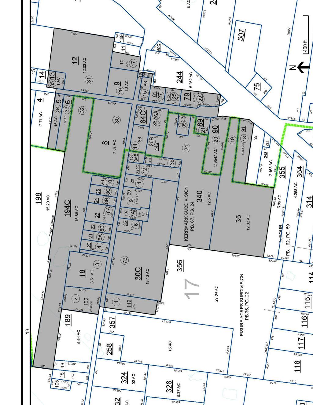
36 36
37 11. Form Prepared By Name Organization Leigh Ann Gardner, Jessica Bandel, Elizabeth Humphreys Center for Historic Preservation Street & Number Middle Tennessee State University, Box 80 Date October 9, 2012 City or Town Murfreesboro Telephone State TN Zip Code Additional Documentation Submit the following items with the completed form: Maps: A USGS map or equivalent (7.5 or 15 minute series) indicating the property's location. Sketch map for historic districts and properties having large acreage or numerous resources. Key all photographs to map. Photographs (refer to Tennessee Historical Commission National Register Photo Policy for submittal of digital images and prints) Additional items: (additional supporting documentation including historic photographs, historic maps, etc. should be included on a Continuation Sheet following the photographic log and sketch maps) Paperwork Reduction Act Statement: This information is being collected for applications to the National Register of Historic Places to nominate properties for listing or determine eligibility for listing, to list properties, and to amend existing listings. Response to this request is required to obtain a benefit in accordance with the National Historic Preservation Act, as amended (16 U.S.C.460 et seq.). Estimated Burden Statement: Public reporting burden for this form is estimated to average 100 hours per response including time for reviewing instructions, gathering and maintaining data, and completing and reviewing the form. Direct comments regarding this burden estimate or any aspect of this form to the Office of Planning and Performance Management. U.S. Dept. of the Interior, 1849 C. Street, NW, Washington, DC. 37
38 NPS Form a OMB No United States Department of the Interior National Park Service National Register of Historic Places Continuation Sheet Section number Page 38 Rosemark Historic Put District Here N/A Name of multiple listing (if applicable) Photo Log : City or Vicinity: Rosemark County: Shelby State: Tennessee Photographer: Elizabeth Humphreys and Carroll Van West Date Photographed: March of Kerrville-Rosemark Road (#1). Photographer facing south. 2 of Kerrville-Rosemark Road (#1), well house. Photographer facing south. 3 of Kerrville-Rosemark Road (#1), barn. Photographer facing south. 4 of Kerrville-Rosemark Road (#2). Photographer facing north. 5 of Kerrville-Rosemark Road (#2), well house and storage shed. Photographer facing northeast. 6 of Kerrville-Rosemark Road (#2), landscape. Photographer facing north. 7 of Kerrville-Rosemark Road (#3). Photographer facing north. 8 of Kerrville-Rosemark Road (#5A). Photographer facing north. 9 of Kerrville-Rosemark Road (#6). Photographer facing south. 10 of Kerrville-Rosemark Road (#7A). Photographer facing southwest. 11 of Kerrville-Rosemark Road (#7A), fuel tank. Photographer facing southwest. 12 of Kerrville-Rosemark Road (#7A), stock barn. Photographer facing southwest. 13 of Kerrville-Rosemark Road (#7A), slaughterhouse. Photographer facing south. 14 of Kerrville-Rosemark Road (#7A), slaughterhouse interior. Photographer facing north. 15 of 54 Kerrville-Rosemark Road (#7B), agricultural landscape. Photographer facing southwest. 16 of 54 First Presbyterian Church, 8582 Kerrville-Rosemark Road (#8A). Photographer facing north.
39 NPS Form a OMB No United States Department of the Interior National Park Service National Register of Historic Places Continuation Sheet Section number Page 39 Rosemark Historic Put District Here N/A Name of multiple listing (if applicable) 17 of 54 First Presbyterian Church (#8A). Photographer facing northwest. 18 of Kerrville-Rosemark Road (#9). Photographer facing southwest. 19 of Kerrville-Rosemark Road (#10). Photographer facing north. 20 of Kerrville-Rosemark Road (#11). Photographer facing south. 21 of Kerrville-Rosemark Road (#13A). Photographer facing southeast. 22 of Kerrville-Rosemark Road (#14). Photographer facing south. 23 of Kerrville-Rosemark Road (#14), servant dwelling. Photographer facing southeast. 24 of 54 Millington Telephone Company, 8741 Kerrville-Rosemark Road (#16). Photographer facing southwest. 25 of Kerrville-Rosemark Road (#17). Photographer facing north. 26 of Rosemark Road (#18). Photographer facing west. 27 of Rosemark Road (#19). Photographer facing west. 28 of Rosemark Road (#19), view toward outbuilding. Photographer facing west. 29 of Rosemark Road (#20). Photographer facing southwest. 30 of Rosemark Road (#21). Photographer facing west. 31 of Rosemark Road (#22), agricultural landscape. Photographer facing southeast. 32 of Rosemark Road (#23). Photographer facing southwest. 33 of Rosemark Road (#23), cookhouse/servant s dwelling. Photographer facing west. 34 of Rosemark Road (#25). Photographer facing east. 35 of 54 Moore Brothers Gin, 8617 Rosemark Road (#26A) toward Moore Brothers Warehouse (#26B). Photographer facing southwest. 36 of 54 Moore Brothers Gin, Lint House (#26A). Photographer facing southeast.
40 NPS Form a OMB No United States Department of the Interior National Park Service National Register of Historic Places Continuation Sheet Section number Page 40 Rosemark Historic Put District Here N/A Name of multiple listing (if applicable) 37 of Rosemark Road (#27). Photographer facing northeast. 38 of Rosemark Road (#28). Photographer facing southwest. 39 of 54 Richland Associate Reformed Presbyterian Church, 8658 Rosemark Road (#29). Photographer facing east. 40 of Rosemark Road (#30). Photographer facing west. 41 of 54 Tipton-Rosemark Academy, 8674 Rosemark Road (#31), Gymnasium. Photographer facing southeast. 42 of 54 Tipton-Rosemark Academy, c school building. Photographer facing east. 43 of Rosemark Road (#32). Photographer facing west. 44 of Rosemark Road (#32), Farm Office. Photographer facing southeast. 45 of Rosemark Road (#32), Barn. Photographer facing southeast. 46 of Rosemark Road (#32), Tenant House. Photographer facing southwest. 47 of Rosemark Road (#33) and 8727 Rosemark Road (#34). Photographer facing northwest. 48 of 54 Richland Lodge #748, 8736 Rosemark Road (#35). Photographer facing east. 49 of 54 View of agricultural landscape toward northwest intersection of Rosemark Road and Kerrville Rosemark Road. Photographer facing northeast. 50 of 54 Southeast intersection of Rosemark Road and Kerrville-Rosemark Road. Photographer facing southeast. 51 of 54 Northeast intersection of Rosemark Road and Kerrville-Rosemark Road. Photographer facing northeast. 52 of 54 View of Kerrville-Rosemark Road. Photographer facing east. 53 of 54 View of Rosemark Road. Photographer facing north. 54 of 54 View of intersection of Rosemark Road and State Route 14/Austin Peay Highway at south end of district. Photographer facing south.
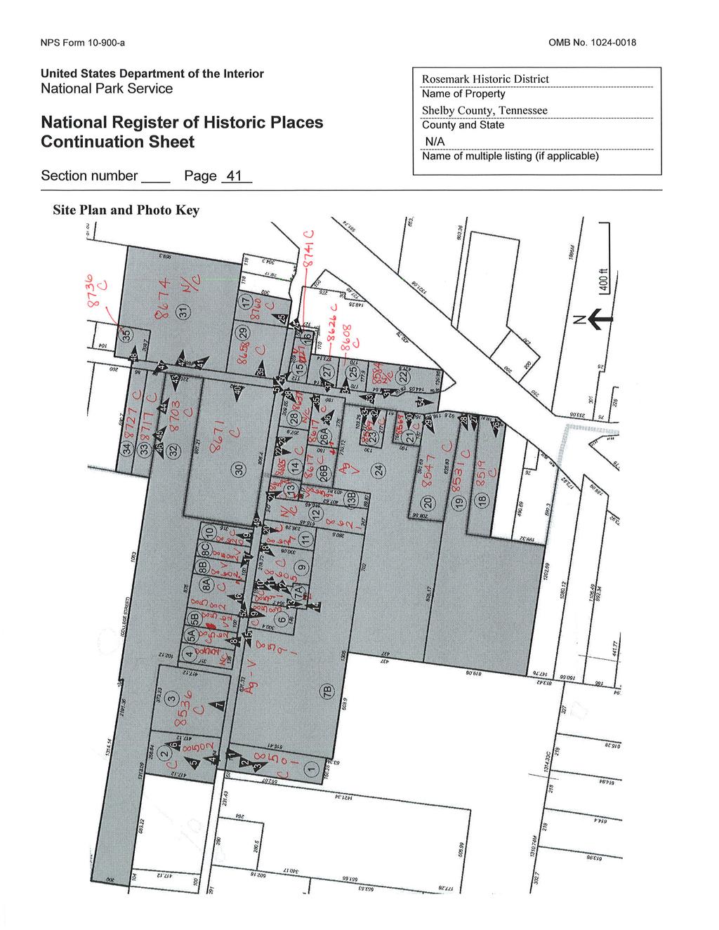
41
Ottawa Historic Resources Inventory: Commercial Historic District Building Information. Significance and Potential Eligibility
 C 01 1 Address: address 1 PIN: 21 11 218 001 Plan: Rectangular Stories: 2 Original Owner: Roof Type: Flat Building Names: Marquette School Foundation: Important Dates: ca 1955 Walls: BRICK Architect /
DRAFT APPENDIX C. COMMON RESIDENTIAL STYLES IN THE SNOHOMISH HISTORIC DISTRICT Era of construction and architectural characteristics
 COMMON RESIDENTIAL STYLES IN THE SNOHOMISH HISTORIC DISTRICT Era of construction and architectural characteristics Gothic Revival (1840 1880) Steeply pitched roof Cross gables common Round turret Bay windows
Part 3 TYPE: BUNGALOW. 1910s 1930s
 RESIDENTIAL TYPES & STYLES Part 3 TYPE: BUNGALOW 1910s 1930s The bungalow is a twentieth-century residential type that arrived in New Orleans in the 1910s via California and the Arts and Crafts movement.
Baker Historic District
 DISTRICT DESCRIPTION This is a historically middle-class neighborhood in the South Side, an area annexed by Denver in 1883, consisting of more than 20 tightly interwoven residential subdivisions. The earliest
Lincoln Mill and Mill Village Historic District. National Register Nomination. 25 May 2009 SCHNEIDER. Historic Preservation, LLC
 Lincoln Mill and Mill Village Historic District National Register Nomination 25 May 2009 SCHNEIDER Historic Preservation, LLC 411 E. 6th Street, Anniston, Alabama 36207 Phone: 256-310-6320 e-mail: dbschneider@bellsouth.net
HOMEWOOD. Architectural Style Guide
 HOMEWOOD Architectural Style Guide HOMEWOOD Architectural Style Guide Homewood Architectural Style Guide 2016 Sponsors: Operation Better Block Neighborhood Allies Carnegie Mellon University To the residents
FINAL DRAFT. Building 59
 Building 59 LOCATION Patch Road behind Building 135 Fort Monroe Hampton, Va. 7 MANAGEMENT ZONE Zone C North Gate/Stilwell Road CLASSIFICATION Contributing Structure CONDITION Good 6 E F PRESERVATION CONSIDERATIONS
NPS Form OMB No (Oct. 1990)
") NPS Form 10-900 OMB No. 10024-0018 (Oct. 1990) United States Department of the Interior National Park Service NATIONAL REGISTER OF HISTORIC PLACES REGISTRATION FORM 1. historic name: other name/site number:
NPS Form 10-900 OMB No. 10024-0018 (Oct. 1990) United States Department of the Interior National Park Service NATIONAL REGISTER OF HISTORIC PLACES REGISTRATION FORM 1. historic name: other name/site number:
VIRGINIA BEACH HISTORICAL REGISTER NOMINATION/APPLICATION FORM
 VIRGINIA BEACH HISTORICAL REGISTER NOMINATION/APPLICATION FORM The completion and submittal of this form constitutes the formal nomination and application of a property to the Virginia Beach Historical
The NWX American Foursquare
 The NWX American Foursquare History and Character Known by a variety of names, including Edwardian, American Basic, and the Basic Box, the American Foursquare made its appearance just after the turn of
What Style is My House?
 What Style is My House? -A Guide to Common House Styles in Decatur, GA- Contents American Small House.. p.2 Colonial Revival....p.3 Craftsman Cottage...p.4 English Vernacular Revival Cottage...p.5 American
Gateway Corridor Standards
 Gateway Corridor Standards Building design and construction: Bungalow Classical Revival Colonial Revival Frame Vernacular Gothic Revival Italianate Mediterranean Revival Queen Anne Shingle architectural
Historic Preservation DESIGN GUIDELINES
 CITY OF GRANBURY Historic Preservation DESIGN GUIDELINES 4. DEFINITIONS Adam (Adamesque, Adam style) Architrave Ashlar Awnings Baluster Balustrade Bargeboard (1780-1820) An architectural style most commonly
FINAL DRAFT. Building 77
 Building 77 LOCATION North Side of Ruckman Road Fort Monroe Hampton, Va. MANAGEMENT ZONE Zone D McNair, Ingalls, Fenwick Corridor CLASSIFICATION Contributing Structure CONDITION Good 5 4 8-A D E PRESERVATION
KNOXVILLE HISTORIC ZONING COMMISSION STAFF REPORT CERTIFICATE OF APPROPRIATENESS APPLICATION
 KNOXVILLE HISTORIC ZONING COMMISSION STAFF REPORT CERTIFICATE OF APPROPRIATENESS APPLICATION PROPERTY ADDRESS: 2331 Jefferson Ave 37876 FILE NO.: 4 E 15 HZ DISTRICT: Edgewood Park City H 1 MEETING DATE:
Morgan s Subdivision Historic District Character-defining Features
 Morgan s Subdivision Historic District Character-defining Features DISTRICT DESCRIPTION This small addition, designed as a neighborhood for those wishing to move east from Capitol Hill, was predominantly
Gateway Corridor Standards
 Gateway Corridor Standards Building design and construction: Bungalow Classical Revival Colonial Revival Frame Vernacular Gothic Revival Italianate Mediterranean Revival Queen Anne Shingle architectural
ST. ANDREWS HISTORIC NEIGHBORHOOD OVERLAY DESIGN STANDARDS
 ST. ANDREWS HISTORIC NEIGHBORHOOD OVERLAY DESIGN STANDARDS The following recommended list of development criteria are presented for consideration in guiding residential development in the St. Andrews historic
Address: 302 West Main Street PIN: Plan: Rectangular Stories: 2 Original Owner: Roof Type: Flat
 D 01 1 Address: 302 West Main Street PIN: 21 11 400 014 Plan: Rectangular Stories: 2 Building Names: Important Dates: ca 1920 Walls: BRICK Architectural Style: American, Late 19th / Early 20th C: Commercial
REPORT TO THE HISTORIC DISTRICT COMMISSION
 Agenda Number: HDC 14-15 MEETING DATE: August 21, 2014 REPORT TO THE HISTORIC DISTRICT COMMISSION SUBJECT: 196 E. Poplar Avenue - Certificate of Appropriateness for exterior alterations INTRODUCTION: Mike
EXCELSIOR SPRINGS HISTORIC RESOURCES 10
 EXCELSIOR SPRINGS HISTORIC RESOURCES 10 Resource No. 1. Property name, present Springdale Apartments 6. Location Map Property name, historic Arlington Hotel; Excelsior Club; Excelsior Springs Sanitarium
211 Turner St. before rehabilitation
 Rehabilitation Tax Credits used to Restore Unusual Gothic Revival-Style House in Beaufort By John P. Wood Preservation/Restoration Specialist, HPO Eastern Office Last fall restoration work was completed
Chapter 11. Exterior Design Factors. Introduction. House design does not stop once room arrangements are determined
 Chapter 11 Exterior Design Factors Introduction House design does not stop once room arrangements are determined Exterior must also be considered Often a client has a certain style in mind that dictates
Architectural Inventory Form (page 1 of 5)
") OAHP1403 Rev. 9/98 COLORADO CULTURAL RESOURCE SURVEY (page 1 of 5) Official eligibility determination (OAHP use only) Date Initials Determined Eligible- NR Determined Not Eligible- NR Determined Eligible-
OAHP1403 Rev. 9/98 COLORADO CULTURAL RESOURCE SURVEY (page 1 of 5) Official eligibility determination (OAHP use only) Date Initials Determined Eligible- NR Determined Not Eligible- NR Determined Eligible-
Gateway Corridor Standards
 Gateway Corridor Standards Building design and construction: Bungalow Classical Revival Colonial Revival Frame Vernacular Gothic Revival Italianate Mediterranean Revival Queen Anne Shingle architectural
Eastlake/Stick - Common character defining features
 Eastlake/Stick The Stick style dates from 1860 to around 1890. The Eastlake style dates from the 1870s and 1880s. Examples of the Stick and Eastlake styles in Los Angeles date from the late 1800s. The
CHAPTER 6 DESIGN GUIDELINES FOR INDIVIDUAL BUILDING ELEMENTS. Commercial Facades
 Design Guidelines for Historic Resources CHAPTER 6 DESIGN GUIDELINES FOR INDIVIDUAL BUILDING ELEMENTS This chapter presents design guidelines for the preservation of individual historic building elements
Tazewell Pike. Neighborhood Conservation Overlay District Design Guidelines
 Tazewell Pike Neighborhood Conservation Overlay District Design Guidelines Knoxville Knox County Metropolitan Planning Commission November 2, 2000 These design guidelines were: Adopted by the Knoxville
State of Mississippi Department of Archives and History P.O. Box 571 Jackson, MS HISTORIC RESOURCES INVENTORY
 State of Mississippi Department of Archives and History P.O. Box 571 Jackson, MS 39205 1. a. Property Name, Historic Stockton-Faulkner House 1. b. Property Name, Common Brandt Memory House 2. Property
THE CITY OF LAKE FOREST HISTORIC PRESERVATION COMMISSION LOCAL LANDMARK NOMINATION INSTRUCTIONS
 THE CITY OF LAKE FOREST HISTORIC PRESERVATION COMMISSION LOCAL LANDMARK NOMINATION INSTRUCTIONS This application is for the nomination of individual properties as Local Historic Landmarks within the City
Maryland Historical Trust Inventory No. PG: 85B-007 Maryland Inventory of Historic Properties Form
 Maryland Historical Trust Inventory No. PG: 85B-007 Maryland Inventory of 1. Name of Property (indicate preferred name) historic other 2. Location street and number Cedarville State Forest Road, Cedarville
Resources Present: _x_building Structure Object Site District _X_Element of District Other:
 NRHP Status Code 5D1 - contributor Page 1 of 1 *Resource Name: 1006 S. Hayworth Ave. P1: Other Identifier: 1006 S. Hayworth Ave. c: Address: 1006 S. Hayworth Ave., Los Angeles, CA 90035 e: Other Locational
The NWX Colonial Revival Style
 The NWX Colonial Revival Style History and Character The NorthWest Crossing Colonial Revival style home takes it cues from the rebirth of interest in the early English and Dutch houses of the Atlantic
5.1 INTRODUCTION 5.2 EXISTING CONDITIONS
 Chapter 5: Aesthetic Resources 5.1 INTRODUCTION This chapter considers the potential of the Proposed Action to impact the visual character and aesthetic resources of the project area and the surrounding
ADDENDUMS CRAFTSMAN The Craftsman style of Architecture was influenced by the English Arts and Crafts movement and East Asia, particularly Japan. In t
 ADDENDUMS CRAFTSMAN The Craftsman style of Architecture was influenced by the English Arts and Crafts movement and East Asia, particularly Japan. In the beginning Craftsman homes were a workman s bungalow
DEPARTMENT OF HISTORIC RESOURCES
 DEPARTMENT OF HISTORIC RESOURCES 2801 Kensington Avenue, Richmond, Virginia 23221 Telephone: (804) 367-2323 Fax: (804) 367-2391 PRELIMINARY INFORMATION FORM HISTORIC DISTRICT An historic district is defined
1 of 1 1/31/2016 2:49 PM
 Guide to Residential Styles Realtor Magazine http://realtormag.realtor.org/home-and-design/guide-residential-styles 1 of 1 1/31/2016 2:49 PM Every house has a style. Sometimes it has two or more; because
- As the designated authority under the National Historic Preservation Act
 - As the designated authority under the National Historic Preservation Act of 1986, as amended, I hereby certify that this )C nomination - request for determination of eligibility meets the documentation
National Register of Historic Places Registration Form
 NPS Form 10-900 OMB No. 1024-0018 (Expires 5/31/2012) United States Department of the Interior National Park Service National Register of Historic Places Registration Form This form is for use in nominating
M E M O R A N D U M PLANNING AND COMMUNITY DEVELOPMENT DEPARTMENT CITY OF SANTA MONICA PLANNING DIVISION
 M E M O R A N D U M 10-B PLANNING AND COMMUNITY DEVELOPMENT DEPARTMENT CITY OF SANTA MONICA PLANNING DIVISION DATE: April 9, 2018 TO: FROM: SUBJECT: The Honorable Landmarks Commission Planning Staff 133
CITY OF ZEPHYRHILLS DESIGN GUIDELINES FOR REHABILITATING THE EXTERIORS OF CONTRIBUTING STRUCTURES IN THE HISTORIC DISTRICT
 CITY OF ZEPHYRHILLS DESIGN GUIDELINES FOR REHABILITATING THE EXTERIORS OF CONTRIBUTING STRUCTURES IN THE HISTORIC DISTRICT TABLE OF CONTENTS INTRODUCTION... i THE REVIEW PROCESS...x CHANGES REQUIRING A
Design Guidelines for
 Chapter 6 Design Guidelines for Historic Resources Design Guidelines for Individual Building Elements This chapter presents design guidelines for the preservation of individual historic building elements
Chapter 8: BEACH SOUTH OF ATLANTIC AVENUE NEIGHBORHOOD PLANNING AREA ANALYSIS
 Chapter 8: BEACH SOUTH OF ATLANTIC AVENUE NEIGHBORHOOD PLANNING AREA ANALYSIS The Beach South of Atlantic Avenue Neighborhood Planning Area includes the parcels adjacent to S Fletcher Avenue from Atlantic
Chapel Hill Historic District Commission MILES RESIDENCE. Request for a Certificate of Appropriateness 240 Glandon Drive PIN
 Chapel Hill Historic District Commission MILES RESIDENCE Request for a Certificate of Appropriateness 240 Glandon Drive PIN 9788871387 The Miles residence is a Cape Cod Revival structure located at 240
National Register Nomination, Linden Place, 500 Hope Street, Bristol, RI 02809
 Roger Williams University DOCS@RWU Historic Preservation Capstone Projects School of Architecture, Art, and Historic Preservation Theses and Projects 2015 National Register Nomination,, 500 Hope Street,
Atkins Hall (Building 31)
") Atkins Hall (Building 31) Masonry detailing: brick segmental arches over window and door openings, continuous water table at top of foundation Sheet metal string course to define entablature at sheet metal
Atkins Hall (Building 31) Masonry detailing: brick segmental arches over window and door openings, continuous water table at top of foundation Sheet metal string course to define entablature at sheet metal
National Register of Historic Places inventory Nomination Form
 NPS Form 10-900-a OMB No. 1024-0018 (3-82) Exp. 10-31-84 United States Department of the Interior National Park Service National Register of Historic Places inventory Nomination Form F
Chapter 6.0: Architectural Styles
 Chapter 6.0: Architectural Styles In this chapter you will find: Residential Architectural Styles Commercial Architectural Styles The following chapter identifies those architectural styles most frequently
handling). The information will be reviewed and verified by the Commission at its next regular meeting, then forwarded to Ould Colony Artisans.
. The information will be reviewed and verified by the Commission at its next regular meeting, then forwarded to Ould Colony Artisans.") Thank you for your interest in the Historic Marker Program. The Hampton Heritage Commission has established this program to recognize buildings in Hampton that contribute in some positive way to the appreciation
Thank you for your interest in the Historic Marker Program. The Hampton Heritage Commission has established this program to recognize buildings in Hampton that contribute in some positive way to the appreciation
Architectural Inventory Form (page 1 of 5)
") OAHP1403 Rev. 9/98 COLORADO CULTURAL RESOURCE SURVEY (page 1 of 5) I. IDENTIFICATION 1. Resource number 5RT-2050 2. Temporary resource number: 145008005 3. County: Routt County 4. City: Steamboat Springs
OAHP1403 Rev. 9/98 COLORADO CULTURAL RESOURCE SURVEY (page 1 of 5) I. IDENTIFICATION 1. Resource number 5RT-2050 2. Temporary resource number: 145008005 3. County: Routt County 4. City: Steamboat Springs
HERITAGE ASSESSMENT REPORT APPENDIX B. Cultural Heritage Resource Evaluation Forms. Project Number:
 APPEDIX B Cultural Heritage Resource Evaluation Forms Project umber: 160960594 Project umber: 160960594 35 List of Properties 823 County Road 4... 1 840 County Road 4... 2 1568 County Road 5... 3 1582/1590
Ordnance Street 110 Plan OS Lot 413 B202; parts of Lot 412 and portion of Lot 413
 Ordnance Street 110 Plan OS Lot 413 B202; parts of Lot 412 and portion of Lot 413 110 Ordnance Street has cultural heritage value under 3 categories Physical built in 1886, it is an example of late 19
HISTORIC RESOURCES INVENTORY - BUILDING AND STRUCTURES
 HISTORIC RESOURCES INVENTORY - BUILDING AND STRUCTURES * Note: Please attach any additional or expanded information on a separate sheet. GENERAL INFORMATION Building Name (Common) Neighborhood Music School
National Register of Historic Places Registration Form
 United States Department of the Interior National Park Service National Register of Historic Places Registration Form DRAFT This form is for use in nominating or requesting determinations for individual
City or town: Montpelier State: Vermont County: Washington_
 United States Department of the Interior National Park Service National Register of Historic Places Registration Form This form is for use in nominating or requesting determinations for individual properties
DRAFTING III- ARCHITECTURAL
 7963 DRAFTING III- ARCHITECTURAL CURRICULUM GUIDE CURRICULUM SUMMER 2005 CROSSWALK Trade & Industrial Education Career Technical Education CURRICULUM CROSSWALK PUBLIC SCHOOLS OF NORTH CAROLINA State Board
Parish Derry Slopes ITM Coordinates ; NG Coordinates C House B1 and farm buildings B2; Registered Garden L061
 Asset Ref No. HB/01/27/018A-C, Ballyarnett & Farm; Registered Historic Garden L061 Heritage Type Location Protection Status Condition Ownership (if known) Built Post-Medieval house & farm OS 6-inch map
=-=========================================================================
 NPS Form 10-900 (Rev. 8-86) United States Department of the Interior N~tional Park Service IONAL REGISTER OF HISTORIC PLACES REGISTRATION FORM [\ l r~ LISTED JUr J O 3 1998,,.,-)p fu d OMB No. 1024-0028
Design Guidelines for a Mixed-Use Community. Prairie Trail Pattern Book
 Design Guidelines for a Mixed-Use Community Prairie Trail Pattern Book u r b a n d e s i g n a s s oc i a t e s p r a i r i e t r a i l p a t t e r n b o o k september 2007 A n k e n y, I o w a Partners
B E R O A R C H I T E C T U R E P L L C
 B E R O A R C H I T E C T U R E P L L C A R C H I T E C T U R E S U S T A I N A B I L I T Y P R E S E R V A T I O N Thirty-Two Winthrop Street, Rochester, New York 14607 585-262-2035 contact@beroarchitecture.com
They Can t All Be Victorians: When Old Houses Have No Style
 They Can t All Be Victorians: When Old Houses Have No Style Tuesday June 7 10:30 a.m. 12:00 p.m. They can T all be victorians When old houses have no style A discussion of ordinary buildings for architectural
Community Design & Guidelines. Ooltewah, Tennessee
 Community Design & Guidelines Ooltewah, Tennessee www.cambridgesquaretn.com L E G A C Y R E A L E S TAT E & D E V E L O P M E N T 9 4 5 3 B r a d m o r e L a n e O o l t e w a h, T N 3 7 3 6 3 4 2 3-5
Heritage Designation Brief
 Heritage Designation Brief SMITHTOWN HILL HOUSE 269 Edinburgh Street Peterborough Architectural Conservation Advisory Committee April, 2004 HERITAGE DESIGNATION STATUS SHEET Street Address: 269 Edinburgh
City of Madison Landmarks Commission LANDMARKS AND LANDMARK SITES NOMINATION FORM (1)
") City of Madison Landmarks Commission LANDMARKS AND LANDMARK SITES NOMINATION FORM (1) Name of Building or Site Common Name Judith and Damien Wilson House Historic Name (if applicable) Loyle and Hilda Boutell
City of Madison Landmarks Commission LANDMARKS AND LANDMARK SITES NOMINATION FORM (1) Name of Building or Site Common Name Judith and Damien Wilson House Historic Name (if applicable) Loyle and Hilda Boutell
THE AVENUES HERITAGE CONSERVATION DISTRICT STUDY BUILDING INVENTORY SHEET
 THE AVENUES HERITAGE CONSERVATION DISTRICT STUDY BUILDING INVENTORY SHEET Issued by the Arts, Culture & Heritage Division of the City of Peterborough with ERA Architects Inc. Thank you for agreeing to
Village review design guidelines
 Village review design guidelines Part I Architectural Context Franklin Maple Street Neighborhood Federal Street Neighborhood Maine Street Neighborhood Mill Street Neighborhood Northwest Neighborhood Pleasant
Historic District Commission
 Historic District Commission Page 1 of 26 Staff Report June 6 th, 2018 ADMINISTRATIVE ITEMS / OLD BUSINESS: Administrative Approvals: 1. 238 Deer Street - Recommend Approval 2. 59 Sheafe Street - Recommend
HISTORIC SITE FORM - HISTORIC SITES INVENTORY PARK CITY MUNICIPAL CORPORATION (10-08) 1 IDENTIFICATION
 1 IDENTIFICATION") HISTORIC SITE FORM - HISTORIC SITES INVENTORY PARK CITY MUNICIPAL CORPORATION (10-08) 1 IDENTIFICATION Name of Property: Address: 158 Main Street City, County: Park City, Summit County, Utah AKA: Tax Number:
HISTORIC SITE FORM - HISTORIC SITES INVENTORY PARK CITY MUNICIPAL CORPORATION (10-08) 1 IDENTIFICATION Name of Property: Address: 158 Main Street City, County: Park City, Summit County, Utah AKA: Tax Number:
Predominant Architectural Styles
 The following chapter identifi es those architectural styles most frequently represented within the histroic districts of the City of Independence and the period in history during which these styles were
buildings sites structures objects 0 Total Number of contributing resources previously listed in the National Register : 0
 NPS Form 10-900 (Rev. 8-86) OMB No. 1024-0018 United States Department of the Interior National Park Service NATIONAL REGISTER OF HISTORIC PLACES REGISTRATION FORM other name/site number: 2. Location street
Architectural Patterns
 Overview the architectural patterns section illustrates key elements and design strategies for the four permitted traditional architectural styles and two specific places the Town Center and the Artist
National Register of Historic Places Registration Form
 NPS Form 10-900 OMB No. 10024-0018 (Oct. 1990) National Register of Historic Places Registration Form This form is for use in nominating or requesting determinations for individual properties and districts.
DISMANTLED FEDERAL / GREEK REVIVAL HOUSE PARTS FOR SALE
 Randall Evans Athens Architectural Workshop Athens NY stonloon@mac.com 518-526-1725 DISMANTLED FEDERAL / GREEK REVIVAL HOUSE PARTS FOR SALE On a high escarpment on the Northern end of the Catskills sat
PARMELEE FARMHOUSE Killingworth, Connecticut
 PARMELEE FARMHOUSE Killingworth, Connecticut HISTORIC FABRIC ASSESSMENT SURVEY Prepared for The Town of Killingworth Prepared by Thomas Paske Westfield, Massachusetts January 2011 Objectives and Methodology
CHAPTER 4 OFFICE, LIGHT INDUSTRIAL/FLEX, COMMERCIAL, AND MIXED-USE ARCHITECTURAL STYLES
 OFFICE, LIGHT INDUSTRIAL/FLEX, COMMERCIAL, AND MIXED-USE ARCHITECTURAL STYLES CHAPTER OVERVIEW This chapter includes the following architectural styles that are appropriate for Commercial, Mixed- Use,
ARCHITECTURAL STYLES SECTION 6.2 INTRODUCTION TO PICO-UNION HPOZ PICO-UNION PRESERVATION PLAN - OCTOBER 12, 2006
 SECTION 6.2 INTRODUCTION TO PICO-UNION HPOZ The Architectural Styles Chapter of this Plan is intended to give an overview of the predominant styles that may exist in the Pico-Union HPOZ. Each architectural
Historic District Commission Staff Report November 4 th & 18 th, 2015
 Historic District Commission Staff Report November 4 th & 18 th, 2015 Page 1 of 36 8. 54/58 Ceres Street (Minor HVAC units (roof-mounted)) 9. 67-77 State Street (Minor Revise windows and doors) 10. 143
- buildings. (Rev. 8-86) NATIONAL REGISTER OF HISTORIC PLACES REGISTRATION FORM. other name/site number: not for publication:
 NATIONAL REGISTER OF HISTORIC PLACES REGISTRATION FORM. other name/site number: not for publication:") NPS Form 10-900 (Rev. 8-86) OMB No. 1024-0018 f United States Department of the Interior National Park Service NATIONAL REGISTER OF HISTORIC PLACES REGISTRATION FORM other name/site number: not for publication:
NPS Form 10-900 (Rev. 8-86) OMB No. 1024-0018 f United States Department of the Interior National Park Service NATIONAL REGISTER OF HISTORIC PLACES REGISTRATION FORM other name/site number: not for publication:
Resolution : Exhibit A. Downtown District Design Guidelines March 2003
 Resolution 03-011: Exhibit A Downtown District Design Guidelines March 2003 DOWNTOWN DISTRICT DESIGN GUIDELINES CITY OF SOUTHLAKE, TEXAS Adopted March 2003 1 DOWNTOWN DISTRICT DESIGN GUIDELINES Adopted
Purpose of Conformance to Styles. Historical Architectural Movements. Vernacular. Revival Styles. Neoclassical Styles.
 Originated in the U.S.A. in parallel to the Victorian movement. Purpose of Conformance to Styles The section describes historical architectural movements, which yielded certain architectural styles. The
HISTORIC SITE FORM - HISTORIC SITES INVENTORY PARK CITY MUNICIPAL CORPORATION (10-08) 1 IDENTIFICATION
 1 IDENTIFICATION") HISTORIC SITE FORM - HISTORIC SITES INVENTORY PARK CITY MUNICIPAL CORPORATION (10-08) 1 IDENTIFICATION Name of Property: John W. Buck House Address: 1110 Woodside Avenue AKA: City, County: Park City, Summit
HISTORIC SITE FORM - HISTORIC SITES INVENTORY PARK CITY MUNICIPAL CORPORATION (10-08) 1 IDENTIFICATION Name of Property: John W. Buck House Address: 1110 Woodside Avenue AKA: City, County: Park City, Summit
Gillingham Hall Norfolk
 Gillingham Hall Norfolk Figure 1. Engraving after a drawing by J S Cotman 1818 Impact assessment of proposed alterations NHER No. 10738 Stephen Heywood FSA Heritage and Landscape Norfolk County Council
HISTORIC RESOURCES INVENTORY - BUILDING AND STRUCTURES. Please send completed form to: National Register and State Register Coordinator,
 HISTORIC RESOURCES INVENTORY - BUILDING AND STRUCTURES Please send completed form to: National Register and State Register Coordinator, Connecticut Commission State Historic on Culture Preservation & Tourism,
HISTORIC SITE FORM - HISTORIC SITES INVENTORY PARK CITY MUNICIPAL CORPORATION (10-08) 1 IDENTIFICATION
 1 IDENTIFICATION") HISTORIC SITE FORM - HISTORIC SITES INVENTORY PARK CITY MUNICIPAL CORPORATION (10-08) 1 IDENTIFICATION Name of Property: William Tretheway House Address: 335 Woodside Avenue AKA: City, County: Park City,
HISTORIC SITE FORM - HISTORIC SITES INVENTORY PARK CITY MUNICIPAL CORPORATION (10-08) 1 IDENTIFICATION Name of Property: William Tretheway House Address: 335 Woodside Avenue AKA: City, County: Park City,
Architectural Inventory Form
 COLORADO CULTURAL RESOURCE SURVEY Page 1 of 8 Official Eligibility Determination (OAHP use only) Rev. 9/98 OAHP1403 Date Initials Determined Eligible National Register Determined Not Eligible National
Lancaster Conservation Area Appraisal. Character Area 8. Cathedral
 Lancaster Conservation Area Appraisal Character Area 8. Cathedral March 2013 118 3.8 Character Area 8. Cathedral 3.8.1. Definition of Special Interest "This character area is distinctive for the fine group
Westboro Neighborhood Conservation District Westboro Homeowners Association
 Westboro Neighborhood Conservation District Westboro Homeowners Association Westboro Homeowners Association Westboro Homeowners Association P.O. Box 3829 Topeka, KS 66604 Email: westboronews@gmail.com
Sainte-Catherine Street West
 PACKARD BUILDING 4026-4032 Sainte-Catherine Street West Category: 1 Front North Façade South Façade: Garage Entrance North Façade: Entrance Portico South Facade Key Plan FOURNIER GERSOVITZ MOSS DROLET
DePauw Avenue Historic District
 United States Department of the Interior National Park Service National Register of Historic Places DePauw Avenue Historic District DESCRIPTION The DePauw Avenue Historic District is located along DePauw
Lenoir Downtown National Register Historic District Christmas Ornament Series
 Lenoir Downtown National Register Historic District Christmas Ornament Series 828-757-2177 www.cityoflenoir.com 2008 The Clock on the Square The prominence of street clocks parallels the growth of American
HISTORIC RESOURCES INVENTORY - BUILDING AND STRUCTURES
 HISTORIC RESOURCES INVENTORY - BUILDING AND STRUCTURES Connecticut Commission on Culture & Tourism, One Constitution Plaza, 2nd Floor, Hartford, CT 06103 * Note: Please attach any additional or expanded
TULSA PRESERVATION COMMISSION COA SUBCOMMITTEE STAFF REPORT
 TULSA PRESERVATION COMMISSION COA SUBCOMMITTEE STAFF REPORT Thursday, August 6, 2015 COA-15-037 COA NUMBER: COA-15-037 PROPERTY ADDRESS: 1724 SOUTH MADISON AVENUE DISTRICT: NORTH MAPLE RIDGE HISTORIC DISTRICT
List of Buildings of Local Architectural or Historic Interest BUCKHURST HILL PARISH
 List of Buildings of Local Architectural or Historic Interest BUCKHURST HILL PARISH 1. ST. STEPHEN'S CHURCH Albert Road /Buckhurst Way Attractive, albeit modest, late 19th century church (date stone 1876)
Replacement Cost Questionnaire
 Replacement Cost Questionnaire 1. Please provide some general information about yourself: A) Name and address of insured location (as it appears on your Homeowners policy): Name: Street Address: City:
Town Center Design Guidelines
 Adopted by City Council on September 18, 2018 Design Theme The Draper Town Center Design Theme is defined as encompassing those architectural design styles that were prevalent in the construction of civic
History of the Foundation Buildings and Landscapes
 CORNER HOUSE 1 FOUNDATION HOUSE LONG HOUSE History of the Foundation Buildings and Landscapes The Fourth Corner Foundation s name derives from occupying one corner of the intersection of Windham Four Corners,
HERITAGE STATEMENT AND IMPACT ASSESSMENT HILLBARK FARMHOUSE FRANKBY
 HILLBARK FARMHOUSE HERITAGE STATEMENT AND IMPACT ASSESSMENT HILLBARK FARMHOUSE FRONT ENTRANCE CONTENTS Executive summary 1.0 INTRODUCTION 1.1. Background to the report 1.2. Purpose of the Report 2.0 SIGNIFICANCE
B E R O A R C H I T E C T U R E P L L C
 B E R O A R C H I T E C T U R E P L L C A R C H I T E C T U R E S U S T A I N A B I L I T Y P R E S E R V A T I O N Thirty-Two Winthrop Street, Rochester, New York 14607 585-262-2035 contact@beroarchitecture.com
Analysis of Environs of 1000 New York Street, German Methodist Episcopal Church
 Item No. 3: L-14-00028 p.1 Analysis of Environs of New York Street, German Methodist Episcopal Church Step One Historical Significance and Context According to the application for Historic Landmark Designation,
Enterprise. Pattern Book July 2009
 Enterprise Pattern Book July 2009 TABLE OF CONTENTS PAGE Acknowledgements i 1.0 Introduction 1 1.1 Background 1 1.2 Purpose and Intent 2 1.3 Applicability 2 ENTERPRISE PATTERN BOOK Prepared by: 2.0 Preservation