Homewood Evacuation and Life Safety Report
|
|
|
- Crystal Henry
- 5 years ago
- Views:
Transcription
1 Homewood Evacuation and Life Safety Report September 25, 2016 (Revised September 29, 2016) Contents 1. INTRODUCTION STATEMENT of PURPOSE EVACUATION NON EXACERBATION EXISTING CONDITIONS PROPOSED FIRE SAFETY MEASURES Improved Prepositioned Fire Fighting Capability and Equipment Increased Staffing New Apparatus Improved Water System Project Structure Safety Program Building Type and Material Class Defensible Space and Vegetation Management Education, Operations and Maintenance Public Communication Construction Mitigation Other Agreements Conclusion Page 1 of 13
2 1. INTRODUCTION This report is written in reference to the Homewood Mountain Resort (HMR) Ski Area Master Plan Project (the Project ) that was approved by Placer County in December of 2011, and subsequently approved by the Tahoe Regional Planning Agency (TRPA) Governing Board, following environmental review under the California Environmental Quality Act (CEQA) and the TRPA Compact process. The contents of this report are based on the Project as denoted in that approval. As such, the reader is directed to the Final EIR/EIS for complete details of the Project, which is available at plans/. Furthermore, this report is limited in scope to addressing issues of Evacuation and Life Safety, which are typically associated with wildfire, however, it is applicable to other disasters that may cause the evacuation of the Project. 2. STATEMENT of PURPOSE This report was commissioned by the North Tahoe Fire Protection District ( NT Fire ) for the purposes of providing an evaluation and clarification of Homewood s commitments and mitigation and to provide further details as needed for construction standards, fire safety measures, evacuation procedures and shelter in place concepts to insure that the Project will not result in any significant adverse impacts on wildfire evacuation risks on the West Shore during construction or operation and will not exacerbate any existing wildfire evacuation risks in the Lake Tahoe region given the changed circumstances in the Project Area since the County s and TRPA s approvals in Furthermore, to accomplish the goal of not exacerbating current evacuation systems for neighboring residents and visitors, this report evaluates Homewood s commitment to providing areas of refuge to increase life safety protection in the event of a fire requiring regional evacuation, in which residents outside of the Project boundary can find refuge in a wildland fire scenario. This report was mandated by a settlement agreement (the Settlement ) between Homewood Resort and a plaintiff who opposed the certification of the project EIR by Placer County. The Settlement states the following: Homewood will work with the County and the NTFPD to obtain a written report determining that the changed circumstances in the Project Area and Homewood s overall commitments to wildfire evacuation mitigation measures are sufficient to ensure that the Project will not result in any significant adverse impacts on wildfire evacuation risks on the West Shore during construction or operation and will not exacerbate any existing wildfire evacuation risks in the Lake Tahoe region EVACUATION The Project area is covered in the Placer Operational Area East Side Emergency Evacuation Plan (EEP) (appendix F) which was adopted in March of 2015, which replaced a similar plan dated The EEP is the regional plan for the coordination of Incident Command and Evacuation Procedures in Page 2 of 13
3 the Project Area. This EEP, among other things, notes the complexities and risks associated with Evacuation and states Despite a record of very successful evacuations in the past, the limited number of roads in the area always makes evacuations problematic. The EEP further states the assumptions as follows: a. An evacuation order is given coincident with first response/initial attack. b. Evacuation of the entire eastern side of the County is not required. c. Most, but not all, of the roads and pre designated shelter and evacuation centers on the eastern side are available for use. d. Mutual aid resources for all disciplines are available. e. There will be limited County emergency management organization support in the initial stages of an incident. It should be noted here that evacuation includes moving people to pre designated shelter and evacuation centers. An integral part of this report calls for providing a shelter and evacuation center(s) on site. This is accomplished through an integrated onsite life safety plan that provides for in situ methods of protection that are independent of the availability of immediate evacuation. In addition to the EEP noted above, NT Fire publishes an Emergency Preparedness and Evacuation Guide, which identifies emergency evacuation routes in the Project area and Region (Appendix E, p ). California State Route 89 (SR 89) is the route from which evacuations will occur based on this guide. SR 89 intersects Interstate 80 (I 80) to the north in Truckee, California, SR 28 in Tahoe City, California, and U.S. 50 at Lake Tahoe Boulevard in South Lake Tahoe. The EIR/EIS identified existing traffic congestion during peak summer periods near the junction of SR 89 and SR 28 in Tahoe City in the vicinity of Fanny Bridge in Tahoe City. Subsequent to the Project, a project was approved and funded to add a second bridge across the Truckee River just to the east of Fanny Bridge. This new bridge would improve west bound traffic through the Tahoe City Y and, therefore, would increase overall evacuation capability for the West Shore. Consequently, as this bridge addition is both permitted and funded, the evacuation capabilities of the West Shore will be improved over the pre approval condition of the Project. However, evacuation is only one part of any life safety plan and, furthermore, any complex evacuation route can become compromised in a major disaster. Therefore, this report, consistent with the Settlement and direction of NT Fire, includes several items on a programmatic level that will lower the demand on evacuation systems by providing defensible space, fire safe buildings, increased firefighting capacity and areas of refuge for the residents of the Project and, to some extent, the general public in the adjacent neighborhoods. All of these items, which are enumerated below, will provide for a shelter in place strategy as part of managing a wildfire event NON EXACERBATION The Settlement required that a finding of non exacerbation be made for evacuation from the West Shore and, by extension, the North Tahoe Basin, as some evacuation routes are shared by some or all. Key to providing for non exacerbation will be to implement a comprehensive fire safety program. Page 3 of 13
4 Because of the limitations imposed by the geography of the region and the fact that evacuation is not always a possibility due to conditions that are inherent in disasters, the goals of the Settlement will be accomplished through an integrated onsite life safety plan that provides for in situ methods of protection that will be independent of the availability of immediate evacuation. This mitigation is over and above that provided by the new bridge at the Tahoe City Y. 3. EXISTING CONDITIONS This summary of existing conditions is focused on the existing wildland fire danger and the existing fire protection equipment and personnel. The Project is composed of private lands in the base area with some Forest Service lands under Special Use Permit in the upper reaches of the Resort. The main base area of the existing Homewood ski area fronts on West Lake Blvd (aka North Base). The second base area (the South Base) is located just to the south and represents the historic base of the Tahoe Ski Bowl, which was joined to Homewood in a gradual process started in the 1980s and now is fully owned by the Homewood Ski Area. Opposite the Homewood North Base, on the lake side of the road, Homewood owns both the Homewood Marina dock, boat storage and repair facility as well as the adjacent small hotel and restaurant facility known as West Shore Cafe and Inn (see appendix A for Base Area Map). To the north, south and in between the base areas are a checkerboard pattern of private ownership parcels. There is an existing fire station roughly 1/2 mile from the proposed Village also fronting on West Lake Blvd. The station was built in 1962 as a three bay Type 5 1 structure with concrete block walls (CMU) and a wood trussed roof. Over the years, a small wood framed extension was added on the north side of the building. The building currently houses an engine, an ambulance and a utility vehicle. The structure has been evaluated for expansion but due to age, piece meal construction and changes in building code, a complete rebuild has been determined to be the only rational expansion alternative. Furthermore, the current structure does not comply with (nor can it be made to comply with) any seismic standards or critical infrastructure standard. The building is on a small lot and is bound on the back by the public trail system. The existing station is inadequate for the expanded equipment needs and service that are in the NT Fire long range plans, or to service the proposed Project. Further, the Station is surrounded by a close canopy of trees that are not within control of the NT Fire. Staffing and equipment at the existing station varies from two to three people and consists of a Captain and Fire Fighter/paramedic, which is augmented by an Engineer when staffed by three people. Existing equipment consists of one Type 1 2 engine, one ambulance and one utility vehicle. 1 Building Type refers to the classification of building design and materials that are found in the California Building Code (Model Code: International Building Code). Building Types range from Type I (commonly known as high rise (the highest life safety standard) to Type 5 which is construction of any materials approved by the code and include all flammable building materials. Type 5 is inherently a non fire resistive construction type. 2 Firefighting apparatus in classified by Type with Type 1 being the highest standard for an apparatus. Versatility will often dictate a range of apparatus beyond the largest equipment, e.g. as Brush Engine which is an agile wildland fire apparatus. Page 4 of 13
5 Water supply is provided by two entities, Tahoe City Public Utility District (PUD) and Madden Creek Water Company which supply water to South Base and North Base respectively (see attached project map). The current water capacity is insufficient for the Project buildout. The surrounding forest within the ski area has been subject to a selective thinning program which has helped maintain forest health. Some significant species diversity exists as well. Brush in the forest is at dense levels, likely due to the canopy thinning. The ski runs that collect at both the North Base and South Base are subject to annual mowing as needed to provide skiing on minimal snow depth. These areas, under existing conditions, provide areas of refuge in the event of wildfire. The forest outside of the ski area boundaries is of mixed ownership in small lots and does not appear to have any purposeful management for crown thinning and exhibits dense brush growth throughout. 4. PROPOSED FIRE SAFETY MEASURES As noted in the statement of purpose, the purpose of this program is to meet the requirement of nonexacerbation of the evacuation capacity of the existing evacuation routes. While the improvements at the Y are significant, they do not address the fact that evacuation may not be a realistic possibility at any given time. In short, immediate evacuation is only one component of a life safety plan and is easily compromised by events or conditions outside of control of the authorities let alone the Project. The roads leading away from Homewood are low speed two lane roads which are often densely lined with forest. Highway 89 has been closed frequently over the decades by numerous disasters or accidents. The most recent fire related event that closed the road was the relatively small Washoe Fire (19.83 acres in August of 2007). Further, this Emergency Response Plan, while precipitated by evacuation due to fire, inherently has life safety enhancements for all conditions that NT Fire would be the first responders for. Evacuation can be compromised at any time by any type of disaster, be it auto accident, fire on the evacuation route itself, landslide, floods, snow fall or snow avalanche, therefore communities can be cut off from services for any number of unforeseen conditions. In addition, as recently observed in the fires in Canada, evacuation on even a 4 lane road is not an assured condition in high fire danger areas. In short, there is no feasible way to build a safe evacuation route given the local geography. Consequently, irrespective of the cause of the disaster, every viable emergency plan must include a shelter in place concept. Especially in mountainous environments, the only viable plan for safe evacuation requires that populations must be able to shelter in place, perhaps for extended periods of time, until evacuation routes are secure. Furthermore, as a result of this plan, the Project will be a place for local residents to evacuate to, which will provide an improved level of safety for existing residents and exceed the nonexacerbation threshold required in the Settlement. The methods for providing for Fire Safety, as well as other disasters, concentrate on the following main topics: 1. Improved Pre positioned Fire Fighting Capability and Equipment 2. Increased Building Standards 3. Increase in Available Fire Flows Page 5 of 13
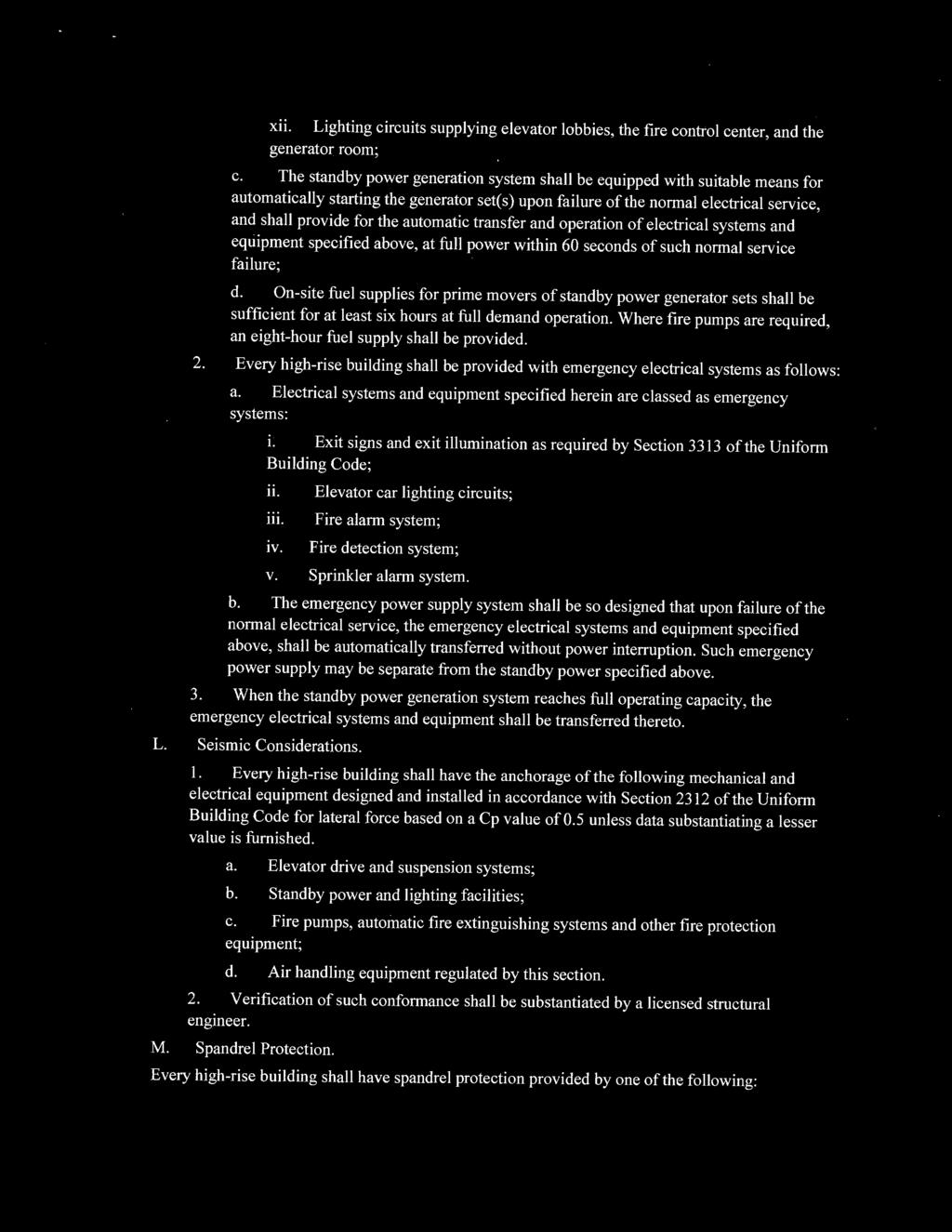
6 4. Defensible Space and Vegetation Management per Wildlands Urban Interface Code (WUI) 5. Education, Maintenance and Management of; facilities, personnel, guests and owners 6. Provide Public Communication though Visual, Audible and Media Equipment When these factors are aggregated, they will be augmented with a central fire control facility for the buildings that will essentially be the equivalent of a high rise building control room (see appendix B). This control room will provide for a centralized communication system that will reach all development within the Project. In addition, and to the extent that they are required, it will control emergency generators, sprinkler systems, alarms, and smoke control systems in one central location. While not every building will be fully controlled from this control room due to small size or remote nature, the fire control room will act as the command center for the entire Project and will nominally provide for control of communication and alarm systems throughout the resort Improved Prepositioned Fire Fighting Capability and Equipment As noted above, the capacity and equipment in the existing station is below the capacity needed to defend the surrounding area. While the existing building could be replaced with a hardened structure (a structure which will not combust), its location is not central to the Village, water system controls nor the public, who needs to be managed to be effective in ensuring that the Village is a place of refuge. Consequently, a new fire station in a more central location is a necessary part of this plan. An important part of the ability of this Program to function is that the crews and equipment need to be pre positioned, i.e. essentially on or adjacent to the site on a 24/7 basis. For the public to be properly managed, Staff needs to be in communication from the onset of any fire or emergency. In addition to the new station, the equipment needs to be updated to accommodate the Project as follows: Increased Staffing The existing station is staffed with between two to three personnel. As a result of the new apparatus and increased standard for the local conditions, a staff of four personnel on a 24 hour schedule is the proposed staffing to accommodate the Project and local service area. Expansion capability should also include the provision to house up to five personnel on site New Apparatus Updated or new apparatus will be required as a result of the Project as well as increased level of service for the surrounding area. This report is not intended to quantify the service life of existing equipment so whether existing equipment is in need of updating is not the subject of analysis in this report but a matter of the routine equipment replacement plan of NT Fire. Proposed equipment for the new station is as follows: 1. One Type 1 Engine 2. One Type III Brush Engine Page 6 of 13
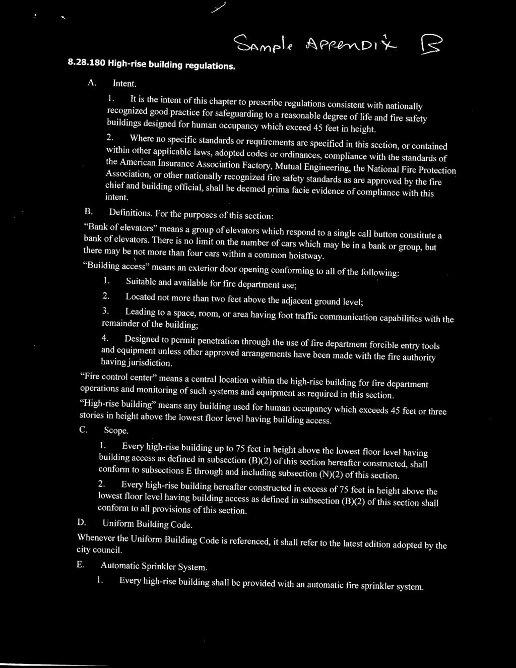
7 3. One ALS Ambulance 4. One Water Tender or Aerial Ladder Truck 5. One Utility Vehicle In addition to the list above, additional apparatus are anticipated under future plans and funding agreements as follows: A new ladder truck is on the future list of equipment for the project area. It s funding will come from an existing Community Facilities District (CFD) which the Project will be required to be a part of. In addition, the NT Fire District is adding a pumper boat that can be used to draw water directly from the lake for redundant or improved fire flow. To facilitate the utility of that pumper boat, the Project will need to connect its fire flow supply to the lake with a stand pipe system that will deliver the water to the ski hill side of the Village and to any other stand pipe system that is required by the final building design Improved Water System In addition to the improvements above, to address current water capacity, the EIR/EIS includes mitigation requiring a detailed Water System Engineering Report approved by the serving water supplier (TCPUD and/or MCWC) for any portion of the Project requiring water supply from the TCPUD and/or MCWC prior to approval of development. (Final EIR/EIS, p ) As noted in the EIR/EIS, the project is required to meet fire flow requirements based on the California Fire Code and other applicable requirements based on TRPA and Placer County fire prevention standards. (Final EIR/EIS, p ). This plan is founded on gravity flow entirely which means that it will be independent of power service to the region. This, in combination with the pumper boat noted above, could provide redundant fire flow capacity that is not reliant on either regional power or local generators. All of this will result in a redundant and fully independent fire flow capacity that exceeds normal design standards and existing infrastructure Project Structure Safety Program The nature of the proposed Project involves a Village plan that is identical in function to most successful base area villages which seek to provide direct access to the snow. Dwelling units are laid out to provide direct access to the snow in what is commonly referred to as ski to from access. In addition, units must provide the best available views of the natural features that the guests come to enjoy. It is common for these types of development to exceed the 150 access rule for standard firefighting equipment access; consequently, they are commonly designed with an integrated advanced firefighting and equipment standard. Mitigation for these access limitations will be the same for Homewood as with all modern implementations of such plans, which include a multifaceted protection system that results in a cumulative higher level of building protection from both fires within the building and defending the building from combustion due to wildland fire hazards. The EIR/EIS specifically requires that TRPA, NT Fire, and CalFire review building designs, building materials, landscaping, and vegetation clearance for compliance with TRPA s Code of Page 7 of 13
8 Ordinances, Public Resources Code section 4291, and California Building Code provisions applying to new buildings located in a high fire hazard area. (Final EIR/EIS, pp. 3 82, ) Building Type and Material Class While the materials and life safety design for those larger structures designed to provide shelter in place will be analogous to a high rise package (see appendix B high rise building regulations ) the building systems will not follow a strict Type I program but will allow other classes of building materials, as would be expected by their midrise height and mixture of uses. While not specifically a Type 1 system, the overall building package will be of a higher standard and class of materials then would be the minimum based on height, volume and use. The standard will prohibit combustible exterior materials; however, some use of combustible materials may be allowed as needed to meet the expectations of the prospective buyer or guest. Any risk associated with these materials can be offset by improved building fire protection systems some of which are noted below. Beyond those buildings that are designated as shelter in place facilities, there are some single family and multifamily that would normally be allowed to be Type 5 3 construction. Many of these buildings are close to the property line and, therefore, are not capable of providing the maximum defensible space buffer as called out in the WUI code and the related Guide to Fire Adapted Communities and NT Fires Emergency Preparedness and Evacuation Guide. These buildings that cannot meet the defensible space standards will be required to have fire resistive/proof exterior building materials as well as tempered windows in the direction of the non compliant setback. While specific building plans are not part of this review, the following general criteria will be applied at plan check: a. Parking: All parking structures will be of Type 1 construction with two hour or greater fire separation between common parking structures and habitable space above. b. Where fire department access occurs through a garage structure, electric low profile carts will be provided to move equipment, fire fighters and also provide for evacuation for injured public. c. Stand pipes and equipment caches will be required within buildings that have access limitations or provide fire department access routes. i. Increased sprinkler standards including sprinkled building eaves (13D) ii. Spark protection on all eave venting systems iii. Fire resistive cold roof designs (if employed) iv. Fire resistive building materials and opening protection d. Exterior building materials will be essentially of type I construction standards with the exception that wood trim elements may be allowed. Additionally, type 3 and 4 3 Type 5 construction in residential buildings generally have combustible exterior materials other than roofs which must be Class A. Page 8 of 13
9 construction types (aka heavy timber ) will be allowed to be incorporated into an otherwise noncombustible/combustion resistive construction type. Built up assemblies such as roofs and siding can be incorporated with resistive materials to form a Class A 4 assembly at the discretion of the fire marshal. Windows, that face a property line where the defensible space recommendations of the Project cannot be met, must be double panes and of tempered glass. e. Photovoltaics (PVs), if applied to roofs, must meet the Class A roof standard or provide additional protection such as exterior sprinklers. Wiring standards must conform to the latest standards currently being developed to prevent electrical fires. f. Unique or unusual designs. All combustible materials that have vents to the exterior of the building must be protected against ignition by ember resistive venting. Cold roof designs (a design that allows cold air to circulate between the finished roof and the insulation below) are of particular concern as they essentially provide a chimney that can virtually come right down to ground level and exit at the ridge of the roof. Cold roofs are a highly desirable building element for both energy efficiency and leak prevention, but their fire hazard must be addressed and mitigated in the details of the design. g. All multifamily buildings will have control systems to shut down exterior air intake and will be equipped with smoke control systems that can be used to pressurize access corridors and stairs Defensible Space and Vegetation Management Defensible space (D space), in its simplest realization, is about protecting individual homes by allowing sufficient space between buildings and the surrounding wildland forest to permit firefighters to successfully occupy the space and protect individual structures. In the case of the Project, the opportunity exists to expand this practice to protect the entire development as one contiguous fire safe zone. The Project incorporates a number of features that will reduce existing wildfire risks not only for the Project itself, but for existing residents in the area. In addition to others noted in this Report: The Project s snowmaking system will be upgraded to provide water for fire suppression during the summer (Final EIR/EIS, p ); The Project will continue to implement its fuel reduction program, which has already reduced the risk of wildfire in the west shore (Final EIR/EIS, p ); To further realize this objective, the Project will create a vegetation management plan, prepared by a licensed forester, to provide for a Defensible Space plan and ongoing vegetation management to 4 Building materials, especially roofing, have a fire hazard Class. Class A is basically non combustible, or materials that will not spread flame i.e. fire resistive Page 9 of 13
10 increase passive fire safety for the Project as well as improve the ability of NT Fire to prevent or suppress fire in the surrounding forest. This is required mitigation in the EIR/EIS. (EIR/EIS, p ). From the onset of the Project, forest management can reduce fire risk, as well as improve the health of the forest. Controlling crown density (distance between trees) and ladder fuels (brush that can spread fire to the tree canopy) and removing forest litter will dramatically reduce the threat of wildland fire and, if coupled with onsite firefighting, can protect the Project from any wildland fire threat (see appendix C Guide to Fire Adapted Communities). The following are some specifics of the plan to be prepared: a. Increase Defensible Space (D Space) as indicated on the attached concept plan (Appendix A), over and above the recommendation of the WUI Code. Where property lines allow and forest stands permit: i. Manage surrounding forest to the next lower level of hazard (see WUI forest hazard ratings types) ii. Increase D space to the property line in all directions iii. Continue to manage vegetation in the lower ski runs to provide areas of refuge outside of structures iv. Use only fire resistive vegetation in all landscaping adjacent to the structures ( zone 1 see WUI) v. Manage forest stands for maximum diversity of age and species to ensure long term health 4.5. Education, Operations and Maintenance a. The CC&Rs for the Project, which will be required and specified on any final building plat and a requirement in the Development Agreement (see below) will forbid any owner of a building or HOA from making any change to the building in terms of remodel or applied finishes that would compromise any otherwise fire resistive materials (e.g. combustible oil based finishes applied to fire treated materials). b. The Developer will be responsible for the maintenance of all of the above and the fire safely plan during construction. Details will be reviewed and approved by the NT Fire at time of building permit. c. The Developer and ultimately the HOA will be responsible for managing all facilities noted above during operation. In addition, they will provide fire safety plans for all residential buildings and instructions on what to do in the event of a wildland fire event. These provisions will be incorporated into the operation of the Fire Control room (see above Structure Safety ). d. Ski resort parking will be available during the fire season to off site populations during emergencies as directed by NT Fire and may be a site of self refuge Public Communication As discussed above, the Project will have a fire control room which will act as the command center for the entire Project and will nominally provide for control of communication and alarm systems Page 10 of 13
11 throughout the resort. This public visual, audible and media information system is an essential part of the entire program as communication with the public in a wildfire scenario is the key to maintaining control and reducing panic which frequently results in the needless loss of life. This communication system must be coupled with trained staff within the development that understand the shelter in place concept and locations and must be able to communicate that information to the public and direct them to the proper locations. Staff training will be reviewed by NT Fire as part of their ongoing review and maintenance of the fire control systems, equipment cashes, and forest/vegetation management plan. 5. Construction Mitigation The construction of the Project will entail some additional impacts; however, they are readily mitigated by implementing some of the more basic elements of this plan. Specifically, the full defensible space vegetation modification will add to both the existing resort s fire safety as well as the surrounding area. Water system improvements will generally precede major construction. Further, the nature of the building systems (fire resistive/proof elements) will minimize, if not eliminate, the potential for significant construction related fires. Lastly, the construction mitigation plan included in the Final EIR/EIS (p ) will coordinate construction activities with the availability of adequate firefighting capacity. While at full intensity, upwards of 100 workers may be on site, their actions will be under the full control of the fire department to the extent that they might, during extraordinary conditions, contribute to firefighting and evacuation capacity deficiencies: however, the initial D Space implementation will make shelter in place a viable option from the onset. 6. Other Agreements While the EIR/EIS requires the Project pay fees to maintain existing levels of fire protection service in the NTFPD service area (Final EIR/EIS, p. 3 82), funding for the proposed equipment, station and personnel have not been established. Of course, the overall improvements result in a large net improvement for the West Shore in general, albeit that some of this may be overdue based on existing conditions. As a result of refinement of plans, phasing and funding, it is likely that a Development Agreement (DA) between the NT Fire and the Developer will be required before construction and will provide specificity and timing on the items outlined in this report as well as cost recovery procedures. This DA will be mutually beneficial to all parties as it will provide specific responsibilities and timing, which will ensure that Fire Fighting Capability and Equipment will be sufficient to defend the Project and surrounding area. The DA will run with the land so, irrespective of future ownership, the requirements of this plan will be enforceable as a matter of contract and if not fulfilled, can result in the denial or revocation of occupancy permits for the Project. Page 11 of 13
12 7. Conclusion This Project s shelter in place strategy results in a comprehensive life safety plan which is the first of its kind to be developed in conjunction with NT Fire. As a result, the Project will reduce the risks associated with evacuation by reducing the number of people attempting to use evacuation routes. In addition, the Project significantly improves life safety concerns associated with wildland fires and other disasters by creating a robust shelter in place program within the Project itself. The conclusion that this shelter in place strategy is the key to providing for improved life safety and will achieve the goal of non exacerbation, is supported by the Placer County Local Hazard Mitigation Plan of 2010; Annex I, North Tahoe Fire Protection District 5 : Appendix D. This Annex acknowledges that redundant evacuation routes exist only on paper for much of North Tahoe and that the entire North Tahoe area is frequently without any evacuation route due to a broad range of environmental conditions. Essentially, all communities within the area should be managed with the highest degree of shelter in place design and implementation because immediate evacuation at any time is an unrealistic expectation. Highway 89, the principal evacuation route for Tahoe City, the West Shore and all of the resort and residential communities on the Truckee River corridor, is subject to closures by uncontrollable events. Highway 89 to the south, while an alternate route for evacuation from the Project, is similarly challenged. Further, while wildland fire evacuation is one risk that is established, multiple disaster scenarios are simple to extrapolate in this mountainous environment that would defy attempts at immediate evacuation. Even a simple car crash could frustrate the capacity of any evacuation plan. A complex disaster such as an earthquake with disabled roads, downed power lines and, in some locations, ruptured gas lines would overwhelm any evacuation plan instantly. As such, shelter in place plans have utility in virtually all reasonably foreseeable disasters. Because of all of the above, the Project far exceeds the current standards for providing for life safety for this Project. In summary, the Project will provide the highest level of life safety that is practicable in this environment. This report determines that the changed circumstances in the Project Area and Homewood s overall commitments to wildfire evacuation mitigation measures are sufficient to ensure that the Project will not result in any significant adverse impacts on wildfire evacuation risks on the West Shore during construction or operation and will not exacerbate any existing wildfire evacuation risks in the Lake Tahoe region. Furthermore, going forward, this plan will likely provide a pathway as to how to practically mitigate any future development either through individual plans or community based plans. 5 This document was updated in 2016 but the Annex related to North Tahoe Fire Project District has not been formally adopted to date. Page 12 of 13
13 Appendices A: Concept Plan and Base Area Map B: High rise building regulations C: Guide to Fire Adapted Communities D: Annex I: North Tahoe Fire Protection District (Local Hazard Mitigation Plan 2010) E: Emergency Preparedness and Evacuation Guide (North Tahoe Fire Protection District) F: Placer Operational Area East Side Emergency Evacuation Plan (EEP) Page 13 of 13


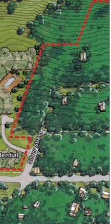


14 Property line South Base North Base General Area of Refuge Fire Command Center Homewood Base Area Exhibit "A" Concept Plan and Base Area Map

15


16

17


18

19


20

21

22


23

24

25


26 Exhibit "C" G UI D E TO FIRE ADAPTED COMMUNITIES
27 This reference guide was created through the collaboration of members of the Fire Adapted Communities (FAC) Coalition. The FAC Coalition is a group of organizations and federal agencies seeking to advance the message of Fire Adapted Communities and strengthening local wildfire preparedness at all levels. A list of contributors to this publication and their contact information is provided in Chapter 6. Thank you for embracing your preparedness role and empowering and motivating others in your community to implement actions that positively contribute to wildfire preparedness and resiliency. To learn more about Fire Adapted Communities and the work of the coalition members visit
28 GUIDE TO FIRE ADAPTED COMMUNITIES TABLE OF CONTENTS What is a Fire Adapted Community? Collaboration and Outreach The Surrounding Environment Planning and Regulatory Considerations Neighborhoods, Landscapes, and Buildings Conclusions and Resources
29 CHAPTER 1 WHAT IS A FIRE ADAPTED COMMUNITY? This guide is designed to help leaders, planners, emergency professionals, and citizens learn the best approaches and programs to help their community become more fire adapted. WHAT IS A FIRE ADAPTED COMMUNITY? Communities in wildfire prone areas are learning what it takes to be fully prepared for wildland fire. A fire adapted community incorporates people, buildings, businesses, infrastructure, cultural resources, and natural areas into the effort to prepare for the effects of wildland fire. Community leaders and residents accept responsibility for living in an area with wildfire hazards. They have the knowledge and skills and have adopted tools and behaviors to prepare in advance for their community s resilience in a wildfire prone environment. DEVELOPMENT PRESSURES IN THE WILDLAND URBAN INTERFACE Dramatic population increases in the wildland urban interface (WUI) exacerbate the wildfire problem by adding new residents who may have little or no experience with wildfire. In the past 50 years, the 220 million acres of identified WUI in the United States have become populated with over 120 million people living in 50 million housing units and working in several hundred thousand businesses. This is a growth rate of 300% in the WUI, which is faster than the general population growth rate for the same time period (IAWF 2013). A Fire Adapted Community... Acknowledges and understands its wildfire risk Recognizes that it is in or near a fire prone ecosystem Has leaders and citizens with the knowledge, skills, willingness, and realistic expectations to properly prepare for and deal with wildland fire Communicates clearly with citizens about wildfire risks and specific methods for preparedness Has adequate local fire suppression training, equipment, and capacity to meet realistic community protection needs Creates and uses a Community Wildfire Protection Plan (CWPP) Reduces levels of flammable vegetation on lands near and inside the community Has local building, planning, zoning, and fire prevention policies and codes that require ignition resistant buildings, building materials, and landscapes Has buildings and landscaping that are designed, constructed, retrofitted, and maintained in a manner that is resistant to ignition Creates safety features such as buffers between fuels and neighborhoods, designated evacuation routes, and internal neighborhood safety zones Makes sure fire adapted community features, activities, and behaviors are maintained over time Has leaders and residents who coordinate, plan, and collaborate to leverage their resources to reduce wildfire risk while increasing community resiliency 2 WHAT IS A FIRE ADAPTED COMMUNITY?


30 WHAT IS THE WILDLAND URBAN INTERFACE? Fire professionals call the situation where buildings are built near or among fire prone ecosystems the wildland urban interface (WUI) (pronounced woo-ee). It is more helpful to think of the WUI not as a place, but as a set of conditions that may exist in any community. The WUI is determined by the type and distribution of vegetation, combustibility of buildings and their proximity to vegetation and other structures, climate and weather patterns, fire history, topography and other landscape features, access, and other factors. Photo credit: Graham Lewis, Ashland, OR Depending on WUI conditions, the lands, communities, buildings, businesses, utilities, and infrastructure adjacent to or surrounded by fire prone wildlands may be at risk. There is an interplay in the WUI setting not only can human developments become fuels for a wildfire, but fires may also move from human developments into natural areas. In addition to the estimated 50 million housing units located in the WUI nationwide, there are typically many other important community assets located in wildfire prone areas, including utilities, highways, bridges, watersheds, forests, natural areas, and parks (IAWF 2013). WILDLAND FIRES TODAY While lightning-caused wildland fires are natural events that aid in promoting forest, grassland, and rangeland health, human impacts have led to uncharacteristically severe and damaging wildfires in recent years. Wildfires are getting worse due to overgrown forests, accumulation of excess fuels, climatic changes leading to increases in severe weather and more frequent droughts, and fast growth and poorly planned development in WUI areas. In the past several decades, wildfires in the United States have become increasingly large and destructive, costing up to 50 times more for suppression than for prevention. From 2004 to 2013, the United States had an average of 59,911 wildfires burning 6.6 million acres per year. Annual wildfire costs exceed $4.7 billion nationally for federal, state, and local response (Headwaters Economics 2013, IAWF 2013). This figure does not include the many indirect and lingering costs of wildfire, which range from two to 30 times more than the reported suppression costs (WFLC 2010). When energy and resources are focused on wildfire suppression, less attention and funding are dedicated to prevention and preparedness activities (Chu 2013, Healy 2013). Development patterns and climatic changes are exposing communities to more frequent and more severe wildland fires. Uncharacteristically severe wildfires can have a wide range of adverse impacts on property and natural ecosystems, including flooding, erosion, loss of wildlife habitat, and impacts on social, ecological, and economic values. WHAT IS A FIRE ADAPTED COMMUNITY? 3


31 EVERYONE IS RESPONSIBLE FOR WILDFIRE PREPAREDNESS As wildland fires become more hazardous and increasingly expensive and difficult to fight, greater emphasis is being placed on community and individual responsibility and preparedness. The wildfire preparedness solution requires participation from everyone residents, homeowners, business owners, land managers, utility companies, fire departments, community leaders, emergency managers, first responders, insurance providers, wildland fire specialists, government officials, and more. In short, everyone is encouraged to learn their role and take TOOLS FOR THE FIRE ADAPTED COMMUNITY Specific fire adapted community tools and strategies address resident safety, building and neighborhood design, business preparedness, infrastructure and utility protection, wildland and park management, an active part in helping their community better adapt to wildland fire. It takes multiple approaches for a community to prepare for wildland fire many established programs can be employed during the process of adapting to wildfire. When implemented, local approaches strengthen a community s resilience and should provide a reduced level of need for suppression resources. and other community assets. The more actions a community takes during this process, the more resilient and adapted the community becomes to the wildfire threat. Graphic credit: USDA Forest Service 4 WHAT IS A FIRE ADAPTED COMMUNITY?
32 ELEMENTS OF A FIRE ADAPTED COMMUNITY COMMUNITY COLLABORATION PLANNING AND REGULATORY CONSIDERATIONS CHAPTER 4 CHAPTER 2 COLLABORATION COLLABORATION COLLABORATION COLLABORATION SURROUNDING ENVIRONMENT CHAPTER 3 NEIGHBORHOODS, LANDSCAPES AND BUILDINGS CHAPTER 5 WHAT IS A FIRE ADAPTED COMMUNITY? 5

33 CASE STUDY: FIRE ADAPTED COMMUNITY, WALDO CANYON The Waldo Canyon Fire started in late June 2012 near Colorado Springs, Colorado. The fire threatened the Cedar Heights community, but no houses were lost. Two days later, the fire entered the Mountain Shadows neighborhood, where 347 houses were eventually destroyed. A post-fire assessment demonstrated that the mitigation work conducted in high risk areas was responsible for an 82% rate of saving houses. More houses and properties would have been destroyed if the surrounding WUI communities had not worked to reduce their wildfire risk. Photo credit: Colorado Springs Fire Department For more information: EXPECTATIONS AND RESPONSIBILITIES DURING AND AFTER A WILDFIRE Some new WUI residents may expect the same level of fire protection service that they had in their former urban or suburban community. As part of wildfire preparedness efforts, WUI residents can be educated about the specific steps to take before and during a wildfire. This information is incorporated into several existing programs, including the Firewise Communities/USA and Ready, Set, Go! programs. These programs provide information about the wildfire threat to neighborhoods, each resident s responsibility for preparing their property, and the importance of orderly evacuation should it become necessary. These programs also emphasize the responsibilities and limitations of fire fighters during a wildfire response. Advance preparation is the reason why wildfire preparedness collaboration and outreach programs are such an important part of a community s overall approach to becoming more adapted to wildfire. The goal is always to maximize the protection of lives and property, while also enhancing emergency responder safety and fire fighter effectiveness during a wildfire event. Effective Approaches for the Fire Adapted Community Effective wildfire risk reduction programs include four major categories: Collaboration, outreach, and marketing for wildfire preparedness (Chapter 2) Assessment of risks in the surrounding environment (Chapter 3) Implementation of planning policies, standards, and regulations (Chapter 4) Encouragement and assistance for neighborhoods and property owners (Chapter 5) 6 WHAT IS A FIRE ADAPTED COMMUNITY?
34 EVOLUTION OF THE FIRE ADAPTED COMMUNITY CONCEPT The National Fire Plan (USDA/USDI 2000a; 2000b) and Ten-Year Comprehensive Strategy (WGA 2001) placed a priority on working collaboratively within communities in the WUI to reduce their risk of large scale wildfire. The Healthy Forests Restoration Act of 2003, also known as the Healthy Forests Initiative (Pub. L. No , 2003), encouraged communities to engage in comprehensive wildfire risk reduction planning. This legislation included statutory incentives for the USDA Forest Service and the Bureau of Land Management to give consideration to the priorities of local communities as they develop and implement forest management and hazardous fuels reduction projects. National Wildland Fire Planning Initiatives National Cohesive Wildland Fire Management Strategy (WFLC 2011, WFLC 2012) Quadrennial Fire Review (NWCG 2009) A Collaborative Approach for Reducing Wildland Fire Risks to Communities and the Environment: Ten-Year Comprehensive Strategy (WGA 2001) Healthy Forests Restoration Act of 2003 (aka Healthy Forests Initiative, Pub. L. No ) National Fire Plan (USDA/USDI 2000a; 2000b) The fire adapted community concept was given further prominence in the first Quadrennial Fire and Fuel Review (NWCG 2005), which suggests promoting fire adapted human communities, rather than escalating protection of communities at risk in the wildland urban interface. The subsequent Quadrennial Fire Review (NWCG 2009) goes further, saying the notion that government will always be there needs to be changed to a model where property owners and local communities take responsibility and become active participants in addressing the effects of wildfire. The National Cohesive Wildland Fire Management Strategy (WFLC 2011, WFLC 2012) clearly encourages communities to develop adaptive approaches in planning for, responding to, and recovering from wildfires. The National Cohesive Wildland Fire Management Strategy The National Cohesive Wildland Fire Management Strategy identifies three factors as offering the greatest opportunities for making a difference in addressing wildfire: Restoring and maintaining resilient landscapes at a regional and subregional scale, with recognition that many ecosystems currently lack health and vitality Creating fire adapted communities in areas of high wildfire risk, with options and opportunities to engage communities in becoming more resistant to the threat Responding to wildfires with the full capacity of interagency cooperation, providing collaborative methods to move forward while recognizing the different missions and capabilities of partner agencies and organizations For more information: index.shtml WHAT IS A FIRE ADAPTED COMMUNITY? 7

35 CHAPTER 2 COLLABORATION AND OUTREACH COLLABORATION IS CENTRAL TO THE FIRE ADAPTED COMMUNITY Adapting a community to wildland fire need not be a complex process, but it does require deliberate and sustained collaboration among community and fire management leaders. A collaborative effort can yield more valuable program outcomes for resources invested, since ideas, energy, and activities can be shared among organizations and agencies. Collaboration can build partnerships, solve difficult problems, and resolve conflicts. CREATING THE COLLABORATIVE TEAM The fire adapted community concept is more than an understanding of defensible space and vegetation types it includes the creation of a collaborative team where a wide variety of community members and organizations are involved in adapting to the wildland fire challenge. The collaborative team may include homeowners, elected officials, community decision makers, fire services managers, emergency responders, land managers, natural resource Effective collaboration and outreach raises awareness in the community. Basic outreach actions, such as publishing a brochure or creating a website, will not necessarily change attitudes and behaviors. When outreach efforts are wedded to marketing concepts, they become more effective by providing incentives for community members to change their behaviors. A balanced and creative mix of collaboration, outreach, and marketing will increase the success of a fire adapted community process. agencies, business and industry representatives, utilities, and other stakeholders. It is important to identify key players and strong leaders and to develop a consensus on formality and structure (see case study). The team may consider becoming a nonprofit agency, an advisory commission with appointed members, or an ad hoc coalition. Photo credit: Frank Riley, Chestatee-Chattahoochee Resource Conservation and CASE STUDY: Development Council, Towns County, GA LOCAL LEADERSHIP FOR A FIRE ADAPTED COMMUNITY Leadership for a fire adapted community can spring from a wide range of sources in a community. Strong leaders are often referred to as a sparkplug they have enthusiasm, social connections, and the ability to coordinate the collaborative team. In Towns County, Georgia, the Fire Adapted Communities Learning Network (see Chapter 6) is supporting Frank Riley of the Chestatee-Chattahoochee Resource Conservation and Development Council. Frank coordinates a collaborative team that includes local fire districts and departments, elected officials, and leaders of the Chattahoochee/Oconee National Forest. The team is now working to leverage their collective resources to make progress on jointly developed objectives in the fire adapted community process. For more information: 8 COLLABORATION AND OUTREACH
36 ROLES IN THE COLLABORATIVE PROCESS Well-defined roles encourage a shared, cohesive, and synergistic approach to the common threat of wildfire. It is particularly important to assign roles and responsibilities in the planning documents for all wildfire risk reduction actions by individuals, agencies, organizations, or governments. Local Leaders and Elected Officials Local Planners and Code Officials Local Fire Protection Services Insurance Industry Local Emergency Managers Utility and Transportation Companies Citizens, Homeowners, Neighborhoods, Associations, Volunteer Groups Business Leaders Outreach, Education, Marketing, and Media Specialists Developers, Builders, and Landscapers Managers and Foresters for Local, State, Federal, or Private Lands Collaboration makes sense as the initial direction for any community engaged in wildfire risk reduction. The goal is to cooperatively identify problems and develop a plan for mutual action that best fits local needs and priorities. COLLABORATION AND OUTREACH 9

37 THE ONGOING COLLABORATIVE CYCLE There are several commonly identified stages of collaboration (see graphic below). Movement from one stage to the next depends on the motivation and progress of the collaborative team. If the collaborative team gets stuck at one stage, working ahead on the next stage often creates the momentum to complete the process. This type of process allows communities to move forward with the best short term wildfire risk reduction actions, while existing within a larger context where the final outcomes are unknowns. Because wildfire risk reduction is a long term process, community collaboration and outreach should also be long term projects. To address new problems and challenges, the collaborative process should also become what is called an adaptive or iterative process, involving repeated rounds of analysis and action, always assessing the outcomes to inform the next round of planning and action. Over time, the entire process is repeated to build new actions based on the lessons learned from past activities. Sustain and Maintain Efforts Track Progress and Outcomes Convene a Collaborative Team Assess Existing Conditions and Capabilities Plan Programs to Achieve Goals COLLABORATIVE TOOLS FOR THE FIRE ADAPTED COMMUNITY As the collaborative team works through the process, they will determine which resources are needed for their unique situation. Tools available for this process include: Community Wildfire Protection Plan (CWPP) Ready, Set, Go! Program (RSG!) Firewise Communities/USA Recognition Program (Firewise) Wildland Fire Assessment Program (WFAP) Cooperative Alliances or Mutual Aid Agreements Factors to Consider When Selecting Collaborative Tools Level and nature of wildland fire risks Knowledge base of the community s residents Attitudes of community leaders Resources available to local, state, and federal agencies Status and types of fuels on surrounding lands Condition of landscaping and building materials Activity level of property or homeowner associations Existing landscaping regulations and building codes Likelihood for participation of community members Availability of outreach and communication resources Accomplish Risk Reduction Actions 10 COLLABORATION AND OUTREACH

38 COMMUNITY WILDFIRE PROTECTION PLAN (CWPP) A CWPP is designed in collaboration among a variety of community partners who form a working group to develop this formal plan. The CWPP can take a variety of forms, based on the needs of the community. It may address issues such as wildland fire response, hazard mitigation, community preparedness, building protection, or all of the above. The CWPP examines risk levels and identifies strategic sites and methods for risk reduction projects throughout the community. Of the 70,000 high risk communities, only 11% have completed CWPPs (IAWF 2013). The process of developing a CWPP can help to clarify and refine a community s priorities for the protection of life, property, and critical infrastructure in the WUI. Through the CWPP process, a working group develops a roadmap to reduce wildfire risk. Workshops for community leaders and other stakeholders may be offered as part of the collaborative planning process. The CWPP is often a precursor to seeking funding for community wildfire risk reduction projects. Community Wildfire Protection Plan Collaboration Developed by local and state government representatives in consultation with federal agencies and a broad range of interested stakeholders Prioritized Fuels Reduction Identifies and prioritizes areas for hazardous fuels reduction and recommends the types and methods of treatment that will prepare the community Treatment of Structural Ignitability Recommends measures that homeowners, businesses, and other community members can take to reduce the ignitability of buildings and landscapes For more information: files/cwpphandbook.pdf CASE STUDY: CWPP SUCCESS IN RURAL AREA Taylor (population 1,062) is located in rural northeast Florida and surrounded by over 700,000 acres of wildfire prone national forest, state forest, and private timber land. In 2006, Baker County Fire and Emergency Services, Florida Forest Service, USDA Forest Service, and community members collaborated to develop a CWPP. A major component of the CWPP was a 30-foot wide and 11-mile long control line (firebreak) around the community. The control line was nearly complete when the 2007 Bugaboo Wildfire approached. Fire fighters were able to set backfires along the control line, thus guiding the fire around the community and preventing the loss of any buildings in Taylor. Photo credit: Florida Forest Service For more information: and COLLABORATION AND OUTREACH 11

39 COLLABORATIVE TOOLS FOR THE FIRE ADAPTED COMMUNITY (CONT.) READY, SET, GO! (RSG!) RSG! is designed to stimulate an ongoing dialogue between local fire departments and the citizens they serve. RSG! provides fire departments with the tools and guidance necessary to deliver the wildfire preparedness message in high risk WUI areas, encouraging residents to take personal responsibility for the safety of their families and their property. The program also trains residents to have heightened situational awareness and to act early if evacuation becomes necessary, which supports both personal safety and fire fighter effectiveness during a wildfire event. The RSG! program works in complementary fashion with the messages of other wildland fire outreach programs and is managed by the International Association of Fire Chiefs in partnership with the USDA Forest Service, US Department of the Interior, and the US Fire Administration. Ready, Set, Go! Ready (Preparedness) Teaches homeowners to create their own preparedness plan and follow principles of ignition resistant design Set (Awareness) Encourages citizens to have heightened situational awareness and evacuation preparedness when a wildfire starts Go! (Evacuation) Urges citizens to follow their plan and leave early in the event of a wildfire, increasing the safety of both residents and fire fighters For more information: 12 COLLABORATION AND OUTREACH
40 COLLABORATIVE TOOLS FOR THE FIRE ADAPTED COMMUNITY (CONT.) FIREWISE COMMUNITIES/ USA RECOGNITION PROGRAM (FIREWISE) Firewise encourages local solutions by involving homeowners in taking individual responsibility for preparing their houses for the risk of wildfire. Firewise teaches people how to adapt to the risk of living with wildfire and encourages neighbors to work together and take action to prevent future losses. Firewise emphasizes that all members of a community have a role to play in protecting themselves and each other from the risk of wildfire. The program is cosponsored by the USDA Forest Service, the US Department of the Interior, and the National Association of State Foresters. WILDLAND FIRE ASSESSMENT PROGRAM (WFAP) The Wildland Fire Assessment Program provides volunteer fire fighters and nonoperational personnel, such as Fire Corps members, with training that specifically prepares them to conduct assessments on houses located in the WUI and provide recommendations to owners on protecting their properties. Through this program the National Volunteer Fire Council provides a training course, toolkit, and materials for conducting assessments to assist in the fire adapted community process. The training courses are available at fire departments, fire academies, and other locations. This program is a joint effort of the USDA Forest Service and the National Volunteer Fire Council. Firewise Communities/USA Recognition Program Using the five step Firewise process, communities develop an action plan that guides their residential risk reduction activities, while engaging and encouraging their neighbors to become active participants in building a safer place to live. Wildfire Risk Assessment Obtain a written assessment from your state forestry agency or local fire department Board or Committee Form a board or committee and create an action plan based on the assessment Event Conduct a Firewise Day event in your community Investment Invest a minimum of $2 per capita in annual Firewise actions Application Submit an application for recognition from your state Firewise liaison For more information: COLLABORATION AND OUTREACH 13

41 COOPERATIVE ALLIANCES AND MUTUAL AID AGREEMENTS A variety of alliances and agreements can be activated to address wildfire prevention, fuels reduction, and cooperative wildfire response. These alliances may be established by fire departments, landowners, or government land management agencies to facilitate cooperative activities and provide technical support and sharing of resources, training, and lessons learned. Cooperative Alliances and Agreements Several types of cooperative alliances and agreements are commonly used in wildfire mitigation and preparedness. Landowner Associations provide technical support and assistance to members, with or without the assistance of government agencies. The motivation for landowner associations is greatest in areas where the wildfire threat is high and where landowners stand to benefit from fuels reduction to improve forest or range health. Prescribed Fire Councils bring together fire managers, natural resource professionals, and landowners to provide a forum for sharing ideas and information and creating opportunities for on-the-ground collaboration. Prescribed Fire Councils promote the appropriate use of prescribed fire (controlled burning) and seek to inspire community assistance and support for wildfire risk reduction efforts. Mutual Aid Agreements are undertaken among wildland fire response agencies and fire services within a geographic area. These agreements define wildfire suppression responsibilities, use and reimbursement of resources, and provisions for joint projects in training or building capacity. These agreements provide important guidance for the order of actions and responsibilities in the event of a large wildfire. Cooperative alliances and mutual aid agreements recognize that no single agency or landowner can do everything that is needed in preparing or responding to wildfires or other hazards. Photo credit: Hylton Haynes CASE STUDY: BROAD COLLABORATION FOR COMMUNITY PROTECTION During the 1983 Thumb Butte fire in Arizona, agencies were forced to work as three separate units rather than as one because their fire hoses were not compatible. This event was the catalyst for a long term effort to improve communication and standardization of equipment among area fire fighting agencies. Prescott Area Wildland/Urban Interface Commission was founded in 1990 as a nonprofit charter by the City of Prescott and Yavapai County. The commission is comprised of federal, state, county, and municipal agencies working with 11 smaller fire departments, homeowner associations, businesses, community leaders, and volunteers to mitigate the threat of wildfire and to promote forest health in an area larger than the state of Massachusetts, such as the vegetation chipping activity in the photograph. The commission works throughout the year to prevent and prepare for wildfire with activities in education, grant funding, training, biomass utilization, and a monthly forum for sharing ideas, coordinating efforts among participants, and updating the Yavapai CWPP that was prepared for the community. For more information: 14 COLLABORATION AND OUTREACH
42 PUBLIC OUTREACH PROGRAMS In the wildfire preparedness context, public outreach can take the form of publications, news coverage, training programs, events, and many other formats. Whether performing a single round of homeowner notifications, a series of workshops, or a multi-year effort to raise awareness and participation, a set of logical steps (see inset) assures the greatest level of success for the outreach effort. Because wildfire threatens entire communities, risk reduction is inherently connected to people and their attitudes and behaviors. Research has shown that public outreach is related to a reduction in preventable wildfires in other words, more education results in fewer human-caused wildfires (Prestemon et al. 2010). The damage averted can be 35 times the amount invested in wildfire public outreach programs (Prestemon et al. 2010). Public Fire Education Planning A Five Step Process 1. Conduct a Community Risk Analysis Identify fire and life safety problems and the characteristics of those at risk in the community. 2. Develop Community Partnerships Join forces with groups or organizations to address the community s risk, involving the community in the planning and solution process. 3. Create an Outreach Strategy Prepare a detailed plan for the wildfire risk reduction outreach process, involving a variety of interventions, such as education, engineering of solutions, and enforcement of safety rules. 4. Implement the Strategy Test the interventions and put the plan into action in the community as scheduled in your plan. 5. Evaluate the Results Demonstrate that the risk reduction efforts are reaching target populations, having the planned impact, and are reducing losses. For more information: downloads/pdf/publications/fa-219.pdf Public outreach programs are designed to raise awareness, improve audience knowledge and attitudes, and involve community members in skill building projects. Yet outreach information alone rarely changes behaviors marketing techniques can go a step further to focus on identifying and removing barriers to risk reduction activities. COLLABORATION AND OUTREACH 15
43 MESSAGES AND MESSENGERS The perspective of residents must be understood to effectively design and deliver the wildfire risk reduction message (see inset). It is important to gather input and craft messages that will most effectively reach target audience members (McCaffrey 2006, Monroe et al. 2006). When developing wildfire outreach programs, careful consideration must be given to how the messenger agency appears and how the message will be received by the target audiences. The outreach agency should be a trusted source and avoid exaggeration by providing reliable information. In particular, take advantage of the golden moment in the months after a wildfire to communicate the wildfire preparedness message (Sturtevant et al. 2005, Jakes and Barro 2004). Keep information clear, consistent, and repetitive, while avoiding jargon and acronyms. The three most important topics to cover are (1) what can be lost, (2) the realistic odds of wildfire, and (3) what residents can do to prepare (Monroe et al. 2006). MEDIA CHANNELS FOR WILDFIRE MESSAGES The term media here refers to any means of communicating with the intended audiences. While mass media and print materials are traditional ways of providing public information, outreach professionals should be creative in selecting media for wildfire risk reduction programs. Outreach programs and media channels will vary from community to community, depending on local needs. Research suggests that face-to-face outreach programs are the most effective way to share messages. Trusted personal messengers include neighbors, friends, fire department personnel, and first responders. Residents can be engaged through workshops, advisory boards, webinars, seminars, volunteer programs, workdays, and many other formats. In addition, electronic and social media are also a popular and important resource. In all cases, the outcome is a more informed citizen who is ready to tackle wildfire risk reduction issues in a collaborative manner. Effective Wildfire Messages Certain words and phrases are regularly chosen by focus groups as more acceptable for use in wildfire risk reduction messages. Safety is a very favorable message theme (SGSF 2011, PFE 2008). The term controlled burn is much more favorable than the term prescribed fire. Language was tested very carefully with focus groups and the best message about burning was Allow fire managers to use controlled burns when and where doing so will safely reduce the amount of fuels for wildfire. The researchers note that while the public understands that no one can really control fire, they still want to know that someone is trying to control it (PFE 2008). Healthy forests are important to the health of people is a well-accepted message. Stories that demonstrate the benefits of prescribed fire or thinning for forest health will increase overall acceptability of these strategies (SGSF 2011, PFE 2008). Messages that focus on cost savings are personally relevant to residents (Monroe et al. 2006). Potential messages: Wildfire risk reduction may save 20 times the costs of wildfire suppression or Every acre of land with reduced wildfire risk represents a public cost savings of $1,000 to $2,000 per acre (Hinckley and Wallace 2012, Prestemon et al. 2010). 16 COLLABORATION AND OUTREACH
44 MARKETING THE WILDFIRE MESSAGES Even with the best public outreach program, awareness of wildfire risk does not automatically lead to the adoption of risk reduction behaviors (Toman et al. 2013). Marketing techniques can be used to create the desired behavior changes for a fire adapted community (see table). As residents knowledge, attitudes, and behaviors are better understood, it is likely that certain barriers to behavior change will be identified. This information can be gathered through observations, surveys, or interviews, followed by focus groups to gain further insight and test possible strategies. Marketing strategies can then be selected for implementation, and the outcomes can be monitored (evaluated) to demonstrate effectiveness or identify areas for improvement. Marketing Techniques Objectives Examples Removal of barriers Make the desired behavior easier Provide technical or physical by removing barriers. assistance to people unable to complete wildfire preparation. Bring in outside assistance to clear brush. Prompts Provide reminders in the Use advertising or signs to general media and at the point remind residents of scheduled of action, if possible. workdays or debris pickups. Pledges Collect written commitments for Have residents sign agreements: desired behaviors. I will remove debris from my roof every March or I will assist with the community workday by helping to trim trees. Norms Provide a model or standard of Demonstrate fire resistant behavior for residents to follow. landscaping at a prominent house or business. Have well-known members of the community participate and give public testimonials. Incentives Reward the desired behaviors. Decrease homeowner association dues in return for compliance with fire resistant design principles. Have contests with prizes for the best examples of the desired behavior. Awards and positive Publicly acknowledge positive Provide yard signs or window feedback actions and maintain attention decals for program participants. to the issue. Have an annual awards ceremony with a local official or celebrity as emcee. COLLABORATION AND OUTREACH 17

45 CHAPTER 3 THE SURROUNDING ENVIRONMENT CONSIDER THE SURROUNDING ENVIRONMENT To become better adapted to wildfire, citizens must think beyond the boundaries of the neighborhood and community by considering the surrounding environment. Conditions in adjacent and surrounding areas must be assessed to determine the impact on the community s wildfire risk. The owners and managers of surrounding lands should therefore be involved in the process of creating a fire adapted community. THE IMPORTANCE OF FUELS MANAGEMENT TO REDUCE WILDFIRE RISK It is important for land managers to have a wildland fire response plan with adequate equipment, training, or cooperative agreements in place. It is even more important for land managers to employ regular fuels reduction treatments such as thinning, prescribed fire, mowing, chopping, or other techniques on properties with high wildfire risk. Fuels reduction is important because many of the ranches, forests, and wildlands surrounding high risk communities may have up to a century of fuels accumulation. Cooperative alliances or agreements can assist in fuels reduction projects that cross ownership or jurisdictional boundaries (see Chapter 2). Local organizations, such as Conservation Districts and local Fire Safe Councils, often serve an important role that helps bridge land ownerships and align mitigation projects. Photo credit: North Central Texas Prescribed Burn Association CASE STUDY: COLLABORATIVE VEGETATION MANAGEMENT ON PRIVATE LANDS The North Central Texas Prescribed Burn Association represents 10 Texas counties. The association advocates for the safe and responsible use of prescribed burning as a part of range and scrub fuels management, which has risk reduction advantages for property owners as well as benefits for local wildlife, livestock, and native habitats. Association members receive burn school training, burn schedule calendar coordination, equipment inventory to coordinate support, an interactive map with a membership roster to help connect neighbors, links to relevant websites (such as weather services), and contact information for officials. This neighbor-helping-neighbor cooperative provides the resources, education, encouragement, and empowerment that property owners need to use prescribed fire on a sustained basis. The association was formed in 2008 and became a member of the Texas Alliance of Prescribed Burn Associations in For more information: or land/technical_guidance/burn 18 THE SURROUNDING ENVIRONMENT


46 The issue is not if an area will burn but when and at what intensity. The wildland fire preparation work of a community can be negated if land managers in the surrounding environment do not address their wildfire risk. CASE STUDY: ACCOMPLISHING CREATIVE FOREST RESTORATION Four national forests in Arizona Kaibab, Coconino, Apache-Sitgreaves, and Tonto are actively engaged in the collaborative, landscape scale Four Forest Restoration Initiative. Together with a diverse group of stakeholders, the four forests are working to restore ponderosa pine forests, providing for fuels reduction, forest health, and biodiversity, while creating sustainable wood products industries and jobs in the region. Through innovative use of GPS technology, managers are carrying out 40 different prescriptions for forest thinning that are specifically tailored to ecosystems and wildlife habitats in each area as demonstrated by the before and after photographs. For more information: BEFORE AFTER Photo credit: Four Forest Restoration Initiative THE ULTIMATE OBJECTIVES ARE SAFETY AND FOREST HEALTH The objectives of fuels reduction are to return forests and wildlands to a more natural, fire resilient condition and to ensure that the community s risk has been reduced. Fuels reduction contributes to a situation where forests, wildlife, and residents all benefit, and wildfire season is met with less apprehension. Objectives of a fuels management program: Reduce wildfire risk Create buffer zones around communities Restore forest health and resilience Protect and enhance water resources Protect and enhance wildlife habitat Generate revenue from biomass sales Generate revenue from carbon offsets Improve ingress and egress Enhance aesthetics and recreation opportunities OVERCOMING BARRIERS TO FUELS REDUCTION The public generally supports the need for fuels reduction and is at least cautiously supportive of the use of both prescribed fire and mechanized thinning. Yet a review of public concerns about fuels management approaches reveals that the main factors influencing citizen support are program cost, confidence in the program to accomplish its objectives, comfort with the risks of the program, and perceptions of the effects of the program (Toman et al. 2013). To accomplish fuels management objectives, it is important to increase public understanding of forest health and the contribution of prescribed fire and other fuels management approaches. Ongoing public outreach campaigns can result in increased acceptance and support for wildfire risk reduction. As discussed in Chapter 2, messages about prescribed fire are better framed in a forest health context in addition to the wildfire prevention context. Public outreach programs should continue to work to generate a deeper understanding of fuels management options. THE SURROUNDING ENVIRONMENT 19
47 CHAPTER 4 PLANNING AND REGULATORY CONSIDERATIONS ENCOURAGING FIRE ADAPTATION IN THE WILDLAND URBAN INTERFACE As development expands in fire prone ecosystems, the number of at risk buildings also increases. Expanding WUI development threatens public safety, jeopardizes community resources, and requires added fire protection services, ultimately impacting budgets and community well-being. In addition to collaborative and fuels management approaches, community leaders may address this challenge by using planning and regulatory tools. Many states have adopted legislation and mapping systems to encourage wildfire mitigation in high risk areas either by education and planning or by regulatory measures. Most states also have partnership agreements with federal agencies for participation in federally sponsored mitigation programs, such as the development of CWPPs. In some cases, state agencies may take the lead, but in many cases, the option falls to local governments to carry out wildfire mitigation programs. LOCAL LAND USE PLANNING APPROACHES Proactive land use planning is one of the best ways to address wildland fire concerns and to decrease the number of residents at risk of damage from future wildfires. The term land use planning refers to the formal process of designing population centers, including transportation networks and the orderly development of settlements. Integrating wildfire risk reduction into the land use planning process helps a community provide for resident safety while addressing wildland fires in a cost-effective manner. Wildfire risk reduction can be addressed through specific voluntary plans, such as the Community Wildfire Protection Plan (CWPP, see Chapter 2), and through broader policies, such as the Comprehensive Plan (Comp Plan), which dictates long term community policy for transportation, utilities, land use, recreation, and housing. Wildfire risk reduction may also be integrated with other hazard planning in the Local Mitigation Strategy (LMS). These planning mechanisms provide the opportunity to manage wildfire risk through policy driven approaches and regular review. Local Planning Horizons 7 years 5 years Fire Adapted Community Annually CWPP LMS Comp Plan Local planning and regulatory mechanisms can augment the collaborative actions of residents and the fuels management actions of surrounding land managers to create a genuine level of community resilience. 20 PLANNING AND REGULATORY CONSIDERATIONS

48 LOCAL REGULATORY APPROACHES In addition to planning, communities may want to pursue regulatory approaches to wildfire risk reduction. Regulations are a mechanism for enacting the land use and development policies in a Comprehensive Plan. Regulations may govern building characteristics, development design, and other community features. For the fire adapted community, regulations may include mechanisms as diverse as land development rules, development review requirements, zoning restrictions, special overlay districts, vegetation management ordinances, community protection zones, building codes or standards, and neighborhood deed restrictions. Regulatory approaches are especially helpful in areas where public safety and community values are impacted by wildfire risk or where there is public or cultural reluctance to voluntarily address the wildfire hazard. This may include, for example, areas with many new residents unfamiliar with the dangers that wildland fire may bring. It is estimated that less than 10% of at risk WUI communities have adopted a WUI code or other regulatory mechanism (IAWF 2013). Model Ordinances for Wildfire Mitigation Communities looking at potential risk reduction codes, ordinances, and standards have resources to help them navigate the process. A number of state ordinances and standards can be referenced along with national and international codes. California: Model Ordinance for the Defensibility of Space and Structures; Model Ordinance for Very High Fire Hazard Zone Adoption Florida: Model Wildfire Mitigation Ordinance Oregon: Forestland Urban Interface Fire Protection Act Utah: Wildland Urban Interface Code National: NFPA 1144 Standard for Protection of Life and Property from Wildfire and NFPA 1141 Standard for Fire Protection Infrastructure for Land Development in Suburban and Rural Areas International Code Council: International Urban Wildland Interface Code CASE STUDY: FUELS MANAGEMENT ORDINANCES The mountain community of Ruidoso, New Mexico, is surrounded by the Lincoln National Forest. The village has a permanent population of about 9,500, which swells by an additional 7,200 summer visitors who inhabit WUI vacation houses scattered throughout the steep and heavily wooded canyons. Wildfires in 2000 prompted the USDA Forest Service to name Ruidoso the second most vulnerable community in the United States. With funding from the National Fire Plan, Ruidoso has been addressing their wildfire risk by improving fire prevention and suppression, reducing hazardous fuels, restoring fire adapted ecosystems, and promoting community assistance. The village arborist provides assessments for homeowners that emphasize wildfire risk reduction. In 2002, the village passed a set of fuels management ordinances to Photo credit: Village of Ruidoso, NM require the creation of defensible space and reduced fuels on 13,000 acres of the community. Since the program started, fuels reduction on about 65% of the properties in Ruidoso has been completed, such as the defensible space around the house in the photograph. In 2013, the Village Council passed an updated ordinance based on Firewise principles. For more information: PLANNING AND REGULATORY CONSIDERATIONS 21
49 INTEGRATION OF PLANNING AND REGULATORY STRATEGIES Like other natural hazards, wildland fires do not respect political or jurisdictional boundaries. Plan integration means that local plans are coordinated with existing local, state, regional, or federal planning efforts and standards. For example, an interlocking set of wildfire plans and regulations can provide a framework for fuels management actions, outreach programs, development regulations, and the Firewise Communities/USA Recognition Program. Integrated Approaches for the Fire Adapted Community Voluntary and Collaborative Efforts Regulations 22 PLANNING AND REGULATORY CONSIDERATIONS Plans and Policies

50 OVERCOMING BARRIERS TO PLANNING AND REGULATION While lack of funding is a significant barrier to implementing wildfire risk reduction projects, local governments often find that lack of information and antagonistic attitudes may also be barriers to regulatory approaches. Community members may hold differing perceptions of level of risk, private property rights, economic development pressures, and other factors that may be perceived as contradictory with wildfire risk reduction activities. For example, some property owners may believe that risk reduction does not make a difference, while others may place a higher value on keeping nature as is rather than reducing fuels. Partner agencies may feel threatened by increased responsibilities or a perception of having to compete for limited funding dollars. Helping residents understand the documented benefits of action for both community resilience and forest health will go a long way toward engendering support for risk reduction regulations. Productive strategies for overcoming incompatible attitudes include outreach programs, diverse stakeholder involvement in collaborative teams, and marketing programs to encourage behavior change (Chapter 2). The beauty of a truly collaborative process is that it serves to bring people closer together and to build a better understanding of and ownership in the issues, rather than enhancing conflict. Shared responsibility and creative funding for risk reduction will enhance community acceptance (Chapter 6 has information about funding sources). Finally, planning for multiple natural and man-made hazards has numerous benefits for the community. For example, a fuels buffer can become a community park, a fire resistant building may also be more resilient to storms, a subdivision evacuation route can be used during many different types of disasters, and the enhanced capabilities of local fire and emergency services can serve the community well into the future. CASE STUDY: COLLABORATION FOR WILDFIRE PROTECTION IN A POPULATED AREA The Orange County Fire Authority (OCFA) is a regional fire service agency that serves 23 cities plus unincorporated areas in a large California county with over 1.6 million residents. OCFA provides services from 71 fire stations and 10 reserve stations, including defensible space assessments for individual properties, planning and development services for new projects, community education, cooperative planning for wildfire defense, and a systematic approach to wildfire risk reduction in member communities. OCFA also implements Ready, Set, Go! Photo credit: Orange County Fire Authority in neighborhoods, maintains a fuels reduction corridor between wildlands and developments, and publishes wildfire risk maps for the entire county. For more information: PLANNING AND REGULATORY CONSIDERATIONS 23

51 CHAPTER 5 NEIGHBORHOODS, LANDSCAPES, AND BUILDINGS PREPARING NEIGHBORHOODS AND DEVELOPMENTS FOR WILDFIRE For each building or neighborhood that is inadequately prepared for wildfire, the risk level to the entire community increases. Success comes from the involvement of neighbors, adjacent landowners, small farms, local fire departments, and other partners in transforming neighborhoods and thereby the entire community into a place that is prepared for wildfire. Achieving these objectives requires active engagement and preparation by homeowners before a wildfire threatens. Preparation protects property and lives, but it also contributes to emergency responder safety and fire fighter effectiveness during a wildfire event. Outreach and education programs have successfully encouraged neighborhood wildfire preparation and risk reduction actions. In the past several decades, residents living in fire prone areas in the United States have become much more aware of their wildfire risk and the fact that wildfire preparation actions on their properties are their own responsibility (Toman et al. 2013). Residents are now more likely to adopt many wildfire risk reduction actions. Residents of WUI neighborhoods share their level of wildfire risk. If one house is inadequately prepared for wildfire, the risk to the entire neighborhood increases. CASE STUDY: WORKING WITH NEIGHBORHOOD ORGANIZATIONS FOR WILDFIRE RISK REDUCTION Interviews with WUI community members from around the country show that engaging with neighborhood organizations can be an effective way to accomplish wildfire preparation goals. Neighborhood organizations can help leverage local resources by: Identifying opinion leaders who are networked with multiple groups Modeling fire mitigation behaviors Providing technical resources and support fostering an open and collaborative atmosphere Neighborhood organizations can range from homeowner associations and community councils to Photo credit: Cathi Kramer volunteer fire departments and neighborhood book clubs (McCaffrey 2006). The neighbors in the photograph work together to remove woody debris from a wildlands area in the Horseshoe Lake Community of Big Lake, Alaska. For more information: 24 NEIGHBORHOODS, LANDSCAPES, AND BUILDINGS
52 Actions for Ignition Resistant Neighborhoods and Developments D B A C E A Encourage individual preparation for each structure: Follow guidelines in the following sections for ignition resistant landscapes and buildings. C Facilitate emergency response: Make sure roads are wide enough for emergency vehicle access and turnaround; provide metal road signs. B Prevent wildfire incursion: Provide fuels buffers between neighborhoods and fire prone wildlands. D Facilitate evacuation: Provide more than one entrance and exit to the neighborhood and avoid dead end streets. E Create a safe zone: Provide an internal safety zone in case evacuation routes are obstructed. Firewise Communities/USA Recognition Program (Firewise) Recognition by Firewise empowers neighbors to work together to reduce their risk by taking individual responsibility to prepare their houses for wildfire. As a result of the five step Firewise process, neighborhoods can apply for status as a nationally recognized community. To maintain recognition, communities conduct and document annual wildfire safety activities. This component creates a sustainable program of local action. Only 1,039 of the 70,000 high risk communities in the United States (<1.5%) have achieved Firewise Communities/USA recognition, thus continued emphasis is needed on this neighborhood program (IAWF 2013). For more information: NEIGHBORHOODS, LANDSCAPES, AND BUILDINGS 25

53 HOW BUILDINGS ARE IGNITED BY WILDFIRE Although wildfire can threaten a building in three different ways (burning embers, direct flame contact, and radiant heat), ember exposure is the most significant cause of ignition. For example, windblown embers (firebrands) can directly ignite easily ignited materials such as a wood shake roof covering, lawn chairs, wood piles, mulch, pine needles, or debris that has accumulated in gutters, roof valleys, or around dormers. Other combustible building components, such as siding or a deck, would be vulnerable to the flames or radiant heat from these more easily ignited materials. Gable ends and open eave vents are also vulnerable to the entry of embers, which can then ignite combustible items in attic spaces. Because embers can travel a long distance when carried up by convection currents, a wildfire is still a threat even if it is miles away (IBHS 2011). Research confirms that certain key characteristics determine which buildings burn and which buildings survive. Keeping property free of debris and maintaining fire resistant landscaping reduces the likelihood of building ignition. Everyday preparedness actions are important, such as creating a fuels free (mulch free) zone within five feet of the building s foundation, moving firewood piles and propane tanks away from buildings, keeping roofs clean, keeping combustible landscape plants away from buildings, and disposing of landscape trimmings (IBHS 2011). These preparatory actions must be regularly performed before a wildfire occurs to improve the survivability of people and property. FOR DESIGNERS AND DEVELOPERS: SAFER FROM THE START By creating developments with wildfire in mind, communities of the future have a better chance of surviving and thriving in fire prone environments. The Safer From the Start guide from NFPA s Firewise program addresses the interests of developers, builders, contractors, building supply warehouses, and homeowners in communities at risk from wildfire. The guide provides information on how to integrate ignition resistant concepts into development design, architectural specifications, and neighborhood covenants or deed restrictions. Since relatively small construction details can make a house vulnerable to wildfire, it is difficult to identify an ignition-resistant house. The house in the photograph has many good features, including noncombustible roofing and siding, dual-pane windows, a prepared and maintained defensible space, and a near-house noncombustible (gravel) zone that continues under an attached deck. Yet this house is potentially vulnerable to ember exposure at the edges of the flat cement-based roof. Photo credit: IBHS For more information: 26 NEIGHBORHOODS, LANDSCAPES, AND BUILDINGS


54 PREPARING LANDSCAPES AND BUILDINGS FOR WILDFIRE The wildfire survival rate of individual houses, businesses, and other buildings can be increased by advance preparation. Once the risk is understood, homeowners can collaborate with their local fire department and state forestry personnel for more specific information about techniques, materials, and preparation procedures. Community organizations or homeowner associations can develop partnerships, promote events, and encourage resident participation. Making this positive impact does not require a lot of money or time just the effort and commitment of the property owners and neighborhood. Actions for Fire Resistant Landscapes A B C A B Prevent wildfire and ember incursion: Provide defensible space, install fire resistant landscaping and noncombustible mulches (e.g., rock or crushed brick), group landscaping vegetation in separate islands, and avoid use of ladder fuels that could allow fire to move into taller trees. Do not use wood and other combustible fencing within five feet of buildings. Keep buildings free of fuels: Clear vegetative debris off the roof and out of the gutters. Keep debris, wood piles, and gas cylinders away from buildings. C Facilitate emergency response: Provide defensible space and keep driveways wide and clear of overhanging branches. Actions for Ignition Resistant Buildings, Houses, and Businesses A Maintain ignition resistant buildings: Use fire rated roof coverings (tile, metal, asphalt, or fiberglass composition shingles), and install noncombustible soffits and siding (brick, stone, stucco, or other fire rated systems). Use noncombustible (metal) gutters. A B Resist intrusion of embers and flames: Use noncombustible materials for soffits, install 1/8-inch or smaller mesh screening on openings in the building enclosure (e.g., attic and crawl space vents), add spark arrestors on chimneys, and have multipane windows with tempered glass. B NEIGHBORHOODS, LANDSCAPES, AND BUILDINGS 27

55 CASE STUDY: HOUSES SAVED BY FIRE RESISTANT LANDSCAPING Eight houses were destroyed by a lightning-caused wildfire in August 2013 in the resort area near Rockport Reservoir about 10 miles outside of Park City, Utah. Homeowners who had implemented fire resistant landscaping saw their houses survive the wildfire. As a result, Summit County officials are considering mandating wildfire mitigation efforts in the future. Photo credit: Utah Army National Guard For more information: The Role of Insurance in Encouraging Wildfire Preparedness Insurers can play an important role in encouraging residents and businesses in the WUI to embrace ignition resistant design and construction principles. Because of the increasing number of wildfires and associated losses during the past 10 years, many insurers recognize the need for effective property mitigation for houses in wildfire prone areas. As the number of people living in the WUI continues to grow, the wildfire risk on insurers books also continues to increase. The Insurance Institute for Business & Home Safety (IBHS), funded solely by the property insurance industry, is conducting research to study and understand the vulnerabilities of buildings subjected to wildfire exposures at its research center in South Carolina. The primary objective of this research is to reduce the likelihood of wildfire caused building ignitions in communities located in the WUI. IBHS research explores each of the three main hazards and exposures for building ignition: burning embers (firebrands), direct flame contact, and radiant heat. Findings are translated into actionable information for consumers to use in making their houses more ignition resistant. In some areas, insurance availability and affordability has become a topic of concern. Insurers know that having a Class A roof and creating (and effectively maintaining) defensible space are two critical ways to make houses more ignition resistant. It is likely that property inspections for insurers in the WUI will increase to ensure that homeowners take appropriate mitigation actions. Many insurers also are conducting education campaigns aimed at policyholders in the WUI to inform them of effective wildfire preparedness measures that can reduce the risk of property damage or destruction. For more information: 28 NEIGHBORHOODS, LANDSCAPES, AND BUILDINGS

56 CHALLENGES TO NEIGHBORHOOD WILDFIRE RISK REDUCTION Despite growing public awareness, barriers to risk reduction remain, including situational and psychological factors. Actions can be deterred by situational factors such as local weather conditions, financial hardship, physical disability, lack of time, status or seasonality of residence, or conditions of adjacent properties. Psychological factors such as perceived ineffectiveness of actions or beliefs about others attitudes may also discourage actions (Toman et al. 2013). Residents will often seek to balance risk reduction behaviors against their personal need for privacy, naturalness, or a certain aesthetic. Marketing techniques can be particularly effective in overcoming barriers to individual actions (see Chapter 2). MAINTAINING THE FIRE ADAPTED COMMUNITY An important component of wildfire risk reduction is maintaining the preparation measures in a continuous process. Accountability for the long term maintenance of wildfire risk reduction measures will vary from community to community. Potential options include property and homeowner associations, business alliances, community coalitions, conservation districts, or other groups with a vested interest. FOR RENOVATORS: COSTS AND BENEFITS OF IGNITION RESISTANT RETROFITS FOR EXISTING BUILDINGS Much can be done to prepare existing buildings for wildfire in neighborhoods that have already been built in fire prone WUI areas. Easier and more cost-effective actions include creating a five foot noncombustible zone around the building and under the entire footprint of any attached deck, timely roof maintenance, vent modifications, boxing in eaves, landscaping modification and maintenance, installation of chimney spark arrestors, and enclosure of spaces under raised (pier or post-and-beam) buildings. Photo credit: USDA Forest Service, SW Region, Kaibab National Forest For detailed information on wildfire retrofits: or NEIGHBORHOODS, LANDSCAPES, AND BUILDINGS 29
57 CHAPTER 6 CONCLUSIONS AND RESOURCES EFFECTIVE APPROACHES FOR THE FIRE ADAPTED COMMUNITY Effective wildfire risk reduction programs include four major categories: Collaboration, outreach, and marketing for wildfire preparedness (Chapter 2) Assessment of risks in the surrounding environment (Chapter 3) Implementation of planning policies, standards, and regulations (Chapter 4) Encouragement and assistance for neighborhoods and property owners (Chapter 5) These categories directly relate to the programs discussed throughout this guide, with more information about how to select the best approaches for each community s particular situation. Because the conditions and needs of each place will be unique, there is no one-size-fits-all checklist or approach. Each community must use the collaborative process to determine which aspects of wildfire preparation are included in their action plans. Becoming a fire adapted community is an ongoing process. The wildfire risk has taken many decades to build up, and so risk reduction is also a long term process. Collaboration, outreach, planning, and neighborhood engagement should be repeated in cycles over time (see Chapter 2). Each time the process is repeated, new features can be incorporated based on the lessons learned from past activities. There is something for everyone to contribute in the ongoing fire adapted community process. The conditions must be created and maintained over time to reap the benefits of wildfire risk reduction. FUNDING FOR THE FIRE ADAPTED COMMUNITY Lack of financial resources is one of the biggest barriers to wildfire risk reduction actions. The availability of funding and resources becomes an important factor in bringing the fire adapted community to fruition. Visit the Fire Adapted Communities website ( for more information on potential funding resources. Communities may be able to access funding for specific projects though hazard mitigation planning processes of state forestry and emergency management agencies. A very valid argument for funding preventive actions exists based on the documented potential for cost savings compared to the expense of wildfire suppression (see Chapter 1). THE FIRE ADAPTED COMMUNITY PROCESS IN CONTEXT Planning for multiple natural and man-made hazards has numerous benefits for the community. For example, a fuels buffer can become a community park, a fire resistant building may also be more resilient to storms, a subdivision evacuation route can be used during many different types of disasters, and the enhanced capabilities of local fire and emergency services can serve the community well into the future. 30 CONCLUSIONS AND RESOURCES
58 ENSURING THE FIRE ADAPTED COMMUNITY IS SUSTAINABLE Long term maintenance of wildfire risk reduction projects in a fire adapted community is of special concern. Some risk reduction programs address the wildfire threat only at the time of heightened attention after a wildfire or during a required review process for a new development. For the fire adapted community to be successfully maintained over time, the motivation for a sustainable program must come from within the community and must be repetitively promoted, both before and after wildfire events. Effective and long term maintenance of the fire adapted community requires the ongoing cooperation and participation of the community partners, as well as integration of the various planning, outreach, and marketing programs. Actions outlined in the CWPP or other community plan must be undertaken by community partners to keep the long term wildfire risk reduction strategy working for the fire adapted community. It is particularly important for the community to assign responsibility and accountability for long term wildfire risk reduction activities. Long term maintenance of wildfire risk reduction actions can be written into plans and agreements, handled by third party managers and monitors, or otherwise incorporated into the community s culture by being regularly discussed at meetings and events. The Fire Adapted Communities Learning Network The Fire Adapted Communities Learning Network is a community of professionals and practitioners formed around the common issue of the fire adapted community process. The network promotes learning and the spread of best practices and emerging concepts among stakeholders and across geographic boundaries. Activities include collaborative planning, implementation, adaptive management, and the sharing of lessons learned. Workshops, online workspace, webinars, peer learning, and educational exchanges are just a few of the mechanisms the network uses. For more information: region/fac-learning-network.aspx CONCLUSIONS AND RESOURCES 31


59 PARTNERS FOR FIRE ADAPTED COMMUNITIES Insurance Institute for Business & Home Safety 4775 East Fowler Ave Tampa, FL International Association of Fire Chiefs Ready, Set, Go! 4025 Fair Ridge Drive Fairfax, VA National Fire Protection Association Firewise Communities/USA 1 Batterymarch Park Quincy, MA National Volunteer Fire Council Wildland Fire Assessment Program 7852 Walker Drive, Suite 375 Greenbelt, MD National Wildfire Coordinating Group Wildland Urban Interface Mitigation Committee 3833 South Development Ave Boise, ID The Nature Conservancy Fire Learning Network 4245 North Fairfax Drive, Suite 100 Arlington, VA US Department of the Interior 1849 C Street NW Washington, DC US Fire Administration Federal Emergency Management Agency US Department of Homeland Security South Seton Avenue Emmitsburg, MD USDA Forest Service 1400 Independence Ave SW Washington, DC The Watershed Research and Training Center 98-B Clinic Ave Hayfork, CA CONCLUSIONS AND RESOURCES
60 GLOSSARY OF TERMS Community Protection Zone: Also called buffer zone or fuels management zone. A zone of reduced and managed fuels that surrounds a community in a high risk area and is designed to help protect the community from wildfire. Controlled Burn: See prescribed fire. Defensible Space: The area around a structure where flammable vegetation and objects are managed to increase the chance that a structure will survive a wildfire with or without active protection. This space is wide enough to prevent direct flame impingement and reduce the amount of radiant heat reaching the structure. The defensible space for each structure varies depending on the type of vegetation and topography. Ecosystem: An interacting natural system, including all the component organisms together with the abiotic environment and processes affecting them. Embers: Also called firebrands. Burning pieces of vegetation (trees, brush, chaparral) and/or parts of buildings that float up into the air on the convection currents created by a fire. Embers are usually carried ahead of a large wildfire on the wind and may fall back to the ground to cause spot fires or ignite buildings beyond the wildfire perimeter. Fire Adapted Community (FAC): A human community consisting of informed and prepared residents collaboratively planning and taking action to safely co-exist with wildland fire. Fire Adapted Ecosystem: See fire prone ecosystem. Fire History: The chronological record of the occurrence of fire in an ecosystem or at a specific site. The fire history of an area may inform planners and residents about the level of wildfire hazard in that area. Fire Prone Ecosystem: An area where periodic fire maintains the natural structure and function of the ecosystem, often inhabited by plants and animals that have special adaptations that help them survive fire. Many of the ecosystems of North America fall into this category. Fire Season: The time of year when wildfires are most likely to occur in a given area, such as during warmer or drier months. Wildfires can occur during any month of the year, but each area will have its own particular time of high wildfire activity. Fire Suppression: Also called wildfire response. The work of containing or fighting a wildfire, beginning with its discovery and continuing until the fire is extinguished and mop-up is completed. Firebrands: See embers. Fuels Management Zone: See community protection zone. Fuels: Also called wildland fuels. The dead and living materials in the natural environment that will burn. This includes dead pine needles, grasses, twigs, branches, and trees, as well as living grasses, shrubs, and trees. At the wildland urban interface, fuels may also include structures, woodpiles, propane tanks, brush piles, and other parts of the built environment. Fuels Management: Also called fuels reduction. Act or practice of controlling flammability and reducing resistance to control of wildland fuels through mechanical, chemical, biological, or manual means, or by fire, in support of land management objectives. Fuels Reduction: See fuels management. Ladder Fuels: Fuels that allow a fire to spread from the ground level up to the forest canopy, leading to a crown fire. Ladder fuels include vines, hanging branches, shrubs, or an understory layer of small or medium sized flammable trees, such as young pines. Ladder fuels may also allow fire to spread from the ground up to the eaves of a building. Fuels reduction strategies often focus on reducing ladder fuels first. Mechanical Treatment: See mechanized fuels treatment. Mechanized Fuels Treatment: Also called mechanical treatment. Biomass reduction including mechanical and hand techniques such as thinning, chipping, mastication, mowing, crushing, hand and machine piling, and lop and scatter. Prescribed Fire: Also called controlled burn. Any fire ignited by management actions to meet specific objectives. A written, approved prescribed fire plan must exist, and National Environmental Policy Act requirements (where applicable) must be met, prior to ignition. Spark Arrestor: An approved device installed atop a chimney, flue, or exhaust pipe to prevent the emission or entrance of sparks and embers. Wildfire: An unplanned, unwanted wildland fire including unauthorized human-caused fires, escaped wildland fire use events, escaped prescribed fire projects, and all other wildland fires where the objective is to put the fire out. Wildfire Mitigation: Also called WUI mitigation actions. Activities or projects that address fuels build-up, structure flammability, and similar issues to reduce wildfire impacts to lives, structures, and communities. Examples include Firewise principles, defensible space, hardening structures, and fuels management treatments. Wildfire Response: See fire suppression. Wildland Fuels: See fuels. Wildlands: An area in which development is essentially non-existent, except for roads, railroads, power lines, and similar transportation facilities. Structures, if any, are widely scattered. Wildland Urban Interface (WUI): The line, area, or zone where structures and other human development meet or intermingle with undeveloped wildlands or vegetative fuels. WUI Mitigation Actions: See wildfire mitigation. CONCLUSIONS AND RESOURCES 33
61
.")
")
62 Exhibit "D" ANNEX I: NORTH TAHOE FIRE PROTECTION DISTRICT I.1 District Profile Figure I.1 of the Lake Tahoe Basin Fire Protection Agencies shows the area covered by the North Tahoe Fire Protection District (NTFPD). North Tahoe Fire protects all of the Placer County communities on the north and west shores of the Lake Tahoe Basin. Figure I.1. Lake Tahoe Basin Fire Protection Agencies: North Tahoe Fire Protection District Placer County (North Tahoe Fire Protection District) FINAL Annex I.1 Local Hazard Mitigation Plan April 2010
63 North Tahoe Fire Protection District serves the north and west shores of Lake Tahoe, California. The District covers over 31 square miles of territory and borders the largest alpine lake in North America. The full-time resident population is just over 18,000 people, but communities swell to well over 50,000 people on any given day in the busy winter and summer tourist seasons. The district serves a rural area and is geographically isolated due to the numerous high mountain passes, two-lane highways, harsh weather conditions, and extreme influxes of tourists. The areas served are at altitudes of 6,000 feet to over 9,000 feet. The District is a combination fire department with five fire stations and employs 40 full-time personnel. It also employs 20 to 25 part-time personnel. This district is an all risk fire and EMS transporting agency, providing fire suppression and prevention, rescue, hazardous materials, and paramedic ambulance services. The District, under long term contract, administers and provides this all risk fire and EMS service to the community of Alpine Meadows, a world-class ski resort with over 750 housing units, limited egress, and a fire station staffed during peak demand, about 5 months throughout the year. I.2 Hazard Identification and Summary The NTFPD s planning team identified the hazards that affect the District and summarized their frequency of occurrence, spatial extent, potential magnitude, and significance specific to the District (see Table I.1). Placer County (North Tahoe Fire Protection District) FINAL Annex I.2 Local Hazard Mitigation Plan April 2010
64 Table L.1. NTFPD Hazard Summaries Hazard Probability of Occurrence Spatial Extent Potential Magnitude Significance Agricultural Hazards Unlikely Limited Negligible Low Avalanche Likely Limited Limited Low Dam Failure Occasional Limited Limited Medium Drought Occasional Significant Limited Low Earthquake Occasional Significant Critical High Flood (100-year) Occasional Limited Critical Medium Flood (Stormwater) Occasional Limited Limited Low Human Health Hazards: West Nile Virus Occasional Limited Limited Low Landslide Occasional Limited Limited Medium Severe Weather: Extreme Cold/Freeze Likely Extensive Limited Medium Extreme Heat Likely Extensive Limited Medium Fog Occasional Significant Limited Low Heavy Rain/ Thunderstorm/Hail/ Lightning/Wind Likely Significant Limited Low Snow (was Winter Storm) Likely Extensive Critical Medium Tornado Occasional Limited Limited Low Soil Hazards: Erosion Occasional Limited Limited Low Expansive Soils Unlikely Limited Negligible Low Volcano Unlikely Significant Limited Low Wildfire Likely Significant Critical High Guidelines for Hazard Rankings Frequency of Occurrence: Highly Likely Near 100 percent probability in next year Likely Between 10 and 100 percent probability in next year or at least one chance in ten years Occasional Between 1 and 10 percent probability in next year or at least one chance in next 100 years Unlikely Less than 1 percent probability in next 100 years Potential Magnitude: Catastrophic More than 50 percent of area affected Critical 25 to 50 percent Limited 10 to 25 percent Negligible Less than 10 percent Spatial Extent: Limited Less than 10 percent of planning area Significant percent of planning area Extensive percent of planning area Source: North Tahoe Fire Protection District Significance (subjective): Low, Medium, High Impacts of past events and vulnerability to specific hazards are discussed below (see Section 4.1 Hazard Identification for more detailed information about these hazards and their impacts on Placer County). Placer County (North Tahoe Fire Protection District) FINAL Annex I.3 Local Hazard Mitigation Plan April 2010
65 I.3 Vulnerability Assessment The intent of this section is to assess the District s vulnerability separate from that of the planning area as a whole, which has already been assessed in Section 4.3 Vulnerability Assessment in the main plan. For more information about how hazards affect the County as a whole, see Chapter 4 Risk Assessment in the main plan. I.3.1 Assets at Risk This section considers the District s assets at risk. Table I.2 lists District assets identified by representatives from the NTFPD as important to protect in the event of a disaster. Table I.2. NTFPD Critical Facilities and Other District Assets Name of Asset Type Replacement Value Hazard Specific Info North Tahoe FPD facilities Essential Headquarters Station 51 Essential $14.6 million Station 52 Training Essential $12.5 million Station 53 Homewood Essential $9.5 million Station 54 District shop Essential $8.0 million Station 55 Fuels Reduction Essential $8.0 million Station 56 Alpine Meadows Essential $6.5 million Type 1 Structure Engines X 6 Essential $700,000 each Type 3 Brush Engines X 3 Essential $400,000 each ALS Ambulances X 7 Essential $125,000 each Command Vehicles etc. $50,000 Placer Co. Sheriff Dispatch & Office Highways, Bridges, Arterial Roads Essential Transport/ Lifeline Utilities Transport/ Lifeline Power, Water, Gas, Sewer CalTrans & Placer Co. DPW Transport/ Lifeline Facilities and Equipment Lake Tahoe Outlet Dam Schools and Shelter locations Groceries stores Source: North Tahoe Fire Protection District High Loss High Loss It is important to note that there are no hospitals within the North Tahoe Fire District boundaries. This becomes a significant vulnerability when the highways become impassable due to flooding, rock/mudslides, avalanches, and interstate closures. Placer County (North Tahoe Fire Protection District) FINAL Annex I.4 Local Hazard Mitigation Plan April 2010
66 Natural Resources Several state or federally listed species may be found within the District boundary. These are identified, along with other species of concern found in the District, in Table I.3. Table I.3. Species of Concern in the North Tahoe Fire Protection District Species Mammals Federal Status Critical Habitat in NV/CA Office Lead State Fisher, Martes pennanti (West Coast DPS) C N/A YFWO CA Birds Yellow-billed cuckoo, Coccyzus americanus (Western U.S. DPS) C N/A SFWO CA/NV Bald eagle, Haliaeetus leucocephalus T N SFWO CA/NV Amphibians Yosemite toad, Bufo canorus C N/A SFWO CA Mountain yellow-legged frog, Rana muscosa (Sierra Nevada DPS) C N/A SFWO CA/NV Fishes Lahontan cutthroat trout, Oncorhynchus clarki henshawi T N NFWO CA/NV Plants Webber ivesia, Ivesia webberi C N/A NFWO CA/NV Tahoe Yellowcress, Rorippa subumbellata C N/A NFWO CA/NV Source: North Tahoe Fire Protection District Growth and Development Trends Population growth within the NTFPD continues but is not uniform throughout. The areas within and closest to the developed communities are growing fastest and have higher housing densities. The more rural, mountainous areas are experiencing limited growth, in part due to land ownership, lack of services, and overall rugged terrain. Unique to this part of Placer County is not the growth of full time residents, but the influx of visitors and tourists to the area, especially during the peak summer and winter seasons. While this area is home to only about 18,000 full time residents, during high season some 50,000 people, on any given day, may be enjoying the vast recreational and tourist opportunities. This spike in population creates a unique vulnerability to the area, especially in the event highways become impassable due to flooding, landslides, avalanches, or gridlocks due to high volume and extreme weather conditions. Even during the off-season, the lack of multiple transportation routes, if closed, can leave the resident population cut off from necessary, and potentially lifesaving, services. Placer County (North Tahoe Fire Protection District) FINAL Annex I.5 Local Hazard Mitigation Plan April 2010
67 I.3.2 Estimating Potential Losses Dam Failure A dam failure can range from a small uncontrolled release to a catastrophic failure caused by prolonged rainfall and flooding. The primary danger associated with dam failure is the high velocity flooding of those properties downstream of the dam. Dam failure flooding varies by area depending on which dam fails and the nature and extent of the dam failure and associated flooding. Vulnerability to dam failures is generally confined to the areas subject to inundation downstream of the facility. Based on analysis provided in the Placer County General Plan Background Report, only four dams within Placer County have the potential to affect more than 100 persons. Of these four, a failure of the Lake Tahoe Dam could potentially impact areas within the NTFPD. Failure of this dam would be contained within the Truckee River floodway to Nevada County and could impact in excess of 1,000 people. Flood The Truckee River Watershed is the primary watershed of concern within the District boundaries. The Truckee River Watershed, with an area of approximately 2,720 square miles, encompasses the entire Lake Tahoe, Truckee River, and Pyramid Lake systems. The overflowing and diversion of Squaw Creek (upper Truckee River Basin) is responsible for major flooding events, such as the January floods of 1997, in eastern Placer County. Flooding and soil erosion due to heavy rains and snow runoff have been a historical problem. Abundant snowfall in the mountains combined with rain and steep terrain can mean rapid runoff and flooding. Water flow can be high in peak runoff periods with historical downstream flooding. The primary impacts from flooding within the district include damage to roads, utilities, bridges, and flooding of homes, businesses and critical facilities. Road closures create difficulties in providing emergency services to areas cut off by flooding and limit the area s ability to evacuate. The most notable flood event impacting the District is the January floods of This flooding started in late December over a crowded holiday period, with heavy winter storms causing some 6-7 feet of snow to fall at the lake level, followed by a warm wet storm causing approximately 14 inches of rain to fall in a two-day period. Flooding was widespread over much of northern California and parts of Nevada. All of the NTFPD s response area was impacted by flooding. Damage to infrastructure and private property was estimated at $35 million, and included damage to bridges, highways, surface streets, utilities, and the collapse of a portable classroom. All transportation and supply routes were cut off or gridlocked and inaccessible. Mud and rockslides occurred throughout the region, with one large landslide, approximately 1 mile in length, occurring on the west shore. Placer County (North Tahoe Fire Protection District) FINAL Annex I.6 Local Hazard Mitigation Plan April 2010
68 Landslides Given the geology, climate, and terrain of the District, landslides can be a significant concern. Notable landslides of record include the landslides occurring along the Truckee River, Squaw Creek, and Bear Creek rivers associated with the 1997 flood event. These include the Wayne Road, Sandy Way, and Navajo Court landslides discussed in detail in Section 4.1 of the main plan. See Figure 4.24 for a map depicting these landslide areas. Severe Weather: Extreme Temperatures Extreme weather events, often accompanied by extreme temperatures, occur on an annual basis within the NTFPD boundaries. With altitudes ranging from 6,000 to 9,000 feet above msl, extreme cold/freezing temperatures can create significant problems. Of particular concern to the District is the vulnerability of the area to broken utilities and power failures during extreme weather events. Most notably, during the mid-80s, a gas main failure occurred in Carson City, Nevada, causing a major outage throughout the region. This also resulted in an overload of the power utilities in the District, causing failures lasting several days. The District estimates that such outages lasting several days during extreme weather events occur approximately every 2-3 winters. Severe Weather: Snow Extreme winter weather events are a major concern to the District. Snow and winter weather conditions regularly result in utility outages and the closure of major transportation routes. According to the NTFPD planning team, major winter storms have routinely cut off transportation routes in the district for hours (as recent as March 2007) to over a week (back in the 1950s), stranding thousands and causing a major impact to services and supplies. Wildfire All communities within the District are listed on the National Fire Plan s Communities at Risk list as set forth in Section of the main plan. Over one hundred years of aggressive fire suppression under the national fire suppression policy has rendered wildlands severely overgrown. Much of the private land in the District s area is in the wildland urban interface with increasing residential development. According to the NTFPD, the following areas of the District were prioritized for projects because of their population, values at risk, and fuel availability: Tahoe City Lake Forest Highlands Dollar Point Cedar Flats Carnelian Bay Agate Bay Tahoe Vista Placer County (North Tahoe Fire Protection District) FINAL Annex I.7 Local Hazard Mitigation Plan April 2010
69 Kings Beach Kingswood Talmont Tahoe Park Pineland Timberland Skyland Tahoe Pines Tahoe Swiss Village Homewood Chamberlands Tahoma McKinney Estates. As more people move into the area and impacts from recreational demands increase, there will be more human-caused wildfire starts each year. And, the increased number of widely scattered homes within the District adds greatly to the danger, complexity, and cost of fighting these fires. Currently, many of the communities in the District are limited to one route access and egress in the event of a major wildfire. Historically, these routes are closed during major events, stranding many people, including visitors, away from their families and homes. So far there has been no loss of life attributed to the limited evacuation routes, but it is likely only a matter of time before people are cut off and trapped by a major fire event. Forest overgrowth due to the efficiency of modern firefighting techniques, and to society s current election to limit forest thinning and harvesting, is a serious problem. If wildfire does not impact the forest first, native insects will eventually kill millions of trees. Explosions in insect populations usually start during a drought, when the lack of water combined with too many trees per acre render the trees to weak to fight off the insect attacks. Without a change in management practices on public lands, there is little hope of avoiding a kill off of trees similar to the kill off experienced by other national forests. The most notable recent wildfire to impact the District was the Washoe Fire in August This fire occurred in the wildland urban interface area of Tahoe Park and Tahoe Woods subdivision, along the west shore of Lake Tahoe. Although no lives were lost, the fire destroyed 5 residential structures and encompassed 19 acres. Power and gas utilities incurred damages. There were also losses to timber assets, loss of watershed protection, and loss of the aesthetic value of a scenic corridor. This event caused major disruptions to west shore and Tahoe City traffic and business on a busy summer weekend. Highway 89 in West Lake was closed for a period of time. Along with severe winter storms and heavy snow, wildland fires are a significant threat to regional power distribution systems. Power outages caused by wildland fires directly affect the safety of district residents, drastically restrict critical water system operations, and severely limit available water supplies for fire suppression. Other Hazards While of lower planning significance to the District relative to other hazards, the following information about avalanche and hazardous materials release should still be noted: Placer County (North Tahoe Fire Protection District) FINAL Annex I.8 Local Hazard Mitigation Plan April 2010
70 Avalanche During an intense snow year in 1982, multiple major avalanches caused deaths, injuries, property damage, and isolated residents in the Alpine Meadow s ski resort and valley. Seven people died in the March 31, 1982 event, and resulted in significant damage to the ski area lodge, shop and some residential homes, as well as to power infrastructure. In the 1976 Beaver Bowl Avalanche, three fatalities occurred. According to the NTFPD, in addition to the above events resulting in fatalities, numerous avalanches have occurred over the years causing damage to structures, vehicles, and closing main roads (including Highway 89). Avalanches continue to occur in the Lake Tahoe region almost every year. Several avalanches during the winter of 2008/2009 took the lives of 3 highly respected local citizens. I.4 Capability Assessment Capabilities are the programs and policies currently in use to reduce hazard impacts or that could be used to implement hazard mitigation activities. This capabilities assessment is divided into five sections: regulatory mitigation capabilities; administrative and technical mitigation capabilities; fiscal mitigation capabilities; mitigation outreach and partnerships; and other mitigation efforts. I.4.1 Regulatory Mitigation Capabilities Table I.4 lists regulatory mitigation capabilities, including planning and land management tools, typically used by local jurisdictions to implement hazard mitigation activities and indicates those that are in place in the NTFPD. Table I.4. NTFPD s Regulatory Mitigation Capabilities Regulatory Tool Yes/No Comments General plan No See Placer County Zoning ordinance No See Placer County Subdivision ordinance No See Placer County Site plan review requirements Yes Structural plan checks Growth management ordinance Floodplain ordinance Other special purpose ordinance (stormwater, water conservation, wildfire) No No Yes Local Fire Prevention Code Building code Yes Version: Placer County Building Code (2007 California Building Code) Erosion or sediment control program Storm water management program Capital improvements plan No No Yes Placer County (North Tahoe Fire Protection District) FINAL Annex I.9 Local Hazard Mitigation Plan April 2010
71 Regulatory Tool Yes/No Comments Economic development plan Local emergency operations plan Other special plans Yes Community Wildfire Protection Plan Flood Insurance Study or other engineering study for streams Source: North Tahoe Fire Protection District No Yes No See Placer County Alpine Meadows, Community Wildfire Protection Plan, 2005 The Alpine Meadows Community Wildfire Protection Plan (CWPP) summarizes wildfire dangers and issues within the Alpine Meadows area. The CWPP also catalogs community wildfire protection needs and identifies corrective action and community projects that will mitigate some of the problems. I.4.2 Administrative/Technical Mitigation Capabilities The board is comprised of 5 members representing 5 regions within the Lake Tahoe basin and is selected by registered voters within the District. The board serves as the governing body for the District s more than 18,000 residents. Members of the board are elected by geographical Division for 4 years. The Board of Directors approves District Rules and Regulations and, through the Fire Chief, ensures adherence to District policies. District policy and actions may be adopted by motion, or more formally, by resolution. The NTFPD provides services through six fire stations: Alpine Meadows, Tahoe City, Homewood, Dollar Hill, Carnelian Bay, and Kings Beach. These fire stations are staffed by 60 to 65 uniformed and support personnel. The Assistant Chief oversees the operations division which includes service delivery, communications, apparatus repair, replacement, and purchasing. The Assistant Chief is responsible for engine company staffing, alarm response guidelines, and standard operating procedures. NTFPD s dispatch services are provided by the Grass Valley Emergency Command Center in Grass Valley, CA. The dispatch center uses computer aided dispatching to ensure optimal resource monitoring and management utilizing the closest resource backed up by station cover assignments in a multi-tiered alarm structure. For apparatus maintenance and repair the District employs 1 full-time Mechanic/Captain and two part-time assistants. The District pursues an aggressive vehicle replacement policy which refurbishes engines after 10 years, places them in reserve after 20 years and replaces them after 25 years. District ambulances are designed to have the ambulance module remounted on a new Placer County (North Tahoe Fire Protection District) FINAL Annex I.10 Local Hazard Mitigation Plan April 2010
72 chassis every 5 years until replacement. The North Tahoe Fire Protection District maintenance and repair facility personnel ensure the District purchases only items of a specified quality at the least expense to the taxpayers. The District maintenance and repair facility personnel are charged with all tasks associated with providing a safe and reliable apparatus fleet at the lowest possible expense to the taxpayers. I.4.3 Fiscal Mitigation Capabilities Table I.5 identifies financial tools or resources that the District could potentially use to help fund mitigation activities. Table I.5. NTFPD s Fiscal Mitigation Capabilities Financial Resources Community Development Block Grants Accessible/Eligible to Use (Yes/No) No Comments Authority to levy taxes for specific purposes Yes Only with 2/3 voter approval Fees for water, sewer, gas, or electric services Impact fees for new development No Yes Incur debt through general obligation bonds Yes Only with 2/3 voter approval Incur debt through special tax bonds Yes Only with 2/3 voter approval Incur debt through private activities Withhold spending in hazard prone areas Source: North Tahoe Fire Protection District No No As indicated above, the District has several programs, plans, policies, and codes and ordinances that guide hazard mitigation. Some of these are described in more detail below. Codes and Ordinances Avalanche Placer County s avalanche management program defines Potential Avalanche Hazard Areas (PAHAs) where the minimum probability of avalanche occurrence is 1 in 100 per year or where avalanche damage has already occurred. According to the Placer County Avalanche Ordinance the following information must be disclosed in PAHAs: Identification that a structure is within a PAHA; A warning that avalanche control work is conducted in the area and avalanche warnings will be provided as feasible; and Identification of sources that provide weather information and general information on avalanches. Placer County (North Tahoe Fire Protection District) FINAL Annex I.11 Local Hazard Mitigation Plan April 2010
73 In addition, the County limits construction as necessary in PAHAs and will not issue a building permit for construction in a PAHA without certifying that the structure will be safe under the anticipated snow loads and conditions of an avalanche. I.4.4 Mitigation Outreach and Partnerships The NTFPD has automatic aid agreements with bordering Districts and mutual aid agreements with other fire agencies throughout the area. The District relies heavily upon this aid from their neighbors. Due to the high costs that are associated with a resort based economy, three-quarters of the NTFPD personnel live outside of the area served. This requires additional personnel from neighbors to respond and assist with incidents that are within the operational area. The District is also a participating member of the Sierra Front WildFire Cooperators, a bi-state, multi-agency organization. The cooperators address numerous issues pertaining to wildfire suppression, prevention and public education. The District also works with other agencies on wildfire-related matters. Working with professional fire experts from the U.S. Forest Service and California Department of Forestry and Fire Protection helps ensure that the District s work complements state and federal work and is up to standard for controlling wildfires. In implementing many of the fuels management projects, the NTFPD works closely with the Tahoe Fire and Fuels Team which consists of representatives of Tahoe Basin fire agencies, CAL FIRE, Nevada Division of Forestry and related state agencies, the Nevada Fire Safe Council, the Tahoe Regional Planning Agency, the USDA Forest Service, conservation districts from both states, the California Tahoe Conservancy, and the Lahontan Regional Water Quality Control Board. Coordination of fuels reduction projects in the Tahoe Basin is overseen by a Multi- Agency Committee (MAC) comprised of the above agencies. I.4.5. Other Mitigation Efforts The District is involved in a variety of mitigation activities including, public education, fuels management projects, and other activities to reduce fuel loads and fire risk. These mitigation activities include: Public presentations and defensible space inspections Working with Homeowner s Association s Living with Fire publication Public outreach via website, local paper and school education programs Fire & Life Safety structural plan review program Forest Fuel s management program Advise and assist with water system infrastructure improvements Details on some of the recent, ongoing mitigation projects are noted below. Placer County (North Tahoe Fire Protection District) FINAL Annex I.12 Local Hazard Mitigation Plan April 2010
74 Fuel Reduction Projects The NTFPD has begun work on three fuel reduction projects across North Tahoe that are top priorities in the CWPP. The projects are employing an innovative mix of NTFPD hand crews, low-impact equipment, controlled burning, and limited commercial harvesting to reduce fuel and create shaded fuel breaks. This will be an ongoing project for years to come and will require ongoing maintenance for treated parcels. Initial treatment has begun on high priority areas. To date, 230 acres in various areas have undergone treatment. The three current projects include the following priority areas: Rocky Ridge neighborhood, the Firestone property on Dollar Hill, and an area between Dollar Hill neighborhoods and Chinquapin. To date, the Rocky Ridge Neighborhood and the Firestone property on Dollar Hill are complete. The Dollar Hill neighborhoods and Chinquapin projects are ongoing. Rocky Ridge Neighborhood (June 1, 2008 September 1, 2008) 25 acre high hazard area where prevailing winds would carry fire from Tahoe City into the neighborhood. Number nine priority project in the CWPP. NTFPD hand crews and low-impact, rubber tracked chipper were used on steep slopes. Partnership with California State Parks and Rocky Ridge homeowners who are completing defensible space within 100 feet of structures. Project Goal: Create a shaded fuel break where wildfire would move from the forest canopy to the ground and become manageable. Project cost: $85,000. Funding provided by California State Parks, SNPLMA and a federal earmark for NTFPD provided by U.S. Congressman John Doolittle. Firestone Property on Dollar Hill (Start August 15, 2008) 65 acre tract on Dollar Hill owned by North Tahoe Public Utility District (NTPUD). Number two priority project in the CWPP. NTFPD hand crews thinned vegetation in stream areas while a commercial timber company was used to remove trees less than 18 inches diameter. NTPUD assisted the project by allowing North Tahoe Fire to use their property as storage areas on Defensible Space clean-up days for free chipping and pine needle drop. Project Goal: Create a shaded fuel break between neighborhoods east and west of the project area in order to help protect lives and homes in the event of a wildfire. Project cost: $190,000. Funds provided by North Tahoe Public Utility District and funds from federal land sales outside of Las Vegas through the Southern Nevada Public Lands Management Act (SNPLMA). Area between Dollar Hill and Chinquapin (work ongoing for the past two years is moving toward completion) 40 acre treatment around the Chinquapin neighborhood east of Dollar Hill. Number one priority project in the CWPP. NTFPD hand crews removing fuels on very steep, inaccessible slopes and preparing for controlled burns each year. Low-temperature understory burning will be used on days when conditions allow the smoke to be carried away from neighborhoods. Placer County (North Tahoe Fire Protection District) FINAL Annex I.13 Local Hazard Mitigation Plan April 2010
75 Partnership with CAL FIRE, Incline-based North Lake Tahoe Fire Protection District, and Chinquapin homeowners. Project Goal: Understory burns will replace nutrients in the soil, creating a healthier forest that doesn t have to be treated as often. The area should not need treatment again in less than 10 years. Project Cost: $200,000. Funding provided by Chinquapin homeowners, Secure Rural Schools and Community Self-Determination Act Title III funds and a federal earmark for NTFPD provided by U.S. Congressman John Doolittle. Fuels Reduction: Chipper Program The NTFPD provides fuels reduction chipping to roughly 1200 or more properties each year, which is equivalent to over 300 acres of treatment in the district. Chipping statistics from 1999 to 2007 are provided below: Chipping Stats Season Parcels Treated Pounds , , , , , , , , ,277 Totals ,309, Lots = at ¼ acre per lot average. Source: North Tahoe Fire Protection District I.5 Mitigation Strategy I.5.1 Mitigation Goals and Objectives The North Tahoe Fire Protection District adopts the hazard mitigation goals and objectives developed by the HMPC and described in Chapter 5 Mitigation Strategy. I.5.2 Mitigation Actions The planning team for the NTFPD identified and prioritized the following mitigation actions based on the risk assessment. Background information and information on how each action will be implemented and administered, such as ideas for implementation, responsible office, partners, potential funding, estimated cost, and schedule are included. Placer County (North Tahoe Fire Protection District) FINAL Annex I.14 Local Hazard Mitigation Plan April 2010
76 1. Community Wildfire Protection Plan (CWPP) projects Issue/Background: TBFC Final Report Finding 2: The risk of wildfire in the Tahoe Basin is extreme and the probability of catastrophic fire occurrence is increasing. North Tahoe Fire participated in a joint bi-state CWPP development in The resulting document is used to direct and prioritize fuel treatment projects in and around the district. The plan utilizes a ranking system of projects based on protecting life, property and the environment. The ranking coupled with funding and available resources allows work to start in the identified hazard areas. This plan is now 5 years old and needs to be updated. During the last 5 years, the District has identified many difficulties in proceeding with priority projects. Some of these difficulties are due to multiple land owners in a single project plot and funding limitations. There are also areas that were not identified in the original plan leaving gaps in the protective halo surrounding the communities. Funding is needed to update the plan, continue projects, address the identified problems, and provide for ongoing maintenance in the areas already treated. Other Alternatives: Existing Planning Mechanism(s) through which Action Will Be Implemented: Existing CWPP and future updates help establish priorities and projects. TBFC Recommendations: 15, 54, 69, 89 and the Lake Tahoe Basin Multi-Jurisdictional Fire Reduction and Wildfire Prevention Strategy 10-Year Plan Responsible Office: North Tahoe Fire Protection District. Priority (High, Medium, Low): High Cost Estimate: Sum of all projects in 2004 plan $13,406,070. Benefits (Losses Avoided): Life safety, catastrophic loss to property, watershed stability, forest health, and regional economics. Potential Funding: Local, state and federal funding. Schedule: Ongoing. 2. Defensible Space Inspection, Tree Marking, Chipping Program, and Public Education Issue/Background: Defensible space is the single most important action that can be taken by individual home owners to protect homes from wildland fire. It is also one of the most critical aspects of protecting the wildland from fire that originates in the community. Placer County (North Tahoe Fire Protection District) FINAL Annex I.15 Local Hazard Mitigation Plan April 2010
77 Inspections, free chipping, public education, enforcement, and compliance are important components to the overall success of the program and when coupled with CWPP projects, lead to improved wildland intermix safety. Chipping programs can lead to less dooryard burning, better air quality and better compliance with regulations. Inspections, public education, and enforcement are needed to help protect the entire community through uniform communications and standards. Residential chipping services have increased by percent each year and need to continue. This increase dictates the following years projected needs. This aspect of the community assistance program allows homeowners to complete defensible space on their own with the knowledge that the material will be disposed of efficiently. Disposal of material is the biggest problem for homeowners and the chipping program allows homeowners the opportunity and incentive to complete work. Other Alternatives: Existing Planning Mechanism(s) through which Action Will Be Implemented: TBFC Recommendations and 44 describe actions that will assist property owners and fire agencies with attaining required defensive space for all properties within 5 years. Responsible Office: North Tahoe Fire Protection District. Priority (High, Medium, Low): High Cost Estimate: $200,000 (Annually). Benefits (Losses Avoided): Life, property, environmental health and safety. Potential Funding: Local, state and federal funding. Schedule: Ongoing May through November each year. 3. Hazardous Wood Roof Replacement Program Issue/Background: Historical data suggests that firebrands are a principle WUI ignition factor and that highly ignitable wood roofs can cause homes to be lost in wildland fire events without direct flame impingement into the structure. In January 2008, NTFPD adopted fire code changes to prohibit the use of shake shingles on new construction. The high cost of wood shake roof replacement precludes many property owners from changing to Class A fire resistive materials. The cost/benefit relationship is difficult when roofs contain additional years of useful life. A stipend program to assist property owners with the costly conversion is felt to be the only way of achieving successful change out close to 100 percent. Placer County (North Tahoe Fire Protection District) FINAL Annex I.16 Local Hazard Mitigation Plan April 2010
78 According to the Tahoe Fire Commission Report (May 2008), there are many homes in the basin which have wood shake shingle roofs that pose a risk to the dwelling and surrounding homes as well. Furthermore, the report recognizes that replacing wood shake shingle roofs is one of the most effective retrofits a homeowner can do. Finding 17A specifically states that the use of appropriate building materials helps prevent homes from ignition in a fire. Finding 17B also states that there is a need to require the retrofitting of such structures to make them safer from the hazards of catastrophic fire within the basin. To reduce the risk posed by wood shake shingle roofs, the report recommends that local governments, with the assistance of the Tahoe Basin fire chiefs and any basin fire safe councils, pursue any grant or loan programs that may be available to assist property owners in retrofitting their residences to meet these requirements. Other Alternatives: Existing Planning Mechanism(s) through which Action Will Be Implemented: Existing CWPP as well as the TBFC Final Report Recommendations Responsible Office: North Tahoe Fire Protection District / Nevada Fire Safe Counsel. Priority (High, Medium, Low): High Cost Estimate: $1,906,822 ($1,206,822 federal share + $700,000 non-federal share). Benefits (Losses Avoided): In addition to the avoided loss of life and safety, the net present value of benefits calculated in the Benefit Cost Analysis is $12,419,506. Data not included in this estimate includes the value of power lines and electric infrastructure, pumping stations and other water infrastructure, and the value of merchantable timber. Finally, there is damage to the local tourist-dependent economy and the watershed protecting the clarity of Lake Tahoe. Potential Funding: FEMA and local funding. Schedule: The goal stated in the Fire Commission report is to have fire resistive roofing on all structures within 10 years. North Tahoe Fire plans to begin a 5 year effort starting in The local program is expected to take at least three full years (36 months) to be complete but could be completed earlier depending upon the participation level of property owners. The proposed schedule of work is as follows: Outreach & marketing to prepare educational materials, handouts, and supplies 1 month Management paperwork & notification to designated treatment areas 4 months Homeowner receives contractor bids 2 months Contractor selection and homeowners contractual agreement 2 months Permit process through Building Department 2 months Roofing construction and replacement 20 months Close out open Building Dept permit through sign-off 1 month Property owner submits for reimbursement 1 month Placer County (North Tahoe Fire Protection District) FINAL Annex I.17 Local Hazard Mitigation Plan April 2010
79 Funds advance to the Fire District 1 month Project tracking and reporting to OES 2 months 4. Regional Water System Fire Protection Upgrades and Interoperability Issue/Background: The communities in the North Tahoe Fire Protection District are served by 16 different public and private water purveyors. All of these companies were started many decades ago with little to no regional master planning or concern for fire suppression. Several of these systems were installed years ago and designed to only provide domestic water to a few seasonal customers. Adequate fire suppression infrastructure is a key component of community fire suppression capabilities. The lack of adequate fire flow has a direct relation to life safety, environmental protection, property loss prevention and regional economic stability. Several recent structure fires could have been suppressed much quicker if there had been adequate hydrants with the proper fire flow and storage to support the fire fight. All of these fires have either extended into the wildland or had great potential to destroy hundreds to thousands of acres of National Forest land and the associated watershed leading directly into Lake Tahoe. Current California Fire Code requires a minimum of 1000 GPM fire flow for 2 hours for a typical residential structure. This includes hydrant spacing of 500 feet or less, the necessary storage and/or refill capacity of at least 120,000 gallons, the proper main lines, pump capacity and back up power supplies. Many of the residential structures in this District exceed the typical residential square footage by 3-4 times. This, compounded with the multitude of small water companies, exacerbates the lack of adequate fire flow. Existing and future water system facilities need to be hardened and protected against fire, tampering, and potential attack. Structural improvements, system redundancy, alarm systems, source identification, and regional master planning are needed to meet the stated objectives for the least cost. Other Alternatives: Existing Planning Mechanism(s) through which Action Will Be Implemented: Regional water purveyor capital improvement project master planning and cost study. Responsible Office: Regional planning lead by Placer County Water Authority with cooperation of all local public and private water companies and the North Tahoe Fire Protection District. Priority (High, Medium, Low): High Cost Estimate: $ million. Placer County (North Tahoe Fire Protection District) FINAL Annex I.18 Local Hazard Mitigation Plan April 2010
80 Benefits (Losses Avoided): Life safety, environmental damage, water clarity, property loss, economic stability. Potential Funding: Rate payers; local, state and federal funds. Schedule: Ongoing for years. 5. North Tahoe Fire Protection District Critical Facility Infrastructure Improvements Issue/Background: All North Tahoe Fire District facilities were built 50 to 60 years ago and fail to meet current building codes and seismic standards for critical public safety facilities. Scientists have studied the Lake Tahoe region for earthquake faults and have located three major faults within the Lake Tahoe Basin. According to their calculations, these faults are capable of producing quakes reaching 7.0 or above on the Richter scale. In addition to the typical and expected damage from the quake itself, these quakes are more than capable of producing large underwater landslides that have produced massive seiche waves in the basin in the ancient past. These waves are reported to have been up to 100 high and have deposited massive boulders far above the current lake level. Four of the District s five fire stations are built only a few feet above lake level and are well within the projected hazard zones for seiche wave damage. All of the facilities would sustain major damage in a heavy earthquake possibly trapping and injuring emergency response personnel and destroying emergency response units. Funding is needed for facilities master planning, property acquisition, funding studies, plan development and construction. Other Alternatives: Existing Planning Mechanism(s) through which Action Will Be Implemented: A seismic upgrade and/or relocation of all North Tahoe Fire District facilities needs to be studied and completed as soon as possible. Responsible Office: North Tahoe Fire Protection District. Priority (High, Medium, Low): High Cost Estimate: $6-10 million + 07 est. ($300K planning, permits each station, $2 mil. 52, 55, $1 mil. 53, 54) Benefits (Losses Avoided): Safety of emergency response personnel and equipment is critical for natural disaster response and mitigation. Potential Funding: Federal, state and local pre-disaster mitigation funds. Schedule: 3-10 years. Placer County (North Tahoe Fire Protection District) FINAL Annex I.19 Local Hazard Mitigation Plan April 2010
81 6. North Tahoe Fire Protection District Headquarters Station Relocation and EOC Development Issue/Background: All North Tahoe Fire District facilities were built 40 to 60 years ago with no consideration for current fulltime co-educational staffing and District administrative functions. The facilities do not properly house District staff or modern fire equipment and technology. They also do not meet current public accessibility requirements or meet national standards for public safety facilities. The District has also identified a great need to establish a regional Emergency Operations Center and have redundant dispatch capabilities to manage large scale, natural, or man-made disasters or long-term events. No facility with the proper infrastructure and technology currently exists in the region. The Lake Tahoe region has and will again become geographically isolated from all forms of outside assistance, for extended periods of time, during natural and man-made disasters. This is evidenced in many severe winter storms as recently as the winter of (1952, 1982, 1992, 1997, 2007) The USFS has direct protection responsibilities for approximately 90 percent of the land located in the Tahoe Basin. The Forest Service does not have any facilities or fire protection equipment located on the northern half of the lake basin. Recommendation #79 of the TBFC Final Report states that all fire agencies in the basin must respond closest forces to mitigate any wildland fire threats. North Tahoe Fire, by default, is the closest resource to any incident on the north shore of the lake. The District has worked hard over the last several years with the USFS as well as CAL FIRE, discussing the feasibility of co-locating Federal and/or State resources in a North Tahoe Facility to improve response times and establish a presence on the north shore. This idea is fully supported in Recommendations of the TBFC Final Report and would benefit all parties as well as improve protection and reduce loss on the north shore. Other Alternatives: Existing Planning Mechanism(s) through which Action Will Be Implemented: North Tahoe Fire has already expended significant funds and resources for the initial planning phases of this project. Responsible Office: North Tahoe Fire Protection District. Priority (High, Medium, Low): High Cost Estimate: $14.6 Million ($4.6 million Federal/$10 million local). Benefits (Losses Avoided): The ability of local emergency services to function during and after any type of local or regional disaster is critical for public safety and economic stability. Response personnel and equipment must be safe from harm in order to respond and assist local victims and prevent further damage and harm during and after the emergency. The proposed Placer County (North Tahoe Fire Protection District) FINAL Annex I.20 Local Hazard Mitigation Plan April 2010
82 facility improvements would address these issues and provide the necessary facilities to house fire, rescue, EMS, and law enforcement personnel during emergencies, extended periods of inclement weather that isolates the region, loss of power, and long term emergency management. Potential Funding: Local, state and federal funds Schedule: Planning and permits Implementation and construction.* *Contingent on funding from multiple sources 7. FCC P-25 Interoperability Radio Systems Issue/Background: Communications is a factor cited in almost every fatality, injury or near miss report involving emergency responders. Communication difficulties are also discussed in the Lake Tahoe Basin Fire Commission Final Report compiled after the Angora and Washoe Fires of The need for effective communications, consolidated dispatch functions, technology updates, and multi-jurisdictional interoperability are critical to firefighter and public safety as well as property and environmental conservation. Many of these issues are part of a federal standard and compliance is required by This is an unfunded mandate of significant expense that affects the local taxpayer and fire district budgets for many years. Other Alternatives: Existing Planning Mechanism(s) through which Action Will Be Implemented: Federal FCC standards and specifications. Responsible Office: North Tahoe Fire Protection District. Priority (High, Medium, Low): High Cost Estimate: $500,000 for base, mobile, and handheld radios, $200,000 for District s portion of required infrastructure; upgrades (based on 2007 cost estimates). Benefits (Losses Avoided): emergency response agencies. Current technology, inter-operability with multi-disciplinary Potential Funding: Federal, state and local funds. Schedule: Pending funding, estimated Placer County (North Tahoe Fire Protection District) FINAL Annex I.21 Local Hazard Mitigation Plan April 2010
83 8. Skid Steer Loader with Transport Trailer, Fuels Reduction Masticator Attachment and Snow Blower Attachment Issue/Background: CWPP/Fuels reduction work: Minimum impact mastication equipment can reduce hazardous fuel loads much more quickly and efficiently than hand treatment. This equipment is the most effective method of maintaining previously treated lots and also works very well in smaller urban lots. The speed and efficiency of production allows much more fuels reduction work to be done each season, thereby reducing the threat of catastrophic wild fire in the communities quickly. This goal is clearly identified in the Tahoe Basin Fire Commission s Final Report. Mastication helps eliminate the fuels without the need to wait for piles to cure and waiting for a permissible burn day. Less pile burning means better air quality, fewer resources needed for the same result and less public concern. Critical infrastructure needs: Heavy snowfall can exceed 60 inches in a single storm. Without access to hydrants and key emergency infrastructure facilities, the ability to serve and protect the community is severely hampered. The year round use of this District asset would prove valuable by freeing up personnel to work on other projects and components of fuels reduction and emergency services. It would allow personnel to rapidly clear hydrants during and after storms. It would lower the occurrence of workers comp. injuries with less man hours spent hand treating fuels reduction projects or digging over 800 hydrants buried after each storm. Other Alternatives: Existing Planning Mechanism(s) through which Action Will Be Implemented: CWPP Projects, Multi-Jurisdictional Fuel Reduction and Wildfire Prevention Strategy 10-Year Plan. Responsible Office: North Tahoe Fire Protection District. Priority (High, Medium, Low): High Cost Estimate: $150,000 Benefits (Losses Avoided): Life safety and property loss prevention. Potential Funding: Federal, State and local funds. Schedule: District GIS Technology, Equipment, Database and Mapping Improvements Issue/Background: Handle and manipulate information, statistical analysis, project planning and tracking, fuels management, parcel treatment, services provided: Placer County (North Tahoe Fire Protection District) FINAL Annex I.22 Local Hazard Mitigation Plan April 2010
84 GIS/GPS interface for response routes, Hydrant locations when covered by snow; Critical tool for many applications used in fuels management and emergency services; Sharing information with other agencies for project work; and Presentations for public education, evacuation routes, fuels management. Other Alternatives: Existing Planning Mechanism(s) through which Action Will Be Implemented: Tahoe Basin Fire Commission Report, Recommendation #6. Responsible Office: North Tahoe Fire Protection District. Priority (High, Medium, Low): High Cost Estimate: $30,000. Benefits (Losses Avoided): Improved response times to emergencies, improved regional information sharing. Potential Funding: Federal, State and local funds. Schedule: Emergency Radio Transmitters and Information Systems Issue/Background: Lake Tahoe experiences a significant influx of visitors during the busy summer and ski seasons. There are also times where natural and man-made disasters affect the region, possibly for extended periods of time. During these times, evacuation or emergency instructions are critical between public safety agencies and the public. Accessing emergency information particularly during power outages is critical to public safety. Advising and educating the public (many who are not familiar with the area) is an important task. Creating a network of low output emergency radio transmitters could be crucial to safe and orderly evacuations or shelter in place notifications. Other Alternatives: Existing Planning Mechanism(s) through which Action Will Be Implemented: The NTFPD in cooperation with Placer County and the State of California will implement this project for the benefit of the region. FCC approval would be required. Responsible Office: North Tahoe Fire Protection District. Priority (High, Medium, Low): High Cost Estimate: $42,500. Placer County (North Tahoe Fire Protection District) FINAL Annex I.23 Local Hazard Mitigation Plan April 2010
85 Benefits (Losses Avoided): Emergency communications with the public including orderly evacuation instructions, shelter in place instructions, public safety messages such as road closures, avalanche danger, high fire danger, etc. Potential Funding: Federal, state and local funds. Schedule: Hydrant Risers, Replacements and Markers Issue/Background: There are over 825 hydrants in the District serviced by 16 different water companies. There are many small water companies with little to no funds available for infrastructure repairs or upgrades. Other Alternatives: Existing Planning Mechanism(s) through which Action Will Be Implemented: Responsible Office: Water companies and North Tahoe Fire District. Priority (High, Medium, Low): Medium Cost Estimate: $275,000. Riser parts plus labor to install $175+$150=$325 per hydrant plus 17 percent administrative fee including contingency. Benefits (Losses Avoided): Protecting lives and property by gaining faster access to water supplies especially during inclement weather. Potential Funding: Federal, state and local funds as well as local rate payers. Schedule: As soon as funding and resources are available. This project may be done separately or in conjunction with the regional water system upgrades and interoperability. 12. Seiche Wave Warning Systems, Signs and Public Education Issue/Background: Scientists have studied the Lake Tahoe region for earthquake faults and have located three major faults within the Lake Tahoe basin. According to their calculations, these faults are capable of producing quakes reaching 7.0 or above on the Richter scale. These quakes are more than capable of producing large underwater landslides that have produced massive seiche waves in the basin in the ancient past. These waves are reported to have been up to 100' high. Most of the basin s communities are located less than 100 feet above lake level. If a seiche wave were to occur to the magnitude reached in the past, there could be significant loss of life. This Placer County (North Tahoe Fire Protection District) FINAL Annex I.24 Local Hazard Mitigation Plan April 2010
86 type of incident could happen very rapidly with little to no warning, due to the relatively small confines of the lake basin. A sophisticated network of warning devices coupled with information signs and regular public education could improve evacuations and save lives. Other Alternatives: Existing Planning Mechanism(s) through which Action Will Be Implemented: UNR and USGS research with tsunami warning systems as a template. Responsible Office: Placer County OES/North Tahoe Fire. Priority (High, Medium, Low): Medium Cost Estimate: Undetermined. Benefits (Losses Avoided): Significant life safety due to advanced warning Potential Funding: Undetermined Schedule: Undetermined. 13. Evacuation Shelter Improvements Issue/Background: Generators, water, food supplies, cots, shelter managers, CERT teams. Other Alternatives: Existing Planning Mechanism(s) through which Action Will Be Implemented: Responsible Office: American Red Cross, TTUSD, North Tahoe Fire. Priority (High, Medium, Low): Medium Cost Estimate: Undetermined. Benefits (Losses Avoided): Life safety Potential Funding: Undetermined Schedule: Undetermined Placer County (North Tahoe Fire Protection District) FINAL Annex I.25 Local Hazard Mitigation Plan April 2010


87 EMERGENCY PREPAREDNESS AND EVACUATION GUIDE + Exhibit "E" ALL OUTDOOR FIRES PROHIBITED DURING FIRE SEASON FOR MORE INFO, CONTACT YOUR FIRE DEPT. BROUGHT TO YOU BY: NORTH TAHOE FIRE PROTECTION DISTRICT MEEKS BAY FIRE PROTECTION DISTRICT FUNDING PROVIDED BY: CAL FIRE GRANT

88 Greetings Community Members, WELCOME Every community has certain natural and manmade hazards, and the Tahoe Basin is no different. Experts in various fields strive to identify these hazards and emergency services managers work to develop response and mitigation strategies. Whether you are visiting for the day or have lived here for decades, you are residing in a high-sierra environment that is prone to rapidly changing weather and extreme seasonal variations, which combined with the Lake Tahoe Basin s unique landscape makes for a myriad of potential Michael Schwartz North Tahoe Fire PD George Morris III CAL FIRE NEU Tim Alameda Meeks Bay Fire PD hazards. This Emergency Preparedness and Evacuation Guide has been developed to assist you in preparing for specific emergency situations. Please take a few minutes to familiarize yourself with the guide and the index as it has three main components, emergent, evacuation and educational. The emergent section contains guidance pertaining to an immediate threat, the evacuation map identifies potential routes out of the area (in an emergency law enforcement officials will provide specific routing based on the emergency) and the education section has detailed information and hazard specific planning suggestions. Your local fire districts, the State Forestry & Fire Protection agency and county emergency managers are constantly updating emergency plans and we need you to do the same. Have a family emergency and communications plan that does not rely on local utilities, which may not be available during an emergency. After reviewing this guide and developing your family or businesses emergency plan, this guide has been provided to you in a convenient plastic sheath with a magnet for you to place in a prominent location (such as the outside of the refrigerator or filing cabinet) where it can be readily accessed during an emergency. The North Tahoe and Meeks Bay Board of Directors and staff want you to be as prepared as possible during an emergency. Check our agencies web sites and follow us on social media for valuable tips and up to date information. Your questions are welcome and input is valued, so please contact us via the information on the back cover as needed. Stay safe and be prepared, Michael Schwartz George Morris III Timothy Alameda Fire Chief, NTFPD Fire Chief, NEU Unit CAL FIRE Fire Chief, MBFPD EMERGENT INFORMATION EVACUATION INFORMATION EDUCATIONAL INFORMATION 01 +
89 WELCOME...01 INDEX...02 MAP IMPORTANT NOTIFICATIONS...05 IMPORTANT CONTACTS...06 EVACUATION PLANS...07 PRE-EVACUATION PREPARATION...08 WILDFIRE THREAT...09 PREPARE A DISASTER SUPPLIES KIT...10 FIRE WEATHER WARNINGS...11 CREATE DEFENSIBLE SPACE...12 INDEX SEVERE WEATHER THREAT...13 WEATHER & EVACUATION TERMS DISASTER PLANNING : AVALANCHES DISASTER PLANNING : FLOODS DISASTER PLANNING : EARTHQUAKES TSUNAMI RISK...18 DEVELOP A FAMILY PLAN...19 DEVELOP A PET PLAN / SPECIAL NEEDS POPULATIONS To aid in folding, match symbols ( H H ; n n ; etc.) EMERGENT INFORMATION EVACUATION INFORMATION EDUCATIONAL INFORMATION 02 +

90
91 Since no single method of communication is failsafe, regional public safety officials use a combination of four methods to keep the public informed during an emergency. > 1. Local government Public Information Officers (PIO) gather key information from the Incident Commander, first responders and elected officials, producing press releases that are then disseminated to social media and are broadcast by local media outlets and on NTFPD AM station 1630 to keep the public informed during an emergency. > 2. Emergency Managers can initiate the Emergency Alert System (EAS). This system interrupts local radio and television broadcasts with emergency alerts for instructions to the public. IMPORTANT NOTIFICATIONS > 3. First Responders and credentialed volunteers (CEIT & CERT) will assist in alerting citizens of impending hazards by door to door canvassing of neighborhoods, answering phone calls at fire stations, providing information tables at local markets, directing traffic in evacuations. > 4. The e-emergency Notification Phone System can be used to automatically telephone residents and relay emergency information. The Emergency Notification Phone System is a computer system that calls telephones in particular geographic areas, and plays a recorded message. However, there are two issues to consider, availability of electric utility power, and ability of the system to contact a particular type of telephone. In an emergency, the electric utility power may fail at any time. This means that any telephone that relies on power to function will not work. The Emergency Notification Phone System can only contact hardwired telephones (so-called wire line or PSTN phones) which are serviced by SBC, AT&T, or another local telephone company. You may also pre-register cell phone numbers with emergency alert services through Placer or El Dorado County. In an Emergency, tune to the EAS Local Primary Stations: NTFPD 1630AM KUNR 88.7FM KOWL 1490AM KRLT 93.9FM KTKE 101.5FM FOLLOW US on Facebook at ENROLL IN Placer County Alert, ENROLL IN El Dorado County Alert, TUNE IN for North Tahoe Fire Critical Emergency Information on 1630AM Radio (WQMS 260) 05 +
92 PHONE NUMBERS AND WEB SITES WHEN THERE IS AN ACTIVE EMERGENCY, PLEASE TUNE IN TO 1630AM ON YOUR RADIO DIAL. ANY LIFE-THREATENING EMERGENCY CALL 911. North Tahoe Fire Protection District Meeks Bay Fire Protection District IMPORTANT CONTACTS Placer County Sheriff s Office El Dorado County Sheriff s Office Placer County Office of Emergency (During major incident responses) Services (During non-incident periods) (OES).aspx El Dorado County Office of Emergency Services American Red Cross (Sacramento Office) National Weather Service 06 Caltrans USFS-Lake Tahoe Basin Management Unit CAL FIRE-Auburn Nevada-Yuba-Placer Unit California Governor s Office of Emergency Services +

93 MAKE A PLAN IF YOU MUST LEAVE YOUR HOME EVACUATION PLANS Begin evacuation immediately when the official warning is issued. Your life might be in danger, do not waste time leaving your home. Have a place to go such as the home of a family member or friend, or a shelter. Plan your route before the disaster. Listen to the radio for updates on the situation. Notify family or friends of your plans, if possible. Tell them when you are leaving and where you are going. Use travel routes specified by local officials (see attached map for routes). Know where you are going before you leave. Bring extra cash. Banks may be closed, ATMs may not work. Take your disaster supplies kit. Secure and lock your home before you leave. Bring toys, books and games for entertainment. If driving in smoke, turn on headlights, move as far to the right as possible and drive slowly. When you arrive at a shelter make sure you register with official personnel. Don t panic, drive slowly and arrive safely at your destination. MAKE A PLAN IF YOU MUST STAY AND SHELTER IN PLACE. > If evacuation routes are blocked you will be required to stay in your home during the fire. If you shelter in place, stay away from windows, move to an interior room or hallway. If the house does catch fire there will still be time to get out. Do not try and leave until the fire has passed and you can safely drive to a shelter location. > Have your disaster supplies kit in hand, including pet supplies. > You need to store at least a three-day supply of water for each person in your household. Stored water should be changed every six months. > Notify family or friends of the situation if possible. > Work with neighbors to develop a neighborhood plan that keeps everyone informed. > Listen to your battery operated radio for emergency updates. > Once you have decided to stay, remain in your home until the emergency is over. 07 +
94 PRE-EVAUCATION PREPARATION STEPS When an evacuation is anticipated, follow these checklists (if time allows) to give your home the best chance of surviving a wildfire: PRE-EVACUATION PREPARATION OUTSIDE > Gather up flammable items from the exterior of the house and bring them inside (patio furniture, children s toys, door mats, trash cans, etc.) or place them away from house. > Turn off propane tanks. > Move propane BBQ appliances away from structures. > Connect garden hoses to outside water valves or spigots for use by firefighters. Fill water buckets and place them around the house. > Don t leave sprinklers on or water running; they can affect critical water pressures. > Leave exterior lights on so your home is visible to firefighters in the smoke or darkness of night. > Put your Emergency Supply Kit in your vehicle. > Back your car into the driveway with vehicle loaded and all doors and windows closed. Carry your car keys with you. > Have a ladder available and place it at the corner of the house for firefighters to quickly access your roof. > Seal attic and ground vents with pre-cut plywood or commercial seals. > Monitor your property and the fire situation. Don t wait for an evacuation order if you feel threatened and need to leave. > Check on neighbors and make sure they are preparing to leave. INSIDE THE HOUSE > Shut all windows and doors, leaving them unlocked. > Remove flammable window shades and curtains. Close metal shutters. > Move flammable furniture to the center of the room, away from windows and doors. > Shut off gas at the meter. Turn off pilot lights. > Leave your lights on so firefighters can see your house under smoky conditions. > Shut off the air conditioning. ANIMALS > Locate your pets and keep them secure nearby. > Prepare animals for transport and think about moving them to a safe location early. 08 +
95 TAKE ACTION IMMEDIATELY WHEN WILDFIRE STRIKES. Follow these steps as soon as possible to get ready to go! 1. Review your Evacuation Checklist. 2. Ensure your Emergency Supply Kit is in your vehicle. 3. Cover up to protect against heat and flying embers. Wear long pants, long-sleeve shirt, heavy shoes/boots, cap, dry bandana for face cover, goggles or glasses. 100% cotton is preferable. 4. Locate your pets and take them with you. WHEN TO EVACUATE WILDFIRE THREAT Leave as soon as evacuation is recommended by fire officials to avoid being caught in fire, smoke or road congestion. Don t wait to be ordered by authorities to leave. Evacuating early also helps firefighters keep roads clear of congestion, and lets them move more freely to do their job. In an intense wildfire, they may not have time to knock on every door. If you are advised to leave, don t hesitate! > Officials will determine the areas to be evacuated and escape routes to use depending upon the fire s location, behavior, winds, terrain, etc. > Law enforcement agencies are typically responsible for enforcing an evacuation order. Follow their directions promptly. > You will be advised of potential evacuations as early as possible. You must take the initiative to stay informed and aware. Listen to your radio/tv for announcements from law enforcement and emergency personnel. > You may be directed to temporary assembly areas to await transfer to a safe location. The terms Voluntary and Mandatory are used to describe evacuation orders. However, local jurisdictions may use other terminology such as Precautionary and Immediate Threat. These terms are used to alert you to the significance of the danger. All evacuation instructions provided by officials should be followed immediately for your safety. 09 +

96 Prepare to care for yourself, your family and pets for a duration of at least three days and up to seven days. The best time to assemble a disaster supplies kit is well before you need it. Most of these items are already in your home, it is matter of assembling them before a disaster occurs. PREPARE A DISASTER SUPPLIES KIT > Water One gallon per person and per pet for each day. Store water in unbreakable containers. Identify the storage date and replace every six months. > Food A supply of non-perishable packaged or canned foods with a hand-operated can opener. > Anti-bacterial hand wipes or gel. > First Aid Kit, a first aid book and required prescription medications. > Blankets or sleeping bags at least one per person. > Battery-powered radio, flashlight and plenty of extra batteries. > Fire extinguisher ABC type. > Credit cards, cash and change. > An extra set of car and house keys. > Extra pair of eyeglasses. > Toothbrush, toothpaste, shampoo and toilet paper. > A list of family physicians. > A list of important family information including phone numbers. > Special items for infants, elderly, or disabled family members. SANITATION SUPPLIES > Large plastic trash bags for waste, tarps and rain ponchos. > Large trash cans. > Bar soap and liquid detergent. > Household bleach. > Rubber gloves. Stocking up now on emergency supplies can add to your family s safety and comfort during and after a disaster. Store enough supplies for at least three days, preferably as many as seven days. 10 +

97 RED FLAG WARNINGS The National Weather Service (NWS) offices issue Fire Weather Watches and Red Flag Warnings for critical fire weather patterns that contribute to the extreme fire danger and/ or fire behavior. A Fire Weather Watch is used to alert agencies to the high potential for development of a Red Flag event in the hour time frame. The Watch may be issued for all or selected portions of a fire weather zone. A watch may be issued in the first 12 hour time period only for an expected dry thunderstorm event. FIRE WILDLFIRE WEATHER THREAT WARNINGS Red Flag Warning/Fire Weather Watches in discussions and headlines In the discussion portion of the Fire Planning Forecast (FWF), NWS offices will mention critical weather patterns that might lead to conditions approaching or exceeding Red Flag criteria through the extended forecast. This will assist fire agencies in their allocating and moving resources in anticipation of increased fire activity. Fire Weather Watches and Red Flag Warnings will be headlined in spot forecasts, the fire weather narrative, and appropriate zone sections within the fire weather planning forcast. The headline will be in the same format as on the RFW product itself. WHEN A WILDLAND FIRE OCCURS > Stay calm and do not panic. You will think more rationally if you remain calm. Keep family members and pets together. Wear long pants, long sleeved shirts made from natural fibers, and boots or sturdy shoes for protection from the heat. If advised to evacuate, DO SO IMMEDIATELY. Drive slowly, turn on your vehicle headlights and stay as far to the right of the road as possible. 11 +

98 WHAT IS DEFENSIBLE SPACE? The term defensible space refers to the area between a home and an oncoming wildfire where the vegetation has been managed to reduce the wildfire threat and allow firefighters to effectively defend the house. Defensible space improves the likelihood of a home surviving in the event of a wildfire. CREATE DEFENSIBLE SPACE STEP ONE: Determine the size of an effective defensible space. STEP TWO: Remove dead vegetation. STEP THREE: Create a separation between trees and shrubs. STEP FOUR: Remove ladder fuels. STEP FIVE: Create a Lean, Clean and Green Area extending 5 feet to 30 feet from the house. STEP SIX: Create a noncombustible area at least 5 feet wide around the base of the house. STEP SEVEN: Maintain the Defensible Space Zone. Please visit LivingWithFire.info to learn more about the above steps. NONCOMBUSTIBLE AREA ZONE ONE: Zone One extends 30 feet out from buildings, structures, decks, etc. This area needs to have a very low potential for ignition from flying embers. Remove all dead or dying vegetation. Trim tree canopies regularly to keep their branches a minimum of 10 feet from structures and other trees. Remove dried leaves and pine needles from your yard, roof, and rain gutters. Relocate woodpiles or other combustible materials into Zone Two. Remove combustible material and vegetation from around and under decks. Remove or prune vegetation near windows. Remove ladder fuels (low vegetation that allows a fire to spread from the ground to the tree canopy). Reduce the height of low-level vegetation and/or trim low tree branches. 12 LEAN, CLEAN AND GREEN AREA ZONE TWO: Zone Two extends 30 to 100 feet out from buildings, structures, and decks. You can minimize the chance of fire jumping from plant to plant or other combustibles by removing dead material and removing, separating, and/or thinning vegetation. The minimum spacing between vegetation is three times the dimension of the plan or other combustibles. Please visit ReadyForWildfire.org to learn more about wildfire prevention and defensible space. +
99 SEVERE WEATHER SAFETY TIPS TO SAVE YOUR LIFE! FACT: Hundreds of people die each year in the United States due to lightning, flash floods, powerful thunderstorm winds, and winter storms or winter cold. Additionally, thousands of people are injured by these weather events each year. Will it happen to you? FACT: If you are aware of what weather event is about to impact your area, you are more likely to survive such an event. To stay on top of the weather, utilize NOAA Weather Radio All Hazards receiver units that can be purchased at most electronic stores. Make sure the model you purchase has a battery-backup. The programmable types allow you to selectively screen out those county warnings you are not interested in. Most homes have a smoke detector; shouldn t your home also have a weather radio? SEVERE WEATHER THREAT WHAT YOU CAN DO BEFORE SEVERE WEATHER STRIKES: 1. Develop a disaster plan for you and your family at home, work, school, and when outdoors. The American Red Cross offers planning tips and information on putting together a disaster supplies kit at 2. Identify a safe place to take shelter. Information on how to build a Safe Room in your home or school is available from the Federal Emergency Management Agency at 3. Know the county in which you live or visit and in what part of that county you are located. The National Weather Service issues severe weather warnings on a county basis, or for a portion of a county. Local counties within our area include Placer, El Dorado, Nevada, and Washoe. 4. Keep a highway map nearby to follow storm movement from weather bulletins. 5. Have a NOAA Weather Radio All Hazards receiver unit with a warning alarm tone and battery back-up to receive warning bulletins. 6. National Weather Service (NWS) watches and warnings are also available on the Internet. Select your local NWS office at go to the NWS Home Page at or for Reno, go to 7. Listen to commercial radio or television/cable TV for weather information. 8. Check the weather forecast before leaving for extended periods outdoors. Watch for signs of approaching storms. 9. If severe weather threatens, check on people who are elderly, very young, or physically or mentally disabled. Don t forget about pets. 13 +
100 IS IT A WATCH OR IS IT A WARNING? A watch is intended to provide lead time for those who need to set their plans in motion. A watch means that hazardous weather is possible in and close to the watch area. A warning means that weather conditions pose a threat to life or property; people in the path of the hazard need to take protective action. These terms are used for Thunderstorms, Flashfloods, Fire Weather and Winter Storms. WEATHER & EVACUATION TERMS WINTER STORMS WATCHES & WARNINGS Winter Storm Watch Conditions are favorable for hazardous winter weather conditions including heavy snow, blizzard conditions, significant accumulations of freezing rain or sleet, and dangerous wind chills. The watches are usually issued 12 to 36 hours in advance. Winter Storm Warning Hazardous winter weather conditions that pose a threat to life and/ or property are occurring, imminent, or likely. The term winter storm warning is used for a combination of two or more of the following winter weather events: heavy snow, freezing rain, sleet, and strong winds. The following event-specific warnings are issued for a single weather hazard: blizzard warning, heavy snow warning or ice storm warning. Snow Advisory Snowfall roughly half the amount required for a winter storm warning. Blizzard Warning Sustained winds or frequent gusts of 35 miles per hour or greater with considerable falling and/or blowing snow. Visibility will be reduced to 1/4 mile or less for a period of three hours or more. EVACUATION TERMS Evacuation Advisory An advisory is issued when there is reason to believe that the emergency will escalate and require mandatory evacuations. An advisory is meant to give residents as much time as possible to prepare transportation arrangements. Voluntary Evacuation Is used when an area is going to be impacted and residents are willing and able to leave before the situation gets worse. This is helpful for residents with medical issues, people with pets and those who will have difficultly making travel arrangements. Under this evacuation order you do not have to leave the area. Mandatory Evacuation You MUST leave the area IMMEDIATELY, your life is in danger. Under these circumstances the situation is severe and you may not have time to gather special belongings or paperwork, every minute you delay could increase your danger. Please do not take this order lightly; it is for your safety. Remember to follow any instruction you receive from a law enforcement or fire officer. 14 +

101 WHAT TO EXPECT WITH AN AVALANCHE Snow avalanches are a natural phenomena resulting from the interaction of site-specific weather, terrain, and snowpack conditions. Because these factors are constantly changing, precise prediction of when destructive avalanches will occur is limited. DISASTER PLANNING: AVALANCHES BEFORE AN AVALANCHE > Most avalanches occur on slopes with inclinations between 30 and 45. Slopes on leeward sides of windy ridges are likely areas for large accumulations of wind blown snow to form slabs. If there are no terrain features or trees to anchor the snow in place, these slopes become starting zones for slab avalanches. DURING AN AVALANCHE > Warn those around you of the impending slide. > Try and get out of the way if possible; if on skis, move out diagonally. If on a snowmobile, move downhill. > Drop anything in your hands that will drag you down. Use a swimming motion thrusting upward to try and stay near the surface of the snow. > Try to keep your arms and hands moving so the instant the avalanche stops you can make an air pocket in front of your face by punching the snow around you before it sets. > If you are in a house, try and move to the opposite side of the structure of the slide and find a door or window to make an escape. AFTER AN AVALANCHE > The INSTANT the avalanche stops try to maintain an air pocket in front of your face by using your hands and arms to punch in the snow and make a pocket of air. Most deaths are due to suffocation, the snow will set very quickly. > If you are lucky enough to be near the surface, try and stick out an arm or a leg so that rescuers can find you. > Do not panic, keep your breathing steady to help preserve your air space and help your body conserve energy. > If someone around you is caught in an avalanche, watch as they are carried downhill, paying particular attention to the last point you saw them. If possible mark the spot so that rescuers can reduce search time. 15 +

102 WHAT TO EXPECT DURING A FLOOD EVENT Flash floods, abundant rain, and rain-on-snow events are the three types of flood phenomena that occur throughout the state. At Lake Tahoe these events cause small creeks to overflow and homes in low lying areas can experience some localized flooding. BEFORE A FLOOD DISASTER PLANNING: FLOODS > Check drains and drainage to divert water away from your home. Build barriers and landscape around your home or buildings to reduce or stop floodwaters and mud from entering. Seal lower walls with waterproofing compounds and install check valves in sewer traps to prevent flood water from backing up into drains. DURING A FLOOD > Listen for updates from the radio and television. Know the location for sandbags and sand. Move valuables out of the path of water or mud. Contact local authorities and notify them of the location of the flooding. If necessary, turn off utilities before problems escalate. > If water is diverted check with neighboring properties to ensure that additional damage is not occurring. AFTER THE FLOOD > Prior to entering a building, check for structural damage. Check the foundation walls and posts. Make sure it is not in danger of collapsing. Watch for electrical shorts or live wires before making certain that the main power switch is turned off. Remove all floodwaters from under structures as soon as possible. 16 +

103 WHAT TO EXPECT IN AN EARTHQUAKE During an earthquake the solid earth moves like the deck of a ship. The actual movement of the ground is seldom the direct cause of death or injury. Most casualties result from falling objects and debris because the shocks can shake, damage or demolish buildings. Earthquakes may also trigger landslides, cause fires and disrupt utilities. BEFORE AN EARTHQUAKE DISASTER PLANNING: EARTHQUAKES 17 > Check your home for potential hazards. Place large and heavy objects on lower shelves. Securely fasten shelves to walls. Brace or anchor high or top-heavy objects. Strap water heaters to keep them from falling. > Know where and how to shut off electricity, gas, and water at main switches and valves. Have the proper tools close by so that there is no delay when it is time to shut off the utilities. > Hold occasional drills so each member of your household knows what do in an earthquake. > Have your Disaster Supply Kit ready and accessible. WHAT TO DO DURING AN EARTHQUAKE > First and foremost, stay calm. Think through the consequences of any action you take. > If you are inside, stay inside; take cover under a heavy desk or table. Stand under a supported doorway or along an inside wall away from any windows. > If you are outside, stay there; stay away from tall buildings, look up and watch for falling objects. If you are in a moving car, safely stop the car and remain inside. WHAT TO DO AFTER AN EARTHQUAKE Image courtesy of University of Nevada Seismology Department > Check yourself and people nearby for injuries. Provide first aid if needed. Be prepared for additional earthquake shocks called aftershocks. These are smaller than the main shock, some may be large enough to cause additional damage or bring weakened structures down. > Check gas, electric, and water lines. If damaged, shut off valves. Turn off appliances. Do not light matches or candles. Check for natural gas leaks by odor only. If a gas leak is detected, open all windows and doors, leave immediately and do not re-enter the building until a utility official says it is safe. > Check your home for damage, approach chimneys with caution. If there is any question of safety leave your home and do not re-enter until the item can be checked. Open any closet or cupboard cautiously due to falling objects. > Do not flush toilets until sewer lines are checked. > Check with neighbors to see if your assistance is needed. +

104 TSUNAMI AT LAKE TAHOE? Earthquake-caused large waves in a lake or closed body of water is called seiche (pronounced say sh). The word originates in a Swiss French dialect word that means to sway back and forth. Due to Lake Tahoe s size, depth and close proximity to earthquake faults it is at risk for a seiche. A large earthquake could cause a wave up to 33 feet in height to come ashore at any location around the lake. These waves could move back and forth across the lake for many hours. WHAT TO DO AFTER AN EARTHQUAKE TSUNAMI RISK > If you are close to the lake or on the beach during an earthquake, move immediately to higher ground. If a seiche occurs it will happen quickly. > If you live in a home near the lake, move away from windows and doors that face the lake. If possible move to an upstairs location. Do not go outside after an earthquake until you are certain that there is no seiche approaching. > If you are ordered to evacuate, don t waste time, take an evacuation kit and leave. Do not return until the authorities have given the all clear. 18 +

105 MAKE A FAMILY EMERGENCY PLAN DEVELOP A FAMILY PLAN > Meet with household members Explain the dangers to children and your emergency plans. Work with them as a team to prepare your family to deal with emergencies. > Discuss what to do about power outages and personal injuries. > Post emergency telephone numbers near telephones. > Learn how to turn off the water, gas and electricity at your home. > Decide where to meet in the event of an emergency; you may become separated from family members. Choose a place right outside your home in case of a sudden emergency, like a fire. Choose a location outside your neighborhood in case you cannot return home. > Choose an Out-of-Town contact Ask an out-of-town friend or relative to be your contact in the event of a disaster. Everyone must know the contact s phone number. It is often easier to make a long distance phone call than a local call from a disaster area. > Teach children how to make long distance telephone calls. > Complete a family communications plan Your plan should include contact information for family members, work and school. > Escape routes and safe places In a fire or other emergency, you may need to evacuate very quickly. Be ready to get out fast. Be sure everyone in your family knows the best escape routes out of your home as well as where the safe places are in your home for each type of disaster. Draw a Home Family Escape Plan with your family outlining two escape routes from each room. HOW TO TURN OFF GAS Make sure all family members know how and when to shut off the gas supply. > If you smell gas after an earthquake, shut off the main gas valve. > Use a wrench to turn the valve either way until it is perpendicular to the pipe. > Attach the wrench to the gas meter with a wire. ON OFF TURN CLOCKWISE 90º 19 +

106 DEVELOP A PET PLAN / SPECIAL NEEDS POPULATIONS DEVELOP A PET PLAN In the event of a disaster, if you must evacuate, the most important thing you can do for your pets is to evacuate them, too. If you are away from your home when your neighborhood is evacuated you will not be allowed back to retrieve your pet, so make arrangements with neighbors before a disaster strikes. Pets are not allowed at public shelters for health and space reasons, so arrangements must be made in advance for pets. Pets might not be allowed in hotels or motels so planning is crucial. > Make sure that your pets are current on their vaccinations. Pet shelters may require proof of vaccines. > Keep a collar with identification on your pet and have a leash on hand to control your pet. > If possible, have a properly-sized pet carrier for each animal. > Have a supply of pet food, water and any required medications. Animals brought to a pet shelter are required to have a proper identification collar, proper identification on all belongings, leash, food bowl, food and water. SPECIAL NEEDS AND VULNERABLE POPULATIONS Certain individuals in the community may have special problems to deal with in a disaster, including the elderly, people with medical conditions, and people with certain disabilities (mobilty, visually impaired, hearing impaired, developmental or cognitive disabilites). If you have a family member who is one of these individuals, there are special considerations to think about and plan for before a disaster occurs. If the family member has medications or equipment that they are dependent on, plan to bring those items with you if an evacuation is necessary. Shelters will not have additional medication or medical equipment available. Documentation about insurance and medical conditions should also accompany the person. Plan ahead for transportation needs for family members with special needs. Transportation for the general public in an emergency evacuation may not be suitable for their situation. If the famliy member has special dietary needs, bring these special foods and supplements with you. Many special needs populations are easily upset and stressed by sudden and frightening changes. Plans should be made to ensure that a caregiver or trusted family member is able to stay with them at all times during an evacuation. 20 +


107 NORTH TAHOE FIRE PROTECTION DISTRICT PHYSICAL ADDRESS: STATION FAIRWAY DRIVE TAHOE CITY, CA TEL FAX MAILING ADDRESS: P.O. BOX 5879 TAHOE CITY, CA WEBSITE: MICHAEL SCHWARTZ, FIRE CHIEF MEEKS BAY FIRE PROTECTION DISTRICT PHYSICAL ADDRESS: 8041 EMERALD BAY RD. TAHOMA, CA TEL FAX MAILING ADDRESS: PO BOX 128 TAHOMA, CA WEBSITE: TIM ALAMEDA, FIRE CHIEF +

108 Exhibit F PLACER OPERATIONAL AREA EASTSIDE EMERGENCY EVACUATION PLAN PLACER OPERATIONAL AREA EAST SIDE EMERGENCY EVACUATION PLAN 1. GENERAL This is a plan for conduct of a physical evacuation of one or more communities in the unincorporated Placer County area on the eastern side of the County that is necessitated by a larger incident, most probably a forest fire or flood. For the purposes of this plan, the "eastern side" comprises all of Placer County from just west of Cisco Grove to the Nevada State line not including the areas within the Tahoe National Forest and the Lake Tahoe Basin Management Unit. The dense forests, rugged terrain, and the scarcity of roads in the area - problems that present difficulties for first responders and residents/transients alike- complicate any evacuation. Whereas the potential exists for severe winter storms, mass casualty incidents or floods on the eastern side, forest fire remains the greatest single threat to communities. For all but the wettest of months, homes and businesses in wildland-urban interface areas are particularly susceptible to fire damage and destruction. During fire season, the combination of dense forests, heavy fuel loads, low humidity, potential for high winds and the steep terrain in the Sierra Nevadas can rapidly turn even small fires into lethal, major disasters. Despite a record of very successful evacuations in the past, the limited number of roads in the area always makes evacuations problematic. The need to quickly execute a rapid evacuation of residents, businesses, transients, and even pets, requires detailed planning, de-confliction of response actions, and cooperation between first responders and supporting agencies alike. Therefore, in order to meet this planning challenge, the Placer County Sheriff's Office (PCSO), Nevada County Sheriff's Office (NCSO), Town of Truckee, the five eastern Fire Protection Districts/Departments, California Highway Patrol (CHP), USDA Forest Service (USFS), American Red cross (ARC), Placer County Office of Emergency Services (PCOES), Nevada County Office of Emergency Services (NCOES) and other state and federal contributing agencies developed this plan to help increase preparedness, and facilitate the efficient and rapid evacuation of threatened communities in the far eastern end of the County. While focusing on fire-induced evacuations, the plan remains applicable to all evacuations in general. 2. PURPOSE This plan prescribes specific responsibilities for first responders, County staff and other state, federal and non-profit contributing agencies for conducting an emergency evacuation of one or more communities as part of a larger natural disaster or humancaused incident on the east side of Placer County. MARCH 2015 PLACER OPERATIONAL AREA 308

109 PLACER OPERATIONAL AREA EASTSIDE EMERGENCY EVACUATION PLAN 3. ASSUMPTIONS a. An evacuation order is given coincident with first response/initial attack. b. Evacuation of the entire eastern side of the County is not required. c. Most, but not all, of the roads and pre-designated shelter and evacuation centers on the eastern side are available for use. d. Mutual aid resources for all disciplines are available. e. There will be limited County emergency management organization support in the initial stages of an incident. 4. SCOPE This plan applies to an evacuation of one or more communities due to a disaster or incident, response to which affects all public jurisdictions on the eastern side. It also applies to evacuations necessitated by incidents that start in the Tahoe National Forest or the Lake Tahoe Basin Management Unit that threaten County areas. Portions of this plan and agency responsibilities delineated herein are applicable for requests for mutual aid from adjacent Counties impacted by similar incidents or events. For planning purposes, "evacuation" begins upon the order of the Incident Commander and concludes upon IC release of the area to general reentry. Evacuee support and damage/safety assessment activities occurring after completion of the initial evacuation but prior to general reentry are more correctly the subject of incident specific plans. However, some activities are referred to in this plan for clarity in illustrating the relationship between "incident command" as exercised by first responders and "emergency management" as exercised by the County through the Emergency Management Organization (EMO). 5. AUTHORITIES AND REFERENCES This Plan complies with the Placer County Emergency Operations Plan (EOP), the California Emergency Plan and legal authorities in the California Emergency Services Act, and is developed by authority of Placer County Code, Chapters 2 and CONCEPT OF OPERATIONS a. Initial Response: Initial response to a disaster or incident occurring on the eastern side is by local, state and federal resources using Unified Command methodology. Upon assessment of the incident and in consultation with other responding agencies, Incident Command (IC) makes the decision that the incident has the real potential of becoming too great to handle or is actually beyond the capability of available resources, and therefore orders an evacuation. The IC directs that notifications be made, and directs promulgation of evacuation notices throughout affected areas via emergency notification systems and television and MARCH PLACER OPERATIONAL AREA 309
110 PLACER OPERATIONAL AREA EASTSIDE EMERGENCY EVACUATION PLAN radio stations. As the incident is both multi-jurisdictional and multi-disciplinary, the IC requests OES response to provide incident emergency management. Subsequently, OES activates those members of the Emergency Management Organization (EMO) needed to support the evacuation and the greater incident, and ensures either an incident EOC on the eastern side or the EOC in Auburn is made operational. The following functions are normally present in typical evacuation scenarios: Evacuation Alerts, Warnings and Orders: Dissemination of evacuation alerts, warnings and orders are the responsibility of law enforcement. The Placer County Sheriffs Office (PCSO), assisting law enforcement, and other personnel as available commence evacuation notifications using all means such as door to door visits, and use of handheld, vehicular and helicopter mounted public address systems. The IC notifies dispatch as well to disseminate instructions and warnings via the emergency notification system (Everbridge) and assigns Incident PIO to provide the same evacuation instructions to the media (listed at Attachment B) for emergency broadcast. Evacuation Emergency Medical Services (EMS) Emergency medical services for an evacuation are provided by all fire protection districts through engine-company Advanced Life Support (ALS) and the Truckee (TFPD) and North Tahoe Fire Protection Districts (NTFPD) ambulance service. Ambulance Mutual Aid is requested through the single ordering point established by the IC. The Placer County Medical/Health Operational Area Coordinator (MHOAC) receives requests for medical mutual aid and, if unable to fill the request locally, will forward it to the Regional Disaster Medical Health Coordinator (RDMHC) for action. Requests for aerial evacuation are made from the ICP to dispatch. NTFPD and TFPD also provide Advanced Life Support (ALS) medical transport, i.e., ambulance evacuation/transportation of the medically fragile from health care facilities or homes. Evacuation Emergency Public Information Public information about the evacuation will be disseminated at the direction of the IC, most often through the Incident PIO. In the event of a fast-moving fire or other life-threatening situation, the Incident PIO, a member of the Tahoe PIO Team or a member of the Auburn PIO Team should be assigned to begin notifications. Using IC guidance, this person will draft, obtain approval and then disseminate the message to critical media. (Attachment B). MARCH PLACER OPERATIONAL AREA 310

111 PLACER OPERATIONAL AREA EASTSIDE EMERGENCY EVACUATION PLAN Once the County EOC is operational, public information officers from all agencies establish a Joint Information Center (JIC) in which advisories, warnings, traffic updates, press releases, etc. are written, edited, assembled, and, after approval of the IC, released to the public and the media. The JIC also collects and disseminates information gathered from government agencies, businesses or schools regarding evacuation centers (locations where evacuees can get information on the evacuation) and emergency shelters (with overnight provisions), pet disposition, provision of security in evacuated areas, etc. Radio and television stations interrupt regular programming to broadcast emergency instructions as appropriate. Residents and visitors will be encouraged to also monitor instructions provided over the air, on car radios, on-line, or social media. Lastly, the EOC will maintain an emergency evacuation information message on the Public Information hotline at (530) in Auburn, and (530) on the eastern side, as well as on the County website. Evacuation and Reentry In Unified Command, the decision to evacuate or to prioritize evacuations of multiple areas is made after consultation between Incident Commanders. Execution of the actual evacuation order is by PCSO, with assistance from all other responding law enforcement, if and as available. Individuals will be strongly encouraged to evacuate, however those who refuse evacuation will be allowed to shelter-in-place. During enforcement of the evacuation, law enforcement will encourage family, friends and neighbors to assist any who require assistance (medically fragile, aged, etc). Volunteers, if available, may also be employed to assist those needing help to include assisting those without vehicles get to evacuation bus stops when and if Tahoe Area regional Transit (TART) or Tahoe Truckee Unified School District (TTUSD) or other buses or means of public transport are used. To facilitate a rapid and effective evacuation, the IC will identify all directly threatened and potentially threatened areas for evacuation. Evacuation centers and emergency shelters for the evacuees have been pre-coordinated and contact information determined (Attachment A). Upon consultation with OES and American Red Cross, Unified Command will select the emergency shelters and evacuation centers to be used. The decision is based on the threat and the probability that the facilities and routes of ingress and egress will remain out of danger. Pending OES arrival at the incident, the senior County representative coordinates with ARC and HHS to ensure designated facilities are put into operational order. Reentry during active response: The Incident Commander is the sole authority for allowing individual reentry into any secured incident area, either on an unlimited or escorted basis, during active response operations. Most often requests for reentry are by homeowners wishing to recover pets or family items, but, as law enforcement maintains incident site security for any MARCH PLACER OPERATIONAL AREA 311
112 PLACER OPERATIONAL AREA EASTSIDE EMERGENCY EVACUATION PLAN and all incidents, any IC decision on reentry is made after full consultation with law enforcement. Reentry after active response: Although not the main focus of this plan, upon transition from initial or extended response to remediation of the incident area, general reentry will only be allowed after completion of safety and damage assessments by numerous agencies such as DPW-Roads, Environmental Health, Building Department, and law enforcement/fire forensic investigators, etc. The Damage/Safety Assessment Teams determine the state of damage and threats to public safety from unstable structures such as fire/flood damaged and now unsupported chimneys and walls as well as from other threats such as damaged or weakened roadways, downed lines or fire weakened trees or telephone/power poles. Environmental Health as an example has the responsibility for determining the presence of hazardous materials resulting from burned structures or of contaminants left by receding floodwaters, etc. These assessments will determine, prior to any IC decision, that the area is safe or hazards are clearly marked allowing for unrestricted access by the general public. Incident Command and Emergency Management Tactical employment of fire, law and emergency medical resources, as well as the decision to warn, or evacuate or shelter-in-place is the purview of the IC, and is executed from the Incident Command Post (ICP). Evacuation orders issued during an active emergency response are coordinated under the direction of Incident Commanders acting in Unified Command. It is imperative that all agencies affected by the response, or having critical infrastructure affected or potentially affected by the incident, or which act solely in a support role, initially respond and send representation to the ICP. All agencies should self-refer to the ICP whenever possible rather than waiting on a request to do so. Note: Attachment E is a guide for both fire and law incident commanders who are considering or ordering an emergency evacuation. The Attachment contains general information on the technical aspects of ordering an evacuation as well as a check list for incident commanders. Upon the opening of an incident Emergency Operations Center (EOC) by the County, the IC may release some of agency representatives to the EOC. The senior County representative on-scene or OES meets with the Unified Command to better understand the direction the incident is taking and ascertain the best location for an incident EOC, and potentially, an incident base. With that information, the senior County representative also consults with ARC to ensure any requested County support or facility owner/manager concerns are addressed to facilitate the opening and operation of shelters and evacuation centers. MARCH PLACER OPERATIONAL AREA 312
113 PLACER OPERATIONAL AREA EAST SIDE EMERGENCY EVACUATION PLAN Once alerted, the local Emergency Management Organization (EMO) reports to and works from the incident EOC to provide emergency management and County coordinated support. Upon arrival on-scene, OES assumes direction of active emergency management of the incident from the incident EOC. The EMO maintains communications with the Auburn EOC (if activated) as well as with regional and state agencies, assisting agencies, and the ICP. It coordinates non-tactical matters such as emergency care and shelter, animal services, provision of DPW traffic control assets, damage and safety assessments, evacuation centers and Local Assistance Centers used during recovery, etc. It is through the EMO that the decision to issue a proclamation of local emergency is made and information needed for preparation is provided. Locations that can potentially be used for an incident EOC have been pre-designated and are listed at Attachment D. Traffic Control CHP is primarily responsible for traffic control, however, other agencies such as the Sheriffs Office and the Department of Public Works can and often do assist on an as-needed basis. Potential issues include access and egress for emergency vehicles and evacuees alike, and minimizing or preventing unauthorized traffic entering the affected area. The Unified Command establishes evacuation priorities, and CHP further designates the supporting routes. Placer County Department of Public Works (DPW) and CAL TRANS support traffic control with traffic control implements and personnel, as requested. The primary roads in the area, Interstate 80 (1-80) and State Highways 28, 89 and 267 comprise the major evacuation routes. Depending on the location and movement of the incident, the Unified Command designates which is or are to be used for evacuation and which for emergency vehicle ingress and egress. When necessary, surface streets will also be designated for evacuees and for emergency vehicle traffic. A map of the major road networks is at Attachment A. Transportation Once students and school sites are secured, school or Tahoe Area Regional Transit (TART) buses may be utilized for evacuations, if required. This may be a viable option during severe winter storms when roads are not passable to normal vehicular traffic. Other buses besides those mentioned above, if available in the area, will also be considered for use. Contact information for buses is at Attachment B. There may also be instances where boats could be used for ferrying evacuees MARCH PLACER OPERATIONAL AREA 313
114 PLACER OPERATIONAL AREA EAST SIDE EMERGENCY EVACUATION PLAN across or down the lake due to lakeside road destruction or landslides that close the roads. The U.S. Coast Guard Station Lake Tahoe may be contacted for assistance in coordinating this resource. Resources and Support Discipline-specific mutual aid for fire, law enforcement and emergency medical services is requested through the single resource ordering point at the ICP. Requests for additional or other resources such as animal services, public works, Red Cross, etc. are requested through (1) agency or OES representatives at the ICP, (2) Dispatch, or (3) once established, through the incident EOC. Requests unable to be filled locally are processed and forwarded by the activated EOC to the State Regional EOC (REOC) for fulfillment by regional, state, or federal resources. Communications Responders, mutual aid resources and contributing agencies use existing radio communications systems on frequencies coordinated through PSAPs. Additional mobile communications support is available and is requested either through Dispatch or directly from the Communications Coordinator in the EOC. Cellular and satellite phones, as available with local agencies and personnel as well as with responding and supporting agencies, are used as local service and prevailing weather allows. Amateur radio operators, living or working on the eastern slope and in the Auburn area are also available and will be requested by OES to support any major incident involving an evacuation. Requests for Government Emergency Telecommunications Service (GETS), used to prioritize emergency communications traffic when local communications are overwhelmed, are requested by Incident Command or by the EMO Communications Coordinator. Care and Shelter The Division of Human Services in the Department of Health and Human Services (HHS) coordinates mass care shelters as delineated in the Emergency Operations Plan (EOP). The American Red Cross (ARC) normally opens and operates one or more pre-designated shelters and evacuation centers (Attachment C), but County staff responsibility remains with Human Services. Shelters will be selected based on near- and long-term site security (based the direction of movement of fire or flooding, etc.) and ease of access. The Medical/Health Operational Area Coordinator is a position jointly held by the Public Health Officer and the Executive Director of Sierra-Sacramento Valley EMSA (S-SV), responsible during an evacuation for assessing immediate medical needs, coordinating medical evaluations and all other MARCH PLACER OPERATIONAL AREA 314
115 PLACER OPERATIONAL AREA EAST SIDE EMERGENCY EVACUATION PLAN tasks assigned by the Health and Safety Code. Mental health counseling of evacuees is coordinated by the Adult System of Care Division of HHS. Animal Services Shelters to accommodate pets/domestic animals (hereinafter "pets") will be set up by Animal Services. However, care and evacuation of pets remains the responsibility of the pet owner. Animal Services coordinates emergency evacuation and care of pets when owners are precluded from entering an area or if pets have had to be abandoned due to the incident or the owner's absence. Pet volunteer organizations may also be available to assist in sheltering. Pets evacuated will be transported to designated areas and held in more permanent custodial care until the incident is resolved or the animal(s) is/are claimed by owners. Local facilities will be designated and promulgated to the public by Animal Services at the time of the incident. Owners able to transport their own pets or animals during an emergency, but who still require temporary shelter, will be directed by Animal Services via traffic control, road signage or public service announcements to emergency holding areas. b. Extended Response: Unified Command continues in the field in response to the incident. The EMO operates from an incident EOC on the eastern side or from the EOC in Auburn depending on the needs of the incident. The principal focus of extended response concentrates on those activities necessary to ensure rapid reentry and comprise, among other things, damage and safety assessments and preparation and coordination with local, state and federal officials for set up and operation of Local Assistance Centers/Disaster Recovery Centers. 7. Evacuation Responsibilities by Agency As an evacuation is only one aspect of a larger incident, all Departments and agencies listed below retain responsibility for completing EOP-Iisted tasks in addition to these evacuationspecific responsibilities. A. Eastern Side Special Districts 1) Fire Protection Districts/Fire Departments Provide Advanced Life Support (ALS) emergency medical services, i.e., engine company ALS Provide ALS transport (NTFPD and TFPD only) Assist law enforcement with alerts, warning and evacuations as available Provide technical fire and geographic area expertise to Unified Command 2) Tahoe Truckee Unified School District Open and support use of requested school(s) for use as emergency shelters or evacuation centers. Provide school buses to assist in incidents/evacuations, as requested. MARCH PLACER OPERATIONAL AREA 315
116 PLACER OPERATIONAL AREA EASTSIDE EMERGENCY EVACUATION PLAN B. Placer County Agencies 1) Placer County Deputy CEO -Tahoe Senior County representative at incident pending arrival of Program Manager, OES, or designee. In consultation with OES and the IC and considering the physical characteristics of the incident, select location for Incident EOC. Coordinate sites for emergency shelters/evacuation centers and ensure their operational status. Serve as Incident EOC Director pending arrival of OES, and direct EMO members of County staff on eastern side to report to EOC. 2) Office of Emergency Services (OES) Provide County emergency management support of the evacuation as part of a larger, more significant incident such as forest fire, flood, etc. Activate the Emergency Management Organization in Auburn or at the Incident EOC on the Eastern Slope, as appropriate. This includes County Public Information LeadfTeam if activation hasn't already occurred Coordinate with Local, State (CaiOES, CALFIRE, CHP, CAL TRANS, etc.) and federal agencies as well as other public and private entities, if deployed, for support and to provide current incident operational information. Consider long-term ramifications of the evacuation and begin planning for return of evacuees. Begin planning and coordination for incident recovery. 3) Placer County Sheriff's Office (PCSO) Alert and warn all persons and businesses to be evacuated, including the use of the emergency notification system, as required. Implement evacuation- notify residents and businesses, and certify areas as clear of inhabitants, transients, those using recreational facilities, etc. Provide mobile communications support for the evacuation, as requested. Provide Search and Rescue team support as requested to support the evacuation or evacuees. 4) Public Information Officer (PIO) Coordinate and prepare advisories, warnings, updates and evacuation orders for broadcast to responding agencies, school authorities, media, and the public. Include evacuation information in Joint Information Center (JIC) operations and provide it to media, the public, and other jurisdictions. 5) Department of Health & Human Services (HHS) Human Services Division MARCH PLACER OPERATIONAL AREA 316
117 PLACER OPERATIONAL AREA EASTSIDE EMERGENCY EVACUATION PLAN Provide or coordinate with ARC and other agencies for the opening and operation of shelters for evacuees. + Adult System of Care Provide or coordinate mental health services for evacuees + Environmental Health As a member of Damage and Safety Assessment Teams, provide technical, environmental health expertise to IC for determining advisability of allowing reentry into evacuated areas during active response operations. Coordinate or provide testing of evacuated areas for hazardous materials, environmental health hazards and infectious diseases. + Animal Services Provide or arrange transport and care of abandoned pets and those unable to be transported by their owners. Coordinate and manage holding areas for pets of evacuees for those unable to care for their pets or those in emergency shelters 6) Department of Public Works - Tahoe Assist evacuation with traffic closure level analysis and traffic control equipment, as requested Provide evacuation support (vehicles, personnel, etc.) as requested. Assist with maintaining County road access as requested in matters such as clearing downed trees, snow and mudslide removal and flood affect abatement. Participate in Safety and Damage Assessment Teams, as needed. 7) Planning Department- Tahoe Land Use Manager for Tahoe Area is second in order of seniority among Placer County agency heads on the eastern side. 8) Building Department- Tahoe Participate in Safety and Damage Assessment Teams, as needed 9) Facility Services Department Participate in Safety and Damage Assessment Teams, as needed C. State Agencies 1) California Highway Patrol Provide evacuation traffic control. Determine primary and alternate evacuation routes. Assist PCSO, as requested, in alerting, warning and evacuations. MARCH PLACER OPERATIONAL AREA 317
118 PLACER OPERATIONAL AREA EASTSIDE EMERGENCY EVACUATION PLAN 2) California Department of Transportation (CAL TRANS) Assist CHP as requested with traffic control 3) California State Parks Provide disposition and status of visitors and staff in park facilities before, during and after an evacuation. D. USDA Forest Service Provide disposition of visitors and staff in forests before, during and after an evacuation. E. Other Agencies 1) American Red Cross Open and operate emergency shelters or evacuation centers, as necessary, and coordinate local volunteer support of the shelters. 2) Sierra-Sacramento Valley Emergency Medical Services Agency (S-SV) In conjunction with the Placer County Public Health Officer, execute all Medical Health Operational Area Coordinator tasks regarding provision of medical care for evacuees, coordination of medical and health resources, etc. per provisions of the Public Health and Safety Code, Sections ) Out of County Mutual Aid Providers Law enforcement, fire and emergency medical services mutual aid providers in Nevada and El Dorado Counties and the State of Nevada are requested to maintain familiarity with this plan to provide mutual aid as requested. Attachments: A. Maps: Road Networks and Key Emergency Facility Locations B. Important Phone Numbers/Contact Information including Media C. Contact Information for Shelters and Evacuation Centers D. Alternate EOC Locations E. Immediate Emergency Evacuation Guidelines for Incident Commanders MARCH PLACER OPERATIONAL AREA 318
119 Troy Eder PLACER COUNTY tl D 319 LEGEND D Potential EOC Location Evacuation Center Potential Evacuation Center D Placer County D Lake Interstate Highway Road N t DATA DISCLAIMER: The features on this map were prepared for geographic purposes only and are not intended to iluslrate legal boundaries or supercede local ordinances. Official information concerning the features depicted on lhis map should be obtained from recorded documents and local governing agencies. D ~'"' 9? ~ t! 0 C') ~ ~\) Soda Springs -~ ~ L ~m Q 0 ~ 0 0 ~ ~ 0 < m ~ 0 c 0 z m ~ > ~

120 Eder LEGEND 0 Potential EOC Location Evacuation Center 320 Potential Evacuation Center D Placer County 0 Lake Interstate Highway -Road N i DATA DISCLAIMER: The features on this map were prepared for geographic purposes only and are not intended to ilustrate legal North Tahoe Middle School CIJ boundaries or supercede local ordinances. Official ::I: information concerning the features depicted on this map Q should _be obtain~ from recorded documents and local ""'1"1 N governing agencies. m Lake Tahoe -i ::0 c: 0 " m )> z c z 0 ~ ::I:
121 North Tahoe Middle School 0 CUSTOMS HOUSE FaiiWay Community Center Tahoe Park HWY 89 I WEST LAKE BL Lake Tahoe PLACER COUNTY LEGEND D Potential EOC Location Evacuation Center 321 ~ ~ ' Potential Evacuation Center D Placer County D Lake Interstate Highway Road N! DATA DISCLAIMER: The features on this map were prepared for geographic purposes only and are not intended to illustrate legal " boundaries or supercede local ordinances. Official information concerning the features depicted on this map E l D 0 R AD 0 C 0 U NT Y /M,' should be obtained from recorded documents and local llj -~ governing agencies. ~ L ~~=L ~L L_~~ ~~ :E m en -t en ::I: 0 ::0 m a :s:: m UJ
122 FOR OFFICIAL USE ONLY ATTACHMENT 8- EMERGENCY CONTACT INFORMATION (All Numbers are (530) except as noted) AGENCY American Red Cross (ARC) - Tahoe OFFICE Emergency/ After Hours/Weekends Alpine Springs County Water District CA Dept. of Fish & Game (DF&G) CAL FIRE -Truckee FFS BC - Troy Adamson Dispatch: ECC-Grass Valley CA State Parks - Tahoma CAL TRANS - District 3 CHP - Truckee Area Lake Tahoe Basin Mgmt. Unit-North Meeks Bay FPD (EI Dorado County) Office Chief - Tim Alameda North Lake Tahoe FPD (Nevada) North Tahoe Fire Protection District Chief: Mike Schwartz North Tahoe Public Utility District Office GM: Cindy Gustafson Northstar Community Service District Fire Dept Fire Chief: Mark Shadowens Gen Mgr (ofc) (Public) x (Dispatch) (Dispatch) (Dispatch) (ECC-Camino) X Placer County (Contact all through Sheriff's Dispatch if unable to call direct) Placer County Fire (ECC-Grass Valley) CEO Rep-Tahoe: Jennifer Merchant OES Emergency Operation Center (Auburn) (DURING ACTIVATION ONLY) OES Duty Officer (Dispatch) PIO -Tahoe: Robert Miller HHS- Tahoe FOR OFFICIAL USE ONLY 322
123 FOR OFFICIAL USE ONLY Environmental Health Animal Services Sheriffs Office - Auburn Dispatch Sheriffs Office -Tahoe Tahoe Dispatch Tahoe- Capt.: Denis Walsh Public Works -Tahoe Liberty Utilities Reg'l Emer Mgr.: Blaine Ladd Squaw Valley Fire Department Chief: Pete Bansen Duty Officer Squaw Valley Pub Service District General Manager: Mike Geary Tahoe Area Regional Transit Transit Manager Frank Silva Tahoe City Public Utility District GM: Cindy Gustafson After Hours Answering Service Tahoe National Forest Tahoe-Truckee Sanitation Agency Tahoe-Truckee Unified School District Superintendent Dr.Rob Leri Placer County - continued Truckee Town Mgr.: Tony Lashbrook PIO: Alex Terrazas Police Dispatch Truckee Donner PUD Truckee Fire Protection District Chief: Bob Bena Truckee Tahoe Airport District Truckee Sanitary District US Coast Guard US FS - Tahoe National Forest US FS - Lake Tahoe Basin Mgmt. Unit X or (Dispatc (On Call) (ECC-Grass Valley) () FOR OFFICIAL USE ONLY 323
124 FOR OFFICIAL USE ONLY Washoe County Sheriffs - Incline Office Dispatch Water Quality Ctl Board-Lahontan Admin Officer Media Contacts: (All numbers are 24x7) Sierra Sun Newspaper KTHO radio - South Lake Tahoe KTKE radio - Truckee KRL T radio - South Lake Tahoe KKTO radio - Tahoe City/Reno KUNR radio- Reno/Truckee KOH radio AM - Reno (EAS) KTVN - TV Reno KOLO - TV Reno Cable Television Carriers Southern link Communications Charter FOR OFFICIAL USE ONLY 324
125 ATTACHMENT C EMERGENCY SHELTERS AND EVACUATION CENTERS Kings Beach North Tahoe Event Center 8318 North Lake Boulevard Kings Beach Office After Hours POC: William Seiter/ Chief Engineer Kings Beach Elementary 8125 Steelhead Kings Beach Office After Hours POC: Kyle Mohagen/ Principal Kings Beach United Methodist Church 8425 Dolly Varden Avenue Kings Beach Office After Hours POC: Sandy Barnstead/ Pastor Tahoe City: Noel Porter Retreat Center 855 Westlake Boulevard Tahoe City Office After Hours POC: Jenny Liem/ Executive Director North Tahoe Middle School 2945 Polaris Road Tahoe City Office After Hours POC: Theresa Rensch/ Principal North Tahoe High School 2945 Polaris Road Tahoe City Office After Hours POC:Joann Mitchell/Principal Tahoe Lake Elementary School 375 Grove Street Tahoe City Office After Hours POC: Mark Button/Head of Facilities Fairway Community Center 330 Fairway Center Tahoe City, CA Office After Hours Answering Service POC: Cindy Gustafson /General Manager After Hours (TCPUD) 325
126 ATTACHMENT C (CONTINUED) Truckee: Alder Creek Middle School Alder Drive (530) Office (530) Hien Larson (530) Steve Scott (530) Mark Button Glenshire Elementary School Dorchester Drive (530) Office (530) Kathleen Gauthier (530) Mark Button Sierra High School Donner Pass Road (530) Office (530) Greg Wohlman (530) Mark Button Church of the Mountains Church Street (530) Office (530) Jeff Hall (Pastor) Truckee Seventh Day Adventist Church Brockway Road (530) Office Tahoe Truckee High School Donner Pass Road (530) Office (530) Logan Mallonee (530) John Carlson (530) Mark Button Truckee Elementary School Donner Pass Road (530) Office (530) Valerie Simpson (530) Mark Button Truckee Community Center Church Street (530) Office Veterans Hall High Street (530) Office (530) Steve Randall Sierra Mountain Comm Ed Ctr (TTUSD) Donner Pass Road (530) Office (530) Mark Button 326
127 ATTACHMENT D POTENTIAL EOC LOCA T/ONS * Primary location (All phones are Area Code 530) Custom House (Conference Room)* 775 North Lake Blvd Tahoe City Office Fax After Hours/Disbatch Tahoe Area Regional Transit 870 Cabin Creek Road Truckee Office Fax After Hours Tahoe City PUD 221 Fairway Drive Tahoe City Office Fax After Hours Answering Service 327

128 Attachment E Immediate Emergency Evacuation Guidelines To be used by first-arriving fire and law enforcement on a threat to health and public safety causing consideration of an immediate emergency evacuation 1. Identify map control features and event condition trigger points for directly affected or potentially affected areas. Control features are grid lines or map symbols for such things as schools, churches, hospitals, railroads, or other easily identifiable objects or landmarks. Trigger points - are resource, weather or incident specific conditions that once arrived at are cause for immediate action. Examples are nearness of a fire to a structure or landmark, increasing wind speeds at a fire, approach of a rain storm, or the lack of needed resources. Any one of these can cause either an Evacuation Order to be issued or an Evacuation Warning to be changed to an Evacuation Order. 2. Law enforcement and fire Incident Commanders collaborate and issue, through Dispatch, an evacuation warning, order or shelter in place order: Evacuation Warning: To warn the residents and the public in a potentially threatened area being considered for evacuation (Advise both the public and the media, and use map grids or control features to identify the limits of the area). Evacuation Order: To evacuate areas under immediate threat (use map grids or control features to identify the specific area). Shelter In Place Order: To direct residents to remain in place (issued due to hazardous conditions such as narrow roads, poor visibility, toxic gases, etc.) 3. Use Traffic Control Points (TCP) and Closure "levels": Level1 - Residents only; Escorts may be required. Level 2 - Closed to all traffic except fire, law, emergency medical services, and critical resources, e.g., public works, power, telecommunications, etc. Escorts may be required. Level 3- Closed to all traffic except fire and law. Level 4 - Closed to all traffic. Area blocked or not safe even for fire or law. Examples of warning or evacuation orders: "An Evacuation Warning has been issued for the Alpine Meadows Subdivision as a Potential Threat Area. No closures are in affect at this time, however if the fire reaches Secret Town Canyon, an Evacuation Order will be issued and Level 1 road closure implemented. Affected area is grids A3, A4 B3, B4, C3, and A5 of the Compass Map 2002 Placer County Street and Road Atlas." "An Evacuation Order has been issued for the Sunnyside/Timberland area as an Immediate Threat Area. Level 3 road closure is in affect (closed to traffic except fire and law). Affected area is all area south of Ward Creek Boulevard/Pineland Drive and north of Blackwood Canyon Road. Two TCPs are set up on West Lake Boulevardone at Pineland Drive and one at Blackwood Canyon Road " 328
Fire Adapted Communities Background
 www.fireadapted.org Fire Adapted Communities Background 2005 Quadrennial Fire Review promoted Fire Adapted Human Communities as solution to escalating suppression costs, structure losses, fatalities 2009
5.8 PUBLIC SERVICES FIRE PROTECTION AND EMERGENCY SERVICES
 5.8 PUBLIC SERVICES FIRE PROTECTION AND EMERGENCY SERVICES 5.8.1 INTRODUCTION This section assesses the proposed projects potential impacts on fire protection services. Information for the following analysis
4 ESF 4 Firefighting
 4 ESF 4 Firefighting THIS PAGE LEFT BLANK INTENTIONALLY ESF 4 Firefighting Table of Contents 1 Purpose and Scope... ESF 4-1 2 Policies and Agreements... ESF 4-1 3 Situation and Assumptions... ESF 4-2 3.1
To: All SAAS Accredited Certification Bodies Subject: Clarification to Emergency and Health & Safety Requirements in the SA8000 Standard
 SOCIAL ACCOUNTABILITY ACCREDITATION SERVICES To: All SAAS Accredited Certification Bodies Subject: Clarification to Emergency and Health & Safety Requirements in the SA8000 Standard Background: After an
COMMUNITY WILDFIRE PROTECTION PLAN POWELL RIVER REGIONAL DISTRICT
 COMMUNITY WILDFIRE PROTECTION PLAN POWELL RIVER REGIONAL DISTRICT OUTLINE Introduction/Background Information CWPP Planning Structure Brief Overview of the WRMS Results Recommendations/Action Plan INTRODUCTION
APPENDIX D Evacuation Planning Guidelines
 APPENDIX D Evacuation Planning Guidelines Background The growth of urban development in forested wildland areas in recent years has resulted in a potentially hazardous situation. People are attracted to
Nevada County. Fire Prevention. Programs. BOS Workshop January 25, 2018
 Nevada County Fire Prevention BOS Workshop January 25, 2018 Programs Overview 2017 fire season overview Hazardous vegetation ordinance Fire prevention assistance program Fire Safe Council Contract Evacuation
STAFF REPORT SAUSALITO CITY COUNCIL
 STAFF REPORT SAUSALITO CITY COUNCIL MEETING DATE: January 8, 2019 AGENDA TITLE: LEAD DEPARTMENT: Southern Marin Fire District Lessons Learned Update Report Southern Marin Fire District, Fire Chief Chris
New Millennium Wildfires: Paradigm Shifts for the 21 st Century: Assessing the Home Ignition Zone
 New Millennium Wildfires: Paradigm Shifts for the 21 st Century: Assessing the Home Ignition Zone NM WUI Summit April 1, 2017 Albuquerque, NM Hank Blackwell Wildfire Solutions What Is A Healthy Forest?
Urban Planning and Land Use
 Urban Planning and Land Use 701 North 7 th Street, Room 423 Phone: (913) 573-5750 Kansas City, Kansas 66101 Fax: (913) 573-5796 Email: planninginfo@wycokck.org www.wycokck.org/planning To: From: City Planning
3.0 CARSON CITY FIRE HISTORY & FIRE RESOURCES
 3.0 CARSON CITY FIRE HISTORY & FIRE RESOURCES 3.1 WILDFIRE HISTORY Significant wildland fires have occurred in and around Carson City over the last 24 years. Table 3-1 summarizes the fire histories and
INTERNAL DRAFT - NOT FOR DISTRIBUTION
 Appendix H. Fire-Safety Information for Santa Monica Mountains Residents... 1 H.1. Fire-Safety Internet Links... 1 H.2. CAL FIRE Evacuation Tips... 4 H.3. Public Resources Code 4290 and 4291... 6 H.4.
A. WHAT IS A GENERAL PLAN?
 I. Introduction A. WHAT IS A GENERAL PLAN? A general plan is the planning guideline for the future of a city. It contains goals and policies which regulate urban development, the protection of the natural
FIRE PREVENTION OFFICE Placer Hills Fire Protection District NEW PROJECT GUIDELINES
 Established 1949 FIRE PREVENTION OFFICE Placer Hills Fire Protection District NEW PROJECT GUIDELINES The following are guidelines for new development. Any submitted plans must comply with these guidelines,
3.10 LAND USE SETTING PROJECT SITE EXISTING LAND USE DESIGNATIONS AND ZONING. General Plan Land Use Designations.
 This section of the Draft EIR addresses the existing land uses on and adjacent to the project site and discusses the potential impacts of the proposed project on existing land uses. Key issues addressed
SOUTH SANTA CLARA COUNTY FIRE PROTECTION DISTRICT INTRODUCTION
 ANNEX 2. SOUTH SANTA CLARA COUNTY FIRE PROTECTION DISTRICT INTRODUCTION The South Santa Clara Fire Protection District (SSCFPD) encompasses approximately 320 square miles of unincorporated areas in the
City of Los Angeles January FIRE PROTECTION
 ENVIRONMENTAL SETTING 2. FIRE PROTECTION Fire Protection Fire prevention, fire suppression, and life safety services are provided throughout the City of Los Angeles by the Los Angeles Fire Department (LAFD),
Pebble Beach Community Services District Fire Department 3101 Forest Lake Road, Pebble Beach, CA
 Pebble Beach Community Services District Fire Department 3101 Forest Lake Road, Pebble Beach, CA. 93953 Staff Report October 27, 2006 To: From: Board of Directors George Haines, Fire Chief Subject: PBCSD
6.0 CARSON COLONY VOLTAIRE CANYON
 6.0 CARSON COLONY VOLTAIRE CANYON FUEL HAZARD: MODERATE COMMUNITY RISK: HIGH The Carson Colony-Voltaire Canyon neighborhood is located to the west of Curry Street, bounded on the north by the Humboldt
Chapter 5: Recreation
 Chapter 5: Recreation Introduction and Setting Recreational opportunities within Nevada County are varied, ranging from public parks with intensively used active recreational facilities, to vast tracts
CHAPTER 7: Transportation, Mobility and Circulation
 AGLE AREA COMMUNITY Plan CHAPTER 7 CHAPTER 7: Transportation, Mobility and Circulation Transportation, Mobility and Circulation The purpose of the Transportation, Mobility and Circulation Chapter is to
ROPER Consulting. Subject: Bonsall High School Project. Dear Mr. Medcalf and Members of the Board of Trustees,
 ROPER Consulting 806 Canada St. Ojai, CA 93023 Phone: (805) 377-0493 E-Mail: boz806@gmail.com To: Bonsall Unified School District Date: March 20, 2018 Facilities, Maintenance and Transportation Attn: David
SAN RAFAEL GENERAL PLAN 2040 INTRODUCTION AND OVERVIEW
 SAN RAFAEL GENERAL PLAN 2040 INTRODUCTION AND OVERVIEW Steering Committee Presentation February 14, 2018 Purpose of General Plan Guide land use and development decisions Coordinate transportation, infrastructure,
Chapter Master Planned Communities (MPC) District
 District") Sections 14.53.010 Purpose and Intent 14.53.020 Applicability 14.53.030 Procedure 14.53.040 MPC Standards 14.53.050 Required Findings 14.53.010 Purpose and Intent Chapter 14.53 Master Planned Communities
Sections 14.53.010 Purpose and Intent 14.53.020 Applicability 14.53.030 Procedure 14.53.040 MPC Standards 14.53.050 Required Findings 14.53.010 Purpose and Intent Chapter 14.53 Master Planned Communities
EXHIBIT A CITY OF FORT WALTON BEACH, FLORIDA COASTAL MANAGEMENT & CONSERVATION
 EXHIBIT A CITY OF FORT WALTON BEACH, FLORIDA INTRODUCTION The Coastal Management and the Conservation Elements required by Chapter 9J-5.012 and 5.013, F.A.C., respectively, have been combined into one
RECREATION AND OPEN SPACE ELEMENT GOALS, OBJECTIVES, AND POLICIES
 RECREATION AND OPEN SPACE ELEMENT GOALS, OBJECTIVES, AND POLICIES Goal 7 To provide park facilities, recreation programs, and open space resources that are safe, adequate, and accessible to all City residents,
Concord Community Reuse Project Goals and Guiding Principles. Overarching Goals (OG)
") Concord Community Reuse Project Goals and Guiding Principles Overarching Goals (OG) No priority is implied by the order of presentation of the goals and guiding principles. Overarching goals for the Concord
Concord Community Reuse Project Goals and Guiding Principles Overarching Goals (OG) No priority is implied by the order of presentation of the goals and guiding principles. Overarching goals for the Concord
ESF 4. Fire Fighting
 ESF 4 Fire Fighting This page left blank intentionally. 1 Introduction: Purpose and Scope Emergency Support Function 4 coordinates and manages all fire detection, control, and suppression efforts within
SOCIETY OF FIRE PROTECTION ENGINEERS POSITION STATEMENT P THE ROLE OF THE FIRE PROTECTION ENGINEER IN THE CONSTRUCTION DESIGN PROCESS
 SOCIETY OF FIRE PROTECTION ENGINEERS POSITION STATEMENT P-02-07 THE ROLE OF THE FIRE PROTECTION ENGINEER IN THE CONSTRUCTION DESIGN PROCESS March, 2007 Society of Fire Protection Engineers - 1 - Position
Shoreline Master Program Town of La Conner, Washington
 Shoreline Master Program Town of La Conner, Washington Department of Ecology approval effective Adopted September 24, 2013 by Town of La Conner Ordinance No.1106 Amended May 13, 2014 by Town of La Conner
Appendix J Framework Fire Prevention and Suppression Plan. Prepared by Idaho Power Company 1221 W Idaho Street Boise, ID 83702
 Framework Fire Prevention and Suppression Plan Prepared by Idaho Power Company W Idaho Street Boise, ID 0 November 0 TABLE OF CONTENTS.0.0.0.0.0 INTRODUCTION.... Purpose.... Oregon's Wildfire Protection
Branch Fire Rescue Services
 Branch Fire Rescue Services Introduction Through the protection of life, property and the environment, Fire Rescue Services strives to improve the livability of all Edmontonians. The provision of internationally-recognized
The Rocky Mountain Arsenal and the Northeast Greenway Corridor Project:
 The Rocky Mountain Arsenal and the Northeast Greenway Corridor Project: Contamination to Collaboration Presented by Howard Kenison Overview of Presentation Rocky Mountain Arsenal Contamination Litigation,
greenprint midtown SUSTAINABILITY ACTION PLAN 2012
 greenprint midtown SUSTAINABILITY ACTION PLAN 2012 MIDTOWN ALLIANCE SOUTHFACE ENERGY INSTITUTE RENAISSANCE PLANNING GROUP SUSTAINABLE ATLANTA PERKINS+WILL 2 GREENPRINT MIDTOWN 1. Introduction Sustainability
THE CORPORATION OF THE TOWN OF ATIKOKAN BY-LAW NO
 THE CORPORATION OF THE TOWN OF ATIKOKAN BY-LAW NO. 34-12 BEING a by-law to establish and regulate a fire department; WHEREAS the Fire Protection and Prevention Act, 1997, S.O. 1997, c.4 as amended, permits
East to West, North to South: NFPA Resources for Fire Safety
 East to West, North to South: NFPA Resources for Fire Safety Presentation to Wildland Fire Canada October 9, 2014 Shayne Mintz, National Fire Protection Association What is the National Fire Protection
Glenborough at Easton Land Use Master Plan
 Implementation 114 9.0 IMPLEMENTATION 9.1 OVERVIEW This chapter summarizes the administrative procedures necessary to implement the proposed land use plan, infrastructure improvements, development standards,
Prepared by: Casey Kempenaar, Senior Planner
 CITY OF CITRUS HEIGHTS PLANNING DIVISION STAFF REPORT PLANNING COMMISSION MEETING September 13, 2017 Prepared by: Casey Kempenaar, Senior Planner REQUEST The applicant requests a Design Review Permit Modification
Dwelling Units Max 12 dwelling units per acre/min 8 dwelling units per acre. Development Mix 80% non residential/20% residential
 13. OSTEEN LOCAL PLAN Background: The Osteen Local Plan area is located in southwest Volusia County along the SR 415 corridor between Lemon Bluff Road and Acorn Lake Road and includes 3,990 acres. The
EXECUTIVE SUMMARY. Introduction
 EXECUTIVE SUMMARY Introduction State Route 68 is a designated scenic route that connects the world-renowned Monterey Peninsula to US Highway 101 and the Salinas Valley. SR 68 is a key route for bicycle,
READY, SET, GO! A Wildfire Readiness Guide for Property Owners
 WILDFIRE READY, SET, GO! A Wildfire Readiness Guide for Property Owners San Ramon Valley Fire Protection District 1500 Bollinger Canyon Road San Ramon, CA 94583 (925) 838-6600 www.firedepartment.org A
This page intentionally blank.
 This page intentionally blank. Parks, Recreation, and Open Space Chapter Relationship to Vision Vision Parks, Recreation and Open Space Chapter Concepts County Government. County government that is accountable
Humboldt No. 1 Fire Protection District
 Humboldt No. 1 Fire Protection District Municipal Service Review September 2008 Prepared for Development of the District Sphere of Influence Report TABLE OF CONTENTS Page Local Agency Formation Commission
Fire Flow Requirements Standard
 Fire Flow Requirements Standard Scope This standard documents the requirements for fire flow within the Fresno County Fire Protection District (FCFPD). This includes areas that have a water purveyor who
CITY OF CHARLOTTESVILLE, VIRGINIA CITY COUNCIL AGENDA
 CITY OF CHARLOTTESVILLE, VIRGINIA CITY COUNCIL AGENDA Agenda Date: December 16, 2013 Action Required: Adoption of Resolution Presenter: Staff Contacts: Title: James E. Tolbert, AICP, Director of NDS James
Arlington, Virginia is a worldclass
 EXECUTIVE S U M M A RY Arlington maintains a rich variety of stable neighborhoods, quality schools and enlightened land use policies, and received the Environmental Protection Agency s highest award for
CHAPTER 7: VISION AND ACTION STATEMENTS. Noble 2025 Vision Statement
 CHAPTER 7: VISION AND ACTION STATEMENTS This chapter presents the vision, policy and action statements that transform the comprehensive planning study, an analysis of Noble s past, future trends and community
DRAFT FOR PUBLIC REVIEW. Game Plan for a Healthy City
 DRAFT FOR PUBLIC REVIEW 2018 Game Plan for a Healthy City 2 Denveright. Parks & Recreation Game Plan Draft for Public Review Draft for Public Review Executive Summary Game Plan Overview Executive Summary
Chapter 5: Natural Resources and Environment
 NATURAL RESOURCES AND ENVIRONMENT 5-1 5 Chapter 5: Natural Resources and Environment BACKGROUND AND INTENT Urban expansion represents the greatest risk for the future degradation of existing natural areas,
3. VISION AND GOALS. Vision Statement. Goals, Objectives and Policies
 Vision Statement Queen Creek s interconnected network of parks, trails, open spaces and recreation opportunities provide safe and diverse activities and programs that sustain its unique, small town, equestrian
The Conservation Fund The Center for Conservation and Development
 The Conservation Fund The Center for Conservation and Development Partners in Land and Water Conservation Smart Growth and Sustainable Ranges August 23, 2004 Savannah, GA The Conservation Fund--8/23/04
Fire Flow Requirements Standard
 Fire Flow Requirements Standard Scope This standard documents the requirements for fire flow within the Fresno County Fire Protection District (FCFPD). This includes areas that have a water purveyor who
Canyon Lake Master Plan Revision Public Information Meeting March 18, 2016
 Canyon Lake Master Plan Revision Public Information Meeting March 18, 2016 Marcus Schimank Canyon Lake Manager Capital Regional Office U.S. Army Corps of Engineers Fort Worth District US Army Corps of
Proposed Comprehensive Plan Strategies DRAFT for discussion June 28, 2017
 Proposed Comprehensive Plan Strategies DRAFT for discussion June 28, 2017 Land Use Rural Areas Refine the Farm and Forest area (FF) Update FF boundaries to account for existing lots less than five acres
4. ENVIRONMENTAL IMPACT ANALYSIS 10. PUBLIC SERVICES 1. FIRE PROTECTION
 4. ENVIRONMENTAL IMPACT ANALYSIS 10. PUBLIC SERVICES 1. FIRE PROTECTION 1. ENVIRONMENTAL SETTING a. Fire Stations The County of Los Angeles Fire Department (LACFD) provides fire protection and emergency
Creating Complete Roadway Corridors:
 Creating Complete Roadway Corridors: The AASHTO Guide to Transportation Landscape Architecture and Environmental Design NCHRP Project 15-33 Status Report AASHTO Standing Committee on Design Technical Committee
COUNTY OF SACRAMENTO CALIFORNIA PLANNING COMMISSION REPORT
 COUNTY OF SACRAMENTO CALIFORNIA PLANNING COMMISSION REPORT TO: FROM: SUBJECT: COUNTY PLANNING COMMISSION DEPARTMENT OF COMMUNITY DEVELOPMENT GROWTH AREA PLANS UPDATE CONTACT: Cindy Storelli, Principal
FIREFIGHTING RESOURCES OF CALIFORNIA ORGANIZED FOR POTENTIAL EMERGENCIES
 FIREFIGHTING RESOURCES OF CALIFORNIA ORGANIZED FOR POTENTIAL EMERGENCIES PAST, CURRENT AND FUTURE DIRECTIONS A PROGRESS REPORT OCTOBER 1988 PAST, CURRENT, AND FUTURE Coordinate multi-agency resources during
Fire evacuation drill
 European guideline (handbook) Fire evacuation drill (draft document) Ver: 2010-06-02 Prepared by Aleš Jug, Slovenia Related guideline: CFPA E: 19_2009 Fire safety engineering concerning evacuation from
NATIONAL FIRE PROTECTION ASSOCIATION Fourth Survey of the Needs of the U. S. Fire Service
 NATIONAL FIRE PROTECTION ASSOCIATION Fourth Survey of the Needs of the U. S. Fire Service MAKE IT EASY Complete the Survey Online www.nfpa.org/2015needsassessment **NFPA FDID top left corner** **PASSWORD
BYLAW 5542 *******************************************************************************
 BYLAW 5542 ********************** A BYLAW OF THE CITY OF LETHBRIDGE TO AUTHORIZE THE ESTABLISHMENT AND OPERATION OF A FIRE AND EMERGENCY SERVICES DEPARTMENT *******************************************************************************
CHAPTER 5: IMPLEMENTING THE 2030 PLAN
 CHAPTER 5: IMPLEMENTING THE 2030 PLAN GENERAL Each decision by the County Commissioners and recommendation made by the Planning Commission has the potential to contribute to or take away from the implementation
Fire FY Performance Plan
 I. Mission Statement In partnership with our community, we will; Be prepared Respond quickly Solve problems Be nice Get home safely Fire II. Department Overview The Marin County Fire Department was established
Department of Community Development. Planning and Environmental Review Division Revised Notice of Preparation
 Department of Community Development Michael J. Penrose, Acting Director Divisions Building Permits & Inspection Code Enforcement County Engineering Economic Development & Marketing Planning & Environmental
Growth Management: Common Value 2 of Community Character
 Growth Management: Common Value 2 of Community Character 24 Why is Growth Management a Common Value? Effective Growth Management is essential to protecting our surrounding ecosystem and reinforcing our
The transportation system in a community is an
 7 TRANSPORTATION The transportation system in a community is an important factor contributing to the quality of life of the residents. Without a sound transportation system to bring both goods and patrons
Preliminary Plan Framework: Vision and Goals
 Preliminary Plan Framework: Vision and Goals Draft: May 2015 Introduction Since the Town of Milliken s comprehensive plan was last updated in 2010, the community was heavily impacted by the 2013 flood,
Comprehensive Plan ADOPTED APRIL 2014
 Comprehensive Plan ADOPTED APRIL 2014 8 8. Outstanding Recreational & Cultural Opportunities We are proud of our community s parks and recreation system. Our community will ensure that the legacy of our
Emergency Evacuations What you need to know
 Emergency Evacuations What you need to know Wildland Fires in Boulder County Olde Stage/Neva: January 2009 3000 acres Sunshine: March 2006 4.7 acres Elk Mountain: February 2006 600 acres Plainview: January
NOTICE OF PREPARATION and ANNOUNCEMENT OF SCOPING MEETINGS
 NOTICE OF PREPARATION and ANNOUNCEMENT OF SCOPING MEETINGS Environmental Impact Report Release Date: June 22, 2018 To: Subject: Lead Agency: California and Nevada State Clearinghouses, California Responsible
HOUSING ELEMENT GOALS, OBJECTIVES, AND POLICIES
 HOUSING ELEMENT GOALS, OBJECTIVES, AND POLICIES Goal 6 Maintain and enhance the supply of decent, safe, energy efficient and affordable housing and maximize viable options and opportunities for present
Proposed Safety Element Amendments
 Proposed Safety Element Amendments Staff recommends the following amendments to the Safety Element (strikethrough removes text and new text underlined): CHAPTER 1: NATURAL HAZARDS 3.0 FIRE HAZARDS 3.1
Flint Canyon. September 6, 2012 Wildland Fire Investigation Report. 1 P a g e. Flint Canyon Fire Investigation Report
 Flint Canyon September 6, 2012 Wildland Fire Investigation Report 1 P a g e FLINT CANYON FIRE September 6, 2012 Fire Investigation Report Location: Bureau of Land Management Idaho Falls District Idaho
Lewisville Lake Master Plan Revision Public Information Meeting May 2 & 4, 2017
 Lewisville Lake Master Plan Revision Public Information Meeting May 2 & 4, 2017 Presented By Rob Jordan Lake Manager U.S. Army Corps of Engineers Fort Worth District US Army Corps of Engineers Purpose
Support the implementation of Cape Coral's Comprehensive Plan. Protect and utilize the unique natural resources in the City.
 7.0 OVERVIEW - RECOMMENDATIONS Chapter 7 The preparation of the Cape Coral Parks and Recreation Master Plan spanned a period of approximately 12 months. Plan preparation included the input of a wide range
CHAPTER 1 Introduction
 CHAPTER 1 Introduction From sea to summit, Lane County covers almost 4,800 square miles of diverse Oregon landscape. Stretching from the Pacific Ocean through the Coastal Range, the Willamette Valley to
Yadkin River Greenway Feasibility Study Fact Sheet Village of Clemmons, Town of Lewisville, Town of Bermuda Run
 Fact Sheet Village of Clemmons, Town of Lewisville, Town of Bermuda Run Project Background The Yadkin River Greenway Feasibility Study is a joint project with the Village of Clemmons, the Town of Bermuda
Mary Norwood. Mayoral Forum on Greenspace Responses
 1. What do you believe is the single most pressing issue impacting Atlanta s urban forest and greenspace, and how would you solve that issue? Preserving and Protecting Atlanta s forest cover Lungs of Atlanta
DRAFT Amsterdam/Churchill Community Plan (4/17/08) Adopted By the Gallatin County Commission
 Adopted By the Gallatin County Commission") DRAFT Amsterdam/Churchill Community Plan (4/17/08) Adopted By the Gallatin County Commission Table of Contents Acknowledgements Chapter 1: Introduction A Brief History What s Next Authority Organization
DRAFT Amsterdam/Churchill Community Plan (4/17/08) Adopted By the Gallatin County Commission Table of Contents Acknowledgements Chapter 1: Introduction A Brief History What s Next Authority Organization
VILLAGE OF BOLTON HERITAGE CONSERVATION DISTRICT PLAN
 Page 1 1. INTRODUCTION AND BACKGROUND 1.1 THE PROJECT VILLAGE OF BOLTON HERITAGE CONSERVATION DISTRICT PLAN TERMS OF REFERENCE The Town of Caledon (Town) is a large, predominantly rural municipality with
Colorado Division of Fire Prevention and Control. Colorado Counties Inc. June 5, 2018
 Colorado Division of Fire Prevention and Control Colorado Counties Inc. June 5, 2018 Brief History and Background Vaughn Jones Mike Morgan The Division Background Wildfire in Colorado is a Public Safety
Executive Summary of Qualifications
 Executive Summary of Qualifications is a Veteran-Owned Small Business operating since 1995. is Native American owned and is comprised of experienced fire protection/safety engineers and technical staff,
Economy Vision Statements: Social Wellbeing Vision Statements: Natural Environment Vision Statements:
 Economy Vision Statements: 1. Our business environment makes us a region of choice for new employers as we encourage entrepreneurship and have a vibrant, diversified and resilient regional economy. 2.
CHAPTER 12 IMPLEMENTATION
 CHAPTER 12 IMPLEMENTATION The 2010 Town of Denton Comprehensive Plan is intended to capture a vision of the future of Denton. As such, it provides a basis for a wide variety of public and private actions
Sacramento Area Council of Governments (SACOG)
") Sacramento Area Council of Governments (SACOG) The Blueprint Vision The SACOG Board of Directors adopted the Preferred Blueprint Scenario in December 2004, a bold vision for growth that promotes compact,
Sacramento Area Council of Governments (SACOG) The Blueprint Vision The SACOG Board of Directors adopted the Preferred Blueprint Scenario in December 2004, a bold vision for growth that promotes compact,
Describing the Integrated Land Management Approach
 Describing the Integrated Land Management Approach ISBN No. 978-0-7785-8902-0 (Online Edition) Pub No. I/422 What is Integrated Land Management? Integrated land management (ILM) is the strategic, planned
SURREY FIRE SERVICE. Construction Fire Safety Plan Bulletin
 SURREY FIRE SERVICE Construction Fire Safety Plan Bulletin The B.C. Fire Code requires building owners/contractors to comply with the requirements of the BC Fire Code 5.6 Construction and Demolition Sites
LAND USE ELEMENT. Purpose. General Goals & Policies
 LAND USE ELEMENT Purpose This Land Use Element contains the goals and policies necessary to support the City s responsibility for managing land resources and guiding development through implementing regulations,
COUNTY OF BERGEN DEPARTMENT OF PUBLIC SAFETY LAW AND PUBLIC SAFETY INSTITUTE POLICE, FIRE & EMS ACADEMIES 281 Campgaw Road Mahwah, N.J.
 COUNTY OF BERGEN DEPARTMENT OF PUBLIC SAFETY LAW AND PUBLIC SAFETY INSTITUTE POLICE, FIRE & EMS ACADEMIES 281 Campgaw Road Mahwah, N.J. 07430 (201)785-6000 Police FAX (201)785-6036 Fire FAX (201)785-6036
CHAPTER 8 ISSUES, CONCERNS, CONSTRAINTS AND OPPORTUNITIES
 CHAPTER 8 ISSUES, CONCERNS, CONSTRAINTS AND OPPORTUNITIES Introduction This River Conservation Plan was developed during a time of tremendous activity and effort in planning the transformation of the Delaware
FAQ S about Restoration Planning FROM THE Department of Ecology WEBSITE:
 FAQ S about Restoration Planning FROM THE Department of Ecology WEBSITE: http://www.ecy.wa.gov/programs/sea/sma/st_guide/smp/restoration/qanda.html Notations in parentheses are staff notes directing you
Fire Department Access and Water Supply
 Fire Department Access and Water Supply CHAPTER 18 Chapter 18 was reorganized for the 2003 edition and now includes most site design issues in one location. The access and fire lane requirements previously
The Illinois Department of Transportation and Lake County Division of Transportation. Route 173, including the Millburn Bypass
 The Illinois Department of Transportation and Lake County Division of Transportation welcome you to this Public Hearing for U.S. Route 45 from Illinois Route 132 to Illinois Route 173, including the Millburn
Gold Line Bus Rapid Transit Transit Oriented Development (BRTOD) Helmo Station Area Plan
 Helmo Station Area Plan") Appendix F Gold Line Bus Rapid Transit Transit Oriented Development (BRTOD) Helmo Station Area Plan Introduction and Purpose of the Plan The Gold Line Bus Rapid Transit facility is an eleven-mile dedicated
Appendix F Gold Line Bus Rapid Transit Transit Oriented Development (BRTOD) Helmo Station Area Plan Introduction and Purpose of the Plan The Gold Line Bus Rapid Transit facility is an eleven-mile dedicated
COASTAL CONSERVANCY. Staff Recommendation June 5, 2008 SAN DIEGO RIVER TRIBUTARY CANYONS PROJECT. File No Project Manager: Megan Johnson
 COASTAL CONSERVANCY Staff Recommendation June 5, 2008 SAN DIEGO RIVER TRIBUTARY CANYONS PROJECT File No. 08-059 Project Manager: Megan Johnson RECOMMENDED ACTION: Authorization to disburse an amount not
4.7 FIRE PROTECTION Project Setting
 4.7 FIRE PROTECTION 4.7.1 Project Setting The Project site is located at 6516 Cat Canyon Road in Santa Maria, approximately ten miles southeast of the communities of Santa Maria and Orcutt in northern
Cotswolds AONB Landscape Strategy and Guidelines. June 2016
 Cotswolds AONB Landscape Strategy and Guidelines June 2016 Cotswolds AONB Landscape Strategy and Guidelines Introduction The evolution of the landscape of the Cotswolds AONB is a result of the interaction
Joe Pool Lake Master Plan Revision Public Information Meeting May 23, 2017
 Joe Pool Lake Master Plan Revision Public Information Meeting May 23, 2017 Presented By Jason Owen Lake Manager U.S. Army Corps of Engineers Fort Worth District US Army Corps of Engineers Purpose of this
FIRE AND RESCUE. Intent
 FIRE AND RESCUE Intent The Fire and Rescue Plan is designed to maintain Prince William County as a safe community, reducing loss of life, injury, and property from fire and/or accident. The mission of
Section 3b: Objectives and Policies Rural Environment Updated 19 November 2010
 Page 1 of Section 3b 3b RURAL ENVIRONMENT 3b.1 Introduction The Rural Environment comprises all the land outside of the Residential, Town Centre and Industrial Environments. Most land within the District