SOIL SURVEY OF JEWELL COUNTY, KANSAS.
|
|
|
- Reynard Richards
- 5 years ago
- Views:
Transcription
1 SOIL SURVEY OF JEWELL COUNTY, KANSAS.
2 KANSAS AGRICULTURAL EXPERIMENT STATION. MANHATTAN, KAN., January 1, HE soil survey of Jewell county was made by the Kansas T State Agricultural College in cooperation with the Bureau of Soils, United States Department of Agriculture. The field work was done by A. E. Kocher of the United States Department of Agriculture and R. I. Throckmorton, J. P. Stack, and E. H. Smies, of the Kansas Agricultural Experiment Station. The soil samples for chemical analysis were analyzed under the direction of C. O. Swanson of the Department of Chemistry. The report was written by L. E. Call and R. I. Throckmorton of the Department of Agronomy, and by C. 0. Swanson, all of the Kansas station. The mechanical analyses of the soil types were made by the Bureau of Soils, United States Department of Agriculture. W. M. JARDINE, Director. (3)
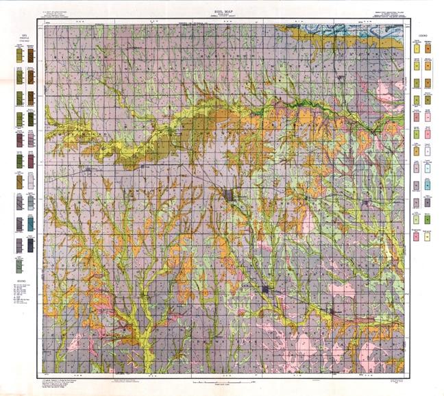
3 SOIL SURVEY OF JEWELL COUNTY. DESCRIPTION OF THE AREA. Jewell county is situated on the north line of Kansas midway between the east and west boundaries. The county is thirty miles square and comprises 900 square miles, or 578,840 acres. DRAINAGE. The Republican river and its tributaries on the north, and the tributaries of the Solomon river on the south, make up the main drainage systems. The largest tributary of the Republican river is White Rock creek which passes in an easterly direction entirely across the north central part of the area. The eastern and southern parts are drained by a number of streams, of which the largest are Buffalo, East and West March, Limestone, West Limestone, and East Oak creeks. In dry seasons these stream beds are empty, and there are times when the Republican river carries the only running water in the county. South of Ionia, Jewell, and Randall the country is flat to gently rolling. Small streams are less numerous and drainage is not so good. Broadly speaking, the surface of the county presents three general physiographic divisions, the outlines of which mark the boundaries of the various soil groups. First, the high plateau and deeply eroded plains which cover the northern and central parts of the county; second, the level or gently sloping plains which lie two or three hundred feet below the high plateau and bound that division on the east and south; and third, the numerous valleys. CLIMATE. Table I shows an annual precipitation of 26.8 inches. This is favorably distributed for the growth of crops, nearly three-fourths of it falling during the five months from April to August, inclusive, and nearly one-third during June and July. There is, however, a wide variation in the total amount of rainfall for the driest and wettest years. Because of the relatively high temperature and the dry condition of the atmosphere due to the prevalence of hot, burning winds, evaporation is rapid and much care is necessary to prevent the loss of moisture during the growing season. (5)
4 SOILS. The soil of Jewell county fall naturally into four general groups: (1) Residual soils or those derived from the underlying rocks; (2) loessial soils or those formed from the weathering of wind-blown deposits; (3) soils of mixed loessial and residual origin; and (4) alluvial soils or those laid down by streams. The oldest geological formation contributing to the soils of this county consists of slate-colored shales, known as the Graneros shales. This material weathers into soft, thin flakes and then into dark, heavy clay, The formation is exposed only on steep, eroded hillsides and has given rise to the rough broken land. Overlying these shales are several beds of limestone. The first of these consists of a massive bluish-gray limestone with an average thickness of about fifteen feet. The second bed consists of several layers of hard-grained limestone separated from one another by thin beds of shale and having a total thickness of about ten feet. The third, which is known as the fence-post bed, is a capping of limestone about nine inches thick. Above the limestone occur beds of light-colored shales and thin layers of limestone. Together these four formations have given rise to the Benton stony loam and a deep phase of this type.
5 Along the south slope of the White Rock creek and in a few places in the southern part of the county erosion has exposed a formation of chalk, soft limestone, and shales. In the former location this has given rise to a dark-colored soil which has been classified as the Benton silty clay loam, while in the southern part of the county its weathering in the presence of iron has given a type with a yellow subsoil, which has been classified as the Belvidere silt loam. Overlying these formations and covering a large portion of the county is a deposit of loess. It is composed of light yellowishbrown silt and very fine sand, varying greatly in depth in different parts of the county. In the northeastern part, where the county consists of a high, level divide, its depth probably exceeds one hundred feet; but in the central part, where the county is considerably eroded, much of it has been washed away and on the slopes it has disappeared entirely. In weathering, it has given rise to two important groups of soils-the Colby and the Jewell series. The bottom or alluvial soils may be grouped into three separate series whose types are marked by distinct characteristics. The Lincoln series includes the dark-colored types not subject to overflow. The other two groups of alluvial soils, Sarpy and Laurel, are found in the bottoms of the Republican river and are each subject to overflow. Table II gives the names and extent of the several types mapped in Jewell county.
6 Colby Series. The Colby silt loam, Colby silty clay loam, and Colby very fine sandy loam, with two phases of the silt loam, comprise about seventy percent of the total area of the county. The soils of this series owe their origin to the weathering of the loessial material which covers the greater part of the county. The topography ranges from quite rolling to level, the silt loam occupying the more level areas. COLBY SILT LOAM. The surface soil of the Colby silt loam consists of a brownishgray to dark grayish-brown silt loam containing a very small amount of very fine sand and a high content of organic matter. The subsoil is usually made up of two distinct layers, the upper of which is a grayish-brown to reddish-brown compact silty clay loam, becoming lighter in color and texture with increasing depth. The lower layer is a pale yellowish-gray, mealy, unaltered loess. The depth of the surface soil varies with the topography and degree of weathering, ranging from five to ten inches on the slopes and from eight to twenty inches on the level areas. As a rule, the soil contains enough clay to give it a slightly compact structure when wet, and on drying a slight crust often forms on the surface. The soil is usually well supplied with lime throughout, while the deep subsoil frequently contains white lime concretions from onehalf to three or four inches in diameter. The type as a whole is friable and easily worked, and a fairly good tilth can be maintained with very little difficulty. However, in a few instances small spots occur where the compact layer immediately below the surface has become so hard as to be called hardpan. The greater part of the type has sufficient slope to insure good surface drainage. In the more hilly areas drainage is excessive and erosion is proceeding at a rapid rate. The Colby silt loam, heavy phase, is closely HEAVY PHASE. associated with the Colby silt loam, the chief point of difference being that the former has a finer, smoother silt loam surface; a slightly heavier, deeper, and darker colored subsoil; a lower elevation; and a more uniformiy level topography. This phase is an extensive soil in the southern and eastern parts of the county. It occurs in many small bodies of very irregular outline and constitutes about one-half of the gently rolling country which lies between the general level of the hills.
7 The surface of this phase ranges from fairly level to gently undulating. Because of the level topography, the drainage is imperfectly developed, though the slope is usually sufficient to remove any excess water. The heavy phase of the Colby silt loam is one of the most popular soils in the county, outside of the valleys, because of its loose, mellow surface and wide crop adaptation. LIGHT PHASE. The Colby silt loam, light phase, is an intermediate soil between the silt loam on one hand and the very fine sandy loam on the other. Since it occurs as a narrow strip between these two types, the texture varies considerably. In general, however, it consists of about twelve inches of a brownish-gray loam, resting on a layer of light gray or yellowish-gray compact silt clay loam. At an average depth of about twenty-four inches there occurs a light yellowish-gray friable silt loam, which passes at three or four feet into a thick bed of light gray fine sand. The type has a mellow, easily worked surface, and because of the heavy subsoil is fairly retentive of moisture. It is deficient in organic matter. The light phase of the Colby silt loam is not an extensive type, and is found near the bluffs of the Republican valley in the northeastern corner of the county. The greater part of it has a moderately level to gently sloping topography as it occupies the drainage divide between White Rock creek and the Republican river. The drainage is excellent. Table IIII gives the results of mechanical analysis of typical samples of the soil, subsoil, and lower subsoil of the Colby silt loam. COLBY SILTY CLAY LOAM. The surface soil of the Colby silty clay loam consists of grayishbrown or brownish-gray silt loam or silty clay loam with an average depth of about four inches. The subsoil consists of two distinct strata. The upper one, extending to about twenty-four inches, is made up of grayish-brown to slightly reddish-brown
8 compact silty clay loam; the lower one of lighter colored unweathered loess. This deep subsoil material usually consists of light yellowish-gray, friable silt loam carrying a small amount of clay and very fine sand. Although no large bodies of the Colby silty clay loam are found, the type is widely distributed and the aggregate covers a considerable proportion of the county. It is most extensively developed in the hilly section east of Mankato, though it is found in smaller bodies along nearly every draw in the county. The topography of the greater part of the type ranges from gently sloping to quite steep. Usually the areas occur along the sides and around the heads of draws, but frequently they extend over the narrow ridges and up onto the high level plateaus. Because of its sloping position, the soil is subject to considerable erosion, and much care is necessary in cropping to prevent its further washing. The type is not an easy one to work, and unless thoroughly cultivated is apt to suffer from drouth. Table IV gives the results of mechanical analysis of samples of the surface soil, subsoil, and lower subsoil of this type: COLBY VERY FINE SANDY LOAM. The surface soil of the Colby very fine sandy loam from ten to twenty-four inches in depth consists of grayish-brown to light brownish-gray very fine sandy loam containing a relatively high percentage of silt. The subsoil to thirty-six inches consists of a yellowish-gray to buff-colored silt loam carrying a small amount of very fine sand. The type is not very extensive; being found in only one continuous strip about one-half to one mile in width on the slopes leading down into the Republican valley in the northeastern corner of the county. A few narrow strips of this body extend south along the deep erosions, but in no case is the type found more than two miles from the river bottoms.
9 The Colby very fine sandy loam is a loessial soil, formed largely by the weathering of fine materials which have been blown from the sandy soils in the Republican river valley. The surface is sloping to quite steep, though only on the sides of the draws is it too steep for cultivation. Because of the steep topography, drainage is sometimes excessive. The soil is easy to cultivate and retains moisture throughout the growing season, making it well suited to crops which mature early. It is, however, deficient in humus. Jewell Series. The origin of the Jewell series, which occurs in small bodies throughout the southern part of the county, has not been definitely determined, but is thought to be due to an intermingling of the same loessial material that gives rise to the Colby soils with. residual material from the underlying shales. This series, which is made up of the Jewell silt loam and Jewell silty clay loam, makes up but a very small portion of the county. JEWELL SILT LOAM. The surface soil of the Jewell silt loam consists of dark grayishbrown to medium grayish-brown smooth silt loam carrying a relatively large amount of organic matter and extending to a depth of ten to twelve inches. The subsoil is made up of two or more layers. The upper one, extending from twelve to twenty inches, consists of dark grayish-brown silty clay or silty clay loam, Below this lies a tough, compact layer of silty clay, varying in color from gray to blackish-brown. When wet this is very sticky and plastic, and on drying becomes brittle and impervious like hardpan. At a depth of twenty to thirty inches the compact layer grades into light gray or mottled friable silt loam or silty clay loam. The greater part of the Jewell silt loam has a level topography. The soil is easily cultivated and in ordinary years is said to retain moisture a little better than the more elevated upland types. The results of this type depend very much on the character of rainfall. In favorable years excellent yields are secured, but owing to the impervious subsurface soil the deep subsoil is seldom wet except in the rainiest years. The results of mechanical analysis of samples of the soil and subsoil of this type are given in Table V.
10 JEWELL SILTY CLAY. The JewelI silty clay consists of ten to twelve inches of dark gray to grayish-brown silty clay. At an average depth of twentyfour inches the subsoil grades into light gray or white silty clay containing a small amount of lime and slightly marked with reddish-brown iron stains. When wet the soil is sticky and plastic, and in this condition is very hard to work. The surface drainage of the type is good, but the compact structure of the subsoil retards the downward passage of the water. Because of this and the plastic nature of the surface soil, the greater part of the type is still in pasture. Mechanical analysis of samples of the soil and subsoil of the Jewell silty clay gave tho following results: Belvidere Series. BELVIDERE SILT LOAM. The surface soil of Belvidere silt loam ordinarily consists of eight to sixteen inches of grayish-brown to dark brown heavy silt loam, with an average depth of twelve inches, Small flakes of gray or yellow shale are sometimes found throughout the soil. The subsoil to a depth of thirty-six inches ranges from an ocherousyellow friable silt loam, closely approaching a silt, to a lighttextured silty clay loam. This soil is always heaviest on the
11 slopes. In such places erosion has carried away the dark silty soil, leaving the yellow silty clay loam exposed. The Belvidere silt loam is one of the less extensive soils in the county. It occurs on the moderate slopes in the eastern and southern parts of the county. This soil is residual in origin, being formed from the weathering of gray to yellow calcareous shale of the Cretaceous period. Benton Series. The Benton series consists of the Benton silty clay loam, the Benton stony loam, and a deep phase of the Benton stony loam. The soils of this series are residual in origin, being derived from limestone and shale. The topography ranges from sloping to hilly. The series usually occupies the position between the lowland or bottom soils and the upland soils as the Colby series. BENTON SILTY CLAY LOAM. The surface soil of the Benton silty clay loam consists of eight to twelve inches of brownish-gray to dark brown silty clay loam, with a high content of organic matter, underlaid by a brownishgray silty clay loam. At a depth of about twenty-four inches the material becomes lighter in color and texture, and at thirty-six inches there is usually found a light yellowish-gray friable silty clay loam containing numerous small particles of lime. Below this the material passes gradually into marl, chalk, or clay, which is frequently near the surface on the upper slopes and causes light gray spots in the fields. In all cases the soil is loose and easy to cultivate, while its high organic-matter content gives it a higher water-holding capacity than is usually found in types of such porous subsoil. This soil is of comparatively small extent, being found mostly on the slope along the south side of White Rock creek. In the lower parts of the slope the surface contains considerable material that has been washed down from the higher soils, and on its upper boundary more or less loessial material has been added to the soil. Under the influence of lime and a favorable moisture supply a great deal of organic matter has accumulated, to which the color of the soil is due.
12 14 Bulletin No. 210, January, The following Table VII gives the results of mechanical analysis of samples of the soil and subsoil of the Benton silty clay loam: BENTON STONY LOAM. The surface soil of the Benton stony loam, ranging in depth from three to ten inches, consists of dark brown loam or silt loam carrying a high admixture of white calcareous shales and small fragments of partially disintegrated limestone. The subsoil, when any is present, consists of light brownish-gray or yellowishgray silty clay loam which soon passes into limestone fragments. Frequently the soil covering is very shallow and a stratum of limestone is found from one to two feet below the surface. This type represents the area of rough stony land adjoining the streams that have cut into the underlying shales and limestones. Areas are found along nearly all the streams and draws in the eroded section of the south central and eastern parts of the county. The largest bodies are found skirting the uplands south of the White Rock creek. Usually the topography is steep and precipitous along the larger streams, but away from the streams it becomes more gentle and joins the upland types in gentle slopes. The type is excessively drained and the character of the surface is such that erosion is rapidly exposing additional areas of the underlying rock. The Benton stony loam is too rough and stony to be of use for cultivated crops. DEEP PHASE. The Benton stony loam, deep phase, is closely associated with the main type. The chief points of difference are that the phase has a deeper soil with less limestone in the subsoil, and a somewhat more level topography. It is, therefore, a little better adapted to cultivated crops. This phase occurs in narrow strips along nearly all of the draws in the south central part of the county. Many of the areas are of such small extent or so closely associated with the main type that no attempt was made to separate them on the map.
13 ROUGH BROKEN LAND. The rough broken land, occurring on the sides of steep slopes where erosion is active in removing the material, is naturally a type of considerable variation. Typically, it consists of steelgray to bluish-black, heavy, plastic clay resting on mottled black and yellow heavy clay of sticky, compact structure. At varying depths, depending on the state of weathering and the rapidity of erosion, the clay grades into beds of bluish-black or slate-colored shale. Sometimes the shale is found outcropping on the surface. The rough broken land is an unimportant soil, occurring only in narrow strips on steep, eroded hillsides. It is a residual soil derived from the weathering of slate-colored shales. Where the hills are not too steep they support a good growth of native grass. None of this soil is under cultivation, as its rough and broken topography prevents it from being used for cultivated crops. Lincoln Series. The Lincoln series includes the dark-colored types of bottomland soils not subject to overflow. They are found along every stream in the county except the Republican river and constitute the most valuable soils in this section of the state. The types are composed of reworked loessial material, of which the greater part has been carried in from near-by upland plains. The series has a nearly level, terrace-like topography, with a slight fall in the direction of the streams. Usually the slope is sufficient to provide good drainage, though some of the heavier and depressed areas are in need of tiling. Four types and two phases were mapped, ranging from very fine sandy loam to heavy clay. LINCOLN VERY FINE SANDY LOAM. The Lincoln very fine sandy loam has a surface soil ranging from a medium to light brownish-gray silty very fine sandy loam to brownish-gray very fine sandy loam containing a high content of rather coarse silt. At an average depth of about twelve inches the material grades into slightly lighter colored silty very fine sandy loam, which passes into a layer of light gray coarse silt and very fine sand at thirty inches. The presence of the fine sandy material gives a loose mellow surface which permits of cultivation under a wide range of moisture conditions. In a few instances, small spots are encountered in the fields where the surface soil enters upon a compact layer of gray silty material. During long
14 periods of drouth this material dries and bakes into a condition resembling hardpan. On such spots crops suffer from drouth. This is an inextensive type, occurring in narrow strips from one-eighth to one-fourth mile in width along the immediate bank of White Rock creek. LINCOLN SILT LOAM. The surface soil of the Lincoln silt loam to an average depth of twelve inches consists of dark brown to brownish-gray silt loam with a high percentage of organic matter. The subsoil consists of two distinct layers, the upper one being a brown to dark brown silty clay loam of compact structure, which grades at about thirty inches into light grayish-brown or brownish-gray friable material of somewhat lighter texture. Throughout the greater part of the type the high content of organic matter renders the type friable and easily worked, though in a few cases where the soil is shallow it becomes rather hard and compact when dry. This is one of the most productive soils in the county and is well adapted to all crops grown in this part of the state. COLLUVIAL PHASE. The Lincoln silt loam, colluvial phase, is a medium to heavy silt loam with a high content of organic matter. When dry the color is a dark brownish-gray to brown, but when wet it becomes dark brown. At an average depth of fifteen inches the soil grades into a light brownish-gray friable silt loam containing a small amount of very fine sand. A layer of brown to dark brown compact silt loam containing considerable clay usually occurs at from twenty to thirty inches, and below this material the friable silt loam is again found. This phase is a widely distributed soil, being found in narrow strips along nearly all the smaller streams in the county. The phase is very closely associated with the main type and in many cases the mapping of each includes small bodies of the other. In formation this phase is largely colluvial, as it occurs chiefly along the streams where water flows rapidly after heavy rains and carries to lower levels most of the materials cut from the hills. The materials which make up the soil are, therefore, chiefly those which have been washed down from adjacent slopes rather than those left by overflowing streams.
15 The position of this soil in relation to the upland types resuits in its receiving much of the water drained from these soils. This greatly improves its moisture condition. Because of the high organic content it is fairly friable and easily worked. SANDY SUBSOIL PHASE. The soil of the Lincoln silt loam, sandy subsoil phase, to an average depth of about twelve inches consists of a friable silt loam containing a small amount of very fine sand and a high content of organic matter. When the soil is dry the color ranges from dark gray to brownish-gray, but when wet it is dark brown or black. The subsoil is a light brownish-gray silt loam of slightly heavier texture than the soil, which grades at about eighteen inches into light grayish-brown silty very fine sandy loam. Below this, alternating layers of light and dark colored sandy material extend to depths of thirty to fifty feet. This phase is limited in extent, being confined to comparatively small bodies within the valley of White Rock creek. It is very productive, easily worked, and well adapted to a wide range of crops. LINCOLN SILTY CLAY LOAM. The Lincoln silty clay loam consists of twelve inches of dark brownish-gray silty loam overlying material of about the same texture but lighter color. At twenty to twenty-four inches the subsoil grades into gray to light brownish gray silty clay loam. When wet the soil is sticky and plastic, and in this condition is very difficult to work, but owing to the presence of large quantities of organic matter it becomes friable and mellow under cultivation. If thoroughly worked it holds moisture well, but if allowed to become too dry the surface bakes and cracks and evaporation is rapid. The type is found in small areas along nearly all the larger streams in the county. It lies away from the streams and near the base of the hills, and usually occupies a slightly depressed position with respect to the other Lincoln types. Because of the difficulty of preparing the land and the tendency of the soil to bake in the spring, it is often a hard matter to secure a good stand of corn. When properly drained the soil is well adapted to alfalfa. LINCOLN SILTY CLAY. The Lincoln silty clay varies somewhat with location and mode of formation. Immediately under the bluffs, where the soil is largely formed by the wash from the heavy clay of the rough
16 broken land, it consists of eight to ten inches of heavy dark brownish-gray clay, with a slightly bluish cast, grading into dark gray compact clay containing a few small particles of shale and lime. At an average of twenty-four inches the subsoil grades into a dark brownish-gray compact silty clay loam with a rather high content of lime. Farther out in the bottom, where the type is more largely sedimentary in origin, the soil is more uniformly dark gray to black, and grades at a depth of ten inches into heavy clay loam or silty clay of dark gray color which is sometimes mottled with brown. In these locations the lime and small particles of shale are usually entirely absent. When wet the soil is sticky and plastic, and upon drying it becomes baked and hard. It is a difficult soil to work unless handled when in the proper condition with respect to moisture. The type is both alluvial and colluvial in formation. Because of its flat surface and its relatively low position with respect to the other Lincoln soils, which separate it from the streams, the drainage of the type is frequently deficient. The following Table VIII gives the results of mechanical analysis of samples of the soil and subsoil of the Lincoln silty clay: Laurel Series. The Laurel series, which comprises the Laurel fine sand and Laurel fine sandy loam, makes up the light-colored sandy soils and subsoils found in the bottoms of the Republican river. These soils are of alluvial formation and are subject to overflow. They have a level to dune-like topography, are deficient in organic matter, and unless protected are subject to blowing. LAUREL FINE SAND. The Laurel fine sand consists of about twenty inches of gray fine sand of loose, open structure. The subsoil is a light gray fine to medium sand, very loose and incoherent. In some places a small area of black silty clay loam an inch or less in thickness is
17 found between the soil and subsoil. The soil is made up chiefly of clean quartz and contains very little organic matter. The Laurel fine sand is found within the larger bands of the Republican river. Owing to the tendency of the soil to drift very little of it is cultivated, and in its present condition has very little agricultural value. LAUREL VERY FINE SANDY LOAM. The surface soil of the Laurel very fine sandy loam consists of light gray to brownish-gray very fine sandy loam with an average depth of about twelve inches. The subsoil to twenty-four inches consists of yellowish-gray fine sandy loam containing a small amount of silt and clay or light gray fine to very fine sand. Below this depth it is nearly always light gray sharp fine sand. At varying depths throughout the subsoil occurs a stratum of dark heavy silt or silty clay loam one to two inches in thickness. Although the surface soil contains considerable silt, it is loose and friable of structure and easy to cultivate. The surface is level and all of the type is subject to overflow. In some of the poorly drained, areas a small amount of salt is found, but the affected areas are of small extent. Sarpy Series. The soils of the Sarpy series are of very small extent and comprise the dark-colored surface soils containing considerable organic matter and light-colored sandy subsoils of the Republican river valley. These soils are of low, flat topography, subject to frequent overflow. They are lower than some of the soils which separate them from the river, and therefore have poor drainage. SARPY SILT LOAM. The soil of the Sarpy silt loam consists of twelve to fourteen inches of brownish-gray to brown silt loam containing a small quantity of fine sand and considerable organic matter. The subsoil over the larger part of the type consists of fourteen to thirtysix inches of light brownish-gray to yellowish-gray silty very fine sandy loam. In places the subsoil consists of twelve to eighteen inches of black silty clay loam resting on clean gray sand which extends to a depth of several feet.
18 Only five small bodies of this type, with a combined area of less than a square mile, are found in the county. They occur as narrow, shallow depressions which wind through the areas of lightertextured soils. SARPY SILTY CLAY LOAM. Since the Sarpy silty clay loam is associated with long-abandoned channels of the Republican river, it is a type with very little uniformity in texture. In places it consists of ten to twelve inches of brownish-gray to brown silty clay loam containing a small amount of very fine sand, and in other places it consists of sixteen inches of dark brownish-gray heavy clay loam carrying a large amount of organic matter. The subsoil usually consists of light gray fine sandy loam cut by one or more thin layers of dark silty clay. In some places a gray sharp sand of fine to medium texture begins at twenty-four inches, continuing downward for several feet. The type is of little importance as its total area in the county is only about a square mile. The areas occurring near White Rock creek occupy a slight elevation and are well drained. They are under cultivation, while the areas in the Republican river valley are covered almost entirely with growths of trees, weeds, and grasses. Meadow. Meadow comprises the low-lying areas along streams which are subject to frequent overflow and which are so varied in texture that a strictly textural separation is impracticable. The soils range from silty fine sandy loam to silty clay loam. The color ranges from brown in the light-textured areas to black where the texture is heavy. The subsoil is even more variable than the soil, ranging from a fine sandy loam to clay. This type is formed of material deposited by successive overflows and represents parts of the present flood plain of the stream. It lies from twelve to twenty-five feet below the other valley soils and from ten to twenty feet above the stream bed. Salty Marsh. Salty marsh differs from the land mapped as meadow and other alluvial soils in that it carries injurious quantities of salt. The soil has little uniformity either in texture or color, the surface soil ranging from gray silt loam or fine sandy loam to a fine sandy clay or clay loam. Near the stream channel it is frequently a black heavy clay which is very slippery and plastic when wet.
19 The type is found only along the streams in the eastern part of Vicksburg township. Its area in the county is small, being about 512 acres. Owing to the accumulation of salt, largely sodium chloride, the type is unfit for cultivated crops. CHEMICAL ANALYSIS OF SOIL TYPES IN JEWELL COUNTY. The detailed report of the chemical analysis of soil types in Jewell county is give in the tables in the Appendix. The grouping is made with reference to the classifications of types used in the soil survey. The table gives the location where each sample was taken, the type as given in the soil survey, and the percentage of plantfood elements found in the different types. None of these soils were acid. In Table IX are given the pounds of fertility elements per acre in the surface soil. These calculations are made on the assumption that an acre of the soil seven inches deep weighs two million pounds. The total amount of fertility elements in the subsurface and subsoil of any type can be calculated from the percentage composition given in the table in the Appendix, assuming that the thirteen inches subsurface stratum weighs four million pounds and the twenty inches of subsoil stratum weighs six million pounds.
20 THE NITROGEN CONTENT. The average fertile upland silt and loam soils of the Colby and Jewell series contain, in round numbers, three thousand pounds of nitrogen per acre in the surface seven inches. The sandy upland soils contain a much smaller amount. Colby very fine sandy loam contains 1800 pounds per acre. The soils of the Benton series were in two cases taken in a native meadow and a pasture, and in one case in recently broken land. The soils from the Benton series are irregular, one containing.24 percent nitrogen, the second.23 percent, and the third.35 percent. This high percent of the latter is in a large measure due to the fact that the sample was taken only four inches deep. If it is assumed that.24 or.23 represents the average of the native prairie soil and that is compared with the average of the upland soils,.15 or.16 percent, it appears that these soils have lost one-third of the original stock of nitrogen. This assumption is supported by studies of soils from other counties where it has been found, by direct comparison of samples of cultivated and uncultivated soils in close proximity to each other, that the cultivated soils have lost from one-fourth to two-fifths of the nitrogen originally present in the virgin soil. The bottom soils as a class have a much higher nitrogen content than the upland soils. The Lincoln silty clay and the Lincoln silt loam have each 4200 pounds per acre in the surface soil. This is above the average for good soils. The sandy subsoil phase, the colluvial phase, and the silty very fine sandy loam of the Lincoln series have a much smaller nitrogen content than the silty clay and the silt loam soils. The Sarpy silty clay loam and the Sarpy silt loam have 3800 and 2400 pounds per acre, respectively. The soils in the Laurel series are low in nitrogen content. The chemical analyses of the soils from the salt marsh show that if these soils could be freed from excess of salt they would be fertile. The percent of nitrogen in the subsurface soil is approximately two-thirds that of the surface soil, and the percent of nitrogen in the subsoil is about one-third that of the subsurface soil. Nitrogen and carbon are the two elements which show this progressive decrease. But these figures of progressive decrease do not tell the whole story. The nitrogen in the subsurface and the subsoil is much less easily made available than that in the surface. When the surface soil is removed from the land by blowing or washing, the harm is not only that the soil which contains more nitrogen has been removed, but the soil which takes its place contains this
21 smaller amount of nitrogen in a less available form. This is one of the reasons why unproductive spots appear in fields where the soil has been blown or washed away. THE PHOSPHORUS CONTENT. The phosphorus content of the upland soils in Jewell county averages well with the upland soils of central Kansas. Unlike nitrogen, the percentage of phosphorus does not decrease in the subsurface and subsoil. That is, the soils in the lower strata contain as much phosphorus per cubic foot as the surface soil. But the phosphorus in the subsurface and subsoil is in a different condition. If the surface soil were removed the plants would suffer for want of phosphorus, not because the total amount present in each unit of soil mass was less, but because this phosphorus was in an unavailable condition. The organic matter in the subsurface and subsoil is old and has little power to liberate plant food. This condition is remedied when deep-rooted plants are grown, like sweet clover or alfalfa. It is true that roots of grain crops extend below the surface soil, but their roots are small compared with those of sweet clover or alfalfa, and the benefit is correspondingly less. The Colby silty clay loam averages about 800 pounds of phosphorus per acre in the surface soil, and the Colby silt loam, as well as the Jewell silty clay, a trifle less. These soils have an increasing percentage of phosphorus in the deeper strata. The soils of the Benton series average as high in phosphorus content as the bottom soils. The soils of the Lincoln series average 1100 pounds of phosphorus per acre. Lincoln silty clay, with 1360 pounds, has the highest phosphorus content of any soil in Jewell county. Phosphorus as an element does not leach from the soil to any appreciable extent. For that reason, the phosphorus content of bottom soils is determined to a large extent by the phosphorus content of the adjacent upland. The soils of the Sarpy series average as high in phosphorus as the soils of the Lincoln series. The Laurel soils have a phosphorus content of 860 pounds per acre. This is high for sandy soils. THE POTASSIUM CONTENT. The potassium content of all soil types in Jewell county is high. Most types average over two percent. This is equivalent to over forty thousand pounds per acre in the surface soil. The soils of the Benton series have a much smaller amount, but because of the high lime content of these soils the potassium is more avail-
22 able. The average mixed commercial fertilizer of formula contains 1.66 percent potassium. The upland soils of Jewell county contain more potassium per pound of soil than such a fertilizer. This does not mean that the potassium in this soil is necessarily of the same value for crop production, but it does mean that if these soils are rightly handled they have a store of potassium which will last indefinitely. POTASSIUM ASSOCIATED WITH PROBLEM OF NITROGEN AND ORGANIC MATTER. Nitrogen and phosphorus accumulate to the largest extent in the grain, while potassium accumulates to the largest extent in the leaves and stems of the plant. A fifty-bushel corn crop contains 9.5 pounds of potassium in the grain, and 26 pounds in the stalk. The same relative proportion holds true for all cereal crops, that the leaves and stems of plants contain about three times as much potassium as the grain. A soil whose potassium content is two percent contains forty thousand pounds of this element per acre in the surface soil. If only ten pounds are removed every year, the supply would last four thousand years. This means indefinitely, because in such long periods of time the topography of the earth is changed by the insensible lowering of the earth s surface. But the larger part of the potassium in the soil is in the rock material; unavailable and insoluble. The force which will make this potassium available is decaying vegetable matter, which is also rich in potassium. When this organic matter decays, the potassium stored in the plant structure is available for the growing crop, while when it is decomposed it helps to liberate more potassium from the large amount stored in the soil. The problem of potassium in Jewell county is so closely connected with the problem of nitrogen and organic matter, that when this is properly handled, the potassium problem will be solved and it will never be necessary for the farmers of Jewell county to purchase potassium in the form of commercial fertilizers. THE CALCIUM OR LIME* CONTENT. As a class, the soils of Jewell county are well stocked with lime. In regions of small rainfall, the calcium content increases in the subsurface and subsoil. On no other element is the climatic effect shown to be as great as on this. Soils in the southeastern
23 part of the state contain a much smaller amount of calcium than the soils where the climate is drier, as in Jewell county. The age of a soil derived from limestone can sometimes be judged by its calcium content. The high calcium content of the soils of the Benton series is due to the recent formation. The hilly nature of the series favors erosion, which continually removes the soil from the slopes and prevents its accumulation in a deep stratum. New soil high in calcium content is therefore being constantly formed from the lime rock beneath. Calcium is one of the elements absolutely essential to the growth of plants, but the amounts so needed are small as compared with soil needs. The influence of calcium on the chemical, physical, and biological properties of the soil is so great that it has been called the dominant factor in soil fertility. When soils are deficient in calcium the condition called acid soil arises. Ordinarily the calcium neutralizes the soil acids Calcium improves the physical condition of the soil by making the subsoils more open. The well-known success of alfalfa in Jewell and the surrounding counties is due in no small measure to the large calcium content of these soils. The presence of inorganic carbon shows that the soils are well supplied with lime in the best form. THE CARBON CONTENT. Carbon is determined as organic and inorganic. The organic carbon has come from plant residues. The inorganic carbon is present in undecomposed carbonates, such as limestone. The organic carbon is an index of the amount of organic matter in the soil, which is assumed to be twice as much as the carbon. This assumption is based on a study of the organic matter found in the plant residues and the changes it undergoes in the soil. The term humus is frequently used for this, but it has different meanings in the minds of different writers. With some the term humus is synonymous with organic matter, with others it applies to definite chemical compounds. Strictly speaking, humus is organic matter in a certain stage of decay. Organic matter includes humus, but all organic matter in the soil is not humus. When soils contain an abundance of organic matter, humus is continually formed.
24 SOIL PROBLEMS OF JEWELL COUNTY. Any area of country as large as Jewell county has several soil problems. These soil problems may be natural and characteristic of the several soils, or they may have been brought about by poor methods of tillage. Some of the more important of these problems are the maintenance of the supply of organic matter where it is abundant, and the increasing of the supply where the soils are deficient in this material; the prevention of erosion on the steeper slopes; and the drainage of the wetter areas. SUPPLY OF ORGANIC MATTER. The problem of maintaining the supply of organic matter in Jewell county is a very serious one, especially on the lighter soils. Any soil that is being cultivated is constantly losing organic matter through decay, and unless it is supplied in some way the amount of this material becomes so low that decreased crop yields result. Organic matter enables the soil to hold more water, keeps it in good tilth, and in decaying makes available the unavailable plant food in the soil. The loss of organic matter may cause decreased yields, not necessarily because the plant-food elements have been exhausted, but because there is no fresh organic matter present to make the supply of plant food available. Organic matter is supplied by all kinds of plant life. Corn stalks and straw are useful for this purpose. When they can not be used as feed or made into manure, they should be worked into the soil. Such material should never be burned, for when burned the organic matter is destroyed. Organic matter may also be supplied in the form of barnyard manure. On many farms, especially those having sandy soils, it may be impossible to maintain the supply by returning all fodder, straw, and manure to the fields. On such farms it will be necessary to grow crops for the purpose of turning under as green manure. However, all other sources of organic matter should be utilized before resorting to the use of green manuring crops, for in growing green manuring crops large amounts of water are used and thus lost from the soil as far as other crops are concerned. The soils of Jewell county that require special care in regard to the organic content are: the light phase of Colby silt loam, the eroded portion of all Colby types, Lincoln very fine sandy loam, and the members of the Laurel series.
25 USE OF STRAW. Wheat straw is undoubtedly one of the most valuable byproducts of the farm. At the present time a large quantity of the straw is burned or otherwise destroyed. This results in a loss that the farmer can not afford. The average annual production of straw in Jewell county for the last five years has been 57,254 tons. This straw, if properly used on the land, would supply not only organic matter which would greatly increase the water-holding capacity of the soil, but would add as well over $175,000 worth of plant food annually. When burned not only is the organic matter destroyed but most of the plant food is lost. The most economical way of handling the straw is to utilize as much of it as possible for feed and bedding and then apply the manure to the soil. When it is not possible to follow this method, the straw should be applied as a surface dressing on wheat during the winter at the rate of one to one and a half tons per acre. Heavier application should be avoided. When top dressings of this kind are made, the straw acts as a surface mulch and aids in the conservation of moisture. Later it becomes incorporated in the soil mass and supplies organic matter and plant food. BARNYARD MANURE. Barnyard manure, providing it can be obtained, is one of the best forms in which to supply organic matter. Fresh manure furnishes the largest amount of organic matter. Therefore, whenever possible, manure should be applied in a fresh condition. If manure is stored it decays rapidly, and organic matter as well as plant food is lost. One of the greatest wastes on the average farm results from the leaching and fermentation of manure, due to poor handling. Half of the value of manure is lost when it is exposed to the weather for six months. The feed lot should be cleaned in the spring and the manure never left to be leached by the rains of spring and summer. Manure can be applied with best results to crops like alfalfa, corn, and kafir. It should be applied in small quantities and evenly spread over a large area. Manure can also be used with profit as a top dressing upon wheat, provided it is distributed evenly. When used on wheat it should be applied in the fall or early winter, when it will serve as a protection to the wheat during a severe freeze and as a mulch to prevent evaporation during the following spring and summer.
26 Application of barnyard manure will also aid greatly in improving the physical condition of the heavy soils of the county, especially the local area of heavy soils known as gumbo. Organic matter will make these soils more open and porous and thus easier to cultivate. EROSION. On some of the steeper slopes of the county erosion has had a marked effect in depleting the soil of its fertility by removing the surface portion. When a field is eroded and the surface soil removed the most valuable part of the soil is gone. The surface soil contains more humus than the subsoil, and the plant food in the surface soil is more readily available than that in the subsoil. The soils of Jewell county on which this process has taken place to a noticeable extent are the steeper slopes of all the Colby soils, but especially the lighter ones, the Benton soils, and the Belvidere silt loam. A soil which will hold only a small amount of water is more subject to erosion than one which has a greater water-holding capacity. Since organic matter increases the water-holding power of a soil, an abundance of this material in the soil will aid in preventing erosion. This is true not only because it will cause the soil to hold more water and prevent excessive surface flow, but also because the organic matter binds together the soil particles. Erosion may also be prevented by throwing fodder or straw into a wash as soon as it commences to form. Gullies that have been formed may be filled by throwing waste material, such as brush, fodder or stover, into them, and then plowing the soil in from each side until the gully is filled. The area should then be seeded to some strong rooted crop, such as alfalfa. Many soil slopes that are subject to erosion are adapted to alfalfa and should be kept in this crop almost continuously. DRAINAGE. There are a few local areas of Jewell silt loam and Jewell silty clay which may be benefited greatly by tile drainage. However, this is not a general condition. The heavier, low lying areas of the Sarpy series may be benefited by drainage where such a system is practical. COMMERCIAL FERTILIZERS. Commercial fertilizers are not used in Jewell county, but more interest is being shown in their use each year, and the general nature of their effect on the soil should be understood. Commer-
27 cial fertilizers supply one or more of the plant-food elementsnitrogen, phosphorus, or potassium. Most of the fertilizers found on the market are known as complete fertilizers and contain all three of these elements. However, a fertilizer may be purchased which supplies but a single element. NITROGEN. A thirty-bushel crop of wheat removes from the soil forty pounds of nitrogen, and a fifty-bushel crop of corn removes fifty pounds of nitrogen. This figures only the nitrogen contained in the grain, assuming that all the straw and stalks are returned to the soil. If the nitrogen in this thirty-bushel crop of wheat were purchased as a commercial fertilizer it would cost $8. It would, therefore, cost about one-fourth the value of the wheat crop to supply, by means of commercial fertilizers, the nitrogen removed in the grain. It would be impracticable at present market prices to attempt to supply the nitrogen removed by wheat in this way. It would not only be impracticable, but it would be foolish when in the air above the soil there are millions of pounds of nitrogen which may be obtained by means of leguminous crops. In order that the grain crop may receive the benefit of this nitrogen, leguminous crops, such as cowpeas, alfalfa, and clover, should be grown in rotation with the grain crop, or manure obtained from feeding leguminous crops should be applied upon the land where the grain crop is to be grown. With such a cheap and practicable means of securing nitrogen from the air, it is only the unthinking farmer who would purchase nitrogen in any large quantity in the form of commercial fertilizer. PHOSPHORUS. A thirty-bushel crop of wheat, including straw, removes about ten and one-half pounds of phosphorus. This simply means that when the crop is removed a definite quantity of plant food is removed, and the stock present in the soil is diminished by that amount. The difference between the nitrogen and phosphorus problem is this: the ultimate supply of nitrogen is inexhaustiblethe stock in the soil can be replenished from the stock in the air, while phosphorus can not be so replenished. When that which is in the soil is used it is gone forever from the land, unless it is returned in manure or organic matter, or purchased in the form of a fertilizer.
28 Phosphorus occurs in the soils of Jewell county in relatively large quantities. Where good methods of cultivation are practiced there is sufficient to last for many years, but on soils that have been eroded the more quickly available phosphates have been removed with the surface soil. It is on such areas as this that it may be necessary to supply phosphorus as a commercial fertilizer in future years. It has not proved profitable in Jewell county in the past to use fertilizer supplying phosphorus, and until the time comes when the supply of available phosphorus is less abundant than at present commercial fertilizers supplying this plant food should not be used. Commercial fertilizers should not be applied with the expectation of replacing barnyard manure or green manuring crops, but when employed should be used only where necessary to supplement these materials. POTASSIUM. The chemical analyses of the soils of Jewell county show that the potassium content of the surface soil varies from 21,400 pounds to 59,800 pounds per acre. With this large supply of potassium in the soil and the small amount actually removed by grain crops, it is doubtful if it will ever become necessary to supply potassium by means of commercial fertilizers. The problem of potassium is not to supply large quantities of this plant food, but to liberate and make available the supply that is now in the soil in an unavailable condition. This may be done by practicing good methods of cultivation and keeping the soil well supplied with organic matter.
29 APPENDIX. - METHODS OF CHEMICAL ANALYSES OF THE SOIL. The methods used by chemists in the investigation of soil fertility elements may be divided into three classes: (1) Solution by water or weak acid; (2) solution by strong acids; (3) solution by fusion. Which of these methods to use depends on the object in view. The first method gives the amount of water-soluble material at the time the analysis is made. It furnishes an index to the immediate crop-producing power of the soil, and is very valuable in investigations of methods of handling the soil and systems of cropping. In most of the older books the results obtained by solution in strong acids are generally given. This method was originally adopted because it was thought that the amount so dissolved represented all that the plant could ever obtain from the soil. By this method nearly all the calcium is obtained, about eightyfive percent of the phosphorus, and about twenty to twenty-five percent of the potassium. These figures should be kept in mind when results obtained by strong acid solution are compared with the amounts obtained by fusion. Very valuable results have been obtained by the use of the strong acid method, but its chief objection is that the results obtained are relative. In a soil survey, it is desirable to obtain the total amount of each element. The same agencies which made the soil from the original rock are still operative. The decay of organic matter, the freezing and thawing of every winter, slowly affect all the insoluble compounds in the soil. The third method, that of fusion, is the one used in the analysis of Kansas soils. In this method all of the elements are converted by heat into forms soluble in acids, and consequently the total amounts are obtained. In sampling the soil a tube two inches in diameter is used for taking the surface sample. By means of this it is possible to obtain a uniform core even if the ground is recently plowed. The surface sample is taken to a depth of seven inches. The subsurface is taken to a depth of twenty inches, and the subsoil to forty
30 inches. These two latter are taken by means of an inch and a half auger. For the surface sample soil is taken from eight to ten or more borings in the field, and for the subsurface and subsoil samples soil is taken from at least five borings. The whole of each sample is put in a strong cloth bag and shipped to the chemical laboratory. Sampling soil is an operation that requires care, thought, and experience. The place where a soil sample is taken is located by the method of the United States Land Survey, ten acres being the smallest unit. The more important types were sampled in several locations. An acre of soil seven inches deep is assumed to weigh about two million pounds. The subsurface thirteen inches then weighs about four million pounds, and the subsoil six million pounds. This makes it easy to compute the pounds per acre when the chemical composition is known. This calculation only involves multiplying the percentage of the constituent by 2, 4, or 6, with due regard to the decimal point. A percentage of 0.1 means two thousand pounds per acre for the surface soil, four thousand for the subsurface, and six thousand for the subsoil; 0.01 percent is equivalent to one-tenth the above amounts. The soil sample is designated by a whole number and the different portions by the decimals.1,.2, and.3 piaced after the number. Thus, , , and mean soil, subsurface and subsoil from sample Sometimes by reason of the shallowness of the soil, or unimportance of the type, only the surface soil is sampled. In an average very fertile soil, the elements nitrogen, phosphorus, potassium, calcium, and carbon constitute between four and five percent of the total soil mass. The soil must also furnish iron, magnesium and sulphur to plants. But practically all soils furnish these elements in great abundance, as the plants use comparatively small amounts. All these elements needed by plants are present in the form of compounds, and it is the form of these compounds that determines the availability of these elements and hence the crop-producing power of the soil. The following table gives the analyses of all the soil types sampled in Jewell county. It shows the location at which the sample was taken; the type of soil and stratum sampled; the sample number; and the percentage of plant-food elements-nitrogen, phosphorus, potassium, calcium, organic carbon, and inorganic carbon.
31
32
33
34
2014 Iowa FFA Soil Judging CDE Exam
 2014 Iowa FFA Soil Judging CDE Exam 1. Landscape position is one aspect of evaluating the surface features of a certain tract of land. Identifying the correct landscape position will indicate: a. If the
SOIL SURVEY OF CHEROKEE COUNTY, KANSAS.
 SOIL SURVEY OF CHEROKEE COUNTY, KANSAS. The soil survey of Cherokee county was made by the Kansas State Agricultural College in cooperation with the Bureau of Soils, United States Department of Agriculture.
2018 Iowa FFA Soil Judging CDE Exam 1. Landscape positions characterizes the location of the soil on the landscape and identifies potential risks.
 2018 Iowa FFA Soil Judging CDE Exam 1. Landscape positions characterizes the location of the soil on the landscape and identifies potential risks. Which landscape position is considered the floodplain
2017 Iowa FFA Soil Judging CDE Exam
 2017 Iowa FFA Soil Judging CDE Exam 1. Landscape positions vary in soil composition and makeup. What landscape position would be characterized by having strata and lenses of different textures in the profile:
Iowa FFA Soil Career Development Event 2008
 Iowa FFA Soil Career Development Event 2008 1. In Iowa, corn suitability ratings for soil mapping units specifies a. natural weather conditions b. surface and subsurface drainage installed where needed
Kansas State Agricultural College SWEET CLOVER.
 Kansas State Agricultural College EXPERIMENT STATION Circular No. 34. DEPARTMENT OF AGRONOMY L. E. Call, Agronomist in Charge SWEET CLOVER. By C. C. CUNNINGHAM. SWEET CLOVER is destined to occupy an important
2016 Iowa FFA Soils Evaluation CDE Exam
 2016 Iowa FFA Soils Evaluation CDE Exam 1. Which of the following is true regarding soil horizons? a. A horizon is darker in color and has more organic matter b. B horizon is darker in color and has more
IOWA FFA STATE SOILS CDE SATURDAY, OCTOBER 13, 2007 AMES, IOWA
 IOWA FFA STATE SOILS CDE SATURDAY, OCTOBER 13, 2007 AMES, IOWA 1. Moderately sloping has what percent slope: a. 9-14% b. 2-5% c. 5-9% d. over 14% 2. Which of the following horizons is the loose underlying
II We Fall-plow or Spring-plow
 II We Fall-plow or Spring-plow r,n Illinois? an JU L 11 R. S. SMITH, in Soil Physics and Soi' Survey., t lllii'vl\).. THE PROBLEM wl1'eth~ 0 f I-plow or to spring-plow IS an especially difficult one in
The Nature of Soil Soil Conservation Sustainable Ag.
 Chapter 6 & 7 The Nature of Soil Soil Conservation Sustainable Ag. Climate Soil Forming Factors Parent material Organisms Topography Time Value of Soil Soil is under appreciated Condition of soil affects
EDULABZ. Ans. (b) 7. The soft, porous layer with a good water-retaining capacity forms the
 7. The soft, porous layer with a good water-retaining capacity forms the") 3 SOIL I. Multiple choice questions: Tick ( ) the correct choice. 1. The process of soil formation is called (a) conservation (b) weathering (c) erosion (d) none Ans. (b) 2. Soil profile consists of (a)
3 SOIL I. Multiple choice questions: Tick ( ) the correct choice. 1. The process of soil formation is called (a) conservation (b) weathering (c) erosion (d) none Ans. (b) 2. Soil profile consists of (a)
Land Capability Classifications
 Land Capability Classifications Unit: Soil Science Problem Area: Basic Principles of Soil Science Student Learning Objectives. Instruction in this lesson should result in students achieving the following
Pits 1 & 3 Questions. 7. Subsurface: Texture (5 pts) A. Coarse B. Moderately course C. Medium D. Fine E. Very Fine
 A. Coarse B. Moderately course C. Medium D. Fine E. Very Fine") Minnesota Soils Scorecard Questions for Pits 1-4 Scantron # 105481 Use your soils scorecard to fill out the answers on your scantron Bubble in the front side of the sheet for Pit 1 (# 1-45) and Pit 2 (#51-95)
Minnesota Soils Scorecard Questions for Pits 1-4 Scantron # 105481 Use your soils scorecard to fill out the answers on your scantron Bubble in the front side of the sheet for Pit 1 (# 1-45) and Pit 2 (#51-95)
Unit II Soil Management
 Unit II Soil Management Lesson 2: Using Soil Survey Manuals Soil survey manuals provide useful information for grassland management. Soil scientists evaluate the soil for chemical and physical properties,
CB1 Moderately undulating landscape with slight gilgai (few inches) formation: broad ridge tops and upper slopes of moderately shallow grey cracking
 formation: broad ridge tops and upper slopes of moderately shallow grey cracking") CB1 Moderately undulating landscape with slight gilgai (few inches) formation: broad ridge tops and upper slopes of moderately shallow grey cracking clays (Ug5.22 and Ug5.23). Associated are: (i) some
CB1 Moderately undulating landscape with slight gilgai (few inches) formation: broad ridge tops and upper slopes of moderately shallow grey cracking clays (Ug5.22 and Ug5.23). Associated are: (i) some
Unit 5: Soil - Stages of Soil formation
 Biology Form 3 Page 68 Ms. R. Buttigieg Unit 5: Soil - Stages of Soil formation Soil is the layer of material covering parts of the land, the home of many organisms and the area from which land plants
Horner-McLaughlin Woods: Soil Types
 Horner-McLaughlin Woods: Soil Types Not present at HMW Adrian Muck Conover Loam 0-4% Slopes Houghton Muck Miami Loam 2-6% Slopes Miami Loam 6-12% Slopes Miami Loam 12-18% Slopes t 0 0.125 0.25 Miles Mary
Lesson 3: Understanding Soil Color
 Lesson 3: Understanding Soil Color 1 Bright colored Color Dull colored Humus Mottle colored Native vegetation Structure Tall prairie grass Texture Deciduous hardwood forest 2 I. Soils have many features
STATE TAX COMMISSION OF MISSOURI ASSESSOR MANUAL
 STATE TAX COMMISSION OF MISSOURI ASSESSOR MANUAL CHAPTER: REVISION DATE: 10/1/2008 Page 1 of 18 7.3 The purpose of this section of the Assessor s Manual is to supplement the State Tax Commission s published
Unit E: Basic Principles of Soil Science. Lesson 3: Understanding Soil Color
 Unit E: Basic Principles of Soil Science Lesson 3: Understanding Soil Color 1 Important Terms Bright-colored Color Deciduous hardwood forest Dull-colored Humus Mottle-colored Native vegetation Structure
Lesson 1: Recognizing the Characteristics of Soils and the Soil Requirements for Fruit and Nut Crops
 Lesson 1: Recognizing the Characteristics of Soils and the Soil Requirements for Fruit and Nut Crops 1 Mineral matter Organic matter Pore spaces Tilth Hygroscopic water Soil aeration 22 I. Soil is a layer
2012 FINAL SOILS AREA 2 Envirothon Questions Answer KEY
 2012 FINAL SOILS AREA 2 Envirothon Questions Answer KEY Questions 1-6 to be answered at the soil pit: 1. Soil scientists categorize soils by drainage classes. What is the drainage class of the soil at
A. E. ALDOUS GENERAL CHARACTERISTICS
 KOREAN LESPEDEZA 1 A. E. ALDOUS GENERAL CHARACTERISTICS Korean lespedeza, an annual legume with very fine stems, is a comparatively new crop in Kansas. It is closely related to the small Japanese lespedeza
Alluvium Bedrock Chemical Weathering Climate Glacial Till Loess Native Vegetation
 1 Alluvium Bedrock Chemical Weathering Climate Glacial Till Loess Native Vegetation Organic Matter Outwash Parent Material Physical Weathering Prairie Soils Timber Soils Topography 2 There are five primary
Soil Survey of San Luis Obispo County, California Paso Robles Area
 United States Department of Agriculture Soil Conservation Service In cooperation with University of California Agricultural Experiment Station Soil Survey of San Luis Obispo County, California Paso Robles
Soil Resources. Soil Horizons
 Soil Resources Soil Uppermost layer of earth s crust that supports plants, animals and microbes Soil Forming Factors Parent Material Time Climate Organisms Topography Soil Composition Mineral Particles
4/23/2018. Soil John Wiley & Sons, Inc. All rights reserved. Lecture 14
 Lecture 14 Soil Lecture 14 1. The Soil System 2. Soil Properties and Major Soil Types 3. Environmental Problems Related to Soil 4. Soil Conservation and Regeneration 1 The Soil System Soil Uppermost layer
List of Equipment, Tools, Supplies, and Facilities:
 Unit C: Traits of Soil Lesson 3: Understanding Soil Color Student Learning Objectives: Instruction in this lesson should result in the students achieving the following objectives: 1. Identify physical
PHYSICAL CHAtlACTERISTICS REPORT FOR THE PROPOSED SAND AND GRAVEL SITE AT MANOR FARM, UFFINGTON
 PHYSICAL CHAtlACTERISTICS REPORT FOR THE PROPOSED SAND AND GRAVEL SITE AT MANOR FARM, UFFINGTON Introduction Following the" request for detailed information on the physical characteristics of soil at Manor
Soil Notes. General Soil Information
 Soil Notes General Soil Information Definition Soil relatively thin surface layer of the Earth s crust consisting of mineral and organic matter that is affected by agents such as weather, wind, water,
There are different types of weathering weathering and weathering. Both types work together to change Earth s surface.
 Weathering effects Classifying Sediment The surface processes that break down rock are called. Weathering breaks rock into smaller and smaller pieces. Tiny moss plants, earthworms, wind, rain, and even
Loam: About 40% sand, 40% silt, 20% clay. Mixture of pore sizes to balance water retention and aeration. Considered the best soil for growing crops.
 Soil Characteristics Soil is formed from a combination of two Primary sources: Weathering of Parent Rock ( ) = material introduced by plants, animals, and decomposers Minor sources: Nutrients incorporated
WEATHERING AND SOIL FORMATION. 8th Grade- Mr. Stelma
 WEATHERING AND SOIL FORMATION 8th Grade- Mr. Stelma WEATHERING EFFECTS The surface processes that break down rock are called weathering. Weathering breaks rock into smaller and smaller pieces. Tiny moss
5.1 Introduction to Soil Systems IB ESS Mrs. Page
 5.1 Introduction to Soil Systems IB ESS Mrs. Page 2015-2016 I Am Soil Thinking Routine: See, Think, Wonder Look at the following images. For each image write down what you see Then write down what you
List of Equipment, Tools, Supplies, and Facilities:
 Unit A: Principles of Soil Lesson 4: Formation of Soil Student Learning Objectives: Instruction in this lesson should result in the students achieving the following objectives: 1. Identify 5 factors involved
1. Position (2 pts.) 2. Parent Material (2 pts.) 3. Slope Characteristics (2 pts.) 4. Surface Stoniness or Rockiness (2 pts.)
 2. Parent Material (2 pts.) 3. Slope Characteristics (2 pts.) 4. Surface Stoniness or Rockiness (2 pts.)") Maryland Envirothon SOILS Exam Guidance Information (revised 2017) Objective: To test students' knowledge and awareness of basic soil science and its application in wise land-use planning and therefore
Maryland Envirothon SOILS Exam Guidance Information (revised 2017) Objective: To test students' knowledge and awareness of basic soil science and its application in wise land-use planning and therefore
SITE TOPSOIL & FINISH GRADING
 CITY OF BRAMPTON LANDSCAPE SPECIFICATIONS SECTION 02911-1 PART 1 GENERAL 1.1 Related Work.1 Section 02311 Site Grading.2 Section 02315 Excavating, Trenching, & Backfilling.3 Section 02906 Planting of Trees,
DO YOU KNOW YOUR SOILS? (Rev. 10/11)
") DO YOU KNOW YOUR SOILS? (Rev. 10/11) Circle all the correct answers. 1. What is the layer normally present on the surface of the soil in cropped fields? a. O c. Ap e. B g. R b. A d. E f. C 2. Available
DO YOU KNOW YOUR SOILS? (Rev. 10/11) Circle all the correct answers. 1. What is the layer normally present on the surface of the soil in cropped fields? a. O c. Ap e. B g. R b. A d. E f. C 2. Available
Soil characteristics that influence nitrogen and water management
 Section C Soil characteristics that influence nitrogen and water management Soil characteristics vary across the landscape Soils vary from one field to another, and often within the same field. Soil differences
2011 Wisconsin Envirothon Soils and Land Use Exam
 2011 Wisconsin Envirothon Soils and Land Use Exam USE THE OCONTO COUNTY SOIL SURVEY TO ANSWER QUESTIONS 1-4 The Pensaukee River Wetland Complex is a mixture of state (Pensaukee Wildlife Area) and privately
A&L Canada Laboratories Inc.
 A&L Canada Laboratories Inc. 2136 Jetstream Rd, London ON N5V3P5 Tel: (519) 457-2575 Fax: (519) 457-2664 SOIL SAMPLING GUIDE SOIL SAMPLING PROCEDURES The intention of the following information is to aid
Team number Page 1 of Canon Envirothon Soils Station Test. Soils and Climate Change
 Team number Page 1 of 9 2006 Canon Envirothon Soils Station Test Soils and Climate Change There are many kinds of soil on the surface of the earth. The kind of soil that is present at a given location
Untbersrttp of &tt?ona. SUDAN GRASS IN ARIZONA By R. S. HAWKINS, Assistant Agronomist
 Untbersrttp of &tt?ona COLLEGE OF AGRICULTURE CIRCULAR NO. 35 MAY, 1921 Agricultural Experiment Station D. W. WORKING, DIRECTOR SUDAN GRASS IN ARIZONA By R. S. HAWKINS, Assistant Agronomist Sudan grass
Farmers need to develop an understanding
 Fact Sheet 782 Basics of Soil and Plant Fertility Farmers need to develop an understanding of the basics of soil physiology and the factors that affect plant fertility. Not only is this knowledge essential
EARTH SCIENCE CONCEPTS -Geologic time scale
 EARTH SCIENCE CONCEPTS -Geologic time scale -Plate Tectonics -Earthquakes *result of vibrations (often due to plate movement) deep in the Earth that release energy *often occur at transform boundaries
Recommended Resources: The following resources may be useful in teaching
 Unit B: Establishing a Fruit Garden Lesson 1: Recognize the Characteristics of Soils and the Soil Requirements for Fruit and Nut Crops Student Learning Objectives: Instruction in this lesson should result
VARIATIONS IN THE ROOT SYSTEM OF THE COMMON EVERLASTING (GNAPHALIUM POLYCEPHALUM).
.") VARIATIONS IN THE ROOT SYSTEM OF THE COMMON EVERLASTING (GNAPHALIUM POLYCEPHALUM). HELEN GUHMAN University of Cincinnati It has been observed that the root system of the common everlasting (Gnaphalium
VARIATIONS IN THE ROOT SYSTEM OF THE COMMON EVERLASTING (GNAPHALIUM POLYCEPHALUM). HELEN GUHMAN University of Cincinnati It has been observed that the root system of the common everlasting (Gnaphalium
Soil Characteristics. Soil Science 101
 Craig R. Miller Parks & Open Space Manager www.cpnmd.org Soil Characteristics There are several ways to describe soil. Understanding the characteristics of soil helps the gardener amend soil. Urban soil
Eco new farmers. Module 2 Soil and Nutrient Cycling. Section 1 Soils and soil fertility
 Eco new farmers Module 2 Soil and Nutrient Cycling Section 1 Soils and soil fertility Module 2 Soil and Nutrient Cycling Section 1 - Soils and soil fertility www.econewfarmers.eu 1. Introduction You will
THE UNIVERSITY OF ILLINOIS LIBRARY
 THE UNIVERSITY OF ILLINOIS LIBRARY BULLETIN No. 184 TESTS WITH NITRATE OF SODA IN THE PRODUCTION OF EARLY VEGETABLES BY JOHN W. LLOYD URBAXA, ILLINOIS, NOVEMBER, 1915 SUMMARY OF BULLETIN No. 184 1. Top-dressings
THE TENNESSEE VEGETABLE GARDEN
 THE BACKYARD SERIES BACKYARD VEGETABLES W 346-A THE TENNESSEE VEGETABLE GARDEN SITE SELECTION AND SOIL TESTING Natalie Bumgarner, Assistant Professor and UT Extension Residential and Consumer Horticulture
HORT 102: Soil Properties. Cultivated Plants: Lecture 15. [Teresa Koenig] Slide #: 1 Slide Title: Intro Information Slide
![HORT 102: Soil Properties. Cultivated Plants: Lecture 15. [Teresa Koenig] Slide #: 1 Slide Title: Intro Information Slide](/thumbs/76/74082590.jpg "HORT 102: Soil Properties. Cultivated Plants: Lecture 15. [Teresa Koenig] Slide #: 1 Slide Title: Intro Information Slide") HORT 102: Soil Properties Cultivated Plants: Lecture 15 [Teresa Koenig] Slide #: 1 Slide Title: Intro Information Slide Title: Lecture 15 Soil Properties Speaker: Teresa Koenig Created by: Teresa Koenig,
HORT 102: Soil Properties Cultivated Plants: Lecture 15 [Teresa Koenig] Slide #: 1 Slide Title: Intro Information Slide Title: Lecture 15 Soil Properties Speaker: Teresa Koenig Created by: Teresa Koenig,
DOES YOUR SOIL dry out more slowly after a heavy rain than
 "c. -;> TILTH OF CORN-BE J[ SOILS Y f T-, Cannot Be Maintained ~ 0 I~ 0 Without Legumesuand IG ~.. By R. S. STAUFFER, Associate Professor of Soil Physics DOES YOUR SOIL dry out more slowly after a heavy
Soil resources in upper Basho Valley.
 Soil resources in upper Basho Valley. Åge A. Nyborg, 2007 Norwegian Forest and Landscape Institute. Soil management challenges in Upper Basho Valley Low nutrient content, low organic matter content, deficient
 Soils Soil is one of the world's most important natural resources. Together with air and water it is the basis for life on planet earth. Most of our food depends on soil - it is where we find the plants
A GUIDE FOR LAND JUDGING IN MICHIGAN. D. L. Mokma, E. Dersch and D. Kesselring
 A GUIDE FOR LAND JUDGING IN MICHIGAN D. L. Mokma, E. Dersch and D. Kesselring Michigan State University in cooperation with the Michigan Chapter of the Soil and Water Conservation Society The study of
Examining soils in the field. Examining soils in the field. Environment Agency thinksoils examining soils in the field
 Examining soils in the field thinksoils Examining soils in the field Environment Agency thinksoils examining soils in the field 31 Examining soils in the field 32 Environment Agency thinksoils examining
CHECKLIST BMPs for FIELD NURSERIES REGULATIONS, SITE SELECTION, WATER MANAGEMENT
 CHECKLIST BMPs for FIELD NURSERIES REGULATIONS, SITE SELECTION, WATER MANAGEMENT Regulations For information on the Wetlands Protection Act or the Water Management Act, contact the Massachusetts Department
Swan Coastal Plain - Reading
 Swan Coastal Plain Almost all the soils of the Swan Coastal Plain are formed by material deposited by rivers and wind. The Yilgarn Block, east and south of the scarp bordering the Swan Coastal Plain, rose
The relationship between soil (growing
 4 Plant, Soil and Water Relationships The relationship between soil (growing media), air, and water is one of the least understood aspects in production and maintenance of plants. As a result, a significant
Soil Physical Properties
 Soil Physical Properties ESRM 311 SEFS 507 Some examples of mineral soil development eg, Rock Weathering Types of Weathering Physical/Mechanical Chemical Biological Photo by D Vogt CO 2 + H 2 O H 2 CO
Soil is. Pieces of rock Minerals Decaying organic matter Water Air Living organisms All mixed together!
 Soil is. Pieces of rock Minerals Decaying organic matter Water Air Living organisms All mixed together! Soil Horizons the layers of soil O-horizon: the surface litter. Mainly black or brown A-horizon:
Using Land Capability Classifications
 Lesson C7 2 Using Land Capability Classifications Unit C. Plant and Soil Science Problem Area 7. Soil Erosion and Land Management Lesson 2. Using Land Capability Classifications New Mexico Content Standard:
DIRT! APES Laboratory Activity
 Name: Part I: Soil Texture DIRT! APES Laboratory Activity Can one determine the texture of soil by examining the particles found in a particular sample? The purpose of this activity is to determine the
a. Section includes planting soils specified by composition of the mixes.
 SECTION 32 9113 SOIL PREPARATION PART 1 - GENERAL 1.1 RELATED DOCUMENTS A. Drawings and general provisions of the Contract, including General and Supplementary Conditions and Division 01 Specification
Cotton Varieties for Southeast Missouri
 UNIVERSITY OF MISSOURI COLLEGE OF AGRICULTURE AGRICULTURAL EXPERIMENT STATION BULLETIN 249 Cotton Varieties for Southeast Missouri Deltas on Rich Loamy" Soil COLUMBIA, MISSOURI MARCH,1927 THIS BULLETIN
THE FOREST NURSERY AND ITS SOILS
 THE FOREST NURSERY AND ITS SOILS Dr. Jack May, Professor School of Forestry University of Georgia Forest tree nurseries are located on a variety of soils ranging in texture from sand to silt loam in the
Learning Objectives Part 1. Chapter 4 Soil Physical Properties. Soil Physical Properties. Color. Physical properties part 1
 Learning Objectives Part 1 Chapter 4 Soil Physical Properties Know what color tells you about a soil Describe the concept of soil texture and its importance Use the textural triangle to determine a soil
FERTILIZER, IRRIGATION STUDIES ON AVOCADOS AND LIMES ON THE ROCKDALE SOILS OF THE HOMESTEAD AREA
 Proc. Fla. State Hort. Soc. 66:228-230. 1953. FERTILIZER, IRRIGATION STUDIES ON AVOCADOS AND LIMES ON THE ROCKDALE SOILS OF THE HOMESTEAD AREA M. H. Gallatin Soil Scientist, U.S.D.A., B.P.I.S.A.E., Soils
2016 Area 3 Envirothon Muskingum County Soils Test ANSWER KEY
 2016 Area 3 Envirothon Muskingum County Soils Test ANSWER KEY 1. The majority of the bedrock in Muskingum County is. a. sedimentary bedrock b. glacial bedrock c. igneous bedrock d. metamorphic bedrock
Chapter 15 Soil Resources
 Chapter 15 Soil Resources Overview of Chapter 15 What is Soil? Soil Horizons Nutrient Cycling Soil Properties and Major Soil Types Soil Problems Soil Conservation and Regeneration Soil Uppermost layer
SWEET POTATOES. A. G. B. Bouquet Vegetable Crops Oregon State College. Federal Cooperative Extension Service Oregon State College.
 3O.7I (3cI flci3lt STTLT'. LCTO Extension Circular 7O Revision of Circ, 285 OCT 2 :i August 194.1 N., SWEET POTATOES by A. G. B. Bouquet Vegetable Crops Federal Cooperative Extension Service Corvallis
SOIL EROSION COMBATING IS ESSENTIAL IN ORDER TO CONSERVE OUR VALUABLE SOIL RESOURCES
 SOIL EROSION COMBATING IS ESSENTIAL IN ORDER TO CONSERVE OUR VALUABLE SOIL RESOURCES A. Introduction - Land is also a precious resource. Land is needed for agriculture and occupation. Land is under pressure
AGRICULTURAL EXPERIMENT STATION. KANSAS STATE AGRICULTURAL COLLEGE.
 APRIL, 1915. BULLETIN No. 205. AGRICULTURAL EXPERIMENT STATION. KANSAS STATE AGRICULTURAL COLLEGE. GROWING CORN IN KANSAS. MANHATTAN, KANSAS. GROWING CORN IN KANSAS. BY C. C. CUNNINGHAM. INTRODUCTION.
Soil Chemistry. Key Terms.
 Soil Chemistry Key Terms Key Terms in Soil Chemistry Buffering capacity - this is the soil's ability to resist changes in soil ph. Soils with a high buffering capacity require a great deal of amendment
If your soil has a high salinity content, the plants
 E-60 7-01 Managing Soil Salinity Tony Provin and J.L. Pitt* If your soil has a high salinity content, the plants growing there will not be as vigorous as they would be in normal soils. Seeds will germinate
Soil Horizons cont. Oa- highly decomposed Oi-undecomposed
 Soils Soil Basics Soil Horizons Soil Horizons cont. O Horizon: Or organic layer Organic layer of decomposing plant and animal tissue. Wooded upland areas have thin O horizons Wetlands may have thick O
Soil Geography Notes JC-Learn. JC-Learn. Geography Notes Soil. 1 P a g e
 JC-Learn Geography Notes Soil 1 P a g e Soil Soil is the thin covering of loose material that makes up the outermost layer of our planet. It is a living thing and a rich natural resource. Plants need soil
Soil Formation. 6.E.2.3 Explain how the formation of soil is related to the parent rock type and the environment in which it develops.
 Soil Formation 6.E.2.3 Explain how the formation of soil is related to the parent rock type and the environment in which it develops. What is soil? A loose mixture of weathered rock, organic material,
Overview of Chapter 14
 14 Soil Resources Overview of Chapter 14 The Soil System Soil Properties and Major Soil Types Environmental Problems Related to Soil Soil Conservation and Regeneration Soil Uppermost layer of earth s crust
Growing Broccoli at Veg-Acre Farms
 Growing Broccoli at Veg-Acre Farms tj2u lajif/iam $tcliard.6 Sandwich, Massachusetts V EG-ACRE Farms, owned and operated by this writer, are located in Sandwich on Cape Cod, Massachusetts. While this location
1 Describe the concept of soil texture and its importance. 2 Determine the texture of a soil sample.
 Interest Approach Provide students with various samples of soil. One sample should be nearly all sand, one nearly all clay, and one nearly all silt. Ask students to determine how the samples differ. Would
SOIL SURVEY OF PORTIONS 81 AND 82 OFTHE FARM VAALBANK 512JQ, NEAR MAGALIESBURG, SOUTH-WEST OF PRETORIA
 REPORT For Newtown Landscape Architects SOIL SURVEY OF PORTIONS 81 AND 82 OFTHE FARM VAALBANK 512JQ, NEAR MAGALIESBURG, SOUTH-WEST OF PRETORIA By N.M. Mushia, D.G. Paterson and S.D. Mkula Report Number
Mature basalt volcanic soils
 MANAGING NORTHLAND SOILS Mature basalt volcanic soils 8.1.2 Soil types in this group Kerikeri friable clay (KE) Kerikeri friable clay with large boulders (KEb) Matarau friable clay (MC, MCH*) Matarau friable
Soil is formed by various processes and originates from parent material.
 Soils and sediments usually contain organic matter from decayed vegetation. A majority of the organic matter is humic substances. o Humic substances are naturally formed from the decomposition of vegetation.
Raingardens. Conserving and Protecting Water L
 L-5482 08-08 Raingardens Justin Mechell, Extension Assistant, and Bruce Lesikar, Extension Program Leader for Biological and Agricultural Engineering,The Texas A&M University System A raingarden is an
AGRICULTURAL LAND CLASSIFICATION AND SOIL PHYSICAL CHARACTERISTICS BIRCH PIT, NEAR COLCHESTER ESSEX
 AGRICULTURAL LAND CLASSIFICATION AND SOIL PHYSICAL CHARACTERISTICS BIRCH PIT, NEAR COLCHESTER ESSEX AGRICULTURAL LAND CLASSIFICATION AND SOIL PHYSICAL CHARACTERISTICS SEMI-DETAILED SURVEY BIRCH PIT, NEAR
Land Capability Class
 Guide for Applying Conservation Treatments for Land Evaluation (5/23/2011) LAND TREATMENT After examining and determining the physical features of the soil profile, one can determine the land capability
Soil Nutrient Management
 31 st May 2016 Soil Nutrient Management Christopher Johns Research Manager Northern Australia and Land Care Key Points The most basic components of soil are minerals, organic matter, water and air. Mineral
AGRICULTURAL LAND CLASSIFICATION AND SOIL PHYSICAL CHARACTERISTICS LAND NEAR SHIRE HILL FARM SAFFRON WALDEN ESSEX
 AGRICULTURAL LAND CLASSIFICATION AND SOIL PHYSICAL CHARACTERISTICS LAND NEAR SHIRE HILL FARM SAFFRON WALDEN ESSEX AGRICULTURAL LAND CLASSIFICATION (ALC) AND SOIL PHYSICAL CHARACTERISTICS LAND NEAR SHIRE
3 From Bedrock to Soil
 CHAPTER 10 3 From Bedrock to Soil SECTION Weathering and Soil Formation BEFORE YOU READ After you read this section, you should be able to answer these questions: What is soil? How do the features of soil
DELHI PUBLIC SCHOOL TAPI
 DELHI PUBLIC SCHOOL TAPI CLASS VII SUBJECT: SCIENCE Ch 9- SOIL Subjective Type Exercises A. Very Short Answer Questions 1. What is weathering? Ans: The process of breaking down of rocks by the action of
Soil is the Key (Chapter 3)
") Soil is the Key (Chapter 3) Soils 101 Soil profile Soil sources, texture, chemistry, physical properties Soil Amendments Identifying your soil Soil Testing Fertilizers Soil Profile Vertical distribution
Soil is the Key (Chapter 3) Soils 101 Soil profile Soil sources, texture, chemistry, physical properties Soil Amendments Identifying your soil Soil Testing Fertilizers Soil Profile Vertical distribution
Ombrogenous Peat Swamps and Development
 Ombrogenous Peat Swamps and Development 1. Background 1.1. Formation of ombrogenous peat swamps Formation of ombrogenous peat is a geogenic process that results in the accumulation of plant debris in an
Establish plants outdoors
 Establish plants outdoors Note: This section is in two parts Prepare ground for establishing plants CONTENTS Part 1 Page Number Preparing the area...2 Soils and growing media...3-4 Clearing the site...5
Topoclimate Southland Soil Technical Data Sheet No Waiau
 This Technical Data Sheet describes the typical average properties of the specified soil. It is essentially a summary of information obtained from one or more profiles of this soil that were examined and
SOIL DATA: Avondale. in Allen, TX. This information was taken from NRCS web soil survey of Collin County, Texas.
 SOIL DATA: Avondale in Allen, TX This information was taken from NRCS web soil survey of Collin County, Texas. United States Department of Agriculture Soil Conservation Service in cooperation with Texas
The issue of Protection of class I and class II soils in the One Plan
 The issue of Protection of class I and class II soils in the One Plan Alan Palmer Soil and Earth Sciences Massey University Palmerston North 1 What is the problem? Horizons appears to have backed away
SOIL TEST HANDBOOK FOR GEORGIA
 SOIL TEST HANDBOOK FOR GEORGIA Georgia Cooperative Extension College of Agricultural & Environmental Sciences The University of Georgia Athens, Georgia 30602-9105 EDITORS: David E. Kissel Director, Agricultural
Section 1. Judging the soil pit (questions 1-4)
") CONNECTICUT ENVIROTHON 2009 SOILS QUESTIONS Please select the best response to the following questions. There are 25 questions; each question is worth 4 points. Section 1. Judging the soil pit (questions
CONNECTICUT ENVIROTHON 2009 SOILS QUESTIONS Please select the best response to the following questions. There are 25 questions; each question is worth 4 points. Section 1. Judging the soil pit (questions