SOIL SURVEY OF PORTIONS 81 AND 82 OFTHE FARM VAALBANK 512JQ, NEAR MAGALIESBURG, SOUTH-WEST OF PRETORIA
|
|
|
- Barbara Wells
- 5 years ago
- Views:
Transcription
1 REPORT For Newtown Landscape Architects SOIL SURVEY OF PORTIONS 81 AND 82 OFTHE FARM VAALBANK 512JQ, NEAR MAGALIESBURG, SOUTH-WEST OF PRETORIA By N.M. Mushia, D.G. Paterson and S.D. Mkula Report Number GW/A/2015/27 July 2015 ARC-Institute for Soil, Climate and Water, Private Bag X79, Pretoria 0001, South Africa Tel (012) Fax (012)
2 CONTENTS Page 1. TERMS OF REFERENCE 3 2. SITE CHARACTERISTICS Location Site details Climate Parent Material 4 3. METHODOLOGY 5 4. SOILS 5 5. AGRICULTURAL POTENTIAL 8 REFERENCES 9 APPENDIX: SOIL MAP 2
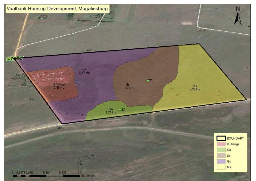
3 1. TERMS OF REFERENCE The ARC-Institute for Soil, Climate and Water (ARC-ISCW) was contracted by Newtown Landscape Architects to undertake a soil investigation of a portions of the farm Vaalbank 512JQ, located near the town of Magaliesburg in Gauteng Province. The purpose of the investigation is to contribute to the application for the proposed housing development project. The objectives of the study are; To classify the soils and to produce a soil map of the specified areas; and To assess present land use and agricultural potential. 2. SITE CHARACTERISTICS 2.1 Location The area that was investigated comprises Portions 81 and 82 of the farm Vaalbank 512JQ, approximately 3 km to the west of Magaliesburg (see Figure 1). The area is approximately 27 ha in extent and the site lies immediately to the north of the R509 tar road. 2.2 Site details The area is generally comprised of almost flat topography with gentle slopes (<2%) towards the Magaliesberg mountain ridge located to the north of the study area. The property has a few existing dwellings located on it comprising of some informal houses (presumably overflow from Ga-Mohale village), as well as some ruined old buildings in the western portion of the study area. Most of the area is covered by grass or fallow lands and there are some large stones on the surface in some areas. 3

4 Figure 1 Locality map 2.3 Climate The climate of the area (Koch, 1987) can be regarded as typical of the Highveld, with cool to cold, dry winters and warm, moist summers. The long-term average annual rainfall is approximately 610 mm. Temperatures vary from an average monthly maximum and minimum of 27.9ºC and 15.0ºC for January to 18.9ºC and 0.6 o C for July respectively. Frost occurs most years on approximately half of the 81 days between mid-may and early August. 2.4 Parent Material The parent material of the soils is mainly derived from the underlying Pretoria shale and slate, with sporadic occurrences of Pretoria quartzite and Hekpoort lava (Geological Survey, 1973). 4
5 3. METHODOLOGY A hand auger was used to investigate the study area on a grid of 100 x 100 m, to a depth of 1.2 m (or shallower, if a restricting layer such as rock was encountered). The soils were classified (Soil Classification Working Group, 1991) and areas of different soil types were noted and mapped. Samples of topsoil and subsoil were taken at two localities and the soils analyzed (Non-Affiliated Soil Analysis Work Committee, 1991) for sand, silt and clay percentage, exchangeable cations, cation exchange capacity (CEC), ph (H 2 O), and P (Bray 1). The sampling sites are marked S1 and S2 on the soil map (Appendix). The broad agricultural potential of each soil mapping unit was then assessed (see Table 3). 4. SOILS Most of the area consists of shallow soils, mainly of the Glenrosa form (Gs mapping unit) and Mispah form (Ms mapping unit), with a shallow topsoil grading into hard or weathering rock. A portion of the southern side of the property close to R509 is comprised of moderate to high clay content soils of the Oakleaf form (Oa mapping unit) and the remaining part is comprised of soils high clay soils of Sterkspruit form (Ss mapping unit). A summary of the main soil characteristics is given in Table 1 below. 5
6 Table 1 Soil mapping units MAP UNIT DOMINANT SOIL FORM SUBDOMINANT SOIL FORM EFFECTIVE DEPTH (mm) DESCRIPTION OF MAPPING UNIT Shallow soils Ms Mispah Glenrosa Shallow, grey-brown, structureless sandy loam topsoil abruptly overlying hard rock Gs Glenrosa Mispah Shallow, grey-brown to greyish, structureless sandy loam grading into weathering rock Deep clayey soils Ss Sterkspruit Valsrivier Dark brown, weakly structured, sandy clay loam topsoil overlying brown, prismatic structured, clay subsoil Oa Oakleaf Tukulu Dark brown, structureless to weakly structured, sandy loam to sandy clay loam topsoil overlying light brown, weakly structured, sandy clay loam to sandy subsoil Miscellaneous Buildings Area occupied by informal residential and other structures AGRIC. POT. AREA (ha) Low 7.36 Low 8.87 Low 6.17 Moderate 1.71 None 2.89 Total
7 Table 2 Soil analysis results Sample site S1 S2 Co-ordinates (Lat/Long) 25 o S 27 o E 25 o S 27 o E Soil Form Sterkspruit Oakleaf Horizon A1 B1 A1 B1 Depth (mm) Sa Si % Cl Na K Ca cmol kg Mg CEC P (ppm) ph (H 2 O) Org. C (%) The analysis results show the clay-rich nature of the soils, with textures of sandy clay to clay, especially in the subsoil (crop rooting zone). The high calcium and magnesium content, and consequent high CEC (cation exchange capacity) of the Sterkspruit soils (map unit Ss), is an indication of the tendency of these soils to disperse, causing a surface crust in certain circumstances. There is a relatively high organic carbon content, but low P levels, both of which are a likely consequence of not having been cultivated in the recent past. 7
8 5. AGRICULTURAL POTENTIAL The map units, their areas, percentages and broad potential classes are given in Table 3. Table 3 Potential Class Low Moderate Very Low Agricultural Potential Map Unit(s) Ms, Gs, Ss Oa Main limiting factor(s) Shallow to very shallow soil depth (Ms, Gs);structured, clay subsoil (Ss) Few limiting factors. Moderately deep soil, friable with moderate texture Buildings Little or no available soil Total Area in ha (+ % of survey area) 22.4 ha (83.0%) 1.71 ha (6.3%) 2.89 ha (10.7%) ha (100%) Approximately 60% of the study area comprises Mispah soils (Ms unit) and Glenrosa (Gs unit) that are too shallow for any meaningful agricultural activity and are suited for grazing at best. Most of the remaining soils are Sterkspruit (Ss unit) and these soils have high clay content (Table 2) and moderate to strong grade of structure in the underlying horizon, the clay content in these soils can be problematic and makes mechanical operations difficult. Water logging is an observable character of these soils after heavy rains. Such soils may be somewhat suited for the cultivation of vegetables and grazing pasture, but if cultivation of these soils is to be practiced, optimal internal drainage will need to be put in place, so that excess wetness does not occur in the root zone. However, these soils can be erodible, with the removal of vegetation causing potential crusting problems. The Oakleaf soils (Oa unit) have a moderate agricultural potential, with only a possible high subsoil clay content that could potentially pose a problem to cultivation. 8
9 REFERENCES Geological Survey, : scale geological map 2527DC Hekpoort. Department of Mineral and Energy Affairs, Pretoria. Koch, F.G.L., Climate data. In Land types of the maps 2526 Rustenburg and 2528 Pretoria. Mem. Agric. nat. Res. S. Afr. No. 8. Department of Agriculture, Pretoria. Non-Affiliated Soil Analysis Working Committee, Methods of soil analysis. SSSSA, Pretoria. Soil Classification Working Group, Soil classification. A taxonomic system for South Africa. Institute for Soil, Climate and Water, Pretoria. 9
10 APPENDIX: SOIL MAP 10
11 11
SOIL SURVEY FOR PROPOSED WET ASH DISPOSAL FACILITY, HENDRINA POWER STATION, MPUMALANGA PROVINCE
 REPORT for Lidwala Environmental and Planning Servives by the INSTITUTE FOR SOIL CLIMATE AND WATER AGRICULTURAL RESEARCH COUNCIL SOIL SURVEY FOR PROPOSED WET ASH DISPOSAL FACILITY, HENDRINA POWER STATION,
SCOPING REPORT. On contract research for ILISO CONSULTING
 SCOPING REPORT On contract research for ILISO CONSULTING Proposed Construction of a 65 MW Photovoltaic Power Plant, Duvha Power Station, Mpumalanga Province Soils and Agricultural Potential Scoping Study
SOILS AND AGRICULTURAL POTENTIAL FOR THE PROPOSED P166 SERVITUDE, MBOMBELA, MPUMALANGA PROVINCE
 REPORT On contract research for Royal Haskoning DHV SOILS AND AGRICULTURAL POTENTIAL FOR THE PROPOSED P166 SERVITUDE, MBOMBELA, MPUMALANGA PROVINCE By F.T. Seabi (Pr. Nat. Sci. 400370/11) & D.G. Paterson
The entire site supports grass on which sheep had been grazing recently.
 PHYSICAL CHARACTERISTICS REPORT FOR LAND AT HORSEHAY A^ Agricultural Land Classification of approximately 14 hectares of land to the southwest of Horsehay was undertaken in November 1989. The site lies
PROPOSED OPEN CAST COAL SITE SEPTEMBER 1992
 AGRICULTURAL LAND CLASSIFICATION AND STATEMENT OF PHYSICAL CHARACTERISTICS SKIERS SPRING, HOYLAND, SOUTH YORKSHIRE PROPOSED OPEN CAST COAL SITE SEPTEMBER 1992 ADAS LEEDS STATUTORY GROUP Job No. 98/92 MAFF
Report on a soil survey and agricultural suitability investigation of the property known as Erf 660, De Doorns.
 De Doorns erf 660 Soil Report 1 Report on a soil survey and agricultural suitability investigation of the property known as Erf 660, De Doorns. by F. Ellis September 2006 CONTENTS 1 INTRODUCTION AND TERMS
STATEMENT OF PHYSICAL CHARACTERISTICS AND AGRICULTURAL LAND CLASSIFICATION WITTON PARK, COUNTY DURHAM PROPOSED QUARRY EXTENSION DECEMBER 1992

PHYSICAL CHAtlACTERISTICS REPORT FOR THE PROPOSED SAND AND GRAVEL SITE AT MANOR FARM, UFFINGTON
 PHYSICAL CHAtlACTERISTICS REPORT FOR THE PROPOSED SAND AND GRAVEL SITE AT MANOR FARM, UFFINGTON Introduction Following the" request for detailed information on the physical characteristics of soil at Manor
MAFF Ministry of Ifinil Agriculture Rsheries and Food
 MAFF Ministry of Ifinil Agriculture Rsheries and Food STATEMENT OF PHYSICAL CHARACTERISTICS AND AGRICULTURAL LAND CLASSIFICATION SHILBOTTLE COLLIERY RECLAMATION SCHEME NORTHUMBERLAND DECEMBER 1994 ADAS
STATEMENT OF PHYSICAL CHARACTERISTICS AND AGRICULTURAL LAND CLASSIFICATION
 STATEMENT OF PHYSICAL CHARACTERISTICS AND AGRICULTURAL LAND CLASSIFICATION BIRKWOOD FARM, ALTOFTS WEST YORKSHIRE Proposed Opencast Extraction of Clay and coal ADAS January 1990 Leeds Regional Office File
AGRICULTURAL USE & QUALITY OF LAND NEAR MINDALE HOUSE PRESTATYN. Report 762/1
 AGRICULTURAL USE & QUALITY OF LAND NEAR MINDALE HOUSE PRESTATYN Report 762/1 11 th April, 2012 AGRICULTURAL USE & QUALITY OF LAND NEAR MINDALE HOUSE PRESTATYN F W Heaven, BSc, MISoilSci Report 762/1 Ltd
Topoclimate Southland Soil Technical Data Sheet No. 8. Sobig
 This Technical Data Sheet describes the typical average properties of the specified soil. It is essentially a summary of information obtained from one or more profiles of this soil that were examined and
AGRICULTURAL LAND CLASSIFICATION AND SOIL PHYSICAL CHARACTERISTICS BIRCH PIT, NEAR COLCHESTER ESSEX
 AGRICULTURAL LAND CLASSIFICATION AND SOIL PHYSICAL CHARACTERISTICS BIRCH PIT, NEAR COLCHESTER ESSEX AGRICULTURAL LAND CLASSIFICATION AND SOIL PHYSICAL CHARACTERISTICS SEMI-DETAILED SURVEY BIRCH PIT, NEAR
AGRICULTURAL LAND CLASSIFICATION AND STATEMENT OF PHYSICAL CHARACTERISTICS
 AGRICULTURAL LAND CLASSIFICATION AND STATEMENT OF PHYSICAL CHARACTERISTICS SEGHILL, NORTHUMBERLAND PROPOSED VASTE DISPOSAL SITE ADAS January 1989 Leeds Regional Office REF: 3/89 2FCS 4191 lds.rpg3.seghill
AGRICULTURAL LAND CLASSIFICATION AND SOIL PHYSICAL CHARACTERISTICS LAND NEAR SHIRE HILL FARM SAFFRON WALDEN ESSEX
 AGRICULTURAL LAND CLASSIFICATION AND SOIL PHYSICAL CHARACTERISTICS LAND NEAR SHIRE HILL FARM SAFFRON WALDEN ESSEX AGRICULTURAL LAND CLASSIFICATION (ALC) AND SOIL PHYSICAL CHARACTERISTICS LAND NEAR SHIRE
SOIL DATA: Avondale. in Allen, TX. This information was taken from NRCS web soil survey of Collin County, Texas.
 SOIL DATA: Avondale in Allen, TX This information was taken from NRCS web soil survey of Collin County, Texas. United States Department of Agriculture Soil Conservation Service in cooperation with Texas
2012 FINAL SOILS AREA 2 Envirothon Questions Answer KEY
 2012 FINAL SOILS AREA 2 Envirothon Questions Answer KEY Questions 1-6 to be answered at the soil pit: 1. Soil scientists categorize soils by drainage classes. What is the drainage class of the soil at
EDULABZ. Ans. (b) 7. The soft, porous layer with a good water-retaining capacity forms the
 7. The soft, porous layer with a good water-retaining capacity forms the") 3 SOIL I. Multiple choice questions: Tick ( ) the correct choice. 1. The process of soil formation is called (a) conservation (b) weathering (c) erosion (d) none Ans. (b) 2. Soil profile consists of (a)
3 SOIL I. Multiple choice questions: Tick ( ) the correct choice. 1. The process of soil formation is called (a) conservation (b) weathering (c) erosion (d) none Ans. (b) 2. Soil profile consists of (a)
AGRICULTURAL LAND CLASSIFICATION AND STATEMENT OF PHYSICAL CHARACTERISTICS
 AGRICULTURAL LAND CLASSIFICATION AND STATEMENT OF PHYSICAL CHARACTERISTICS DALE PIT FARM. HATFIELD VOODHOUSE PROPOSED EXTRACTION OF SAND AHD GRAVEL ADAS April 1989 Leeds Regional office File Ref: 2FCS
Agricultural Land Classification and Statement of Physical Characteristics Higbfield Farm Whitley Bridge North Yorkshire October 1996
 Agricultural Land Classification and Statement of Physical Characteristics Higbfield Farm Whitley Bridge North Yorkshire October 1996 Resource Planning Team ADAS Reference: 82/96 Leeds Statutory Group
Restoration of Degraded Soils
 Restoration of Degraded Soils Saline Soils Electrical Conductivity (EC) 4dS m -1 Sodic Soils EC
Topoclimate Southland Soil Technical Data Sheet No. 76. Mossburn
 This Technical Data Sheet describes the typical average properties of the specified soil. It is essentially a summary of information obtained from one or more profiles of this soil that were examined and
Topoclimate Southland Soil Technical Data Sheet No Waiau
 This Technical Data Sheet describes the typical average properties of the specified soil. It is essentially a summary of information obtained from one or more profiles of this soil that were examined and
ACRE NOOK EAST QUARRY, CHELFORD, CHESHIRE. Statement of Site Physical Characteristics January 1998
 ACRE NOOK EAST QUARRY, CHELFORD, CHESHIRE Statement of Site Physical Characteristics January 1998 J M LePage Resource Planning Team RPT Reference: 084/97 & 25/RPT/0863 Northern Region FRCA Reference: EL
2014 Iowa FFA Soil Judging CDE Exam
 2014 Iowa FFA Soil Judging CDE Exam 1. Landscape position is one aspect of evaluating the surface features of a certain tract of land. Identifying the correct landscape position will indicate: a. If the
SUMMARY. alcholnie.doc\ih\jk
 SUMMARY A detailed Statement of Physical Characteristics and Agricultural Land Classification survey of ha of land at Stainton ("Holme Hall Quarry Extension") was carried out in September 1994. At the
CORNFORTH EAST QUARRY COUNTY DURHAM
 CORNFORTH EAST QUARRY COUNTY DURHAM AgricuUural Land Classification (ALC) and Statement of Physical Characteristics Report and Map MARCH 1999 Resource Planning Team RPT Job Number: 5/99 Northern Region
PHYSICAL CHARACTERISTICS REPORT INCORPORATING AGRICULTURAL LAND CLASSIFICATION LAND AT BOLE INGS, WESTBURTON, NOTTINGHAMSHIRE (SK805875)
") (krahs 2% I?5 PHYSICAL CHARACTERISTICS REPORT INCORPORATING AGRICULTURAL LAND CLASSIFICATION LAND AT BOLE INGS, WESTBURTON, NOTTINGHAMSHIRE (SK805875) 1.0 INTRODUCTION 1.1 The site, an area of 84.5 hectares,
(krahs 2% I?5 PHYSICAL CHARACTERISTICS REPORT INCORPORATING AGRICULTURAL LAND CLASSIFICATION LAND AT BOLE INGS, WESTBURTON, NOTTINGHAMSHIRE (SK805875) 1.0 INTRODUCTION 1.1 The site, an area of 84.5 hectares,
Topoclimate Southland Soil Technical Data Sheet No. 11. Pukemutu
 This Technical Data Sheet describes the typical average properties of the specified soil. It is essentially a summary of information obtained from one or more profiles of this soil that were examined and
Iowa FFA Soil Career Development Event 2008
 Iowa FFA Soil Career Development Event 2008 1. In Iowa, corn suitability ratings for soil mapping units specifies a. natural weather conditions b. surface and subsurface drainage installed where needed
AGRICULTURAL LAND CLASSIFICATION REPORT LAND AT BRANT FARM, STOURPORT-ON-SEVERN
 AGRICULTURAL LAND CLASSIFICATION REPORT LAND AT BRANT FARM, STOURPORT-ON-SEVERN INTRODUCTION 1. This report presents the findings of a detailed Agricultural Land Classification (ALC) survey on 12ha of
Tools to facilitate the use of Soil Maps in Emilia-Romagna region (Italy) Paola Tarocco
 Paola Tarocco") Tools to facilitate the use of Soil Maps in Emilia-Romagna region (Italy) Paola Tarocco Soil maps Vs Thematic maps Soil maps are not easy to manage. Legends are usually based on soil classifications (e.g.
Tools to facilitate the use of Soil Maps in Emilia-Romagna region (Italy) Paola Tarocco Soil maps Vs Thematic maps Soil maps are not easy to manage. Legends are usually based on soil classifications (e.g.
Lesson 1: Recognizing the Characteristics of Soils and the Soil Requirements for Fruit and Nut Crops
 Lesson 1: Recognizing the Characteristics of Soils and the Soil Requirements for Fruit and Nut Crops 1 Mineral matter Organic matter Pore spaces Tilth Hygroscopic water Soil aeration 22 I. Soil is a layer
P/2014/00830 Received 27/06/2014 SOIL RESOURCES AND AGRICULTURAL USE & QUALITY OF LAND AT ROLLESTON PARK FARM TUTBURY, STAFFORDSHIRE.
 P/2014/00830 Received 27/06/2014 SOIL RESOURCES AND AGRICULTURAL USE & QUALITY OF LAND AT ROLLESTON PARK FARM TUTBURY, STAFFORDSHIRE Report 953/1 28 th May, 2014 SOIL RESOURCES AND AGRICULTURAL USE & QUALITY
Vietnam soils. Soil K and soil P status. Rich in phosphorus >0.10% P 2 O 5. in hydromorphous soils >0.20% P 2. in ferralitic soils
 Vietnam soils K and soil P status Rich in phosphorus >0.0% P O in hydromorphous soils >0.% P O in ferralitic soils Medium in phosphorus >0.0 0.0% P O in hydromorphous soils >0.0 0.% P O in ferralitic soils
AGRICULTURAL LAND CLASSIFICATION
 AGRICULTURAL LAND CLASSIFICATION GOOLE/HOOK LOCAL PLAN SITES SURVEYED FOR BOOTHFERRY BOROUGH COUNCIL'S INDUSTRIAL LAND SUITABILITY STUDY ADAS February 1991 Leeds Regional Office 2FCS 5205 CONTENTS 1. Introduction
2016 Area 3 Envirothon Muskingum County Soils Test ANSWER KEY
 2016 Area 3 Envirothon Muskingum County Soils Test ANSWER KEY 1. The majority of the bedrock in Muskingum County is. a. sedimentary bedrock b. glacial bedrock c. igneous bedrock d. metamorphic bedrock
CAVIL HEAD OCCS ACKLINGTON NOVEMBER 1997
 CAVIL HEAD OCCS ACKLINGTON Agricultural Land Classification (ALC) and Statement of Physical Characteristics Report NOVEMBER 1997 Resource Planning Team RPT Job Number: 67/97 Northern Region MAFF Reference:
STATEMENT OF PHYSICAL CHARACTERISTICS OLDWICK FARM, WEST LAVANT, WEST SUSSEX
 STATEMENT OF PHYSICAL CHARACTERISTICS OLDWICK FARM, WEST LAVANT, WEST SUSSEX STATEMENT OF PHYSICAL CHARACTERISTICS OLDWICK FARM, WEST LAVANT, WEST SUSSEX 1. BACKGROUND 1.1 This 37.1 ha site was surveyed
2018 Iowa FFA Soil Judging CDE Exam 1. Landscape positions characterizes the location of the soil on the landscape and identifies potential risks.
 2018 Iowa FFA Soil Judging CDE Exam 1. Landscape positions characterizes the location of the soil on the landscape and identifies potential risks. Which landscape position is considered the floodplain
HUMBLEBURN OCCS, CRAGHEAD, COUNTY DURHAM SURVEY OF RESTORED LAND OCTOBER RPT Job Number: 73/97 MAFF Reference: EL LURET Job Number: ME3RTP
 HUMBLEBURN OCCS, CRAGHEAD, COUNTY DURHAM SURVEY OF RESTORED LAND OCTOBER 1997 Resource Planning Team Northern Region FRCA, Leeds RPT Job Number: 73/97 MAFF Reference: EL 10387 LURET Job Number: ME3RTP
Topoclimate Southland Soil Technical Data Sheet No. 23. Waikiwi
 This Technical Data Sheet describes the typical average properties of the specified soil. It is essentially a summary of information obtained from one or more profiles of this soil that were examined and
SOILS AND AGRICULTURAL USE & QUALITY OF LAND OFF HOLT ROAD, ROSSETT. Report 1067/1
 SOILS AND AGRICULTURAL USE & QUALITY OF LAND OFF HOLT ROAD, ROSSETT Report 1067/1 2 nd March, 2015 SOILS AND AGRICULTURAL USE AND QUALITY OF LAND OFF HOLT ROAD, ROSSETT M W Palmer, MSc, PhD, MISoilSci
Soil Notes. General Soil Information
 Soil Notes General Soil Information Definition Soil relatively thin surface layer of the Earth s crust consisting of mineral and organic matter that is affected by agents such as weather, wind, water,
Soil resources in upper Basho Valley.
 Soil resources in upper Basho Valley. Åge A. Nyborg, 2007 Norwegian Forest and Landscape Institute. Soil management challenges in Upper Basho Valley Low nutrient content, low organic matter content, deficient
 Cci
Cci IOWA FFA STATE SOILS CDE SATURDAY, OCTOBER 13, 2007 AMES, IOWA
 IOWA FFA STATE SOILS CDE SATURDAY, OCTOBER 13, 2007 AMES, IOWA 1. Moderately sloping has what percent slope: a. 9-14% b. 2-5% c. 5-9% d. over 14% 2. Which of the following horizons is the loose underlying
Mature basalt volcanic soils
 MANAGING NORTHLAND SOILS Mature basalt volcanic soils 8.1.2 Soil types in this group Kerikeri friable clay (KE) Kerikeri friable clay with large boulders (KEb) Matarau friable clay (MC, MCH*) Matarau friable
AGRICULTURAL LAND CLASSIFICATION
 AGRICULTURAL LAND CLASSIFICATION STAINSBY HALL, MIDDLESBROUGH PROPOSED GOLF COURSE ADAS December 1990 Leeds Regional Office 2FCS 5100 CONTENTS 1. INTRODUCTION AND GENERAL SITE CHARACTERISTICS 2. AGRICULTURAL
AGRICULTURAL LAND CLASSIFICATION AND STATEMENT OF SOIL PHYSICAL CHARACTERISTICS EXTENSION TO CLOUD HILL QUARRY, BREEDON ON THE HILL, LEICESTERSHIRE
 AGRICULTURAL LAND CLASSIFICATION AND STATEMENT OF SOIL PHYSICAL CHARACTERISTICS EXTENSION TO CLOUD HILL QUARRY, BREEDON ON THE HILL, LEICESTERSHIRE 1.0 BACKGROUND 1.1 A site of approximately 14.5 ha in
6 Athlone Street Tel: SWELLENDAM Cell:
 C R LUBBE 6 Athlone Street Tel: 028 514 2359 SWELLENDAM Cell: 082 853 1274 6740 e-mail: macquarrie@vodamail.co.za Attention: Louise Mari van Zyl Cape EA Prac 1 June 2018 P O Box 2070 GEORGE 6530 Dear Ms
Examining soils in the field. Examining soils in the field. Environment Agency thinksoils examining soils in the field
 Examining soils in the field thinksoils Examining soils in the field Environment Agency thinksoils examining soils in the field 31 Examining soils in the field 32 Environment Agency thinksoils examining
Horner-McLaughlin Woods: Soil Types
 Horner-McLaughlin Woods: Soil Types Not present at HMW Adrian Muck Conover Loam 0-4% Slopes Houghton Muck Miami Loam 2-6% Slopes Miami Loam 6-12% Slopes Miami Loam 12-18% Slopes t 0 0.125 0.25 Miles Mary
Soil Requirements of. Healthy Urban Trees
 Soil Requirements of Healthy Urban Trees Healthy Urban Soil Trees require adequate supply of uncompacted, well aerated, and moist soil in order to thrive. These soil conditions enable tree roots to obtain
Land Capability Classifications
 Land Capability Classifications Unit: Soil Science Problem Area: Basic Principles of Soil Science Student Learning Objectives. Instruction in this lesson should result in students achieving the following
Unit 1 Lesson 5 Soil Formation. Copyright Houghton Mifflin Harcourt Publishing Company
 The Dirt on Soil What causes soil to form? Soil is a loose mixture of rock fragments, organic matter, water, and air that can support the growth of vegetation. The first step in soil formation is the weathering
Soil Interpretations Erosion and Sedimentation Control Planning and Design Workshop
 Soil Interpretations Erosion and Sedimentation Control Planning and Design Workshop Presented by Richard Brooks Presentation prepared by Kristin May Resource Soil Scientists USDA-Natural Resources Conservation
LAND NORTH OF TAMWORTH. Agricultural Land Classification ALC Map and Report April 1998
 LAND NORTH OF TAMWORTH Agricultural Land Classification ALC Map and Report April 1998 A,L Cooke Resource Planning Team RPT Reference: 130/97 & 25/RPT/Ol loa Northern Region FRCA Reference: EL 37/11747
STAFFORDSHIRE AND STOKE-ON- TRENT STRUCTURE PLAN Site 7: Priory Farm. Agricultural Land Classification ALC Map and Report November 1998
 STAFFORDSHIRE AND STOKE-ON- TRENT STRUCTURE PLAN Site 7: Priory Farm Agricultural Land Classification ALC Map and Report November 1998 A J Spalding Resource Planning Team RPT Reference: 008/98 & 25/RPT/Ol
AGRICULTURAL LAND CLASSIFICATION GREAT GRIMSBY LOCAL PLAN SITE AG 2. GREAT COATES AUGUST 1993
 AGRICULTURAL LAND CLASSIFICATION GREAT GRIMSBY LOCAL PLAN SITE AG 2. GREAT COATES AUGUST 1993 ADAS Job No:- 131/93 Leeds Statutory Group MAFF Ref- EL 51/5 SUMMARY An Agricultural Land Classification survey
If A rr Ministry of. IfiriEI. Agriculture Fisheries and Food
 If A rr Ministry of IfiriEI. Agriculture Fisheries and Food AGRJCULTURAL LAND CLASSIFICATION CLEETHORPES DISTRICT LOCAL PLAN SITE H2 (SOUTH WEST) OCTOBER 1993 ADAS Leeds Statutory Group Job No:- 164/93
Unit E: Basic Principles of Soil Science. Lesson 3: Understanding Soil Color
 Unit E: Basic Principles of Soil Science Lesson 3: Understanding Soil Color 1 Important Terms Bright-colored Color Deciduous hardwood forest Dull-colored Humus Mottle-colored Native vegetation Structure
SOIL SURVEY REPORT ON SENCE de LIEU, PAARL
 SOIL SURVEY REPORT ON SENCE de LIEU, PAARL April 2016 Report compiled by: B Schloms Pr. Sci. Nat. (registration Number 400059) Contents 1 Terms of reference 2 Allocation of responsibilities 3 Description
AGRICULTURAL LAND CLASSIFICATION VULCAN VILLAGE (PROPOSED GOLF COURSE) ST HELENS MBC
 ST HELENS MBC") AGRICULTURAL LAND CLASSIFICATION VULCAN VILLAGE (PROPOSED GOLF COURSE) ST HELENS MBC MJW WOOD ADAS Ref: 25/RPT/0709 Resource Planning Team Job No: 155/94 ADAS Statutory Group MAFF Ref: EL 25/10811 WOLVERHAMPTON
AGRICULTURAL LAND CLASSIFICATION VULCAN VILLAGE (PROPOSED GOLF COURSE) ST HELENS MBC MJW WOOD ADAS Ref: 25/RPT/0709 Resource Planning Team Job No: 155/94 ADAS Statutory Group MAFF Ref: EL 25/10811 WOLVERHAMPTON
URBAN SOILS & SEATTLE EXAMPLES
 Class Results - Mystery Soil #1 14 12 10 8 6 4 2 0 Sandy Clay Loam Sandy Loam Silty Loam Class Results - Mystery Soil #2 6 5 4 3 2 1 0 Silty Clay Clay Loam Sandy Sandy Silty Sandy Silty Loamy Loam Clay
AGRICULTURAL LAND CLASSIFICATION AND STATEMENT OF SOIL PHYSICAL CHARACTERISTICS TYTTENHANGER QUARRY EXTENSION, LONDON COLNEY, HERTFORDSHIRE
 AGRICULTURAL LAND CLASSIFICATION AND STATEMENT OF SOIL PHYSICAL CHARACTERISTICS TYTTENHANGER QUARRY EXTENSION, LONDON COLNEY, HERTFORDSHIRE 1.0 BACKGROUND 1.1 The site covers an area of 42.2 ha, and is
Soils of Palau. Diversity and Fertility. Palau Livestock Management Workshop March 23-25, Jonathan Deenik, PhD University of Hawaii
 Soils of Palau Diversity and Fertility Jonathan Deenik, PhD University of Hawaii Palau Livestock Management Workshop March 23-25, 2011 Outline Plant nutrition Soil fertility Soil composition Texture and
Unit 5: Soil - Stages of Soil formation
 Biology Form 3 Page 68 Ms. R. Buttigieg Unit 5: Soil - Stages of Soil formation Soil is the layer of material covering parts of the land, the home of many organisms and the area from which land plants
If you are not able to turn in your notebook see me or Dan ASAP
 Notebook Collection Collecting hard copies now OR Electronic versions using Catalyst drop box Due by 5:30 pm today Use website for link If you are not able to turn in your notebook see me or Dan ASAP URBAN
Soils and plant nutrients
 Soils and plant nutrients Soils and soil texture Soil texture triangle Plant nutrients Major nutrients Secondary nutrients Minor nutrients Exchange Capacity (CEC) Soil ph Soils Consists of a series of
HORT 102: Soil Properties. Cultivated Plants: Lecture 15. [Teresa Koenig] Slide #: 1 Slide Title: Intro Information Slide
![HORT 102: Soil Properties. Cultivated Plants: Lecture 15. [Teresa Koenig] Slide #: 1 Slide Title: Intro Information Slide](/thumbs/76/74082590.jpg "HORT 102: Soil Properties. Cultivated Plants: Lecture 15. [Teresa Koenig] Slide #: 1 Slide Title: Intro Information Slide") HORT 102: Soil Properties Cultivated Plants: Lecture 15 [Teresa Koenig] Slide #: 1 Slide Title: Intro Information Slide Title: Lecture 15 Soil Properties Speaker: Teresa Koenig Created by: Teresa Koenig,
HORT 102: Soil Properties Cultivated Plants: Lecture 15 [Teresa Koenig] Slide #: 1 Slide Title: Intro Information Slide Title: Lecture 15 Soil Properties Speaker: Teresa Koenig Created by: Teresa Koenig,
Recommended Resources: The following resources may be useful in teaching
 Unit B: Establishing a Fruit Garden Lesson 1: Recognize the Characteristics of Soils and the Soil Requirements for Fruit and Nut Crops Student Learning Objectives: Instruction in this lesson should result
Soil Horizons cont. Oa- highly decomposed Oi-undecomposed
 Soils Soil Basics Soil Horizons Soil Horizons cont. O Horizon: Or organic layer Organic layer of decomposing plant and animal tissue. Wooded upland areas have thin O horizons Wetlands may have thick O
Do Now: From which materials do you think soil is made? Are all soils the same? Think of some ways that they are different?
 Do Now: From which materials do you think soil is made? Are all soils the same? Think of some ways that they are different? Basics Soil is a major component of the biosphere It contains solids, liquids
Soil Physical Properties
 Soil Physical Properties ESRM 311 SEFS 507 Some examples of mineral soil development eg, Rock Weathering Types of Weathering Physical/Mechanical Chemical Biological Photo by D Vogt CO 2 + H 2 O H 2 CO
 108 40' 29'' W Soil Map Mesa County Area, Colorado 108 36' 55'' W 39 10' 11'' N 39 6' 31'' N 4331700 4332500 4333300 4334100 4334900 4335700 4336500 4337300 4338100 701100 701900 702700 703500 704300 705100
Understanding Soil Variability to Utilize Variable Rate Fertilizer Technology
 Understanding Soil Variability to Utilize Variable Rate Fertilizer Technology Agronomy Update -2012 Red Deer, AB Jan 17 & 18, 2012 Ross H. McKenzie Research Scientist Agronomy Research & Innovation Div.
AGRICULTURAL LAND CLASSIFICATION KNOWSLEY UDP, SITE 45.01
 AGRICULTURAL LAND CLASSIFICATION KNOWSLEY UDP, SITE 45.01 MJW WOOD ADAS Ref: 25/RPT/OOll Resource Planning Team Job No: 016/95 ADAS Statutory Group MAFF Ref: EL 25/10763 WOLVERHAMPTON rnwtaiow2to»yyje
 Soils Soil is one of the world's most important natural resources. Together with air and water it is the basis for life on planet earth. Most of our food depends on soil - it is where we find the plants
Humisphere SOIL RECONNAISSANCE MISSION TO 3 ESTATES IN TANZANIA. Ir. J.H.M. (Hans) Scholten
 Scholten") Humisphere SOIL RECONNAISSANCE MISSION TO 3 ESTATES IN TANZANIA Ir. J.H.M. (Hans) Scholten September 2012 CONTENT 1. INTRODUCTION 3 2. SOIL INFORMATION OBTAINED 3 3. SOILS OF KWAMDULU ESTATE. 4 3.1 Soils..
Humisphere SOIL RECONNAISSANCE MISSION TO 3 ESTATES IN TANZANIA Ir. J.H.M. (Hans) Scholten September 2012 CONTENT 1. INTRODUCTION 3 2. SOIL INFORMATION OBTAINED 3 3. SOILS OF KWAMDULU ESTATE. 4 3.1 Soils..
Alternative Crop Suitability Methodology
 Alternative Crop Suitability Methodology The Alternative Agriculture in Missouri Hub on Community Commons includes model-based ratings of natural suitability for selected alternative crops. These ratings
ON LANDSCAPING, SOILS, SOIL AMENDMENTS AND PROPER SEED ESTABLISHMENT (BOTH GRASS LAWNS AND MEADOWS).
.") ON LANDSCAPING, SOILS, SOIL AMENDMENTS AND PROPER SEED ESTABLISHMENT (BOTH GRASS LAWNS AND MEADOWS). John D. Chibirka USDA-NRCS Resource Soil Scientist 1238 County Welfare Road, Suite 220 Leesport, PA
ON LANDSCAPING, SOILS, SOIL AMENDMENTS AND PROPER SEED ESTABLISHMENT (BOTH GRASS LAWNS AND MEADOWS). John D. Chibirka USDA-NRCS Resource Soil Scientist 1238 County Welfare Road, Suite 220 Leesport, PA
Soil Geography Notes JC-Learn. JC-Learn. Geography Notes Soil. 1 P a g e
 JC-Learn Geography Notes Soil 1 P a g e Soil Soil is the thin covering of loose material that makes up the outermost layer of our planet. It is a living thing and a rich natural resource. Plants need soil
HINCKLEY AND BOSWORTH LOCAL PLAN Land south of Earl Shilton - Site G Agricultural Land Classification February 1997
 HINCKLEY AND BOSWORTH LOCAL PLAN Land south of Earl Shilton - Site G Agricultural Land Classification February 1997 Resource Planning Team ADAS Reference: 95/96n Eastern Statutory Centre MAFF Reference:
3. What are the five master horizons? Give distinguishing features of each. 5. List three means by which plant roots come into contact with nutrients.
 Study Questions Exam 1 1. What are the four general components of soil? 2. Define regolith and solum. 3. What are the five master horizons? Give distinguishing features of each. 4. What is meant by an
STATE TAX COMMISSION OF MISSOURI ASSESSOR MANUAL
 STATE TAX COMMISSION OF MISSOURI ASSESSOR MANUAL CHAPTER: REVISION DATE: 10/1/2008 Page 1 of 18 7.3 The purpose of this section of the Assessor s Manual is to supplement the State Tax Commission s published
Also available on the web at
 2009 2000 First print Compiled by Directorate Agricultural Information Services Department of Agriculture, Forestry and Fisheries In cooperation with ARC-Institute for Tropical and Subtropical Crops Printed
Soil Formation. 6.E.2.3 Explain how the formation of soil is related to the parent rock type and the environment in which it develops.
 Soil Formation 6.E.2.3 Explain how the formation of soil is related to the parent rock type and the environment in which it develops. What is soil? A loose mixture of weathered rock, organic material,
Pits 1 & 3 Questions. 7. Subsurface: Texture (5 pts) A. Coarse B. Moderately course C. Medium D. Fine E. Very Fine
 A. Coarse B. Moderately course C. Medium D. Fine E. Very Fine") Minnesota Soils Scorecard Questions for Pits 1-4 Scantron # 105481 Use your soils scorecard to fill out the answers on your scantron Bubble in the front side of the sheet for Pit 1 (# 1-45) and Pit 2 (#51-95)
Minnesota Soils Scorecard Questions for Pits 1-4 Scantron # 105481 Use your soils scorecard to fill out the answers on your scantron Bubble in the front side of the sheet for Pit 1 (# 1-45) and Pit 2 (#51-95)
Lesson 3: Understanding Soil Color
 Lesson 3: Understanding Soil Color 1 Bright colored Color Dull colored Humus Mottle colored Native vegetation Structure Tall prairie grass Texture Deciduous hardwood forest 2 I. Soils have many features
Soils and Land Use Test
 SOIL PROPERTIES Total Score /50 1) List two of the five main functions of soil. (2 points) Habitat for organisms, Engineering medium, Filters and stores water, Anchor for plants, Cycles nutrients 2) Small
Soil testing Page 1. Contrary to what is widely believed, the colour of the soil reveals very little about its fertility.
 Soil testing Page 1 Soil The Basics Soil is the uppermost surface of the earth, which has been slowly transformed by decomposition due to the effects of weather, vegetation and human activities. The parent
Terminology & Soil Science. Andy Spetch
 Terminology & Soil Science Andy Spetch 1 Presentation Soil Profile Soil Structure Soil Texture Compaction Cation Exchange Capacity Soil ph Nutrients / Organic Matter / EC / PTE s 2 What is Soil: A blend
Saline and Sodic Field Demonstration project
 Saline and Sodic Field Demonstration project 2007-2013 Tile drainage will help decrease the soluble salt level over time but does not address parts of the field that have sodium issues as well. Reclamation
MAFF I^inistry of IfiriEE Agriculture Fisheries and Food
 MAFF I^inistry of IfiriEE Agriculture Fisheries and Food AGRICULTURAL LAND CLASSIFICATION BROOMY HOLM FARM, EDMONDSLEY, CO DURHAM PROPOSED GOLF COURSE DECEMBER 1993 ADAS Leeds Statutory Group JobNo:- 168/93
THE SCORE CARD. Observed Soil Properties. Interpretive Soil Properties
 Rev. 07/18/2008 Jim Doolittle Doug Malo Tom Schumacher Plant Science Department SDSU and Kent Cooley Lance Howe Bruce Kunze Jim Millar Walt Schaefer Dan Shurtliff Steve Winter USDA Natural Resources Conservation
EXPERIMENT 6 PREPARATION OF LAND CAPABILITY CLASS MAP
 EXPERIMENT 6 PREPARATION OF LAND CAPABILITY CLASS MAP Structure 6.0 Objectives 6.1 Intnxluction 6.2 Experiment 6.21 Deciding Factors for Land Capability 6.2.2 Requirements 6.23 Procedure 6.3 Observations
Management of Sodic Soils in Alberta
 June 2010 Agdex 518-20 Management of Sodic Soils in Alberta The two main types of salt-affected soils found in Alberta are soils and sodic soils. Saline soils are soils with a high enough concentration
HAVE YOU NOTICED at construction sites how a
 Explaining a Soil Profile HAVE YOU NOTICED at construction sites how a cross section of soil has a layered look? Soil near the top of the cross section is often dark, and soil below appears lighter. What
2 Older farm homes on the land
 2 Older farm homes on the land LAND RANCHES EXCHANGES This ranch consists of 70 +/_ acres of level farmland. Prime 13700 POWERHOUSE RD POTTER VALLEY agricultural land at an attractive price. This property