AGRICULTURAL USE & QUALITY OF LAND NEAR MINDALE HOUSE PRESTATYN. Report 762/1
|
|
|
- Ella Harvey
- 5 years ago
- Views:
Transcription

1 AGRICULTURAL USE & QUALITY OF LAND NEAR MINDALE HOUSE PRESTATYN Report 762/1 11 th April, 2012
2 AGRICULTURAL USE & QUALITY OF LAND NEAR MINDALE HOUSE PRESTATYN F W Heaven, BSc, MISoilSci Report 762/1 Ltd Lockington Hall, Lockington, Derby DE74 2RH 11 th April, 2012
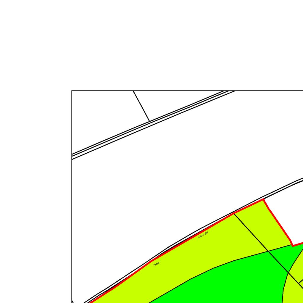
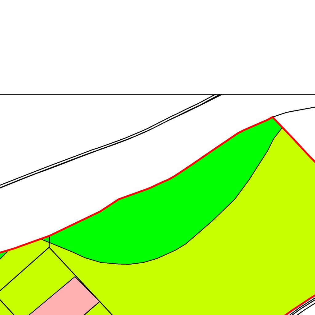
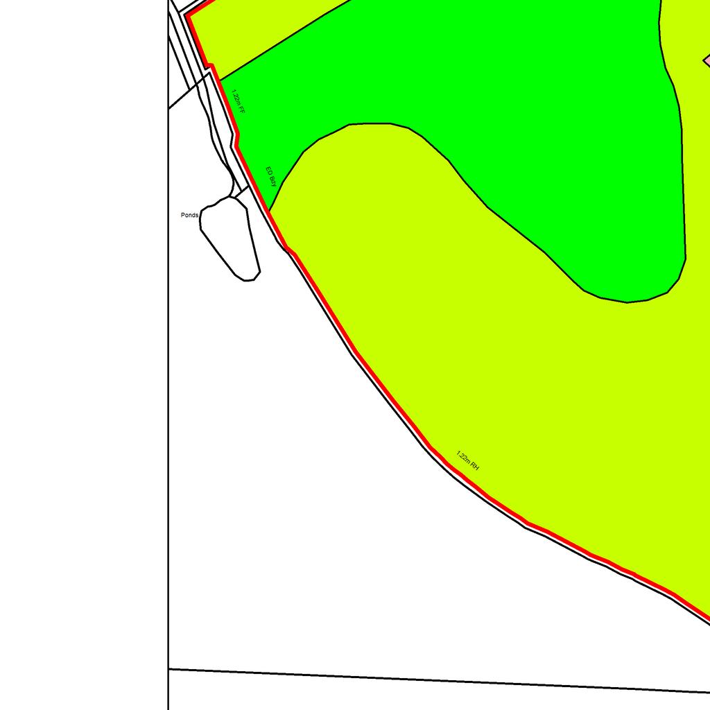
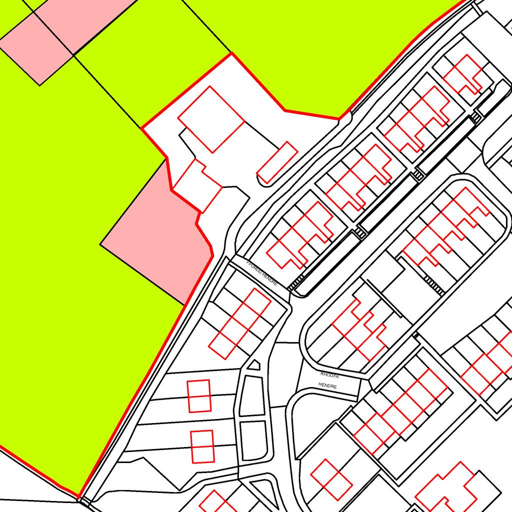
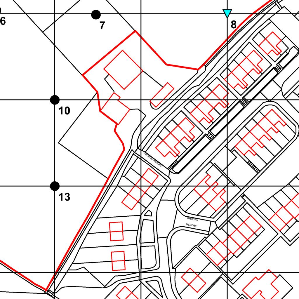
3 SUMMARY An agricultural land classification survey has been carried out of 4.2 ha of arable land near Mindale House, Ty Newydd Road/FFordd Hendre, Prestatyn. The land is dominated by heavy textured, slowly permeable soils developed in reddish till or clayey alluvium. Agricultural land quality is governed by the degree of winter wetness in the soils, placing about three quarters of the land in sub-grade 3b and the rest in sub-grade 3a. 1
4 1.0 Introduction 1.1 This report provides information on the soils and agricultural quality and use of 4 ha of land to the north of Mindale House, Ty Newdydd Road, FFordd Hendre, Prestatyn. The land is being considered for development. The report is based on a soil and agricultural desk study and a survey of the land in April SITE ENVIRONMENT AND AGRICULTURAL USE 1.2 The site comprises agricultural fields that lie to the north-west of Mindale House and the urban development of Meliden. The application boundary in the north east and west is marked by field boundaries. The land slopes down from 25 m aod in the south east to around 18 m aod in the north-west. 1.3 The land is in grass used for the pasturage of horses. One field has been worked to provide a dressage area for horses with a sand cover over a membrane. 1.4 Historically, the land has been used for market gardening, but with limited success. PUBLISHED INFORMATION 1.5 BGS 1:50,000 geological mapping shows that the land is underlain by Pennine Coal Measures, covered by Devensian Till on the upper slopes, and with Flandrian alluvium in the valley floor. 1.6 The National Soil Map 1 at 1:25,000 scale shows soils of the Salop association, comprising slowly permeable seasonally waterlogged fine loamy over clayey soils associated with some more freely-draining types. 1.7 The provisional Agricultural Land Classification (ALC) map series published at one inch to the mile published in 1971 shows the land as of Grade 2 quality. 1 Rudeforth, C. C, et al (1984): Soils and their Use inwales. Soil Survey of England and Wales Bulletin No 11 2
5 2.0 Soils 2.1 The Defra Soil Strategy 2 points out that soils deliver a range of vital functions for human activities including production of food and fibre, support for ecosystems and habitats, and environmental services that play a vital role in the global carbon cycle, stabilising and degrading contaminants and providing clean water. One of the strategy s objectives is to ensure that soil functions (soil ecosystem services) are fully valued in the planning process. 2.2 A detailed soil resource and agricultural quality survey was carried out in early April It was based on observations at intersects of a 50 m grid, giving a sampling density of more than two observations per hectare. During the survey soils were examined by a combination of pits and augerings to a maximum depth of 1.1 m. A log of the sampling points and a map (Map 2) showing their location is in an appendix to this report. 2.3 The survey shows that the fields mainly have clay lower subsoil overlain by a variable thickness of loamy upper subsoil. The topsoil is heavy or medium clay loam. Heavy soils 2.4 The topsoil is typically a cm-thick heavy or medium clay loam over heavy clay loam upper subsoil with mottle colours indicting seasonal wetness. On the sloping land in the east the lower subsoils are reddish brown and grey mottled clays with occasional stony and sandy pockets. On the flat land of the valley floor the lower subsoils are formed in clayey alluvium. 2.5 A typical profile from near observation 8 (Map 2) is described below: 0-28 cm Dark brown (7.5YR 3/2) heavy clay loam; a few small subangular stones; moderately developed medium subangular blocky structure; friable consistency; 5% fine and medium macropores; many very fine fibrous roots; abrupt smooth boundary to: cm brown (7.5YR 5/3) heavy clay loam with a few strong brown (7.5YR 5/6) mottles; a few small subangular stones; weakly developed medium and coarse subangular 2 Safeguarding our Soils: a Strategy for England (Defra, 2009) 3
6 blocky structure; firm consistency; 2% fine macropores; common very fine fibrous roots; common ferri-manganiferous concentrations; clear smooth boundary to: cm Yellowish red (5YR 4/6) clay with many distinct reddish grey (5YR 5/2) and reddish yellow (5YR 6/8) mottles; common very small and rounded quartzite stones; very weak coarse prismatic structure becoming massive below; firm consistency; 0.1% very fine macropores; common ferri-manganiferous concretions; a few very fine fibrous roots. 2.6 These soils are slowly permeable and affected by waterlogging in winter because of slow movement of water through the lower subsoils (wetness class III or IV) They have a limited capacity to absorb excess winter rainfall and a moderate capacity to absorb or attenuate pollutants falling on the soil surface. Loamier soils 2.7 Near the bottom of the slope is a strip of soils where the topsoils are medium clay loam or sandy clay loam overlying similar textured upper subsoils extending to more than 50 cm depth before clay is encountered. The upper subsoils are relatively permeable and this reduces the degree of winter wetness in the soils (wetness class ii or III). 4
7 3.0 Agricultural Quality 3.1 To assist in assessing land quality, the Ministry of Agriculture, Fisheries and Food (MAFF) developed a method for classifying agricultural land by grade according to the extent to which physical or chemical characteristics impose long-term limitations on agricultural use for food production. The MAFF Agricultural Land Classification (ALC) system classifies land into five grades numbered 1 to 5, with grade 3 divided into two sub-grades (3a and 3b). The system was devised and introduced in the 1960s and revised in The agricultural climate is an important factor in assessing the agricultural quality of land and has been calculated using the Climatological Data for Agricultural Land Classification 3. The relevant site data for an average elevation of 20 m is given below. Climate is not on its own a limiting factor in this area. Average annual rainfall: January-June accumulated temperature >0 C Field capacity period (when the soils are fully replete with water) Summer moisture deficits for: 703 mm 1448 day 169 days Early Nov-late April wheat: 103 mm potatoes: 93 mm 3.3 The survey described in the previous section was used in conjunction with the agroclimatic data above to classify the site using the revised guidelines for agricultural land classification issued in 1988 by the Ministry of Agriculture, Fisheries and Food 4. SURVEY RESULTS 3.4 The land is classified as grade 3, mostly in sub-grade 3b. 3 Climatological Data for Agricultural Land Classification. Meteorological Office, Agricultural Land Classification for England and Wales: Guidelines and Criteria for Grading the Quality of Agricultural Land. MAFF,
8 Sub-grade 3a 3.5 This sub-grade occurs in parts of the site on soils similar to those described in paragraph 2.7, mainly on the lower slopes beside the valley. The land can be wet in late autumn and spring because of water ponding over the subsurface clay layers or from local groundwater over the alluvium (wetness class II or III), but to a lesser extent than in the sub-grade 3b land described below. This slightly restricts workability and increases the risk of poaching damage from over-wintering animals. Sub-grade 3b 3.6 This sub-grade occurs in parts of the site on soils similar to those described in paragraph 2.4, with evidence of soil wetness within 45 cm of the soil surface The topsoils are wet from late autumn to early spring because of water ponding over the subsurface clay layers (wetness class III or IV) and this leads to poor workability and poaching damage from over-wintering animals. Other land 3.7 Near the farm buildings some of the land is used as garden, and some land is used for exercising horses. Grade areas 3.7 The boundaries between the different grades of land are shown on Map 1 and the areas occupied by each are shown below. Table 1. Areas within the survey area occupied by the different land grades Grade/sub-grade Area (ha) % of site Sub-grade 3a Sub-grade 3b Other land Total
9 APPENDIX LOCATION AND DETAILS OF OBSERVATIONS 7
10 Agricultural land quality survey of land at Mindale House - Details of observations at each sampling point Obs Topsoil Upper subsoil Lower subsoil Slope Wetness Agricultural quality No Depth Texture Stones Depth Texture Mottling, Depth Texture Mottling ( ) Class Grade Main limitation (cm) (%) (cm) etc (cm) HCL SCL xxx SCL xx 1 II 3a W ca HZCL ZC xxx ZC xxxx 0 IV 3b W SCL SCL xx HSCL xx(x) 1 III 3a W C xxx HCL C xxx rb C xxx 2 IV 3b W MCL-SCL MCL-SCL x HCL xx 0 II 2/3a W HCL 0 C+HCL mixed soil bund 0 III 3b W 7 HCL topsoil and subsoil mixed 3b w HCL HCL xx rb C xxx 3 IV 3b W MCL HCL xx rb C xxx 4 III 3a W MCL rb C xxx 4 IV 3b W HCL C xxx C xxx 4 IV 3b W HCL rb C xx(x) rb C xxx 4 III 3b W MCL MCL xx rb C xxx 3 IV 3b W Key to table Mottle intensity: Texture: Limitations: o unmottled C - clay W - wetness/workability x few to common rusty root mottles (topsoils) ZC - silty clay D - droughtiness or a few ochreous mottles (subsoils) SC - sandy clay De - depth xx common to many ochreous mottles and/or dull structure faces CL - clay loam (H-heavy, M-medium) St stoniness xxx common to many greyish or pale mottles (gleyed horizon) ZCL - silty clay loam (H-heavy, M-medium) Sl slope xxxx dominantly grey, often with some ochreous mottles (gleyed horizon) SCL - sandy clay loam F - flooding SZL - sandy silt loam (F-fine, M-medium,C-coarse) T topography/microrelief SL - sandy loam (F-fine, M-medium, C-coarse) LS - loamy sand (F-fine, M-medium, C-coarse) Texture suffixes & prefixes: S - sand (F-fine, M-medium, C-coarse) rb reddish brown; gy grey; dk - dark LP loamy peat; P - peat chk - chalk a depth underlined (e.g. 50) indicates the top of a slowly permeable layer
11
12
13
P/2014/00830 Received 27/06/2014 SOIL RESOURCES AND AGRICULTURAL USE & QUALITY OF LAND AT ROLLESTON PARK FARM TUTBURY, STAFFORDSHIRE.
 P/2014/00830 Received 27/06/2014 SOIL RESOURCES AND AGRICULTURAL USE & QUALITY OF LAND AT ROLLESTON PARK FARM TUTBURY, STAFFORDSHIRE Report 953/1 28 th May, 2014 SOIL RESOURCES AND AGRICULTURAL USE & QUALITY
SOILS AND AGRICULTURAL USE & QUALITY OF LAND OFF HOLT ROAD, ROSSETT. Report 1067/1
 SOILS AND AGRICULTURAL USE & QUALITY OF LAND OFF HOLT ROAD, ROSSETT Report 1067/1 2 nd March, 2015 SOILS AND AGRICULTURAL USE AND QUALITY OF LAND OFF HOLT ROAD, ROSSETT M W Palmer, MSc, PhD, MISoilSci
PHYSICAL CHARACTERISTICS REPORT INCORPORATING AGRICULTURAL LAND CLASSIFICATION LAND AT BOLE INGS, WESTBURTON, NOTTINGHAMSHIRE (SK805875)
") (krahs 2% I?5 PHYSICAL CHARACTERISTICS REPORT INCORPORATING AGRICULTURAL LAND CLASSIFICATION LAND AT BOLE INGS, WESTBURTON, NOTTINGHAMSHIRE (SK805875) 1.0 INTRODUCTION 1.1 The site, an area of 84.5 hectares,
(krahs 2% I?5 PHYSICAL CHARACTERISTICS REPORT INCORPORATING AGRICULTURAL LAND CLASSIFICATION LAND AT BOLE INGS, WESTBURTON, NOTTINGHAMSHIRE (SK805875) 1.0 INTRODUCTION 1.1 The site, an area of 84.5 hectares,
AGRICULTURAL LAND CLASSIFICATION AND SOIL PHYSICAL CHARACTERISTICS LAND NEAR SHIRE HILL FARM SAFFRON WALDEN ESSEX
 AGRICULTURAL LAND CLASSIFICATION AND SOIL PHYSICAL CHARACTERISTICS LAND NEAR SHIRE HILL FARM SAFFRON WALDEN ESSEX AGRICULTURAL LAND CLASSIFICATION (ALC) AND SOIL PHYSICAL CHARACTERISTICS LAND NEAR SHIRE
PROPOSED OPEN CAST COAL SITE SEPTEMBER 1992
 AGRICULTURAL LAND CLASSIFICATION AND STATEMENT OF PHYSICAL CHARACTERISTICS SKIERS SPRING, HOYLAND, SOUTH YORKSHIRE PROPOSED OPEN CAST COAL SITE SEPTEMBER 1992 ADAS LEEDS STATUTORY GROUP Job No. 98/92 MAFF
STATEMENT OF PHYSICAL CHARACTERISTICS AND AGRICULTURAL LAND CLASSIFICATION
 STATEMENT OF PHYSICAL CHARACTERISTICS AND AGRICULTURAL LAND CLASSIFICATION BIRKWOOD FARM, ALTOFTS WEST YORKSHIRE Proposed Opencast Extraction of Clay and coal ADAS January 1990 Leeds Regional Office File
AGRICULTURAL LAND CLASSIFICATION AND STATEMENT OF PHYSICAL CHARACTERISTICS
 AGRICULTURAL LAND CLASSIFICATION AND STATEMENT OF PHYSICAL CHARACTERISTICS DALE PIT FARM. HATFIELD VOODHOUSE PROPOSED EXTRACTION OF SAND AHD GRAVEL ADAS April 1989 Leeds Regional office File Ref: 2FCS
Agricultural Land Classification and Statement of Physical Characteristics Higbfield Farm Whitley Bridge North Yorkshire October 1996
 Agricultural Land Classification and Statement of Physical Characteristics Higbfield Farm Whitley Bridge North Yorkshire October 1996 Resource Planning Team ADAS Reference: 82/96 Leeds Statutory Group
STATEMENT OF PHYSICAL CHARACTERISTICS AND AGRICULTURAL LAND CLASSIFICATION WITTON PARK, COUNTY DURHAM PROPOSED QUARRY EXTENSION DECEMBER 1992

AGRICULTURAL LAND CLASSIFICATION AND SOIL PHYSICAL CHARACTERISTICS BIRCH PIT, NEAR COLCHESTER ESSEX
 AGRICULTURAL LAND CLASSIFICATION AND SOIL PHYSICAL CHARACTERISTICS BIRCH PIT, NEAR COLCHESTER ESSEX AGRICULTURAL LAND CLASSIFICATION AND SOIL PHYSICAL CHARACTERISTICS SEMI-DETAILED SURVEY BIRCH PIT, NEAR
MAFF Ministry of Ifinil Agriculture Rsheries and Food
 MAFF Ministry of Ifinil Agriculture Rsheries and Food STATEMENT OF PHYSICAL CHARACTERISTICS AND AGRICULTURAL LAND CLASSIFICATION SHILBOTTLE COLLIERY RECLAMATION SCHEME NORTHUMBERLAND DECEMBER 1994 ADAS
AGRICULTURAL LAND CLASSIFICATION REPORT LAND AT BRANT FARM, STOURPORT-ON-SEVERN
 AGRICULTURAL LAND CLASSIFICATION REPORT LAND AT BRANT FARM, STOURPORT-ON-SEVERN INTRODUCTION 1. This report presents the findings of a detailed Agricultural Land Classification (ALC) survey on 12ha of
AGRICULTURAL LAND CLASSIFICATION AND STATEMENT OF PHYSICAL CHARACTERISTICS
 AGRICULTURAL LAND CLASSIFICATION AND STATEMENT OF PHYSICAL CHARACTERISTICS SEGHILL, NORTHUMBERLAND PROPOSED VASTE DISPOSAL SITE ADAS January 1989 Leeds Regional Office REF: 3/89 2FCS 4191 lds.rpg3.seghill
SUMMARY. alcholnie.doc\ih\jk
 SUMMARY A detailed Statement of Physical Characteristics and Agricultural Land Classification survey of ha of land at Stainton ("Holme Hall Quarry Extension") was carried out in September 1994. At the
 Cci
Cci ACRE NOOK EAST QUARRY, CHELFORD, CHESHIRE. Statement of Site Physical Characteristics January 1998
 ACRE NOOK EAST QUARRY, CHELFORD, CHESHIRE Statement of Site Physical Characteristics January 1998 J M LePage Resource Planning Team RPT Reference: 084/97 & 25/RPT/0863 Northern Region FRCA Reference: EL
AGRICULTURAL LAND CLASSIFICATION AND STATEMENT OF SOIL PHYSICAL CHARACTERISTICS EXTENSION TO CLOUD HILL QUARRY, BREEDON ON THE HILL, LEICESTERSHIRE
 AGRICULTURAL LAND CLASSIFICATION AND STATEMENT OF SOIL PHYSICAL CHARACTERISTICS EXTENSION TO CLOUD HILL QUARRY, BREEDON ON THE HILL, LEICESTERSHIRE 1.0 BACKGROUND 1.1 A site of approximately 14.5 ha in
LAND NORTH OF TAMWORTH. Agricultural Land Classification ALC Map and Report April 1998
 LAND NORTH OF TAMWORTH Agricultural Land Classification ALC Map and Report April 1998 A,L Cooke Resource Planning Team RPT Reference: 130/97 & 25/RPT/Ol loa Northern Region FRCA Reference: EL 37/11747
MAFF I^inistry of IfiriEE Agriculture Fisheries and Food
 MAFF I^inistry of IfiriEE Agriculture Fisheries and Food AGRICULTURAL LAND CLASSIFICATION BROOMY HOLM FARM, EDMONDSLEY, CO DURHAM PROPOSED GOLF COURSE DECEMBER 1993 ADAS Leeds Statutory Group JobNo:- 168/93
STAFFORDSHIRE AND STOKE-ON- TRENT STRUCTURE PLAN Site 7: Priory Farm. Agricultural Land Classification ALC Map and Report November 1998
 STAFFORDSHIRE AND STOKE-ON- TRENT STRUCTURE PLAN Site 7: Priory Farm Agricultural Land Classification ALC Map and Report November 1998 A J Spalding Resource Planning Team RPT Reference: 008/98 & 25/RPT/Ol
CAVIL HEAD OCCS ACKLINGTON NOVEMBER 1997
 CAVIL HEAD OCCS ACKLINGTON Agricultural Land Classification (ALC) and Statement of Physical Characteristics Report NOVEMBER 1997 Resource Planning Team RPT Job Number: 67/97 Northern Region MAFF Reference:
The entire site supports grass on which sheep had been grazing recently.
 PHYSICAL CHARACTERISTICS REPORT FOR LAND AT HORSEHAY A^ Agricultural Land Classification of approximately 14 hectares of land to the southwest of Horsehay was undertaken in November 1989. The site lies
AGRICULTURAL LAND CLASSIFICATION KNOWSLEY UDP, SITE 45.01
 AGRICULTURAL LAND CLASSIFICATION KNOWSLEY UDP, SITE 45.01 MJW WOOD ADAS Ref: 25/RPT/OOll Resource Planning Team Job No: 016/95 ADAS Statutory Group MAFF Ref: EL 25/10763 WOLVERHAMPTON rnwtaiow2to»yyje
AGRICULTURAL LAND CLASSIFICATION VULCAN VILLAGE (PROPOSED GOLF COURSE) ST HELENS MBC
 ST HELENS MBC") AGRICULTURAL LAND CLASSIFICATION VULCAN VILLAGE (PROPOSED GOLF COURSE) ST HELENS MBC MJW WOOD ADAS Ref: 25/RPT/0709 Resource Planning Team Job No: 155/94 ADAS Statutory Group MAFF Ref: EL 25/10811 WOLVERHAMPTON
AGRICULTURAL LAND CLASSIFICATION VULCAN VILLAGE (PROPOSED GOLF COURSE) ST HELENS MBC MJW WOOD ADAS Ref: 25/RPT/0709 Resource Planning Team Job No: 155/94 ADAS Statutory Group MAFF Ref: EL 25/10811 WOLVERHAMPTON
CORNFORTH EAST QUARRY COUNTY DURHAM
 CORNFORTH EAST QUARRY COUNTY DURHAM AgricuUural Land Classification (ALC) and Statement of Physical Characteristics Report and Map MARCH 1999 Resource Planning Team RPT Job Number: 5/99 Northern Region
AGRICULTURAL LAND CLASSIFICATION AND STATEMENT OF SOIL PHYSICAL CHARACTERISTICS TYTTENHANGER QUARRY EXTENSION, LONDON COLNEY, HERTFORDSHIRE
 AGRICULTURAL LAND CLASSIFICATION AND STATEMENT OF SOIL PHYSICAL CHARACTERISTICS TYTTENHANGER QUARRY EXTENSION, LONDON COLNEY, HERTFORDSHIRE 1.0 BACKGROUND 1.1 The site covers an area of 42.2 ha, and is
M AFT Ministry of Ifin&l. Agriculture Rsheries and Food
 ^ M AFT Ministry of Ifin&l. Agriculture Rsheries and Food AGRICULTURAL LAND CLASSIFICATION BARNSLEY UDP (AREA OF SEARCH FOR AIRFIELD) SOUTH YORKSHIRE JANUARY 1995 ADAS Job No:- 9/95 Leeds Statutory Group
PHYSICAL CHAtlACTERISTICS REPORT FOR THE PROPOSED SAND AND GRAVEL SITE AT MANOR FARM, UFFINGTON
 PHYSICAL CHAtlACTERISTICS REPORT FOR THE PROPOSED SAND AND GRAVEL SITE AT MANOR FARM, UFFINGTON Introduction Following the" request for detailed information on the physical characteristics of soil at Manor
Grade. % of Survey Area 1. Staplehay. 2 3a. 3a 3b Non Ag Organ Ag Bldgs. 1 Non Ag Urban
 ^ ( ^ ^fcj 2JiOc^ TAUNTON LOCAL PUW FIRST ALTE31ATI0N AOtECULTURAL LAND CLASSIFICATION OF ALTERNATIVE SITES R^»rt of Survey 1. Introduction Agricultural Land Classification surveys were carried out at
If A rr Ministry of. IfiriEI. Agriculture Fisheries and Food
 If A rr Ministry of IfiriEI. Agriculture Fisheries and Food AGRJCULTURAL LAND CLASSIFICATION CLEETHORPES DISTRICT LOCAL PLAN SITE H2 (SOUTH WEST) OCTOBER 1993 ADAS Leeds Statutory Group Job No:- 164/93
STATEMENT OF PHYSICAL CHARACTERISTICS OLDWICK FARM, WEST LAVANT, WEST SUSSEX
 STATEMENT OF PHYSICAL CHARACTERISTICS OLDWICK FARM, WEST LAVANT, WEST SUSSEX STATEMENT OF PHYSICAL CHARACTERISTICS OLDWICK FARM, WEST LAVANT, WEST SUSSEX 1. BACKGROUND 1.1 This 37.1 ha site was surveyed
MAFF Ministry of iflmll Agriculture Fisheries and Food
 m MAFF Ministry of iflmll Agriculture Fisheries and Food AGRICULTURAL LAND CLASSIFICATION EAST YORKSHIRE BOROUGH LOCAL PLAN (SITES AROUND DRIFFIELD) FEBRUARY 1995 ADAS Job No:- 47-54/95 Leeds Statutory
AGRICULTURAL LAND CLASSIFICATION GREAT GRIMSBY LOCAL PLAN SITE AG 2. GREAT COATES AUGUST 1993
 AGRICULTURAL LAND CLASSIFICATION GREAT GRIMSBY LOCAL PLAN SITE AG 2. GREAT COATES AUGUST 1993 ADAS Job No:- 131/93 Leeds Statutory Group MAFF Ref- EL 51/5 SUMMARY An Agricultural Land Classification survey
AGRICULTURAL LAND CLASSIFICATION SEMI-DETAILED SURVEY EGG FARM KINGS LANGLEY HERTFORDSHIRE
 AGRICULTURAL LAND CLASSIFICATION SEMI-DETAILED SURVEY EGG FARM KINGS LANGLEY HERTFORDSHIRE AGRICULTURAL LAND CLASSIFICATION SEMI-DETAILED SURVEY EGG FARM, KINGS LANGLEY, HERTFORDSHIRE 1. BACKGROUND 1.1
AGRICULTURAL LAND CLASSIFICATION
 AGRICULTURAL LAND CLASSIFICATION GOOLE/HOOK LOCAL PLAN SITES SURVEYED FOR BOOTHFERRY BOROUGH COUNCIL'S INDUSTRIAL LAND SUITABILITY STUDY ADAS February 1991 Leeds Regional Office 2FCS 5205 CONTENTS 1. Introduction
STATEMENT OF PHYSICAL CHARACTERISTICS AND AGRICULTURAL LAND CLASSIFICATION
 STATEMENT OF PHYSICAL CHARACTERISTICS AND AGRICULTURAL LAND CLASSIFICATION DRAX AND BARLOV: Proposed Waste (PFA) disposal and Industrial development site ADAS MAY 1989 LEEDS REGIONAL OFFICE FILE REF: 2FCS
HUMBLEBURN OCCS, CRAGHEAD, COUNTY DURHAM SURVEY OF RESTORED LAND OCTOBER RPT Job Number: 73/97 MAFF Reference: EL LURET Job Number: ME3RTP
 HUMBLEBURN OCCS, CRAGHEAD, COUNTY DURHAM SURVEY OF RESTORED LAND OCTOBER 1997 Resource Planning Team Northern Region FRCA, Leeds RPT Job Number: 73/97 MAFF Reference: EL 10387 LURET Job Number: ME3RTP
HINCKLEY AND BOSWORTH LOCAL PLAN Land south of Earl Shilton - Site G Agricultural Land Classification February 1997
 HINCKLEY AND BOSWORTH LOCAL PLAN Land south of Earl Shilton - Site G Agricultural Land Classification February 1997 Resource Planning Team ADAS Reference: 95/96n Eastern Statutory Centre MAFF Reference:
FROGS HALL FARM, TAKELEY, ESSEX. Agricultural Land Classification Report & Statement of Soil Physical Characteristics. May 1999
 FROGS HALL FARM, TAKELEY, ESSEX. Agricultural Land Classification Report & Statement of Soil Physical Characteristics May 1999 Resource Planning Team RPT Job Number: 34/99 Eastem Region MAFF Reference:
ADy^S. Whelpley Farm, Whiteparish, Wiltshire. Resource Plaiming Team Taunton Statutory Unit. November 93
 S^Fs (S3 "S^/^S Whelpley Farm, Whiteparish, Wiltshire AGRIULTURAL LAND LASSIFIATION REPORT OF SURVEY Resource Plaiming Team Taunton Statutory Unit November 93 ADy^S WHELPLEY FARM, WHITEPARISH, WILTSHIRE
HARRINGTON CEMENT WORKS, HASLINGFIELD ROAD, HARRINGTON, CAMBS. Agricultural Land Classification ALC Map and Soil Physical Characteristics Report
 HARRINGTON CEMENT WORKS, HASLINGFIELD ROAD, HARRINGTON, CAMBS. Agricultural Land Classification ALC Map and Soil Physical Characteristics Report September 1997 Resource Planning Team Eastern Region FRCA
AGRICULTURAL LAND CLASSIFICATION
 AGRICULTURAL LAND CLASSIFICATION STAINSBY HALL, MIDDLESBROUGH PROPOSED GOLF COURSE ADAS December 1990 Leeds Regional Office 2FCS 5100 CONTENTS 1. INTRODUCTION AND GENERAL SITE CHARACTERISTICS 2. AGRICULTURAL
Oaklands College, St. Albans, Hertfordshire. Agricultural Land Classification & Soil Physical Characteristics Report.
 Oaklands College, St. Albans, Hertfordshire Agricultural Land Classification & Soil Physical Characteristics Report November 1997 Resource Planning Team RPT Job Number: 64/97 Eastern Region MAFF Ref.:
NORTH DEVON LOCAL PLAN: BARNSTAPLE AGRICULTURAL LAND CLASSIFICATION. Report of Survey 1. SUMMARY
 NORTH DEVON LOCAL PLAN: BARNSTAPLE AGRICULTURAL LAND CLASSIFICATION Report of Survey. SUMMARY Thirty eight hectares of land at five sites around Barnstaple were surveyed using the Agricultural Land Classifiaction
AGRICULTURAL LAND CLASSIFICATION FAVERSHAM LOCAL PLAN
 AGRICULTURAL LAND CLASSIFICATION FAVERSHAM LOCAL PLAN - 1 - AGRICULTURAL LAND CLASSIFICATION FAVERSHAM LOCAL PLAN ' BACKGROUND 1.1 The local plan areas surveyed are divided into three separate sites in
SOIL RESOURCES REPORT HALVERGATE MARSHES, NORFOLK 1. BACKGROUND
 V 1,^/ R//?^ SOIL RESOURCES REPORT HALVERGATE MARSHES, NORFOLK 1. BACKGROUND 1.1 The area surveyed (a total of 33.6 hectares) comprises six fields on Halvergate Marshes, Norfolk. The water levels of these
Topoclimate Southland Soil Technical Data Sheet No. 8. Sobig
 This Technical Data Sheet describes the typical average properties of the specified soil. It is essentially a summary of information obtained from one or more profiles of this soil that were examined and
York Potash Project Mine, MTS and MHF Environmental Statement, Part 2 Chapter: 16 Land Use and Soils Appendix 16.5 Outline Soil Management Plan
 York Potash Project Mine, MTS and MHF Environmental Statement, Part 2 Chapter: 16 Land Use and Soils Appendix 16.5 Outline Soil Management Plan Document title: Status: Draft Report Date: 21 August 2014
Examining soils in the field. Examining soils in the field. Environment Agency thinksoils examining soils in the field
 Examining soils in the field thinksoils Examining soils in the field Environment Agency thinksoils examining soils in the field 31 Examining soils in the field 32 Environment Agency thinksoils examining
3.44b. Soil Classification AK & BR
 3.44b Soil Classification AK & BR Why look at soil? Because soil and its constituents are the base material for growing trees. History Why a Forestry Commission soil classification? There is a need for
SOIL SURVEY OF PORTIONS 81 AND 82 OFTHE FARM VAALBANK 512JQ, NEAR MAGALIESBURG, SOUTH-WEST OF PRETORIA
 REPORT For Newtown Landscape Architects SOIL SURVEY OF PORTIONS 81 AND 82 OFTHE FARM VAALBANK 512JQ, NEAR MAGALIESBURG, SOUTH-WEST OF PRETORIA By N.M. Mushia, D.G. Paterson and S.D. Mkula Report Number
AGRICULTURAL LAND CLASSIFICATION AND STATEMENT OF SOIL PHYSICAL CHARACTERISTICS. DERBYSHIRE MINERALS PLAN - EGGINTON (Shes A and B)
") AGRICULTURAL LAND CLASSIFICATION AND STATEMENT OF SOIL PHYSICAL CHARACTERISTICS DERBYSHIRE MINERALS PLAN - EGGINTON (Shes A and B) LO BACKGROUND 1.1 The survey area comprises two sites A and B which form
AGRICULTURAL LAND CLASSIFICATION AND STATEMENT OF SOIL PHYSICAL CHARACTERISTICS DERBYSHIRE MINERALS PLAN - EGGINTON (Shes A and B) LO BACKGROUND 1.1 The survey area comprises two sites A and B which form
Topoclimate Southland Soil Technical Data Sheet No. 76. Mossburn
 This Technical Data Sheet describes the typical average properties of the specified soil. It is essentially a summary of information obtained from one or more profiles of this soil that were examined and
Wooodside Lane-Kings Stanley. Agricultural Land Classification. September RPT Job Number; ^/98
 Wooodside Lane-Kings Stanley Agricultural Land Classification September 1998,-1 - \ Resource Planning Team Bristol FRCA Westem Region 37 RPT Job Number; ^/98 FRCA File No: EL14/1506 WOODSIDE LANE, KINGS
MAFF Ministry of Ifini.! Agriculture Fisheries and Food. (.L,^ fu Ai-c lot^sr
 9 MAFF Ministry of Ifini.! Agriculture Fisheries and Food (.L,^ fu Ai-c lot^sr AGRICULTURAL LAND CLASSIFICATrON HAiMBLETON DISTRICT PLAN NORTH YORKSHIRE JULY 1995 ADAS Job No:- 87-96/95 Leeds Statutory
Horner-McLaughlin Woods: Soil Types
 Horner-McLaughlin Woods: Soil Types Not present at HMW Adrian Muck Conover Loam 0-4% Slopes Houghton Muck Miami Loam 2-6% Slopes Miami Loam 6-12% Slopes Miami Loam 12-18% Slopes t 0 0.125 0.25 Miles Mary
AGRICULTURAL LAND CLASSIFICATION AND SOIL ASSESSMENT
 AGRICULTURAL LAND CLASSIFICATION AND SOIL ASSESSMENT ALTERNATIVE ALLOTMENT SITES AT HUNSLET, LEEDS Report commissioned by the Leeds Development Corporation ADAS June 1989 Leeds Regional Office Ids.ALCA.Alltmnt.Hunslet
TAXONOMIC CLASS: Loamy-skeletal, mixed, mesic Vitrandic Durochrepts
 ESRM311/SEFS507 Important Soil Series in Seattle Area ALDERWOOD SERIES The Alderwood series consists of moderately deep, moderately well drained soils formed in glacial till. Alderwood soils are on glacially
Topoclimate Southland Soil Technical Data Sheet No Waiau
 This Technical Data Sheet describes the typical average properties of the specified soil. It is essentially a summary of information obtained from one or more profiles of this soil that were examined and
AGRICULTURAL LAND CLASSIFICATION LEEDS AND LANGLEY BY-PASS, KENT
 AGRICULTURAL LAND CLASSIFICATION LEEDS AND LANGLEY BY-PASS, KENT AGRICULTURAL LAND CLASSIFICATION LEEDS AND LANGLEY BY-PASS, KENT 1 BACKGROUND 1 1 In connection with proposals for the Leeds and Langley
Topoclimate Southland Soil Technical Data Sheet No. 11. Pukemutu
 This Technical Data Sheet describes the typical average properties of the specified soil. It is essentially a summary of information obtained from one or more profiles of this soil that were examined and
5 RESULTS FOR THE REJECT EMPLACEMENT AREA
 SPECIALIST CONSULTANT STUDIES 9b - 21 NARRABRI COAL OPERATIONS PTY LTD of the REA, BSA and Water Pipeline Report No. 674/17 5 RESULTS FOR THE REJECT EMPLACEMENT AREA 5.1 Introduction From the information
AGRICULTURAL LAND CLASSIFICATION
 AGRICULTURAL LAND CLASSIFICATION BOOTHFERRY LOCAL PLAN HUMBERSIDE AUGUST 1992 AGRICULTURAL LAND CLASSIFICATION ADAS Leeds Statutory Group Ref: 52-69/92 MAFF File:- 1 Cf
Preliminary Soil Survey at N Fifikh Site
 Feasibility Study on Water Resources Development in Rural Area in the Kingdom of Morocco Final Report Volume VII Data Book Data Book SO Soil Survey SO2 Preliminary Soil Survey at N Fifikh Site Preliminary
Iowa FFA Soil Career Development Event 2008
 Iowa FFA Soil Career Development Event 2008 1. In Iowa, corn suitability ratings for soil mapping units specifies a. natural weather conditions b. surface and subsurface drainage installed where needed
Lesson 3: Understanding Soil Color
 Lesson 3: Understanding Soil Color 1 Bright colored Color Dull colored Humus Mottle colored Native vegetation Structure Tall prairie grass Texture Deciduous hardwood forest 2 I. Soils have many features
2014 Iowa FFA Soil Judging CDE Exam
 2014 Iowa FFA Soil Judging CDE Exam 1. Landscape position is one aspect of evaluating the surface features of a certain tract of land. Identifying the correct landscape position will indicate: a. If the
SOIL SURVEY FOR PROPOSED WET ASH DISPOSAL FACILITY, HENDRINA POWER STATION, MPUMALANGA PROVINCE
 REPORT for Lidwala Environmental and Planning Servives by the INSTITUTE FOR SOIL CLIMATE AND WATER AGRICULTURAL RESEARCH COUNCIL SOIL SURVEY FOR PROPOSED WET ASH DISPOSAL FACILITY, HENDRINA POWER STATION,
2011 Wisconsin Envirothon Soils and Land Use Exam
 2011 Wisconsin Envirothon Soils and Land Use Exam USE THE OCONTO COUNTY SOIL SURVEY TO ANSWER QUESTIONS 1-4 The Pensaukee River Wetland Complex is a mixture of state (Pensaukee Wildlife Area) and privately
Girtridge Monitor Farm Meeting
 Girtridge Monitor Farm Meeting 15 th August 2018 1 Managing Soil Drainage and Compaction in Pasture Key factors for movement of water in the soil Soil Texture Soil Structure Soil Compaction 2 1 Soil Texture
AGRICULTURAL LAND CLASSIFICATION MID-BEDFORDSHIRE DISTRICT LOCAL FLAN
 AGRICULTURAL LAND CLASSIFICATION MID-BEDFORDSHIRE DISTRICT LOCAL FLAN AGRICULTURAL LAND CLASSIFICATION MID-BEDFORDSHIRE DISTRICT LOCAL PLAN 10 BACKGROUND 1.1 ADAS Statutory Group were requested on behalf
Recommended Resources: The following resources may be useful in teaching this lesson:
 Unit E: Basic Principles of Soil Science Lesson 4: Understanding Soil Texture and Structure Student Learning Objectives: Instruction in this lesson should result in students achieving the following objectives:
Unit E: Basic Principles of Soil Science. Lesson 3: Understanding Soil Color
 Unit E: Basic Principles of Soil Science Lesson 3: Understanding Soil Color 1 Important Terms Bright-colored Color Deciduous hardwood forest Dull-colored Humus Mottle-colored Native vegetation Structure
Land Capability Classifications
 Land Capability Classifications Unit: Soil Science Problem Area: Basic Principles of Soil Science Student Learning Objectives. Instruction in this lesson should result in students achieving the following
1 Describe the concept of soil texture and its importance. 2 Determine the texture of a soil sample.
 Interest Approach Provide students with various samples of soil. One sample should be nearly all sand, one nearly all clay, and one nearly all silt. Ask students to determine how the samples differ. Would
Soil Horizons cont. Oa- highly decomposed Oi-undecomposed
 Soils Soil Basics Soil Horizons Soil Horizons cont. O Horizon: Or organic layer Organic layer of decomposing plant and animal tissue. Wooded upland areas have thin O horizons Wetlands may have thick O
Soil Maps for Production Agriculture. Jarrod O. Miller, Extension Agronomist
 Soil Maps for Production Agriculture Jarrod O. Miller, Extension Agronomist Origination of Soil Mapping Originally mapped by Division of Soils Federal Bureau of Soils Soil Conservation Service (SCS) started
2018 Iowa FFA Soil Judging CDE Exam 1. Landscape positions characterizes the location of the soil on the landscape and identifies potential risks.
 2018 Iowa FFA Soil Judging CDE Exam 1. Landscape positions characterizes the location of the soil on the landscape and identifies potential risks. Which landscape position is considered the floodplain
SOIL CHARACTERIZATION USING DIAGNOSTIC PROPERTIES
 SOIL CHARACTERIZATION USING DIAGNOSTIC PROPERTIES The following are the characters of the pedologically important properties used in categorizing soils: SOIL CHARACTERIZATION Soil Profile Description:
2012 FINAL SOILS AREA 2 Envirothon Questions Answer KEY
 2012 FINAL SOILS AREA 2 Envirothon Questions Answer KEY Questions 1-6 to be answered at the soil pit: 1. Soil scientists categorize soils by drainage classes. What is the drainage class of the soil at
Parent Material & some of Seattle s soils
 Parent Material & some of Seattle s soils ESRM 311/SEFS 507 Week 3 SOILS = f(cl, r, o, p, t) Parent Materials 1) Sedentary a) residual (bedrock weathered in place) b) organic 2) Transported by a) gravity
Soil Physical Properties
 Soil Physical Properties ESRM 311 SEFS 507 Some examples of mineral soil development eg, Rock Weathering Types of Weathering Physical/Mechanical Chemical Biological Photo by D Vogt CO 2 + H 2 O H 2 CO
Reference Card S-2, Side A: Delineating Horizon Boundaries
 Reference Card S-2, Side A: Delineating Horizon Boundaries Distinguishing Soil Horizons Soil horizons are delineated based on differences in: Texture Color Structure and Consistence Redoximorphic Features
Unit II Soil Management
 Unit II Soil Management Lesson 2: Using Soil Survey Manuals Soil survey manuals provide useful information for grassland management. Soil scientists evaluate the soil for chemical and physical properties,
Understanding Soil Texture and Structure
 Lesson C6 4: Understanding Soil Texture and Structure Unit C. Plant and Soil Science Problem Area 6. Basic Principles of Soil Science Lesson 4. Understanding Soil Texture and Structure Learning Goal: Understand
Topoclimate Southland Soil Technical Data Sheet No. 23. Waikiwi
 This Technical Data Sheet describes the typical average properties of the specified soil. It is essentially a summary of information obtained from one or more profiles of this soil that were examined and
IOWA FFA STATE SOILS CDE SATURDAY, OCTOBER 13, 2007 AMES, IOWA
 IOWA FFA STATE SOILS CDE SATURDAY, OCTOBER 13, 2007 AMES, IOWA 1. Moderately sloping has what percent slope: a. 9-14% b. 2-5% c. 5-9% d. over 14% 2. Which of the following horizons is the loose underlying
HAVANT BOROUGH LOCAL PLAN Site 43 Land at Manor Road, Hayling Island, Hampshire. Agricultural Land Classification ALC Map and Summary Report
 Al HAVANT BOROUGH LOCAL PLAN Site 43 Land at Manor Road, Hayling Island, Hampshire Agricultural Land Classification ALC Map and Summary Report October 1997 Resource Planmng Team RPT Job Number 1507/134/97
S9. Thin Dark Surface
 Dominant Field Indicators of Hydric Soils in Florida S9. Thin Dark Surface For use in LRRs R, S, U, and T; for testing in LRRs K and L. A layer 5 cm (2 inches) or more thick within the upper 15 cm (6 inches)
Lesson 1: Identifying Texture in Soil
 Lesson 1: Identifying Texture in Soil 1 Clods Loam Peds Permeability Soil structure Soil texture Soil workability Textural triangle Water-holding capacity 2 I. A. Soil texture is the fineness or coarseness
Section 1. Judging the soil pit (questions 1-4)
") CONNECTICUT ENVIROTHON 2009 SOILS QUESTIONS Please select the best response to the following questions. There are 25 questions; each question is worth 4 points. Section 1. Judging the soil pit (questions
CONNECTICUT ENVIROTHON 2009 SOILS QUESTIONS Please select the best response to the following questions. There are 25 questions; each question is worth 4 points. Section 1. Judging the soil pit (questions
27/01/2017. This event is being run by SAC Consulting. What is Soil?
 This event is being run by SAC Consulting What is Soil? 1 Soil Texture It describes the physical composition of the soil % of sand, silt and clay Refers to the mineral fragments of the soil only water
Report on the soil evaluation at Harakeke 2015 Ltd Properties, Tasman District, Nelson
 Report on the soil evaluation at Harakeke 2015 Ltd Properties, Tasman District, Nelson Dr Iain Campbell Land & Soil Consultancy Services Nelson October 2014 SUMMARY Five separate soil groupings were identified
Team number Page 1 of Canon Envirothon Soils Station Test. Soils and Climate Change
 Team number Page 1 of 9 2006 Canon Envirothon Soils Station Test Soils and Climate Change There are many kinds of soil on the surface of the earth. The kind of soil that is present at a given location
Soil Structure, Density, and Porosity. Laboratory #4
 Soil Structure, Density, and Porosity Laboratory #4 Objectives Understand the concept of soil structure and how it differs from soil texture. Understand how soil structure influences other soil properties.
Kenya Agricultural Research Institute Kenya Soil Survey P.O. Box Tel: /
 Kenya Agricultural Research Institute Kenya Soil Survey P.O. Box 14733-00800 Tel: 4443376/4440903 E-mail - kss@iconnect.co.ke NAIROBI THE SOIL CONDITIONS OF SIX EXPERIMENTAL SITES IN MACHANG A, EMBU, KIREGE,
Pits 1 & 3 Questions. 7. Subsurface: Texture (5 pts) A. Coarse B. Moderately course C. Medium D. Fine E. Very Fine
 A. Coarse B. Moderately course C. Medium D. Fine E. Very Fine") Minnesota Soils Scorecard Questions for Pits 1-4 Scantron # 105481 Use your soils scorecard to fill out the answers on your scantron Bubble in the front side of the sheet for Pit 1 (# 1-45) and Pit 2 (#51-95)
Minnesota Soils Scorecard Questions for Pits 1-4 Scantron # 105481 Use your soils scorecard to fill out the answers on your scantron Bubble in the front side of the sheet for Pit 1 (# 1-45) and Pit 2 (#51-95)
SOILS IN URBAN / SUBURBAN LANDSCAPES. Lisa Krall Soil Scientist CT USDA NRCS Tolland, CT
 SOILS IN URBAN / SUBURBAN LANDSCAPES Lisa Krall Soil Scientist CT USDA NRCS Tolland, CT What is Urban Soil? Is This Soil? Is This Soil? active gravel pit pavement and buildings vegetated roadside areas
List of Equipment, Tools, Supplies, and Facilities:
 Unit C: Traits of Soil Lesson 3: Understanding Soil Color Student Learning Objectives: Instruction in this lesson should result in the students achieving the following objectives: 1. Identify physical
ON LANDSCAPING, SOILS, SOIL AMENDMENTS AND PROPER SEED ESTABLISHMENT (BOTH GRASS LAWNS AND MEADOWS).
.") ON LANDSCAPING, SOILS, SOIL AMENDMENTS AND PROPER SEED ESTABLISHMENT (BOTH GRASS LAWNS AND MEADOWS). John D. Chibirka USDA-NRCS Resource Soil Scientist 1238 County Welfare Road, Suite 220 Leesport, PA
ON LANDSCAPING, SOILS, SOIL AMENDMENTS AND PROPER SEED ESTABLISHMENT (BOTH GRASS LAWNS AND MEADOWS). John D. Chibirka USDA-NRCS Resource Soil Scientist 1238 County Welfare Road, Suite 220 Leesport, PA