DEVELOPMENT PLAN FOR WOLF RANCH NORTH PLANNED UNIT DEVELOPMENT
|
|
|
- Emerald Carr
- 5 years ago
- Views:
Transcription
1 DEVELOPMENT PLAN FOR WOLF RANCH NORTH PLANNED UNIT DEVELOPMENT 1. DEFINITIONS All definitions listed in Chapter 16 of the Unified Development Code of the City of Georgetown (the Code ) shall govern interpretation of this Development Plan. Any terms not defined shall be interpreted using Random House Webster s Unabridged Dictionary, subject to the approval of interpretation by the Planning and Development Department. 2. PROPERTY This Development Plan (hereinafter referred to as the Plan ) covers approximately acres of land located within the city limits of Georgetown, Texas, and being more particularly described in Exhibit A, attached hereto and incorporated herein. 3. PURPOSE The purpose of this Plan is to ensure the development of an integrated, unified development that meets the following PUD standards: (i) is equal to or superior to development that would occur under the standard ordinance requirements, in particular, Local Commercial (C-1); (ii) is in harmony with the 2030 Comprehensive Plan of the City of Georgetown, Texas; (iii) is an orderly and creative arrangement of all land uses with respect to each other and to the entire community; and (iv) will be staged in a manner which can be accommodated by the timely provision of public utilities, facilities and services. 4. APPLICABILITY OF CITY ORDINANCES 4.1 Zoning The Property shall be regulated for purposes of zoning by this Plan. All aspects not specifically covered by this Plan shall be regulated by applicable sections of the Code. All uses and development within the Property shall generally conform to the Development Plan as set forth herein. The PUD is designed to be used in conjunction with Local Commercial (C-1), which is the zoning designation most similar to and compatible with the uses proposed for the PUD. All standards and requirements of Local Commercial (C-1) shall apply unless specifically superseded by the standards and requirements of this Development Plan. 4.2 Other Ordinances All other Ordinances within the Code of Ordinances of the City of Georgetown shall apply to the Property, except as clearly modified by this Plan. 1
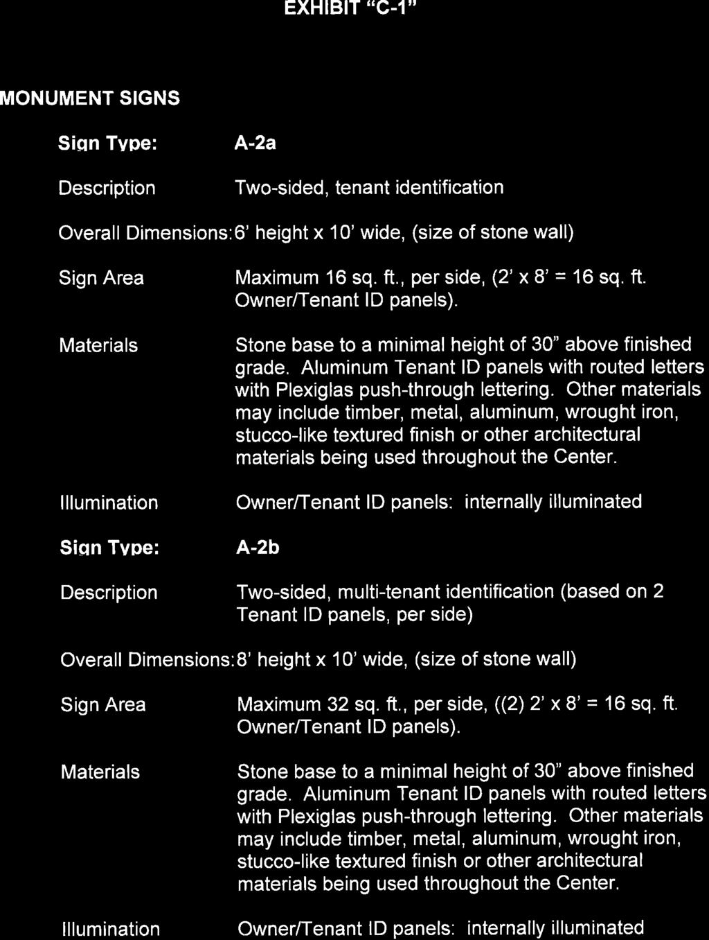
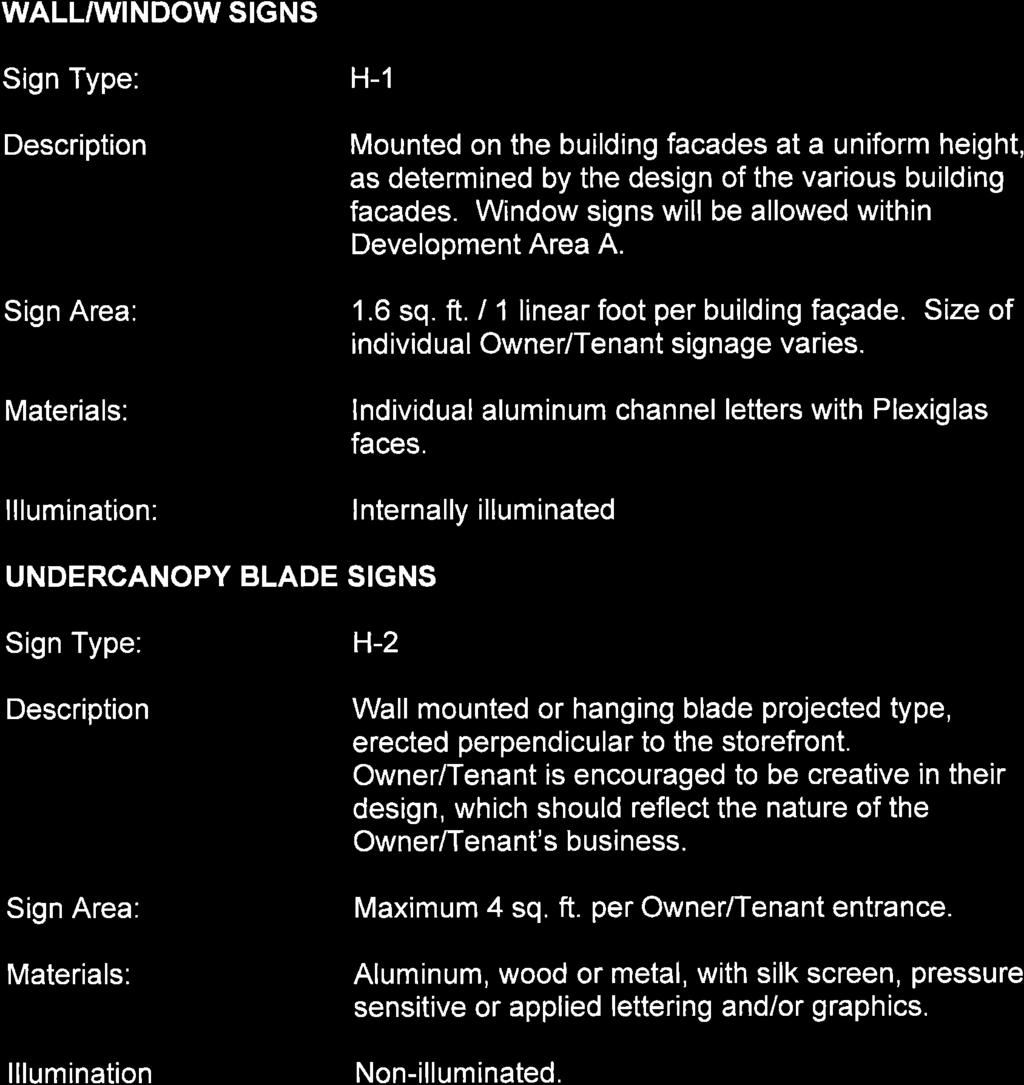
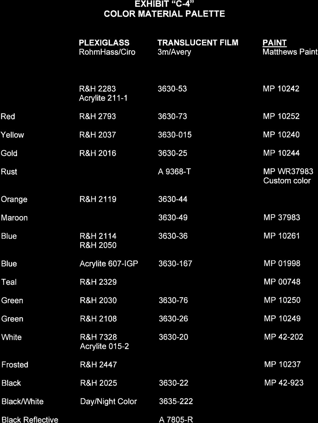
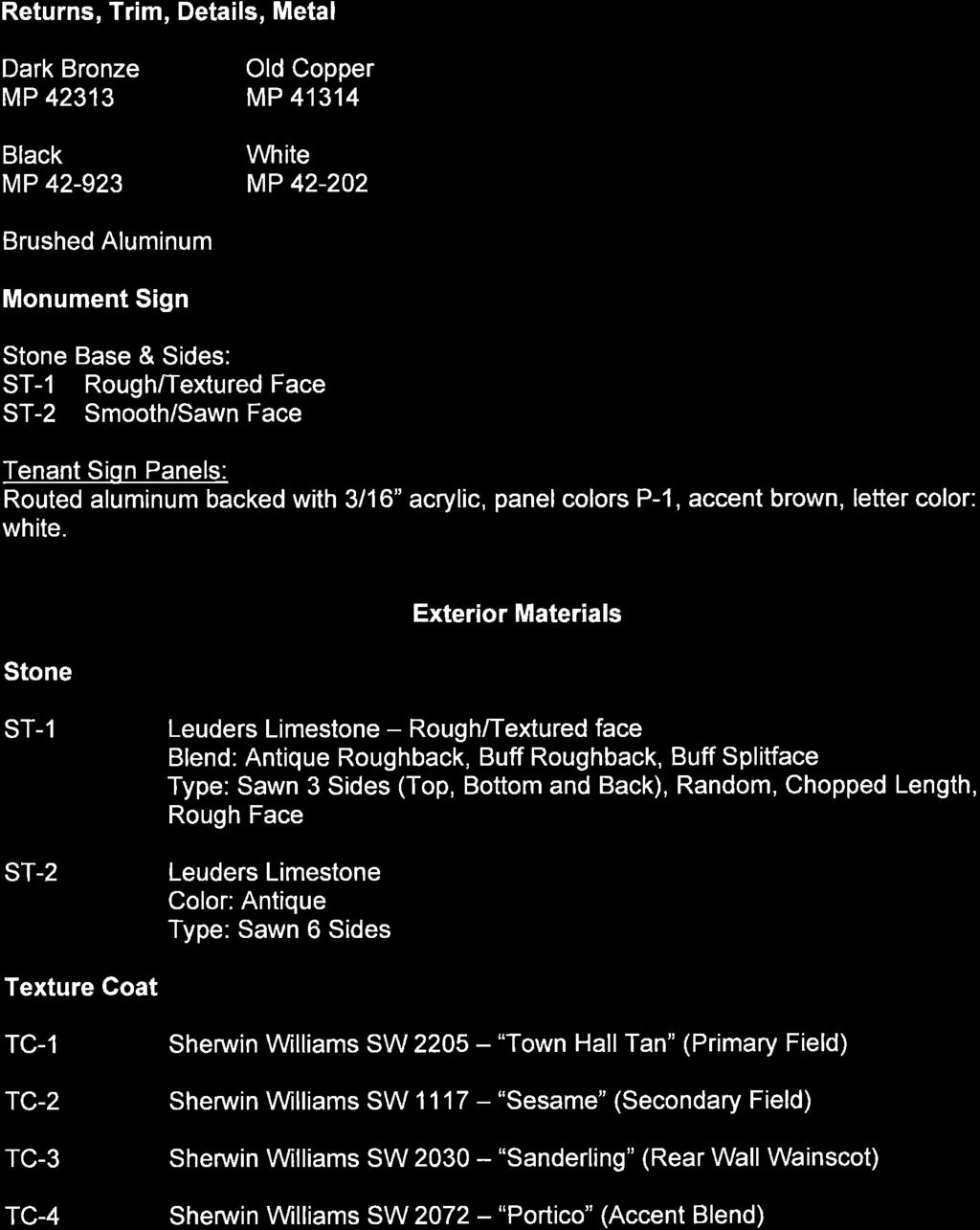
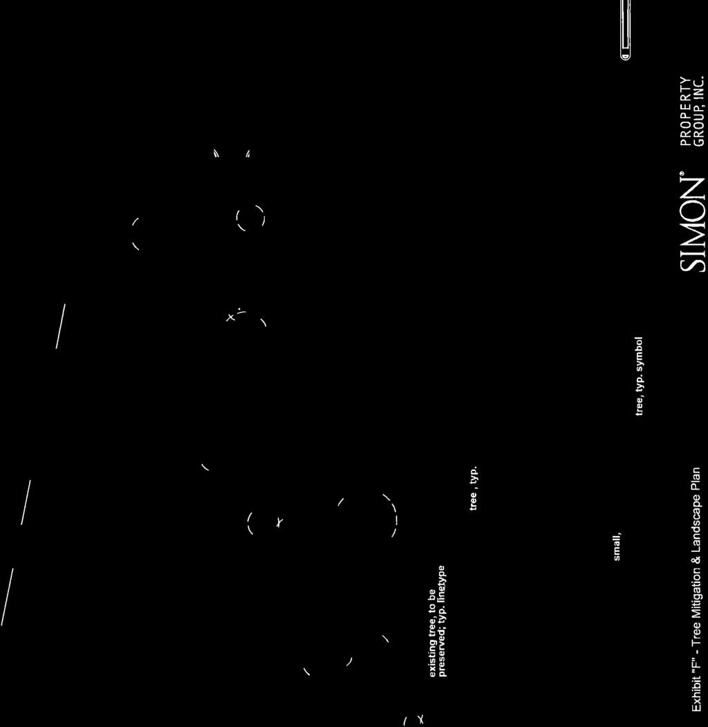
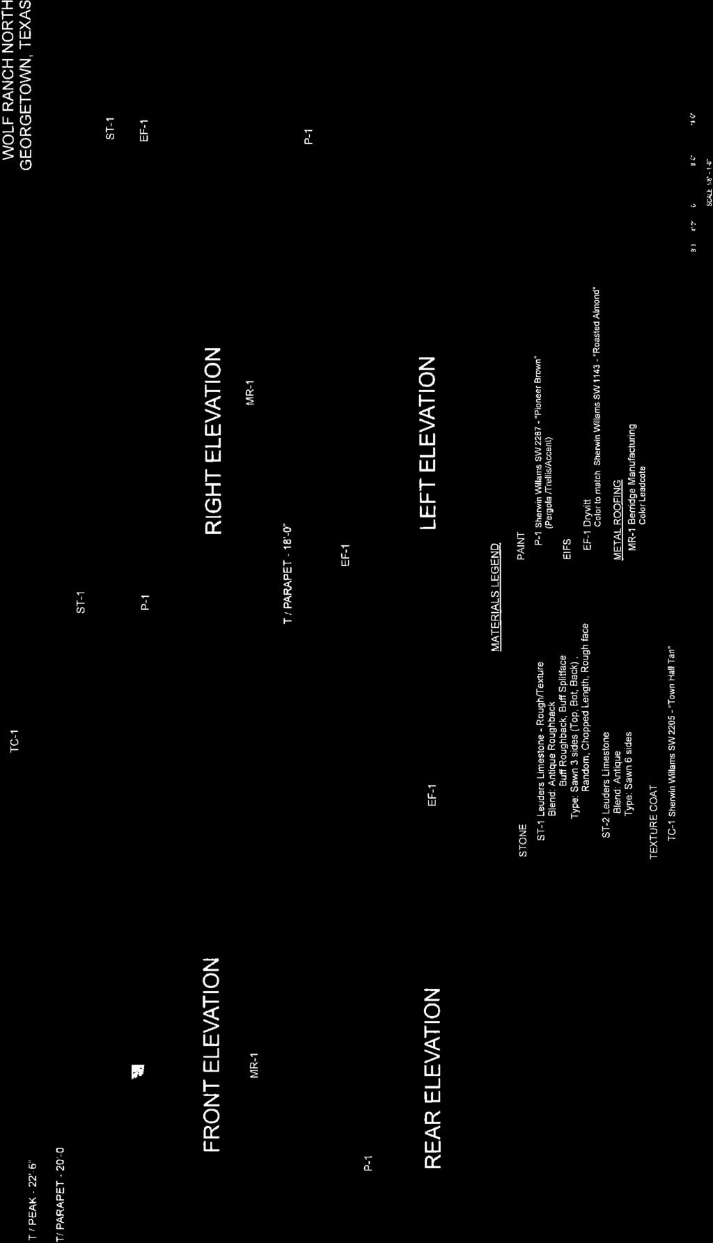
2 5. SIGNAGE PLAN The Signage Plan shall be as depicted in Exhibits C, C-1, C-2", C-3, and C-4, attached hereto and incorporated herein. Exhibits C-1 narrates the designs of the signs shown on the Signage Plan. Exhibit C-2 provides Wolf Ranch North signage criteria. Exhibit C-3", attached separately but incorporated herein, contains renderings of each parcel s monument sign. Exhibit C-4 contains the color palette applicable to the signs governed by this section and the Signage Plan. All regulation of signage shall be pursuant to this section. If not set forth herein, the applicable sections of the Code shall apply. The primary goal of the Signage Plan is to effectively utilize signs as a means of clear visual communication, blending with the natural environment, and improving pedestrian and traffic safety. Owner/Tenant signage will only convey the name of the business and product of service offered. All signs shall be constructed of materials and colors compatible with those utilized on the primary building s facades so as to blend into the environment and consistent with the above stated exhibits. 6. UTILITY SCHEMATIC, DRAINAGE AND TOPOGRAPHY MAP A Utility Schematic and Drainage Map and Topography Map, are attached hereto as Exhibits D and E" respectively, and incorporated herein. Both maps are conceptual in nature and may be modified in the future. Plans for drainage facilities will be reviewed as part of the subdivision and construction plan review process and approved by the City and/or the State of Texas prior to installation. 7. SH 29 DRIVEWAY AND INTERNAL DRIVE LOCATION The locations of the two newly constructed driveways off of SH 29 and the internal drive are shown on Exhibit B. This plan eliminates four current driveways and replaces them with two. 8. LANDSCAPING PLAN The Landscaping Plans and cross-sections are attached hereto and incorporated herein as Exhibit F (Tree Mitigation & Landscape Plan) and Exhibit F-1 (Gateway Landscape Buffer Cross Sections). Exhibit F-1 shows the location of preserved trees, replaced trees and all of the required landscaping along the buffer yard. All regulation of landscaping shall be pursuant to this section. If not set forth herein, the applicable sections of the Code shall apply. All plant species selections for Wolf Ranch North will be from the approved Wolf Ranch plant palette, with the exception of Live Oak (Quercus virginiana). 2
3 8.1 Street Yard Landscaping A minimum of twenty-four percent (24%) of the PUD will be landscaped, exceeding the twenty percent (20%) minimum requirement as stated in Section of the Code. 8.2 Grass and Turf Areas All landscaped areas not in groundcover or shrub beds, or undisturbed areas, will be planted with common Bermuda and/or native grasses. St. Augustine grass is prohibited. Overseeding in fall with cool season grasses is allowed. The use of edging material to separate all grass areas from shrub and groundcover areas is encouraged wherever possible. The edging material will be steel, stone, aggregate, or mulch. No plastic edging is allowed. No vegetative slopes shall exceed a 3:1 ratio, unless constructed of solid sod or slope stabilization matting. 8.3 Irrigation An underground, automatic irrigation system will be installed in all landscaped areas. Sprinkler heads will be located to effectively water the landscaped areas with minimal spray onto roadways, parking areas and walkways. Landscape areas within Simon Road Rights-of- Way, if to be irrigated, will be irrigated in compliance with the City of Georgetown s regulations. 8.4 Parking Lot Landscaping Landscape areas will be provided within all parking lots. Tree islands and peninsulas will be located so as to maximize the protection of existing mature trees. In areas where no existing trees are located within the parking field, tree islands will be provided to reduce the thermal impact of unshaded parking lots. Trees may exceed spacing requirements to allow them to be grouped to mimic existing clusters and create a more aesthetic effect. 8.5 Gateway Landscape Buffers The SH 29 Gateway Buffer shall be within approximately twenty-five feet (25 ) from the rightof-way line, planted in close conformity with the landscape provisions of Section Gateway Overlay District Landscaping section of the Code. Cross-sections of the SH 29 and Simon Road Gateway Landscape Buffer Sections are shown on Exhibit F-1", attached hereto and incorporated herein. Buffer trees shall be a combination of both large, shade trees and smaller, ornamental trees, interspersed in clusters along the buffer yards, in lieu of shade trees only. 8.6 West Landscape Buffer A 25 medium level landscape buffer will be provided along the west side of the property per section c.2. The code only requires a 25 setback. 3
4 8.7 Utility Lines All utility lines will be underground to connection points provided by the utility service provider. Special care and consideration will be given when digging along the rear of the property in case grave sites are identified during construction. Special care also will be made to the existing trees that are to remain. All transformers will be screened by plantings and/or hardscape. Electric service shall be installed according to the City s Development Regulations. 9. TREE PRESERVATION All proposed shade trees will be a minimum of four inch (4 ) caliper. Exhibit F - The Tree Mitigation & Landscape Plan illustrates that 15% of the Protected Trees are being preserved on site, compared to the 20% required by Table within the Code. The Tree Mitigation & Landscape Plan, as shown on Exhibit F, depicts the location of saved trees and replaced trees, as well as all other buffer landscaping. The Code requires that 40% of the total caliper inches of removed Protected Trees be replaced. Based on the above, 43% of all caliper inches of currently existing trees will be saved and/or replaced as part of the buffer requirements. Additionally, mitigation for trees to be removed, will not be required if tree number 8540 (25 Live oak) is to be saved and a pervious paving system is utilized within the critical root zone of existing trees to be saved. No oak or elm trees along the cemetery property line will be removed and the Urban Forester shall be involved in the sizing and alignment of parking peninsulas to optimal preservation of the root zones of these trees to remain. 9.1 Tree Protection Plan At or before site plan review, and prior to the removal of any trees, a Tree Protection Plan shall be submitted to the Urban Forester Department pursuant to Section 8.02 of the Code. Unless noted herein, all other provisions of the Code shall be complied with in full. Native trees of desirable species shall be preserved to the maximum extent feasible. Preserved natural areas shall be integrated with the design of open space, screening and landscaped areas. Since no Heritage Trees exist on site, protection measures for Protected Trees may also take priority over conflicting requirements in the Code, including but not limited to setbacks, lot design standards, building height limits, sidewalks, lighting, signage, landscaping and landscape buffers, parking design, including depth, width and count, vehicle stacking spaces, drive aisle widths, gateway overlay requirements, fencing, dumpster locations, drainage criteria, connectivity, driveway separations, utility extension, utility location and easements, 4
5 and impervious coverage. Public health and safety shall be maintained with all proposed designs. After consultation with the Urban Forester, an alternative standard or design that gives priority to Protected Tree Preservation may be approved by the Planning and Development Department for administrative applications. 9.2 Tree Survey A Tree Survey has been filed with, and accepted by, the Planning and Development Department as required by Section 8.05 of the Code. 10. IMPERVIOUS COVERAGE The property within the PUD is allowed to be developed at 70% impervious cover. Permeable pavers can be installed to obtain 75% impervious cover as long as they are installed in accordance with the design requirements set forth by TCEQ and as long as the downstream drainage is not increased or the downstream drainage system capacity is adequate. When one Lot remains to be developed, and (1) it is determined during the design of this Lot that it will exceed 75% impervious cover, and (2) if the Lot s Developer can provide documentation to the Director that the aggregate of the other Lots within the PUD, fully developed, will not exceed 70%, then the Lot s Developer can exceed the 75% impervious coverage maximum, up to 80%. 11. PERMITTED USES AND LIMITATIONS The PUD is designed to be used in conjunction with Local Commercial (C-1), which is the zoning designation most similar to and compatible with the uses proposed for the PUD. All standards and requirements of Local Commercial(C-1) shall apply unless specifically superseded by the standards and requirements of this Development Plan Prohibited Uses The Fuel Sales Specific Use will not be an allowable use under this zoning. In addition to the items strictly prohibited within Local Commercial (C-1), the following items are also expressly prohibited: There shall be no free-standing Kiosk type building or small light structures permitted in the parking areas or service areas outside of the main buildings. No truck or commercial vehicle of any kind shall be permitted to be parked on the property for a period of more than four (4) hours unless said vehicles are temporarily 5
6 present and necessary and incident to the business on the property. No truck or commercial vehicle shall be parked overnight, except within a screened enclosure. No recreational vehicle of any kind shall be parked within the proposed development overnight, and no boats, boat trailers or trailers of any kind, campers or mobile homes shall be permitted to park overnight on or near the property at any time unless kept inside a screened enclosure. No truck, commercial or recreational vehicle of any kind shall be used as a domicile or residence, either permanent or temporary Cell Tower Parcel The cell tower parcel will be included in the subdivision for Wolf Ranch North and will not be required to have frontage to a public road. A permanent cross access easement to the cell tower parcel will be provided as part of the subdivision process Outdoor Sales and Displays Outdoor sales and displays are permitted in conjunction with the use of a building, so long as said outdoor sales are temporary in nature. Any outdoor sales continuing for more than three consecutive days are prohibited. Outdoor sales and displays in conjunction with the use of a building are further limited to the following areas: Sidewalks Outdoor sales and displays are permitted on sidewalks adjacent to buildings, but limited to an area of no more than twenty-five percent (25%) of the sidewalk area that is located within fifteen feet (15 ) from the building. In no event may the outdoor sale and display area exceed ten percent (10%) of the interior floor area of the adjoining building. The Code limits outdoor sales to 30% of the sidewalk area located within 5' of the building Dining Areas Any outdoor café or outdoor dining area (including outdoor seating for a restaurant, bar, tavern or pub) that: (i) is located and operated as an integral part of the principal use, and (ii) does not comprise a separate business use or a separate business activity is permitted Height Restrictions All height restrictions established for Local Commercial (C-1) shall apply to all buildings within the PUD. Height shall be measured to top of highest element including parapet walls, 6
7 sloped roofs and architectural elements. One forty-five foot (45') foot decorative architectural feature, as part of the primary building design, may be considered by the Planning Director on the easternmost development, as shown on Exhibit F-2,with review of the Site Plan, provided that compatibility, appropriate scale, aesthetic enhancement of the intersection and consistency with the larger development area are considered in determination of approval Setbacks (See Exhibit B ) All setbacks established for Local Commercial (C-1) shall apply to all buildings and parking spaces within the PUD, except for the following setbacks: Side Setback = 0 for internal lot lines. (Code requires 10 ) Rear Setback to Residential District = 0 (Code requires 25, but a portion of the PUD abuts the cemetery (zoned RS) at the rear). All access drives proposed within the PUD are allowed to encroach within the Setbacks to allow for cross-access between the proposed lots Buildings Building Materials All buildings will be constructed to follow a consistent architectural theme with building materials consistent with Section of the Code. All building materials utilized within the PUD will be consistent with the materials shown on Exhibit C Building Articulation Horizontal Articulation will be achieved through the use of projecting canopies, awnings, masonry pilaster or accents or with change of materials and colors. Canopies may be freestanding trellis elements or extend as a fixed facade element. Vertical Articulation will be achieved by creating stepped parapets, towers or vertical feature elements that extend above and back over the primary roof structure. The facades of the retail shops will receive Vertical Articulation below the primary sign area, through the use of sloped and flat canopies or awning elements mounted at varying elevations Outdoor Storage, Service and Loading Areas All outdoor storage, truck docks, loading areas, trash compactors, refuse storage containers and ground-mounted service equipment will be screened from public view and constructed in compliance with the Code. 7
8 11.8 Exterior Lighting Minimal Spillover All site lighting will be designed and installed to restrict the level of illumination to two (2) foot candles maximum measured at a height of three feet (3 ) at the property line of adjacent properties. All light fixtures will meet Illuminating Engineering Society of North America standards for sharp cutoff. Facade lighting shall be accomplished by the use of wall mounted light fixtures or ground lights General Parking Lot Illumination All site lighting will be designed and installed so that the level of illumination as measured in foot candles at grade provides a minimum of two (2) foot candles maintained. Where possible on the site to maintain acceptable light uniformity, a maximum to minimum light level design goal is not to exceed a ratio of five to one. Light fixtures will be a Quality-Lighting-Design SL metal halide deep shoe box light with a concealed source and shall be mounted on maximum thirty (30') foot poles. The color of the light fixture and post shall be dark bronze, anodized finish. No general parking lot illumination light shall be attached to any structure Building mounted lights at service areas and service entrances Standard wall pack, exposed source fixtures are prohibited. Fixtures are to be QL- Design SL-Metal halide, deep shoebox fixture with a concealed source Parking Requirements All parking and parking lot design shall be in compliance with Code Section Cross parking and cross access will be in place for each development within the PUD. All access to parking aisles shall contain a painted stop bar on the exiting lane of the pavement designating both the need to stop and the direction of the travel lanes, eliminating the need for directional arrows as required in Section of the Code Drive Aisle/Parking Space Widths The internal access drive aisles shall be as shown on Exhibit B (25 in the East-West direction and 28 in the North-South direction). All parking stalls that are accessed off of these drive aisles may by 9 wide. 8
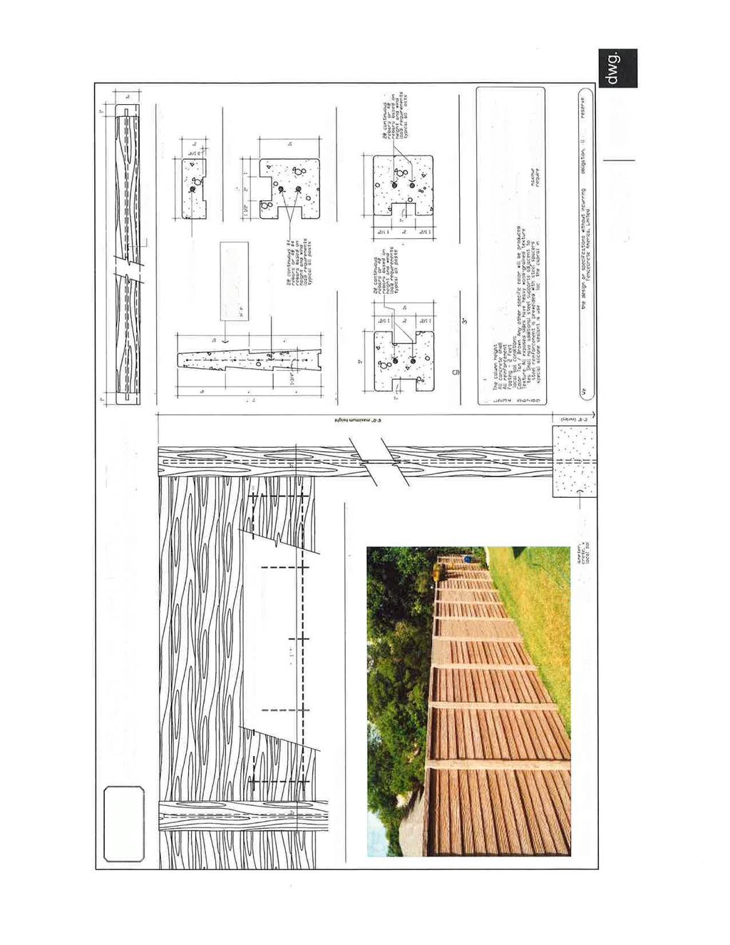
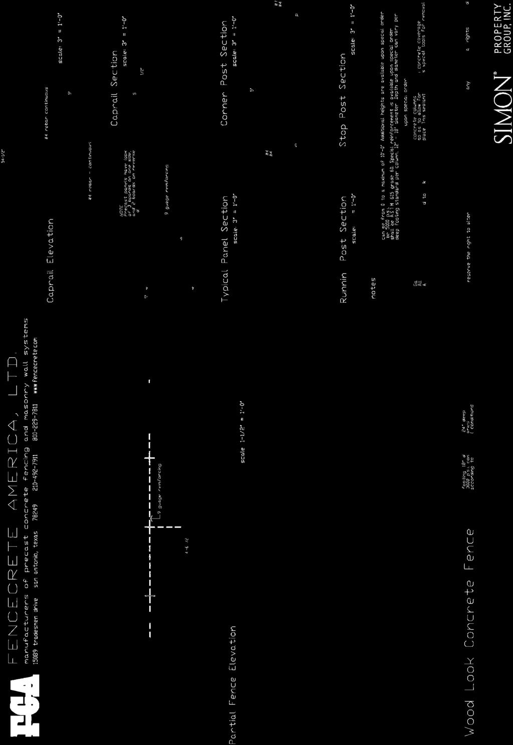
9 All other drive aisles may be reduced to a minimum of 24 and all parking stalls that are accessed off of these drive aisles may be 9 wide. Code Section B requires 9 wide parking stalls for 26 drive aisles and 10 wide parking stalls for 24 drive aisles Drive-Through Stacking Requirements Restaurant drive throughs shall provide for a minimum of 8 stacking spaces as measured from the pick-up window. Code Section allows for 6 stacking spaces measured from the order box and 4 spaces measured between the order box and the pick-up window. The length for the drive through stacking spaces shall be a minimum of 18.5 which is being reduced from the required 20 length as provided in Code Section A. These queuing spaces will not be allowed to encroach into the drive aisle in a manner that will impede traffic flow or block parking Rear Yard Screen Wall A 6 high screen wall will be built along the rear property line, from the northwest corner of the property to twenty-five feet (25 ) west of the northeast corner of the property, in accordance with the requirements of Code Section The alignment of wall panels or groups of wall panels may be intermittently offset toward the interior of each parcel as required to avoid conflicts with existing tree trunks and major structural roots. In an effort to preserve as much root zone as possible, the Urban Forester will be included in decisions as to where the fence footings and panels will be located along the back property line. Open spaces between offset wall panels will be allowed. 9
10 LIST OF EXHIBITS 1. Exhibit A : Property Description 2. Exhibit B : Development Site Plan 3. Exhibit C : Signage Plan 4. Exhibit C-1 : Sign Descriptions 5. Exhibit C-2": Signage Criteria 6. Exhibit C-3 Monument Sign Elevation 7. Exhibit C-4 Color Material Palette 8. Exhibit D : Utility Schematic and Drainage Plan 9. Exhibit E : Topography Map 10. Exhibit F : Tree Mitigation & Landscape Plan 11. Exhibit F-1 : Gateway Landscape Buffer Sections 12. Exhibit F-2 : Gateway Architectural Feature 13. Exhibit G : Existing Tree Plan 14. Exhibit H": Sample Elevation 15. Exhibit I : Rear Screen Wall Exhibit 16. Exhibit J Summary of PUD Justification 10
11 EXHIBIT A PROPERTY DESCRIPTION
12
13
14
15 EXHIBIT B DEVELOPMENT SITE PLAN
16 11/16/2012 H:\Jobfiles\SIM (Simon)\SIM (Wolf Ranch)\Jobfiles\PUD\Cad Exhibits\PUD Exhibit B.dwg 25' Landscape Buffer Wolf Ranch North Exhibit "B" - Development Plan Internal Access Road
17 EXHIBIT C SIGNAGE PLAN
18 11/16/2012 H:\Jobfiles\SIM (Simon)\SIM (Wolf Ranch)\Jobfiles\PUD\Cad Exhibits\PUD Exhibit C.dwg A-2a Wolf Ranch North Exhibit "C" - Signage Plan A-2a A-2a Approximate Location Sign A-2a (Typ. up to Five Locations) Approximate Location Sign A-2a or A-2b
19 EXHIBIT C-1 SIGN DESCRIPTIONS
20
21
22
23 EXHIBIT C-2 SIGNAGE CRITERIA
24
25
26
27

28
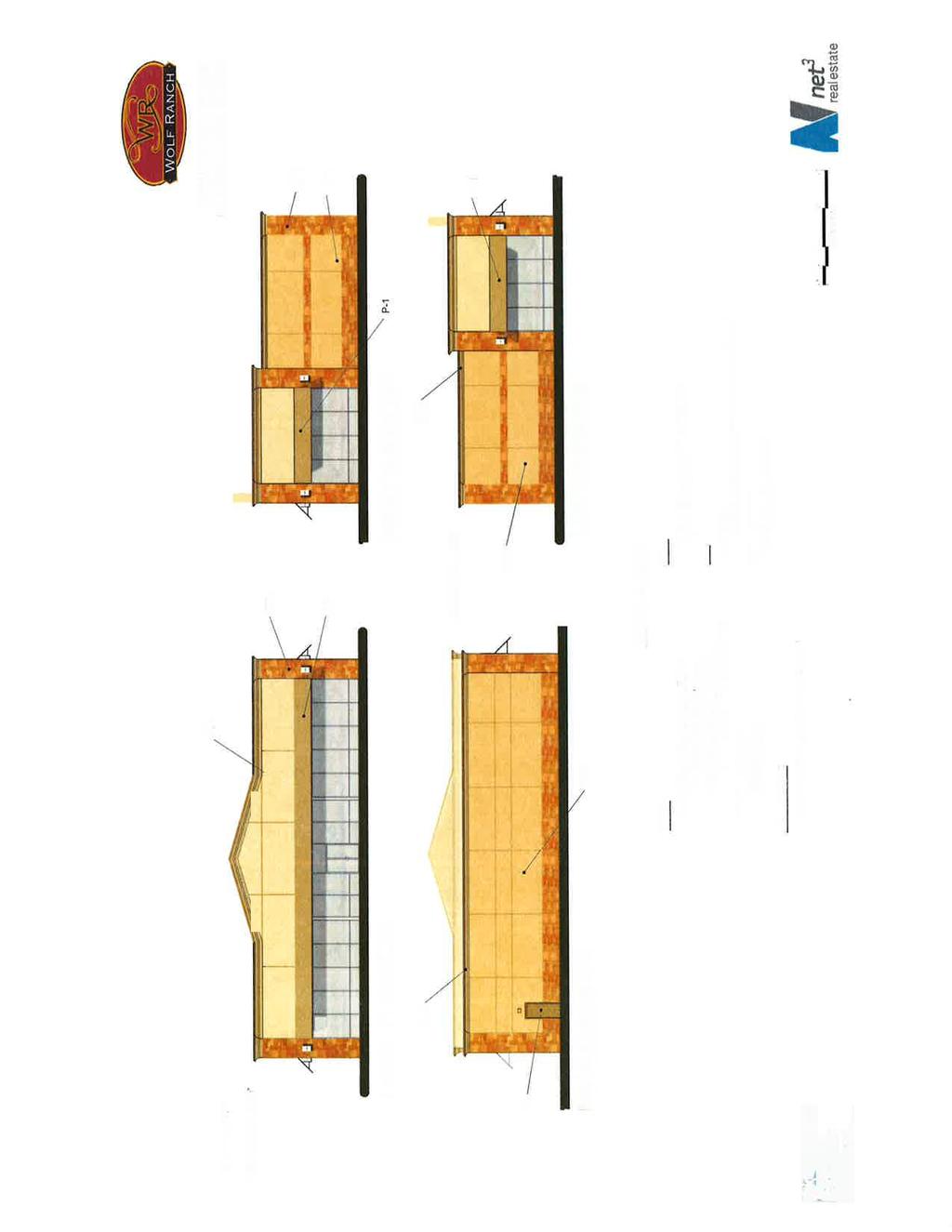
29 EXHIBIT C-3" MONUMENT SIGN ELEVATIONS
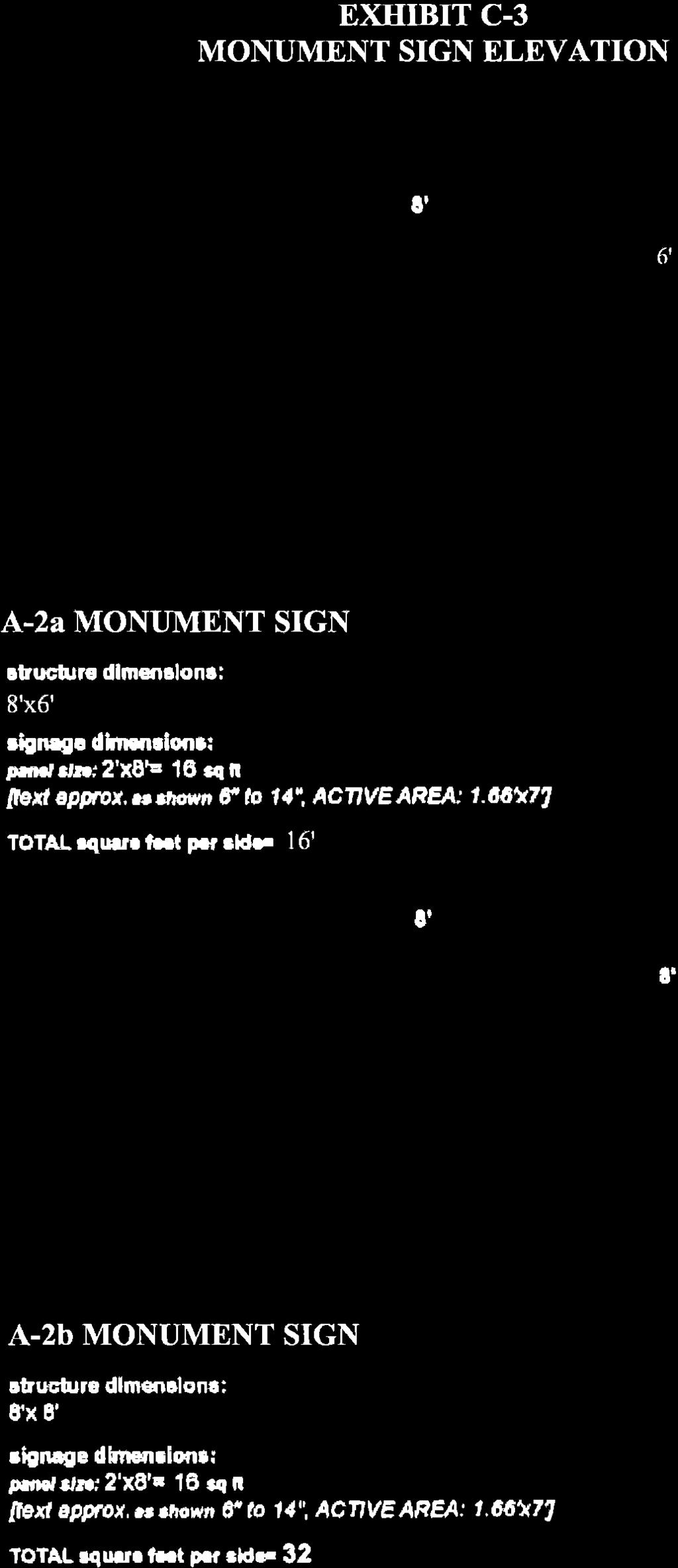
30
31 EXHIBIT C-4 COLOR MATERIAL PALETTE
32
33
34
35 EXHIBIT D UTILITY SCHEMATIC AND DRAINAGE PLAN
36 Wolf Ranch North Exhibit "D" - Utility Schematic and Drainage Plan W W SS SS SD SD FO OHE UGE G Existing Water Proposed Water Existing Sanitary Proposed Sanitary Existing Storm Drain Proposed Storm Drain Existing Fiber Optic Existing Overhead Electric Proposed Underground Electric Proposed Gas Existing Fiber Optic Proposed Manhole Existing 8" Water H:\Jobfiles\SIM (Simon)\SIM (Wolf Ranch)\Jobfiles\PUD\Cad Exhibits\PUD Exhibit D.dwg Proposed Fire Hydrant Connect to Existing Waterline Proposed 8" Water Existing Inlet Existing Inlet Existing 8" Water Proposed Utility Sleeves Existing Overhead Electric Proposed Utility Sleeves Remove Existing Inlet New Curb Inlet Proposed Utility Sleeves Proposed 8" Sanitary Line Proposed Underground Electric Proposed Manhole Connect to Existing Manhole 11/16/2012 Proposed Gas Existing 8" Sanitary Line Existing 36" Storm Drain Raw Water Line Existing Inlet
37 EXHIBIT E" TOPOGRAPHY MAP
38 11/16/2012 H:\Jobfiles\SIM (Simon)\SIM (Wolf Ranch)\Jobfiles\PUD\Cad Exhibits\PUD Exhibit E.dwg Wolf Ranch North Exhibit "E" - Topography Map
39 EXHIBIT F TREE MITIGATION & LANDSCAPE PLAN
40
41 EXHIBIT F-1 GATEWAY LANDSCAPE BUFFER SECTIONS
42
43 EXHIBIT F-2 GATEWAY ARCHITECTURAL FEATURE
44
45 EXHIBIT G EXISTING TREE PLAN
\Jobfiles\PUD\Cad Exhibits\PUD Exhibit G.")
46 11/16/2012 H:\Jobfiles\SIM (Simon)\SIM (Wolf Ranch)\Jobfiles\PUD\Cad Exhibits\PUD Exhibit G.dwg Wolf Ranch North Exhibit "G" - Existing Trees
47 EXHIBIT H SAMPLE ELEVATION


48
49 EXHIBIT I REAR SCREEN WALL EXHIBIT
50
51 EXHIBIT K SUMMARY OF PUD JUSTIFICATION The purpose of this PUD is to establish and encourage the most desirable and efficient use of land while enhancing the physical environment through functional and compatible land use configurations. The irregularly shape development parcel provides for access constraints and development inefficiencies in the land use. This PUD contains many of the same criteria that is within the Wolf Ranch PUD, and we felt that it is important to have this development complement Wolf Ranch so we can provide a uniform and consistent theme for the residents and visitors entering the Gateway to Georgetown. Following is a list of the requests for leniency from the current code as well as a list of items being proposed that are above and beyond the code requirements. REQUESTS FOR LENIENCY LANDSCAPE Section B. Since the site has no Heritage Tree and therefore can not realize the benefit of saving that classification of tree, the same benefits are being requested to be granted by taking priority to save Protected Trees. Section B. Parking stalls in excess of 50 feet from the trunk of a tree will be allowed due to the shape and special constraints of site and the preservation of existing trees. Section C.2 Small, ornamental trees (in addition to shade trees) shall be allowed to meet the shade tree requirement of the Scenic Overlay District. Table The majority of existing trees are hackberry and only a few desirable species exist on the developable portions of the site; therefore, only 15% of the Protected Trees are being preserved on site, compared to the 20% required by code. SIGNAGE Table Sign Dimensions by District. We are requesting the ability for one of our monument signs (Sign A-3 shown on Exhibit C) to be able to be 8 in height to accommodate the potential for a multi-tenant use. This 8 height is what currently exists at the outparcel developments along SH 29 at Wolf Ranch. The design of the sign will be consistent with the Wolf Ranch outparcel monument signs to maintain consistency along the SH 29 gateway corridor. SETBACKS All setbacks within the C-1 zoning have been maintained with the exception of the following: Rear setback to Residential District (RS). A portion of the tract will encroach upon this setback due to the zoning classification of the cemetery being RS. In lieu of adhering to this setback, a masonry-type fence will be installed along the entire rear property line to keep trash and debris from blowing onto the cemetery land and to provide privacy for family visiting loved ones that have deceased. Table B We are requesting a reduction in the minimum aisle widths for 9 wide, 90 stalls from 26 to 24 on all secondary drives within Development Areas A and B. This width is consistent with the drive aisles that are in use at Wolf Ranch. This request is being made to maximize the parking opportunities within this irregularly shaped development parcel. Table We are requesting a reduction of Restaurant drive through spaces measured from the order box from six spaces to four spaces with a total required stacking of 8 spaces. This is consistent with the request that was made for the restaurant drive through on Lot 9 at Wolf Ranch. We will require that all additional stacking will not impede upon the internal access road shown on Exhibit B.
52 Table We are requesting a reduction of Restaurant drive through spaces measured from the order box from six spaces to four spaces with a total required stacking of 8 spaces. This is consistent with the request that was made for the restaurant drive through on Lot 9 at Wolf Ranch. We will require that all additional stacking will not impede upon the internal access road shown on Exhibit B. Table A We are requesting a reduction in drive through queuing space length from 20 to Because the triangularly shaped parcel provides for various site planning constraints, this request is being made so that we may be able to maximize the opportunity to provide for drive through restaurants within this development. The PUD will require that vehicular stacking at drive throughs will not impede upon the drive aisles or parking. Section 12.4 Height Restrictions We are proposing to install a Gateway architectural feature, up to 45, at the southeast corner of Development Area B, as shown on Exhibit F-2. This feature is intended to provide a visual offset from the vertical dominance of the existing cell tower and to complement the similar feature that exists at Wolf Ranch. BETTERMENTS Landscape Section Four percent more landscape area is being provided on the overall site area addressed by this PUD than the amount required by code. Section C.2 Small, ornamental trees interspersed among shade trees will enhance the aesthetic of the street yards by diversifying foliage and flower colors and textures as well as visually softening the buildings and complimenting the scale of their facades. Section Code requires shade trees to be a minimum of three inch (3 ) caliper. This PUD requires a minimum of four inch (4 ) caliper shade trees. Section A superior, masonry or cementitious material will be used in lieu of wood for the Rear Yard Screen Wall, and the wall will extend along the entire cemetery boundary. Enhanced materials (no plastic) will be required for edging of all turf grass areas A permanent, underground irrigation system will be provided within all landscaped areas. A pervious paver system for vehicular-use areas will be utilized within the root zones of existing trees. Overall, a minimum of forty-three percent of all caliper inches of currently existing trees will be saved and/or replaced. The ordinance requires mitigation for 40% of total diameter of Protected Trees removed. A 25 medium level landscape buffer will be provided along the west side of the property per section c.2. The code requires that a 25' setback only be provided. General While the C-1 Zoning allows for Fuel Sales, we are establishing Fuel Sales as a prohibited use within this Development Plan. The proposed plan eliminates four existing driveways and replaces them with two new drives.
5.1.1 The streetscape along US Highway 64 (Brevard Road); and, The built environment within new residential developments; and,
; and, The built environment within new residential developments; and,") Article 5. Landscaping 5.1 Purpose The Town of Laurel Park s landscape standards are designed to create a beautiful, aesthetically pleasing built environment that will complement and enhance community
Article 5. Landscaping 5.1 Purpose The Town of Laurel Park s landscape standards are designed to create a beautiful, aesthetically pleasing built environment that will complement and enhance community
Landscaping Standards
 CHAPTER 29 ARTICLE 403 29.403 Landscaping Standards Purpose: The purpose of this section is to protect and promote the public health, safety and general welfare by requiring landscaping in relation to
ARTICLE 9: LANDSCAPING AND FENCING REQUIREMENTS
 ARTICLE 9: LANDSCAPING AND FENCING REQUIREMENTS Section 9.01 Intent The intent of the landscaping requirements are to improve the appearance of lot areas and soften paved areas and buildings; to provide
Landscape and fencing requirements of this Chapter shall apply to all new landscaped areas.
 Chapter 19.06. Landscaping and Fencing. Sections: 19.06.01. Purpose. 19.06.02. Required Landscaping Improvements. 19.06.03. General Provisions. 19.06.04. Landscaping Plan. 19.06.05. Completion of Landscape
Section 511: 11 th Street Overlay District 1. Intent: 11 th Street is the primary entrance route into the city from the south, providing direct
 Section 511: 11 th Street Overlay District 1. Intent: 11 th Street is the primary entrance route into the city from the south, providing direct access from US Highway 12. As such, the community has identified
D. Landscape Design. 1. Coverage Intent: To provide adequate landscaping materials that enhance the appearance of development projects.
 D. Landscape Design The standards and guidelines in this section give design guidance for the landscaping components of industrial and office projects. City regulations require that all landscaping be
U.S. Highway 377 North Overlay District. 1. General Purpose and Description
 U.S. Highway 377 North Overlay District 1. General Purpose and Description The purpose of the U.S. Highway 377 North Overlay District is to implement the recommendations within the U.S. Highway 377 North
The following specific definitions shall apply to the landscaping and screening regulations contained in this article:
 ARTICLE XII. LANDSCAPING Sec. 5-421. Purpose. The purpose of landscaping and screening requirements is to improve certain setback and yard areas, including off-street vehicular parking and open-lot sales
FREEWAY/TOURIST DISTRICT
 FREEWAY/TOURIST DISTRICT DESIGN STANDARDS FOR THE CITY OF MOUNTLAKE TERRACE March, 2014 MOUNTLAKE TERRACE FREEWAY/TOURIST DESIGN STANDARDS March, 2014 1 TABLE OF CONTENTS Introduction...1 Design Site Design
PART I-D BUFFERS AND LANDSCAPING REQUIREMENTS
 District Regulations Of General Applicability ARTICLE IX PART I-D BUFFERS AND LANDSCAPING REQUIREMENTS 9-107 BUFFERS AND LANDSCAPING 9-107 A. General Landscaping and Maintenance Requirements. Except for
The purpose of the requirements in this Article is to provide for landscaping and screening of parking and other outdoor areas that will:
 XIII. LANDSCAPING & SCREENING A. Purpose The purpose of the requirements in this Article is to provide for landscaping and screening of parking and other outdoor areas that will: 1. Protect residential
Building and Site Design Standards
 Commercial Design Standards All Business and Industrial Uses as Described in Section 2234 Requiring Special Permit Review Except Large-Scale Ground Mounted Solar Photovoltaic Installations and Wireless
Chapter PEDESTRIAN COMMERCIAL (PC) ZONING DISTRICT
 ZONING DISTRICT") Chapter 11-17 PEDESTRIAN COMMERCIAL (PC) ZONING DISTRICT Sections: 11-17-01 GENERAL PURPOSE 11-17-02 PERMITTED BUILDING TYPES 11-17-03 USES PERMITTED WITH DESIGN REVIEW 11-17-04 USES PERMITTED BY CONDITIONAL
Chapter 11-17 PEDESTRIAN COMMERCIAL (PC) ZONING DISTRICT Sections: 11-17-01 GENERAL PURPOSE 11-17-02 PERMITTED BUILDING TYPES 11-17-03 USES PERMITTED WITH DESIGN REVIEW 11-17-04 USES PERMITTED BY CONDITIONAL
The Highway Overlay District applies to an area within the City of Papillion's zoning jurisdiction described as:
 ARTICLE XXVIII. HOD Highway Overlay District 205-164. Intent. The Highway Overlay District recognizes the strategic importance of the Highway 370 corridor as an entrance to Papillion from Interstate 80
SECTION RESIDENTIAL LANDSCAPING, STREETSCAPING, AND AMENITY STANDARDS
 SECTION 3.5400 RESIDENTIAL LANDSCAPING, STREETSCAPING, AND AMENITY STANDARDS 3.5401 RESIDENTIAL LANDSCAPE STANDARDS a) These standards shall apply to any single family detached and duplex residential zoning
City of Aurora Planning Department DESIGN STANDARDS FOR MOTOR VEHICLE FUEL DISPENSING STATION. August 3, 1998
 City of Aurora Planning Department DESIGN STANDARDS FOR MOTOR VEHICLE FUEL DISPENSING STATION August 3, 1998 1. GENERAL PURPOSE AND APPLICABILITY The following design standards for motor vehicle fuel dispensing
ARTICLE XIX SCREENING, LANDSCAPING AND TREES
 ARTICLE XIX SCREENING, LANDSCAPING AND TREES Part I. Landscaping and Screening Section 304 Purpose. The purpose of this Part is to establish minimum landscaping and screening requirements that provide
DEVELOPMENT CONTROLS MEDICAL DISTRICT
 6.01. GENERAL DESIGN GUIDELINES A. Site Planning B. Architectural Design C. Medical Facility Signage & Lighting D. Exhibit 48. ARCHITECTURAL DESIGN CONCEPTS 6.02. MEDICAL FACILITY STANDARDS & GUIDELINES
4. INDUSTRIAL 53 CASTLE ROCK DESIGN
 4. INDUSTRIAL 53 CASTLE ROCK DESIGN CASTLE ROCK DESIGN 54 4. INDUSTRIAL Overview Well-designed and attractive industrial centers are the product of blending economic realities with both functional and
5.1 Commercial and Industrial Development. (Effective April 1, 2006)
") 5.1 Commercial and Industrial Development. (Effective April 1, 2006) A. Applicability: The requirements of this section (5.10) shall apply to all uses within the LB Local Business; HB Highway Business;
5.1 Commercial and Industrial Development. (Effective April 1, 2006) A. Applicability: The requirements of this section (5.10) shall apply to all uses within the LB Local Business; HB Highway Business;
ARTICLE VI. LANDSCAPING, BUFFERING, AND OPEN SPACE REQUIREMENTS.
 ARTICLE VI. LANDSCAPING, BUFFERING, AND OPEN SPACE REQUIREMENTS. 6-1. Landscaping Standards. (A) Landscaping. In order to maintain and enhance the existing tree coverage in Norwood, to promote careful
BUFFERS, TREE PROTECTION AND LANDSCAPING. Sec Purpose and Intent.
 ARTICLE 20 BUFFERS, TREE PROTECTION AND LANDSCAPING Sec. 20.1. Purpose and Intent. Trees improve air and water quality, reduce soil erosion, reduce noise and glare, provide habitat for desirable wildlife,
SECTION 1000 HIGHWAY CORRIDOR OVERLAY DISTRICT REGULATIONS
 SECTION 1000 HIGHWAY CORRIDOR OVERLAY DISTRICT REGULATIONS 1001.00 INTENT AND PURPOSE... 1000-1 1002.00 CLASSIFICATIONS... 1000-1 1003.00 DEVELOPMENT STANDARDS TABLES Page 1003.01 Buffer Requirements...................................
Chapter 11. Industrial Design Guidelines 11.1 INTRODUCTION AND PURPOSE 11.3 SITE PLANNING GUIDELINES 11.2 GENERAL DESIGN OBJECTIVES
 Chapter 11 Industrial Design Guidelines 11.1 INTRODUCTION AND PURPOSE The following industrial/design guidelines seek to assure high quality development in Santa Ana s industrial districts by: The design
VILLAGE OF CHANNAHON COMMERCIAL DESIGN GUIDELINES. Village of Channahon S. Navajo Drive Channahon, IL (815)
") VILLAGE OF CHANNAHON COMMERCIAL DESIGN GUIDELINES Village of Channahon 24555 S. Navajo Drive Channahon, IL 60410 (815) 467-6644 www.channahon.org Adopted March 6, 2006 VILLAGE OF CHANNAHON COMMERCIAL DESIGN
VILLAGE OF CHANNAHON COMMERCIAL DESIGN GUIDELINES Village of Channahon 24555 S. Navajo Drive Channahon, IL 60410 (815) 467-6644 www.channahon.org Adopted March 6, 2006 VILLAGE OF CHANNAHON COMMERCIAL DESIGN
Urban Design Manual 2.0 DRIVE-THROUGH FACILITIES. Background. Urban Design Challenges
 222221 2.0 DRIVE-THROUGH FACILITIES Background In recent years, drive-through facilities have grown significantly in popularity with drive-through restaurants, in particular, being established on numerous
MIXED-USE ZONING DISTRICT DESIGN GUIDELINES
 MIXED-USE ZONING DISTRICT DESIGN GUIDELINES In addition to the development regulations contained in the Mixed-Use Zoning District, design guidelines are presented here to provide an added level of definition
ARTICLE XIII USE PROVISIONS. Section Mall of Georgia Overlay District Requirements:
 ARTICLE XIII USE PROVISIONS Section 1315. Mall of Georgia Overlay District Requirements: Section 1315.1 Findings and Purposes: The Mall of Georgia Overlay District is intended to enhance the viability
3.4 Business & Light Industrial Parks and Buildings
 3.4 Business & Light Industrial Parks and Buildings I. GOALS A. To encourage superior design in business and light industrial parks. Section 3.4 - Business & Light Industrial Parks and Buildings B. To
Prepared by: LCT Design Group, LLC 401 North Franklin Street, Suite 5S Chicago, Illinois 60610
 Prepared by: LCT Design Group, LLC 401 North Franklin Street, Suite 5S Chicago, Illinois 60610 Existing Conditions Residential Guidelines Future Land Use -East Study Area - West Study Area Existing Conditions
Improve the appearance of off-street parking areas, vehicular use areas, and property abutting public and private roads;
 Bedford Township, MI (Monroe Co.) 2012 http://library.municode.com/index.aspx?clientid=02123 400.1907 - Landscaping and screening. Se 1907. 1. Intent. Landscaping, greenbelts, and screening are necessary
Design Guidelines Checklist
 Design Guidelines Checklist A quick reference to the City of Vista Design Guidelines City of Vista Community Development Department Planning Division 600 Eucalyptus Avenue Vista, CA 92084 760.639.6100
180 ZONING 180. ARTICLE XLII STREETSCAPE ENHANCEMENT OVERLAY ( SEO ) DISTRICT [Added Ord. No. 1086]
![180 ZONING 180. ARTICLE XLII STREETSCAPE ENHANCEMENT OVERLAY ( SEO ) DISTRICT [Added Ord. No. 1086]](/thumbs/75/72360049.jpg "180 ZONING 180. ARTICLE XLII STREETSCAPE ENHANCEMENT OVERLAY ( SEO ) DISTRICT [Added Ord. No. 1086]") 180 ZONING 180 ARTICLE XLII STREETSCAPE ENHANCEMENT OVERLAY ( SEO ) DISTRICT [Added 4-6-2016 Ord. No. 1086] 180.145. SEO DISTRICT 180.145.1. Intent. The SEO DISTRICT Regulations are intended to address
180 ZONING 180 ARTICLE XLII STREETSCAPE ENHANCEMENT OVERLAY ( SEO ) DISTRICT [Added 4-6-2016 Ord. No. 1086] 180.145. SEO DISTRICT 180.145.1. Intent. The SEO DISTRICT Regulations are intended to address
GENERAL LANDSCAPE PROVISIONS. The following landscape provisions shall be adhered to by all land uses unless otherwise noted:
 CHAPTER 1.18 Sections: 1.18.005 Purpose. 1.18.010 Landscaping, Buffering, and Fencing Improvements Required. 1.18.015 General Landscape Provisions. 1.18.020 Landscaping Plan. 1.18.025 Single-Family Dwellings
CHAPTER 11 HC HIGHWAY COMMERCIAL DISTRICT
 CHAPTER 11 HC HIGHWAY COMMERCIAL DISTRICT SECTION 11.01 DESCRIPTION AND PURPOSE This District is intended primarily for uses emphasizing highway related service, such as service stations, restaurants,
Rootstown Township Zoning Resolution 8/26/99. CHAPTER 430 Landscaping And Screening Requirements
 430.01 Purpose. 430.02 Landscaping along the street frontage. 430.03 Screening and landscaping of parking lots 430.04 Screening and buffering when lot abuts a residential district. 430.05 Screening of
F. Driveways. Driveways which provide access to off-street parking or loading from public streets shall comply with the following:
 Section 20.945.040 General Design Standards for Surface Parking Areas. A. Review Authority. Parking lot design and drainage shall be subject to review and approval of the City Transportation Manager. B.
ARTICLE XII BUFFER REQUIREMENTS
 ARTICLE XII 1200. Intent. It is the intent of this section to establish standards to provide for buffer amenities and screening throughout unincorporated Georgetown County. The purpose of these standards
KASPER. City of Georgetown, Texas PUD Planned Unit Development. December 30, 2015 Revised January 27, 2016
 KASPER City of Georgetown, Texas PUD Planned Unit Development December 30, 2015 Revised January 27, 2016 Applicant: Sentinel Land Company, LLC 4910 Campus Drive Newport Beach, CA Prepared by: SEC Planning
36.1. PURPOSE APPLICABILITY DESIGN REVIEW GUIDELINES
 CHAPTER 36: DESIGN STANDARDS 36.1. PURPOSE The purpose of this chapter is to ensure that projects are designed and constructed consistent with the Community Design Subelement of the Land Use Element and
Design Guidelines for Residential Subdivisions
 Design Guidelines for Residential Subdivisions Development Services 972-466-3225 cityofcarrollton.com This page intentionally left blank. Table of Contents Purpose... 1 Design Objectives... 1 Design Guidelines
ARTICLE 12. LANDSCAPING REQUIREMENTS.
 ARTICLE 12. LANDSCAPING REQUIREMENTS. 12.1 GENERAL REQUIREMENTS 12.2 LANDSCAPE PLAN REQUIRED 12.3 LANDSCAPE DESIGN STANDARDS 12.4 REQUIRED PARKING LOT LANDSCAPE 12.5 REQUIRED BUFFER YARD 12.6 ADDITIONAL
Gas Stations ottawa.ca
 Urban Design Guidelines for Gas Stations ottawa.ca Ce document est disponible en français sur ottawa.ca. This document is available in French on ottawa.ca. Approved by City Council May 24, 2006 City of
ARTICLE II. LANDSCAPING
 ARTICLE II. LANDSCAPING Sec. 35-31. Landscaping required for all site development. (a) Residential Developments: (1) All residential lots shall provide a minimum of one (1) boulevard tree (planted between
4.500 Preston Road Overlay District
 Section 4.500 Preston Road Overlay District 2004 Zoning Ordinance 4.500 Preston Road Overlay District (ZC 98-29; Ordinance No. 98-9-12) 4.501 Purpose To provide appropriate design standards for the use
VILLAGE OF HUNTLEY COMMERCIAL DESIGN GUIDELINES
 VILLAGE OF HUNTLEY COMMERCIAL Village of Huntley Development Services Department Planning & Zoning Division 10987 Main Street Huntley, Illinois 60142 (847) 515-5252 www.huntley.il.us VILLAGE OF HUNTLEY
EXHIBIT B PROJECT NARRATIVE POULSBO MEADOWS
 EXHIBIT B PROJECT NARRATIVE POULSBO MEADOWS Name of Project: Poulsbo Meadows; A Planned Residential Development (PRD)/Plat Applicants Name: PBH Group LLC/Byron Harris PO Box 1010 Silverdale, WA 98038 Description
Article 10: Landscaping and Buffering
 10.01: Purpose Article 10: Landscaping 10.01: Purpose The purpose of this article is to: A) Promote and protect the interest of the public convenience, comfort, prosperity, or general welfare in accordance
Sec Intent and purpose.
 1 of 5 10/12/2012 10:33 AM Hastings, Michigan, Code of Ordinances >> PART II - CODE OF ORDINANCES >> Chapter 90 - ZONING >> ARTICLE XII. - LANDSCAPING >> ARTICLE XII. - LANDSCAPING Sec. 90-1006. - Intent
5.7 Design Criteria for the Private Realm Organization of Private Realm Design Standards and Guidelines Guidelines vs.
 5.7 Design Criteria for the Private Realm The Private Realm (shown in Exhibit 5.7a) includes the privately owned property not included in the Setback Realm described in the previous section. It encompasses
EXHIBIT. PUD Written Description
 EXHIBIT D PUD Written Description Krispy Kreme at Merrill Road PUD Revised 09-30-2013 City Development Number: I. PROJECT DESCRIPTION The subject property identified as Real Estate No.120466 0030 on Panel
VILLAGE OF SKOKIE Design Guidelines for Mixed-Use Districts NX Neighborhood Mixed-Use TX Transit Mixed-Use CX Core Mixed-Use
 VILLAGE OF SKOKIE Design Guidelines for Mixed-Use Districts NX Neighborhood Mixed-Use TX Transit Mixed-Use CX Core Mixed-Use TABLE OF CONTENTS CHAPTER 1 SITE DESIGN Purpose 1 CHAPTER 2 SITE DESIGN Streetscape
COMMUNITY DEVELOPMENT DEPARTMENT
 COMMUNITY DEVELOPMENT DEPARTMENT CONDITIONAL USE APPLICATION FOR CITY USE ONLY Date Received: Date Determined Complete: Fees Paid: PC Meeting: Fees: $200 / $400 with Site Plan; plus all applicable Engineering
CHAPTER 3. Design Standards for Business, Commercial, Industrial, Recreational and Institutional Uses
 CHAPTER 3 Design Standards for Business, Commercial, Section Number Title Ordinance Number Date of Ordinance 16-3-1 Applicability 2006-11 2008-04 07-01-08 16-3-2 Uniform Standards for Architectural Design
ARTICLE 9: Landscaping
 ARTICLE 9: Landscaping 9-10 Legislative Intent The purpose of this Article is to regulate the planting and preservation of landscape materials; to facilitate the creation of an attractive and healthy environment;
This chapter contains the design standards and guidelines for development and improvement of office and industrial buildings and
 CHAPTER 4: INDUSTRIAL AND OFFICE This chapter contains the design standards and guidelines for development and improvement of office and industrial buildings and projects. Applicants should discuss specific
PLANNED UNIT DEVELOPMENT & SUBDIVISION STAFF REPORT Date: March 15, 2012
 PLANNED UNIT DEVELOPMENT & SUBDIVISION STAFF REPORT Date: March 15, 2012 DEVELOPMENT NAME SUBDIVISION NAME LOCATION OSR Subdivision OSR Subdivision 5559 Old Shell Road (South side of Old Shell Road, 570
ORDINANCE WHEREAS, this Ordinance is consistent with the City of Winter Garden Comprehensive Plan; and
 ORDINANCE 17-06 AN ORDINANCE OF THE CITY COMMISSION OF THE CITY OF WINTER GARDEN, FLORIDA, CREATING ARTICLE XIV OF CHAPTER 118 OF THE CITY OF WINTER GARDEN CODE OF ORDINANCES PROVIDING FOR THE EAST PLANT
LANDSCAPE ORDINANCE PASADENA PLANNING DEPARTMENT (713) FAX (713)
 FAX (713)") LANDSCAPE ORDINANCE PASADENA PLANNING DEPARTMENT (713) 475-5543 FAX (713) 477-1072 ARTICLE X. LANDSCAPING OF NONRESIDENTIAL SITES* Sec. 9-195. Applicability. (a) This article shall apply to the following:
LANDSCAPE ORDINANCE PASADENA PLANNING DEPARTMENT (713) 475-5543 FAX (713) 477-1072 ARTICLE X. LANDSCAPING OF NONRESIDENTIAL SITES* Sec. 9-195. Applicability. (a) This article shall apply to the following:
Incredible Universe. Planned Unit Development Guidelines. City of Sacramento, California. PUD Established: 2/8/1994 PUD Revised: 1/22/2004 (P03-066)
") Incredible Universe Planned Unit Development Guidelines City of Sacramento, California PUD Established: 2/8/1994 PUD Revised: 1/22/2004 (P03-066) Originating Resolution Number#: 94-081 Table of Contents
Incredible Universe Planned Unit Development Guidelines City of Sacramento, California PUD Established: 2/8/1994 PUD Revised: 1/22/2004 (P03-066) Originating Resolution Number#: 94-081 Table of Contents
3.13. Development Guidelines
 3.3 Landscaping Elements Landscaping should be used to frame and soften structures, define site functions, enhance the quality of the environment, and screen undesirable views. Safety, environmental impacts,
AIRPORT BUSINESS PARK
 PIER MAC PETROLEUM INSTALLATION LTD. AIRPORT BUSINESS PARK DEVELOPMENT APPLICATIONS March 2003 4.1 Airport Business Park Development Permit Area 4.1.1 Justification/Design Concept The design concept envisioned
MIDTOWN MIXED-USE VILLAGE. TECHNICAL DATA SHEET COMPONENT C-1 FOR PUBLIC HEARING - PETITION NUMBER Project No RZ1.1. Issued.
 N MIDTOWN MIXED-USE VILLAGE TECHNICAL DATA SHEET COMPONENT C- FOR PUBLIC HEARING - PETITION NUMBER 04-00 Project No. 496 Issued Revised SCALE: " = 0' N 0 0 0 40 RZ. c GENERAL PROVISIONS: a. SITE LOCATION.
CHAPTER ADDITIONAL REQUIREMENTS IN THE NC, NEIGHBORHOOD COMMERCIAL ZONE
 CITY OF MOSES LAKE MUNICIPAL CODE CHAPTER 18.31 ADDITIONAL REQUIREMENTS IN THE NC, NEIGHBORHOOD COMMERCIAL ZONE Sections: 18.31.010 Purpose 18.31.020 Minimum Lot Area 18.31.030 Setbacks 18.31.040 Maximum
BOULEVARD AND PARKWAY STANDARDS
 88-323 BOULEVARD AND PARKWAY STANDARDS 88-323-01 PURPOSE Considerable public and private investment exists and is expected to occur adjacent to boulevards and parkways within the city. The following standards
E. Natural areas include habitats such as wetlands, tidal marshes, waterways, natural drainage-ways, woodlands and grassland meadows.
 Adopted November 1999 I. Purpose A. The purpose of these guidelines is to assist in the design and layout of open space, as provided on developed lots within the District. The intent of these guidelines
CENTERS AND CORRIDORS
 INITIAL DESIGN STANDARDS AND GUIDELINES for CENTERS AND CORRIDORS City of Spokane Planning Services Third Floor, City Hall 808 W. Spokane Falls Blvd. Spokane, WA 99201-3329 (509) 625-6300 www.spokaneplanning.org
ARTICLE 27 CORRIDOR OVERLAY DISTRICTS
 Section 2701 - PURPOSE ARTICLE 27 HIGHWAY 52 CORRIDOR OVERLAY DISTRICT First Reading: 9-1-2015 Second Reading: 10-6-2015 Adoption: 11-7-2015 Yankton County offers one of the most scenic drives in South
Application for Site Plan Review
 Application for Site Plan Review City of Pontiac Office of Land Use and Strategic Planning 47450 Woodward Ave, Pontiac, MI 48342 T: 248.758.2800 F: 248.758.2827 Property/Project Address: Sidwell Number:
City of Mt. Juliet Planning & Zoning Department. Site Plan Checklist. Site plan cklist v1.18
 City of Mt. Juliet Planning & Zoning Department Site Plan Checklist Site Plan approval is required for all specified community facilities, all commercial, industrial, and multi-family residential activities
CHAPTER FIVE COMMUNITY DESIGN
 CHAPTER FIVE COMMUNITY DESIGN CHAPTER FIVE - COMMUNITY DESIGN Assumptions Frazier Park and Lebec have historically developed according to different patterns of spatial form. While both communities are
CHAPTER 20: INSTITUTIONAL USE DEVELOPMENT STANDARDS
 CHAPTER 20: INSTITUTIONAL USE DEVELOPMENT STANDARDS ARTICLE 1: GENERAL INSTITUTIONAL USE STANDARDS 320-01. Application The provisions of this Chapter shall apply to the following uses in any zone: (e)
TOWN CENTER DESIGN STANDARDS FOR THE CITY OF. August, MOUNTLAKE TERRACE TOWN CENTER DESIGN STANDARDS August,
 TOWN CENTER DESIGN STANDARDS FOR THE CITY OF MOUNTLAKE TERRACE August, 2008 MOUNTLAKE TERRACE TOWN CENTER DESIGN STANDARDS August, 2008 1 TABLE OF CONTENTS Introduction...3 Design Site Design...4 Pedestrian
ARTICLE RRCO RED ROCK CORRIDOR OVERLAY DISTRICT
 ARTICLE 11.10 RRCO RED ROCK CORRIDOR OVERLAY DISTRICT (adopted 11/22/2011 MC16-116-11) SECTIONS: 11.10.01 Intent 11.10.02 Boundaries of District 11.10.03 Development Standards 11.10.04 Variance 11.10.01
SITE PLAN REVIEW APPLICATION AND CHECKLIST
 SITE PLAN REVIEW APPLICATION AND CHECKLIST PROJECT SUMMARY: Project Name: City/ETA Location: City ETA (Application fee & number of copies needed are based on location) Property Location (Legal Description
SITE PLAN REVIEW APPLICATION
 SITE PLAN REVIEW APPLICATION CITY OF THE DALLES Community Development Department 313 Court Street The Dalles, OR 97058 (541) 296-5481, ext. 1125 Fax (541) 298-5490 www.ci.the-dalles.or.us Date Filed File#
DESIGN AND LANDSCAPE GUIDELINES FOR DEVELOPMENT
 DESIGN AND LANDSCAPE GUIDELINES FOR DEVELOPMENT IN THE SECOND SUPERVISORIAL DISTRICT (REVISED) ADOPTED BY RIVERSIDE COUNTY BOARD OF SUPERVISORS ON SEPTEMBER 15, 1998 REVISED OCTOBER 23, 1998 REVISED AUGUST
SECTION 24 DESIGN GUIDELINES FOR LARGE COMMERCIAL AND RETAIL DEVELOPMENTS INTRODUCTION & PROCEDURE 24-2
 1 SECTION 24 DESIGN GUIDELINES FOR LARGE COMMERCIAL AND RETAIL DEVELOPMENTS INTRODUCTION & PROCEDURE 24-2 Page # ARTICLE I. SITE DESIGN AND RELATIONSHIP TO COMMUNITY 1. Site Design 24-3 2. Multiple Stores/Structures
ARTICLE 3 LANDSCAPING AND SCREENING REQUIREMENTS
 ARTICLE 3 CHAPTER 4 LANDSCAPING AND SCREENING REQUIREMENTS SEC 3.401 SEC 3.402 (D) (E) PURPOSE: The purpose of this Chapter is to establish minimum standards for the design, installation, and maintenance
From Sarasota County Optional Commercial Redevelopment Regulations. a. Intent.
 From Sarasota County Optional Commercial Redevelopment Regulations a. Intent. 1. In the County there are older commercial properties, particularly narrow strip commercial properties on arterial roadways
LITTLETON CENTER DESIGN GUIDELINES
 LITTLETON CENTER DESIGN GUIDELINES Littleton Center Design Guidelines 1 I. DESIGN REVIEW PROCESS These Design Guidelines have been initially created by Hallin Family LLC (the "Developer"), and govern all
B. Blocks, Buildings and Street Networks
 B. Blocks, Buildings and Street Networks Figure IV.4 A rational block pattern with connected streets Introduction The single most important element in the physical and functional integration of mixed use
ARTICLE 21A LANDSCAPING AND SCREENING
 ARTICLE 21A LANDSCAPING AND SCREENING SECTION 21A.01 INTENT AND SCOPE OF REQUIREMENTS Landscaping, greenbelts, and screening are necessary for the continued protection and enhancement of all land uses.
PLANNED UNIT DEVELOPMENT APPLICATION
 PLANNED UNIT DEVELOPMENT APPLICATION CITY OF THE DALLES Community Development Department 313 Court Street The Dalles, OR 97058 (541) 296-5481, ext. 1125 Fax (541) 298-5490 www.ci.the-dalles.or.us Date
M E M O R A N D U M. Consider a recommendation of a site plan for Sherwin Williams, a proposed approximately 4,500 square-foot paint store.
 M E M O R A N D U M Meeting Date: February 10, 2014 Item No. E- 8 To: From: Subject: Planning and Zoning Commission Cassie Harashe, Planner I Consider a recommendation of a Site Plan for Sherwin Williams,
(DC1) Direct Development Control Provision DC1 Area 4
 Direct Development Control Provision DC1 Area 4") . General Purpose (DC) Direct Development Control Provision DC Area 4 The purpose of this Provision is to provide for an area of commercial office employment and residential development in support of the
. General Purpose (DC) Direct Development Control Provision DC Area 4 The purpose of this Provision is to provide for an area of commercial office employment and residential development in support of the
City of Bonner Springs, Kansas
 City of Bonner Springs, Kansas Site Plan Requirements, Outdoor Lighting Standards & Landscape Regulations March 29, 2017 City of Bonner Springs Planning Division SECTION 10. SITE PLANS: ZONING ORDINANCE
City of Redlands Architectural Guidelines for Non-Residential Development
 14. Building articulation shall be included in the design of building, in order to create a formal entry statement. Avoid this Do this Page 11 15. Give special attention to creating pedestrian scale and
ORDINANCE NO. 14,767
 ORDINANCE NO. 14,767 AN ORDINANCE to amend the Municipal Code of the City of Des Moines, Iowa, 2000, adopted by Ordinance No. 13,827, passed June 5, 2000, amended by Ordinance No. 13,878 passed November
Chapter 19.5 LANDSCAPING REQUIREMENTS
 Chapter 19.5 LANDSCAPING REQUIREMENTS Sec. 19.5-1. Intent The intent of the landscaping requirements stated herein are as follows: To aid in stabilizing the environment's ecological balance by contribution
CRESCENT RESOURCES INC.
 CRESCENT RESOURCES INC. Due Diligence Checklist Project Name: Client: Project No. Date: 1 Survey Review survey for compliance with Crescent Resources, Inc. s Instructions to Surveyors (see below): All
The broad range of permitted and special uses allowed in the district remain, but some descriptions have been clarified.
 Memorandum To: Emily Fultz, AICP City Planner, City of Edwardsville From: Michael Blue, FAICP Principal, Teska Associates Date: January 24, 2019 RE: B-1 Zoning District Update A draft, updated B-1 Central
CITY OF ZEELAND PLANNING COMMISSION
 APPLICATION FOR SITE PLAN REVIEW AND SPECIAL LAND USE Date City Official App. Filing Fee Rec'd ($350) NOTE TO APPLICANT: Please submit this application for Site Plan Review along with twenty (20) copies
Chapter 4: Jordan Road Character District
 4: Jordan Road Character District 4.1 Introduction The Jordan Road character district encompasses much of the former Jordan orchard and farmstead, which was a significant part of Sedona s history. The
Sec Development Standards in the Environmental Overlay (EO) District
 District") Sec. 4-12 Development Standards in the Environmental Overlay (EO) District a. Applicability. The Environmental Overlay District applies to areas identified on the official Zoning Map. Environmental Overlay
Sec. 4-12 Development Standards in the Environmental Overlay (EO) District a. Applicability. The Environmental Overlay District applies to areas identified on the official Zoning Map. Environmental Overlay
Community Design Plan
 Gardena General Plan 2006 Authority While the is not a required element of a General Plan, it is included because improving the community appearance and image is paramount to the overall quality of life
4.0 business park design guidelines
 city of antioch citywide design guidelines manual 4.0 business park design guidelines 4.1 introduction The intent of the business park design guidelines is to aid private development in the creation of
ARTICLE 7: Institutional, Mixed-Use, Commercial, and Light Industrial Building and Site Design Standards
 ARTICLE 7: Institutional, Mixed-Use, Commercial, and Light Industrial Building and Site Design Standards... 7-1 17.7.1: General...7-1 17.7.1.1: Purpose and Intent... 7-1 17.7.1.2: Applicability... 7-1
Resolution : Exhibit A. Downtown District Design Guidelines March 2003
 Resolution 03-011: Exhibit A Downtown District Design Guidelines March 2003 DOWNTOWN DISTRICT DESIGN GUIDELINES CITY OF SOUTHLAKE, TEXAS Adopted March 2003 1 DOWNTOWN DISTRICT DESIGN GUIDELINES Adopted
ARTICLE 5 LANDSCAPE IMPROVEMENTS
 ARTICLE 5 LANDSCAPE IMPROVEMENTS 5-1 Purpose and Applicability 5-2 Landscape Plans and Installation 5-3 Landscaping Standards 5-4 Landscape Maintenance ARTICLE 5-1 PURPOSE AND APPLICABILITY 5-1-1 Purpose