INTRODUCTION Under Plan Change 15A JWS property on the corner of Henaghans Road and Hendersons Line in Whakarongo has been zoned Rural.
|
|
|
- Chester Rodgers
- 5 years ago
- Views:
Transcription
1 JOHN WAYNE STEPHENSON (JWS) HEARING OF SUBMISSIONS OF PROPOSED PLAN CHANGE lsa OF THE DISTRICT PLAN FOR THE PALMERSTON NORTH CITY COUNCIL INTRODUCTION Under Plan Change 15A JWS property on the corner of Henaghans Road and Hendersons Line in Whakarongo has been zoned Rural. JWS presents this submission to support JWS contention that JWS property should be re-zoned to Rural Residential under Plan Change 15A PRE-AMBLE Questions were being asked at the Hearing yesterday about the numbers of properties covered by the earlier JWS all inclusive submission. When first settled in the 1870's the area was part of what was known as the Scandinavian and Roadsmens blocks. This land was split into 20 acre lots of which there were 45 in the area of JWS submission. The original settlers were to build the roads and railways and had blocks of land on which to fell the bush to erect housing and enable the raising of livestock to feed themselves and their families. Some of these blocks were subsequently amalgamated into larger farms as farming economics dictated. Most have since been subdivided and re subdivided because of the proximity to the city. JWS property is an early amalgamation of three of these 20 acre blocks. JWS earlier submission was for all the land between Henaghans Road and Stoney Creek Road. The adjoining land between Stoney Creek Road and the urban city has now been zoned Residential. JWS in his original submission was also thinking further down the line where City planners may avoid the situation such as that which has occurred in the disjointed Schnell Drive commented on by a submitter to the Hearing yesterday afternoon. The density of subdivisions in the north east of the so called Hendersons Block around JWS property on the corner of Hendersons and Henaghans Road plus the development on the corner of Henaghans Road and Kelvin Grove Road has been intensive. JWS included these areas from Henaghans Road back to Stoney Creek Road in his original submission because of: the Council's recent history of granting consents for subdivisions and because of its proximity to the area now zoned Residential between Stoney Creek and the already built up city and the nearby land over the other side of Kelvin Grove Road being zoned Rural Residential. This submission will now only apply to the property owned by JWS.
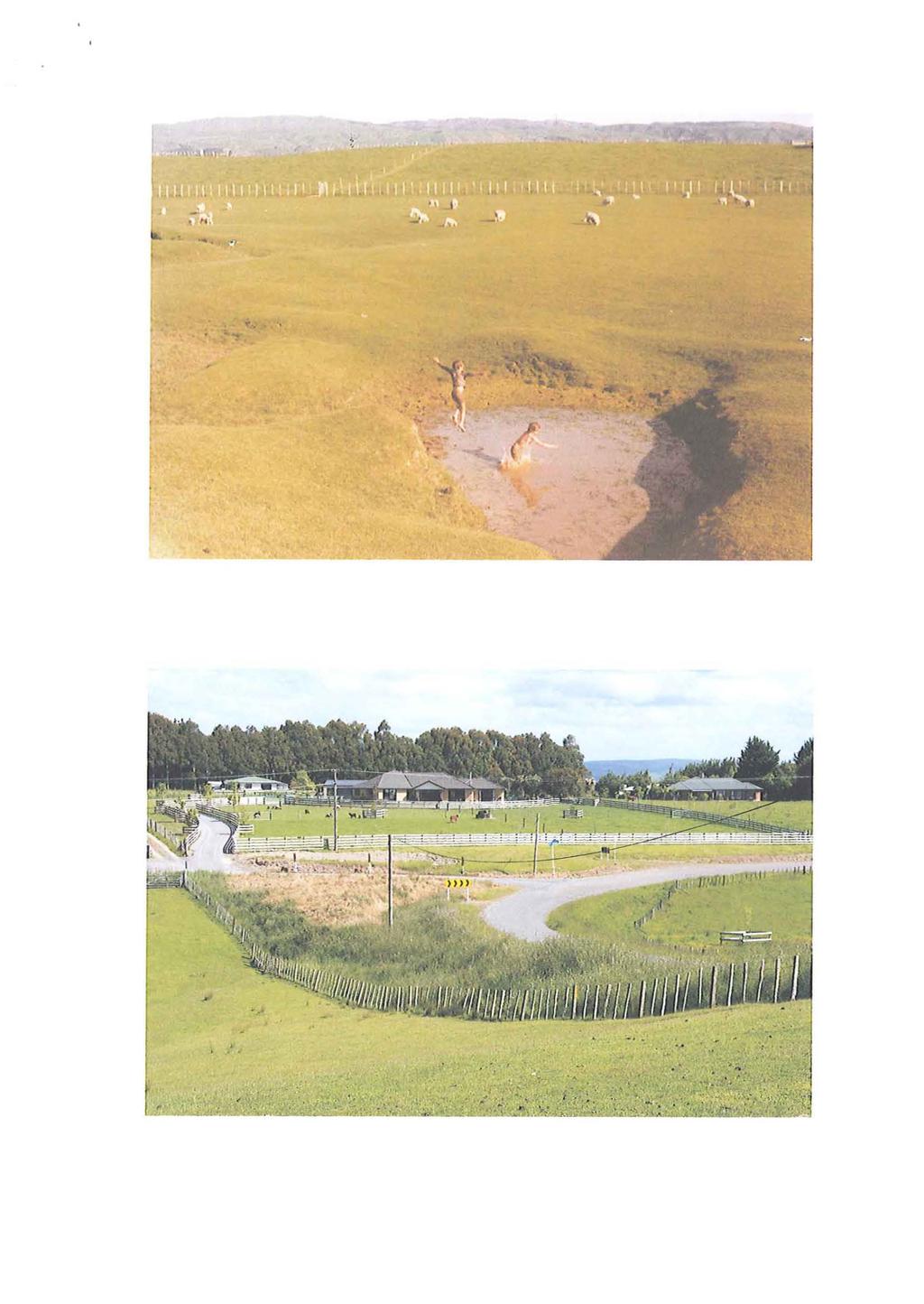
2 BACKGROUND JWS has owned the Whakarongo property for 37 years, taking over the farm in Over that time the nature of the area has changed from rural to rural residential. Our original 60 acre farm is now possibly the only remaining farm in the vicinity that is still intact from when the first settlers arrived. Over time it has become less and less of an economic unit. By JWS count since 1978 there have been an additional 20 new homes erected on Hendersons Line between Stoney Creek Road and Henaghans Road. The paper road on the farm purchased by JWS has now been converted into Hendersons Line extension from which a further 14 properties have been created, all but"one of which have been built on. Nearby to these properties has been the Glenburn development on which yet another 19 properties have been created. On Henaghans Road, from which we are accessed, a further 15 houses have been erected since our arrival. JWS has now recently received consent from Council to subdivide off five properties along the Hendersons Line extension road frontage. Properties have been sub-divided and re-subdivided over the years and neighbours have told JWS of their intentions to subdivide in the future as well. They have recognised the changing nature of the area. Land agents frequently include "subdivision potential" in their advertising when marketing the neighbourhood properties when they become available for sale. I am personally not aware of the Council declining consents for subdivisions applied for in the immediate vicinity. When our children started at the local school in 1980 there were approximately 95 pupils in attendance and the school was struggling to retain 3 teachers. The school now has 507 pupils and 22 permanent teachers (a total of 40 staff when counting all the support people). I am trying above to paint a picture here that what was basically a rural environment is now effectively a rural residential district despite the Council having zoned the area Rural in the past and in the proposed zoning under Plan Change 15A We were originally in that part of the Orua County Council which was subsequently absorbed into the Palmerston North City Council which implies, presumably, that the Council expect this area to be available for future extension of the city residential, commercial, or industrial areas. Plans and photos ofthe changing nature of the area attached. GEOGRAPHIC AND GEOLOGICAL CONSIDERATION The property is located on what could be described as a plateau above the Manawatu River floodplain. The soils are a heavy clay which get water logged in winter and set like concrete in summer. It is unsuitable for horticulture or for grazing with heavy livestock as they quickly pug the ground once the land is wet. Over the years of my experience on the property I have found the rearing and fattening of lambs to be the most effective use of the land.
3 The soils have been commented on adversely by all soil consultants used to support the various subdivision consents applications. Further to those reports is the latest submission to Council by their consultant Dr Craig Ross, a Soil Scientist, in his report 28 August 2015 which rated the soils on JWS property as Class 3 and Class 6 (Section 42A Report page 101 Appendix 2) i.e. low suitability or unsuitable for much farming activity. With the small size of the property and its use restricted by the poor quality soils the farm is now an uneconomic unit. EFFECTS OF SUBDIVISIONS ON FARMING DECISIONS With the changing positions taken by Council as to what will be the strategy for future use of the land in our vicinity it has been very difficult to utilise the farm to its maximum potential. The replacement of existing sub-standard fencing and the investment in further fencing, replacement of tired old pastures, application of fertilizers, repair and maintenance of existing drainage and further drainage all to maximise the productive capability of the poor grade soils has all been put on hold because of the uncertain future mid-term. After investing significantly in new farm sheds to replace sheds that existed beyond their economic lives Council approved a subdivision of a nearby 16 hectare block on Henaghans Road creating 12 new lifestyle blocks. Despite this subdivision being objected to by most locally affected landowners (including ourselves) Council proceeded to grant that consent. Council held that subdivision would not create a precedent but subsequent history has proved otherwise. The rural nature of the environment locally has now been irrecoverably changed with that and all the subsequent subdivisions that have been proceeded with. SECTION 42A REPORT - RURAL SUBDIVISION OCTOBER 2015 PROPOSED PLAN CHANGE 15A STATEMENT OF EVIDENCE BY JOHN ROBERT HUDSON John Robert Hudson, Landscape Architect, has commented in his report dated 08 October 2015 included in the Section 42A Report on 15A Rural Subdivision. Pg 116 Landscape Conclusion: From a landscape and visual effects perspective, this area is appropriate for inclusion in the Overlay. Mr Hudson has reported in Section 21 on page 110- "There are only a small number of requests which I considered appropriate to be added to the Overlay from a landscape perspective, as the Overlay stands. Generally speaking these are either in the areas where the inclusion of the properties would fit with existing patterns of development, and set up a logical progression of movement through increasing lot sizes from the urban to the rural areas; or they are on the edges of the Proposed Overlay and constitute a natural extension of the Overlay with minimal landscape effects."
4 In his report (page 136) he has commented further: Existing landscape character: Easy rolling pasture across terrace landscape above the Manawatu River escarpment. Vegetation in low wet areas through the pasture and associated with dwellings, particularly towards Palmerston North city. This area covers a range of lots from open farmland to the north/north-west, and scattered ruralresidential/rural lifestyle on variable lot sizes to the south-west, on the outskirts of the city. Hendersons Line and Henaghans Road currently form the visual boundary of that scattered variable development to the south/south-west, with land to the north/north-east of Henaghans Road being open farmland. A small area of subdivision of 1 ha lots exists in the northeast of this property, at Glenburn Road" Visual Effects ofaddition to the Overlay: Dwellings set more closely together than is the norm in this wider area. Dwellings could be fitted into the undulating topography and visual effects mitigated with planting, and subdivision on this lot would appear as congruous with the more intensively developed areas towards the city and in parts of the submission area. landscape Character Effects ofaddition to Overlay: loss of rural character to the north and north-west of Henaghans Road. Intensification of 1ha on this property would be incongruous with the existing pattern of development in the immediate vicinity northeast of Henaghans Road, which consists of a scattering of variable lot sizes, typically over 4ha, but not southwest towards the city. Long term residential development pressure may be an issue over this area as the city expands east, which would be made more difficult if smaller lots prevailed over this area. landscape Conclusion: From a landscape and visual effects perspective, this area is appropriate for inclusion in the Overlay. SECTION 42A REPORT PROPOSED PLAN CHANGE 1SA STATEMENT OF EVIDENCE BY DAVID RICHARD MURPHY 09 OCTOBER 201S RURAL SUBDIVISION OCTOBER 201S Below is the Council response on pages 34 and 35 to JWS submission dated 04 March location: Henaghans Road, Hendersons Line, Hazelhurst Line, Stoney Creek Road (excluding the Stoney Creek flood plain). Submission: Requests the area bounded by properties on the Henaghans Road, Hendersons Line, Hazelhurst Line, Stoney Creek Road (excluding the Stoney Creek flood plain) to be included in the Rural Residential Overlay because of inferior Class III soils, contiguousness with existing development of city and compatibility with intent of P15A. Technical Comment: Soils: Marton (Class 3) and Halcombe Hill (Class 6}.1 Landscape: From a landscape perspective and visual effects perspective, this area is appropriate for inclusion in the overlay.
5 Planning Comment: This is a large area of class 3 land. As noted by the submitter, there has been small a number of rural-residential subdivision proposals approved in this general location during the duration of the operative District Plan, despite the overlay not being applied to this area. While there are a number of 1ha rural-residential allotments to the north-east and southern edges of the block of land referred to in the submission, the large majority of the land is held in large lots typically 8 hectares in size. The south-western edge of this land is also effected by the air noise contours and a further submission in opposition was received from PNAL. While the landscape evidence is favourable for inclusion in the overlay, the land in this location was assessed as part of the most recent Residential Growth Strategy (the Hendesons Area). While it was not identified for future growth it remains a potential medium to long term option (outside of the air noise contours) should City West not advance. It is one ofthe few area to the north ofthe Manawatu River that is located in close proximity to the existing urban area that is not subject to class 1-2 soils, high liquefaction risk or flooding from the Manawatu River, Mangaone Stream or Taonui basin. Recommendation: Reject JWS COMMENTS ON COUNCIL RECOMMENDATION TO REJECT JWS SUBMISSION As explained earlier in this submission Council have approved many and incremental subdivisions into small lifestyle blocks since our arrival in by JWS count of Hendersons Line, Hendersons Line extension, and Henaghans Road a total of 54 blocks which excludes the 19 blocks on the nearby Glenburn subdivision. The soil types have been confirmed as inferior classes 3 and 6 unsuitable or low suitability for many farming activities. The north-east edge of the block of land referred to by Council as an area where there is a number of one hectare rural residential allotments is precisely the location of JWS property. Council comments that this land in this location was assessed potentially as part of the Residential Growth Strategy in the medium to long term. JWS attended a presentation by Mr Kobus Mentz on 14 September 2011 in the Council Chamber where he was explaining how appropriate land on the edges of urban areas could be subdivided and that those subdivisions and the location of buildings erected thereon could be planned in such a way that would allow further subsequent and incremental subdivisions plus the required infrastructure of roads, power, sewerage etc. Mr Mentz gave several examples where this incremental increase in density of land use had been successful in the past. The Council comments on the air noise contours. There exists many constructions within the various air noise contours at present within the urban area and within the rural and rural residential areas. JWS has read that with technical progress, present and future aircraft will require less runway for take-off and landing purposes. JWS believes aircraft are also quieter these days. Irrespective of the comments above, JWS property is well outside the existing air noise contours.
6 PLAN CHANGE 15 LEGAL REPORT COOPER RAPLEY SEPTEMBER 2015 Should the Council consider that this submission to Council be rejected because of existing restricting infrastructure JWS refers to the Agenda - Hearing by Commissioners paper pages 18 and 19 Policy 3-4: The Strategic integration of infrastructure with land use Territorial Authorities must proactively develop and implement appropriate land use strategies to manage urban growth, and they should align their infrastructure asset management planning with those strategies, to ensure the efficient and effective provision ofassociated infrastructure. Policy 3-5: Urban growth and rural residential subdivision on versatile soils In providing for urban growth (including implementing Policy 3-4), and controlling rural residential subdivision ("lifestyle blocks") Territorial Authorities must pay particular attention to the benefits of the retention of Class 1 and 11 versatile soils for use as production land in their assessment of how best to achieve sustainable management. JWS must emphasise here, that JWS makes this submission and the earlier submission of 04 March 2015 in relation to his particular property on the corner of Hendersons Line and Henaghans Road with its already high density of lifestyle blocks. JWS contends, however, consideration should also be given by Council for the longer term population growth over other area bounded by Henaghans Road, Hendersons Line and Kelvin Grove Road some of which has already been proposed to be zoned Rural Residential. SUBMITTED When JWS was obtaining consents for JWS application to Council for his recent subdivision creating five one hectare blocks, no neighbours commented adversely on the proposed development, in fact several ofthem stated they would also like to subdivide their properties. The mold for this area has been cast and has been for some time. Consultants reports supporting applications for subdivision consents have confirmed this for many years. John Hudson's Section 42 Report Summary of Conclusions refers to "John W Stephenson" 23 hectares - Area bounded by Henaghans Road and Hendersons Line; north side of Henaghans Road From a landscape and visual effects perspective, this area is appropriate for inclusion in the Overlay. This appears to refer specifically to JWS property, not the total area that Council appeared to consider with JWS submission of 04 March 2015 with - JWS 04 March 2015 submission. JWS submits to Council the above specific property should be rezoned Rural Residential. It appears JWS property and situation is not in a too dissimilar to that of submitter 90 Sandra K Hey, which submission Council sought fit to accept and rezone Rural Residential. When we arrived in 1978 JWS had three houses bordering JWS property. Now in 2015 there are 14. JWS has placed before this Hearing how Council can or should be able to mitigate the effects of rezoning this land as Rural Residential on subsequent future rezoning as Residential (refer Kobus Mentz presentation) and on infrastructure planning (if required) (refer Cooper Rapley Report).
7 To be consistent with; previous Council granting of consents for subdivision in the vicinity and the nearby Rural Residential existing and further nearby proposed Rural Residential zonings and because the remaining property to be held by JWS will be below the 20 ha threshold for Rural Zoning It is submitted that JWS property be included in the Rural Residential zone under Plan change 15A of the Palmerston North District Plan.

8 \ --< l <l,: ---= ~._---, i.. ::-=-_-:-..c::=- / ---_ " '.~
9 .~ "'-,-.. Y I,/
10
11 ~, ", -,.J, " -'
12
13 :
RURAL ZONE - POLICY. Rural Zone Policy. Issue: Rural Environment. Ruapehu District Plan Page 1 of 8
 Rural Zone Policy RU2 RURAL ZONE - POLICY RU2.1 Introduction The natural resources of the rural environment in the Ruapehu District provide the basis for the existing and potential character, intensity
4 RESIDENTIAL ZONE. 4.1 Background
 4 RESIDENTIAL ZONE 4.1 Background The residential areas within the City are characterised by mainly lowrise dwellings sited on individual allotments. Past architectural styles, settlement patterns and
Land Use Amendment in Southwood (Ward 11) at and Elbow Drive SW, LOC
 at and Elbow Drive SW, LOC") 2018 November 15 Page 1 of 10 EXECUTIVE SUMMARY This land use amendment application was submitted by Rick Balbi Architect on 2017 August 31 on behalf of Sable Developments Ltd, and with authorization from
2018 November 15 Page 1 of 10 EXECUTIVE SUMMARY This land use amendment application was submitted by Rick Balbi Architect on 2017 August 31 on behalf of Sable Developments Ltd, and with authorization from
QUEENSTOWN LAKES DISTRICT COUNCIL
 QUEENSTOWN LAKES DISTRICT COUNCIL Hearing of Submissions on the Proposed District Plan Report 16.9 Report and Recommendations of Independent Commissioners Regarding Upper Clutha Planning Maps Lake McKay
LAND USE AMENDMENT CORNERSTONE (WARD 3) 60 STREET NE AND COUNTRY HILLS BOULEVARD NE MAP 26NE BYLAW 22D2017
 60 STREET NE AND COUNTRY HILLS BOULEVARD NE MAP 26NE BYLAW 22D2017") Page 1 of 14 EXECUTIVE SUMMARY This Land Use Amendment application covers an area of 43.76 hectares ± (108.14 acres ±) located in northeast Calgary, bound by Country Hills Boulevard NE to the south and
Page 1 of 14 EXECUTIVE SUMMARY This Land Use Amendment application covers an area of 43.76 hectares ± (108.14 acres ±) located in northeast Calgary, bound by Country Hills Boulevard NE to the south and
SECTION 7A: WHAKARONGO RESIDENTIAL AREA
 SECTION 7A: WHAKARONGO RESIDENTIAL AREA CONTENTS 7A.1 Introduction 1 7A.2 Resource Management Issues 1 7A.3 Objectives and Policies 1 7A.4 Methods 4 7A.5 Residential Zone 4 7A.5.1 Rules: Controlled Activities
Site Option 3: Te Matai
 Site Option 3: Te Matai Location Napier Drain looking south east Description The Te Matai growth option is located between the existing residential boundary (Ruamahanga Crescent) Napier Road (State Highway
NORTH EAST INDUSTRIAL ZONE
 SECTION 12A: NORTH EAST INDUSTRIAL ZONE CONTENTS 12A.1 Introduction 1 12A.2 Resource Management Issues 2 12A.3 Objectives and Policies 3 12A.4 Rules: Permitted Activities 8 R12A.4.1 Permitted Activities
QUEENSTOWN LAKES DISTRICT COUNCIL
 QUEENSTOWN LAKES DISTRICT COUNCIL Hearing of Submissions on the Proposed District Plan Report 16.8 Report and Recommendations of Independent Commissioners Regarding Upper Clutha Planning Maps Church Road,
Guidance Notes Completing an AEE
 Guidance Notes Completing an AEE The purpose of this guidance note is to assist you with completing your Assessment of Environmental Effects (AEE) for your land-use consent application. If you do not provide
ADMINISTRATION RECOMMENDATION 2016 November 03. That Calgary Planning Commission recommends APPROVAL of the proposed Land Use Amendment.
 Page 1 of 12 EXECUTIVE SUMMARY This Land Use Amendment application covers an area of 75.76 hectares ± (187.20 acres ±) located in northeast Calgary, bound by Stoney Trail NE to the north, 128 Avenue NE
Proposed Plan Change 55: District Wide Rules. Hearing Report
 Proposed Plan Change 55: District Wide Rules Hearing Report Appendix 5 BEFORE THE HEARINGS PANEL In the Matter of: The Resource Management Act 1991 And Proposed Plan Change 55: Chapter 3 District Wide
LAND USE AMENDMENT CORNERSTONE (WARD 3) COUNTRY HILLS BOULEVARD AND STONEY TRAIL NE BYLAW 9D2017
 COUNTRY HILLS BOULEVARD AND STONEY TRAIL NE BYLAW 9D2017") Page 1 of 12 EXECUTIVE SUMMARY This Land Use Amendment application covers an area of 54.92 hectares ± (135.71 acres ±) located in northeast Calgary, bound by Country Hills Boulevard NE to the north and
Page 1 of 12 EXECUTIVE SUMMARY This Land Use Amendment application covers an area of 54.92 hectares ± (135.71 acres ±) located in northeast Calgary, bound by Country Hills Boulevard NE to the north and
SECTION ONE North East Industrial Zone Design Guide Palmerston North City Council June 2004
 SECTION ONE North East Industrial Zone Design Guide Palmerston North City Council June 2004 young heart easy living 1 Preface Industrial areas are a very important component of the economic well-being
SECTION 2.4 URBAN DEVELOPMENT AND STRATEGIC URBAN DIRECTIONS
 SECTION 2.4 URBAN DEVELOPMENT AND STRATEGIC URBAN DIRECTIONS 2.4.1 INTRODUCTION In 1993/94 the Hastings District Council completed the Hastings Urban Development Strategy. The purpose of this study was:
CITY VIEW OBJECTIVES
 SECTION 2: CITY VIEW OBJECTIVES CONTENTS 2.1 Introduction 1 2.2 Strategic Direction 1 2.3 The City View Resource Management Issues for the City 1 2.4 The Goal 3 2.5 The City View Objectives 3 Palmerston
INCREMENTAL CHANGE AREA REVIEW March 2015 Page 1
 INCREMENTAL CHANGE AREA REVIEW March 2015 Page 1 Table of Contents Introduction... 3 Background to Review... 3 Comparison of the Schedules to the General Residential Zone... 7 Methodology... 7 Policy Context...
Section 12C Subdivision in the Rural Residential Zone
 Section 12C 12C Subdivision in the Rural Residential Zone The Rural Residential Zone provides part of the range of residential opportunities within the City. Land zoned rural residential is considered
Rezoning. Rezone from A-1 to RH to create 9 suburban single family residential lots. Approval to Proceed
 City of Surrey PLANNING & DEVELOPMENT REPORT Rezoning Proposal: Rezone from A-1 to RH to create 9 suburban single family residential lots. Recommendation: Approval to Proceed Location: 18712 and Portion
Appendix 1 Structure plan guidelines
 Appendix 1 Structure plan guidelines This appendix forms part of the regional policy statement [rps]. 1.1. Introduction Structure plans are an important method for establishing the pattern of land use
ADMINISTRATION RECOMMENDATION(S) 2017 June 15. That Calgary Planning Commission recommends APPROVAL of the proposed Land Use Amendment.
 2017 June 15. That Calgary Planning Commission recommends APPROVAL of the proposed Land Use Amendment.") Page 1 of 7 EXECUTIVE SUMMARY The proposed land use amendment seeks to redesignate a Special Purpose Future Urban Development (S-FUD) District parcel in Residual Ward 3 Sub Area 3H to Industrial Outdoor
Page 1 of 7 EXECUTIVE SUMMARY The proposed land use amendment seeks to redesignate a Special Purpose Future Urban Development (S-FUD) District parcel in Residual Ward 3 Sub Area 3H to Industrial Outdoor
Statement of Community Involvement LAND OFF SOUTHDOWN ROAD HORNDEAN, HAMPSHIRE
 LAND OFF SOUTHDOWN ROAD HORNDEAN, HAMPSHIRE CONTENTS Page 1. Introduction 3 2. Pre-application Discussions 4 3. The Consultation Process 5 4. Consultation Feedback 7 5. Responses to Consultation Feedback
ONTARIO MUNICIPAL BOARD
 PL 120483 ONTARIO MUNICIPAL BOARD Applicant/Appellant: 2124123 Ontario Limited Subject: OPA, Rezoning and Draft Plan of Subdivision Municipal Address: 3940 Highway 7 East Municipality: City of Markham
QUEENSTOWN LAKES DISTRICT COUNCIL SUBDIVISION DESIGN GUIDELINES
 Attachment C: Draft QLDC Subdivision Design Guidelines QUEENSTOWN LAKES DISTRICT COUNCIL DESIGN GUIDELINES A DESIGN GUIDE FOR AND DEVELOPMENT IN THE URBAN ZONES QUEENSTOWN OFFICE 10 Gorge Road Queenstown
TO: Mayor & Council DATE: April 12, The Planning and Development Department and the Engineering Department recommend that Council:
 CORPORATE REPORT NO: R080 COUNCIL DATE: April 12, 2010 REGULAR COUNCIL TO: Mayor & Council DATE: April 12, 2010 FROM: SUBJECT: General Manager, Planning and Development General Manager, Engineering Neighbourhood
TIDAPA Structure Plan
 TIDAPA Structure Plan Prepared by Tract Consultants 28 MARCH 2017 0217-0074 Table of Contents 01 STRATEGIC CONTEXT Executive Summary Regional Context Page 3 Page 4 02 LOCAL CONTEXT Aerial Photograph Local
PUBLIC NOTICE UNDER CLAUSE 5 OF SCHEDULE 1 OF THE RESOURCE MANAGEMENT ACT 1991 PLAN CHANGE 12 TO THE OPERATIVE CITY OF NAPIER DISTRICT PLAN
 PUBLIC NOTICE UNDER CLAUSE 5 OF SCHEDULE 1 OF THE RESOURCE MANAGEMENT ACT 1991 PLAN CHANGE 12 TO THE OPERATIVE CITY OF NAPIER DISTRICT PLAN Public notice is given in accordance with Clause 5 of Schedule
NORTH BETHANY ELEMENTARY SCHOOL SITE ASSESSMENT
 NORTH BETHANY ELEMENTARY SCHOOL SITE ASSESSMENT Prepared for: Prepared by: October 10, 2014 Page 2 Introduction and Purpose This report provides an assessment of two potential sites for a new elementary
I615. Westgate Precinct
 I615. Westgate Precinct I615.1. Precinct Description The Westgate Precinct is located approximately 18km west of the Auckland city centre. There are seven Sub-precincts in the Westgate Precinct: Sub-precinct
Planning Proposal Toronto Road, Booragul. Amendment to Lake Macquarie Local Environmental Plan (LMLEP) 2014
 2014") Planning Proposal Toronto Road, Booragul Amendment to Lake Macquarie Local Environmental Plan (LMLEP) 2014 Local Government Area: Name of Draft LEP: Subject Land: Land Owner: Applicant: Folder Number:
Planning Proposal Toronto Road, Booragul Amendment to Lake Macquarie Local Environmental Plan (LMLEP) 2014 Local Government Area: Name of Draft LEP: Subject Land: Land Owner: Applicant: Folder Number:
Rural (Urban Expansion) Environment
 Environment") RUEE.1 Rural (Urban Expansion) Environment Subsequent to the receipt of appeals, a 'marked up' version of the Proposed District Plan was prepared. The provisions of the Proposed Version of the Plan subject
RUEE.1 Rural (Urban Expansion) Environment Subsequent to the receipt of appeals, a 'marked up' version of the Proposed District Plan was prepared. The provisions of the Proposed Version of the Plan subject
QUEENSTOWN LAKES DISTRICT COUNCIL Hearing of Submissions on the Proposed District Plan
 QUEENSTOWN LAKES DISTRICT COUNCIL Hearing of Submissions on the Proposed District Plan Report 16.4 Report and Recommendations of Independent Commissioners Regarding Upper Clutha Planning Maps Glen Dene
RLE.1 Rural Living Environment
 Index.1 Description and Expectations.2 Objectives.3 Policies.4 Guidance RLE.2 Landuse RLE.2.1 Eligibility Rules RLE.2.2 Notification Rules RLE.2.3 Discretionary Activities RLE.3 Subdivision RLE.3.1 Eligibility
Edward R. Sajecki Commissioner of Planning and Building. Land Use Review- Former Parkway Belt West Lands- Fieldgate Drive and Audubon Boulevard
 Corporate Report Clerk s Files Originator s Files CD.04.FOR DATE: November 15, 2011 TO: FROM: SUBJECT: Chair and Members of Planning and Development Committee Meeting Date: December 5, 2011 Edward R. Sajecki
Subdivision Design Criteria. Penihana North GUIDELINES TO THE RULES
 Created September 2013 Penihana North Subdivision Design Criteria GUIDELINES TO THE RULES This part of the Plan sets out the design criteria for subdivision in Penihana North. The criteria will be considered
I539. Smales 2 Precinct
 I539. Smales 2 Precinct I539.1. Precinct Description The Smales 2 Precinct applies to a 4.8 hectare block of land located on the southern side of Northcote Road and fronting Lake Pupuke, Takapuna. The
LAND USE AMENDMENT DOWNTOWN COMMERCIAL CORE (WARD 7) MACLEOD TRAIL SE AND 5 AVENUE SE BYLAW 254D2017
 MACLEOD TRAIL SE AND 5 AVENUE SE BYLAW 254D2017") Page 1 of 10 EXECUTIVE SUMMARY This Land Use Amendment application seeks to redesignate a full downtown block (currently the YWCA site) from a Direct Control based on the CM-2 District (Land Use Bylaw
Page 1 of 10 EXECUTIVE SUMMARY This Land Use Amendment application seeks to redesignate a full downtown block (currently the YWCA site) from a Direct Control based on the CM-2 District (Land Use Bylaw
I403 Beachlands 1 Precinct
 I403. Beachlands 1 I403.1. Precinct Description Beachlands is a rural and coastal village located on the eastern side of Auckland, adjoining the Tamaki Strait coastline. The original Beachlands village
Ground Floor Flat 15 Redbourne Avenue London N3 2BP
 Location Ground Floor Flat 15 Redbourne Avenue London N3 2BP Reference: 17/4160/FUL Received: 28th June 2017 Accepted: 29th June 2017 Ward: West Finchley Expiry 24th August 2017 Applicant: Proposal: Mr
Tāhuhu whakaruruhau ā-taone The sheltering ridge pole
 B2. Tāhuhu whakaruruhau ā-taone - Urban growth and form B2.1. Issues Tāhuhu whakaruruhau ā-taone The sheltering ridge pole Auckland s growing population increases demand for housing, employment, business,
FOR SALE RESIDENTIAL DEVELOPMENT OPPORTUNITY BLAIRTUMMOCK EASTERHOUSE
 FOR SALE RESIDENTIAL DEVELOPMENT OPPORTUNITY BLAIRTUMMOCK EASTERHOUSE RESIDENTIAL DEVELOPMENT SITE Land at Blairtummock, Easterhouse Residential Development Opportunity Site area of 5.71 hectares (14.11
WHERE DO WE GROW FROM HERE?
 WHERE DO WE GROW FROM HERE? Have your say. HAVE YOUR SAY ON THE NELSON TASMAN FUTURE DEVELOPMENT STRATEGY Nelson and Tasman are growing fast and we continue to need more houses for people to live in, places
Planning Proposal Concurrent DA/LEP Amendment for Belmont North Pharmacy Amendment No. 24 to Lake Macquarie Local Environmental Plan (LMLEP) 2014
 2014") Planning Proposal Concurrent DA/LEP Amendment for Belmont North Pharmacy Amendment No. 24 to Lake Macquarie Local Environmental Plan (LMLEP) 2014 Local Government Area: Name of Draft LEP: Subject Land:
Planning Proposal Concurrent DA/LEP Amendment for Belmont North Pharmacy Amendment No. 24 to Lake Macquarie Local Environmental Plan (LMLEP) 2014 Local Government Area: Name of Draft LEP: Subject Land:
AND STATEMENT OF EVIDENCE OF JOHN LONINK ON BEHALF OF CHRISTCHURCH CITY COUNCIL SPECIFIC PURPOSE (GOLF RESORT) ZONE
 ZONE") Page 1 of 13 BEFORE THE CHRISTCHURCH REPLACEMENT DISTRICT PLAN INDEPENDENT HEARINGS PANEL IN THE MATTER of the Resource Management Act 1991 and the Canterbury Earthquake (Christchurch Replacement District
Page 1 of 13 BEFORE THE CHRISTCHURCH REPLACEMENT DISTRICT PLAN INDEPENDENT HEARINGS PANEL IN THE MATTER of the Resource Management Act 1991 and the Canterbury Earthquake (Christchurch Replacement District
I209 Quay Park Precinct
 I209. Quay Park I209.1. Precinct description The Quay Park Precinct is located on reclaimed land at the eastern end of the city centre and along the City Centre waterfront. It is dissected to the east
Schedule of Planning Applications Committee Date: 23 May Reference: 06/17/0726/F Parish: Hemsby Officer: Mr J Beck Expiry Date:
 Schedule of Planning Applications Committee Date: 23 May 2018 Reference: 06/17/0726/F Parish: Hemsby Officer: Mr J Beck Expiry Date: 22-05-2018 Applicant: Proposal: Site: Mr Gillett Change of use to the
Neighbourhood Planning Site Assessment Pro-forma and Guide Version 2
 Neighbourhood Planning Site Assessment Pro-forma and Guide Version 2 September 2014 Site HNP 006 Land East of Stanbridge Road and North of Lower Road 1. Background information Site location and use Site
Derry City and Strabane District Council Planning Committee Report
 Derry City and Strabane District Council Planning Committee Report COMMITTEE DATE: 23 rd March 2016 APPLICATION No: APPLICATION TYPE: PROPOSAL: LOCATION: APPLICANT: LA11/2015/0395/F Residential Development
I609. Penihana North Precinct
 I609. Penihana North Precinct I609.1. Precinct description The Penihana North Precinct is located south of the Swanson Railway Station, adjacent to the Rural Urban Boundary (RUB) and Waitakere Ranges Heritage
LONGDEN VILLAGE DEVELOPMENT STATEMENT
 LONGDEN VILLAGE DEVELOPMENT STATEMENT 2017-2027 1 Longden Development Statement 2017-2027 15/01/18 1. Background 1.1 Longden Village Longden village is a very rural and traditional community first mentioned
S o u t h C e n t r a l O u t l i n e P l a n. Leduc Business Park. North Leduc Industrial Area Structure Plan C it y of Led u c.
 Leduc Business Park North Leduc Industrial Area Structure Plan C it y of Led u c Prepared for Farm Air Properties Inc. January, 2007 Table of Contents Page Number 1.0 Purpose of Plan and Definition of
Section 3b: Objectives and Policies Rural Environment Updated 19 November 2010
 Page 1 of Section 3b 3b RURAL ENVIRONMENT 3b.1 Introduction The Rural Environment comprises all the land outside of the Residential, Town Centre and Industrial Environments. Most land within the District
ADMINISTRATION RECOMMENDATION(S) 2017 February 09. That Calgary Planning Commission recommends APPROVAL of the proposed Land Use Amendment.
 2017 February 09. That Calgary Planning Commission recommends APPROVAL of the proposed Land Use Amendment.") Page 1 of 10 EXECUTIVE SUMMARY This land use amendment application is to accommodate changes to the location of a stormwater retention pond and land use boundaries adjacent to Environmental Reserve in
Page 1 of 10 EXECUTIVE SUMMARY This land use amendment application is to accommodate changes to the location of a stormwater retention pond and land use boundaries adjacent to Environmental Reserve in
Plan Modification to Chapter B2 of the Auckland Unitary Plan(AUP) Operative in part (15 November 2016)
 Operative in part (15 November 2016)") UNITARY PLAN UPDATE REQUEST MEMORANDUM TO FROM Phill Reid Linley Wilkinson DATE 25 September 2018 SUBJECT Plan Modification to Chapter B2 of the Auckland Unitary Plan(AUP) Operative in part (15 November
UNITARY PLAN UPDATE REQUEST MEMORANDUM TO FROM Phill Reid Linley Wilkinson DATE 25 September 2018 SUBJECT Plan Modification to Chapter B2 of the Auckland Unitary Plan(AUP) Operative in part (15 November
What progress have we made so far? NEWSLETTER PROPOSED IONA RESIDENTIAL DEVELOPMENT UPDATE
 MAY 2017 NEWSLETTER PROPOSED IONA RESIDENTIAL DEVELOPMENT UPDATE The Iona Working Group has been set up to encourage discussions between the parties involved in the Environment Court Process. This newsletter
I Te Koti Taiao o Aotearoa Ōtautahi Rohe ENV-2018-CHC- Appellant. Queenstown Lakes District Council. Respondent
 In the Environment Court of New Zealand Christchurch Registry I Te Koti Taiao o Aotearoa Ōtautahi Rohe ENV-2018-CHC- Under In the matter of Between the Resource Management Act 1991 (RMA) An appeal under
Outline Plan in Belvedere (Ward 9) at Street SE, LOC (OP)
 at Street SE, LOC (OP)") 2018 October 04 Page 1 of 12 EXECUTIVE SUMMARY This outline plan application was submitted by B&A Planning Group on 2016 July 15, on behalf of Tristar Communities Inc. for 50.14 hectares (123.89 acres)
2018 October 04 Page 1 of 12 EXECUTIVE SUMMARY This outline plan application was submitted by B&A Planning Group on 2016 July 15, on behalf of Tristar Communities Inc. for 50.14 hectares (123.89 acres)
Welcome. Land adjacent Sandy Lane WALTHAM CHASE THE PROPOSED SITE
 Land adjacent Sandy Lane WALTHAM CHASE Existing Linden Homes developments Welcome Welcome to Linden Homes Southern s ( Linden ) public exhibition about its proposals for a range of high-quality homes for
Rural (Urban Expansion) Environment
 Environment") RUEE.1 Rural (Urban Expansion) Environment Index RUEE.1 RUEE.1.1 RUEE.1.2 RUEE.1.3 RUEE.1.4 RUEE.2 RUEE.2.1 RUEE.2.2 RUEE.2.3 RUEE.2.4 RUEE.3 Rural (Urban Expansion) Environment Description and Expectations
RUEE.1 Rural (Urban Expansion) Environment Index RUEE.1 RUEE.1.1 RUEE.1.2 RUEE.1.3 RUEE.1.4 RUEE.2 RUEE.2.1 RUEE.2.2 RUEE.2.3 RUEE.2.4 RUEE.3 Rural (Urban Expansion) Environment Description and Expectations
PARISH / WARD: Peacehaven / Peacehaven East PROPOSAL:
 APPLICATION ITEM LW/16/0802 NUMBER: NUMBER: 7 APPLICANTS NAME(S): Mr J Robison & Ms S Teng PARISH / WARD: Peacehaven / Peacehaven East PROPOSAL: Planning Application for Conversion of existing garage to
CITY CLERK. Parkland Acquisition Strategic Directions Report (All Wards)
") CITY CLERK Clause embodied in Report No. 10 of the, as adopted by the Council of the City of Toronto at its meeting held on November 6, 7 and 8, 2001. 10 Parkland Acquisition Strategic Directions Report
CITY CLERK Clause embodied in Report No. 10 of the, as adopted by the Council of the City of Toronto at its meeting held on November 6, 7 and 8, 2001. 10 Parkland Acquisition Strategic Directions Report
TOWN OF BRUDERHEIM Report to the capital region board
 TOWN OF BRUDERHEIM Report to the capital region board Introduction to the Town of Bruderheim Municipal Development Plan amendment and Relation to the CRB Evaluation Criteria 02 march 2017 1 Introduction
I602. Birdwood Precinct
 I602. Birdwood Precinct I602.1. Precinct description The Birdwood Precinct applies to an area west of Don Buck Road and south of Red Hills Road in west Auckland. It incorporates subdivision and development
Neighbourhood Plan Representation
 Date: 10 th November 2017 Neighbourhood Plan Representation Land to the east of Callow Hill Road, Alvechurch Introduction This representation has been prepared by RPS Planning and Development on behalf
Local Area Key Issues Paper No. 11: Extractive industry - Yandina Creek and Browns Creek Road
 Draft Sunshine Coast Planning Scheme Review of Submissions Local Area Key Issues Paper No. 11: Extractive industry - Yandina Creek and Browns Creek Road Key Issue: No. of submissions: Sites identified
Harrow Lane, St Leonards-on-Sea, East Sussex, TN37 7JZ ERECTION OF 113 DWELLINGS TOGETHER WITH ESTATE ROADS (DETAILED SUBMISSION)
") AGENDA ITEM NO: Report to: PLANNING BOARD Date: 10 September, 2003 Report from: Borough Planning Officer Application Address: Proposal: Application No: Recommendation: Ward: File No: Applicant: Interest:
AGENDA ITEM NO: Report to: PLANNING BOARD Date: 10 September, 2003 Report from: Borough Planning Officer Application Address: Proposal: Application No: Recommendation: Ward: File No: Applicant: Interest:
WELLINGTON CITY DISTRICT PLAN
 Section 32 Report WELLINGTON CITY DISTRICT PLAN PROPOSED DISTRICT PLAN CHANGE 54 REZONING 178 AND 180 OWHIRO BAY PARADE 1 Introduction Before a Proposed District Plan change is publicly notified the Council
Derry City and Strabane District Council Planning Committee Report
 Derry City and Strabane District Council Planning Committee Report COMMITTEE DATE: 23rd March 2016 APPLICATION No: APPLICATION TYPE: PROPOSAL: LOCATION: APPLICANT: AGENT: LA11/2015/0263/O Outline Planning
Planning Commission Staff Report Project Plan Approval Hearing Date: June 14, 2017
 Planning Commission Staff Report Project Plan Approval Hearing Date: June 14, 2017 ITEM 3 Peter Matson requests Project Plan Approval for an 80-acre mixed-use plan that includes 220 residential units and
ROCHFORD LOCAL DEVELOPMENT FRAMEWORK: Sustainability Appraisal/ Strategic Environmental Assessment. Rochford Core Strategy Preferred Options Document
 ROCHFORD LOCAL DEVELOPMENT FRAMEWORK: Sustainability Appraisal/ Strategic Environmental Assessment Non Technical Summary Rochford Core Strategy Preferred Options Document October 2008 SUSTAINABILITY APPRAISAL
EVIDENCE OF CAREY VIVIAN (PLANNER) 13 JUNE 2018
 13 JUNE 2018") QUEENSTOWN-LAKES DISTRICT COUNCIL PROPOSED DISTRICT PLAN HEARING STREAM 14 IN THE MATTER of a hearing on submissions to the Proposed District Plan Stage 2 and Variation 1 pursuant to clause 8B of the First
QUEENSTOWN-LAKES DISTRICT COUNCIL PROPOSED DISTRICT PLAN HEARING STREAM 14 IN THE MATTER of a hearing on submissions to the Proposed District Plan Stage 2 and Variation 1 pursuant to clause 8B of the First
HOROWHENUA DEVELOPMENT PLAN June create a safe crossing for children moving to and from the school and other areas. 7.8 Ohau
 7.8 Ohau create a safe crossing for children moving to and from the school and other areas. Ohau has a traditional village form with a collective of school, church and reserve at the main road intersection.
DEVELOPMENT MANAGEMENT REPORT
 ITEM A08-1 DEVELOPMENT MANAGEMENT REPORT TO: BY: DATE: DEVELOPMENT: SITE: WARD: APPLICATION: APPLICANT: Development Management Committee Development Manager Proposed live/work unit in connection with existing
1. Assessment of Environmental Effects
 1. Assessment of Environmental Effects Table of Contents 1. Introduction and Overview 1 2. Statutory Assessment 3 3. Site Description 5 4. Proposal Description 7 5. Assessment of Effects on the Environment
DUNSFOLD NEIGHBOURHOOD PLAN Site Selection Policies
 DUNSFOLD NEIGHBOURHOOD PLAN Site Selection Policies The criteria for assessing sites for future housing and business development in Dunsfold are set out below. (Development criteria, covering what it is
St Michaels C of E Junior & Infant School, Nantmel Grove, Bartley Green, Birmingham, B32 3JS
 Committee Date: 06/03/2014 Application Number: 2013/08595/PA Accepted: 19/11/2013 Application Type: Full Planning Target Date: 14/01/2014 Ward: Bartley Green St Michaels C of E Junior & Infant School,
DRAFT FOR YOUR FEEDBACK DRAFT LOGAN RESERVE PLAN
 DRAFT FOR YOUR FEEDBACK CONTENTS INTRODUCTION... BACKGROUND... State Government... Council... PLANNING LEGISLATION AND RULES... CONSULTATION PROCESS...... ENVIRONMENT AND CONSERVATION... HOUSING... Proposed
4121 Lawrence Avenue East Rezoning Application Preliminary Report
 STAFF REPORT ACTION REQUIRED 4121 Lawrence Avenue East Rezoning Application Preliminary Report Date: October 11, 2011 To: From: Wards: Reference Number: Scarborough Community Council Director, Community
Lake Macquarie City. A copy of the published amendment including the instrument and maps, is provided in Attachment 7 of this report.
 Planning Proposal Amendment No. 77 to Lake Macquarie Local Environmental Plan 2004 and proposed Amendment to Draft Lake Macquarie Local Environmental Plan 2013 Minor Zone Boundary Adjustment - Pasminco
3.10 LAND USE SETTING PROJECT SITE EXISTING LAND USE DESIGNATIONS AND ZONING. General Plan Land Use Designations.
 This section of the Draft EIR addresses the existing land uses on and adjacent to the project site and discusses the potential impacts of the proposed project on existing land uses. Key issues addressed
Form to Submit Land for Residential Evidence Gathering Shepway Strategic Housing Land Availability Assessment (SHLAA) Partial Review
 Partial Review") Form to Submit Land for Residential Evidence Gathering Shepway Strategic Housing Land Availability Assessment (SHLAA) Partial Review All organisations and individuals who wish to put forward land for consideration
Form to Submit Land for Residential Evidence Gathering Shepway Strategic Housing Land Availability Assessment (SHLAA) Partial Review All organisations and individuals who wish to put forward land for consideration
BEFORE THE CHRISTCHURCH REPLACEMENT DISTRICT PLAN HEARINGS PANEL
 BEFORE THE CHRISTCHURCH REPLACEMENT DISTRICT PLAN HEARINGS PANEL IN THE MATTER of the Resource Management Act 1991 and the Canterbury Earthquake (Christchurch Replacement District Plan) Order 2014 AND
I611. Swanson North Precinct
 I611. Swanson North Precinct I611.1. Precinct Description Swanson North is located in the north eastern foothills of the Waitakere Ranges. It is outside the Waitakere Ranges Heritage Area Act and the Waitakere
Section 12B 12B Subdivision in Residential Zones
 Section 12B 12B Subdivision in Residential Zones The Residential Zones provide for a range of infill and greenfield living opportunities across the City for the community to accommodate current and future
Variation No 1: Dundalk & Environs Development Plan Core Strategy
 Variation No 1: Dundalk & Environs Development Plan 2009-2015 Core Strategy Adopted on 29 th August 2011 CONTENTS Page Section 1 1.0 Synopsis 1 1.1 Background Document 1 1.2 Variation of Dundalk and Environs
DECISION OF THE QUEENSTOWN LAKES DISTRICT COUNCIL RESOURCE MANAGEMENT ACT 1991
 DECISION OF THE QUEENSTOWN LAKES DISTRICT COUNCIL RESOURCE MANAGEMENT ACT 1991 Applicant: RM reference: Location: Proposal: Flax Trust (Mr F van Brandenburg) RM150185 Birchwood Road Wakatipu Basin Application
PLANNING COMMITTEE REPORT
 PLANNING COMMITTEE REPORT TO: BY: Planning Committee South Head of Development DATE: 19 December 2017 DEVELOPMENT: SITE: WARD: APPLICATION: APPLICANT: Conversion of existing water storage reservoir to
9 CITY OF VAUGHAN OFFICIAL PLAN AMENDMENT NO BOCA EAST INVESTMENTS LIMITED
 9 CITY OF VAUGHAN OFFICIAL PLAN AMENDMENT NO. 631 - BOCA EAST INVESTMENTS LIMITED The Planning and Economic Development Committee recommends the adoption of the recommendations contained in the following
POLICY AMENDMENT AND LAND USE AMENDMENT TUXEDO PARK (WARD 9) CENTRE STREET N AND 26 AVENUE NE BYLAWS 36P2017 AND 234D2017
 CENTRE STREET N AND 26 AVENUE NE BYLAWS 36P2017 AND 234D2017") Page 1 of 11 EXECUTIVE SUMMARY This application proposes to redesignate a single parcel of land in the Community of Tuxedo Park from Commercial Corridor 2 (C-COR2 f1h10) District to Mixed Use Active Frontage
Page 1 of 11 EXECUTIVE SUMMARY This application proposes to redesignate a single parcel of land in the Community of Tuxedo Park from Commercial Corridor 2 (C-COR2 f1h10) District to Mixed Use Active Frontage
2.0 AREA PLANS. Lakeside Business District. Lakeside Business District Land Use Categories:
 Lakeside Business District Lakeside Business District Land Use Categories: Campus Commercial Campus Commercial means a mixture of uses which includes corporate offices, office parks, hotels, commercial,
DINBVfZGH THE CITY OF EDINBURGH COUNCIL
 DINBVfZGH THE CITY OF EDINBURGH COUNCIL Item 6 Development Management Sub-Committee 24 November 2010 Report by the Head of Planning by Scottish Water for Residential Development at Land at 55 Buckstone
3 Abbey View Mill Hill London NW7 4PB
 Location 3 Abbey View Mill Hill London NW7 4PB Reference: 15/03203/HSE Received: 26th May 2015 Accepted: 16th June 2015 Ward: Mill Hill Expiry 11th August 2015 Applicant: Proposal: Mr Richard Benson Alterations
I511. Hatfields Precinct
 I511. Hatfields Precinct I511.1. Precinct Description The Hatfields Precinct is a contiguous 183.8 hectare block of rural land held in 8 freehold titles, located immediately to the north of Hatfields Beach.
Request for Statement of Interest in Implementation of the Roosevelt Road Redevelopment Plan
 425 Hillside Avenue Request for Statement of Interest in Implementation of the Roosevelt Road Redevelopment Plan I. INTRODUCTION The is seeking the services of a qualified consulting firm to prepare plans
King s College Proposed Private Plan Change 41 Golf Avenue, Otahuhu URBAN DESIGN ASSESSMENT
 King s College Proposed Private Plan Change 41 Golf Avenue, Otahuhu URBAN DESIGN ASSESSMENT CONTENTS 1.0 EXCECUTIVE SUMMARY... 1 2.0 INTRODUCTION... 2 2.1 Purpose of document... 2 2.2 Report structure...
Tennis Court Rear Of 3-5 Corringway London NW11 7ED
 Location Tennis Court Rear Of 3-5 Corringway London NW11 7ED Reference: 18/4122/FUL Received: 3rd July 2018 Accepted: 3rd July 2018 Ward: Garden Suburb Expiry 28th August 2018 Applicant: Ms Sarah Robinson
Derry City and Strabane District Council Planning Committee Report. Amended layout from approval A/2004/0462/F with reduction from 166 units
 Derry City and Strabane District Council Planning Committee Report COMMITTEE DATE: 1 st February 2017 APPLICATION No: APPLICATION TYPE: PROPOSAL: LOCATION: APPLICANT: AGENT: Full Planning application Amended
Hearing Topic: 058 Public Open Space. Primary Evidence: from Andrea Broughton
 Submitter: Andrea & Alex Broughton Submission Number: 5650-1 Hearing Topic: 058 Public Open Space Primary Evidence: from Andrea Broughton Date: 10 June 2015 1. Introduction My name is Andrea Broughton
BREEDON NORTHERN LIMITED
 Non Technical Summary CONTENTS 1 INTRODUCTION... 1 2 SITE DESCRIPTION... 1 3 DESCRIPTION OF THE DEVELOPMENT... 6 4 NEED FOR THE DEVELOPMENT... 8 5 KEY ISSUES CONSIDERED IN THE ENVIRONMENTAL IMPACT ASSESSMENT...
Exhibit A. 8:9 Scuffletown Rural Conservation District
 Exhibit A 8:9 Scuffletown Rural Conservation District 8:9.1 Intent and Purpose The Scuffletown Rural Conservation (SRC) District is intended to provide for residential development that supports the development