SUPPLEMENTARY GUIDANCE: HOUSING DEVELOPMENT IN THE COUNTRYSIDE AND GREEN BELT
|
|
|
- Rachel Wright
- 5 years ago
- Views:
Transcription

.")
1 PLANNING COMMITTEE TUESDAY 9 OCTOBER 2018 ITEM NO 5.2 SUPPLEMENTARY GUIDANCE: HOUSING DEVELOPMENT IN THE COUNTRYSIDE AND GREEN BELT Report by Head of Communities and Economy 1 PURPOSE OF REPORT 1.1 This report seeks the Committee s agreement to undertake a formal consultation on its proposed Development in the Countryside and Green Belt supplementary guidance which sets out the Council s position with regard residential development in rural locations. 2 BACKGROUND 2.1 At its meeting of 7 November 2017 the Council adopted the Midlothian Local Development Plan 2017 (MLDP). The MLDP included a commitment to prepare Supplementary Guidance and Planning Guidance on a number of topic areas (Section 7.2, pages 81 and 82 of the MLDP). Additional guidance is required to provide further detail and interpretation of the policies and strategy set out in its development plan. One of the topic areas which needs further clarification is with regard development in the countryside and green belt. 2.2 Draft Supplementary Guidance has to be published to enable interested parties to make comment and for any representations received to be considered prior to finalisation of the guidance. Supplementary Guidance is subject to screening for a Strategic Environmental Assessment (SEA) and Habitats Regulations Appraisal (HRA). Furthermore, the local planning authority must also notify Scottish Ministers of its intention to adopted Supplementary Guidance, who have the opportunity to intervene in its drafting and adoption. Once adopted Supplementary Guidance forms part of the development plan and is given statutory weight. Supplementary Guidance is expected on core topics which are integral to the Council spatial strategy. Supplementary Guidance will be a significant policy consideration in the assessment of planning applications. 2.3 Non-statutory Planning Guidance does not require prior publication, consultation or notification to Scottish Ministers. Planning Guidance will be a material consideration in the assessment of planning applications but does not form part of the development plan.
2 3 DEVELOPMENT IN THE COUNTRYSIDE AND GREEN BELT SUPPLEMENTARY GUIDANCE 3.1 The MLDP sets out those developments which are acceptable in the countryside and the green belt (policies RD1: Development in the Countryside and ENV1: Protection of the Green Belt). These policies state that housing will only be permitted where it is required for the furtherance of an established countryside activity. This is a longstanding national policy position that has been set out in detail in successive local plans with the aim of preventing unsustainable development in rural areas whilst supporting the rural economy. 3.2 Exceptions to the general policy position were introduced into the now superseded Midlothian Local Plan 2008, including the provision for additional residential units to be built in the vicinity of existing housing groups, redevelopment for residential purposes of redundant nonresidential buildings and the conversion of steadings into residential accommodation. These changes were made in light of updated guidance from the Scottish Government which seeks to provide for growing communities and new employment opportunities in rural areas. Provision for these residential exceptions are retained in the MLDP, though the detailed policy interpretation is subject to Supplementary Guidance. 3.3 The draft Supplementary Guidance is appended to this report, which includes: details of what constitutes a housing group under policy RD1; guidance on identifying the most appropriate location for new dwellings at existing housing groups; guidance on when non-residential buildings can be redeveloped and the appropriate scale and design for replacement development; and details on what constitutes an acceptable steading conversion. 3.4 The draft guidance will be made publically available on the Council s website for a period of at least four weeks. The Community Councils, the Scottish Environment Protection Agency (SEPA), Scottish Water, the Forestry Commission and Scottish Natural Heritage will be notified and invited to make comment. In addition, bodies with a specialist interest or persons/groups who made representations to the development in the countryside and green belt policies in the plan, will also be notified.
3 4 RECOMMENDATION 4.1 The Committee is recommended to: a) approve the draft Development in the Countryside and Green Belt Supplementary Guidance for consultation; b) instruct officers to screen the draft guidance for a Strategic Environmental Assessment (SEA) and Habitats Regulations Appraisal (HRA); and c) consider a further report on the Development in the Countryside and Green Belt Supplementary Guidance following the proposed consultation. Ian Johnson Head of Communities and Economy Date: 2 October 2018 Contact Person: Fraser James, Planning Officer Fraser.james@midlothian.gov.uk Tel No: Background Papers: MLDP 2017 adopted 7 November 2017 and Appendix 1: draft Supplementary Guidance for Development in the Countryside and Green Belt
4 Midlothian Local Development Plan Housing Development in the Countryside and Green Belt Supplementary Guidance
5
6 Contents 1. Introduction 2. Development in Rural Areas 3. Countryside and Green Belt in Midlothian 4. General Development Requirements 5. Housing - Development Required to Support an Established Countryside Activity 6. Housing - Development in Housing Groups 7. Conversions of redundant farm buildings or other non-residential buildings 8. Redevelopment of redundant farm buildings or other non-residential buildings 9. Enabling Development 10. Appendix 1: LDP Policies
7 2 1. Introduction 1.1 This Supplementary Guidance relates principally to policies RD1 Development in the Countryside of the Midlothian Local Development Plan 2017 but also ENV1 Protection of the Green Belt. It seeks to provide additional guidance and clarity regarding the circumstances in which exceptions may be made to the requirement to demonstrate that the proposed housing is for the furtherance of a countryside activity, including: the circumstances when/where new housing may be appropriate within the context of housing groups; when the conversion of redundant farm buildings or other non-residential buildings to houses would be acceptable; when/where redevelopment of farm buildings or other non-residential buildings would be acceptable; and enabling development. Policy RD1 includes reference to business development in the countryside but this issue is not subject of this guidance. 1.2 When considering proposals, prospective applicants should be aware that all policies in the Local Development Plan will apply to any proposal. While policies RD1 or ENV1 are likely to be the most significant factor in determining applications in the countryside, this alone does not guarantee compliance with the plan as a whole. Consideration of proposals for development covered by these policies should also refer to policies RD2 Low Density Rural Housing, MIN1 Areas of Search for Mineral Extraction, NRG1 Renewable and Low Carbon Energy Projects, and NRG2 Wind Energy, where these are applicable. In addition consideration and acknowledgement should be given to existing and emerging supplementary and planning guidance on relevant topics such as Green Networks, Low Density Rural Housing, Quality of Place etc. 2. Development in Rural Areas 2.1 Generally planning policy has historically sought to restrict unnecessary development in countryside locations, principally to prevent sporadic and unsustainable growth and to maximise use of infrastructure,resources and services more commonly available in established urban areas. While this principle is still relevant today, the countryside is a workplace for some, a playground for others and a vital ecosystem for all. 2.2 Government policy supports rural development that supports prosperous and sustainable communities and business whilst protecting and enhancing environmental quality. It also promotes responsible access and the right to roam. However as a place to live and work there are challenges to address and overcome in respect of the the climate change agenda and the Government's sustainability policies, particularly given the development pressures resulting from Midlothian's close proximity to Edinburgh. 2.3 The Council's planning policies seek to provide a balance between development and protecting the essential characteristics of the countryside. It seeks to do this by minimising the adverse affects on the character of the countryside while maximising the benefits to its communities and the Midlothian economy.
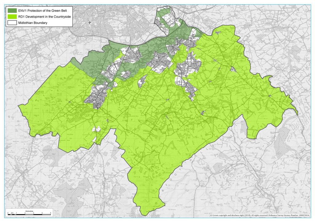
8 3 3. Countryside and Green Belt in Midlothian 3.1 For the purposes of this guidance, the countryside is defined as land out with defined settlement boundaries, which can be seen in the image below. Approximately 9.5% of Midlothian is covered by the Green Belt and a further 80% is covered by the countryside policy.
9 4
10 5 3.2 Midlothian is located in close proximity to Edinburgh with the A720 City bypass forming the majority of the northern boundary. This creates development pressure for housing developments of all types, including in the countryside. As a consequence of this location, Midlothian's larger settlements are located close to the City Bypass and alongside the main north-south transport routes through Midlothian, particularly the A7 and A701. This has resulted in a concentration of urban development at the northern edge of the county with concerns frequently raised about the loss of countryside, the increase in coalescence between settlements and the consequential loss of identity for communities. As a result, the countryside in this area is covered by the Green Belt policy. Green Belt is a long established planning policy tool to protect the setting of urban areas, prevent urban sprawl and manage and protect agricultural, forestry and recreational uses and discourage inappropriate development. 3.3 The wider landscape of Midlothian consists of the Pentland Hills in the west, the Moorfoot Hills in the south with the Tranent-Mayfield ridge in the east. This bowl shape was the result of a concentration of ice which melted approximately 20,000 years ago with a torrent of melt water carving out the river valleys of the North and South Esk. The ground elevation of Midlothian is slightly higher than Edinburgh to the north due to a rebound in the earth's crust. 3.4 The character of the agricultural land in the north of the county is generally flat and lower lying, which contains the majority of Midlothian's Prime Agricultural Land. The land rises gently southwards away from the coast where a more undulating landscape is common, resulting in a large number of protected Special Landscape Areas. There are a wide variety of landscapes in this area with moorlands and natural uplands towards the Moorfoot Hills at the southern boundary and dramatic incised valleys around the North and South Esk. 3.5 Throughout Midlothian there are large areas of countryside owned by landed estates centred on historic castles and country houses which have played a crucial role in the shaping of Midlothian's human landscape and are an important link to our past. The gardens and parkland in the vicinity of these have often been carefully designed to provide an attractive setting, with many identified in the Inventory of Historic Gardens and Designed Landscapes for their aesthetic, historical, scenic and/or nature conservation value. 3.6 The wider human landscape has been shaped by past and present developments in agriculture. Throughout Midlothian there are many groups of historic sandstone agricultural buildings, with the most common layouts being steadings with associated housing such as stand alone farmhouses (often 2-storey) and terraced farm cottages (often single or one and a half storey). 3.7 There are large river valleys centred on the North and South Esk rivers in the west and centre of the county and the Tyne to the east. As the geography of these areas have been untouched by agriculture in many places, these form important wildlife corridors and well as distinctive features in the landscape.
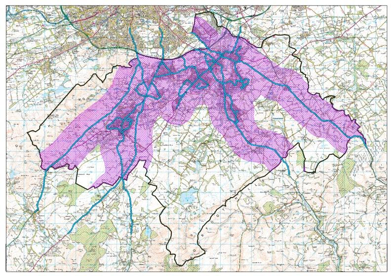
11 6 4. General Development Requirements 4.1 All development in the countryside is required to be of a scale and character that is appropriate to the rural landscape, be capable of being serviced with an adequate and appropriate access, be capable of being provided with drainage and public water supply and be accessible by public transport. These requirements are a necessary pre-requisite for any development to be considered acceptable, irrespective of whether the proposal would otherwise be supported by LDP policy. 4.2 With respect to the public transport requirement, all development has to be either within 1 mile (1600m) of services (such as shops or schools) or to a bus service of at least 1 per hour. The map below shows the bus routes in Midlothian at the time of writing and the areas that are within 1 mile of them.
12 7
13 8 4.3 It will be the responsibility of the applicant to demonstrate compliance with the policy and the necessary standards. Policies RD1 and ENV2 are reproduced in Appendix Housing - Development Required to Support an Established Countryside Activity 5.1 Both policies permit development which is required for the furtherance of an established countryside activity. The onus is on the applicant to demonstrate compliance with the relevant policies to the satisfaction of the Council. 5.2 In demonstrating the need for a permanent dwelling, the Council will expect an application to be accompanied by an independent report prepared by a suitably qualified professional to support the need for a house and on the viability of the associated business and its operational requirements. In outlining the needs of the business, it should be apparent to the Council whether the need can be met within an existing settlement and whether the occupier will be employed full-time in the associated countryside activity, and therefore whether it meets the other requirements of the policy. The most common reasons for such houses are typically the need for an onsite presence for security and animal husbandry. 6. Housing - Development in Housing Groups 6.1 Policy RD1 allows for the development of a house where there is a group of 5 existing dwellinghouses. This aspect of the countryside policy sets out a flexible approach to ensure that there are appropriate opportunities for small-scale infill within housing groups. The aim is to allow for development in the countryside of a scale and at locations which maintain the essential character of the countryside. Groups that are applicable 6.2 The policy does not apply to housing groups of less than five housing units. Neither does it apply where an existing planning permission for one or more dwellings, if implemented, brings the number of dwellings up to five during the Local Development Plan period. Only houses that are complete by the Local Development Plan adoption date (7 November 2017) will be considered in determining the size of the group. Groups within the Green Belt are covered by policy ENV1 of the LDP, which does not make provision for development at housing groups, therefore proposals in such locations will not be considered in accordance with the plan. Dwellings located within the built-up area as defined by policy DEV2 of the LDP will not be considered as constituting part of a group.
14 9 6.3 The cohesiveness of the group will be considered in determining the appropriateness of any proposed development. The proximity of the buildings which constitute a group should, as a rule of thumb, be no more than twice the width of the curtilage of the existing units. Units should generally have intervisibility with one another for them to be considered as part of the same cohesive group, therefore local topographical features will be important. 6.4 The planning system seeks to direct development to areas where there is good access to public transport and/or local services. This is more difficult to achieve in the countryside as the public transport and services available are typically not of a frequency which would normally accommodate new development, leading to a concern relating to sustainability and reducing the need for car based travel. Policy RD1 states that any development will need to be accessible to public transport or local services within 1600m (1 mile). Identifying appropriate plots for development 6.5 Upon receipt of a proposal, the council will assess the suitability for growth within the group in question in line the criteria outlined. Account will be taken of the form, character and cohesiveness of the group as well as the level of containment provided by existing features, such as natural and manmade boundaries. 6.6 Any new unit within a housing group must be of a location, scale and character that is in keeping with that of the existing group. More significant proposals beyond infill development, with wider implications for landscape impact or servicing should be promoted through the Local Development Plan. 6.7 With regards to the location of new development, the preference of the Council will generally be for new units to be located within any gaps in the group. Where there are no gaps, consideration will be given to locations adjoining the existing group, particularly where there is a site that adjoins the group on two sides or where there are existing physical or visually remote from the host group will not be acceptable.
15 10 Guidance on Acceptable Plots 1. Gap sites within the group will generally take precedence over other locations (typically these are sites with built development on either side); 2. Where no gap sites are present, sites adjoining the group are preferable. Normally, a site will be preferred if at least two sides adjoin the boundaries of existing properties though, in some cases, a site which adjoins the boundary of only one property may be preferable if it relates better visually to the group. All proposals which adjoin a group (as opposed to gap sites) should meet the following requirements: there is an existing physical or visual feature which provides containment for the group and therefore reduces pressure for ribbon development or rural sprawl; where such a feature does not exist, there should be potential for such a feature to be provided so long as it is in character with the scale and appearance of the group; 3. Proposals located in open fields adjoining a group, which have no physical features to provide containment will not be acceptable; 4. Proposals located on the opposite side of physical features which form strong boundaries for a group (e.g. main roads, burns, substantial tree belts, etc) will not be acceptable. 6.8 The design of any proposed dwelling will be an important consideration in determining the acceptability of a proposal. Development must be small-scale and respect the character, cohesiveness and amenity of the group being extended. For example, proposals should not be suburban in character when they relate to the expansion of a group whose character and design is of a rural vernacular nature. Proposals should be avoided where they represent ribbon or linear development along a public road. Furthermore, proposals will not be acceptable where it results in coalescence with another group or settlement. More detail on acceptable design can be found in the Quality of Place Supplementary Guidance.
16 11 Question 1 Does the draft guidance set appropriate parameters for identifying housing groups? Question 2 Does the draft guidance set appropriate parameters for identifying acceptable plots within housing groups? 7. Conversions of redundant farm buildings or other non-residential buildings 7.1 Policies RD1 and ENV1 gives policy support for the conversion of redundant farm steadings and other non-residential buildings in the countryside. The aim is to ensure that buildings that contribute to the character of the countryside, such as those of traditional or historic design, are retained and where possible alternative uses found. 7.2 Before such developments can be considered, it must be justified and demonstrated that the buildings in question are fully redundant. The Planning Authority will not support the conversion of such buildings where these are still in use or where their loss may result in the requirement for a replacement building elsewhere. 7.3 Where buildings are capable of renovation and conversion and are examples of traditional, architectural or historic interest their demolition and redevelopment will be resisted. Resulting buildings must make a significant and positive contribution to the landscape and its retention beneficial to the surroundings.
17 12 Will converting a non-residential building be acceptable? The conversion of the building may be acceptable, provided that both of the following are not applicable: The building still in use; and The loss of the building would result in a requirement for a building elsewhere, unless it is demonstrated that the existing building is no longer suitable for the use that is being displaced. Both of the following must be applicable for a conversion to be deemed acceptable: The building capable of renovation and conversion without substantial alteration or extension to the original fabric; and The building represents an example of traditional, architectural or historic interest OR the building makes a significant positive contribution to the character and appearance of the landscape 7.4 The acceptability or a proposed steading conversion will largely depend upon the design elements used. The building which is proposed for conversion should be of a scale which will allow for the conversion without the need for significant extension to the building. Where the building has existing openings, these should be retained in designing the conversion in order to retain its character. Acceptable conversions should not alter the original fabric of the building to a significant degree. More detail on acceptable design can be found in the Quality of Place Supplementary Guidance.
18 13 Question 3 Does the draft guidance set appropriate parameters for identifying those non-residential buildings where conversion will be encouraged? Question 4 Are the requirements set for proposed conversions appropriate? 8. Redevelopment of redundant farm buildings or other non-residential buildings 8.1 Where a redundant farm building or other non-residential building in the countryside is judged not to be an example of traditional, architectural or historic interest, their demolition and redevelopment may be appropriate. The aim is to allow for the removal of buildings, which may be an eyesore, and their replacement with development of a higher design quality, resulting in a net environmental benefit. 8.2 As mentioned above, before such developments can be considered, it must be justified and demonstrated that the buildings in question are fully redundant. The aim is to ensure that new development preserves and enhances the appearance and character of the countryside, therefore should such a building be demolished prior to receipt of a planning application and assessment by the Council, it is unlikely that new development will be supported except unless it is required for an established countryside use as outlined in policy RD1. Redevelopment of redundant buildings will not be consented in the Green Belt and such proposals are not supported by policy ENV1.
19 14 Will redeveloping a non-residential building be acceptable? The redevelopment of the building may be acceptable, provided that the following are applicable: The building is no longer in use; The loss of the building would not result in a requirement for a building elsewhere, unless it is demonstrated that the existing building is no longer suitable for the use that is being displaced; and The building does not represent an example of traditional, architectural or historic interest or make a significant positive contribution to the character and appearance of the landscape 8.3 For a proposal for redevelopment to be deemed successful, it must result in a development which respects and enhances the character and appearance of the countryside. Furthermore, the scale of development should not extend significantly beyond the footprint of the original building, unless there are significant design reasons for doing so. More detail on acceptable design can be found in the Quality of Place Supplementary Guidance.
20 15 Question 5 Does the draft guidance set appropriate parameters for identifying those non-residential buildings where redevelopment would be permitted? Question 6 Are the requirements for the development replacing the non-residential building appropriate? 9. Enabling Development 9.1 There are a number of large rural non-residential buildings of value to the local landscape and whose current use has or may become redundant. In the interest of retaining such buildings, the Council will consider enabling development as an option. Where a building is listed, reference should be made to policy ENV22 of the MLDP. 9.2 Where such enabling development is proposed, it is the responsibility of the applicant/developer to bring to the attention of the Council any issue that they consider relevant. The Council will need to be convinced of the following in determining such a proposal.
21 16 Will enabling development be acceptable? The provision of new development to financially assist in the preservation of a redundant building may be acceptable, provided that the following are applicable: It is demonstrated that the quality of the building and/or it's contribution to the character or appearance of the rural landscape is of considerable significance; The building is not located in the Green Belt; The proposed enabling development is located in the vicinity of the building whose restoration it is proposed to enable; It is demonstrated that such development is the only means of retaining the building and other options of funding have been exhausted. It is demonstrated that the scale of the proposed development represents the minimum necessary to enable the building's conservation and reuse; The resulting development is of a high quality design that respects the building and its setting. 9.3 In considering matters relating to the financial viability of alternative options and the minimum necessary scale of new development needed to retain a building, the Council reserves the right to base its decision on satisfactory evidence to that effect through an open book process. Question 7 Does the draft guidance establish an acceptable approach to the retention of buildings of value? Question 8 What alternative options would you suggest to secure the retention of buildings of value?
22 Appendix 1: LDP Policies
23 18 Policy RD 1 Development in the Countryside Development in the countryside will only be permitted if: A. it is required for the furtherance of agriculture (including farm-related diversification), horticulture, forestry, countryside recreation or tourism; or B. it accords with policies RD2, MIN1, NRG1 or NRG2; or C. it accords with the Council's Supplementary Guidance on Development in the Countryside and Green Belt. All such development will need to be: Housing a. of a scale and character appropriate to the rural area and well integrated into the rural landscape; and b. capable of being serviced with an adequate and appropriate access; and c. capable of being provided with drainage and a public water supply at reasonable cost, or an acceptable private water supply. Development must protect and where appropriate improve the water environment, avoiding unacceptable and unnecessary surface and foul water discharges to watercourses; and d. accessible by public transport and services (where appropriate), either within 1,600 metres (1 mile) of a settlement or a bus route with a frequency of at least 1 bus per hour. Normally, housing will only be permissible where it is required for the furtherance of an established countryside activity (see criterion A above). The applicant will be required to show the need for the new dwelling is permanent; cannot be met within an existing settlement; and that the occupier will be employed full-time in the associated countryside activity. Proposals to replace an existing dwelling may be permissible where it can be demonstrated that it is incapable of renovation or improvement; that the proposal relates to a complete dwelling (i.e. not the plot of a previous, now demolished house); and provided that the replacement is of a similar scale.
24 19 The following circumstances are exceptions to the above requirement to demonstrate that the housing is for the furtherance of a countryside activity. The details of these exceptions will be set out in the relevant Supplementary Guidance: housing groups (allowing 1 new dwelling during the plan period where there are 5 existing units); conversions of redundant farm buildings or other non-residential buildings; redevelopment of redundant farm buildings or other non-residential buildings; or enabling development where it can be clearly shown to be the only means of preventing the loss of a heritage asset and securing its long-term future. In all circumstances, proposals for new dwellings in the countryside must demonstrate a Very Good or better BREEAM (Buildings Research Establishment Environmental Assessment Methodology) rating or equivalent standard for any successor development. Business in the countryside Development opportunities that will enhance rural economic development opportunities will be permitted provided that they accord with criteria a - d above. Proposals will not be permissible if they are of a primarily retail nature or harm the amenity of nearby residents through unacceptable levels of noise, light or traffic.
25 20 Policy 1 Protection of the Green Belt Protection of the Green Belt Development will not be permitted in the Green Belt except for proposals that: A. are necessary to agriculture, horticulture or forestry; or B. provide opportunities for access to the open countryside, outdoor sport or outdoor recreation which reduce the need to travel further afield; or C. are related to other uses appropriate to the rural character of the area; or D. provide for essential infrastructure; or E. form development that meets a national requirement or established need if no other site is available. Any development proposal will be required to show that it does not conflict with the overall objectives of the Green Belt which are to: Direct development to the most appropriate locations and support regeneration; Protect and enhance the character, landscape setting and identity of the City and Midlothian towns by clearly identifying their physical boundaries and preventing coalescence; and Protect and provide access to open space. Housing Housing will normally only be permissible where it is required for the furtherance of an established Green Belt activity (see criterion A above). The applicant will be required to show the need for the new dwelling is permanent; cannot be met within an existing settlement; and that the occupier will be employed full-time in the associated countryside activity. A planning condition limiting the occupancy of the house is likely to be attached in the event of approval.
26
27
Suffolk Coastal Local Plan Review Issues and Options, August 2017, Public Consultation
 Suffolk Coastal Local Plan Review Issues and Options, August 2017, Public Consultation Having reviewed the issues and options documents, the Society has made the following response: Part 1 - Strategic
DEVELOPMENT MANAGEMENT REPORT
 ITEM A08-1 DEVELOPMENT MANAGEMENT REPORT TO: BY: DATE: DEVELOPMENT: SITE: WARD: APPLICATION: APPLICANT: Development Management Committee Development Manager Proposed live/work unit in connection with existing
Site Assessment Technical Document Appendix A: Glossary
 Central Bedfordshire Council www.centralbedfordshire.gov.uk Site Assessment Technical Document Appendix A: Glossary July 2017 1.1.11-1 - ii Appendix A: Glossary Term Agricultural Land Classification AONB
About 10% of the Borough's population lives in the seven rural parishes. Population figures from the 1991 census are given below:-
 8. THE DISTRICT VILLAGES 8.1 Population About 10% of the Borough's population lives in the seven rural parishes. Population figures from the 1991 census are given below:- Village No. of Persons Cottingham
Development in the Green Belt
 Supplementary Planning Document: Development in the Green Belt Consultation Draft February 2013 Local Development Framework How to comment This document was published on 21st March 2013 and comments should
Parish of Repton NEIGHBOURHOOD DEVELOPMENT PLAN
 Parish of Repton NEIGHBOURHOOD DEVELOPMENT PLAN BASIC CONDITIONS STATEMENT December 2018 CEF 4 Legal Requirements This statement has been produced by the NDP Working Group on behalf of Repton Parish Council
Schedule of Planning Applications Committee Date: 23 May Reference: 06/17/0726/F Parish: Hemsby Officer: Mr J Beck Expiry Date:
 Schedule of Planning Applications Committee Date: 23 May 2018 Reference: 06/17/0726/F Parish: Hemsby Officer: Mr J Beck Expiry Date: 22-05-2018 Applicant: Proposal: Site: Mr Gillett Change of use to the
DUNSFOLD NEIGHBOURHOOD PLAN Site Selection Policies
 DUNSFOLD NEIGHBOURHOOD PLAN Site Selection Policies The criteria for assessing sites for future housing and business development in Dunsfold are set out below. (Development criteria, covering what it is
Derry City and Strabane District Council Planning Committee Report
 Derry City and Strabane District Council Planning Committee Report COMMITTEE DATE: 23 rd March 2016 APPLICATION No: APPLICATION TYPE: PROPOSAL: LOCATION: APPLICANT: LA11/2015/0395/F Residential Development
LONGDEN VILLAGE DEVELOPMENT STATEMENT
 LONGDEN VILLAGE DEVELOPMENT STATEMENT 2017-2027 1 Longden Development Statement 2017-2027 15/01/18 1. Background 1.1 Longden Village Longden village is a very rural and traditional community first mentioned
Newcourt Masterplan. November Exeter Local Development Framework
 Newcourt Masterplan November 2010 Exeter Local Development Framework Background The Exeter Core Strategy Proposed Submission sets out the vision, objectives and strategy for the development of Exeter up
3(iv)(b) TCP/11/16(29)
(b) TCP/11/16(29)") 3(iv)(b) TCP/11/16(29) TCP/11/16(29) Planning Application 09/02229/AML Erection of a dwellinghouse, garage with upper floor accommodation and stables (Approval of Matters Specified by Conditions) at land
3(iv)(b) TCP/11/16(29) TCP/11/16(29) Planning Application 09/02229/AML Erection of a dwellinghouse, garage with upper floor accommodation and stables (Approval of Matters Specified by Conditions) at land
Perth and Kinross Council Development Management Committee 20 February 2013 Report of Handling by Development Quality Manager
 Perth and Kinross Council Development Management Committee 20 February 2013 Report of Handling by Development Quality Manager 4(4)(iii) 13/81 Erection of sports hall, associated changing facilities, offices
STATEMENT OF OBJECTION TO THE PROPOSED DEVELOPMENT OF LAND AT CHURCH CLIFF DRIVE FILEY
 STATEMENT OF OBJECTION TO THE PROPOSED DEVELOPMENT OF LAND AT CHURCH CLIFF DRIVE FILEY You will be aware that Scarborough borough council have adopted a new local plan that includes land at Church Cliff
Cookham Parish Council s Response to The Draft Local Borough Plan
 Cookham Parish Council s Response to The Draft Local Borough Plan As Agreed at the Planning Committee Meeting on 10 th January 2017. Designation of Poundfield as a Local Green Space The Parish Council
Case Officer: Sarah Kay File No: CHE/14/00515/REM Tel. No: (01246) Plot No: 2/6132 Ctte Date: 15 th September 2014 ITEM 1
 Plot No: 2/6132 Ctte Date: 15 th September 2014 ITEM 1") Case Officer: Sarah Kay File No: CHE/14/00515/REM Tel. No: (01246) 345786 Plot No: 2/6132 Ctte Date: 15 th September 2014 ITEM 1 APPROVAL OF RESERVED MATTERS FROM APPLICATION CHE/12/00234/OUT (1) LAYOUT,
Case Officer: Sarah Kay File No: CHE/14/00515/REM Tel. No: (01246) 345786 Plot No: 2/6132 Ctte Date: 15 th September 2014 ITEM 1 APPROVAL OF RESERVED MATTERS FROM APPLICATION CHE/12/00234/OUT (1) LAYOUT,
Ipswich Issues and Options for the Ipswich Local Plan Review, August 2017, Public Consultation
 Ipswich Issues and Options for the Ipswich Local Plan Review, August 2017, Public Consultation Having reviewed the issues and options documents, the Society has made the following response: Part 1 Strategic
Perth and Kinross Council Development Management Committee 8 June Pre-Application Report by Development Quality Manager
 Perth and Kinross Council Development Management Committee 8 June 2016 5(3)(i) 16/259 Pre-Application Report by Development Quality Manager Residential development at St Martins Road, Land 120 metres West
Planning, Design and Access Statement
 Planning, Design and Access Statement November 2018 Demolition of Lansdowne House and garage, and part of the existing adjacent William Ainge Court development, and redevelopment and reconfiguration of
DEVELOPMENT MANAGEMENT REPORT
 ITEM A07-1 DEVELOPMENT MANAGEMENT REPORT TO: BY: Development Management Committee (South) Development Manager DATE: 21 June 2016 DEVELOPMENT: SITE: WARD: APPLICATION: APPLICANT: Outline application for
Derry City and Strabane District Council Planning Committee Report
 Derry City and Strabane District Council Planning Committee Report COMMITTEE DATE: 20.12.2017 APPLICATION No: APPLICATION TYPE: PROPOSAL: LOCATION: APPLICANT: AGENT: A/2014/0495/F Full Construction of
CA//17/02777/FUL. Scale 1:1,250. Planning Services Canterbury City Council Military Road Canterbury Kent CT1 1YW
 O CA//17/02777/FUL Scale 1:1,250 Map Dated: 15/03/2018 Planning Services Canterbury City Council Military Road Canterbury Kent CT1 1YW AGENDA ITEM NO 16 PLANNING COMMITTEE APPLICATION NUMBER: SITE LOCATION:
RURAL ZONE - POLICY. Rural Zone Policy. Issue: Rural Environment. Ruapehu District Plan Page 1 of 8
 Rural Zone Policy RU2 RURAL ZONE - POLICY RU2.1 Introduction The natural resources of the rural environment in the Ruapehu District provide the basis for the existing and potential character, intensity
LETTER OF OBJECTION LAND TO THE SOUTH WEST OF FORGE GARAGE, HIGH STREET, PENSHURST, KENT, TN11 8BU
 Senior Planning Officer Andrew Byrne Sevenoaks District Council Community & Planning Services PO Box 183 Argyle Road Sevenoaks Kent TN13 1GN 04 November 2011 Your Ref: 11/02258/FUL For the attention of
ALLERTHORPE NEIGHBOURHOOD PLAN
 Allerthorpe s Neighbourhood Plan sets out a vision for the Parish for the next 15 years (2018 2033) that builds on and reflects the opinions and views of parish residents. VISION In 2033 Allerthorpe will
Scottish Natural Heritage. Better places for people and nature
 Scottish Natural Heritage Better places for people and nature Contents Summary... 3 SNH approach... 5 Place-making in policy and practice... 6 Developing the contribution of the natural heritage to place-making...
Settlement Boundaries Methodology North Northumberland Coast Neighbourhood Plan (August 2016)
") Introduction This background paper sets out a methodology for the definition of settlement boundaries in the North Northumberland Coast Neighbourhood Plan. The neighbourhood plan is planning positively
Introduction This background paper sets out a methodology for the definition of settlement boundaries in the North Northumberland Coast Neighbourhood Plan. The neighbourhood plan is planning positively
Great Easton Neighbourhood Plan Statement of Basic Conditions
 Great Easton Neighbourhood Plan 2017-2031 Statement of Basic Conditions OCTOBER 2016 GREAT EASTON PARISH COUNCIL Contents 1.0 Introduction....Page 2 2.0 Summary of Submission Documents and Supporting Evidence..
Guide. Guide to Regional Planning Policies. Background
 Guide Guide to Regional Planning Policies January 2017 Background The Strategic Planning Policy Statement for NI - Planning for Sustainable Development - sets out the Department s regional planning policies
2014/0590 Reg Date 26/06/2014 Chobham
 2014/0590 Reg Date 26/06/2014 Chobham LOCATION: PROPOSAL: TYPE: APPLICANT: OFFICER: ASCOT PARK POLO CLUB, WESTCROFT PARK FARM, WINDLESHAM ROAD, CHOBHAM, WOKING, GU24 8SN Erection of a two storey detached
2015/1020 Mr Edward Cockburn Caravan storage on hardcore base (Retrospective) Ranah Stones, Whams Road, Hazlehead, Sheffield, S36 4HT
 Ranah Stones, Whams Road, Hazlehead, Sheffield, S36 4HT") 2015/1020 Mr Edward Cockburn Caravan storage on hardcore base (Retrospective) Ranah Stones, Whams Road, Hazlehead, Sheffield, S36 4HT Dunford Parish Council have not commented Councillor Andrew Millner
2015/1020 Mr Edward Cockburn Caravan storage on hardcore base (Retrospective) Ranah Stones, Whams Road, Hazlehead, Sheffield, S36 4HT Dunford Parish Council have not commented Councillor Andrew Millner
DRAFT STRATEGIC ENVIRONMENTAL ASSESSMENT REPORT
 DRAFT STRATEGIC ENVIRONMENTAL ASSESSMENT REPORT Published by Limpsfield Parish Council in accordance with EU Directive 2001/42 on Strategic Environmental Assessment and with the Environmental Assessment
PLANNING COMMITTEE REPORT
 PLANNING COMMITTEE REPORT TO: BY: Planning Committee South Head of Development DATE: 19 December 2017 DEVELOPMENT: SITE: WARD: APPLICATION: APPLICANT: Conversion of existing water storage reservoir to
Planning and Regulatory Committee 20 May Applicant Local Councillor Purpose of Report
 Planning and Regulatory Committee 20 May 2014 7. APPLICATION FOR PLANNING PERMISSION FOR THE CARRYING-OUT OF DEVELOPMENT PURSUANT TO PLANNING PERMISSION REFERENCE NUMBER 603451 DATED 28 FEBRUARY 2007 WITHOUT
Change Paper / Date CAIRNGORMS NATIONAL PARK AUTHORITY
 Change Paper / Date CAIRNGORMS NATIONAL PARK AUTHORITY Title: Prepared by: REPORT ON CALLED-IN PLANNING APPLICATION FIONA MURPHY (PLANNING OFFICER DEVELOPMENT MANAGEMENT) DEVELOPMENT PROPOSED: REFERENCE:
Statement of Community Involvement LAND OFF SOUTHDOWN ROAD HORNDEAN, HAMPSHIRE
 LAND OFF SOUTHDOWN ROAD HORNDEAN, HAMPSHIRE CONTENTS Page 1. Introduction 3 2. Pre-application Discussions 4 3. The Consultation Process 5 4. Consultation Feedback 7 5. Responses to Consultation Feedback
ROCHFORD LOCAL DEVELOPMENT FRAMEWORK: Sustainability Appraisal/ Strategic Environmental Assessment. Rochford Core Strategy Preferred Options Document
 ROCHFORD LOCAL DEVELOPMENT FRAMEWORK: Sustainability Appraisal/ Strategic Environmental Assessment Non Technical Summary Rochford Core Strategy Preferred Options Document October 2008 SUSTAINABILITY APPRAISAL
an Inspector appointed by the Secretary of State for Communities and Local Government
 Appeal Decision Site visit made on 23 January 2017 by Gareth Wildgoose BSc (Hons) MSc MRTPI an Inspector appointed by the Secretary of State for Communities and Local Government Decision date: 6 February
Effingham Neighbourhood Plan 1. Basic Conditions Statement
 Effingham Neighbourhood Plan 1 Basic Conditions Statement Effingham Neighbourhood Plan 2016: Basic Conditions Statement 2 Contents This statement has been prepared by Effingham Parish Council to accompany
4.3 Dudley Area Plan. Introduction. History and Existing Character. Desired Future Character for Dudley
 4.3 Dudley Area Plan Introduction The suburb of Dudley has developed as a result of various circumstances including its topography, history and mineral resources. Dudley development has been identified
New Homes at Winton East
 View toward Winton East from Caerketton Hill Aerial photograph of South Edinburgh: Winton East Site Location Indicative proposal Welcome Thank you for coming to the Winton East public exhibition. We would
Application Recommended for Approval Hapton with Park Ward
 Application Recommended for Approval Hapton with Park Ward APP/2017/0036 Outline Planning Application Outline application for the construction of a new 3 bedroom dwelling (with all matters reserved for
Proposed South Lanarkshire Local Development Plan
 Planning and Building Standards Services Proposed South Lanarkshire Local Development Plan Focussing on South Lanarkshire Development Management, Place Making and Design Supplementary Guidance May 2013
Droitwich Spa 6. Reasoned Justification
 87 Droitwich Spa 6 Reasoned Justification 6.1 Droitwich Spa is identified in the settlement hierarchy (Policy SWDP1) as a main town being the largest settlement in Wychavon District with an estimated population
PLANNING COMMITTEE DATE: 07/09/2015 REPORT OF THE SENIOR MANAGER PLANNING AND ENVIRONMENT SERVICE CAERNARFON. Number: 4
 Number: 4 Application Number: C15/0034/37/LL Date Registered: 21/05/2015 Application Type: Full - Planning Community: Llanaelhaearn Ward: Llanaelhaearn Proposal: Location: Summary of the Recommendation:
26 September 2014 CONSULTATION EXPIRY : APPLICATION EXPIRY : 22 July 2014 SUMMARY RECOMMENDATION: PERMISSION
 Item No.: 5 The information, recommendations and advice contained in this report are correct as at the date of preparation, which is more than one week in advance of the Committee meeting. Because of the
LONDON BOROUGH OF WALTHAM FOREST
 LONDON BOROUGH OF WALTHAM FOREST Committee/Date: Planning 5th December 2006 Application reference: Applicant: Location: Proposed development: Wards affected: Appendices: 2006/1330/OUT Mr Z Ahmed Nita Villa
Planning Appraisal. Land Adjacent to Norton House Hotel, Edinburgh. May 2017
 Planning Appraisal Land Adjacent to Norton House Hotel, Edinburgh May 2017 Clarendon Planning and Development Ltd Introduction Clarendon Planning and Development Ltd have been requested to provide a summary
Derry City and Strabane District Council Planning Committee Report. Amended layout from approval A/2004/0462/F with reduction from 166 units
 Derry City and Strabane District Council Planning Committee Report COMMITTEE DATE: 1 st February 2017 APPLICATION No: APPLICATION TYPE: PROPOSAL: LOCATION: APPLICANT: AGENT: Full Planning application Amended
Green Networks in Planning Policy and Management
 Promoting green networks in the Lothians & Fife delivering economic, social & ecological benefits in partnership, as part of the Central Scotland Green Network funded by: Green Networks in Planning Policy
Rochford District Council Allocations Development Plan Document: Discussion and Consultation Document Sustainability Appraisal
 Option SWH1 Balanced Communities Option SWH1 1 To ensure the delivery of high quality sustainable communities where people want to live and work Will it ensure the phasing of infrastructure, including
Reference: 16/1447/FUL Received: 7th March 2016 Accepted: 7th March 2016 Ward: East Finchley Expiry 2nd May 2016
 Location 374B Long Lane London N2 8JX Reference: 16/1447/FUL Received: 7th March 2016 Accepted: 7th March 2016 Ward: East Finchley Expiry 2nd May 2016 Applicant: Ms Katrin Hirsig Proposal: Single storey
Neighbourhood Plan Representation
 Date: 10 th November 2017 Neighbourhood Plan Representation Land to the east of Callow Hill Road, Alvechurch Introduction This representation has been prepared by RPS Planning and Development on behalf
Neighbourhood Planning Local Green Spaces
 Neighbourhood Planning Local Green Spaces Introduction... 2 1. Why green space is important... 4 2. Neighbourhood plans and green space... 6 3. Evidence... 8 Statutory designations... 9 Green space audit...
Welcome to our exhibition
 Welcome to our exhibition The Homes & Communities Agency (HCA) welcomes you to this public exhibition explaining our proposals for the redevelopment of the former Lea Castle Hospital site. About the Homes
South Worcestershire Development Plan. South Worcestershire Design Guide Supplementary Planning Document
 South Worcestershire Development Plan South Worcestershire Design Guide Supplementary Planning Document Statement of Consultation: Early Engagement Scoping Paper February 2017 1. Introduction 1.1 This
19 th October FAO Paul Lewis Planning Policy Branch Planning Division Welsh Assembly Government Cathays Park Cardiff CF10 3 NQ
 19 th October 2009 FAO Paul Lewis Planning Policy Branch Planning Division Welsh Assembly Government Cathays Park Cardiff CF10 3 NQ Dear Sir / Madam Technical Advice Note 6 Planning for Sustainable Rural
Highland Council Allotment Policy
 Highland Council Allotment Policy 1. Introduction 1.1 Allotment gardening offers the benefit of a healthy lifestyle all year round that is active, sustainable and socially inclusive. The Highland Council
Sustainability Statement. Whitby Business Park Area Action Plan
 Sustainability Statement Whitby Business Park Area Action Plan November 2014 Contents Page 1. Introduction 1 2. Scoping 3 3. Sustainability Appraisal of Options 6 4. Assessment of Draft Area Action Plan
EXTRACT FROM THE CUDDINGTON NEIGHBOURHOOD PLAN The Policies
 EXTRACT FROM THE CUDDINGTON NEIGHBOURHOOD PLAN The Policies Environment and Landscape Policy 1 - Landscape Setting Development should respect and wherever possible enhance the landscape setting of Cuddington
To secure a Green Belt around Cambridge whose boundaries are clearly defined and which will endure for the plan period and beyond.
 4. GREEN BELT OBJECTIVES GB/a GB/b GB/c GB/d To secure a Green Belt around Cambridge whose boundaries are clearly defined and which will endure for the plan period and beyond. To maintain the purposes
an Inspector appointed by the Secretary of State for Communities and Local Government
 Appeal Decision Site visit made on 14 July 2015 by I Radcliffe BSc(Hons) MCIEH DMS an Inspector appointed by the Secretary of State for Communities and Local Government Decision date: 18 August 2015 Appeal
A Growing Community Rural Settlement Areas
 Town of Huntsville Official Plan Review - POLICY BACKGROUND PAPER A Growing Community Rural Settlement Areas BACKGROUND: In addition to the fully municipally-serviced Urban Settlement Area and the Hidden
Neighbourhood Planning Site Assessment Pro-forma and Guide Version 2
 Neighbourhood Planning Site Assessment Pro-forma and Guide Version 2 September 2014 Site HNP 006 Land East of Stanbridge Road and North of Lower Road 1. Background information Site location and use Site
Reporter: Section 3 Place, Drymen, pp reference: Body or person(s) submitting a representation raising the issue (including reference number):
 submitting a representation raising the issue (including reference number):") Issue 10 Drymen Development plan Reporter: Section 3 Place, Drymen, pp.66-69 reference: Body or person(s) submitting a representation raising the issue (including reference number): Nadja Ray (85) Stuart
Issue 10 Drymen Development plan Reporter: Section 3 Place, Drymen, pp.66-69 reference: Body or person(s) submitting a representation raising the issue (including reference number): Nadja Ray (85) Stuart
DEMOLITION OF EXISTING BUNGALOW AND REPLACEMENT BUNGALOW. Ms Sukhi Dhadwar
 SITE PLAN ATTACHED 04. HIGH POINT BEGGAR HILL FRYERNING ESSEX CM4 0PN DEMOLITION OF EXISTING BUNGALOW AND REPLACEMENT BUNGALOW. APPLICATION NO: 15/00315/FUL WARD Ingatestone, Fryerning & Mountnessing 8/13
Planning Statement & Design Statement
 Planning Statement & Design Statement Bankhead Farm Glenbrook Road Balerno Edinburgh Prepared by Clarendon Planning and Development Ltd & Matt Hamlett Architecture & Design On behalf of Mr S.Thomson 1
RURAL DEVELOPMENT FRAMEWORK
 Appendix 5 SUPPLEMENTARY PLANNING GUIDANCE RURAL DEVELOPMENT FRAMEWORK BUCHANAN SOUTH Final Draft for Committee Approval May 2017 Contents Buchanan South Rural Development Framework 1. Purpose 2. Local
2.0 Strategic Context 4
 2.0 Strategic Context 4 2.1 The Area Action Plan is a non-statutory plan, which forms a corporate policy document, expressing particular issues and areas of concern while also providing a vision for the
By to: 30 March Thank you for the opportunity to respond to this important consultation.
 70 Cowcross Street London EC1M 6EJ Tel: 0207 253 0300 Fax: 0207 490 3001 office@cprelondon.org.uk www.cprelondon.org.uk Environment, Housing & Regeneration London Borough of Sutton 24 Denmark Road Carshalton
Housing development on the edge of Forres
 Project Reference Dallas Dhu Details Housing development on the edge of Forres Location Forres, Moray Use Type Housing / Masterplan Client/Developer Sir Alastair Gordon-Cumming, Altyre Estate Lead Designers
INCREMENTAL CHANGE AREA REVIEW March 2015 Page 1
 INCREMENTAL CHANGE AREA REVIEW March 2015 Page 1 Table of Contents Introduction... 3 Background to Review... 3 Comparison of the Schedules to the General Residential Zone... 7 Methodology... 7 Policy Context...
PLANNING COMMITTEE. 14 October 2014
 AGENDA ITEM NO 8 PLANNING COMMITTEE 14 October 2014 APPLICATION NUMBER : CA//14/01744/FUL PROPOSAL : Extension and conversion of roof space of an existing detached bungalow together with enhanced parking
Land at Fiddington Hill Nursery, Market Lavington
 Land at Fiddington Hill Nursery, Market Lavington Briefing Report for Market Lavington Parish Council Persimmon Homes (Wessex) April 2016 Background This brief report has been prepared following the Market
12 TH ANNUAL CHILTERNS AONB PLANNING CONFERENCE ENGLISH HERITAGE: HISTORIC ENVIRONMENT GOOD PRACTICE ADVICE
 12 TH ANNUAL CHILTERNS AONB PLANNING CONFERENCE ENGLISH HERITAGE: HISTORIC ENVIRONMENT GOOD PRACTICE ADVICE MARTIN SMALL HISTORIC ENVIRONMENT PLANNING ADVISER ENGLISH HERITAGE Policy ENGLISH HERITAGE GOOD
CAIRNGORMS NATIONAL PARK AUTHORITY
 Title: Prepared by: REPORT ON CALLED-IN PLANNING APPLICATION MARY GRIER, PLANNING OFFICER (DEVELOPMENT MANAGEMENT) DEVELOPMENT PROPOSED: REFERENCE: APPLICANT: FULL PERMISSION FOR ALTERATIONS, EXTENSIONS
SCOTTISH BORDERS COUNCIL PLANNING AND BUILDING STANDARDS COMMITTEE 25 APRIL 2016 APPLICATION FOR PLANNING PERMISSION IN PRINCIPLE
 SCOTTISH BORDERS COUNCIL PLANNING AND BUILDING STANDARDS COMMITTEE 25 APRIL 2016 APPLICATION FOR PLANNING PERMISSION IN PRINCIPLE ITEM: OFFICER: WARD: PROPOSAL: SITE: APPLICANT: AGENT: REFERENCE NUMBER:
Neighbourhood Planning Guidance Local Green Spaces
 Neighbourhood Planning Guidance Local Green Spaces Introduction This guidance note has been produced for communities preparing neighbourhood plans in North Dorset to help them to identify, assess and designate
PARISH / WARD: Peacehaven / Peacehaven East PROPOSAL:
 APPLICATION ITEM LW/16/0802 NUMBER: NUMBER: 7 APPLICANTS NAME(S): Mr J Robison & Ms S Teng PARISH / WARD: Peacehaven / Peacehaven East PROPOSAL: Planning Application for Conversion of existing garage to
Perth and Kinross Council Development Control Committee 28 November 2012 Report of Handling by Development Quality Manager
 Perth and Kinross Council Development Control Committee 28 November 2012 Report of Handling by Development Quality Manager Partial change of use of chalet development to mixed use development comprising
Proposal: Proposed new access road. The application site is Council owned land and the decision level is at Planning and Licensing Committee.
 Reference: 16/01492/FUL Ward: Warley Site: Lion Lodge South The Avenue Warley Essex CM13 3RZ Proposal: Proposed new access road Plan Number(s): 1:1250 LOCATION PLAN; MB.DJA 1 OF 1; Applicant: Mr M Bryan
Copyright Nigel Deeley and licensed for reuse under this Creative Commons Licence
 1 Copyright Nigel Deeley and licensed for reuse under this Creative Commons Licence Prepared by the Neighbourhood Plan Steering Group on behalf of Garway Parish Council with assistance from 2 Table of
Report Author/Case Officer: Paul Keen Senior Planning Officer (Dev Control) Contact Details:
 Contact Details:") APP 03 Application Number: 17/02060/FUL Description A full planning application for the demolition of an existing bungalow (C3 use class) and associated out buildings and the erection of two, two storey
APP 03 Application Number: 17/02060/FUL Description A full planning application for the demolition of an existing bungalow (C3 use class) and associated out buildings and the erection of two, two storey
CA//16/00504/FUL. Canterbury City Council Military Road Canterbury Kent CT1 1YW. Crown copyright and database rights 2016 Ordnance Survey
 O Scale 1:1,250 Map Dated: 09/05/2016 CA//16/00504/FUL Crown copyright and database rights 2016 Ordnance Survey 100019614 Canterbury City Council Military Road Canterbury Kent CT1 1YW AGENDA ITEM NO 13
Ebbsfleet Development Corporation
 Title of Paper Planning and Housing Delivery Report September 2018 Presented by Sub-Committee Mark Pullin, Chief Planning Officer Planning Committee Purpose of Paper and Executive Summary This paper provides
Briefing Document of CNP. June 2017
 Cholsey Parish Council Cholsey Neighbourhood Plan Briefing Document of CNP June 2017 Cholsey Neighbourhood Plan Page! 1 of! 8 Cholsey Plan Briefing v1.4 Page Left Intentionally Blank Cholsey Neighbourhood
Special Landscape Area (Great Orme and Creuddyn Peninsular). Agricultural land (grade 3a). TPO A14 (1982) - group of trees (G4) on east boundary.
. Agricultural land (grade 3a). TPO A14 (1982) - group of trees (G4) on east boundary.") TAN 24 and TAN 5: Technical Advice Note (TAN) 24: The Historic Environment (2017) Guidance on how the planning system considers the historic environment during development plan preparation and decision
TAN 24 and TAN 5: Technical Advice Note (TAN) 24: The Historic Environment (2017) Guidance on how the planning system considers the historic environment during development plan preparation and decision
INTRODUCTION NORTH HEYBRIDGE GARDEN SUBURB
 INTRODUCTION This event is being hosted by the promoters of the proposed North Heybridge Garden Suburb who are working with Maldon District Council and other key stakeholders on the preparation of a comprehensive
Welford-on-Avon Neighbourhood Plan Consultation Event Sunday, 6 April Your name Your address
 Welford-on-Avon Neighbourhood Plan Consultation Event Sunday, 6 April 2014 Your name Your email address Please either: - complete this feedback form and put it in the box before leaving the Memorial Hall
TOWN AND COUNTRY PLANNING (SCOTLAND) ACT 1997
 ACT 1997") TOWN AND COUNTRY PLANNING (SCOTLAND) ACT 1997 APPEAL AGAINST REFUSAL OF PLANNING PERMISSION FOR CONSTRUCTION OF WIND FARM, CONSISTING OF ERECTION OF 12 NO. WIND TURBINES, HEIGHT OF 70 METRES TO HUB, ASSOCIATED
TOWN AND COUNTRY PLANNING (SCOTLAND) ACT 1997 APPEAL AGAINST REFUSAL OF PLANNING PERMISSION FOR CONSTRUCTION OF WIND FARM, CONSISTING OF ERECTION OF 12 NO. WIND TURBINES, HEIGHT OF 70 METRES TO HUB, ASSOCIATED
CAIRNGORMS NATIONAL PARK AUTHORITY
 Title: REPORT ON CALLED-IN PLANNING APPLICATION Prepared by: KATHERINE DONNACHIE (SENIOR PLANNING OFFICER, DEVELOPMENT MANAGEMENT) DEVELOPMENT PROPOSED: FULL PLANNING PERMISSION FOR REPLACEMENT BRIDGE
2. The application, which is a full plans application, is for a commercial development comprising B1, D1, D2 and A3 uses.
 Former Taff Vale Shopping Centre, Taff Street, Pontypridd, CF37 4TR PLANNING APPLICATION SUPPORTING STATEMENT May 2017 Ref.11431/1 INTRODUCTION AND APPLICATION CONTEXT 1. This planning application statement
4 RESIDENTIAL ZONE. 4.1 Background
 4 RESIDENTIAL ZONE 4.1 Background The residential areas within the City are characterised by mainly lowrise dwellings sited on individual allotments. Past architectural styles, settlement patterns and
Oxford Green Belt Study. Summary of Final Report Prepared by LUC October 2015
 Oxford Green Belt Study Summary of Final Report Prepared by LUC October 2015 Project Title: Oxford Green Belt Study Client: Oxfordshire County Council Version Date Version Details Prepared by Checked by
Paignton Neighbourhood Plan (Submission version 2017)
") Paignton Neighbourhood Plan (Submission version 2017) Introduction This brief statement covers the views of the TDA, only in relation to its role as adviser to the Council on delivery of town centre regeneration.
Paignton Neighbourhood Plan (Submission version 2017) Introduction This brief statement covers the views of the TDA, only in relation to its role as adviser to the Council on delivery of town centre regeneration.
6. Ballintogher Mini-Plan
 County Development Plan 2017-2023 Consolidated Draft + Adopted Amendments August 2017 Volume 2, Chapter 6 Ballintogher Mini-Plan 6. Ballintogher Mini-Plan Village profile Ballintogher is located approximately
SOUTH EAST LINCOLNSHIRE LOCAL PLAN: HOUSING PAPER DONINGTON (JUNE 2016)
") SOUTH EAST LINCOLNSHIRE LOCAL PLAN: HOUSING PAPER DONINGTON (JUNE 2016) 1 DONINGTON S PLACE IN THE SPATIAL STRATEGY 1.1 Policy 2 of the South East Lincolnshire Local Plan 2011-2036 Draft for Public Consultation
SOUTH EAST LINCOLNSHIRE LOCAL PLAN: HOUSING PAPER DONINGTON (JUNE 2016) 1 DONINGTON S PLACE IN THE SPATIAL STRATEGY 1.1 Policy 2 of the South East Lincolnshire Local Plan 2011-2036 Draft for Public Consultation
Everton s Neighbourhood Plan. Site Allocation - Assessment Criteria
 Everton s Neighbourhood Plan Site llocation - ssessment Criteria Introduction 1.1 This report assesses all the sites identified through the emerging Neighbourhood Plan for Everton and their potential for
Appendix 1 Structure plan guidelines
 Appendix 1 Structure plan guidelines This appendix forms part of the regional policy statement [rps]. 1.1. Introduction Structure plans are an important method for establishing the pattern of land use
Urban Growth Boundaries
 Urban Growth Boundaries Discussion Document July 2008 Contents page Introduction... 3 What are urban growth boundaries?... 3 The need to manage growth... 3 Purpose of urban growth boundaries... 4 How will