|
|
|
- Allyson Taylor
- 5 years ago
- Views:
Transcription
1
2
3

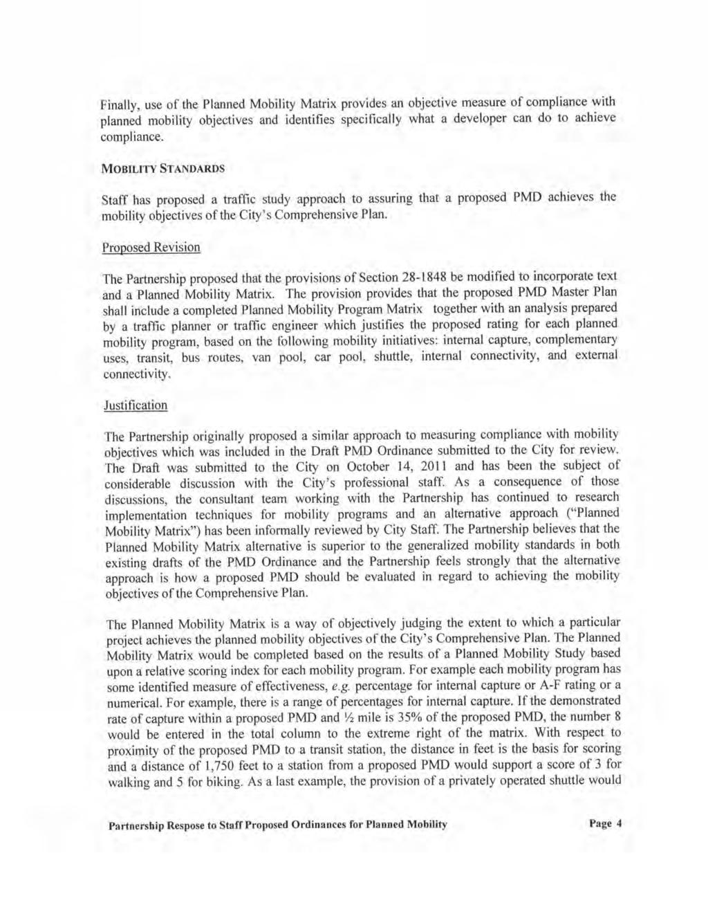
4
5
6
7
8
9
10
11
12
13
14
15
16
17
18
19
20
21
22
23
24
25
26
27
28
29
30
31
32
33
34
35
36
37
38
39
40
41
42
43
44
45
46
47
48
49
50
51
52
53
54
55
56
57
58
59 the establishment of a Planned Mobility Future Land Use Designation; and 2 WHEREAS, as part of amendments to the City's Comprehensive Plan, the City 3 Council designated various areas of the City with a Planned Mobility Future Land Use 4 Designation; 5 WHEREAS, adopted Comprehensive Plan Land Use Policies and require 6 that the City's Land Development Regulations be amended to govern the development and 7 redevelopment of lands designated Planned Mobility; and 8 WHEREAS, the LIRP, W-1 and M-3 zoning districts are hereinafter amended to 9 provide district regulations to govern the development and re-development of lands designated 10 Planned Mobility on the Future Land Use Map of the City's Comprehensive Plan; now therefore THE CITY OF BOCA RATON HEREBY ORDAINS: Section 1. Section Planned Mobility Developments (PMD) is created to read 15 as follows: 16 Section Planned Mobility Developments (PMO). 17 (1) Eligibility. The development parameters hereinafter set forth in this section shall 18 apply to lands which are: 19 (a) zoned LIRP; 20 (b) designated Planned Mobility on the Future Land Use Map of the City's 21 Comprehensive Plan; and 22 (c) approved for development pursuant to Chapter 28, Article XVII, Division 8 23 Planned Mobility Developments. 24 (2) Non-PMD. Nothing in this section or in Chapter 28, Article XVII, Division 8 25 Planned Mobility Developments shall require lands zoned LIRP and designated Planned 26 Mobility on the Future Land Use Map of the City's Comprehensive Plan to exist, develop or 2
60
61 (b) Non-residential floor area may not exceed a floor area ratio of 0.6 of the gross 2 land area of the parcel developed as a PMD. 3 (c) Land used for hotel and motel purposes is not subject to any floor area ratio 4 limitation, provided that the land area and floor area used for hotel and motel purposes shall not 5 be included in the floor area ratio calculations for any land within the PMD which is not used for 6 hotel and motel purposes or density calculations for residential purposes. 7 (d) In no event, shall the total square feet of development for all buildings, including 8 residential buildings, hotels and motels, and non-residential structures regardless of use (but 9 excluding parking structures), within the PMD exceed sooy-seventy percent (0070%) of the total 10 square feet of the parcel developed as a PMD. less the acreage devoted to hotel and motel 11 purposes. 12 (5) Building Height. The maximum building height within the boundaries of a PMD 13 shall be 85 feet. 14 Section 2. Section Planned Mobility Developments (PMD) is created to read 15 as follows: 16 Section Planned Mobility Developments (PMD). 17 (1) Eligibility. The development parameters hereinafter set forth in this section shall 18 apply to lands which are: 19 (a) zoned W-1; 20 (b) designated Planned Mobility on the Future Land Use Map of the City's 21 Comprehensive Plan ; and 22 (c) approved for development pursuant to Chapter 28, Article XVII, Division 8 23 Planned Mobility Developments. 24 (2) Non-PMD. Nothing in this section or in Chapter 28, Article XVII, Division 8 25 Planned Mobility Developments shall require lands zoned W-1 and designated Planned Mobility 26 on the Future Land Use Map of the City's Comprehensive Plan to exist, develop or redevelop as 4
62
63 (b) Non-residential floor area may not exceed a floor area ratio of 0.4 of the gross 2 land area of the parcel developed as a PMD. 3 (c) Land used for hotel and motel purposes is not subject to any floor area ratio 4 limitation, provided that the land area and floor area used for hotel and motel purposes shall not 5 be included in the floor area ratio calculations for any land within the PMD which is not used for 6 hotel and motel purposes or density calculations for residential purposes. 7 (d) In no event, shall the total square feet of development for all buildings, including 8 residential buildings, hotels and motels, and non-residential structures regardless of use (but 9 excluding parking structures}, within the PMD exceed sooy-seventy percent (ezo%) of the total 10 square feet of the parcel developed as a PMD. less the acreage devoted to hotel and motel 11 purposes. 12 (5) Building Height. The maximum building height within the boundaries of a PMD 13 Master Plan shall be 85 feet. 14 Section 3. Section Planned Mobility Developments (PMD) is created to 15 read as follows: 16 Section Planned Mobility Developments (PMD). 17 (1) Eligibility. The development parameters hereinafter set forth in this section shall 18 apply to lands which are: 19 (a) zoned M-3; 20 (b) designated Planned Mobility on the Future Land Use Map of the City's 21 Comprehensive Plan; and 22 (c) approved for development pursuant to Chapter 28, Article XVII, Division 8 23 Planned Mobility Developments. 24 (2) Non-PMD. Nothing in this section or in Chapter 28, Article XVII, Division 8 25 Planned Mobility Developments shall require lands zoned M-3 and designated Planned Mobility 26 on the Future Land Use Map of the City's Comprehensive Plan to exist, develop or redevelop as 6
64
65
66
67
68 AGREEMENTS, DECISIONAL CRITERIA AND MISCELLANEOUS PROVISIONS; AMENDING SECTIONS , AND TO ADD BICYCLE AND PEDESTRIAN POLICIES; PROVIDING FOR SEVERABILITY; PROVIDING FOR REPEALER; PROVIDING FOR CODIFICATION; PROVIDING AN EFFECTIVE DATE 7 8 WHEREAS, on October 26, 2010, the City Council of the City of Boca Raton 9 amended certain goals, objectives and policies of the City's Comprehensive Plan to provide for 10 the establishment of the Planned Mobility Future Land Use Designation; and 11 WHEREAS, as part of amendments to the City's Comprehensive Plan, the City 12 Council designated various areas of the City with the Planned Mobility Future Land Use 13 designation; and 14 WHEREAS, adopted Comprehensive Plan Land Use Policies and require 15 that the City's Land Development Regulations be amended to govern the development and 16 redevelopment of lands designated Planned Mobility on the Future Land Use Map of the 17 Comprehensive Plan ; and 18 WHEREAS, the City's Planned Development Regulations are herein after amended 19 to add a new Division 8 providing for a planned development approval process for lands 20 designated Planned Mobility on the Future Land Use Map of the Comprehensive Plan; now 21 therefore THE CITY OF BOCA RATON HEREBY ORDAINS: 24 Section 1. Section is amended to add the following definitions: 25 Adequate public facilities: Those facilities required to serve a proposed development 26 in accordance with level of service standards adopted in the City's Comprehensive Plan. 2
69 Adequate public facilities shall include those facilities that improve the Quality of Service for 2 transportation related levels. 3 Building massing model: A 3-dimensional drawing.( } using Sketchup or other 4 comparable program which illustrates the location and mass (footprints and vertical and 5 horizontal dimensions) of all proposed buildings Nithout sho Ning any~ The drawing(s) may 6 include architectural detail, fenestration, or other fa9ade design components, such as balconies, 7 windows, doors and roof design. 8 Complementary Uses: Uses that allow a person to meet multiple daily needs by 9 walking from one use to a second use. 10 Distance: Whenever a measurement such as one quarter (%) mile between two 11 locations is stated, the distance shall be measured by reference to the most convenient walking 12 and/or biking route. 13 Drive-through Service: Any commercial operation which dispenses goods, products 14 or service to the occupants of motor vehicles while they are seated in a motor vehicle. 15 Gross land area: The total gross land area encompassed by a unified project, 16 including all the land areas of required or voluntarily dedicated land for public roadway, right-of- 17 way or other purposes. 18 Mobility Circulation System: An interconnected network of streets, roads, transit 19 facilities, driveways, alleys, sidewalks, and paths which provide for multiple modes of travel and 20 are supported by pedestrian and bicycle-oriented environments, conspicuous wayfinding and 21 orientation information, and connectivity to regional transit facilitiesa Regional Transportation 22 Service by at least one (1) mode other than a single-occupancy vehicle. 23 Neighborhood Serving Retail: A commercial establishment that provides goods and 24 services to satisfy primarily the daily needs of nearby residents, employees, customers and 25 guests. 3
70
71 Division 8 - Planned Mobility Development Section Section Section Section Section Section Section Section Section Section Section Section Section Created Purpose Modification of Development Parameters Uses Size PO Plats Waived Eligibility and Applicability of Other Codes PMD Approvals, Master Plans and Site Plans Additional Application Requirements Design Standards Proportionate Fair Share Agreement Decisional Criteria Miscellaneous 15 Section Reserved. 16 Section Created. 17 Planned Mobility Developments (PMD) may be approved for lands that are 18 designated Planned Mobility on the Future Land Use Map of the Comprehensive Plan and upon 19 which the applicant seeks to develop or redevelop in accordance with the regulations set forth in 20 this Division 8. Lands approved hereunder as a PMD shall be noted on the City's Zoning Map 21 by reference to the decisional resolution or ordinance. 22 Section Purpose. 23 In addition to the purposes stated in Section , the purpose and intent of 24 Planned Mobility Developments is to encourage mi>c:ed multiple use land use patterns, 25 pedestrian-oriented site design and to direct higher density development toward locations 26 served by transit, while respecting and complementing the character of existing adjacent 5
72
73
74
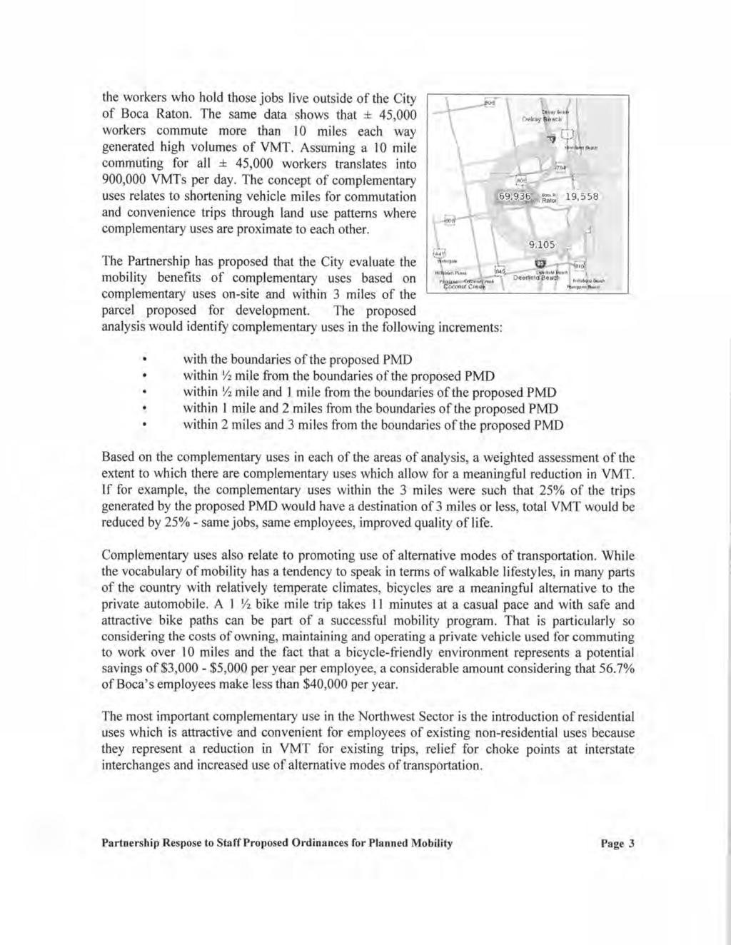
75 I 9112/1 2 Matrix tfa#ig-together with an analysis prepared by a traffic planner or traffic engineer whic h 2 justifies the proposed rating for each planned mobility program. by utilizing the following factors: 3 1. Internal Capture. The inclusion of multiple or mixed uses in the proposed Maste r 4 Plan which will result in trips within the proposed development Complementary Uses. The proposed uses are such that complementary use s 6 are located within reasonable proximity to the proposed development Transit. The extent to which the parcel proposed for development is locate d 8 within walking or biking distance from a transit or bus transfer station Bus Routes. The extent to which the center of the parcel proposed fo 10 development is located within a five (5) minute walk of an established bus route Van Pool. The extent and effectiveness of any van pool program for employee s 12 of uses in the proposed development Car Pool. The extent and effectiveness of any car pool program for employees o f 14 uses in the proposed development. including preferential parking and other incentives Shuttle. The availability of shuttle service to transit and bus transfer station s 16 and/or to complementary uses Internal Connectivity. The extent and effectiveness of internal connectivit y 18 between building and uses within the proposed development External Connectivity. The extent and effectiveness of connectivity between th e 20 proposed development and building and uses located within one half mile of the propose d 21 development. I Table 1. Planned Mobility Program Matrix Internal Capture 5% 10% 15% 20% 25% 30% 35% 40% 45% 50% Rating Peak I Daily.5 I
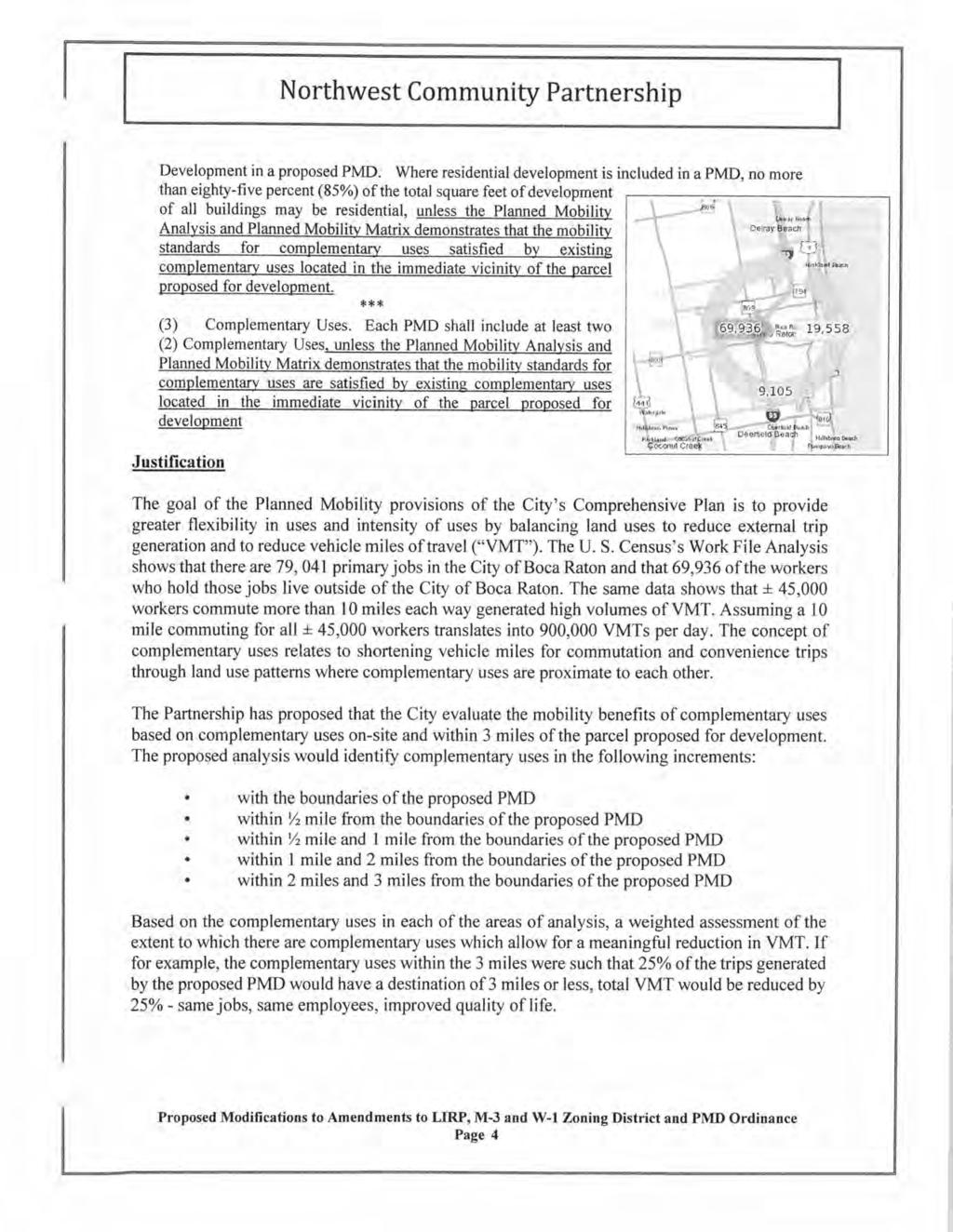
76 I 9/ 1 Complementary 5% 10% 15% 20% 25% 30% 35% 40% 45% SO% Uses (w/in "x" miles).smile I mile I mile 0 0 I mile I Transit Station 750 1,250 1,500 1,750 2,000 2,250 2,500 Dist. (ft) Walking I 0 Biking Bus Routes (#) w/in 5 min. walk Alt. Vehicle A B c D E Van Pool CarPool I Shuttle Private Public 5 10 Internal A B c D E Connectivity External A B c D E Connectivity I lltotal I I II 2 3 (9) Any additional information as may be reasonably required by the City staff, the 4 Planning and Zoning Board, and/or the City Council. 5 Section Design Standards. 6 A PMD shall be designed so as to conform to the following design standards: 7 t!.lresidential Development in a proposed PMD. Where residential developme ntis 8 included in a PMD, no more than eighty-five percent (85%) of the total square fee t of 11
77 development of all buildings may be residential. unless the Planned Mobility Analysis and 2 Planned Mobility Matrix demonstrates that the mobility standards for complementarv uses 3 satisfied by existing complementary uses located in the immediate vicinitv of the parcel 4 proposed for development 5 (2) Minimum floor area. The minimum floor area of a residential dwelling unit in a 6 PMD shall be square feet. The average floor area of all the dwelling units in a PMD 7 shall be not less than 4-;G00900 square feet per unit. 8 (3) Complementary Uses. Each PMD shall include at least two (2) Complementary 9 Uses. unless the Planned Mobility Analysis and Planned Mobility Matrix demonstrates that the 10 mobility standards for complementary uses are satisfied by existing complementarv uses 11 located in the immediate vicinity of the parcel proposed for development 12 (4) Site Design. 13 (a) A PMD shall identify locations where sidewalks, shared use pathways, and other 14 trails or unimproved travel ways will provide non-vehicular mobility connection(s) between each 15 proposed or existing area of predominant residential character and a proposed or existing area 16 of employment or Neighborhood Serving Retail. 17 (b) Proposed land uses shall be integrated so that all uses to be developed are 18 capable of sharing amenities and infrastructure with one another and with existing adjacent land 19 uses, and so that nonresidential uses are conveniently located for access by adjacent or nearby 20 residential uses to reduce vehicular trips and trip lengths. 21 (c) Adequate residential density or non-residential intensity, or both, shall be 22 provided to generate an internal rate of capture of vehicular trips, and to create attractive and 23 functional areas that will serve as anchors for revitalization, redevelopment, and infill 24 development. 25 (d) Provide bicycle, pedestrian, transit and vehicle access within the area of a PMD 26 and between areas that are adjacent to the PMD. 12
78 (e) Streets shall be designed with a pedestrian orientation, which includes the 2 provision of continuous sidewalks and areas where pedestrian amenities such as seating areas, 3 street trees, trash receptacles, shelters and lighting are located. 4 (f) While parking garages are preferred for satisfying the off-street parking 5 requirements of the PMD, where new surface parking lots are provided they shall be located 6 and designed to support pedestrian safety, connectivity and comfort by reducing the number of 7 curb cuts and providing interconnectivity between and through sites. 8 (g) The extent of surface parking lots shall be broken up with landscaping and 9 placement around the PMD. 10 (h) Convenience parking between the right-of-way and building entrances shall be 11 provided based on the use and design of the building, consistent with providing pedestrian 12 accessibility and minimizing vehicular conflicts. 13 (i) Drive-through service is strongly discouraged. 14 (5) Sidewalks. In addition to Sections , et seq., the following requirements 15 shall be met. 16 (a) Sidewalks adjacent to or within a private or public right-of-way shall be designed 17 as follows: 18 (i) A planted buffer zone that shall be a minimum of four (4) feet in width, measured 19 from the back of curb or when no curb, ten (1 0) feet from the edge of pavement. 20 (ii) A pedestrian sidewalk that shall be a minimum of six (6) feet in width, and which 21 shall provide a clear pedestrian path for the entire width at all times. 22 (iii) The planted buffer zone shall include street trees, street furniture, pedestrian 23 scaled lighting, awnings and other pedestrian-oriented features. 24 (iv) Utilities, street trees, poles and all similar objects shall not be located within or 25 along the edges of the pedestrian sidewalk. 26 (v) Sidewalks shall be constructed on both sides of tae-any public right-of-way. 13
79 (b) All other sidewalks shall be a minimum of six (6) feet in clear width, with a 2 minimum of ten (10) feet in width for locations with sidewalk cafes, displays, sales or other 3 pedestrian-oriented activities. 4 (6) Bicycle Facilities. Off-street and on-street bicycle facilities shall be provided in 5 accordance with Sections et seq. Where the City has established or adopted a plan to 6 establish an on-street or off-street bicycle, pedestrian, greenway and shared-use pathway 7 system that abuts or adjoins the PMD, the PMD shall provide for a connection to that pathway 8 system. 9 (7) Connectivity. 10 (a) General. The PMD shall create conditions which are conducive to a Mobility 11 Circulation System. Pathways and sidewalks shall be designed to enhance pedestrian comfort 12 and use by way of such techniques as distinctive pavement; identity, way finding and directional 13 signage; identified departure and arrival points; distance markers and destination walking arrival 14 times in minutes; shaded rest stops with "street" furniture and spray water features; and, 15 decorative pole lighting fixtures. 16 (b) Regional Transportation Service. A PMD that is located within one half(%) mile 17 of any Regional Transportation Service point of service shall identify a continuous non-vehicular 18 connection between the PMD and such point of service. A non-vehicular connection may cross 19 a street that accommodates vehicular travel and still be deemed continuous if a clearly 20 delineated crosswalk with pedestrian signage exists or will be provided during implementation of 21 the PMD. If the PMD has frontage on any transit route, a bus shelter and/or transiubus pick-up 22 facility shall be provided by the PMD unless there is an existing suitable facility within 600 feet of 23 the PMD. For any PMD with a street frontage in excess of 600 feet, transit stops shall be 24 provided every 600 feet along the property frontage. 25 (c) City Transit Program. All PMD's shall participate in the City's transit programs. 26 The PMD shall either implement and maintain a shuttle service operating between the PMD and 14
80 the Tri-Rail station, or pay an annual fee to the City in lieu thereof. 2 (d) Crosswalks. Crosswalks shall be provided at all signalized or stopped controlled 3 intersections and pedestrian signals shall be installed at all signalized intersections and any 4 other locations where high pedestrian volumes or other conditions warrant a signalized 5 crossing. 6 (8) Setbacks. The minimum front, side and rear yard setbacks for all buildings within 7 a PMD shall be twenty (20) feet, except that the minimum setback from any road right-of-way 8 having a functional classification of urban major arterial, urban principal arterial, or urban 9 collector, as designated in the Comprehensive Plan, shall be fifty (50) feet, except that parcels 10 proposed for development with frontage on more than one (1) urban major arterial, urban 11 principal arterial or urban collector shall only be required to have a fiftv (50) foot setback along 12 one (1.) major road frontage or at corners of two (2) major roads. a twenty-five (25) foot setback 13 along both roads. Except as provided herein, all required yards shall be landscaped in 14 accordance with the City's landscape regulations and Community Appearance Board criteria. 15 (a) Outdoor seating for restaurants and cafes, and pedestrian amenities such as 16 benches, street trees, trash receptacles, shelters and lighting shall be permitted within any 17 required yard setback if the yard fronts along a public or private right of way. 18 (b) The inclusion of any required sidewalk or other pedestrian or non-vehicular 19 pathways within the area of any required setback is permitted when doing so would provide 20 direct walking access between Complementary Uses. 21 (9) Open/Green Space. The minimum open/green space required in a PMD shall be 22 25%. Plazas, paver driveways which are posted with signs that identify the driveway as a joint 23 vehicular and pedestrian way, sidewalks, covered arcades, gazebos, and other hardscape 24 areas may be counted towards satisfying the open/green space requirement provided such 25 areas promote connectivity and mobility 15
81 (10) Adequate Public Facilities. The public facilities serving the PMD shall be 2 adequate taking into account those public facilities dedicated, constructed and a proportionate 3 share thereof paid by the PMD. 4 (11) Building Design. 5 (a) Building massing shall be designed to result in structures which are varied in 6 terms of height, bulk, and articulation. 7 (b) Uses that are oriented towards pedestrians, such as retail sales and services, 8 shall be located on the ground floor of ~non-residential and residential building{s) in which 9 such uses are proposed. 10 (c) Each building shall include at least one pedestrian entrance oriented toward the 11 public street or other primary pedestrian access way and shall include design elements to 12 ensure that such entrance is identifiable and integrated into the building architecture. Such 13 design elements may include, but are not limited to canopies, wall recesses or projections, 14 arcades, arches, and columns. 15 (d) Building facades shall be designed to reduce the uniform monolithic scale and 16 appearance of large unadorned walls, while providing a more pedestrian-oriented design and 17 visual interest through the use of detail and scale and fenestration (i.e. character and 18 interrelationships of facade design components including windows, doors, and roof design). 19 (e) Window and door openings of buildings shall provide transparency into the 20 ground floor of retail facilities. A minimum of sixty (60) percent of the ground level retail facade 21 shall be transparent (including windows and door openings), as measured between two (2) and 22 eight (8) feet above the ground of all building containing retail facilities that fronts along a private 23 or public right-of-way. 24 (12) Lighting. Outdoor lighting shall create and encourage a pedestrian friendly 25 environment. Pedestrian scaled lighting placed along a public sidewalk shall be at a height of 26 no greater than fifteen (15) feet and shall be placed along the public sidewalk at a spacing of no 16
82 greater than fifty (50) feet. Lighting shall be located as close as possible to the center-point 2 between adjacent street trees. 3 (13) Parking. Except as provided in subsections (a) (b) and (c) below, the provisions 4 of Chapter 28, Article XVI Off Street Parking and Loading shall apply. 5 (a) Required Parking Spaces. The provision of required parking within a PMD shall 6 be in the amount of ninety five pereent (95%) of the off street parking requirement in Chapter 7 28, Artiele XVII and bieyele parking shall be ten pereent (10%) of the required number of motor 8 vehiele parking spaees and inelude long term and short term faeilities. in accordance with the 9 following: 10 Automobile 11 Office = 3 per sf 12 Medical 4.5 per 1,000 sf 13 Financial = 1 per 250 sf 14 Restaurant 15 per sf 15 Retail = 4 per 1,000 sf 16 Residential 17 1 BR = 1 per dwelling unit 18 2 BR 1.5 per dwelling unit 19 3BR = 2.0 per dwelling unit 20 Roc/Cultural = 1 per 3.5 seats + 1 per 25 non-seating sf 21 Education = 1 per 5 students. 1 per employee and 3 per sf 22 Industrial.95 per 500 sf or.95 per employee (max shift) 23 Hotel = 1 per room+ 35% of accessory uses per Chapter 28, Art. 24 VII (b) Bicycle Racks = 5% of required automobile spaces Shared Parking. Shared parking in accordance with Section is required 30 permitted and shared parking agreements with adjacent uses shall be strongly encouraged. 31 Reserved Parking. Reserved parking and/or valet parking is strongly 32 discouraged. unless the applicant demonstrates that the use of reserved or valet parking 33 contributes to satisfying the planned mobility objectives of the Comprehensive Plan. 34 (b) Shared Parking. Shared parking in accordance with Section is required 35 and shared parking agreements 'lt'ith adjacent uses shall be strongly encouraged. 17
83 (o) Reserved Parking. Res01ved parking and/or '4'alet parking is strongly 2 discouraged. 3 (d) On-Street Parking Locations. On-street parking (parallel or angled) is permitted 4 and may be used when continuous pedestrian connections are provided between the on-street 5 spaces and the non-residential uses of PMD. Such on-street parking spaces may be counted 6 toward satisfying the off-street parking requirement for those non-residential uses to which the 7 on-street spaces are connected. 8 (e) Surface parking spaces shall be located to the rear and sides of buildings 9 wherever feasible. 10 (f) Surface parking lots and maneuvering areas located to the side of a building 11 cannot occupy more than fifty percent (50%) of a site's frontage onto an urban minor arterial or 12 urban collector street. 13 (g) Wherever possible, parking lots and maneuvering areas on corner lots should not 14 be located adjacent to intersections. 15 (h) When surface parking lots are provided, provide smaller, more dispersed surface 16 parking lots instead of one large parking area. 17 (14) Parking Structures. 18 (a) Parking structures are preferred for satisfying the PMD's off-street parking 19 requirements and shall be designed so that automobile headlamps are screened with an 20 opaque structure to a height of at least three and one-half (3.5) feet above any drive surface 21 within the structure. 22 (b) Parking structures shall be wrapped with either residential or non-residential 23 uses, or both, or otherwise buffered from the street and adjacent residential structures by the 24 use of landscaping with over-story canopy of palm trees and under-story of trees at a density of 25 one (1) over-story and one (1) under-story tree for every one hundred and fifty (150) square feet 26 of distance between the parking structure and the street or adjacent residential structure. 18
84 (c) Parking structures that are not wrapped shall be designed in the same 2 architectural style with similar materials and finishes as the principal building or buildings which 3 are served by the structure; 4 (d) No light fixture on the top floor of a parking structure shall be located at a height 5 above the surface of the top parking level of greater than three and one half (3 %) feet. 6 (e) Parking structures shall be designed to include pedestrian walkways separated 7 from the driving aisles near all entrances and exits to and from the parking structure and be 8 designed in accordance with the City's Engineering Design Standards Manual. 9 (f) Covered pedestrian access shall be provided between parking structures and the 10 main use buildings that they are intended to serve. 11 (15) Streets Network. All streets and vehicular drives within a PMD shall be designed 12 as follows: 13 (a) All streets and drives shall be designed to create connections within the PMD 14 Master Plan, between all stand-alone Site Plans of the PMD Master Plan, and between the 15 PMD and all streets and drives in proximity thereto. 16 (b) Any street network that is provided shall be designed to accommodate future 17 street and pedestrian connections to adjacent developable or redevelopable parcels. 18 (c) No side of a street block shall exceed 660 feet in length unless outdoor 19 pedestrian access is provided through the block at intervals of no more than 660 feet. 20 (d) Curvilinear street designs, dead end streets and cui-de-sacs are discouraged 21 and streets within the PMD area shall connect to and continue any street patterns that are 22 previously established or approved on adjacent parcels. 23 (e) Landscape Treatment: 24 (i) All streets shall be treated with landscaping through sustainable practices such 25 as xeroscape, native plants, and the selection of materials that require minimum continuous 26 maintenance and irrigation. 19
85 (ii) Street trees shall be planted at a maximum distance between trees of 35 feet on 2 center. 3 (iii) Hardscape materials, patterns, and colors shall serve to complement buildings 4 and adjacent spaces such as plazas. 5 (16) Driveway Standards. Any driveway located within a PMD or at points of access 6 to a PMD not on a thoroughfare roadway may be designed per the urban driveway classification 7 standards set forth in Section All other points of access shall comply with the suburban 8 driveway classification standards set forth in Section (17) Community Appearance Board. All landscaping, colors and materials shall be 10 reviewed and approved on a preliminary basis by the Community Appearance Board in 11 accordance with their rules and regulations as part of the PMD approval process. Where these 12 design standards refer to trees, tree plantings and other landscape requirements the intent is to 13 set forth a minimum requirement. The Community Appearance Board in the exercise of its 14 jurisdiction may require a greater amount. 15 Section Proportionate Fair Share Agreements. 16 In order that the PMD may provide adequate public facilities and Mobility 17 Infrastructure, and in order to assure the implementation of the Planned Mobility Strategies 18 within the PMD, an applicant for a PMD may submit a proposed Proportionate Fair Share 19 Agreement pursuant to Section Proportionate Fair Share Program. The City Council in its 20 sole discretion may enter into a proportionate fa ir share agreement or not in connection with the 21 approval of a PMD. For purposes of this Section it is understood that an applicant may propose 22 a proportionate fair share agreement even though level of services and/or Quality of Services 23 are otherwise met, but rather for the purpose of assuring the implementation of the Planned 24 Mobility Strategies of the PMD, to otherwise mitigate the impact of the PMD and to improve the 25 Quality of Service within the planning area of the City where the PMD is located. By way of 26 example, the City may from time to time adopt resolutions that encourage the implementation of 20
86
87 (e) Any modifications of development parameters or design standards pursuant to 2 Section mitigate daily vehicle trips and vehicle miles traveled. 3 Section Miscellaneous. 4 (1) In the event of conflict between the provisions of this Division 8 and the other 5 provisions of Article XVII, the provisions of this Division 8 shall prevail to the extent of such 6 conflict. It is the intent that a PMD be subject to all provisions of Article XVII not in conflict with 7 this Division 8. 8 (2) In the event of conflict between the provisions of this Division 8 and the other 9 provisions of this Code of Ordinances, the provisions of this Division 8 shall prevail to the extent 10 of such conflict. It is the intent that a PMD be subject to all provisions of this Code of 11 Ordinances not in conflict with this Division (3) Conditions of approval. The Planning and Zoning Board and the City Council 13 may impose reasonable conditions on PMD approval in order to ensure that its Planned Mobility 14 Strategies are achieved and that the approved PMD, if any, is implemented, including: 15 (a) A condition describing an enforceable method of securing performances of any 16 condition; 17 (b) A condition requiring recording of appropriate covenants and restrictions 18 documenting and restricting the densities and intensities regarding all or a portion of the PMD; 19 or, 20 (c) A proportionate fair share agreement. 21 (4) The city manager shall have the power and authority to make such rules, 22 regulations and criteria as may be necessary to effect the provisions of this Division 8, and to 23 make such other reasonable rules and regulation as he may deem proper to implement the 24 provisions of this Division 8 and which shall not be inconsistent with the terms and provisions of 25 this Division Section Reserved. 22
88
89 new developments and/or redevelopments shall include bicycle and pedestrian facilities in 2 accordance with applicable standards. 3.{61 Design Guidelines. On-street bicycle facilities shall comply with the "Manual of 4 Uniform Minimum Standards for Design. Construction and Maintenance for Streets and 5 Highways" (commonly known as the "Florida Greenbook"). 6 Sec. 23-.:t-e Maintenance and repair policy. 7 Sidewalk or pathway construction in a public right-of-way shall be repaired, if needed, 8 by the abutting property owner, and the abutting property owner shall be responsible for 9 maintaining the sidewalk or pathway and swale area clean and free of trash, debris and foreign 10 materials. A shared-use path constructed in a city right-of-way shall be repaired by the city and 11 the city shall be responsible for maintaining the shared-use path clean and free of trash, debris 12 and foreign materials. The city may enter into an agreement to repair and maintain shared-use 13 paths constructed on private property or property owned by other public entities. 14 Section 4. If any section, subsection, clause or provision of this ordinance is held 15 invalid, the remainder shall not be affected by such invalidity. 16 Section 5. All ordinances and resolutions or parts of ordinances and resolutions and 17 all sections and parts of sections in conflict herewith shall be and hereby are repealed. 18 Section 6. Codification of this ordinance in the City Code of Ordinances is hereby 19 authorized and directed. 20 Section 7. This ordinance shall take effect immediately upon adoption. 21 PASSED AND ADOPTED by the City Council of the City of Boca Raton this 22 day of ' CITY OF BOCA RATON, FLORIDA ATIEST: Susan Whelchel, Mayor 30 24
90
91
92
93
94
95
96
97
98
99
100
101
102
103
104
105
106
107
108
109
110
111
112
113
114
115
116
117
118
119
120
121
122
123
124
125
126
127
128
129
130
131
132
133
VILLAGE OF SKOKIE Design Guidelines for Mixed-Use Districts NX Neighborhood Mixed-Use TX Transit Mixed-Use CX Core Mixed-Use
 VILLAGE OF SKOKIE Design Guidelines for Mixed-Use Districts NX Neighborhood Mixed-Use TX Transit Mixed-Use CX Core Mixed-Use TABLE OF CONTENTS CHAPTER 1 SITE DESIGN Purpose 1 CHAPTER 2 SITE DESIGN Streetscape
ORDINANCE AN ORDINANCE TO ADD A NEW SECTION 4.N. IN THE ZONING CODE FOR THE TOWN OF MIDDLETOWN, RELATING TO MIXED-USE DEVELOPMENT
 Introduced: November 5, 2018 Approved: ORDINANCE 18-11-01 AN ORDINANCE TO ADD A NEW SECTION 4.N. IN THE ZONING CODE FOR THE TOWN OF MIDDLETOWN, RELATING TO MIXED-USE DEVELOPMENT BE IT ENACTED BY THE MAYOR
Chapter PEDESTRIAN COMMERCIAL (PC) ZONING DISTRICT
 ZONING DISTRICT") Chapter 11-17 PEDESTRIAN COMMERCIAL (PC) ZONING DISTRICT Sections: 11-17-01 GENERAL PURPOSE 11-17-02 PERMITTED BUILDING TYPES 11-17-03 USES PERMITTED WITH DESIGN REVIEW 11-17-04 USES PERMITTED BY CONDITIONAL
Chapter 11-17 PEDESTRIAN COMMERCIAL (PC) ZONING DISTRICT Sections: 11-17-01 GENERAL PURPOSE 11-17-02 PERMITTED BUILDING TYPES 11-17-03 USES PERMITTED WITH DESIGN REVIEW 11-17-04 USES PERMITTED BY CONDITIONAL
CHAPTER 3. Design Standards for Business, Commercial, Industrial, Recreational and Institutional Uses
 CHAPTER 3 Design Standards for Business, Commercial, Section Number Title Ordinance Number Date of Ordinance 16-3-1 Applicability 2006-11 2008-04 07-01-08 16-3-2 Uniform Standards for Architectural Design
MIXED-USE VILLAGE OVERLAY FLOATING DISTRICT
 MIXED-USE VILLAGE OVERLAY FLOATING DISTRICT Zoning regulations developed by committee to the Planning Board for the Town of DeWitt, NY Issue date: 13 July 2017 revised 3/12/2018, revised 4/26/2018, 5/9/2018
B. Blocks, Buildings and Street Networks
 B. Blocks, Buildings and Street Networks Figure IV.4 A rational block pattern with connected streets Introduction The single most important element in the physical and functional integration of mixed use
ATTACHMENT A. SILVERDALE DESIGN STANDARDS Amendments to the Waaga Way Town Center Chapter
 ATTACHMENT A SILVERDALE DESIGN STANDARDS Amendments to the Waaga Way Town Center Chapter Chapter 10. Waaga Way Town Center 10.1 Physical Identity Elements & Opportunities The Waaga Way Town Center includes
ALBEMARLE COUNTY CODE CHAPTER 18 ZONING SECTION 20A NEIGHBORHOOD MODEL - NMD
 CHAPTER 18 ZONING SECTION 20A NEIGHBORHOOD MODEL - NMD Sections: 20A.1 PURPOSE AND INTENT 20A.2 STATUS AS A PLANNED DEVELOPMENT DISTRICT 20A.5 CODES OF DEVELOPMENT 20A.6 PERMITTED USES 20A.7 RESIDENTIAL
DRAFT. 10% Common Open Space
 % OF CHARLOTTE IS CATEGORIZED AS A. LAND USES : Placeholder map displaying location of Place Type GOALS: Accommodate XX% of future growth. Provide a concentration of primarily commercial and civic activity
ARTICLE 6: Special and Planned Development Districts
 ARTICLE 6: Special and Planned Development Districts 6-10 Traditional Neighborhood Development (TND) District 6-10.10 Purpose and Intent The Traditional Neighborhood Development (TND) District provides
5.1.1 The streetscape along US Highway 64 (Brevard Road); and, The built environment within new residential developments; and,
; and, The built environment within new residential developments; and,") Article 5. Landscaping 5.1 Purpose The Town of Laurel Park s landscape standards are designed to create a beautiful, aesthetically pleasing built environment that will complement and enhance community
Article 5. Landscaping 5.1 Purpose The Town of Laurel Park s landscape standards are designed to create a beautiful, aesthetically pleasing built environment that will complement and enhance community
FLORIN ROAD CORRIDOR Site Plan and Design Review Guidelines Checklist
 FLORIN ROAD CORRIDOR Site Plan and Design Review Guidelines Checklist Applicant s Name: Project Address: Phone: Email: Applicant shall fill out the design guidelines checklist for all guidelines applicable
CHAPTER 530 SITE PLAN REVIEW
 ARTICLE I. GENERAL PROVISIONS CHAPTER 530 SITE PLAN REVIEW Community Planning and Economic Development Development Services Division 250 South 4 th Street, Room 300 Minneapolis MN 55415-1316 612-673-3000
Buildings may be set back to create small plazas provided that these setbacks do not substantially disrupt the street wall s continuity.
 6-22 Community Design Street Walls and Street-front Setbacks The siting of buildings will play a critical role in establishing the character and sense of place for the District. Siting buildings at the
CITY OF KEIZER MASTER PLAN APPLICATION & INFORMATION SHEET
 CITY OF KEIZER MASTER PLAN APPLICATION & INFORMATION SHEET PRE-APPLICATION CONFERENCE Prior to the actual filing of a Master Plan application, it is strongly recommended that the applicant contact Planning
AWH REPORT OF THE PLANNING AND DEVELOPMENT DEPARTMENT FOR APPLICATION FOR REZONING ORDINANCE TO PLANNED UNIT DEVELOPMENT
 AWH REPORT OF THE PLANNING AND DEVELOPMENT DEPARTMENT FOR APPLICATION FOR REZONING ORDINANCE TO PLANNED UNIT DEVELOPMENT MAY 8, 2014 The Planning and Development Department hereby forwards to the Planning
DRAFT Northeast Quadrant of Kipling Avenue and Highway 7 DRAFT AUGUST 29, Goals Land Use. The goals of this Plan are to:
 AUGUST 29, 2017 12.15 Northeast Quadrant of Kipling Avenue and Highway 7 12.15.1 Goals 12.15.2 Land Use The goals of this Plan are to: 12.15.2.1 General Provisions: a) Ensure the development of a compact
FREEWAY/TOURIST DISTRICT
 FREEWAY/TOURIST DISTRICT DESIGN STANDARDS FOR THE CITY OF MOUNTLAKE TERRACE March, 2014 MOUNTLAKE TERRACE FREEWAY/TOURIST DESIGN STANDARDS March, 2014 1 TABLE OF CONTENTS Introduction...1 Design Site Design
SOUTHEAST ANTELOPE VALLEY COMMUNITY STANDARDS DISTRICT ORDINANCE NO. An Ordinance amending Title 22 Planning and Zoning of the Los Angeles County
 SOUTHEAST ANTELOPE VALLEY COMMUNITY STANDARDS DISTRICT Revised 2.7.07 ORDINANCE NO. An Ordinance amending Title 22 Planning and Zoning of the Los Angeles County Code to establish the Southeast Antelope
Incentive Zoning Regulations Florida Municipal City of Orlando
 Topic: Resource Type: State: Jurisdiction Type: Municipality: Year (adopted, written, etc.): 2002 Community Type applicable to: Title: Incentive Zoning Regulations Florida Municipal City of Orlando Document
DEVELOPMENT CONTROLS MEDICAL DISTRICT
 6.01. GENERAL DESIGN GUIDELINES A. Site Planning B. Architectural Design C. Medical Facility Signage & Lighting D. Exhibit 48. ARCHITECTURAL DESIGN CONCEPTS 6.02. MEDICAL FACILITY STANDARDS & GUIDELINES
ORDINANCE WHEREAS, this Ordinance is consistent with the City of Winter Garden Comprehensive Plan; and
 ORDINANCE 17-06 AN ORDINANCE OF THE CITY COMMISSION OF THE CITY OF WINTER GARDEN, FLORIDA, CREATING ARTICLE XIV OF CHAPTER 118 OF THE CITY OF WINTER GARDEN CODE OF ORDINANCES PROVIDING FOR THE EAST PLANT
REZONING APPLICATION MPD SUPPLEMENT
 REZONING APPLICATION MPD SUPPLEMENT For Staff Use Only: DATE/TIMESTAMP: ZA# RECEIVED BY: The intent of the Master Planned District (MPD) designation is to allow flexibility in the design and construction
B L A C K D I A M O N D D E S I G N G U I D E L I N E S for Multi-family Development
 B L A C K D I A M O N D D E S I G N G U I D E L I N E S for Multi-family Development Adopted June 18, 2009 This section of the Design and focuses on site planning and design guidance for new multi-family
ARTICLE 13 STREETS General
 ARTICLE 13 STREETS 13.1 General Streets shall be designed to suit their functions. Many streets have purposes other than vehicular traffic. As an alternative to current N.C. Department of Transportation
Be it enacted by the Town Board of the Town of Guilderland that the following new A (Transit Oriented Development (TOD) District) is adopted:
 District) is adopted:") Local Law No. 4 of 2018 (Adoption of 280-18A (Transit Oriented Development District) Be it enacted by the Town Board of the Town of Guilderland that the following new 280-18A (Transit Oriented Development
Local Law No. 4 of 2018 (Adoption of 280-18A (Transit Oriented Development District) Be it enacted by the Town Board of the Town of Guilderland that the following new 280-18A (Transit Oriented Development
180 ZONING 180. ARTICLE XLII STREETSCAPE ENHANCEMENT OVERLAY ( SEO ) DISTRICT [Added Ord. No. 1086]
![180 ZONING 180. ARTICLE XLII STREETSCAPE ENHANCEMENT OVERLAY ( SEO ) DISTRICT [Added Ord. No. 1086]](/thumbs/75/72360049.jpg "180 ZONING 180. ARTICLE XLII STREETSCAPE ENHANCEMENT OVERLAY ( SEO ) DISTRICT [Added Ord. No. 1086]") 180 ZONING 180 ARTICLE XLII STREETSCAPE ENHANCEMENT OVERLAY ( SEO ) DISTRICT [Added 4-6-2016 Ord. No. 1086] 180.145. SEO DISTRICT 180.145.1. Intent. The SEO DISTRICT Regulations are intended to address
180 ZONING 180 ARTICLE XLII STREETSCAPE ENHANCEMENT OVERLAY ( SEO ) DISTRICT [Added 4-6-2016 Ord. No. 1086] 180.145. SEO DISTRICT 180.145.1. Intent. The SEO DISTRICT Regulations are intended to address
BE IT ORDAINED by the Board of Supervisors of Chesterfield County:
 Attachment A AN ORDINANCE TO AMEND THE CODE OF THE COUNTY OF CHESTERFIELD, 1997, AS AMENDED, BY AMENDING AND REENACTING SECTIONS 19.1-52, 19.1-53, 19.1-236, 19.1-247, 19.1-253, 19.1-263, 19.1-341, 19.1-346,
A BILL FOR AN ORDINANCE TO AMEND CHAPTER 9, KAUAI COUNTY CODE 1987, RELATING TO STREET REQUIRE:MENTS FOR SUBDIVISIONS
 ORDINANCE NO. BILL NO. { vy"yj1j A BILL FOR AN ORDINANCE TO AMEND CHAPTER 9, KAUAI COUNTY CODE 1987, RELATING TO STREET REQUIRE:MENTS FOR SUBDIVISIONS BE IT ORDAINED BY THE COUNCIL OF THE COUNTY OF KAUA'I,
TOP TEN LIST OF COMMUNITY CONCERNS REGARDING PROPOSED AMENDMENTS TO CHAPTER 42
 TOP TEN LIST OF COMMUNITY CONCERNS REGARDING PROPOSED AMENDMENTS TO CHAPTER 42 1. Extend the urban area to Beltway 8 in stages, over say a three-year period, prioritizing development in transit and declining
Section 9 NEIGHBORHOOD DESIGN
 Section 9 NEIGHBORHOOD DESIGN City of Lancaster Comprehensive Plan D u n k i n, S e f k o & A s s o c i a t e s, I n c. NEIGHBORHOOD DESIGN INTRODUCTION There are many ways in which a neighborhood can
Future Five. Design/ Development Guidelines. January 2008 Amended June 08 per City Council motion
 Future Five Design/ Development Guidelines January 2008 Amended June 08 per City Council motion 5-Points Design Guidelines Table of Contents I. Introduction 3 II. Area boundaries 4 III. Review Process
Chapter 11. Industrial Design Guidelines 11.1 INTRODUCTION AND PURPOSE 11.3 SITE PLANNING GUIDELINES 11.2 GENERAL DESIGN OBJECTIVES
 Chapter 11 Industrial Design Guidelines 11.1 INTRODUCTION AND PURPOSE The following industrial/design guidelines seek to assure high quality development in Santa Ana s industrial districts by: The design
(DC1) Direct Development Control Provision DC1 Area 4
 Direct Development Control Provision DC1 Area 4") . General Purpose (DC) Direct Development Control Provision DC Area 4 The purpose of this Provision is to provide for an area of commercial office employment and residential development in support of the
. General Purpose (DC) Direct Development Control Provision DC Area 4 The purpose of this Provision is to provide for an area of commercial office employment and residential development in support of the
Article 7.05 Manufactured Home Park Districts
 Article Manufactured Home Park Districts.01 Intent The purpose of the MHP Manufactured Home Park District is to give recognition to the fact that manufactured homes can provide satisfactory living conditions
Policies and Code Intent Sections Related to Town Center
 Policies and Code Intent Sections Related to Town Center The Town Center Vision is scattered throughout the Comprehensive Plan, development code and the 1994 Town Center Plan. What follows are sections
Mark-up of the effect of the proposed Bronte Village Growth Area OPA No.18 on the text of section 24, Bronte Village, of the Livable Oakville Plan
 Mark-up of the effect of the proposed Bronte Village Growth Area OPA No.18 on the text of section 24, Bronte Village, of the Livable Oakville Plan Notes: This document is provided for information purposes
INSTITUTIONAL USE DESIGN COMPATIBILITY TECHNIQUES
 INSTITUTIONAL USE DESIGN COMPATIBILITY TECHNIQUES INTRODUCTION Community institutions are an important part of the character and vitality of neighborhoods in Forsyth County. Institutional uses include
ARTICLE V PLANNED UNIT DEVELOPMENT DISTRICT
 ARTICLE V PLANNED UNIT DEVELOPMENT DISTRICT A. Purpose and Objective The Planned Unit Development (PUD) procedure provides a flexible land use and design regulation through the use of performance criteria
ARTICLE 13 STREETS General
 ARTICLE 13 STREETS 13.1 General Streets shall be designed to suit their functions. Many streets have purposes other than vehicular traffic. As an alternative to current N.C. Department of Transportation
4.1.3 LAND USE CATEGORIES
 4.1.3 LAND USE CATEGORIES a. City Center District The City Center District incorporates the existing character and mix of uses in downtown Belmont to encourage redevelopment and new development in keeping
MIDTOWN MIXED-USE VILLAGE. TECHNICAL DATA SHEET COMPONENT C-1 FOR PUBLIC HEARING - PETITION NUMBER Project No RZ1.1. Issued.
 N MIDTOWN MIXED-USE VILLAGE TECHNICAL DATA SHEET COMPONENT C- FOR PUBLIC HEARING - PETITION NUMBER 04-00 Project No. 496 Issued Revised SCALE: " = 0' N 0 0 0 40 RZ. c GENERAL PROVISIONS: a. SITE LOCATION.
Chapter Master Planned Communities (MPC) District
 District") Sections 14.53.010 Purpose and Intent 14.53.020 Applicability 14.53.030 Procedure 14.53.040 MPC Standards 14.53.050 Required Findings 14.53.010 Purpose and Intent Chapter 14.53 Master Planned Communities
Sections 14.53.010 Purpose and Intent 14.53.020 Applicability 14.53.030 Procedure 14.53.040 MPC Standards 14.53.050 Required Findings 14.53.010 Purpose and Intent Chapter 14.53 Master Planned Communities
A. Background Summary of Existing Challenges and Potential Possibilities. 1. Summary of Existing Assets and Potential Opportunities
 A. Background 1 A Main Street Master Plan Study was performed and completed in October of 2007. The study was initiated to review current land uses and development patterns along Main Street, from Parrish
WEST LOOP DESIGN GUIDELINES CHECKLIST
 WEST LOOP DESIGN GUIDELINES CHECKLIST Section 1.0 General Strategies 1.1 DESIGN EXCELLENCE: ENCOURAGE HIGH QUALITY AND INNOVATIVE DESIGN OF NEW BUILDINGS WITHIN THE WEST LOOP WITHOUT BEING PRESCRIPTIVE
DESIGN AND LANDSCAPE GUIDELINES FOR DEVELOPMENT
 DESIGN AND LANDSCAPE GUIDELINES FOR DEVELOPMENT IN THE SECOND SUPERVISORIAL DISTRICT (REVISED) ADOPTED BY RIVERSIDE COUNTY BOARD OF SUPERVISORS ON SEPTEMBER 15, 1998 REVISED OCTOBER 23, 1998 REVISED AUGUST
Clairtrell Area Context Plan
 Clairtrell Area Context Plan March 2005 Urban Development Services City Planning Contents 1. Introduction... 4 2. Development Structure... 6 2.1 Streets... 7 2.1.1 Sheppard Avenue and Bayview Avenue...
The broad range of permitted and special uses allowed in the district remain, but some descriptions have been clarified.
 Memorandum To: Emily Fultz, AICP City Planner, City of Edwardsville From: Michael Blue, FAICP Principal, Teska Associates Date: January 24, 2019 RE: B-1 Zoning District Update A draft, updated B-1 Central
Highland Village Green Design Guidelines
 Highland Village Green Design Guidelines Publishing Information Title Highland Village Green Design Guidelins Author The City of Calgary Status DRAFT - Proposed document subject to changes Additional Copies
The purpose of the requirements in this Article is to provide for landscaping and screening of parking and other outdoor areas that will:
 XIII. LANDSCAPING & SCREENING A. Purpose The purpose of the requirements in this Article is to provide for landscaping and screening of parking and other outdoor areas that will: 1. Protect residential
SMALL LOT DESIGN STANDARDS. An Illustrated Working Draft for Test Implementation
 SMALL LOT DESIGN STANDARDS An Illustrated Working Draft for Test Implementation SMALL LOT DESIGN STANDARDS ILLUSTRATED WORKING FOR TEST IMPLEMENTATION OVERVIEW SMALL LOT CODE AMENDMENT & POLICY UPDATE
SUBCHAPTER 4-B GUIDELINES FOR THE B-3 COMMERCIAL CHARACTER AREA
 1 SUBCHAPTER 4-B GUIDELINES FOR THE B-3 COMMERCIAL CHARACTER AREA Downtown Bozeman should be the location of buildings of greatest height and intensity in the community. The following guidelines apply
CHARLES PUTMAN CHARLES PUTMAN AND ASSOCIATES, INC
 MEMORANDUM CHARLES PUTMAN & ASSOCIATES, INC. LAND DEVELOPMENT CONSULTANTS PLANNING ZONING PERMITTING 4722 NW Boca Raton Boulevard, Suite C-106 Boca Raton, Florida 33431 Phone: 561/994-6411 FAX: 561/994-0447
ARTICLE IV: DEVELOPMENT STANDARDS 404 MASTER PLANNING
 IV 13 404 MASTER PLANNING Master Planning through the Site Analysis (Master Planning Site Analysis) or Planned Development (Master Planning Planned Development) is provided to encourage development which
CENTERS AND CORRIDORS
 INITIAL DESIGN STANDARDS AND GUIDELINES for CENTERS AND CORRIDORS City of Spokane Planning Services Third Floor, City Hall 808 W. Spokane Falls Blvd. Spokane, WA 99201-3329 (509) 625-6300 www.spokaneplanning.org
CHAPTER 7: Transportation, Mobility and Circulation
 AGLE AREA COMMUNITY Plan CHAPTER 7 CHAPTER 7: Transportation, Mobility and Circulation Transportation, Mobility and Circulation The purpose of the Transportation, Mobility and Circulation Chapter is to
R STREET CORRIDOR NEIGHBORHOOD Site Plan and Design Review Supplemental Guidelines Checklist
 R STREET CORRIDOR NEIGHBORHOOD Site Plan and Design Review Supplemental Guidelines Checklist Applicant s Name: Project Address: Phone: Email: Applicant shall fill out the design guidelines checklist for
ORDINANCE NO
 ORDINANCE NO. 2013-28 AN ORDINANCE AMENDING CHAPTER 98, ZONING, ARTICLE IV, OVERLAY DISTRICTS AND SPECIAL DISTRICTS OF THE CODE OF ORDINANCES OF WEST MELBOURNE, FLORIDA TO ESTABLISH DIVISION 5, MIXED USE
Design Guidelines for Residential Subdivisions
 Design Guidelines for Residential Subdivisions Development Services 972-466-3225 cityofcarrollton.com This page intentionally left blank. Table of Contents Purpose... 1 Design Objectives... 1 Design Guidelines
The Brown Road Innovation Zoning District shall be specified for the areas as designated on the Charter Township of Orion Zoning Map.
 Section 34.00 Preamble The purpose of the Brown Road Innovation Zoning District shall be to encourage the development of property in accordance with the Charter Township of Orion Master Plan in a manner
OCEAN BOULEVARD PLANNED DEVELOPMENT DISTRICT (PD-5)
") OCEAN BOULEVARD PLANNED DEVELOPMENT DISTRICT (PD-5) Ordinance History: C-5562, 1982 The intent of the Planned Development Plan is to provide a framework to guide new development in a way that is sensitive
OCEAN BOULEVARD PLANNED DEVELOPMENT DISTRICT (PD-5) Ordinance History: C-5562, 1982 The intent of the Planned Development Plan is to provide a framework to guide new development in a way that is sensitive
ARTICLE 8 DESIGN STANDARDS
 ARTICLE 8 DESIGN STANDARDS 8.000 Overview. The purpose of this Article is to establish additional standards for certain uses. These standards are intended to reduce adverse effects on surrounding property
5.4 Development Incentives for All Commercial and Industrial Districts (except the TC: Town Center District).
.") 5.4 Development Incentives for All Commercial and Industrial Districts (except the TC: Town Center District). The following Development Incentives are provided in order to encourage flexibility and creativity
5.4 Development Incentives for All Commercial and Industrial Districts (except the TC: Town Center District). The following Development Incentives are provided in order to encourage flexibility and creativity
4.0 Design Guidelines For The Village Centre. South fields Community Architectural Design Guidelines Town of Caledon
 4.0 Design Guidelines For The Village Centre 4.0 Design Guidelines for the Village Centre The Village Centre is the focal point of the entire South Fields Community and is designed as a traditional commercial
4.9 Mendocino Avenue Corridor Plan Design Guidelines
 4.9 Mendocino Avenue Corridor Plan Design Guidelines The Mendocino Avenue Corridor Plan addresses the area between College Avenue and Steele Lane. Mendocino Avenue is a busy arterial that runs parallel
CHAPTER 11 HC HIGHWAY COMMERCIAL DISTRICT
 CHAPTER 11 HC HIGHWAY COMMERCIAL DISTRICT SECTION 11.01 DESCRIPTION AND PURPOSE This District is intended primarily for uses emphasizing highway related service, such as service stations, restaurants,
To encourage commercial development which is consistent with the long range, comprehensive, general plan for Knoxville and Knox County.
 Page 1 of 5 9. - C-6 general commercial park district. A. Legislative purpose, intent and application. The legislative purpose, intent and application of the general commercial park development [district]
Metro. Activity Center Design Guidelines. Recommendations For Developing Focused, Mixed-Use Commercial/Residential Centers
 Metro Activity Center Design Guidelines Recommendations For Developing Focused, Mixed-Use Commercial/Residential Centers Metro Activity Centers What is a MAC? Legacy, the adopted guide for the future growth
REPORT OF THE PLANNING AND DEVELOPMENT DEPARTMENT FOR APPLICATION FOR REZONING ORDINANCE TO PLANNED UNIT DEVELOPMENT AUGUST 18, 2016
 REPORT OF THE PLANNING AND DEVELOPMENT DEPARTMENT FOR APPLICATION FOR REZONING ORDINANCE TO PLANNED UNIT DEVELOPMENT AUGUST 18, 2016 AWH The Planning and Development Department hereby forwards to the Planning
CHESAPEAKE LANDSCAPE ORDINANCE
 CHESAPEAKE LANDSCAPE ORDINANCE CONSERVATION PRESERVATION CZO 19-600 Effective October 16, 2008 BUFFER YARD C PARKING LOT REFORESTATION YEAR 1 REFORESTATION YEAR 4 BUFFER YARD F CBPA REFORESTATION Page
Planned Residential Neighborhoods Land Use Goals
 Planned Residential Neighborhoods Land Use Goals Issue: Guidelines that provide for diverse high quality residential areas that include a variety of housing styles and layouts are needed. Goal 1: Create
FUTURE LAND USE ELEMENT
 FUTURE LAND USE ELEMENT GOAL I: To create and sustain a great place to live, play, and prosper Objective 1: The City of Ocala shall incorporate the principles and strategies of the Ocala 2035 Vision into
13. New Construction. Context & Character
 13. New Construction Context & Character While historic districts convey a sense of time and place which is retained through the preservation of historic buildings and relationships, these areas continue
VEHICULAR AND PEDESTRIAN CIRCULATION
 This perspective sketch communicates the intended character and quality of a proposed streetscape design. Locate benches near a major intersection where people tend to gather. Seating and lighting provide
Planned Development Review Revisions (Project No. PLNPCM )
") Planned Development Review Revisions (Project No. PLNPCM2014-00139) Standard residential development Planned Development Example: Smaller lot sizes than what is allowed to create open space amenity. What
Planned Development Review Revisions (Project No. PLNPCM2014-00139) Standard residential development Planned Development Example: Smaller lot sizes than what is allowed to create open space amenity. What
WHEREAS, after consideration of the evidence presented at the public hearing on January 14, 2010, the Prince George's County Planning Board finds:
 R E S O L U T I O N WHEREAS, the Prince George s County Planning Board has reviewed DDS-600 requesting a departure for the location of two loading spaces without driveway access along Toledo Terrace in
OFFICE CONSOLIDATION SECONDARY PLAN AREA 22 THE BRAMALEA SOUTH INDUSTRIAL SECONDARY PLAN
 OFFICE CONSOLIDATION SECONDARY PLAN AREA 22 THE BRAMALEA SOUTH INDUSTRIAL SECONDARY PLAN November 2010 EXPLANATORY NOTES (Secondary Plan Area 22) General (pertaining to all secondary plan office consolidations)
Harmony Technology Park Third Filing, Second Replat Custom Blending, Project Development Plan/Final Development Plan - FDP #130021
 ITEM NO FDP #130021 MEETING DATE July 23, 2013 STAFF Pete Wray ADMINISTRATIVE TYPE I HEARING STAFF REPORT PROJECT: APPLICANT: OWNER: Harmony Technology Park Third Filing, Second Replat Custom Blending,
WATERFRONT DISTRICT DESIGN STANDARDS
 WATERFRONT DISTRICT DESIGN STANDARDS 20.25.080 WATERFRONT DISTRICT A. Purpose. This section is intended to implement The Waterfront District Subarea Plan by: 1. Creating a safe, vibrant mixed-use urban
Landscape and fencing requirements of this Chapter shall apply to all new landscaped areas.
 Chapter 19.06. Landscaping and Fencing. Sections: 19.06.01. Purpose. 19.06.02. Required Landscaping Improvements. 19.06.03. General Provisions. 19.06.04. Landscaping Plan. 19.06.05. Completion of Landscape
Mixed-Use Trip Reduction Measures (MUTRM) A. Intent and Purpose
 A. Intent and Purpose") CHAPTER 900. SECTION 901. DEVELOPMENT STANDARDS TRANSPORTATION 901.13. Mixed-Use Trip Reduction Measures (MUTRM) A. Intent and Purpose The intent of Mixed Use Trip Reduction Measures (MUTRM) is to promote
CHAPTER 900. SECTION 901. DEVELOPMENT STANDARDS TRANSPORTATION 901.13. Mixed-Use Trip Reduction Measures (MUTRM) A. Intent and Purpose The intent of Mixed Use Trip Reduction Measures (MUTRM) is to promote
ELK GROVE TOWN CENTER DESIGN GUIDELINES
 ......... ELK GROVE TOWN CENTER DESIGN GUIDELINES LAGUNA RIDGE SPECIFIC PLAN... June 2008 ............ DESIGN GUIDELINES Table of Contents Contents Section A: Town Center Overview...1 A.1. Purpose and
Prepared by: LCT Design Group, LLC 401 North Franklin Street, Suite 5S Chicago, Illinois 60610
 Prepared by: LCT Design Group, LLC 401 North Franklin Street, Suite 5S Chicago, Illinois 60610 Existing Conditions Residential Guidelines Future Land Use -East Study Area - West Study Area Existing Conditions
Millcreek City Planning and Community Development 3330 South 1300 East Millcreek, Utah Phone: (801) Inspections: (385)
 Inspections: (385)") Millcreek City Planning and Community Development 3330 South 1300 East Millcreek, Utah 84106 Phone: (801) 214-2750 Inspections: (385) 468-6690 STAFF MEMORANDUM From: Robert May, Planner To: Millcreek Community
Millcreek City Planning and Community Development 3330 South 1300 East Millcreek, Utah 84106 Phone: (801) 214-2750 Inspections: (385) 468-6690 STAFF MEMORANDUM From: Robert May, Planner To: Millcreek Community
City of Largo, Florida
 City of Largo, Florida Post Office Box 296, Largo, Florida 33779 0296 MEMO DATE: May 9, 2005 AGENDA DATE: PREPARED BY: TITLE: May 17, 2005, Regular Meeting Michael J. Staffopoulos, P.E., Community Development
CITY OF MADISON, WISCONSIN
 CITY OF MADISON, WISCONSIN AN ORDINANCE creating new Section 33.02(14) and renumbering current Section 33.02(14) to Section 33.02(15) of the Madison General Ordinances to establish Urban Design District
3.0 URBAN DESIGN. December 6, OVERVIEW
 Urban Design 3.0 URBAN DESIGN December 6, 2007 3.1 OVERVIEW The highly urban character of Easton Place is defined by the overall design of the community. The following sections provide an overview of the
BOULEVARD AND PARKWAY STANDARDS
 88-323 BOULEVARD AND PARKWAY STANDARDS 88-323-01 PURPOSE Considerable public and private investment exists and is expected to occur adjacent to boulevards and parkways within the city. The following standards
CITY OF SAN MATEO ORDINANCE NO
 CITY OF SAN MATEO ORDINANCE NO. 2012-4 AMENDING SECTION 27.38.090, OPEN SPACE REQUIREMENTS, OF CHAPTER 27.38, CBD DISTRICTS-CENTRAL BUSINESS DISTRICT, SECTION 27.64.023, PARKING PROHIBITED ON LAWNS, FLOWERS,
Building and Site Design Standards
 Commercial Design Standards All Business and Industrial Uses as Described in Section 2234 Requiring Special Permit Review Except Large-Scale Ground Mounted Solar Photovoltaic Installations and Wireless
PROPOSED WATERFRONT DISTRICT DESIGN STANDARDS
 PROPOSED WATERFRONT DISTRICT DESIGN STANDARDS 20.25 DESIGN REVIEW. 20.25.080 WATERFRONT DISTRICT A. Purpose. This section is intended to implement The Waterfront District Subarea Plan by: 1. Creating a
GUIDING PRINCIPLES IN THIS CHAPTER
 GUIDING PRINCIPLES The guiding principles and design concepts in this chapter work together with the Chapel Hill 2020 Comprehensive Plan to support new public places that can be enjoyed by all while also
AN ORDINANCE THE COUNCIL OF THE CITY OF PHILADELPHIA HEREBY ORDAINS:
 AN ORDINANCE Amending Title 14 of The Philadelphia Code, entitled Zoning and Planning, by amending Section 14-507, entitled /CDO, Central Delaware Riverfront Overlay District, under certain terms and conditions.
CHAPTER FIVE COMMUNITY DESIGN
 CHAPTER FIVE COMMUNITY DESIGN CHAPTER FIVE - COMMUNITY DESIGN Assumptions Frazier Park and Lebec have historically developed according to different patterns of spatial form. While both communities are
CHAPTER 21 NC-PUD NEIGHBORHOOD COMMERCIAL PUD DISTRICT
 CHAPTER 21 NC-PUD NEIGHBORHOOD COMMERCIAL PUD DISTRICT Section 21.1. Title and Purpose. The Neighborhood Commercial Planned Unit Development District, designated the, is intended for commercial uses of
MIAMI 21 SEPTEMBER 2015 APPENDIX J: NEIGHBORHOOD REVITALIZATION DISTRICTS TABLE OF CONTENTS J.1. NEIGHBORHOOD REVITALIZATION DISTRICT NRD-1
 TABLE OF CONTENTS J.1. NEIGHBORHOOD REVITALIZATION DISTRICT NRD-1 1.1 Boundaries J.3 1.2 Intent J.3 1.3 Effect of District Designation J.3 1.4 Additional Notice and Review J.3 1.5 Wynwood Thoroughfares
TRANSPORTATION ELEMENT GOALS, OBJECTIVES, AND POLICIES
 TRANSPORTATION ELEMENT GOALS, OBJECTIVES, AND POLICIES GOAL 2 The City shall provide a safe, convenient, effective, and energy efficient multimodal transportation system which is coordinated with the Future
5.1 Commercial and Industrial Development. (Effective April 1, 2006)
") 5.1 Commercial and Industrial Development. (Effective April 1, 2006) A. Applicability: The requirements of this section (5.10) shall apply to all uses within the LB Local Business; HB Highway Business;
5.1 Commercial and Industrial Development. (Effective April 1, 2006) A. Applicability: The requirements of this section (5.10) shall apply to all uses within the LB Local Business; HB Highway Business;
MONTGOMERY COUNTY PLANNING DEPARTMENT
 MONTGOMERY COUNTY PLANNING DEPARTMENT THE MARYLAND-NATIONAL CAPITAL PARK AND PLANNING COMMISSION MCPB Item No.: Date: 5-03-18 Pike and Rose, Phase I: Site Plan Amendment No. 82012002D Rhoda Hersson-Ringskog,
SECTION 1000 HIGHWAY CORRIDOR OVERLAY DISTRICT REGULATIONS
 SECTION 1000 HIGHWAY CORRIDOR OVERLAY DISTRICT REGULATIONS 1001.00 INTENT AND PURPOSE... 1000-1 1002.00 CLASSIFICATIONS... 1000-1 1003.00 DEVELOPMENT STANDARDS TABLES Page 1003.01 Buffer Requirements...................................