DESIGN & ACCESS STATEMENT
|
|
|
- Kelley Stokes
- 5 years ago
- Views:
Transcription

1 DESIGN & ACCESS STATEMENT Oyster Wharf, Phase 2, Mumbles June 2018 T: T: T: Cardiff Swansea Bristol F: E: W:
2 P ROJECT SUMMA RY P HASE 2 OY STE RW HA RF, M UM B LES Description of development: Proposed demolition of the existing Tivoli Walk and construction of a three storey building comprising an 16 bed hotel, ground floor commercial use (Use Classes A1 and A3), and other associated works Location: Tivoli Walk, Tivoli Building, Mumbles Road, Swansea Date: June 2018 Asbri Project ref: S Client: Next Colour Ltd Asbri Planning Ltd Unit 9 Oak Tree Court Mulberry Drive Cardiff Gate Business Park Cardiff CF23 8RS T: E: mail@asbriplanning.co.uk W: asbriplanning.co.uk Name Prepared by Hywel Purchase Planner Approved by Phil Baxter Director Date June 2018 June 2018 Revision J UNE
3 CONTENTS P HASE 2 OY ESTE RW HARF, M UMBLE S Section 1 Introduction 5 Section 2 Site Analysis 7 Section 3 Planning Policy 14 Section 4 Five Objectives of Good Design 16 Section 5 Appraisal & Conclusion 23 J UNE
4 J UNE

5 1. INTRODUCTION P HASE 2 OY STE RW HA RF, M UM B LES Introduction Synopsis The purpose of a Design & Access Statement (DAS) is to provide a clear and logical document to demonstrate and explain the various facets of design and access in relation to the site and to appraise the proposed development against relevant planning policies. It also presents the details of a planning application in a way that can be read both by professionals and the public. The diagram below, extracted from Chapter 4 of Planning Policy Wales, summarises the five objectives of good design that should be taken into account when preparing a DAS. The circular nature of the diagram represents the equal weightings that need to be given to each of the 5 Objectives of Good Design: Access; Movement; Character; Environmental Sustainability and Community Safety. Contents The statement is subdivided into seven sections, commencing with a brief overview of the proposal in this section. Section 2 outlines a description of the application site, section 3 identified the relevant national and local planning policies which provide the framework for appraising the application, Section 4 analyses the five objectives of good design and explores the relevant design and access facets associated with the application, and Section 5 provides an appraisal of the development against the relevant policies, justifying why it should be granted as well as drawing upon the conclusions of this document. Proposal This Design and Access Statement (DAS) has been prepared on behalf of Next Colour Ltd to accompany a full Planning Application for the proposed demolition of the existing Tivoli Walk and construction of a three storey building comprising an 16 bed hotel, ground floor commercial use (Use Classes A1 and A3), and other associated works, on land occupied by the Tivoli Walk and part of the existing tennis court area, Mumbles Road, Swansea. The site has an extensive planning history and has the benefit of an extant planning permission (reference 2016/0840) for the demolition of the existing Tivoli Walk building to be replaced by a new three storey building incorporating ground floor commercial area (Class A1 and A3) with external roof terrace above and other associated works. The geographical location of the Application Site within Swansea is shown on Page 4. The application is supported by a site layout plan, floor plans and full elevational plans as well as technical supporting documents, illustrating that the site is capable of accommodating the development and its associated works. J UNE

6 J UNE

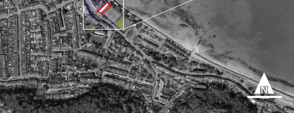
7 2. SITE ANALYSIS P HASE 2 OY STE RW HA RF, M UM B LES Location The application site, highlighted in red on the preceding page, comprises the former Tivoli Walk and an element of the existing tennis court area, which lies centrally within the urban area of Mumbles, approximately 8km to the south-west of Swansea City Centre. The site is located within Mumbles retail core which is designated as a district shopping centre and is positioned along the coastal frontage of Swansea Bay which is in an excellent location in terms of tourism attraction and visitor destination potential. The site is centered on the grid coordinates E:261684, N:188080, and its location within its local context is shown on Page 6. Site Features The Tivoli Building and Walk was constructed in the 1930s and historically accommodated a cinema with seating for up to 1,000 patrons together with ancillary uses. Prior to the redevelopment works commencing the main building accommodated a mix of leisure and retail uses. Due to the buildings past use as a cinema it exhibits a unique design and is a prominent feature along the street scene, significantly contributing to the local design vernacular. The Tivoli Walk previously had both A1 and A3 uses in operation. These uses have now ceased. Local Facilities The site is particularly well served in terms of its proximity to public transport services, with bus stops located within the immediate vicinity of the site along Mumbles Road as well as on Newton Road. Services running at these stops provide good connections with Swansea City Centre, with each service running approximately every hour. In addition to good public transport connections, there are numerous facilities/amenities within the sites locality. For example, much of Newton Road and part of Mumbles Road forms a District Shopping Centre (under Policy EC5 of the Swansea Unitary Development Plan). As already discussed, there are new commercial uses associated with the Phase 1 element of the Oyster Wharf Development which has been in operation since the end of The proposal represents the second phase of works associated with the Oyster Wharf Development adjoining the western boundary of the site, which has been in operation since the end of 2016, enhancing the setting of the Conservation Area as well as helping to revitalize the Mumbles District Centre. In terms of boundaries, the site fronts onto Mumbles Road with Image Source: Mumbles Conservation Area Review (April 2018) other retail uses located on the opposite side of the road. To the rear, is an area of public realm space associated with the Oyster Wharf Development, as well as a parking area and Mumbles promenade. Meanwhile, to the south-east, there are three public tennis courts and a bowling green. J UNE


8 Image Source: Mumbles Conservation Area Review (April 2018) J UNE
9 Mumbles Conservation Area Review April 2018 (Draft the two built-up areas are tennis courts and bowling greens The Review lists inappropriate designs and materials of some for Public Consultation) lines with trees. The Conservation Area Review states that the new and enveloping development as a weakness. The new At present, part of the site overlaps with the Mumbles attractive small sports pavilion provides a heritage note which Oyster Wharf development is regarded as a building of high Conservation Area. There is currently a draft review of the should be protected. The proposed development would require visual merit and the proposed development will maintain this Mumbles Conservation Area published for Public Consultation. the use of part of the tennis court area, but does not encroach status through the choice of materials used. The current Conservation Area includes most of the seafront areas onto the actual tennis court itself. below the high escarpment of wooded limestone cliffs, the original village streets climbing the slopes, and the wooded backdrop to The Mumbles Conservation Area Review states a number of the coastal settlement. The Conservation Area recommends the notable buildings that have qualities or characteristics that make expansion of this area northwards to include the Newton Road them focal points and important heritage features in the shopping centre, the grid of Victorian terrace houses and streetscape. On the Mumbles Road these include: The White Oystermouth castle and its grounds. If adopted, the Conservation Rose Inn; the Methodist Church; the former Post Office; the Area would increase, resulting in the proposed site being included Village Inn; the recently converted Conservative Club; The within it. George Inn; 722 Mumbles Road; and, the Bristol Channel Yacht Club building. The Review states there are few negative The diagram on Page 8 identifies the potential areas for change, as buildings which are of inappropriate scale, materials, design or a result of the Mumbles Conservation Area Review. massing and create a negative effect on the historic character of the Conservation Area. These examples are the late C20th row of The Conservation Area Review document identifies different six shops to the south of the Post Office built in brick with character areas, with the proposed development being included unsympathetic fenestration and flat roofs; and, within the Seafront Character Area. The Mumbles seafront Mumbles Road, a two-storey terrace which introduces new provides the public space of the town and, as such, its townscape materials, fenestration and roof lines which do not accord with qualities and character particularly important to protect, improve their neighbours. The image on Page 10 shows the townscape and enhance. Within this Character Area, the long line of sea characteristics along the Mumbles Road, where it can be seen facing development on the western side of the Mumbles Road that the relatively new Phase 1 aspect of the Oyster Wharf (from the Newton Road junction to the narrowing of the development is identified as a Focal Building. developable land past Verdi s restaurant to the south) presents the main townscape. A SWOT analysis was undertaken as part of the Mumbles Conservation Area review, where it is worth noting that the The area between the Mumbles Road and the sea wall is public success of the recent Oyster Wharf development has been open space where, at the northern end, the area opposite the highlighted as a strength. Another strength includes notable Newton Road junction has proposals for a new development buildings that provide focal points of interest along the seafront. called Oystermouth Square which is subject to a development The recent Oyster Wharf development is listed as a building brief and it approved as an SPG. Currently used for car parking, providing a focal point of interest and it is considered that the this site is screened by a small area of trees and grass. Between proposed development will also contribute in the same way. J UNE


10 Image Source: Mumbles Conservation Area Review (April 2018) J UNE
11 Site History An application was submitted (under reference 2014/0681) for the conversion and adaption of the building to a mixed use development and construction of 2 no. A3 units on adjacent land was approved on 05/08/2014. Subsequently, applications for various Non-Material Amendments were made in 2014 and 2015 (planning references 2014/1966, 2015/0846, and 2015/1221). There is an extant planning permission associated with the site (under reference 2016/0840), granted on 23rd June 2016, for the demolition of the existing Tivoli Walk building to be replaced by a new three storey building incorporating ground floor commercial area (Class A1 and A3) with external roof terrace above and other associated works. The Delegated Panel Report associated with the extant planning permission stated that, in terms of the visual amenity of the consented scheme, the Tivoli is a significant building just outside the boundary of the Mumbles Conservation Area and the already approved redevelopment proposals will enhance the setting of the Conservation Area as well as helping to revitalize the Mumbles District Centre. The current Tivoli Walk buildings are of no architectural interest, but the existing low single storey scale means that they are neutral with regard to the Conservation Area. The report goes on to say that, in terms of highways, the extant permission will effectively increase the provision of A3 use and applying the parking standards in isolation suggests that additional parking would be required. Experience has shown that increases in floor area does not necessarily result in a corresponding increase in parking demand and as the existing offering does not have exclusive parking available, it is likely that any increase in demand brought about by the improved facilities will be accommodated in public parking as currently. Opportunities Sustainable Location The site s proximity to the transport network and strong public transport facilities (i.e. bus stops located along Mumbles Road and Newton Road) as well as a number of facilities within its proximity contribute to its sustainability. Pedestrian Linkages - Provision for pedestrians is of a good standard within the immediate vicinity of the site, with wide footways on both sides of the carriageway. In addition, a signal controlled pedestrian crossing is located on Mumbles Road, approximately 70m to the northwest of the application site. Oyster Wharf Development - The proposal represents phase 2 of the Oyster Wharf development. The wider development is seen as a significant project within Mumbles and the proposal is a further commitment to fully regenerating what is to become an important destination within the Swansea Bay Region. Constraints Flood Risk Area - The application site is located within a Zone C2 flood risk area. A flood risk assessment will be submitted as part of the planning application to consider the risks associated with flooding. Part loss of existing tennis courts - The proposal will involve the loss of some of the existing tennis court area. Consideration will need to be given to keeping this impact to a minimum. Residential Amenity - Consideration will be given to residential dwellings within the vicinity of the proposed development, to ensure any potential impact is kept to a minimum. An opportunities and constraints plan is shown on Page 13. J UNE
12 Proposed Site Boundary J UNE


13 OPPORTUNITIES AND CONSTRAINTS Newton Road Mumbles Road Mumbles Road KEY Application Site Partial Loss of Community Recreation Facility Main Roads Zone C2 Flood Risk Area Bus Stops Consideration to residential amenity of nearby dwellings Phase 1 of Oyster Wharf Development Footway/Cycle Facilities J UNE
 and its associated Technical Advice Notes (TANs), together with the Local Planning Policy and its")
, published by the Welsh Government in November 2016.")

14 3. PLANNING POLICY FRAMEWORK P HASE 2 OY STE RW HA RF, M UM B LES Policy The planning policy framework for the determination of this application is provided by the content and scope of National Planning Policy, which is contained within the ninth edition of Planning Policy Wales (PPW) and its associated Technical Advice Notes (TANs), together with the Local Planning Policy and its supplementary planning guidance. A summary of the relevant national and local policy is as follows. Planning Policy Wales National planning policy is contained within the Ninth edition of Planning Policy Wales (PPW), published by the Welsh Government in November PPW is supported by 21 topic-based Technical Advice Notes (TANs), which are also relevant. PPW is the Welsh Government s principal planning policy document, setting out the context for sustainable land use planning policy, within which Development Plans are prepared and development control decisions are taken. Technical Advice Notes The following Technical Advice Notes are considered relevant to this proposed development, and have been taken into account for this application: TAN 11: Noise (1997) TAN 12: Design (2016) TAN 18: Transport (2007) TAN 4: Retail and Commercial Development (2016) TAN 23: Economic Development (2014) Supplementary Planning Guidance (SPG) District Centres, Local Centres and Community Facilities (2010) Mumbles Conservation Area Review (April Draft currently released for Public Consultation) Parking Standards Planning Obligations Planning for Community Safety The statutory development plan for the site is provided by the City and County of Swansea Unitary Development Plan (UDP) which was formerly adopted in March One of the strategic spatial visions of the plan is to develop Swansea s waterfront location, this is underpinned by the Swansea Bay Strategy. It focuses on the 8.5km of waterfront from Swansea Marina in the east to Mumbles Pier in the west,. Policy Relating to reference Strategic Policies EV1 Design EV2 Siting and Location EV3 Accessibility EV9 Conservation Areas EV13 Shopfronts EV36 Development and Flood Risk EV40 Air, Noise and Light Pollution EC5 District Shopping Centres ECNR Non Retail Uses with Shopping Centres AS1 New Development Proposals AS2 Design and Layout AS5 Walking and Cycling AS6 Parking AS10 Traffic Management and Highway Safety Swansea Unitary Development Plan Section 38(6) of the Planning and Compulsory Purchase Act 2004 requires that decisions be made in accordance with the development plan unless material considerations indicate otherwise. J UNE

 J")
15 Application Site shown within Swansea UDP Proposals Map (Part within District Shopping Centre and Mumbles Conservation Area) J UNE


16 5. RESPONSE TO FIVE OBJECTIVES OF GOOD DESIGN P HASE 2 OY STE RW HA RF, M UM B LES Overview This chapter is to explore the relevant design and access facets associated with the application and will assess the planning merits associated with the scheme. A series of plans that will accompany the planning submission are shown from Page 19. These include elevation plans, floor plans and perspective drawings. The five objectives of good design are a set of principle considerations, as outlined in Technical Advice Note 12, to ensure developments effectively respond to local context so that they assimilate into the locality and are functional for their intended user. The Five Objectives of Good Design are Access, Movement, Character, Environmental Sustainability and Community Safety each of which will be dealt with separately in turn below. Access and car parking The development will include multiple building access points which will be designed in accordance with Approved Document M, the relevant British Standards and Planning Policies. The existing Tivoli Walk is proposed to be retained, providing access to the hotel entrance and the newly developed Tivoli Building and ground floor level, but also maintaining the pedestrian route between the Mumbles Road and the Promenade. The restaurant access will be from the rear of the promenade, with the retail unit access from the Mumbles Road. sustainable location with considerable opportunity for movement by non-car modes. The Transport Statement which accompanied the wider development also focussed on assessing impacts associated with increased private vehicle movements. No parking provision is proposed as part of the current proposals and this will be provided by the Local Authority on the existing adjacent tennis courts. A Movement Map showing surrounding streets, main roads and public transport links is shown on page 17. Movement A Transport Statement accompanied the wider proposals for the Tivoli Development and this examined the transport infrastructure within the vicinity of the site. It undertook a descriptive audit of the sites accessibility and movement by foot, bicycle and public transport. This concluded that the site is within a J UNE
17 North to Swansea City Centre MOVEMENT MAP West to Murton, Bishopston, Southgate, Pennard, Oxwich, Port Eynon South-east to Mumbles Pier, Langland, Caswell KEY Main Road Footways/Cycle Route Bus Stops J UNE


18 Character The proposed building design is based around simple forms and simple detailing. The proposed pallet of materials complements the recently completed Phase 1 development. The existing Pier 39 retail unit is proposed to be demolished to make way for a new 2 storey building with ground floor commercial area and a hotel at the first and second floors. Landscaping The proposed development requires one tree to be removed, however it is not considered that this would have a long-term impact on the visual appearance of the surrounding area. The adjacent landscaping proposals for the Tivoli development will be extended as part of the current proposals. The ground floor commercial area will accommodate 125 square metres of trading space for the retail unit and 2500 square foot of trading space for the restaurant. The roof over the restaurant will include an external terrace as part of Le Bistrot Pierre. The proposed building is three storeys in scale albeit there is an element which is significantly set back above the ground floor. This helps provide a transition in scale between the proposal and the adjacent development without detracting from the overall visual amenity of the redevelopment. The layout of the development provides pedestrian access throughout. The existing Tivoli Walk is retained yet improved and the layout allows for improved trading space for the occupier. This would reinforce the adjacent completed development and complement its use and attractiveness. The layout also allows for a seamless interaction with the Tivoli buildings. As already discussed, it is noted that the schedule for the Mumbles Conservation Area is currently being reviewed and is likely to be extended. However, the proposals are considered appropriate for the immediate context which is influenced by the maritime environment in the vicinity. The drawings included within this DAS illustrate the proposals for the development. J UNE
19 J UNE
20 Environmental Sustainability It is intended that the commercial units will incorporate sustainable construction methods to achieve excellent energy efficiency ratings. The design solution seeks to use passive measures such as orientation, natural ventilation and natural light as much as possible to respond to energy hierarchy. Community Safety TAN 12 suggests that community safety can be achieved via design solutions that can aid crime prevention. These include providing natural surveillance, improving safety by reducing conflicts in uses, and promoting a sense of ownership and responsibility. The wider development has reconfigured the Tivoli Building and introduced additional units to the north so that there is a much greater focus on the foreshore location. This is further reinforced by the current proposals so that increased activity will give rise to better natural surveillance and a feeling of security, especially during operating hours. J UNE
21 J UNE
22 J UNE
23 6. APPRAISAL & CONCLUSION P HASE 2 OY STE RW HA RF, M UM B LES Principle of Development Firstly, in consideration with the principle of development, there is already an extant planning permission on-site (under reference 2016/0840) for the demolition of the Tivoli Walk building to be replaced by a new three storey building incorporating a ground floor commercial area. In addition, the proposal represents the second phase of works associated with the Oyster Wharf development, seen as a significant project within Mumbles and the proposal acts as a further commitment to fully regenerating what is to become an important destination within the Swansea Bay region. The proposed development is located within a designated district centre and, as a mixed-use development, is considered to be in accordance with Policy EC5 and ECNR. Visual Amenity The proposed development relates to the second phase of the Tivoli redevelopment. The Tivoli building is a significant building just outside the boundary of the Mumbles Conservation area (although the draft review of the Mumbles Conservation Area shows an extended conservation area boundary) and the first phase of the development has enhanced the setting of the Conservation Area and has helped revitalise the Mumbles District Centre. In addition, the existing Tivoli Walk buildings are of very little architectural merit and, it is considered that, the proposed development is a betterment over the existing situation. The proposed development is based around simple forms and simple detailing, with the pallet of materials to be used complemented and enhancing the recently completed Phase 1 of the development. The proposed building design is based around simple forms and simple detailing. The proposed pallet of materials complements the recently completed Phase 1 development. The proposal is therefore considered a positive addition that will enhance the character, appearance and setting of the Mumbles Conservation Area, and is within accordance with Policy EV1, EV2 and EV13 of the Swansea UDP. Residential Amenity The scale, siting, and layout of the proposed development has been designed to minimise any detrimental impacts upon the amenity of existing any future occupiers. The use of the roof terrace (providing an external area for Le Bistrot Pierre) is not considered to cause any disturbance in terms of background noise generated by conversation/laughter etc. For example, the unstable British climate would mean that the rooftop terrace would likely be limited to some 9-12 weeks a year maximum (assuming good summer weather). Highways The Delegated Panel Report for the extant planning permission stated that: This proposal will effectively increase the provision of A3 use and applying the parking standards in isolation suggests that additional parking would be required. Experience has shown that increases in floor area does not necessarily result in a corresponding increase in parking demand and as the existing offering does not have exclusive parking available, it is likely that any increase in demand by the improved facilities will be accommodated in public parking as currently. It is considered that any increase in parking demand as a result of the development proposals will be accommodated in public parking spaces. Therefore, it is considered that the proposals would be in-line with Policy AS5, AS6, and AS10 of the Swansea UDP. Conclusion This DAS has been prepared on behalf of Next Colour Ltd to accompany a full planning application for the proposed demolition of the existing Tivoli Walk and construction of a three storey building comprising an 16 bed hotel, ground floor commercial use (Use Classes A1 and A3), and other associated works, on land occupied by the Tivoli Walk and part of the existing tennis court area, Mumbles Road, Swansea. The site benefits from an extant planning permission for the demolition of the existing Tivoli Walk building to be replaced by a new three storey building incorporating ground floor commercial area (Class A1 and A3) with external roof terrace above and other associated works. In light of the above, it is concluded that the proposal fully accords with both national and local policies and there are no material considerations which should prevent the planning application from being determined in accordance with the relevant planning policy framework. J UNE
2. The application, which is a full plans application, is for a commercial development comprising B1, D1, D2 and A3 uses.
 Former Taff Vale Shopping Centre, Taff Street, Pontypridd, CF37 4TR PLANNING APPLICATION SUPPORTING STATEMENT May 2017 Ref.11431/1 INTRODUCTION AND APPLICATION CONTEXT 1. This planning application statement
STATEMENT OF OBJECTION TO THE PROPOSED DEVELOPMENT OF LAND AT CHURCH CLIFF DRIVE FILEY
 STATEMENT OF OBJECTION TO THE PROPOSED DEVELOPMENT OF LAND AT CHURCH CLIFF DRIVE FILEY You will be aware that Scarborough borough council have adopted a new local plan that includes land at Church Cliff
Newcourt Masterplan. November Exeter Local Development Framework
 Newcourt Masterplan November 2010 Exeter Local Development Framework Background The Exeter Core Strategy Proposed Submission sets out the vision, objectives and strategy for the development of Exeter up
PLANNING STATEMENT. On behalf of Hindle Property Investments Ltd. Site of the Former Hippodrome Henblas Street, Wrexham LL13 8AD
 PLANNING STATEMENT On behalf of Hindle Property Investments Ltd Site of the Former Hippodrome Henblas Street, Wrexham LL13 8AD Construction of 2 retail units and 13 no apartments August 2018 Martin Planning
Schedule of Planning Applications Committee Date: 23 May Reference: 06/17/0726/F Parish: Hemsby Officer: Mr J Beck Expiry Date:
 Schedule of Planning Applications Committee Date: 23 May 2018 Reference: 06/17/0726/F Parish: Hemsby Officer: Mr J Beck Expiry Date: 22-05-2018 Applicant: Proposal: Site: Mr Gillett Change of use to the
Perth and Kinross Council Development Management Committee 20 February 2013 Report of Handling by Development Quality Manager
 Perth and Kinross Council Development Management Committee 20 February 2013 Report of Handling by Development Quality Manager 4(4)(iii) 13/81 Erection of sports hall, associated changing facilities, offices
Derry City and Strabane District Council Planning Committee Report
 Derry City and Strabane District Council Planning Committee Report COMMITTEE DATE: 23 rd March 2016 APPLICATION No: APPLICATION TYPE: PROPOSAL: LOCATION: APPLICANT: LA11/2015/0395/F Residential Development
Land Adj. 63 Sunny Bank Road, Sutton Coldfield, Birmingham, B73 5RJ
 Committee Date: 11/07/2013 Application Number: 2013/03520/PA Accepted: 20/05/2013 Application Type: Full Planning Target Date: 15/07/2013 Ward: Sutton Vesey Land Adj. 63 Sunny Bank Road, Sutton Coldfield,
Cow & Snuffers, Llandaff North Design and Access Statement. 08 April 2011 Client: Michelle Hartley
 Cow & Snuffers, Llandaff North Design and Access Statement 08 April 2011 Client: Michelle Hartley Contents 1.0 Introduction 1 2.0 Understanding the Context 3 3.0 Planning Context 9 4.0 Vision and Objective
DELEGATED DECISION on 1st September 2015
 Application N o : 14/04810/OUT LONDON BOROUGH OF BROMLEY TOWN PLANNING RENEWAL AND RECREATION DEPARTMENT DELEGATED DECISION on 1st September 2015 14/04810/OUT Claire Harris 4 Oaklands Road Bromley BR1
intu Bromley Planning Summary Bringing more to Bromley February 2014
 intu Bromley Planning Summary February 2014 Bringing more to Bromley Contents Introduction 1 Description of the Proposals 2 Economic Benefits 4 Planning Policy 6 Cinema and Catering Assessment 7 Design
Design Review Report Former YMCA Building, Bridgend DCFW Ref: N164 Meeting of 12th April 2018
 Design Review Report Former YMCA Building, Bridgend DCFW Ref: N164 Meeting of 12 th April 2018 Review Status PUBLIC Meeting date 12 th April 2018 Issue date 18 th April 2018 Scheme location Bridgend Scheme
DESIGN & ACCESS STATEMENT
 DESIGN & ACCESS STATEMENT Land off Frondeg Terrace, Llanelli December 2017 T: 029 2073 2652 T: 01792 480535 T: 01454 203599 Cardiff Swansea Bristol F: 029 2073 2670 E: mail@asbriplanning.co.uk W: www.asbriplanning.co.uk
Planning, Design and Access Statement
 Planning, Design and Access Statement November 2018 Demolition of Lansdowne House and garage, and part of the existing adjacent William Ainge Court development, and redevelopment and reconfiguration of
I615. Westgate Precinct
 I615. Westgate Precinct I615.1. Precinct Description The Westgate Precinct is located approximately 18km west of the Auckland city centre. There are seven Sub-precincts in the Westgate Precinct: Sub-precinct
SUBMISSION TO DRAFT FINGAL COUNTY DEVELOPMENT PLAN RE: LANDS AT CASTLEKNOCK VILLAGE CENTRE
 April 2016 SUBMISSION TO DRAFT FINGAL COUNTY DEVELOPMENT PLAN 2017-2023 RE: LANDS AT CASTLEKNOCK VILLAGE CENTRE On behalf of: Lidl Ireland GmbH Submitted to: Planning & Strategic Infrastructure Department
Longbridge Town Centre Phase 2 Planning Application
 Longbridge Town Centre Phase 2 Planning Application Non-Technical Summary of the Environmental Statement December 2013 Introduction A full application for Planning Permission has been submitted to Birmingham
DESIGN & ACCESS STATEMENT
 DESIGN & ACCESS STATEMENT Demolition of Detached Dwellinghouse and Construction of 11 Dwellinghouses with Access Road & Associated Infrastructure, Ystradgynlais, Powys On Behalf of Watree Homes Limited
PHASE III: Reserved Matters Submission
 Statement of Compliance with the outline approval for the proposed residential development of land at: BURGES LANE, WIVELISCOMBE PHASE III: Reserved Matters Submission Foreword Contents: This Statement
6 Site Framework Strategies
 6 Site Framework Strategies 6.1 Introduction Section 6 identifies a number of specific areas which are considered to be key sites within the Plan area and which may have potential for development / redevelopment.
Description Details submitted pursuant to discharge of condition 5 (Design Code) attached to planning permission 13/01729/OUT.
 attached to planning permission 13/01729/OUT.") ITEM 9 Application Number: 18/00266/DISCON Description Details submitted pursuant to discharge of condition 5 (Design Code) attached to planning permission 13/01729/OUT. AT The Point, 602 Midsummer Boulevard,
ITEM 9 Application Number: 18/00266/DISCON Description Details submitted pursuant to discharge of condition 5 (Design Code) attached to planning permission 13/01729/OUT. AT The Point, 602 Midsummer Boulevard,
GREENFORD HALL & ADJOINING LAND
 GREENFORD HALL & ADJOINING LAND CONTENTS 1. Introduction 1. Introduction 2. Urban Context 2.1 The Site and Surroundings 2.2 Urban Context Map 2.3 Access and Movement 3. Planning Context 3.1 Planning History
MATURE SUBURBS RESIDENTIAL DEVELOPMENT GUIDELINES
 MATURE SUBURBS RESIDENTIAL DEVELOPMENT GUIDELINES DRAFT FEBRUARY 2005 BIRMINGHAM CITY COUNCIL 1 Introduction Mature Suburbs Residential Development Guidelines - Interim Supplementary Planning Advice -
UPPER GORDON ROAD TO CHURCH HILL, CAMBERLEY CONSERVATION AREA
 Introduction This leaflet explains the purpose of conservation areas and the implication of their designation for residents, property owners and the Council. It provides you with a plan of the area and
PLANNING COMMITTEE DATE: 07/09/2015 REPORT OF THE SENIOR MANAGER PLANNING AND ENVIRONMENT SERVICE CAERNARFON. Number: 4
 Number: 4 Application Number: C15/0034/37/LL Date Registered: 21/05/2015 Application Type: Full - Planning Community: Llanaelhaearn Ward: Llanaelhaearn Proposal: Location: Summary of the Recommendation:
1 The development hereby permitted shall be carried out in accordance with the following approved plans:
 Location The Avenue Tennis Club The Avenue London N3 2LE Reference: 16/6509/FUL Received: 10th October 2016 Accepted: 10th October 2016 Ward: Finchley Church End Expiry 5th December 2016 Applicant: Mrs
REFERENCE: B/03745/12 Received: 02 October 2012 Accepted: 05 October 2012 WARD(S): Totteridge Expiry: 30 November 2012.
: Totteridge Expiry: 30 November 2012.") LOCATION: 15A Pyecombe Corner, London, N12 7AJ REFERENCE: B/03745/12 Received: 02 October 2012 Accepted: 05 October 2012 WARD(S): Totteridge Expiry: 30 November 2012 Final Revisions: APPLICANT: PROPOSAL:
LOCATION: 15A Pyecombe Corner, London, N12 7AJ REFERENCE: B/03745/12 Received: 02 October 2012 Accepted: 05 October 2012 WARD(S): Totteridge Expiry: 30 November 2012 Final Revisions: APPLICANT: PROPOSAL:
Sustainability Statement. Whitby Business Park Area Action Plan
 Sustainability Statement Whitby Business Park Area Action Plan November 2014 Contents Page 1. Introduction 1 2. Scoping 3 3. Sustainability Appraisal of Options 6 4. Assessment of Draft Area Action Plan
Tall Buildings Strategy
 Chapter 8 Tall Building Strategy Mayor of London 115 existing & consented tall buildings effect on views of palace of westminster Chapter 8 Tall Buildings Strategy tall building cluster upto 150m with
Site north of Hattersley Road West (east of Fields Farm Road), Hattersley
, Hattersley") Application Number 17/00982/REM Proposal Site Applicant Recommendation Reason for report Application for the approval of reserved matters (means of access, landscaping, layout, scale and appearance) relating
Application Number 17/00982/REM Proposal Site Applicant Recommendation Reason for report Application for the approval of reserved matters (means of access, landscaping, layout, scale and appearance) relating
Statement of Community Involvement LAND OFF SOUTHDOWN ROAD HORNDEAN, HAMPSHIRE
 LAND OFF SOUTHDOWN ROAD HORNDEAN, HAMPSHIRE CONTENTS Page 1. Introduction 3 2. Pre-application Discussions 4 3. The Consultation Process 5 4. Consultation Feedback 7 5. Responses to Consultation Feedback
Planning, Taxi Licensing and Rights of Way Committee Report. Application No: P/2018/0725 Grid Ref:
 Planning, Taxi Licensing and Rights of Way Committee Report Application No: P/2018/0725 Grid Ref: 310683.45 291656.14 Community Council: Newtown and Llanllwchaiarn Valid Date: 18/07/2018 Officer: Gemma
Site Location Plan. Land on the North West of Epsom Road Waddon Croydon. 1 : A4 September The. Waddon. Waddon.
 138 140 44.3m MP 11.5 El Sub Sta EPSOM ROAD 13 Bank 1 to 5 154 Trough 19to21 1 to 5 156 The Waddon (PH) 23 FB Waddon Station 45.0m Posts 29to31 1 to 9 Stafford Court 39 37 Meridian Court 10 43 to 45 1
Garages To Rear Of The Willows 1025 High Road London N20 0QE
 Location Garages To Rear Of The Willows 1025 High Road London N20 0QE Reference: 15/03944/FUL Received: 25th June 2015 Accepted: 2nd July 2015 Ward: Totteridge Expiry 27th August 2015 Applicant: Mr Alex
REFERENCE: B/00601/12 Received: 11 February 2012 Accepted: 21 February 2012 WARD(S): High Barnet Expiry: 17 April 2012
: High Barnet Expiry: 17 April 2012") LOCATION: 37 Kings Road, Barnet, Herts, EN5 4EG REFERENCE: B/00601/12 Received: 11 February 2012 Accepted: 21 February 2012 WARD(S): High Barnet Expiry: 17 April 2012 Final Revisions: APPLICANT: PROPOSAL:
LOCATION: 37 Kings Road, Barnet, Herts, EN5 4EG REFERENCE: B/00601/12 Received: 11 February 2012 Accepted: 21 February 2012 WARD(S): High Barnet Expiry: 17 April 2012 Final Revisions: APPLICANT: PROPOSAL:
Town of Cobourg Heritage Master Plan. Statutory Public Meeting
 Town of Cobourg Heritage Master Plan Statutory Public Meeting April 25 th 2016 Presentation Overview 1. Introduction 2. Project background and schedule overview 3. Review of strategic direction content
design & access statement Proposed Erection of 68 Bedroom Hotel and Restaurant with Associated Landscaping
 Proposed Erection of 68 Bedroom Hotel and Restaurant with Associated Landscaping Promenade, design & access statement lawrencemcphersonassociates 6 new road, ayr, ka8 8ex On Behalf of July 2015 CONTENTS
Canterbury City Council Military Road Canterbury Kent CT1 1YW. Title: CA/16/02745/ADV. Author: Planning and Regeneration.
 O Crown copyright and database rights 2017 Ordnance Survey 100019614 Title: CA/16/02745/ADV Author: Planning and Regeneration Scale 1:1,250 Map Dated: 23/01/2017 Canterbury City Council Military Road Canterbury
PLANNING STATEMENT. Market House Market Place Kingston upon Thames KT1 1JS
 PLANNING STATEMENT To support planning and listed building consent applications for change of use from Class A1 shop and Class A3 cafe to Class A3 restaurant at: Market House Market Place Kingston upon
Former North Works, Lickey Road, Longbridge, Birmingham
 Committee Date: 14/11/2013 Application Number: 2013/06431/PA Accepted: 27/08/2013 Application Type: Full Planning Target Date: 26/11/2013 Ward: Longbridge Former North Works, Lickey Road, Longbridge, Birmingham
Neighbourhood Planning Local Green Spaces
 Neighbourhood Planning Local Green Spaces Introduction... 2 1. Why green space is important... 4 2. Neighbourhood plans and green space... 6 3. Evidence... 8 Statutory designations... 9 Green space audit...
SOUTH CAMBRIDGESHIRE DISTRICT COUNCIL. Planning and New Communities Director
 SOUTH CAMBRIDGESHIRE DISTRICT COUNCIL REPORT TO: Planning Committee 3 October 2012 AUTHOR/S: Planning and New Communities Director S/1723/12/OL CAXTON AND ELSWORTH OUTLINE APPLICATION FOR ERECTION OF RESTAURANT/TAKEAWAY
Welcome. Walk Around. Talk to Us. Write Down Your Comments
 Welcome This is an information meeting introducing the applications for proposed redevelopment of the Yorkdale Shopping Centre site at 3401 Dufferin Street and 1 Yorkdale Road over the next 20+ years,
Cardiff International Sports Village Waterfront Development Volume IV : Non-Technical Summary of the Environmental Statement
 Greenbank Partnerships Ltd October 2012 Cardiff International Sports Village Waterfront Development Volume IV : Non-Technical Summary of the Environmental Statement Environmental Statement - Non Technical
DEVELOPMENT MANAGEMENT REPORT
 ITEM A08-1 DEVELOPMENT MANAGEMENT REPORT TO: BY: DATE: DEVELOPMENT: SITE: WARD: APPLICATION: APPLICANT: Development Management Committee Development Manager Proposed live/work unit in connection with existing
PLANNING COMMITTEE REPORT
 PLANNING COMMITTEE REPORT TO: BY: Planning Committee South Head of Development DATE: 19 December 2017 DEVELOPMENT: SITE: WARD: APPLICATION: APPLICANT: Conversion of existing water storage reservoir to
Report Author/Case Officer: Joanne Horner Contact Details:
 APP 04 Application Number: 16/00140/FUL Other Two storey side extension to existing dwelling and formation of hard standing to provide parking for number 54 (Resubmission of withdrawn application 15/02852/FUL)
Application Recommended for Approval Hapton with Park Ward
 Application Recommended for Approval Hapton with Park Ward APP/2017/0036 Outline Planning Application Outline application for the construction of a new 3 bedroom dwelling (with all matters reserved for
Plumpton Neighbourhood Development Plan Revised Pre Submission Document - Regulation 14 Consultation
 REPRESENTATIONS... Plumpton Parish Council Plumpton Neighbourhood Development Plan Revised Pre Submission Document - Regulation 14 Consultation Representations submitted on behalf of: Cala Homes (South
Eastbourne Borough Council. Summary Proof of Evidence Of Barry John Cansfield BA (Hons), BTP, MRTPI on behalf of PRLP
, BTP, MRTPI on behalf of PRLP") Eastbourne Borough Council (Arndale Centre and surrounding Land at Terminus Road, Sutton Road and Ashford Road) (Compulsory Purchase Order 2015) Section 226 (1)(a) of the Town and Country Planning Act
Eastbourne Borough Council (Arndale Centre and surrounding Land at Terminus Road, Sutton Road and Ashford Road) (Compulsory Purchase Order 2015) Section 226 (1)(a) of the Town and Country Planning Act
Development of land adjacent to Braggs Farm Lane and Rumbush Lane, Dickens Heath. Welcome. Today s exhibition. The proposal site
 Welcome Welcome to this event to discuss the development of land adjacent to Braggs Farm Lane. is currently in the preliminary stages of designing proposals to sensitively develop this site with high-quality
49 Broughton Avenue London N3 3EN
 Location 49 Broughton Avenue London N3 3EN Reference: 17/3448/RCU Received: 30th May 2017 Accepted: 1st June 2017 Ward: Finchley Church End Expiry 27th July 2017 Applicant: Mr P Atwal Proposal: Erection
1 The development hereby permitted shall be carried out in accordance with the following approved plans:
 Location 59 Greenway Close London N20 8ES Reference: 16/00011/HSE Received: 30th December 2015 Accepted: 7th January 2016 Ward: Totteridge Expiry 3rd March 2016 Applicant: Mr Ankit Shah Proposal: Part
Ward: West Wittering. Proposal Change of use from public highway pavement to residential garden use.
 Parish: West Wittering Ward: West Wittering WW/17/03295/FUL Proposal Change of use from public highway pavement to residential garden use. Site Izora 1 Watersedge Gardens West Wittering PO20 8RA Map Ref
Amendments to Illustrative Masterplan. Outline Planning Application RU.14/0099. Royal Holloway University of London
 Amendments to Illustrative Masterplan Outline Planning Application RU.14/0099 Royal Holloway University of London Stride Treglown job no. 15114 Prepared by AR Checked by MH Date July 2014 Revision - Revisions
LETTER OF OBJECTION LAND TO THE SOUTH WEST OF FORGE GARAGE, HIGH STREET, PENSHURST, KENT, TN11 8BU
 Senior Planning Officer Andrew Byrne Sevenoaks District Council Community & Planning Services PO Box 183 Argyle Road Sevenoaks Kent TN13 1GN 04 November 2011 Your Ref: 11/02258/FUL For the attention of
Design statement. for redevelopment of. former industrial use site at Willenhall, to. residential use.
 Design statement for redevelopment of former industrial use site at, to residential use. Good design can help create lively places with distinctive character; streets and public spaces that are safe, accessible,
Planning and Sustainability Statement
 Land adjacent to Manor Farm, Catterick Village Pallett Hill Sand and Gravel Co Ltd Proposed 10 new dwellings, (6 No market dwellings and 4 No affordable dwellings) with access, associated car parking and
Draft Hailey Neighbourhood Plan
 Persimmon Homes (Wessex) Draft Hailey Neighbourhood Plan Representations to West Oxfordshire District Council s Regulation 16 Consultation December 2018 2 Copyright 2018 Persimmon Homes Ltd. All rights
Parish of Repton NEIGHBOURHOOD DEVELOPMENT PLAN
 Parish of Repton NEIGHBOURHOOD DEVELOPMENT PLAN BASIC CONDITIONS STATEMENT December 2018 CEF 4 Legal Requirements This statement has been produced by the NDP Working Group on behalf of Repton Parish Council
Vision for Irvine: a self-confident town where people aspire to live and work and which they are proud to call home
 Vision for Irvine: a self-confident town where people aspire to live and work and which they are proud to call home Stunning view out to the harbourside Artist s impression of how the Bridgegate area could
an Inspector appointed by the Secretary of State for Communities and Local Government
 Appeal Decision Site visit made on 11 October 2016 by Mike Hayden BSc DipTP MRTPI an Inspector appointed by the Secretary of State for Communities and Local Government Decision date: 21 November 2016 Appeal
Land off Nursery Road / Church Street, Lozells, Birmingham, B19. Erection of 5 no. dwellings and retention of area of public open space.
 Committee Date: 08/08/2013 Application Number: 2013/03635/PA Accepted: 14/06/2013 Application Type: Full Planning Target Date: 09/08/2013 Ward: Lozells and East Handsworth Land off Nursery Road / Church
KOGARAH CITY COUNCIL a better lifestyle. Appendix 7 Precinct Analysis Blakehurst
 Appendix 7 Precinct Analysis Blakehurst (Blakehurst Centre) Rezone from R2 Low Density Residential to R3 - Medium Density Residential Rezone from B1 Neighbourhood Centre to B2 Local Centre Existing Zoning
Former Keighley College Buildings, North Street
 Introduction The Vision To create a high quality, mixed-use destination that will lead to the successful redevelopment of the site and contribute to the wider regeneration of the town centre The Opportunity
Town Council. Report Author/Case Officer: Alex Harrison Contact Details:
 Application Number: 09/00330/FUL ERECTION OF TWO STOREY SIDE EXTENSION AT The Pink Punters, 2 Watling Street, Fenny Stratford FOR Mr F McMahon Target: 27th April 2009 Ward: Bletchley And Fenny Stratford
5 Gratton Terrace London NW2 6QE. Reference: 17/5094/HSE Received: 4th August 2017 Accepted: 7th August 2017 Ward: Childs Hill Expiry 2nd October 2017
 Location 5 Gratton Terrace London NW2 6QE Reference: 17/5094/HSE Received: 4th August 2017 Accepted: 7th August 2017 Ward: Childs Hill Expiry 2nd October 2017 Applicant: WSD (Gratton) Ltd Proposal: The
Tennis Court Rear Of 3-5 Corringway London NW11 7ED
 Location Tennis Court Rear Of 3-5 Corringway London NW11 7ED Reference: 18/4122/FUL Received: 3rd July 2018 Accepted: 3rd July 2018 Ward: Garden Suburb Expiry 28th August 2018 Applicant: Ms Sarah Robinson
YMCA Erdington (Phase 2), 300 Reservoir Road, Erdington, Birmingham, B23 6DB
, 300 Reservoir Road, Erdington, Birmingham, B23 6DB") Committee Date: 13/06/2013 Application Number: 2013/03011/PA Accepted: 30/04/2013 Application Type: Full Planning Target Date: 30/07/2013 Ward: Stockland Green YMCA Erdington (Phase 2), 300 Reservoir Road,
Committee Date: 13/06/2013 Application Number: 2013/03011/PA Accepted: 30/04/2013 Application Type: Full Planning Target Date: 30/07/2013 Ward: Stockland Green YMCA Erdington (Phase 2), 300 Reservoir Road,
Welcome to our public exhibition
 About our development Welcome to our public exhibition This exhibition gives you the chance to view and comment on our proposals for a new residential development of 165 high-quality homes, along with
Chapter 2: OUTLINE PLANNING APPLICATION PROPOSALS. A New Garden Neighbourhood Matford Barton 17
 Chapter 2: OUTLINE PLANNING APPLICATION PROPOSALS A New Garden Neighbourhood Matford Barton 17 2.1. SUMMARY AND STATUS OF THE PROPOSALS 2.1.1. The parameter plans and associated wording in this chapter
PUBLIC REALM STRATEGY
 CONSULTATION DRAFT PUBLIC REALM STRATEGY Trenchard Street & Frogmore Street City Design Group Place Directorate Public Realm Strategy Trenchard Street & Frogmore Street Contents 1. Introduction 2. Understanding
Reference: 16/1234/HSE Received: 25th February 2016 Accepted: 2nd March 2016 Ward: High Barnet Expiry 27th April 2016
 Location 7 Sunset View Barnet EN5 4LB Reference: 16/1234/HSE Received: 25th February 2016 Accepted: 2nd March 2016 Ward: High Barnet Expiry 27th April 2016 Applicant: Proposal: Mr & Mrs Peter & Anny Woodhams
1. Objectives of this consultation
 1. Objectives of this consultation Provide an update on the results of the December 2014 consultation Provide a summary of the Pre-Submission Plan which is now out for formal consultation To ask for your
Perth and Kinross Council Development Management Committee 24 April 2013 Report of Handling by Development Quality Manager
 Perth and Kinross Council Development Management Committee 24 April 2013 Report of Handling by Development Quality Manager Alterations,Carpenter House, Carpenter Street, Perth, PH1 5GB Ref. No: 13/00303/FLL
Rev John Withy, Sion House, 120 Melmount Road, Sion Mills
 Derry City and Strabane District Council Planning Committee Report COMMITTEE DATE: 4 th October 2017 APPLICATION No: APPLICATION TYPE: PROPOSAL: LOCATION: APPLICANT: AGENT: LA11/2016/0701/F Full Retrospective
SOUTH CAMBRIDGESHIRE DISTRICT COUNCIL. Planning and New Communities Director
 SOUTH CAMBRIDGESHIRE DISTRICT COUNCIL REPORT TO: Planning Committee 5 June 2013 AUTHOR/S: Planning and New Communities Director S/0747/13/FL HISTON Construction of Car Park at Histon Baptist Church, Station
Brookside Walk Children's Play Area, London, NW4
 LOCATION: Brookside Walk Children's Play Area, London, NW4 REFERENCE: H/05584/13 Received: 26 November 2013 Accepted: 11 December 2013 WARD(S): Hendon Expiry: 05 February 2014 Final Revisions: APPLICANT:
Application Guide. Should you have any questions on the Outline Application please contact:
 Application Guide Application Guide This guide describes the structure of the Outline Application, explains the different documents that have been submitted with it and identifies what will happen next.
Persimmon Homes Thames Valley Date received: 2 nd April week date(major): 2 nd July 2014 Ward: Nascot
: 2 nd July 2014 Ward: Nascot") PART A Report of: DEVELOPMENT MANAGEMENT SECTION HEAD Date of Committee: 26 th June 2014 Site address: Rounton, 28, Nascot Wood Road Reference Number: 14/00497/REM Description of Development: Reserved
PART A Report of: DEVELOPMENT MANAGEMENT SECTION HEAD Date of Committee: 26 th June 2014 Site address: Rounton, 28, Nascot Wood Road Reference Number: 14/00497/REM Description of Development: Reserved
Seaburn. Planning Application Summary. For: Siglion. Date: 15/11/2016
 Seaburn Planning Application Summary For: Siglion - Date: 15/11/2016 Application Details Cundall submitted a planning application on behalf of Siglion to redevelop the seafront in Seaburn. Siglion is
Reference: 16/1447/FUL Received: 7th March 2016 Accepted: 7th March 2016 Ward: East Finchley Expiry 2nd May 2016
 Location 374B Long Lane London N2 8JX Reference: 16/1447/FUL Received: 7th March 2016 Accepted: 7th March 2016 Ward: East Finchley Expiry 2nd May 2016 Applicant: Ms Katrin Hirsig Proposal: Single storey
SOUTH CAMBRIDGESHIRE DISTRICT COUNCIL. REPORT TO: Planning Committee 1 April 2015 Planning and New Communities Director
 SOUTH CAMBRIDGESHIRE DISTRICT COUNCIL REPORT TO: Planning Committee 1 April 2015 AUTHOR/S: Planning and New Communities Director Application Number: Parish(es): Proposal: Site address: Applicant(s): Recommendation:
Derry City and Strabane District Council Planning Committee Report
 Derry City and Strabane District Council Planning Committee Report COMMITTEE DATE: 23rd March 2016 APPLICATION No: APPLICATION TYPE: PROPOSAL: LOCATION: APPLICANT: AGENT: LA11/2015/0263/O Outline Planning
Welcome to our exhibition
 Welcome to our exhibition The Homes & Communities Agency (HCA) welcomes you to this public exhibition explaining our proposals for the redevelopment of the former Lea Castle Hospital site. About the Homes
APP/G1630/W/15/
 Appeal Decision Site visit made on 20 October 2015 by William Fieldhouse BA (Hons) MA MRTPI an Inspector appointed by the Secretary of State for Communities and Local Government Decision date: 20 November
Test Valley Borough Council Southern Area Planning Committee 8 January 2019
 ITEM 11 APPLICATION NO. 18/02218/FULLS APPLICATION TYPE FULL APPLICATION - SOUTH REGISTERED 23.08.2018 APPLICANT Rugby Football Union SITE The Trojans Club, Stoneham Lane, Eastleigh, SO50 9HT, CHILWORTH
The Proposed Auckland Unitary Plan (notified 30 September 2013)
") 3 Business zones Introduction There are 10 business zones in the Unitary Plan: City Centre Metropolitan Centre Town Centre Local Centre Neighbourhood Centre Mixed Use General Business Business Park Light
3 Business zones Introduction There are 10 business zones in the Unitary Plan: City Centre Metropolitan Centre Town Centre Local Centre Neighbourhood Centre Mixed Use General Business Business Park Light
3 Abbey View Mill Hill London NW7 4PB
 Location 3 Abbey View Mill Hill London NW7 4PB Reference: 15/03203/HSE Received: 26th May 2015 Accepted: 16th June 2015 Ward: Mill Hill Expiry 11th August 2015 Applicant: Proposal: Mr Richard Benson Alterations
DAREBIN PLANNING SCHEME AMENDMENT C137
 Who is the planning authority? Planning and Environment Act 1987 DAREBIN PLANNING SCHEME AMENDMENT C137 EXPLANATORY REPORT This amendment has been prepared by the Darebin City Council, who is the planning
UTT/16/1466/DFO GREAT DUNMOW MAJOR
 UTT/16/1466/DFO GREAT DUNMOW MAJOR PROPOSAL: LOCATION: APPLICANT: AGENT: Reserved matters approval for the accesses to the site and principal roads within the site including spine road following outline
Page 1 of 19 URBAN DESIGN FRAMEWORK FOR BOLTON STREET WATERFORD
 Page 1 of 19 URBAN DESIGN FRAMEWORK FOR BOLTON STREET WATERFORD 1.0 Introduction: The relocation of the City Council stores and depot from Bolton Street creates an exciting opportunity for development
D4.4N Site, CMK Planning Brief
 D4.4N Site, CMK Planning Brief Adopted June 2013 (Updated March 2017) D4.4N Site, CMK Planning Brief This document has been prepared by Milton Keynes Council s Urban Design and Landscape Architecture Team
1. Welcome. Background
 1. Welcome The purpose of this exhibition is to provide you with an update on progress on the Kilnwood Vale Scheme. In order to improve the scheme and deliver key facilities earlier in the development,
6.0 Development of Amenities,
 6.0 Development of Amenities, conservation of architectural heritage and other features This chapter outlines the Area's significant potential to provide for amenities of city wide and local importance
Former Temple Cowley Pools, Oxford TEMPLE COWLEY LIBRARY * ELEVATION SHOWN IS INDICATIVE AND SUBJECT TO FINAL DESIGN AND AGREEMENT.
 OPEN SPACE TEMPLE COWLEY LIBRARY library beyond Proposed apartments Proposed apartments Proposed houses Temple Road * ELEVATION SHOWN IS INDICATIVE AND SUBJECT TO FINAL DESIGN AND AGREEMENT. * Welcome
Ipswich Issues and Options for the Ipswich Local Plan Review, August 2017, Public Consultation
 Ipswich Issues and Options for the Ipswich Local Plan Review, August 2017, Public Consultation Having reviewed the issues and options documents, the Society has made the following response: Part 1 Strategic
Place Brief. National Collections Facility (NCF site)
") Place Brief. National Collections Facility (NCF site) Contents 1.0 Purpose 2.0 Location and Proposal 3.0 Vision and Aim 4.0 Placemaking Principles 5.0 Conclusion Plan 1 Location Plan Plan 2 Placemaking
Place Brief. National Collections Facility (NCF site) Contents 1.0 Purpose 2.0 Location and Proposal 3.0 Vision and Aim 4.0 Placemaking Principles 5.0 Conclusion Plan 1 Location Plan Plan 2 Placemaking
3/29 Rhu Marina Reporter David Russell. Body or person(s) submitting a representation raising the issue (including reference number):
 submitting a representation raising the issue (including reference number):") Development Plan Reference: 3/29 Rhu Marina Reporter David Russell The Council s submission to the Reporters starts on page 194 of the report. It is in four parts, 1. Summary of representations, 2. Modifications
Development Plan Reference: 3/29 Rhu Marina Reporter David Russell The Council s submission to the Reporters starts on page 194 of the report. It is in four parts, 1. Summary of representations, 2. Modifications
[PLANNING RATIONALE] For Site Plan Control and Lifting of Holding Zone By-Law 101 Champagne Avenue. May 23, 2014
![[PLANNING RATIONALE] For Site Plan Control and Lifting of Holding Zone By-Law 101 Champagne Avenue. May 23, 2014](/thumbs/75/71599615.jpg "[PLANNING RATIONALE] For Site Plan Control and Lifting of Holding Zone By-Law 101 Champagne Avenue. May 23, 2014") [PLANNING RATIONALE] For Site Plan Control and Lifting of Holding Zone By-Law 101 Champagne Avenue May 23, 2014 Contents 1.0 Introduction... 2 2.0 Site Context... 2 2.1 Adjacent Uses... 2 Figure 1: Site
[PLANNING RATIONALE] For Site Plan Control and Lifting of Holding Zone By-Law 101 Champagne Avenue May 23, 2014 Contents 1.0 Introduction... 2 2.0 Site Context... 2 2.1 Adjacent Uses... 2 Figure 1: Site