Winchester District Local Plan Part 2 Development Management and Site Allocations Publication Draft for Consultation
|
|
|
- Christal Ford
- 5 years ago
- Views:
Transcription

1 Our ref: J tc Mr S Opacic, Head of Strategic Planning, Winchester City Council, Colebrook Street, Winchester SO23 9LJ sopacic@winchester.gov.uk 21 st December 2015 Dear Mr Opacic, Winchester District Local Plan Part 2 Development Management and Site Allocations Publication Draft for Consultation GL Hearn acts on behalf of Crest Nicholson (Crest) in relation to the promotion of SHLAA site 356 comprising land at The Vineyard and Land to the east of Tangier Lane (the Tangier Lane Site), Bishop s Waltham. Crest has been promoting the land since March 2011, through the Winchester District Local Plan Part 1 review and subsequently via the evidence gathering stages associated with development of the Bishop s Waltham Parish Development Plan and the Winchester District Local Plan Part 2 Development Management and Site Allocations. GL Hearn is instructed to make representations on behalf of Crest to the current consultation stage of the Winchester District Local Plan Part 2 Development Management and Site Allocations (hereafter LPP2). They are made with the objective of achieving a sound plan without undue delay in the preparation process. Crest remains broadly supportive of the emerging Local Plan and wishes to help constructively facilitate delivery of the key housing allocations. These representations should be read in conjunction with previous representations made by GL Hearn through the plan making process (7 th March 2014 and 5 th December 2014). Background and general approach to Housing allocations The Winchester City Council Local Plan Part 1 was adopted in March Policy MTRA2 of the Plan prescribes a target of about 500 new homes for Bishop s Waltham. The material supporting the Bishop s Waltham Development Strategy identifies 128 dwellings that are classified as completions/commitments within the Plan period, leaving a residual requirement of 372 dwellings to be allocated. Source New Dwellings Completions ( ) 49 Outstanding Permissions at 31 st March SHLAA sites within settlement boundary 24 Total Supply 128 Page 1 of 7
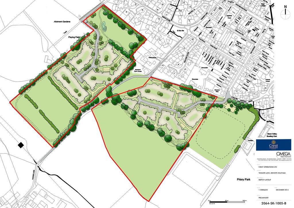
2 This approach would deliver up to 500 dwellings within the settlement via allocations, with the flexibility required by the NPPF and the target of about 500 dwellings being provided by windfalls that the Council expects to be delivered and which have not been taken into account in the supply figures. However, we noted in our previous representations to the Bishop s Waltham Development Plan (dated 7 th March 2014 and the previous consultation on the draft LPP2 dated 5 th March 2014) that reliance on all commitments coming forward and all SHLAA sites delivering as predicted is probably optimistic. Therefore, in our view it would be sensible to plan positively for a housing target at the upper end of the range implied by about 500 dwellings at Bishop s Waltham. It would be reasonable to conclude that this would be up to 550 dwellings during the Plan period. If it is assumed that around 100 of the identified commitments come forward and around 50 windfalls could be delivered then having regard to the opportunities that have been identified by the Development Strategy, it would be positive and pragmatic to aim for these allocations to deliver around 400 dwellings, subject to the requirement that sites should be delivered in accordance with the principles of sustainable development. This would provide a positive approach to planning for housing, rather than relying on all sites being delivered in full to meet the minimum requirement, and hoping that unidentified sites come forward to boost supply. It would also include a margin of flexibility and adaptability advocated by the NPPF (paragraph 14; paragraph 157). The Winchester District Local Plan Part 2 site allocations strategy identifies allocations that collectively could deliver circa 380 dwellings during the Plan period, apportioned to the following sites: Coppice Hill (Approx. 80 dwellings) Martin Street (Approx. 60 dwellings) The Vineyard and land to the East of Tangier Lane (Approx. 120 dwellings) Albany Farm (Approx. 120 dwellings) Tollgate House (limited market housing to facilitate the restoration of Tollgate House) The representations below address the proposed site allocation at The Vineyard and land to the East of Tangier Lane (the areas of SHLAA site 356 that have been identified as a development option). The Vineyard and Land to the East of Tangier Lane Allocation Crest supports the allocation of land at the Vineyard and land to the east of Tangier Lane (Tangier Lane Site) as one of the principal locations for new housing at Bishop s Waltham. The site has been identified as a result of discussions with the Bishop s Waltham Parish Council and Winchester City Council. Crest has engaged with the Bishop s Waltham Neighbourhood Plan Working Group and has provided evidence in support of the development potential of the site. Plans and proposals for development of the whole of SHLAA site 356 were drawn up and presented to the Group and advice was given on the nature of development that could be achieved. Planning and sustainability appraisals have been carried out; masterplan feasibility studies and transport assessments have been undertaken and shared with the Parish and City Councils. The work and evidence previously presented to the Councils to date has demonstrated that a 200 dwelling scheme with supporting open space, arranged across the whole of SHLAA site 356 could be delivered sustainably. The current consultation information shows the Vineyard/Tangier Lane Site (part of the SHLAA Site 356), now allocated for approximately 120 dwellings, using only the northern most part of land to the south east of Tangier Lane and the northern half of the Vineyard, to the north west of Tangier Lane. While it is acknowledged that the Councils have adopted a dispersal approach to allocating sites for residential development to meet the requirement identified in Local Plan Part 1, this should not be an exercise dictated by the objective of apportioning a set quantum of dwellings across the sites selected as the most appropriate for development, pursued without careful regard to site-specific factors; which may support the sustainable delivery of additional dwellings within these sites. Crest has prepared a draft illustrative masterplan that Page 2 of 7
3 could comfortably accommodate 120 dwellings on the land identified by the Council. Whilst Crest supports the site s allocation for 120 units, our client considers that the masterplan demonstrates the site could accommodate between 120 and 150 units. The masterplan is attached to these representations (Drg No SK-1005-B Sketch Site Layout). The layout uses the northern component of the land to the south east of Tangier Lane and the northern half of the Vineyard, to the north west of Tangier Lane. The draft concept masterplan indicates two access points, via Albany Road and The Avenue, with pedestrian and cycle links across Tangier Lane, linking the parcels either side of the lane. Highways Implications and Site Access With respect to the wider cumulative impact of the allocated housing sites upon the wider highway network at Bishop s Waltham, Winchester City Council commissioned SYSTRA, transport consultants, to undertake a study to assess the cumulative impacts of the development growth proposed within LPP2 along the B2177/B3354 corridor. The study focused on a number of key junctions along this route and in relation to Bishop s Waltham included Winchester Road/Winters Hill; Winchester Road/Old Station Road roundabout and Winchester Road/Botley Road roundabout. Traffic performance statistics revealed that these junctions have capacity to accommodate planned and background growth to With respect to access to facilities and sustainable modes of transport, the Council s Transport Assessment of Potential Site Allocations rates the site as adequate in terms of accessibility. However, the WCC Sustainability Appraisal suggests that the distance of the site from the majority of services and facilities located in the town would lead to minor negative effects in the short/medium term. The Vectos Transport Assessment prepared on behalf of Crest disagrees with this, concluding that the location of the site accords with current transport policy regarding accessibility and that local facilities and services could be conveniently accessed by a number of sustainable transport modes, including walking, cycling and public transport services. The site is well located within walking distance of the town centre and its associated health and community facilities. While it is located slightly beyond the 2 kilometre threshold for walking to the local village schools, the site is well connected to existing public rights of way and established footpath links, on routes which are not heavily trafficked. As a requirement of any allocation it would be reasonable and feasible to seek some improvement to pedestrian links between the site and key local facilities in the centre of Bishops Waltham. The Vineyard/Tangier Lane allocation is one of the two main sites identified to deliver housing growth in Bishop s Waltham, the other being Albany Farm (120 dwellings); The Vineyard/Tangier Lane site is both closer to the local schools and town centre facilities, and is also more accessible by non-motorised modes of transport. During the December 2014 public consultation on LPP2, the majority of the representations received relating to Policy BW3 The Vineyard/Tangier Lane Housing Allocation were concerned with options available to access the site. GL Hearn has advised in previous representations that three potential options exist to provide access to The Vineyard/Tangier Lane site (via Albany Road, Tangier Lane and The Avenue). In this respect a transport assessment associated with the site has been undertaken by Vectos Transport Planning. The assessment demonstrates that The Avenue and Albany Road each provide viable access options; the respective junctions with Winchester Road are each capable of safely accommodating traffic associated with a development of up to 200 dwellings. The assessment, which was submitted with previous representations made on behalf of Crest, also accompanies these representations. It demonstrates that each access option could safely accommodate a higher volume of traffic than the draft allocation would require. Additionally, the report shows that the site is well-connected and that there are no impediments to delivery in respect of safe vehicular and pedestrian access. To facilitate access via the end of The Avenue there would be a requirement for the access road to cross the corner of Priory Park, entering the allocation at the north eastern corner of the land to the east of Tangier Page 3 of 7
4 Lane. The route could be delivered with only limited land-take from the playing field, comprising an area not used for pitch provision. Title to the land, which rests with the Parish Council, has been checked and there would be no restriction on using the land for access purposes. To achieve access via Albany Road the road would extend across the unmade section of track leading to the allotments and cricket field to the south, and would be routed in an easterly direction encroaching on a small section of the land designated as a Site of Importance for Nature Conservation (SINC). As part of the proposed access works the section of carriageway leading from the end of Albany Road into the site would be made up to adoptable standard, incorporating existing sections of verge and parts of the unmade surface into parallel parking bays beyond the running sections of carriageway. Given the width of this part of the allotment access track there is also the opportunity to provide dedicated parking/loading bays for allotment holders, to the benefit of users of the allotments and residents of the local area. The extent of land would also offer an opportunity to introduce verge/boundary landscaping alongside the allotments to help enclose and shield the plots, creating an attractive arrival point at the end of Albany Road. It is noted that an access point via Tangier Lane was considered in an earlier Vectos Transport Assessment, which advised that a case could potentially be made for accessing the site from the Lane. However, given the availability of alternative options via Albany Road and The Avenue, this option was not actively pursued. Following initial feedback during the public consultation period, Vectos Transport Planning has reviewed the original assessment of Tangier Lane. The updated assessment considers that an access of suitable width could be delivered via Tangier Lane subject to the removal of some existing foliage and the relocation of street lighting. A meeting was held between Crest, Vectos Transport Planning and Hampshire County Council on 11 th December 2015 at which the principle of accessing the site via Tangier Lane was agreed. A plan submitted with these representations shows details of the proposed access points from Albany Road, The Avenue and Tangier Lane and demonstrates that all of the accesses are feasible and deliverable (Drg No SK-1100-A Indicative Access Arrangements). Crest has control over the land necessary to facilitate access via Albany Road. The land required to deliver a suitable carriageway width via Tangier Lane is either within the limits of the highway, or comprises land owned by a third party with whom Crest is in discussions regarding the securing of an option. The small section of Priory Park required to facilitate access is owned by the Parish Council, who have been instrumental in identifying and selecting the draft housing allocations, including the proposed points of access. It is therefore reasonable to conclude that they are willing to make the land available to provide a means of access. Within the representations made by Crest to the LPP2 in December 2014, it was stated that Policy BW3 should be amended to include access via Tangier Lane as an option within the policy. The latest iteration of the policy, within the Submission Draft of LPP2 makes reference to Tangier Lane as a potential means of access. However, as currently worded the policy requires the development to secure access via all three points. This is unduly onerous and as demonstrated by the submitted transport assessment, would be unnecessary. Mindful of this, the following amendments to the proposed Policy BW3 are sought: Policy BW3 The Vineyard/Tangier Lane Housing Allocation Land at The Vineyard and land east of Tangier Lane, as shown on the Policies Map, is allocated for the development of about 120 dwellings. Planning permission will be granted provided that detailed proposals accord with the Development Plan and meet the following site specific development requirements: Nature and Phasing of Development - A masterplan establishing principles for the disposition of housing, open space, access points and linkages with adjacent sites and the wider countryside, including proposals for the SINC to ensure that there is no net loss of biodiversity for the whole allocated area, should be submitted Page 4 of 7
5 with each application for development. Any subsequent applications for all or part of the site should also demonstrate how the proposal will accord with these principles and achieve the form of development intended buy this allocation as a whole. Access - Provide two points of access via Albany Road and Tangier Lane/or The Avenue, including traffic management measures to address any potential problems at the junctions with Winchester Road and with on-street parking; - Provide a new/improved footpath/cycleway along the northern edge of the site as part of a route along the southern edge of Bishop s Waltham to link with Priory Park and the Martin Street Site (Policy BW2) and the Albany Farm site (Policy BW4). Environmental - Provide substantial landscape framework to create a new settlement edge to the south and west; - Protect, retain and reinforce existing treed boundaries; - Provide on-site open space (Informal Open Space and Local Equipped Area for Play); - Minimise the impact of the access points on the Site of Importance for Nature Conservation (SINC) and Priory Park; - Improve/manage the SINC as Natural Green Space and ensure no net detriment to biodiversity (including habitat isolation and fragmentation) through onsite and, if necessary, offsite measures; - Create a green corridor along the southern boundary of the site to improve pedestrian and biodiversity links. Infrastructure - Contribute to the expansion of Bishop s Waltham Infants and Junior Schools and other infrastructure need to make the development acceptable in planning terms. Ecology During the December 2014 consultation on LPP2, Natural England raised concerns regarding the future of the SINC adjacent to Albany Road and the impact that public access may have on its integrity. Winchester City Council has had further discussions with Natural England regarding future management of the SINC during which potential compensatory biodiversity measures were explored as a requirement of the policy. It is important to note in this context that with the exception of the small corner section of the SINC required for access to The Vineyard, the draft concept masterplan shows the SINC land to the north of the Vineyard retained as an open landscaped buffer between the existing housing on Siskin Close and Ambleside and the proposed allocation. It is Crest s intention that this land would be improved and managed to the benefit of its habitat value and as a community resource. The Parish Council or Hampshire and Isle of Wight Wildlife Trust could be assigned the land, rendering it either as a publicly accessible space or as a protected area with restricted access, depending on the objectives of the beneficiary. Aspect Ecology has carried out an Ecological Appraisal of the SINC, which concludes that the current designation is merited. However, the grassland (the reason the site is of interest) has become impoverished though lack of positive management and as such, there is considerable potential to secure a net gain in biodiversity through implementation of a management strategy delivered as a requirement of any allocation. Aspect Ecology has also carried out an Ecology Appraisal of the wider site. Improved management of the SINC itself and the creation of green links and pathways through the wider design of the scheme, together with specific species mitigation and enhancement proposals, would help to facilitate net gains, in accordance with the objectives set out in the NPPF (paragraph 109). Page 5 of 7
6 Green Infrastructure Winchester City Council s Sustainability Appraisal of Potential Allocations suggests that development of the site would result in the loss of Green Infrastructure Assets. As described above, delivery of the SINC land to the north of The Vineyard as publicly accessible green space/improved habitat would deliver tangible Green Infrastructure benefits, along with suggested improvements to the pitches and environs of the allotments as outlined above. An increase in the quantum of development would help to support more comprehensive improvements in this regard. Development of the SHLAA site (and indeed the allocation now proposed) would not result in the loss of rights of way, public open space, allotments, local nature reserves or SSSIs. Contrary to the assessment it is contended that there would be GI benefits as a result of the development of the site. Through scheme design there is a valuable opportunity to create and improve lateral pedestrian links across the south of Bishop s Waltham improving accessibility to the public open space, allotments and cricket pitch immediately to the north west of the site. Housing would address these areas positively seeking to create links between the site and the under-used mini football pitch and area of green space adjoining the boundary of The Vineyard to the west. A large mature oak tree situated on this boundary could be incorporated as a key landscape feature, with dwellings fronting onto, and positively addressing it, accentuating views towards the open space beyond. The layout could create a focal point around this established landscape feature and create links around the tree into the open space to the west, thereby drawing it into the settlement and inevitably increasing its use and value to the community. Crest have been in discussions with Bishop s Waltham Cricket Club who neighbour the site to the north west with regard to the provision of an additional cricket green to the south west of The Vineyard. This is positively supported by the local cricket club and would further provide positive net green infrastructure gains to Bishop s Waltham arising from the development. Overall, the allocation would encourage incorporation and enhancement of existing green infrastructure and the creation of a network running through the southern margins of the settlement, in accordance with the draft objectives set out within the emerging Local Plan Part 2. Landscape The Council s Landscape appraisal suggests that part of the SHLAA site (south west part of the Vineyard site, to the north of Tangier Lane) is most Sensitive in landscape terms due to (its) special quality and sense of place in terms of local landscape character. This assessment of the quality of the landscape in this location is disputed. It is pertinent to note to there are large pylons running in close proximity parallel to the south western boundary of The Vineyard. Furthermore the existing hedgelines within The Vineyard site would act as obvious visual buffers to the development, and could readily be supplemented to provide screening, if required. As noted above, a concept Masterplan has been prepared to show how a scheme for residential development extending south to the first defined hedgeline within The Vineyard site could comfortably deliver 120 dwellings, including the allocated land to the east of Tangier Lane. The southern boundary of the development area within The Vineyard is bounded by a robust and clearly defined hedge with trees that create a logical and obvious line to define development on the site. Crest has also considered layout options that would take in additional land to the south within The Vineyard, extending to the second established hedgeline, which would also provide a robust, defensible boundary. The larger site could deliver further dwellings; such that if combined with the allocated land to the east of Tangier Lane there would be more than sufficient land to accommodate between 150 and 160 dwellings in total, with an extensive open space buffer extending towards that valley-bottom. The extension of the development boundary southwards within The Vineyard, to the second defined hedgeline, would create further capacity without compromising the criteria that have informed the allocation, providing a contingency position against under delivery from the other main sites (as outlined below). Page 6 of 7
7 In accordance with Policy CP2 of the Winchester District Local Plan Part 1, the site has the potential to deliver a mix of market homes for sale; affordable homes and homes attractive to the private rented sector. It is considered that the sites identified by the Councils at Bishop s Waltham to accommodate the range of housing required are realistic. However, the quantum of development allocated to each should be adjusted to provide a more robust strategy to deliver up to the 400 dwellings advocated within these representations. Accordingly, it is suggested that the strategy for Bishop s Waltham should be defined as follows: Coppice Hill (Approx. 60 dwellings) Martin Street and Part of Priory Park (Approx. 60 dwellings) The Vineyard and land to the East of Tangier Lane (approx. 160 dwellings) Albany Farm (approx. 120 dwellings) Tollgate House (limited market housing to facilitate the restoration of Tollgate House) The Vineyard and land east of Tangier Lane site represents a sustainable location for new housing development in Bishop s Waltham. It is currently identified as having capacity for approximately 120 dwellings. However, there is potential for the quantum of development on the site to be increased without compromising any of the Councils objectives for allocation and to help provide a contingency against potential under delivery from some of the other proposed residential sites. If you require any further information please contact me without hesitation. Yours sincerely, Tony Clements Planning Director tony.clements@glhearn.com Enc: Illustrative Masterplan 2064-SK-1005-B Sketch Site Layout Indicative Access Arrangements 2064-SK-1100-A Indicative Access Arrangements Page 7 of 7
8

9
WHITELEY TOWN COUNCIL NORTH WHITELEY DEVELOPMENT SEPTEMBER 2014
 WHITELEY TOWN COUNCIL NORTH WHITELEY DEVELOPMENT SEPTEMBER 2014 Dear Resident This Special Edition of the Whiteley Voice which has been prepared in conjunction with the North Whiteley Consortium is to
Plumpton Neighbourhood Development Plan Revised Pre Submission Document - Regulation 14 Consultation
 REPRESENTATIONS... Plumpton Parish Council Plumpton Neighbourhood Development Plan Revised Pre Submission Document - Regulation 14 Consultation Representations submitted on behalf of: Cala Homes (South
Blandford Forum Town Council, Blandford St Mary Parish Council and Bryanston Parish Council
 Blandford Forum Town Council, Blandford St Mary Parish Council and Bryanston Parish Council Blandford + Neighbourhood Plan 2 Pre-Submission Plan Consultation (November 2018) Representations submitted on
Neighbourhood Planning Local Green Spaces
 Neighbourhood Planning Local Green Spaces Introduction... 2 1. Why green space is important... 4 2. Neighbourhood plans and green space... 6 3. Evidence... 8 Statutory designations... 9 Green space audit...
Land at Rampton Road. Cottenham
 Land at Rampton Road Cottenham Introduction TEP is preparing an outline planning application for 54 dwellings on 6.9 hectares of land adjacent to Rampton Road, Cottenham on behalf of the owners Cambridgeshire
SOUTH EAST LINCOLNSHIRE LOCAL PLAN: HOUSING PAPER DONINGTON (JUNE 2016)
") SOUTH EAST LINCOLNSHIRE LOCAL PLAN: HOUSING PAPER DONINGTON (JUNE 2016) 1 DONINGTON S PLACE IN THE SPATIAL STRATEGY 1.1 Policy 2 of the South East Lincolnshire Local Plan 2011-2036 Draft for Public Consultation
SOUTH EAST LINCOLNSHIRE LOCAL PLAN: HOUSING PAPER DONINGTON (JUNE 2016) 1 DONINGTON S PLACE IN THE SPATIAL STRATEGY 1.1 Policy 2 of the South East Lincolnshire Local Plan 2011-2036 Draft for Public Consultation
LEEDS SITE ALLOCATIONS PLAN MATTER 3 GREEN BELT KCS DEVELOPMENT AUGUST 2017
 LEEDS SITE ALLOCATIONS PLAN MATTER 3 GREEN BELT KCS DEVELOPMENT AUGUST 2017 Smith Limited Suite 9C Joseph s Well Hanover Walk Leeds LS3 1AB T: 0113 2431919 F: 0113 2422198 E: planning@peacockandsmith.co.uk
Kibworth Harcourt. Introduction. Introduction
 Introduction Introduction Welcome to this public exhibition on the proposals for the delivery of new homes on land at The Kibworths. The purpose of today s exhibition is to give you the opportunity to
Test Valley Borough Council Southern Area Planning Committee 8 January 2019
 ITEM 11 APPLICATION NO. 18/02218/FULLS APPLICATION TYPE FULL APPLICATION - SOUTH REGISTERED 23.08.2018 APPLICANT Rugby Football Union SITE The Trojans Club, Stoneham Lane, Eastleigh, SO50 9HT, CHILWORTH
Newcourt Masterplan. November Exeter Local Development Framework
 Newcourt Masterplan November 2010 Exeter Local Development Framework Background The Exeter Core Strategy Proposed Submission sets out the vision, objectives and strategy for the development of Exeter up
an Inspector appointed by the Secretary of State for Communities and Local Government
 Appeal Decision Site visit made on 23 January 2017 by Gareth Wildgoose BSc (Hons) MSc MRTPI an Inspector appointed by the Secretary of State for Communities and Local Government Decision date: 6 February
Public Consultation. Land at Monks Farm, North Grove. Welcome
 Welcome Welcome to our public exhibition for development on Land at Monks Farm, orth Grove. Gallagher Estates and Gleeson Strategic Land are preparing an outline planning application for new homes, open
Great Easton Neighbourhood Plan Statement of Basic Conditions
 Great Easton Neighbourhood Plan 2017-2031 Statement of Basic Conditions OCTOBER 2016 GREAT EASTON PARISH COUNCIL Contents 1.0 Introduction....Page 2 2.0 Summary of Submission Documents and Supporting Evidence..
A payment of 1080 is due in this instance, for a meeting and follow up written response, and will be made by card over the phone.
 JPPC ref: AG/6002 18 th September 2014 Planning Services Vale of White Horse District Council Benson Lane Crowmarsh Gifford Wallingford OX10 8ED Dear Sir/Madam REQUEST FOR PRE-APPLICATION ADVICE RE: RESIDENTIAL
Parish of Repton NEIGHBOURHOOD DEVELOPMENT PLAN
 Parish of Repton NEIGHBOURHOOD DEVELOPMENT PLAN BASIC CONDITIONS STATEMENT December 2018 CEF 4 Legal Requirements This statement has been produced by the NDP Working Group on behalf of Repton Parish Council
Settlement Boundaries Methodology North Northumberland Coast Neighbourhood Plan (August 2016)
") Introduction This background paper sets out a methodology for the definition of settlement boundaries in the North Northumberland Coast Neighbourhood Plan. The neighbourhood plan is planning positively
Introduction This background paper sets out a methodology for the definition of settlement boundaries in the North Northumberland Coast Neighbourhood Plan. The neighbourhood plan is planning positively
Draft Hailey Neighbourhood Plan
 Persimmon Homes (Wessex) Draft Hailey Neighbourhood Plan Representations to West Oxfordshire District Council s Regulation 16 Consultation December 2018 2 Copyright 2018 Persimmon Homes Ltd. All rights
PHASE III: Reserved Matters Submission
 Statement of Compliance with the outline approval for the proposed residential development of land at: BURGES LANE, WIVELISCOMBE PHASE III: Reserved Matters Submission Foreword Contents: This Statement
3. Neighbourhood Plans and Strategic Environmental Assessment
 1. Introduction This report sets out a draft Screening Determination for the Preston Parish Council s Neighbourhood Plan and has been prepared by rth Hertfordshire District Council. The purpose of the
Oxford Green Belt Study. Summary of Final Report Prepared by LUC October 2015
 Oxford Green Belt Study Summary of Final Report Prepared by LUC October 2015 Project Title: Oxford Green Belt Study Client: Oxfordshire County Council Version Date Version Details Prepared by Checked by
Welcome. Land adjacent Sandy Lane WALTHAM CHASE THE PROPOSED SITE
 Land adjacent Sandy Lane WALTHAM CHASE Existing Linden Homes developments Welcome Welcome to Linden Homes Southern s ( Linden ) public exhibition about its proposals for a range of high-quality homes for
Joint Core Strategy Rushden Sustainable Urban Extension
 Date Page 1 of 18 Report Originator Title Planning Manager Joint Core Strategy Rushden Sustainable Urban Extension 1. PURPOSE OF REPORT 1.1 To consider representations received on the emerging Joint Core
Chapter 2: OUTLINE PLANNING APPLICATION PROPOSALS. A New Garden Neighbourhood Matford Barton 17
 Chapter 2: OUTLINE PLANNING APPLICATION PROPOSALS A New Garden Neighbourhood Matford Barton 17 2.1. SUMMARY AND STATUS OF THE PROPOSALS 2.1.1. The parameter plans and associated wording in this chapter
DEVELOPMENT MANAGEMENT REPORT
 ITEM A08-1 DEVELOPMENT MANAGEMENT REPORT TO: BY: DATE: DEVELOPMENT: SITE: WARD: APPLICATION: APPLICANT: Development Management Committee Development Manager Proposed live/work unit in connection with existing
South Worcestershire Development Plan. South Worcestershire Design Guide Supplementary Planning Document
 South Worcestershire Development Plan South Worcestershire Design Guide Supplementary Planning Document Statement of Consultation: Early Engagement Scoping Paper February 2017 1. Introduction 1.1 This
Ref: A073350/SM/sm Date: 13 September 2013
 Ref: A073350/SM/sm Date: 13 September 2013 Ian Parkinson Development Control Team Leader Planning Portsmouth City Council Civic Offices Guildhall Square Portsmouth PO1 2AY Dear Ian LIGHT & GLEAVE VILLA
Statement of Community Involvement LAND OFF SOUTHDOWN ROAD HORNDEAN, HAMPSHIRE
 LAND OFF SOUTHDOWN ROAD HORNDEAN, HAMPSHIRE CONTENTS Page 1. Introduction 3 2. Pre-application Discussions 4 3. The Consultation Process 5 4. Consultation Feedback 7 5. Responses to Consultation Feedback
Longbridge Town Centre Phase 2 Planning Application
 Longbridge Town Centre Phase 2 Planning Application Non-Technical Summary of the Environmental Statement December 2013 Introduction A full application for Planning Permission has been submitted to Birmingham
an Inspector appointed by the Secretary of State for Communities and Local Government
 Appeal Decision Site visit made on 24 October 2017 by Jonathan Price BA(Hons) DMS DipTP MRTPI an Inspector appointed by the Secretary of State for Communities and Local Government Decision date: 22 ND
DUNSFOLD NEIGHBOURHOOD PLAN Site Selection Policies
 DUNSFOLD NEIGHBOURHOOD PLAN Site Selection Policies The criteria for assessing sites for future housing and business development in Dunsfold are set out below. (Development criteria, covering what it is
HAYLE NEIGHBOURHOOD PLAN FUTURE HOUSING EXPANSION VISION DOCUMENT. Prepared for Hayle Neighbourhood Plan Steering Group by AECOM
 HAYLE NEIGHBOURHOOD PLAN FUTURE HOUSING EXPANSION VISION DOCUMENT Prepared for Hayle Neighbourhood Plan Steering Group by AECOM December 2015 1. Introduction Context Hayle is a linear town situated in
Cotswolds AONB Landscape Strategy and Guidelines. June 2016
 Cotswolds AONB Landscape Strategy and Guidelines June 2016 Cotswolds AONB Landscape Strategy and Guidelines Introduction The evolution of the landscape of the Cotswolds AONB is a result of the interaction
LETTER OF OBJECTION LAND TO THE SOUTH WEST OF FORGE GARAGE, HIGH STREET, PENSHURST, KENT, TN11 8BU
 Senior Planning Officer Andrew Byrne Sevenoaks District Council Community & Planning Services PO Box 183 Argyle Road Sevenoaks Kent TN13 1GN 04 November 2011 Your Ref: 11/02258/FUL For the attention of
Wallingford Neighbourhood Plan
 Wallingford Neighbourhood Plan Introduction What is neighbourhood planning? Neighbourhood planning was introduced by the Localism Act 2011 to give local people more influence over how development comes
University Park, Worcester Non Technical Summary December 2011
 University Park, Worcester Non Technical Summary December 2011 Introduction UW Wrenbridge LLP, a Joint Venture Company of the University of Worcester and Wrenbridge Land Ltd (the Applicants ) intend to
an Inspector appointed by the Secretary of State for Communities and Local Government
 Appeal Decision Site visit made on 6 November 2017 by Rachel Walmsley BSc MSc MA MRTPI an Inspector appointed by the Secretary of State for Communities and Local Government Decision date: 19 th January
Proposed Amendment to the
 Proposed Amendment to the Carrigaline Electoral Area Local Area Plan Amendment No 1: Carrigaline (T-02, O-02 & U-02) August 2012 Proposed Amendment to the Carriagline Electoral Area Local Area Plan 2011
Planning Application 13/00952/FULLS at Ampfield Hill, Romsey, Test Valley: Great Crested Newt Survey Following on From Ecological Assessment
 10 June 2014 Mr Allan Clark esq Ampfield Parish Council Blue Haze Ampfield Hill Ampfield Romsey SO51 9BD By email only Our Ref: P13/46 Dear Mr Clark Planning Application 13/00952/FULLS at Ampfield Hill,
WELCOME. Land North of STEVENAGE. We would like to thank you for attending our public exhibition today.
 WELCOME We would like to thank you for attending our public exhibition today. The purpose of this event is to share our proposals and hear your thoughts on our ideas. Members of the project team are on
Land at Fiddington Hill Nursery, Market Lavington
 Land at Fiddington Hill Nursery, Market Lavington Briefing Report for Market Lavington Parish Council Persimmon Homes (Wessex) April 2016 Background This brief report has been prepared following the Market
CA//17/02777/FUL. Scale 1:1,250. Planning Services Canterbury City Council Military Road Canterbury Kent CT1 1YW
 O CA//17/02777/FUL Scale 1:1,250 Map Dated: 15/03/2018 Planning Services Canterbury City Council Military Road Canterbury Kent CT1 1YW AGENDA ITEM NO 16 PLANNING COMMITTEE APPLICATION NUMBER: SITE LOCATION:
Welcome to our exhibition
 Welcome to our exhibition The Homes & Communities Agency (HCA) welcomes you to this public exhibition explaining our proposals for the redevelopment of the former Lea Castle Hospital site. About the Homes
APP/G1630/W/15/
 Appeal Decision Site visit made on 20 October 2015 by William Fieldhouse BA (Hons) MA MRTPI an Inspector appointed by the Secretary of State for Communities and Local Government Decision date: 20 November
Case Officer: Sarah Kay File No: CHE/14/00515/REM Tel. No: (01246) Plot No: 2/6132 Ctte Date: 15 th September 2014 ITEM 1
 Plot No: 2/6132 Ctte Date: 15 th September 2014 ITEM 1") Case Officer: Sarah Kay File No: CHE/14/00515/REM Tel. No: (01246) 345786 Plot No: 2/6132 Ctte Date: 15 th September 2014 ITEM 1 APPROVAL OF RESERVED MATTERS FROM APPLICATION CHE/12/00234/OUT (1) LAYOUT,
Case Officer: Sarah Kay File No: CHE/14/00515/REM Tel. No: (01246) 345786 Plot No: 2/6132 Ctte Date: 15 th September 2014 ITEM 1 APPROVAL OF RESERVED MATTERS FROM APPLICATION CHE/12/00234/OUT (1) LAYOUT,
Great Easton Sustainable Housing Development Sites - Site Seven, Broadgate extension site SHLAA Ref HSG/03)
") Great Easton Sustainable Housing Development Sites - Site Seven, Broadgate extension site SHLAA Ref HSG/03) 1. Introduction The Great Easton Neighbourhood Plan Group are preparing a Neighbourhood Plan
Great Easton Sustainable Housing Development Sites - Site Seven, Broadgate extension site SHLAA Ref HSG/03) 1. Introduction The Great Easton Neighbourhood Plan Group are preparing a Neighbourhood Plan
Carterton Construction Ltd is bringing forward plans for up to 85 new family homes and extra care facilities on land east of Burford.
 Welcome Carterton Construction Ltd is bringing forward plans for up to 85 new family homes and extra care facilities on land east of. We are at the early stages of designing our proposals and have a number
WELCOME GYPSY LANE. Wider Site Location plan. Proposals for the development of LAND OFF FOXLYDIATE LANE WEBHEATH. Proposals for the development of
 WELCOME The developers are preparing an outline planning application for a residential led development and need the community s views in order to develop the proposals further WHAT IS PROPOSED? A high
Peter Brett Associates LLP (PBA) act on behalf of db symmetry ltd in respect of the proposed symmetry park, Kettering development (the Site).
 act on behalf of db symmetry ltd in respect of the proposed symmetry park, Kettering development (the Site).") Our ref: 30062 2 nd August 2017 Kettering Borough Council Planning Department Municipal Offices Bowling Green Rd Kettering NN15 7QX 61 Oxford Street Manchester M1 6EQ T: +44 (0)161 245 8900 E: manchester@peterbrett.com
Our ref: 30062 2 nd August 2017 Kettering Borough Council Planning Department Municipal Offices Bowling Green Rd Kettering NN15 7QX 61 Oxford Street Manchester M1 6EQ T: +44 (0)161 245 8900 E: manchester@peterbrett.com
GREENBANK DEVELOPMENT MASTERPLAN
 DEVELOPMENT MASTERPLAN POTENTIAL TRAIN STATION COMMUNITY CENTRE Greenbank will be a connected masterplanned community providing easy access to local and surrounding amenity. Affordable quality homes, green
Built Up Area Boundary (BUAB)
") Parish Boundary Built Up Area Boundary (BUAB) Potential Sites Map not to scale DWELLING SIZE POLICY Residential developments must provide a mix of dwelling sizes (market and affordable) that reflect the
Parish Boundary Built Up Area Boundary (BUAB) Potential Sites Map not to scale DWELLING SIZE POLICY Residential developments must provide a mix of dwelling sizes (market and affordable) that reflect the
UTT/16/1466/DFO GREAT DUNMOW MAJOR
 UTT/16/1466/DFO GREAT DUNMOW MAJOR PROPOSAL: LOCATION: APPLICANT: AGENT: Reserved matters approval for the accesses to the site and principal roads within the site including spine road following outline
Rochford District Council Allocations Development Plan Document: Discussion and Consultation Document Sustainability Appraisal
 Option SWH1 Balanced Communities Option SWH1 1 To ensure the delivery of high quality sustainable communities where people want to live and work Will it ensure the phasing of infrastructure, including
Wildlife and Planning Guidance: Neighbourhood Plans
 Wildlife and Planning Guidance: Neighbourhood Plans This Leaflet is one of a series of 4 Wildlife and Planning Guidance Leaflets and is intended to provide useful information to assist you to campaign
SPG 1. * the northern and western sections which are open fields used for pasture and grazing;
 SPG 1 1.0 INTRODUCTION This development brief is based on the allocation of the Priors Hall site for employment and countryside recreational purposes in the Corby Borough Local Plan. The brief is intended
Planning Department Dover District Council Council Offices White Cliffs Business Park Dover Kent CT16 3PJ. Our Ref: MB/LP/11002.
 Planning Department Dover District Council Council Offices White Cliffs Business Park Dover Kent CT16 3PJ Our Ref: MB/LP/11002 1 June 2016 Dear Sir/Madam, RE LINWOOD YOUTH CENTRE, 92 MILL ROAD, DEAL, CT14
WELCOME. Welcome and thank you for visiting today.
 WELCOME Welcome and thank you for visiting today. Bellway Homes Ltd (Yorkshire) are preparing a reserved matters planning application for a residential development of 293 homes at land North of Yew Tree
Schedule of Planning Applications Committee Date: 23 May Reference: 06/17/0726/F Parish: Hemsby Officer: Mr J Beck Expiry Date:
 Schedule of Planning Applications Committee Date: 23 May 2018 Reference: 06/17/0726/F Parish: Hemsby Officer: Mr J Beck Expiry Date: 22-05-2018 Applicant: Proposal: Site: Mr Gillett Change of use to the
8.0 Design and Form of Development 43/
 42/ 8.0 Design and Form of Development 43/ Rothwells Farm, Golborne/ Development Statement Figure 7. Site Constraints Key 44/ Site Boundary 360 Bus Route/Stops Existing Trees Underground Water Pipe Sensitive
Plumpton Neighbourhood Plan Site Assessment Report
 Plumpton Neighbourhood Plan Site Assessment Report May 2016 1 Contents 1. Introduction 3 2. Methodology 4 2.1 Identification of Potential Sites 4 2.2 Assessment Process 5 2.3 Assessment Criteria 6 2.4
CALA HO ME S WELCOME
 WELCOME Welcome to this public consultation event for our proposed residential development of 56 high quality homes on land to the north east of Station Road in Earls Colne. Thank you for taking the time
EAST OF ENGLAND OFFICE
 Mr Philip Isbell Direct Dial: 01223 582751 Mid Suffolk District Council 131 high Street Our ref: P00524468 Needham Market Ipswich Suffolk IP6 8DL 18 January 2017 Dear Mr Isbell T&CP (Development Management
Welcome. Site/11/04. Site/11/03. Proposed Site. 11,400 new homes needed in east Cambs
 Welcome Welcome to our consultation on our proposals for new homes on land north east of Soham Road, Fordham. Members of the project team are available to answer any questions you have and listen to feedback.
LAND EAST OF MILL LANE, SHERBURN VILLAGE PLANNING STATEMENT
 LAND EAST OF MILL LANE, SHERBURN VILLAGE PLANNING STATEMENT On behalf of The Church Commissioners for England Land East of Mill Lane, Sherburn Village Planning Statement On Behalf of The Church Commissioners
Neighbourhood Plan Representation
 Date: 10 th November 2017 Neighbourhood Plan Representation Land to the east of Callow Hill Road, Alvechurch Introduction This representation has been prepared by RPS Planning and Development on behalf
Ward: Southbourne. Outline application with all matters reserved. Erection of 5 no. dwellings and associated works.
 Parish: Southbourne Ward: Southbourne SB/16/00205/OUT Proposal Site Outline application with all matters reserved. Erection of 5 no. dwellings and associated works. Dunkirk South Lane Southbourne Emsworth
Welcome to our Public Consultation
 About our development This exhibition gives you the chance to view and comment on our emerging plans for a proposed residential development located on land to the West of Alwyn Road, Rugby. Welcome to
INTRODUCTION. Land south of Bishopswood Lane, Tadley
 0 INTRODUCTION THE SITE Introduction Gladman Developments Ltd. has successfully invested in communities throughout the UK over the past 0 years, developing high quality and sustainable residential, commercial
WINCHESTER TOWN 3.1 LOCATION, CHARACTERISTICS & SETTING
 WINCHESTER TOWN 3.1 LOCATION, CHARACTERISTICS & SETTING 3.1.1 The area referred to by the City Council, as Winchester Town, consists of the Winchester Wards plus the adjoining built up areas of Badger
Site Assessment Technical Document Appendix A: Glossary
 Central Bedfordshire Council www.centralbedfordshire.gov.uk Site Assessment Technical Document Appendix A: Glossary July 2017 1.1.11-1 - ii Appendix A: Glossary Term Agricultural Land Classification AONB
Site ref: AS06 Site Name or Address: Murreys Court, Agates Lane
 Site ref: AS06 Site Name or Address: Murreys Court, Agates Lane Proposed Land Use: Total Site Area (Ha): Housing 1.85 Ha Description: It is understood that the owner has no plans to dispose of the site
1. Nantwich - Planning for a Sustainable Future
 1. Nantwich - Planning for a Sustainable Future Cheshire East Council is charged with preparing its Development Plan to guide housing and other growth over the period to 2030. The Council intends to publish
Welcome to our exhibition
 Welcome to our exhibition housing development A46 Wildmoor Alcester Road Canal Quarter A422 Town Centre housing development Warwickshire-based IM Properties, one of the UK s largest privately owned property
Briefing Document of CNP. June 2017
 Cholsey Parish Council Cholsey Neighbourhood Plan Briefing Document of CNP June 2017 Cholsey Neighbourhood Plan Page! 1 of! 8 Cholsey Plan Briefing v1.4 Page Left Intentionally Blank Cholsey Neighbourhood
2014/0590 Reg Date 26/06/2014 Chobham
 2014/0590 Reg Date 26/06/2014 Chobham LOCATION: PROPOSAL: TYPE: APPLICANT: OFFICER: ASCOT PARK POLO CLUB, WESTCROFT PARK FARM, WINDLESHAM ROAD, CHOBHAM, WOKING, GU24 8SN Erection of a two storey detached
3.1 The hybrid planning application proposes the following description of development:
 CHAPTER 3: PROPOSED DEVELOPMENT 3.1 The hybrid planning application proposes the following description of development: Hybrid (part-outline/part-full) planning application for a single composite development
Toddington Central Bedfordshire Stage 3 Green Belt Study December 2017
 Toddington Central Bedfordshire Stage 3 Green Belt Study December 2017 Site: ALP086 - Middle Lakes, Toddington Site size (ha): 2.83 Site: ALP086 - Middle Lakes, Toddington Site size (ha): 2.83 Site description
SOUTH CAMBRIDGESHIRE DISTRICT COUNCIL. Planning and New Communities Director
 SOUTH CAMBRIDGESHIRE DISTRICT COUNCIL REPORT TO: Planning Committee 9 January 2013 AUTHOR/S: Planning and New Communities Director S/2270/12/FL FEN DRAYTON 850m long flood defence embankment ranging in
2.4 Site Photographs. 4 View of Listed Building looking East. 3 View looking north west of the field adjacent to the site from existing hard standing
 Looking north on to from the junction to 2 View towards the entrance of from 3 View of southern access to site from Riddles Road 4 3 2 4 Looking west on to from southern access to site View of Grade II
LONGDEN VILLAGE DEVELOPMENT STATEMENT
 LONGDEN VILLAGE DEVELOPMENT STATEMENT 2017-2027 1 Longden Development Statement 2017-2027 15/01/18 1. Background 1.1 Longden Village Longden village is a very rural and traditional community first mentioned
Development of land adjacent to Braggs Farm Lane and Rumbush Lane, Dickens Heath. Welcome. Today s exhibition. The proposal site
 Welcome Welcome to this event to discuss the development of land adjacent to Braggs Farm Lane. is currently in the preliminary stages of designing proposals to sensitively develop this site with high-quality
Applicant: Mr C Fletcher Agent: Ms B Stala Case Officer: Sally Smith (HBC) Jill Lee (WCC) Ward: Stakes Parish Southwick and Widley
 Jill Lee (WCC) Ward: Stakes Parish Southwick and Widley") Site Address: Berewood Phase 2 Development Site, London Road, Purbrook, Waterlooville Proposal: Reserved Matters Application for landscaping of Phase A of the Town Park (under Condition 6(i)d)), together
Site Address: Berewood Phase 2 Development Site, London Road, Purbrook, Waterlooville Proposal: Reserved Matters Application for landscaping of Phase A of the Town Park (under Condition 6(i)d)), together
1. Local Plan Context
 1. Local Plan Context WHY ARE YOU HERE? ABOUT US PLANNING APPLICATION CONSULTATION Stewart Milne Homes are in the process of preparing a detailed planning application for a development of approximately
Planning and Sustainability Statement
 Land adjacent to Manor Farm, Catterick Village Pallett Hill Sand and Gravel Co Ltd Proposed 10 new dwellings, (6 No market dwellings and 4 No affordable dwellings) with access, associated car parking and
24 April Mr Charles Judson Planning Officer St. Edmundsbury District Council West Suffolk House Western Way Bury St Edmunds IP33 3YU
 24 April 2017 Mr Charles Judson Planning Officer St. Edmundsbury District Council West Suffolk House Western Way Bury St Edmunds IP33 3YU Dear Mr Judson Re: DC/17/0521/FUL Creation of municipal operational
Table of Allocated Housing Sites
 Draft as of 0 November 016 Table of Allocated Housing s Name Green 1 (30, 33, 10, 169, 36/ 100) Barratt s Farm Balsall Common Yes 57 800 Includes existing park. Listed buildings to edge of site. of search
Planning and Regulatory Committee 20 May Applicant Local Councillor Purpose of Report
 Planning and Regulatory Committee 20 May 2014 7. APPLICATION FOR PLANNING PERMISSION FOR THE CARRYING-OUT OF DEVELOPMENT PURSUANT TO PLANNING PERMISSION REFERENCE NUMBER 603451 DATED 28 FEBRUARY 2007 WITHOUT
Departure from the Development Plan. Town Council objection to a major application. DETERMINE
 Item No. 9 APPLICATION NUMBER CB/17/01642/OUT LOCATION Land rear of 43 to 91 Silver Birch Avenue South of Alder Green and Aspen Gardens, Aspen Gardens, Stotfold PROPOSAL Outline application for up to 95
Draft Western District Plan
 Powered by TCPDF (www.tcpdf.org) Draft Western District Plan Submission_id: 31440 Date of Lodgment: 15 Dec 2017 Origin of Submission: Online Organisation name: Goodman Property Services Australia Pty Ltd
Public Consultation 23 January Peel Hall, Warrington Board 1. A message from Satnam... Site history...
 Board 1 A message from Satnam... Thank you for attending today s public consultation about proposals to develop a new residential neighbourhood at. The display boards show why the development is needed
LAND EAST OF HORNDEAN. 1. Welcome. Morrisons supermarket. Keydell Nurseries A3(M)
") 1. Welcome Bloor Homes welcomes you to today s Public Exhibition relating to development proposals for Land to the East of Horndean. Idsworth Close Rowlands Castle Road Roa d Dell Piece East J2 Pyle Farm
1. Welcome Bloor Homes welcomes you to today s Public Exhibition relating to development proposals for Land to the East of Horndean. Idsworth Close Rowlands Castle Road Roa d Dell Piece East J2 Pyle Farm
Plaistow and Ifold Neighbourhood Plan Pre-Submission Consultation Draft
 Mrs Beverley Weddell Clerk to Plaistow And Ifold Parish Council Lock House Lodge Knightons Lane Dunsfold, GU8 4NU. Dear Mrs Weddell, Our ref: Your ref: Telephone Fax HD/P5402/ 01483 252040 18 th October
Welcome to our public exhibition
 About our development Welcome to our public exhibition This exhibition gives you the chance to view and comment on our proposals for a new residential development of 165 high-quality homes, along with
INTRODUCTION NORTH HEYBRIDGE GARDEN SUBURB
 INTRODUCTION This event is being hosted by the promoters of the proposed North Heybridge Garden Suburb who are working with Maldon District Council and other key stakeholders on the preparation of a comprehensive
Reserved Matters application for a site that straddles the boundary between CBC and BBC
 BBC APPLICATION 15/02682/MAR NUMBER CBC APPLICATION CB/15/04294/RM NUMBER LOCATION Wixams Land at former storage depot, Bedford Road, Wilstead Bedfordshire PROPOSAL Reserved Matters Application for Strategic
WILMCOTE NEIGHBOURHOOD PLAN
 WILMCOTE NEIGHBOURHOOD PLAN 1. Introduction. 1.1 David Holmes Planning Ltd has been instructed to advise Wilmcote Parish Council, who wish to prepare a Neighbourhood Plan. In particular we are asked to
CHRISTOPHER WICKHAM ASSOCIATES Town Planning Consultancy
 ROCHFORD CORE STRATEGY EXAMINATION STATEMENT BY CHRISTOPHER WICKHAM ASSOCIATES (4961) ON BEHALF OF INNER LONDON GROUP (9917) POLICY H1 THE EFFICIENT USE OF LAND FOR HOUSING REPRESENTATION ID: 16190 CHRISTOPHER
Land at Pirton Fields. South Churchdown, Innsworth Design and Access Statement Addendum
 Land at Pirton Fields South Churchdown, Innsworth Design and Access Statement Addendum February 2017 Revisions Revision Date Description Prepared Approved Document No. 15-45-CR02 - Land at Pirton Fields
Tarrington Neighbourhood Development Plan Housing site assessment
 Tarrington Neighbourhood Development Plan Housing site assessment December 2015 Dr DJ Nicholson DJN Planning Ltd 1. Introduction 1.1 Tarrington Neighbourhood Development Plan (NDP) Steering Group have
1. Welcome. Background
 1. Welcome The purpose of this exhibition is to provide you with an update on progress on the Kilnwood Vale Scheme. In order to improve the scheme and deliver key facilities earlier in the development,
Perth and Kinross Council Development Management Committee 8 June Pre-Application Report by Development Quality Manager
 Perth and Kinross Council Development Management Committee 8 June 2016 5(3)(i) 16/259 Pre-Application Report by Development Quality Manager Residential development at St Martins Road, Land 120 metres West