ACQUISITION PROJECT FOR Greenlands Acquisition Project for
|
|
|
- Gordon Tyler
- 5 years ago
- Views:
Transcription

1 ACQUISITION PROJECT FOR A Greenlands Acquisition Project for

2 1.0 INTRODUCTION TABLE OF CONTENTS AUTHORITY RESOLUTION At Meeting #8/15 of Toronto and Region Conservation Authority held on September 25, 2015 the following was adopted by Resolution #A161/15. THAT the Greenlands Acquisition Project for be approved; THAT the Minister of Natural Resources and Forestry be requested to approve the project pursuant to Section 24 of the Conservation Authorities Act; THAT the project be circulated to Toronto and Region Conservation Authority (TRCA) participating municipalities as the basis for funding and land securement opportunities; THAT the project be circulated to the Credit Valley, Central Lake Ontario and Lake Simcoe Region conservation authorities, Nature Conservancy of Canada and Oak Ridges Moraine Land Trust and other relevant organizations for their information and as the basis for any joint land securement opportunities which may arise; AND FURTHER THAT authorized TRCA officials be directed to take any necessary action to implement the Greenlands Acquisition Project AUTHORITY RESOLUTION... i LIST OF BOXES... iii LIST OF FIGURES... iii LIST OF MAPS... iii LIST OF TABLES... iii EXECUTIVE SUMMARY...iv 1 INTRODUCTION Greenlands Securement Public Benefits of Greenlands Securement Healthy Rivers and Shorelines Greenspace and Biodiversity Sustainable Communities Business Excellence, a Green Economy and Responsive Governance CONTEXT The Living City Vision The United Nations Earth Charter Legislated Mandate and Purpose of Conservation Authorities SUPPORT AND DIRECTION FOR GREENLANDS SECUREMENT TRCA Plans, Policies and Projects Building The Living City: 10-Year Strategic Plan, The Living City Policies for Planning and Development in the Watersheds of the TRCA Environmental Protection Sustainable Near-urban Agriculture Cultural Heritage Preservation Integrated Restoration Prioritization Framework Drinking Water Source Protection Provincial Land Use Plans and Policies LEGACY OF LAND SECUREMENT TYPES AND TOOLS OF GREENLANDS SECUREMENT Types of Ownership Fee Simple Easements Conservation Easements Access Easements Covenants Leases and Agreements Greenlands Securement Tool Box PROPERTY SELECTION Criteria for Greenlands Securement Factors for Greenlands Securement FINANCIAL STRATEGY Land Securement Costs Land Securement Funding Sources Federal Government Provincial Government Municipal Funding Partners City of Toronto Regional Municipality of Durham Regional Municipality of Peel Regional Municipality of York Town of Mono and Township of Adjala-Tosorontio Local Municipalities Non-government Organizations Foundations, Private and Corporate Donations Greenlands Care and Uses Management Agreements Special Agreements and Rentals Conservation Parks Education Field Centres Limited Interest Acquisitions Other TRCA Lands Conservation Land Care Costs CONCLUSION Priorities for 2016 to REFERENCES i ii
3 LIST OF BOXES EXECUTIVE SUMMARY Box 2.1: Conservation authorities objectives and powers regarding greenlands securement in the Conservation Authorities Act, R.S.O. 1990, Chapter Box 4.1: TRCA land securement projects, LIST OF FIGURES Figure 4.1: TRCA land securement, Figure 4.2: TRCA greenlands per capita, LIST OF MAPS Map 1.1: TRCA greenlands... 2 LIST OF TABLES Table 4.1: TRCA greenlands by securement method, as of December 31, Table 4.2: TRCA greenlands by watershed, as of December 31, Table 4.3: TRCA greenlands by municipality, as of December 31, Table 5.1: TRCA greenlands securement tools Table 7.1: Funding sources for TRCA greenlands securement Table 7.2: TRCA greenlands management categories Table 7.3: TRCA conservation land care program components The purpose of the Greenlands Acquisition Project for (GAP) is to provide background about, and implementation tools for, the securement of greenlands by Toronto and Region Conservation Authority (TRCA). The Greenlands Acquisition Project for set a target of 1,000 hectares of greenlands to be secured during 5 year term of the project. Toronto and Region Conservation Authority has secured 802 hectares of this 1,000 hectares-target as of December 31, This GAP builds on the Greenlands Acquisition Project for and previous TRCA land securement projects. It continues on the course of those projects with new knowledge and refined direction provided by Building The Living City, TRCA s strategic plan for , and The Living City Policies for Planning and Development in the Watersheds of the Toronto and Region Conservation Authority, and provincial plans for land use. Securements made under the GAP are based primarily on identifying and assessing land opportunities which may arise in the real estate market. Therefore, the project is limited by the unpredictable nature of this market. This document discusses the need for securing greenlands into public ownership and the role of acquisition in relation to other forms of securement. It relates the GAP to the broader context of TRCA s vision for The Living City and to the United Nations Earth Charter. Details of TRCA s legislated mandate for land securement are also provided. Recent support for greenlands securement is provided by plans and strategies. These include TRCA s integrated watershed and waterfront plans that combine the latest science including the Terrestrial Natural Heritage System Strategy, provincial plans for drinking water source protection and provincial land use plans. Toronto and Region Conservation Authority s history of securement began with purchases in the late 1940s and involved numerous projects that made these purchases possible. The GAP reviews the types of ownership and the tools used by TRCA to secure greenlands. Toronto and Region Conservation Authority evaluates greenlands against the criteria and factors for securement established in the GAP. Finally the project details the financial strategy including potential funding partners. The GAP identifies funding partners and estimated financial contributions over its five year duration. By making a projection based on experience in recent years, it is estimated that TRCA could secure approximately 1,000 hectares (2,500 acres) over the five year duration of the GAP, at a projected purchase expense of $ million. iii iv
: Regulation and planning, including provincial policy, official plans and")
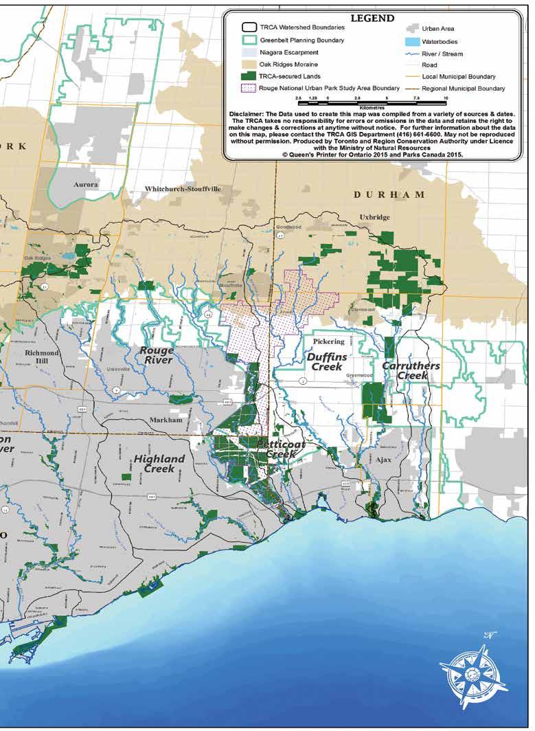
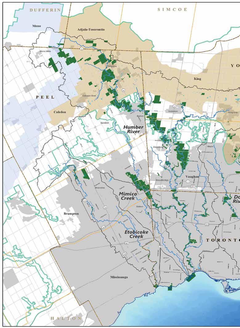
4 1.0 INTRODUCTION 1 INTRODUCTION 1.1 Greenlands Securement Land securement relies on various tools including the following (see Section 5 for more details): Regulation and planning, including provincial policy, official plans and zoning. Stewardship, including voluntary action, which can be encouraged by incentives and education. Securement of full or partial interest, by means such as fee simple, covenant, easement, lease or agreement. Secures public access for outdoor education, an interregional trail and other appropriate resource-based recreation or other uses. Ensures the land remains unaltered in order to protect important or sensitive species, landforms, features or functions, and thus ensures more certainty of permanent care and control than other methods can provide (e.g., Environmentally Significant Areas, habitat for species at risk and wellhead protection zones). Conserves a key property when no other solution exists. 1.2 Public Benefits of Greenlands Securement Toronto and Region Conservation Authority is the environmental custodian of the lands and waters in its jurisdiction, which is the most populous city region in Canada. A city region is healthy only when it has clean air, clean water, a sound natural heritage system, and natural areas and open space for its people. Greenlands are lands that support a healthy city region. A permanently secure system of publicly-owned greenlands is required to provide all of these. Greenlands are not only spaces to be set aside elsewhere, but are integral to the city environment. Toronto and Region Conservation Authority undertakes a broad variety of projects and programs to meet its legislated mandate of conserving, restoring, developing and managing natural resources other than gas, oil, coal and minerals. Key to the success of these projects has been the securement of greenlands into public ownership. Over 18,000 hectares (over 44,500 acres) of greenlands have been secured by TRCA between 1949 and 2014 which is 7.2% of TRCA s jurisdiction. Map 1.1 shows the distribution of these lands within the 249,000 hectares (615,000 acres) of TRCA s jurisdiction. The Toronto region continues to experience enormous population growth and urban areas are expanding rapidly. Urban development threatens the quantity and quality of our water and natural areas. A larger population has greater need for the benefits of natural areas. There is growing public understanding and appreciation of the values of such lands. Until around the turn of the 21st century the amount of publicly owned greenlands in the TRCA region was no longer keeping pace with the increases in population. With the continued population increase through initiatives such as intensification, brownfields redevelopment and greenfields redevelopment, TRCA must continue its securement of greenlands. Within the past five years, TRCA has secured large blocks of greenlands in its securement of Bolton Camp in the Town of Caledon and the Greenwood Conservation Lands in the City of Pickering. Municipal and provincial land use regulations and plans are important, but such plans to protect natural areas are susceptible to policy revisions and cannot guarantee protection in perpetuity. Private land stewardship is also important, but offers no certainty that owners will practice careful stewardship, or that voluntary stewardship will be continued by future owners. The GAP deals with greenlands securement. Other TRCA policies and programs such as Ontario Regulation 166/06, The Living City Policies for Planning and Development in the Watersheds of the Toronto and Region Conservation Authority (TRCA, 2014) and watershed plans address regulation, planning and stewardship. Acquisition is often the most financially costly approach to securing greenlands, and is therefore used where the public interest cannot be achieved effectively through planning, regulation or voluntary measures such as stewardship. Land acquisition will be considered where the securement: Expands properties already in public ownership. Provides a link between lands which are already in public ownership. Facilitates a project such as flood control, erosion control or shoreline protection. Is needed to regenerate a degraded area. The Toronto region offers a vibrant economy and a high quality of life, attributes that are enjoyed by residents and serve to attract investment and immigrants from around the world. The region s economy and quality of life are dependent in no small measure upon the many environmental, economic, social and health benefits provided by natural areas and processes. In The Living City Report Card, TRCA calculated the known annual value of the existing natural cover (not including street and backyard trees) in its jurisdiction as a community asset with an annual value of over $1.2 billion (Greening Greater Toronto and TRCA, 2011). This number would double if the system is expanded to the targeted natural system in the Terrestrial Natural Heritage System Strategy (TRCA, 2007). As the urban area expands, additional buildings and pavement block the absorption of water and degrade its quality. Natural habitats are lost, their quality is degraded and biodiversity is reduced. Population growth creates more demand for outdoor recreation and puts greater pressure on remaining natural areas. Securing greenlands for public ownership offers many benefits that allow a community to thrive and grow. The securement of greenspace must keep pace with urbanization and population growth to maintain these benefits, supporting human health and quality of life. 1 2
5 1.0 INTRODUCTION 1.0 INTRODUCTION 3 4


6 1.0 INTRODUCTION 1.0 INTRODUCTION Healthy Rivers and Shorelines Healthy rivers and shorelines is one of the four pillars of TRCA. The Living City envisions a city region where the water in our rivers, streams and waterfront is swimmable, fishable and easily treatable for drinking, even in the most highly populated areas. Greenlands secured through the GAP will protect our waters. Natural landforms and natural cover encourage the absorption of rain and snowmelt. This serves to reduce runoff, flooding and erosion, recharge soil moisture, groundwater and wetlands, and sustain baseflow in streams and rivers. Secured greenlands can buffer streams from agricultural or industrial activities, filter runoff, and exclude incompatible uses from wellhead areas and recharge zones, thereby protecting drinking water sources. A report by The Trust for Public Land s Center for City Park Excellence indicates that Philadelphia experienced US$16 million in annual public cost savings as a result of storm water management and air pollution reduction (The Trust for Public Land, 2008). In a study to capture the value of services provided by trees in the Puget Sound basin, American Forests estimated that tree cover in the country s urban growth boundary area had reduced stormwater storage costs by US$910 million (American Forests, 1998). Riverside vegetation reduces bank erosion, and tree shade keeps streams cool in summer for the benefit of native fish. Secured valley lands provide space for rivers to flood naturally without damage to property. All these functions benefit not only the immediate area, but the entire downstream watercourse. Securing river headwater lands in the Oak Ridges Moraine can benefit all Toronto area river systems, the downstream municipalities and Lake Ontario. Along the Lake Ontario waterfront, shorelines that are secured in public ownership provide protection for coastal processes, such as natural erosion of shorelines and transportation of sediments, offer water-based recreational opportunities, provide public access, and present unique views and vistas of Lake Ontario Greenspace and Biodiversity Another pillar of TRCA, greenspace and biodiversity, envisions a robust, resilient and equitably distributed system of green infrastructure that provides ecological services to all residents of The Living City. Greenlands secured through the GAP will protect natural communities that are important in Ontario and Canada. Toronto and Region Conservation Authority s jurisdiction overlaps the Carolinian and the Great Lakes St. Lawrence forest regions, which is the most species rich in Canada, and the provincially significant Oak Ridges Moraine and Niagara Escarpment (also a UNESCO World Biosphere Reserve). The natural communities of these areas, and of the river valleys and waterfront, include many types of forests and wetlands, as well as some natural meadows and coastal habitats. They are home to diverse plants and animals, including 688 species of conservation concern, both resident and migratory. Kettle lakes, streams, estuaries and Lake Ontario are home to fish and other aquatic species of plants and animals. Genetic diversity is crucial to their long term survival, and provides resilience to mediate natural stresses and stresses caused by humans. Greenlands providing healthy terrestrial and aquatic natural heritage systems can sustain that biodiversity. A healthy, diverse ecosystem keeps populations in balance and pests under control. Natural organisms provide many services. They recycle organic wastes into nutrients, maintain soil structure and fertility, and recycle oxygen and carbon dioxide to maintain a healthy atmosphere and to moderate temperature Sustainable Communities Well planned neighbourhoods that provide easy access to employment, school, recreation and amenities on foot or by bicycle and support a variety of careers, lifestyles and income levels are part of the TRCA s sustainable communities pillar. Greenlands secured through the GAP make our communities more sustainable and more liveable in many ways. Vegetation can reduce noise pollution. Woodlands can absorb carbon dioxide emissions from cars in the atmosphere and store it for generations. Trees can remove sulphur dioxide, reduce particulates in the air and provide for the oxygen needs of people. By reducing air pollution levels, the burden of disease from stroke, heart disease, lung cancer, and both chronic and acute respiratory diseases, including asthma, can be reduced. The lower levels of air pollution, the better the cardiovascular and respiratory health of the population will be, both long- and short-term. Reducing outdoor air pollution also reduces emissions of carbon dioxide and short-lived climate pollutants such as black carbon particles and methane, thus contributing to the near- and long-term mitigation of climate change (World Health Organization, 2014). Evaporation from the leaves of a large tree in summer can provide a cooling effect similar to air conditioners. In a study to capture the value of services provided by trees in the Puget Sound basin, American Forests estimated that tree cover in the country s urban growth boundary area had reduced generated annual air quality savings of US$19.5 million (American Forests, 1998). A report by The Trust for Public Land s Center for City Park Excellence indicates that Philadelphia experienced US$16 million in annual public cost savings as a result of storm water management and air pollution reduction (The Trust for Public Land, 2008). Toronto and Region Conservation Authority works with municipalities and community groups to develop an inter regional trail system, with routes along the Oak Ridges Moraine, the Lake Ontario waterfront, the Niagara Escarpment and the river valleys from the Oak Ridges Moraine to the waterfront. Such trails require secure corridors of public greenlands. Toronto and Region Conservation Authority also works with these groups to develop local trail systems. These systems allow for active transportation and can provide recreational opportunities. 5 6


7 1.0 INTRODUCTION 1.0 INTRODUCTION Business Excellence, a Green Economy and Responsive Governance The values of properties adjacent to natural greenlands are typically about eight to 20 per cent more than comparable properties elsewhere (Crompton, 2001). Even views of greenspace can improve mental health (Maller et al., 2008). People come to greenlands to relax, enjoy the beauty, draw artistic inspiration, find open spaces, exercise, escape the noise, odours and crowds of the built environment, and for contemplation and spiritual connection. Public greenlands are known to encourage relaxation and friendly social interaction and reduce stress. Nearby greenlands have been shown to make higher residential densities more liveable. 2 CONTEXT Business excellence, a green economy and responsive governance, where residents are actively engaged in community life and empowered to make meaningful contributions to long-term ecological stability, improved human health and well-being and prosperity, and where they are able to connect easily and mobilize quickly to address challenges and opportunities, is the final pillar of TRCA s ongoing commitment to The Living City. Publicly-owned greenlands provide opportunities for resource based recreation and outdoor education that are compatible with ecological values. Greenlands provide an attractive setting for many forms of physical activity needed to promote good health and to reduce the economic burden of physical inactivity (estimated to cost Ontario CDN$1.8 billion annually). Recreation may include activities such as walking, cycling, snowshoeing, cross country skiing, horseback riding, nature appreciation, wildlife viewing, photography, fishing, canoeing, child play and discovery. Public health researchers have found that living close to urban greenspaces like parks and trails can increase urban residents levels of physical activity and reduce the likelihood of being overweight or obese. This reduces the risk of diabetes and several types of cancer (Bedimo- Rung, et al., 2006). Education activities offered in greenlands provide children and adults with direct experience in the natural environment and an essential understanding of the critical role that nature plays in sustaining our lives and economies. Individuals and groups using greenlands for study and research contribute to that knowledge. Environmental education is essential to TRCA s work in transforming communities toward sustainable living and building a public commitment to environmental conservation. Toronto and Region Conservation Authority greenlands provide such benefits to people of all ages, cultures and income levels. They are especially valuable to those who lack the money or freedom required to travel. Forecasts suggest that the population of the Greater Toronto Area could grow by approximately two million in the next 20 years. Greenspace that is crowded with people cannot provide the same benefits to people or natural heritage. Over-use degrades natural values and leads to conflicts among users. Expensive intervention is required to protect and rehabilitate threatened natural areas, and to manage conflicts. More public greenlands are needed to meet the demand of a rapidly growing population. Greenlands securement helps TRCA achieve its vision for The Living City and support the principles of the United Nations Earth Charter of which TRCA endorsed. Conservation authorities are permitted by the Conservation Authorities Act R.S.O. 1990, Chapter 27 (Government of Ontario, 1990a). 2.1 The Living City Vision Toronto and Region Conservation Authority has a vision for The Living City : The quality of life on Earth is being determined in rapidly expanding city regions. Our vision is for a new kind of community The Living City where human settlement can flourish forever as part of nature s beauty and diversity. The vision of The Living City is based on the four pillars of TRCA s ongoing commitment to healthy rivers and shorelines, greenspace and biodiversity, sustainable communities, and business excellence, a green economy and responsive governance. Sustaining The Living City requires a commitment to protect and restore the natural environment. This commitment is critical to the future health of our communities, our region and our planet. The GAP supports The Living City vision and its four objectives. The Living City Strategic Plan (TRCA, 2006) targeted the securement of a further 4,000 hectares (10,000 acres) of greenlands by TRCA. Toronto and Region Conservation Authority has secured 1980 hectares since 2006, meeting 49.5% of the securement target. While no specific target for securement was set in the latest strategic plan, there is continued support for greenlands securement to achieve The Living City. 2.2 The United Nations Earth Charter In 2002, TRCA joined thousands of organizations and individuals in endorsing the United Nations Earth Charter, an international declaration of the fundamental principles to create a just, sustainable and peaceful global society in the 21st century. For TRCA, the Earth Charter provides a broad conception of sustainable development and sustainable living. The GAP supports several principles of the Earth Charter, including the following: Establish and safeguard viable nature and biosphere reserves, including wild lands and marine areas, to protect Earth s life support systems, maintain biodiversity, and preserve our natural heritage. 7 8


8 2.0 CONTEXT 2.0 CONTEXT Secure Earth s bounty and beauty for present and future generations. Accept that with the right to own, manage, and use natural resources comes the duty to prevent environmental harm and to protect the rights of people. Protect and restore the integrity of Earth s ecological systems, with special concern for biological diversity and the natural processes that sustain life. Transmit to future generations values, traditions, and institutions that support the long term flourishing of Earth s human and ecological communities. Respect Earth and life in all its diversity. 2.3 Legislated Mandate and Purpose of Conservation Authorities As permitted by the Conservation Authorities Act, the GAP s aim is to secure property, whether by fee simple, leasehold, easement, covenant, or stewardship agreements in hazard, conservation and environmentally significant lands in order to protect against unwise use which would affect the lands ability to perform its natural functions and to conserve the lands for the benefit of the people within TRCA s watersheds. Under the GAP, whenever any land or any use or right therein is secured, it is being secured for one or more of the following purposes: flood control, erosion control, bank stabilization, shoreline management works or the preservation of environmentally sensitive lands. If it is determined by TRCA that the land, use or right therein, is not being secured for any of the aforementioned purposes, TRCA will comply with the consent provisions of the Planning Act (Government of Ontario, 1990b) prior to securement, if applicable. 3 SUPPORT AND DIRECTION FOR GREENLANDS SECUREMENT Toronto and Region Conservation Authority, by its objectives and purpose as provided by the Conservation Authorities Act R.S.O. 1990, Chapter 27 (Government of Ontario, 1990a), as amended (Box 2.1), is authorized to secure land and interest in land. Box 2.1 Conservation authorities objectives and powers regarding greenlands securement in the Conservation Authorities Act, R.S.O. 1990, Chapter 27. Objects 20. (1) The objects of an authority are to establish and undertake, in the area over which it has jurisdiction, a program designed to further the conservation, restoration, development and management of natural resources other than gas, oil, coal and minerals. Powers of authorities 21. (1) For the purposes of accomplishing its objects, an authority has power, (c) to acquire by purchase, lease or otherwise and to expropriate any land that it may require, and, subject to subsection (2), to sell, lease or otherwise dispose of land so acquired. Toronto and Region Conservation Authority s Watershed Plan (1980a and 1986a) and The Greenspace Strategy (1989). Watershed (Crombie, 1990), the report from the Royal Commission on the Future of the Toronto Waterfront, and the Province of Ontario s Space for All: Options for a Greater Toronto Area Greenlands Strategy (Kanter, 1990) recognized the need to conserve and enhance the natural heritage of the Greater Toronto Area. Additional plans and reports support public securement of greenlands. A goal of TRCA s Integrated Shoreline Management Plan: Tommy Thompson Park to Frenchman s Bay (1996) is to complete public ownership of that shoreline. Our Toronto Waterfront: Gateway to the New Canada (Toronto Waterfront Revitalization Task Force, 2000) recommends making the water s edge an accessible public amenity from Etobicoke to Scarborough and reconnecting the city to its waterfront. Land securement is one of a suite of implementation tools recommended in TRCA s integrated watershed plans. These plans incorporated significant advances in scientific understanding of natural heritage, surface water and ground water systems, improved stakeholder engagement, and the integrated scientific information from different disciplines along with stakeholder interests. The combination of integrated scientific understanding and shared objectives among watershed stakeholders informs the TRCA s securement strategies in terms of locations and priorities for securement. Several new initiatives also call for land securement and public ownership since TRCA s Greenlands Acquisition Project for was approved in These include Building The Living City, The Living City Policies for Planning and Development in the Watersheds of the Toronto and Region Conservation Authority and provincial plans and policies, and are described below. 3.1 TRCA Plans, Policies and Projects Numerous TRCA plans, policies and projects inform TRCA s greenlands securement. Recent such projects are profiled in this section. 9 10


9 3.0 SUPPORT AND DIRECTION FOR GREENLANDS SECUREMENT 3.0 SUPPORT AND DIRECTION FOR GREENLANDS SECUREMENT Building The Living City: 10-Year Strategic Plan, The future health and well-being of the residents of the Toronto region depend on clean air, pure water and wholesome local food supplies, on the integrity of natural systems, on access to greenspaces and green jobs, and on vibrant sustainable neigbourhoods that meet the needs and support the aspirations of their residents. A robust, resilient and equitably distributed system of green infrastructure, defined as natural vegetation, vegetative systems, soil in volumes and qualities adequate to sustain vegetation and absorb water, and supportive green technologies that replicate ecosystem functions (Green Infrastructure Ontario Coalition and EcoJustice, 2012) provides ecological services to all residents of The Living City. Large and interconnected greenlands offer a wide range of active and passive recreational opportunities, while safeguarding their natural environmental functions and providing suitable habitats for plant and animal species. Land suitable for growing food is recognized and protected as a vital and irreplaceable resource, providing locally sourced, affordable and healthy foods to The Living City. While the current pace of development challenges our capacity to carefully plan for green infrastructure, effective public transit and livable communities, it also presents significant opportunities to improve the sustainability of our region. Programs and policies to build and grow The Living City, including TRCA land securement, must accommodate and support future growth patterns or risk being displaced by traditional development approaches and other short-term fixes. The population in the Toronto region is diversifying, aging and growing. The programs of TRCA must accommodate the needs and aspirations of a more diverse and aging population base, addressing accessibility issues, language barriers, cultural sensitivities, and an increase demand for recreational facilities and access to greenspace. Urban greenspace in all its forms from large natural areas and agricultural land to neighborhood parks, street trees and green roofs is vital to healthy and resilient communities. Greenspace can remove carbon from the atmosphere, reduce summer heat and energy consumption, purify our air and water, support wildlife, provide food, increase our physical and mental health, add beauty to our communities, bring people together and provide sanctuary to all members of society. The strategic plan for TRCA, Building The Living City (TRCA, 2013), commits TRCA to working to restore the integrity and health of the region s rivers and waters, to working to establish a regional system of natural areas that preserves habitat, improves air quality, and provides opportunities for the enjoyment of nature and outdoor recreation, and to facilitating broad community support for sustainable living and city building that improves the quality of life for residents, business and nature. It commits TRCA to strive to create a network of greenspace and green infrastructure that weaves through every community to connect a healthy and resilient landscape, to improve the protection of the Toronto region s natural systems, and to support more people engaging with nature more often. Toronto and Region Conservation Authority will work with our partners to secure, design and distribute greenspace and green infrastructure to all communities in an equitable manner, directing ecosystem services to the areas where the need is greatest. Toronto and Region Conservation Authority will work with its partners to create key linkages between natural areas, and to identify and protect the significant spaces in our region that are sensitive and ecologically important that will benefit from careful control of community use. Faced with declining quality of much of the greenspace in the region and increased demands for this essential resource by a rapidly growing urban population, now is the opportune time to rethink greenspace as an integrated system. Through thoughtful planning and action we will help develop a network of greenspace for the Toronto region that maximizes community wellbeing and protection of our local ecosystems. This will include helping people become healthier and happier by promoting appropriate access to existing nature and by creating new green infrastructure in urban areas. To ensure that future generations also benefit from greenspace, TRCA will also create awareness of the need to invest in its long-term management and renewal The Living City Policies for Planning and Development in the Watersheds of the TRCA As one of the most rapidly growing and ethnically diverse city-regions in North America, TRCA s jurisdiction was home to some 3.4 million people in 2011 (Ontario Ministry of Natural Resources and Forestry, 2012), compared to approximately 1.2 million in The impacts of the urbanization taking place to accommodate this growth are evidenced in historical Ontario Ministry of Natural Resources and Forestry records, settler reports and other sources, which show that over 120 species, including elk, bobcat, Atlantic salmon, yellow bullhead, wood turtle, calypso orchid and Indian paintbrush, are no longer found in the region. This happened primarily through the direct loss of natural cover, due first to the conversion of forest lands to agricultural uses and later to urbanization. The remaining natural cover was affected through changes in water quantity and quality, soil compaction, invasive plants and recreational use. The Living City Policies for Planning and Development in the Watersheds of the Toronto and Region Conservation Authority (TRCA, 2014) replaces TRCA s Valley and Stream Corridor Management Program (MTRCA, 1994) as TRCA s main policy document for planning and regulation. The Living City Policies for Planning and Development in the Watersheds of the Toronto and Region Conservation Authority contains the principles, goals, objectives and policies approved by TRCA for the administration of TRCA s legislated and delegated roles and responsibilities in the planning and development approvals process. In addition, it reflects and clarifies the current practice of TRCA s role as a public commenting body, service provider, resource management agency, a representative of the provincial interest for natural hazards, a regulator, and a landowner in the context of the planning and development process Environmental Protection The document identifies various securement tools used by TRCA through the greenlands securement projects within the environmental protection policies (Section 7.3). One of the goals related to environmental protection is to secure the natural system in public ownership for its long term protection and maintenance. As such, policy promotes the conveyance of lands in the natural system into public ownership through the planning process. While fee simple public ownership provides the best protection of the natural system for the long term and is the most preferred form of ownership, other mechanisms listed in the greenlands securement projects may be used. Public ownership of waterfront lands is a key means to managing natural hazards, while providing accessible open space integrated with opportunities for public enjoyment and aquatic and natural heritage restoration. With regards to the Lake Ontario shoreline, it is the policy of TRCA to prevent, eliminate or reduce the risk of flood and erosion hazards to life and property through the conveyance of hazard lands into public ownership, where feasible [policy a) iii)]


10 3.0 SUPPORT AND DIRECTION FOR GREENLANDS SECUREMENT 3.0 SUPPORT AND DIRECTION FOR GREENLANDS SECUREMENT Sustainable Near-urban Agriculture Agricultural land is a vital resource, which must be conserved. Progressive environmental stewardship in the farming/agricultural sector will be a requirement for TRCA to collectively realize The Living City vision for a healthy, attractive, sustainable urban region extending into the 22nd century, based on a foundation of healthy rivers and shorelines, greenspace and biodiversity, sustainable communities, and business excellence, a green economy and responsive governance. Agricultural lands provide the following values: A source of local food production and employment; A cultural heritage landscape; Areas with a high potential for containing archaeological sites; Connecting lands to support native flora and fauna populations; and Pervious surfaces that permit infiltration of water to help maintain aquifer water levels and minimize runoff. A vision for sustainable near-urban agriculture on TRCA lands includes the use of diverse crops and innovative and sustainable agricultural production methods, such as a combination of appropriate technology, environmental goods and services, beneficial management practices, community shared agriculture, and community gardens. These may be on a smaller scale than the typical agrifood industry approach and do not compromise other TRCA objectives, such as the Terrestrial Natural Heritage System Strategy and The Living City objectives. The Living City Policies for Planning and Development in the Watersheds of the Toronto and Region Conservation Authority identify that it is TRCA policy to support and encourage the protection of agricultural land as important landscape components within TRCA watersheds (policy 7.2.2). Securement of lands that can be used for near urban agriculture into public ownership can secure these types of lands and their benefits. The TRCA s sustainable near-urban agriculture policy then governs the agricultural lands within TRCA s ownership Cultural Heritage Preservation Cultural heritage plays a key role in building sustainable communities where residents enjoy a satisfying quality of life and sense of place. Working to preserve and celebrate the cultural heritage of the TRCA watersheds can also provide a connection to the past that increases our understanding of human relationships with the environment. Cultural heritage resources in TRCA s watersheds consist of cultural heritage landscapes (such as countryside roads, agricultural communities, clusters of century homes and 20th century ethnic architecture), built heritage resources (heritage buildings and structures), and archaeological sites. Watershed groups for the Rouge and the Don rivers have developed cultural heritage master plans to help identify opportunities to integrate heritage features, landscapes, and stories into new developments and community-based initiatives. Toronto and Region Conservation Authority s archaeology unit developed a master plan mapping tool for all of TRCA s properties as a first phase in the management of cultural heritage resources on TRCA lands. The Living City Policies for Planning and Development in the Watersheds of the Toronto and Region Conservation Authority direct that, where possible, Aboriginal archaeological sites are incorporated into the natural system and preserved for the future, with limited investigative excavations. Euro-Canadian archaeological sites are also protected by TRCA. The unique riverine association of TRCA lands provides an unlimited potential for holding archaeological resources. With the goal of promoting the importance of cultural heritage to the planning and development of sustainable communities, it is the policy of TRCA to encourage the protection and enjoyment of cultural heritage resources, including built heritage, cultural heritage landscapes, and archaeological resources throughout the watersheds urban and rural landscapes, and to continue to celebrate the interpretive value of cultural heritage resources through adaptive reuse, restoration and education programs on TRCA lands (policy 6.9.1) Integrated Restoration Prioritization Framework Toronto and Region Conservation Authority has a responsibility to direct its restoration efforts and related investments wisely to help achieve The Living City objectives, which are in line with the objectives of our municipal and other funding partners. In this regards, TRCA developed an Integrated Restoration Prioritization (IRP) framework (2015) that is rooted in a systems approach to landscape planning that emphasizes the importance of building resilience and achieving multiple ecological benefits to the natural system. The IRP process identifies the restoration priority locations across the TRCA jurisdiction based on the synthesis of existing strategies, plans and programs. These include the Terrestrial Natural Heritage System Strategy, watershed plans, fish management plans, and restoration opportunity plans. The detailed assessment of the data collected and derived through these initiatives is used to develop a spatially explicit map that highlights the priorities for restoration such that the natural system function and ecosystem services are maximized. This allows for the strategic allocation of restoration efforts to the locations that provide the maximum benefit to the natural system function and services. The IRP assessment provides support to TRCA and the partner municipalities as well as other stakeholders in the management and restoration of natural systems throughout TRCA s jurisdiction. Given that the IRP assessment provides a decision support tool to help select sites for restoration that will contribute most to enhance natural system function and services, it aligns strongly with the restoration need and opportunity criteria for securement identified in the GAP for (Section 6.1). With support from the IRP framework, securement strategies can systematically identify areas for securement that are in line with the restoration priorities. 3.2 Drinking Water Source Protection 13 14

11 3.0 SUPPORT AND DIRECTION FOR GREENLANDS SECUREMENT 3.0 SUPPORT AND DIRECTION FOR GREENLANDS SECUREMENT Land securement is considered an important tool for source protection. Significant groundwater recharge areas that maintain water levels in aquifers can be protected by securing lands and maintaining their natural cover. Greenlands securement can also protect groundwater quality in areas where aquifers may be vulnerable to contamination from activities on the landscape. Water sources can be protected by conserving important hydrological features such as wetlands, lakes, ponds, watercourses, headwater areas and wellhead areas. In the TRCA jurisdiction, these areas have been identified as part of the Approved Assessment Report: Toronto and Region Source Protection Area (TRCA, 2012). 3.3 Provincial Land Use Plans and Policies The watersheds under the jurisdiction of TRCA include areas that fall under the Province s Niagara Escarpment Plan (revised 2005; Government of Ontario, 2005b), Oak Ridges Moraine Conservation Plan (2002), Greenbelt Plan (Government of Ontario, 2005c) and Growth Plan for the Greater Golden Horseshoe (Government of Ontario, 2006a). These plans define land use zones and designations and legislate additional protection through the planning process. The provincial plans are subject to amendment through regular 10- year reviews. A coordinated review is taking place in 2015 and implications of this review on TRCA land securement will be better reflected in TRCA s next greenlands acquisition strategy. In the meantime, TRCA continues to participate as a partner in coordinated programs to secure lands in the Greenbelt, Oak Ridges Moraine and Niagara Escarpment. plans or by locally-generated policies regarding matters of municipal interest. Provincial plans and municipal plans build upon the policy foundation provided by the PPS and provide a framework for supporting and integrating the principles of strong communities, a clean and healthy environment and economic growth for the long term. Some of the updated policies in the 2014 Provincial Policy Statement that relate to the securement and management of greenlands focus on the following: Promoting the use of active transportation and providing for connectivity among transportation modes. Requiring the consideration of potential impacts of climate change (e.g., flooding due to severe weather) that may increase the risk associated with natural hazards and to support the reduction of greenhouse gas emissions and adaptation to climate change. Encouraging green infrastructure and strengthening stormwater management requirements. Growing the Greenbelt was initiated in 2008 to allow the Ontario government to assess requests from regional, county and single-tier governments to expand the Greenbelt. Associated funding could help secure long-term protection of greenlands through public ownership. The cities of Mississauga and Toronto are two municipalities within the TRCA jurisdiction that are seeking to expand the Greenbelt within the urban river valleys in their municipalities. The 2014 Provincial Policy Statement (PPS) under the Planning Act provides policy direction on matters of provincial interest related to land use planning and development. It sets the policy foundation for regulating the development and use of land, and supports the provincial goal to enhance the quality of life for all Ontarians. The PPS provides for appropriate development while protecting resources of provincial interest, public health and safety, and the quality of the natural and built environment. The PPS states that land use planning is only one of the tools for implementing provincial interests and that a wide range of legislation, regulations, policies and programs may also affect planning matters and assist in implementing these interests. It goes on to say that the policies of the PPS may be complemented by provincial Requiring the identification of natural heritage systems. Promoting the conservation of cultural heritage and archaeological resources. The Government of Ontario is pursuing the Ontario Trails Act. Bill 100, supporting Ontario s Trail Act, 2015, was carried at its first reading in May One of the purposes of the proposed Act is to protect trails for today s generation and future generations. Bill 100 identifies that landowners may grant an easement, with or without covenants, with conservation authorities for any the following reasons. The preservation, enhancement or management of the use of, or access to, all or a portion of the land for purposes relating to trails or to activities relating to trails. The creation, maintenance or management of trails for public use. The purposes as may be prescribed by the regulations made under the Act. If enacted, the Ontario Trails Act will provide additional legislative support for TRCA s commitment to securing lands for the purposes of creating trail connections

12 4.0 LEGACY OF LAND SECUREMENT 4 LEGACY OF LAND SECUREMENT Securements were rapid in the years after 1954 s Hurricane Hazel, when there was great interest in purchasing floodplains and lands for flood control works, and spending was matched by the Province and in some cases by the federal government. Some of the largest single securements to have occurred in recent years include the purchase of the 400 hectare (1,000 acre) Walker Woods in 1991, a transfer from the Ontario Realty Corporation of more than 1,300 hectares (more than 3,200 acres) in 2004, the purchase of the 392 hectares (969 acres) of Brock North and South lands in 2009, and the management of the 428 hectare (1,057 acre) Oak Ridges Corridor Park on behalf of the Province of Ontario in Securement costs varied by location (urban or rural) and by type of tool used to secure the land (Table 4.1). Figure 4.1 shows the amount of land secured by TRCA from 1949 to 2014 by year. Table 4.1: TRCA greenlands by securement method, as of December 31, SECUREMENT METHOD HECTARES ACRES The greenlands secured are distributed between the nine watersheds and Lake Ontario waterfront in TRCA s jurisdiction (Table 4.2) and between TRCA s municipal funding partners (Table 4.3). Table 4.2: TRCA greenlands by watershed, as of December 31, WATERSHED HECTARES ACRES Carruthers Creek Don River 1,153 2,849 Duffins Creek 3,342 8,257 Etobicoke Creek Highland Creek Humber River 7,842 19,378 Lake Ontario Waterfront 1,374 3,396 Mimico Creek Toronto and Region Conservation Authority has a long history of effective land securement and protection. The first generation of conservation authorities in the Toronto region included the Etobicoke and Mimico (established in 1946), Humber Valley (1948), Don Valley (1948) and Rouge Duffins Highland Petticoat (1954). Some of the earliest properties they secured included land for flood control works (Etobicoke Creek in Brampton), for conservation areas (Albion Hills, Heart Lake and Boyd), for headwater protection (Uxbridge Forest) and for heritage protection (Black Creek Pioneer Village). When the four authorities amalgamated in 1957 as the Metropolitan Toronto and Region Conservation Authority, more than half of the first year s budget was devoted to the purchase and development of conservation area lands. Securement continued at a rapid pace for many years, particularly in the valley lands of what was then known as Metropolitan Toronto. That early foresight and leadership established the foundation for a greenlands system which now comprises more than 18,000 hectares (44,500 acres). Toronto and Region Conservation Authority secured 802 hectares of greenlands between 2011 and 2014, less than 200 hectares short of the target of 1,000 hectares established in the Greenlands Acquisition Project for with one year remaining in the project. The GAP builds on previous TRCA projects aimed at securing land for conservation purposes (Box 4.1). Box 4.1: TRCA land securement projects, Plan for Flood Control and Water Conservation (1959) Interim Water and Related Land Management Project Lake Ontario Waterfront Projects ( , , , , ) Hazard and Conservation Land Acquisition Project within The Municipality of Metropolitan Toronto ( ) The Municipality of Metropolitan Toronto Valley and Shoreline Regeneration Project ( ) Project for the Acquisition of Land within the Niagara Escarpment Park System ( ) Interim Greenspace Protection and Acquisition Project ( ) Greenspace Protection and Acquisition Project ( ) Natural Heritage Lands Protection and Acquisition Project ( ) Greenlands Acquisition Project for Greenlands Acquisition Project for Numerous site specific projects Easements 470 1,161 Petticoat Creek Leases and Agreements 841 2,077 Rouge River 3,106 7,676 Fee Simple 16,714 41,301 TOTAL 18,024 44,539 TOTAL 18,024 44,539 Figure 4.1: TRCA land securement,


13 4.0 LEGACY OF LAND SECUREMENT 4.0 LEGACY OF LAND SECUREMENT Table 4.3: TRCA greenlands by participating municipality, as of December 31, MUNICIPAL FUNDING PARTNER HECTARES ACRES Adjala-Tosorontio Durham 4,049 10,006 5 TYPES AND TOOLS OF GREENLANDS SECUREMENT Mono Peel 4,059 10,031 Toronto 4,889 12,081 York 4,834 11,945 TOTAL 18,024 44,539 The volume of TRCA greenlands compared to population has fluctuated over the years (see Figure 4.2). Hectares of TRCA-secured greenlands per capita have been increasing since a low point of 2.9 hectares per capita in 2001 and currently sit at just under 3.5 hectares per capita. Figure 4.2: TRCA greenlands per capita, Securement of greenlands can be achieved by various means and through different types of securement. The following section provides an overview of the different types of ownership and the variety of tools that TRCA uses to secure greenlands. 5.1 Types of Ownership There are several kinds of ownership of property rights, each with particular costs and benefits. Any property considered for securement is investigated to assess the quality and significance of its resources or function. Toronto and Region Conservation Authority can then determine the appropriate type of ownership to ensure the protection of the features or functions of the land. Hectares per 1,000 people Toronto and Region Conservation Authority secures property rights in one or a combination of the following ways: fee simple, conservation easements, covenants, leases and agreements. These are described below. All types of property ownership other than fee simple are considered limited interest Fee Simple This is the purchase of the total interest in a property. Full ownership is the most effective way to protect greenlands because the owner has full property rights on the greenlands Year 19 20
14 5.0 TYPES AND TOOLS OF GREENLANDS SECUREMENT 5.0 TYPES AND TOOLS OF GREENLANDS SECUREMENT Easements Covenants Table 5.1: TRCA greenlands securement tools. Toronto and Region Conservation Authority has entered into upwards of 200 conservation easements and other easements as well as a number of restrictive covenants for purposes such as protecting and conserving land, public use, constructing flood control, and erosion control and shoreline protection works. Conservation easements and access easements are the main types of easements used by TRCA Conservation Easements Conservation easements are specific or limited rights of use granted by an owner. Such rights are registered on title and are binding on future owners. These easements provide for the protection of a resource or resources found on a particular piece of property. Amendments to the Conservation Lands Act in 1994 permit landowners to grant easements to conservation bodies, such as the Crown, conservation authorities, municipal councils, bands or registered charities, for the protection and conservation of land. The Living City Foundation and TRCA may accept donations of easements. The use of conservation easements is gaining wide support and acceptance among landowners, special interest groups and conservation stewards. Toronto and Region Conservation Authority will continue to use conservation easements for the implementation of this GAP Access Easements Access easements are specific or limited rights of use granted by an owner. Such rights are registered on title and are binding on future owners. These easements provide for the ability for TRCA to develop trail networks and public access, as well as construction and maintenance of restorative (i.e. hazard mitigation) and green infrastructure works. Covenants have traditionally been used to restrict an owner from undertaking specific activities on all or a portion of the owner s property. These covenants would typically protect a resource or restrict the filling of lands and/or the building of structures. Amendments to the Conservation Lands Act in 1994 permit a landowner to grant or sell a positive covenant to TRCA, obligating the landowner to undertake an activity, such as manage a woodlot or otherwise maintain a resource. Such positive covenants increase TRCA s ability to protect and enhance greenlands. The 1994 amendments also allow landowners to enter into covenants with conservation bodies (such as the Crown, conservation authorities, municipal councils, bands or registered charities) for the protection and conservation of land. The Living City Foundation and TRCA may accept donations of covenants Leases and Agreements Leases and agreements, depending on their terms, can range from little more than a right to occupy to almost an equivalent of fee simple interest. The benefits and costs associated with the interests obtained vary accordingly. For example, Oak Ridges Corridor Park is a 428 hectares (1,057 acres) parcel of land that was transferred by private owners and developers to the Province of Ontario as part of the Pickering Land Exchange Agreement reached in The intent of the transfer of lands is to provide a natural continuous east-west corridor that protects the headwaters the Humber River and Rouge River watersheds. The Province of Ontario subsequently transferred management responsibility of the Oak Ridges Corridor Park to TRCA through a management agreement. 5.2 Greenlands Securement Tool Box Toronto and Region Conservation Authority uses various means to secure land or property rights (Table 5.1). The tools include the planning process, arms-length transaction, donation, exchange, municipal land, expropriation, extended tenancy, right of first refusal, joint ownership, purchase and resale, and agreement land. These tools may be used alone or in combination. Securement Tool Planning Process Arms-Length Transaction Donation Exchange Municipal Lands Expropriation Extended Tenancy Right of First Refusal Joint Ownership Purchase and Resale Agreement Lands / Lease Description In reviewing proposed plans for development (e.g., plans of subdivision, rezoning applications, official plan amendments and severances), TRCA determines whether there are valley and stream corridors, Environmentally Significant Areas or waterfront corridors that should be set aside for conveyance at a nominal cost to TRCA, or for acquisition of a limited interest by TRCA. Such determinations are noted by TRCA this in its comments. Where planning applicants own lands within the target Terrestrial Natural Heritage System, TRCA will, as part of its plan review, recommend that applicants convey their target system lands to the appropriate public agency and have those lands protected through appropriate zoning. Most TRCA securements are achieved through the planning process. Arms-length transactions are transactions with a willing buyer and a willing seller. Most purchases under TRCA's land securement projects are made through arms-length transactions. Toronto and Region Conservation Authority encourages donations of land or property rights and often works with The Living City Foundation in pursuing such donations. Under the federal Ecological Gifts Program, owners of land which is certified by the Minister of the Environment as important to the preservation of Canada's environmental heritage receive a favourable federal tax credit for the full value of the land, easement or covenant and a reduction in the taxable capital gain realized upon the disposition of the property when they donate land to TRCA, The Living City Foundation or other organization designated by the minister. Owners of land in a valley or stream corridor adjacent to TRCA property sometimes trade that land for parcels of land which is surplus to TRCA s requirements. While these transactions traditionally consist of the exchange of fee simple interests, they can consist of any combination of property interests. Some exchanges bring funds which can be used to secure additional conservation lands. Toronto and Region Conservation Authority may secure property interests in municipal lands at a nominal cost when they are located within the boundaries of approved TRCA securement projects. Toronto and Region Conservation Authority has the right under the Conservation Authorities Act to expropriate land or an interest in land where required for an approved project but TRCA attempts, whenever possible, to deal with a willing vendor. An owner donates or sells land, but retains entitlement to use the land for a period of time after the transfer. Such extended use may or may not involve payment from that owner, e.g., for rental of a house on the land. If a landowner indicates a desire to sell land sometime in the future, a legally binding agreement can be written to provide TRCA with the opportunity to match a future purchase offer on the property before it is sold. A partnership between TRCA and one or more other organizations to co own a property. Purchase of an entire property to meet the needs of a project or ecological purpose and then severing and reselling a section that is not required for the purpose. Lands owned by a public agency or non government organization that are managed or lease by TRCA under an agreement


15 6.0 PROPERTY SELECTION 6 PROPERTY SELECTION Landform Conservation Areas Categories 1 and 2 on the Oak Ridges Moraine. Lands identified in the Niagara Escarpment Plan, especially Escarpment Natural Areas and Escarpment Protection Areas. Lands that provide greenlands restoration opportunities, including lands identified as priority for ecosystem restoration. Links for a regional trail system. Cultural heritage features and landscapes, including built heritage, viewsheds and archaeological resources. 6.2 Factors for Greenlands Securement Each candidate property will be evaluated on its suitability for securement, according to the following factors: The significance of the lands to the greenlands system. The nature and immediacy of the threat to the lands (such as vacant lots of record in natural areas which have existing development rights). The degree of flood and erosion risk. The need for the lands to support TRCA projects. Agricultural lands and lands suitable for near urban agricultural use. Links to greenlands systems in neighbouring conservation authorities. The relationship of a specific property to those already in public ownership (e.g., securing greenlands around existing TRCA properties results in large areas that are better buffered from surrounding land uses and support greater biodiversity). Toronto and Region Conservation Authority must focus its efforts on securing greenlands that will best achieve TRCA s vision for The Living City. To that end, factors and criteria for greenlands securement have been established. 6.1 Criteria for Greenlands Securement Toronto and Region Conservation Authority has established criteria for lands to be secured. They are derived from TRCA s The Greenspace Strategy, The Living City Policies for Planning and Development in the Watersheds of the Toronto and Region Conservation Authority, Terrestrial Natural Heritage System Strategy (TNHSS) and integrated watershed management plans. In addition, several provincial plans, including the Niagara Escarpment Plan, Oak Ridges Moraine Conservation Plan, and Greenbelt Plan, identify some other valuable natural areas. Securement criteria include: Lands identified for the target system in TRCA s watershed plans and TNHSS and municipal natural heritage systems. Valley and stream corridors. Lake Ontario waterfront. Life Science Areas of Natural and Scientific Interest. Wetlands. Kettle features. Significant Groundwater Recharge Areas. Highly Vulnerable Aquifers. Carolinian forest. Important woodlot/vegetation/habitat linkages. Interior forest areas, and/or lands which contribute to the expansion of interior forest habitats. Riparian habitat zones. Habitat for aquatic and terrestrial species of concern and sensitive species, including those listed under Species at Risk Act and Endangered Species Act. Flood control, flood vulnerable, erosion control and reservoir project lands, and associated access lands. Lands identified as appropriate for inclusion in the proposed Rouge National Urban Park. Lands which are identified by TRCA in cooperation with its member municipalities and/or the Province of Ontario as being complementary to the TRCA greenlands system. Lands that provide a buffer from surrounding land uses to the aforementioned areas. The valley and stream corridors, Lake Ontario waterfront, Niagara Escarpment and Oak Ridges Moraine are large scale regional natural features within the TRCA jurisdiction. The major river valleys, waterfront, Niagara Escarpment and Oak Ridges Moraine also serve as corridors where further securement will allow the completion of an inter-regional trail network. The availability of access to the property. The ability to achieve an equitable geographic distribution of greenlands. The ability of TRCA or other agencies to conserve and maintain the lands. The availability of alternatives to securement, such as stewardship or regulation. The willingness of the owner to enter into negotiations. The costs and availability of funding for both securement and long term management. Environmentally Significant Areas. Rouge/Duffins Corridor lands

 of wildlife habitat.")
16 7.0 FINANCIAL STRATEGY Ecological Gifts Program are eligible to receive a donation receipt for the fair market value of the gift. 7 FINANCIAL STRATEGY Some Ecological Gift tax advantages include: eliminated taxable capital gain on the disposition of the property; applicable for up to 10 years of tax credit/deduction; no income limit for calculating the tax credit/deduction; donation value certified by the Government of Canada; tax liability for recipients of donation that do not protect the gifted land Federal Government To date, 1,110 ecological gifts valued at over $716 million have been donated across Canada, protecting over 166,000 hectares (410,000 acres) of wildlife habitat. Many of these ecological gifts contain areas designated as being of national or provincial significance, and many are home to some of Canada s species at risk. There are two costs associated with the securement of greenlands initial land securement costs and long-term land care costs. Funds to cover these costs may come from a number of sources. 7.1 Land Securement Costs Costs associated with the securement of greenlands include, but are not limited to, purchase price, legal, appraisal, survey and environmental audit fees, demolition and property clean up, fencing and site securement, land transfer tax and outstanding realty taxes, sales taxes, interest charges, and administration fees. Determining the amount of funding required in a single year can be difficult as there are a number of factors that affect funding requirements, including: The number of priority properties that are available at any one time. The securement tool used to secure the property (e.g., the cost of securing properties through the development process is fairly minimal while the cost of securing property zoned for high-rise residential can be in the multi-million dollar range). The influence on value and price by the location of the property within TRCA s jurisdiction. 7.2 Land Securement Funding Sources To address the challenge of determining funding requirements, the funding is split into two components. The first component is base funding to cover the costs related to obtaining property rights through securement tools such as the planning process, donations, easements and land exchanges. These costs include items such as those noted in Section 7.1: Land Securement Costs, with the exception of purchase price, and other basic costs associated with securement. This base funding is included as part of TRCA s annual capital levy request and would be secured from TRCA s participating municipal partners. The second component of the funding for the GAP is secured on a property-by-property basis. Funding for land purchases come from one or more of the following funding sources: federal, provincial, regional and municipal governments, foundations, private and corporate donations, and non-government organizations. TRCA s greenlands securement funding sources and projected amounts are listed in Table 7.1. Environment Canada operates the Ecological Gifts Program. This program enables owners of property with sensitive natural features to preserve wildlife habitat by offering enhanced income tax advantages to donors. Donations of fee simple title and partial interests, including conservation easements, are eligible. Gift recipients include approved land trusts and other conservation charities, as well as government agencies selected by the donor and approved by the Minister of the Environment. Toronto and Region Conservation Authority has been designated by the Minister of the Environment to accept these donations. Donors who participate in the Funding Source 2016 ($) In 2013 it was announced that the Government of Canada would act to protect Canada s rich natural heritage through a new National Conservation Plan to further increase protected areas. This investment of $252 million, dispersed between a number of agencies and non-government organizations, aims to safeguard and enhance biodiversity and ecosystems through conservation and stewardship actions. The plan supports the creation and enjoyment of protected areas and greenspaces. It will supports the restoration of degraded ecosystems that, once restored, provide habitat for wildlife and clean water and are essential for the protection and recovery of species at risk. Table 7.1: Projected funding and sources for TRCA greenlands securement ($) Capital Levy 150, , , , , ,000 Participating Municipalities 4,300,000 4,400,000 4,600,000 4,900,000 5,200,000 23,400,000 Local Municipalities 605, , , , ,000 3,345,000 Donations/ Fundraising 620, , , , ,000 3,385,000 Land Sale Proceeds 375, , , , ,000 2,155,000 Non-Government Organizations 30,000 30,000 30,000 30,000 30, ,000 Total 6,080,000 6,270,000 6,550,000 6,985,000 7,350,000 33,235, ($) 2019 ($) 2020 ($) Total ($) 25 26
 of land through the Ecological Gifts Program, including 11 fee simple donations (167 hectares or 413 acres) and 14 easement")
17 7.0 FINANCIAL STRATEGY 7.0 FINANCIAL STRATEGY Since 1997, TRCA has acquired 384 hectares (949 acres) of land through the Ecological Gifts Program, including 11 fee simple donations (167 hectares or 413 acres) and 14 easement donations (217 hectares or 536 acres). The total value of these donations is over $6 million Provincial Government The Province of Ontario, primarily through the Ministries of Natural Resources and Forestry, Environment and Climate Change and Infrastructure, works with a number of partners to deliver conservation initiatives, including the Nature Conservancy of Canada, Ducks Unlimited Canada, the Ontario Land Trust Alliance and conservation authorities. These partners also contribute science and land management expertise during the process of identifying priority areas, negotiating land purchase and ensuring long-term conservation. In addition, the Province s share of land disposition revenue is reinvested in the securement of new greenlands Municipal Funding Partners Municipal funding partners of TRCA include the City of Toronto and the Regional Municipalities of Durham, Peel and York, the Town of Mono and the Township of Adjala- Tosorontio City of Toronto The City of Toronto established a Land Acquisition for Source Water Protection Reserve in 2004 and subsequently replaced the reserve with a capital project in The protection of Lake Ontario as the source of potable water for the City of Toronto is a high priority for the City of Toronto. It is recognized that protecting and improving the water quality of the various river systems and watersheds that flow into Lake Ontario through the GTA is an important objective in source water protection. The Land Acquisition for Source Water Protection capital project is a vital tool to help meet this objective is the protection of the river systems and watersheds through securement of key parcels of land. The acquisition of land within the City of Toronto is the first priority. However, funding may be provided to the TRCA for the acquisition of land outside of the City of Toronto but within the TRCA s watershed, to a maximum of 33 per cent of the purchase price Regional Municipality of Durham The Regional Municipality of Durham has established a Land Acquisition Reserve fund for conservation property acquisition purposes. The Regional Municipality of Durham established a Regional Land Conservation and Protection Reserve Fund for conservation property acquisition purposes through its Land Securement Funding Policy for Conservation Areas (2007) for the five Conservation Authorities. A goal of this policy is to ensure that land acquisition efforts of the Regional Municipality of Durham, in partnership with the Conservation Authorities in Durham Region, will contribute to the protection, enhancement and restoration of the natural environment in Durham Region. Funding is based primarily on the following evaluation criteria: Properties will be purchased for conservation purposes only, as part of Conservation Authority land acquisition plans; Properties acquired will be located within, or contribute to, the enhancements of the Regional Official Plan Greenlands System, and be outside of urban areas; Properties acquired will contain key natural heritage and/or key hydrological features; Acquisitions will support Regional long-term planning and growth management (i.e., not preclude or compromise future planned growth). For competing proposals, preference will be given to properties that: Consolidate, enlarge and/or otherwise enhance existing tracts of publicly owned conservation lands; Have the greatest percentage of natural feature coverage; Are located on the Oak Ridges Moraine; Have the greatest risks of damage and degradation; Exhibit other significant features/resources (e.g., well head protection). The Regional Municipality of Durham will be no more than 40 per cent of the total direct cost of acquisition as part of this funding program. This funding program s commitments expire at the end of each budget year unless otherwise identified or authorized Regional Municipality of Peel The Regional Municipality of Peel has developed protocols and criteria for TRCA and Credit Valley Conservation Authority to access funds from the Region s Conservation Reserve to help cover the costs associated with securing key natural heritage, environmentally sensitive and significant lands in Peel Region Regional Municipality of York York Regional Council adopted the Greenlands Property Securement Strategy A Legacy for Our Future in April This strategy established a comprehensive plan to guide the Regional Municipality of York in securing key natural heritage and greenlands properties within the Region. Under the umbrella of York Region s Greening Strategy (adopted 2001 and refined in 2012) and Official Plan (1994), the securement strategy outlines a plan to provide funding to assist with land acquisition and securement initiatives Town of Mono and Township of Adjala- Tosorontio A small amount of capital levy comes from the Town of Mono and the Township of Adjala-Tosorontio and may be directed towards greenlands securement Local Municipalities There may be certain priority locations where the local municipality will want to expedite the securement of a property by contributing to the purchase Non-government Organizations A number of land trusts, alliances and non-government organizations have been formed to secure natural heritage lands and to protect the environment. It is important to work with these organizations to avoid duplication of effort and to ensure all natural heritage lands are provided with the maximum sustainable protection. These groups include the Oak Ridges Moraine Land Trust, Oak Ridges Trail Association, Bruce Trail Conservancy, Nature Conservancy of Canada and Ducks Unlimited Canada Foundations, Private and Corporate Donations The Living City Foundation has identified the need to support TRCA to accelerate land securement to protect natural heritage lands. The Living City Foundation will help TRCA secure funding from sources such as the Friends of the Greenbelt Foundation, Green Durham Association, other private foundations, and private and corporate donations. 7.3 Greenlands Care and Uses All properties, regardless of the management category and intensity of public use, require regular and proper inspection, land planning, management and monitoring to ensure that TRCA greenlands support The Living City vision and its objectives. Greenlands afford opportunities for recreation which in turn provides multiple health benefits. Providing safe recreational opportunities in these greenlands is a major concern for TRCA. Toronto and Region Conservation Authority must manage its properties to reduce the risk from hazard trees, deter encroachment from neighbours by erecting fencing and pursuing outreach efforts, discourage vandalism, dumping, poaching and trespassing, and monitor and protect archaeological sites. Toronto and Region Conservation Authority maintains its properties in order to provide a safe environment for the public and aims to enhance its lands so as to improve the visitor experience
18 7.0 FINANCIAL STRATEGY 7.0 FINANCIAL STRATEGY The TRCA conservation land care program aims to establish the best possible land asset management practice, decrease the risk from trail hazards, deter and mitigate encroachments, reduce the risks to archaeological sites and discourage unauthorized use of conservation lands. Projects under the program ensure that the natural and cultural heritage values for which the lands were brought in to public ownership are protected, while still providing a safe and enhanced visitor experience. The overall strategic directions of TRCA s conservation land care program are to: Assess maintenance needs and develop maintenance standards (i.e., best management practices) to reflect The Living City vision. Increase TRCA s profile and presence by working with communities to complete comprehensive conservation land management plans. Increase enforcement and security for TRCA lands, regardless of ownership type. Improve overall condition of TRCA lands, regardless of ownership type. Develop, implement and update trail, land and cultural heritage management and master plans. Provide safe and secure lands by fencing property boundaries, removing public use hazards, eliminating poaching, and addressing illegal garbage dumping and unauthorized motorized use. Protect archaeological sites within TRCA lands, regardless of ownership type. Improve the integration between the conservation land management plans and the maintenance and regeneration projects performed on a property. Implement an invasive species management program. Create, maintain and regularly update conservation land management and public use data and maps. Toronto and Region Conservation Authority actively manages its properties for conservation purposes, such as flood control reservoirs and channels, riverside erosion control, shoreline protection on the Lake Ontario waterfront, habitat creation and enhancement projects, cultural heritage resource management, and the planting of millions of trees and shrubs. The many valuable benefits which TRCA greenlands provide are discussed in Section 1.2: Public Benefits of Greenlands Securement. This work is being undertaken within the context of the new realities that are shaping the Toronto region, including a growing and changing population, rapid urban expansion, impacts of climate change, and local and global economic challenges. A key component of meeting these challenges will be rethinking greenspace to ensure communities have sustainable access to the wealth of protected conservation lands, parks, valleys and stream corridors in the TRCA watershed. Toronto and Region Conservation Authority lands form the major portion of the City of Toronto s extensive park and open space system, as well as large portions of the park systems in the municipalities surrounding Toronto. In addition to parkland, TRCA lands provide more than 400 kilometres of recreational trails. For the purpose of conservation land care, TRCA greenlands have been divided into several management categories including management agreements, special agreements and rentals, conservation parks, education field centres, limited interest acquisitions, and other lands. Table 7.2 provides a summary of the area of TRCA land classified in each management category. Some TRCA greenlands, such as Altona Forest and the East Duffins Headwaters complex, are managed with the assistance of community stewardship groups. Table 7.2: TRCA greenlands management categories, as of December 31, MANAGEMENT CATEGORY HECTARES ACRES Management agreements 5,447 13,534 Special agreements and rentals 1, 971 4,870 Conservation parks 406 1,002 Education field centres Limited interest acquisitions 470 1,161 Other TRCA lands 9,610 23,747 TOTAL 18,024 44, Management Agreements These lands are managed for TRCA by municipalities for park, recreation and open space uses. The municipality is responsible for all maintenance costs associated with the property. Toronto and Region Conservation Authority costs relate to the administration of the management agreement. Examples include Marie Curtis Park, G. Ross Lord Park and Humber Bay Park in the City of Toronto, Greenwood Conservation Area in the Town of Ajax, and Milne Park in the Town of Markham Special Agreements and Rentals These lands are rented or leased to a third party for their use. In leases such as Wild Water Kingdom, Earth Rangers Centre and Treetop Trekking at Heart Lake and Bruce s Mill conservation areas, the lessee is responsible for all the maintenance costs associated with the property. Toronto and Region Conservation Authority costs relate to the administration of the lease. In rentals such as houses, TRCA is responsible for maintenance costs. Costs would include items such as maintenance of building and infrastructure, inspection and removal of hazardous trees, fencing, realty taxes and insurance Conservation Parks Toronto and Region Conservation Authority operates conservation parks and is responsible for their maintenance costs. Property costs include items such as maintenance of buildings and infrastructure, grass cutting, inspection and removal of hazardous trees, fencing, realty taxes and insurance. Conservation parks in the TRCA jurisdiction include Albion Hills Conservation Area, Boyd Conservation Area, Bruce s Mill Conservation Area, Claireville Conservation Area, Heart Lake Conservation Area, Petticoat Creek Conservation Area, Glen Haffy Conservation Area, Indian Line Campground, Kortright Centre for Conservation and Black Creek Pioneer Village Education Field Centres Three residential education field centres are operated by TRCA Albion Hills, Claremont and Lake St. George field centres. Property and maintenance costs for the field centres are entirely the responsibility of TRCA and include items such as maintenance of buildings and infrastructure, grass cutting, inspection and removal of hazardous trees, fencing, realty taxes and insurance Limited Interest Acquisitions Limited interest acquisitions include conservation easements and covenants. Costs include regular monitoring to ensure the property owner is complying with the terms of the easement or covenant Other TRCA Lands The maintenance cost of all other TRCA lands is the responsibility of TRCA. These costs would include items such as hazardous tree inspection and removal, encroachment identification and removal, fencing, realty taxes and insurance. 7.4 Conservation Land Care Costs It is essential that TRCA properties are managed in a manner that will achieve The Living City vision. All properties, regardless of the intensity of public use, require annual inspection, comprehensive planning, fence repairs, clean-up, signage, resource management and general care, and cost TRCA in taxes and insurance. The conservation land care program includes a variety of activities and components (Table 7.3) and can be divided into the following categories: management planning, research and monitoring, asset management, and administration. Many operations on TRCA lands serve the community while generating revenue to offset their costs or support additional programs. However, the cost of caring for its lands is greater than the funds TRCA generates from its current revenue sources such as park admission fees, permit fees, rentals revenue and leases revenue. In 2007 TRCA allocated approximately $87 per hectare per year to manage its properties. That level of funding covered taxes, insurance, and minimal enforcement and operations. An increase in the level of funding for conservation land care was needed in order to shift TRCA s conservation land care program from a reactive to an active management program. Based on recent analysis of costs to adequately conservation manage lands, TRCA has established a benchmark amount of $307 per hectare per year to address all of the components of the conservation land care program listed in Table 7.3. Toronto and Region Conservation Authority is working with its funding partners to achieve this level of funding for land that cannot be placed under management agreement or otherwise supported

19 7.0 FINANCIAL STRATEGY Table 7.3: TRCA conservation land care program components. LAND CARE ACTIVITY Conservation Land Management Planning, Research and Monitoring LAND CARE RESPONSIBILITIES Complaint response Planning (including management, master, trail, landscape, archaeology, built heritage, cultural heritage, natural heritage, site securement and protection plans) Regular inspections and audits 8 CONCLUSION 31 Conservation Land Operations Conservation Land Administration Access control to greenlands Basic access facilities Building and infrastructure inspection and maintenance Community education and awareness campaigns Hazards inspection and removal Invasive vegetation management Landscape maintenance Parking Property boundary fencing Property signage Property standards (including illegal dumping and noxious weeds) Public safety and security patrols Resource management Stewardship and community groups coordination and liaison TRCA policy enforcement Volunteer support Waste collection and disposal Conservation easement compliance monitoring Encroachments resolution Insurance Legal disputes resolution Management agreements Record keeping Responding to requests for easements Taxes Greenlands are essential for healthy communities. They provide public benefits of clean water, safe rivers and shorelines, clean air, a functional natural heritage system and space for public use. Toronto and Region Conservation Authority has a vital public responsibility of securing greenlands. The GAP for provides the background, rationale and mechanisms for securing greenlands within the Toronto region for the public good. While provincial plans for the Niagara Escarpment, Oak Ridges Moraine and Greenbelt are now steering much development away from natural areas, securement of key greenlands for public ownership remains essential. Whereas land use designations are subject to change through the Planning Act, TRCA securement provides stronger and more permanent protection of land as greenspace and allows for public access for enjoyment, recreation and education. The GAP has well defined geographic criteria and securement factors for screening potential lands to secure, and it can use the science based tools of the TNHSS to identify and assess potential properties. 8.1 Priorities for 2016 to 2020 Securement priorities for 2016 to 2020 include: Securing lands to extend and to complete the natural system and public ownership along the river valleys and Lake Ontario shoreline. Securing continuous corridors to enhance biodiversity and allow for regional trail system. Securing greenlands adjacent or in proximity to existing TRCA properties, to support the natural system and public benefit. Securing lots of record that are located in the flood plain or in ecologically or hydrologically important areas. Securing areas for source water protection, as they are identified. The GAP identifies funding partners and estimated financial contributions over its five year duration. Based on recent rate projections from typical years, it is estimated that 1,000 hectares (2,500 acres) could be secured during the period of this acquisition project. The exact locations and sizes of greenlands to be secured will be determined by real estate opportunities. 32
1 Introduction. Chapter. In this chapter:
 Chapter 1 Introduction In this chapter: 1.1 A Snapshot of the Region 1.2 Towards a Sustainable Region 1.3 The Provincial Context 1.4 Purpose and Organization The Regional Municipality of York Official
3-2 Environmental Systems
 3-2 Environmental Systems 3.0 ENVIRONMENTAL SYSTEMS CONTENTS 3.1 GREENWAY SYSTEM 3.1.1 General Policies 3.1.2 Natural Heritage Network 3.1.3 Natural Heritage Network Enhancement Lands 3.1.4 Rouge Watershed
Peel Region. Greenbelt Plan Conformity. Plan Review. Background & Approach
 Peel Region Plan Review Background & Approach Greenbelt Plan Conformity November 2008 Page 2 of 13 2 COMMENT SHEET Region of Peel Greenbelt Plan Policy Review This comment sheet is to be used to provide
Township of Adjala-Tosorontio Official Plan Review. Natural Heritage
 Township of Adjala-Tosorontio Official Plan Review 13 Natural Heritage Introduction What is an Official Plan? An official plan is a municipal policy document which sets out the community s vision and strategies
Central Lake Ontario Conservation Conservation Lands Master Plan
 Conservation Lands Master Plan Top 13 Frequently Asked Questions 1. What are conservation lands? Where are these conservation lands located in the Central Lake Ontario Conservation watershed? Conservation
This page intentionally blank.
 This page intentionally blank. Parks, Recreation, and Open Space Chapter Relationship to Vision Vision Parks, Recreation and Open Space Chapter Concepts County Government. County government that is accountable
OFFICIAL PLAN FOR THE TOWN OF NEW TECUMSETH
 OFFICIAL PLAN FOR THE TOWN OF NEW TECUMSETH Approved by Simcoe County- March 10, 2010 TABLE OF CONTENTS PAGE# 1.0 TITLE AND COMPONENTS... 5 2.0 INTRODUCTION... 6 2.1 Purpose... 6 2.2 Organization of the
Albion Hills Conservation Area Master Plan. Public Information Session
 Albion Hills Conservation Area Master Plan Public Information Session 1 03.25.2014 Meeting Agenda 1. Project Introduction Property History Current Use Master Plan Process 2. Draft Vision Goals and Objectives
The protection of the agricultural resources of the Province;
 PART II INTRODUCTION An Official Plan is a policy document, which is intended to serve as the basis for making land use decisions and managing change in any municipality in Ontario. According to the Planning
RECOMMENDED DIRECTIONS REPORT FOR THE TOWN OF RICHMOND HILL
 RECOMMENDED DIRECTIONS REPORT ENVIRONMENTAL POLICY REVIEW FOR THE TOWN OF RICHMOND HILL Prepared for: Town of Richmond Hill 225 East Beaver Creek Road Richmond Hill, ON, L4B 3P4 Prepared by: SENES Consultants
Official Plan Review
 Official Plan Review Summary Report - The Built Environment August 2014 Part 1: Introduction Planning for a healthy, prosperous and sustainable community is an important goal for our municipality. From
Synopsis of 50 years of Planning in the Greater Golden Horseshoe (GGH), Ontario, Canada. Olusola Olufemi 2015
, Ontario, Canada. Olusola Olufemi 2015") Synopsis of 50 years of Planning in the Greater Golden Horseshoe (GGH), Ontario, Canada Olusola Olufemi 2015 Canada Background Canada s population is 34,834,841 (July 2014 est.) Capital city: Ottawa Canada
Synopsis of 50 years of Planning in the Greater Golden Horseshoe (GGH), Ontario, Canada Olusola Olufemi 2015 Canada Background Canada s population is 34,834,841 (July 2014 est.) Capital city: Ottawa Canada
10.0 Open Space and Public Realm
 10.0 Open Space and Public Realm 10.0 Open Space and Public Realm The Public Open Space System is comprised of: outdoor spaces available for public use that are either publicly owned (e.g., parks and
Environment and Sustainability. Environment and Sustainability
 4 Environment and Sustainability Environment and Sustainability ENVIRONMENT AND SUSTAINABILITY 4.1 CLIMATE CHANGE AND AIR QUALITY... 4-5 4.1.1 OBJECTIVES... 4-6 4.1.2 POLICIES... 4-6 4.2 NATURAL HERITAGE
CONSULTING SERVICES FOR THE WHITEBELT VISIONING EXERCISE ADDENDUM TO THE GTA WEST LAND USE STUDY WORK PROGRAM
 CONSULTING SERVICES FOR THE WHITEBELT VISIONING EXERCISE ADDENDUM TO THE GTA WEST LAND USE STUDY 1. Introduction WORK PROGRAM The Town of Caledon is a large, local municipality located in the Greater Toronto
1.0 PLANNING MARKHAM S FUTURE CONTENTS
 1-1 Planning Markham s Future 1.0 PLANNING MARKHAM S FUTURE CONTENTS 1.1 THE PURPOSE OF THE OFFICIAL PLAN 1.2 THE MARKHAM CONTEXT 1.3 THE REGULATORY CONTEXT 1.3.1 Province of Ontario 1.3.2 York Region
2.0 A FRAMEWORK FOR SUSTAINABLE GROWTH CONTENTS
 2-2 A Framework for Sustainable Growth 2.0 A FRAMEWORK FOR SUSTAINABLE GROWTH CONTENTS 2.1 MANAGING SUSTAINABLE GROWTH THE VISION TO 2031 2.2 GOALS AND OBJECTIVES 2.2.1 Protecting the Natural Environment
THE GREENBELT ACT AND PLAN
 Ontarians have come to value the Greenbelt since it was created in February 2005. It protects 1.8 million acres of environmentally sensitive and agricultural land around the Greater Golden Horseshoe. Growing
TERRESTRIAL NATURAL HERITAGE SYSTEM STRATEGY APPENDIX F: MODEL POLICIES FOR THE IMPLEMENTATION OF THE TARGET TERRESTRIAL NATURAL HERITAGE SYSTEM
 TERRESTRIAL NATURAL HERITAGE SYSTEM STRATEGY APPENDIX F: MODEL POLICIES FOR THE IMPLEMENTATION OF THE TARGET TERRESTRIAL NATURAL HERITAGE SYSTEM C H A P T E R 1 M O D E L P O L I C I E S F O R I M P L
Regional Context Statement
 Regional Context Statement REGIONAL CONTEXT STATEMENT 3. REGIONAL CONTEXT STATEMENT In 1995, the Provincial Government passed into law the Growth Strategies Act. The purpose of this provincial initiative
CONTENTS 2.0 A FRAMEWORK FOR SUSTAINABLE GROWTH 2.1 MANAGING SUSTAINABLE GROWTH THE VISION TO GOALS AND OBJECTIVES 2.3 MARKHAM STRUCTURE
 2 A Framework for Sustainable Growth 2.0 A FRAMEWORK FOR SUSTAINABLE GROWTH CONTENTS 2.1 MANAGING SUSTAINABLE GROWTH THE VISION TO 2031 2.2 GOALS AND OBJECTIVES 2.2.1 Protecting the Natural Environment
MAYFIELD WEST SECONDARY PLAN PHASE 2
 MAYFIELD WEST SECONDARY PLAN PHASE 2 Public Open House #3 February 25, 2010 Draft Preferred Land Use Scenario TOWN OF CALEDON PLANNING & DEVELOPMENT DEPARTMENT Open House Agenda TOWN OF CALEDON 1. Welcome
APPENDIX I Presentations
 APPENDIX I Presentations Workshop Summary Report 11 Peel Region Official Plan Review May 5, 2010 Compatible Active Recreation Workshop July 29, 2010 Components of PROPR Sustainability Planning Tools/Updates
Figure 1. Proposed Strategic Habitat Conservation Areas for Florida
 Figure 1. Proposed Strategic Habitat Conservation Areas for Florida Critical Lands and Waters Identification Project (CLIP) Cooperative Effort Century Commission for Sustainable Florida Florida Natural
Arlington, Virginia is a worldclass
 EXECUTIVE S U M M A RY Arlington maintains a rich variety of stable neighborhoods, quality schools and enlightened land use policies, and received the Environmental Protection Agency s highest award for
PSRC REVIEW REPORT & CERTIFICATION RECOMMENDATION
 PSRC REVIEW REPORT & CERTIFICATION RECOMMENDATION KITSAP COUNTY COUNTYWIDE PLANNING POLICIES July 2, 2012 BACKGROUND A major emphasis of the Washington State Growth Management Act (GMA) is the need to
COMMUNITY SUSTAINABILITY AND ENVIRONMENTAL MASTER PLAN IMPLEMENTATION UPDATE
 Attachment 1 COMMUNITY SUSTAINABILITY AND ENVIRONMENTAL MASTER PLAN IMPLEMENTATION UPDATE Priorities and Key Initiatives Committee May 2013 Page E-1 How we grow Goal 2: To ensure sustainable development
Albion Hills Conservation Area Master Plan: Project Summary
 Albion Hills Conservation Area Master Plan- Project Summary December 9, 2014 Albion Hills Conservation Area Master Plan- Project Summary December 9, 2014 Albion Hills Conservation Area Master Plan: Project
section 3: Vision, Values and Goals
 Vision, Values and Goals 3 2041 Vision: Victoria is an urban sustainability leader inspiring innovation, pride and progress towards greater ecological integrity, livability, economic vitality, and community
NEW REGIONAL OFFICIAL PLAN HIGH LEVEL PROCESS & FRAMEWORK
 NEW REGIONAL OFFICIAL PLAN HIGH LEVEL PROCESS & FRAMEWORK Why A New Official Plan Originally the role of Regionally Planning and content of Regional Official Plan (1970s) primarily focused on protecting
CHAPTER 12 IMPLEMENTATION
 CHAPTER 12 IMPLEMENTATION The 2010 Town of Denton Comprehensive Plan is intended to capture a vision of the future of Denton. As such, it provides a basis for a wide variety of public and private actions
Infrastructure, Development and Enterprise Services. Natural Heritage Action Plan (NHAP) Project Initiation
 Project Initiation") Staff Report To Service Area Committee of the Whole Infrastructure, Development and Enterprise Services Date Monday, March 6, 2017 Subject Natural Heritage Action Plan (NHAP) Project Initiation Report
Staff Report To Service Area Committee of the Whole Infrastructure, Development and Enterprise Services Date Monday, March 6, 2017 Subject Natural Heritage Action Plan (NHAP) Project Initiation Report
Summary of Changes for the Comprehensive Draft Proposed Official Plan Amendment
 Summary of Changes for the Comprehensive Draft Proposed Official Plan Amendment Note: Due to the broad scope of the Official Plan Review, this list is not exhaustive of the extent of changes in the comprehensive
Objectives and Strategies for the Integration of Recreation, Parks and Open Space in Regional Plans
 BULLETIN 2 Objectives and Strategies for the Integration of Recreation, Parks and Open Space in Regional Plans TABLE OF CONTENTS Introduction 3 Land-use Framework Outcomes 1 4-8 Land-use Framework Outcomes
4 Sustainability and Growth Management
 4 Sustainability and Growth Management Introduction Traditionally, has assumed growth and development with limited consideration for the long-term negative social, environmental or economic impacts on
Toronto Complete Streets Guidelines
 Toronto Complete Streets Guidelines 108 110 7.1 Green Infrastructure Design Principles 112 7.2 Context-Sensitive Green Streets 114 7.3 Key Green Street Elements Green infrastructure refers to natural and
NORTHERN LANDS NORTHERN LEADERSHIP
 NORTHERN LANDS NORTHERN LEADERSHIP The GNWT Land Use and Sustainability Framework Our Lands, Our Interests, Our Future ii Land is Life MESSAGE FROM THE PREMIER Land is life. It is the link to our past.
AMENDMENT NO. 2 TO THE TRENT HILLS OFFICIAL PLAN
 The Municipality of Trent Hills Official Plan AMENDMENT NO. 2 TO THE TRENT HILLS OFFICIAL PLAN Adopted by Council on Approved by the Ministry of Municipal Affairs and Housing on Version Date: November
RECREATION AND OPEN SPACE ELEMENT GOALS, OBJECTIVES, AND POLICIES
 RECREATION AND OPEN SPACE ELEMENT GOALS, OBJECTIVES, AND POLICIES Goal 7 To provide park facilities, recreation programs, and open space resources that are safe, adequate, and accessible to all City residents,
THE REGIONAL MUNICIPALITY OF PEEL BY-LAW NUMBER
 - 1 - THE REGIONAL MUNICIPALITY OF PEEL BY-LAW NUMBER 34-2010 A by-law to adopt Regional Official Plan Amendment Number 24 to the Region of Peel Official Plan in order to amend policies related to Growth
2.0 A FRAMEWORK FOR SUSTAINABLE GROWTH CONTENTS
 2-2 A Framework for Sustainable Growth 2.0 A FRAMEWORK FOR SUSTAINABLE GROWTH CONTENTS 2.1 MANAGING SUSTAINABLE GROWTH THE VISION TO 2031 2.2 GOALS AND OBJECTIVES 2.2.1 Protecting the Natural Environment
Sustainable Growth. Sustainable Growth
 2 Sustainable Growth Sustainable Growth SUSTAINABLE GROWTH 2.1 COMMUNITY VISION... 2-5 2.2 THE CITY SYSTEM... 2-7 2.2.1 AREAS... 2-7 2.2.2 CITY-WIDE SYSTEMS... 2-8 2.2.3 PROVINCIAL PLAN BOUNDARIES AND
Planning Department. Director of Planning. Manager of Planning. Planning Technician/ Sustainability Coordinator. Planner II/ Heritage Coordinator
 Department Director of Manager of Policy Planner Planner II (2) Planner II/ Heritage Coordinator Technician/ Sustainability Coordinator Technician Administrative Clerk March 2017 Department 2018 Business
CITY COUNCIL AGENDA REPORT
 CITY COUNCIL AGENDA REPORT Subject: COUNCIL MOTION LRT ALIGNMENT REMOVAL FROM THE TRANSPORTATION MASTER PLAN On February 10, 2016 Councillor Hughes provided notice in accordance with Section 23 of Procedure
TOWN OF SAUGEEN SHORES OFFICIAL PLAN
 TOWN OF SAUGEEN SHORES OFFICIAL PLAN Adopted by Council: December 10, 2012 Approved by County of Bruce: March 26, 2014 (Office Consolidation September 2014) Town of Saugeen Shores 1 Table of Contents Saugeen
MAYFIELD WEST SECONDARY PLAN PHASE 2
 MAYFIELD WEST SECONDARY PLAN PHASE 2 Council Information Workshop February 16, 2010 Draft Preferred Land Use Plan TOWN OF CALEDON PLANNING & DEVELOPMENT DEPARTMENT Workshop Agenda TOWN OF CALEDON 1. Welcome
13. VANDORF-PRESTON LAKE SECONDARY PLAN 13.1 INTRODUCTION
 13. VANDORF-PRESTON LAKE SECONDARY PLAN 13.1.1 Purpose 13.1 INTRODUCTION The Vandorf-Preston Lake Secondary Plan establishes the principles, objectives and general policies, as well as specific strategies
Feasibility Analysis for Expansion of the Provincial Greenbelt Plan Area into Mississauga
 Feasibility Analysis for Expansion of the Provincial Greenbelt Plan Area into Mississauga November 8, 2013 Natural Heritage and Urban Forest Strategy: Draft Discussion Paper #3: Table of Contents 1.0 Introduction...
OFFICIAL PLAN CITY OF THUNDER BAY OFFICIAL PLAN A
 2 0 1 8 OFFICIAL PLAN CITY OF THUNDER BAY OFFICIAL PLAN A TABLE OF CONTENTS PART 1 INTRODUCTION...2 PART 2 - NATURAL HERITAGE SYSTEM.... 10 PART 3 - RESOURCES... 22 PART 4 - DEVELOPMENT CONSTRAINTS AND
Chapter 1. Community Context. Vision Statement Population and Housing Trends Legislative Context Regional Context Statement
 Chapter 1 Community Context Vision Statement Population and Housing Trends Legislative Context Regional Context Statement 1.1 VISION STATEMENT CORPORATE MISSION STATEMENT To promote a safe and livable
Scottish Natural Heritage. Better places for people and nature
 Scottish Natural Heritage Better places for people and nature Contents Summary... 3 SNH approach... 5 Place-making in policy and practice... 6 Developing the contribution of the natural heritage to place-making...
A Growing Community Rural Settlement Areas
 Town of Huntsville Official Plan Review - POLICY BACKGROUND PAPER A Growing Community Rural Settlement Areas BACKGROUND: In addition to the fully municipally-serviced Urban Settlement Area and the Hidden
APPENDIX L3. Table of Contents. SWP EA Information Sheets
 E N V I R O N M E N T A L A S S E S S M E N T APPENDIX L3 SWP EA Information Sheets Table of Contents EA Info Sheet 1... L3-1 EA Info Sheet 2... L3-3 EA Info Sheet 3... L3-5 EA Info Sheet 4... L3-7 SCARBOROUGH
6 Growth Management Challenges and Opportunities
 6 Growth Management Challenges and Opportunities The Town has established a goal of attaining a 50% participation rate with respect to employment opportunities versus residential population. The Town s
AMENDMENT NO. 107 TO THE CLARINGTON OFFICIAL PLAN ADOPTED BY CLARINGTON COUNCIL NOVEMBER 1, 2016
 AMENDMENT NO. 107 TO THE CLARINGTON OFFICIAL PLAN ADOPTED BY CLARINGTON COUNCIL NOVEMBER 1, 2016 Purpose The purpose and effect of the Recommended Official Plan Amendment No. 107 is to bring the Clarington
APPENDIX F: EXTERNAL APPROVALS
 1.0 RESPONSIBILITIES When the City is constructing the Park or Open Space Development lands (OPTION I), after the subdivision construction process is completed by the Developer, Open Space Development
The Five Components of the McLoughlin Area Plan
 The Five Components of the McLoughlin Area Plan This documents contains the complete language of the five components of the McLoughlin Area Plan: The Vision Statement The Values The Guiding Principles
Plan Modification to Chapter B2 of the Auckland Unitary Plan(AUP) Operative in part (15 November 2016)
 Operative in part (15 November 2016)") UNITARY PLAN UPDATE REQUEST MEMORANDUM TO FROM Phill Reid Linley Wilkinson DATE 25 September 2018 SUBJECT Plan Modification to Chapter B2 of the Auckland Unitary Plan(AUP) Operative in part (15 November
UNITARY PLAN UPDATE REQUEST MEMORANDUM TO FROM Phill Reid Linley Wilkinson DATE 25 September 2018 SUBJECT Plan Modification to Chapter B2 of the Auckland Unitary Plan(AUP) Operative in part (15 November
Western City District What we heard
 What we heard Vision to 2056 and Priorities Governance and implementation Infrastructure and funding The protection of the natural landscape including biodiversity and the Metropolitan Rural Area for food
Tāhuhu whakaruruhau ā-taone The sheltering ridge pole
 B2. Tāhuhu whakaruruhau ā-taone - Urban growth and form B2.1. Issues Tāhuhu whakaruruhau ā-taone The sheltering ridge pole Auckland s growing population increases demand for housing, employment, business,
This page has been intentionally left blank.
 This page has been intentionally left blank. Chapter 3 3-2 3. Employment 3.A Niagara Economic Gateway 3.A.1 General The Niagara Economic Gateway comprises: a) The Gateway Economic Zone which includes all
Parks Master Plan Implementation: Phase I Waterfront Use and Design REPORT #: September 7, 2016 File #
 0 'O DI Lan-171-14 1 - THE CORPORATION OF THE TOWN OF COBOURG..,. STAFF REPORT TO: FROM: Mayor and Members of Council Dean A. Hustwick, Director of Recreation and Culture DATE OF MEETING: Committee of
New Official Plan Quest November 2013
 City of Markham New Official Plan Quest November 2013 Building Markham s Future Together - 6 Key Strategic Priorities 1. Growth - Managing our Growth 2. Transportation/Transit - Improving transportation
12 AMENDMENT NO. 149, TOWN OF MARKHAM HIGHWAY 404 NORTH SECONDARY PLAN
 12 AMENDMENT NO. 149, TOWN OF MARKHAM HIGHWAY 404 NORTH SECONDARY PLAN The Planning and Economic Development Committee recommends the adoption of the recommendation contained in the following report August
Section 1 Introduction
 Section 1 Section 1,, describes the role of the Official Plan. The Official Plan is one of five growth management plans that was completed under the umbrella of Ottawa 20/20. 1.1 The Role of the Official
Chapter 6 cultural heritage
 6 Cultural Heritage 6.1 Protecting Vaughan s Cultural Heritage 165 6.1.1 Protecting Vaughan s Cultural Heritage 165 6.1.2 Maintaining a Heritage Inventory 166 6.1.3 Promoting Vaughan s Cultural Heritage
CITY OF VAUGHAN EXTRACT FROM COUNCIL MEETING MINUTES OF DECEMBER 10, 2013
 Item 1, Report No. 55, of the Committee of the Whole (Working Session), which was adopted without amendment by the Council of the City of Vaughan on December 10, 2013. Regional Councillor Di Biase declared
KING CITY COMMUNITY PLAN
 KING CITY COMMUNITY PLAN TOWNSHIP OF KING JANUARY 27, 2000 AMENDMENT NO. 54 to the OFFICIAL PLAN for the TOWNSHIP OF KING PLANNING AREA THE COMMUNITY PLAN TABLE OF CONTENTS PAGE PART 1 INTRODUCTION 1.1
CALGARY: City of Animals Edited by Jim Ellis
 CALGARY: City of Animals Edited by Jim Ellis ISBN 978-1-55238-968-3 THIS BOOK IS AN OPEN ACCESS E-BOOK. It is an electronic version of a book that can be purchased in physical form through any bookseller
Streets for People, Place-Making and Prosperity. #TOcompletestreets
 COMPLETE STREETS FOR TORONTO Streets for People, Place-Making and Prosperity COMPLETE STREETS: A NEW APPROACH A Complete Streets design approach considers the needs of all users people who walk, bicycle,
TRCA Roles and Responsibilities in Planning and Development
 TRCA Roles and Responsibilities in Planning and Development Regional Watershed Alliance November 14, 2018 Laurie Nelson, MCIP, RPP Associate Director, Planning and Policy Outline Roles and Legislation
EXHIBIT A CITY OF FORT WALTON BEACH, FLORIDA COASTAL MANAGEMENT & CONSERVATION
 EXHIBIT A CITY OF FORT WALTON BEACH, FLORIDA INTRODUCTION The Coastal Management and the Conservation Elements required by Chapter 9J-5.012 and 5.013, F.A.C., respectively, have been combined into one
9 CITY OF VAUGHAN OFFICIAL PLAN AMENDMENT NO BOCA EAST INVESTMENTS LIMITED
 9 CITY OF VAUGHAN OFFICIAL PLAN AMENDMENT NO. 631 - BOCA EAST INVESTMENTS LIMITED The Planning and Economic Development Committee recommends the adoption of the recommendations contained in the following
The West Vaughan Employment Area Secondary Plan Policies
 Part 2: The West Vaughan Employment Area Secondary Plan Policies 2.1 General Policies It is the policy of Council: 2.1.1. That the West Vaughan Employment Area (the WVEA), identified on Schedule 1, will
3 TOWN OF WHITCHURCH-STOUFFVILLE OFFICIAL PLAN AMENDMENT NOS. 116 & 117
 3 TOWN OF WHITCHURCH-STOUFFVILLE OFFICIAL PLAN AMENDMENT NOS. 116 & 117 The Planning and Economic Development Committee recommends the adoption of the recommendations contained in the following report,
BE WATER WISE. Managing Your Onlot Stormwater. Sept. 23, 2006 Watershed Weekend
 BE WATER WISE Managing Your Onlot Stormwater Sept. 23, 2006 Watershed Weekend 2006 1 All water resources are interrelated through the Hydrologic Cycle Sept. 23, 2006 Watershed Weekend 2006 2 What is Storm
CITY OF LANGLEY OFFICIAL COMMUNITY PLAN BYLAW, 2005, NO APPENDIX II - REGIONAL CONTEXT MAP
 CITY OF LANGLEY OFFICIAL COMMUNITY PLAN BYLAW, 2005, NO. 2600 APPENDIX II - REGIONAL CONTEXT MAP ± Legend Agricultural Mixed Employment Industrial Conservation & Recreation Regional City Centre Urban Containment
SUSTAINABILITY PLAN OTTAWA COUNTY PARKS AND RECREATION COMMISSION FALL 2017
 SUSTAINABILITY PLAN OTTAWA COUNTY PARKS AND RECREATION COMMISSION FALL 2017 Table of Contents Introduction Natural Resources Quality of Life Community Continuing the Mission Sustainability Measuring Sustainability
4. What are the goals of the Kawarthas, Naturally Connected project? 7. What are watersheds and why are they being used as the project boundaries?
 Frequently Asked Questions (FAQs) 1. What are Natural Heritage Systems (NHS)? 2. Why are they important? 3. Which areas of the province have undertaken NHS projects? 4. What are the goals of the Kawarthas,
Conservation Area Master Plan
 Conservation Area Master Plan October 2011 A 1.0 INTRODUCTION TABLE OF CONTENTS PREPARED BY: Advisory Committee Conservation Lands Group, TRCA EXECUTIVE SUMMARY... iv Chapter 1. Introduction...1 1.1 Overview...
Brampton. Secondary Plan. Review. Bram West. A New Direction in Planning & Public Consultation
 Brampton Bram West Secondary Plan Review A New Direction in Planning & Public Consultation Introduction The Bram West Secondary Plan Review offers an important opportunity for the community to define a
CITY CLERK. Parkland Acquisition Strategic Directions Report (All Wards)
") CITY CLERK Clause embodied in Report No. 10 of the, as adopted by the Council of the City of Toronto at its meeting held on November 6, 7 and 8, 2001. 10 Parkland Acquisition Strategic Directions Report
CITY CLERK Clause embodied in Report No. 10 of the, as adopted by the Council of the City of Toronto at its meeting held on November 6, 7 and 8, 2001. 10 Parkland Acquisition Strategic Directions Report
Planning for Staten. Habitat Restoration and Green Infrastructure. Island s North Shore
 Habitat Restoration and Green Infrastructure Planning for Staten Island s North Shore Community Board 1 March 1, 2018 NYC Parks Forestry, Horticulture, and Natural Resources Funded by the NYS Department
CONSERVATION ELEMENT GOALS, OBJECTIVES, AND POLICIES
 CONSERVATION ELEMENT GOALS, OBJECTIVES, AND POLICIES Goal 4 To conserve, manage, appropriately use and protect the natural resources of the City ensuring continued resource availability and environmental
City of Toronto Official Plan Indicators
 City of Toronto Official Plan Indicators Attachment 1 2017 Gladki Planning Associates in association with Hemson Consulting & Studio Jaywall City of Toronto Official Plan Indicators 1 Introduction What
HALIFAX GREEN NETWORK PLAN
 HALIFAX GREEN NETWORK PLAN Community Planning & Economic Development Standing Committee June 21, 2018 Photo credit: Vlastimil Koutecky, Flickr Creative Commons HGNP PROCESS PHASE 1 FOUNDATIONS PHASE 2
Comprehensive Plan ADOPTED APRIL 2014
 Comprehensive Plan ADOPTED APRIL 2014 8 8. Outstanding Recreational & Cultural Opportunities We are proud of our community s parks and recreation system. Our community will ensure that the legacy of our
An Introduction to the Far North Land Use Strategy
 An Introduction to the Far North Land Use Strategy December, 2013 Ministry of Natural Resources Table of Contents PREFACE... 3 About the Far North... 3 Evolution of Land Use Planning in the Far North...
National Association of Conservation Districts. Kris Hoellen Vice President, Sustainable Programs The Conservation Fund September 19, 2013
 National Association of Conservation Districts Kris Hoellen Vice President, Sustainable Programs The Conservation Fund September 19, 2013 Our Mission The Conservation Fund forges partnerships to conserve
3. VISION AND GOALS. Vision Statement. Goals, Objectives and Policies
 Vision Statement Queen Creek s interconnected network of parks, trails, open spaces and recreation opportunities provide safe and diverse activities and programs that sustain its unique, small town, equestrian
Town of Peru Comprehensive Plan Executive Summary
 Town of Peru Comprehensive Plan Executive Communities that plan grow by choice, not by chance. A plan makes growth thoughtful, understandable, and predictable. A plan shows that a community is managing
City of Peterborough Draft Official Plan 2016 Part 1 (Sections A to C) Vision and Strategic Policies
 Vision and Strategic Policies") City of Peterborough Draft Official Plan 2016 Part 1 (Sections A to C) Vision and Strategic Policies Includes Figure 2 Commercial Structure and Schedule A-1 City Structure Table of Contents A. INTRODUCTION...
City of Peterborough Draft Official Plan 2016 Part 1 (Sections A to C) Vision and Strategic Policies Includes Figure 2 Commercial Structure and Schedule A-1 City Structure Table of Contents A. INTRODUCTION...
CLAIREVILLE CONSERVATION AREA
 CLAIREVILLE CLAIREVILLE CONSERVATION AREA MANAGEMENT PLAN UPDATE Table of Contents Table of ContentS LIST OF BOXES... iv LIST OF FIGURES... iv LIST OF MAPS... iv LIST OF TABLES... v EXECUTIVE SUMMARY...
SECTION ONE: INTRODUCTION. introduction
 introduction 1 INTRODUCTION Since it was first established in 1843 as a trading post for the Hudson s Bay Company, Victoria has evolved into a Provincial capital city that is recognized across Canada and
SECTION FOUR: MISSION STATEMENT, GOALS & OBJECTIVES
 SECTION FOUR: MISSION STATEMENT, GOALS & OBJECTIVES Chapter Summary Chapter Ten: Mission Statement, Goals & Objectives To fulfill its mission, the Parks and Recreation Commission has identified four basic
Appendix A. Planning Processes. Introduction
 1 Planning Processes Introduction This appendix outlines a number of planning processes which are used in the Auckland Region to support the effective management of development in the region s rural and
Report to: Development Services Committee Report Date: September 11, 2017
 ~RKHAM Report to: Development Services Committee Report Date: September 11, 2017 SUBJECT: PREPARED BY: Conceptual Master Plan for the Future Urban Area - Community Structure Plan and Key Policy Direction
SCORP THE 2019 STATEWIDE COMPREHENSIVE OUTDOOR RECREATION PLAN EXECUTIVE SUMMARY
 THE 2019 STATEWIDE COMPREHENSIVE OUTDOOR RECREATION PLAN EXECUTIVE SUMMARY SCORP Statewide Comprehensive Outdoor Recreation Plan 1 December 11, 2018 Dear Fellow Coloradans, It gives me great pleasure to
{Best Practices. Summary of Tools, Strategies and Best Practices from 11 Michigan Case Study Communities
 Case Studies Michigan Coastal Community Working Waterfronts { Summary of Tools, Strategies and from 11 Michigan Case Study Communities Table of Contents Zoning...2 Community and Stakeholder Collaboration
APPENDIX K WINDSOR OFFICIAL PLAN
 CEAA ENVIRONMENTAL ENVIRONMENTAL IMPACT ASSESSMENT AMBASSADOR BRIDGE ENHANCEMENT PROJECT Replacement Span and Plaza Expansion APPENDIX K WINDSOR OFFICIAL PLAN Avalon Consulting Professionals of Ontario,