DOWNTOWN PHOENIX URBAN FORM PROJECT
|
|
|
- Marjorie Briggs
- 6 years ago
- Views:
Transcription

1 DOWNTOWN PHOENIX URBAN FORM PROJECT NACAA Fall Meeting October 22, 2008 Dean Brennan, FAICP Principal Planner
2 ARIZONA GHG GROWTH RATE Percent Source: AZ Climate Change Action Plan AZ NC NM CA NY
3 PREDICTED IMPACTS WESTERN U.S. AND CANADA Source: AZ Climate Change Action Plan Temperatures Increase in summer temperatures (IPCC) 3.6 to 9.0 o F in the next years Water Supply Prolonged drought Decreased snowfall Early snow melt
4 PREDICTED IMPACTS: 2099 WESTERN U.S. AND CANADA Source: AZ Climate Change Action Plan Colorado River Basin 15% less run-off to Colorado River 40% decrease in River basin storage 44 to 55% less hydroelectric power Increase in wildfires 15 to 30% loss of forested area


5 PHOENIX SUSTAINABILITY & CLIMATE CHANGE Council Sustainability Subcommittee Energy Conservation Green Buildings & Energy Codes Renewable Energy Projects Alternative Fuel Fleet


6 CLIMATE CHANGE ADAPTATION Heat Island Task Force Downtown Urban Form Open Space Preservation Water Conservation

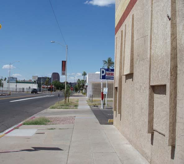
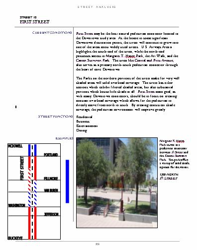
7 McDowell Road 7 th Avenue th Street 7 th DOWNTOWN URBAN FORM PROJECT Approximately 350 square blocks or 2 square miles Buckeye Road

8 DOWNTOWN PHOENIX PLAN CHAPTERS 1. Implementing the Downtown Strategic Vision 2. The Connected Oasis: The Big Idea 3. Downtown Character Areas 4. Sustainable Development in a Desert Environment 5. Circulation and Parking 6. Zoning and Urban Form 7. Implementation Appendix


9 CHAPTER 2: THE CONNECTED OASIS THE BIG IDEA GREEN STREET NETWORK


10 WHAT S MISSING? Shade! Is There a Difference?


11 URBAN HEAT ISLAND AND LIVABILITY


12 WHAT IS THE CONNECTED OASIS?

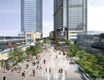

13 THE CONNECTED OASIS Pedestrian Corridors Regional System

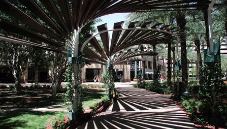
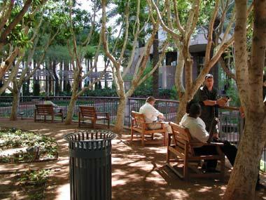
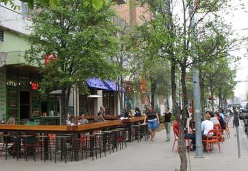
14 PhxSCAPE PROGRAM (Shade & Comfort Activates the Pedestrian Environment) PEDESTRIAN SHADE Wells Fargo Through Block Promotes convective air flow Planting for localized cooling Centrally located fountain induces air movement Dark shade not desirable in winter Renaissance Plaza Pocket park at northeast corner Tree planting for shade and cooling Eroded corner for shade a air movement


15 PhxSCAPE PROGRAM (Shade & Comfort Activates the Pedestrian Environment) RETROFIT SHADE


")
16 PhxSCAPE PROGRAM (Shade & Comfort Activates the Pedestrian Environment) RETROFIT SHADE


17 CHAPTER 4: SUSTAINABLE DEVELOPMENT IN A DESERT CLIMATE Definition The difference in temperature between densely populated urban areas and the surrounding countryside Causes The prevalence of dark and dense building materials in the environment such as those use for roadways and buildings The presence of cars and other mechanical equipment that inject heat into the environment

18 GREEN STREETS

19 OUTDOOR SURFACE TEMPERATURES Renaissance Plaza, June 15, 2007 at 1:30 PM Db F, Globe Temperature F 106 F -Trees in Sun 127 F - Granite Facade 105 F - Glass/Aluminum Storefront 133 F - Decomposed Granite Planting Bed in Sun 106 F - Plants in Sun 135 F - Exposed Aggregate Conc. in Sun 121 F - Exposed Aggregate Conc. in Shade 121 F - Granite pavers in Sun 111 F - Granite pavers in Shade
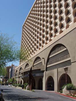
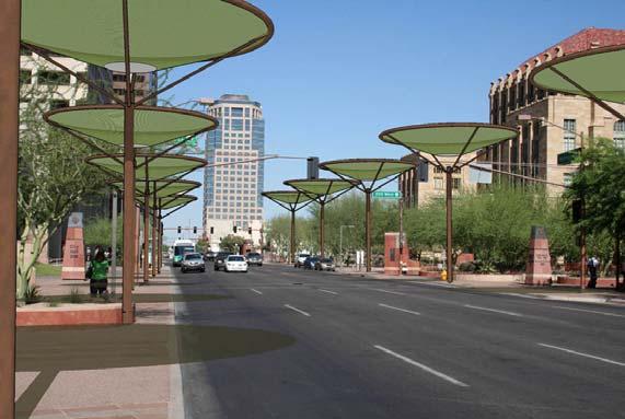
20 DOWNTOWN BUILDING SHADE AND MASSING Renaissance Plaza Pocket park at northeast corner Tree planting for shade and cooling Eroded corner for shade a air movement 101 First Avenue (at Adams) Overhang for protection from sun Tree planting at corner Ample area for pedestrian movement to avoid sunlight Space for air movement

21 Design Strategies Thermal Comfort THE HEAT EXPERIENCED BY A PERSON IN THE URBAN ENVIRONMENT IS A COMBINATION OF AIR TEMPERATURE AND THE HEAT RADIATING FROM SURROUNDING SURFACES. THE AIR TEMPERATURE IN THIS CASE WAS 110 DEGREES. WHEN COMBINED WITH THE HEAT OF THE SURROUNDING SURFACES THE EFFECTIVE TEMPERATURE FOR A PERSON ON THE SIDEWALK WAS 132 DEGREESS. ambienttemp: F avgrh: 30.0% windspeed (mph): 15mph eff. TEMP: F The model represents typical conditions in downtown Phoenix on June 23 at 1:30 PM
22 THERMAL COMFORT DESIGN STRATEGIES Base Case No Strategies Employed Dry Bulb Temp 104 F Wet Bulb Temp 71 F MRT 177 F SET 117 F 127 F Concrete Wall 121 F Concrete Pavers 135 F Concrete Pavers
23 THERMAL COMFORT DESIGN STRATEGIES Pedestrian Shade Canopy and Building Shades 6 F REDUCTION FROM BASE CASE Dry Bulb Temp 104 F Wet Bulb Temp 71 F MRT 158 F SET 111 F 115 F Concrete Wall 121 F Concrete Pavers
24 THERMAL COMFORT DESIGN STRATEGIES Urban Forestry 13 F REDUCTION FROM BASE CASE Dry Bulb Temp 104 F Wet Bulb Temp 71 F MRT 136 F SET 104 F 110 F Concrete Wall 116 F Concrete Pavers
25 THERMAL COMFORT DESIGN STRATEGIES 4mph Convective Air Flow 17 F REDUCTION FROM BASE CASE Dry Bulb Temp 104 F Wet Bulb Temp 71 F MRT 129 F SET 100 F 109 F Concrete Wall 116 F Concrete Pavers

26 THERMAL COMFORT DESIGN STRATEGIES Water and Summary of Design Responses 22 F REDUCTION FROM BASE CASE Dry Bulb Temp 104 F Wet Bulb Temp 71 F MRT 177 F SET 95 F 109 F Concrete Wall 80 F Concrete Pavers


27 Design Strategies Building Form RESEARCH SHOWS THAT NARROWER STREET CANYONS ARE THE MOST EFFECTIVE WAY TO INCREASE THERMAL COMFORT AT THE STREET LEVEL IN HOT, ARID CLIMATES. HOWEVER, THE INCREASED MASS OF BUIDINGS INCREASES THE URBAN HEAT ISLAND EFFECT. THE CHALLENGE IS TO FIND A BALANCE BETWEEN THE TWO CONDITIONS. INCREASED HEIGHT OF STREET CANYONS PROMOTE SHADE ON STREETS. THE NARROWER PROPORTIONS ALSO REDUCE THE AMOUNT OF SKY SEEN BY THE MATERIAL SURFACES, REDUCING THE POSSIBILITY OF NIGHT TIME COOLING. FIND A BALANCE BETWEEN NARROW AND WIDE SPACES COMBINE TOWERS WITH CONTINUOUS STREET WALLS RESERVE 20% OF LOT COVERAGE FOR SHADED OPEN SPACES.


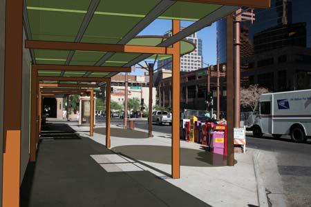
28 Street Shading Strategies for Heat Mitigation Connected Oasis diagram showing green streets and open space system of parks and connectors Low mass paving and building materials such as crumb rubber asphalt and permeable concrete decrease the UHI and provide additional daytime cooling. STREET LEVEL SHADING IN THE FORM OF TREE PLANTING AND ARCHITECTURAL CANOPIES ARE REQUIRED TO REDUCE HEAT BUILD UP ON STREET EXPOSED TO SUNLIGHT. A COMPREHENSIVE SYSTEM OF STREET SHADING IS ONE OF THE KEY COMPONENTS OF THE CONNECTED OASIS, THE PROPOSED OPEN SPACE FRAMEWORK PLAN OF THE URBAN FORM PROJECT. THREE POSSIBLE SHADING STRATEGIES ARE SHOWN. THE FIRST EMPHASIZES TREE PLANTING AND IS APPROPRIATE FOR RESIDENTIAL AREAS. THE SECOND INCLUDES AN ARCHITECTURAL CANOPY OVER THE RIGHT-OF-WAY AND IS APPROPRIATE FOR COMMERCIAL AREAS. THE THIRD SHOWS A RETROFIT CANOPY FOR EXISTING STREETS UNSUITABLE FOR PLANTING.

29 DOWNTOWN BUILDING SHADE AND MASSING Renaissance Plaza Pocket park at northeast corner Tree planting for shade and cooling Eroded corner for shade a air movement 101 Building Overhang for protection from sun Tree planting at corner Ample area for pedestrian movement to avoid sunlight Space for air movement
30 CHAPTER 6: ZONING AND URBAN FORM STANDARDS Form-Based Code


31 Well-intentioned policy statement: Infill and develop in existing urbanized areas. Build affordable multi-family housing near transportation corridors. Source: FBCI

32 TYPICAL STREET VIEW QUESTIONS?
FRUITVALE TRANSIT VILLAGE (Phase 2) Residential Project
 Residential Project") FRUITVALE TRANSIT VILLAGE (Phase 2) Residential Project DEVELOPER: SIGNATURE PROPERTIES ARCHITECT: HKIT ARCHITECTS April 23, 2010 TABLE OF CONTENTS 3 Vision 4 Description of Site 5 Guiding Concepts 6
FRUITVALE TRANSIT VILLAGE (Phase 2) Residential Project DEVELOPER: SIGNATURE PROPERTIES ARCHITECT: HKIT ARCHITECTS April 23, 2010 TABLE OF CONTENTS 3 Vision 4 Description of Site 5 Guiding Concepts 6
11.0. Design Manual: Sustainable Initiatives. Chapel Hill Streetscape and Lighting Master Plan mikyoung kim design all rights reserved.
 11.0 Design Manual: Sustainable Initiatives 2008 mikyoung kim design all rights reserved. Chapel Hill Streetscape and Lighting Master Plan 109 110 Chapel Hill Streetscape and Lighting Master Plan DESIGN
Neighborhood Infrastructures Blue Green Infrastructure
 Neighborhood Infrastructures Blue Green Infrastructure Blue green infrastructure refers to the components of the neighborhood fabric that connect habitat, parks and open space while managing stormwater.
Town Center Design Guidelines
 Adopted by City Council on September 18, 2018 Design Theme The Draper Town Center Design Theme is defined as encompassing those architectural design styles that were prevalent in the construction of civic
3.13. Development Guidelines
 3.3 Landscaping Elements Landscaping should be used to frame and soften structures, define site functions, enhance the quality of the environment, and screen undesirable views. Safety, environmental impacts,
Site Planning. 1.0 Site Context. 2.0 Pedestrian Circulation Systems. Pag e 2-23
 The following photographs from throughout the country illustrate key urban design principles. Photographs are provided to illustrate the overall urban design concepts described in Chapter 1 of the Downtown
City of Redlands Architectural Guidelines for Non-Residential Development
 14. Building articulation shall be included in the design of building, in order to create a formal entry statement. Avoid this Do this Page 11 15. Give special attention to creating pedestrian scale and
Project Consulting Team:
 THE DOWNTOWN CHERRYVILLE LAND USE + STREETSCAPE MASTER PLAN WAS FUNDED THROUGH THE GENEROUS DONATIONS OF THE FOLLOWING: The Community Foundation of Gaston County ElectriCities of North Carolina The Cherryville
REDMOND CENTRAL CONNECTOR ART & DESIGN MASTER PLAN
 REDMOND CENTRAL CONNECTOR ART & DESIGN MASTER PLAN Redmond Central Connector Master Plan design principles principles make it redmond: past, present, future not just a place with art, a place that is art
Little Mountain UDP Presentation
 Summary of UDP Evaluation of Dec 2015 Plan Dec 2015 Site Plan Transitional edges work well Central spine and permeability are strong Tree retention is good Establish Big Idea Sameness of built form contributes
Chapter 5: Mixed Use Neighborhood Character District
 5: Mixed Use Neighborhood Character District 5.1 Introduction The Mixed Use Neighborhood character district acts as a transition or bridge between the State Route 89A District s commercial area to the
East Central Area Plan
 East Central Area Plan Steering Committee Meeting March 8 th, 2018 CHUN Tears McFarlane House Vision Statement Development Opportunities Analysis Vision Elements 1. Equitable, Affordable and Inclusive
CITY OF SANTA ANA Public Works Agency. PARKWAYS..What are they, and why are they important?
 PARKWAYS..What are they, and why are they important? A parkway generally refers to the narrow piece of land between the street and sidewalk. They are also sometimes called tree lawns, parking strips or
1 st now. Design Elements. iii STREET TREES PATTERNED CROSSWALKS SPECIAL SIDEWALK PAVING. First Street ELEMENTS TRANSIT SHELTER / LANTERN
 Design Elements A framework for Design Elements has been developed in response to Project Restore s vision and goals for the First Street Corridor. Guided by the principles good urban design and smart
GREENING THE BOULEVARD Master Plan Concepts for Venice Boulevard between Lincoln and Sawtelle
 GREENING THE BOULEVARD Katherine Spitz Associates Inc. 4212½ Glencoe Avenue Marina Del Rey, CA 90292 310 574 4460 Fax 574 4462 January 2008 Table of Contents Overview Proposed Design Improvements Illustration
Toronto Complete Streets Guidelines
 Toronto Complete Streets Guidelines 108 110 7.1 Green Infrastructure Design Principles 112 7.2 Context-Sensitive Green Streets 114 7.3 Key Green Street Elements Green infrastructure refers to natural and
COMMERCIAL & INDUSTRIAL DESIGN GUIDELINES CITY OF RANCHO CUCAMONGA PLANNING DIVISION
 COMMERCIAL & INDUSTRIAL DESIGN GUIDELINES CITY OF RANCHO CUCAMONGA PLANNING DIVISION INTRODUCTION These guidelines were prepared in response to the needs of many users: developers, property owners, architects,
Highland Village Green Design Guidelines
 Highland Village Green Design Guidelines Publishing Information Title Highland Village Green Design Guidelins Author The City of Calgary Status DRAFT - Proposed document subject to changes Additional Copies
STREETSCAPE IMPROVEMENTS - RECOMMENDATIONS
 STREETSCAPE IMPROVEMENTS - RECOMMENDATIONS Figure 4.3.1- A map of all of the recommended streetscape improvements. The key component of downtown s public realm, apart from its public spaces, is its street
VEHICULAR AND PEDESTRIAN CIRCULATION
 This perspective sketch communicates the intended character and quality of a proposed streetscape design. Locate benches near a major intersection where people tend to gather. Seating and lighting provide
Planning Board Hearing October 20th, 2016
 Planning Board Hearing October 0th, 06 Developer: Real Estate Management & Leasing: Architect: Transportation Engineers: Landscape Architect: Civil Engineer: THE ARSENAL PROJECT Planning Board AGENDA Introduction
PIKE PINE RENAISSANCE: ACT ONE. October 19, 2017
 PIKE PINE RENAISSANCE: ACT ONE October 19, 2017 WATERFRONT SEATTLE PROGRAM PROJECT INTRODUCTION Pike and Pine streets, between First and Melrose avenues Pedestrian and streetscape improvements Budget:
Lehigh Acres Land Development Regulations Community Planning Project
 Lehigh Acres Land Development Regulations Planning Effort Summary In July, 2010 Commissioner Frank Mann invited the Lehigh Acres community to start discussing how to achieve their recently adopted community
chapter DESIGN GUIDELINES NEW RIVER MASTER PLAN REPORT
 chapter DESIGN GUIDELINES NEW RIVER MASTER PLAN REPORT .76 DESIGN GUIDELINES An Overview design guidelines NEW RIVER MASTER PLAN Design Guidelines can transform the image of a city. Specific, design-based
D. Landscape Design. 1. Coverage Intent: To provide adequate landscaping materials that enhance the appearance of development projects.
 D. Landscape Design The standards and guidelines in this section give design guidance for the landscaping components of industrial and office projects. City regulations require that all landscaping be
DRAFT ROOSEVELT ROAD. District Recommendations. Figure 5.23 The Roosevelt Road Corridor
 CHAPTER 5 Figure 5.23 The Road Corridor Road will develop as a mixed-use corridor, emphasizing regional retail, west of the river and mixed-use development east of the river. KEY RECOMMENDATIONS 1. High
Buildings may be set back to create small plazas provided that these setbacks do not substantially disrupt the street wall s continuity.
 6-22 Community Design Street Walls and Street-front Setbacks The siting of buildings will play a critical role in establishing the character and sense of place for the District. Siting buildings at the
WEST LOOP DESIGN GUIDELINES CHECKLIST
 WEST LOOP DESIGN GUIDELINES CHECKLIST Section 1.0 General Strategies 1.1 DESIGN EXCELLENCE: ENCOURAGE HIGH QUALITY AND INNOVATIVE DESIGN OF NEW BUILDINGS WITHIN THE WEST LOOP WITHOUT BEING PRESCRIPTIVE
Urban Design Manual PLANNING AROUND RAPID TRANSIT STATIONS (PARTS) Introduction. Station Study Areas
 Introduction. Station Study Areas") 111111 PLANNING AROUND RAPID TRANSIT STATIONS (PARTS) Introduction The ION rapid transit system will link Waterloo, Kitchener and Cambridge through a central transit corridor (CTC). There are a number
111111 PLANNING AROUND RAPID TRANSIT STATIONS (PARTS) Introduction The ION rapid transit system will link Waterloo, Kitchener and Cambridge through a central transit corridor (CTC). There are a number
Urban Head Island Background Information
 Urban Head Island Background Information Living in the desert has always been a challenge for people and other living organisms. There is too little water and, in most cases, too much heat. Some of the
Policies and Code Intent Sections Related to Town Center
 Policies and Code Intent Sections Related to Town Center The Town Center Vision is scattered throughout the Comprehensive Plan, development code and the 1994 Town Center Plan. What follows are sections
Community Mixed Use Zone Districts (CMU)
") 18.28.500 Community Mixed Use Zone Districts (CMU) The Community Mixed Use Zone Districts (CMU) are intended to help implement the land use goals and strategies found in the Golden Vision 2030 values,
18.28.500 Community Mixed Use Zone Districts (CMU) The Community Mixed Use Zone Districts (CMU) are intended to help implement the land use goals and strategies found in the Golden Vision 2030 values,
4.9 Mendocino Avenue Corridor Plan Design Guidelines
 4.9 Mendocino Avenue Corridor Plan Design Guidelines The Mendocino Avenue Corridor Plan addresses the area between College Avenue and Steele Lane. Mendocino Avenue is a busy arterial that runs parallel
CHAPTER 13 DESIGN GUIDELINES
 CHAPTER 13 DESIGN GUIDELINES Section 1300.00 Section 1300.01 Design Guidelines Purpose The purposes of this section are to: A. The purpose of this Section is to establish procedures and standards to serve
THE LANDMARK PROJECT: ST. GEORGE CAMPUS BEFORE AND AFTER
 THE LANDMARK PROJECT: ST. GEORGE CAMPUS BEFORE AND AFTER The Landmark Project will reimagine the historic core of the St. George campus by creating dynamic, open spaces where students, faculty and the
FONTANA URBAN GREENING
 FONTANA URBAN GREENING MASTER PLAN COMMUNITY WORKSHOP #1 DECEMBER 17th, 2018 GOALS Fontana Forward Comprehensive Plan Urban Greening Master Plan State/Local Landscape Regulations Fontana Active Transportation
BUSINESS DISTRICT DESIGN GUIDELINES
 Des Plaines, Illinois Prepared for the City of Des Plaines by: The Lakota Group Laurie Marston, AICP March 2005 Section 5: Streetscape Elements Business District Design Guidelines STREETSCAPE ELEMENTS
Division VI Community Mixed Use (CMU) Architectural Guidelines and Standards
 Architectural Guidelines and Standards") Division VI 18.40.800 Community Mixed Use (CMU) Architectural Guidelines and Standards 18.40.810 Guidelines The goals of the Comprehensive Plan include a focus on pedestrian safety, amenities and aesthetics
Division VI 18.40.800 Community Mixed Use (CMU) Architectural Guidelines and Standards 18.40.810 Guidelines The goals of the Comprehensive Plan include a focus on pedestrian safety, amenities and aesthetics
QUEEN-RIVER SECONDARY PLAN
 34 QUEEN-RIVER SECONDARY PLAN 34. QUEEN RIVER SECONDARY PLAN 1. INTRODUCTION The Queen-River area is approximately 6.4 hectares and is located at the eastern edge of the Downtown as shown on Map 34-1.
13. New Construction. Context & Character
 13. New Construction Context & Character While historic districts convey a sense of time and place which is retained through the preservation of historic buildings and relationships, these areas continue
Revitalization Guidelines for Corridors, Villages and Town Centres
 Revitalization Guidelines for Corridors, Villages and Town Centres July 2017 Updated May, 2018 Publishing Information Title: Prepared by: Revitalization Guidelines for Corridors, Villages and Town Centres
Table of Contents. Elm Avenue Improvement Plan City of Waco, Texas. Introduction 1. Existing Context 1 Figure 1 2.
 Table of Contents Introduction 1 Existing Context 1 Figure 1 2 Plan Guidelines 3 Future Urban Form 4 The West-End 4 Main Street 6 The East-End 7 Figure 2 9 Public Improvement Recommendations 7 General
W O R K S H O P S U M M A R Y
 W O R K S H O P S U M M A R Y Community Workshop #2: Preliminary Design Strategies October 27, 2007 Upper Market Community Workshop Series and Design Plan Page 1 of 13 INTRODUCTION The Upper Market Community
TALL BUILDING GUIDELINES
 TALL BUILDING GUIDELINES Urban Design Guidance for the Site Planning and Design of Tall Buildings in Milton May, 2018 A Place of Possibility Contents 1.0 INTRODUCTION 1 1.1 What is a Tall Building? 2
Uptown Rideau Street Secondary Plan [Amendment #166, January 12, 2016]
![Uptown Rideau Street Secondary Plan [Amendment #166, January 12, 2016]](/thumbs/76/73760497.jpg "Uptown Rideau Street Secondary Plan [Amendment #166, January 12, 2016]") [Amendment #166, January 12, 2016] The policies of this Secondary Plan are in effect, save and except for the property at 560 Rideau Street, for which there remains a site specific appeal to this Secondary
[Amendment #166, January 12, 2016] The policies of this Secondary Plan are in effect, save and except for the property at 560 Rideau Street, for which there remains a site specific appeal to this Secondary
The open space system should provide connective elements, relate to natural resources, and enhance the suburban character of the landscape..
 The open space system should provide connective elements, relate to natural resources, and enhance the suburban character of the landscape.. Mixed-use and infill development should maintain or enhance
3.0 URBAN DESIGN. December 6, OVERVIEW
 Urban Design 3.0 URBAN DESIGN December 6, 2007 3.1 OVERVIEW The highly urban character of Easton Place is defined by the overall design of the community. The following sections provide an overview of the
VILLAGE OF SKOKIE Design Guidelines for Mixed-Use Districts NX Neighborhood Mixed-Use TX Transit Mixed-Use CX Core Mixed-Use
 VILLAGE OF SKOKIE Design Guidelines for Mixed-Use Districts NX Neighborhood Mixed-Use TX Transit Mixed-Use CX Core Mixed-Use TABLE OF CONTENTS CHAPTER 1 SITE DESIGN Purpose 1 CHAPTER 2 SITE DESIGN Streetscape
open house 3 CITY OF SALEM Downtown Streetscape Plan
 open house 3 Streetscape concepts CITY OF SALEM Downtown Streetscape Plan analysis concepts we are here refined concepts & document Feb 13th 1 2 3 apr 18th KICKOFF OPEN HOUSE Streetscape Work Group Walking
WELCOME and introduction
 1 WELCOME and introduction Mobility Hub Locations within Burlington STUDY OVERVIEW STUDY OBJECTIVES The City of Burlington is developing four Area Specific Plans, one for each of Burlington s Mobility
Potential Green Infrastructure Strategies May 6, 2015 Workshop
 Potential Green Infrastructure Strategies May 6, 2015 Workshop Background The City of Cortland is developing the Tioughnioga Urban Headwaters Green Infrastructure Action Plan with funding from the National
Integration of Public Realm and Library Precinct Landscape Plan Ground Floor
 Integration of Public Realm and Library Precinct Landscape Plan Ground Floor LANE 1 2 4 10 3 5 10 6 5 7 WEST GEORGIA STREET 4 10 14 HOMER STREET 12 B B 14 11 A A 13 MAIN ENTRY 8 8 9 LIBRARY SQUARE PLAZA
FROM DUPONT CIRCLE NORTH TO CALIFORNIA STREET, NW. Welcome!
 FROM DUPONT CIRCLE NORTH TO CALIFORNIA STREET, NW Welcome! Meeting Agenda 6:00 PM Open House 6:30 PM Presentation 7:00 PM Open House / Q&A at the Boards Project Design Team Connecticut Avenue, NW Project
NORTHGATE AREA. Design Guidelines. Effective, final draft: 2 may 02. City of Seattle Department of Design, Construction & Land Use
 NORTHGATE AREA neighborhood urban village Design Guidelines Effective, final draft: 2 may 02 City of Seattle Department of Design, Construction & Land Use Design Review: Northgate Area Neighborhood Design
Monitoring Performance and Effectiveness of Urban Stormwater Best Management Practices. Jim Duncker, USGS Kuldip Kumar, MWRDGC David Leopold, CDOT
 Monitoring Performance and Effectiveness of Urban Stormwater Best Management Practices Jim Duncker, USGS Kuldip Kumar, MWRDGC David Leopold, CDOT Stormwater Management Water Efficiency Transportation Energy
ARLINGTON COUNTY, VIRGINIA
 ARLINGTON COUNTY, VIRGINIA County Board Agenda Item Meeting October 15, 2005 DATE: September 28, 2005 SUBJECT: Request to Advertise the adoption of the 2005 Clarendon Sector Plan C. M. RECOMMENDATION:
Design Guidelines. Roosevelt. Mike Podowski DPD Design Guidelines Ordinance ATT 13 August 13, 2012 Version #1
 Roosevelt Design Guidelines The Roosevelt Neighborhood Design Guidelines apply within the Neighborhood Boundary. Map 1 2 Map 2 3 Map 3 4 CS1 Natural Systems and Site Features Citywide Guideline: Use natural
Gateway commercial MIXED USE MASTER SITE PLAN. CITILAND AIrDRIE GATEWAY VENTURE INC. airdrie GATEWAY COMMERCE CENTRE. airdrie, ALBERTA FEBRUARY 2012
 Gateway commercial MIXED USE MASTER SITE PLAN 1914 CENTRE STREET NORTH CALGARY, AB CANADA T2E 2S8 T. 403.264.7177 F. 403.264-7175 WWW.CITILAND.CA CITILAND AIrDRIE GATEWAY VENTURE INC. airdrie GATEWAY COMMERCE
DOWNTOWN TRANSCONA URBAN DESIGN GUIDELINES
 DOWNTOWN TRANSCONA URBAN DESIGN GUIDELINES May 18, 2010 Introduction DOWNTOWN TRANSCONA URBAN DESIGN GUIDELINES The Downtown Transcona Urban Design Guidelines ("the Guidelines") establish criteria for
To ensure human scale design, the towers step back from the facade of the building after four stories.
 41 40 SPRING GARDEN WEST A DESIGN BY PUBLIC ENGAGEMENT Chapter 3 Design SETBACK (SPRING GARDEN WEST LOOKING SOUTH) To ensure human scale design, the towers step back from the facade of the building after
Guidelines. Building. The minimum setback of an attached garage from the lot line shall be 6m. 4. Zoning Provision
 Objectives Create dwellings that are compatible with the neighborhood in scale, function and character Create pedestrian friendly neighborhood Prevent garage dominated streetscape Strengthen the dwelling
URBAN DESIGN BRIEF 181 Burloak Drive, Oakville
 URBAN DESIGN BRIEF 181 Burloak Drive, Oakville February 2017 Our File: 1730B 230-7050 WESTON ROAD / WOODBRIDGE / ONTARIO / L4L 8G7 / T: 905 761 5588/ F: 905 761 5589/WWW.MHBCPLAN.COM TABLE OF CONTENTS
THE NEIGHBORHOOD TODAY
 THE NEIGHBORHOOD TODAY CORE AREA VISION How are we Good Urbanism A Site s DNA thinking about Elements of great Unique elements urban communities embedded in a place the site and design? ELEMENTS LIKE:
.+-M,.-,.+*,,A,--< ;:--t fi. ;,==: r ) i Q ; ',,(.:,*> 8 I-="' e$ ,; \!!&,,u
 i Q ; ',,(.:,*> 8 I-=' e$ ,; \!!&,,u") fv :.,; \!!&,,u.+-m,.-,.+*,,a,--< ;:--t fi. ;,==: r ) i Q ; ',,(.:,*> 8 -="' e$ r,ct,, -; ;: \$ il!!,y.;;., $..L,: [i October 18, 201 0 TO: FROM: Honorable Mayor and City Council Planning Department SUBJECT:
fv :.,; \!!&,,u.+-m,.-,.+*,,a,--< ;:--t fi. ;,==: r ) i Q ; ',,(.:,*> 8 -="' e$ r,ct,, -; ;: \$ il!!,y.;;., $..L,: [i October 18, 201 0 TO: FROM: Honorable Mayor and City Council Planning Department SUBJECT:
COMPLETE GREEN STREET CHECKLIST
 COMPLETE GREEN STREET CHECKLIST This document was developed to dissect the structure of an urban street and explore opportunities to make our streets more complete while also integrating green street strategies.
Chapter SAR, SENSITIVE AREA RESORT ZONE
 Moab Municipal Code Chapter 17.32 SAR, SENSITIVE AREA RESORT ZONE Page 1 of 8 Sections: 17.32.010 Objectives and characteristics. 17.32.020 Use regulations. Chapter 17.32 SAR, SENSITIVE AREA RESORT ZONE
Figure Example of out door dining in the public right-of-way.
 Section 2 Core Area Goal 2.2.1 To maintain and enhance the character of existing streets in the Downtown Area. Character Figure 2.2.1 Example of out door dining in the public right-of-way. A. Provide street
The broad range of permitted and special uses allowed in the district remain, but some descriptions have been clarified.
 Memorandum To: Emily Fultz, AICP City Planner, City of Edwardsville From: Michael Blue, FAICP Principal, Teska Associates Date: January 24, 2019 RE: B-1 Zoning District Update A draft, updated B-1 Central
DEVELOPMENT DESIGN GUIDELINES
 DEVELOPMENT DESIGN GUIDELINES Approved by Surrey City Council January 26, 2004 Campbell Heights Business Park - Development Design Guidelines TABLE OF CONTENTS 1.0 DEVELOPMENT CONCEPT... 1 2.0 DESIGN OBJECTIVES...
expectations for new development W A T E R F R O N T D R I V E
 expectations for new development W A T E R F R O N T D R I V E 1 April 2004 W A T E R F R O N T D R I V E expectations for new development Introduction and Intent This statement of expectations for development
E L L I O T R O A D T E C H N O L O G Y C O R R I D O R
 E L L I O T R O A D T E C H N O L O G Y C O R R I D O R Light Industrial Planned Area Development (LI PAD) Rezoning Application Narrative SUBMITTED TO: CITY OF MESA PLANNING DIVISION Mesa, Arizona Page
NEC of Central Avenue and Indian School Road
 NEC of Central Avenue and Indian School Road For this location, there are two applicable plans that provide guidance on development. The two plans include the Indian School Specific Plan (1991) and the
City of Fort Lauderdale UPTOWN URBAN VILLAGE. Public Workshop December 7, 2016
 Public Workshop December 7, 2016 Workshop Agenda Introductions Project Presentation o o o History Project Scope/Timeline Character of Study Area o o o o Land Use Public Realm/Pedestrian Mobility Multimodal
PINE CURVE REZONING. Property does not meet criteria for open space preservation and is not a candidate for a park
 PINE CURVE REZONING BACKGROUND Purchased as two parcels in 2001 and 2002 Annexed and Zoned Greater Downtown District Historic Center September 25, 2002 and October 7, 2002 WHAT THE PROJECT IS AND IS NOT
CITY OF CLEVELAND GREEN DESIGN GUIDELINES
 CITY OF CLEVELAND GREEN DESIGN GUIDELINES SEPTEMBER 18, 2008 PROJECT COMPLIANCE PATH: 1. Approved master plan 2. Approved design district boundaries 3. Approved district design guidelines, Green design
SECTION V: DESIGN GUIDELINE EXAMPLES
 SECTION V: DESIGN GUIDELINE EXAMPLES Introduction The Syracuse Town Center is envisioned as an area that creates a sense of place, a community downtown. As such, the Town Center Committee recommended the
Gas Stations ottawa.ca
 Urban Design Guidelines for Gas Stations ottawa.ca Ce document est disponible en français sur ottawa.ca. This document is available in French on ottawa.ca. Approved by City Council May 24, 2006 City of
Town Center (part of the Comprehensive Plan)
") Town Center (part of the Comprehensive Plan) Mercer Island Town Center Looking North (2014) In 1994, a year-long process culminated in a set of design guidelines and code requirements for the Town Center
Town Center (part of the Comprehensive Plan) Mercer Island Town Center Looking North (2014) In 1994, a year-long process culminated in a set of design guidelines and code requirements for the Town Center
Designing for Sustainability: A Consultant s Perspective
 Session 462 Asphalt Pavement Sustainability Designing for Sustainability: A Consultant s Perspective Timothy A. Bevan, P.E. / CH2M HILL Transportation Research Board 87th Annual Meeting January 13-17,
Commercial Development Permit Area
 City of Kamloops KAMPLAN Commercial Development Permit Area PURPOSE The purpose of this Development Permit Area (DPA) is to establish objectives and provide guidelines for the form and character of commercial
East Central Area Plan
 East Central Area Plan Steering Committee Meeting January 10 th, 2019 Tears-McFarlane House Community Room East Central Area Plan Steering Committee Meeting January 10 th, 2019 CHUN Tears-McFarlane House
Proposed for Vic West Neighbourhood Plan. Design Guidelines for Intensive Residential Development - Townhouse and Attached Dwelling
 Proposed for Vic West Neighbourhood Plan Design Guidelines for Intensive Residential Development - Townhouse and Attached Dwelling Design Guidelines for Intensive Residential Development - Townhouse and
1. Avoid extensive blank walls that would detract from the experience and appearance of an active streetscape.
 08 ARCHITECTURAL DETAIL Once a building s massing and street wall have been defined, architectural details, including façade variation, materials and window treatment, shape a building s visual identity.
GUIDING PRINCIPLES IN THIS CHAPTER
 GUIDING PRINCIPLES The guiding principles and design concepts in this chapter work together with the Chapel Hill 2020 Comprehensive Plan to support new public places that can be enjoyed by all while also
TRANSIT ORIENTED DEVELOPMENT PINELLAS COUNTY MPO LIVABLE COMMUNITIES INITIATIVE PINELLAS COUNTY COMPREHENSIVE PLAN AMENDMENTS
 PINELLAS COUNTY MPO LIVABLE COMMUNITIES INITIATIVE MODEL LAND DEVELOPMENT CODE TRANSIT ORIENTED DEVELOPMENT PINELLAS COUNTY COMPREHENSIVE PLAN AMENDMENTS MPO Livable Communities Initiative Goal: Improve
Architectural Standards
 Architectural Standards A collection of provisions working in concert to meet the community design objectives for downtown 1. Average Daylight Plane Concept. Provisions ensures that facades along streets
CARVER COUNTY DIVISION OF PUBLIC WORKS LANDSCAPE POLICY. Adopted by the Carver County Board of Commissioners March 3, 2015
 CARVER COUNTY DIVISION OF PUBLIC WORKS LANDSCAPE POLICY Adopted by the Carver County Board of Commissioners March 3, 2015 Policy Statement Goals It is the goal of Carver County Public Works to provide
Planning and Design: Applied LID Techniques Redevelopments, Housing, Mixed Use, Infrastructure
 Civil Engineering Landscape Architecture Environmental Restoration Planning Planning and Design: Applied LID Techniques Redevelopments, Housing, Mixed Use, Infrastructure Peg Staeheli, ASLA, LEED AP March
Green Cities: An A-to-Z Guide
 Green Cities: An A-to-Z Guide Heat Island Effect Contributors: Nevin Cohen & Paul Robbins Print Pub. Date: 2011 Online Pub. Date: May 04, 2010 Print ISBN: 9781412996822 Online ISBN: 9781412973816 DOI:
FDOT D4 Complete Streets
 FDOT D4 Complete Streets Context Sensitive Solutions Directs that complete street solutions will complement the context of the community. Collaborative approach to decision making, project development,
II. SINGLE FAMILY RESIDENTIAL
 II. SINGLE FAMILY RESIDENTIAL Castle Rock is made up of numerous individually built houses and subdivision tracts that have been developed during the past century. Some of the tracts are diverse in architectural
COLERAIN TOWNSHIP ZONING COMMISSION Regular Meeting Tuesday, October 18, :00 p.m.
 COLERAIN TOWNSHIP ZONING COMMISSION Regular Meeting Tuesday, October 18, 2016-6:00 p.m. Colerain Township Government Complex 4200 Springdale Road - Cincinnati, OH 45251 1. Meeting called to order. Pledge
SECTION TWO: Urban Design Concepts
 SECTION TWO: Urban Design Concepts The Gardnerville Plan for Prosperity shapes economic opportunities presented by regional growth. The Urban Design Concepts provide policies and concepts for land use,
The Vision. Photo provided by The Minervini Group. 46 Vision, Objectives & Strategies
 Vision, Objectives & Strategies The is the public framework and guide for future development of the Grand Traverse Commons. The establishes public polices for infrastructure, the preservation of natural
Request for Proposal
 Request for Proposal 10 th Street Corridor Master Plan Department of Planning and Zoning 500 Quartermaster Court Suite 200 Jeffersonville, IN 47130 April 18, 2017 For further information contact: Chad
University Parkway Corridor Plan. Public Workshop Sept. 18, 2017
 University Parkway Corridor Plan Public Workshop Sept. 18, 2017 AGENDA 1. Overview of Process 2. Study Area 3. Components of the Plan 4. What We Know 5. What We Have Heard 6. Tonight s Input 7. Next Steps
Housing and Coach House Guidelines - Ladner
 Housing and Coach House Guidelines - Ladner Policy D.8: Encourage Compatible Housing Design Encourage housing design that is sensitive to existing single family housing neighbourhoods by requiring a design
Uniformity Avg. : Min. Maintained Use/Task
 WEST WHITELAND TOWNSHIP SUBDIVISION AND LAND DEVELOPMENT ORDINANCE OUTDOOR LIGHTING SECTION 03/10/04 REVISION Section 428. Lighting Control 1. Purpose. The standards established in this section set forth
Regulating Plan. Beacon Island Amendment 3 April 1, 2013 Page 1 B C BUILDING HEIGHTS LAND USE GRAND TOTAL* 850
 Regulating Plan LN US Lot Size Units Patio Homes** 3,500 to 4,200 sf Min. 69 Townhomes 1,750 sf Min. 95 Mid-Rise partments 301 High-Rise ondo/pt/retirement 385 GRN TOTL* 850 *Unit Land Use counts in each
RESIDENTIAL + MIXED USE CONNECTING PEOPLE
 RESIDENTIAL + MIXED USE CONNECTING PEOPLE 2900 On First, Seattle, WA CARDUCCI ASSOCIATES PROFILE Founded in 1976, Carducci Associates is a professional landscape architecture and planning firm based in