Consent of copyright owner required for any other use. For inspection purposes only. APPENDIX 2.iO.l. EPA Export :15:52:22
|
|
|
- Julianna Cole
- 6 years ago
- Views:
Transcription
1 APPENDIX 2.iO.l 4,. EPA Export :15:52:22
2
3
4
5
6
7
8 Appendix i.ll.1 Recorded Archaeological Sites and Monuments The recorded archaeological sites within 1.5km of the proposed development are listed below; all noted in the Sites and Monuments Records for Gorey 6 sheet 7. The monuments are listed in a standard format as follows: RMP No. Description NGR Townland Class wx007: Gorey Corporation Medieval town The medieval town of Gorey. Lands WXOO7: Gorey Corporation Church Lands The site of a 17 h century tomb is located in flat ground in the centre of Gorey. The graveyard is surrounded by a modern wall. There is no sign of the original church the graves are mostly 18 h and lgth century. There is a 17th century tomb rectangular in shape in the centre of the graveyard. The tomb consists of four to five parts.the top and side stones and end parts. The inscription dedicated to bishop Ram is at the North western end of the tomb. The tomb is oriented south east to north west. For those that are surnamed Ram or be so by descent and for none other name or blood I made this monument. WXOO7: /16019 Gorey Corporation Holy Well Lands This site is located in a low-lying boggy area with a stream to the south directly. The views are restricted in all directions. There are no visible remains of the site. The boggy area has been filled up with earth recently and this presumably has covered the signs of any crosses. WXOO7: /15953 Gorey Corporation Holy Well Lands About a _ a mile to the south east of this graveyard is a holy well called tobar Chriost ie. The well of Christ at which stations of the cross were performed about 20 years since on the eve of St John for the succeeding week. The site is situated in a waterlogged hollow with views restricted in all directions. The site is silted up at present.
9 . APPENDIX 2.ii.2 _. I :.
10 Appendix Archaeological Finds The recorded archaeological finds in the vicinity of the site are listed below, all noted in the National Museum of Ireland files, Kildare Street, Dublin 2, in local journals, or in other published catalogues of prehistoric material: Raftery (1983) Eogan (1965; 1983; 1994), Harbison (1968; 1969a; 1969b) and the Irish Stone Axe Project Database. The following townlands were assessed; Gorey Corporation Lands, Gorey town, Scarawalsh. NMI No. Description Townland Find NMI: 1909:32 Near Gorey Foodvessel, Vase A foodvessel vase sherds were found near Gorey in 1882 which I shall be happy to donate NMI: 1989:42-44 Scarawalsh(Gorey) Vase Urn Found in a local sand pit by three schoolboys in the 1980 s NMI: 1963: 52 Scarawalsh Cinerary Urn NMI: 1963:53 Scarawalsh Burnt bone NMI: 1963: 54 Scarawalsh Cinerary Urn NMI:1963:55 Scarawalsh Human bones, cremated NMI: 1963: 56 Scarawalsh Cinerary Urn NMI:1963:57 Scarawalsh Human bones, cremated NMI:1963:58 Scarawalsh Human bones, cremated
11 .,, /1 :.,..,.,. -., AtiPENDa : _.
12 Appendix Previous excavations Previously published archaeological excavations in the area from 1969 to 2001 ( are summarised below. These are listed in a standardised format as follows: Wexford 1989:099 Gorey Corporation Urn burial T Lands Portions of an Encrusted Urn and cremated bone were discovered by local schoolboys exposed in the face of a disused gravel pit on the outskirts of Gorey. The urn measured some 0.3m in diameter and 0.4m in height. Excavation in the immediate vicinity of the find revealed traces of a pit some 0.5m in maximum width, the floor of the pit being 0.35m below the present surface (the topsoil had been removed some years previously). The floor of the pit contained sherds in situ of the rim of a Vase Urn with incised lattice decoration. The Vase Urn appeared to have been inverted in the pit. It is not clear whether the Encrusted Urn (which was also inverted over a deposit of cremated bone, according to the finders) was buried in the same pit or in a separate pit nearby. Raghnall Floinn, National Museum of Ireland, Dublin. Wexford 1995:275 Church St., Gorey Medieval urban T E285 An archaeological assessment was carried out on a proposed development at 17 Church St., Gorey, Co. Wexford, to fulfil a condition of the planning approval. The site lies within the zone of archaeological potential as defined by the OPW Urban Archaeological Survey. Three trenches were opened along the line of the foundations for the proposed extension. No archaeological deposits or features were encountered and natural soil was reached at depths of 0.8-I.5m beneath stratified fill. There are no further archaeological implications for the development of the site. Margaret Gowen, Rath House, Ferndale Rd, Rathmichael, Co. Dublin. l
13 Wexford 1998:668 TOWN CENTRE, GOREY Urban post-medieval T SMR 77:33 98E0134 Archaeological monitoring of site investigation works, which preceded the Gorey Regional Water Supply Scheme, was carried out in Gorey town centre between 18 March and 8 April Fiftyeight narrow slit-trenches were excavated through the town centre and its environs, 28 of these were excavated within the zone of archaeological potential as identified in the Urban Survey, and sixteen of these were monitored. Only two features of archaeological interest were revealed in the course the monitoring. The first occurred in Trench 9 along The Avenue and appeared to be the remains of a robbed-out wail associated with 18th-century pottery. The second feature occurred in Trench 13 along McDermot Street and consisted of the remains of a north-east/south-west-orientated drain, constructed of hand-made red bricks. The remainder of the stratigraphy in the trenches consisted of the tarmacadam road surface overlying hard-core and natural geology. Rob Lynch, for Margaret Gowen & Co. Ltd, 2, Killiney View, Albert Road Lower, Gleanageary, Co. Dublin.. Wexford 2000:1059 GOREY WATER SUPPLY SCHEME No archaeological SMR 7:33 98EOl34 ext. significance Monitoring of pipe-trench excavation for the laying of water mains in Gorey town centre was carried out from July to October Monitoring on this section of the scheme covered Main Street and those streets south of it. The site works lay within the zone of archaeological potential for the town, as identified by the Urban Archaeology Survey. Previous monitoring of this scheme was undertaken by Rob Lynch;under the same licence (Excavations 1998,216). No features or finds of archaeological significance were revealed while monitoring this scheme. Angela Wallace, Margaret Gowen & Co. Ltd, 2 Killiney View, Albert Road Lower, Glenageary, Co. Dublin.
14 :. \... / APPENDUr
15 a Appendix Summary of Legislation Governing the Protection of Cultural Heritage in Ireland (Produced by C.R.D.S. Ltd) The National Monuments Acts 1930 to 1994 The National Monuments Acts, 1930 to 1994 provide a specific legislative basis for the protection of archaeological monuments and areas and archaeological objects. The Minister of Arts, Culture and the Gaeltacht (now the Minster of Arts, Heritage, Gaeltacht and the Islands) is required to establish and maintain both a Register of Monuments and Places and Record of Historic Monuments under the terms of the 1987 and 1994 Amendments Acts respectively. a The Record of Monuments and Places is meant to contain a list of places where the Minister believes there are monuments. The Register of Historic Monuments is meant to contain a list of historic monuments and archaeological areas which are known and which in his/her opinion should be entered. In the case of the Record of Monuments and Places the record shall consist of a list of monuments and such places, and maps showing them, for each county in the State. Under Section 1 of the 1987 Act all monuments dating to before AD 1700 are automatically defined as historic monuments. Historic monuments may also be of such later date as the Minister may appoint by regulations. Under Section 12 of the 1994 Act all monuments listed on the Record of Monuments and Places are given a minimum level of protection in the form of a requirement to give two months notice in writing to the Minister of intention to interfere. A national monument, as defined in Section 2 of the 1930 Act, may also include, as provided for in Section 11 of the 1987 Act, a group of buildings, structures or erections and/or any place comprising the remains or traces of buildings, structure or erection. The 1930 definition also includes the site of the monument and such portion of land adjoining such site as may be required to fence, cover in or otherwise preserve from injury the monument or to preserve the amenities thereof. Archaeological areas are defined under Section 1 of the 1987 Act as areas which the Minister considers to be of archaeological importance but not including the area of an historic monument entered in the Register. Notification has to be sent to the owner that such a historic monument or area has been entered in the Register. Other forms of protection include a preservation order and a temporary preservation order instituted under section 8 of the 1930 Act and Section 4 of the 1954 Act respectively. A Preservation Order may be made if the Minister is of the opinion that a monument is in danger of being or is actually being destroyed, injured or removed, or is falling into decay through
16 neglect while a Temporary Preservation Order, lasting for a period of six months, may be made if the Minister is of the opinion that a national monument is in immediate danger of injury or destruction The Minister may also, under Section 9 of the 1930 Act, appoint her/himself guardian of a national monument (obliging her/him to maintain it) and thus make it an offence to demolish or remove wholly or in part or to disfigure, deface or alter, or in any manner injure or interfere with the national monument or to excavate, dig, plough or otherwise disturb the ground within, around or in proximity to any such national monument without the consent of the Minister. Heritaue Act 1995 The Heritage Act established a statutory Heritage Council, the functions of which include proposing policies and priorities for the identification, protection and preservation of the national heritage. Section 2 of the Act includes in its definition of archaeology the term landscape and landscape is defined as including areas, sites, vistas and features of significant scenic, archaeological, geological, historical, ecological or other scientific interest. Local Government (Plannina and Development) Acts 1963 to 1993 Under the Local Government Planning and Development Acts 1963 to 1964 the use of land for agriculture (including turbary) or forestry (including afforestation) are exempted by statute from the provisions therein. Furthermore other activities such as river dredging and land reclamation can be exempted by regulation. However, in the case of those activities exempted by regulation, the exemption ceases if the activity consists of or comprises the excavation, alteration or demolition of caves, sites, features or other objects of archaeological... interest the preservation of which is an objective for the development plan for the area in which the development in proposed or if it is a class of activity scheduled in the Environmental Impact Assessment (EIA) Regulations. The Environmental Imoact Assessment (EIA) Directive and Reaulations The EIA Regulations of 1989 were made under the European Communities Act 1972, for the purpose of giving effect to the European Communities (now EU) Environmental Impact Assessment Directive. Environmental Impact Statements (EISs) are required to contain a description of the likely significant effects, direct and indirect, on the environment of a development, explained by its possible impact on, inter alia, the cultural heritage and where significant adverse effects are identified a description of the measures envisaged in order to avoid reduce or remedy those effects.
17 I,, a The Forestrv Act 1988 The Forestry Act 1988, established Coillte Toeranta as a semi-state company. Under the Act, it is a general duty of the company to have due regard to the environmental and amenity consequences of its operations. The Turf Development Acts 1946 to 1990 The Turf Development Acts provide the statutory basis for Bord Na M na and its activities; In performance and exercise of its duties Bord Na M na may ensure that all its activities are conducted in such a manner as to afford appropriate protection for the environment both locally and nationally. m The Roads Act 1993 The Roads Act 1993 provides for local authorities to be roads authorities and sets out the functions of the National Roads Authority. It requires the roads authorities to prepare an EIS for any proposed road development that fall within the parameters set out in the Roads Regulation 1994 or if the Minister for the Environment considers a particular road development to have significant effects on the environment. National Parks and Heritaoe Areas Bill The Bill, if enacted would allow the Minister for Arts, Culture and the Gaeltacht to enter into management agreements with landowners and to acquire land where this would be desirable for the proper exercise of his/her functions under the Act. Where land is owned by him/her or is subject to a management agreement he/she will be able to designate it as a National Historic Park provided such land contains historic heritage, i.e. historic monuments, archaeological areas and monuments of national importance.
1. Legislation and policy on the protection of the archaeological heritage during road construction Seán Kirwan
 1. Legislation and policy on the protection of the archaeological heritage during road construction Seán Kirwan Route selection for national road schemes avoids known monuments. This complex of medieval
Meales Farm, Sulhamstead, West Berkshire
 Meales Farm, Sulhamstead, West Berkshire An Archaeological Watching Brief For Mr. Robert Astor by Steve Ford Thames Valley Archaeological Services Ltd Site Code CHH02/29 May 2002 Summary Site name: Meales
Archaeological Conservation Works at Murrooghkilly Cairn, Co. Clare.
 Funding Reference No.: LIFE11/922 ITM: 516541/710578 Licence No.: 17E0498 RMP: CL002-001--- ÆGIS Reference: 89-20b Archaeological Conservation Works at Murrooghkilly Cairn, Co. Clare. Licence holder: F.
Oweninny Wind Farm. Oweninny Environmental Impact Statement Appendix 13. Cultural Heritage Correspondence
 Oweninny Wind Farm Oweninny Environmental Impact Statement Appendix 13 Cultural Heritage Correspondence Copyright ESB International Limited, all rights reserved. Farm Document Number File Reference: Oweninny
An Archaeological Evaluation at Granta Cottages, Newmarket Road, Great Chesterford, Essex. August 2015
 An Archaeological Evaluation at Granta Cottages, Newmarket Road, Great Chesterford, Essex August 2015 by Pip Parmenter and Ben Holloway on behalf of Mr G Elmer and Mrs L King CAT project ref.: 15/06a NGR:
Centre for Archaeological Fieldwork Evaluation/Monitoring Report No Monitoring Report No. 201
 Monitoring Report No. 201 Land adjacent to 58 Drumreagh Road Drumreagh Ballygowan Co. Down LICENCE NO.: AE/10/91E BRIAN SLOAN 1 Site Specific Information Site Name: Land adjacent to 58 Drumreagh Road,
Archaeological Investigation in advance of Development at 2 Palace Cottages, Charing Palace, Charing, Kent
 Archaeological Investigation in advance of Development at 2 Palace Cottages, Charing Palace, Charing, Kent Site Code CHAR-EV-14 NGR 95412 49439 Date of Report 18/12/2014 Swale and Thames Archaeological
EVALUATION REPORT No. 300
 EVALUATION REPORT No. 300 Southwest of 2A Cloughey Road, Portaferry, Co. Down Licence No.: AE/135/85E Sapphire Mussen Report Date: 14 th May 2015 Site Specific Information Site Name: [Southwest of 2a]
Chitty Farmhouse Extension, Wall Lane, Silchester, Hampshire
 Chitty Farmhouse Extension, Wall Lane, Silchester, Hampshire An Archaeological Watching Brief For In Touch by Andrew Mundin Thames Valley Archaeological Services Ltd Site Code CFS 08/52 May 2008 Summary
An Bord Pleanála. Eirgrid Plc. Meath County Council Cavan County Council Monaghan County Council
 An Bord Pleanála Ref: PL02.VS0002 Prospective Applicant: Eirgrid Plc. Local Authorities: Meath County Council Cavan County Council Monaghan County Council Nature of Application: Written opinion on information
Appletree, Thames Street, Sonning Berkshire
 Appletree, Thames Street, Sonning Berkshire An Archaeological Watching Brief for Mr and Mrs A Popham by Sian Anthony Thames Valley Archaeological Services Ltd Site Code ATS 02/83 October 2002 Summary Site
National Monuments in State Care: Ownership & Guardianship. Wexford
 National Monuments in State Care: Ownership & Guardianship 4th March 2009 Wexford National Monuments Service Seirbhís na Séadcomharthaí Náisiúnta Disclaimer These data sets are based on records many of
Ivol Buildings, Woodcote Road, South Stoke, Oxfordshire
 Ivol Buildings, Woodcote Road, South Stoke, Oxfordshire An Archaeological Watching Brief For Christ Church, Oxford by Pamela Jenkins Thames Valley Archaeological Services Ltd Site Code IBSS 04/03 March
Archaeological Evaluation and Assessment of Land at Minnis Beeches, Canterbury Road, Swingfield, Dover, Kent
 Archaeological Evaluation and Assessment of Land at Minnis Beeches, Canterbury Road, Swingfield, Dover, Kent NGR: TQ 6307 1545 Site Code: MB-EV-10 (Planning Consent Y10/0311/SH) Report for Thorndene Ltd.
Foreword. Síle de Valera, TD, Minister for Arts, Heritage, Gaeltacht and the Islands
 Foreword This Code of Practice is a significant milestone in the protection of the archaeological heritage. It marks an agreement between my Department and the National Roads Authority, one of the largest
Garage Site, Foots Cray High Street, Sidcup, Kent, London Borough of Bexley
 Garage Site, Foots Cray High Street, Sidcup, Kent, London Borough of Bexley An Archaeological Evaluation for Mizen Design Build by Andy Taylor Thames Valley Archaeological Services Ltd FOC 07 September
Northbury Farm, Castle End Road, Ruscombe, Berkshire
 Northbury Farm, Castle End Road, Ruscombe, Berkshire An Archaeological Watching Brief For Sir Colin and Lady Southgate by Danielle Milbank Thames Valley Archaeological Services Ltd Site Code NFR 07/120
Circular L8/08 2 September Water Services Investment and Rural Water Programmes Protection of Natural Heritage and National Monuments
 Circular L8/08 2 September 2008 Water Services Investment and Rural Water Programmes Protection of Natural Heritage and National Monuments 1. The purpose of this Circular is to provide local authorities
Land adjacent to Dingle Dock, Front Street, East Garston
 Land adjacent to Dingle Dock, Front Street, East Garston An Archaeological Watching Brief for Dr J Davies by Jo Pine Thames Valley Archaeological Services Site Code DEG99/82 January 2000 Summary Site name:
Archaeological Monitoring of Land at 29 Royal Pier Road, Gravesend, Kent
 Archaeological Monitoring of Land at 29 Royal Pier Road, Gravesend, Kent Site Code ROY/WB/15 Report for Dr Maxted Date of report 06/10/2015 SWAT ARCHAEOLOGY Swale and Thames Archaeological Survey Company
National Monuments in State Care: Ownership & Guardianship. Dublin
 National Monuments in State Care: Ownership & Guardianship 4th March 2009 Dublin National Monuments Service Seirbhís na Séadcomharthaí Náisiúnta Disclaimer These data sets are based on records many of
Newcombe House & Kensington Church Street
 Newcombe House & Kensington Church Street Archaeological Evaluation September 2017 Summary Site name: Newcombe House, Kensington Church Street, Notting Hill, London Grid reference: TQ 25318 80372 Site
Elm Park, Station Road, Ardleigh, Essex, CO7 7RT: archaeological watching brief on installation of new water pipe
 Elm Park, Station Road, Ardleigh, Essex, CO7 7RT: archaeological watching brief on installation of new water pipe November 2015 report prepared by Howard Brooks BA FSA MCIfA on behalf of Partnerships in
MONITORING REPORT: No. 289
 MONITORING REPORT: No. 289 21 Ballynarrig Road Ballydarrog Co. Derry AE/14/213E Dermot Redmond Site Specific Information Site Name: 21 Ballynarrig Road, Limavady Townland: Ballydarrog SMR No. : LDY 016:004
Archaeological Evaluation and Assessment of Land at Kent Cottage, 19 Chapel Street, Hythe, Kent
 Archaeological Evaluation and Assessment of Land at Kent Cottage, 19 Chapel Street, Hythe, Kent Planning Application Y13/0463/SH Date of Report: 29/04/2015 Report for Marc Carney SWAT. ARCHAEOLOGY Swale
MONITORING REPORT: No. 283
 MONITORING REPORT: No. 283 Dunluce Castle Visitor Centre Option Site D Magheracross Co. Antrim AE/14/109E Dermot Redmond List of Contents Site Specific Information 1 Account of the Monitoring 2 Discussion
National Monuments in State Care: Ownership & Guardianship. Laois
 National Monuments in State Care: Ownership & Guardianship 4th March 2009 Laois National Monuments Service Seirbhís na Séadcomharthaí Náisiúnta Disclaimer These data sets are based on records many of which
National Monuments in State Care: Ownership & Guardianship. Kildare
 National Monuments in State Care: Ownership & Guardianship 4th March 2009 Kildare National Monuments Service Seirbhís na Séadcomharthaí Náisiúnta Disclaimer These data sets are based on records many of
Report To An Bord Pleanála. Potential Significant Effects on the Environment /European Sites
 S I M O N C L E A R & A S S O C I A T E S P L A N N I N G A N D D E V E L O P M E N T C O N S U L T A N T S h Report To An Bord Pleanála Potential Significant Effects on the Environment /European Sites
Identify matters regarding the project which inform the preparation of the Environmental Impact Statement (EIS);
;") 3 SCOPING THE EIS 3.1 INTRODUCTION 1 Consultation is an important part of the Environmental Impact Assessment (EIA) process; in this context, consultation with statutory agencies, interested parties, the
3 SCOPING THE EIS 3.1 INTRODUCTION 1 Consultation is an important part of the Environmental Impact Assessment (EIA) process; in this context, consultation with statutory agencies, interested parties, the
THE REGIONAL MUNICIPALITY OF YORK BYLAW NO A bylaw to adopt Amendment No. 6 to the Official Plan for The Regional Municipality of York
 THE REGIONAL MUNICIPALITY OF YORK BILL NO. 13 BYLAW NO. 2014-13 A bylaw to adopt Amendment No. 6 to the Official Plan for The Regional Municipality of York WHEREAS the Planning Act, R.S.O. 1990, c.p.13,
Monitoring Report No. 166
 Monitoring Report No. 166 No. 2a Loughadian Road Poyntzpass County Down AE/08/189 Nick Beer Site Specific Information Site Address: 2a Loughadian Road, Poyntzpass. Townland: Loughadian SMR No.: DOW 033:034
New Media Building, Goldsmiths College, New Cross, London Borough of Lewisham
 New Media Building, Goldsmiths College, New Cross, London Borough of Lewisham An Archaeological Evaluation for Willmott Dixon Construction by Andy Taylor Thames Valley Archaeological Services Ltd Site
New Swimming Pool,West Meon House, West Meon, Hampshire
 New Swimming Pool,West Meon House, West Meon, Hampshire An Archaeological watching brief and building recording for Mr and Mrs Younger by Danielle Milbank Thames Valley Archaeological Services Ltd Site
Perth and Kinross Council Development Management Committee 24 April 2013 Report of Handling by Development Quality Manager
 Perth and Kinross Council Development Management Committee 24 April 2013 Report of Handling by Development Quality Manager Alterations,Carpenter House, Carpenter Street, Perth, PH1 5GB Ref. No: 13/00303/FLL
Windsor Berkshire. Archaeological Watching Brief. King Edward VII Car Park Extension. Archaeological Watching Brief Report
 King Edward VII Car Park Extension Windsor Berkshire Archaeological Watching Brief Report March 202 Client: Royal Borough of Windsor and Maidenhead Issue No: OA Job No: 5242 NGR: SU 972 779 Archaeological
PHASE 1 ARCHAEOLOGICAL IMPACT ASSESSMENT PROPOSED DEVELOPMENT ERF 3 ROBERTSON WESTERN CAPE PROVINCE
 PHASE 1 ARCHAEOLOGICAL IMPACT ASSESSMENT PROPOSED DEVELOPMENT ERF 3 ROBERTSON WESTERN CAPE PROVINCE Prepared for BOLAND ENVIRO Att: Mr Nik Wullschleger PO Box 250 Worcester 6849 Fax: (023) 347 0336 By
Monitoring Report No. 168
 Monitoring Report No. 168 Loughgall Presbyterian Church Cloven Eden Loughgall County Armagh AE/08/203 Nick Beer Site Specific Information Site Address: Loughgall Presbyterian Church, 100 Cloven Eden Road,
NON-TECHNICAL SUMMARY
 Proposed Sand and Gravel Extraction and Associated Processing Operations with Restoration to a Mixture of Agriculture and Nature Conservation including Areas of Shallow Water at Hedgeley, Northumberland
Barvills Solar Farm Environmental Statement Non-Technical Summary
 Barvills Solar Farm Environmental Statement Non-Technical Summary 13 March 2015 Produced for Prepared by St John s House Queen Street, Manchester M2 5JB Contents Contents... 2 1 Introduction... 3 1.1 Development
BANDON FLOOD RELIEF SCHEME
 WHAT HAPPENS NEXT? All comments received in response to this Public Information Event will be considered by the OPW and will be taken into account in the preparation of the first stage in the Bandon Flood
Merrowdene, Earleydene, Sunninghill, Berkshire
 Merrowdene, Earleydene, Sunninghill, Berkshire An Archaeological Watching Brief For Mr and Mrs Jackson by Andy Taylor Thames Valley Archaeological Services Ltd Site Code MES 05/88 January 2006 Summary
Land at Downsview Avenue, Storrington, West Sussex
 Land at Downsview Avenue, Storrington, West Sussex An Archaeological Evaluation for Bellwinch Homes Limited by Andy Taylor Thames Valley Archaeological Services Ltd Site Code DAS 04/21 March 2004 Summary
National Monuments in State Care: Ownership & Guardianship. Offaly
 National Monuments in State Care: Ownership & Guardianship 4th March 2009 Offaly National Monuments Service Seirbhís na Séadcomharthaí Náisiúnta Disclaimer These data sets are based on records many of
National Monuments in State Care: Ownership & Guardianship. Roscommon
 National Monuments in State Care: Ownership & Guardianship 4th March 2009 Roscommon National Monuments Service Seirbhís na Séadcomharthaí Náisiúnta Disclaimer These data sets are based on records many
National Monuments in State Care: Ownership & Guardianship. Tipperary North
 National Monuments in State Care: Ownership & Guardianship 4th March 2009 Tipperary National Monuments Service Seirbhís na Séadcomharthaí Náisiúnta Disclaimer These data sets are based on records many
Greater London. Greater London 6/42 (D.01.M001) TQ
 TQ") Authority 6/42 (D.01.M001) TQ 54207390 ST. JAME'S INVESTMENTS, LOWFIELD STREET AND MARKET STREET, DARTFORD Environmental Statement. Archaeology. Volume 9 of 10 AOC Archaeology Group Twickenham : AOC Archaeology
Authority 6/42 (D.01.M001) TQ 54207390 ST. JAME'S INVESTMENTS, LOWFIELD STREET AND MARKET STREET, DARTFORD Environmental Statement. Archaeology. Volume 9 of 10 AOC Archaeology Group Twickenham : AOC Archaeology
RÓISÍN BURKE ADOPT A MONUMENT IRELAND
 RÓISÍN BURKE ADOPT A MONUMENT IRELAND WHAT IS THE ADOPT A MONUMENT IRELAND SCHEME? ADOPT A MONUMENT IRELAND THE ADOPT A MONUMENT SCHEME AIMS TO EMPOWER COMMUNITIES TO BECOME ACTIVELY INVOLVED IN THE CONSERVATION
Site Assessment Report Phase 2 Report No. PH Appendix D Cultural Heritage Report
 Site Assessment Report Phase 2 Report No. PH 00857 00 Appendix D Cultural Heritage Report D HIGH LEVEL ARCHAEOLOGICAL ASSESSMENT OF LANDS AT KILBRIDE, SHELTON ABBEY & FERRYBANK ARKLOW, CO. WICKLOW PART
69 DRUMLOUGH ROAD, DRUMGATH, COUNTY DOWN
 MONITORING REPORT NO. 223 69 DRUMLOUGH ROAD, DRUMGATH, COUNTY DOWN LICENCE NO. EMILY MURRAY Report Date: 13 th April 2011 Site Specific Information Site name: Townland: SMR No. : Grid ref.: County: Excavation
1. ARCHAEOLOGICAL IMPACT ASSESSMENT
 1. ARCHAEOLOGICAL IMPACT ASSESSMENT 1.1 Introduction. 1.2 Methodology 1.3 Receiving Environment 1.4 Archaeological and Historical Background 1.5 Recorded archaeological sites in the vicinity of the proposed
MONITORING REPORT: No. 276
 MONITORING REPORT: No. 276 Between 51 and 53 Castor Bay Road Lurgan Co. Armagh AE/13/214 Dermot Redmond Site Specific Information Site Name: Between 51 and 53 Castor Bay Road, Lurgan, Co. Armagh Townland:
Bridge House, Ham Island, Old Windsor, Berkshire
 Bridge House, Ham Island, Old Windsor, Berkshire An Archaeological Watching Brief for Mr A Chadwick by Alan Ford Thames Valley Archaeological Services Site Code BHHI98/55 August 1998 Bridge House, Ham
Chapter 4. Route Window C12: Mile End Park and Eleanor Street Shafts
 Chapter 4 Route Window C12: Mile End Park and Eleanor Street Shafts 48 Crossrail Amendment of Provisions 4 Route Window C12: Mile End Park and Eleanor Street Shafts Location plan of Mile End Park and Eleanor
Guidelines for the Assessment of Architectural Heritage Impacts of National Road Schemes
 Guidelines for the Assessment of Architectural Heritage Impacts of National Road Schemes NATIONAL ROADS AUTHORITY Guidelines for the Assessment of Architectural Heritage Impacts of National Road Schemes
Epsom Water Works, East Street, Epsom, Surrey
 Epsom Water Works, East Street, Epsom, Surrey An Archaeological Desk-Based Assessment for St James Homes Ltd by Steve Ford Thames Valley Archaeological Services Site Code ESE99/85 December 1999 Epsom Water
APPENDIX 10 UNESCO WORLD HERITAGE SITE
 APPENDIX 10 UNESCO WORLD HERITAGE SITE The Convention Concerning the Protection of the World Cultural and Natural Heritage - The World Heritage Convention 1972 The World Heritage Convention was ratified
APPENDIX 10 UNESCO WORLD HERITAGE SITE
 APPENDIX 10 UNESCO WORLD HERITAGE SITE The Convention Concerning the Protection of the World Cultural and Natural Heritage - The World Heritage Convention 1972 The World Heritage Convention was ratified
New horse training area, Manor Farm, Great Kimble, Buckinghamshire
 New horse training area, Manor Farm, Great Kimble, Buckinghamshire An Archaeological Watching Brief For Redwing Structures (Marlow) Limited by Andy Taylor Thames Valley Archaeological Services Ltd Site
Gryme s Dyke, Stanway Green
 Gryme s Dyke, Stanway Green A short assessment of the archaeological impact of contractor s groundworks at the southern end of the Gryme s Dyke Middle earthwork February 2000 Archive report on behalf of
The Local Government Perspective. John Mulholland, Kilkenny County Council.
 The Local Government Perspective John Mulholland, Kilkenny County Council. Co Kilkenny is located in the South East of Ireland about 100km from Dublin. Population of approx 100,000 people A rural County
Centre for Archaeological Fieldwork, School of Archaeology and Palaeoecology, Queen s University Belfast.
 Centre for Archaeological Fieldwork, School of Archaeology and Palaeoecology, Queen s University Belfast. Monitoring Report No. 04 Duneight Motte and Bailey, May 2004. On behalf of Monitoring Report: Duneight
SOUTH CAMBRIDGESHIRE DISTRICT COUNCIL. Planning and New Communities Director
 SOUTH CAMBRIDGESHIRE DISTRICT COUNCIL REPORT TO: Planning Committee 5 June 2013 AUTHOR/S: Planning and New Communities Director S/0747/13/FL HISTON Construction of Car Park at Histon Baptist Church, Station
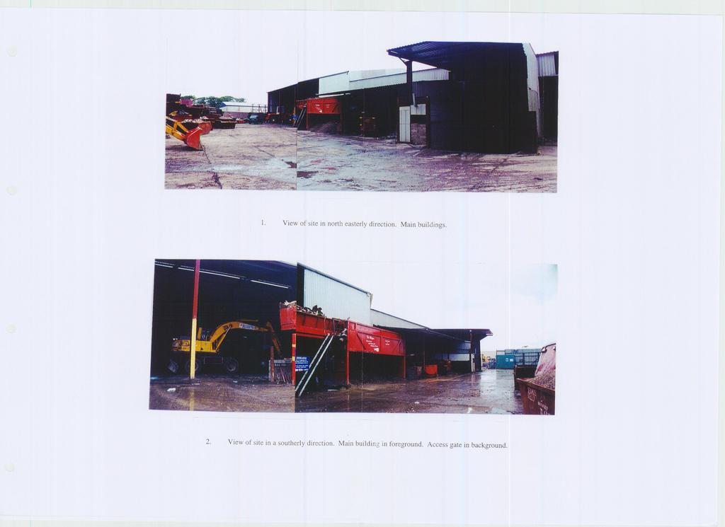
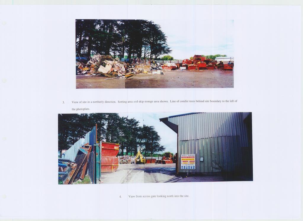
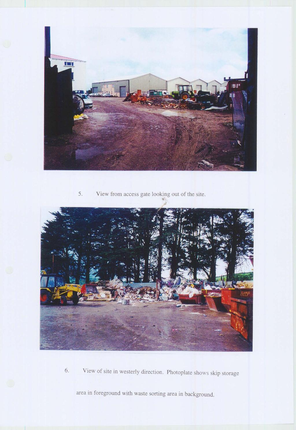
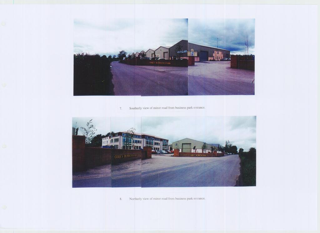
For inspection purposes only. PLATES
 CONTENTS INTRODUCTION... 1 Proposed Facility... 1 Methodology... 1 Author... 2 Consultations... 2 RECEIVING ENVIRONMENT... 2 The Landscape... 2 Historical and Archaeological Background... 2 ARCHAEOLOGICAL
Evaluation/Monitoring Report No. 243
 60m NORTH OF 64 BALLYGROOBANY ROAD BALLYNAHINCH RICHHILL COUNTY ARMAGH LICENCE NO.: AE/12/91E NAOMI CARVER 1 Site Specific Information Site Name: site 60m north of 64 Ballygroobany Road, Ballynahinch,
PROJECT INFORMATION. The type of development
 A LETTER OF RECOMMENDATION (WITH CONDITIONS) FOR THE EXEMPTION OF A FULL PHASE 1 ARCHAEOLOGICAL HERITAGE IMPACT ASSESSMENT FOR THE PROPOSED, CONSTRUCTION OF A FILLING STATION AND ASSOCIATED INFRASTRUCTURE
Downton Manor, Downton, near Lymington, Hampshire
 Downton Manor, Downton, near Lymington, Hampshire An Archaeological Evaluation for New Milton Sand and Gravel by Sian Anthony Thames Valley Archaeological Services Ltd Site Code DMD03/20 May 2003 Summary
Communicating Archaeology in the NRA
 Communicating Archaeology in the NRA Publicising archaeological discoveries on national road schemes in Ireland National Roads Authority December 2010 1. Foreword by Fred Barry, Chief Executive Contents
Departure from the Development Plan. Town Council objection to a major application. DETERMINE
 Item No. 9 APPLICATION NUMBER CB/17/01642/OUT LOCATION Land rear of 43 to 91 Silver Birch Avenue South of Alder Green and Aspen Gardens, Aspen Gardens, Stotfold PROPOSAL Outline application for up to 95
Grantham Southern Quadrant Link Road Environmental Statement
 Grantham Southern Quadrant Link Road Environmental Statement Non Technical Summary Introduction Lincolnshire County Council (LCC) is submitting a planning application for the proposed implementation of
14 Introduction 14.2 Study area 14.3 Impact assessment methodology Magnitude Significance 14.4 Impact assessment 14.4.
 14 14.1 Material Assets: Agronomy Introduction 14.2 Study area 14.3 Impact assessment methodology 14.3.1 Magnitude 14.3.2 Significance 14.4 Impact assessment 14.4.1 Impact identification 14.4.2 Mitigation
Evaluation/monitoring Report No. 241 KING S CASTLE NURSING HOME ARDGLASS CO. DOWN AE/12/19 SARAH GORMLEY
 Evaluation/monitoring Report No. 241 KING S CASTLE NURSING HOME ARDGLASS CO. DOWN AE/12/19 SARAH GORMLEY 1 Site Specific Information Site Name: Townland: King s Castle Ardglass SMR No. : DOW 045:024 Status:
ARCHAEOLOGICAL S E R V I C E S. Hurley Manor, High Street, Hurley, Berkshire. Archaeological Evaluation. by James McNicoll-Norbury
 T H A M E S V A L L E Y ARCHAEOLOGICAL S E R V I C E S Hurley Manor, High Street, Hurley, Berkshire Archaeological Evaluation by James McNicoll-Norbury Site Code: HMH14/51 (SU 8252 8378) Hurley Manor,
Environmental Impact Assessment for Waterway Restoration Projects. Chris John, Technical Director Ecus Ltd.
 Environmental Impact Assessment for Waterway Restoration Projects Chris John, Technical Director Ecus Ltd. Environmental Impact Assessment for Waterway Restoration Projects What is Environmental Impact
Interim Statement on Archaeological Evaluation on land immediately to the east of the Manor Lodge, Manor Lane, Sheffield, South Yorkshire
 Archaeological Research & Consultancy at the University of Sheffield Research School of Archaeology West Court 2 Mappin Street Sheffield S1 4DT Phone 0114 2225106 Fax 0114 2797158 Interim Statement 1107.2
High Speed Rail (London- West Midlands)
") High Speed Rail (London- West Midlands) Draft Environmental Minimum Requirements Annex 3: Draft Heritage Memorandum November 2013 ESA 4.4 High Speed Rail (London- West Midlands) Draft Environmental Minimum
High Speed Rail (London- West Midlands) Draft Environmental Minimum Requirements Annex 3: Draft Heritage Memorandum November 2013 ESA 4.4 High Speed Rail (London- West Midlands) Draft Environmental Minimum
National Monuments in State Care: Ownership & Guardianship. Wicklow
 National Monuments in State Care: Ownership & Guardianship 4th March 2009 Wicklow National Monuments Service Seirbhís na Séadcomharthaí Náisiúnta www.archaeology.ie Disclaimer These data sets are based
MEETING OF DÚN LAOGHAIRE-RATHDOWN COUNTY COUNCIL 7 TH JULY 2014 PROPOSED HOUSING DEVELOPMENT, CLONTIBRET HOUSE, FRASCATI ROAD, BLACKROCK, CO.
 MEETING OF DÚN LAOGHAIRE-RATHDOWN COUNTY COUNCIL 7 TH JULY 2014 PROPOSED HOUSING DEVELOPMENT, CLONTIBRET HOUSE, FRASCATI ROAD, BLACKROCK, CO. DUBLIN IN ACCORDANCE WITH PART 8, ARTICLE 81 OF THE PLANNING
HERITAGE WESTERN CAPE GUIDELINES FOR PUBLIC MONUMENTS AND MEMORIALS
 HERITAGE WESTERN CAPE GUIDELINES FOR PUBLIC MONUMENTS AND MEMORIALS Adapted from the Public Monuments and Memorials Project by SAHRA for DAC (2003) and amended following the public consultation meeting
HERITAGE WESTERN CAPE. 10 June 2015 Version 13 for Comment
 HERITAGE WESTERN CAPE 10 June 2015 Version 13 for Comment GUIDE TO GRADING IN TERMS OF THE NHRA This guide is devised to satisfy Section 7 of the National Heritage Resources Act, 1999 (Act 25 of 1999)
Replacement Golf Course Facilities and Residential Development, Churston. Environmental Statement Non-Technical Summary
 Replacement Golf Course Facilities and Residential Development, Churston Environmental Statement Non-Technical Summary July 2011 Reproduced from the Ordnance Survey s map with the permission of the Controller
volume 11 environmental assessment section 2 environmental impact assessment Part 7 ha 218/08
 DESIGN MANUAL FOR ROADS AND BRIDGES volume 11 environmental assessment section 2 environmental impact assessment Part 7 ha 218/08 glossary of terms Used in DMRB Volume 11, Sections 1 and 2 SUMMARY This
TOWN OF AURORA ARCHITECTURAL SALVAGE PROGRAM GUIDE
 PLANNING AND DEVELOPMENT SERVICES Development Planning Division Heritage Planning Section Phone: 905-727-3123 ext. 4226 Fax: 905-726-4736 Email: planning@aurora.ca Town of Aurora 100 John West Way, Box
PANSHANGER QUARRY, Hertfordshire
 PANSHANGER QUARRY, Hertfordshire Proposed enhanced restoration of Phases F & H Briefing Note 1 March 2015 INERT (INACTIVE) RESTORATION MATERIALS, CONTROLS AND OPERATIONS 1 Introduction This briefing note
National Monuments in State Care: Ownership & Guardianship. Meath
 : Ownership & Guardianship 4th March 2009 Meath National Monuments Service Seirbhís na Séadcomharthaí Náisiúnta www.archaeology.ie Disclaimer These data sets are based on records many of which date to
National Monuments in State Care: Ownership & Guardianship. Sligo
 National Monuments in State Care: Ownership & Guardianship 4th March 2009 Sligo National Monuments Service Seirbhís na Séadcomharthaí Náisiúnta www.archaeology.ie Disclaimer These data sets are based on
Landscape Act. (Act No. 110 of June 18, 2004)
") Landscape Act (Act No. 110 of June 18, 2004) INDEX Chapter I General Provisions (Articles 1 to 7) Chapter II Landscape Plans and Measures Based on Them Section 1 Formulation, etc. of Landscape Plans (Articles
Landscape Act (Act No. 110 of June 18, 2004) INDEX Chapter I General Provisions (Articles 1 to 7) Chapter II Landscape Plans and Measures Based on Them Section 1 Formulation, etc. of Landscape Plans (Articles
Archaeological monitoring and recording at 54 Wellesley Road, Colchester, Essex, CO3 3HF
 Archaeological monitoring and recording at 54 Wellesley Road, Colchester, Essex, CO3 3HF October 2015 by Laura Pooley on behalf of Mr Wright Planning reference: 145409 CAT project ref.: 14/12d NGR: TL
6A St John s Road, Wallingford Oxfordshire
 6A St John s Road, Wallingford Oxfordshire An Archaeological Evaluation Stage 2 for Spearcliff Estates Ltd by Steve Ford Thames Valley Archaeological Services Ltd Site SJW03/116 January 2004 Summary Site
Archaeological evaluation: land to the rear of Clare Road, Braintree, Essex
 Archaeological evaluation: land to the rear of 41-45 Clare Road, Braintree, Essex March 2014 commissioned by Mr Mark Plummer report prepared by Ben Holloway and Howard Brooks Planning reference: 13/000585/FUL,
Archaeology and Planning in Greater London. A Charter for the Greater London Archaeology Advisory Service
 Archaeology and Planning in Greater London A Charter for the Greater London Archaeology Advisory Service THE PURPOSE OF THE CHARTER This Charter sets out how English Heritage will provide archaeological
volume 11 environmental assessment section 2 environmental impact assessment Part 4 ha 204/08 scoping of environmental impact assessments
 DESIGN MANUAL FOR ROADS AND BRIDGES volume 11 environmental assessment section 2 environmental impact assessment Part 4 ha 204/08 scoping of environmental impact assessments SUMMARY This Advice Note provides
SOUTH CAMBRIDGESHIRE DISTRICT COUNCIL. Executive Director (Operational Services) Corporate Manager (Planning and New Communities)
 Corporate Manager (Planning and New Communities)") SOUTH CAMBRIDGESHIRE DISTRICT COUNCIL REPORT TO: Planning Committee 12 January 2011 AUTHOR/S: Executive Director (Operational Services) Corporate Manager (Planning and New Communities) Notes: S/1848/10
SOUTH CAMBRIDGESHIRE DISTRICT COUNCIL REPORT TO: Planning Committee 12 January 2011 AUTHOR/S: Executive Director (Operational Services) Corporate Manager (Planning and New Communities) Notes: S/1848/10
METHODOLOGY FOR IMPACT ASSESSMENT ON HERITAGE ASSETS IDENTIFICATION OF THE RECEPTOR ASSESSMENT OF THE RECEPTOR S IMPORTANCE
 METHODOLOGY FOR IMPACT ASSESSMENT ON HERITAGE ASSETS The determination of impacts on heritage assets follows the standard procedures applied to all Environmental Impact Assessment. This entails the identification
Monitoring of invasive groundworks ahead of the installation of a septic tank at 16a, 16b and 16c Donegore Hill Muckamore County Antrim
 Monitoring Report No. 177 Monitoring of invasive groundworks ahead of the installation of a septic tank at 16a, 16b and 16c Donegore Hill Muckamore County Antrim LICENCE NO.: AE/09/48 Brian Sloan 1 Site
1. Listed Building and Conservation Area considerations 2. Protection of Known Archaeological Remains 3. Parking
 08/01222/FUL ERECTION OF SINGLE STOREY SIDE EXTENSION TO CHURCH TO PROVIDE FOR PARISH HALL (RESUBMISSION OF 08/00206/FUL) AT St Mary And St Giles Church, Church Street, Stony Stratford FOR Rev R Northing
The following aspects have a direct bearing on the survey and the resulting report:
 13. ARCHAEOLOGICAL AND HERITAGE RESOURCES A Phase 1 archaeological survey of the site in accordance with the requirements of Section 38(3) of the National Heritage Resources Act (Act 25 of 1999) was conducted
What is fieldwalking?
 Cambridge Archaeology Field Group May 2012 What is fieldwalking? Archaeological fieldwalking (or Surface Artefact Collection as it is sometimes known) is the systematic recovery and recording of artefacts
Archaeological monitoring and recording at 24 St Peter's Road, West Mersea, Essex, CO5 8LJ
 Archaeological monitoring and recording at 24 St Peter's Road, West Mersea, Essex, CO5 8LJ April 2017 by Dr Elliott Hicks figures by S Carter fieldwork by Adam Wightman on behalf of Brett Lord NGR: TM
ARCHAEOLOGICAL ASSESSMENT AT FOSTER S AVENUE, BOOTERSTOWN, DUBLIN 4 ON BEHALF OF: FOSTER STACK LTD AUTHOR: JACQUI ANDERSON MARCH 2019
 ARCHAEOLOGICAL ASSESSMENT AT FOSTER S AVENUE, BOOTERSTOWN, DUBLIN 4 ON BEHALF OF: FOSTER STACK LTD AUTHOR: JACQUI ANDERSON MARCH 2019 IAC PROJECT REF.: J3436 ABSTRACT Irish Archaeological Consultancy Ltd