Description: Erection of 77 no dwellings with associated highways, drainage, parking, garages and gardens (amended plans).
|
|
|
- Pamela Alexander
- 6 years ago
- Views:
Transcription
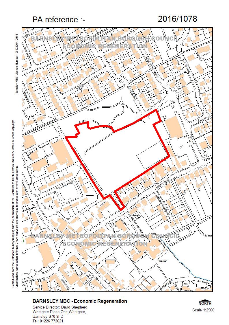
1 2016/1078 Applicant: Kier Living Northern Description: Erection of 77 no dwellings with associated highways, drainage, parking, garages and gardens (amended plans). Site Address: Former Royston High School, Off Midland Road, Royston, Barnsley, S71 4QP 9 representations from local residents. Councillors Cheetham and Clements object to the proposed development. Site Description The site consists of the remaining land belonging to the former Royston High School site in Royston. The site is 2.1ha in size and is located to the north of Midland Road, the west of The Lane, the east of Station Road and the south of a new housing estate of 143 houses already under construction on part of the former school site. The site is predominately open and clear of features. However a former multi use games court exists in the south east corner of the site within a fenced enclosure. In addition a footpath passes through the western part of the site connecting Midland Road and Warren Walk. A small electricity substation building is located in the south western most corner of the site. Other than that the majority of the site is overgrown with scrub grass. The site is located in a predominately residential area and is overlooked by a number of houses located on Midland Road in particular. However other uses located nearby include a small Asda supermarket located to the east on The Lane, Royston Methodist Church to the south and Royston Leisure Centre to the west of the site on Station Road. Public open space associated with the housing development under construction abuts the northern boundary of the site. This is scheduled to contain a LEAP play area and an informal play area. Previously planning permission was granted for the site to be developed to contain a retail foodstore, an associated petrol filling station (full planning permission) and a health centre (outline) in addition to the development of 143 houses already under construction. This happened subsequent to the site becoming vacated following the closure of the school (ref 2012/1337). Proposed Development The application seeks planning permission for a development of 77 houses. The development is proposed to be made up of a mixture of 2, 3 and 4 bed properties that would be housed in layout consisting solely of detached and semi-detached houses. Access into the development is proposed via the new road located to the East of the site that has been constructed to serve the housing estate already under construction on part of the former school site (The Lane) which was originally intended to also serve the retail development, petrol filling station and health centre. This route contains a new roundabout that has been constructed on The Lane and Old Royston Avenue.
2 All of the house types would be of two storey construction. The elevations would be of a traditional yet contemporary appearance with a mixture of external facing materials including dark red brick, light brown brick and white render. Relevant History 2012/1337 Full application for erection of 143 dwellings, supermarket (Class A1), petrol filling station, additional parking for community campus, public open space, landscaping access, parking and outline application for health centre (Class D1) with all matters. Outline and full planning permission granted with conditions 19/03/2013. Policy Context Planning decision should be made in accordance with the development plan unless material considerations indicate otherwise and the NPPF does not change the statutory status of the development plan as the starting point for decision making. The development plan consists of the Core Strategy and the saved Unitary Development Plan policies. The Council has also adopted a series of Supplementary Planning Documents and Supplementary Planning Guidance Notes, which are other material considerations. The Council has submitted our emerging Local Plan to the Secretary of State but we are at an early stage in the examination process. It establishes policies and proposals for the development and use of land up to the year The document is a material consideration and represents a further stage forward in the progression towards adoption of the Local Plan. As such increasing weight can be given to the policies contained within the document although, in accordance with paragraph 216 of the NPPF, the extent of this will depend on: The extent to which there are unresolved objections to relevant policies (the less significant the unresolved objections, the greater the weight that may be given) and; The degree of consistency of the relevant policies in the emerging plan to the policies in the NPPF (the closer the policies in the emerging plan to the policies in the NPPF, the greater the weight that may be given). Local Development Framework Core Strategy CSP3 Sustainable Drainage Systems CSP4 Flood Risk CSP8 The Location of Growth CSP9 The Number of New Homes to be Built CSP10 The Distribution of New Homes CSP14 Housing Mix and Efficient Use of Land CSP15 Affordable Housing CSP17 Housing Regeneration Areas CSP26 New Development and Highway Improvement CSP29 Design CSP36 Biodiversity and Geodiversity CSP39 Contaminated and Unstable Land CSP40 Pollution Control and Protection CSP43 Education Facilities and Community Facilities Saved UDP Policies UDP notation: Existing Community Facility
3 SPD s - Designing New Residential Development - Parking - Open Space Provision on New Housing Developments Other South Yorkshire Residential Design Guide Publication version of the Draft Local Plan Proposed allocation: Urban Fabric NPPF The National Planning Policy Framework sets out the Government s planning policies for England and how these are expected to be applied. At the heart is a presumption in favour of sustainable development. Development proposals that accord with the development plan should be approved unless material considerations indicate otherwise. Where the development plan is absent, silent or relevant policies are out-of-date, permission should be granted unless any adverse impacts of doing so would significantly and demonstrably outweigh the benefits, when assessed against the policies in the Framework as a whole; or where specific policies in the Framework indicate development should be restricted or unless material considerations indicate otherwise. Consultations Affordable Housing Requested 15% of the number of dwellings to be provided as affordable housing under policy CSP15. Biodiversity Officer No objections provided that the development is carried out in accordance with the mitigation and enhancement measures detailed in the ecological reports. Coal Authority No objections Contaminated Land No objections have been received. Drainage The application is not objected to subject to the imposition of the standard condition requiring full surface and foul water drainage details to be provided prior to the commencement of development. Education State that a contribution of 234,734 is required to fund additional school place capacity at local primary schools. Highways No objections subject to conditions. Regulatory Services No objections subject to standard conditions to limit the effects of noise and dust during the construction phase. Tree Officer No objections subject to conditions. SYAS No objections have been received.
4 SYMAS No objections as the site is located outside of a mining referral area. Ward Councillors Objections from Cllrs Cheetham and Clements based upon the following concerns:- Lack of community benefit Concerns are raised that a housing development would not benefit the community in the same way that the previously approved plans for a supermarket for the site would have done. This is in terms of the contribution that would have made to increasing parking provision for the neighbouring community campus. In addition it is stated that community consultations carried out subsequent to the closure of the school side expressed a strong preference against a development solely made up of new houses. Concerns that the development would add to existing traffic congestion problems experienced on Midland Road It is queried whether the development would provide a contribution to enhance green space Yorkshire Water Do not object to the development subject to the imposition of conditions. However YW would wish to see further evidence to discount the use of infiltration drainage, or discharge into a local watercourse prior to accepting attenuated flows into the sewer network. Representations The application was originally advertised by neighbour notification letters, site and press notice. In addition amended plan notification letters were issued following the changes to the proposed site layout plan. 9 representations have been received. In summary the main concerns expressed are as follows:- Harm to the living conditions of existing properties by way of overlooking/loss of privacy, loss of light, security, light pollution, noise, concerns about the potential for trespass and littering. It is asserted that Royston should be regarded as a village that cannot accommodate additional development An argument is made that other previously developed sites should be developed for housing in preference to a site which was previously school playing field. Concerns that additional traffic using Midland Road and elsewhere in Royston would increase the risk of accidents due to the built up nature of the road network, the high amounts of on street parking and a lack of safe stopping places. Lack of school places Concerns are raised that children are already having to travel outside Royston to attend school. It is questioned whether the development would lead to the loss of the greenspace due to be provided as part of the housing development already taking place on the other part of the former school site. Residents from the new estate would object to this as it would take away provisions were a reason for the purchasers to buy the new houses. Councillors are asked to note that the open space approved as part of the existing development would not be affected by the proposal. Children s play It is requested that the public open space under construction in association with the existing housing development includes a play area or skate park to provide a play
5 facility for local children. Councillors are asked to note that this land is located outside of the site and is scheduled to include an equipped play area by the time it has been completed. Assessment Principle of Development The site is proposed to be designated within the Urban Fabric of Royston in the Local Plan. Royston is designated as a Principal Town in both the proposed local plan and the adopted Core Strategy making it a priority to accommodate new housing growth. In addition the site is in a sustainable location near to Royston Town Centre. All of these factors point strongly in support of the application being considered in land use planning policy terms. For the time being the site is subject to an out of date land use designation dating back to the year 2000 adopted UDP which identifies the site as being an Existing Community Facility in association with its previous use as part of the former school site. However the Council has previously granted planning permission for the site to be redeveloped for an alternative land use (retail) following the closure of the school on the opening of Carlton Community College, establishing an acceptance on the Council s part that the site can be redeveloped for a non community purpose based use. In any case the site specific UDP policy would be classed as being out date by the NPPF. In which case the NPPF is explicit that:- any adverse impacts of doing so would significantly and demonstrably outweigh the benefits, when assessed against the policies in the Framework taken as a whole; or specific policies in the NPPF indicate development should be restricted. Currently the Council is unable to demonstrate a 5 year housing land supply which is another important material consideration weighing in favour of the proposal being supported in principle. Taking into account these factors the case weighs strongly in favour of the residential development being supported in land use planning policy terms. Representations from 2 of the Ward Councillors have expressed disappointment that the application proposes that the site is redeveloped for residential purposes instead of retail. However the defined centre of Royston does not extend to within the site and the site does not benefit from a retail land use planning policy designation. Based upon this a strong argument would not exist to argue the case that the site should be safeguarded for retail use purposes. Visual Amenity There are few existing features within the site to prevent a constraint to the development. This is with the exception of existing trees which exist on or outside the western and southern site boundary. An arboricultural implications assessment has been received to show that these trees would not be affected by the development. The Arboricultural Officer therefore has no objections to the application subject to suitable tree protection barrier fencing being in place during the construction period. The main visual amenity considerations are therefore with regards to the form of the development itself. The plans for it include a mixture of house types (2, 3 and 4 bedroom houses) which accords with the aims of policy CSP14 and the SPD.
6 In addition the provision of 77 dwellings would make efficient use of the land available giving rise to an amount of development which is near to what would be aimed for by policy CSP14. The plans have achieved that whilst at the same time meeting spacing between building and private rear garden standards within the site, although at the time of writing this report Officers are still working to resolve minor discrepancies with the layout to ensure that SPD spacing standards are fully complied with (see below section on residential amenity). In addition the plans utilise a range of parking solutions so that unbroken rows of parking spaces are avoided in the majority of locations. In addition the layout plan includes space for soft landscaping to the fronts of dwellings in and around the parking spaces. Regarding the house types, 11 different varieties would be includes which would achieve variation and prevent the development from appearing monotonous. The houses would all be convention two storey houses avoiding any issue about incompatibility. Also a varied palette of materials would be used. Overall the proposals are considered acceptable with regards to visual amenity considerations having regard to the Designing Residential Development SPD and policies CSP29 and CSP26 of the Core Strategy. Residential Amenity The application is sensitive from a residential amenity perspective given that it is overlooked by existing dwellings located in Midland Road. The relationship between the site and these dwellings is complicated further by the fact that a number of these dwellings are located in backland locations pushed up close to the site boundary. The plans have been amended with the aim of designing more suitable relationships. Back to back distances between new and existing properties need to achieve the minimum 21m distance aimed for by the SPD. Officers are working with the applicants to resolve this issue and this is expected to be resolved prior to the plans being considered by the Board. These are considered to be capable of being resolved without materially affecting the layout and so if they are not resolved prior to members considering the application the recommendation seeks to give officer delegated authority to resolve prior to issuing the decision. The most difficult properties to design the development around are Nos Midland Road and No.49. The applicant has afforded consideration to this by amending the plans to orientate the nearest dwellings to be side on to those properties at tight angles to avoid direct overlooking relationships. Whilst not ideal it is not felt that the relationships would give rise to concerns sufficient to warrant refusal of the application. Within the development the plans achieve the spacing between building and private rear garden standards ensuring that a suitable standard of residential amenity shall be provided for future residents. Noise was identified as a potential issue from the following 3 sources:- Road traffic noise from the surrounding road network. Plant noise and intermittent delivery noise from the adjacent ASDA supermarket. Plant noise from Royston Leisure Centre / Civic Hall (audible but not significant or loud). Throughout the majority of the site the only form of sound insulation that is required is standard double glazing. However the report has identified that enhanced double glazing and mechanical ventilation is required on some of the dwellings located adjacent to the Asda service yard. Regulatory Services are content that the proposed mitigation measures would
7 be sufficient for the affected houses to be occupied without noise being an amenity issue. As such they have resolved not to object under policy CSP40 Pollution Control and Protection. Highway Safety The potential effect of the development on the highway network is one of the most sensitive issues with the application due to the potential effect of the development on the capacity of the Midland Road/High Street/Church Street cross roads located in the centre of Royston The application is accompanied by a Transport Assessment which summarises the forecasted effects of the development on the public highway network. In addition the Council have commissioned consultants to undertake a modelling exercise. The residential development would be expected to produce less trips than predicted to occur as a result of the foodstore, petrol filling station and health centre development included within the existing planning permission but which are yet to be implemented. The results of the junction assessments suggest that the Midland Road / Church Street / High Street / Station Road junction will be operating at capacity in the 2021 PM Peak without the addition of development traffic. However, the assessment predicts that the potential increase of trips from the development affecting this junction is small and within daily fluctuations of background traffic passing through the junction. Furthermore the assessment has identified that the location of the site in the centre of Royston means that the site has very good access by bus and the surrounding residential area provides an opportunity for many trips to be made on foot or by bicycle. As such the findings have concluded that the development would not give rise to residual cumulative effect that would be regarded as severe, the threshold by which the Government regards that development may be resisted on transport grounds. Highways have not identified any reasons to contradict the conclusions of the report and are satisfied with the proposed new junction to serve the development. They are also satisfied with the internal circulation routes and parking areas but are still working with the applicant to resolve minor discrepancies with the internal layout (e.g. road widths not quite achieving 5.5m, no. of dwellings served off a private drive). Again these are considered to be capable of being resolved without materially affecting the layout and so if they aren t resolved prior to members considering the application the recommendation seeks to give officer delegated authority to resolve prior to issuing the decision. Overall, subject to resolving the minor discrepancies highways have resolved not to object to the proposed development taking into account of the advice within the NPPF and considered acceptable and Core Strategy policy CSP26 New Development and Highway Improvement. Other Considerations Drainage/Flood Risk The site is not located in an area that is categorised to be an above low risk of flooding and therefore the part of policy CSP4 and national policy requiring developments to be steered towards areas of low flood risk is complied with. The application is accompanied by a proposed drainage strategy. This indicates that sub-soil conditions are unlikely to support the use of soakaways. As such, and due to the lack of space available the method of attenuation for the surface runoff on site is proposed to oversized pipes under the proposed carriageways prior to discharge into the sewer network. Policy hierarchy for the discharge of surface water is that first priority should be given to infiltration drainage. If that is not viable discharge to a local watercourse at an attenuated
8 rate should be followed. Only then should a proposal be made to discharge into the public sewer network. Yorkshire Water s position is therefore that a condition would need to be imposed on any granting of planning permission requiring further evidence in support of the applicant s proposal, or an alternative means of surface water to be found. The Council s drainage officer is of the same view with neither resolving to object to the development, subject to this condition being in place. Ground Conditions The site is not located in a high risk coal mining referral area and as such the development is not likely to be affected by any problems associated with shallow coal workings or mine entries. Neither the Coal Authority, nor SYMAS have raised any objections on that basis. The site does contain made ground and as such an intrusive site investigation would be required to inform any mitigation measures. This would need to be conditioned. Biodiversity The ecological report submitted with the application has not identified any constraints to the development as the value of the site and the potential for protected species to be affected by the development is low. Mitigation recommended includes undertaking any works affecting existing vegetation between September and February (inclusive), taking a precautionary approach to the felling of a tree assessed to have a low potential for bat roosts by leaving it on the ground for 24 hours after felling to allow any undiscovered bats to escape. In addition the provision of a lighting plan for the area of the development adjacent to the western boundary is recommended to maintain its functionality for commuting and foraging bats. The provision of a number bird nesting boxes throughout the development is proposed as enhancements. The Biodiversity Officer accepts the findings and has raised no objections against policy CSP36 Biodiversity and Geodiversity subject to the imposition ensuring that the proposed mitigation and enhancement measures are delivered. S106 Affordable housing, public open space, education and additional proposal Education have confirmed that a contribution is required towards funding additional primary school places as a result of the development. The amount required would be 239, A S106 Agreement would be required to ensure the provision of this payment. A contribution for secondary provision is not required. Public open space Green space provision would be required for the development in accordance with the Open Space Provision on New Housing Developments SPD. Due to the provisions which have been agreed to be provided as part of the existing development bordering the site to the north that is to include the provision an equipped play area it has been determined that provision would be best met via a contribution towards off site green space in its entirety. Using the formula in the SPD the commuted sum required is 135, Again this would need to be secured via a S106 Agreement. AH Under policy CSP15 15% of the houses should be provided as affordable housing in this area of the Borough. However a viability appraisal submitted with the application contends that the effect of paying the sum would prejudice the viability of the development. The District Valuation Service were commissioned by the Council to carry out an independent assessment of the applicants appraisal. They disagreed that the development was unable to support the payment of the education and public open space contributions. However they were in agreement that the viability of the development would be marginal if affordable housing policy were to be applied. Given that policy CSP15 is subject to viability and given the other contributions that the development would make to housing growth and
9 delivery this is not considered to be an issue warranting the application being resisted in this case. Archaeology A desk based assessment report has been identified stating that the potential for the site to contain archaeological remains is low. No objections have been received from SYAS to the contrary. Conclusion In summary the proposal to develop the site for housing purposes is supported in land use planning policy terms for the following summary of reasons:- The saved land use policy relating to the site in the UDP (existing community facility) is out of date following the closure of the school. The previous decision to grant planning permission for a development of a retail foodstore, petrol filling station and a health centre has established that the Council is not intent on retaining the site for an alternative community use. Royston is a principal town and a priority to accommodate new housing growth within the adopted Core Strategy. The site is in a central and accessible location within Royston making the site sustainable. The development would contribute towards addressing the shortfall in the Council s 5 year housing land supply. The site does not form part of the designated centre of Royston and is not proposed to be allocated for retail purposes in the emerging Local Plan. As such the grounds do not exist to refuse the application in preference for the site to be safeguarded for retail purposes. In terms of the detail of the development itself, the proposals would deliver a mixed development that would include a range of 2, 3 and 4 bedroom houses that would be suitable to meet the needs of a variety of households. In addition the plans represent an efficient use of land. Through the inclusion of 11 different house types and a varied palette of materials the development would create sufficient visual interest. In addition the plans would now include sufficient soft landscaping to the fronts of properties. Residential amenity is an important consideration given the proximity of existing dwellings overlooking the site on Midland Road. The relationships between new and existing properties would be regarded as acceptable subject to minor modifications to the plans to ensure that they would achieve the minimum 21m distance aimed for by the SPD. The recommendation therefore seeks delegated authority to resolve this matter with the applicants prior to a final decision being made, subject to changes being accommodated without the layout being materially affected. It is acknowledged that the effects of the development on the local highway network are a sensitive consideration. However the development would give rise to considerably fewer trips than the plans for the development for the foodstore, petrol filling station and health centre which already benefit from planning permission. Again however minor modifications are required to ensure that the layout satisfies the required highway design standards. Mitigation is required for the provision of additional primary school places as a result of the development in the form of the commuted sum stated. The development would also require
10 a contribution towards the enhancement of public open space located off the site, again by way of a commuted sum. Other matters considered include drainage, trees, biodiversity, archaeology and air quality. No areas of specific harm have been identified subject to conditions being in place to ensure that the recommendations contained within the various supporting reports are followed through. In the opinion of the Local Planning Authority there are no other material considerations which would indicate a decision should be made at variance to the above. Overall it is considered that the presumption in favour of sustainable development exists in this case and that planning permission should be granted accordingly, subject to minor modifications to the plans to ensure that planning and highways design guidance is satisfied. Recommendation Grant planning permission subject to conditions and a S106 Agreement (commuted sums for the provision of education and public open space off the site) and if minor issues with the internal layout are not resolved prior to the meeting, give officers delegated authority to negotiate a solution that meets with the Council s guidance prior to issuing the decision. 1 The development hereby permitted shall be begun before the expiration of 3 years from the date of this permission. Reason: In order to comply with the provision of Section 91 of the Town and Country Planning Act The development hereby approved shall be carried out strictly in accordance with the following plans and specifications as approved unless required by any other conditions in this permission:- - Geoff Perry Associates Limited 'planning layout' rev - Geoff Perry Associates Limited house type brochure containing plans for Cedarwood, Chelmsford, Chelwood, Collingwood, Cranwood, Hareford, Hatton, Hazelwood, Holmewood, Lindwood, Garages - Geoff Perry Associates Limited house type Chelwood Special Render - the recommendations contained in the Preliminary Geoenvironmental Investigation report 2321/1 from Lithos. Reason: In the interests of the visual amenities of the locality and in accordance with LDF Core Strategy Policy CSP 29, Design. 3 No development shall take place until full details of the proposed external materials have been submitted to and approved in writing by the Local Planning Authority. The development shall be carried out in accordance with the approved details. Reason: In the interests of the visual amenities of the locality and in accordance with LDF Core Strategy Policy CSP 29, Design. 4 Prior to the commencement of development plans to show the following levels shall be submitted to and approved by the Local Planning Authority; finished floor levels of all buildings and structures; road levels; existing and finished ground levels. Thereafter the development shall proceed in accordance with the approved details. Reason: To enable the impact arising from need for any changes in level to be assessed and in accordance with LDF Core Strategy Policy CSP 29, Design.
11 5 The parking/manoeuvring facilities, indicated on the submitted plan, shall be surfaced in a solid bound material (i.e. not loose chippings) and made available for the manoeuvring and parking of motor vehicles prior to the development being brought into use, and shall be retained for that sole purpose at all times. Reason: In the interest of highway safety, in accordance with Core Strategy Policy CSP No development shall take place, including any works of demolition, until a Construction Method Statement has been submitted to, and approved in writing by, the Local Planning Authority. The approved Statement shall be adhered to throughout the construction period. The Statement shall provide for: - The parking of vehicles of site operatives and visitors - Means of access for construction traffic - Loading and unloading of plant and materials - Storage of plant and materials used in constructing the development - The erection and maintenance of security hoarding including decorative displays and facilities for public viewing, where appropriate - Wheel washing facilities - Measures to control the emission of dust and dirt during construction - Measures to control noise levels during construction Reason: In the interests of highway safety, residential amenity and visual amenity, in accordance with Core Strategy Policies CSP 26 and CSP Vehicular and pedestrian gradients within the site shall not exceed 1:12. Reason: In the interest of highway safety, in accordance with Core Strategy Policy CSP Prior to any works commencing on-site, a condition survey (including structural integrity) of the highways to be used by construction traffic shall be carried out in association with the Local Planning Authority. The methodology of the survey shall be approved in writing by the Local Planning Authority and shall assess the existing state of the highway. On completion of the development a second condition survey shall be carried out and shall be submitted for the written approval of the Local Planning Authority, which shall identify defects attributable to the traffic ensuing from the development. Any necessary remedial works shall be completed at the developer's expense in accordance with a scheme to be agreed in writing by the Local Planning Authority. Reason: In the interest of highway safety, in accordance with Core Strategy Policy CSP No development shall take place until: (a) Full foul and surface water drainage details, including a scheme to limit surface water run-off and a programme of works for implementation, have been submitted to and approved in writing by the Local Planning Authority: (b) Porosity tests are carried out in accordance with BRE 365, to demonstrate that the subsoil is suitable for soakaways; (c) Calculations based on the results of these porosity tests to prove that adequate land area is available for the construction of the soakaways; Thereafter no part of the development shall be occupied or brought into use until the approved scheme has been fully implemented and the scheme shall be retained throughout the life of the development. Reason: To ensure proper drainage of the area, in accordance with Core Strategy policy CSP4.
12 10 The erection of barriers and any other measures specified for the protection of any retained tree shall be undertaken in accordance with the approved plans and particulars before any equipment, machinery or materials are brought on to the site for the purposes of the development, and shall be maintained until all equipment, machinery and surplus materials have been removed from the site. Nothing shall be stored or placed in any area fenced off in accordance with this condition and the ground levels within those areas shall not be altered, nor shall any excavation be made, without the written consent of the Local Planning Authority. Reason: To safeguard existing trees, in the interest of visual amenity. 11 No development shall take place until there has been submitted to and approved in writing by the Local Planning Authority, full details of both hard and soft landscaping works, including details of the species, positions and planted heights of proposed trees and shrubs; together with details of the position and condition of any existing trees and hedgerows to be retained. The approved hard landscaping details shall be implemented prior to the occupation of the building(s). Reason: In the interests of the visual amenities of the locality, in accordance with Core Strategy Policy CSP All planting, seeding or turfing comprised in the approved details of landscaping shall be carried out in the first planting and seeding seasons following the occupation of the buildings or the completion of the development, whichever is the sooner; and any trees or plants which die within a period of 5 years from the completion of the development, are removed, or become seriously damaged or diseased shall be replaced in the next planting season with others of similar size and species. Reason: In the interests of the visual amenities of the locality, in accordance with Core Strategy Policy CSP No development shall take place until there has been submitted to and approved in writing by the Local Planning Authority a plan indicating the position of boundary treatment to be erected. The boundary treatment shall be completed before the dwelling is occupied. Development shall be carried out in accordance with the approved details. Reason: In the interests of the visual amenities of the locality and the amenities of occupiers of adjoining property in accordance with Core Strategy policy CSP Prior to commencement of development an investigation and risk assessment to assess the nature and extent of any contamination on the site shall be submitted to and approved in writing by the Local Planning Authority. The investigation and risk assessment must be undertaken by competent persons and a written report of the findings must be produced. The report of the findings must include: (i) a survey of the extent, scale and nature of contamination; (ii) an assessment of the potential risks to: human health, property (existing or proposed) including buildings, crops, livestock, pets, woodland and service lines and pipes, adjoining land, groundwaters and surface waters, ecological systems, archeological sites and ancient monuments; (iii) an appraisal of remedial options, and proposal of the preferred option(s). This must be conducted in accordance with DEFRA and the Environment Agency's 'Model Procedures for the Management of Land Contamination, CLR 11'.
13 The development shall be carried out in accordance with the approved report including any remedial options. Reason: To ensure that risks from land contamination to the future users of the land and neighbouring land are minimised, together with those to controlled waters, property and ecological systems, and to ensure that the development can be carried out safely without unacceptable risks to workers, neighbours and other offsite receptors in accordance with Core Strategy Policy CSP Prior to commencement of development full details of the mitigation measures identified in the Ecological Survey, including a timetable for their implementation, shall be submitted to and approved in writing by the Local Planning Authority. The development shall be implemented in accordance with the approved details. Reason: To conserve and enhance biodiversity in accordance with Core Strategy Policy CSP The development shall be carried out strictly in accordance with the noise mitigation measures set out in the noise assessment report submitted by Environmental Noise Solutions Limited dated 4th November Measures to be incorporated comprise:- a) Plots 1-4 and Plots 6-7 windows which overlook the ASDA service yard shall have enhanced glazing rated at least 41 db Rw (such as 6 mm glass / 6-16 mm cavity / 8.8 Pilkington Optiphon, or equivalent). b) Plots 1-4 and Plots 6-7 bedrooms with enhanced glazing shall be provided with mechanical ventilation. Appropriate ventilation solutions include; - A fully ducted mechanical ventilation system with heat recovery (MVHR). - A System 3 mechanical extract ventilation (MEV) system (e.g. Airflow Developments Ltd.) - A whole house positive input ventilation (PIV) system (e.g. Nuaire Drimaster 365). - An individual room ventilator, such as the Titon Sonair unit (or equivalent). Reason: In the interests of the amenities of local residents and in accordance with Core Strategy Policy CSP A landscape management plan, including long term design objectives, management responsibilities and maintenance schedules for all landscape areas located outside of the curtilage of private gardens, shall be submitted to and approved by the Local Planning Authority prior to the occupation of the development or any part thereof, whichever is the sooner, for its permitted use. The landscape management plan shall be carried out in accordance with the approved plan and retained as such thereafter. Reason: In the interests of the visual amenities of the locality, in accordance with Core Strategy Policy CSP Construction or remediation work comprising the use of plant, machinery or equipment, or deliveries of materials shall only take place between the hours of 0800 to 1800 Monday to Friday and 0900 to 1400 on Saturdays and at no time on Sundays or Bank Holidays. Reason: In the interests of the amenities of local residents and in accordance with Core Strategy Policy CSP No building or other obstruction including landscape features shall be located over or within 3.0 (three) metres either side of the centre line of the 160mm water main i.e. a protected strip width of (6) metres, that enters the site. If the required stand-off distance is to be achieved via diversion or closure of the water main, the developer shall submit evidence to the Local Planning Authority that the diversion or closure has been agreed with the relevant statutory undertaker Reason: In order to allow sufficient access for maintenance and repair work at all times.
14
Site Address: Site Accessed off Bondfield Close, Bondfield Crescent, Wombwell, Barnsley, S73 8TX
 2017/0155 Applicant: Craig Hawley, Gleeson Regeneration Ltd Description: Residential development of 49 no dwelling houses. Site Address: Site Accessed off Bondfield Close, Bondfield Crescent, Wombwell,
Mr & Mrs Connolly per Pump House Designs Pump House Yard The Green SEDLESCOMBE, East Sussex. TN33 0QA
 AGENDA ITEM NO: 5 (c) Report to: PLANNING COMMITTEE Date: 03 June 2015 Report from: Head of Housing and Planning Services Application Address: Proposal: Application No: Recommendation: Ward: File No: Applicant:
CA//16/00504/FUL. Canterbury City Council Military Road Canterbury Kent CT1 1YW. Crown copyright and database rights 2016 Ordnance Survey
 O Scale 1:1,250 Map Dated: 09/05/2016 CA//16/00504/FUL Crown copyright and database rights 2016 Ordnance Survey 100019614 Canterbury City Council Military Road Canterbury Kent CT1 1YW AGENDA ITEM NO 13
TOWN AND COUNTRY PLANNING ACT 1990
 To: Keele Seddon Ltd c/o Gratton Planning Services - Mr Philip Gratton Barn Bank Vanity Close Oulton Stone Staffordshire ST15 8TZ Description of development Proposed student accommodation with carparking
Departure from the Development Plan. Town Council objection to a major application. DETERMINE
 Item No. 9 APPLICATION NUMBER CB/17/01642/OUT LOCATION Land rear of 43 to 91 Silver Birch Avenue South of Alder Green and Aspen Gardens, Aspen Gardens, Stotfold PROPOSAL Outline application for up to 95
Application Recommended for Approval Hapton with Park Ward
 Application Recommended for Approval Hapton with Park Ward APP/2017/0036 Outline Planning Application Outline application for the construction of a new 3 bedroom dwelling (with all matters reserved for
Description: Outline application for a development of approximately 100 dwellings (all matters reserved apart from means of access).
.") 2016/1531 Applicant: Hoyland Developments Ltd, C/o Johnson Mowat Description: Outline application for a development of approximately 100 dwellings (all matters reserved apart from means of access). Site
2016/1531 Applicant: Hoyland Developments Ltd, C/o Johnson Mowat Description: Outline application for a development of approximately 100 dwellings (all matters reserved apart from means of access). Site
Derry City and Strabane District Council Planning Committee Report
 Derry City and Strabane District Council Planning Committee Report COMMITTEE DATE: 23 rd March 2016 APPLICATION No: APPLICATION TYPE: PROPOSAL: LOCATION: APPLICANT: LA11/2015/0395/F Residential Development
UTT/17/2075/FUL - (BERDEN) (Referred to Committee by Councillor Janice Loughlin. Reason: In the Public Interest)
 (Referred to Committee by Councillor Janice Loughlin. Reason: In the Public Interest)") UTT/17/2075/FUL - (BERDEN) (Referred to Committee by Councillor Janice Loughlin. Reason: In the Public Interest) PROPOSAL: LOCATION: APPLICANT: Amendments to the design of a scheme for a 49.99MW battery
UTT/17/2075/FUL - (BERDEN) (Referred to Committee by Councillor Janice Loughlin. Reason: In the Public Interest) PROPOSAL: LOCATION: APPLICANT: Amendments to the design of a scheme for a 49.99MW battery
Site north of Hattersley Road West (east of Fields Farm Road), Hattersley
, Hattersley") Application Number 17/00982/REM Proposal Site Applicant Recommendation Reason for report Application for the approval of reserved matters (means of access, landscaping, layout, scale and appearance) relating
Application Number 17/00982/REM Proposal Site Applicant Recommendation Reason for report Application for the approval of reserved matters (means of access, landscaping, layout, scale and appearance) relating
PLANNING COMMITTEE REPORT
 PLANNING COMMITTEE REPORT TO: BY: Planning Committee South Head of Development DATE: 19 December 2017 DEVELOPMENT: SITE: WARD: APPLICATION: APPLICANT: Conversion of existing water storage reservoir to
Construction of 9 dwellings and associated infrastructure.
 Application Number 16/00653/FUL Proposal Site Applicant Recommendation Construction of 9 dwellings and associated infrastructure. Land at Grange Road South, Hyde McDermott Developments Ltd Approve REPORT
an Inspector appointed by the Secretary of State for Communities and Local Government
 Appeal Decision Site visit made on 14 July 2015 by I Radcliffe BSc(Hons) MCIEH DMS an Inspector appointed by the Secretary of State for Communities and Local Government Decision date: 18 August 2015 Appeal
SOUTH CAMBRIDGESHIRE DISTRICT COUNCIL. Executive Director (Operational Services) Corporate Manager (Planning and New Communities)
 Corporate Manager (Planning and New Communities)") SOUTH CAMBRIDGESHIRE DISTRICT COUNCIL REPORT TO: Planning Committee 12 January 2011 AUTHOR/S: Executive Director (Operational Services) Corporate Manager (Planning and New Communities) Notes: S/1848/10
SOUTH CAMBRIDGESHIRE DISTRICT COUNCIL REPORT TO: Planning Committee 12 January 2011 AUTHOR/S: Executive Director (Operational Services) Corporate Manager (Planning and New Communities) Notes: S/1848/10
Case Officer: Sarah Kay File No: CHE/14/00515/REM Tel. No: (01246) Plot No: 2/6132 Ctte Date: 15 th September 2014 ITEM 1
 Plot No: 2/6132 Ctte Date: 15 th September 2014 ITEM 1") Case Officer: Sarah Kay File No: CHE/14/00515/REM Tel. No: (01246) 345786 Plot No: 2/6132 Ctte Date: 15 th September 2014 ITEM 1 APPROVAL OF RESERVED MATTERS FROM APPLICATION CHE/12/00234/OUT (1) LAYOUT,
Case Officer: Sarah Kay File No: CHE/14/00515/REM Tel. No: (01246) 345786 Plot No: 2/6132 Ctte Date: 15 th September 2014 ITEM 1 APPROVAL OF RESERVED MATTERS FROM APPLICATION CHE/12/00234/OUT (1) LAYOUT,
Description: Proposed development of 48 dwellings and associated roads and infrastructure
 2016/1308 Applicant: Jaguar Estates Description: Proposed development of 48 dwellings and associated roads and infrastructure Site Address: Land off Pilley Green/ Lidgett Lane, Tankersley, Barnsley, S75
1 The development hereby permitted shall be carried out in accordance with the following approved plans:
 Location The Avenue Tennis Club The Avenue London N3 2LE Reference: 16/6509/FUL Received: 10th October 2016 Accepted: 10th October 2016 Ward: Finchley Church End Expiry 5th December 2016 Applicant: Mrs
Site Address: Land to the south-east of Dearne Hall Road and 1 and 3 Claycliffe Road, Low Barugh, Barnsley. S75 1LX
 2016/1159 Applicant: Barratt Homes C/o Paul Butler, PB Planning Ltd Description: Variation of condition 2 of app 2015/0891 - Residential development with associated public open space, landscaping and link
SOUTH CAMBRIDGESHIRE DISTRICT COUNCIL. REPORT TO: Planning Committee 1 April 2015 Planning and New Communities Director
 SOUTH CAMBRIDGESHIRE DISTRICT COUNCIL REPORT TO: Planning Committee 1 April 2015 AUTHOR/S: Planning and New Communities Director Application Number: Parish(es): Proposal: Site address: Applicant(s): Recommendation:
SUBJECT TO ATTACHED SCHEDULE OF THIRTY SIX CONDITIONS
 Stratton House 58/60 High West Street Dorchester Dorset DT1 1UZ Duchy of Cornwall Poundbury Farmhouse Poundbury Farm Way Poundbury Dorchester DT1 3RT Tel: (01305) 251010 Fax: (01305) 251481 Minicom: (01305)
Harrow Lane, St Leonards-on-Sea, East Sussex, TN37 7JZ ERECTION OF 113 DWELLINGS TOGETHER WITH ESTATE ROADS (DETAILED SUBMISSION)
") AGENDA ITEM NO: Report to: PLANNING BOARD Date: 10 September, 2003 Report from: Borough Planning Officer Application Address: Proposal: Application No: Recommendation: Ward: File No: Applicant: Interest:
AGENDA ITEM NO: Report to: PLANNING BOARD Date: 10 September, 2003 Report from: Borough Planning Officer Application Address: Proposal: Application No: Recommendation: Ward: File No: Applicant: Interest:
Planning and Regeneration PO Box 28, Birmingham B1 1TU DECISION DOCUMENT APPLICATION NUMBER: 2017/05933/PA TOWN AND COUNTRY PLANNING ACT 1990
 Planning and Regeneration PO Box 28, Birmingham B1 1TU DECISION DOCUMENT APPLICATION NUMBER: 2017/05933/PA TOWN AND COUNTRY PLANNING ACT 1990 APPLICANT EDSI 1 Lancaster Circus Queensway Birmingham B4 7DJ
an Inspector appointed by the Secretary of State for Communities and Local Government
 Appeal Decision Site visit made on 11 October 2016 by Mike Hayden BSc DipTP MRTPI an Inspector appointed by the Secretary of State for Communities and Local Government Decision date: 21 November 2016 Appeal
49 Broughton Avenue London N3 3EN
 Location 49 Broughton Avenue London N3 3EN Reference: 17/3448/RCU Received: 30th May 2017 Accepted: 1st June 2017 Ward: Finchley Church End Expiry 27th July 2017 Applicant: Mr P Atwal Proposal: Erection
Planning Committee 04/02/2015 Schedule Item 6. Smith Farm Estate, Old Bridge Close, Northolt, UB5 6UA.
 Planning Committee 04/02/2015 Schedule Item 6 Ref: Address: Ward: Proposal: PP/2014/5145 Smith Farm Estate, Old Bridge Close, Northolt, UB5 6UA. Greenford Broadway Installation of sports pitch, reconstruction
Persimmon Homes Thames Valley Date received: 2 nd April week date(major): 2 nd July 2014 Ward: Nascot
: 2 nd July 2014 Ward: Nascot") PART A Report of: DEVELOPMENT MANAGEMENT SECTION HEAD Date of Committee: 26 th June 2014 Site address: Rounton, 28, Nascot Wood Road Reference Number: 14/00497/REM Description of Development: Reserved
PART A Report of: DEVELOPMENT MANAGEMENT SECTION HEAD Date of Committee: 26 th June 2014 Site address: Rounton, 28, Nascot Wood Road Reference Number: 14/00497/REM Description of Development: Reserved
Garages To Rear Of The Willows 1025 High Road London N20 0QE
 Location Garages To Rear Of The Willows 1025 High Road London N20 0QE Reference: 15/03944/FUL Received: 25th June 2015 Accepted: 2nd July 2015 Ward: Totteridge Expiry 27th August 2015 Applicant: Mr Alex
Site off Hattersley Road West (bound by Hattersley Road West to the north west and Sandy Bank Avenue to the south and west), Hattersley
, Hattersley") Application Number 17/00984/REM Proposal Site Applicant Recommendation Reason for report Application for the approval of reserved matters (means of access, landscaping, layout, scale and appearance) relating
Application Number 17/00984/REM Proposal Site Applicant Recommendation Reason for report Application for the approval of reserved matters (means of access, landscaping, layout, scale and appearance) relating
26 September 2014 CONSULTATION EXPIRY : APPLICATION EXPIRY : 22 July 2014 SUMMARY RECOMMENDATION: PERMISSION
 Item No.: 5 The information, recommendations and advice contained in this report are correct as at the date of preparation, which is more than one week in advance of the Committee meeting. Because of the
DONCASTER METROPOLITAN BOROUGH COUNCIL. PLANNING COMMITTEE 3 rd May Expiry Date:
 DONCASTER METROPOLITAN BOROUGH COUNCIL PLANNING COMMITTEE 3 rd May 2016 Application 7 Application Number: 16/00741/FUL Application Expiry Date: 3 rd May 2016 Application Type: Full application Proposal
Report Author/Case Officer: Paul Keen Senior Planning Officer (Dev Control) Contact Details:
 Contact Details:") APP 03 Application Number: 17/02060/FUL Description A full planning application for the demolition of an existing bungalow (C3 use class) and associated out buildings and the erection of two, two storey
APP 03 Application Number: 17/02060/FUL Description A full planning application for the demolition of an existing bungalow (C3 use class) and associated out buildings and the erection of two, two storey
Reference: 16/1447/FUL Received: 7th March 2016 Accepted: 7th March 2016 Ward: East Finchley Expiry 2nd May 2016
 Location 374B Long Lane London N2 8JX Reference: 16/1447/FUL Received: 7th March 2016 Accepted: 7th March 2016 Ward: East Finchley Expiry 2nd May 2016 Applicant: Ms Katrin Hirsig Proposal: Single storey
Site Location Plan. Land on the North West of Epsom Road Waddon Croydon. 1 : A4 September The. Waddon. Waddon.
 138 140 44.3m MP 11.5 El Sub Sta EPSOM ROAD 13 Bank 1 to 5 154 Trough 19to21 1 to 5 156 The Waddon (PH) 23 FB Waddon Station 45.0m Posts 29to31 1 to 9 Stafford Court 39 37 Meridian Court 10 43 to 45 1
2015/1020 Mr Edward Cockburn Caravan storage on hardcore base (Retrospective) Ranah Stones, Whams Road, Hazlehead, Sheffield, S36 4HT
 Ranah Stones, Whams Road, Hazlehead, Sheffield, S36 4HT") 2015/1020 Mr Edward Cockburn Caravan storage on hardcore base (Retrospective) Ranah Stones, Whams Road, Hazlehead, Sheffield, S36 4HT Dunford Parish Council have not commented Councillor Andrew Millner
2015/1020 Mr Edward Cockburn Caravan storage on hardcore base (Retrospective) Ranah Stones, Whams Road, Hazlehead, Sheffield, S36 4HT Dunford Parish Council have not commented Councillor Andrew Millner
Derry City and Strabane District Council Planning Committee Report. Amended layout from approval A/2004/0462/F with reduction from 166 units
 Derry City and Strabane District Council Planning Committee Report COMMITTEE DATE: 1 st February 2017 APPLICATION No: APPLICATION TYPE: PROPOSAL: LOCATION: APPLICANT: AGENT: Full Planning application Amended
Mid Suffolk District Council Planning Control Department 131 High Street Needham Market IP6 8DL
 Mid Suffolk District Council Planning Control Department 131 High Street Needham Market IP6 8DL OUTLINE PLANNING PERMISSION Town and Country Planning Act 1990 THE TOWN AND COUNTRY PLANNING (DEVELOPMENT
SOUTH CAMBRIDGESHIRE DISTRICT COUNCIL. Planning and New Communities Director
 SOUTH CAMBRIDGESHIRE DISTRICT COUNCIL REPORT TO: Planning Committee 9 January 2013 AUTHOR/S: Planning and New Communities Director S/2064/12/FL WATERBEACH Demolition of existing 35 no. shared amenity apartments
5 Gratton Terrace London NW2 6QE. Reference: 17/5094/HSE Received: 4th August 2017 Accepted: 7th August 2017 Ward: Childs Hill Expiry 2nd October 2017
 Location 5 Gratton Terrace London NW2 6QE Reference: 17/5094/HSE Received: 4th August 2017 Accepted: 7th August 2017 Ward: Childs Hill Expiry 2nd October 2017 Applicant: WSD (Gratton) Ltd Proposal: The
UTT/17/2050/FUL - (STANSTED MOUNTFITCHET)
") UTT/17/2050/FUL - (STANSTED MOUNTFITCHET) (Referred to the Planning Committee by Cllr Sell. Reason: The loss of trees and introduction of back-land development) PROPOSAL: LOCATION: APPLICANT: AGENT: Erection
UTT/17/2050/FUL - (STANSTED MOUNTFITCHET) (Referred to the Planning Committee by Cllr Sell. Reason: The loss of trees and introduction of back-land development) PROPOSAL: LOCATION: APPLICANT: AGENT: Erection
Redevelopment of the site, including demolition of existing buildings, for approximately 96 new dwellings and associated works - outline
 Application Number 15/00986/OUT Proposal Site Applicant Recommendation Redevelopment of the site, including demolition of existing buildings, for approximately 96 new dwellings and associated works - outline
1 The development hereby permitted shall be carried out in accordance with the following approved plans:
 Location 59 Greenway Close London N20 8ES Reference: 16/00011/HSE Received: 30th December 2015 Accepted: 7th January 2016 Ward: Totteridge Expiry 3rd March 2016 Applicant: Mr Ankit Shah Proposal: Part
Ground Floor Flat 15 Redbourne Avenue London N3 2BP
 Location Ground Floor Flat 15 Redbourne Avenue London N3 2BP Reference: 17/4160/FUL Received: 28th June 2017 Accepted: 29th June 2017 Ward: West Finchley Expiry 24th August 2017 Applicant: Proposal: Mr
2014/0590 Reg Date 26/06/2014 Chobham
 2014/0590 Reg Date 26/06/2014 Chobham LOCATION: PROPOSAL: TYPE: APPLICANT: OFFICER: ASCOT PARK POLO CLUB, WESTCROFT PARK FARM, WINDLESHAM ROAD, CHOBHAM, WOKING, GU24 8SN Erection of a two storey detached
SOUTH CAMBRIDGESHIRE DISTRICT COUNCIL. Director of Development Services
 SOUTH CAMBRIDGESHIRE DISTRICT COUNCIL REPORT TO: Development and Conservation Control Committee 5 th April 2006 AUTHOR/S: Director of Development Services S/2290/05/F Haslingfield House (Revised Design)
Statement of Community Involvement LAND OFF SOUTHDOWN ROAD HORNDEAN, HAMPSHIRE
 LAND OFF SOUTHDOWN ROAD HORNDEAN, HAMPSHIRE CONTENTS Page 1. Introduction 3 2. Pre-application Discussions 4 3. The Consultation Process 5 4. Consultation Feedback 7 5. Responses to Consultation Feedback
Ward: Southbourne. Outline application with all matters reserved. Erection of 5 no. dwellings and associated works.
 Parish: Southbourne Ward: Southbourne SB/16/00205/OUT Proposal Site Outline application with all matters reserved. Erection of 5 no. dwellings and associated works. Dunkirk South Lane Southbourne Emsworth
Ward: West Wittering. Proposal Change of use from public highway pavement to residential garden use.
 Parish: West Wittering Ward: West Wittering WW/17/03295/FUL Proposal Change of use from public highway pavement to residential garden use. Site Izora 1 Watersedge Gardens West Wittering PO20 8RA Map Ref
SOUTH CAMBRIDGESHIRE DISTRICT COUNCIL. Planning and New Communities Director
 SOUTH CAMBRIDGESHIRE DISTRICT COUNCIL REPORT TO: Planning Committee 5 June 2013 AUTHOR/S: Planning and New Communities Director S/0747/13/FL HISTON Construction of Car Park at Histon Baptist Church, Station
Land Adj. 63 Sunny Bank Road, Sutton Coldfield, Birmingham, B73 5RJ
 Committee Date: 11/07/2013 Application Number: 2013/03520/PA Accepted: 20/05/2013 Application Type: Full Planning Target Date: 15/07/2013 Ward: Sutton Vesey Land Adj. 63 Sunny Bank Road, Sutton Coldfield,
SOUTH CAMBRIDGESHIRE DISTRICT COUNCIL. Planning and New Communities Director. Linton. Yes
 SOUTH CAMBRIDGESHIRE DISTRICT COUNCIL REPORT TO: Planning Committee 2 July 2014 AUTHOR/S: Planning and New Communities Director Application Number: Parish(es): Proposal: Site address: Applicant(s): Recommendation:
Outh SOUTH CAMBRIDGESHIRE DISTRICT COUNCIL. Joint Director for Planning and Economic Development S/0179/18/OL. Histon. Approval.
 Outh SOUTH CAMBRIDGESHIRE DISTRICT COUNCIL REPORT TO: Planning Committee 4 April 2018 AUTHOR/S: Joint Director for Planning and Economic Development Application Number: Parish(es): Proposal: Site address:
SOUTH CAMBRIDGESHIRE DISTRICT COUNCIL. Planning and New Communities Director
 SOUTH CAMBRIDGESHIRE DISTRICT COUNCIL REPORT TO: Planning Committee 9 January 2013 AUTHOR/S: Planning and New Communities Director S/2270/12/FL FEN DRAYTON 850m long flood defence embankment ranging in
PLANNING COMMITTEE REPORT
 PLANNING COMMITTEE REPORT TO: BY: Planning Committee South Head of Development DATE: 20 March 2018 DEVELOPMENT: SITE: WARD: APPLICATION: APPLICANT: Proposed erection of 2 no. 3-bedroom dwellings and conversion
Site: Essex Police & La Plata House London Road Brentwood Essex CM14 4QJ
 Reference: 16/01805/OUT Ward: Brentwood West Site: Essex Police & La Plata House London Road Brentwood Essex CM14 4QJ Proposal: Outline application for demolition of existing police station buildings,
Derry City and Strabane District Council Planning Committee Report. Environmental Improvement Scheme. Derry City & Strabane District Council
 Derry City and Strabane District Council Planning Committee Report COMMITTEE DATE: 7 th September 2016 APPLICATION No: APPLICATION TYPE: PROPOSAL: LA11/2015/0776/F Environmental Improvement Scheme Provision
Reserved Matters application for a site that straddles the boundary between CBC and BBC
 BBC APPLICATION 15/02682/MAR NUMBER CBC APPLICATION CB/15/04294/RM NUMBER LOCATION Wixams Land at former storage depot, Bedford Road, Wilstead Bedfordshire PROPOSAL Reserved Matters Application for Strategic
LAND & DEVELOPMENT OFFICE. 170 Church Road, Hove, BN3 2DJ mishonmackay.com
 LAND & DEVELOPMENT OFFICE 170 Church Road, Hove, BN3 2DJ 01273 829300 land@mishonmackay.com mishonmackay.com APPLICATION NUMBER: APPLICANTS NAME(S): PROPOSAL: LW/15/0462 Seaview Developments ( Sussex )
DEVELOPMENT MANAGEMENT REPORT
 ITEM A08-1 DEVELOPMENT MANAGEMENT REPORT TO: BY: DATE: DEVELOPMENT: SITE: WARD: APPLICATION: APPLICANT: Development Management Committee Development Manager Proposed live/work unit in connection with existing
an Inspector appointed by the Secretary of State for Communities and Local Government
 Appeal Decision Site visit made on 3 May 2017 by Rory Cridland LLB (Hons), Solicitor an Inspector appointed by the Secretary of State for Communities and Local Government Decision date: 31 May 2017 Appeal
3 Tretawn Gardens London NW7 4NP
 Location 3 Tretawn Gardens London NW7 4NP Reference: 16/7886/HSE Received: 12th December 2016 Accepted: 19th December 2016 Ward: Mill Hill Expiry 13th February 2017 Applicant: Proposal: Mr Murray Two storey
PARISH / WARD: Peacehaven / Peacehaven East PROPOSAL:
 APPLICATION ITEM LW/16/0802 NUMBER: NUMBER: 7 APPLICANTS NAME(S): Mr J Robison & Ms S Teng PARISH / WARD: Peacehaven / Peacehaven East PROPOSAL: Planning Application for Conversion of existing garage to
Derry City and Strabane District Council Planning Committee Report
 Derry City and Strabane District Council Planning Committee Report COMMITTEE DATE: 29 th November 2017 APPLICATION No: APPLICATION TYPE: PROPOSAL: LOCATION: APPLICANT: AGENT: LA11/2016/0854/O Outline Shared
REFERENCE: B/03745/12 Received: 02 October 2012 Accepted: 05 October 2012 WARD(S): Totteridge Expiry: 30 November 2012.
: Totteridge Expiry: 30 November 2012.") LOCATION: 15A Pyecombe Corner, London, N12 7AJ REFERENCE: B/03745/12 Received: 02 October 2012 Accepted: 05 October 2012 WARD(S): Totteridge Expiry: 30 November 2012 Final Revisions: APPLICANT: PROPOSAL:
LOCATION: 15A Pyecombe Corner, London, N12 7AJ REFERENCE: B/03745/12 Received: 02 October 2012 Accepted: 05 October 2012 WARD(S): Totteridge Expiry: 30 November 2012 Final Revisions: APPLICANT: PROPOSAL:
It is recommended that the Committee resolve to APPROVE the application and grant planning permission subject to the following conditions:
 LOCATION: Phase 2A Millbrook Park (Site of Former Inglis Barracks), Mill Hill East, London, NW7 1PZ REFERENCE: H/04606/12 Received: 04 December 2012 Accepted: 17 December 2012 WARD: Mill Hill Expiry: 18
3 Abbey View Mill Hill London NW7 4PB
 Location 3 Abbey View Mill Hill London NW7 4PB Reference: 15/03203/HSE Received: 26th May 2015 Accepted: 16th June 2015 Ward: Mill Hill Expiry 11th August 2015 Applicant: Proposal: Mr Richard Benson Alterations
PLANNING COMMITTEE REPORT
 PLANNING COMMITTEE REPORT TO: BY: Planning Committee South Head of Development DATE: 21 August 2018 DEVELOPMENT: SITE: WARD: APPLICATION: APPLICANT: Erection of a new chalet bungalow with associated parking
Derry City and Strabane District Council Planning Committee Report
 Derry City and Strabane District Council Planning Committee Report COMMITTEE DATE: 23rd March 2016 APPLICATION No: APPLICATION TYPE: PROPOSAL: LOCATION: APPLICANT: AGENT: LA11/2015/0263/O Outline Planning
Planning Area Committee 25 June 2018 Addendum to Officers Report RESTRICTION OF PERMITTED DEVELOPMENT RIGHTS - EXTENSIONS
 Planning Area Committee 25 June 2018 Addendum to Officers Report 17/8150/RMA West Hendon Regeneration Area (Phase 6) Pages 11 54 The conditions section shall be changed as follows: RESTRICTION OF PERMITTED
1 The development hereby permitted shall be carried out in accordance with the following approved plans:
 Location Victoria Park Ballards Lane London N3 Reference: 17/1030/FUL Received: 20th February 2017 Accepted: 20th February 2017 Ward: West Finchley Expiry 17th April 2017 Applicant: Mrs Mia Freedman Proposal:
Sustainability Statement. Whitby Business Park Area Action Plan
 Sustainability Statement Whitby Business Park Area Action Plan November 2014 Contents Page 1. Introduction 1 2. Scoping 3 3. Sustainability Appraisal of Options 6 4. Assessment of Draft Area Action Plan
DEVELOPMENT MANAGEMENT REPORT
 ITEM A07-1 DEVELOPMENT MANAGEMENT REPORT TO: BY: Development Management Committee (South) Development Manager DATE: 21 June 2016 DEVELOPMENT: SITE: WARD: APPLICATION: APPLICANT: Outline application for
REPORT OF THE HEAD OF COMMUNITY WELLBEING AND DEVELOPMENT - 1 September 2014 LOCATION: LAND AT WREXHAM ROAD HOLT WREXHAM LL13 9TS
 APPLICATION NO: P/2013 /0823 COMMUNITY: Holt WARD: Holt LOCATION: LAND AT WREXHAM ROAD HOLT WREXHAM LL13 9TS DESCRIPTION: OUTLINE APPLICATION FOR RESIDENTIAL DEVELOPMENT INCLUDING FORMATION OF MULTI- USER
VIEW PLANS AT: mmary&keyval=ny3yzlhy0b100
 HARROGATE BOROUGH COUNCIL 09/6.49.165.A.OUT /15/05195/OUT/0 09/6.49.165.A.OUT /15/05195/OUT/1 DATE: 12 May 2016 PLAN: 09 CASE NUMBER: 15/05195/OUT GRID REF: EAST 416110 NORTH 465707 APPLICATION NO. 6.49.165.A.OUT
Perth and Kinross Council Development Management Committee 20 February 2013 Report of Handling by Development Quality Manager
 Perth and Kinross Council Development Management Committee 20 February 2013 Report of Handling by Development Quality Manager 4(4)(iii) 13/81 Erection of sports hall, associated changing facilities, offices
18 Birkbeck Road London NW7 4AA. Reference: 15/02994/HSE Received: 14th May 2015 Accepted: 26th May 2015 Ward: Mill Hill Expiry 21st July 2015
 Location 18 Birkbeck Road London NW7 4AA Reference: 15/02994/HSE Received: 14th May 2015 Accepted: 26th May 2015 Ward: Mill Hill Expiry 21st July 2015 Applicant: Proposal: Mrs Tania Kallis Single storey
REFERENCE: 15/01661/FUL Registered: 16 March 2015 Expiry date: 25 October 2016
 LOCATION: Land North Of Charcot Road, Colindale REFERENCE: 15/01661/FUL Registered: 16 March 2015 Expiry date: 25 October 2016 WARD: Colindale APPLICANT: PROPOSAL: Fairview New Homes (Colindale) Ltd Erection
Planning and Regulatory Committee 20 May Applicant Local Councillor Purpose of Report
 Planning and Regulatory Committee 20 May 2014 7. APPLICATION FOR PLANNING PERMISSION FOR THE CARRYING-OUT OF DEVELOPMENT PURSUANT TO PLANNING PERMISSION REFERENCE NUMBER 603451 DATED 28 FEBRUARY 2007 WITHOUT
Approval for the layout, scale, appearance and landscaping details for a residential development comprising 44 dwellings.
 Application Number 17/00534/REM Proposal Site Applicant Recommendation Reason for report Approval for the layout, scale, appearance and landscaping details for a residential development comprising 44 dwellings.
BLACKHEATH SQUASH CLUB Blackheath Sports Club, Rectory Field, Charlton Road, London, SE7 7EY. Planning, Design and Access Statement
 Planning, Design and Access Statement Revised: 28 th Jan 2016 Peter Pendleton & Associates Ltd Introduction Planning permission will be sought for a refurbishment of existing courts and extension to provide
Brookside Walk Children's Play Area, London, NW4
 LOCATION: Brookside Walk Children's Play Area, London, NW4 REFERENCE: H/05584/13 Received: 26 November 2013 Accepted: 11 December 2013 WARD(S): Hendon Expiry: 05 February 2014 Final Revisions: APPLICANT:
Land fronting Spring Gardens and Opposite Carrfield Mills, Newton Street, Hyde
 Application Number 15/01110/FUL Proposal Site Applicant Recommendation Development for 3 bungalows, 3 terraced houses, 4 semi-detached houses and 21 apartments (in 2 blocks) on 3 parcels of land with associated
St Michaels C of E Junior & Infant School, Nantmel Grove, Bartley Green, Birmingham, B32 3JS
 Committee Date: 06/03/2014 Application Number: 2013/08595/PA Accepted: 19/11/2013 Application Type: Full Planning Target Date: 14/01/2014 Ward: Bartley Green St Michaels C of E Junior & Infant School,
DELEGATED DECISION on 1st September 2015
 Application N o : 14/04810/OUT LONDON BOROUGH OF BROMLEY TOWN PLANNING RENEWAL AND RECREATION DEPARTMENT DELEGATED DECISION on 1st September 2015 14/04810/OUT Claire Harris 4 Oaklands Road Bromley BR1
PLANNING COMMITTEE DATE: 07/09/2015 REPORT OF THE SENIOR MANAGER PLANNING AND ENVIRONMENT SERVICE CAERNARFON. Number: 4
 Number: 4 Application Number: C15/0034/37/LL Date Registered: 21/05/2015 Application Type: Full - Planning Community: Llanaelhaearn Ward: Llanaelhaearn Proposal: Location: Summary of the Recommendation:
PLANNING COMMITTEE. 14 October 2014
 AGENDA ITEM NO 8 PLANNING COMMITTEE 14 October 2014 APPLICATION NUMBER : CA//14/01744/FUL PROPOSAL : Extension and conversion of roof space of an existing detached bungalow together with enhanced parking
CA//17/02777/FUL. Scale 1:1,250. Planning Services Canterbury City Council Military Road Canterbury Kent CT1 1YW
 O CA//17/02777/FUL Scale 1:1,250 Map Dated: 15/03/2018 Planning Services Canterbury City Council Military Road Canterbury Kent CT1 1YW AGENDA ITEM NO 16 PLANNING COMMITTEE APPLICATION NUMBER: SITE LOCATION:
Site of former Frames Snooker Club, Unit 8, Mount Street, Hyde. Approve, subject to conditions and the prior completion of a Section 106 Agreement
 Application Number 17/00963/FUL Proposal Site Applicant Recommendation Reason for report Full planning application for the demolition of the existing buildings on the site and erection of 24 no. apartment
2015/0141 Reg Date 17/02/2015 Bagshot
 2015/0141 Reg Date 17/02/2015 Bagshot LOCATION: WESTON PADDOCKS (LAND ADJACENT TO 1) WHITMOOR ROAD, BAGSHOT, GU19 5QE PROPOSAL: Outline application for the erection of 10 dwelling houses following the
Final Revisions: Reason: For the avoidance of doubt and in the interests of proper planning.
 LOCATION: Totteridge Village Hall, Badgers Croft, London, N20 8AH REFERENCE: B/01780/12 Received: 11 May 2012 Accepted: 25 May 2012 WARD(S): Totteridge Expiry: 20 July 2012 Final Revisions: APPLICANT:
Plumpton Neighbourhood Development Plan Revised Pre Submission Document - Regulation 14 Consultation
 REPRESENTATIONS... Plumpton Parish Council Plumpton Neighbourhood Development Plan Revised Pre Submission Document - Regulation 14 Consultation Representations submitted on behalf of: Cala Homes (South
Special Landscape Area (Great Orme and Creuddyn Peninsular). Agricultural land (grade 3a). TPO A14 (1982) - group of trees (G4) on east boundary.
. Agricultural land (grade 3a). TPO A14 (1982) - group of trees (G4) on east boundary.") TAN 24 and TAN 5: Technical Advice Note (TAN) 24: The Historic Environment (2017) Guidance on how the planning system considers the historic environment during development plan preparation and decision
TAN 24 and TAN 5: Technical Advice Note (TAN) 24: The Historic Environment (2017) Guidance on how the planning system considers the historic environment during development plan preparation and decision
Application Number 16/00085/FUL
 Application Number 16/00085/FUL Proposal Site Applicant Recommendation To erect 24 family homes with associated landscaping and parking. Mix includes: eight, 2-bed, 3-person apartments; two, 3-bed, 5-person
Committee Report. Case Officer: Gemma Walker. Ward: Bacton & Old Newton. Ward Member/s: Cllr Jill Wilshaw.
 Committee Report Item No: 1 Ward: Bacton & Old Newton. Ward Member/s: Cllr Jill Wilshaw. Reference: DC/17/05423 Case Officer: Gemma Walker Description of Development Outline planning application (all matters
80 residential units with associated garages, roads and sewers. Land off South Meadow Road, Northampton,
 PLANNING COMMITTEE: 30 September 2010 DIRECTORATE: Planning and Regeneration HEAD OF PLANNING: Susan Bridge N/2010/0301: WARD: APPLICANT: AGENT: REFERRED BY: REASON: DEPARTURE: 80 residential units with
Planning, Taxi Licensing and Rights of Way Committee Report. Application No: P/2018/0725 Grid Ref:
 Planning, Taxi Licensing and Rights of Way Committee Report Application No: P/2018/0725 Grid Ref: 310683.45 291656.14 Community Council: Newtown and Llanllwchaiarn Valid Date: 18/07/2018 Officer: Gemma
Perth and Kinross Council Development Management Committee 8 June Pre-Application Report by Development Quality Manager
 Perth and Kinross Council Development Management Committee 8 June 2016 5(3)(i) 16/259 Pre-Application Report by Development Quality Manager Residential development at St Martins Road, Land 120 metres West
2014/0943 Reg Date 06/11/2014 Lightwater
 2014/0943 Reg Date 06/11/2014 Lightwater LOCATION: PROPOSAL: TYPE: APPLICANT: OFFICER: LAND REAR OF 4, 6 & 8 MACDONALD ROAD, LIGHTWATER, GU18 5TN Erection of 2 linked-detached two storey dwellings with
an Inspector appointed by the Secretary of State for Communities and Local Government Decision date: 13 February 2018
 Appeal Decision Site visit made on 23 January 2018 by Stephen Hawkins MA MRTPI an Inspector appointed by the Secretary of State for Communities and Local Government Decision date: 13 February 2018 Appeal
Canterbury City Council Military Road Canterbury Kent CT1 1YW. Title: CA/16/02745/ADV. Author: Planning and Regeneration.
 O Crown copyright and database rights 2017 Ordnance Survey 100019614 Title: CA/16/02745/ADV Author: Planning and Regeneration Scale 1:1,250 Map Dated: 23/01/2017 Canterbury City Council Military Road Canterbury
LAND SOUTH OF ROUNDABOUT AT END OF PRIORY CHASE, RAYLEIGH, ESSEX PROVISION OF A SCOUT BUILDING, ACCESS AND CAR PARKING
 16/00123/FUL LAND SOUTH OF ROUNDABOUT AT END OF PRIORY CHASE, RAYLEIGH, ESSEX PROVISION OF A SCOUT BUILDING, ACCESS AND CAR PARKING APPLICANT: ZONING: PARISH: WARD: MR ANDREW AUSTIN EXISTING RESIDENTIAL