Phase I/Phase II Architectural History Investigation Southwest LRT Project Hennepin County, Minnesota
|
|
|
- Emmeline McCormick
- 6 years ago
- Views:
Transcription

")

1 Phase I/Phase II Architectural History Investigation Southwest LRT Project Hennepin County, Minnesota CH2M HILL, Inc. Project No Volume Six Supplemental Report Number Three (SDEIS) SDEIS Areas in the Following Survey Zones: Eden Prairie Survey Zone Hopkins Survey Zone St. Louis Park Survey Zone Minneapolis West Residential Survey Zone April 2014
2 PHASE I/PHASE II ARCHITECTURAL HISTORY INVESTIGATION FOR THE PROPOSED SOUTHWEST LRT PROJECT, HENNEPIN COUNTY, MINNESOTA Volume Six Supplemental Report Number Three (SDEIS) SDEIS Areas in the Following Survey Zones: Eden Prairie Survey Zone Hopkins Survey Zone St. Louis Park Survey Zone Minneapolis West Residential Survey Zone CH2M Hill, Inc. Project No SHPO File No Group Project No Authorized and Sponsored by: Metropolitan Council Prepared by: Saleh Miller, Principal Investigator and Kelli Andre Kellerhals The 106 Group Ltd. The Dacotah Building 370 Selby Avenue St. Paul, MN April 2014
3 Executive Summary Between August 2013 and March 2014, The 106 Group Ltd. (106 Group) conducted a Phase I and II Architectural History Investigation of the Eden Prairie Segment, Hopkins Operations and Maintenance Facility (OMF), and St. Louis Park/Minneapolis Segment for the Southwest LRT Project (Green Line Extension; formerly referred to as the Southwest Transitway Project). The proposed project consists of the construction of an approximately 16-mile light rail alignment that will operate between downtown Minneapolis through the southwestern suburban cities of St. Louis Park, Hopkins, Minnetonka, and Eden Prairie, passing in close proximity to the city of Edina. This proposed project is receiving funding from the Federal Transit Administration (FTA) and, therefore, must comply with the National Environmental Policy Act (NEPA) and Section 106 of the National Historic Preservation Act of 1966, as amended (Section 106). The Draft Environmental Impact Statement (Draft EIS) for the project was published in October of 2012, with a public comment period concluding on December 31, This investigation examines proposed adjustments to the Locally Preferred Alternative in Eden Prairie (Eden Prairie Segment), a freight rail alignment adjustment (St. Louis Park/Minneapolis Segment), and a potential OMF location that will all be evaluated in a Supplemental Draft EIS (SDEIS) being prepared for the project. The Minnesota Department of Transportation (MnDOT) Cultural Resources Unit (CRU) is acting on behalf of the FTA for many aspects of the Section 106 process. Therefore, Metropolitan Council has consulted with the MnDOT CRU to determine an appropriate area of potential effect (APE) and scope of cultural resources investigations for the project (see the Southwest LRT Research Design). The SDEIS areas (Eden Prairie Segment, Hopkins OMF, and St. Louis Park/Minneapolis Segment) for the Southwest LRT Project are located in Hennepin County, Minnesota. Work Phase TBG MSP iii
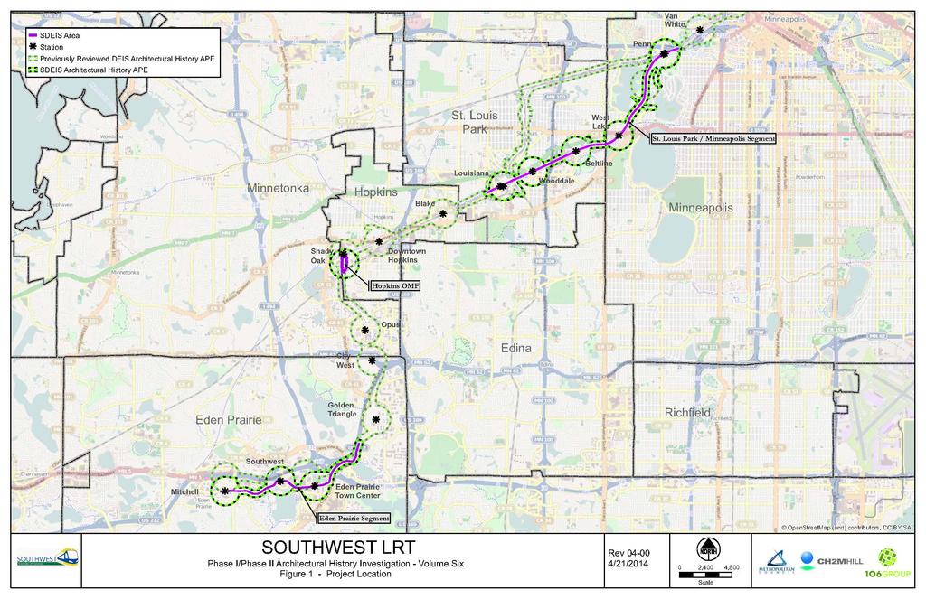
4 Contents Section Page 1 Introduction Methods and Research Design Objectives SDEIS Area of Potential Effect Inventory Forms Evaluation Literature Search Eden Prairie Survey Zone Previously Evaluated Properties Hopkins Survey Zone Previously Evaluated Properties St. Louis Park Survey Zone Previously Evaluated Properties Minneapolis West Residential Survey Zone Previously Evaluated Properties Results Eden Prairie Survey Zone Hopkins Survey Zone St. Louis Park Survey Zone Minneapolis West Residential Survey Zone Edgar J. Couper House, HE-MPC Recommendations References Cited Exhibits 1 Project Location a Previously Listed and Determined Eligible Architectural History Properties, Eden Prairie Segment b Previously Listed and Determined Eligible Architectural History Properties, Hopkins OMF c Previously Listed and Determined Eligible Architectural History Properties, St. Louis Park/Minneapolis Segment Mount Curve Avenue (HE-MPC-5145), Facing South Attachments A Research Design B Eden Prairie Survey Zone Surveyed Properties C Hopkins Survey Zone Surveyed Properties D St. Louis Park Survey Zone Surveyed Properties E Minneapolis West Residential Zone Surveyed Properties F Project Personnel Work Phase TBG MSP v
5 METROPOLITAN COUNCIL SOUTHWEST LRT PROJECT 1 Introduction This report has been prepared to supplement Phase I and II architectural history investigations conducted between 2010 and 2014 for the proposed Southwest LRT Project (Green Line Extension; formerly referred to as the Southwest Transitway Project) in Hennepin County, Minnesota. Results of the previous investigations can be found in the following volumes of the reports entitled Phase I/Phase II Architecture History Investigation for the Proposed Southwest Transitway Project, Hennepin County, Minnesota: Volume One, the Eden Prairie, Minnetonka, Hopkins, and St. Louis Park survey zones (2010) Volume Two, the Minneapolis West Residential, Minneapolis South Residential/Commercial, Minneapolis Downtown, Minneapolis Industrial, and Minneapolis Warehouse survey zones (2012) Volume Three, railroad-related resources in the Minneapolis and St. Louis Railroad; Chicago, Milwaukee and St. Paul Railroad; Minneapolis, Northfield and Southern Railroad; and Great Northern Railroad survey zones (2010) Volume Four, Supplemental Report Number One, additional areas/properties in the St. Louis Park; Minneapolis West Residential; Minneapolis, Northfield and Southern Railroad; and Great Northern survey zones (2012) Volume Five, Supplemental Report Number Two, additional areas/properties in St. Louis Park and Minneapolis West Residential survey zones (2014) This supplemental work was conducted in accordance with Southwest Transitway: A Research Design for Cultural Resources, located in Attachment A of this report. This supplemental Phase I and II architectural history investigation was conducted to address the SDEIS areas (Eden Prairie Segment, Hopkins Operations and Maintenance Facility [OMF], and St. Louis Park/Minneapolis Segment). The SDEIS architectural history area of potential effect (APE) is located within the Eden Prairie survey zone, Hopkins survey zone, St. Louis Park survey zone, and Minneapolis West Residential survey zone. Work Phase 1-1 TBG MSP
6
7 METROPOLITAN COUNCIL SOUTHWEST LRT PROJECT 2 Methods and Research Design 2.1 Objectives The primary objectives of this architectural history investigation were to determine whether there are any architectural history resources within the SDEIS APE, the area within which historic properties may be affected by the proposed project, that were constructed in or before 1965, and if those resources are eligible for listing in the National Register of Historic Places (NRHP). Please see Attachment A for Southwest Transitway: A Research Design for Cultural Resources for a description of the APE. All work was conducted in accordance with the Minnesota State Historic Preservation Office s (SHPO) Guidelines for History/Architecture Projects in Minnesota, MnDOT s Cultural Resources Unit Project and Report Requirements, and The Secretary of the Interior s Standards and Guidelines for Archeology and Historic Preservation [48 Federal Register ] (SHPO 2010; MnDOT CRU 2011; NPS 1983). 2.2 SDEIS Area of Potential Effect The SDEIS architectural history APE for the corridor includes 300 feet on either side of the centerline of the current alignments, and expands to 0.25 miles from the centerpoints of proposed station and OMF locations. The delineation of the SDEIS APE follows the same parameters as the delineation of the APE in the research design, except where notated below. The architectural history APE for the Eden Prairie Segment, Hopkins OMF, and St. Louis Park/Minneapolis Segment has been developed in consultation with MnDOT CRU. The exceptions to the above standard APE for the SDEIS survey areas are as follows: 1. The APE around the Hopkins OMF facility utilizes the same 0.25 mile radius as that employed for the station areas. This addresses visual and other indirect effects and effects of related infrastructure work. See Figure 2b. 2. The 0.25 mile radius APE around Penn Station (in the SDEIS St. Louis Park/Minneapolis Segment) includes a portion of the Kenwood Parkway Residential Historic District. The APE is extended beyond the 0.25 mile radius to include the remainder of the Historic District. This will allow consideration of any potential effects, including parking and traffic, throughout the Historic District along the parkway. See Figure 2c. 3. The 300 foot APE on either side of the project as it crosses the Kenilworth Lagoon/Channel (in the SDEIS St. Louis Park/Minneapolis Segment) includes only a portion of the Lagoon/Channel, which, together with the adjoining Cedar Lake and Lake of the Isles, is part of the Grand Rounds Historic District. The APE is extended beyond the 300 feet on each side of the corridor to include the entire length of the Lagoon/Channel and adjacent portions of the two connecting lakes. This will allow consideration of potential visual and noise effects from the new bridge from vantage points within the Historic District on the lagoon/channel and the lakes. See Figure 2c. 4. Six locations in and/or adjacent to the standard APE include improvements to existing roadways. The APE in these locations is extended outside the standard APE to include parcels adjacent to the construction limits of the roadway improvements. This addresses visual and other indirect effects associated with the improvements. These six locations are as follows: a. Northeast corner of the Mitchell Station APE (see Figure 2a) b. A portion of the north side of the alignment between the Mitchell Station and Southwest Station (see Figure 2a) c. Northeast corner of the Eden Prairie Center Station (see Figure 2a) d. A portion of the west side of the alignment located northeast of Eden Prairie Center Station and east of Valley View Road (see Figure 2a) Work Phase 2-1 TBG MSP
8 SOUTHWEST LIGHT RAIL TRANSIT e. Northeast corner of the Beltline Station APE (see Figure 2c) f. East and west sides of the Penn Station APE (see Figure 2c) 2.3 Inventory Forms PHASE I/PHASE II ARCHITECTURAL HISTORY INVESTIGATION A new or updated Minnesota Architecture-History Inventory Form was completed for each property located within the SDEIS APE that was constructed in or before 1965, and has not been previously listed in or determined eligible for listing in the NRHP or surveyed during the previous Phase I survey completed for the Southwest LRT project. The inventory forms are being submitted to the SHPO. 2.4 Evaluation Upon completion of the fieldwork, the potential eligibility of each resource for listing in the NRHP was assessed based on the property s historical significance and integrity. The NRHP criteria summarized below were used to assess the potential significance of each property: Criterion A association with the events that have made a significant contribution to the broad patterns of our history; Criterion B association with the lives of persons significant in our past; Criterion C embodiment of the distinctive characteristics of a type, period, or method of construction; representation of the work of a master; possession of high artistic values; or representation of a significant and distinguishable entity whose components may lack individual distinction; or Criterion D potential to yield information important to history (NPS 1995). The National Park Service (NPS) has identified seven aspects of integrity to be considered when evaluating the ability of a property to convey its significance: location, design, setting, materials, workmanship, feeling, and association. The integrity of each property or site was assessed in regard to these seven aspects. The properties were also assessed to determine if they represent a type of resource to be evaluated for NRHP eligibility using the Criteria Considerations (NPS 1995). Work Phase 2-2 TBG MSP
9 METROPOLITAN COUNCIL SOUTHWEST LRT PROJECT 3 Literature Search 3.1 Eden Prairie Survey Zone Historical contexts prepared for the previous Southwest LRT architectural history reports were reviewed to gain an understanding of the properties located in the SDEIS APE Previously Evaluated Properties In August of 2013, the 106 Group reviewed the Minnesota SHPO Architecture-History Inventory files and identified no architectural history properties that have been previously listed in or determined eligible for listing in the NRHP that are located within the SDEIS APE for the Eden Prairie segment in the Eden Prairie survey zone (see Figure 2a). 3.2 Hopkins Survey Zone Historical contexts prepared for the previous Southwest LRT architectural history reports were reviewed to gain an understanding of the properties located in the SDEIS APE Previously Evaluated Properties In August of 2013, the 106 Group reviewed the Minnesota SHPO Architecture-History Inventory files and identified no architectural history properties that have been previously listed in or determined eligible for listing in the NRHP that are located within the SDEIS APE for the Hopkins OMF in the Hopkins survey zone (see Figure 2b). 3.3 St. Louis Park Survey Zone Historical contexts prepared for the previous Southwest LRT architectural history reports were reviewed to gain an understanding of the properties located in the SDEIS APE Previously Evaluated Properties In the fall of 2013, the 106 Group reviewed the Minnesota SHPO Architecture-History Inventory files and identified three architectural history properties that have been previously listed in or determined eligible for listing in the NRHP that are located within the SDEIS APE for the St. Louis Park/Minneapolis segment in the St. Louis Park survey zone (see Figure 2c). These properties include: NRHP-listed Chicago, Milwaukee & St. Paul Railroad Depot (HE-SLC-008) NRHP-listed and National Historic Landmark Peavey-Haglin Experimental Concrete Grain Elevator (HE-SLC-009) NRHP-eligible Hoffman Callan Building (HE-SLC-055) 3.4 Minneapolis West Residential Survey Zone Historical contexts prepared for the previous Southwest LRT architectural history reports were reviewed to gain an understanding of the properties located in the SDEIS APE Previously Evaluated Properties In 2013, the 106 Group reviewed the Minnesota SHPO Architecture-History Inventory files and identified two individual properties and four historic districts that have been previously listed in or determined eligible for listing in the NRHP that are located within the SDEIS APE for the St. Louis Park/Minneapolis segment in the Minneapolis West Residential survey zone (see Figure 2c). These properties include: NRHP-eligible Minikahda Club (HE-MPC-17102) NRHP-eligible Mac Martin House (HE-MPC-8763) Work Phase 3-1 TBG MSP
10 SOUTHWEST LIGHT RAIL TRANSIT PHASE I/PHASE II ARCHITECTURAL HISTORY INVESTIGATION NRHP-eligible Grand Round Historic District (XX-PRK-001), including 10 contributing resources 1 : o o o o o o o o o o Kenwood Parkway (HE-MPC-1796) Kenwood Park (HE-MPC-1797) Lake Calhoun (HE-MPC-1811) Cedar Lake (HE-MPC-1820) Kenilworth Lagoon (HE-MPC-1822) Lake of the Isles (HE-MPC-1824) Lake of the Isles Parkway (HE-MPC-1825) Cedar Lake Parkway (HE-MPC-1833) Kenwood Water Tower (HE-MPC-6475) Park Board Bridge No. 4 (HE-MPC-6901) NRHP-eligible Lake of the Isles Residential Historic District (HE-MPC-9860) Kenwood Parkway Residential Historic District (HE-MPC-18059, under evaluation) NRHP-eligible St. Paul Minneapolis and Manitoba Railroad Historic District (HE-MPC-16387) 1 The APE also includes three non-contributing resources in the Grand Rounds Historic District: two wood pile railroad bridges (HE-MPC-1850 and HE-MPC-1851) and a two-lane automobile bridge with a steel beam span (the Burnham Road Bridge, HE- MPC-1832). All of these bridges span the Kenilworth Lagoon/Channel. The two railroad bridges were individually evaluated as not eligible in Volume Three of the Southwest architecture history survey, and the Burnham Road Bridge was individually evaluated as not eligible in MnDOT s statewide bridge survey Work Phase 3-2 TBG MSP

11

12

13
14 METROPOLITAN COUNCIL SOUTHWEST LRT PROJECT 4 Results Staff from the 106 Group conducted a Phase I and II architectural history investigation of the SDEIS APE between August 2013 and March Saleh Miller, M.S. served as principal investigator. A full list of project personnel is provided in Attachment F. During the Phase I survey, the 106 Group documented 41 architectural history properties that were constructed in or before 1965 that are located within the SDEIS APE. Of these 41 properties, one was recommended as potentially eligible during the Phase I investigation and proceeded to a Phase II evaluation. 4.1 Eden Prairie Survey Zone A total of two properties were surveyed in the SDEIS APE for the Eden Prairie segment in the Eden Prairie survey zone. All properties are recommended as not eligible for listing in the NRHP due to a lack of historical significance and/or a loss of integrity. Therefore, none of the properties within the SDEIS APE for the Eden Prairie segment warranted a Phase II evaluation (See Attachment B). 4.2 Hopkins Survey Zone A total of 12 properties were surveyed in the SDEIS APE for the Hopkins OMF in the Hopkins survey zone. All properties are recommended as not eligible for listing in the NRHP due to a lack of historical significance and/or a loss of integrity. Therefore, none of the properties within the SDEIS APE for the Hopkins OMF warranted a Phase II evaluation (See Attachment C). 4.3 St. Louis Park Survey Zone A total of 10 properties were surveyed in the SDEIS APE for the St. Louis Park/Minneapolis segment in the St. Louis Park survey zone. All properties are recommended as not eligible for listing in the NRHP due to a lack of historical significance and/or a loss of integrity. Therefore, none of the properties within the SDEIS APE for the St. Louis Park/Minneapolis segment in the St. Louis Park survey zone warranted a Phase II evaluation (See Attachment D). 4.4 Minneapolis West Residential Survey Zone A total of 17 properties were surveyed in the SDEIS APE for the St. Louis Park/Minneapolis segment in the Minneapolis West Residential survey zone. Sixteen of these properties were recommended as not eligible for listing in the NRHP due to a lack of historical significance and/or a loss of integrity during the Phase I evaluation. Of these 17 properties, one warranted a Phase II evaluation (Table 1). The Phase II evaluation is presented in this section. Table 1. Phase II Architectural History Evaluation Property Name (Historic) Property Address SHPO Inventory Number NRHP Status Edgar J. Couper House 1819 Mount Curve Avenue, Minneapolis HE-MPC-5145 Not eligible Edgar J. Couper House, HE-MPC-5145 Description: This Tudor Revival style house was constructed in The two-and-a-half-story, irregularshaped structure rests on a brick clad foundation, is faced in stucco, and has a cross-gabled roof that is covered with asphalt shingles (Figure 3). The house features two prominent front gables on the façade. Decorative half-timbering is located in the gable ends. A one-story projecting window bay that was added in 1927 is located on the east end of the façade. The bay is clad in stucco and has a flat roof. A two-story sleeping porch that was constructed in 1911 is located on the east elevation. The sleeping porch is faced in stucco and half-timbering and has a hipped roof. A two-story wing that is faced in stucco and has a gable roof is located at the southwest corner of the house. Exterior brick chimneys are located on both the east and west elevations. Work Phase 4-1 TBG MSP

15 SOUTHWEST LIGHT RAIL TRANSIT PHASE I/PHASE II ARCHITECTURAL HISTORY INVESTIGATION Shed-roofed dormers are located on the north, east, and west slopes of the roof. Exposed rafter tails can be seen under the roof eaves and wood trim surrounds all windows and the door. Figure Mount Curve Avenue (HE-MPC-5145), Facing South A large garage is attached to the east elevation of the house via a one-story hyphen. The one-and-a-half-story garage, which was constructed in 1910, is faced in stucco and has a front gabled roof that is covered with asphalt shingles. Decorative half-timbering is located in the gable end. A hipped roof dormer is located on the east slope of the garage roof. An addition was added to the western elevation of the garage in The addition is clad is stucco and has a mansard roof. Flat roof dormers are found on the north, west, and south elevations of the addition. Fenestration on the garage consists of a two-stall metal overhead door; a singlestall metal overhead door; single-light wood casement windows; and one-over-one, double-hung, wood windows. Original building permits have not been found indicating the date of construction of the hyphen, though it was likely added in 1968 as part of the addition to the garage. The hyphen is clad in stucco and has a hipped roof that is covered with asphalt shingles. Fenestration on the hyphen includes a 30-light wood window with 12-light wood transom and a single-leaf metal door with vinyl screen door and eight-light wood transom. The main block of the house features multiple types of fenestration. The first story of the façade is fenestrated with three, paired six-light wood casement windows with two-light transoms; six-light fixed wood windows; six-over-one, double-hung, wood windows with wood storms; fifteen-over-one, doublehung, wood windows; two-over-one, double-hung, wood windows with wood storms; and a single-leaf door with a metal and glass storm door. The main entrance, which is sited slightly off-center, is framed by a frontgabled portico. The second story of the façade is fenestrated with six-over-one, double-hung, wood windows with wood storms; double-hung, wood windows with divided light transoms; eight-over-one, double-hung, wood windows with wood storms; and one-over one, double-hung, wood windows with wood storms. The half-story of the façade is fenestrated with six-over-one, double-hung, wood windows with wood storms and three, nine-light wood casement windows. Fenestration on the first story of the east elevation consists of fifteen-over-one, double-hung, wood windows and two-over-one, double-hung, wood windows with wood storms. The second story of the east elevation is fenestrated with eight-over-one, double-hung, wood windows with wood storms. Fenestration on the first story of the south elevation is only partially visible from the public right-of-way (ROW) due to retaining walls and a fence, and includes two projecting bay windows comprised of one-overone, double-hung, wood windows with nine-light wood transom windows. Fenestration on the second story of the south elevation is also only partially visible from the ROW and includes eight-light wood casement Work Phase 4-2 TBG MSP
16 SOUTHWEST LIGHT RAIL TRANSIT PHASE I/PHASE II ARCHITECTURAL HISTORY INVESTIGATION windows and eight-over-one, double-hung, wood window with wood storms. The half-story of the south elevation is fenestrated with tripled, double-hung, wood windows in the gable ends; it is not possible to determine the number of lights in the windows from the ROW. Fenestration on the first story of the west elevation includes six-over-one, double-hung, wood windows with wood storms; and one-over-one, double-hung, wood windows with divided-light transoms. The second story of the west elevation is fenestrated with eight-light, fixed wood windows; eight-light, wood casement windows; a three-part, single-light casement window; and a six-over-one, double-hung, wood window with wood storm. Fenestration on the half-story on the west elevation includes double-hung wood windows; however, it is not possible to determine the number of lights in the windows from the ROW. History: According to Minneapolis building permits, this Tudor Revival style house and garage were constructed in The house was designed by architect William Kenyon for original owner Edgar J. Couper (City of Minneapolis 1910a:Building Permit #B86416; City of Minneapolis 1910b:Building Permit #B87421). The next year a two-story sleeping porch, also designed by William Kenyon, was added to the east elevation of the house (City of Minneapolis 1911:Buildng Permit #B93810). According to Sanborn maps the first story of the sleeping porch was originally open (Sanborn Map Company 1951). In 1927, a one-story addition was constructed on the rear and front of the dwelling. The front addition appears to be the bay window that is extant on the façade; the addition to the rear of the building is not visible from the ROW. These additions were designed by architect Maurice Maine, the partner of William Kenyon (City of Minneapolis 1927:Building Permit #B206809). In 1968, an addition was constructed on the garage, which based on the form of the garage was likely the western portion (City of Minneapolis 1968:Building Permit #B411206). It is likely that the hyphen between the house and garage was also constructed at this time, though original building permits verifying a date of construction have not been found. Plans found at the Northwest Architectural Archives indicate that the two bay windows on the south elevation were added as part of an interior remodeling project in 1969; the project also included the removal of two casement windows on the first story of the wing on the west elevation. An architect is not listed on the plans (Northwest Architectural Archives 1969). The ownership of this house changed several times in the decades after its construction. The original owner was Edgar J. Couper, who was the vice-president of the Northwestern Knitting Company (also known as Munsingwear) (Minneapolis Directory Company 1910). The Northwestern Knitting Company was the nation s leading manufacturer of underwear in The company s founder, George Munsing, invented a method of combining silk and cotton into woolen underwear to take the itch out of the garment. The undergarment was patented in 1891 and propelled the company into a leading producer and distributor of underwear (City of Minneapolis 2013). By 1920, the house was owned by H.S. Helm, the vice-president and general manager of Russell-Miller Milling Company (Minneapolis Directory Company 1920). By 1927, Mr. George F. Piper, the vice-president of Lane, Piper & Jaffray Inc. and secretary of Piper Brothers Inc., owned the house (Minneapolis Directory Company 1927). In 1931, the house was owned by F. H. Stinchfield. Mr. Stinchfield was a lawyer at Stinchfield, Mackall, Counse, McNally & Moore. Stinchfield s window Eliz owned the house into the 1950s (Minneapolis Directory Company 1931; Minneapolis Directory Company 1940; Minneapolis Directory Company 1950). According to building permits the house was converted into a duplex in 1958 (City of Minneapolis 1958:Building Permit #B364626). The 1969 plans from the Northwest Architectural Archives note that the house is the Mrs. Jack A. Peverill Residence. Information about Peverill and his occupation has not been found. Sheldon S. Sturgis is listed as the current owner of the house. The house remains classified as residential two unit by the City of Minneapolis (Hennepin County Assessor s Office 2014). William Kenyon This house and garage were designed by architect William Kenyon. Kenyon was born in New York in Kenyon graduated from the Boston Art Normal School in 1884 and moved to Minneapolis in He worked in private practice until At that time he entered into a partnership with Maurice Maine, which continued until During their partnership, Kenyon and Maine were well known for designing public buildings, including Abbott Hospital in Minneapolis. The pair was also appointed architects of the New Work Phase 4-3 TBG MSP
17 SOUTHWEST LIGHT RAIL TRANSIT PHASE I/PHASE II ARCHITECTURAL HISTORY INVESTIGATION Carnelia Company in 1914 to design the mining town of Ajo, Arizona. After Kenyon and Maine s partnership ended, Kenyon continued in private practice until his retirement in Kenyon was the chief architect of the Soo Line Railroad for 20 years, as well as a member of the advisory board for the Greater University of Minnesota Campus. He died on February 4, 1940 at the age of 77 (Lathrop 2010: ). The Minneapolis Heritage Preservation Commission lists over 25 structures in Minneapolis attributed to Kenyon; an additional 68 properties in Minneapolis were identified in an unpublished survey as also being attributed to Kenyon, several of which were designed in the Tudor Revival style like the Edgar J. Couper House (Minneapolis HPC 2012:16). Kenyon s notable work includes his own home which was designed in the Tudor Revival style at 1715 James Avenue S. in Minneapolis (Figure 4), the Colonial Revival style John G. Glueck Residence at 2447 Bryant Avenue South in Minneapolis, the Lyman Court Apartments in Minneapolis (razed), the Minnesota State Fair Amphitheatre in St. Paul, and the Soo Line Building at 501 Marquette Avenue South in Minneapolis (Lathrop 2010: ). Tudor Revival The Couper House was designed in the Tudor Revival style, which is loosely based on a variety of late Medieval English prototypes and was popular in the early twentieth century. Tudor Revival was relatively uncommon in the United States before World War I, then exploded in popularity during the 1920s and 1930s, and rivaled only Colonial Revival in popularity as a vernacular domestic building style nationwide. The style then fell out of fashion in the late 1930s. Tudor Revival is subdivided into categories based on the dominant façade material, including stucco wall cladding, brick wall cladding, stone wall cladding, wooden wall cladding, false thatched roof, and parapeted gables. Common characteristics of the style include an asymmetrical design; steeply pitched gable roof, often with a dominant front gable; massive chimney; decorative half-timbering; and tall, narrow windows, commonly in multiple groups and with multi-pane glazing (McAlester 2004: ). The Couper House is an example of the stucco wall cladding subtype. Most stucco wall clad houses were modest in size, making the Couper House somewhat unusual given its larger size. However, the house was constructed in 1910 when stucco was a more common wall cladding choice prior to the expansion of masonry veneering techniques in the 1920s. The house exemplifies characteristics of the Tudor Revival style with its asymmetrical façade, front gables, massive chimneys, decorative timbering, and multiple window groupings. Significance: The Edgar J. Couper House is a good example of the Tudor Revival style, as it features several character-defining features of the style, including an asymmetrical façade, steeply pitched cross-gabled roof with prominent front gables on the façade, massive chimneys, decorative half-timbering, and tall windows located in groups with multi-pane glazing. Additionally, the house is an early example of the style and is part of the stucco wall cladding subtype having been built prior to the 1920s, and is somewhat unique as an example of the stucco cladding subtype, which is a relatively small percentage of the Tudor Revival styles. Despite being a good example of the Tudor Revival style, the house does not possess any particularly unique or distinctive elements of the style which make it stand out among numerous other examples of the style within Minneapolis or the Lowry Hill neighborhood. Numerous examples of the style are found within close proximity of the Couper House, including (but not limited to) the residences at 1771 Logan Avenue South, 1785 Logan Avenue South, 1809 James Avenue South, and 1314 Mount Curve Avenue. The houses at 1771 Logan Avenue South (Figure 5), 1785 Logan Avenue South, and 1809 James Avenue South are examples of the brick wall cladding subtype, while the house at 1314 Mount Curve Avenue (Figure 6) has stone wall cladding. These houses each have the same defining elements of the Tudor Revival style that the Couper House has, including timber framing in the gable ends, large chimneys, steeply pitched gable roofs with dominant front gables, and groups of tall, narrow windows. These houses also appear to retain good historic integrity. As such, the Couper House does not possess any unique or unusual features of the Tudor Revival style that would make it stand out among the ubiquity of the Tudor Revival style within the Lowry Hill neighborhood. NRHP listed Tudor Revival structures in Minneapolis include the Edwin H. Hewitt House at 126 East Franklin Avenue, which was the personal residence of one of Minnesota s most widely acclaimed architects, Edwin Hawley Hewitt (Minneapolis HPC 2014). The large stucco and brick residence features characteristic elements such as prominent front gables and large brick chimneys, and also retains excellent integrity. Therefore, due to the prominence of the Tudor Revival style in the Lowry Hill neighborhood and Work Phase 4-4 TBG MSP
18 SOUTHWEST LIGHT RAIL TRANSIT PHASE I/PHASE II ARCHITECTURAL HISTORY INVESTIGATION Minneapolis, the house does not appear to have significance under NRHP Criterion C within the area of architecture. The house was designed by local architect William Kenyon. Kenyon is well-known for his wide variety of commissions, including residences and commercial buildings throughout Minneapolis. Evaluated within Kenyon s extensive body of work, the Edgar J. Couper House does not appear to stand out or have significance as an exceptional example of his work. Additionally, alterations to the Couper House, though minimal, have impacted the original design intent of the house as planned by Kenyon. Furthermore, Kenyon s own house at 1715 James Avenue South (see Figure 4) is located two blocks east of the Couper House and is also designed in the Tudor Revival style. The James Avenue house is similar in form to the Couper House and features two prominent front gables, large brick chimneys, brick wall cladding, and stucco with halftimbering and decorative timber inlays in the gable ends. The house appears to retain excellent integrity. While the Couper House is a high-quality example of the Tudor Revival style by William Kenyon, Kenyon s personal residence retains a more direct association with Kenyon and his mastery of the Tudor Revival style. Therefore, the Edgar J. Couper House does not appear to have significance under NRHP Criterion C as the work of a master. Although the house was owned by many prominent Minneapolis businessmen, none of them appear to have made sizable contributions to the development of Minneapolis and therefore, this property does not appear to have local significance under Criterion B. In addition, this property does not readily appear to have contributed to significant broad patterns of history; and has not yielded, nor is it likely to yield, information important in prehistory or history. Integrity: This house and garage remain in their original location on the residential street of Mount Curve Avenue in Minneapolis. Therefore, they retain excellent integrity of location, feeling, association, and setting. Since their original construction in 1910, there have been numerous additions to the house and garage. The sleeping porch addition on the house was designed by Kenyon in 1911 and the one-story bay window addition from 1927 was designed by Maurice Maine, Kenyon s partner. The garage addition and hyphen were added in 1968 and bay windows were added to the rear elevation and some original windows on the west elevation of the house were removed in The architect of the 1968 and 1969 alterations is unknown. The garage and hyphen addition, while visible from the façade, are designed in the Tudor Revival style and are of such a scale that they do not overwhelm or detract from the overall design of the house and garage. Since most of the additions to the house were designed by Kenyon or his partner, and those that were not are located on a secondary elevation, the additions only slightly compromise the integrity of design, materials, and workmanship. Overall, the house retains good integrity. Recommendation: The Edgar J. Couper House is a representative example of a William Kenyon-designed Tudor Revival house in Minneapolis. Despite being a good example of the style, the house is not an exceptional example and does not stand out prominently as compared to other examples of Tudor Revival houses in Minneapolis and the numerous examples of the style found within the Lowry Hill neighborhood. Therefore, the house is recommended as not eligible for listing in the NRHP under Criterion C within the area of architecture. Although the house was designed by master architect William Kenyon, the house does not appear to be an exceptional example of Kenyon s work. Additionally, Kenyon s personal residence, also designed in the Tudor Revival style and located just two blocks east of the Couper House, possesses better association with Kenyon. As such, the Edgar J. Couper House is recommended as not eligible for the NRHP under Criterion C as the work of a master. Work Phase 4-5 TBG MSP


19 SOUTHWEST LIGHT RAIL TRANSIT PHASE I/PHASE II ARCHITECTURAL HISTORY INVESTIGATION Figure James Avenue South (William Kenyon Residence), Facing East Figure Logan Avenue South, Facing East Work Phase 4-6 TBG MSP

20 SOUTHWEST LIGHT RAIL TRANSIT PHASE I/PHASE II ARCHITECTURAL HISTORY INVESTIGATION Figure Mt. Curve Avenue, Facing North Work Phase 4-7 TBG MSP
21 METROPOLITAN COUNCIL SOUTHWEST LRT PROJECT 5 Recommendations During the Phase I architectural history investigation, the 106 Group documented 41 properties within the SDEIS APE that were constructed in or before Forty of these properties were recommended as not eligible for listing in the NRHP due to a lack of historical significance and/or a loss of integrity. One property (HE-MPC-5145) was recommended as potentially eligible and proceeded to a Phase II evaluation. During the Phase II evaluation this property was recommended as not eligible. A listing of all inventoried properties is found in the attachments to this report (Attachments B-E). Further information on the properties is found on new or updated inventory forms, which are being submitted to SHPO for inclusion in the statewide inventory. No additional architectural history survey is recommended within this SDEIS APE. Work Phase 5-1 TBG MSP
22 6 References Cited City of Minneapolis 1910a Building Permit #B On file at Minneapolis Development Review, Minneapolis, Minnesota. 1910b Building Permit #B On file at Minneapolis Development Review, Minneapolis, Minnesota Building Permit #B On file at Minneapolis Development Review, Minneapolis, Minnesota Building Permit #B On file at Minneapolis Development Review, Minneapolis, Minnesota Building Permit #B On file at Minneapolis Development Review, Minneapolis, Minnesota Building Permit # On file at Minneapolis Development Review, Minneapolis, Minnesota Northwestern Knitting Company/ Munsingwear. Electronic document, ting_co, accessed December 18, Hennepin County Assessor's Office 2014 Property Information. Electronic document, accessed February Lathrop, Alan K Minnesota Architects: A Biographical Dictionary. University of Minnesota Press, Minneapolis, Minnesota. McAlester, Virginia and Lee 2004 A Field Guide to American Houses. Alfred A. Knopf, New York, New York.
23 Minneapolis Directory Company 1910 Davison s Minneapolis City Directory. Minneapolis Directory Company, Minneapolis, Minnesota Davison s Minneapolis City Directory. Minneapolis Directory Company, Minneapolis, Minnesota Davison s Minneapolis City Directory. Minneapolis Directory Company, Minneapolis, Minnesota Davison s Minneapolis City Directory. Minneapolis Directory Company, Minneapolis, Minnesota Davison s Minneapolis City Directory. Minneapolis Directory Company, Minneapolis, Minnesota Davison s Minneapolis City Directory. Minneapolis Directory Company, Minneapolis, Minnesota. Minneapolis Heritage Preservation Commission (HPC) 2012 Designation Study: Chase Residence th Avenue South, Minneapolis. Electronic document, pdf, accessed March 10, Edwin H. Hewitt House. Electronic document, accessed March 14, Minnesota Department of Transportation, Cultural Resources Unit [MnDOT CRU] 2011 MnDOT s Cultural Resources Unit (CRU) Project and Report Requirements. MnDOT CRU, St. Paul, Minnesota. Minnesota State Historic Preservation Office [SHPO] 2010 Guidelines for History/Architecture Projects in Minnesota. On file at the State Historic Preservation Office, St. Paul, Minnesota. National Park Service [NPS] 1983 Secretary of the Interior s Standards and Guidelines for Archeology and Historic Preservation. Federal Register 48(190): National Register Bulletin: How to Apply the National Register Criteria for Evaluation. United States Department of the Interior, Washington, D.C.
24 Northwest Architectural Archives Mt. Curve Avenue Plans. On file at the Northwest Architectural Archives, University of Minnesota, Minneapolis, Minnesota. Sanborn Map Company 1951 Insurance Map of Minneapolis, Minnesota. Sanborn Map Company, New York, New York.
25 Attachment A Research Design
26 Southwest Transitway: A Research Design for Cultural Resources 12 February 2010, updated 16 March 2010, 2 April 2010 Prepared by Charlene Roise, Hess, Roise and Company Christina Harrison, Archaeological Research Services Mike Justin, Mike Madson, and Joe Trnka, HDR Engineering INTRODUCTION The Hennepin County Regional Rail Authority is proposing to construct the Southwest Light Rail Transit (SWLRT) facility, linking the Intermodal Station in downtown Minneapolis with the central business area in suburban Eden Prairie. The line is located within the cities of Minneapolis, St. Louis Park, Hopkins, Minnetonka, and Eden Prairie. The Federal Transit Administration (FTA) has determined that the proposed project is an undertaking as defined by the National Historic Preservation Act (NHPA) and is subject to the provisions of Section 106 of the NHPA. Section 106 requires that federal agencies take historic properties into account as part of project planning. The Cultural Resources Unit (CRU) of the Minnesota Department of Transportation (MnDOT) is acting on behalf of FTA for many aspects of the Section 106 review process for SWLRT. The FTA has also determined that the SWLRT is subject to the National Environmental Policy Act (NEPA) and a Draft Environmental Impact Statement (DEIS) is being prepared by Hennepin County under the direction of the FTA. Through the NEPA scoping process, four build alternatives were identified. To streamline subsequent analysis, these alternatives were divided into five segments. The following table, which was included in the draft Southwest LRT Technical Memorandum No. 9: Environmental Evaluation (September 9, 2009), outlines the segments that are associated with each of the alternatives: Alternative LRT 1A LRT 3A LRT 3C-1 (Nicollet Mall) LRT 3C-2 (11 th /12 th Street) Segments 1, 4, A 3, 4, A 3, 4, C-1 (Nicollet Mall) 3,4, C-2 (11 th -12 th Streets), C-2A (Blaisdell Avenue), C-2B (1 st Avenue) Segment 1 extends northeast from a station in Eden Prairie at TH 5 along a former rail corridor owned by the Hennepin County Railroad Authority (HCRRA) to a station at Shady Oak Road, on the border between Minnetonka and Hopkins. Southwest Transitway DEIS Cultural Resources Research Design 2/12/2010, rev.3/16/2010,4/2/2010 Page 1
27 Segment 3 creates a new corridor, running east from a station at Mitchell Road in Eden Prairie and turning northerly to terminate at the Shady Oak Station. Segment 4 follows an existing rail corridor east-northeasterly from the Shady Oak Station through Hopkins and Saint Louis Park to the West Lake Station in Minneapolis, near that city s western border. Segment A continues northeast from the West Lake Station, mostly using an existing rail corridor, to the Intermodal Station on the western edge of downtown Minneapolis. Segment C also begins at the West Lake Station, traveling east along a former rail corridor (now the Midtown Greenway), north along one of several alternative courses under and on city streets, to and through downtown Minneapolis, and ultimately ending at the Intermodal Station or South Fourth Street. (For the purpose of this cultural resources assessment, all of the C variations will be considered as a single group.) It should be noted that the above segments overlap at three points: the Shady Oak Station, the West Lake Station, and the Royalston/Intermodal Stations. When the results of the cultural resource surveys are sorted by segment, there will be redundancy in the findings at these three points. This redundancy is inevitable if the effects of each segment are to be analyzed. When a single alternative is selected, it will be necessary to eliminate duplicated properties to obtain an accurate representation of the effects of that alternative. PROPOSED METHODOLOGY FOR ARCHAEOLOGICAL RESOURCES SURVEY Christina Harrison, Archaeological Research Services Mike Justin and Mike Madsen, HDR Engineering This work plan outlines a program to identify archaeological properties which meet the criteria of the National Register of Historic Places in the project s area of potential effect (APE), to be used in assessing potential effects to those properties. Three primary tasks comprise the work plan. First, in order to provide a uniform assessment of available data across the five project segments discussed in the DEIS, the project team will prepare a report (by project segment within a broad APE) to include: results of the literature search, an archaeological probability assessment, and a field survey strategy (Task 1). It is expected that a limited amount of field investigation/sampling may occur as part of this task depending upon the weather. Second, an archaeological inventory/evaluation of the selected alternative will be completed, using a refined APE based on proposed construction (Task 2). Finally, a report of the field investigations of the selected alternative and an assessment of effects will be prepared (Task 3). Southwest Transitway DEIS Cultural Resources Research Design 2/12/2010, rev.3/16/2010,4/2/2010 Page 2
28 Task 1 will involve archaeologists from both HDR and ARS. Support will be provided, as needed, by Hess Roise research staff as well as by geomorphologists and other paleoenvironmental experts provided by HDR. Division of responsibilities will partly depend on what survey needs are identified by the background research, but primary responsibility for precontact and contact period archaeology will rest with Christina Harrison (ARS) and Michael Justin (HDR), and for historic archaeology with Michael Madson (HDR). The personnel for Tasks 2 and 3 are pending. The survey will be conducted in accordance with all federal, state, and local requirements, including the Minnesota Field Archaeology Act and the Minnesota Private Cemeteries Act. Area of Potential Effect (APE) The APE for archaeological resources is generally defined as the anticipated limits of construction activities. At this stage in the project development, factors influencing those limits have not yet been fully identified. The APE, starting with a broad area at first, will be refined as the engineering design advances. For Task 1, the APE for the literature search and probability assessment will be based, as appropriate, on the project limits as defined in the project engineering drawings used to prepare the DEIS. This will include the full width of existing railroad right-of-way corridors as well as the area within 100 feet on either side of the current engineering alignments. The APE near station areas also includes any undeveloped and/or vacant property within 500 feet that could potentially be utilized for construction/development activities. Depending on the station location, these may include open, green spaces (particularly in suburban areas) and paved parking lots (particularly in urban areas). If the literature search/probability assessment identifies potentially significant historic features or high probability areas immediately adjacent to the above-referenced APE parameters, and if the significance of potential sites in these areas is expected to relate to National Register criteria A, B, and/or C, the APE for the field strategy for the Phase I-II survey may be adjusted to include these locations. During Task 2, the APE will be reviewed in light of more detailed engineering plans. Throughout the design phase of the project, the adequacy of the APE will be periodically evaluated and expanded or retracted as necessary as project elements are added or modified. The survey report specified in Task 3 will provide a clear delineation of the surveyed APE, including all additions, so that the adequacy of survey efforts can be readily determined when project changes are proposed. It should be noted that, generally, the APE for archaeological resources is a smaller area located within the APE for history/architecture resources. Southwest Transitway DEIS Cultural Resources Research Design 2/12/2010, rev.3/16/2010,4/2/2010 Page 3
Phase 1a Archaeological Investigation Southwest Light Rail Transit Hennepin County, Minnesota. CH2M HILL, Inc. Project No SDEIS Areas:
 Phase 1a Archaeological Investigation Southwest Light Rail Transit Hennepin County, Minnesota CH2M HILL, Inc. Project No. 474576 SDEIS Areas: Eden Prairie Segment Hopkins Operations and Maintenance Facility
Architectural Inventory Form (page 1 of 5)
") OAHP1403 Rev. 9/98 COLORADO CULTURAL RESOURCE SURVEY (page 1 of 5) Official eligibility determination (OAHP use only) Date Initials Determined Eligible- NR Determined Not Eligible- NR Determined Eligible-
OAHP1403 Rev. 9/98 COLORADO CULTURAL RESOURCE SURVEY (page 1 of 5) Official eligibility determination (OAHP use only) Date Initials Determined Eligible- NR Determined Not Eligible- NR Determined Eligible-
Transportation Committee
 Transportation Committee Business Item No. 2013-286SW Meeting date: October 14, 2013 For the Metropolitan Council meeting of October 16, 2013 Subject: Southwest Light Rail Transit (Green Line Extension):
Architectural Inventory Form
 COLORADO CULTURAL RESOURCE SURVEY Page 1 of 8 Official Eligibility Determination (OAHP use only) Rev. 9/98 OAHP1403 Date Initials Determined Eligible National Register Determined Not Eligible National
Architectural Inventory Form (page 1 of 5)
") OAHP1403 Rev. 9/98 COLORADO CULTURAL RESOURCE SURVEY (page 1 of 5) I. IDENTIFICATION 1. Resource number 5RT-2050 2. Temporary resource number: 145008005 3. County: Routt County 4. City: Steamboat Springs
OAHP1403 Rev. 9/98 COLORADO CULTURAL RESOURCE SURVEY (page 1 of 5) I. IDENTIFICATION 1. Resource number 5RT-2050 2. Temporary resource number: 145008005 3. County: Routt County 4. City: Steamboat Springs
Morgan s Subdivision Historic District Character-defining Features
 Morgan s Subdivision Historic District Character-defining Features DISTRICT DESCRIPTION This small addition, designed as a neighborhood for those wishing to move east from Capitol Hill, was predominantly
7.0 DRAFT SECTION 4(f) EVALUATION
 EVALUATION") 7. DRAFT SECTION 4(f) EVALUATION 7.1 Background Information and Regulatory Requirements This chapter presents the existing conditions and potential effects on parks, recreation areas, wildlife and waterfowl
7. DRAFT SECTION 4(f) EVALUATION 7.1 Background Information and Regulatory Requirements This chapter presents the existing conditions and potential effects on parks, recreation areas, wildlife and waterfowl
MINNESOTA ARCHITECTURE - HISTORY INVENTORY FORM
 Identification Historic Name Dean Parkway Bridge Current Name Bridge 90661 Field # Address Midtown Greenway over Dean Parkway City/Twp Minneapolis County Hennepin Legal Desc. Twp 29N Range 24W Sec 32 QQ
Architectural Inventory Form
 OAHP1403 Rev. 9/98 COLORADO CULTURAL RESOURCE SURVEY Architectural Inventory Form Official eligibility determination (OAHP use only) Date Initials Determined Eligible- NR Determined Not Eligible- NR Determined
Architectural Inventory Form
 COLORADO CULTURAL RESOURCE SURVEY Page 1 of 7 Official Eligibility Determination (OAHP use only) Rev. 9/98 OAHP1403 Date Initials Determined Eligible National Register Determined Not Eligible National
Architectural Inventory Form
 COLORADO CULTURAL RESOURCE SURVEY Page 1 of 8 Official Eligibility Determination (OAHP use only) Rev. 9/98 OAHP1403 Date Initials Determined Eligible National Register Determined Not Eligible National
Architectural Inventory Form
 COLORADO CULTURAL RESOURCE SURVEY Page 1 of 8 Official Eligibility Determination (OAHP use only) Rev. 9/98 OAHP1403 Date Initials Determined Eligible National Register Determined Not Eligible National
IMPORTANT NOTICE. Architectural Inventory Form COLORADO CULTURAL RESOURCE SURVEY I. IDENTIFICATION th Street 5WL.5601
 IMPORTANT NOTICE OAHP1403 Rev. 9/98 COLORADO CULTURAL RESOURCE SURVEY Architectural Inventory Form Page 1 This survey form represents an UNOFFICIAL COPY and is provided for informational purposes only.
MINNESOTA ARCHITECTURE - HISTORY INVENTORY FORM
 Identification Historic Name Nicollet Avenue Bridge Current Name Nicollet Avenue Bridge Field # Address Nicollet Avenue over Minnehaha Creek City/Twp Minneapolis SHPO Inventory Number Review and Compliance
M E M O R A N D U M PLANNING AND COMMUNITY DEVELOPMENT DEPARTMENT CITY OF SANTA MONICA PLANNING DIVISION
 M E M O R A N D U M 10-A PLANNING AND COMMUNITY DEVELOPMENT DEPARTMENT CITY OF SANTA MONICA PLANNING DIVISION DATE: October 8, 2018 TO: FROM: SUBJECT: The Honorable Landmarks Commission Planning Staff
Ottawa Historic Resources Inventory: Commercial Historic District Building Information. Significance and Potential Eligibility
 C 01 1 Address: address 1 PIN: 21 11 218 001 Plan: Rectangular Stories: 2 Original Owner: Roof Type: Flat Building Names: Marquette School Foundation: Important Dates: ca 1955 Walls: BRICK Architect /
THE CITY OF LAKE FOREST HISTORIC PRESERVATION COMMISSION LOCAL LANDMARK NOMINATION INSTRUCTIONS
 THE CITY OF LAKE FOREST HISTORIC PRESERVATION COMMISSION LOCAL LANDMARK NOMINATION INSTRUCTIONS This application is for the nomination of individual properties as Local Historic Landmarks within the City
Baker Historic District
 DISTRICT DESCRIPTION This is a historically middle-class neighborhood in the South Side, an area annexed by Denver in 1883, consisting of more than 20 tightly interwoven residential subdivisions. The earliest
M E M O R A N D U M PLANNING AND COMMUNITY DEVELOPMENT DEPARTMENT CITY OF SANTA MONICA PLANNING DIVISION
 M E M O R A N D U M 10-B PLANNING AND COMMUNITY DEVELOPMENT DEPARTMENT CITY OF SANTA MONICA PLANNING DIVISION DATE: April 9, 2018 TO: FROM: SUBJECT: The Honorable Landmarks Commission Planning Staff 133
Architectural Inventory Form
 OAHP1403 Rev. 9/98 COLORADO CULTURAL RESOURCE SURVEY Architectural Inventory Form Official eligibility determination (OAHP use only) Date Initials Determined Eligible- NR Determined Not Eligible- NR Determined
Appendix D Sources, References Cited
 Southwest Transitway Sources, Cited October 2012 Page 1 Southwest Transitway Page intentionally left blank. October 2012 Page 1 Southwest Transitway Sources, Cited Chapter 2 Hennepin County Rail Authority.
Calvert Hills (66-037)
") Calvert Hills (66-037) Calvert Hills, a cohesive neighborhood in northwestern Prince George s County, is an excellent illustration of the residential development on the outskirts of Washington, D.C., in
Calvert Hills (66-037) Calvert Hills, a cohesive neighborhood in northwestern Prince George s County, is an excellent illustration of the residential development on the outskirts of Washington, D.C., in
Maryland Historical Trust Inventory No. PG: 85B-007 Maryland Inventory of Historic Properties Form
 Maryland Historical Trust Inventory No. PG: 85B-007 Maryland Inventory of 1. Name of Property (indicate preferred name) historic other 2. Location street and number Cedarville State Forest Road, Cedarville
7.0 SECTION 4(F) EVALUATION
 EVALUATION") Chapter 7 Section 4(f) Evaluation 7.0 SECTION 4(F) EVALUATION 7.1 Background Information and Regulatory Requirements This chapter presents the existing conditions and potential effects to parklands and
Chapter 7 Section 4(f) Evaluation 7.0 SECTION 4(F) EVALUATION 7.1 Background Information and Regulatory Requirements This chapter presents the existing conditions and potential effects to parklands and
HISTORIC SITE FORM - HISTORIC SITES INVENTORY PARK CITY MUNICIPAL CORPORATION (10-08) 1 IDENTIFICATION
 1 IDENTIFICATION") HISTORIC SITE FORM - HISTORIC SITES INVENTORY PARK CITY MUNICIPAL CORPORATION (10-08) 1 IDENTIFICATION Name of Property: William Tretheway House Address: 335 Woodside Avenue AKA: City, County: Park City,
HISTORIC SITE FORM - HISTORIC SITES INVENTORY PARK CITY MUNICIPAL CORPORATION (10-08) 1 IDENTIFICATION Name of Property: William Tretheway House Address: 335 Woodside Avenue AKA: City, County: Park City,
Corridor Management Committee. September 29, 2017
 Corridor Management Committee September 29, 2017 1 Today s Topics Chair s Update Proposed Corridor Protection Wall Aesthetic Design Overview Public Outreach Environmental Review Civil Construction Update
Los Angeles Department of City Planning RECOMMENDATION REPORT
 Los Angeles Department of City Planning RECOMMENDATION REPORT CULTURAL HERITAGE COMMISSION HEARING DATE: March 6, 2008 TIME: 10:00 AM PLACE: City Hall, Room 1010 200 N. Spring Street Los Angeles, CA 90012
Tazewell Pike. Neighborhood Conservation Overlay District Design Guidelines
 Tazewell Pike Neighborhood Conservation Overlay District Design Guidelines Knoxville Knox County Metropolitan Planning Commission November 2, 2000 These design guidelines were: Adopted by the Knoxville
Architectural Inventory Form
 COLORADO CULTURAL RESOURCE SURVEY Page 1 of 8 Official Eligibility Determination (OAHP use only) Rev. 9/98 OAHP1403 Date Initials Determined Eligible National Register Determined Not Eligible National
ADDENDUMS CRAFTSMAN The Craftsman style of Architecture was influenced by the English Arts and Crafts movement and East Asia, particularly Japan. In t
 ADDENDUMS CRAFTSMAN The Craftsman style of Architecture was influenced by the English Arts and Crafts movement and East Asia, particularly Japan. In the beginning Craftsman homes were a workman s bungalow
Appendix 1: Site Inventory Form
 Appendix 1: Site Inventory Form Wapsi Valley Archaeology, Inc. Anamosa, IA 56 X Cemetery Washington 83 24 2 NE X 1 5 approx. 200 approx. 201 unknown unknown Historic Resources Evaluation: 07A: Cemetery
HOMEWOOD. Architectural Style Guide
 HOMEWOOD Architectural Style Guide HOMEWOOD Architectural Style Guide Homewood Architectural Style Guide 2016 Sponsors: Operation Better Block Neighborhood Allies Carnegie Mellon University To the residents
IMPORTANT NOTICE. Architectural Inventory Form COLORADO CULTURAL RESOURCE SURVEY I. IDENTIFICATION Eldorado Avenue 5BL.10487
 IMPORTANT NOTICE OAHP1403 Rev. 9/98 COLORADO CULTURAL RESOURCE SURVEY Architectural Inventory Form Page 1 This survey form represents an UNOFFICIAL COPY and is provided for informational purposes only.
Los Angeles Department of City Planning RECOMMENDATION REPORT
 Los Angeles Department of City Planning RECOMMENDATION REPORT CULTURAL HERITAGE COMMISSION DATE: November 3, 2011 TIME: 10:00 AM PLACE: City Hall, Room 1010 200 N. Spring Street Los Angeles, CA 90012 CASE
What Style is My House?
 What Style is My House? -A Guide to Common House Styles in Decatur, GA- Contents American Small House.. p.2 Colonial Revival....p.3 Craftsman Cottage...p.4 English Vernacular Revival Cottage...p.5 American
REPORT TO THE HISTORIC DISTRICT COMMISSION
 Agenda Number: HDC 14-15 MEETING DATE: August 21, 2014 REPORT TO THE HISTORIC DISTRICT COMMISSION SUBJECT: 196 E. Poplar Avenue - Certificate of Appropriateness for exterior alterations INTRODUCTION: Mike
2.1.8 Cultural Resources Regulatory Setting. Affected Environment, Environmental
 REVISED DRAFT ENVIRONMENTAL IMPACT REPORT/ Affected Environment, Environmental 2.1.8 Cultural Resources This section evaluates the potential for historical and archaeological resources within the proposed
IMPORTANT NOTICE. Architectural Inventory Form COLORADO CULTURAL RESOURCE SURVEY I. IDENTIFICATION. 655 Bryan Avenue 5BL.10460
 IMPORTANT NOTICE OAHP1403 Rev. 9/98 COLORADO CULTURAL RESOURCE SURVEY Architectural Inventory Form Page 1 This survey form represents an UNOFFICIAL COPY and is provided for informational purposes only.
APPENDIX D: Visual and Aesthetic Conditions for NCCU Station Refinement. Durham-Orange Light Rail Transit Project
 APPENDIX D: Visual and Aesthetic Conditions for NCCU Station Refinement Durham-Orange Light Rail Transit Project October 2016 1. Introduction The Combined FEIS/ROD summarizes the effects of the D-O LRT
Trinomial NRHP Status Code Other Listings Review Code Reviewer Date
 PRIMARY RECORD Page 1 of 6 *Resource Name or #: (Assigned by recorder) Woolsey Building P1. Other Identifier: None NRHP Status Code Other Listings Review Code Reviewer Date *P2. Location: Not for Publication
B E R O A R C H I T E C T U R E P L L C
 B E R O A R C H I T E C T U R E P L L C A R C H I T E C T U R E S U S T A I N A B I L I T Y P R E S E R V A T I O N Thirty-Two Winthrop Street, Rochester, New York 14607 585-262-2035 contact@beroarchitecture.com
FINAL DRAFT. Building 77
 Building 77 LOCATION North Side of Ruckman Road Fort Monroe Hampton, Va. MANAGEMENT ZONE Zone D McNair, Ingalls, Fenwick Corridor CLASSIFICATION Contributing Structure CONDITION Good 5 4 8-A D E PRESERVATION
CHAPTER 2: HISTORIC BACKGROUND
 CHAPTER 2: HISTORIC BACKGROUND The historic town of Eastlake was created on June 22, 1911 when the Eastlake Subdivision was recorded at the Adams County Clerk and Recorder s Office. The Eastlake Investment
Chapter 8: BEACH SOUTH OF ATLANTIC AVENUE NEIGHBORHOOD PLANNING AREA ANALYSIS
 Chapter 8: BEACH SOUTH OF ATLANTIC AVENUE NEIGHBORHOOD PLANNING AREA ANALYSIS The Beach South of Atlantic Avenue Neighborhood Planning Area includes the parcels adjacent to S Fletcher Avenue from Atlantic
ATTACHMENT 1 DPR 523A AND B REPORTS
 ATTACHMENT 1 DPR 523A AND B REPORTS 824 University Avenue, Berkeley, Alameda County PRIMARY RECORD Page 1 of 10 Other Listings Review Code NRHP Status Code: 6Z Reviewer Date Resource Name: 824 University
The Maryland-National Capital Park and Planning Commission Prince George's County Planning Department Development Review Division
 The Maryland-National Capital Park and Planning Commission Prince George's County Planning Department Development Review Division 301-952-3530 Note: Staff reports can be accessed at www.mncppc.org/pgco/planning/plan.htm.
FINAL MITIGATION PLAN to address
 CENTRAL CORRIDOR LRT STATE CAPITOL MALL HISTORIC FINAL MITIGATION PLAN February 2010 FINAL MITIGATION PLAN to address Adverse Effects of the Central Corridor LRT Project on the State Capitol Mall Historic
Architectural Inventory Form
 COLORADO CULTURAL RESOURCE SURVEY Page 1 of 3 Official Eligibility Determination (OAHP use only) Rev. 9/98 OAHP1403 Date Initials Determined Eligible National Register Determined Not Eligible National
The NWX American Foursquare
 The NWX American Foursquare History and Character Known by a variety of names, including Edwardian, American Basic, and the Basic Box, the American Foursquare made its appearance just after the turn of
Address: 302 West Main Street PIN: Plan: Rectangular Stories: 2 Original Owner: Roof Type: Flat
 D 01 1 Address: 302 West Main Street PIN: 21 11 400 014 Plan: Rectangular Stories: 2 Building Names: Important Dates: ca 1920 Walls: BRICK Architectural Style: American, Late 19th / Early 20th C: Commercial
HISTORIC SITE FORM - HISTORIC SITES INVENTORY PARK CITY MUNICIPAL CORPORATION (10-08) 1 IDENTIFICATION
 1 IDENTIFICATION") HISTORIC SITE FORM - HISTORIC SITES INVENTORY PARK CITY MUNICIPAL CORPORATION (10-08) 1 IDENTIFICATION Name of Property: Address: 164 Sandridge Road AKA: City, County: Park City, Summit County, Utah Tax
HISTORIC SITE FORM - HISTORIC SITES INVENTORY PARK CITY MUNICIPAL CORPORATION (10-08) 1 IDENTIFICATION Name of Property: Address: 164 Sandridge Road AKA: City, County: Park City, Summit County, Utah Tax
L 4-1. Heritage Report: Reasons for Heritage Designation. Kodors House. 35 Rosedale Avenue West
 L 4-1 Brampton Heritage Board Date: January 17, 2012 Heritage Report: Reasons for Heritage Designation Kodors House 35 Rosedale Avenue West December 2011 1 L 4-2 Profile of Subject Property Municipal Address
HISTORIC SITE FORM - HISTORIC SITES INVENTORY PARK CITY MUNICIPAL CORPORATION (10-08) 1 IDENTIFICATION
 1 IDENTIFICATION") HISTORIC SITE FORM - HISTORIC SITES INVENTORY PARK CITY MUNICIPAL CORPORATION (10-08) 1 IDENTIFICATION Name of Property: Address: 158 Main Street City, County: Park City, Summit County, Utah AKA: Tax Number:
HISTORIC SITE FORM - HISTORIC SITES INVENTORY PARK CITY MUNICIPAL CORPORATION (10-08) 1 IDENTIFICATION Name of Property: Address: 158 Main Street City, County: Park City, Summit County, Utah AKA: Tax Number:
1 of 1 1/31/2016 2:49 PM
 Guide to Residential Styles Realtor Magazine http://realtormag.realtor.org/home-and-design/guide-residential-styles 1 of 1 1/31/2016 2:49 PM Every house has a style. Sometimes it has two or more; because
2154 Dundas Street West Intention to Designate under Part IV, Section 29 of the Ontario Heritage Act
 STAFF REPORT ACTION REQUIRED 2154 Dundas Street West Intention to Designate under Part IV, Section 29 of the Ontario Heritage Act Date: February 2, 2009 To: From: Toronto Preservation Board Toronto and
VIRGINIA BEACH HISTORICAL REGISTER NOMINATION/APPLICATION FORM
 VIRGINIA BEACH HISTORICAL REGISTER NOMINATION/APPLICATION FORM The completion and submittal of this form constitutes the formal nomination and application of a property to the Virginia Beach Historical
CEQA and Historic Preservation: A 360 Degree Review
 CEQA and Historic Preservation: A 360 Degree Review California Preservation Foundation Workshop February 11, 2015 Presented by Chris McMorris Partner / Architectural Historian CEQA and Historic Preservation
Historic Resources Inventory Evaluation Form
 Evaluation Date September 12, 2017 Historic Resources Inventory Evaluation Form Community District Designation Downtown Grade 1 The place should be rated for each of the criteria below, in order to establish
MINNESOTA ARCHITECTURE - HISTORY INVENTORY FORM
 Identification Historic Name Bridge L8503 Current Name Bridge L8503 Field # Address Seven Bridges Road over Amity Creek City/Twp City of Duluth County St. Louis Legal Desc. Twp 51N Range 13W Sec 32 QQ
EXCELSIOR SPRINGS HISTORIC RESOURCES 10
 EXCELSIOR SPRINGS HISTORIC RESOURCES 10 Resource No. 1. Property name, present Springdale Apartments 6. Location Map Property name, historic Arlington Hotel; Excelsior Club; Excelsior Springs Sanitarium
Analysis of Environs of 1000 New York Street, German Methodist Episcopal Church
 Item No. 3: L-14-00028 p.1 Analysis of Environs of New York Street, German Methodist Episcopal Church Step One Historical Significance and Context According to the application for Historic Landmark Designation,
CHAPTER 3 DOWNTOWN COMMERCIAL DISTRICT CHARACTER AREA
 CHAPTER 3 DOWNTOWN COMMERCIAL DISTRICT CHARACTER AREA 3.1 INTRODUCTION The Downtown Commercial District Character Area of Grass Valley comprises all of the city's core historic commercial district, including
NPS Form OMB No (Oct. 1990)
") NPS Form 10-900 OMB No. 10024-0018 (Oct. 1990) United States Department of the Interior National Park Service NATIONAL REGISTER OF HISTORIC PLACES REGISTRATION FORM 1. historic name: other name/site number:
NPS Form 10-900 OMB No. 10024-0018 (Oct. 1990) United States Department of the Interior National Park Service NATIONAL REGISTER OF HISTORIC PLACES REGISTRATION FORM 1. historic name: other name/site number:
CHAIR AND MEMBERS PLANNING & ENVIRONMENT COMMITTEE MEETING ON MONDAY AUGUST 28, 2017 JOHN M. FLEMING MANAGING DIRECTOR, PLANNING AND CITY PLANNER
 TO: FROM: SUBJECT: CHAIR AND MEMBERS PLANNING & ENVIRONMENT COMMITTEE MEETING ON MONDAY AUGUST 28, 2017 JOHN M. FLEMING MANAGING DIRECTOR, PLANNING AND CITY PLANNER REQUEST FOR DEMOLITION OF HERITAGE LISTED
Chapter 2, Section C: Urban Design and Visual Resources A. INTRODUCTION
 Chapter 2, Section C: Urban Design and Visual Resources A. INTRODUCTION This attachment considers the potential of the proposed East River Waterfront Access Project at Peck Slip to effect urban design
HISTORIC SITE FORM - HISTORIC SITES INVENTORY PARK CITY MUNICIPAL CORPORATION (10-08) 1 IDENTIFICATION
 1 IDENTIFICATION") HISTORIC SITE FORM - HISTORIC SITES INVENTORY PARK CITY MUNICIPAL CORPORATION (10-08) 1 IDENTIFICATION Name of Property: John W. Buck House Address: 1110 Woodside Avenue AKA: City, County: Park City, Summit
HISTORIC SITE FORM - HISTORIC SITES INVENTORY PARK CITY MUNICIPAL CORPORATION (10-08) 1 IDENTIFICATION Name of Property: John W. Buck House Address: 1110 Woodside Avenue AKA: City, County: Park City, Summit
HISTORIC SITE FORM - HISTORIC SITES INVENTORY PARK CITY MUNICIPAL CORPORATION (10-08)
") 1 IDENTIFICATION HISTORIC SITE FORM - HISTORIC SITES INVENTORY PARK CITY MUNICIPAL CORPORATION (10-08) Name of Property: Address: 929 PARK AVE AKA: City, County: Park City, Summit County, Utah Tax Number:
1 IDENTIFICATION HISTORIC SITE FORM - HISTORIC SITES INVENTORY PARK CITY MUNICIPAL CORPORATION (10-08) Name of Property: Address: 929 PARK AVE AKA: City, County: Park City, Summit County, Utah Tax Number:
Bassett Creek Valley Working Group. October 4, 2017
 Bassett Creek Valley Working Group October 4, 2017 1 Today s Topics Introductions Overview of Design Teams (P+W and WSP) Expertise Working Group Roles and Responsibilities Schedule & Community Engagement
429 Lansdowne Road Building or Property Name. Original owner
 HERITAGE SURVEY AND EVALUATION FORM Municipal Address 429 Lansdowne Road Building or Property Name 042280293 Legal Description PLAN 92 PT BLK 13 JUNC GORE;PT LOT 1 RP4R8942 PART 1 Lot Block Plan Date of
Gateway Corridor Standards
 Gateway Corridor Standards Building design and construction: Bungalow Classical Revival Colonial Revival Frame Vernacular Gothic Revival Italianate Mediterranean Revival Queen Anne Shingle architectural
Part 3 TYPE: BUNGALOW. 1910s 1930s
 RESIDENTIAL TYPES & STYLES Part 3 TYPE: BUNGALOW 1910s 1930s The bungalow is a twentieth-century residential type that arrived in New Orleans in the 1910s via California and the Arts and Crafts movement.
Architectural Inventory Form
 COLORADO CULTURAL RESOURCE SURVEY Page 1 Official eligibility determination (OAHP use only) Date Initials Determined Eligible- NR Determined Not Eligible- NR Determined Eligible- SR Determined Not Eligible-
The NWX Colonial Revival Style
 The NWX Colonial Revival Style History and Character The NorthWest Crossing Colonial Revival style home takes it cues from the rebirth of interest in the early English and Dutch houses of the Atlantic
Ordnance Street 110 Plan OS Lot 413 B202; parts of Lot 412 and portion of Lot 413
 Ordnance Street 110 Plan OS Lot 413 B202; parts of Lot 412 and portion of Lot 413 110 Ordnance Street has cultural heritage value under 3 categories Physical built in 1886, it is an example of late 19
STATE OF VERMONT PUBLIC SERVICE BOARD
 STATE OF VERMONT PUBLIC SERVICE BOARD Petition of Champlain VT, LLC d/b/a TDI New England ) for a Certificate of Public Good, pursuant to 0 V.S.A., ) authorizing the installation and operation of a high
HISTORIC SITE FORM - HISTORIC SITES INVENTORY PARK CITY MUNICIPAL CORPORATION (10-08)
") 1 IDENTIFICATION HISTORIC SITE FORM - HISTORIC SITES INVENTORY PARK CITY MUNICIPAL CORPORATION (10-08) Name of Property: Address: 1114 PARK AVE AKA: City, County: Park City, Summit County, Utah Tax Number:
1 IDENTIFICATION HISTORIC SITE FORM - HISTORIC SITES INVENTORY PARK CITY MUNICIPAL CORPORATION (10-08) Name of Property: Address: 1114 PARK AVE AKA: City, County: Park City, Summit County, Utah Tax Number:
Chapter 6.2: Commercial Architectural Styles
 Chapter 6.2: Commercial Architectural Styles In this chapter you will find: Commercial, Civic, and Religious Styles Vernacular Commercial Victorian Commercial Moderne Gothic Revival COMMERCIAL ARCHITECTURAL
Street & Number: Kerrville-Rosemark Road; , 8736 Rosemark Road
 National Park Service National Register of Historic Places Registration Form This form is for use in nominating or requesting determinations for individual properties and districts. See instructions in
B E R O A R C H I T E C T U R E P L L C
 B E R O A R C H I T E C T U R E P L L C A R C H I T E C T U R E S U S T A I N A B I L I T Y P R E S E R V A T I O N Thirty-Two Winthrop Street, Rochester, New York 14607 585-262-2035 contact@beroarchitecture.com
HISTORIC SITE FORM - HISTORIC SITES INVENTORY PARK CITY MUNICIPAL CORPORATION (10-08) 1 IDENTIFICATION
 1 IDENTIFICATION") HISTORIC SITE FORM - HISTORIC SITES INVENTORY PARK CITY MUNICIPAL CORPORATION (10-08) 1 IDENTIFICATION Name of Property: Marsac Elementary School Address: 445 MARSAC AVE AKA: 431 Marsac Avenue City, County:
HISTORIC SITE FORM - HISTORIC SITES INVENTORY PARK CITY MUNICIPAL CORPORATION (10-08) 1 IDENTIFICATION Name of Property: Marsac Elementary School Address: 445 MARSAC AVE AKA: 431 Marsac Avenue City, County:
APPENDIX J SHPO COORDINATION
 Final Environmental Impact Statement/Final Environment Impact Report Appendix J SHPO Coordination APPENDIX J SHPO COORDINATION August 2011 CRENSHAW/LAX TRANSIT CORRIDOR PROJECT Final Environmental Impact
HISTORIC SITE FORM - HISTORIC SITES INVENTORY PARK CITY MUNICIPAL CORPORATION (10-08) 1 IDENTIFICATION
 1 IDENTIFICATION") HISTORIC SITE FORM - HISTORIC SITES INVENTORY PARK CITY MUNICIPAL CORPORATION (10-08) 1 IDENTIFICATION Name of Property: Wilson-Shields House Address: 139 Park Avenue City, County: Park City, Summit County,
HISTORIC SITE FORM - HISTORIC SITES INVENTORY PARK CITY MUNICIPAL CORPORATION (10-08) 1 IDENTIFICATION Name of Property: Wilson-Shields House Address: 139 Park Avenue City, County: Park City, Summit County,
West Broadway Transit Study Initial Screening of Alternatives Memo
 West Broadway Transit Study Initial Screening of Alternatives Memo 5/22/2015 Prepared by the SRF Consulting Group Team for Table of Contents Purpose... 1 Methodology... 1 Screening... 5 Screening Criteria...
The impacts examined herein take into account two attributes of aesthetic values:
 IV. ENVIRONMENTAL IMPACT ANALYSIS This section addresses the potential impacts to views and aesthetics as a result of the proposed Project at the Project Site and the development scenarios analyzed for
College Park (66-021)
") College Park (66-021) Old Town College Park is a representative example of the many residential subdivisions that emerged as the suburbs of Washington, D.C. expanded with the advent of the streetcar and
College Park (66-021) Old Town College Park is a representative example of the many residential subdivisions that emerged as the suburbs of Washington, D.C. expanded with the advent of the streetcar and
CITY OF MIAMI CEMETERY 1800 N.E. 2 AVENUE
 CITY OF MIAMI CEMETERY 1800 N.E. 2 AVENUE Designation Report City of Miami REPORT OF THE CITY OF MIAMI PLANNING DEPARTMENT TO THE HERITAGE CONSERVATION BOARD ON THE POTENTIAL DESIGNATION OF CITY OF MIAMI
HISTORIC RESOURCES INVENTORY - BUILDING AND STRUCTURES
 HISTORIC RESOURCES INVENTORY - BUILDING AND STRUCTURES Connecticut Commission on Culture & Tourism, One Constitution Plaza, 2nd Floor, Hartford, CT 06103 * Note: Please attach any additional or expanded
Architectural Inventory Form
 IMPORTANT NOTICE OAHP1403 Rev. 9/98 COLORADO CULTURAL RESOURCE SURVEY Page 1 This survey form represents a only. All information, particularly determinations of eligibility for the National Register, the
Los Angeles Department of City Planning RECOMMENDATION REPORT
 Los Angeles Department of City Planning RECOMMENDATION REPORT CULTURAL HERITAGE COMMISSION HEARING DATE: February 15, 2018 TIME: 10:00 AM PLACE: City Hall, Room 1010 200 N. Spring Street Los Angeles, CA
THE AVENUES HERITAGE CONSERVATION DISTRICT STUDY BUILDING INVENTORY SHEET
 THE AVENUES HERITAGE CONSERVATION DISTRICT STUDY BUILDING INVENTORY SHEET Issued by the Arts, Culture & Heritage Division of the City of Peterborough with ERA Architects Inc. Thank you for agreeing to
main line terminus at Camden Station to a northern line to Philadelphia at Bay View Junction. The line includes the NRHP-listed Howard Street
 1 Baltimore and Ohio (B&O) Belt Line Railroad B-5287 Newly Identified This 7.2-mile, double tracked freight line was constructed between 1891 and 1895 to connect the B&O Railroad s The line begins at Camden
Fredericksburg Historic Resources Survey
 Fredericksburg Historic Resources Survey NOVEMBER 2018 Presentation Overview Historic Resources Surveys Project Background Project Goals Project Approach Results Historic Resources Surveys Historic Resources
Urban Design Brief 1576 Richmond Street City of London
 Urban Design Brief City of London Treadstone Developments October 31, 2014 Urban Design Brief October 31, 2014 TABLE OF CONTENTS Page No. INTRODUCTION... 1 SECTION 1 LAND USE PLANNING CONCEPT... 1 1.1
HISTORIC RESOURCE SURVEY FORM University of Oregon Cultural Resources Survey Eugene, Lane County, Oregon Summer 2006
 HISTORIC RESOURCE SURVEY FORM University of Oregon Cultural Resources Survey Eugene, Lane County, Oregon Summer 2006 RESOURCE IDENTIFICATION Current building name: Cascade Annex East Wing Historic building
Phase One Archaeological Investigation Results, James Madison Park Master Development Plan Project, City of Madison, Dane County, Wisconsin
 Phase One Archaeological Investigation Results, James Madison Park Master Development Plan Project, City of Madison, Dane County, Wisconsin Prepared for the City of Madison Parks Department 28 January
City of Madison Landmarks Commission LANDMARKS AND LANDMARK SITES NOMINATION FORM (1)
") City of Madison Landmarks Commission LANDMARKS AND LANDMARK SITES NOMINATION FORM (1) Name of Building or Site Common Name Judith and Damien Wilson House Historic Name (if applicable) Loyle and Hilda Boutell
City of Madison Landmarks Commission LANDMARKS AND LANDMARK SITES NOMINATION FORM (1) Name of Building or Site Common Name Judith and Damien Wilson House Historic Name (if applicable) Loyle and Hilda Boutell
HISTORIC SITE FORM - HISTORIC SITES INVENTORY PARK CITY MUNICIPAL CORPORATION (10-08) 1 IDENTIFICATION
 1 IDENTIFICATION") HISTORIC SITE FORM - HISTORIC SITES INVENTORY PARK CITY MUNICIPAL CORPORATION (10-08) 1 IDENTIFICATION Name of Property: Lapage H. Raddon House Address: 817 Woodside Avenue AKA: City, County: Park City,
HISTORIC SITE FORM - HISTORIC SITES INVENTORY PARK CITY MUNICIPAL CORPORATION (10-08) 1 IDENTIFICATION Name of Property: Lapage H. Raddon House Address: 817 Woodside Avenue AKA: City, County: Park City,
Architectural Inventory Form
 IMPORTANT NOTICE OAHP1403 Rev. 9/98 COLORADO CULTURAL RESOURCE SURVEY Page 1 This survey form represents a only. All information, particularly determinations of eligibility for the National Register, the
Heritage Property 70 Liberty Street (Central Prison Chapel)
") STAFF REPORT ACTION REQUIRED Alteration of a Designated Heritage Property 70 East Liberty Street (Central Prison Chapel) Date: October 9, 2012 To: Toronto Preservation Board Toronto East York Community
STAFF REPORT ACTION REQUIRED Alteration of a Designated Heritage Property 70 East Liberty Street (Central Prison Chapel) Date: October 9, 2012 To: Toronto Preservation Board Toronto East York Community
Corridor Background. Defining the Corridor Study Area. Lake Street. 38th Street. 46th Street
 1 Corridor Background Defining the Corridor Study Area Minnehaha Avenue (CSAH 48) and Hiawatha Avenue (MN 55) are parallel diagonal roadways, approximately three blocks apart, that provide two direct arterial