Historic Landscape Characterisation in Ireland: best practice guidance
|
|
|
- Mervin York
- 5 years ago
- Views:
Transcription


1 Historic Landscape Characterisation in Ireland: best practice guidance
2 Historic Landscape characterisation in ireland: Best practice guidance George Lambrick, Jill Hind and Ianto Wain
3 An Chomhairle Oidhreachta / The Heritage Council 2013 All rights reserved. No part of this book may be printed or reproduced or utilised in any electronic, mechanical, or other means, now known or hereafter invented, including photocopying or licence permitting restricted copying in Ireland issued by the Irish Copyright Licencing Agency Ltd. The Writers Centre 19 Parnell Square, Dublin 1 Published by The Heritage Council The Heritage Council of Ireland Series ISBN Designed and Produced by B+H. Magee Design Ltd Editorial consultant Eleanor Flegg 75 Printedæ onæ Recycledæ paperæ containingæ aæ minimumæ ofæ 75%æ de-inkedæ postæ consumeræ waste. 2
4 CONTENTS FOREWORD 4 ACKNOWLEDGMENTS 5 LIST OF FIGURES 6 INTRODUCTION 8 STAGE A: DEFINING THE OVERALL RATIONALE 18 STAGE B: MAPPING AND DESCRIPTION 29 STAGE C: ASSESSMENT AND ANALYSIS 43 STAGE D: MANAGEMENT ISSUES AND RECOMMENDATIONS 55 GENERAL ISSUE G: DATA MANAGEMENT, ACCESS AND PRESENTATION 68 SUMMARY 80 APPENDIX A: BASELINE DATA CHECKLIST 81 APPENDIX B: OUTLINE CLASSIFICATION OF HISTORIC CHARACTER TYPES (HCTS) 84 APPENDIX C: GLOSSARY 89 APPENDIX D: FURTHER READING 91
5 FOREWORD Since its inception in 1995 the Heritage Council has championed the principle that landscape is a cornerstone of our heritage. It has imprinted itself on us just as much as we have imprinted on it. In the ordinary, day-to-day living of our lives we bring places into existence, and these endure as a special type of gateway unto our collective yesteryears. As artist Alan Counihan puts it: human presences accrete upon the land, clustering around and within the physical remnants of erstwhile activities or the monuments and ruins that once expressed or housed their conscious hopes in this world. In fact the landscape houses the most detailed and faithful record of human history because it is an account of our actions. It is this history, the successes and the failures, the ease and the graft, that gives the landscape its historical depth and character. Drawing on a variety of disciplines such as archaeology, geography and architecture, Historic Landscape Characterisation attempts to describe and document the character of different landscapes in order that they may be valued for the social resource that they are, and managed as historical capital. Managing the landscape is not just about looking after the protected or iconic parts that we are all generally familiar with, but it must also be about understanding and caring for everyday and undesignated places as well. While there are many ways of capturing and sharing these valuable attributes; through folklore projects, fieldname recording, archaeological surveys, artistic collaborations and so on; a way that has emerged in recent years is Historic Landscape Characterisation or HLC. The Heritage Council has advocated this, tested it with a variety of partners and is now sharing this guidance on how to attempt it in a way that can contribute to landscape research, understanding and management. HLC complements other historic environment records which focus mainly on individual heritage assets and areas rather than general landscape character. It also complements and contributes to general Landscape Character Assessment (LCA), enhancing its consideration of historic aspects of the landscape. As such this guidance is intended as a contribution to the government s emerging National Landscape Strategy. ConoræNewman æ ææ æ æ æ æ æ æ æ æ æææææææææææææ æ ch Mi a æ el S t ar r et t æ Chairmanæ æ æ æ æ æ æ æ æ æ æ æ æ æ æ æ æ æ æ æ æ æ æ æ æ æ C h i e f æ E x e c u t i v e 4
6 ACKNOWLEDGEMENTS Oxford Archaeology (OA) with George Lambrick Archaeology and Heritage Consultancy were commissioned by the Heritage Council to carry out a review of Historic Landscape characterisation projects carried out in Ireland before 2009 and develop guidance to support application of a consistent methodological approach in future characterisation projects drawing on the strengths of previous studies. The OA team would like to thank the members of the Steering Group (Dr Gerry Clabby, Prof Gabriel Cooney, Graeme Fairclough, Dr Eoin Sullivan) for their help in preparing this guidance. In addition we are grateful to all those people who attended the Focus Group meetings (Emmet Byrnes, Tom Condit, Anthony Corns, Lisa Courtney, Siobhain Deery, Eoin Halpin, Louise Harrington, Catherine Keena, Dr Tomás Ó Carragáin) and who supplied us with comments, suggestions and illustrations (Loreto Guinan, Will Megarry and Ken Hanley). In particular we would like to thank Ian Doyle of the Heritage Council for much general advice and comments, supplying copies of relevant characterisation studies, organising the various consultation meetings and seeing this through to publication. The illustrations supplied by a range of organisations such as the National Roads Authority, Fingal, Meath, Clare and Monaghan County Councils, School of Archaeology UCD and Department of Archaeology UCC are appreciated. 5
7 List of figures Page Figure 1: Figure 2: The landscape of Kilkenny showing the river Nore running through field systems of varying date with the former demesne of Mount Juliet now operating as a golf course. The remains of the deserted medieval town of Newtown Jerpoint can be seen in the bottom left corner. 8 The townland of Forramoyle East, near Barna in Galway as photographed in A complex of relict fields are set within a more regular pattern of boundary walls and these coupled with the vernacular houses make a strong contribution to the character of the landscape (Jim Sugar). 9 Figure 3 (a): County Offaly as characterised by the EU funded Pathways to European Cultural Landscapes project. This was an early testing of HLC in Ireland, providing a characterisation for counties Offaly, Westmeath and Laois. 3 (b) The Archaeological Landscapes Project based in the School of Archaeology in UCD examined the use of HLC as a means of examining the cultural landscape. The Cooley peninsula in Co Louth was characterised, including this area to the west of Carlingford at the scale of individual fields or land parcels. 13 Figure 4: Areas where HLC has been carried out in Ireland to date 14 Figure 5: The HLC Process 17 Figure 6: Stage A of the HLC process 18 Figure 7: Figure 8: Figure 9: (a) Ordnance Survey vertical aerial photograph of the Balbriggan, Co Dublin, HLC area, (b) HLC land use types for Balbriggan (Fingal County Council) Historic maps such as this one of Dungannon, Co Tyrone, dating from c 1609 help to provide an insight into the evolution of an area 24 Comparison of characterisation by land parcel and townland for Donabate, Co Dublin showing in (a) characterisation by land parcels or fields and (b) by townlands (Fingal County Council) 27 Figure 10: Stage B of the HLC process 29 Figure 11: Sources used in the compilation of the Donabate HLC (Fingal County Council) 31 Figure 12 a-c: Appendix B sets out three levels of HLC analysis, each of which are shown for the Brú na Boinne World Heritage site in Co Meath. (a) Level 1 Broad type HLC, (b) Level 2 Generic type HLC and (c) Level 3 Specific type HLC (Will Magherry and Meath County Council) Figure 13: Intrinsic Bay, Kilkee, County Clare so called after a ship named the Intrinsic was wrecked there in Figure 14: The ladder fields shown here in Co Clare make a distinctive contribution to local character 38 Figure 15: The demesne landscape of Strokestown, Co Roscommon stands out from the surrounding field system in this Ordnance Survey vertical aerial photograph 38 Figure 16: Good fieldwork is enabled by good preparation, documentation and discussion 41 Figure 17: Consultation with local community groups and interested organisations brings differing perspectives to bear on a characterisation study and helps to communicate the importance of the landscape 41 Figure 18: Stage C of the HLC process 43 Figure 19: A study of Clones, Co Monaghan, divided the town into a series of Historic Character Areas 44 Figure 20: HLC of Corcu Duibne, Co Kerry. The relatively large areas with high visibility of medieval fields around Lough Currane and in the Caherlehillan and adjoining valleys are the result of field systems survey. (Making Christian Landscapes INSTAR Project, Archaeology Department, University College Cork). 46 6
8 Figure 21: Figure 22: Figure 23: Time slice mapping of the Brú na Boinne World Heritage site in Co Meath showing broad historical (mid-19th century) land use or characters. In comparison to Figure 12a large estates and demesnes are more visible in this period and the landscape has considerably less settlement (Will Magherry and Meath County Council) 49 The impact of stone clearance over time can be seen in these successive photographs of Glenfahan, Co Kerry by (a) St Joseph (Cambridge University Collection of Aerial Photographs 1964), (b) Gillian Barrett (1990), (c) Markus Casey (c. 2000). The impact of modern clearance and land improvement on historic field patterns is clearly apparent. 50 Interpretative and directional signage at Rindoon deserted medieval settlement in Co Roscommon illustrating how heritage can contribute to tourism and amenity projects 52 Figure 24: Stage D of the HLC process 55 Figure 25: The cumulative impact of modern development 58 Figure 26: The medieval town of Fethard, Co Tipperary retains its rural surroundings 61 Figure 27: Damage identified to this earthwork at Rathcroghan, Co Roscommon 63 Figure 28: Trim SEA cover 65 Figure 29: In 2000 the Heritage Council, in partnership with Clare County Council, commissioned a Landscape Character Assessment (LCA) which included a HLC with (a) resulting Landscape Character Types and (b) Historic Character Types which informed the LCA 67 Figure 30: Stage G of the HLC process 68 Figure 31: The use of GIS in the Making Christian Landscapes project 69 Figure 32: Figure 33: Figure 34: This HLC project examined the corridor of the proposed N20 road scheme to the north and east of Mallow in Co Cork (Ken Hanley/National Roads Authority) 71 Wide ranging consultation can increase understanding of what is seen as significant by different stakeholders and can create an improved awareness of projects 73 Landscape character can be illustrated by original sources such as historic aerial photography. This aerial photograph shows Clogher Head, Co Louth, and dates from

9 INTRODuCTION I come from scraggy farm and moss, Old patchworks that the pitch and toss Of history have left dishevelled. Seamus Heaney A Peacock s Feather The distinctive character of the Irish landscape is based on a fusion of natural and cultural elements. Homesteads and settlements, field boundaries and field patterns, buildings and monuments, demesnes, planted woodlands, cut bogs, roads, quarries, mines and factories all attest to the imprint of people on the landscape. These cultural elements, combined with the natural landscape, give distinctive character to different places. Connemara, for example, has a different character to that of lowland Kilkenny, and this has been shaped, at least in part, by the way that people have lived in the landscape over time. Such differences help to define local identities and a sense of place. Figure1: The landscape of Kilkenny showing the river Nore running through field systems of varying date with the former demesne of Mount Juliet now operating as a golf course. The remains of the deserted medieval town of Newtown Jerpoint can be seen in the bottom left corner. 8

10 What is HLC? Historic Landscape Characterisation (HLC) identifies the contribution of the past to the landscape. All areas have some element of historic character, which needs to be identified. HLC is not concerned exclusively with particular sites or monuments, although these do of course contribute to character, but considers the whole of the area. It contributes to practical landscape management by considering how monuments and landscape patterns are related. HLC contributes to the overall environmental evidence base. It does not create a separate database that subsumes other sources. HLC complements other historic environment records such as the Record of Monuments and Places (RMP) and the National Inventory of Architectural Heritage (NIAH), which focus mainly on individual heritage assets and areas rather than general landscape character. It also complements and contributes to general Landscape Character Assessment (LCA), enhancing its consideration of historic aspects of the landscape. Taken as a whole, HLC both identifies and analyses historic character. It assesses attributes like sensitivity, significance, and pressures of change and this assessment can form a basis for future management. The principles underpinning HLC as a process are: Present not past: it looks at the time-depth of the existing landscape Landscape not sites: it applies to all areas, not just special ones or individual sites Cultural phenomenon: natural / semi-natural habitats contribute as well as human influences Interpretation not record: character is perceived by people People s views: local people s perspectives matter as well as those of experts Management of change: HLC is intended to inform change and not prevent it Figure 2 : The townland of Forramoyle East, near Barna in Galway as photographed in A complex of relict fields are set within a more regular pattern of boundary walls and these coupled with the vernacular houses make a strong contribution to the character of the landscape (Jim Sugar). 9
11 Transparency and accessibility: a clearly articulated process and easy for others to use Inter-operability: it should be capable of integrating with other records (Clark et al 2004) While these principles are more generally recognised, different countries have adopted slightly different approaches. In Ireland, practice to date has sought to recognise and encapsulate how the relict and non-visible attributes of landscape affect the perception of its historic character. Context One of the major influences on the emergence of HLC is the European Landscape Convention (Council of Europe, Florence 2000), which Ireland has ratified. The Convention defines landscape as: an area, as perceived by people, whose character is the result of the action and interaction of natural and/or human factors. The European Landscape Convention (ELC) also makes it clear that it applies to the entire territory, land, inland water and marine areas, and that there is no distinction between rural and urban areas. This definition of landscape is now included in the Planning and Development (Amendment) Act Landscape has many aspects and facets, and requires inter-disciplinary study. The aspect most familiar to the general public (and to planners and politicians) is probably the scenic one, which is captured reasonably well by LCA. However, understanding how landscape character and ecology have been influenced by historic patterns of socioeconomic activity is a specialised perspective. It often needs to be considered separately before being integrated, for management purposes, with LCA s topographical, ecological and visual viewpoints. HLC has been carried out in many European countries and there is a growing body of literature on the topic (see bibliography). But, while the general principles underlying the process are common to all, each country has its own particular landscape character and guidance needs to be tailored accordingly, particularly in the approach to defining generic historic characteristics or types. While individual historic buildings, designed landscapes, sites and monuments contribute to character, HLC offers a holistic approach. This should contribute to the overall environmental evidence base, complementing and contributing to Landscape Character Assessment (LCA) by adding a time-depth dimension. In 2006 the Heritage Council called for the promotion of LCA for the whole country, with HLC forming an integral part of the process. A review of existing LCA projects published that year (Julie Martin Associates 2006) recommended that a National Landscape Classification be commissioned. The Heritage Council reiterated this proposal in 2010 as part of its submission to the Department of Arts, Heritage and the Gaeltacht s National Landscape Strategy (NLS). The guidance presented here is intended to contribute to the development of landscape characterisation in Ireland and to ensure that historic landscapes receive sufficient attention. In recent years, considerable work has been done in Ireland by a variety of organisations relating to Historic Landscape Character, much of it supported by the Heritage Council. This has shown how HLC can be carried out at a range of scales for different purposes, using a more-or-less common set of relatively generic character types which, with more standardisation, could allow comparison of areas and facilitate understanding of the wider landscape. Not all aspects of Historic Landscape Character are visible: some are buried but influence the perception of landscape through knowledge and understanding. 10
12 Benefits Historic Characterisation is a method of recognising the historic character, interest and value of widely different places and environments (rural, urban, coastal or marine). It is a tool that can enhance the understanding of how past human activity has influenced the character of today s landscape, townscape or seascape. HLC can contribute to historical and archaeological research and public understanding. Landscape does not exist in isolation from the people and it is vital to the success of HLC that there is public participation throughout the process. HLC is not just intended to promote understanding of the archaeological and historical character of places, but also to explain how such character needs to be taken into account within a bigger picture of landuse change where often the key issues are driven by quite distinct pressures that focus on particular areas or aspects of the rural, urban or marine environment. In this way, by informing decisions about future change in the light of historic change, HLC can enhance the quality and sustainability of new development and land management. HLC can contribute significantly to people s quality of life, both by promoting understanding of their local environment and by ensuring that new development and landuse respects, maintains, and enhances the historic qualities that people value in the landscape, whether at national, regional or local level. The benefits of HLC are: Implementation of the European Landscape Convention at a local, regional and national level as a key plank of general Landscape Character Assessment (LCA) at regional county or local level Improving public awareness, appreciation and understanding of historic landscape as a key part of people s sense of place and identity. HLC can form a robust basis for covering heritage issues in the drafting of Regional, County and Local Development Plans and guidance as well as their associated Strategic Environmental Assessments Providing a robust basis for assessing interactions of heritage, wildlife and landscape factors in Environmental Impact Assessments (EIAs) of major developments or landuse improvement. Regeneration of small towns and villages in association with the preparation of Village Design Statements Targeting of landscape management initiatives, REPS agri-environment schemes, rural regeneration, farm diversification and woodland expansion, Assisting development of design guidelines for a wide range of developments from expansion of settlements and one-off rural housing to windfarms and other major infrastructure Input to Heritage Strategies, Local Action Plans and Tourism strategies Input to wider environmental initiatives like Integrated Coastal Zone Management Inform the management of National Heritage Sites, Architectural Conservation Areas, Designed Landscapes etc Providing a valuable tool for further research into heritage at local, regional and national level Why do HLC? Historic Landscape Characterisation (HLC) is important for Ireland in respect of two major international obligations: firstly, its contribution to general landscape conservation in the light of Ireland s ratification of the European Landscape Convention (ELC) and, secondly, in the context of the EU Strategic Environmental Assessment (SEA) Directive. 11
13 Although HLC is not a specifically defined requirement, both SEA and EIA regulations refer to the need to consider interrelationships between the architectural and archaeological heritage with landscape, which would be effectively done through HLC. Likewise, the Planning and Development (Amendment) Act 2010 includes objectives for preserving the landscape. These requirements must be seen not only in the light of the integrated definition of landscape in the European Landscape Convention, but also the EU and national requirement for environmental assessment (both at strategic and project level), which is a further indicator for the integrated approach that HLC provides. The potential benefits of HLC can be realised through a wide range of different applications: Strategic planning Development management Conservation management Outreach and education Academic research Increasing the public understanding of historic landscape In considering why HLC should be undertaken it is important to be clear as to what status the study will have and how widely it can contribute to environmental management. Even if primarily designed to feed into a larger landscape characterisation or environmental assessment through formal planning processes, there will be other initiatives to promote sustainability to which it can contribute. Examples of potential applications and inputs include: Formally adopted planning guidance or supporting formal guidance (e.g. as part of the input to formal LCA or design guidelines) Part of a formal SEA or EIA or a supporting document for master planning Part of the formal strategy for allocating agri-environment support or informal information behind such a strategy Part of a Conservation Plan or background research An academic study in its own right or one contributory element to a broader study HLC outputs can be designed to meet the varying needs of different user groups such as: Planners and planning consultants Developers Land managers Landscape specialists Heritage specialists (archaeologists, conservation officers etc) Academic researchers Community groups 12


14 Figure 3 (a): County Offaly as characterised by the EU funded Pathways to European Cultural Landscapes project. This was an early testing of HLC in Ireland, providing a characterisation for counties Offaly, Westmeath and Laois. (b) The Archaeological Landscapes Project based in the School of Archaeology in UCD examined the use of HLC as a means of examining the cultural landscape. The Cooley peninsula in Co Louth was characterised, including this area to the west of Carlingford at the scale of individual fields or land parcels. 13
 the Archaeological Landscape Project also tested HLC in Ireland, including Co Limerick on a townland basis Figure 4:")
15 providing a characterisation for counties Offaly, Westmeath and Laois. (b) the Archaeological Landscape Project also tested HLC in Ireland, including Co Limerick on a townland basis Figure 4: Areas where HLC has been carried out in Ireland to date 14
16 Purpose and scope This guidance document is intended to inform development of landscape policy and to provide local authorities, other official bodies and HLC practitioners with advice on best practice. It is not intended to act as a technical handbook, providing details of methodology, but sets out the principles and broad approach which should be followed across a wide range of applications and scales of study. The guidance is not prescriptive because historic characterisation can be undertaken at widely different scales and for many different purposes and applications. However, while not seeking to impose a uniform approach, the guidance does seek to establish some common principles and standards of historic characterisation that should ensure the achievement of two important goals: 1. HLC must be fit for purpose this includes the primary uses for which it was designed and the range of possible secondary uses or applications. 2. HLC must be consistent it requires sufficient consistency of approach across different scales of assessment to provide a relatively seamless characterisation of large areas from separate studies. This document has been prepared in the light of a review of past HLC projects in Ireland (including some areaspecific reviews of approaches), most of which have been undertaken for or with the support of the Heritage Council. No comparable overarching policy guidance in a single document yet exists in Ireland or the UK, where HLC (and HLA in Scotland) has largely been carried out within nationally-funded programmes with their own internal guidance, or by contractors working on ad hoc projects for developer or local authority clients. The preparation of this guidance has benefited from consultation through a professional focus group involving a range of experienced practitioners in Ireland and the UK. It has also benefited from comparison with English, Scottish and Welsh practice and guidance. The document will be reviewed and updated on at least a five-year basis in the light of further experience and practical application in areas such as strategic planning, development management, conservation management, outreach and education, and academic research. Review may be required sooner to accommodate major changes in relevant legislation. This guidance is intended to have a broad application. Key points are: The contribution HLC can make to improving coverage of cultural heritage on a landscape scale The value of considering generic character, rather than point data, for strategic purposes The potential for ensuring much more effective consideration of the cumulative effects of numerous but individually insignificant small changes The potential for capturing what people especially value about their own environment and sense of place, recognising the value of historic character and patina, not just formally designated places HLC is a powerful vehicle to consider the inter-relationships between heritage, topography, wildlife, and visual and other perceptions of landscape, in a manner that more closely reflects the public s experience of their surroundings than the artificial academic and professional silos into which these topics are conventionally divided 15
17 Structure The guidance is structured so that it can be used to develop and execute specific projects, which may differ significantly in purpose, scale and in the type of environment assessed. It follows four essential stages: Stage A: Defining the overall rationale of the study Stage B: Mapping and description Stage C: Analysis and assessment Stage D: Management issues and recommendations While many studies will seek to complete all the stages of assessment, some may be taken through only the initial stages and others might pick up at a later stage when the baseline characterisation is complete, or when implications have been assessed. For example, it may often be appropriate to take an initial specialist study to the end of Stage B, leaving subsequent stages to be part of other initiatives requiring a wider range of inputs, such as developing broader landscape characterisations, preparing design guidelines, development plan zoning, and Strategic Environmental Assessments. The guidance also covers general issues that need to be considered in relation to all these stages: General Issues: Data management, access and presentation Under these broad topics, the guidelines set out particular issues and approaches that must be considered. Each of these raises further questions to be addressed in planning and conducting characterisation studies. The guidance is presented in response to these questions. 16
18 ThE hlc PROCESS Stage A: Defining the overall rationale A1: Defining the Nature of Project and End User Needs A2: Defining the geographical context and scale of the study and its relationship to others A3: Deciding on the range and levels of detail required in assembling baseline information A4: Deciding the Approach to Defining Historic Landscape Character A5: Defining Relationships with Other Formal Plans or Guidelines etc. q t p Stage B: Mapping and description B1: Detailed definition of areas for mapping and any differences in levels of data collection B2: Identifying, accessing and importing data sets B3: Defining Historic Character Types (HCTs) B4: Defining Historic Character Attributes and Distinctiveness B5: Mapping relict landscapes and archaeological potential B6: Consideration of cultural and associative landscape characteristics B7: What work is needed to enhance or validate desk-based analysis? B8: Synthesising key feature and relationships that define historic character. Stage C: Assessment and analysis C1: Defining the historic character of zones C2: Approach to Assessing Heritage Value and Significance C3: Approach to Assessing evidential value C4: Socio-Economic and Community Values C5: Synthesising Sensitivity and Vulnerability to Change q q q q t Public Participation t Stage D: Management issues and recommendations D1: Strategic Decision Making Process D2: Frameworks for Active Management of Historic Character D3: Issues and Impact Assessment D4: Management, Implementation, Mitigation and Monitoring D5: Integration with Other Guidance and Frameworks General Issues: Data Management, access and presentation q q q t t G1: Data management G2: Reporting and Presentation G3: Consultation G4: Access G5: Presentation in reporting G6: Archiving Data Figure 5: The HLC process 17
19 STAGE A: DEFINING ThE OVERALL RATIONALE ThE hlc PROCESS Stage A: Defining the overall rationale A1: Defining the Nature of Project and End User Needs A2: Defining the geographical context and scale of the study and its relationship to others A3: Deciding on the range and levels of detail required in Assembling baseline information A4: Deciding the Approach to Defining Historic Landscape Character A5: Defining Relationships with Other Formal Plans or Guidelines etc. q t p Public Participation Stage B: Mapping and description Stage C: Assessment and analysis Stage D: Management issues and recommendations General Issues: Data Management, access and presentation Figure 6: Stage A of the HLC process q q q q q q q t t t t A1: Defining the nature of project and end user needs Is the project an HLC or LCA or a combination of the two? Historic Landscape Characterisation and Landscape Character Assessment are different ways of characterising the same area, although neither presents a complete view. Each can make a valuable contribution to the other and, together with ecological and other inputs, will contribute to a holistic landscape assessment. However, the baseline data and analysis applied in HLC tends to be at a much more detailed level of resolution than is usual for LCA. In deciding the methodological approach it is important to be clear whether the HLC will be used as an independent resource in its own right; as a parallel study complementing an LCA; or as an integrated strand of a general landscape characterisation project. What is it for and what are the likely subsidiary uses? HLC has a range of potential uses. These are likely to require different kinds of information, data management, analysis and presentation. It is important to be clear exactly what the key uses are to ensure that the end product will be fit-for-purpose. 18
20 How do issues that arise from intended use(s) affect the specific information that will need to be gathered to make the study useful? How far might a focus on such issues limit use for other purposes? Understanding the decisions that HLC will help to inform is important in determining specific information requirements. Such decisions might include: Allocation of land for different types of development to respect areas with well-preserved and distinctive historic character and to regenerate degraded areas Determining routes for linear infrastructure to avoid and/or minimise impact on distinctive, well-preserved areas of historic character Deciding what and where agri-environment support is likely to have most benefit Developing guidance or master plans to ensure that the location and layout of new development respects and complements local historic character Input to design guidelines and development management showing how areas differ in historic character this might influence choices of siting, proportion and materials Bearing in mind the kinds of decision that HLC will help to inform, what are the general issues that make the area distinctive? Settlement form, density, scale and layout are as important as age, architectural style and materials in defining the historic character of settlements Different types of industry give rise to distinctive forms and scales of building historic industrial processes often determine complex layouts and inter-relationships between historic structures and other landscape features Rural field patterns rely not just on pattern and boundary morphology in plan view, but also the form of boundaries and their vegetation, and how far they have survived later clearance and improvement Townlands, parishes and demesne lands very often reflect the range of resources that were available and how they have been exploited historically patterns of tenure have not only shaped overall landscape character, both in farming systems and urban growth, but continue to influence change Understanding rarity and other values is not just a matter of statistical analysis but also recognition of particular topographical, historical or cultural relationships that make places distinctive recognising this relies on combining specific strands of topography, landcover, historical and cultural data In coastal and off shore areas, historic relationships between land and sea for navigation, trade, fishing and other activities give rise to special qualities and aspects of landscape, townscape and seascape What heritage and wider environmental values and principles need to be considered to ensure that the methodology and criteria adopted are useful and focus on key issues? Historic characterisation is, in many respects, a method of characterising past and ongoing change brought about by human society. It is of value not just for understanding patterns of past change, but also in shaping the future to ensure sustainability of the historic environment. Key principles of heritage management need to be considered in order to focus the study on useful outcomes. These include consideration of: 19
21 What makes the character of places of special interest (age / period, rarity, survival / preservation, group value, vulnerability, associative attributes, amenity and recreation) How places are valued (evidential, historical, cultural, community, economic significance) How change is to be considered (trajectories of change; capacity for change; threats and vulnerability; precautionary principle) How will the needs of user groups vary? HLC outputs are easier to use when they are presented appropriately for different user groups Clarity in levels of presentation (broad-brush or summary, detailed description, technical data) Define levels of IT accessibility suited to different user skills Consider the need for a guidance note or manual Consider the need for technical training How will the public become engaged? There are four particular reasons for the public to be involved in HLC studies. The role of public involvement is to: Help provide understanding of the history of an area through local knowledge or research Help define how and what historic characteristics of places are valued Identify issues of concern about pressures on the historic character of places Provide a forum for outreach and education and involvement in conservation Different levels and kinds of public engagement may be more or less appropriate for different scales and purposes of study, and most likely to be especially useful at relatively local scales. Methods of engagement will vary, including public consultative meetings, focus groups, social media fora, questionnaires and leaflets. A2: Defining the geographical context and scale of the study and its relationship to others What is the basis for defining the study area? The purpose of the study will often determine whether the area to be covered is defined by administrative boundaries (a county, city or development plan area) or if it is a geographically defined area (a search area for suitable development sites, or a research project). What scale? The scale of the study, as well as its purpose and scope, will influence how it should be approached and what can be achieved. This will be referred to in more detail at several points below, but at this stage it is important to define and recognise the issues that arise and how they will be addressed. 20
22 In broad terms the main differences of scale can be grouped as follows: National and regional Sub-regional and county Large sub-county and district areas; large scale linear infrastructure Local areas, urban quarters, and estates Although there are no sharp divisions, at a practical level the scale of a project does demand different kinds and levels of information. It is important to make sure the scale of the study is appropriate for the purposes of the end users, while also being cost-effective (see A4 below). Consider the implications of scale in relation to other potential uses of the study and in relationship to studies at different scales or neighbouring areas: Do other potential uses by the same organisation or supported by others justify the chosen scale? Is data assembled for a national or county level study suitable for local initiatives and vice versa? How will the survey need to deal with any distinctions between urban, rural, coastal and marine environments? Does the study overlap with, or abut, HLC coverage of neighbouring areas? If so what are the implications for compatibility of scale and approach? Does the study involve nesting of scale with separate studies (Architectural Conservation Areas (ACAs) within urban areas; local or district areas within counties)? A3: Deciding on the range and levels of detail required in assembling baseline information What information needs to be captured as baseline evidence? If the HLC is to characterise areas successfully from an historical perspective it is necessary to consider what baseline evidence is required. This will vary to some extent with the purpose and scale of the study, but the following can be regarded as fairly standard requirements: Topographical context (geology, landform, drainage, coastal and marine environment) Historic landuse (historical use / function and habitats of historic value) Morphology of field enclosure (field and boundary shapes); village and urban settlement forms, street plans and building plots Form of boundaries (physical form and vegetation); type of historic building materials used in vernacular architecture Chronology (map, documentary or archaeological/ typological evidence) Historical and archaeological background including the distribution of archaeological sites and monuments and protected structures Historic tenure and administration (townland, parish, demesne, urban estate) Cultural attributes (place names, historical, traditional, religious, literary, artistic associations) 21
23 22 Figure 7: (a) Ordnance Survey vertical aerial photograph of the Balbriggan, Co Dublin, HLC area
24 Figure 7: (b) HLC land use types for Balbriggan 23

25 Figure 8: Historic maps such as this one of Dungannon, Co Tyrone, dating from c 1609 help to provide an insight into the evolution of an area What factors determine the level of detail? In addition to deciding what information needs to be captured to inform the characterisation, there are also important decisions to be made about what range and levels of data need to be gathered, assembled and analysed. Much of this depends on practical issues governing the scale of the study and the resources and time scale available to carry it out, but also concerns what issues are to be covered. There is no single answer to this and certainly no one-size fits all solution. The best way to decide levels of information needed is to consider very carefully how the results of the study will be used. What sort of decisions should it be capable of informing (see A1)? Does the whole area need to be covered at the same level of detail and in the same manner? For studies of small areas there is seldom any merit in adopting a tiered approach that treats some localities in more detail than others. But for large areas, even where an HLC study seeks to fulfil a range of purposes, a combination of generalised overall characterisation with more detailed analysis of specific areas or issues can be a cost effective approach. For some applications a tiered approach may mean establishing a framework at a general level within which more detailed analysis would follow. For example a wide area HLC might do no more than contribute to defining the criteria for identifying areas of least constraint for a particular type of development, which would only be assessed in detail at a subsequent stage of analysis. 24
26 How would a tiered approach fit into existing frameworks? National and regional development and rural management strategies tend to focus on particular areas, geographical criteria or issues: Key aspects of socio-economic infrastructure which will be the focus of future development (major settlements, communication routes, industrial centres, ports) Key natural resources for exploitation (minerals, aggregates, wind, peat, offshore oil and gas) Geographical criteria to define areas for major development (waste and incinerator plants, forestry) The geographical footprint of key issues needing to be addressed (drainage infrastructure improvement, agri-environment policy for rural diversification and landscape conservation) Research programmes at a national, regional or county level typically adopt an elaborate tiered approach based on principles of recognising areas of high potential and carrying out a range of increasingly detailed investigations. These may include: Broad-brush geographical definition of issues and results of previous research Analysis of archaeological or architectural history data to identify areas of special interest Combining characterisation, survey and historical studies to define the context of localities warranting detailed fieldwork and other site-specific research If some areas are to be covered in more detail than others, how will this vary? Three main issues need to be considered to ensure that levels of coverage are cost-effective: Kinds of approach based on choice of mapping units (see A4 below) Levels of data gathering and descriptive mapping and explanation of historic character Levels of analysis of issues and presentation If a tiered approach is adopted, options for nesting detailed analysis within a more general level of treatment need to be considered for each of these issues. Such nesting must not preclude analysis or further future work to achieve a more uniform approach: Detailed description and analysis must be capable of being used, discussed and presented at the more generalised level Generalised levels of coverage should allow scope for more detailed subdivision and future analysis without the generalities being invalidated. A4: Deciding the approach to defining historic Landscape Character What mapping units should be considered for defining areas of common historic character? Three approaches to mapping units have been used in Ireland to date: Historic Landscape Character Units: groups of land parcels where one or more particular historic landscape attributes or types predominate 25
27 Past Resource Management Units: historic spatial units such as townlands, or other historic landholdings or administrative units (estates, parishes), or groups of such units that share a common range of historic landscape attributes Present-day Resource Management Units: pre-defined geographical units relevant to present day management (Landscape Character Areas or Types; Architectural Conservation Areas; farming estates or other management units) What are the pros and cons of these different approaches to identifying and mapping historic character? Each of these is valid and one may be more appropriate than another for different purposes. They are also not mutually exclusive (especially in GIS applications). The land parcel approach is usually the most detailed level of mapping and results can be synthesised in various ways to characterise larger entities, including townlands and modern management areas. Choosing between these approaches requires consideration of a number of further conceptual and practical issues: 1. A distinct strength of characterisation by Historic Landscape Character Units is the relative ease of grouping small areas with common attributes into larger ones. Subdividing larger entities into a more detailed level of resolution may entail considerable reworking. However, at a practical level, characterisation by Historic Landscape Character Units can be very time-consuming when applied to large areas (especially if several detailed distinctions of morphology are entailed) and this may not serve key management issues or user needs. There is a serious danger that time is spent mapping distinctions that do not matter much over large areas. There is also a risk of inadequately distinguishing important specific characteristics in quite small areas where future change is most likely. 2. A major advantage of the approach based on Past Resource Management Units is that it reflects historically meaningful ways that land was managed in the past and which still resonate in the present. This can be important in terms of how landscape character and diversity resonates with people s sense of place. The approach needs to be based on identifying characteristic mixtures of historic landuse and other attributes (shared settlement pattern, soils or topography) that were the basis of historical access to different resources; assigning townlands to a single predominant landuse type can significantly diminish the strength of the approach. A practical difficulty of this approach is that it has an intrinsic tendency to define units which cross geological, topographical, ecological, and landuse boundaries that typically form the basis for other kinds of characterisation. This may be problematic for assimilation into general landscape studies, but may also be a powerful means of enriching such studies with a different perspective on issues of identity and sense of place. 3. Approaches based on Present-day Resource Management Units have the advantage of potentially helping to focus attention on the issues that need to be addressed and may be easier to assimilate into other studies (LCAs, design guidelines). A possible disadvantage is that this may be less than ideal in capturing the key historical influences that have influenced past change and may provide only a rather partial picture. There is a danger that the result may be a superficial assimilation of historic attributes and features into a nonhistorical perspective on landscape rather than making a fundamental contribution to understanding longterm landscape change from the past into the future. 26
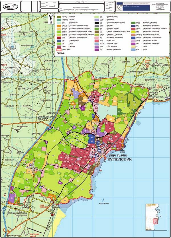
28 IRISH SEA Includes Ordnance Survey Ireland data reproduced under OSi Licence number 2003/07/CCMA/Fingal County Council. Unauthorised reproduction infringes Ordnance Survey Ireland and Government of Ireland copyright. Ordnance Survey Ireland, Legend Study Area Current Landuse Broad Character Types Coastal Communication Designed landscape Enclosure Industrial Military Recreation Settlement Water Woodland ROGERSTOWN BURROW BEAVERSTOWN TURVEY TURVEY RAHILLION PORTRAINE BALLISK COMMON BALLALEASE NORTH PORTRAINE DEMESNE QUAY LANESTOWN NEWBRIDGE DEMESNE BALLALEASE WEST BALLISK BALLYMASTONE BALLALEASE SOUTH BALCARRICK DONABATE IRISH SEA CORBALLIS KILCREA LISSENHALL GREAT BALLYMADROUGH SEAPOINT MALAHIDE Legend Study Area Townlands Current Landuse Broad Character Types Enclosure Includes Ordnance Survey Ireland data reproduced under OSi Licence number 2003/07/CCMA/Fingal County Council. Unauthorised reproduction infringes Ordnance Survey Ireland and Government of Ireland copyright. Ordnance Survey Ireland, Recreation Settlement Figure 9: Comparison of characterisation by land parcel and townland for Donabate, Co Dublin showing in (a) characterisation by land parcels or fields and (b) by townlands 27
29 How can a coherent approach to characterisation be finalised? Often a mixed approach may work best, depending on scale and purpose. Previous studies in Ireland and the UK have shown that it is often helpful to conduct a pilot study for a sample area before finalising the approach. This allows assumptions to be tested and practicalities of data gathering, assimilation and mapping to be refined. This especially applies to studies covering large areas, and studies where tiered levels of data-gathering and different approaches to mapping character are envisaged. A5: Defining relationships with other formal plans or guidelines How will relationships with LCA, SEAs, EIAs, conservation planning or research projects work in practical terms of how data is organised and presented? Apart from being clear about the basic nature and status of the study (see A1 to A4 above) it is also necessary to be clear about how information can readily be extracted for various uses. This includes for example: HLC studies should ideally be fully integrated into the approach needed for an LCA to ensure that key HLC issues are carried forward into the more general landscape characterisation process and key issues remain clear in final conclusions or recommendations Stand-alone HLC studies should be structured so that they can make a valuable contribution to later LCA work by ensuring that key characteristics and issues can be captured within the LCA process Where LCAs already exist, HLC can build on and enrich the results by providing a fuller historic characterisation of pre-determined landscape character types or areas HLC should be capable of informing development plans in terms of land allocations for development both in terms of key strategic planning issues (settlement form and scale, sensitivity to large scale infrastructure, etc) and incremental loss of character. HLC should enable SEA requirements by informing what policies and supporting guidance is needed to ensure that regeneration respects and builds on valued historic character HLC should be capable of feeding directly into urban or rural design guidelines that seek to ensure that new development respects the detailed sensitivity of historic characteristics For local agri-environment grants and conservation planning it is important to define what sort of measures are eligible for support or are achievable through improved management, and how these mechanisms could be harnessed to manage pressures for change in ways that maintain historic character, which may also achieve desirable goals for wider landscape and nature conservation For academic research, integrating HLC into studies investigating the history, landscape archaeology, palaeoenvironment or geography of an area or theme will provide fresh insight into issues and raise new questions that can be tested by fieldwork HLC should provide a wider and more varied landscape context for historic environment resources such as Records of Protected Structures, Recorded Monuments and National Monuments 28
30 STAGE B MAPPING AND DESCRIPTION ThE hlc PROCESS Stage A: Defining the overall rationale q t Stage B: Mapping and description B1: Detailed definition of area for mapping and any differences in levels of data collection B2: Identifying, accessing and importing data sets B3: Defining Historic Character Types (HCTs) B4: Defining Historic Character Attributes and Distinctiveness B5: Mapping relict landscapes and archaeological potential B6: Consideration of cultural and associative landscape characteristics B7: What work is needed to enhance or validate desk-based analysis B8: Synthesising key feature and relationships that define historic character. q q q q t p Public Participation Stage C: Assessment and analysis q t Stage D: Management issues and recommendations General Issues: Data Management, access and presentation q q q q t t Figure 10: Stage B of the HLC process Having defined the parameters of the study, the next stage is to undertake basic mapping and description. This relies on retrieving and marshalling relevant data from which the geographical mapping and description of historic landscape character is carried out. This is an interpretative process but does not, at this stage, assign relative value to areas or consider the possible effect of future change. This stage of analysis consists of four main sub-stages: Detailed definition of areas for mapping and levels of data collection Identifying accessing and importing data sets Deciding Historic Landscape Character types or attributes Defining, describing and mapping Historic Landscape Character Although visual images are a very effective means of conveying information, historic character mapping is insufficient on its own: it must be supported by appropriate text and photographs to convey how character has been identified and indicate what it looks like. 29
31 B1: Detailed definition of areas for mapping and any differences in levels of data collection What area(s) does the study cover and must this be subdivided to allow different levels of detail? Defining the study area, both in map form and through the definition of outer co-ordinates, is important to ensure that consistent coverage is achieved. In many cases especially for local authority administrative areas or area planning this is a simple matter of defining a single area. But sometimes more complex spatial approaches are required: Multiple areas may be needed to consider widely dispersed options for regional infrastructure (different road schemes, waste processing, quarries, forestry, windfarms) Nested areas (to be analysed at different levels of detail) may be desirable, especially for large scale strategic \planning for example, distinguishing detailed analysis of the areas allocated for development from the wider HLC of a strategic plan area I n both these cases, it is important that coverage around the specific area should be large enough to provide a clear idea of its wider context Considerable care needs to be given to achieving consistency of data collection and analysis, and to ensuring that detailed analysis is consistent with broader brush character. B2: Identifying, accessing and importing data sets What datasets/ sources need to be accessed developed and used to create baseline data? This may vary with the scale of the study different data sets will be required for national, regional, county, local area or detailed-locality studies. For a nested approach, additional sets of data or more detailed levels of information may be needed for the areas to be studied in greater detail. An indicative range of data sources typically needing to be considered at different levels is set out in Appendix A below. This includes: modern map base; vertical air photography; LIDAR or other remote sensing imagery; geology and soils; historic maps; built environment and designed landscape records; archaeological records; placenames; townland and other historic boundaries; habitats and nature reserves; and maritime data. 30
32 Data Sources Existing Landuse Information Study area outline Ordnance Survey mapping Digital Aerial Photography Digital Elevation Model Details Predefined study area limits Current edition (2000) (1:1000 & 1:2500) O.S. discovery Series mapping (1:50, (20cm resolution) 1995 (1m resolution black and white O.S.) (not useful) Height infromation derived from contours Soils Mapping GSI Ireland Geology Mapping GSI Ireland Land division (sourced from OS Mapping) Townland boundaries Field boundaries Pre-existing GIS mapping layers Development plan Local Area Plan mapping Donabate local area plan Planning application mapping APASS data available since 1992 Google Earth Visual inspection to supplement digital aerial photography OS mapping Relict Landuse Infromation Topographical Files National Museum of Ireland RMP for Dublin Archaeological Survey of Ireland, Department of Arts, Heritage and the Gaeltacht RPS data Fingal County Council Place names data Place names, field names and street names O.S mapping 1st edition 6 inch scale ( ) digital six inch raster) Down survey Historical Mapping Rocque Taylor Bathometry Data Coastal Survey mapping, shipwreck inventory, admiralty charts Details of pervious excavations and assessments Excavations database ( Figure 11: Sources used in the compilation of the Donabate HLC What other data might be useful? Other sources of data that may be of value for particular studies at various scales include Documentary and secondary historical sources Other survey data (LCA; design guidelines; management plans; ACA appraisals) Strategic policy reviews on different aspects of heritage and landscape 31
33 B3 Defining historic Character Types (hcts) What Historic Landscape Character Types need to be distinguished and mapped in a HLC unit (land parcel) approach? A key principle of defining Historic Character Types is to distinguish those that are (a) historically distinctive and (b) display forms and features that clearly add to understanding and inform practical conservation needs. It is not very helpful to define types that can be mapped morphologically but, for practical purposes, have little or no historic distinctiveness. Equally it can be actively unhelpful to fail to distinguish distinctive historic characteristics that should influence future change. For example: Elaborate morphologies of boundary character, shape and sizes of field enclosure may be of little practical relevance to management but can be important in establishing historical significance and hence sensitivity The form of boundaries (hedges, walls and variants and their condition) can be a vital part of their historic character in addition to the morphology of enclosure and may be especially relevant to future management The morphology of settlements, as well as the architectural styles, can be critical aspects of their historical origins and character that are very relevant to how new residential development fits in Appendix B (below) provides a table that indicates a broad framework of Historic Character Types. In keeping with established practice in Ireland and elsewhere, the most basic divisions reflect various current landuses within which different historical origins and changes can be seen to have influenced present day landscape character. Within these generalised landuse distinctions ( Levels in Appendix B) some very broad subdivisions are suggested, based on attributes of morphology, form and likely period of origin. These are likely to apply to most parts of Ireland. They are intended to help achieve cross-boundary consistency between studies. A third level of detailed subdivision (Appendix B: Level 3) indicates more specific distinctions, based on past practice in Ireland. In some categories, notably rural and urban settlement morphology, new distinctions are suggested to facilitate greater sensitivity to broad historic character for strategic planning (whether at county or local master plan level). 32

34 Figure 12 a: Level 1, Broad type HLC, Brú na Boinne World Heritage site, Co Meath (Will Magherry and Meath County Council) 33

35 34 Figure 12 b: Level 2, Generic type HLC, Brú na Boinne World Heritage site, Co Meath (Will Magherry and Meath County Council)
36 Figure 12 c: Level 3, Specific type HLC, Brú na Boinne World Heritage site, Co Meath (Will Magherry and Meath County Council) 35
37 How should historic character be defined using past resource management units (townlands) as the mapping unit? The essence of this approach is to capture how mixed landuses that supported communities developed through time and have left their mark in the present landscape. This can either be considered in terms of general historical geography, or defined on the basis of mapping the historic character of land parcel groups (as above), using a Geographic Information System (GIS) to analyse the mixture of types occurring within the townland or other unit. GIS can also be used to group townlands according to recurrently similar combinations of types. Where more detailed historical studies are possible or have already been carried out it may be possible to define townlands in terms of particular kinds of farming system, or a period of landscape resettlement and reorganisation of land. In some of these respects, characterisation may be of use in testing historical evidence the detailed character of nineteenth-century land re-organisation or, for a larger picture, examining whether earlier enforced resettlement has left a lasting legacy in landscape character (Smyth 2006). How should historic character be defined using present-day resource management areas as the mapping unit? Both the above approaches can be applied to map historic character within the framework of units based on other land divisions and used to characterise their historic diversity and common characteristics. Alternatively, rather than trying to map types in detail it may be more appropriate (especially for small local areas such as Architectural Conservation Areas, Local Area Plans etc) to describe the historic character of the area in simple terms explaining its key historic attributes. This approach needs not only to explain the morphological variety, but also probable origins and evolution and key attributes (see below). How does the approach differ for Seascapes? The general principles which apply to landscape characterisation do extend into seascapes, but with some specific differences. Additional sources of data for the maritime environment must be consulted (see Appendix A; English Heritage/Cornwall County Council 2008) The methodology must be adapted to take into account the lack of fixed boundaries, such as roads or land ownership extents, within the marine environment Special consideration needs to given to dealing with multiple vertical levels and the dynamic nature of the natural environment using a tiered GIS spatial data model (the sub-sea floor, sea floor, water column, sea surface) Particular consideration also needs to given to the inter-tidal zone and the exercise of historic rights to its resources The historic character of adjacent coastal landscapes with direct maritime associations, need to be considered, not only in terms of the different perspective inherent in the view from sea and historical navigation, but also land-to-sea views and land-to-land views across bays and estuaries, or to and from islands. The nature of how offshore development and other activities impinge on the marine and coastal environment, and people s perceptions of its character, will affect what characteristics need to be captured in any assessment 36

38 Figure 13: Intrinsic Bay, Kilkee, County Clare so called after a ship named the Intrinsic was wrecked in B4: Defining historic Character attributes and distinctiveness What is the range of historic attributes that may be important for different purposes? Historic characterisation of areas relies principally on defining key attributes of: Landuse function Morphology of layout Period of origin and use Physical form Relict survivals The ways in which particular physical features and relationships between them define key historic characteristics of the area needs to be clearly explained in descriptions of the HC Types and the evolution of the landscape. Emphasis must be given to those features, relationships and attributes that are most significant in defining the character, and to why these characteristics matter. To some extent, the significance attached to different attributes will vary according to the uses that will be made of the characterisation study. For example: Landuse function may be important in relation to changes of use and siting of new development Morphology of layout can be especially important in settlement zoning around existing settlements and in siting of development 37


39 Period of origin and use can be especially important in relation to coherence of landscape character and sensitivity to change, as well as understanding Physical form can be especially important in relation to agri-environment schemes and rural conservation, design guidelines, and development management Relict survival can be especially important in overall quality of time-depth and survival in relation to sensitivity to change, although rarely a principal defining factor for historic character Figure 14: The ladder fields shown here in Co Clare make a distinctive contribution to local character Figure 15: The demesne landscape of Strokestown, Co Roscommon stands out from the surrounding field system in this Ordnance Survey vertical aerial photograph 38
40 What attributes are included in HCTs and how should they be explained? As explained above, HC Types tend to be defined on the basis of a combination of historic function, morphology, period and form, but some types are based much more on some of these attributes than others, and none reflect all (the permutations would be too unwieldy to be assimilated properly even for small areas). Since even a long list of broad HCTs and sub-types does not automatically capture all relevant attributes, some other provision is needed to capture particular historic characteristics that do not define types but may still be important in defining historic character. For example: Commonly used HC Types of field enclosure do not indicate the form of boundaries (walls, hedges or dykes) although this may be a highly significant attribute in terms of landscape character Settlement character does not pick up vernacular building materials and forms Some HC Types embed generalised period attributes but others do not; and compared with historic map or documentary evidence, morphological period typologies are indicative rather than definitive Apart from general historical descriptions, how should historic attributes be captured? Two basic means of capturing additional attributes are available: (a) separate layers of mapping and/or (b) descriptive text. Each of these can be applied in more than one way. GIS is an important, but not indispensable aid to both, especially in covering large areas. In combining spatial and descriptive information in the form of polygons, to which text data can be attached, it offers different options for how this issue is approached. Descriptive text can be used in two ways: 1. General description of areas (townlands or other units) to identify their specific attributes of function, morphology, period, form, or relict survival. These can highlight, in more detail, features of particular interest as a commentary on the typological mapping (alternatively, to record historic attributes additional columns can be added to your HLC attribute table). 2. Adding text-based searchable data to polygons, allowing polygons with the same particular attributes to be retrieved. The scope for doing this is very wide but, for example, adding a predominant form attribute field to polygons would allow types of enclosure to be retrieved and mapped according to their boundary form (hedge, wall, dyke, ditch) whatever their morphological properties. Similarly, a field for relict type would allow retrieval of areas where former historic characteristics are still visible as earthworks. Separate mapping of particular attributes can similarly be done in different ways: As layers showing the distribution of separate attributes By creating polygons for areas sharing common attributes B5: Mapping relict landscapes and archaeological potential In many areas, features from earlier periods survive as coherent areas of relict earthworks or ruins. Almost any HC Type may occur in a relict form, although not necessarily dominating an area. Such areas add time-depth and historic legibility to the landscape and should be mapped as an extra layer. However, in some cases, an area of relict features may dominate the historic character of the landscape and can encourage activities such as pilgrimage. In such cases the extant present day character of the landscape may be 39
41 much less distinctive and where the relict character is both dominant and had particular historic resonance it should be used to define and map the HCT as a separate area. Archaeological potential takes more account of buried remains and not just features that are visible on the ground. Evidence from excavations and aerial photographs, combined with standing monuments, will generate a picture of known and potential patterns of sites, but unless these patterns survive as coherent patterns of visible remains (relict landscape), such archaeological potential should be described and, if appropriate, plotted as another layer rather than being used to define historic landscape character. B6: What consideration should be given to cultural and associative landscape characteristics and how should they be mapped? What cultural, aesthetic and historical associations need to be recognised as important sensitivities that are not captured directly by HCTs? There are several aspects of historical and cultural associations with landscape that are broadly abstract in character and are difficult to capture within the Historic Character Types and attributes given above. These include: Traditional culture and religion Designed landscape views and vistas Aesthetic and artistic / literary association Historical political association How can abstract cultural, visual and historic attributes be captured in historic characterisation? As with other additional attributes, two basic means of capturing additional attributes are available, involving (a) separate layers of mapping and/or (b) descriptive criteria and text. Textual description will often be the principal method of recording abstract values, explaining the kind of added value and sensitivity that they give to an area. Mapping such attributes is much more difficult as geographical limits are often difficult to define. Nonetheless, the following are some indications of how this can be approached. Traditional culture and religion: routes of pilgrimage and annual festivals can often be defined, together with an indicative buffer zone (or other indication) of the extent of the area of sensitivity within the visual ambit of such routes and places Designed landscape views and vistas may be mapped as the general visual envelope of a house or other feature and, more particularly, the alignment of particular designed vistas. In detailed studies the routes of intended walks or drives, and associated views and vistas, may be defined. For defence sites and marine pilotage and navigation, similar principles can be applied to define areas within which the visual zone of influence is of particular significance Aesthetic and artistic/ literary association is often very difficult to define, but where an area has been especially popular with artists it may be possible to map particular portrayals of the landscape Historical or political association is often similarly difficult to define geographically, but it may be possible to map the general area of military campaigns and battlefields and, where it is possible to map areas of settlement displacement or colonisation (Smyth 2006), this may add insight into the character of landscape change 40


42 B7: What work is needed to enhance or validate desk-based analysis? Historic Characterisation is dominated by the vertical map-based view, whereas Landscape Character Assessment is dominated by the horizontal, ground-based visual perspective. On the ground, the visual influence of differences in topography and tree cover, or buildings in an urban context, makes a substantial difference to how the character of places is appreciated. Both perspectives are valid and a key issue for integrated approaches to landscape assessment is to consider how these perspectives can be merged to create a more rounded characterisation. It is also important to consider how local communities perceive the historic character of their area. What level of fieldwork is required? An important early step in any characterisation project is to visit the study area and obtain a general appreciation of its visual appearance. As the characterisation progresses it is important that each main character type or general attribute is examined on the ground to gain a clear idea of the relative survival and importance of key features that give the area its character, and to assess how significant these appear to be on the ground. Observations are also important for assessing the visual prominence of relict features and unimproved landcover and habitats. Fieldwork is also very useful for assessing the character of pressures for change and past impacts (settlement expansion). Understanding the practicalities of recommended management actions will often be greatly enhanced by field observation. All fieldwork is usefully supported by systematic record: Adequate field notes within a framework of recording different attributes and issues Mapping of routes taken Photographic record with viewpoints and direction of view recorded (this may include video) Try and incorporate this data into GIS (i.e. record location and orientation of photo location, data can be used later to plot images into GIS). Figure 16: Good fieldwork is enabled by good preparation, documentation and discussion Figure 17: Consultation with local community groups and interested organisations brings differing perspectives to bear on a characterisation study and helps to communicate the importance of the landscape 41
43 What level of consultation is appropriate? Consultation is an important ongoing element of the overall characterisation process, feeding into each stage. It should engage with a wide range of stakeholders, ranging from national heritage bodies through to the local community (see Sections C4 and G3). For the purposes of gathering baseline information at least two strands of consultation can be useful: Gaining additional sources of information about historic features and past change in a locality Checking what historic features, views and associations resonate most clearly with the public It should be noted that the HLC process itself has an educative role and that a two-way exchange of information and impressions will enrich understanding for all parties involved. B8: Synthesising key features and relationships that define historic character Taking the results of desk studies and field observation together, it should be possible to synthesise the physical features and relationships that define the various historic characteristics identified. At a generic level (defining recurrent Historic Character Types) key features and relationships should be identified for each HC Type or other mapping unit. These might include vegetation, topography, monuments, types of settlement pattern, styles of vernacular architecture, agricultural practice, shape and size of enclosure, and how a combination of such features reflect historic interrelationships. Other defining characteristics may draw on specific cultural, visual and historical qualities. The key features and relationships used to distinguish HC Types or attributes used in characterisation must be clearly explained and illustrated with photographs and map extracts. These should be typical examples encompassing the defining characteristics of the HC Type and what distinguishes it from the most similar type. In addition to these generic attributes, specific areas and places will have their own defining distinctiveness. For all but the most localised studies it will not be possible to convey these distinctions through the mapping of generic Historic Character Types, but they can still be recorded as key attributes attached to individual polygons in a GIS, and may be used to illustrate character through specific examples within the accompanying text and photographs. As the next section indicates, this basic synthesis of key characteristics will often provide the building blocks for wider perspectives on broader Historic Character Areas (HCAs), heritage value, sensitivity and vulnerability to change. 42
44 STAGE C: ASSESSMENT AND ANALYSIS ThE hlc PROCESS Stage A: Defining the overall rationale q t Stage B: Mapping and description Stage C: Assessment and analysis C1: Defining the historic character of zones C2: Approach to Assessing Heritage Value and Significance C3: Approach to Assessing evidential value C4: Socio-Economic and Community Values C5: Synthesising Sensitivity and Vulnerability to Change q q q q q p t t Public Participation Stage D: Management issues and recommendations q q t General Issues: Data Management, access and presentation q q t Figure 18: Stage C of the HLC process This section concerns (a) synthesis and analysis of basic data to provide a broader picture of historic character and (b) outline approaches to assessing relative value, sensitivity and vulnerability to change. This includes: Defining Historic Character Areas or zones Assessing heritage and cultural values and significance Assessing historic landscape sensitivity Assessing vulnerability to change Several factors need to be considered in addressing these issues. Although they could be classified to allow geographically-defined HC Types and HC Areas to be tagged with a range of values in a GIS system, an approach based on professional judgement and explanation is ultimately preferable to any elaborate scoring systems. C1: Defining the historic character of areas or zones Why might it be useful to define the historic character of broader areas or zones? The difference between Historic Character Types and Historic Character Areas is as follows: Historic Character Types are generic recurrent combinations of characteristics that reflect a common historical origin and evolution which may occur in many places Historic Character Areas present a broader picture, usually based of groupings of HC Types that show how a particular area is historically distinctive from other areas 43

45 The main purpose of defining HC Areas or Zones is to present broader understandings of historic character from various perspectives. Historic character attributes and the definitions of HCTs and other data attached to specific HCT polygons offer considerable scope for defining broader historic character in different ways. Such data might include: physical form or style of features; historical or cultural associations; extent of relict landscape; condition or sensitivity ratings. What kind of analyses could be useful when assessing historic character at a broader level? The kind of analysis need varies from one case to another, according to the purpose of the overall HLC project, and how far its focus is on description or management of historic character. The most commonly useful analysis seeks to reflect deeper understanding based on historical values, such as how interrelationships between HCTs and their attributes reflect broader patterns of historic land management or how they reflect particular periods of historical change. Patterns of historic land management might, for example, be reflected in townlands of common character or different aspects of an industrial area with associated workers housing. Other analyses more specifically oriented at management issues might seek to examine other aspects of historic character, significance, and sensitivity. For example: specific attributes of form or style; survival, condition and trajectories of change; socio-economic and community values; vulnerability to change. Figure 19: A study of Clones, Co Monaghan, divided the town into a series of Historic Character Areas 44
46 What options are there for how Historic Character Areas might be defined and mapped? Much depends on the scope of the HLC project, especially how far it is intended to synthesise and analyse issues and define management challenges and options, and whether this is part of a standalone HLC project or to be integrated into other characterisation studies or design guidelines. Where such analyses form part of a self-contained HLC project, Historic Character Areas are particularly relevant for urban areas. Equally, at a county level study, HCAs may be relevant for a historical narrative. C2: Approach to assessing heritage value and significance In assessing the significance of historic character two groups of values need to be considered: 1. Evidential value (including: period; survival and condition; rarity; coherence and group value; and trajectories of change) 2. Socio-economic and community value, comprising: Aesthetic and cultural value (including: historical; cultural and artistic association; and design) Community value (including: education; sense of place; amenity; and local distinctiveness) Economic value (including: conservation-led regeneration opportunities; tourism; agricultural diversification) The overall significance of an Historic Character Type or area can be discussed and explained in terms of what weight should be given to different factors in balancing such values. This should be based on professional judgement, drawing on both the historic landscape analysis and results of consultation (Section G3 consultation). C3: Approach to assessing evidential value How should period be considered as a heritage value? Period is built into the definition of some HC Types, but this is based more on typological assumptions than direct evidence. For the purposes of assigning more specific periods, direct evidence (such as historic maps, local history, relationships to datable monuments, and architectural style) must be considered. The extent to which this is available will vary with the level of baseline research. Summary of phases in Irish History I Mesolithic BC II Neolithic/Bronze Age Periods BC III Iron Age Period 500 BC AD IV Early Medieval Period AD V Medieval and Early Post - medieval Period AD VI Late Post - medieval and Modern Periods 1800 AD to present 45

47 46 Figure 20: HLC of Corcu Duibne, Co Kerry. The relatively large areas with high visibility of medieval fields around Lough Currane and in the Caherlehillan and adjoining valleys are the result of field systems survey. (Making Christian Landscapes INSTAR Project, Archaeology Department, University College Cork).
48 Period values can be assessed in various ways, all of which involve some degree of professional judgement: Proportion of Historic Character Types attributable to broad periods (see Appendix B) Grouping HC Types to identify areas of survival from a predominant period Commentaries on the historical character and development of the area that reflect the periods that have contributed most to that character Noting survivals from older periods, which are often significant as extra evidential value for poorly documented periods Highlighting HC Types that are resonant of a particularly important aspect of Irish history (for example, land reorganisation after the Famine) How should rarity be considered as a heritage value? To some extent, rarity is an aspect of all the other values, but is also relevant to functional historic landuse attributes. The broad functional themes that provide the framework for defining historic character are chosen for their universal value and so their relative land cover and frequency is more to do with their intrinsic nature rather than any particular heritage value. Nonetheless, the rarity of especially historically significant attributes or sub-types can be judged by the overall occurrence of the attribute, or the area or number of polygons attributable to the type. More generally, the relative rarity of the more specific historic character types within the overall historic landuse groupings provides an important basis for judging their heritage value. This can be judged or measured in terms of The relative rarity of sub-types (Appendix B levels) within general groupings (by overall area or number of polygons) The relative rarity of sub-types (Appendix B levels with specific period attributes (by overall area or number of polygons) How should coherence and group value be considered? Some areas display a significant level of coherence and group value in their historic landscape characteristics. Group value is very important in assessing the overall historic interest of landscape above the level of different functional HCTs This is often evident from recurrent juxtapositions of HCTs and can be seen in the range of HCTs that characterise individual townlands and how far these survive Coherence is especially evident where pressures of improvement have been limited and trajectories of change have been slow, leaving a relatively coherent level of survival from a particular period and ensuring that historical relationships between different landuse resources are still legible in the landscape This may be especially evident where specific periods of historical change have left an especially strong imprint, for example: different elements of a large demesne estate; the effects of the late nineteenth and early twentieth century Land Commission reassignment of land The overall development of the landscape through time may be especially apparent from the good survival of relict landscapes and coherent areas of later change of different periods Coherence and group value can be especially important where the character of a particular period, or a good general level of survival, stretches over large areas, potentially embracing many different character types. 47
49 At the assessment stage, the coherence and group value of historic character over a wider area can be recorded as an attribute of groups of HCT polygons, or by describing the area over which this is evident. It may also be taken further to help define broader Historic Character Areas. One of the ways of looking at this issue is to consider how historic character relates to definable estates or townlands that may reflect recurrent historic patterns of resource exploitation reflecting a number of landuses (see section A4). 48 How should survival be considered? Survival reflects three broad states of survival 1. Non-visible and buried archaeological potential which no longer contributes visually to landscape character, but may nevertheless inform its understanding. 2. Relict features and structures, such as archaeological sites and monuments which contribute to landscape character as visible historic features that no longer have any extant use. 3. Extant features such as field systems or vernacular buildings, which contribute to historic landscape character in terms of their ongoing use or reuse, reflecting the evolution of human interaction with the environment. In assessing rates of survival within these broad categories, a combination of attributes needs to be considered, including, for example: It is the combination of archaeological potential, relict landscape character and extant character that gives the best sense of overall time depth and evidence of landscape change (see above). Survival of particular features (for example, a designed landscape) Survival of key morphological characteristics (boundaries in field patterns, urban plot shapes) Survival of design values (architectural styles and materials, designed vistas) Overall integrity and coherence (the legibility of historical relationships between areas of different character in terms of visible features) How should condition be considered as a heritage value? While survival reflects the visible presence of different landscape characteristics from the past, condition concerns what might be termed the strength and legibility of the presence. Factors that need to be taken into account include: The extent and prominence of relict landscape features and the impact of improvement or clearance The physical condition of extant landscape features (walls, hedges, designed landscape features, built environment street furniture) How can trajectories of change be considered? The coherence, survival and condition of historic landscape characteristics as whole HCTs or their component elements can be seen from a dynamic perspective as reflecting processes of change. For example, HCTs that have seen a good deal of boundary loss or alterations of key attributes may be at the brink of becoming another Type. Some HCTs (including many field patterns and areas of settlement) can be of very mixed origins. In these cases, piecemeal alteration is part of the essence of their character. Judgements about trajectories of change can usefully take account of: Recurrent patterns of visible landuse change (juxtaposition of abandoned and new buildings; intensive and non-intensive land management; abandonment or regeneration of urban areas) Trajectory of change from map regression or time slices Trajectory of change from formal data (census, planning and agriculture statistics)

50 Figure 21: Time slice mapping of the Brú na Boinne World Heritage site in Co Meath showing broad historical (mid-19th century) land use or characters. In comparison to Figure 12a large estates and demesnes are more visible in this period and the landscape has considerably less settlement (Will Magherry and Meath County Council) 49

, (b) Gillian Barrett (1990), (c)")

51 50 Figure 22: The impact of stone clearance over time can be seen in these successive photographs of Glenfahan, Co Kerry by (a) St Joseph (Cambridge University Collection of Aerial Photographs,1964), (b) Gillian Barrett (1990), (c) Markus Casey (c. 2000). The impact of modern clearance and land improvement on historic field patterns is clearly apparent.
52 There are no fixed terminologies for characterising areas according to their trajectory of change, but distinctions could be made in terms of what extant patterns represent, such as: Reversion to wilder states (extensification, abandonment or neglect) Minimal change (continuity or high survival over long periods) Static (old) imposed change (designed landscapes, systematically reorganised fields, planned settlements) Dynamic (recent) imposed change (recurrent past re-planning; recent major changes from rural to urban use or intensification of uses) Organic slow change (small incremental changes slowly accumulating over centuries) Organic fast change (small incremental changes accumulating over decades) Mixed imposed and organic change These may vary according to whether the area in question is urban or rural etc. Assigning HCTs to these attributes, together with the extent and condition of relict landscape character, may help to indicate historic character in a more dynamic way than a rigid (and somewhat artificial) typology. Understanding the trajectory of change is important because it provides some additional insight into character and what sort of future change may suit different areas. C4: Socio-economic and community values How should historical and cultural associations be considered as a heritage value? Where significant historical and cultural associations are identified (see above) they add value to the area(s) concerned. Their importance is not uniform but can be judged on the basis of various indicators: Whether the associations are nationally, regionally or locally recognised The extent to which such values are overtly used to encourage tourism to the area The longevity, frequency, and popularity of any events, pilgrimages, or other means of commemorating or celebrating the association 51

53 Figure 23: Interpretative and directional signage at Rindoon deserted medieval settlement in Co Roscommon illustrating how heritage can contribute to tourism and amenity projects How should community values be taken into account? Consultation with local residents groups and others will often reveal local traditions of value, or personal and community associations. These may collectively help describe a community s sense of place and add perspective on the character of certain areas that people particularly value or dislike (See G3). The consultation process must gather and record such impressions so that they can be synthesised and, if appropriate, recorded as attributes of particular geographically defined areas. In addition, the study may reveal aspects of the historic development of the landscape that indicate significant potential for education or voluntary involvement in local management initiatives. Communities may also express particular concerns about pressures of change affecting particular areas. This can be taken forward into the impact assessment and management stage of the project. What economic values should be applied to historic character? Changes in employment patterns, population mix and commercial uses can all affect the value of an area. Both positive and negative aspects must be considered. To a significant extent, relative economic values are implicit in the HC Types, but they are also reflected in their condition. This may include urban areas and former industrial sites that are becoming rundown and ripe for regeneration; areas of farmland reverting to scrub, or subject to intensification, boundary removal and stone clearance. Tourism represents a special economic value to which Historic Landscape Character contributes, sometimes very overtly, where key heritage attractions are set within especially valued or important landscape surroundings (Glendalough, Brú na Bóinne, Tara, Rathcroghan, Dysert O Dea). But Historic Landscape Character is also part of visitors intuitive appreciation of the places that they visit, and may contribute to its value for tourism in a much more subtle way. 52
54 The economics of farming, tourism and redevelopment are specialist fields in their own right. Unless expertise is available, assessment should normally be limited to general commentary on the economic context of an area s historic character from a non-specialist perspective. How can heritage values be used to indicate which parts of a study area may be of more significance than others? Separate values can be described and/or combined in different ways to display heritage value geographically. One option is to attach comments, or categories of value, as an attribute of particular HC Types or individual polygons. These can then be retrieved and analysed to indicate the geographical distribution of different values and how they overlap. Examples of such analyses might include: The number, area and distribution of different rarity attributes within the study area Commentary on unusual or special survival by: period; combination of features and HC Types; exceptional survival; historical association area The geographic spread of specific survival coherence or associative attributes, by overall area or number of polygons A preliminary mapping of trajectories of change, based on map regression and HCT attribute data C5: Synthesising sensitivity and vulnerability to change It is a matter for individual studies whether this type of analysis is attempted. Similarly, whether to distinguish relative sensitivity and vulnerability over the whole study area, or just select parts of it subject to particular assessment of development or other landuse implications, is an individual matter. A danger of drawing too narrow a perspective is that these issues will not be put into sufficient focus. How do heritage values, considerations of physical survival and patterns of long term change indicate the overall sensitivity of historic character? Landscape change is much more piecemeal than broad categorisation of HCTs would suggest, and gradual modifications will eventually turn one Type into another. The completeness and integrity of historic character is often better in some areas than others, depending on both survival and condition. This reflects different trajectories of change that have helped to shape what is valued in terms of the present day historic character of places and their significance. Particularly sensitive areas are likely to exist where historic character is rare, distinctive, well-preserved, or historically important, or where it displays, time-depth, or strong associative values Many areas will not be unusual, will have been altered by long-term piecemeal change of no special historic importance and may lack other cultural or aesthetic associations, but yet retain some local distinctiveness and strong community sense of place Areas that have been subject to large scale and rapid recent change may have lost much of their historic character and be relatively less sensitive to further change. Conversely, such areas may equally be more sensitive to additional change. 53
55 Assessing historic landscape sensitivity thus needs to avoid equating this with importance but should take account of both heritage and socio-economic values and completeness and integrity of character in presenting an overall view. How does vulnerability to change differ from historic landscape sensitivity and how should vulnerability be assessed? While judgements of sensitivity are based on an assessment of the value, survival and condition of places Historic Landscape Character, vulnerability to change looks more specifically at how particular aspects of historic character may be more or less robust in the face of different kinds of ongoing change or specific proposals (development plan zonings, for example). There is no set method for assessing vulnerability to change but, in most cases, it is helpful to start from a consideration of the types of ongoing change and pressures that might affect historic character. This should include potentially beneficial trends and opportunities to conserve or enhance character, or promote the social and economic value of the historic environment. Three main strands of evidence need to be examined: Ongoing trajectories of change including agricultural improvement, clearance and development outside zoned areas Strategic planning (including national and regional infrastructure, development plan zoning and search areas) Conservation, agri-environment support, conservation-led regeneration In each case, an assessment needs to be made of how these trends and proposals are likely to impinge on the key historic features and relationships that underpin the historic character of the areas affected. This must be based on a clear appraisal of how robust or fragile such features and relationships are to the types of change anticipated. Understanding historic landscape sensitivity and its vulnerability to change is an important precursor to developing any detailed impact assessment and development of management proposals. As with other analytical stages of the HLC process, this may either be done as a self-contained exercise or integrated into general landscape characterisation, conservation planning or environmental assessment. Assessing vulnerability to change While historic landscape sensitivity is, in some senses, an assessment of what could be lost (or has already been degraded) from a relatively abstract perspective, an assessment of vulnerability to change needs to set this within the context of pressures, processes and trends in how historic character has been changing and is likely to change. The complexity and diversity of how character may change will tend to add to sensitivity. 54
56 STAGE D: MANAGEMENT ISSuES AND RECOMMENDATIONS ThE hlc PROCESS Stage A: Defining the overall rationale q t Stage B: Mapping and description Stage C: Assessment and analysis q q q q p t t Stage D: Management issues and recommendations q q t D1: Strategic Decision Making Process D2: Frameworks for Active Management of Historic Character D3: Issues and Impact Assessment D4: Management, Implementation, Mitigation and Monitoring D5: Integration with Other Guidance and Frameworks q Public Participation General Issues: Data Management, access and presentation q t Figure 24: Stage D of the HLC process Many processes and frameworks already exist for making decisions that affect future management of the historic environment, often in conjunction with other management needs, which are relevant to historic landscape, townscape or seascape character. They include: County Development Plans, and Strategic Environmental Assessments; Environmental Impact Assessments; County Heritage Plans; Landscape Character Assessments; Village Design Statements (VDS); agri-environment programmes; forestry planning; and Integrated Coastal Zone Management planning. D1: Strategic decision making process How can historic characterisation be used to assist and influence strategic development plans? Development plans are drawn up as strategic documents, including a series of policies, which will include some for the historic environment and landscape. They may be national, regional, county or local. Development plans use various methods to define where different types of development should be located or not. These include: Broad policy principles of where different types of development may be located (e.g. one-off rural development, the exploitation of minerals, or use of brownfield land) Preferred areas of least constraint (e.g. for windfarms) Zoning of specific areas of land for particular pre-defined classes of development The issues that arise for the historic character of areas affected may thus either be very generic or quite site-specific. All development plans are subject to Strategic Environmental Assessment. This requires identification of significant 55
57 effects on the architectural and archaeological heritage and landscape likely to arise from the kinds of developments proposed, and the interaction of these and other environmental effects. SEA should be an iterative part of development planning. HLC has an important part to play in shaping such policies with regard to locational guidance and zoning, as well as assessing their effect and what mitigation and monitoring will be needed, including promoting benefits. Assessments of impacts and recommendations for management or mitigation need to be geared to the relevant tier(s) of decision-making and the legislative requirements. For example, where development plans zone areas for particular types of development, the SEAs should consider what actual changes to the historic character of the area are likely to arise, at least in broad terms. Heritage plans and strategies and Integrated Coastal Management Plans offer another vehicle through which the issues identified by an HLC can be highlighted and earmarked for action. Agri-environment schemes and forestry A significant proportion of farmland in Ireland is included within the Rural Environment Protection Scheme (REPS), the national agri-environment scheme, which closed to new agreements in 2009 and in the successor Agrienvironmental Options Scheme (AEOS). The REPs scheme had a set of objectives and conditions which applied generally, including: Protect any features of historical or archaeological interest Maintain and improve the visual appearance of the farm and farmyard while AEOS objectives are to promote biodiversity, to combat climate change, to encourage water management/ quality and to contribute to contribute to positive environmental management of farmed Natura 2000 sites (i.e. sites designated under the EU Habitats and Birds Directives). Whatever form of agri-environment scheme is employed in the future under the Common Agricultural Policy, including schemes to promote High Nature Value Farming (HNVF) (Smith et al., 2010), more specific requirements relating to HLC could for part of a scheme s objectives and any future individual agreements for particular land holdings. Similarly the Forest Service of the Department of Agriculture, Food and the Marine operates a range of forestry schemes. Although not mentioned in documents relating to forestry schemes, HLC should play a part in the drawing up of proposed areas for planting. D2: Frameworks for active management of historic character Development management and planning conditions The majority of development is managed through the development management process at county or sub-county level. Most major developments require a formal Environmental Impact Assessment (EIA), but the majority of these will be dealt with according to existing policies and supplementary guidance. These provide a robust framework for consistent decision-making, including attaching conditions to planning consents. Rather than merely refusing unacceptable proposals, the planning system can be used to influence the nature of development. It can influence detailed location and layout, and ensure appropriate and good design for the locality. Planning conditions may include requirements to preserve particular features of historic interest, restrict building heights, or to define specifications on acceptable materials. Whatever the scale of the project, care must be taken to strike a balance between recommendations that are too generic and ones that are too prescriptive, or that may carry unreasonable obligations with respect to time and money. 56
58 If suitable policies are in place, development management provides an important practical basis for managing impacts on historic character, but this can be greatly enhanced by supporting guidance of various forms. These include HLC studies themselves, and also how HLC is used to inform other guidance including: Landscape Character Assessments Master plans Village Design Statements Architectural Conservation Area statements and appraisals Conservation and management plans Agri-environment objectives guidance These frameworks often provide the basis for developing more detailed policies and guidance for smaller land parcels. An HLC project for such smaller areas may be useful to inform development of policy at this level, providing more detail than would be feasible at county level. How can historic characterisation be used to assist and influence pro-active land management? A crucial aspect of managing the historic character of places is to understand the complexity of the place as well as the importance of the cumulative effect of many small changes. It is to address these individually minor, but collectively significant, changes that detailed design guidelines, and area or site specific management plans, are often needed. Such plans can include master plans, Village Design Statements, Architectural Conservation Area appraisals and conservation plans. Design guidelines are an especially flexible form of guidance as they may be drawn up for particular areas or places at almost any scale, or for particular types of development (forestry, housing, windfarms, quarrying, etc). Likewise, specific grant-aided agri-environment objectives need to be clearly defined to include the conservation of historic character. Boundary loss, stone clearance and other improvements have cumulatively led to massive changes in the character of rural Ireland. Innumerable incremental changes have taken place with very little consideration of whether this is to be regretted, or celebrated as part of a centuries-old and continuing process of change. D3: Issues and impact assessment Development can profoundly change local historic landscape character and HLC can be a valuable tool in assessing and managing impacts. Change also happens more insidiously though agricultural improvement. How should strategic issues be identified and addressed? At a generic level, particular kinds of development or landuse change will incur broadly consistent types of impact, and some of the key categories are discussed below. Thinking about issues in these terms may encourage HLC practitioners and, importantly, consultees to identify what they consider to be the main pressures for change. 57

59 The analysis of sensitivity and vulnerability to change is likely to be very important in identifying issues (see C4 above), but so too is consultation, both with planners and other land managers, and community representatives who will offer their own perspective. It is important that these analyses are not intrinsically judgmental: identification of issues should seek to include those that promote conservation of character as well as those that induce change. Whether they are perceived as desirable, undesirable, or just an ongoing trend are matters on which opinions may legitimately differ. How is the historic character of the landscape most likely to be affected by development and other landuse change? The main ways that historic character may be altered by development or other landuse change include: Wholesale change of historic character from redevelopment or large scale landuse change Alterations affecting physical integrity of historic character especially physical loss or addition of features and changes in condition or detailed stylistic appearance Alterations affecting coherence of historic relationships especially physical severance or islanding of related features, areas or historical land management units Changes in general visual appearance and the legibility of historic character Alteration of perceptual values and historic associations because of physical changes or intrusions in the landscape Alterations to landscape views and vistas and important visual relationships in the landscape Any or all the above may act in combination to alterations to the landscape setting of historic features and places, and this will often be a crucial consideration. Figure 25: The cumulative impact of modern development 58
60 How should impacts and effects be assessed at different scales and in different contexts? As indicated above, distinctions can be made in how far proposed development and landuse changes are defined by location: Change proposed at a general policy level with only generic locational guidance or criteria Defined general areas of suitability or least constraint for particular types of development or landuse Area-specific zoning for pre-defined broad classes of development or landuse Site- and project-specific proposals For each of these, a different level of assessment must be considered. In the context of formal environmental assessments, there are no absolute distinctions of scale as between SEAs and EIAs. While EIAs only apply to site-specific and project-specific developments they may cumulatively have to deal with larger areas and may involve major infrastructure projects crossing very large areas. Master plans that set out proposals for the development of large areas at an outline level may be covered either by EIA (as an overall development project) or by SEA (as a development programme). Although the procedures of EIA impact analysis are not formally required for many other kinds of landuse change, the principles are valid for any application where the significance of change needs to be judged. Assessing effects at a general policy level. Identification of the ways in which development or other landuse change is likely to affect historic character is possible only in generic terms, but this can nevertheless be valuable for highlighting issues to be addressed in more detail through supplementary guidance, development management or detailed management strategies. At this level, likely impacts need to be defined in very general terms, but may nonetheless be fairly clear in indicating The ways in which different types of development are likely to affect historic character The areas where developments of different kinds are most likely to occur The principal historic characteristics of those areas and whether any areas of particular sensitivity are likely to be affected, and if so, how vulnerable they are Whether any of these effects is likely to be of major significance given the broad scale and character of the range of development proposed and the historic sensitivity of the location While a descriptive appraisal of impact is likely to be straightforward, it is unlikely to be possible to give any quantitative indication of the scale of impact, though it may well be relevant to indicate the sensitivity of any historic characteristics likely to be affected Assessing effects for areas identified as having least constraint for particular types of initiative. Although impact assessment is still likely to be very generic, the types and location of proposals are likely to be better defined allowing a clearer assessment. While impacts cannot be quantified, it may be possible to indicate quantitatively what proportion of the area is assigned to different Historic Character Types, how sensitive they are, and how vulnerable to the type of development envisaged. It will often be appropriate to indicate where areas of greatest vulnerability lie. 59
61 Assessing effects for area-specific zoning of development and landuse The historic character of zoned areas can be defined accurately and, since zoning is for specific classes of development or landuse, their likely effects can be defined generically with some confidence. While the precise impacts of projects to implement the zoning cannot be defined in terms of specific features and characteristics, it should be possible to identify all the main issues likely to arise for individual developments. The zoning may well have a profound affect on existing historic character, especially if it relates to a change from agricultural or open land to built development. Where previously developed land is concerned the changes may be much less substantial and in some cases the effects on historic character might be relatively subtle. Because the areas and types of development are much more specific, it becomes possible to assess the general impact of zoning in quantitative as well as qualitative terms for example: the proportion of particular HLC units or townlands affected; or the nature of historic relationships affected. Likewise, it may be appropriate to highlight opportunities to enhance historic character, and social and economic values of heritage, through conservation-led regeneration, indicating how key features and relationships that underpin historic character can be retained and conserved. Assessing effects of site- and project-specific proposals Where development or other changes are project-specific, both the character of the area affected and the full range of impacts likely to arise should be definable, though indirect effects may still be very difficult to predict with certainty. Again, both quantitative and qualitative assessment of the scale and significance of effects is possible. Has potential for environmental, social and economic benefit been identified? Not all the potential impacts on the historic landscape will be negative. Conservation, restoration and sympathetic incorporation of change may produce a positive benefit for an area. Among the benefits which should be considered are: Quality of life sense of identity and place preserved, maintenance of high quality surroundings Habitat preservation dunes, bogs, wetlands, etc Informed planning more sympathetic design Transferability expertise developed in one area applied elsewhere, improving cost effectiveness Knowledge, education and understanding improved and available for use in other projects Tourism stimulus to local businesses and social enterprises The historic landscape is constantly evolving and, apart from the impacts of development, is subject to the influence of agencies outside human control, like coastal erosion. How can synergistic and indirect effects be defined? It is useful to distinguish synergistic effects or impact interactions where, for example, effects on character arise from the interplay of different impacts, from indirect effects which arise from complex pathways of cause and effect. 60

62 Synergistic effects occur when several different impacts combine to alter the landscape setting of a historically important place. While the setting of a particular heritage asset or place is a different concept from the wider historic character of the area, the two are closely linked. HLC can make an important contribution to assessing the effects of development on the setting of heritage features or whole settlements. Indirect effects occur when developments trigger changes in landuse. This especially arises when impacts change the viability of rural landholdings, or sever previously coherent areas of character. Major indirect benefits for historic character can arise from road schemes that bring substantial traffic relief to over-congested historic towns. How should cumulative effects be assessed? Historic landscape character is the result of the cumulative effects of centuries of change. New development or other landuse change will, in some respects, continue that process. The issues at stake are often, not whether there are cumulative effects, but in what direction and at what speed the change will travel. This assessment will often draw usefully on evidence of trajectories of change and vulnerability of historic character highlighted in section C above. In other respects, cumulative effects need to be assessed in terms of how, for example, different development plan zonings add up to an overall change in historic character and whether this gives rise to particularly sensitive effects. A particular development might, for example, threaten the last remaining area where the historic relationship between an historic settlement and its rural surroundings survives. Figure 26: The medieval town of Fethard, Co Tipperary retains its rural surroundings 61
63 Approaches to assessing scale and significance of impacts on Historic Landscape Character In assessing the scale and significance of impacts on Historic Landscape Character, three broad factors must be considered: 1. The relative values, sensitivity and vulnerability of the Historic Landscape Characteristics affected. 2. The nature of the impacts (qualitative effect) judged in terms of how far key historic characteristics will be lost or affected. 3. The physical scale of impact (for example: the area or proportion of an HL unit or townland affected; the length of different HCTs traversed by linear infrastructure; the number or proportion of historic urban plots affected). The significance of effects depends on balancing the scale of impact and sensitivity of the affected character, which is a matter of professional judgement, with reference to the factors discussed in Section C above. Artificial scoring methods that seek to make these judgements seem more objective should be avoided, but various criteria may be useful in seeking consistency. For example: The scale of impact can be considered in terms of whether it would (a) be sufficient to alter the assignment of the area to a particular Historic Character Type or (b) require redrawing boundaries between HCTs If HC Types are altered, how profound is this (would it change basic high level classification (Appendix B) from fields to urban or would the change occur at a lower level)? Other considerations may include whether the basic legibility of historic character will be altered substantially or only peripherally D4: Management, implementation, mitigation and monitoring As with impact assessment, proposals for implementation of actions to conserve or restore historic character, or to prevent, avoid or mitigate adverse effects need to be considered according to how clearly the needs can be defined geographically. However, typical implementation or mitigation proposals will include: Adoption of specific plan policies to safeguard historic character or areas of historic sensitivity or vulnerability Input of HLC into other strategic documents (landscape or other appraisals; site specific assessments, Village Design Statements, Architectural Conservation Area Appraisals, Conservation Plans, master plans, guidelines) Use of HLC-based criteria to define areas of greater or lesser constraint in respect of the likely types of effect Use of HLC-based criteria in other multi-disciplinary studies to define such areas and ensure that proposals avoid historically sensitive and vulnerable landscape Proposed alterations to existing zoning where they are likely to have significant adverse effects on historically sensitive or vulnerable areas Proposed plan policies for specific zonings, if appropriate, to safeguard historic character Generic consideration of how the identified likely effects on specific historic characteristics can be avoided or reduced Input into any design guidelines of the areas or type of change concerned Detailed proposals of how the layout, design and appearance will avoid and reduce effects, and respect or enhance historic character 62

64 What approaches to monitoring historic character already exist? Whatever the source of the impacts, recommendations should be made for some form of monitoring of effects on historic landscape character. The responsibility for monitoring needs to be identified and clearly indicated. Monitoring is already an established part of some aspects of planning and landuse management and heritage conservation. 1. Approaches to monitoring are discussed in Heritage Appraisal of Development Plans (Heritage Council 2000), although the measures for landscape do not make specific reference to historic landscape. 2. Monitoring is an obligatory requirement of the Strategic Environmental Assessment Directive, and the location of incremental changes to the historic landscape arising from development can be tracked through the planning process, including any general audits to check adherence to conditions implementing design guidelines that have incorporated historic character provisions. In both cases, the absence of specific guidance on HLC means that there is also no specific consideration as to how change might be monitored, or how far policies are implemented. Figure 27: Damage identified to this earthwork at Rathcroghan, Co Roscommon 63
65 What are the main provisions that need to be established for effective monitoring? A number of standard requirements for monitoring apply to Historic Characterisation as much as to other environmental values. Specific schemes of monitoring are likely to need, and should focus on, identified pressures for change and impacts. The standard requirements for monitoring are: Clear linkages to identified pressures for change and impacts considered significant Focus on key attributes and physical features that are important for Historic Character Compatibility with strategic planning, landscape or heritage frameworks Sensitivity to the specific pressures of different types of development or other landuse change Ability to monitor positive change, not just loss or damage Ability to monitor indirect and cumulative effects Use of robust, replicable measures Cost effectiveness Resonance with public and community values The details of how these broad principles should apply will vary from one case to another, depending on their scope and purpose. For example: For some impacts, periodic observations of change and appropriate mitigation strategies would be appropriate Where conditions have been placed on development or guidance issued on appropriate design, there must be some mechanism for ensuring that these have been met Attention needs to be given to cumulative effects (for example, a small development within an urban centre or a few isolated houses in rural locations may not have a significant impact, but where several changes take place there must be some check that the combined result does not alter the historic character) Strategies for identifying thresholds of significant change may need to be devised, but care should be exercised in avoiding over mechanistic use of indicators such as percentage loss of field boundaries or number of buildings demolished The most constructive approaches to monitoring will be based on examining how far changes have been influenced by, and followed guidance on, historic character. At a very broad level, it should become possible to examine change by looking at how and why the character of sensitive areas has been altered over a development plan period or over a fixed period (e.g. 5 or 10 years). Another important reason for establishing effective monitoring provisions in relation to Historic Landscape Characterisation is to allow its value and effectiveness to be assessed, and improvements made in future. D5: Integration with other guidance and frameworks What areas of guidance are relevant? National Landscape Guidance (DoE, 2000) and Landscape Character Assessments; heritage plans and strategies; Integrated Coastal Management Zone plans SEA and EIA guidance and documents such as Heritage Appraisal of Development Plans (Heritage Council 2000) 64

66 Village Design Statements (Heritage Council 2012); ACA statements and appraisals; conservation and management plans Design guidelines for particular places or types of development Figure 28: Trim SEA cover In general these guidance documents and the standard formats adopted for these management frameworks do not include specific reference to HLC. But HLC guidance can add an important extra dimension to all these strategic frameworks. The public consultation aspects of the processes used to draft Landscape Character Assessments, heritage plans/ strategies and Village Design Statements offer useful models for developing public participation in HLC studies at both county and local levels. How does historic character guidance fit in with Landscape Character Assessment? The draft guidelines for landscape assessment (DoEHLG 2000) outlines three stages into which the guidance above (Stages B and C) can be integrated: Character Value Sensitivity In the character stage, areas are delineated according to visual distinctiveness 65
67 These are then ascribed a value to which several factors contribute, several of which have a historic component: Aesthetic visual, vistas, scenic areas, outstanding landscapes, areas of special amenity Ecological habitats, biotopes, wildlife sanctuary, Special Areas of Conservation, Natural Heritage Areas and Special Protection Areas Historical archaeological heritage, artefacts, field patterns Socio-cultural buildings, settlements, monuments, social history or social geography Religious shrines, wells, burial places, pilgrimages Mythological ancient stories and folklore The third stage of assessing sensitivity looks at the ability of an area to absorb change without unacceptable impacts on character and value. Unfortunately the methodology suggested, which contains both desk studies and fieldwork, makes no mention of site visits or of any historic sources (such as historic maps), other than existing designations and possibly inventories of monuments and structures. More generally it should be noted that the draft guidance has still not been updated and finalised, and methodological approaches to LCA in Ireland are still a matter of debate and development (Martin et al. 2006). How does historic character assessment fit with other guidance? There are numerous guidance documents that relate to frameworks for managing the impact of development and other landuse change. HLC does not receive specific coverage, although the Environmental Protection Agency (EPA) guidance for Environmental Impact Statements (EPA 2002) has set out what needs to be covered for different environmental topics, including: The landscape (landscape character, landscape context, views and prospects, historical landscapes, manmade landscapes) Material assets, including the architectural and archaeological heritage, and the cultural heritage (folklore/ tradition/history, architecture/settlements, monuments/features, designed landscape, natural resources of economic value) The inter-relationship between the above The EPA Advice Notes on Current Practice in the preparation of Environmental Impact Statements (2003) also makes no specific reference to HLC, but refers to erosion of long established landuse patterns as a type of impact. In other guidance documents, the emphasis is on visual intrusion into the landscape and the impact on designated monuments and features, with landscape only featuring in terms of screening and restoration for minerals extraction. 66
 which included a HLC with (a) resulting Landscape Character Types and (b) Historic Character Types")
68 Figure 29: In 2000 the Heritage Council, in partnership with Clare County Council, commissioned a Landscape Character Assessment (LCA) which included a HLC with (a) resulting Landscape Character Types and (b) Historic Character Types 67
69 GENERAL ISSuE G: DATA MANAGEMENT, ACCESS AND PRESENTATION ThE hlc PROCESS Stage A: Defining the overall rationale q t Stage B: Mapping and description Stage C: Assessment and analysis q q q q p t t Stage D: Management issues and recommendations q q q t General Issues: Data Management, access and presentation G1: Data management G2: Reporting and Presentation G3: Consultation G4: Access G5: Presentation in reporting G6: Archiving Data q t Public Participation Figure 30: Stage G of the HLC process G1: Data management Does the data structure work to handle different sources of information? Much of the information used in HLC is available in digital form that can be imported directly into the project database. Use of separate data tables for each source allows them to be represented as separate layers in the GIS. The file structure within any GIS system is very important, distinguishing between the data (shapefiles) and mapping generated (projects). Within each attribute table, different fields must be allocated to the separate properties associated with the data, following the correct naming conventions (shapefiles can have 10 character field names and no whitespaces are permitted). One field in each attribute table should consist of a unique identifier for the data feature. Where features appear in more than one table (e.g. separate tables for character types in different periods for the same land parcel) then the same ID should be used to assist with analysis. 68
.")
70 Full or partial use of GIS? GIS provides a powerful tool for both the analysis and mapping of landscape character and for assessing the possible impacts of change (for example through viewshed modelling and 3D imaging). Full exploitation of the potential of GIS (using multiple layers of geographically defined polygons with data attached to be combined or intercut to create other entities) allows extremely flexible and sophisticated manipulation and interpretation of data Basic GIS mapping tends to create a single layer of HC assessment with data attached (albeit based on several layers of baseline data). Analysis is reliant on manipulating data attached to polygons to group them in different ways While GIS is a powerful tool, it can introduce a high level of technical complexity so user needs and likely technical abilities are an important consideration in choosing how GIS will be used and how data is constructed and updated. Figure 31: The use of GIS in the Making Christian Landscapes project 69
71 Can layers be interrogated effectively? The data table for each layer should enable many different categories of information attributes to be linked to each point or polygon. Selected information can appear automatically as a label or can be brought up on screen as required for this to be a user-friendly function, the titles for the data fields need to be carefully designed The use of unique identifiers and separation of attributes into distinct fields allows detailed and flexible interrogation Is database structure adequate to meet all needs? Some users will only require a broad-brush view of landscape character; others will require more detail. Having a field attached to HC polygons containing a simple non-technical descriptive text is useful for interrogation of online mapping by non-experts (text limit is 254 characters) For more sophisticated analysis, information on different attributes and values must be allocated to distinct fields Simple abbreviations for character types rather than a numerical coding system can be helpful in making mapping easy to use for a variety of users Have appropriate control terms been developed to ensure consistency and accuracy of data? Typological terminology is an appropriate approach, with clear identification of related information such as historic character type at different periods. Use of standard terms is desirable at least for commonly recurring character types Use of good metadata (data about data) The logic behind the terms should be clear to non-expert users The use of coding that is specific only to the project or database potentially reduces the versatility of the information systems and options for merging different studies to cover larger areas G2: Reporting and presentation How far should HLC projects adopt standard report formats? While particular attention should be paid to the specific purpose and needs of the project, the various stages outlined above must be reflected in the structure of reports and explanatory handbooks that accompany Historic Characterisation studies. Detailed contents and structure may vary with the type and context of the study, but should typically include: Establishment of context and purpose, relationship to previous work Selection of data sources Summary of the GIS and database (or other methods of data handling and analysis) Explanation of relative input of desk-based assessment, fieldwork and consultation Characterisation mapping, HCTs, character descriptions Assessment of significance and value 70
")
72 Figure 32: This HLC project examined the corridor of the proposed N20 road scheme to the north and east of Mallow in Co Cork (Ken Hanley/National Roads Authority) 71
73 Discussion of relative sensitivity and capacity to absorb change Assessment of pressures, impacts or effects Recommendations for managing change through policy, further guidance, revision of land allocation, mitigation or pro-active management actions Provisions for monitoring change Appendices (including results of consultation; guidance on using GIS/data; technical specifications for data structure etc) The project report should be organised to follow this same structure, which will enable users to access information easily and facilitate comparisons between projects in different areas. G3: Consultation Consultation is an important part of the process this is not a distinct stage but occurs throughout the whole process. It should be considered as an integral part of every stage of a HLC project. Ongoing consultation with heritage bodies and relevant governmental levels The majority of HLC projects are commissioned either by government at national, regional or local level, or heritage bodies such as the Heritage Council. A steering group should be established with representatives from relevant stakeholders and others. Regular consultation with the steering group should take place at every stage of the project. This will ensure that: The aims and purpose of the project are clear at its start Opportunities to agree and refine the methodology are addressed Comments are offered on emerging results before they are finalised for wider consultation Where the project has a different origin, or there is no steering group, it is important that consultation with the relevant level of government and heritage bodies is put in place at the start. If the results are to have wide application, HLC projects must maintain an awareness of other initiatives in the area and the policy framework in operation. Wider consultation with other professionals, academics, local groups There are significant potential benefits to be gained from wide ranging consultation: Up-to-date information on state of historic environment knowledge and thinking Understanding of what is seen as significant by different stakeholders and why Understanding of how people interact with landscape around them Identification and sharing of conflicts of priorities Improved awareness of projects leading to better sense of relevance 72

74 The consultation can be carried out in a variety of ways including: Talks Articles, in specialist publications, local newspapers and on relevant websites information leaflets Workshops Questionnaires posted, telephone, online, and face-to-face Meetings Website a project website or pages on local authority site with relevant links. Links can also be established from other sites On-line discussion forum of the use of social media fora set-up an list of interested stakeholders to receive updates and a dedicated address to receive comments and questions Figure 33: Wide ranging consultation can increase understanding of what is seen as significant by different stakeholders and can create an improved awareness of projects 73
75 Where HLC is carried out to inform preparation of planning documentation there needs to be separate consultation HLC surveys may well be commissioned to inform the preparation of development plans or design guidelines. If the HLC is itself to be adopted as formal guidance, there are statutory requirements for the plans and policies themselves to undergo public consultation. This may also apply to supporting guidance. When considered alongside the much broader scope of development plans, the different types of documents that HLC can contribute to will attract a response from a different range of stakeholders. These forms of consultation should help to refine coverage of issues and recommendations for future management of the historic landscape character. G4: Access Accessibility of outputs HLC projects carried out as part of the local authority planning process should be made available to a range of stakeholders beyond the decision-makers within that authority. Development Plans may refer to LCA and HLC, and these should either be included as Appendices if adopted policy, or published (digitally and in hard copy) as separate supplementary guidance (formal or informal) Where HLC is commissioned to inform development of master plans or design statements the same need for availability applies The objectives or possible outcomes of HLC often include encouragement of tourism, local heritage-related initiatives and increased awareness of the local character but, without access to the results, these objectives will not be fulfilled. Accessible HLC information will increase the cost-effectiveness of other characterisation projects carried out in the area at different scales and for different purposes, as some strands of research of data gathering will not need to be duplicated. It will also improve consistency of characterisation, making comparison and identification of wider patterns easier. Researchers who carried out the project may be in a position to host results on their website, but this needs to be publicised. Links between websites help raise awareness. How and where should the HLC be accessible and for what use? There are many options to deliver your final mapping to the online community and for physical access to HLC results. These include: open and restricted uses; hard copy access; and various levels of online or downloadable access to reports and to GIS data. When the GIS facility is disseminated it should be born in mind that, while the datasets shapefiles can be used on any system, the mapping or projects maybe software dependent. In addition, the layers do not have symbols and colours attached to them, and these will need to be set. Archival arrangements provide a further strand of long term access. If HLC is to influence policy and management and inform research it must be widely available. On the publication of reports, copies should be sent to all stakeholders and consultees, including relevant organisations at national level and in neighbouring areas. Libraries and museums copies of reports should be lodged with university libraries, but should also be made available in all local libraries and museums. The role of IT facilities in libraries is increasing and versions of the GIS mapping (projects) could be made available 74


76 Figure 34: Landscape character can be illustrated by original sources such as historic aerial photography. This aerial photograph shows Clogher Head, Co Louth, and dates from
Cotswolds AONB Landscape Strategy and Guidelines. June 2016
 Cotswolds AONB Landscape Strategy and Guidelines June 2016 Cotswolds AONB Landscape Strategy and Guidelines Introduction The evolution of the landscape of the Cotswolds AONB is a result of the interaction
Landscape Policy in Ireland insights from the Heritage Council
 Landscape Policy in Ireland insights from the Heritage Council Ian Doyle Head of Conservation What am I going to talk about? What is landscape? European Landscape Convention Local landscape projects Methods
7. The Landscape. 7.1 Introduction. Environmental Impact Statement (EIS) Scoping Report
 Scoping Report") 7. The Landscape 7.1 Introduction The purpose of this section of the EIS Scoping Report is to describe the scope of work and methods to be applied in the identification and assessment of landscape and
7. The Landscape 7.1 Introduction The purpose of this section of the EIS Scoping Report is to describe the scope of work and methods to be applied in the identification and assessment of landscape and
TOPIC PAPER 2: Links to other sustainability tools
 TOPIC PAPER 2: INTRODUCTION 1.1 Landscape Character Assessment can inform a range of other sustainability tools and methodologies. Equally these other tools may assist in reaching decisions concerning
Connecting rural dwellings with rural development
 Connecting rural dwellings with rural development Dr Mark Scott Department of Planning and Environmental Policy University College Dublin Mark.Scott@ucd.ie Introduction Growing emphasis in the EU is being
LANDMAP Methodology Overview
 LANDMAP Methodology Overview June 2017 Jill Bullen, Senior Landscape Specialist jill.bullen@cyfoethnaturiolcymru.gov.uk 0300 065 4706 (Please note this is an information document and not a training presentation)
LANDSCAPE CHARACTER ASSESSMENT
 THE COUNTY DURHAM LANDSCAPE CHARACTER ASSESSMENT FOREWORD The landscape of County Durham is one of great contrast and diversity. From the North Pennines in the west to the Durham Coast in the east it contains
Tara Skryne Landscape Conservation Area Project: Progress Report: Phase 1
 Tara Skryne Landscape Conservation Area Project: Progress Report: Phase 1 A partnership project between Meath County Council, the Heritage Council and the Department of Environment, Heritage and Local
Strategic Environmental Assessment Screening Report. Dublin Port Masterplan Review 2017
 Strategic Environmental Assessment Screening Report Dublin Port Masterplan Review 2017 Table of Contents 1 Introduction... 1 2 Purpose of the Masterplan... 2 3 Task 1.1 Pre-Screening Check... 5 4 Task
Neighbourhood Planning Local Green Spaces
 Neighbourhood Planning Local Green Spaces Introduction... 2 1. Why green space is important... 4 2. Neighbourhood plans and green space... 6 3. Evidence... 8 Statutory designations... 9 Green space audit...
Settlement Boundaries Methodology North Northumberland Coast Neighbourhood Plan (August 2016)
") Introduction This background paper sets out a methodology for the definition of settlement boundaries in the North Northumberland Coast Neighbourhood Plan. The neighbourhood plan is planning positively
Introduction This background paper sets out a methodology for the definition of settlement boundaries in the North Northumberland Coast Neighbourhood Plan. The neighbourhood plan is planning positively
12 TH ANNUAL CHILTERNS AONB PLANNING CONFERENCE ENGLISH HERITAGE: HISTORIC ENVIRONMENT GOOD PRACTICE ADVICE
 12 TH ANNUAL CHILTERNS AONB PLANNING CONFERENCE ENGLISH HERITAGE: HISTORIC ENVIRONMENT GOOD PRACTICE ADVICE MARTIN SMALL HISTORIC ENVIRONMENT PLANNING ADVISER ENGLISH HERITAGE Policy ENGLISH HERITAGE GOOD
Assessing the Significance of the key characteristics of Historic Landscape Character Areas: a Discussion Paper
 Assessing the Significance of the key characteristics of Historic Landscape Character Areas: a Discussion Paper Background The 11 distinct Historic Landscape Types in the East Devon AONB have been used
MAKING SENSE OF PLACE
 MAKING SENSE OF PLACE Landscape Character Assessment Summary Guidance for England and Scotland MAKING SENSE OF PLACE People can welcome development if it is well designed and contributes to quality of
IDENTIFY, ANALYSE, CHARACTERISE THE LANDSCAPE TO ACT, IMPROVE THE KNOWLEDGE
 WORKSHOP I: Wednesday 2 October Thursday 3 October 2013 Ingrid Sarlöv Herlin ECLAS, SLU, Alnarp, Sweden, Graham Fairclough Univ. of Newcastle, UK IDENTIFY, ANALYSE, CHARACTERISE THE LANDSCAPE TO ACT, IMPROVE
Appendix A. Planning Processes. Introduction
 1 Planning Processes Introduction This appendix outlines a number of planning processes which are used in the Auckland Region to support the effective management of development in the region s rural and
Supplementary Information: LCA Review Forms
 Final Report to The Heritage Council Landscape Character Assessment in Ireland: Baseline Audit and Evaluation Supplementary Information: LCA Review Forms March 2006 Julie Martin Associates The Round House
Call for Proposals. Heritage, natural capital and ecosystem services: case studies. Project No: Date of Issue: Tuesday 14 th November 2017
 Call for Proposals Heritage, natural capital and ecosystem services: case studies Project No: 7705 Date of Issue: Tuesday 14 th November 2017 Summary Historic England is seeking expressions of interest
3. Neighbourhood Plans and Strategic Environmental Assessment
 1. Introduction This report sets out a draft Screening Determination for the Preston Parish Council s Neighbourhood Plan and has been prepared by rth Hertfordshire District Council. The purpose of the
Scottish Natural Heritage. Better places for people and nature
 Scottish Natural Heritage Better places for people and nature Contents Summary... 3 SNH approach... 5 Place-making in policy and practice... 6 Developing the contribution of the natural heritage to place-making...
Appendix 1 Structure plan guidelines
 Appendix 1 Structure plan guidelines This appendix forms part of the regional policy statement [rps]. 1.1. Introduction Structure plans are an important method for establishing the pattern of land use
INCREMENTAL CHANGE AREA REVIEW March 2015 Page 1
 INCREMENTAL CHANGE AREA REVIEW March 2015 Page 1 Table of Contents Introduction... 3 Background to Review... 3 Comparison of the Schedules to the General Residential Zone... 7 Methodology... 7 Policy Context...
Longmore House Salisbury Place Edinburgh EH9 1SH. 18 January 2008
 We safeguard the nation s historic environment and promote its understanding and enjoyment Martin Dean Access and Countryside Projects Officer Development and Environmental Services Clackmannanshire Council
Oxford Green Belt Study. Summary of Final Report Prepared by LUC October 2015
 Oxford Green Belt Study Summary of Final Report Prepared by LUC October 2015 Project Title: Oxford Green Belt Study Client: Oxfordshire County Council Version Date Version Details Prepared by Checked by
Wind energy development in the South Pennines landscape
 Wind energy development in the South Pennines landscape Programme for today Background Policy context South Pennines landscape Impacts of wind energy development The South Pennines Wind Energy Landscape
Landscape Character Assessment (LCA) in Ireland: Baseline Audit and Evaluation
 in Ireland: Baseline Audit and Evaluation") Landscape Character Assessment (LCA) in Ireland: Baseline Audit and Evaluation Sept 2006 Prepared by Julie Martin Associates in Association with Alison Farmer Associates AN CHOMHAIRLE OIDHREACHTA THE HERITAGE
Landscape Character Assessment (LCA) in Ireland: Baseline Audit and Evaluation Sept 2006 Prepared by Julie Martin Associates in Association with Alison Farmer Associates AN CHOMHAIRLE OIDHREACHTA THE HERITAGE
volume 11 environmental assessment section 2 environmental impact assessment Part 7 ha 218/08
 DESIGN MANUAL FOR ROADS AND BRIDGES volume 11 environmental assessment section 2 environmental impact assessment Part 7 ha 218/08 glossary of terms Used in DMRB Volume 11, Sections 1 and 2 SUMMARY This
Plaistow and Ifold Neighbourhood Plan Pre-Submission Consultation Draft
 Mrs Beverley Weddell Clerk to Plaistow And Ifold Parish Council Lock House Lodge Knightons Lane Dunsfold, GU8 4NU. Dear Mrs Weddell, Our ref: Your ref: Telephone Fax HD/P5402/ 01483 252040 18 th October
PPS5: Planning for the Historic Environment
 Heritage at the Heart of the Planning System Heritage Protection Reform Newsletter SPRING 2010 PPS5: Planning for the Historic Environment >> English Heritage welcomes the new Planning Policy Statement
GREEN NETWORK APPLICATIONS IN ESTONIA
 GREEN NETWORK APPLICATIONS IN ESTONIA Kalev Sepp, Tuuli Veersalu, Martk Külvik Estonian University of Life Sciences 1 WHY? BACKGROUND - POLITICAL By adopting the Pan-European Biological and Landscape Diversity
building with nature - a new benchmark for green infrastructure
 building with nature - a new benchmark for green infrastructure Danielle Sinnett, Gemma Jerome, Sarah Burgess, Nick Smith and Roger Mortlock outline the aims, development and proposed operation of Building
The future of landscape characterisation and the future character of landscape Seminar 3-4 March 2014
 The future of landscape characterisation and the future character of landscape Seminar 3-4 March 2014 The European Landscape Convention and Landscape Assessment. Prof. Ingrid Sarlöv Herlin Department of
Archaeology and Planning in Greater London. A Charter for the Greater London Archaeology Advisory Service
 Archaeology and Planning in Greater London A Charter for the Greater London Archaeology Advisory Service THE PURPOSE OF THE CHARTER This Charter sets out how English Heritage will provide archaeological
BEDFORD BOROUGH COUNCIL PLAN IMPLEMENTATION MONITORING REPORT
 BEDFORD BOROUGH COUNCIL PLAN IMPLEMENTATION MONITORING REPORT 2017-18 Summary 1 Progress on local development documents 1 Local development documents adopted in the monitoring period 1st April 2017 31st
Regional / Local Policies. Cathal O Mahony & Jeremy Gault Sustain Partner
 Regional / Local Policies Cathal O Mahony & Jeremy Gault Sustain Partner Content Introduction to CMRC Cork Harbour Working with Local Authorities Expert Couplet Nodes (ECN) Research Work Undertaken - and
SHORELINE, FLOOD AND COASTAL DEFENCE MANAGEMENT PLANS
 These plans may provide opportunities as well as concern for recreational boating. They are currently being revised and consulted on. This document explains how we can engage in the process. Shoreline,
WOKING DESIGN SUPPLEMENTARY PLANNING DOCUMENT (SPD)
") Agenda Item No. 5 EECUTIVE - 15 JANUARY 2015 Executive Summary WOKING DESIGN SUPPLEMENTARY PLANNING DOCUMENT (SPD) The report outlines the various responses to the consultation on the Design Supplementary
Agenda Item No. 5 EECUTIVE - 15 JANUARY 2015 Executive Summary WOKING DESIGN SUPPLEMENTARY PLANNING DOCUMENT (SPD) The report outlines the various responses to the consultation on the Design Supplementary
3 Urban Design and the State Highway Network
 NZ Transport Agency Page 1 of 14 Urban Design Professional Services Guide 1 Introduction This is a professional services guide on urban design, which provides direction to the NZ Transport Agency (NZTA)
Published in March 2005 by the. Ministry for the Environment. PO Box , Wellington, New Zealand ISBN: X.
 Action Pack Published in March 2005 by the Ministry for the Environment Manatū Mō Te Taiao PO Box 10-362, Wellington, New Zealand ISBN: 0-478-18994-X ME number: 580 This document is available on the Ministry
9 Archaeology & Cultural Heritage
 High Clachaig Wind Farm Scoping Report Page 56 9 Archaeology & Cultural Heritage 9.1 Introduction Cultural heritage in this context means the above- and below-ground archaeological resources, built heritage,
Design Guidance. Introduction, Approach and Design Principles. Mauritius. November Ministry of Housing and Lands. .. a
 sig evelo r D Mauritius s. Utilities.. Individu a s. er itects.to ls chpers.po e Public. T. h rban D Sc U e me Promot e h ners. A Design Guidance o.h Planne rs n w iticians r l useholde National Development
Environmental Hazards and Risk Management
 Terms of Reference for ESPON-INTERACT Thematic Study Environmental Hazards and Risk Management Environmental hazards and risk management/preventions are important elements in the discussion of future Structural
Interim Advice Note 76 / 06 ASSESSMENT PART 1 AIMS AND OBJECTIVES OF ENVIRONMENTAL ASSESSMENT. Contents
 Interim Advice Note 76 / 06 VOLUME 11 SECTION 1: ENVIRONMENTAL ASSESSMENT INTRODUCTION PART 1 AIMS AND OBJECTIVES OF ENVIRONMENTAL ASSESSMENT Contents 1. Introduction and Application 2. Aims and Objectives
The European Landscape Convention And National Landscape Strategy. Tony Williams Irish Landscape Institute
 The European Landscape Convention And National Landscape Strategy As a reflection of European identity and diversity, the landscape is our living natural and cultural heritage, be it ordinary or outstanding,
Circular L8/08 2 September Water Services Investment and Rural Water Programmes Protection of Natural Heritage and National Monuments
 Circular L8/08 2 September 2008 Water Services Investment and Rural Water Programmes Protection of Natural Heritage and National Monuments 1. The purpose of this Circular is to provide local authorities
High Speed Rail (London- West Midlands)
") High Speed Rail (London- West Midlands) Draft Environmental Minimum Requirements Annex 3: Draft Heritage Memorandum November 2013 ESA 4.4 High Speed Rail (London- West Midlands) Draft Environmental Minimum
High Speed Rail (London- West Midlands) Draft Environmental Minimum Requirements Annex 3: Draft Heritage Memorandum November 2013 ESA 4.4 High Speed Rail (London- West Midlands) Draft Environmental Minimum
volume 11 environmental assessment section 2 environmental impact assessment Part 4 ha 204/08 scoping of environmental impact assessments
 DESIGN MANUAL FOR ROADS AND BRIDGES volume 11 environmental assessment section 2 environmental impact assessment Part 4 ha 204/08 scoping of environmental impact assessments SUMMARY This Advice Note provides
SCIENCE AND RESEARCH INTERNAL REPORT NO.75 DATABASES AND THEIR APPLICATION TO MANAGEMENT PLANNING. W. Mary McEwen
 SCIENCE AND RESEARCH INTERNAL REPORT NO.75 DATABASES AND THEIR APPLICATION TO MANAGEMENT PLANNING by W. Mary McEwen This is an internal Department of Conservation report and must be cited as Science and
3. Highway Landscaping Assessment
 Guidelines for Highway Landscaping 3-1 3. Highway Landscaping Assessment 3.1 Introduction This section outlines the steps necessary to assess the highway landscaping component of a state highway construction
CORRECTIONS WITHIN DESIGN MANUAL FOR ROADS AND BRIDGES AUGUST 2009
 DESIGN MANUAL FOR ROADS AND BRIDGES CORRECTIONS WITHIN DESIGN MANUAL FOR ROADS AND BRIDGES AUGUST 2009 SUMMARY OF CORRECTION HA 200/08 VOLUME 11, SECTION 1, PART 1 AIMS AND OBJECTIVES OF ENVIRONMENTAL
Great Easton Neighbourhood Plan Statement of Basic Conditions
 Great Easton Neighbourhood Plan 2017-2031 Statement of Basic Conditions OCTOBER 2016 GREAT EASTON PARISH COUNCIL Contents 1.0 Introduction....Page 2 2.0 Summary of Submission Documents and Supporting Evidence..
Garden District Heritage Conservation District Study
 Garden District Heritage Conservation District Study Community Consultation Meeting September 24 th, 2013 What is a Heritage Conservation District? A defined area of heritage significance and character
LONGDEN VILLAGE DEVELOPMENT STATEMENT
 LONGDEN VILLAGE DEVELOPMENT STATEMENT 2017-2027 1 Longden Development Statement 2017-2027 15/01/18 1. Background 1.1 Longden Village Longden village is a very rural and traditional community first mentioned
Landscape and Heritage A Park landscape that embraces the physical, cultural and social heritage of the area
 80 Park Development Framework Our Aim for Landscape and Heritage A Park landscape that embraces the physical, cultural and social heritage of the area Why do we think it is important? The landscapes of
CREATING GREEN INFRASTRUCTURE FOR IRELAND
 CREATING GREEN INFRASTRUCTURE FOR IRELAND Dr William Hynes Downey Hynes Partnership 15 th September 2010 Overview of Presentation Definition of GI Legislation and Policy Background Examples of GI-type
Heritage Action Zone. Explanatory Notes and Guidance
 Heritage Action Zone Explanatory Notes and Guidance Contents What is a Heritage Action Zone?...2 What support can Historic England offer to a Heritage Action Zone?...2 What could a Heritage Action Zone
Section 3b: Objectives and Policies Rural Environment Updated 19 November 2010
 Page 1 of Section 3b 3b RURAL ENVIRONMENT 3b.1 Introduction The Rural Environment comprises all the land outside of the Residential, Town Centre and Industrial Environments. Most land within the District
11/04/2016. NPPF Paragraph 128. NPPF Paragraph 128. NPPF Paragraph 128. NPPF Paragraph 128. NPPF Paragraph 128
 Good practice in the preparation and understanding of NPPF-compliant heritage assessments/statements Stephen Bond, Heritage Places 1 NPPF Paragraphs 133-135 133: Where a proposed development will lead
Site Assessment Technical Document Appendix A: Glossary
 Central Bedfordshire Council www.centralbedfordshire.gov.uk Site Assessment Technical Document Appendix A: Glossary July 2017 1.1.11-1 - ii Appendix A: Glossary Term Agricultural Land Classification AONB
Plumpton Neighbourhood Development Plan Revised Pre Submission Document - Regulation 14 Consultation
 REPRESENTATIONS... Plumpton Parish Council Plumpton Neighbourhood Development Plan Revised Pre Submission Document - Regulation 14 Consultation Representations submitted on behalf of: Cala Homes (South
Fixing the Foundations Statement
 Fixing the Foundations Statement 13 th August 2015 The Heritage Alliance is the largest coalition of non-government heritage interests in England, bringing together 98 national organisations which are
Foreword. Síle de Valera, TD, Minister for Arts, Heritage, Gaeltacht and the Islands
 Foreword This Code of Practice is a significant milestone in the protection of the archaeological heritage. It marks an agreement between my Department and the National Roads Authority, one of the largest
Fingal Development Plan & Green Infrastructure. Nicholas O Kane Senior Executive Planner Fingal County Council
 Fingal Development Plan 2011-2017 & Green Infrastructure Nicholas O Kane Senior Executive Planner Fingal County Council 2011 Fingal Development Plan Must be in compliance with National Spatial Strategy
Archaeological Conservation Works at Murrooghkilly Cairn, Co. Clare.
 Funding Reference No.: LIFE11/922 ITM: 516541/710578 Licence No.: 17E0498 RMP: CL002-001--- ÆGIS Reference: 89-20b Archaeological Conservation Works at Murrooghkilly Cairn, Co. Clare. Licence holder: F.
HS2 Hybrid Bill Petitioning. Summary of SMBC Asks 23/09/13. Background
 Summary of SMBC Asks 23/09/13 Background The Council has a developed a significant number of asks and propositions for consideration by HS2 Ltd and Government throughout further development of the HS2
Landscape and Heritage
 86 Park Development Framework Our Aim for A Park landscape that embraces the physical, cultural and social heritage of the area Why do we think it is important? The landscape provides a setting for every
Historic England Advice Report 26 August 2016
 Case Name: Kingsland Castle Case Number: 1435892 Background Historic England has been asked to review the scheduling for Kingsland Castle. The land on which the monument lies is understood to be for sale.
ROCHFORD LOCAL DEVELOPMENT FRAMEWORK: Sustainability Appraisal/ Strategic Environmental Assessment. Rochford Core Strategy Preferred Options Document
 ROCHFORD LOCAL DEVELOPMENT FRAMEWORK: Sustainability Appraisal/ Strategic Environmental Assessment Non Technical Summary Rochford Core Strategy Preferred Options Document October 2008 SUSTAINABILITY APPRAISAL
Wildlife and Planning Guidance: Neighbourhood Plans
 Wildlife and Planning Guidance: Neighbourhood Plans This Leaflet is one of a series of 4 Wildlife and Planning Guidance Leaflets and is intended to provide useful information to assist you to campaign
An Bord Pleanála. Eirgrid Plc. Meath County Council Cavan County Council Monaghan County Council
 An Bord Pleanála Ref: PL02.VS0002 Prospective Applicant: Eirgrid Plc. Local Authorities: Meath County Council Cavan County Council Monaghan County Council Nature of Application: Written opinion on information
The Initiative Landscape Character Assessment as a tool for the Conservation of Natural Values in the Eastern Mediterranean
 The Initiative Landscape Character Assessment as a tool for the Conservation of Natural Values in the Eastern Mediterranean Sixteenth Council of Europe Meeting of the Workshops for the Implementation of
RÓISÍN BURKE ADOPT A MONUMENT IRELAND
 RÓISÍN BURKE ADOPT A MONUMENT IRELAND WHAT IS THE ADOPT A MONUMENT IRELAND SCHEME? ADOPT A MONUMENT IRELAND THE ADOPT A MONUMENT SCHEME AIMS TO EMPOWER COMMUNITIES TO BECOME ACTIVELY INVOLVED IN THE CONSERVATION
SUSTAINABLE MANAGEMENT
 . Sustainable Management.1 The Concept of Sustainable Management The concept of sustainable management recognises there are limits to the use of natural and physical resources and there is a need to balance
HERITAGE POLICY...Safeguarding the Built Heritage. Conservation Plans. A Guide to the Preparation of Conservation Plans
 HERITAGE POLICY...Safeguarding the Built Heritage Conservation Plans A Guide to the Preparation of Conservation Plans 1 2 1.0 INTRODUCTION 1.1 Scotland has a diverse built heritage: ancient monuments and
Environmental Impact Assessment
 Environmental Impact Assessment Environmental impact assessment (EIA) is the process of systematically drawing together an assessment of the likely significant environmental effects of a development project.
MANAGING CHANGE IN THE HISTORIC ENVIRONMENT. Historic Battlefields August 2016
 MANAGING CHANGE IN THE HISTORIC ENVIRONMENT Historic Battlefields August 2016 Above: Most of Culloden battlefield lay under forestry until clearance by the National Trust for Scotland in the 1980s. While
Scotland s Landscape Charter
 Scotland s Landscape Charter The Scottish Landscape Forum Foreword Scotland s landscapes, which are renowned throughout the world, show the imprint of countless generations of Scots who have shaped this
Everton s Neighbourhood Plan. Site Allocation - Assessment Criteria
 Everton s Neighbourhood Plan Site llocation - ssessment Criteria Introduction 1.1 This report assesses all the sites identified through the emerging Neighbourhood Plan for Everton and their potential for
4 RESIDENTIAL ZONE. 4.1 Background
 4 RESIDENTIAL ZONE 4.1 Background The residential areas within the City are characterised by mainly lowrise dwellings sited on individual allotments. Past architectural styles, settlement patterns and
Sustainability Statement. Whitby Business Park Area Action Plan
 Sustainability Statement Whitby Business Park Area Action Plan November 2014 Contents Page 1. Introduction 1 2. Scoping 3 3. Sustainability Appraisal of Options 6 4. Assessment of Draft Area Action Plan
BlueHealth Environmental Assessment Tool (BEAT):
:") BlueHealth Environmental Assessment Tool (BEAT): Development and validation of a direct-observation audit tool for planning, design, management and post-occupancy evaluation of urban blue spaces. Himansu
BlueHealth Environmental Assessment Tool (BEAT): Development and validation of a direct-observation audit tool for planning, design, management and post-occupancy evaluation of urban blue spaces. Himansu
A Network Theory Framework for Urban Cultural Heritage Conservation. Manal Ginzarly LEMA, Université de Liège
 A Network Theory Framework for Urban Cultural Heritage Conservation Manal Ginzarly LEMA, Université de Liège Objective Develop an ecological approach to the integration of heritage conservation and urban
Land at Rampton Road. Cottenham
 Land at Rampton Road Cottenham Introduction TEP is preparing an outline planning application for 54 dwellings on 6.9 hectares of land adjacent to Rampton Road, Cottenham on behalf of the owners Cambridgeshire
Suffolk Coastal Local Plan Review Issues and Options, August 2017, Public Consultation
 Suffolk Coastal Local Plan Review Issues and Options, August 2017, Public Consultation Having reviewed the issues and options documents, the Society has made the following response: Part 1 - Strategic
Appropriate Assessment in relation to County Donegal Draft Heritage Plan
 Appendix 12 - Consultation Response a) Sinead Harkin Central Planning Unit Donegal County Council County House Lifford County Donegal Dear Ms Harkin, Appropriate Assessment in relation to County Donegal
Examination of South Cambridgeshire Local Plan
 Matter SC6A - Policy SS/5 Waterbeach New Town Historic England( formerly English Heritage) 874 Rep Nos 59748, 60250, 60253 Examination of South Cambridgeshire Local Plan Historic England, Hearing Statement
Proposal to designate the Queen of Sweden Historic Marine Protected Area - Partial Business Regulatory Impact Assessment (BRIA)
") Proposal to designate the Queen of Sweden Historic Marine Protected Area - Partial Business Regulatory Impact Assessment (BRIA) Title of Proposal Designating an area of the Scottish territorial seas as
Proposal to designate the Queen of Sweden Historic Marine Protected Area - Partial Business Regulatory Impact Assessment (BRIA) Title of Proposal Designating an area of the Scottish territorial seas as
PART 5 - NATURAL AND PHYSICAL ENVIRONMENT
 CONTENTS...PAGE 5.1 INTRODUCTION...3 5.2 NATURAL RESOURCES...4 5.3 PHYSICAL RESOURCES...4 5.4 COASTAL ENVIRONMENT...4 5.5 HERITAGE FEATURES...4 5.6 HAZARDS...4 5.7 SUMMARY...4 ISTHMUS SECTION - OPERATIVE
EVALUATION OF MASTER PLAN ALTERNATIVES
 7 The Environmental Report is required to identify, describe and evaluate reasonable alternatives, taking into account the objectives and geographical scope of the Master Plan 2008. Three plan alternatives
WHITELEY TOWN COUNCIL NORTH WHITELEY DEVELOPMENT SEPTEMBER 2014
 WHITELEY TOWN COUNCIL NORTH WHITELEY DEVELOPMENT SEPTEMBER 2014 Dear Resident This Special Edition of the Whiteley Voice which has been prepared in conjunction with the North Whiteley Consortium is to
2A District-wide Policies
 2A Introduction This Chapter contains policies which are relevant to subdivision, use and development activities occurring across all zones and areas of the District. The policies in this Chapter implement
BRE Strategic Ecological Framework LI Technical Information Note 03/2016
 BRE Strategic Ecological Framework Technical Information Note 03/2016 September 2016 Contents 1. Introduction 2. Aims of BRE s Strategic Ecological Framework 3. How SEF is different from previous approaches
Development of green infrastructure in EU regions Nature-based solutions delivering multiple benefits
 Development of green infrastructure in EU regions Nature-based solutions delivering multiple benefits A Policy Brief from the Policy Learning Platform on Environment Introduction What is green infrastructure?
Summary of Action Strategies
 Strategic Action Plan 6 Summary of Action Strategies Action Strategy Categories: 1. Organization and Management 2. Implementation 3. Marketing and Promotion This chapter summarizes all of the action strategies
The Charter of European Planning BARCELONA 2013
 The Charter of European Planning BARCELONA 2013 The Vision for Cities and Regions Territoires of Europe in the 21st Century ECTP-CEU (The European Council of Spatial Planners Le Conseil Européen des Urbanistes)
Appendix. Statement Outlining Compliance with Ministerial Guidelines
 18 Appendix Statement Outlining Compliance with Ministerial Guidelines A18 Statement Outlining Compliance with Ministerial Guidelines Under section 28 of the Planning and Development Act 2010, Meath County
PUBLIC REALM STRATEGY
 CONSULTATION DRAFT PUBLIC REALM STRATEGY Trenchard Street & Frogmore Street City Design Group Place Directorate Public Realm Strategy Trenchard Street & Frogmore Street Contents 1. Introduction 2. Understanding
Public Consultation. Land at Monks Farm, North Grove. Welcome
 Welcome Welcome to our public exhibition for development on Land at Monks Farm, orth Grove. Gallagher Estates and Gleeson Strategic Land are preparing an outline planning application for new homes, open
WELCOME GYPSY LANE. Wider Site Location plan. Proposals for the development of LAND OFF FOXLYDIATE LANE WEBHEATH. Proposals for the development of
 WELCOME The developers are preparing an outline planning application for a residential led development and need the community s views in order to develop the proposals further WHAT IS PROPOSED? A high
Boyne Valley to Lakelands County Greenway. Feasibility Report. Navan Kingscourt Railway Committee
 Boyne Valley to Lakelands County Greenway Feasibility Report Navan Kingscourt Railway Committee June 2013 Quality Control Issue/revision Issue 1 Revision 1 Remarks DRAFT FINAL Date April 2013 June 19 th