Sankey Valley Corridor Enhancement Project Green Infrastructure data Biodiversity and ground nesting bird habitat
|
|
|
- Kristian Foster
- 5 years ago
- Views:
Transcription
1 Sankey Valley Corridor Enhancement Project Green Infrastructure data Biodiversity and ground nesting bird habitat
2 Introduction Sankey Valley is a key environmental and economic corridor; it runs through 3 local authority areas and consists of 20% urban, 80% green infrastructure. This study funded by Natural England sets out the key biodiversity opportunities, building on the work in the Liverpool and Warrington Green Infrastructure Framework. It provides a basis for future targeting of resources, has catalysed a new partnership approach to the valley and may be used in the future in S106 discussions, particularly for the Omega site in Warrington. For this last reason, the study has gone beyond the original brief to assess the opportunities for habitat improvement for ground nesting birds. The work will now be taken forward through the new partnership group that is evolving.

3 Map 1 shows the boundary of the study area. It consists of the combined catchments of the Sankey Brook and its tributaries, as provided by the Environment Agency. Map 1
4 Map 2 shows the distribution of different types of green infrastructure within the study area. This mapping is taken from the Liverpool City Region Green Infrastructure Framework 1. The method used to generate the mapping is described in Appendix 1 of the Framework technical document. The typology classification is estimated to be around 80% accurate. Table 1 gives the percentages of the study area covered by each of the types of green infrastructure. Table 1 Type Area (ha) Percentage Agricultural land % Allotment, community garden or urban farm % Cemetery, churchyard or burial ground % Coastal habitat 1 0.0% Derelict land % General amenity space % Grassland, heathland, moorland or scrubland % Institutional grounds % Not GI % Orchard 3 0.0% Outdoor sports facility % Park or public garden % Private domestic garden % Street trees % Water body % Water course % Wetland % Woodland % 1

5 Map 2
6 Map 3 shows the Core Biodiversity Areas and Connectivity Zone within the study area as per the Liverpool City Region Ecological Framework 2. The Core Biodiversity Areas represent the highest biodiversity resources in the Liverpool City Region. These are seen as the starting point for the development of the LCR Ecological Framework. The Connectivity Zone is a guide to protecting and increasing the linkages between the Core Biodiversity Areas, helping to make [them] more robust and resilient when it comes to adaptation to climate change. The Merseyside Environmental Advisory Service generated the Core Biodiversity Areas and Connectivity Zone for Liverpool City Region, which under this definition includes St Helens but not Warrington. Both of these authorities cover large parts of the study area. The Core Biodiversity Areas and Connectivity Zone were extended to cover Warrington as part of the Liverpool City Region Green Infrastructure Framework. The authorities outside of Liverpool City Region that cover relatively small parts of the study area, Wigan and West Lancashire, are not covered. 2

7 Map 3
8 Map 4 shows the key green infrastructure assets and pinch points within the study area relating to the Enhancing the Ecological Framework priority from the Liverpool City Region Green Infrastructure Framework. The full method for generating these is described in Appendix 1 of the Framework technical document. Essentially, the key assets are where a relatively large number of green infrastructure needs relating to Enhancing the Ecological Framework are met, and the key pinch points are where there are a relatively large number of needs that are not met. If possible, the former should be protected and managed so that they continue to meet the needs. At the latter locations, green infrastructure should be created or enhanced, if possible, in order to start meeting the need.

9 Map 4
10 Map 5 shows opportunities for the most straightforward conversion of land to habitat for groundnesting birds. This is based upon the green infrastructure typology mapping from the Liverpool City Region Green Infrastructure Framework and suggestions from Rick Rogers of St Helens Council. Rick said the following. In creating habitat we should not be displacing existing habitat(s). Therefore, we should be looking at agricultural land to provide the blank canvas. We need to consider the capital works and the revenue side i.e. management/sustainability of the habitat; relatively large areas will be needed to create significant breeding habitat (i.e. space for more than one or two breeding pairs). Options could be to: i. Create hay meadow grassland ii. Change an area of farmland from winter cereals to spring sown with permanent grass margins iii. Create an idealised farmland area to replicate mixed farming to cater for species such as Skylarks and Lapwings iv. Pay farmers to manage skylark plots in the winter cereal crops Issues of nutrient levels may be a factor. Soil inversion could be needed to create meadow habitat. Focusing on Skylarks to give you an idea, the highest breeding densities of Skylark are in arable areas and are around pairs per km 2. A lot will be to do with disturbance and potential for predation and the larger the site the reduced biological edge effects. It will depend on whether the habitat will be solely grassland or will it have features such as trees and hedges? Skylarks are reluctant to breed in tall dense grass (i.e. over 12" in height) and stay about 25m away from trees to nest. Contiguous areas of agricultural land larger than 1km 2 are therefore presented.
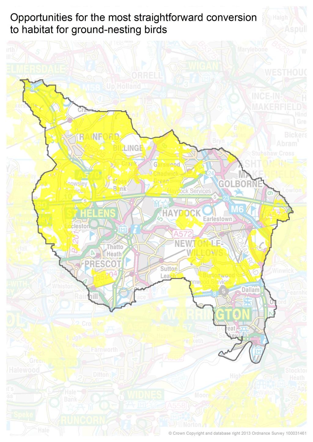
11 Map 5
12 Ground Nesting Birds One key issue for the Sankey Valley is the impact of the major development at Omega on ground nesting bird populations. The opportunity to look wider, beyond the immediate vicinity of the development either side of the M62 in Warrington is being discussed. This would enable a landscape scale approach across the valley providing compensatory and enhanced ground nesting bird habitat. The work developed as part of this plan will form the basis for these discussions. Next Steps A new group focussed on delivery of socio-economic benefits through environment based interventions is developing and will use this work to help shape future activity and delivery of projects and programmes in the area. We are developing a 15 mile long Enviro-economic corridor between Carr Mill, St Helens and Spike Island, Widnes, providing A focus for employment training A sustainable employment access route way A visitor destination with three visitor hubs at Stanley Bank, Bewsey Old Hall area of Warrington and Spike Island A coherent flood management programme A focus for health activities linked to coordinated Natural Health Service provision A functioning, major wildlife corridor Why the Sankey Valley? The scale of the landscape unit, coupled with the breadth of issues influencing it creates a unique opportunity to address a range of problems and issues within a coherent project framework and a broad cross-boundary project partnership. Employment training The Valley offers a wide range of opportunities to establish a programme of employment training initiatives, which can help to increase the work readiness of key target groups such as NEETS whilst providing a site maintenance resource. By developing a land-management team through an accredited training provider, to undertake a range of tasks such as path maintenance, removal of obstacles from river channels routine, basic transferable skills can be instilled whilst supplementing and complimenting current site management. A potential delivery mechanism for this is Groundwork West Lancashire and Wigan. Groundwork has been a principal partner in the development of Stanley Bank, both
13 investing significant cash funding, officer time and providing a range of expertise from landscape design to contract management and strategic project planning. Groundwork is a registered provider of jobs training and run the following options: - Ex-offender focussed Rebuilding lives programme - Apprenticeships and training offer - Progression path to employment Sustainable transport /LSTF Sankey Valley is identified as strategic spine for a sustainable transport network, providing a continuous route to employment sites between St Helens, Warrington and Halton. Successful Local Sustainable Transport Fund bids in St Helens and Warrington will see around 500,000 to be invested in the Sankey Valley in the next 3 years. Visitor Destination Development of three visitor hubs at Stanley Bank, Bewsey and Spike Island linked by the Sankey Canal Trail will provide a sub-regional visitor destination, which, along with Bold Forest Park, will provide key recreational green space for existing and future residential development. The valley holds an important place in national economic history and offers a significant opportunity to market its industrial heritage. Flood Management Significant flooding problems have persisted along the valley, particularly at Black Brook (St Helens), Dallam and Sankey Bridges (Warrington). An approved partnership with the Liverpool University / Waterco Knowledge Transfer Partnership (Admin Decision EPRO ) coupled with Environment Agency funding will allow cost effective and sustainable solutions to be developed. Health The Sankey Valley is a major recreational resource for the three Boroughs, which can play a targeted role in addressing problems such as high levels of cardio-vascular disease and childhood obesity. A natural health service approach linking exercise to health provision using walking, cycling, jogging programmes via a partnership approach with care providers can help to increase participation in exercise as a preventative measure and as a prescribed treatment. A functioning, major wildlife corridor The Government s White Paper on the Natural Environment, The Natural Choice-Securing the Value of Nature, promotes the need for coherent ecological networks and functioning ecosystems as part of ecological sustainability and adaptation to climate change. Liverpool City Region Ecological Framework identifies SVP as a strategically important
14 wildlife corridor, with particular importance, identified for Water Voles (Arvicola aquaticus) via the Wildlife Trust s NW Water Vole Project. Existing data Sankey Valley has been identified in the Liverpool City Region and Warrington Green Infrastructure Framework as a key project. There is a wealth of evidence to underpin the work to develop a cross boundary strategic approach to the Sankey Valley. Appendix1 sets out some of the green infrastructure data. Opportunities The focus on the Sankey valley is in the context of a number of emerging potential opportunities; 1. EU Structural and rural funds 2. Agri- environment schemes 3. Atlantic Gateway Who are the proposed project partners? St Helens Council The Mersey Forest (Key lead partner) Groundwork (Key Lead Partner) Liverpool University /Waterco Knowledge Transfer Partnership Warrington Borough Council (expressed support and synergy to proposed project) Halton Council (expressed support and synergy to HBC project) Sankey Canal Restoration Society (expressed strong support) Environment Agency (expressed outline interest) Wildlife Trusts for Lancashire and Cheshire Liverpool Museum Field Archaeology Unit (expressed support) Canal and Rivers Trust Whilst subject to discussion, it is envisaged that a strategy is developed for the whole valley and that each authority leads on implementation within its area through a local partnership. This will be complimented an overarching sub-regional development level, which is led by The Mersey Forest and supported by Groundwork. How will it be funded? The project will be funded by matching grant bids across a range of sectors including transport (LSTF), Health, E.A. Catchment Improvement Fund, and Heritage Lottery. Current projected investment is: LSFT - 500, 000 ( 420,000 in St Helens) Environment Agency 30,000 Liverpool University KTP 35,000 This will provide a platform for grant funding applications
15 Current Local Authority revenue expenditure can be quantified and where appropriate, elements re-packaged as capital expenditure to provide a degree of match funding along with Officer Staff Time.
Weaver Valley Green Infrastructure data
 Weaver Valley Green Infrastructure data Introduction Introduction Green infrastructure is a 150m 1 asset that we propose can be better used to provide competitive advantage and underpin sustainable growth
Enhancing Ecosystems and Biodiversity. Paul Nolan, Green Infrastructure: Planning for the Liverpool City Region
 Enhancing Ecosystems and Biodiversity Paul Nolan, Green Infrastructure: Planning for the Liverpool City Region Supposing we thought differently Amenity to Necessity Green Space to Green Infrastructure
Making Space for Nature A Leicester Case Study. Dr Helen O Brien Leicester City Council
 Making Space for Nature A Leicester Case Study Dr Helen O Brien Leicester City Council Helen.Obrien@Leicester.gov.uk Definitions Biodiversity (biological diversity) The variety of plant and animal life
Elderberry Walk. Developer HAB Housing
 Case studies Elderberry Walk Developer HAB Housing Development of 161 new homes on the former Dunmail Primary School site, focused around a central green street, with retained trees, new multifunctional
GREEN INFRASTRUCTURE PLANNING GUIDE
 GREEN INFRASTRUCTURE PLANNING GUIDE Authors: C Davies, R MacFarlane, C McGloin, MRoe. Abbreviation Green Infrastructure is frequently abbreviated to as GI and Green Infrastructure Planning as GIP. Contents
NORTH WEST LEEDS COUNTRY PARK AND GREEN GATEWAYS PROJECT. Country Parks Officer Douglas Louis
 NORTH WEST LEEDS COUNTRY PARK AND GREEN GATEWAYS PROJECT Country Parks Officer Douglas Louis Vision To Preserve, Improve and Promote Green Spaces and their Connectivity for People & Wildlife in North West
elbridge Core Strategy
 C elbridge Core Strategy Celbridge is designated as a Moderate Growth Town in the RPGs. The County Development Plan reinforces this designation in its settlement strategy. Moderate Growth Towns within
BOA s and planning. Vanessa Evans Planning and Policy Officer Kent Wildlife Trust
 BOA s and planning Vanessa Evans Planning and Policy Officer Kent Wildlife Trust Planning mechanisms through which BOA s can be used include: 1. forward planning policy through new or emerging Local Plans
CSGN DEVELOPMENT FUND Projects Awarded Funding April 2013
 CSGN DEVELOPMENT FUND 2013-14 - 2014-15 Projects Awarded Funding April 2013 This document provides details of all projects receiving funding from the CSGN Development Fund in 2013-14 and 2014-15. This
Sectoral workshop on Green infrastructure implementation. Multiple benefits of Green Infrastructure
 Sectoral workshop on Green infrastructure implementation Multiple benefits of Green Infrastructure Kristin Faurest Arad October 2015 Contents Green infrastructure as an integrated solution: social, ecological
Development of green infrastructure in EU regions Nature-based solutions delivering multiple benefits
 Development of green infrastructure in EU regions Nature-based solutions delivering multiple benefits A Policy Brief from the Policy Learning Platform on Environment Introduction What is green infrastructure?
EFUF 2014 : Lausanne. Alan Simson Professor of Landscape Architecture + Urban Forestry Leeds Metropolitan University Green Streets Task Group
 EFUF 2014 : Lausanne Green Streets an innovative partnership project designed to enhance and extend the urban forestry associated with the public transport routes in the Leeds City Region Research into
The Duke s River: Revitalising the link between the River Crane and the River Thames
 The Duke s River: Revitalising the link between the River Crane and the River Thames The project The eastern section of the Duke of Northumberland s River runs for approximately four kilometres, from where
South West Nature Map - A Planners Guide
 South West Nature Map - A Planners Guide Helping to Shape Spatial Planning for Biodiversity in Local Development Frameworks Working together for wildlife CONTENTS Foreword 1.0 Introduction 1.1 Purpose
Western Sydney Parklands Australia s Largest Urban Park
 Western Sydney Parklands Australia s Largest Urban Park 37 WLA 1 MAGAZINE 21 38 WESTERN SYDNEY PARKLANDS AUSTRALIA S LARGEST URBAN PARK Large urban parks have dual roles to play in meeting the demands
Brockholes Wetland and Woodland Nature Reserve, Preston Lancashire
 Newlands Brockholes Wetland and Woodland Nature Reserve, Preston Lancashire Nature s Gateway to Lancashire NEWLANDS Brockholes: site profile Brockholes Wetland and Woodland Nature Reserve project area
GREEN INFRASTRUCTURE FRAMEWORK FOR NORTH EAST WALES, CHESHIRE AND WIRRAL. Executive Summary
 GREEN INFRASTRUCTURE FRAMEWORK FOR NORTH EAST WALES, CHESHIRE AND WIRRAL Executive Summary KEY Framework boundary Main settlements Background The Framework considers the natural environments of Denbighshire,
Green Infrastructure, Natural England and the NW. Martin Moss, Green Infrastructure Delivery Leader, NW Regional Advocacy and Partnerships Team.
 Green Infrastructure, Natural England and the NW. Martin Moss, Green Infrastructure Delivery Leader, NW Regional Advocacy and Partnerships Team. Structure. GI and Natural England. Technical development
Priority Delivery Areas for Landscape Scale Conservation in the South West ( )
") Priority Delivery Areas for Landscape Scale Conservation in the South West (2011-15) Together, this set of Biodiversity Delivery Areas (BDAs) represents an ambitious vision to establish a network of strategic
Priority Delivery Areas for Landscape Scale Conservation in the South West (2011-15) Together, this set of Biodiversity Delivery Areas (BDAs) represents an ambitious vision to establish a network of strategic
Neighbourhood Planning Local Green Spaces
 Neighbourhood Planning Local Green Spaces Introduction... 2 1. Why green space is important... 4 2. Neighbourhood plans and green space... 6 3. Evidence... 8 Statutory designations... 9 Green space audit...
Letcombe Brook Project Officer
 Letcombe Brook Project Officer Job Description Responsible to: Responsible for: Purpose of post: Key Committees: Chairman and Trustees of Letcombe Brook Project. Project volunteers and any relevant personnel
Natural Capital City Model - Birmingham
 Nick Grayson Climate Change & Sustainability Manager Birmingham City Council April 29 th 2013 Metanoia EKN- Putting nature s services on the map April 29 th 2013 - Oxford Sustainability Forum June 11 th
Frequently Asked Questions
 1. Where is Aylesbury Woodlands? Frequently Asked Questions Aylesbury Woodlands lies to the east of Aylesbury. It is bounded to the south by the A41. To the north is the Aylesbury Arm of the Grand Union
Park Development Framework Area Proposals. Context to Area 2 Ruckholt Road to Coppermill Lane
 Park Development Framework Area Proposals Context to Area 2 Ruckholt Road to Coppermill Lane The defining feature of this area is the broad expanse of marshlands. These provide the context for a diverse
National Association of Conservation Districts. Kris Hoellen Vice President, Sustainable Programs The Conservation Fund September 19, 2013
 National Association of Conservation Districts Kris Hoellen Vice President, Sustainable Programs The Conservation Fund September 19, 2013 Our Mission The Conservation Fund forges partnerships to conserve
building with nature - a new benchmark for green infrastructure
 building with nature - a new benchmark for green infrastructure Danielle Sinnett, Gemma Jerome, Sarah Burgess, Nick Smith and Roger Mortlock outline the aims, development and proposed operation of Building
Our City Centre is a vibrant, creative and welcoming destination, with a modern business, cultural, shopping, leisure and residential offer
 3. Sheffield in 2034 Our City sits at the heart of a strong, distinctive and internationally successful City Region economy which supports innovation and enterprise Our City Centre is a vibrant, creative
Applicant: Mr C Fletcher Agent: Ms B Stala Case Officer: Sally Smith (HBC) Jill Lee (WCC) Ward: Stakes Parish Southwick and Widley
 Jill Lee (WCC) Ward: Stakes Parish Southwick and Widley") Site Address: Berewood Phase 2 Development Site, London Road, Purbrook, Waterlooville Proposal: Reserved Matters Application for landscaping of Phase A of the Town Park (under Condition 6(i)d)), together
Site Address: Berewood Phase 2 Development Site, London Road, Purbrook, Waterlooville Proposal: Reserved Matters Application for landscaping of Phase A of the Town Park (under Condition 6(i)d)), together
The MAES implementation at European and national scale - guidance and case studies
 The MAES implementation at European and national scale - guidance and case studies Joachim Maes European Commission, DG Joint Research Centre, Ispra Anne Teller European Commission DG Environment, Brussels
Watford Local Plan Part 2 Publication Stage Environmental Report. Appendix 3: Consultation Comments
 Watford Local Plan Part 2 Publication Stage Environmental Report Appendix 3: Consultation Comments August 2016 Appendix 3 - Responses to Consultation of the Local Plan Part 2 As required by the SEA Directive,
Preface. Erie. Scranton. Allentown. Pittsburgh. Harrisburg. Philadelphia
 The Southern Alleghenies Region The Southern Alleghenies Region spans the Laurel Highlands and Allegheny Front in the west across the Appalachians to the east. It is comprised of Blair, Bedford, Cambria,
Chalk, Cherries and Chairs Central Chilterns Landscape Partnership Scheme LANDSCAPE PARTNERSHIP DEVELOPMENT OFFICER JOB INFORMATION PACK
 Chalk, Cherries and Chairs Central Chilterns Landscape Partnership Scheme LANDSCAPE PARTNERSHIP DEVELOPMENT OFFICER JOB INFORMATION PACK How to apply Please complete our application form, together with
Richard Lemon Spatial Project Manager. Biodiversity and Green Infrastructure
 Richard Lemon Spatial Project Manager Biodiversity and Green Infrastructure A key concept: Multifunctionality Combining different functions on the same piece of land multi-functional green space, new
Scotland s 2020 Biodiversity Challenge: Loch Lomond & The Trossachs National Park Authority Delivery Agreement
 Scotland s 2020 Biodiversity Challenge: Loch Lomond & The Trossachs National Park Authority Delivery Agreement Scotland s National Parks Both of Scotland s National Park Authorities contribute to the Scottish
Western City District What we heard
 What we heard Vision to 2056 and Priorities Governance and implementation Infrastructure and funding The protection of the natural landscape including biodiversity and the Metropolitan Rural Area for food
IMPLEMENTING SOMERSET COUNTY S INVESTMENT FRAMEWORK
 IMPLEMENTING SOMERSET COUNTY S INVESTMENT FRAMEWORK SMART CONSERVATION THROUGH SMART GROWTH NJ LAND CONSERVATION RALLY March 22, 2014 Laurette Kratina, PP, AICP, Supervising Planner Somerset County Planning
10.0 Open Space and Public Realm
 10.0 Open Space and Public Realm 10.0 Open Space and Public Realm The Public Open Space System is comprised of: outdoor spaces available for public use that are either publicly owned (e.g., parks and
Natural Environment White Paper & new partnerships to deliver green infrastructure. Henry Smith, Project and Policy Assistant, TCPA
 Natural Environment White Paper & new partnerships to deliver green infrastructure Henry Smith, Project and Policy Assistant, TCPA Presentation outline 1) Green Infrastructure introduction The TCPA s work
SHORELINE, FLOOD AND COASTAL DEFENCE MANAGEMENT PLANS
 These plans may provide opportunities as well as concern for recreational boating. They are currently being revised and consulted on. This document explains how we can engage in the process. Shoreline,
THE HIDDEN VALUE OF OUR GREEN SPACES
 THE HIDDEN VALUE OF OUR GREEN SPACES J A N U A R Y 2 0 1 7 GREEN SPACES... UNDERSTANDING THEIR VALUE The Land Trust is dedicated to providing free public open space for the benefit of communities. Our
Welcome to our exhibition
 Welcome to our exhibition The Homes & Communities Agency (HCA) welcomes you to this public exhibition explaining our proposals for the redevelopment of the former Lea Castle Hospital site. About the Homes
Bigger Better and. Giving nature a home in the Trent Valley: Newark to South Clifton Concept Plan
 Bigger Better and Giving nature a home in the Trent Valley: Newark to South Clifton Concept Plan Our 2050 vision Objectives The Trent and Tame River Valleys will once again be one of the great British
Taking forward the All London Green Grid
 Taking forward the All London Green Grid Foreword Earlier this year, the Mayor published the All London Green Grid Supplementary Planning Guidance to the London Plan which set the vision, and framework,
University Park, Worcester Non Technical Summary December 2011
 University Park, Worcester Non Technical Summary December 2011 Introduction UW Wrenbridge LLP, a Joint Venture Company of the University of Worcester and Wrenbridge Land Ltd (the Applicants ) intend to
Aberdeen City Green Space Network Policy to Practice
 Aberdeen City Green Space Network Policy to Practice Aftab Majeed MIEEM, MRTPI Environmental Planner and Alistair Watson MIEEM Environmental Policy Team Green Networks Why we have the green networks? How
AMENDMENT NO. 30 TO THE OFFICIAL PLAN OF THE TOWN OF MILTON
 AMENDMENT NO. 30 TO THE OFFICIAL PLAN OF THE TOWN OF MILTON Subject: Boyne Survey Secondary Plan and Related Official Plan Amendments The following text and schedules constitute Amendment No. 30 to the
The role of Universities: Civic Design and planning futures
 What did planning ever do for us? A celebration of Civic Design and Planning The role of Universities: Civic Design and planning futures 24 th May 2013 Sue Kidd Head of Civic Design Dept of Geography and
Farmers Investment Co. (FICO) Sahuarita Farms Specific Plan & Minor General Plan Amendment Community Meeting July 1, 2014
 Sahuarita Farms Specific Plan & Minor General Plan Amendment Community Meeting July 1, 2014") Farmers Investment Co. (FICO) Sahuarita Farms Specific Plan & Minor General Plan Amendment Community Meeting July 1, 2014 FICO / Property Overview FICO Properties 7,000 Acres Total 5,900 Acres in Town
Farmers Investment Co. (FICO) Sahuarita Farms Specific Plan & Minor General Plan Amendment Community Meeting July 1, 2014 FICO / Property Overview FICO Properties 7,000 Acres Total 5,900 Acres in Town
CHAPTER 1 Introduction
 CHAPTER 1 Introduction From sea to summit, Lane County covers almost 4,800 square miles of diverse Oregon landscape. Stretching from the Pacific Ocean through the Coastal Range, the Willamette Valley to
UDF PLANS AND GUIDELINES
 UDF PLANS AND GUIDELINES 5 Land Use Land Use Development Plan Plan no. 3 Land Use Development Mixed Use Retail / Leisure Residential Civic and Institutional Proposed Zoning Table Development Edges Plan
Methodology of designing rural areas development projects on the example of the village of Mielnik
 Methodology of designing rural areas development projects on the example of the village of Mielnik WARSAW UNIVERSITY OF TECHNOLOGY Faculty of Geodesy and Cartography Katarzyna Sobolewska-Mikulska,Eng.Ph.D.
Appendix 1 Structure plan guidelines
 Appendix 1 Structure plan guidelines This appendix forms part of the regional policy statement [rps]. 1.1. Introduction Structure plans are an important method for establishing the pattern of land use
Darlington Healthy New Town Hilary Hall Project Manager, HNT
 Bringing a healthy life to communities, bringing healthy communities to life Darlington Healthy New Town Hilary Hall Project Manager, HNT The Healthy New Towns programme has three key aims: 1. To shape
Public Consultation. Land at Monks Farm, North Grove. Welcome
 Welcome Welcome to our public exhibition for development on Land at Monks Farm, orth Grove. Gallagher Estates and Gleeson Strategic Land are preparing an outline planning application for new homes, open
Public Consultation 23 January Peel Hall, Warrington Board 1. A message from Satnam... Site history...
 Board 1 A message from Satnam... Thank you for attending today s public consultation about proposals to develop a new residential neighbourhood at. The display boards show why the development is needed
Making the case for Sustainable Transport Project Potential
 Making the case for Sustainable Transport Project Potential The Structural Investment Fund (SIF) Strategy for Greater Lincolnshire identifies the barriers to growth identified by having poor transport
HS2 Hybrid Bill Petitioning. Summary of SMBC Asks 23/09/13. Background
 Summary of SMBC Asks 23/09/13 Background The Council has a developed a significant number of asks and propositions for consideration by HS2 Ltd and Government throughout further development of the HS2
The Growth Project 2010 The Growth Project in Southport after receiving our award at the Royal Horticultural Society Award Ceremony
 1 The Growth Project 2010 The Growth Project in Southport after receiving our award at the Royal Horticultural Society Award Ceremony 2 Growth Project report 2010 1. Introduction and context The Growth
Oakland County s Green Infrastructure Vision. L. Brooks Patterson Oakland County Executive
 Oakland County s Green Infrastructure Vision L. Brooks Patterson Oakland County Executive Southeast Michigan 20 miles northwest of Detroit Consists of 910 square miles Population of 1.2 million More than
Green Infrastructure Enhancing Europe's Natural Capital
 Green Infrastructure Enhancing Europe's Natural Capital Marco Fritz DG ENV.B.2, Biodiversity CIS Working Group on Programmes of Measures 13/11/13 All (c) belong to the authors of the used material. Target
Biodiversity Standard
 14 Sustainability Service + This is a controlled document whilst viewed at https://universityofleeds.myeqms.com/login/login.aspx. Once downloaded or printed it becomes an uncontrolled copy. Please check
Road Ecology in Practice: Building Resiliency of Urban Ecosystems through Informed Road Network Planning
 Road Ecology in Practice: Building Resiliency of Urban Ecosystems through Informed Road Network Planning Outline What is road ecology? Why is road ecology important? TRCA and road ecology application Peel
LANDSCAPE CHARACTER ASSESSMENT
 THE COUNTY DURHAM LANDSCAPE CHARACTER ASSESSMENT FOREWORD The landscape of County Durham is one of great contrast and diversity. From the North Pennines in the west to the Durham Coast in the east it contains
Green Infrastructure. IENE 2012 International Conference
 Green Infrastructure IENE 2012 International Conference Marco Fritz, DG Environment Potsdam, 22/10/2012 Content 1) Green Infrastructure why does it matter? 2) Added value 3) Policy development framework
Planning for Staten. Habitat Restoration and Green Infrastructure. Island s North Shore
 Habitat Restoration and Green Infrastructure Planning for Staten Island s North Shore Community Board 1 March 1, 2018 NYC Parks Forestry, Horticulture, and Natural Resources Funded by the NYS Department
Natomas Joint Vision Open Space Plan
 Natomas Joint Vision Open Space Plan First Workshop series The City of Sacramento The County of Sacramento LAFCo ERA Economic Research Associates EIP Associates a Division of PBS & J Natomas Joint Vision
COMMUNITY LED REGENERATION CURRENT & FUTURE INITIATIVES FRANK RALLINGS - UNIVERSITY OF BRIGHTON
 COMMUNITY LED REGENERATION CURRENT & FUTURE INITIATIVES FRANK RALLINGS - UNIVERSITY OF BRIGHTON Community Led Regeneration Current & Future Initiatives Neighbourhood Planning Campaigns Community Inspired
Site Assessment Technical Document Appendix A: Glossary
 Central Bedfordshire Council www.centralbedfordshire.gov.uk Site Assessment Technical Document Appendix A: Glossary July 2017 1.1.11-1 - ii Appendix A: Glossary Term Agricultural Land Classification AONB
Thames and Medway Canal
 Thames and Medway Canal High Level Restoration Strategy Prepared by the Thames and Medway Canal Association April 2005 1 Contents Page No Introduction 3 Summary & Vision for the Canal 4 The case for restoration
DUBLIN DOCKLANDS MASTER PLAN AND RELATIONSHIP WITH OTHER PLANS
 .1 National Policy and Programmes.1.1 Sustainable Development A Strategy for Ireland, 1997.1.2 National Climate Change Strategy, 2007-2012.1. National Development Plan 2007-201.1.4 National Spatial Strategy,
SUSTAINABILITY PLAN OTTAWA COUNTY PARKS AND RECREATION COMMISSION FALL 2017
 SUSTAINABILITY PLAN OTTAWA COUNTY PARKS AND RECREATION COMMISSION FALL 2017 Table of Contents Introduction Natural Resources Quality of Life Community Continuing the Mission Sustainability Measuring Sustainability
4. What are the goals of the Kawarthas, Naturally Connected project? 7. What are watersheds and why are they being used as the project boundaries?
 Frequently Asked Questions (FAQs) 1. What are Natural Heritage Systems (NHS)? 2. Why are they important? 3. Which areas of the province have undertaken NHS projects? 4. What are the goals of the Kawarthas,
The Gwennap Parish Vision Statement
 QUICK GUIDE What is a Neighbourhood Development Plan? Ultimately it is a document used by developers or anyone wishing to submit a planning application that describes the vision, strategy, plans, regeneration,
Green Infrastructure planning must be evidence led, thus the importance of this stage in collating your information and responses.
 Green Infrastructure Consultation Proforma Recipients: Andy Maginnis (Countryside Services) regarding access, recreation and tourism Ed Dursley (Transport) regarding access and movement Steve Bloomfield
Saltmarsh Conference. 8 October in the Suffolk Coast & Heaths Area of Outstanding Natural Beauty
 Saltmarsh Conference 8 October 2015 in the Suffolk Coast & Heaths Area of Outstanding Natural Beauty Conference organised by Haidee Stephens, Suffolk Estuaries Officer Suffolk Coast & Heaths AONB t: 01394
Why the workshop, why the cases?
 Green Infrastructure in Central and Eastern Europe Cases from the Czech Republic, Poland and Romania Kristijan Civic, ECNC and Agnes Zolyomi, Zolyomi, CEEweb Workshop on redesigning the landscape, connecting
Circular L8/08 2 September Water Services Investment and Rural Water Programmes Protection of Natural Heritage and National Monuments
 Circular L8/08 2 September 2008 Water Services Investment and Rural Water Programmes Protection of Natural Heritage and National Monuments 1. The purpose of this Circular is to provide local authorities
Landscape Partnership Scheme Summary
 Landscape Partnership Scheme Summary 2016 VISION LANDSCAPE PARTNERSHIP SCHEME SUMMARY 2 Aerial view of Aveley Forest Vision Adopted by the Partnership in 2014, the vision of the Land of the Fanns is The
North District What we heard
 What we heard Vision to 2056 and Priorities Governance and implementation Infrastructure and funding The vision for a metropolis of three cities, and the 30 minute city. Feedback emphasised: That for the
PRESENTATION ON JOHANNESBURG S BIODIVERSITY PROGRAMME
 PRESENTATION ON JOHANNESBURG S BIODIVERSITY PROGRAMME Member of Mayoral Committee: Cllr Prema Naidoo Environmental Management & Johannesburg City Parks PRESENTATION OVERVIEW Jo burg Overview & Context
Connecting Nature and People
 Comhairle Contae Fhine Gall Connecting Nature and People Fingal: An Irish Local Authority s experience Gerry Clabby Europarc Conference, Killarney, Ireland, 28 September 1 October 2014 Planning and Strategic
WELCOME. Land North of STEVENAGE. We would like to thank you for attending our public exhibition today.
 WELCOME We would like to thank you for attending our public exhibition today. The purpose of this event is to share our proposals and hear your thoughts on our ideas. Members of the project team are on
CITY VIEW OBJECTIVES
 SECTION 2: CITY VIEW OBJECTIVES CONTENTS 2.1 Introduction 1 2.2 Strategic Direction 1 2.3 The City View Resource Management Issues for the City 1 2.4 The Goal 3 2.5 The City View Objectives 3 Palmerston
Green Infrastructure SPD - Contents
 Green Infrastructure SPD - Contents Foreword & Executive Summary to be added Section 1: Background 1.1 Introduction and context 1.2 Structure and content of this guidance 1.3 Definition of Green Infrastructure
Office of Greenways & Trails Providing Statewide Leadership and Coordination. Southeast Greenways and Trails Summit October 1-3, 2017
 Office of Greenways & Trails Providing Statewide Leadership and Coordination Southeast Greenways and Trails Summit October 1-3, 2017 1 Office of Greenways and Trails The Office of Greenways and Trails
A Joined-up Regional Landscape: A Roadmap to connect the parts
 Breaking the Barriers: Engineering Solutions to Ecological Problems A Joined-up Regional Landscape: A Roadmap to connect the parts Associate Professor Darryl Low Choy Urban Research Program Outline Nature
Schedule of Planning Applications Committee Date: 23 May Reference: 06/17/0726/F Parish: Hemsby Officer: Mr J Beck Expiry Date:
 Schedule of Planning Applications Committee Date: 23 May 2018 Reference: 06/17/0726/F Parish: Hemsby Officer: Mr J Beck Expiry Date: 22-05-2018 Applicant: Proposal: Site: Mr Gillett Change of use to the
Community Conservation Workshop. Saranac River Basin Communities
 Community Conservation Workshop Saranac River Basin Communities 2 Community Conservation Program Welcome! We have designed a Community Conservation Program that listens to the needs of community members.
8.0 Design and Form of Development 43/
 42/ 8.0 Design and Form of Development 43/ Rothwells Farm, Golborne/ Development Statement Figure 7. Site Constraints Key 44/ Site Boundary 360 Bus Route/Stops Existing Trees Underground Water Pipe Sensitive
Appendix A. Planning Processes. Introduction
 1 Planning Processes Introduction This appendix outlines a number of planning processes which are used in the Auckland Region to support the effective management of development in the region s rural and
Local Wildlife Sites in Leicestershire and Rutland
 Local Wildlife Sites in Leicestershire and Rutland What are Local Wildlife Sites? From mystical ancient woodlands to quiet churchyards and bustling flower-rich roadsides; and from field-bordering hedgerows
A community-based landscape approach to maintain and rebuild SEPLS: Fiji COMDEKS implementation experience
 A community-based landscape approach to maintain and rebuild SEPLS: Fiji COMDEKS implementation experience Ms. Katarina Atalifo, COMDEKS Fiji National Coordinator, GEF-SGP, UNDP COMDEKS Implementation
GREEN NETWORK APPLICATIONS IN ESTONIA
 GREEN NETWORK APPLICATIONS IN ESTONIA Kalev Sepp, Tuuli Veersalu, Martk Külvik Estonian University of Life Sciences 1 WHY? BACKGROUND - POLITICAL By adopting the Pan-European Biological and Landscape Diversity
Grantham Southern Quadrant Link Road Environmental Statement
 Grantham Southern Quadrant Link Road Environmental Statement Non Technical Summary Introduction Lincolnshire County Council (LCC) is submitting a planning application for the proposed implementation of
Statutory and Non-Statutory Designated Sites and Ecology
 Statutory and Non-Statutory Designated Sites and Ecology The National Planning Policy Framework considers the conservation and enhancement of the natural environment in chapter 11 paragraphs 109-119, where
Aquatic, Terrestrial and Landscape Conservation Design Tools and Products of the North Atlantic LCC
 Aquatic, Terrestrial and Landscape Conservation Design Tools and Products of the North Atlantic LCC Scott Schwenk Science Coordinator, North Atlantic LCC Chesapeake Bay FWS Partners Meeting Annapolis,
An Open Spaces Strategy for the London Borough of Tower Hamlets Mid-point update December 2011
 An Open Spaces Strategy for the London Borough of Tower Hamlets 2006 2016 Mid-point update December 2011 1 Table of Contents TABLE OF CONTENTS 2 The Case for an Open Space Strategy...4 Open Spaces and
Objectives and Strategies for the Integration of Recreation, Parks and Open Space in Regional Plans
 BULLETIN 2 Objectives and Strategies for the Integration of Recreation, Parks and Open Space in Regional Plans TABLE OF CONTENTS Introduction 3 Land-use Framework Outcomes 1 4-8 Land-use Framework Outcomes
St. Helens Local Plan Preferred Options December 2016
 St. Helens Local Plan 2018-2033 Preferred Options December 2016 Contents 1. Introduction...1 2. St. Helens Borough Profile...3 3. St. Helens in 2033...7 4. Strategic Policies...10 5. Area Policies...81
Presentation Outcomes
 Green Infrastructure Rappahannock-Rapidan Living Lands Planning Workshop September 17, 2009 Presentation Outcomes Define green infrastructure principles and concepts (video). How are green infrastructure