Strategic Green Belt Review
|
|
|
- Philomena Hart
- 5 years ago
- Views:
Transcription

1 Gre Strategic Green Belt Review Final Report South West Regional Assembly February 2006
2 Strategic Green Belt Review Final Report South West Regional Assembly February 2006
3 Strategic Green Belt Review Final Report Project No: February 2006 Newcombe House 45 Notting Hill Gate London, W11 3PB Telephone: Fax: London@cbuchanan.co.uk Prepared by: Approved by: Greg Lee Michael Wrigley Status: Final Issue no: 1 Date: 3 February 2006 i:\10783x_south west green belt review\study\reports\final report\2 february 2006\strategic green belt review.doc (C) Copyright Colin Buchanan and Partners Limited. All rights reserved. This report has been prepared for the exclusive use of the commissioning party and unless otherwise agreed in writing by Colin Buchanan and Partners Limited, no other party may copy, reproduce, distribute, make use of, or rely on the contents of the report. No liability is accepted by Colin Buchanan and Partners Limited for any use of this report, other than for the purposes for which it was originally prepared and provided. Opinions and information provided in this report are on the basis of Colin Buchanan and Partners Limited using due skill, care and diligence in the preparation of the same and no explicit warranty is provided as to their accuracy. It should be noted and is expressly stated that no independent verification of any of the documents or information supplied to Colin Buchanan and Partners Limited has been made
4 Strategic Green Belt Review - Final Report Contents Page 1. INTRODUCTION Purpose of the report Extent of review work Documents Site visits and meetings Structure 2 2. CONTEXT Introduction Need for Green Belt Review First Detailed proposals 4 3. GREEN BELT REVIEW METHOD Towards a consistent approach Summary of the Methodology 9 4. COMPARATIVE METHODOLOGY REVIEW Introduction Timing Purposes of the Green Belt Absolute and partial constraints Landscape Character Assessment Sustainability Locations for potential review/release Scoring Summary and conclusions on review of methodology IDENTIFICATION OF BOUNDARY AREA REVIEWS Introduction Approach Ranking of harm Conclusions CONCLUSIONS Next Steps / further work 27
5 Strategic Green Belt Review - Final Report 1. Introduction 1.1 Purpose of the report Colin Buchanan (CB) has been appointed by the South West Regional Assembly (SWRA) to undertake a strategic review of Green Belts in the South West. This study will inform preparation of the new Regional Spatial Strategy (RSS) for the region that will cover the period to The overall objectives of the study are to advise on a robust methodology for a strategic, consistent and independent review of the Green Belts across the South West and to undertake an assessment of the technical work on Green Belt review carried out by the appropriate Joint Study Areas. The Brief also provides more detailed objectives as follows: To prepare an apply an independent methodology for Green belt review that can be used in the region; To undertake a strategic review of the advice given by the Regulation 4/4 strategic planning authorities concerning each of the three Green belts and identify where more work would be needed to bring advice into line with the independent methodology established, including whether the advice looked at wider development needs, e.g. ports/airports; To set out in broad strategic terms the extent of Green Belt locations in the RSS (the identification of specific boundaries will be a matter for LDFs) identifying where the rationale for inclusion in Green Belt is relatively weak and where it is stronger; and, To identify other potential locations where extension of Green Belt could be justified in terms of the methodology in order to meet the requirement to identify new areas to compensate for loss of Green Belt due to strategic development needs The purpose of this report is to present our findings of a review of recent Green Belt Reviews undertaken by the three Joint Study Areas (JSAs) of West of England, South East Dorset and Cheltenham and Gloucester. The reviews that we have undertaken are made in comparison to a standard methodology drawn from best practice The recommendations from this review are intended to allow the Regional Planning Body to identify the general extent of Green Belts in the RSS and does not determine precise locations for review of Green Belt. This study uses data supplied by the relevant JSAs and provides a database and map of general areas for review that have been tested against Green Belt purposes and which can be used to develop and evaluate strategic spatial options using environmental capacity and sustainability criteria. It is the full extent of the
6 Strategic Green Belt Review - Final Report Green Belt area around each settlement that is most important because it is in this form that it fulfils the fundamental purpose of its conception- to prevent urban sprawl by keeping land permanently open. The reviews undertaken by the JSA s are not comprehensive in that they have not reviewed the principle for the establishment of the Green Belt in the first place, but have provided advice on potential release areas. The plans produced in this Report do not, and cannot be construed as identifying areas that do not fulfil Green Belt function; rather they are an examination of areas where land might be considered for release to accommodate an urban extension, given an indication of the potential harm that might arise as a consequence of that release This report concludes by considering whether the JSA reviews undertaken are sufficiently rigorous and robust so as to enable the RSS to make recommendations on the areas for addition to Green Belt or release from Green Belt in relation to the preferred strategy. It is a prime purpose to demonstrate how each of the JSA s can structure their reviews in a way that is broadly comparable and will stand up to the rigours of the Examination in Public. 1.2 Extent of review work For clarification the extent of this study and the Green Belt reviews undertaken is limited to the JSAs and therefore does not entail the full extent of all Green Belts. 1.3 Documents A list of the documents that have been supplied to us in respect of Green Belt review work undertaken by the JSA s is provided at Appendix Site visits and meetings Meetings have been held with the planning officers of all the JSAs and site visits have been undertaken. 1.5 Structure This report is structured as follows: Context Green Belt review method Comparison methodology review Identification of boundary review areas
7 Strategic Green Belt Review - Final Report Conclusions
8 Strategic Green Belt Review - Final Report 2. Context 2.1 Introduction This section of the paper provides a summary of emerging strategy as provided in the First Detailed Proposals reports prepared by individual JSAs. 2.2 Need for Green Belt Review This review is being carried out in connection with the new Regional Spatial Strategy for the South West. Policy SS4 of RPG 10 requires local authorities, in preparing their development plans to: Critically review the Green Belt to examine whether boundary alterations are needed to allow for long term sustainable development needs; Remove land from the Green Belt for development if, on balance, this would provide the most sustainable solution for accommodating future development requirements; and Include additional land within the Green Belt where clearly necessary for the purposes set out in PPG The RPG indicates that there is some evidence that development is leaping to settlements beyond the Green Belt leading to less sustainable patterns of development (paragraph 3.11). The review of the Green Belt is thus to ensure that not only does it serve the functions set out in PPG2 but is to be used as part of the strategic decision making process to enable sustainable forms of growth and expansion. 2.3 First Detailed proposals The Section 4/4 (strategic planning) authorities, advising on sub-regional policies, and the Joint Study Area Steering Groups prepared statements of their strategies as contributions to the preparation of the RSS. The Section 4/4 statements are referred to as the First Detailed Proposals. The three JSAs with Green Belts submitted their First Detailed Proposals in August and September, These documents, in connection with technical evidence supplied by the Joint Study Area Steering Groups, help to set the context for the review of the Green Belts and led the Regional Assembly, with the support of GOSW, to require a consistency of approach in the review of the Green Belts The broad strategies contained within the First Detailed Proposals documents are summarised below:
9 Strategic Green Belt Review - Final Report Cheltenham / Gloucester Joint Study Area Cheltenham / Gloucester First Detailed Proposals (September 2005) Cheltenham and Gloucester JSA set out in its vision the objective to maintain the Green Belt, and strengthened its resolve both to protect and expand the Green Belt. The JSA supports the lowest level of housing growth, as identified from RPG 10. Urban areas of Cheltenham / Gloucester will be the focus for development Employment development focused in Gloucester Docks, Cheltenham Town Centre, together with Dursley, Sharpness Docks, Berkeley (BNFL site), Lydney and Cinderford. There is an acceptance of greenfield development. Up to 2016, 55% of the County housing requirement will be focused on the Cheltenham / Gloucester PUA (2,400 dwellings / annum, ). The third alteration to the then structure plan (now abandoned) had proposed that 60 percent of the housing requirement should be focused on Cheltenham and Gloucester. There will be an increased focus upon the urban areas of Stroud/Stonehouse and Tewkesbury / Ashchurch (outside the Green Belt) For the period , it is likely that development at Cheltenham / Gloucester PUA will not be able to continue at the level for the period without the need for urban extensions which, in most cases, would require a review of the Green Belt boundary. The Section 4/4 authority (Gloucestershire County Council) did not consider a Green Belt review appropriate. South East Dorset JSA South East Dorset JSA acknowledged the relationship between pressures from new development and the conservation and enhancement of the environment. Five locations were identified for urban extensions of modest size that would entail development within the Green Belt. A total of 30,900 dwellings to be constructed in the wider study area of South East Dorset with over 90% built within existing urban areas between 2006 and West of England JSA Urban areas of Bristol, Bath and Weston-super-Mare will be the focus for development
10 Strategic Green Belt Review - Final Report Allocate a further 120 to 180 hectares of industrial land and 190,000 to 250,000 square metres of office floorspace for the period at the strategic locations which include (inter alia): - South Bristol (including Hengrove Park) - Avonmouth, Severnside and Royal Portbury - Emerson s Green (including the Science Park) - Built-up areas north of Bristol and south of the M4 Motorway - Bath city centre and Bath Western Riverside (regeneration area) Urban Extensions under consideration that include employment potential: - South west of the Bristol Urban Area - South east of the Bristol Urban Area - North east of the Bristol Urban Area - Weston-super-Mare (Town Centre and urban extensions) Provision will be made for a net increase of 92,500 dwellings in the West of England in the period , averaging 4,625 dwellings per year. About 60% of new housing will be developed through the continuation of existing policies or planned commitments. This will include continued redevelopment and re-use of urban sites for housing, already planned urban extensions at Harry Stoke and Emerson s Green, implementation of the Weston-super- Mare Area Development Framework (which is under preparation), and smaller developments in rural settlements. The remaining housing will be provided through new urban extensions and limited development elsewhere in the sub region. Five locations for possible extensions into Green Belt are proposed for further consideration: - Land adjoining Bristol to the south west - Land adjoining Bristol to the south east - Emerson s Green, adjoining existing commitments - North of Bristol between Harry Stoke and the M32 - South of Bath Extensions to the Green Belt are proposed for further consideration as follows: - North and east of Thornbury;
11 Strategic Green Belt Review - Final Report - North of Yate / Chipping Sodbury; - South west of Nailsea / Backwell; and - Between Peasedown St John, Radstock and Midsomer Norton
12 Strategic Green Belt Review - Final Report 3. Green Belt review method 3.1 Towards a consistent approach This section of the report provides a methodology for undertaking reviews of Green Belts which is based on best practice. The methodology outlined provides a basis for appraising Green Belt review work and for providing a consistent approach to using data available within reviews to provide a sequence for potential review locations, as identified in section The need for consistency of approach to the review of Green Belt is emphasised by GOSW in their letter to SWRA dated 14 November 2005 (copy attached as Appendix 2). There are certain aspects of the methodologies that have been applied by the JSAs which are common, for example, consideration of purpose, consideration of other criteria than those in PPG2 and reference to issues of sustainability. However, there is no common methodology which has been agreed or applied which would take the process of review through to the EiP. We are concerned that in some of the work to date, objectivity in developing and using the analysis has been lost by the arbitrary and apparently inconsistent application of local knowledge (good, excellent or otherwise). It also appears that there has been no rigorous or consistent approach to the identification of areas which might be added to the Green Belt We have reviewed the Cambridge Green Belt review and the Nottingham Derby Green Belt reviews as examples of good practice in order to identify essential and desirable components of a Green Belt review. Notably the Cambridge Green Belt review has withstood the rigour of Examination in Public and comprised comprehensive and transparent assessment. It led to significant changes to the Green Belt including land releases for future development. The review is provided in Appendix Our approach is to establish a model which can be applied consistently to all three JSAs using, as far as possible, data already held. Different methodologies can be equally valid and rigorous. Nevertheless, there are four strands of work which need to be undertaken and would, together, form a satisfactory evidence base for the preparation of the RSS which would be able to withstand examination. They are: Document review Definition of purpose Establishment of sustainability criteria and search area database Application of criteria to search area database
13 Strategic Green Belt Review - Final Report 3.2 Summary of the Methodology The overall method, incorporating the strands of work identified above is summarised in the diagram below: Document review Purposes definition Assessment of areas Areas for review/ Sites database Strategic options Environmental Capacity Develop options Sustainability Appraisal Strategic Environmental Appraisal Document Review Each Green Belt review should contain a document review including national, regional and local policy, assessment of good practice from other reviews, and an assessment of the effectiveness of existing Green Belt policies. In each case the review should include a summary of the original justification for Green Belt designation and of any significant alterations to Green Belt boundaries since designation. Definition of purpose The central justification for Green Belt designation comes from the five purposes set out in paragraph 1.5 of PPG 2, as follows - to check the unrestricted sprawl of large built-up areas; - to prevent neighbouring towns from merging into one another; - to assist in safeguarding the countryside from encroachment; - to preserve the setting and special character of historic towns; and
14 Strategic Green Belt Review - Final Report - to assist in urban regeneration, by encouraging the recycling of derelict and other urban land The starting point for review is to examine each part of the three Green Belts to determine the relative importance of each of the five criteria and identify a ranking of criteria for each Green Belt. This part of the exercise should consider an area wider than the existing Green Belt, so as to be able to determine whether or not the purpose for having Green Belt is justified in areas not currently designated To be able to make judgements on strength of purpose for Green Belt, a common method for assessing the relative strength of purpose should be employed. This might be done through a scoring system applied to each part of the Green Belts for each purpose, or by establishing sub-criteria against which each of the five purposes might be judged. For example the Cambridge Green Belt review identified the principal purposes of the Green Belt as being protecting historic setting and preventing coalescence with surrounding settlements. Elements of that green belt were considered against these two criteria first and the importance of each area contributing to them assessed. Thus whilst several locations may fulfil both main criteria of Green Belt, the sensitivity of each to accommodate development/be released without comprising those particular purposes will vary It is important that in this first part of the study, the Green Belts are appraised using only the five criteria from PPG2. The outputs from this part of the study will be an assessment of areas where the purpose of the Green Belt remains strong, areas where the justification has weakened, and areas where extension of the Green Belt might be justified. Sustainability criteria and potential area of search database The purpose of the third stage is to establish a search areas database and to establish the sustainability criteria that will be used in evaluating the areas within each Green Belt Before commencing the work, in order to reduce the scale of the task and to save time, it might be sensible to restrict the overall area of search for potential release to general locations that are likely to be more sustainable e.g. areas adjacent to PUA s and areas along principal transport corridors. This avoids the need to include within the analysis, peripheral parts of the Green Belt which are clearly inappropriate for development. In order for this process to be transparent, rigorous and defendable, clear reasons as to why search areas are being limited will need to be provided, based on robust strategy The first step is to develop what we have called an Environmental Capacity Framework. This is the assembly of information and analysis required to identify potential development locations and their capacity for development. Thus, it will include, for example, information on absolute and partial constraints, landscape character and quality. Absolute constraints are those which prevent or substantially constrain development from occurring, and include designations such as floodplain, Areas of Outstanding Natural Beauty
15 Strategic Green Belt Review - Final Report and Site of Special Scientific Interest and also include European Habitat Designations Environmental capacity is the ability of a particular environment to perform, and continue to perform its various natural functions. The environmental capacity framework incorporating aspects of quality of life capital as advocated by the Countryside Agency, English Heritage, English Nature and the Environment Agency, will determine the capacity of the area to accommodate change. The sensitivity of a landscape and its capacity to accommodate development is dependant upon its landscape character as well as the values attributed to that landscape by society. The process of identifying environmental capacity allows informed environmentally sensitive decisions to be made. It is a measure of a landscapes ability to accommodate change or intervention without suffering unacceptable effects to its character and values The assessment of landscape character is pertinent to the review of Green Belts. This is because rural and Green Belt areas, if not carefully managed, will experience significant impact as a result of future growth. It is therefore important to understand the sensitivity of these areas to change, so that growth that takes place outside the larger urban centres can be directed to locations which are least sensitive to change and contribute towards achieving a sustainable pattern of development Before land is considered for removal from the Green Belt, it should have been subject to an analysis of suitability for development which includes landscape assessment. This method has been recommended within the CPRE Report Lie of the Land (June 2003) as the most holistic approach to assessing the impact of development on the countryside and rural areas, since it considers the whole of the countryside rather than just specific parts that are protected by planning designations such as AONBs, SSSIs and nature reserves This baseline assessment analysing landscape character helps to define the sensitivity of landscapes to change. This will form an initial picture of potential areas for growth The second step establishes the sustainability criteria that need to be agreed between the three JSAs and applied consistently in all three areas in order to rank the search areas for development. The criteria should reflect the Government s sustainability objectives and those contained within the draft RSS. This process enables areas to be considered for release from Green Belt on the basis of sustainability. Using consistent criteria across all Green Belts means that selection of areas for boundary review occurs on the same basis, which is necessary for purposes of preparing RSS. However, care must be taken to ensure that areas for potential release / and subsequent allocation for development occurs on a competitive like for like basis between Green Belt areas The third step is to assemble a database of search areas within each Green Belt, bringing together both the outputs from the application of the Environmental Capacity Framework and the analysis of purpose. At this stage initial judgements can be made where areas identified as being potentially
16 Strategic Green Belt Review - Final Report suitable for development conflict with areas with a strong justification for inclusion in the Green Belt. All areas should then be subjected to sustainability testing. Application of the criteria and recommendations The final stage of the process is to apply the sustainability criteria to the areas of search, and from this analysis to define areas which can then be introduced to the development of the spatial strategy for each JSA. This pool of potential locations for development would be drawn upon in the identification of the strategic options, which also has to reflect the estimates of demand. Agreement would also be needed on the time horizon for the review. PPG2 requires that Green Belt review looks beyond the timescale of the development plan.
17 Strategic Green Belt Review - Final Report 4. Comparative methodology review 4.1 Introduction A comparative review of the methodologies used in the studies has been undertaken using information provided by each of the JSAs. Documents that have been made available to this study are listed in Appendix 1 along with a summary of their scope. An analysis of data that has been used to undertake the Green Belt Reviews is also contained at Appendix 1. Findings from this summary are provided below. 4.2 Timing The Cheltenham and Gloucester JSA undertook their Green Belt review work to support the Shaping the Future of Cheltenham and Gloucester to 2026 document prior to January The review document was prepared by the Steering Group comprising members of the County Council and District Councils, Gloucestershire First, Gloucestershire Strategic Partnership and the CPRE. Work commenced in The proposed methodology is contained in this paper The South East Dorset JSA undertook their Green Belt review work as part of a detailed examination of future growth prospects and options and as such included detailed examination of potential for development of previously developed land, identification of sustainable planned extensions to the urban core of the JSA and other main settlements and a review of the Green Belt. This documentation was prepared after the Look to the Future: South East Dorset in 2026 document and was prepared by Bournemouth, Dorset, Poole, Christchurch, East Dorset and West Dorset Councils The West of England JSA have taken the first steps of their Green Belt review but are awaiting the outcome of this study before taking the review further. They have reviewed purpose and identified potential areas for development, drawing on joint work on sustainability appraisal and Green Belt review and by individual authorities and this was taken forward in the First Detailed Proposals. A committee paper was prepared in October 2005 and outlined the key issues that would need to be appraised as part of the review work. The committee paper was prepared by Bath & North East Somerset, Bristol, North Somerset and South Gloucestershire Councils drawing on work undertaken by the JSA as a whole In summary all JSAs, apart from the West of England, undertook their Green Belt reviews prior to the publication of their consultation document on the long term options for each JSA area.
18 Strategic Green Belt Review - Final Report 4.3 Purposes of the Green Belt The five purposes of Green Belt designation (outlined in PPG2) provide the starting point for all three reviews and are considered to be the key influences that need to be appraised. However, the ways in which they have been considered vary between the three areas The Cheltenham and Gloucester JSA first considered the applicability of the five purposes to the C&G Green Belt and then undertook a number of visits to areas within the Green Belt and to strategic viewing locations of the Green Belt. The issue of landscape character was included in the analysis of purpose, allowing for ridge lines and general topography. The JSA drew conclusions as to the applicability of the five purposes to parts of the Green Belt on an area by area basis, but limited to locations around the urban area and avoiding Areas of Outstanding Natural Beauty and the Flood Plain. The review scores each area according to purpose but provides no explanation as to how those conclusions are reached. The results of this exercise are summarised in Appendix The principal aims of the Cheltenham and Gloucester Green Belt is to protect Cheltenham and Gloucester and Cheltenham and Bishop s Cleeve from merging and to define a limit to urban sprawl. In this connection the JSA has been able to identify a strategic area which, if lost, would fundamentally undermine the purpose of the Green Belt in respect of preventing Cheltenham coalescing with Gloucester. No such similar conclusion is available in respect of Cheltenham and Bishop s Cleeve. No plan is available showing the conclusions from this strategic assessment. There is concern that such a plan could be read as indicating areas where Green Belt areas contribute less to this purpose of the Green Belt and imply that such areas are suitable for development Protecting historic towns and regeneration purposes are identified as subsidiary purposes to the C&G Green Belt The South East Dorset JSA applied a wide range of criteria in addition to the five purposes, at a relatively fine scale, to assess the performance of the Green Belt. The purposes of sprawl and merging appear to have been combined and therefore not categorically assessed upon their own merits. Regeneration purposes are also not clearly appraised The principal aim of the South East Dorset Green Belt is understood to relate to the protection of settlements within the area from merging and to safeguard the countryside from encroachment. The historic setting of towns was also clearly identified. An extract from the Green Belt review report is attached as Appendix The West of England JSA have commenced their review based upon the five purposes of Green Belt. An initial assessment of the extent to which areas contribute more rather than less to Green Belt purposes has been undertaken by the JSA and has been shown diagrammatically, although it was emphasised that this is not a definitive view. We have interpreted this assessment onto our plans and this map is provided as Appendix 6.
19 Strategic Green Belt Review - Final Report The aims of the West of England Green Belt are provided within the First Detailed Proposals with emphasis on protecting settlements within the area from merging by maintaining the physical separation and distinct identities of the Bristol urban area, Bath and other areas in the sub-region. The historic setting of towns, especially around Bath, and regeneration purposes are also justifications for the Green Belt Overall, all purposes of Green Belt by area, derived from the above reviews are listed at Appendix 7. Additional criteria In terms of justifying modifications to the Green Belt, only the five criteria set out in PPG2 are directly relevant. However, in determining the most appropriate areas for new development and the scale of review, other criteria must be considered. In this next section we review the ways in which these other criteria were identified and have been used in reviews. 4.4 Absolute and partial constraints The Cheltenham and Gloucester JSA considered the following environmental constraints within a separate technical report: Floodplain Areas of Outstanding Natural Beauty Waste sites; Sites of Special Scientific Importance; Important local ridge lines; and, Critical landscape wedges These constraints were overlaid on the Green Belt but there is no indication as to how the two parts of the exercise were brought together to justify nonreview of Green Belt in the areas covered by these constraints The South East Dorset JSA identifies constraints for the purposes of assessing potential development areas. In addition the Green Belt review has considered: Tranquil Areas (identified by the Countryside Agency and CPRE); Light pollution (identified by the CPRE, 2000) Conservation Areas and Listed Buildings;
20 Strategic Green Belt Review - Final Report Country Parks; Forestry Commission land; Special Areas for Conservation (SACs); and, Special Protection Areas (SPAs) These factors were included in the assessment of the Green Belt purposes that areas encompass. Whilst the matters considered appear relevant and can underpin the review of Green Belt, they need to be carefully justified using the original purposes of the Green Belt designation. Without this justification the manner in which they contribute towards or are part of purpose is unclear and so the weight and importance of each is not able to be understood The West of England JSA noted in their Green Belt review that substantial areas are protected from development by policies other than Green Belt, in particular national or international environmental designations such as AONBs or major areas of floodplain. The review of these otherwise protected areas was nevertheless undertaken In summary, the JSAs have approached the use of absolute and partial constraints in different ways, not always linked to the conclusions or recommendations on areas for potential review. 4.5 Landscape Character Assessment It is not clear how the JSAs have used landscape character studies to identify the capacity of Green Belt land to accommodate development The Cheltenham and Gloucester JSA have identified key landscape features to provide a backcloth to views across the Severn Vale that are fundamental to the appreciation of the openness of countryside and form important functions in respect of coalition/merging. Development in these areas would result in the appearance of urban sprawl. A landscape character assessment study is being completed and will be published shortly The South East Dorset JSA considered nature conservation and landscape related factors as part of their review. This was undertaken to identify prominent hill slopes, defining views and landmark features within the Green Belt. These features were identified on illustrative maps. Therefore, elements of landscape character were assessed as part of the review work The West of England JSA have not considered landscape quality assessments as part of their work to date, although it is understood that some districts have carried out landscape character / quality assessment. It is not clear how these individual assessments have been used in the Green Belt review In summary, as with absolute and partial constraints, there is a broad variation in how landscape character has been applied in the reviews.
21 Strategic Green Belt Review - Final Report 4.6 Sustainability The Cheltenham and Gloucester JSA have undertaken a sustainability appraisal of potential strategic growth locations in order to identify strategic locations for growth. Development within the central area of the Green Belt may have sustainability advantages (in transport terms at least) in comparison to other potential locations The South East Dorset JSA considered access to the countryside and recreation issues as part of the Green Belt review. Wider sustainability issues do not appear to have been fully considered as part of the review process The West of England JSA include sustainability criteria within the First Detailed Proposals Report (August 2005), in that a sustainability appraisal of potential development options is undertaken. The Review of the Green Belt (October 2005) report includes a sustainability assessment of the objectives of Green Belt and also makes reference to certain key locations being preferred for reasons of their sustainability. However, there is no comparative evidence to explain why locations have been selected ahead of others in sustainability or other terms In summary, as part of a procedure based approach, sustainability needs to be considered as a key stage within the review process. Sustainability appraisal needs to be identified as part of the methodology for selecting areas for development (and thus for release from the Green Belt). 4.7 Locations for potential review/release The Cheltenham and Gloucester JSA considered 13 locations around Cheltenham and Gloucester in terms of how they performed against the five purposes of Green Belt. The five purposes were then scored for each location (see scoring section below). The review identified potential scope for the removal of Green Belt north of Gloucester and north-west of Cheltenham. There were also areas suggested to be added to the Green Belt including east of Cheltenham and Gloucester; west of Gloucester; south of Gloucester; and north of Bishop s Cleeve. Our interpretation is provided in Appendix The South East Dorset JSA provide conclusions as to which parts of the Green Belt could be released without compromising the purposes of the Green Belt. The impacts of releasing these areas are specified. Maps delineating these areas as drawn by the JSA are reproduced as Appendix 5. The extent of areas that could not be released and those areas less sensitive to release need to be more clearly defined The West of England JSA proposed five locations for possible urban extensions within the Green Belt, subject to further consideration. These areas were first identified in the First Detailed Proposals report. They include land adjoining Bristol to the south west; south east; Emerson s Green; north of Bristol between Harry Stoke and the M32; and south of Bath. These locations for possible urban extensions appear to conflict with the analysis of the Green
22 Strategic Green Belt Review - Final Report Belt by purpose in that locations which would appear to cause more harm than other alternatives have been selected. We are advised that they are justified by a broad judgement of sustainability but have seen no evidence of any rigorous analysis. The JSA proposes general areas for consideration as Green Belt extensions to the north and east of Thornbury; north of Yate / Chipping Sodbury; south west of Nailsea / Backwell; and between Peasedown St John, Radstock and Midsomer Norton. 4.8 Scoring The Cheltenham and Gloucester JSA aimed to differentiate the importance of protecting different areas of countryside by assigning different weights or scores to the areas. The officers undertook site visits to key areas within the Green Belt and these were then scored against the five purposes. A 0 implied little or no importance, a 1 implied some importance, and 2 implied high importance. These results are provided in Appendix The South East Dorset JSA provide comprehensive assessments of impacts of releasing areas of land, but only in respect of environmental and other sustainability objectives The West of England JSA have indicated areas which contribute more rather than less to Green Belt purposes. No objective scoring and weighting was used. 4.9 Summary and conclusions on review of methodology Our interpretation of the documentation provided is that the three JSA s have considered their Green Belts in terms of the purposes provided within PPG The Green Belt reviews that have been undertaken and the data used vary. Notably, the South East Dorset review has benefited from a detailed understanding of housing and employment land targets and a detailed site search (which ignored the Green Belt) and selection process based on sustainability criteria. The result of this assessment was the subject of a separate Green Belt review assessment which had only considered potential urban extensions. Cheltenham and Gloucester undertook a similar process and sequence of studies, but provide a clearer and simpler expression of site selection. This can be used to select next best sites (in terms of impact). The West of England review in contrast, does not explain how sites for potential release from the Green Belt have been selected ahead of alternatives The scoring system associated with the Cheltenham and Gloucester JSA work provides a methodical and sound approach in respect of the review of area by Green Belt purpose, although more explanation is required. This approach enables clear evaluation of identified areas of each Green Belt and will provide a consistent and rational basis for review across the three areas.
23 Strategic Green Belt Review - Final Report Within the three reviews, the methodologies employed do not provide a transparent and clear analysis of Green Belt by purpose and thereby provide a link between potential for change (within the Green Belt) and capacity and demand. Reviews must be objective. The identification of Green Belt by purpose and merits of purpose will provide the basis for developers to submit planning applications to test Green Belt policy. It must be made clear in any review documentation, that all Green Belt serves an important purpose which, irrespective of any strengthening or weakening, does not mean that its purpose ceases to be valid. Instead, the purpose of the exercise is to establish if a release is possible and what harm to the Green Belt would be caused by such a release The emphasis of reviews has been on the potential release of areas for development and there needs to be a consistent approach to considering areas for addition to the Green Belt. To date this appears to have been done on a somewhat arbitrary basis We provide a broad methodology as to how a Green Belt Review should be undertaken in section 3. Below, based on information that we have received, we identify broad areas where improvements to existing reviews are needed. Document Review None of the available Green Belt reviews provide a comprehensive document review that succinctly sets out national and regional policy, considers best practice or outlines the original purpose of the Green Belt or reviews effectiveness of the Green Belt Whilst not expressed in any single document, it is possible to develop such a section from available data. Anecdotal information indicates that Green Belts are effective. This will need to be verified with each JSA. Environmental Capacity West of England have considered landscape character but have not published or made available their work on environmental capacity. The rationale for selecting the five areas (and the alternatives considered) needs to be provided South East Dorset have undertaken a much more rigorous assessment identifying parts of the Green Belt by purpose and providing supporting maps by purpose. Prior to this a separate exercise of site search (for development areas) has been undertaken which has then been subjected to a variety of tests, which included sustainability issues/objectives. Purposes of Green Belt have been overlain on the site search process to identify areas that could be developed. This process means that strategic choices are able to be made, taking into account purpose of Green Belt and other relevant strategic implications of growth.
24 Strategic Green Belt Review - Final Report Cheltenham and Gloucester have provided a landscape structure map and also a map of environmental constraints. Documentation does not provide clear advice as to how these relate to Green Belt purpose or whether they have been used to help define sensitivity of areas to change. The use of environmental constraints has assisted in identifying what areas are to be considered for future development, for example, there is no point in identifying land within the flood plain. Sustainability References are made to sustainable locations for urban growth, but there is no evidence within documentation provided by West of England that there has been any analysis to support the view that these areas are more or less sustainable than other alternatives Cheltenham and Gloucester have undertaken a sustainability appraisal of strategic options for growth Documentation supplied by South East Dorset does provide detailed analysis of growth options and different strategies which incorporate sustainability principles. Sustainability appraisal of spatial options / vision was undertaken. Green Belt purpose, assessment and delineation of sites/areas Whilst not expressed in any single document it is possible to ascertain the main strategic purposes of individual Green Belts. That is to say, it is possible to identify the reasons why Green Belts were originally designated and also to identify where new reasons have materialised The West of England Green Belt review does consider the original reasons for Green Belt designation. An explanation of why areas delineated as contributing more than less to Green Belt purposes is needed from West of England. No weight has been attributed to particular purposes of Green Belt. The process of selecting areas (ahead of alternatives) is not transparent and thus, the purpose of the analysis undertaken is not apparent For Cheltenham and Gloucester a detailed explanation as to why particular purposes are attributed to areas /parts of the Green Belt including sensitivity to change needs to be provided. Cheltenham and Gloucester need to examine our interpretation of delineation (Appendix 4) and clarify extent of zones and provide details as to rationale for site area selection (locations were selected on the basis of examining the purposes of the Green Belt, taking into account the constraints, sustainability criteria, transport modelling and economic data). From available information, there appear to be areas of the Green Belt that have not been assessed or considered for release. Parts of these can be explained by environmental constraints, where it is considered that development could not occur in any event, which is reasonable.
25 Strategic Green Belt Review - Final Report South East Dorset provide maps/diagrams that illustrate individually and cumulatively Green Belt purposes. These are clearly explained and described. No weighting of importance of purpose is provided, nor assessment of the sensitivity or contribution of particular areas of Green Belt to that purpose.
26 Strategic Green Belt Review - Final Report 5. Identification of boundary area reviews 5.1 Introduction The previous sections of the report provide our understanding of reviews undertaken by the JSA's and the data that has underpinned them. This section of the report summarises data on Green Belt purpose and areas identified within individual Green Belts where boundaries could be reviewed It is important to recognise that maps / figures provided within this report provide our current understanding of purposes of parts of Green Belt derived from available information. Although not all areas within the Green Belt are annotated (notably in South East Dorset) this does not mean that those areas do not fulfil any Green Belt function or that the loss of all or parts of these areas would be acceptable. Reviews and identification of potential areas for release have concentrated on areas where urban extensions/development could logically occur It is the full extent of the Green Belt area that is important because it is in this form that it fulfils the purpose of its conception. The reviews undertaken by the JSAs are not comprehensive in that they have not reviewed the principle for the establishment of the Green Belt in the first place, but have provided advice on potential release areas. The plans produced in this Report must not, and cannot be construed as identifying areas that do not fulfil Green Belt function; rather they are an examination of areas where land might be considered for release to accommodate an urban extension given an indication of the potential harm that might arise as a consequence of that release. 5.2 Approach In order to understand results from the Green Belt reviews undertaken and to identify potential areas for release/expansion of boundary, the following sequence was followed: 1. Absolute constraints which prevent or significantly constrain development from occurring restrict the areas of search within the Green Belt. These included European Habitat Designations. A consistent set of constraints have been applied to all three areas, as follows: Floodplain Area of Outstanding Natural Beauty National Park (including proposed extension areas) Ancient woodland RAMSAR
27 Strategic Green Belt Review - Final Report Special Protection Area Site of Special Scientific Interest National Nature Reserve Special Area of Conservation 2. Using available information from reviews, following site visits and discussions with officers of relevant JSAs, purpose has been attributed to areas of the Green Belt. These areas are generally contiguous with settlements (as information has mostly been collected in respect of potential urban extension areas), and avoid absolute constraints listed above (in most instances) Results of the above are mapped and provided at Appendix Identification of areas where Green Belt boundaries are proposed by JSAs to be released and where boundaries are proposed to be expanded. For Cheltenham and Gloucester locations where harm caused to Green Belt appears to be least, based on available information and following discussions with officers of the JSA, have been estimated. These potential locations are provided at Appendix 9. With regards Cheltenham and Gloucester, the JSA review work only provides for two potential extension locations, to the north of Gloucester and north-west of Cheltenham. 4. All potential boundary review sites are assessed given available information on Green Belt purpose in a table, firstly identifying the amount of purposes fulfilled by each, and, secondly, by weighting the main purposes of Green Belt ahead of other purposes (which is based on the reasons why Green Belt was originally established). Results of these analyses are provided at Appendix Ranking of harm Ranking of harm caused to Green Belt, described in paragraph above, is based on the number of purposes that areas of Green Belt fulfil. It does not consider the sensitivity of areas to change, as in this connection further work needs to be undertaken. This is important because areas of Green Belt might only fulfil a single purpose and yet have no capacity to accommodate development, that is without undermining the very purpose of the Green Belt itself. Furthermore, some locations that fulfil more or the same number of purposes as other areas, may have capacity to accommodate development without undue harm being caused to Green Belt as compared to other apparently similar, less or more sensitive areas Nevertheless, weighting the purposes for the Green Belts so as to achieve a cumulative ranking does provide a rationale basis for identifying areas where boundaries might be reviewed. However, this analysis should be considered in combination with the consideration of landscape character and environmental
28 Strategic Green Belt Review - Final Report capacity to absorb development (see section 4.5 and paragraph to ) The results of the ranking analysis are provided graphically in Appendix 11. Whilst it is not anticipated that results will match the advice provided by the JSAs exactly, because the JSAs have taken into consideration sustainability criteria and environmental capacity (albeit it seems to be on an arbitrary basis (see section 4.5)), we comment as follows: Cheltenham and Gloucester areas identified as causing least harm to Green Belt (should sites be released) match those identified within the Green Belt review work undertaken by the JSAs. Their review work provides for two potential extension locations, to the north of Gloucester and north west of Cheltenham. West of England areas identified as causing least harm do not match those identified by the JSAs. The manner in which potential sites for release /review have been identified need to be carefully explained given ranking results as two areas that are identified as most sensitive to change are proposed to be potentially reviewed and locations which are less or least sensitive are not all used. It is assumed that locations in the open countryside could not be used, as development of a new settlement is not appropriate, albeit that it would be helpful if such an explanation was provided. South East Dorset areas identified for release largely match ranking, and differences can be explained by examining the absolute constraints maps (see Technical Report Development Options, prepared by the JSA) and from examination of assessments of individual sites In respect of airports and ports, from examination of purpose provided and information available from JSAs: Gloucester Airport located in most sensitive part of the Green Belt so that release will need detailed assessment of landscape capacity but is likely to cause substantial harm. Bristol Airport ranked second least harm caused to Green Belt, indicating that some potential for Green Belt to be reviewed. Landscape capacity assessment will need to be undertaken to establish scope and scale of release that can be achieved. An extract from the Inspectors Report in respect of the examination of the North Somerset Replacement Local Plan was published in advance of the main report which is due out in March The Inspector s report is not binding. The extract handles the future of the Airport and advises that the northern side of the operational area of the airport be released from the Green Belt. The report states that should additional development be required located outside of the released area then very special circumstances would need to be demonstrated that clearly outweigh the harm to the Green Belt and any other harm. Bristol Port located outside of the Green Belt. It is understood that the proximity of Portishead to the Port and Gordano means that any extension of
29 Strategic Green Belt Review - Final Report Port could lead to narrowing of the gap between adjacent settlements. The impact of the Port proposals may mean that the gap between settlements becomes critical so that the case for extending the Green Belt into this location would need to be considered. The Somerset County Development Plan First Review (1972) indicates that this area was not included within the original Green Belt because of its potential for dock development. However, the area between Portishead and Royal Portbury Dock is proposed for inclusion in Green Belt within the draft Joint Replacement Structure Plan (2002) and draft North Somerset Local Plan. The Inspector's Interim Report (January 2006) recommends that the Green Belt extension between the Docks and Portishead be confirmed and that the area between the Docks and M5 be removed from the Green Belt and safeguarded for port uses as well as an area of search for a park & ride / station facility. Bournemouth Airport not specifically reviewed by the JSA although land adjoining nearby settlements is identified and considered as being likely to cause third least harm and fifth least harm. This seems to indicate that land surrounding the airport is sensitive to change. 5.4 Conclusions This section provides a comparative analysis of Green Belt by purpose and of the harm that would be caused to Green Belt should land be released. Ranking of harm demonstrates that analysis undertaken by Cheltenham and Gloucester and South East Dorset JSAs is explainable but only by using background material and reports. However, proposed areas for review / release within West of England are not Landscape capacity analysis within all areas is not documented, although in many instances officers of JSAs have clearly considered the landscape and its ability to absorb development. This needs to be rectified.
30 Strategic Green Belt Review - Final Report 6. Conclusions Across all three green belts there are a limited numbers of locations where urban expansion could be achieved without significantly and adversely affecting the purpose of the Green Belts All three Joint Study teams have analysed their Green Belt by purpose. On its own this analysis is an insufficient basis on which to identify potential locations for development. This is recognised in all three areas. Fundamentally, an assessment of the Green Belt based on an understanding of their original purposes has not been undertaken in all cases. There is an understanding of the need to assess development potential / capacity taking into account absolute / partial constraints / landscape character and quality as well as sustainability issues. Two of the Joint Study teams have applied this approach (but in different ways). The third, West of England, recognises the need to adopt this approach but has not yet applied it A key issue in the review of the Green Belts is the selection of general areas of search. In order to demonstrate objectivity there is a need to adopt a standard approach to the areas which are to be the subject of detailed analysis of development potential. West of England, in particular, has identified five potential areas of release (in effect, search areas) without providing a clear method or rationale as to why areas have been selected ahead of alternatives. Any method used needs to be able to withstand examination and so there must be a rigour and commonality of approach in the selection of areas of search that can be defended There is a need for more careful analysis of the areas of search in order to assess capacity in relation to quality of landscape and general issues of sustainability. We have identified a lack of transparency in the ways in which landscape character assessments have been used to identify the potential locations for development and then the capacity of sites to accommodate development. Whilst officers clearly are very knowledgeable about their areas and do appreciate the landscape and its character, there is a lack of clarity in the ways this understanding is brought together with the analysis of Green Belt purpose With regards to the time horizon of the Green Belt reviews undertaken, because selection of areas of search has been limited to examination of potential peripheral expansions (of urban areas), the reviews of Green Belt undertaken will probably not be able to provide for the period beyond the time horizon of the emerging RSS. For the reviews to have endured for longer, all potential development options would need to have been considered, including more radical, and possibly, more sustainable strategic options. This is particularly important in looking at longer term strategy, beyond the time horizon of the current round of development planning These conclusions lead us to recommend a methodology which involves identification of potential development capacities and then drawing upon that pool of development capacities to develop and evaluate alternative strategies.
31 Strategic Green Belt Review - Final Report 6.2 Next Steps / further work The methodological sequence in Chapter 5 provides a rational and comparative basis for green belt review, and draws largely on information and analysis already held by the Joint Study teams. The significant gap is the lack of a common basis for assessing landscape quality and capacity for development. Additional work to fill this gap would need to be undertaken Impartial and common landscape character assessment of the Green Belts to ascertain capacity of all potential expansion locations to absorb development would benefit the preparation of the RSS and provide a rigorous basis for defending proposed changes to the Green Belts at the forthcoming public examination In summary the following areas of work need to be undertaken: OVERVIEW OF ADDITIONAL WORK REQUIRED Work Document Review Definition of purpose Establishment of sustainability criteria and search area database Application of criteria to search areas database Gap / Additional work areas Information exists but not provided in single location Relative importance of each Green Belt purpose not defined. Judgement possible based on policy documents. Environmental capacity assessments of areas of Green Belt need to be undertaken. Where information exists an overall comparative table of development options based on sustainability considerations should be assembled. Where this information is lacking steps should be taken to obtain it
32 Strategic Green Belt Review Appendices to Final Report Appendix 1 Summary of Green Belt Review documents supplied by the JSAs and data review
33 Strategic Green Belt Review Appendices to Final Report Green Belt Review documents supplied by JSAs West of England JSA First Detailed Proposals (November 2005) First Detailed Proposals (August 2005) Green Belt Review Committee Paper (October 2005) Your Area: Your Vision (November 2004) Extracts from South Gloucestershire Local Plan Inspectors Report (date unknown) Mapinfo files containing environmental consideration and locational/ Infrastructure considerations by area within the Green Belt Sustainability Appraisal of Sub Regional Spatial Strategy Development Options (Appendix B ) Cheltenham and Gloucester JSA Cheletenham and Gloucester First Detailed Proposals (September 2005) Detailed Strategy Document Supporting the First Detailed proposals from Cheltenham and Gloucestershire County Council for the Cheltenham and Gloucester Joint Study Area (September 2005) Technical Background Paper: Strategic re-assessment Review of Green Belt (2005) Shaping the Future of Cheltenham and Gloucester to 2026 (January 2005) Cheltenham and Gloucestershire Joint Study Area Report to Cabinet (Gloucestershire County Council) (7 September 2005) Technical Background Paper: Constraints Officer Working Group Green Belt Background Paper Gloucester Structure Plan 2 nd Review: Draft Consultation (May 1996) Landscape structure map (hand drawn by officers) Initial Working Draft Strategic Environmental Appraisal of the Cheltenham and Gloucester Joint Study Area (April 2005) 2
34 Strategic Green Belt Review Appendices to Final Report Green Belt Background Paper Gloucester Structure Plan 2 nd Review Draft for Consultation (May 1996) Photograph plates of key views of and within Green Belt South East Dorset JSA South East Dorset Strategy (November 2005) First Detailed Proposals (November 2005) Strategic Review of Green Belt (2005) Technical Report: Development Options Report (25 November 2005) (Draft) Technical Report: Testing of Growth Options Western Sector Feasibility Study, Dorset (Volumes 1 3) (Atkins, January 2005) First Detailed Proposals Strategy Document (September 2005) Areas of Great Landscape Value, East Dorset District Council (June 1997) Extracts from Replacement Bournemouth, Dorset and Poole Deposit Structure Plan (July 2004) 3
35 Strategic Green Belt Review Appendices to Final Report Green Belt area West of England Summary of scope of key documents supplied Document Coverage Comments Sub-regional spatial options notes for members workshop 10 Sept 04 Environmental and physical constraints map West of England joint study area first detailed proposals, August 2005 Assesses strategic locations for development against the following nine criteria: 1. regeneration 2. economic growth 3. communities 4. development (potential to meet varied needs) 5. access to jobs and facilities 6. existing centres (ability to support) 7. environment 8. efficient land use 9. need to travel SSSI, SAC, SPA, RAMSAR & NNR; historic parks and gardens; conservations areas; common land; UK BAP habitats; Ancient woodland; slopes >10 degrees; AONB; surveyed ALC grades 1,2 or 3a; provisional ALC grades 1 or 2; SNCI/wildlife site; SAM; Flood risk zone 1 or 2. Sets out subjects that will be included within the RSS and which require further assessment as part of the process of developing the RSS, and in order to identify suitable sites for development. These are: regenerating and reinforcing the role of the main urban areas; roles and development of smaller towns; role and strength of the greenbelt; role and development of rural areas; economic development; new homes; sites for gypsies and travellers; social and cultural provision; education; health; transport; environmental resource use and management. The work carried out for this document and the GB review need to be conjoined to develop a fuller assessment. The report at paragraph 2.4 notes that all information required to test the implications of the levels of growth and spatial strategy proposed. Results from the Strategic Transport Study are awaited and further work on the strategic review of the green belt and strategic sustainability appraisal is also to be carried out. West of England partnership; planning, transport and environment group. Agenda item 10 of 14 October 2005 Review of Green Belt Bath and North East Somerset landscape character assessments have been undertaken but were not supplied in time to be taken into consideration for this report Assesses extent to which Green Belt contributes to essential GB objectives (PPG2); consider whether good reasons exist to justify removal of areas from GB to meet long term development requirements; and assess whether additional areas could meet GB requirements. Identifies five broad GB areas that could possibly be released and briefly describes the impact of development in these areas. Appendix 3 assesses defined areas within the GB and their contribution to PPG2 criteria. There is not a detailed landscape character assessment of the GB nor is there an analysis of the function or strength of purpose of areas within the GB. The document sets out the parameters of the review but there is no indication that the more detailed approach to review should be taken. 4
36 Strategic Green Belt Review Appendices to Final Report Green Belt area Document Coverage Comments South Gloucestershire landscape character assessment, draft June 2002 Initial working draft strategic sustainability appraisal of the Cheltenham and Gloucester JSA. June 2005 Divides the district into landscape character areas. Each character area is assessed looking at : key characteristics; location; physical influences; land cover; settlement and infrastructure; landscape character; the changing landscape; and landscape character area boundary. The document is a Sustainability Appraisal of the development options within the C&G JSA. Identifies absolute constraints. Assessment covers areas in the northern part of the West of England GB. Ideally this type of assessment should be carried out for all areas within the GB. The work carried out for this document and the GB review need to be conjoined to develop a fuller assessment. A study of landscape character being carried out. This work needs to be fed into the GB review. 5.2 states that further work has been carried out to determine environmental constraints this work needs to be fed into the GB review. Cheltenham and Gloucester Cheltenham and Gloucester joint study area paper September 2005 Green Belt background paper, Gloucestershire structure plan 2 nd review May 1996 C&G JSA background paper: strategic reassessment of the Green Belt. (no date) This document sets out the boundaries of the C&G JSA, sets out the core purposes of the JSA strategy, core strategy and policies for the JSA. This is a discussion paper and does not contain analysis. Document contains the results of two pieces of work: 1) purpose and meaning of the GB in C&G context examined; and 2) results of a field assessment of the setting of each GB settlement. The SA appraises options for development at a strategic level. More detailed assessments are required to fully evaluate GB. Green Belt review is required to develop a coherent spatial strategy for the JSA. The document does not contain the results of the field trip and there is no discussion about the stage two work setting of settlements. Stage one is a discussion of the PPG2 criteria and is not an analysis of those criteria. Stage two scores different parts of the GB in meeting the PPG2 criteria Technical background paper on behalf of SWRA (January 2005) It appears that this working paper explains the methodology used in producing the above background paper. Sets out the key identified constraints. A full landscape character assessment is currently being undertaken and will be available shortly. Cheltenham and Gloucester JSA working group on the Green Belt, September 2004 (draft interim report) Defines broad landscape areas within the GB. This is a discussion paper looking at the PPG2 criteria only. Green Belt review work was stopped after the local elections. 5
37 Strategic Green Belt Review Appendices to Final Report South East Dorset Green Belt area Document Coverage Comments Shaping the future of Cheltenham and Gloucester to 2026, January 2005 C&G JSA Report to cabinet, 07 th September 05 C&G JSA detailed strategy document for first detailed proposals (September 2005) Untitled map (no date) South East Dorset Strategy, November SED 02: the strategy South East Dorset sub-regional study: final first detailed proposals, September 2005 South East Dorset sub-regional study: final first detailed proposals, technical report: development options. Draft November 2005 Western sector feasibility study vol 1 (no date) Chapter 1 Introduction Western sector feasibility study volume 3: shadow appropriate assessment (no date) Public consultation document. Sets out potential development options for the JSA but does not contain any analysis. Does identify main physical constraints to development. (technical work is contained in background papers) Progress report detailing advice to be sent to SWRA regarding policy for the RSS. The report is concerned with housing growth and does not contain technical assessment work. County Council advice is based on no change to the Green Belt in the period to Green Belt review work was stopped after the local elections. Document covers the issues of constraints to development, transport and the Green Belt. The County Council does not support development within the Green Belt n the period to No assessment of the GB is provided. Indicates critical landscape wedges, important local ridge lines, AONB, flood plain, waste sites and 250m buffer from waste sites. Document sets out a broad development strategy for SE Dorset and provides an overview analysis of the strategic issues facing the SE Dorset sub-region. It is based on a series of technical reports including one assessing development options/green Belt Predecessor of the above document setting out components for the sub-regional strategy. This document looks at urban potential, urban extensions and contains a review of the Green Belt. The urban extensions search identifies absolute constraints and partial constraints (termed discretionary constraints). These constraints have been mapped. Table four of the paper lists the criteria for rigorous testing. This testing process conforms with the process used in the Cambridge study. Study assesses the potential for a major growth area to the west of Poole. The study is to inform the SE Dorset sub-regional strategy. This document is a shadow assessment of the impact of the proposed western extension on neighbouring internationally designated sites Dorset Heaths Special Area of Conservation (csac), Dorset Heaths Special Protection Area (SPA) and wetland of international importance (Ramsar site) and Poole Harbour SPA and Ramsar site. The analysis work carried out for this document needs to be undertaken in the context of a Green Belt review as this would provide a more robust position on which the county council can defend its stance. The Green Belt review is an integral part of developing the strategy and a comprehensive Green Belt review will result in a more robust strategy. Looking at the SE Dorset assessment and the South Gloucestershire landscape character assessment it would be useful to have a proforma to standardise recording of data and its presentation simply to speed up the process of comparison and analysis. The assessment looks at predetermined sites and thus does not identify transport corridors The study identifies ecological areas which are considered to be constraints to development but the analysis is more detailed than is required for the Green Belt assessment process. South East Dorset sub-regional study: testing of growth options technical report (no date) The site is located within the Green Belt. Document provides an overview of the growth strategies for the sub-region and an assessment matrix of each option when assessed against a number of sustainability criteria. Document does not provide detailed assessment. 6
38 Error! Unknown document property name. The following table compares data used in and available to the Green Belt review processes in each JSA against that which was collected and used to undertake the Cambridge Sub region Study Green Belt review. Green Belt Area Assessment Constraints to development West of England Cheltenham & Gloucester South East Dorset Historic parks and formal public open space Playing fields Sub-regional spatial options notes for members workshop 10 Sept 04 Yes in the November 05 technical report on development options. Partial or discretionary constraints have also been identified. Sub-regional spatial options notes for members workshop 10 Sept 04 Initial working draft strategic sustainability appraisal of the Cheltenham and Gloucester South East Dorset Strategy, November SED 02: the strategy JSA. June 2005 Environmental and physical constraints map Technical background paper on behalf of SWRA (April 2005) South East Dorset sub-regional study: final first detailed proposals, technical report: development options. Draft November 2005 SSSIs Sub-regional spatial options notes for members workshop 10 Sept 04 Environmental and physical constraints map Initial working draft strategic sustainability appraisal of the Cheltenham and Gloucester JSA. June 2005 Technical background paper on behalf of SWRA (April 2005) Western sector feasibility study volume 3: shadow appropriate assessment (no date) (only in the area relevant to the study) South East Dorset Strategy, November SED 02: the strategy South East Dorset sub-regional study: final first detailed proposals, technical report: development options. Draft November 2005 Grade 1 flood plain (0.1-1% annual probability) Sub-regional spatial options notes for members workshop 10 Sept 04 Environmental and physical constraints map Initial working draft strategic sustainability appraisal of the Cheltenham and Gloucester JSA. June 2005 Technical background paper on behalf of SWRA (April 2005) Western sector feasibility study volume 3: shadow appropriate assessment (no date) (only in the area relevant to the study) South East Dorset Strategy, November SED 02: the strategy South East Dorset sub-regional study: final first detailed proposals, technical report: development options. Draft November 2005 Grade 1 ground water protection zone Initial working draft strategic sustainability appraisal of the Cheltenham and Gloucester JSA. June 2005 Technical background paper on behalf of SWRA (April 2005) Western sector feasibility study volume 3: shadow appropriate assessment (no date) (only in the area relevant to the study) South East Dorset Strategy, November SED 02: the strategy South East Dorset sub-regional study: final first detailed proposals, technical report: development options. Draft November 2005 SAMs Sub-regional spatial options notes for members workshop 10 Sept 04 Environmental and physical constraints map Ancient woodland Sub-regional spatial options notes for members workshop 10 Sept 04 Environmental and physical constraints map Sites with known mineral reserve Sub-regional spatial options notes for members workshop 10 Sept 04 RAMSAR sites Sub-regional spatial options notes for members workshop 10 Sept 04 Environmental and physical constraints map Initial working draft strategic sustainability appraisal of the Cheltenham and Gloucester JSA. June 2005 Technical background paper on behalf of SWRA (April 2005) Initial working draft strategic sustainability appraisal of the Cheltenham and Gloucester JSA. June 2005 Technical background paper on behalf of SWRA (April 2005) Initial working draft strategic sustainability appraisal of the Cheltenham and Gloucester JSA. June 2005 Technical background paper on behalf of SWRA (April 2005) Western sector feasibility study volume 3: shadow appropriate assessment (no date) (only in the area relevant to the study) South East Dorset Strategy, November SED 02: the strategy South East Dorset sub-regional study: final first detailed proposals, technical report: development options. Draft November 2005 Western sector feasibility study volume 3: shadow appropriate assessment (no date) (only in the area relevant to the study) South East Dorset Strategy, November SED 02: the strategy South East Dorset sub-regional study: final first detailed proposals, technical report: development options. Draft November 2005 Western sector feasibility study volume 3: shadow appropriate assessment (no date) (only in the area relevant to the study) South East Dorset Strategy, November SED 02: the strategy South East Dorset sub-regional study: final first detailed proposals, technical report: development options. Draft November 2005 Grade 1 agricultural land Cemeteries Sub-regional spatial options notes for members workshop 10 Sept 04 Initial working draft strategic sustainability appraisal of the Cheltenham and Gloucester JSA. June 2005 Technical background paper on behalf of SWRA (April 2005) Western sector feasibility study volume 3: shadow appropriate assessment (no date) (only in the area relevant to the study) South East Dorset Strategy, November SED 02: the strategy South East Dorset sub-regional study: final first detailed proposals, technical report: development options. Draft November 2005 Western sector feasibility study volume 3: shadow appropriate assessment (no date) (only in the area relevant to the study)
39 Strategic Green Belt Review Appendices to Final Report Green Belt Area Assessment Setting of the main urban centres West of England Cheltenham & Gloucester South East Dorset Detail of setting of urban areas in relation to Green Belt areas contained within mapinfo files supplied. Additional work needs to be undertaken respect of historic towns. C&G JSA background paper: strategic reassessment of the Green Belt. (January 2005) categorises importance of Green Belt locations in regard to historic setting but there is no analysis. South East Dorset sub-regional study: final first detailed proposals, technical report: development options. Draft November 2005 topography Detail of topography in respect of entire Green Belt is mapped. sense of approach change on the urban-rural edge Detail of setting of urban areas and thus sense of approach in relation to Green Belt areas contained within mapinfo files supplied. landmarks Some detail of key landmarks setting of urban areas in relation to Green Belt areas contained within mapinfo files supplied. Additional work needs to be undertaken in respect of historic towns. skylines Some detail of important skyline supplied in mapinfo files supplied. views from the urban centre Character of settlements within the Green Belt Detail of setting of urban areas in relation to Green Belt areas contained within mapinfo files supplied. Additional work needs to be undertaken respect of historic towns. no historic characteristics Acknowledged in West of England joint study area first detailed proposals, August 2005 that Bath is a historic asset but not related to Green Belt review. Additional work needs to be undertaken respect of historic towns. South East Dorset sub-regional study: final first detailed proposals, technical report: development options. Draft November 2005 West of England partnership; planning, transport and environment group. Agenda item October 2005 review of Green Belt. Appendix three assesses sections of the Green Belt against PPG2 criterion to preserve the setting and special character of historic towns but this is not an analysis of the historic characteristics. spatial distribution Cultural, social and economic links West of England joint study area first detailed proposals, August 2005 Cheltenham and Gloucester joint study area paper September 2005 South East Dorset Strategy, November SED 02: the strategy Environmental capital local character areas biodiversity Too limited extent para 3.3 of Green Belt review background paper. Cotswold escarpment and the Severn Vale are acknowledged in Sept 04 working group minutes as being important landscape features. South Gloucestershire have a landscape character assessment dating from This covers the northern and north-eastern parts of the Green Belt. Not a similar document for the other parts of the Green Belt. Landscape character assessment of bath and North East Somerset has been undertaken. Initial strategic sustainability appraisal of the Cheltenham and Gloucester JSA. June 2005 Technical background paper on behalf of SWRA (January 2005) South East Dorset sub-regional study: final first detailed proposals, technical report: development options. Draft November character areas identified but further work on biodiversity required. Transport corridors and nodes West of England joint study area first detailed proposals, August 2005 To be considered in more detail once the Greater Bristol Strategic Transport Study is finalised. September 04 working group minutes acknowledge that this is an area to be looked at. Cheltenham and Gloucester joint study area paper September 2005 strategic links and not assessed in relation to housing or Green Belt. C&G JSA detailed strategy document for first detailed proposals looks at strategic linkages from an economic perspective. Yes in the November 05 technical report on development options (assessed from the strategic economic perspective). 8

40 Strategic Green Belt Review Appendices to Final Report Green Belt Area West of England Cheltenham & Gloucester South East Dorset Assessment Capacity assessment South East Dorset Strategy, November SED 02: the strategy. Uses Urban housing capacity study and is not an assessment of capacity within the Green Belt. Comments Review so far looks at the PPG2 objectives and considers the assessment criteria in this context only. Absolute constraints are mentioned (e.g. floodplain) as are some landscape features, but there needs to be a stronger analysis on how these contribute to the value of areas within the Green Belt and in identifying possible areas for release. Various strands of work need to be complied into a single document. Cambridge style landscape assessment should be carried out, the work so far is too superficial. 9
41 Error! Unknown document property name. Appendix 2: Correspondence from GOSW to SWRA of 14 November 2005
42 14 November 2005 Bryony Houlden South West Regional Assembly Dennett House 11 Middle Street TAUNTON Somerset TA12 1SH Bronwyn Hill Regional Director 2 Rivergate Temple Quay Bristol BS1 6EH GTN: Tel: Fax: Mast House Shepherds Wharf 24 Sutton Road Plymouth PL4 0HJ GTN: Tel: Fax: E mail: Bronwyn.hill@gosw.gsi.gov.uk Regional Spatial Strategy Reinforcing the evidence base I thought it would be helpful to write to you with some thoughts following the recent Assembly plenary and Peter Brown s letter of 3 November to the 4(4) Authorities. We also undertook, at one of the Assembly s workshop sessions on 21 October, specifically to set out the Government s position in respect of the RSS and the Green Belt. When Baroness Andrews agreed an extension to the RSS timetable in June she stressed the need for the Assembly to move quickly to plug gaps in the evidence base. Thoss Shearer s letter of 16 August elaborated on this, pointing to the need to ensure that the evidence underpinning the JSA work and first detailed proposals is robust and complete. Peter Brown s letter helpfully identifies a number of areas in which further work is needed. However, I am concerned that it may not go far enough in filling the gaps in critical areas. As Peter s letter acknowledges, testing of growth levels has varied across the JSA and 4(4) work. However, it is clear that there is not enough information about the possible implications of planning for higher growth scenarios including those set out in the draft Regional Economic Strategy. The RSS and RES processes will test the realism of the growth scenarios but the former will be frustrated if we do not have complete and robust information about the spatial implications. The work recently commissioned from Roger Tym & Partners will help the Assembly and others to better understand the economic potential of key places but it will need to be taken further to articulate the spatial, transport and other non-economic implications of higher scenarios should they materialise. We hope that it will be possible to arrive at a common regional view about what the levels of growth are likely to be to
43 inform the draft RSS and its implementation plan. But in any event it is inevitable that the EiP Panel will want to look at the implications of planning for the range of growth scenarios and essential that complete and robust information is available for them to properly consider the issues and arrive at a clear view. I know that the Assembly is commissioning a study to look at the consistency of the JSA and 4(4) work to review the green belts. I would like to be reassured that this will be taken further to make sure the gaps in the reviews that are already apparent are filled. It will not be necessary for the RSS to repeat the policies and purposes of the green belt which are clearly set out in PPS2. But as Peter says in his letter, RPG10 has since 2001 required strategic authorities to review the green belt in Structure Plans to establish its general extent, and this has not yet been completed. This responsibility has now passed to the RPB in the RSS. The reviews must be completed if the RSS is to set out clear policies on the changes to the general extent of the green belt, displayed diagrammatically as well as in words as part of the key diagram for the urban areas concerned, where these are necessary to accommodate any proposed urban extensions. The RSS cannot remit this work to LDDs or a future review of RSS. It is vital that completion of the green belt reviews takes place hand-in-hand with the work to test the implications of the growth scenarios, so that the possible effects on the green belt are understood and its general extent is established (including possible increases) to ensure that the green belt purposes are robust for the future. It is entirely right for the JSAs and the 4/4 authorities in the three relevant parts of the Region to participate in these reviews, but ultimately if the work they submit is insufficient it will be necessary for the RPB to take the reviews forward in tandem with its emerging thinking about the most appropriate locations and size of urban extensions, and time is running out. You will also be aware of the difficulties in obtaining reliable supporting evidence and costings for the transport schemes associated with a number of the JSA and 4(4) authority submissions. The Regional Funding Allocations initiative provides the region with an opportunity to plan for investment over the long term but in order to do this we do need reliable costed transport proposals with which the region can prioritise. In the RSS context, if the Regional Transport Strategy is to be fully integrated, robust evidence is required to support the infrastructure needs associated with growth. These are the main areas where further work appears to be needed, but we are also concerned to ensure that sufficient evidence is available to support the emerging RSS policies for the rural parts of the region. It will be essential to ensure that, for example, emerging proposals in rural areas are supported by robust and realistic evidenced based economic assessments in order to ensure sustainable outcomes. I have copied this letter to the planning/environment directors of the 4(4) Authorities and to Claire Gibson at the RDA. BRONWYN HILL
44 Strategic Green Belt Review Appendices to Final Report Appendix 3: Best Practice Review
45 Strategic Green Belt Review Appendices to Final Report Methodology used for reviewing the Green Belt in the Cambridge sub-region study The review of the green belt around Cambridge comprised the following principal components: 1. Identify constraints to development. 2. Identification of primary and secondary green belt purpose. 3. Assessment of areas within the Green Belt for further investigation: o Setting and character o Environmental capacity o Relationship of urban/rural edge 4. Sustainability assessment of individual sites. The review was carried out in three stages and these are set out below. Stage one Agreement on and mapping of constraints to development. Some of these are absolute constraints, such as SSSIs and grade 1 flood plain, and others are partial constraints, such as, grade 1 agricultural land. These areas were excluded from search areas for new development. Stage two 1. Establish the primary purpose of the Green Belt (to preserve the special character of Cambridge and to maintain the quality of its setting) and secondary purpose (to prevent further coalescence of settlements). 2. Setting and special character of the green belt. For the Cambridge study this comprised: o local character areas vegetation, historic attributes, views; o topography; o views of the city of Cambridge, and o the interface between the city and its surrounding villages and the countryside. 3. Environmental capacity framework assessment of potential development sites. This comprised the following elements: o landscape and setting relationship between site and surrounding landscape and historic core of Cambridge; o vegetation structure determined capacity assessing ability of existing vegetation to screen development; o topography important in considering local and wider impacts; o o biodiversity considered broadly at this stage; transport assess ability of site to contribute to sustainable travel patterns and includes walking, cycling and public transport. 4. Relationship of the rural/urban edge. 5. Examination of the degree of physical and visual separation between settlements. Stage three Following from stage two, areas within the Green Belt where it was considered that development could be accommodated, where assessed on a site by site basis against a set of agreed capacity and sustainability criteria.
46 Strategic Green Belt Review Appendices to Final Report Nottingham Derby Green Belt Methodology Study discussions held with officers from local authorities affected by the Green Belt, matters to be raised are: - the history of the Green Belt; - purpose of the Green Belt; - views on the effect of the Green Belt; - the designation and operation of the Green Belt in policy making in the development plan and development control; - possible changes to Green Belt boundaries. Meetings or telephone conversations with interest parties in the outcome of the Green Belt, identified by the steering group; - parties familiar with environmental issues of the area, i.e. Environment Agency; - with knowledge of strategic interest in development activity, i.e. House Building Federation (HBF); - from the voluntary sector, i.e. Council for the Protection of Rural England (CPRE) and friends of Green Belt. The report format used is as follows: The origins of the Green Belt - Philosophical origins of Green Belt; The purpose. - As identified in PPG 2, it identifies 5 purposes; - To check the unrestricted sprawl of large built up areas; - To prevent neighbouring towns from merging into one another; - To assist in safeguarding the countryside from encroachment; - To preserve the setting and character of historic towns; - To assist in urban regeneration, by encouraging the recycling of derelict and other urban land. Green Belt Objectives - These are not objectives of Green Belt policy, but objectives which land in Green Belts might have a positive role in fulfilling. - Operation of Green Belt Policy - It identifies that there is a unique issue to Green Belt when preparing development plans and how they should deal with them;
47 Strategic Green Belt Review Appendices to Final Report Section 2 National Planning Policy Green Belt and Sustainable Development - The overarching goal of spatial planning is now to contribute towards greater sustainability by bringing about development that is more sustainable. Findings of the study The Plan-Led system Section 3 examines the Nottingham Derby Green Belt Introduction Review - Identifies the location of the Green Belt/s; - Potential changes to the defined area; - How existing Green Belts have been defined historically and why; - If any extensions or reductions are proposed; Implications of maintaining the Green Belt - It identifies consequences of development in the Green Belt Green Wedges - These are areas of open space to be protected from development or provide wildlife corridors within urban areas. Leicester and Derby identify these where there are no Green Belt designations. Section 4 Green Belt and Spatial Planning Options for the way forward - It identities are three tests for the consideration of options, they are: reflect the proper role of RPG be consistent with the aim of achieving more sustainable development assist with the operational issues raised by having part of the Region subject to Green Belt policy
48 Strategic Green Belt Review Appendices to Final Report Influences on the approach - The main influences are on the review are: Preparation of RPG Formulation of Spatial Strategy The scale of development to be provided for. Spatial Strategy Scale of development - It identifies a sequence of steps in assessing the scale of changes to the Green belt: how much development provision is to be made in the Region, and in the Three Cities Sub Area; what proportion of the Sub Area provision should be in or closely related to each of the cities; how much development can and should take place within the urban areas; what level of development should take place on the edge of or closely related to the urban areas. Proposed Approach - The questions to be addressed are therefore: Mechanism what mechanism should be followed for changing Green Belt boundaries? how should the locations for the boundary changes be identified? - It identifies the removal of land from the Green Belt the approach or to change the boundaries. - The following approach is suggested: in the RPG, establishing the expectation that some of the required development will be accommodated in what is now Green Belt; in the structure plans, preferably informed by joint working of the local authorities in the sub region, identification of the broad areas where Green Belt boundaries will need to be changed;
49 Strategic Green Belt Review Appendices to Final Report in local plans, identifying those areas within the areas of search to be allocated for development, and redrawing the boundaries. Criteria of development locations - The criteria used is: - Opportunity: the trip lengths generated by movement between new homes and other facilities can be low, because of the pattern of uses there can be good access to public transport; By impact locations which minimise the impact on environmental assets. These have included: national or county wide landscape and nature conservation designations agricultural land classification water source protection areas, and areas at risk from flooding. - By 'contribution' the extent to which adding to the development in a location can improve the overall pattern of development. Identifying locations - These locations were tested for their impact and contribution, through a process which is both convergent and iterative. The development envisaged could be achieved by either: a series of small scale peripheral expansions located according to the criteria of opportunity and impact a few larger schemes located according to the opportunity and impact criteria, but creating a contribution by involving employment as well as housing and providing for other facilities to be included. Adding to the Green Belt - No areas proposed as can be controlled through other planning policies and controls. Section 5 Conclusions and Recommendations Conclusions Recommendation
50 Strategic Green Belt Review Appendices to Final Report Appendix 4: Cheltenham and Gloucester - Previous Work on Green Belt Review
51 a b c d e Purpose Location West of Gloucester North of Gloucester city centre North-east of Gloucester North of Brockworth South-East of Gloucester f South of Gloucester g South-west of Cheltenham h West of Cheltenham (Golden Valley area) i North-west of Cheltenham j North of Cheltenham (Bishop s Cleeve Gap) k North of Bishop s Cleeve l East of Cheltenham m South of Cheltenham 1) Preventing Sprawl 2) Preventing Towns Merging 3) Safeguard Countryside 4) Historic Setting (Chosen Hill) (Cotswold Edge, Robinswood Hill) (Hunt s Grove 0 1 ridge) (Hunting Butt s Ridge) ) Encourage Recycling
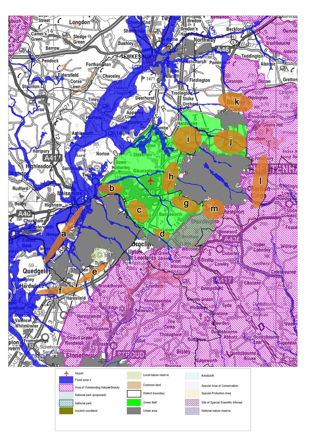
52
53 Strategic Green Belt Review Appendices to Final Report Appendix 5: South East Dorset - Previous Work on Green Belt Review
")
54 Strategic Green Belt Review Appendices to Final Report South East Dorset Green Belt Review Extract from Technical Report: Development Options Report (25 November 2005) (Draft)
55 Strategic Green Belt Review Appendices to Final Report Appendix 6: West of England - Previous Work on Green Belt Reviews

56 Strategic Green Belt Review Appendices to Final Report West of England ; Previous Work on Green Belt Review Extract from West of England Partnership Planning, Transport And Environment Group Review Of Green Belt Report (14 October 2005)
57 Strategic Green Belt Review Appendices to Final Report Appendix 7: Green Belt Review of Purposes
58 Strategic Green Belt Review Appendices to Final Report Green Belt Purposes Cheltenham / Gloucester JSA Sprawl Merging Encroachment History Regeneration Outside Urban Areas Gloucester / Cheltenham and Cheltenham / Bishop s Cleeve Severn Vale (West of Gloucester) Land on the edge of the urban areas Surrounding historic rural towns Gloucester Docks and other development within the defined urban areas South East Dorset JSA Sprawl Merging Encroachment History Regeneration Outside Urban Areas Bournemouth / Airport Bournemouth / Merley / Wimborne Minster Bournemouth / West Parley / Ferndown Bournemouth / Upton Wareham / Northport / Sandford / Holton Heath Ferndown / West Moors West Moors / St Leonards St Leonards / Ringwood West Moors / Three Legged Cross Three Legged Cross / Verwood Land on the edge of the urban areas (particularly north and west) Christchurch (north and south) Wimborne Minster (south and west) Wareham (north and east) Hampreston, Hurn Village, Pamphill, Morden Holdenhurst (east and west) and Throop Bournemouth West of England JSA Sprawl Merging Encroachment History Regeneration Outside Urban Areas Bristol / Bath Bristol / Nailsea / Backwell Bristol / Keynsham Bristol / Yate / Pucklechurch Bath, Peasedown St John and Radstock Bristol / Keynsham / Saltforf / Bath Land on the edge of the urban areas Cotswold AONB Bath Stoke Park Surrounding historic rural towns South Bristol
59 Strategic Green Belt Review - Final Report Appendix 8: Green Belt Review analysis of purpose

60
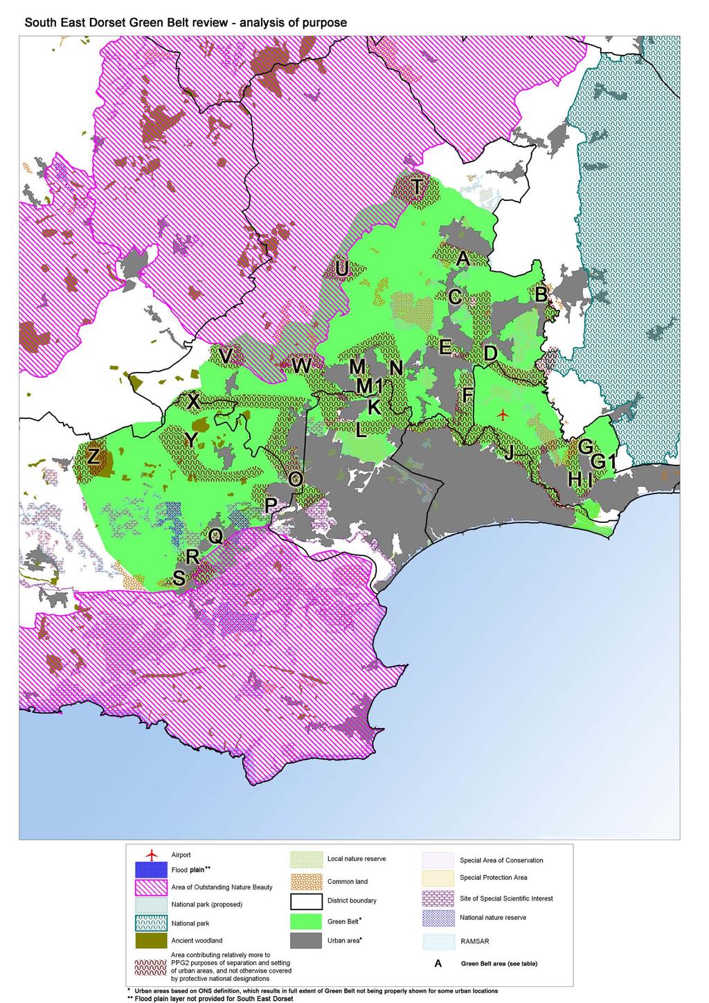
61
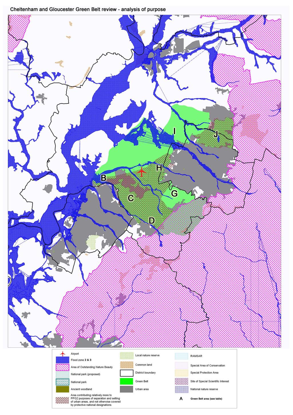
62
63 Strategic Green Belt Review Appendices to Final Report Appendix 9: Green Belt Review - identified locations for boundary review
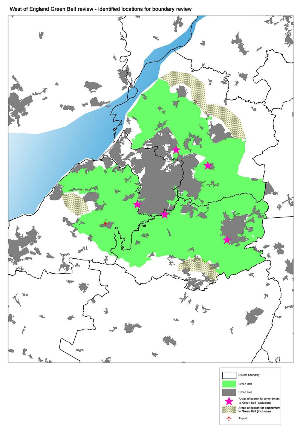
64
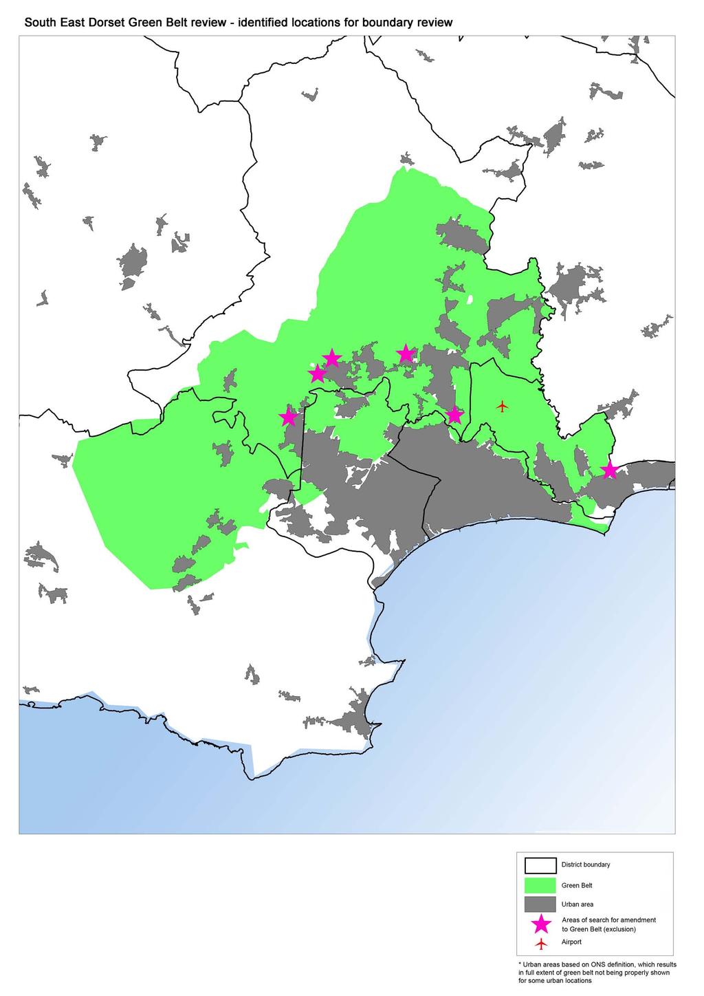
65
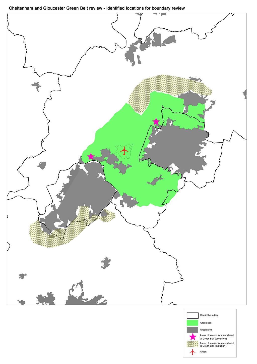
66
67 Strategic Green Belt Review Appendices to Final Report Appendix 10: Green Belt Review analysis of purpose

68 Strategic Green Belt Review Appendices to Final Report

69 Strategic Green Belt Review Appendices to Final Report
70 Strategic Green Belt Review Appendices to Final Report Appendix 11: Green Belt Review ranking of sensitivity to change
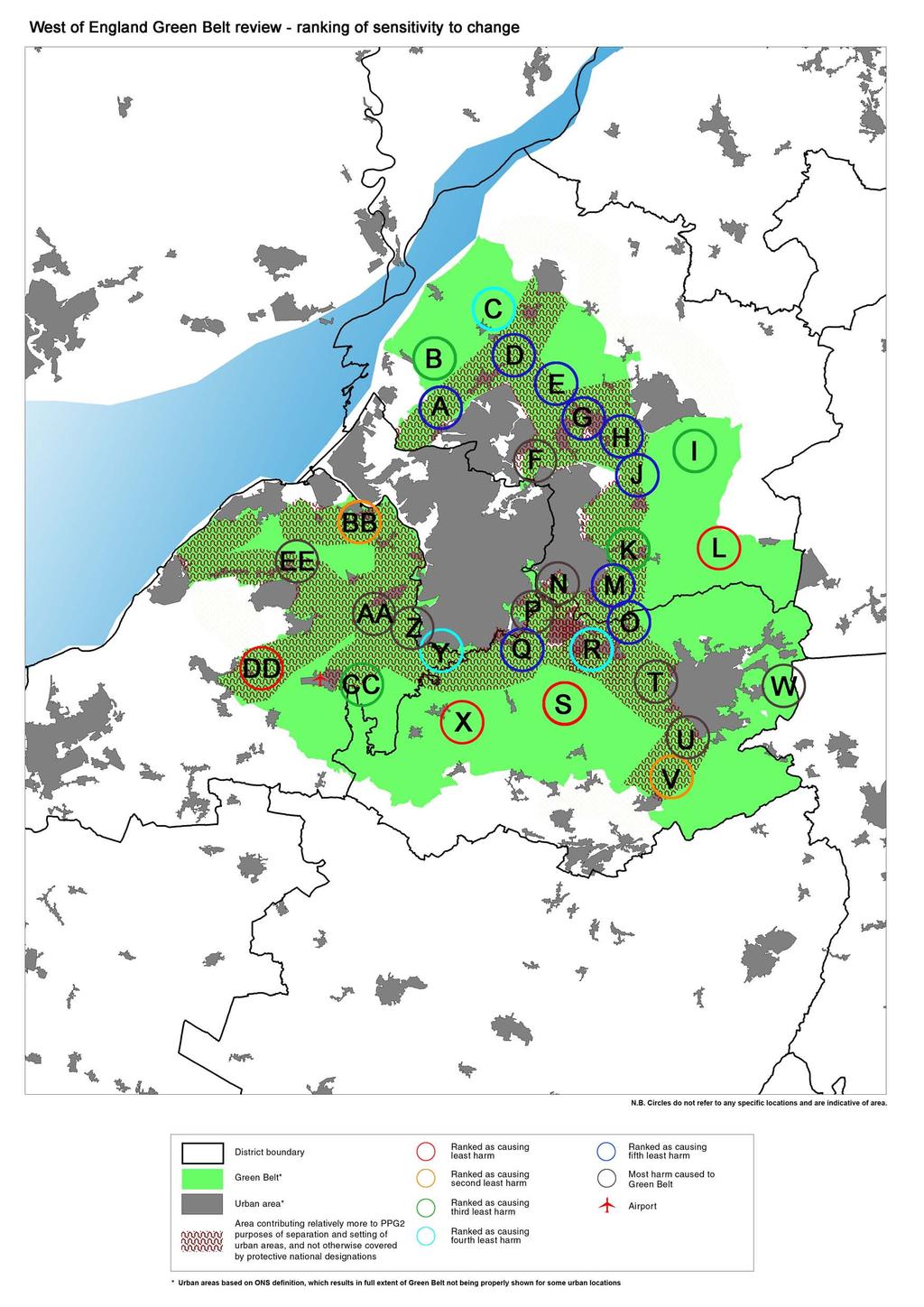
71
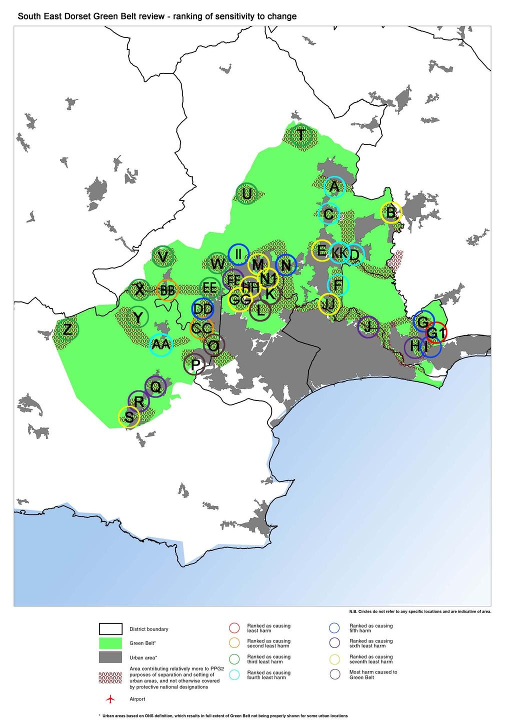
72
73

74 Contact: Greg Lee Colin Buchanan Newcombe House 45 Notting Hill Gate London W11 3PB T E greg.lee@cbuchanan.co.uk LONDON BRISTOL EDINBURGH GLASGOW MANCHESTER NEWBURY BELFAST DUBLIN GALWAY
Oxford Green Belt Study. Summary of Final Report Prepared by LUC October 2015
 Oxford Green Belt Study Summary of Final Report Prepared by LUC October 2015 Project Title: Oxford Green Belt Study Client: Oxfordshire County Council Version Date Version Details Prepared by Checked by
GUILDFORD BOROUGH GREEN BELT AND COUNTRYSIDE STUDY
 GUILDFORD BOROUGH GREEN BELT AND COUNTRYSIDE STUDY Volume II - Addendum On behalf of Guildford Borough Council PPG Ref : BNL.0287 April 2014 COPYRIGHT The conents of this document must not be copied or
Site Assessment Technical Document Appendix A: Glossary
 Central Bedfordshire Council www.centralbedfordshire.gov.uk Site Assessment Technical Document Appendix A: Glossary July 2017 1.1.11-1 - ii Appendix A: Glossary Term Agricultural Land Classification AONB
Cotswolds AONB Landscape Strategy and Guidelines. June 2016
 Cotswolds AONB Landscape Strategy and Guidelines June 2016 Cotswolds AONB Landscape Strategy and Guidelines Introduction The evolution of the landscape of the Cotswolds AONB is a result of the interaction
Draft Hailey Neighbourhood Plan
 Persimmon Homes (Wessex) Draft Hailey Neighbourhood Plan Representations to West Oxfordshire District Council s Regulation 16 Consultation December 2018 2 Copyright 2018 Persimmon Homes Ltd. All rights
LEEDS SITE ALLOCATIONS PLAN MATTER 3 GREEN BELT KCS DEVELOPMENT AUGUST 2017
 LEEDS SITE ALLOCATIONS PLAN MATTER 3 GREEN BELT KCS DEVELOPMENT AUGUST 2017 Smith Limited Suite 9C Joseph s Well Hanover Walk Leeds LS3 1AB T: 0113 2431919 F: 0113 2422198 E: planning@peacockandsmith.co.uk
Settlement Boundaries Methodology North Northumberland Coast Neighbourhood Plan (August 2016)
") Introduction This background paper sets out a methodology for the definition of settlement boundaries in the North Northumberland Coast Neighbourhood Plan. The neighbourhood plan is planning positively
Introduction This background paper sets out a methodology for the definition of settlement boundaries in the North Northumberland Coast Neighbourhood Plan. The neighbourhood plan is planning positively
Proposed Sheffield City Region Combined Green Belt Review A Common Approach August 2014
 Proposed Sheffield City Region Combined Green Belt Review A Common Approach August 2014 1.1 Purpose To achieve the principles of Duty to Cooperate, it is beneficial for all Local Authorities within the
The Case for a South Hampshire Green Belt. January 2018
 The Case for a South Hampshire Green Belt January 2018 CPRE Hampshire s Vision For A Green Belt South Hampshire is a growth area. A consequence of this is the need for more employment, and more housing.
SWJCS GREEN BELT REVIEW
 SWJCS GREEN BELT REVIEW July 2010 dnsplanning+design Prepared by DNS Planning and Design/ Nicholas Pearson Associates on behalf of CONTENTS 1. Introduction... 6 2. Parameters of the Study... 9 3. Methodology...
Plumpton Neighbourhood Development Plan Revised Pre Submission Document - Regulation 14 Consultation
 REPRESENTATIONS... Plumpton Parish Council Plumpton Neighbourhood Development Plan Revised Pre Submission Document - Regulation 14 Consultation Representations submitted on behalf of: Cala Homes (South
Sustainability Statement. Whitby Business Park Area Action Plan
 Sustainability Statement Whitby Business Park Area Action Plan November 2014 Contents Page 1. Introduction 1 2. Scoping 3 3. Sustainability Appraisal of Options 6 4. Assessment of Draft Area Action Plan
Appendix A: Retail Planning Assessment
 Rotherham Town Centre Masterplan Appendix A: Retail Planning Assessment 139 Appendix A Rotherham Town Centre Masterplan Retail Planning Background and Policy Context 1. Introduction 1.1 The Masterplan
Babergh and Mid Suffolk Joint Draft Local Plan Consultation, August 2017, Public Consultation
 Babergh and Mid Suffolk Joint Draft Local Plan Consultation, August 2017, Public Consultation Having reviewed the documents, the Society has made the following response: Housing Delivery Q 7. Do you agree
ROCHFORD LOCAL DEVELOPMENT FRAMEWORK: Sustainability Appraisal/ Strategic Environmental Assessment. Rochford Core Strategy Preferred Options Document
 ROCHFORD LOCAL DEVELOPMENT FRAMEWORK: Sustainability Appraisal/ Strategic Environmental Assessment Non Technical Summary Rochford Core Strategy Preferred Options Document October 2008 SUSTAINABILITY APPRAISAL
Policy DM19: Development and Nature Conservation
 Avonmouth Wetland Habitat Project October 2010 and December 2011 (the Cresswell study). Policy Links Bristol Local Plan Core Strategy Lead Policy BCS4: Avonmouth and Bristol Port BCS9: Green Infrastructure
Suffolk Coastal Local Plan Review Issues and Options, August 2017, Public Consultation
 Suffolk Coastal Local Plan Review Issues and Options, August 2017, Public Consultation Having reviewed the issues and options documents, the Society has made the following response: Part 1 - Strategic
DUNSFOLD NEIGHBOURHOOD PLAN Site Selection Policies
 DUNSFOLD NEIGHBOURHOOD PLAN Site Selection Policies The criteria for assessing sites for future housing and business development in Dunsfold are set out below. (Development criteria, covering what it is
an Inspector appointed by the Secretary of State for Communities and Local Government
 Appeal Decision Site visit made on 6 November 2017 by Rachel Walmsley BSc MSc MA MRTPI an Inspector appointed by the Secretary of State for Communities and Local Government Decision date: 19 th January
Development in the setting of the Cotswolds AONB
 COTSWOLDS CONSERVATION BOARD POSITION STATEMENT Development in the setting of the Cotswolds AONB.1. Introduction Areas of Outstanding Natural Beauty (AONBs) are designated by the Government for the purpose
3. Neighbourhood Plans and Strategic Environmental Assessment
 1. Introduction This report sets out a draft Screening Determination for the Preston Parish Council s Neighbourhood Plan and has been prepared by rth Hertfordshire District Council. The purpose of the
INCREMENTAL CHANGE AREA REVIEW March 2015 Page 1
 INCREMENTAL CHANGE AREA REVIEW March 2015 Page 1 Table of Contents Introduction... 3 Background to Review... 3 Comparison of the Schedules to the General Residential Zone... 7 Methodology... 7 Policy Context...
12 TH ANNUAL CHILTERNS AONB PLANNING CONFERENCE ENGLISH HERITAGE: HISTORIC ENVIRONMENT GOOD PRACTICE ADVICE
 12 TH ANNUAL CHILTERNS AONB PLANNING CONFERENCE ENGLISH HERITAGE: HISTORIC ENVIRONMENT GOOD PRACTICE ADVICE MARTIN SMALL HISTORIC ENVIRONMENT PLANNING ADVISER ENGLISH HERITAGE Policy ENGLISH HERITAGE GOOD
Evesham 7. Reasoned Justification
 95 Reasoned Justification 7.1 Evesham is situated within the Vale of Evesham and has an estimated population of 22,800 (2009 Mid-Term Population Estimates). As a main town it provides a wide range of services
Neighbourhood Planning Local Green Spaces
 Neighbourhood Planning Local Green Spaces Introduction... 2 1. Why green space is important... 4 2. Neighbourhood plans and green space... 6 3. Evidence... 8 Statutory designations... 9 Green space audit...
TOPIC PAPER 2: Links to other sustainability tools
 TOPIC PAPER 2: INTRODUCTION 1.1 Landscape Character Assessment can inform a range of other sustainability tools and methodologies. Equally these other tools may assist in reaching decisions concerning
Ebbsfleet Development Corporation
 Title of Paper Planning and Housing Delivery Report September 2018 Presented by Sub-Committee Mark Pullin, Chief Planning Officer Planning Committee Purpose of Paper and Executive Summary This paper provides
Examination of South Cambridgeshire Local Plan
 Matter SC6A - Policy SS/5 Waterbeach New Town Historic England( formerly English Heritage) 874 Rep Nos 59748, 60250, 60253 Examination of South Cambridgeshire Local Plan Historic England, Hearing Statement
Plaistow and Ifold Neighbourhood Plan Pre-Submission Consultation Draft
 Mrs Beverley Weddell Clerk to Plaistow And Ifold Parish Council Lock House Lodge Knightons Lane Dunsfold, GU8 4NU. Dear Mrs Weddell, Our ref: Your ref: Telephone Fax HD/P5402/ 01483 252040 18 th October
North Somerset Council Local Development Framework
 North Somerset Council Local Development Framework Sites and Policies Development Plan Document Evidence Paper Re-opening Portishead Railway Line and Options for the Location of Portishead Railway Station
Strategic Environmental Assessment Screening Report. Dublin Port Masterplan Review 2017
 Strategic Environmental Assessment Screening Report Dublin Port Masterplan Review 2017 Table of Contents 1 Introduction... 1 2 Purpose of the Masterplan... 2 3 Task 1.1 Pre-Screening Check... 5 4 Task
Habitat Regulations Assessment (HRA) Screening Determination. May 2017
 Screening Determination. May 2017") Cholsey Parish Council Cholsey Neighbourhood Plan Habitat Regulations Assessment (HRA) Screening Determination May 2017 Cholsey Neighbourhood Plan Page! 1 of! 10 SASR - HRA v1.1 Page Left Intentionally
Cholsey Parish Council Cholsey Neighbourhood Plan Habitat Regulations Assessment (HRA) Screening Determination May 2017 Cholsey Neighbourhood Plan Page! 1 of! 10 SASR - HRA v1.1 Page Left Intentionally
SINGLE CONVERSATION: WEST OF ENGLAND DELIVERY AND INFRASTRUCTURE INVESTMENT PLAN
 West of England Partnership with the Homes & Communities Agency SINGLE CONVERSATION: WEST OF ENGLAND DELIVERY AND INFRASTRUCTURE INVESTMENT PLAN Delivering place based priorities and sub-regional development
Droitwich Spa 6. Reasoned Justification
 87 Droitwich Spa 6 Reasoned Justification 6.1 Droitwich Spa is identified in the settlement hierarchy (Policy SWDP1) as a main town being the largest settlement in Wychavon District with an estimated population
Effingham Neighbourhood Plan 1. Basic Conditions Statement
 Effingham Neighbourhood Plan 1 Basic Conditions Statement Effingham Neighbourhood Plan 2016: Basic Conditions Statement 2 Contents This statement has been prepared by Effingham Parish Council to accompany
Development in the Green Belt
 Supplementary Planning Document: Development in the Green Belt Consultation Draft February 2013 Local Development Framework How to comment This document was published on 21st March 2013 and comments should
LETTER OF OBJECTION LAND TO THE SOUTH WEST OF FORGE GARAGE, HIGH STREET, PENSHURST, KENT, TN11 8BU
 Senior Planning Officer Andrew Byrne Sevenoaks District Council Community & Planning Services PO Box 183 Argyle Road Sevenoaks Kent TN13 1GN 04 November 2011 Your Ref: 11/02258/FUL For the attention of
Perth and Kinross Council Development Management Committee 20 February 2013 Report of Handling by Development Quality Manager
 Perth and Kinross Council Development Management Committee 20 February 2013 Report of Handling by Development Quality Manager 4(4)(iii) 13/81 Erection of sports hall, associated changing facilities, offices
STATEMENT OF OBJECTION TO THE PROPOSED DEVELOPMENT OF LAND AT CHURCH CLIFF DRIVE FILEY
 STATEMENT OF OBJECTION TO THE PROPOSED DEVELOPMENT OF LAND AT CHURCH CLIFF DRIVE FILEY You will be aware that Scarborough borough council have adopted a new local plan that includes land at Church Cliff
EFDC Draft Local Plan Consultation Theydon Bois Guidance Notes Extended Version
 EFDC Draft Local Plan Consultation Theydon Bois Guidance Notes Extended Version There are nine questions you can respond to in the consultation if you wish. Epping Forest District Council (EFDC) has a
CA//17/02777/FUL. Scale 1:1,250. Planning Services Canterbury City Council Military Road Canterbury Kent CT1 1YW
 O CA//17/02777/FUL Scale 1:1,250 Map Dated: 15/03/2018 Planning Services Canterbury City Council Military Road Canterbury Kent CT1 1YW AGENDA ITEM NO 16 PLANNING COMMITTEE APPLICATION NUMBER: SITE LOCATION:
Appropriate Assessment in relation to County Donegal Draft Heritage Plan
 Appendix 12 - Consultation Response a) Sinead Harkin Central Planning Unit Donegal County Council County House Lifford County Donegal Dear Ms Harkin, Appropriate Assessment in relation to County Donegal
High Speed Rail (London- West Midlands)
") High Speed Rail (London- West Midlands) Draft Environmental Minimum Requirements Annex 3: Draft Heritage Memorandum November 2013 ESA 4.4 High Speed Rail (London- West Midlands) Draft Environmental Minimum
High Speed Rail (London- West Midlands) Draft Environmental Minimum Requirements Annex 3: Draft Heritage Memorandum November 2013 ESA 4.4 High Speed Rail (London- West Midlands) Draft Environmental Minimum
Case Officer: Sarah Kay File No: CHE/14/00515/REM Tel. No: (01246) Plot No: 2/6132 Ctte Date: 15 th September 2014 ITEM 1
 Plot No: 2/6132 Ctte Date: 15 th September 2014 ITEM 1") Case Officer: Sarah Kay File No: CHE/14/00515/REM Tel. No: (01246) 345786 Plot No: 2/6132 Ctte Date: 15 th September 2014 ITEM 1 APPROVAL OF RESERVED MATTERS FROM APPLICATION CHE/12/00234/OUT (1) LAYOUT,
Case Officer: Sarah Kay File No: CHE/14/00515/REM Tel. No: (01246) 345786 Plot No: 2/6132 Ctte Date: 15 th September 2014 ITEM 1 APPROVAL OF RESERVED MATTERS FROM APPLICATION CHE/12/00234/OUT (1) LAYOUT,
North Somerset. Statement. Adopted March 2007
 North Somerset Replacement Written Statement Adopted March 2007 North Somerset Replacement 1 North Somerset Council Replacement North Somerset Council Development and Environment Somerset House Oxford
APP/G1630/W/15/
 Appeal Decision Site visit made on 20 October 2015 by William Fieldhouse BA (Hons) MA MRTPI an Inspector appointed by the Secretary of State for Communities and Local Government Decision date: 20 November
Design Guidance. Introduction, Approach and Design Principles. Mauritius. November Ministry of Housing and Lands. .. a
 sig evelo r D Mauritius s. Utilities.. Individu a s. er itects.to ls chpers.po e Public. T. h rban D Sc U e me Promot e h ners. A Design Guidance o.h Planne rs n w iticians r l useholde National Development
WINCHESTER TOWN 3.1 LOCATION, CHARACTERISTICS & SETTING
 WINCHESTER TOWN 3.1 LOCATION, CHARACTERISTICS & SETTING 3.1.1 The area referred to by the City Council, as Winchester Town, consists of the Winchester Wards plus the adjoining built up areas of Badger
9 CITY OF VAUGHAN OFFICIAL PLAN AMENDMENT NO BOCA EAST INVESTMENTS LIMITED
 9 CITY OF VAUGHAN OFFICIAL PLAN AMENDMENT NO. 631 - BOCA EAST INVESTMENTS LIMITED The Planning and Economic Development Committee recommends the adoption of the recommendations contained in the following
Introduction. Grounds of Objection
 Planning application ref. number 18/04496/APP Planning application to Aylesbury Vale District Council for the erection of 17 dwellings and associated works to the South of Hogshaw Road Granborough. Granborough
BEDFORD BOROUGH COUNCIL PLAN IMPLEMENTATION MONITORING REPORT
 BEDFORD BOROUGH COUNCIL PLAN IMPLEMENTATION MONITORING REPORT 2017-18 Summary 1 Progress on local development documents 1 Local development documents adopted in the monitoring period 1st April 2017 31st
Designations protecting the historic designed landscape
 Historic Landscape Project Designations protecting the historic designed landscape A. Key national designations affecting the historic environment: 1. Listed buildings 2. Scheduled Monuments (generally
Neighbourhood Planning Guidance Local Green Spaces
 Neighbourhood Planning Guidance Local Green Spaces Introduction This guidance note has been produced for communities preparing neighbourhood plans in North Dorset to help them to identify, assess and designate
South Worcestershire Development Plan. South Worcestershire Design Guide Supplementary Planning Document
 South Worcestershire Development Plan South Worcestershire Design Guide Supplementary Planning Document Statement of Consultation: Early Engagement Scoping Paper February 2017 1. Introduction 1.1 This
Ipswich Issues and Options for the Ipswich Local Plan Review, August 2017, Public Consultation
 Ipswich Issues and Options for the Ipswich Local Plan Review, August 2017, Public Consultation Having reviewed the issues and options documents, the Society has made the following response: Part 1 Strategic
Everton s Neighbourhood Plan. Site Allocation - Assessment Criteria
 Everton s Neighbourhood Plan Site llocation - ssessment Criteria Introduction 1.1 This report assesses all the sites identified through the emerging Neighbourhood Plan for Everton and their potential for
Great Easton Neighbourhood Plan Statement of Basic Conditions
 Great Easton Neighbourhood Plan 2017-2031 Statement of Basic Conditions OCTOBER 2016 GREAT EASTON PARISH COUNCIL Contents 1.0 Introduction....Page 2 2.0 Summary of Submission Documents and Supporting Evidence..
CHRISTOPHER WICKHAM ASSOCIATES Town Planning Consultancy
 ROCHFORD CORE STRATEGY EXAMINATION STATEMENT BY CHRISTOPHER WICKHAM ASSOCIATES (4961) ON BEHALF OF INNER LONDON GROUP (9917) POLICY H1 THE EFFICIENT USE OF LAND FOR HOUSING REPRESENTATION ID: 16190 CHRISTOPHER
Toddington Central Bedfordshire Stage 3 Green Belt Study December 2017
 Toddington Central Bedfordshire Stage 3 Green Belt Study December 2017 Site: ALP086 - Middle Lakes, Toddington Site size (ha): 2.83 Site: ALP086 - Middle Lakes, Toddington Site size (ha): 2.83 Site description
Parish of Repton NEIGHBOURHOOD DEVELOPMENT PLAN
 Parish of Repton NEIGHBOURHOOD DEVELOPMENT PLAN BASIC CONDITIONS STATEMENT December 2018 CEF 4 Legal Requirements This statement has been produced by the NDP Working Group on behalf of Repton Parish Council
Suffolk Coast & Heaths AONB Boundary Variation Project
 Suffolk Coast & Heaths AONB Boundary Variation Project 24 September 2014, David Vose, Jonathan Dix Background The project to formally consider a variation to the boundary of the SC&H AONB boundary www.naturalengland.org.uk
LONGDEN VILLAGE DEVELOPMENT STATEMENT
 LONGDEN VILLAGE DEVELOPMENT STATEMENT 2017-2027 1 Longden Development Statement 2017-2027 15/01/18 1. Background 1.1 Longden Village Longden village is a very rural and traditional community first mentioned
Reserved Matters application for a site that straddles the boundary between CBC and BBC
 BBC APPLICATION 15/02682/MAR NUMBER CBC APPLICATION CB/15/04294/RM NUMBER LOCATION Wixams Land at former storage depot, Bedford Road, Wilstead Bedfordshire PROPOSAL Reserved Matters Application for Strategic
DUBLIN DOCKLANDS MASTER PLAN AND RELATIONSHIP WITH OTHER PLANS
 .1 National Policy and Programmes.1.1 Sustainable Development A Strategy for Ireland, 1997.1.2 National Climate Change Strategy, 2007-2012.1. National Development Plan 2007-201.1.4 National Spatial Strategy,
Newcourt Masterplan. November Exeter Local Development Framework
 Newcourt Masterplan November 2010 Exeter Local Development Framework Background The Exeter Core Strategy Proposed Submission sets out the vision, objectives and strategy for the development of Exeter up
South West Nature Map - A Planners Guide
 South West Nature Map - A Planners Guide Helping to Shape Spatial Planning for Biodiversity in Local Development Frameworks Working together for wildlife CONTENTS Foreword 1.0 Introduction 1.1 Purpose
MATURE SUBURBS RESIDENTIAL DEVELOPMENT GUIDELINES
 MATURE SUBURBS RESIDENTIAL DEVELOPMENT GUIDELINES DRAFT FEBRUARY 2005 BIRMINGHAM CITY COUNCIL 1 Introduction Mature Suburbs Residential Development Guidelines - Interim Supplementary Planning Advice -
WILMCOTE NEIGHBOURHOOD PLAN
 WILMCOTE NEIGHBOURHOOD PLAN 1. Introduction. 1.1 David Holmes Planning Ltd has been instructed to advise Wilmcote Parish Council, who wish to prepare a Neighbourhood Plan. In particular we are asked to
Derry City and Strabane District Council Planning Committee Report
 Derry City and Strabane District Council Planning Committee Report COMMITTEE DATE: 23 rd March 2016 APPLICATION No: APPLICATION TYPE: PROPOSAL: LOCATION: APPLICANT: LA11/2015/0395/F Residential Development
37 NAGS HEAD LANE BRENTWOOD ESSEX CM14 5NL
 SITE PLAN ATTACHED 37 NAGS HEAD LANE BRENTWOOD ESSEX CM14 5NL RAISE RIDGE, EXTEND HIPPED ROOF TO GABLE AND ADD SIDE DORMER WITH PART SINGLE PART TWO STOREY REAR EXTENSION INCORPORATING JULIETTE BALCONY
Urban Growth Boundaries
 Urban Growth Boundaries Discussion Document July 2008 Contents page Introduction... 3 What are urban growth boundaries?... 3 The need to manage growth... 3 Purpose of urban growth boundaries... 4 How will
DEVELOPMENT MANAGEMENT REPORT
 ITEM A08-1 DEVELOPMENT MANAGEMENT REPORT TO: BY: DATE: DEVELOPMENT: SITE: WARD: APPLICATION: APPLICANT: Development Management Committee Development Manager Proposed live/work unit in connection with existing
19 th October FAO Paul Lewis Planning Policy Branch Planning Division Welsh Assembly Government Cathays Park Cardiff CF10 3 NQ
 19 th October 2009 FAO Paul Lewis Planning Policy Branch Planning Division Welsh Assembly Government Cathays Park Cardiff CF10 3 NQ Dear Sir / Madam Technical Advice Note 6 Planning for Sustainable Rural
2015/1020 Mr Edward Cockburn Caravan storage on hardcore base (Retrospective) Ranah Stones, Whams Road, Hazlehead, Sheffield, S36 4HT
 Ranah Stones, Whams Road, Hazlehead, Sheffield, S36 4HT") 2015/1020 Mr Edward Cockburn Caravan storage on hardcore base (Retrospective) Ranah Stones, Whams Road, Hazlehead, Sheffield, S36 4HT Dunford Parish Council have not commented Councillor Andrew Millner
2015/1020 Mr Edward Cockburn Caravan storage on hardcore base (Retrospective) Ranah Stones, Whams Road, Hazlehead, Sheffield, S36 4HT Dunford Parish Council have not commented Councillor Andrew Millner
The analysis of key visual characteristics and attributes that contribute to variations in the
 15.0 CHIGWELL/CHIGWELL ROW 15.1 Overview 15.1.1 Chigwell and Chigwell Row settlements are situated in the south of Epping Forest District, to the south of Abridge and southwest of Stapleford Abbotts. Both
DRAFT STRATEGIC ENVIRONMENTAL ASSESSMENT REPORT
 DRAFT STRATEGIC ENVIRONMENTAL ASSESSMENT REPORT Published by Limpsfield Parish Council in accordance with EU Directive 2001/42 on Strategic Environmental Assessment and with the Environmental Assessment
Fixing the Foundations Statement
 Fixing the Foundations Statement 13 th August 2015 The Heritage Alliance is the largest coalition of non-government heritage interests in England, bringing together 98 national organisations which are
Ref: A073350/SM/sm Date: 13 September 2013
 Ref: A073350/SM/sm Date: 13 September 2013 Ian Parkinson Development Control Team Leader Planning Portsmouth City Council Civic Offices Guildhall Square Portsmouth PO1 2AY Dear Ian LIGHT & GLEAVE VILLA
Change Paper / Date CAIRNGORMS NATIONAL PARK AUTHORITY
 Change Paper / Date CAIRNGORMS NATIONAL PARK AUTHORITY Title: Prepared by: REPORT ON CALLED-IN PLANNING APPLICATION FIONA MURPHY (PLANNING OFFICER DEVELOPMENT MANAGEMENT) DEVELOPMENT PROPOSED: REFERENCE:
SPG 1. * the northern and western sections which are open fields used for pasture and grazing;
 SPG 1 1.0 INTRODUCTION This development brief is based on the allocation of the Priors Hall site for employment and countryside recreational purposes in the Corby Borough Local Plan. The brief is intended
4/1 West of England HMA sub-regional strategy
 Bath and North East Somerset Council (3000) Bristol City Council (3001) North Somerset Council (3002) South Gloucestershire Council (3003) West of England Partnership 4/1 West of England HMA sub-regional
NEW SCARBOROUGH BOROUGH LOCAL PLAN
 NEW SCARBOROUGH BOROUGH LOCAL PLAN OBJECTION TO THE INCLUSION OF SITE HA 21 (LAND OFF CHURCH CLIFF DRIVE, FILEY) AS AN ALLOCATED SITE FOR NEW HOUSING DELIVERY Prepared by: Emily Agus MEng (Hons), PhD,
Eastbourne Borough Council. Summary Proof of Evidence Of Barry John Cansfield BA (Hons), BTP, MRTPI on behalf of PRLP
, BTP, MRTPI on behalf of PRLP") Eastbourne Borough Council (Arndale Centre and surrounding Land at Terminus Road, Sutton Road and Ashford Road) (Compulsory Purchase Order 2015) Section 226 (1)(a) of the Town and Country Planning Act
Eastbourne Borough Council (Arndale Centre and surrounding Land at Terminus Road, Sutton Road and Ashford Road) (Compulsory Purchase Order 2015) Section 226 (1)(a) of the Town and Country Planning Act
building with nature - a new benchmark for green infrastructure
 building with nature - a new benchmark for green infrastructure Danielle Sinnett, Gemma Jerome, Sarah Burgess, Nick Smith and Roger Mortlock outline the aims, development and proposed operation of Building
Variation No 1: Dundalk & Environs Development Plan Core Strategy
 Variation No 1: Dundalk & Environs Development Plan 2009-2015 Core Strategy Adopted on 29 th August 2011 CONTENTS Page Section 1 1.0 Synopsis 1 1.1 Background Document 1 1.2 Variation of Dundalk and Environs
Neighbourhood Plan Representation
 Date: 10 th November 2017 Neighbourhood Plan Representation Land to the east of Callow Hill Road, Alvechurch Introduction This representation has been prepared by RPS Planning and Development on behalf
Watford Local Plan Part 2 Publication Stage Environmental Report. Appendix 3: Consultation Comments
 Watford Local Plan Part 2 Publication Stage Environmental Report Appendix 3: Consultation Comments August 2016 Appendix 3 - Responses to Consultation of the Local Plan Part 2 As required by the SEA Directive,
WELCOME GYPSY LANE. Wider Site Location plan. Proposals for the development of LAND OFF FOXLYDIATE LANE WEBHEATH. Proposals for the development of
 WELCOME The developers are preparing an outline planning application for a residential led development and need the community s views in order to develop the proposals further WHAT IS PROPOSED? A high
3 Urban Design and the State Highway Network
 NZ Transport Agency Page 1 of 14 Urban Design Professional Services Guide 1 Introduction This is a professional services guide on urban design, which provides direction to the NZ Transport Agency (NZTA)
Derry City and Strabane District Council Planning Committee Report
 Derry City and Strabane District Council Planning Committee Report COMMITTEE DATE: 20.12.2017 APPLICATION No: APPLICATION TYPE: PROPOSAL: LOCATION: APPLICANT: AGENT: A/2014/0495/F Full Construction of
A428 Cambourne to Cambridge Segregated Bus Route
 A428 Cambourne to Cambridge Segregated Bus Route Consideration of Green Belt Issues August 2017 A 17 Minster Precincts Peterborough PE1 1XX United Kingdom T +44 (0) 1733 310 471 F +44 (0) 1733 553 661
GREEN BELT ASSESSMENT OF HOLLANDS FARM, BOURNE END AND SURROUNDING AREA
 27 November 2017 SHF/AC P17-1325 KBEG OF HOLLANDS FARM, BOURNE END AND SURROUNDING AREA PREPARED ON BEHALF OF KEEP BOURNE END GREEN (KBEG) Prepared by: SARAH HAMILTON FOYN BSc (Hons) Dip TP MRTPI ANDREW
Cookham Parish Council s Response to The Draft Local Borough Plan
 Cookham Parish Council s Response to The Draft Local Borough Plan As Agreed at the Planning Committee Meeting on 10 th January 2017. Designation of Poundfield as a Local Green Space The Parish Council
COVENTRY CORE STRATEGY PROPOSED SUBMISSION DOCUMENT. PLANNING AND COMPULSORY PURCHASE ACT 2004 (as amended) REPRESENTATIONS ON BEHALF OF:
 REPRESENTATIONS ON BEHALF OF:") + COVENTRY CORE STRATEGY PROPOSED SUBMISSION DOCUMENT PLANNING AND COMPULSORY PURCHASE ACT 2004 (as amended) REPRESENTATIONS ON BEHALF OF: THE QUEEN S COLLEGE, OXFORD BLUEMARK DEVELOPMENTS LIMITED CALA
+ COVENTRY CORE STRATEGY PROPOSED SUBMISSION DOCUMENT PLANNING AND COMPULSORY PURCHASE ACT 2004 (as amended) REPRESENTATIONS ON BEHALF OF: THE QUEEN S COLLEGE, OXFORD BLUEMARK DEVELOPMENTS LIMITED CALA
Rebuttal to Proof of Evidence from Dr Chris Miele (VSH Nominee) By Chris Surfleet - Cultural Heritage
 By Chris Surfleet - Cultural Heritage") CEN/R1.2/OBJ11/CUL Rebuttal to Proof of Evidence from Dr Chris Miele (VSH Nominee) By Chris Surfleet - Cultural Heritage CEN/R1.2/OBJ11/CUL REBUTTAL PROOF OF EVIDENCE CHRIS SURFLEET CULTURAL HERITAGE TRANSPORT
CEN/R1.2/OBJ11/CUL Rebuttal to Proof of Evidence from Dr Chris Miele (VSH Nominee) By Chris Surfleet - Cultural Heritage CEN/R1.2/OBJ11/CUL REBUTTAL PROOF OF EVIDENCE CHRIS SURFLEET CULTURAL HERITAGE TRANSPORT
Perth and Kinross Council Development Management Committee 8 June Pre-Application Report by Development Quality Manager
 Perth and Kinross Council Development Management Committee 8 June 2016 5(3)(i) 16/259 Pre-Application Report by Development Quality Manager Residential development at St Martins Road, Land 120 metres West
Planning Policy Statement 7: Sustainable Development in Rural Areas
 December 2003 Consultation Response Planning Policy Statement 7: Sustainable Development in Rural Areas A response by Friends of the Earth Introduction Friends of the Earth has a strong interest in the
an Inspector appointed by the Secretary of State for Communities and Local Government
 Appeal Decision Site visit made on 22 April 2014 by Simon Warder MA BSc(Hons) DipUD(Dist) MRTPI an Inspector appointed by the Secretary of State for Communities and Local Government Decision date: 28 May
Planning and Regulatory Committee 20 May Applicant Local Councillor Purpose of Report
 Planning and Regulatory Committee 20 May 2014 7. APPLICATION FOR PLANNING PERMISSION FOR THE CARRYING-OUT OF DEVELOPMENT PURSUANT TO PLANNING PERMISSION REFERENCE NUMBER 603451 DATED 28 FEBRUARY 2007 WITHOUT
Fire Sprinklers Working Group Final Report
 Introduction The Building Act received Royal Assent on March 25, 2015. The Act aims to establish more consistent building requirements across British Columbia and create a more robust and modern building