STATEMENT OF EVIDENCE OF DONALD ALAN SANGSTER
|
|
|
- Marylou Annis Jacobs
- 5 years ago
- Views:
Transcription
1 AT THAMES-COROMANDEL DISTRICT COUNCIL: IN THE MATTER AND IN THE MATTER of the Resource Management Act 1991 of submissions by Pohutukawa Slopes Limited to the Proposed District Plan. STATEMENT OF EVIDENCE OF DONALD ALAN SANGSTER A: INTRODUCTION 1. My name is Donald Alan Sangster. I became a registered surveyor under the Survey Act in 1981 and hold the degree of Bachelor of Surveying (Otago). I am a full member of the New Zealand Planning Institute (Inc) ( NZPI ) and the New Zealand Institute of Surveyors (Inc) ( NZIS ), and the Resource Management Law Association. I had thirteen years of experience from working for the Wellington City Council and Thames- Coromandel District Council under the Town and Country Planning Act 1977, the Local Government Act 1974 and the Resource Management Act I have been consulting in surveying, planning and resource management from a sole practice based in Thames since April During 2014 I completed the Making Good Decisions course run by the Ministry for the Environment and have qualified as an independent commissioner. 2. My area of experience includes preparation of submissions and presentation of evidence at hearings. 3. I am familiar with the provisions of the Proposed District Plan ( PDP ), and other statutory planning instruments which are relevant to the hearing. 4. I attest that the following evidence and expert opinion therein are given from within my area of expertise. For this hearing I have been instructed to give evidence by Pohutukawa Slopes Limited. 1
2 5. Although this is a hearing at Council, I have read the code of conduct for expert witnesses in the Environment Court of New Zealand Practice Note I understand my obligations under the Code and agree to comply with it and attest that I have considered all material facts including those that may alter or detract from the opinions that I express in my evidence, except where I state that I am relying on the evidence of another person. 6. All but one of the photographs referred to in this evidence were taken on a Canon 7D camera with a 30 mm F1.4 lens. This is a crop factor camera that with this lens is the equivalent of a 50 mm lens on a full frame camera. One photograph was taken on a full frame Canon 5D with a 50 mm F2.5 lens. 7. I have read the hearing reports and recommendations in relation to two of the submissions (269.2 and 269.3). Submission is to be considered during the March 2015 hearings 8. Leave was sought and approved, to address matters in relation to the 10 February 2015, 24 February 2015, and March 2015 hearings in this evidence. As the officer s report for the March hearing is not yet available, the right is reserved for further evidence addressing the officer report, to be lodged to that hearing by its due date, if considered necessary by the submitter. B: PURPOSE AND SCOPE OF MY EVIDENCE 9. The purpose of my evidence will cover the following matters: A description of the property, history of the site, the aims of its owners, and the work undertaken to date. Submission 269.3: Proposed rule change to PDP Section 38 Rule 8. Submission 269.2: Inclusion of a Site Development Plan in Section 25. Submission 269.1: Rezoning from Rural Zone to Coastal Living Zone on map 24D. The policy and legislative framework into which the relief sought in the submissions sits. The Council officer s reports and recommendations. Further submissions by other parties. My conclusions. 2
3 C: THE PROPERTY 10. This land is located north of Tairua township. It comprises of two distinct parts. The southern part contains the leg-in access, and some land facing south towards Tairua township. The northern part of the land comprises of an east facing slope that falls to the sea, bounded to the east by Recreation Reserve along the foreshore which comprises of cliffs. The northern part of the site includes a ridgeline with the boundary fence on the ridge. I refer to the panoramic photograph taken by myself on 28 February 2014 that forms part of the submission documents. 11. The site is legally described as Lot 1 DP , and has a land area of 13.2 hectares including the leg-in access. 2.5 hectares of the land has been covenanted to the Council as a conservation area. The address of the land is 42 Ocean Beach Road, Tairua. 12. The land is shown on PDP planning map 24D as Rural Zone. Overlay map 24D identifies that the land is subject to: Partially within the Coastal Environment Overlay. Partially within the Outstanding Landscape Overlay. Partially within the Natural Character Overlay. Partially within the orange zone of the Rule 38.1(c) Table 1 Identification of Priority Areas for Protection, which provides for an additional covenant lot per 4 hectares of area to be placed under covenant: approximately 8.6 hectares, as measured by planimeter, including the 2.5 hectares already under covenant. 13. The parent land and the subject site have been the subject of a number of subdivision applications during the 2000s. The covenant area was created in the subdivision consent that created Lot 1 DP This consent was viewed by the then owners as Stage One of development of the land; however Stage Two was declined by the Council and subsequently the Environment Court, primarily on landscape grounds. 3
4 14. When the current owners, Pohutukawa Slopes Limited ( PSL ), bought the land in March 2009, it appeared that no work had been undertaken in relation to the covenant area within the land. As described in the evidence of Bryan Travers, a director of PSL, the land and its vegetation was in generally poor condition, and this included the covenant area that had a substantial number of wilding pines, pampas grasses, gorse, woolly nightshade, and other pest species. 15. PSL has spent the last six years rehabilitating the land as described by Mr Travers. I have visited the site on two occasions and can attest to the nature of the work being undertaken, which in my view as a planning practitioner in this district for the last 20 years is unlike any other that I am aware of. In my experience, generally little management is undertaken of this type of land by covenantors, and the active work undertaken at this site is exceptional. The panoramic photograph in the submission that was prepared by Mr H Forsyth in evidence for the Council in 2008 shows the state of the land when purchased by PSL. The 2014 panorama taken from the same location by myself gives a strong indication of the changes wrought, and continuing to be undertaken by PSL. 16. The on-going work has been described by Mr Travers, and this includes continuing weed removal, enrichment plantings, and intensive ridgeline plantings along the western ridge. It is anticipated that approximately 90% of the body of the lot will be in fully maintained indigenous vegetation when this work is completed. 17. Mr Travers has described the proposed use of the land by his family and their future aspirations. He has also described to you the nature of the financial inputs that have been necessary to achieve these goals. 18. This aspiration is to subdivide the land into four lots, two of which would be located below the ridgeline within the northern area, and two of which would be located in southern area as part of the edge of Tairua township integrating with other existing development. The work undertaken by the current owners alleviates all concerns in regard to landscape, as set out in the landscape evidence that will be presented today. 4

5 19. Relevant maps from TCDC s intramap website follow: Natural Character Overlay Outstanding Landscape Overlay 5
")
6 Covenant areas (purple TCDC, blue Queen Elizabeth II National Trust) 6

7 Coastal Environment Overlay. Part of the site lies within it. All of the Isles Estate lies within it. 7

8 20. The seaward part of the property lies within Landscape Unit 70 identified in the report entitled Coromandel Peninsula Landscape Assessment, dated September 2011, prepared by Stephen Brown, Landscape Architect. An extract from the map follows, with the property boundaries approximately shown on it. This report identified the area in red as outstanding and is less than that shown in the PDP. The outstanding area in the report appears to be limited to the coastal margin only and not to the upper part of the land and does not include all of the existing covenant or vegetated area. Photomontage prepared by author in Photoshop CS5.1 by matching contour lines and coastline. [Note: A small amount of distortion is likely.] D: SUBMISSION This submission, which has been reported on to the 10 th February 2015 hearing, sought changes to chapter 38 rule 8 Subdivision Creating One or More Conservation Lots as a restricted discretionary activity. The submission sought that either the reference to previous covenant a a Base map from Quickmap, overlay from Coromandel Peninsula Landscape Assessment, page
 as being redundant as a double up. 22. The officer report has recommended that reference to covenant subdivision under previous plans, be deleted in accordance with Option 2 of submission 269.3.")
9 subdivision be deleted, or reference to covenant subdivision under a previous plan, be deleted (rule 8.1(a)). The submission also changes to sought deletion of the reference in rule 8.3, to rule 8.1(e) as being redundant as a double up. 22. The officer report has recommended that reference to covenant subdivision under previous plans, be deleted in accordance with Option 2 of submission This recommendation, reported in paragraph 52 of the officer report, with its recommended changes shown in the screen shot below from the Tracked Changes appendix to the officer report, is acceptable to the submitter. b 23. Under these proposed changes, it appears that PSL could subdivide one further lot from the property, by covenanting a further 4 hectares of native vegetation as identified in orange in the chart, as a restricted discretionary activity, or two lots as a discretionary activity covenanting the additional 6.1 hectares approximately. 24. The submitter also supports the acceptance recommendations in regards to its further submissions to submission Surveying Services Ltd (FS269.14), submission Ross Edens and others (FS269.10), and submission Whauwhau Environmental Group (FS269.11). b Section 38 tracked changes in report to 10 February 2015 hearing 9
10 25. The submitter also supports the recommendation to reject further submission FS made by Benjamin C. Grubb against submission c 26. This recommendation provides a useful baseline, although not a permitted baseline for consideration of the other two submissions by PSL. E: SUBMISSION This submission which has been reported on to the 24 February hearings, sought the provision of a site development plan for this property. The plan shows four lots, with proposed areas to be placed under covenant. The four lots are as previously described in paragraph The house sites within the two northern lots would be visible out to sea, but not from Tairua township with specific ridgetop planting being undertaken along the boundary fence line. The northern house site within the southern area will be considerably shielded from view by existing plantings within the land and covenanted on other land to the south. The southern-most house site will be just behind the existing development along Ocean Beach Road, and downhill from other approved house lots. This lot will integrate with Tairua itself. 29. It is of importance to note that all of the house sites are outside of the Outstanding Landscape Overlay, the Natural Character Overlay, and the Identified Priority Areas for Protection under section 38 rule 8/1(c). The northern two sites will be within the Coastal Environment Overlay. 30. Representative photographs taken by myself are attached to the landscape evidence of Dennis Scott, Registered Landscape Architect. These show the degree of integration that applies to the proposal. The house locations are identified on the photos, being generally obscured by ridgelines, and foliage. Amongst other things, this matter will be specifically addressed in the evidence of Mr Scott. The photography is single frame normal perspective imagery equivalent to a 50 mm lens on a full-frame 35mm camera. c Attachment A to 10 February 2015 hearing 10

11 31. The proposed rules in the Site Development Plan ( SDP ) have been set out in the format used elsewhere in section 25 of the PDP. This has been noted in the officer s report to the 24 February hearings at paragraph The proposed rules of the SDP include those for dwellings and subdivision. It is proposed that the defined building areas, subject to geotechnical constraints, will be no more than 2000 m 2 each, that they will have roof lines below the ridgeline that constitutes the western boundary of the main body of the lot, and that the balance of the all of the land apart from the access and house curtilages be vegetated in indigenous vegetation and covenanted. The recommendation for a Land Management Plan in draft rules 1(d) and 2 will be consistent with the work undertaken by PSL over the last six years, and will provide recognition of that work. Reference is made to the map in paragraph 18 to show the extent to which covenanting would increase and add to the ecological corridor. 33. In support of its submission, PSL lodged a further submission FS269.4 in opposition to the TCDC submission which as follows: The officer report recommends acceptance of the Council submission and rejection of the PSL further submission. 34. Further submission FS by Ben and Donna Grubb sought rejection of the PSL submission The submission summary with Mr and Mrs Grubb s FS follows: The officer report recommends acceptance of their further submission. The submitters oppose the position taken by Mr and Mrs Grubb. 11
12 35. The overall recommendation of the officer report in relation to submission is that no change be made to the PDP on the basis that consultation is not possible through lodging a submission, and that instead a private plan change or resource consent should be lodged. In the reasons for the recommendation it is stated: 36. Reasons (a) and (b) are relevant to this proposal. The recommendation in the officer report is for submission to be adopted, reinforcing the legacy only approach, and accordingly that no Site Development Plans be inserted into the PDP. 37. It is my view that inclusion of additional Site Development Plans is valid. These came from existing structure plans in the Operative District Plan, and Structure Planning is a useful tool for integration of development. Extensive geotechnical, ecological, archaeological, access and servicing information is already available for this property in Council records from previous applications, in particular RMA/2003/555 and SUB/2006/94. The information showed the viability for a higher intensity of development than that proposed by the current owners. The proposed development sites take the existing information into account. 38. Therefore it is my view that PSL submission should be accepted, and the TCDC submission rejected. 39. Consideration of relevant objectives and policies and other statutory documents is made later in this evidence in relation to all three submissions. 12
13 F: SUBMISSION This submission which is to be reported on to the March hearings, sought the provision of a change of zone from Rural to Coastal Living for this property, to be shown on map 24D. This is the same zoning as the Isles Estate and other land at the end of Pumpkin Hill Road to the north. This will have the effect of extending this zone southwards, with the southern part of the land adjoining the existing Tairua Residential lots along Ocean Beach Road. Overall, there an area zoned Rural would remain between the body of the subject site and Ocean Beach Road. The majority of that land is under covenant and unlikely to be further subdivided. The map in paragraph 18 above shows the existing covenant areas. 41. Other land in the vicinity zoned Coastal Living is one block in the Sailors Grave area. By reference to the photomontage in paragraph 19 above, the Coromandel Peninsula Landscape Assessment ( CPLA ) shows that much of the land in the Isles Estate and most of the land in the subject site is similar, ie is not an outstanding landscape, although the PDP layer shows the subject site as being such leaving the Isles Estate largely undefined as such. 42. Reference to photography such as the panorama taken by myself indicates the similarity in the two blocks, supported by the CPLA report and map. Notwithstanding this, it is the intention of the owners to place all of the land identified as outstanding landscape into covenant, as this is the area in which rehabilitation has been undertaken. 13

14 43. The CPLA states: d 44. Any development of this site creating new lots will be outside of the area identified by Mr Brown, or the Outstanding Landscape Overlay in the PDP. Of particular note is that houses facing Tairua will have little impact due to their context within existing development, and house sites to the east of the ridge will only be visible to the local boating fraternity and even then well out to sea, and outside of the outstanding areas. 45. Subdivision in the Coastal Living Zone is provided for in section 38 of the PDP, with notified minimum lot areas of 1000 m 2 for a site not connected by public wastewater. It is acknowledged that subdivision to this degree is not what is sought by the submitters in their submission, simply to provide a zoning that would meet their needs. d Stephen Brown, Coromandel Peninsula Landscape Assessment, 2011, page
15 46. It is further acknowledged that section 41 rule 14 as notified, provides for one house per lot as a permitted activity in the Coastal Living Zone, as long as the bulk and location standards of table 5 are met, and that these would likely be easily met for all of the four possible lots. 47. Alternatively, it may be appropriate to rezone the southern-most block in the land, being that shown as 4 on the SDP map, as Residential, due to it adjoining land of this zoning and already being fully serviced with wastewater and stormwater reticulation. It is considered possible to take this approach within the scope of the submission as the outcome will be similar. 48. Rezoning will be an effective way to manage this land if there is a restriction to four lots being allowed within the land. Such a restriction would be acceptable to the submitters. 49. Mr and Mrs Grubb also filed a further submission in opposition to the submission The submitter seeks that the further submission be rejected. The FS number is not known, but will be indexed in the Council report when released. 50. As set out earlier, this part of the evidence is prepared without the benefit of knowing the Council staff recommendation in respect to this submission. Further evidence may be needed for the March hearings. This would be presented in written form only if deemed necessary. G: STATUTORY MATTERS 51. Relevant objectives and policies of the PDP, the Regional Policy Statement ( RPS ), the New Zealand Coastal Policy Statement 2010 ( NZCPS ) and Part II of the Resource Management Act 1991 ( Part II ), are considered as follows. Note: A listing of relevant statutory provisions from the RMA, NZCPS and RPS were included in the submission, and it is not necessary to reproduce those provisions in this evidence, although commentary will be undertaken. A listing of the relevant objectives and policies of the PDP form part of the appendices to this evidence Appendix A. 15
16 Objectives and Policies of the Proposed District Plan 52. It is recognised that the objectives and policies may change as a result of hearings of submissions. This assessment is based on the objectives and policies as notified. Relevant provisions in regard to biodiversity, the coastal environment, landscape and natural character, settlement development and growth, and subdivision, are considered. 53. Biodiversity: The enhancement works being undertaken both within the existing covenant area, and also within other land with the outstanding landscape and natural character overlays, is consistent with objective 1, all relevant parts of policy 1a, particular a), b), c), e), f) and g). No particular land use activities that require buffers under d) are indicated. 54. Clearance of indigenous vegetation has not and will not occur, thus policy 1b is met. 55. Restoration and enhancement is continuously being undertaken. From existing reporting including that by M J Johnston in 2003, the site was seen as of particular importance and worthy of preservation. It appears likely that all parts of policy 1c are relevant and supported. In particular, subdivision under section 38 rule 8 with the proposed modifications, provides a likelihood that some subdivision can be undertaken under the PDP, providing a type of baseline for assessing the overall requests. 56. It is unknown at this stage if any of the matters raised in policy 1e apply to the land. However, the development with its enhancement works, and with proposed house sites outside of the indigenous areas or defined overlays, will not be contrary to policy 1e. 57. Coastal Environment: The issue in section 7.2 states that the values and characteristics of the Coastal Environment need to be carefully balanced with meeting people s interest in using it. This proposal does precisely that as described to you in the evidence of Mr Travers. 58. All relevant parts of objective 1 that can be supported by the proposal, are, ie bullet points 1, 2, 3, and 6. The separation of the land from the Coastal Marine Area by an existing reserve effectively supports bullet points 4 and 5. 16
17 59. Landscape and Natural Character: The proposed development, in whichever parts of the submissions are acceptable to the Council, appropriately addresses all of the issues raised in section 9.2. The proposed house sites are not within the Outstanding Landscape Overlay. Notwithstanding this, house design is intended to be unobtrusive, down from the ridgeline for the northern two houses, and generally integrating with existing development in the case of the southern two house sites. With this approach, the proposal is consistent with the intention of all of the relevant objectives and policies including policy 1d. Note: the ridgeline itself is not within the Outstanding Landscape Overlay. 60. Settlement Development and Growth: The northern two house sites / lots, cannot be regarded as part of the Tairua township. However, it is reasonable to regard those lots subdivided in the past and now built on, and the proposed two southern sites / lots as being part of the township, whether they stay in the Rural Zone with a Site Development Plan, or are rezoned as Coastal Living as requested. The northern two lots are geographically disconnected from Tairua township although would be connected via an existing access to Ocean Beach Road. 61. The southern-most lot is within reach of existing reticulation for wastewater and stormwater as shown on as-built drawings prepared by Dunwoodie and Green Surveyors in September e [Appendix B]. The following image shows the location of public water supply reticulation that is accessible to the southern-most lot. e Dunwoodie and Green Surveyors Ltd, As Built Services Plan, Southern Men Trust, Stormwater/Sewer, drawing 4701 sheet 14, Sept 2004, held in TCDC records for RMA/2003/555 17


18 f 62. All other lots will be fully serviced on site, or it is possible that the reticulation may be extended to serve the second southern lot. The policies in respect to servicing can be met, ie Objective 1, policy 1a, 1b, 1e and 1f. As relevant, the water supply policies of the RPS are supported. In addition the following extract from TCDC s rating database shows that the property is serviceable for water supply; this was confirmed with Council s customer services. f TCDC Intramaps 18
19 63. Other relevant objectives and policies integrate with those for biodiversity, landscape and amenity. For the reasons set out earlier, the proposal is also consistent with the following relevant policies: Policy 3c a), b), d), e), f), g), j), and k). The other sub-policies of policy 3 are either not relevant or the topography means that consideration is not needed. 64. All of the submissions are consistent with Policies 5a, 5b, 5c and all parts of 5d. 65. Objective 6 is addresses issues of character, biodiversity, and landscape. To the extent that the southern two lots could be regarded as settlement growth, they have no adverse effects on these matters, and are thus consistent with policies 6a and 6b. 66. Objective 10 considers the context of Tairua as beach-village built form as expressed in policy 10o. The proposal is consistent with this policy. 67. Subdivision: This proposal will not adversely affect the character and amenity of surrounding built and natural environment. House sites on the southern part of the land would form part of the existing character, whilst house sites in the northern part are away from the outstanding landscape overlay area and will have no effect on land based viewing locations. Thus policy 1a is met. Open space characteristics apply to this land, most of which is either under indigenous vegetation or will be. The house sites will integrate with that, being consistent with policy 1e. Policy 1f is met in that if the land is rezoned, the southern houses will consolidate with existing development. 68. The link to Ocean Beach Road has been examined in the past by Traffic Design Group.g The entrance was found to be safe and therefore the proposal is consistent with objective 4 and its policies 4a and 4b. g Traffic Design Group, The Southern Men Trust Ocean Beach Road Access Assessment, Tairua, 14 July 2003, file 6605, held in TCDC records for application RMA/2003/555 19

20 69. Some minor contouring works will be needed for completion of access and house sites. These are generally away from matters of concern in policy 5a, although an authority may be required for work within the vicinity of midden T11/907. It is intended that extensions to access will follow the topography of the land and to the extent possible policies 5b and 5c are to be met. 70. Objective 6 addresses biodiversity. As set out above, restoration and enhancement work has been on-going, and the proposal is consistent with all relevant policies in section Objective 9 addresses infrastructure needs. The proposal will not cause adverse demand on infrastructure. The stormwater reticulation and a connection for wastewater for the southern most site, has already been constructed and approved by Council. Thus policy 9a is met. The northern sites will be of appropriate size to easily accommodate complying on-site wastewater systems meeting policy 9b. 72. As a body the suite of objectives and policies are supported. To quote from the Environment Court case Te Whakaruru Limited v TCDC W086/2008, Environment Judge Dwyer stated when considering section 104D RMA gateway tests for a non-complying activity, in relation to Operative District Plan objectives and policies at paragraphs : 20
21 73. In general, the proposal in the submissions is supported by the objectives and policies as notified, and may only be contrary to that regarding the midden site. A house and its access can be constructed anywhere within the property, outside of the covenant area or outstanding landscape overlay, as of right under PDP section 56 rule 12 as notified. This would likely require the access over the midden site also with an authority being needed from Heritage New Zealand (Historic Places Trust). Accordingly, in the manner expressed by the Environment Court, this proposal would easily meet the gateway test for objectives and policies if needed. The objectives and policies are broadly effects based, as they are in the Operative Plan also, and therefore the other gateway test of adverse environmental effects is likely to be passed. 74. Accordingly, it is my view that the proposal is in keeping with the thrust of the PDP and should be adopted in one or more of the forms listed in the submissions. Waikato Regional Policy Statement (as per list in submission) 75. Policy 6.2 of the RPS sets out matters of importance for development in the coastal environment ( CE ). These particularly apply to that area identified on the PDP map as being within the CE. The proposal is consistent with all of the matters listed in policy
 refers to maintenance and enhancement of natural character by development. The proposal is consistent with these policies. 77. In addition the water supply requirements of policy 6.1.")
22 76. Policy 12.3 sets out matters in regard to landscape, natural character and amenity. Policy a) refers to no loss of natural character in outstanding areas. Policy b) refers to maintenance and enhancement of natural character by development. The proposal is consistent with these policies. 77. In addition the water supply requirements of policy 6.1.7(j) of the RPS Decisions Version will be met as per the following extracts: New Zealand Coastal Policy Statement (2010) (as per list in submission) 78. The enhancement works in the proposal are consistent with and support objective 1 bullet points 1 and 2. The natural character of the CE will not be adversely affected by appropriate development below the ridgeline which may be visibly distantly at sea. Substantial restoration of the CE has been undertaken; thus objective 2 is supported. 79. The ability to financially support the restoration work by limited development is supported by objective 6 with its reference to the social, economic and cultural well-being of people and communities. This objective is consistent with section 5 of the RMA. 80. Policy 1 is supported by the proposals. Part of the land only is within the CE. Restoration work and limited development outside of the area identified as Outstanding Landscape is consistent with this policy. 81. Policy 13 addresses natural character. The policy seeks to avoid adverse effects of activities on natural character. The proposed development area is outside of natural character areas as mapped in the PDP (see paragraph 18 above) consistent with Policy 13(1). Building below the ridgeline and outside of the rehabilitation area is consistent with the matters raised in Policy 13(2). 22
23 82. Policy 14 addresses restoration of natural character. The submitters have been undertaking this for six years, with many more years planned. The proposal is supported by policy Policy 15 addresses natural features and natural landscapes. The natural landscape at this site was severely degraded as witnesses by the historical photography. The mapping of it as a Natural Character area in the PDP did not really note this. However, the restoration work that has been undertaken and continuing is consistent with the outcomes anticipated in Policy 15. The site does not have any particular outstanding natural features. The development area is outside of the natural (intervened) landscape. The proposal is consistent with the policy. Part II Resource Management Act Section 5 of the Act sets out its purpose. This is the highest order provision in the law with the subsequent sections 6 8 subservient to and supporting it. Section 5 provides for sustainable management of resources... in a way, or at a rate, which enables people and their communities to provide for their social, economic, and cultural wellbeing and for their health and safety while: (a) sustaining the potential of natural and physical resources... to meet the reasonably foreseeable needs of future generations, and (b) safeguarding the life-supporting capacity of air, water, soil and ecosystems, and (c) avoiding, remedying or mitigating any adverse effects of activities on the environment. 85. The relief sought in the submissions is supported by Section 5. The work undertaken by the submitters has enormous public benefit, creating a haven of natural character and indigenous values. The work undertaken is an example to the community at large. To remain financially viable, limited development of the some of the land is proposed. 23
24 86. The proposed alteration to the subdivision section 38 rule 8 goes some way towards a resource consent application being favourably viewed. However, the proposed Site Development Plan goes further and provides the certainty about the outcome. Rezoning is another tool which could be used if the SDP is not seen as applicable in the light of Section 5 and all relevant policy documents. 87. Section 6(a), (b) and (c) of the Act are of particular importance. Subsections (a) and (b) are being addressed substantially in the evidence of Mr Scott. The PDP in section 38 rule 8.1(c) has noted this site as having indigenous vegetation of internationally to regionally significant of medium high or medium priority. The large scale restoration work undertaken by the submitters supports section 6(c) of the Act where it refers to the protection of areas of significant indigenous vegetation. 88. In conclusion the submissions are supported by Part II of the Act. H: SUMMARY AND CONCLUSION 89. The Council s recommendation for changes to section 38 rule 8 of the PDP is supported by the submitters, and meets the outcome anticipated in the submission. Accordingly adoption of the Council s recommendation is sought by the submitters in accordance with submission The implementation of a Site Development Plan is supported by the objectives and policies of the PDP. Adoption of submission gives a baseline for consideration as to whether the SDP is appropriate. It is my view that the SDP will give certainty, and there is enough information in Council records for the property to support the sustainability of this approach. Accordingly, the adoption of submission is sought by the submitters, with the rejection of submission Submission sought rezoning to Coastal Living Zone as an alternative to the Site Development Plan approach in submission Re-zoning would be best undertaken with a limitation as to lot numbers. The forthcoming staff recommendation will be reviewed by way of a future addendum to this evidence. 24
25 92. The submissions are consistent with all relevant policy documents from Part II of the Act, to the NZCPS, the RPS and the PDP. In my opinion they should be adopted into the Plan as consistent with and supportive of the aims of the Plan. 17 February

26 APPENDIX A: OBJECTIVES AND POLICIES FROM NOTIFIED PROPOSED DISTRICT PLAN 26

27 27

28 28

29 29
30 30

31 31

32 32

33 33
34 APPENDIX B: Dunwoodie and Green Plan 4701 sheet 14 34
Proposed Plan Change 55: District Wide Rules. Hearing Report
 Proposed Plan Change 55: District Wide Rules Hearing Report Appendix 5 BEFORE THE HEARINGS PANEL In the Matter of: The Resource Management Act 1991 And Proposed Plan Change 55: Chapter 3 District Wide
RURAL ZONE - POLICY. Rural Zone Policy. Issue: Rural Environment. Ruapehu District Plan Page 1 of 8
 Rural Zone Policy RU2 RURAL ZONE - POLICY RU2.1 Introduction The natural resources of the rural environment in the Ruapehu District provide the basis for the existing and potential character, intensity
Section 6A 6A Purpose of the Natural Features and Landscapes Provisions
 Section 6A 6A Purpose of the Natural Features and Landscapes Provisions This Chapter addresses the protection and management of natural features and landscapes within the City. The City has a number of
PART 5 - NATURAL AND PHYSICAL ENVIRONMENT
 CONTENTS...PAGE 5.1 INTRODUCTION...3 5.2 NATURAL RESOURCES...4 5.3 PHYSICAL RESOURCES...4 5.4 COASTAL ENVIRONMENT...4 5.5 HERITAGE FEATURES...4 5.6 HAZARDS...4 5.7 SUMMARY...4 ISTHMUS SECTION - OPERATIVE
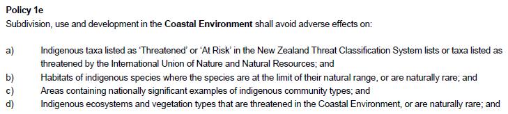
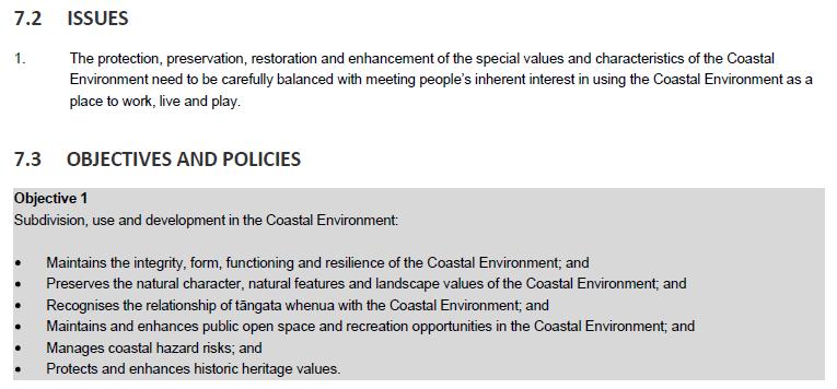
Introduction. Regional Context
 Introduction The applicant seeks consent to subdivide Lot 3 422974, a 9.07 ha lot, into two lots, Lot 1 being 0.58ha and the balance, Lot 2 of 8.5ha. As shown on attached plan prepared by Dunwoodie & Green
Chapter 3: Natural Environment. Proposed Waikato District Plan Stage 1. (Notified version)
") Chapter 3: Natural Environment Proposed Waikato District Plan Stage 1 Page 2 of 7 Contents Chapter 3: Natural Environment... 3 3.1 Indigenous Vegetation and Habitats... 3 3.1.1 Objective Biodiversity and
Chapter 3: Natural Environment Proposed Waikato District Plan Stage 1 Page 2 of 7 Contents Chapter 3: Natural Environment... 3 3.1 Indigenous Vegetation and Habitats... 3 3.1.1 Objective Biodiversity and
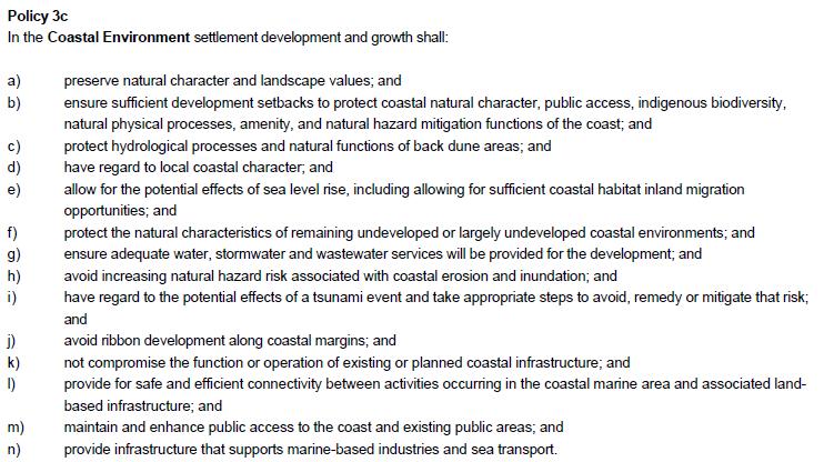
Appendix 1 Structure plan guidelines
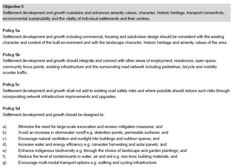
 Appendix 1 Structure plan guidelines This appendix forms part of the regional policy statement [rps]. 1.1. Introduction Structure plans are an important method for establishing the pattern of land use
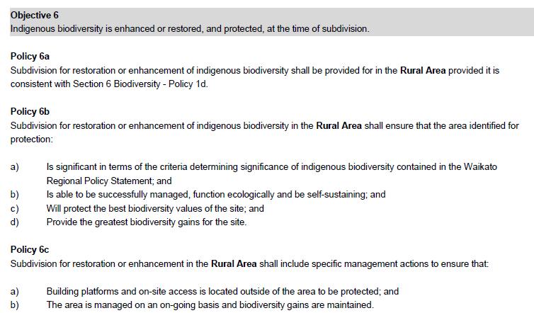
Tāhuhu whakaruruhau ā-taone The sheltering ridge pole
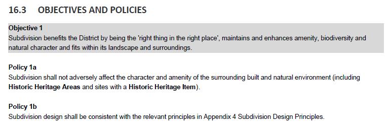
 B2. Tāhuhu whakaruruhau ā-taone - Urban growth and form B2.1. Issues Tāhuhu whakaruruhau ā-taone The sheltering ridge pole Auckland s growing population increases demand for housing, employment, business,
AND STATEMENT OF EVIDENCE OF JOHN LONINK ON BEHALF OF CHRISTCHURCH CITY COUNCIL SPECIFIC PURPOSE (GOLF RESORT) ZONE
 ZONE") Page 1 of 13 BEFORE THE CHRISTCHURCH REPLACEMENT DISTRICT PLAN INDEPENDENT HEARINGS PANEL IN THE MATTER of the Resource Management Act 1991 and the Canterbury Earthquake (Christchurch Replacement District
Page 1 of 13 BEFORE THE CHRISTCHURCH REPLACEMENT DISTRICT PLAN INDEPENDENT HEARINGS PANEL IN THE MATTER of the Resource Management Act 1991 and the Canterbury Earthquake (Christchurch Replacement District
WELLINGTON CITY DISTRICT PLAN
 Section 32 Report WELLINGTON CITY DISTRICT PLAN PROPOSED DISTRICT PLAN CHANGE 54 REZONING 178 AND 180 OWHIRO BAY PARADE 1 Introduction Before a Proposed District Plan change is publicly notified the Council
Section 3b: Objectives and Policies Rural Environment Updated 19 November 2010
 Page 1 of Section 3b 3b RURAL ENVIRONMENT 3b.1 Introduction The Rural Environment comprises all the land outside of the Residential, Town Centre and Industrial Environments. Most land within the District
Great Easton Neighbourhood Plan Statement of Basic Conditions
 Great Easton Neighbourhood Plan 2017-2031 Statement of Basic Conditions OCTOBER 2016 GREAT EASTON PARISH COUNCIL Contents 1.0 Introduction....Page 2 2.0 Summary of Submission Documents and Supporting Evidence..
CA.1 Coastal Area. Index. CA.1.1 Description and Expectations
 Index.1.2.3.4 CA.2 CA.2.1 CA.2.2 CA.2.3 CA.3 CA.3.1 CA.3.2 CA.3.1 CA.4 CA.4.1 CA.4.2 CA.4.3 CA.4.4 CA.5 CA.5.1 CA.5.2 Description and Expectations Objectives Policies Guidance Note Landuse Eligibility
Plan Modification to Chapter B2 of the Auckland Unitary Plan(AUP) Operative in part (15 November 2016)
 Operative in part (15 November 2016)") UNITARY PLAN UPDATE REQUEST MEMORANDUM TO FROM Phill Reid Linley Wilkinson DATE 25 September 2018 SUBJECT Plan Modification to Chapter B2 of the Auckland Unitary Plan(AUP) Operative in part (15 November
UNITARY PLAN UPDATE REQUEST MEMORANDUM TO FROM Phill Reid Linley Wilkinson DATE 25 September 2018 SUBJECT Plan Modification to Chapter B2 of the Auckland Unitary Plan(AUP) Operative in part (15 November
BEFORE THE CENTRAL OTAGO DISTRICT COUNCIL
 BEFORE THE CENTRAL OTAGO DISTRICT COUNCIL IN THE MATTER OF Proposed Plan Change 12 to the Central Otago District Plan ON BEHALF OF Wooing Tree Holdings Limited Requestor EVIDENCE OF BENJAMIN ESPIE (LANDSCAPE
Appendix A. Planning Processes. Introduction
 1 Planning Processes Introduction This appendix outlines a number of planning processes which are used in the Auckland Region to support the effective management of development in the region s rural and
Hearing Topic: 058 Public Open Space. Primary Evidence: from Andrea Broughton
 Submitter: Andrea & Alex Broughton Submission Number: 5650-1 Hearing Topic: 058 Public Open Space Primary Evidence: from Andrea Broughton Date: 10 June 2015 1. Introduction My name is Andrea Broughton
QUEENSTOWN LAKES DISTRICT COUNCIL
 QUEENSTOWN LAKES DISTRICT COUNCIL Hearing of Submissions on the Proposed District Plan Report 16.9 Report and Recommendations of Independent Commissioners Regarding Upper Clutha Planning Maps Lake McKay
BEFORE THE CHRISTCHURCH REPLACEMENT DISTRICT PLAN HEARINGS PANEL
 BEFORE THE CHRISTCHURCH REPLACEMENT DISTRICT PLAN HEARINGS PANEL IN THE MATTER of the Resource Management Act 1991 and the Canterbury Earthquake (Christchurch Replacement District Plan) Order 2014 AND
I Te Koti Taiao o Aotearoa Ōtautahi Rohe ENV-2018-CHC- Appellant. Queenstown Lakes District Council. Respondent
 In the Environment Court of New Zealand Christchurch Registry I Te Koti Taiao o Aotearoa Ōtautahi Rohe ENV-2018-CHC- Under In the matter of Between the Resource Management Act 1991 (RMA) An appeal under
EVIDENCE OF CAREY VIVIAN (PLANNER) 13 JUNE 2018
 13 JUNE 2018") QUEENSTOWN-LAKES DISTRICT COUNCIL PROPOSED DISTRICT PLAN HEARING STREAM 14 IN THE MATTER of a hearing on submissions to the Proposed District Plan Stage 2 and Variation 1 pursuant to clause 8B of the First
QUEENSTOWN-LAKES DISTRICT COUNCIL PROPOSED DISTRICT PLAN HEARING STREAM 14 IN THE MATTER of a hearing on submissions to the Proposed District Plan Stage 2 and Variation 1 pursuant to clause 8B of the First
RLE.1 Rural Living Environment
 Index.1 Description and Expectations.2 Objectives.3 Policies.4 Guidance RLE.2 Landuse RLE.2.1 Eligibility Rules RLE.2.2 Notification Rules RLE.2.3 Discretionary Activities RLE.3 Subdivision RLE.3.1 Eligibility
SUSTAINABLE MANAGEMENT
 . Sustainable Management.1 The Concept of Sustainable Management The concept of sustainable management recognises there are limits to the use of natural and physical resources and there is a need to balance
LANDSCAPE GUIDELINES. Countryside & Coastal Countryside Environments. Landscape, Natural Character & Amenity Values Guide
 Landscape, Natural Character & Amenity Values Guide Copyright WDC 2009 Version A2 18May09 Environmental Services Group Publication Countryside & Coastal Countryside Environments START HERE Quality Land
STATEMENT OF OBJECTION TO THE PROPOSED DEVELOPMENT OF LAND AT CHURCH CLIFF DRIVE FILEY
 STATEMENT OF OBJECTION TO THE PROPOSED DEVELOPMENT OF LAND AT CHURCH CLIFF DRIVE FILEY You will be aware that Scarborough borough council have adopted a new local plan that includes land at Church Cliff
Proposed Southland District Plan 2012 Appeal Version October 2016
 S e c t i o n 3. 5 - F i o r d l a n d / R a k i u r a Z o n e The Fiordland/Rakiura Zone encompasses the Fiordland and Rakiura National Parks and part of Mt Aspiring National Park. It also includes areas
I539. Smales 2 Precinct
 I539. Smales 2 Precinct I539.1. Precinct Description The Smales 2 Precinct applies to a 4.8 hectare block of land located on the southern side of Northcote Road and fronting Lake Pupuke, Takapuna. The
Derry City and Strabane District Council Planning Committee Report
 Derry City and Strabane District Council Planning Committee Report COMMITTEE DATE: 23 rd March 2016 APPLICATION No: APPLICATION TYPE: PROPOSAL: LOCATION: APPLICANT: LA11/2015/0395/F Residential Development
PUBLIC NOTICE UNDER CLAUSE 5 OF SCHEDULE 1 OF THE RESOURCE MANAGEMENT ACT 1991 PLAN CHANGE 12 TO THE OPERATIVE CITY OF NAPIER DISTRICT PLAN
 PUBLIC NOTICE UNDER CLAUSE 5 OF SCHEDULE 1 OF THE RESOURCE MANAGEMENT ACT 1991 PLAN CHANGE 12 TO THE OPERATIVE CITY OF NAPIER DISTRICT PLAN Public notice is given in accordance with Clause 5 of Schedule
open space environment
 This section updated August 09 GUIDELINE TO THE RULES The Open Space Environment Rules apply to activities on sites within the Open Space Environment as shown on the Human Environments Maps. Most of the
I403 Beachlands 1 Precinct
 I403. Beachlands 1 I403.1. Precinct Description Beachlands is a rural and coastal village located on the eastern side of Auckland, adjoining the Tamaki Strait coastline. The original Beachlands village
Appendix A- A - Relief sought
 Appendix A- A - Relief sought Chapters 3 Strategic Direction 3.2.5 The retention of the District s distinctive landscapes. (addresses Issues 2 and 4) It is unclear whether provision 3.2.5 is a heading
ONTARIO MUNICIPAL BOARD
 PL 120483 ONTARIO MUNICIPAL BOARD Applicant/Appellant: 2124123 Ontario Limited Subject: OPA, Rezoning and Draft Plan of Subdivision Municipal Address: 3940 Highway 7 East Municipality: City of Markham
SECTION ONE North East Industrial Zone Design Guide Palmerston North City Council June 2004
 SECTION ONE North East Industrial Zone Design Guide Palmerston North City Council June 2004 young heart easy living 1 Preface Industrial areas are a very important component of the economic well-being
Section 12C Subdivision in the Rural Residential Zone
 Section 12C 12C Subdivision in the Rural Residential Zone The Rural Residential Zone provides part of the range of residential opportunities within the City. Land zoned rural residential is considered
QUEENSTOWN LAKES DISTRICT COUNCIL Hearing of Submissions on the Proposed District Plan
 QUEENSTOWN LAKES DISTRICT COUNCIL Hearing of Submissions on the Proposed District Plan Report 16.4 Report and Recommendations of Independent Commissioners Regarding Upper Clutha Planning Maps Glen Dene
Case Officer: Sarah Kay File No: CHE/14/00515/REM Tel. No: (01246) Plot No: 2/6132 Ctte Date: 15 th September 2014 ITEM 1
 Plot No: 2/6132 Ctte Date: 15 th September 2014 ITEM 1") Case Officer: Sarah Kay File No: CHE/14/00515/REM Tel. No: (01246) 345786 Plot No: 2/6132 Ctte Date: 15 th September 2014 ITEM 1 APPROVAL OF RESERVED MATTERS FROM APPLICATION CHE/12/00234/OUT (1) LAYOUT,
Case Officer: Sarah Kay File No: CHE/14/00515/REM Tel. No: (01246) 345786 Plot No: 2/6132 Ctte Date: 15 th September 2014 ITEM 1 APPROVAL OF RESERVED MATTERS FROM APPLICATION CHE/12/00234/OUT (1) LAYOUT,
Sustainability Statement. Whitby Business Park Area Action Plan
 Sustainability Statement Whitby Business Park Area Action Plan November 2014 Contents Page 1. Introduction 1 2. Scoping 3 3. Sustainability Appraisal of Options 6 4. Assessment of Draft Area Action Plan
Perth and Kinross Council Development Management Committee 20 February 2013 Report of Handling by Development Quality Manager
 Perth and Kinross Council Development Management Committee 20 February 2013 Report of Handling by Development Quality Manager 4(4)(iii) 13/81 Erection of sports hall, associated changing facilities, offices
2A District-wide Policies
 2A Introduction This Chapter contains policies which are relevant to subdivision, use and development activities occurring across all zones and areas of the District. The policies in this Chapter implement
QUEENSTOWN LAKES DISTRICT COUNCIL
 QUEENSTOWN LAKES DISTRICT COUNCIL Hearing of Submissions on the Proposed District Plan Report 16.8 Report and Recommendations of Independent Commissioners Regarding Upper Clutha Planning Maps Church Road,
New Approaches to Coastal Development Gary Taylor Chairman Environmental Defence Society
 New Approaches to Coastal Development Gary Taylor Chairman Environmental Defence Society Public interest ENGO Founded in 1971 Professionally based Went into recess in 1990s Reformed in 1999 after Arrigato
Lake Macquarie City. A copy of the published amendment including the instrument and maps, is provided in Attachment 7 of this report.
 Planning Proposal Amendment No. 77 to Lake Macquarie Local Environmental Plan 2004 and proposed Amendment to Draft Lake Macquarie Local Environmental Plan 2013 Minor Zone Boundary Adjustment - Pasminco
6 Landsc apes and rur al char ac
 LANDSCAPES AND RURAL CHARACTER QLDC PROPOSED DISTRICT PLAN [PART TWO] DECISION VERSION ter 6 Landsc apes and rur al char ac 6.1 Purpose Appendix C QLDC DISTRICT PLAN [PART TWO] DECISION VERSION 6 Landsc
Rural (Urban Expansion) Environment
 Environment") RUEE.1 Rural (Urban Expansion) Environment Index RUEE.1 RUEE.1.1 RUEE.1.2 RUEE.1.3 RUEE.1.4 RUEE.2 RUEE.2.1 RUEE.2.2 RUEE.2.3 RUEE.2.4 RUEE.3 Rural (Urban Expansion) Environment Description and Expectations
RUEE.1 Rural (Urban Expansion) Environment Index RUEE.1 RUEE.1.1 RUEE.1.2 RUEE.1.3 RUEE.1.4 RUEE.2 RUEE.2.1 RUEE.2.2 RUEE.2.3 RUEE.2.4 RUEE.3 Rural (Urban Expansion) Environment Description and Expectations
Section 32 report: Natural heritage for the Proposed Natural Resources Plan for the Wellington Region
 Section 32 report: Natural heritage for the Proposed Natural Resources Plan for the Wellington Region Issues and Evaluation Report Section 32 report: Natural heritage for the Proposed Natural Resources
H7 Open Space zones. (a) provide for the needs of the wider community as well as the needs of the community in which they are located;
 provide for the needs of the wider community as well as the needs of the community in which they are located;") H7. Open Space zones H7.1. Background The majority of land zoned as open space is vested in the Council or is owned by the Crown. However some areas zoned open space are privately owned. While the open
H7. Open Space zones H7.1. Background The majority of land zoned as open space is vested in the Council or is owned by the Crown. However some areas zoned open space are privately owned. While the open
4 Residential and Urban Living Zones
 4 Residential and Urban Living Zones Refer to Chapters 11 to 20 for additional rules that may apply to these zones. 4.1 OBJECTIVES AND POLICIES Objective Res1 Policy 1 Policy 2 Policy 3 Policy 4 Policy
I541. Te Arai North Precinct
 I541. Te Arai North Precinct I541.1. Precinct Description The Te Arai North Precinct contains approximately 616ha of coastal land north of Te Arai Point, generally known as Mangawhai North Forest. The
Rural (Urban Expansion) Environment
 Environment") RUEE.1 Rural (Urban Expansion) Environment Subsequent to the receipt of appeals, a 'marked up' version of the Proposed District Plan was prepared. The provisions of the Proposed Version of the Plan subject
RUEE.1 Rural (Urban Expansion) Environment Subsequent to the receipt of appeals, a 'marked up' version of the Proposed District Plan was prepared. The provisions of the Proposed Version of the Plan subject
LEEDS SITE ALLOCATIONS PLAN MATTER 3 GREEN BELT KCS DEVELOPMENT AUGUST 2017
 LEEDS SITE ALLOCATIONS PLAN MATTER 3 GREEN BELT KCS DEVELOPMENT AUGUST 2017 Smith Limited Suite 9C Joseph s Well Hanover Walk Leeds LS3 1AB T: 0113 2431919 F: 0113 2422198 E: planning@peacockandsmith.co.uk
Subdivision and Development
 Subdivision and Development 8.0 Introduction - Subdivision and Development The principle purpose of subdivision is to provide a framework for land ownership so that development and activities can take
1. Assessment of Environmental Effects
 1. Assessment of Environmental Effects Table of Contents 1. Introduction and Overview 1 2. Statutory Assessment 3 3. Site Description 5 4. Proposal Description 7 5. Assessment of Effects on the Environment
SECTION 2.4 URBAN DEVELOPMENT AND STRATEGIC URBAN DIRECTIONS
 SECTION 2.4 URBAN DEVELOPMENT AND STRATEGIC URBAN DIRECTIONS 2.4.1 INTRODUCTION In 1993/94 the Hastings District Council completed the Hastings Urban Development Strategy. The purpose of this study was:
I611. Swanson North Precinct
 I611. Swanson North Precinct I611.1. Precinct Description Swanson North is located in the north eastern foothills of the Waitakere Ranges. It is outside the Waitakere Ranges Heritage Area Act and the Waitakere
BEFORE THE AUCKLAND UNITARY PLAN INDEPENDENT HEARINGS PANEL
 1 BEFORE THE AUCKLAND UNITARY PLAN INDEPENDENT HEARINGS PANEL IN THE MATTER of the Resource Management Act 1991 and the Local Government (Auckland Transitional Provisions) Act 2010 AND IN THE MATTER of
Understanding Wellington City s DISTRICT PLAN
 Understanding Wellington City s DISTRICT PLAN Wellington City Council 1 UNDERTANDING WELLINGTON CITY S DISTRICT PLAN CONTENTS 1. Introduction...3 1.1. Overview of this Guide...3 1.2. What is the District
Appendix A - Relief sought
 Appendix A - Relief sought Chapter 2 Definitions Definitions Tourism Activity (new) and Visitor Industry (new) The plan does not provide specific definition for tourism. The plan does introduce a new strategic
B4. Te tiaki taonga tuku iho - Natural heritage
 B4. Te tiaki taonga tuku iho - Natural heritage Tuia I runga, tuia i raro, tuia ki te waonui a Tiriwa Bind the life forces of heaven and earth to the great realm of Tiriwa B4.1. Issues Auckland s distinctive
Planning Proposal Toronto Road, Booragul. Amendment to Lake Macquarie Local Environmental Plan (LMLEP) 2014
 2014") Planning Proposal Toronto Road, Booragul Amendment to Lake Macquarie Local Environmental Plan (LMLEP) 2014 Local Government Area: Name of Draft LEP: Subject Land: Land Owner: Applicant: Folder Number:
Planning Proposal Toronto Road, Booragul Amendment to Lake Macquarie Local Environmental Plan (LMLEP) 2014 Local Government Area: Name of Draft LEP: Subject Land: Land Owner: Applicant: Folder Number:
STRATEGIC DIRECTION. QLDC PROPOSED DISTRICT PLAN [PART TWO] DECISIONS VERSION 3 strategic direction
![STRATEGIC DIRECTION. QLDC PROPOSED DISTRICT PLAN [PART TWO] DECISIONS VERSION 3 strategic direction](/thumbs/79/79711764.jpg "STRATEGIC DIRECTION. QLDC PROPOSED DISTRICT PLAN [PART TWO] DECISIONS VERSION 3 strategic direction") 3 STRATEGIC DIRECTION QLDC PROPOSED DISTRICT PLAN [PART TWO] DECISIONS VERSION 3 strategic direction QLDC DISTRICT PLAN [PART TWO] AUGUST 2015 3 strategic direction 3.1 Purpose This chapter sets out the
3 STRATEGIC DIRECTION QLDC PROPOSED DISTRICT PLAN [PART TWO] DECISIONS VERSION 3 strategic direction QLDC DISTRICT PLAN [PART TWO] AUGUST 2015 3 strategic direction 3.1 Purpose This chapter sets out the
STAGE 3 - SECTION 32 CHAPTER 9 NATURAL AND CULTURAL HERITAGE
 STAGE 3 - SECTION 32 CHAPTER 9 NATURAL AND CULTURAL HERITAGE Notified 25 July 2015 Contents 1 INTRODUCTION AND STRATEGIC CONTEXT 3 1.1 INTRODUCTION 3 1.2 PURPOSE AND SCOPE OF THE NATURAL AND CULTURAL HERITAGE
E15. Vegetation management and biodiversity
 E15. management and biodiversity E15.1. Background contributes to a range of ecosystem services such as erosion and sediment control, reducing stormwater flows, protecting or enhancing water quality, amenity
Examination of South Cambridgeshire Local Plan
 Matter SC6A - Policy SS/5 Waterbeach New Town Historic England( formerly English Heritage) 874 Rep Nos 59748, 60250, 60253 Examination of South Cambridgeshire Local Plan Historic England, Hearing Statement
4 RESIDENTIAL ZONE. 4.1 Background
 4 RESIDENTIAL ZONE 4.1 Background The residential areas within the City are characterised by mainly lowrise dwellings sited on individual allotments. Past architectural styles, settlement patterns and
Planning Proposal Charlestown Swim and Leisure Centre LEP Amendment
 Planning Proposal Charlestown Swim and Leisure Centre LEP Amendment Amendment No. 4 to Lake Macquarie Local Environmental Plan 2014 (PP_2014_LAKEM_005_00) Local Government Area: Name of Draft LEP: Lake
Plumpton Neighbourhood Development Plan Revised Pre Submission Document - Regulation 14 Consultation
 REPRESENTATIONS... Plumpton Parish Council Plumpton Neighbourhood Development Plan Revised Pre Submission Document - Regulation 14 Consultation Representations submitted on behalf of: Cala Homes (South
12 Subdivision, Services and Infrastructure
 12 Subdivision, Services and Infrastructure Section 12A 12A Purpose of Subdivision Provisions... 1 12A.1 General Subdivision Objectives and Policies... 2 12A.2 Activity Status Rules... 4 12A.3 General
DRAFT STRATEGIC ENVIRONMENTAL ASSESSMENT REPORT
 DRAFT STRATEGIC ENVIRONMENTAL ASSESSMENT REPORT Published by Limpsfield Parish Council in accordance with EU Directive 2001/42 on Strategic Environmental Assessment and with the Environmental Assessment
15 Rural Residential Zone
 15 Rural Residential Zone Section 15A 15A Purpose of the Rural Residential Zone... 1 15A.1 Objectives and Policies of the Rural Residential Zone... 1 15A.2 Activity Status Rules... 5 15A.3 Permitted Activity
3. Highway Landscaping Assessment
 Guidelines for Highway Landscaping 3-1 3. Highway Landscaping Assessment 3.1 Introduction This section outlines the steps necessary to assess the highway landscaping component of a state highway construction
GIBBSTON CHARACTER ZONE. QLDC PROPOSED DISTRICT PLAN [PART FOUR] AUGUST gibbston character zone
![GIBBSTON CHARACTER ZONE. QLDC PROPOSED DISTRICT PLAN [PART FOUR] AUGUST gibbston character zone](/thumbs/75/72573993.jpg "GIBBSTON CHARACTER ZONE. QLDC PROPOSED DISTRICT PLAN [PART FOUR] AUGUST gibbston character zone") 23 GIBBSTON CHARACTER ZONE QLDC PROPOSED DISTRICT PLAN [PART FOUR] AUGUST 2015 23 gibbston character zone QLDC PROPOSED DISTRICT PLAN [PART FOUR] AUGUST 2015 23 gibbston character zone 23.1 Zone Purpose
23 GIBBSTON CHARACTER ZONE QLDC PROPOSED DISTRICT PLAN [PART FOUR] AUGUST 2015 23 gibbston character zone QLDC PROPOSED DISTRICT PLAN [PART FOUR] AUGUST 2015 23 gibbston character zone 23.1 Zone Purpose
1 INTRODUCTION TO NATURAL ENVIRONMENT
 Kāpiti Coast District Plan Review Section 32 Analysis Summary Report 1 INTRODUCTION TO NATURAL ENVIRONMENT Diverse landscapes, plants and animals make up the natural environment of the District. Much has
PART 3 - RESOURCE MANAGEMENT
 CONTENTS... PAGE 3.1 INTRODUCTION... 3 3.2 NATURAL AND PHYSICAL ENVIRONMENT... 3 3.3 URBAN SUSTAINABLE MANAGEMENT... 5 3.4 RESOURCE MANAGEMENT ISSUES... 5 3.5 RESOURCE MANAGEMENT OBJECTIVES AND POLICIES...
AND MEMORANDUM OF COUNSEL FOR QUEENSTOWN LAKES DISTRICT COUNCIL REGARDING STRATEGIC TOPICS 23 JULY 2018
 BEFORE THE ENVIRONMENT COURT ENV-2018-CHC-000053 ENV-2018-CHC-000054 ENV-2018-CHC-000055 (continued over) IN THE MATTER of the Resource Management Act 1991 AND IN THE MATTER of appeals under clause 14
I542. Te Arai South Precinct
 I542. Te Arai South Precinct I542.1. Precinct Description The Te Arai South Precinct contains approximately 750ha of coastal land south of Te Arai Point, known as Mangawhai South Forest. The land within
Coastal Environment Overlay and Coastal Zone - District Plan Direction Setting Document (Draft to Proposed)
") Coastal Environment Overlay and Coastal Zone - District Plan Direction Setting Document (Draft to Proposed) 1.0 Background Coastal Zone The Coastal Zone was originally defined in 1975 following the release
Coastal Environment Overlay and Coastal Zone - District Plan Direction Setting Document (Draft to Proposed) 1.0 Background Coastal Zone The Coastal Zone was originally defined in 1975 following the release
WELCOME GYPSY LANE. Wider Site Location plan. Proposals for the development of LAND OFF FOXLYDIATE LANE WEBHEATH. Proposals for the development of
 WELCOME The developers are preparing an outline planning application for a residential led development and need the community s views in order to develop the proposals further WHAT IS PROPOSED? A high
In the Environment Court of New Zealand Christchurch Registry ENV-2016-CHC- Appellants. Otago Regional Council. Respondent
 In the Environment Court of New Zealand Christchurch Registry ENV-2016-CHC- Under In the matter of Between the Resource Management Act 1991 (RMA) an appeal under Clause 14(1), First Schedule of the RMA
Planning Proposal Concurrent DA/LEP Amendment for Belmont North Pharmacy Amendment No. 24 to Lake Macquarie Local Environmental Plan (LMLEP) 2014
 2014") Planning Proposal Concurrent DA/LEP Amendment for Belmont North Pharmacy Amendment No. 24 to Lake Macquarie Local Environmental Plan (LMLEP) 2014 Local Government Area: Name of Draft LEP: Subject Land:
Planning Proposal Concurrent DA/LEP Amendment for Belmont North Pharmacy Amendment No. 24 to Lake Macquarie Local Environmental Plan (LMLEP) 2014 Local Government Area: Name of Draft LEP: Subject Land:
Development in the setting of the Cotswolds AONB
 COTSWOLDS CONSERVATION BOARD POSITION STATEMENT Development in the setting of the Cotswolds AONB.1. Introduction Areas of Outstanding Natural Beauty (AONBs) are designated by the Government for the purpose
Everton s Neighbourhood Plan. Site Allocation - Assessment Criteria
 Everton s Neighbourhood Plan Site llocation - ssessment Criteria Introduction 1.1 This report assesses all the sites identified through the emerging Neighbourhood Plan for Everton and their potential for
DUNSFOLD NEIGHBOURHOOD PLAN Site Selection Policies
 DUNSFOLD NEIGHBOURHOOD PLAN Site Selection Policies The criteria for assessing sites for future housing and business development in Dunsfold are set out below. (Development criteria, covering what it is
AOTEA SUPERMARKET ZONE. Zone Introduction
 C18 AOTEA SUPERMARKET ZONE Zone Introduction C18.1 Objective This zone identifies a specific area in Aotea for a stand alone supermarket. The zone is site specific and has a range of objectives, policies
Bill Stockman PROPOSED SHED PLANNER S REPORT & ASSESSMENT OF ENVIRONMENTAL EFFECTS
 Thomson Survey Limited Shed Land Use Proposal January-19 Bill Stockman PROPOSED SHED 798D Taupo Bay Road PLANNER S REPORT & ASSESSMENT OF ENVIRONMENTAL EFFECTS Thomson Survey Ltd Kerikeri 1.0 INTRODUCTION
INCREMENTAL CHANGE AREA REVIEW March 2015 Page 1
 INCREMENTAL CHANGE AREA REVIEW March 2015 Page 1 Table of Contents Introduction... 3 Background to Review... 3 Comparison of the Schedules to the General Residential Zone... 7 Methodology... 7 Policy Context...
Site Assessment Technical Document Appendix A: Glossary
 Central Bedfordshire Council www.centralbedfordshire.gov.uk Site Assessment Technical Document Appendix A: Glossary July 2017 1.1.11-1 - ii Appendix A: Glossary Term Agricultural Land Classification AONB
I602. Birdwood Precinct
 I602. Birdwood Precinct I602.1. Precinct description The Birdwood Precinct applies to an area west of Don Buck Road and south of Red Hills Road in west Auckland. It incorporates subdivision and development
Neighbourhood Plan Representation
 Date: 10 th November 2017 Neighbourhood Plan Representation Land to the east of Callow Hill Road, Alvechurch Introduction This representation has been prepared by RPS Planning and Development on behalf
Draft Hailey Neighbourhood Plan
 Persimmon Homes (Wessex) Draft Hailey Neighbourhood Plan Representations to West Oxfordshire District Council s Regulation 16 Consultation December 2018 2 Copyright 2018 Persimmon Homes Ltd. All rights
13 FUTURE DEVELOPMENT AND STRUCTURE PLANS
 13 FUTURE DEVELOPMENT AND STRUCTURE PLANS Contents 13.1 Introduction 13.2 Resource Management Issues 13.3 Objectives 13.4 Policies 13.5 Strategy 13.6 Implementation 13.6.1 District Plan Regulatory Methods
Oxford Green Belt Study. Summary of Final Report Prepared by LUC October 2015
 Oxford Green Belt Study Summary of Final Report Prepared by LUC October 2015 Project Title: Oxford Green Belt Study Client: Oxfordshire County Council Version Date Version Details Prepared by Checked by
49 Scheduled Activities
 49 Scheduled Activities 49.1 Rules Explanation The rules for scheduled activities take precedence over the other rules for the Environment in which the scheduled activity is located. This means that, where
11. ISLINGTON ROUTE SECTION ENVIRONMENTAL BASELINE AND ASSESSMENT OF IMPACTS OVERVIEW OF ISLINGTON ROUTE SECTION... 2
 11. ISLINGTON ROUTE SECTION ENVIRONMENTAL BASELINE AND ASSESSMENT OF IMPACTS... 2 11.1 OVERVIEW OF ISLINGTON ROUTE SECTION... 2 11.2 POLICIES RELEVANT TO ALL WORKSITES IN ISLINGTON... 3 11.3 FARRINGDON
I609. Penihana North Precinct
 I609. Penihana North Precinct I609.1. Precinct description The Penihana North Precinct is located south of the Swanson Railway Station, adjacent to the Rural Urban Boundary (RUB) and Waitakere Ranges Heritage
Retirement Village & Carehome Complex BUPA New Zealand 25 Ulyatt Road, Napier
 Retirement Village & Carehome Complex BUPA New Zealand 25 Ulyatt Road, Napier Resource Consent Application Wasley Knell Consultants Limited Table of Contents 1.0 PROPOSAL... 2 2.0 LOCATION... 3 3.0 RESOURCE
Salhouse Parish Council, 11 th November Response to Planning Application
 Salhouse Parish Council, 11 th November 2013 Response to Planning Application 20131408 Summary Salhouse Parish Council (SPC) has received via Broadland District Council a Planning Application for a 5MWp
Strategic Environmental Assessment Screening Report. Dublin Port Masterplan Review 2017
 Strategic Environmental Assessment Screening Report Dublin Port Masterplan Review 2017 Table of Contents 1 Introduction... 1 2 Purpose of the Masterplan... 2 3 Task 1.1 Pre-Screening Check... 5 4 Task
9 CITY OF VAUGHAN OFFICIAL PLAN AMENDMENT NO BOCA EAST INVESTMENTS LIMITED
 9 CITY OF VAUGHAN OFFICIAL PLAN AMENDMENT NO. 631 - BOCA EAST INVESTMENTS LIMITED The Planning and Economic Development Committee recommends the adoption of the recommendations contained in the following
Appropriate Assessment in relation to County Donegal Draft Heritage Plan
 Appendix 12 - Consultation Response a) Sinead Harkin Central Planning Unit Donegal County Council County House Lifford County Donegal Dear Ms Harkin, Appropriate Assessment in relation to County Donegal