The DCR Neponset River Trail Central Avenue to Mattapan Square
|
|
|
- Alexandrina Thomas
- 5 years ago
- Views:
Transcription

1 The DCR Neponset River Trail Central Avenue to Mattapan Square Photo Public Meeting Tuesday, August 30, :30 pm 9:00 pm Foley Senior Residences Dining Room 249 River Street, Mattapan

2 DCR MISSION STATEMENT To protect, promote and enhance our common wealth of natural, cultural and recreational resources.
3 Consultant Design Team: Crosby Schlessinger Smallridge, LLC Landscape Architects Deneen Crosby Principal in Charge/Project Manager AECOM Structural Engineers Bob Hajjar Project Engineer BSC Group Civil Engineers Peter Reed Project Engineer Epsilon Permitting Mike Howard Project Manager Nitsch Engineering Surveyors Paul LeBaron Project Surveyor
4 Commonwealth of Massachusetts Governor Deval L. Patrick Lieutenant Governor Timothy Murray Energy and Environmental Secretary Richard K. Sullivan, Jr. Department of Conservation and Recreation Commissioner Edward M. Lambert, Jr.

5 The DCR Neponset River Reservation Regional Connections Lower Neponset River Reservation Phase I Upper Neponset River Reservation Phase II Upper Neponset River Master Plan 2006 Neponset River Esplanade Project Completed Fall 2010 Esplanade Extension Project Under Design Central Ave to Mattapan Square Under Design


6 Commonwealth Investment in the DCR Neponset River Reservation DCR has already made an investment of $7 million for the Neponset River Trail The additional cost for the construction of the Neponset Trail between Central Avenue and Mattapan Square is: $7 Million $9 Million DCR has also made a significant financial investment in the following parks along the trail: Pope John Paul II Park Neponset Park Neponset Salt Marsh Restoration Ryan Playground Kennedy Playground and Gardens Neponset Esplanade Park Martini Shell Park


7 The DCR Neponset River Reservation Regional Trail Filling in the Gaps?
8 The DCR Upper Neponset River Master Plan Completed 2006


9 Project Goals Continue development of a greenway corridor and a continuous multi use pathway system through the reservation Connect to a regional pathway system Provide access to the river s edge Improve management and operation of The DCR Neponset River Reservation by providing staff with continuous access to The DCR Neponset River Reservation Ensure public safety Provide universal access


10 Project Scope Construct a 10 wide multi use path along the Neponset River Provide universal access along the Neponset River Install trail signage Install fencing for security Install boardwalk and bridge connections


11 Meeting Objectives Review previously presented alternatives Review proposed option Discuss next steps/schedule


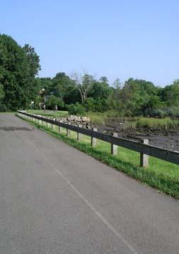
12 Project Site Central Ave to Blue Hill Ave The Missing Link Neponset Trail &7 Brush Hill Road completed Fall 2010
13 OPTION A Primary Trail South of Neponset River
14 OPTION B Primary Trail South and North of Neponset River

15 OPTION C Primary Trail North of Neponset River
16 OPTION D Primary Trail South of Neponset River with Connection to North Side of River

17 OPTION E Primary Trail North and South of Neponset River
18 Public Input Comments Received VOTES FOR = 6 AGAINST= 14 VOTES FOR = 34 AGAINST= 2 VOTES FOR = 28 AGAINST= 5 with Connection VOTES FOR = 13 AGAINST= 13 VOTES FOR = 7 AGAINST= 13 + Exit at Mattapan Sq. is safer + Gateway through Mattapan Sq. is a celebratory entrance + Simple, direct, maximum safety (traffic wise for cyclists and pedestrians) + Access connection to Central Ave. business district, The DCR Blue Hills Reservation + Traverses already disturbed land + Avoids archaeological & contaminated areas of the river + Equity for Mattapan & Milton + Will activate/connect Ryan Playground + Increased access from Mattapan + Does not impact abutters + Proximity to the river + Equity for Mattapan residents + Proximity to the river + Path along park, not on train tracks + Will activate/connect Ryan Playground + Connects Milton & Mattapan + Access from both sides + Gateway through Mattapan Square is a celebratory entrance + Gives Boston residents easier access to trolley line + Proximity to river + Better connection to existing trails + Minimizes traffic issues at Mattapan Square + Will activate/connect Ryan Playground + Equity for Mattapan & Milton + Access from both sides of the river + Gateway through Mattapan Square is a celebratory entrance + Path along park instead of train track + Proximity to river + Milton side of MBTA minimizes traffic concerns in Mattapan Square Trail will impact abutters* Ledge removal* Tree removal* Milton only/doesn t connect to Mattapan Too close to trains/ concrete/infrastructure Too much along train track, lack of view Parking on residential streets Connection to River Street is unsafe Exit into Mattapan Square is unsafe Crossing in a remote area safety concern Connection to River Street is unsafe No trail on the south side Disturbs archaeological sites Appears to use more roadway, which is more hazardous Parking on residential streets Trail will impact abutters Easement over private land required (DCR Concern) Trail will impact abutters* Ledge removal Tree removal* Crossing in a remote area safety concern Not enough river views Parking on residential streets Trail will impact abutters* Ledge removal* Tree removal* Cost Parking on residential streets Crossing in a remote area safety concern *Comments via Comments in BOLD were received by more than one person
 + Water access to canoe launches 5) Safe access to Mattapan Square 6) Minimize habitat impact OPTION B")
19 Additional Evaluation Criteria from Public Meeting Input 1) + Equity for users on both sides of the river 2) + Consider neighborhood and abutter concerns 3) + Minimize trail user parked cars in neighborhoods 4) + Water access to canoe launches 5) Safe access to Mattapan Square 6) Minimize habitat impact OPTION B

20 OPTION B REVISED Preferred Alternate Neighborhood Trail Connection Connection to the MBTA Station Ryan Park Bridge over River Existing Footpath Potential Footpath Extension Canopy Walk / Bridge over Railroad Rice Islands
21 Archaeological Impacts of Preferred Alternate All potential sites avoided with current path alignment
 Rail overpass Cost Lapse in Trolley Service during Construction 5) Under existing trolley bridge over the river Safety Flooding Mattapan Station")
22 Alternative Crossing Analysis: 1) At grade crossing Safety Jeopardizes funding eligibility 2) At grade crossing within station Conflict with trail users and station traffic Safety Inefficient 3) Pedestrian tunnel Safety Flooding issues Permitting 4) Rail overpass Cost Lapse in Trolley Service during Construction 5) Under existing trolley bridge over the river Safety Flooding Mattapan Station 6) Pedestrian overpass + Higher visibility + No dangerous at grade crossing + Enhances funding eligibility
 Surveillance cameras 2)")
 Possible low")
 Wireless police boxes (under")
23 Pedestrian Overpass Safety and Security Possibilities: 1) Surveillance cameras 2) Contact station in historic building for DCR staff or a potential vendor 3) Possible low level lighting 4) Access ramp into Mattapan Station 5) Wireless police boxes (under discussion)
24 Preferred Alternative Trail Access Neighborhood Trail Access to Fremont St Park Access Access Point MBTA Connection Bridge Access

25 Preferred Alternative Water Access and Views Overlook Canoe Launch Areas for Water Access and Views Overlook Boardwalk Overlook Bridge Bridge Views Views from Bridge Views of Rice Islands Footbridge over waterway

26 Central Avenue Access


27 Preferred Alternative Along MBTA Line Detail Proposed Trail Section Existing Min Multiuse Trail Center Line of Track


28 Preferred Alternative Along MBTA Line Rite Aide Central Avenue Bridge Eliot Street Neponset River Primary Trail within MBTA Right of Way Continues the existing trail across Central Avenue Follows the trolley line for safety Exists within MBTA Right of Way Separated from houses by railway and embankment


29 Preferred Alternative Rice Islands Eliot Street Valley Station Trail Follows the river Separated from housing by railway, grade change and fencing Access at Central Ave. and Ryan Playground Provide additional fencing for safety and security as needed

30 Preferred Alternative River Crossing Trail Bridge to cross the Neponset River Separated from houses by fencing and vegetation

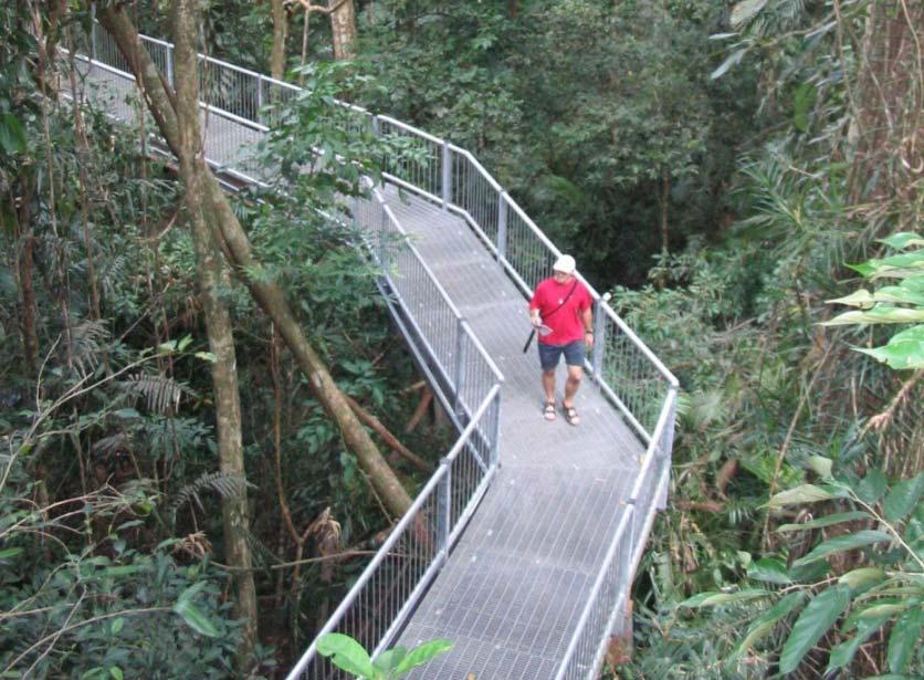
31 Bridge Precedent Images Blue Heron Bridge at The DCR Upper Charles River Reservation 10 wide x 140 long (Watertown, MA)

32 Bridge Types GIRDER BASKET HANDLE TRUSS ARCH


33 Preferred Option River Bend River Street Trail Separated from housing by River Street Path connects trail to local community


34 Rail Crossing Over pass Perspectives

35 Canopy Walk


36 Rail Crossing and Canopy Walk

37 Preferred Option Mattapan Station SECTION PIVOTS Mattapan Station Platforms Mattapan Station Service Yard Trail Neponset River Residences Separated from residences by vegetation and the river Allows for river views Visible from the station

38 Northern Trail Mattapan Square
39 Mattapan Square
40 Central Avenue to Mattapan Square Overall Project Work Completed Neponset Open House Mar 8, 2006 Master Plan Complete 2006 Martini Shell Park & Nep. Esplanade Park Construction Complete Fall 2010 Public Meeting May 17, 2010 Public Meeting for Project Update/Potential Design Opportunities TBD 2011 TIGER III Grant Application Oct 30, 2011 Public Meeting Aug 30, 2011 Construction Complete Fall 2013 Public Meeting April 26, 2006 Site Walk Summer 2010 Nep. Esplanade Construction Complete Fall 2010 Martini Shell Renovation Complete Fall 2010 PUBLIC COMMENT PERIOD (ENDS SEPT 28, 2011) TIGER Grant Award Spring, 2012 MEPA and NEPA Permitting Sept 2011 Stake Holders Updates & Additional Meetings Fall 2011 Milton & Boston Conservation Commissions Dec 2011


41 Questions and Discussion
42 Additional Information WEBSITE: m COMMENTS AND/OR SUGGESTIONS: Phone: dcr.updates@state.ma.us Write: Department of Conservation and Recreation Office of Public Outreach 251 Causeway Street, Suite 600 Boston, MA NOTE: Public comments submitted to DCR by or letter will be posted on the DCR website in their entirety, and no content, including personal information, will be redacted.
Charles River Reservation Footbridge Projects/Trail Corridor Proposal. May 7, 2009, 6:30 8:00 pm Newton-Wellesley Hospital Auditorium, Newton
 Charles River Reservation Footbridge Projects/Trail Corridor Proposal May 7, 2009, 6:30 8:00 pm Newton-Wellesley Hospital Auditorium, Newton Commonwealth of Massachusetts Governor Deval L. Patrick Lieutenant
DRAW SEVEN PARK RENOVATION PROJECT SOMERVILLE, MASSACHUSETTS
 DRAW SEVEN PARK RENOVATION PROJECT SOMERVILLE, MASSACHUSETTS DCR Public Meeting Monday, February 5th 6:30pm-8:30pm East Somerville Community School 50 Cross Street, Somerville, MA, 02145 Commonwealth of
Construction Contract A47CN01: Wollaston Station Improvements and Quincy Center Garage Demolition. June 2017
 Construction Contract A47CN01: Wollaston Station Improvements and Quincy Center Garage Demolition June 2017 OVERVIEW Today s board action will provide for the construction of improvements to the Wollaston
Corridor Management Committee. September 29, 2017
 Corridor Management Committee September 29, 2017 1 Today s Topics Chair s Update Proposed Corridor Protection Wall Aesthetic Design Overview Public Outreach Environmental Review Civil Construction Update
Welcome. Green Line LRT. Beltline Alignment Options. Stay engaged! Follow the Green Line story at calgary.ca/greenline
 Welcome Green Line LRT Beltline Alignment Options Stay engaged! Follow the Green Line story at calgary.ca/greenline Green Line LRT Why are we here? Our Challenge Determine the best alignment in the Beltline.
Master Plan Implementation Committee Meeting
 MILTON VILLAGE ZONING AND WATERFRONT STUDY Master Plan Implementation Committee Meeting February 12, 2018 7:00-9:00 pm IMAGE: GOOGLE COMPILED MEETING FEEDBACK/SURVEY RESULTS Waterfront Principles - Prioritized
Southeast Extension to RidgeGate Parkway Scoping Booklet
 Southeast Extension to RidgeGate Parkway Scoping Booklet PUBLIC SCOPING MEETING SCHEDULE Public Scoping Meeting Wednesday, November 2, 2011 6:00pm to 7:30pm City of Lone Tree Recreation Center Willow Room
CITY OF BEACON NOTICE TO LANDSCAPE ARCHITECTS GENERAL INFORMATION AND REQUEST FOR PROPOSALS
 CITY OF BEACON NOTICE TO LANDSCAPE ARCHITECTS GENERAL INFORMATION AND REQUEST FOR PROPOSALS The City of Beacon (the CITY) is issuing this Request for Proposals (RFP) for the selection of a landscape architect
Welcome. Northern Segment of Hwy 100 I-90 to South of Madison Street Meeting Goals:
 Welcome Northern Segment of Hwy 100 I-90 to South of Madison Street Meeting Goals: - Review Environmental Assessment - Share Preferred Alternative -Receive Public Comments 2003 EA Preferred Alternative
May 4, Via electronic mail
 Via electronic mail ben.lynch@state.ma.us Ben Lynch, Waterways Program Chief Department of Environmental Protection One Winter Street Boston, Massachusetts 02108 Re: DDRC Gateway LLC Ch. 91 License # 8530
RE: Comments on the Environmental Notification Form (ENF) for the I 90 Allston Interchange Project MEPA #15278
 for the I 90 Allston Interchange Project MEPA #15278") December5,2014 SecretaryMaeveVallelyBartlett ExecutiveOfficeofEnergyandEnvironmentalAffairs(EEA) 100CambridgeSt.,Suite900 BostonMA02114 RE:CommentsontheEnvironmentalNotificationForm(ENF)fortheI 90AllstonInterchangeProject
December5,2014 SecretaryMaeveVallelyBartlett ExecutiveOfficeofEnergyandEnvironmentalAffairs(EEA) 100CambridgeSt.,Suite900 BostonMA02114 RE:CommentsontheEnvironmentalNotificationForm(ENF)fortheI 90AllstonInterchangeProject
OVERMOUNTAIN VICTORY TRAIL BURKE CALDELL CORRIDOR FEASIBLITY STUDY REQUEST FOR QUALIFICATIONS CALDWELL COUNTY PATHWAYS
 OVERMOUNTAIN VICTORY TRAIL BURKE CALDELL CORRIDOR FEASIBLITY STUDY REQUEST FOR QUALIFICATIONS CALDWELL COUNTY PATHWAYS Caldwell County Pathways along with our co-partners City of Lenoir, Town of Gamewell,
Anderson Memorial Bridge Rehabilitation Project Boston/Cambridge
 Anderson Memorial Bridge Rehabilitation Project Boston/Cambridge MEPA Meeting, EEA#14702 Wednesday, March 2, 2011 6:30 PM Dr. Martin Luther King, Jr. School 100 Putnam Avenue, Cambridge, MA Rendering by:
6:00 8:00 PM I-95 FROM EXIT 57 TO EXIT 60 PROJECT
 PUBLIC INFORMATIONAL MEETING TUESDAY, APRIL 27, 2010 AT NEWBURYPORT CITY HALL, AUDITORIUM 60 PLEASANT STREET NEWBURYPORT, MASSACHUSETTS 6:00 8:00 PM FOR THE PROPOSED WHITTIER BRIDGE / I-95 IMPROVEMENTS
MISSISSIPPI GORGE REGIONAL PARK MASTER PLAN
 MISSISSIPPI GORGE REGIONAL PARK MASTER PLAN Minneapolis Park and Recreation Board CAC MEETING #1 APRIL 23, 2018 AGENDA Mississippi Gorge Regional Park Master Plan CAC #1 01 / Welcome and Calling Circle
CHARLES COUNTY GOVERNMENT RFP NO POPES CREEK RAIL TRAIL DESIGN
 CHARLES COUNTY GOVERNMENT Department of Fiscal and Administrative Services Purchasing Division Telephone: 301-645-0656 July 7, 2015 RFP NO. 16-02 POPES CREEK RAIL TRAIL DESIGN ADDENDUM NUMBER ONE TO: All
TOWN COUNCIL / PLANNING COMMISSION
 Workshop #3 TOWN COUNCIL / PLANNING COMMISSION January 20, 2011 Consultant Team In Attendance Tonight BMS Design Group Nevada City and San Francisco Michael Smiley, AICP, ASLA Partner-in-Charge Nancy L.
City of Poughkeepsie Waterfront Redevelopment Strategy. Poughkeepsie Waterfront Redevelopment Strategy
 City of Poughkeepsie Waterfront Redevelopment Strategy Poughkeepsie Waterfront Redevelopment Strategy City of Poughkeepsie Prime Assets: Major Waterfront Advantages: - Central City of the Hudson River
Overview Report. Proposed Development
 Overview Report Proposed Development the construction of a 1km cycle/pedestrian trail including a new footbridge, new car park and entrance road at Drumshanbo Lock and a new pedestrian/cycle road crossing,
Massachusetts Water Resources Authority
 Massachusetts Water Resources Authority Upper Neponset Valley Replacement Sewer Project Information Purpose of Project To bring capacity of the 100+ year old sewers up to the level of service the MWRA
Pennsy Greenway Trail
 Town of Schererville Pennsy Greenway Trail DES. #s: 0401062, 1173595 & 1382661 Construction of Pennsy Greenway Trail beginning at Wilhelm Street and continuing northwest along the former Penn Central railroad
Notes from table discussions at the Metro North Regional Forum in Malden on April 30, 2014
 Notes from table discussions at the Metro North Regional Forum in Malden on April 30, 2014 These notes represent a summary of the themes, locations, and discussions that were discussed as part of the facilitated
The Great Molasses Flood Memorial:
 The Great Molasses Flood Memorial: A CONCEPTUAL LOOK INTO DESIGN OPTIONS FOR RAMP PARCEL 6 By Bryan Webb BryanWebb33@gmail.com Introduction: As discussed at in the community meeting on June 26, 2014 Parcel
M E M O R A N D U M. DATE: July 19, Patrick D. O Keeffe, City Manager. Economic Development & Housing
 M E M O R A N D U M DATE: July 19, 2011 TO: FROM: Patrick D. O Keeffe, City Manager Economic Development & Housing SUBJECT: Resolution of the City Council of the City of Emeryville Approving the Application
5. Father Hennepin Blufs Park and Hennepin Island Father Hennepin Bluffs Park Supporting Initiatives (see Figure 36): 7-22
: 7-22") 5. Father Hennepin Blufs Park and Hennepin Island As described in existing conditions portion of Chapter 2, Father Hennepin Blufs Park lies on the upland portion of the park and Hennepin Island spans the
5. Father Hennepin Blufs Park and Hennepin Island As described in existing conditions portion of Chapter 2, Father Hennepin Blufs Park lies on the upland portion of the park and Hennepin Island spans the
Urban runoff in my neighborhood (Capitol Hill) is heavy with trash and other debris.
 is heavy with trash and other debris.") South Platte River Meeting Comments & s #1 I am a huge fan of river areas and would love the Platte and surrounding waterways to improve to allow habitat for wildlife and recreation opportunities for citizens.
South Platte River Meeting Comments & s #1 I am a huge fan of river areas and would love the Platte and surrounding waterways to improve to allow habitat for wildlife and recreation opportunities for citizens.
SELMON GREENWAY FEASIBILITY STUDY. For: Hillsborough County Metropolitan Planning Organization By: Renaissance Planning
 SELMON GREENWAY FEASIBILITY STUDY For: Hillsborough County Metropolitan Planning Organization By: Renaissance Planning SELMON GREENWAY FEASIBILITY STUDY VISION Multimodal connection between Bayshore Blvd
Silver Line Gateway. Extension of Silver Line Bus Rapid Transit (BRT) to Chelsea and East Boston. Public Informational Meeting Chelsea, MA
 to Chelsea and East Boston. Public Informational Meeting Chelsea, MA") Silver Line Gateway Extension of Silver Line Bus Rapid Transit (BRT) to Chelsea and East Boston Public Informational Meeting Chelsea, MA August 18, 2014 Introduction / Design Process Design Team Joe Pavao,
Silver Line Gateway Extension of Silver Line Bus Rapid Transit (BRT) to Chelsea and East Boston Public Informational Meeting Chelsea, MA August 18, 2014 Introduction / Design Process Design Team Joe Pavao,
I-90 ALLSTON INTERCHANGE A MULTIMODAL TRANSPORTATION PROJECT PUBLIC INFORMATION MEETING SEPTEMBER 18, 2014 JACKSON MANN COMMUNITY CENTER
 I-90 ALLSTON INTERCHANGE A MULTIMODAL TRANSPORTATION PROJECT PUBLIC INFORMATION MEETING SEPTEMBER 18, 2014 JACKSON MANN COMMUNITY CENTER 1 Project Need Deteriorating viaduct requiring replacement All Electronic
BeltLine Corridor Environmental Study
 BeltLine Corridor Environmental Study Joint TAC and SAC Meeting December 8, 2008 What We Will Discuss Today Outreach and Agency Coordination Scoping Results Existing Conditions Historical and Archeological
Mississippi Skyway Preliminary Engineering Report
 EXECUTIVE SUMMARY Mississippi Skyway Preliminary Engineering Report CITY OF RAMSEY, MINNESOTA DECEMBER 2014 City of RAMSEY EXECUTIVE SUMMARY Project Need and Intent The Mississippi Skyway pedestrian bridge
Infrastructure Investment Incentive Program (I-Cubed)
") Infrastructure Investment Incentive Program (I-Cubed) Presentation to Watertown Town Council June 29, 2017 Agenda 1. What is I-Cubed? 2. How are improvements selected? 3. Proposed I-Cubed improvements
Infrastructure Investment Incentive Program (I-Cubed) Presentation to Watertown Town Council June 29, 2017 Agenda 1. What is I-Cubed? 2. How are improvements selected? 3. Proposed I-Cubed improvements
DRAFT ROOSEVELT ROAD. District Recommendations. Figure 5.23 The Roosevelt Road Corridor
 CHAPTER 5 Figure 5.23 The Road Corridor Road will develop as a mixed-use corridor, emphasizing regional retail, west of the river and mixed-use development east of the river. KEY RECOMMENDATIONS 1. High
Welcome to the. Open House
 Welcome to the 5th Street to Kinsman Road Open House November 14 5:30 7:00 p.m. Please sign in Project Overview In December 2016, City Council adopted SW 5th Street as the preferred alignment to connect
GLX Project Green Line Extension Project GLX WORKING GROUP PRESENTATION OCTOBER 2, 2014
 GLX Project Green Line Extension Project 1 Agenda Welcome GLX Sustainability Project Overview & Updates Upcoming Public Meetings Station Meeting Lechmere Station Meeting Union Sq. & Washington St. Working
Highland Falls Waterfront Redevelopment Feasibility Study Village Board Meeting March 20, 2017
 Village Board Meeting March 20, 2017 Agenda I. Public Meeting #1 Visioning Summary II. Public Meeting #2 Comment Summary III. IV. IV. Case Study: Milton Train Station Schematic Design Concepts Schedule/Next
Recreational Pathway Crossing of Richmond Street Municipal Class Environmental Assessment. Public Information Centre #2 April 22, 2015
 Recreational Pathway Crossing of Richmond Street Municipal Class Environmental Assessment Public Information Centre #2 April 22, 2015 1. Study Process PHASE 1 PHASE 2 PHASE 3 PHASE 1 : Problem/Opportunity
APPENDIX D: Visual and Aesthetic Conditions for NCCU Station Refinement. Durham-Orange Light Rail Transit Project
 APPENDIX D: Visual and Aesthetic Conditions for NCCU Station Refinement Durham-Orange Light Rail Transit Project October 2016 1. Introduction The Combined FEIS/ROD summarizes the effects of the D-O LRT
Bridge Type Assessment and Evaluation
 16M-01410-01 (3216026) Glen Road Pedestrian Bridge EA Study Bridge Type Assessment and Evaluation Factor Group/Criteria Alternative 1: Steel girder with two inclined steel legs Alternative 2: Steel girder
Second Line West Pedestrian/Cyclist Crossing of Highway 401 Class EA. Second Line West Pedestrian/Cyclist Crossing of Highway 401 Class EA
 1 1 Purpose of Public Information Centre #2 To provide interested and/or potentially affected stakeholders with an opportunity to participate in the planning and decision-making process for this Municipal
PIKE PINE RENAISSANCE: ACT ONE. October 19, 2017
 PIKE PINE RENAISSANCE: ACT ONE October 19, 2017 WATERFRONT SEATTLE PROGRAM PROJECT INTRODUCTION Pike and Pine streets, between First and Melrose avenues Pedestrian and streetscape improvements Budget:
BeltLine Corridor Environmental Study
 BeltLine Corridor Environmental Study Citywide Conversation on Transit and Trails April 2, 2009 Agenda & Introductions Introductions Environmental Study Process Overview of the BeltLine Project BeltLine
Asbury Chapel Subdivision Sketch Plan
 Asbury Chapel Subdivision Sketch Plan PART 1: PROJECT SUMMARY Applicant: NVR Inc. Project Size: +/- 76.13 acres Parcel Numbers: 02101112,02116101,02116112, 02116113 Current Zoning: Transitional Residential
Institutional Master Plan The Arnold Arboretum of Harvard University
 Institutional Master Plan The Arnold Arboretum of Harvard University Submitted to: Boston Redevelopment Authority One City Hall Square Boston, MA 02201 Submitted by: The Arnold Arboretum of Harvard University
Advisory Group Meeting 16 November 2010
 Advisory Group Meeting 16 November 2010 City of Boston Thomas M. Menino Mayor Tonight s Topics Residential Districts Industrial Districts Commercial Districts Open Space Transportation Other 4. Require
Rosecrans/Marquardt Grade Separation Project. Community Open House Meeting
 Rosecrans/Marquardt Grade Separation Project Community Open House Meeting October 17, 2017 Rosecrans/Marquardt Presentation Agenda 1. Welcome Remarks & Introductions 2. Community Outreach 3. Project Goals
Emerson Park Master Plan Update. Public Meeting III August 27, 2014
 Emerson Park Master Plan Update Public Meeting III August 27, 2014 Meeting Agenda: Project Update Presentation of Master Plan Components Discussion and Feedback The Path Forward: Building on the Concept
PUBLIC HEARING. DRAFT Environmental Impact Statement. Matthews Memorial Baptist Church Washington, DC October 18, National Capital Region
 National Capital Region DRAFT Environmental Impact Statement PUBLIC HEARING Matthews Memorial Baptist Church Washington, DC October 18, 2007 Introduction Welcome and team introduction Hearing procedures
Welcome to the Sellwood Bridge Project Pre-Construction Open House
 Welcome to the Sellwood Bridge Project Pre-Construction Open House 5:30 7:30 p.m. Please sign in here Information stations and project staff are located throughout the room. Goals for Tonight s Meeting
OPPORTUNITIES AND CONSTRAINTS - OXBOW PARK ENTRANCE AND PUT-IN
 OPPORTUNITIES AT OXBOW EXISTING WETLANDS Site is undeveloped and we can design a park that works well from the start. SAND BEACH Potential to eliminate invasive species. DEBRIS (CONCRETE, OLD CARS) VEGETATION
Rose Kennedy Greenway Ramp Parcels Study
 Rose Kennedy Greenway Ramp Parcels Study Public Meeting #1 June 26, 2014 Consultants: HDR Utile, Inc. MassDOT & Boston Redevelopment Authority Rose Kennedy Greenway Ramps Parcels Study Public Meeting #1
HELLO & WELCOME. Prior/Venables Replacement A NEW PLAN FOR THE FALSE CREEK FLATS PLANNING PROCESS OVERVIEW
 HELLO & WELCOME. A NEW PLAN FOR THE FALSE CREEK FLATS Since last May, City staff have been working with you to identify the key issues, desires and directions for the future of the False Creek Flats. Throughout
Draft Downtown Waterfront Municipal Harbor Plan
 7/20/2016 Draft Downtown Waterfront Municipal Harbor Plan FRAMEWORK MHP BACKGROUND & GOALS AMPLIFICATIONS, SUBSTITUTE PROVISIONS, & OFFSETS CHAPTER 91 LONG-TERM LICENSE FEES PREPARING FOR CLIMATE CHANGE
The Atlanta BeltLine. Quarterly Briefing March @atlantabeltline. Reynoldstown Senior Affordable Housing
 The Atlanta BeltLine Quarterly Briefing March 30, 2017 @atlantabeltline @atlantabeltline @atlantabeltline Reynoldstown Senior Affordable Housing Framework for a multi-use and transit corridor in the heart
Hudson Group North America LLC
 Hudson Group North America LLC Mr. John Palmieri, Director Boston Redevelopment Authority One City Hall Square Boston, MA 02201 August 30, 2010 RE: 120 Kingston Street Development, Notice of Project Change
Preservation & Design Awards
 EVANSTON PRESERVATION COMMISSION Preservation & Design Awards 2018 Nomination Form The Evanston Preservation Commission is pleased to call for nominations for the 2018 Evanston Preservation & Design Awards.
M E M O R A N D U M. Chair and Members of North West Planning Advisory Committee
 Item 9.1.1 PO Box 1749 Halifax, Nova Scotia B3J 3A5 Canada M E M O R A N D U M TO: FROM: Chair and Members of North West Planning Advisory Committee Stephanie Salloum, Planner II DATE: June 26, 2017 SUBJECT:
Public Open House. Welcome! Presentation at 5:15 p.m. Please sign-in at the registration table
 Public Open House Welcome! Presentation at 5:15 p.m. Please sign-in at the registration table The Grand Avenue Extension Location and Environmental Study will determine the location of the extension of
Preliminary Design of Major Rehabilitation Works for the Bridge Structure on PTH 1A Over Assiniboine River and CP Rail (Bridge Site No.
 Preliminary Design of Major Rehabilitation Works for the Bridge Structure on PTH 1A Over Assiniboine River and CP Rail (Bridge Site No. 2582-00) Public Consultation Report December 2014 First Street Bridge
1.0 INTRODUCTION 1.1 TH 14 WEST STUDY AREA Project Description Functional Classification Purpose of the Project
 1.0 INTRODUCTION 1.1 TH 14 WEST STUDY AREA 1.1.1 Project Description The Trunk Highway (TH) 14 West Corridor is a two-lane roadway approximately 22 miles in length. Located in Nicollet County, the corridor
RESPONSES TO PUBLIC CONCERNS AND QUESTIONS
 RESPONSES TO PUBLIC CONCERNS AND QUESTIONS Stations and Summary Questions for Public Meeting #2 June 23, 2015 General Questions / Concerns: 1. Is there any way this development can raise revenue for the
TOWN OF WHITBY REPORT RECOMMENDATION REPORT
 TOWN OF WHITBY REPORT RECOMMENDATION REPORT REPORT TO: Council REPORT NO: PL 95-09 DATE OF MEETING: October 13, 2009 PREPARED BY: Planning/Public Works Joint Report FILE NO(S): N/A LOCATION: N/A REPORT
Welcome! Community Meeting FOR YOUR NEW WEBBER PARK LIBRARY
 Community Meeting FOR YOUR NEW WEBBER PARK LIBRARY Tuesday, April 21, 6 p.m. to 7:30 p.m. Webber Community Center Multipurpose Room 4400 Dupont Ave. N., Minneapolis, MN 55412 Welcome! Please join Hennepin
Umass Amherst Design Center in Springfield - Court Square
 Umass Amherst Design Center in Springfield - Court Square UMass Amherst Design Center in Springfield, MA The Springfield Initiative: UMass plan to help revitalize the City of Springfield Support from:
WELCOME 50 street cp rail grade separation + road widening. public information session #1 June 26, pm to 8 pm
 WELCOME 50 street cp rail grade separation + road widening public information session #1 June 26, 2018 5 pm to 8 pm session purpose To provide residents, businesses, and users of 50 Street with the opportunity
METROPOLITAN COUNCIL 390 North Robert Street, St. Paul, MN Phone (651) ; TDD (651)
 ; TDD (651)") DATE: December 20, 2011 METROPOLITAN COUNCIL 390 North Robert Street, St. Paul, MN 55101 Phone (651) 602-1000; TDD (651) 291-0904 TO: Metropolitan Parks and Open Space Commission FROM: Tori Dupre, Senior
DATE: December 20, 2011 METROPOLITAN COUNCIL 390 North Robert Street, St. Paul, MN 55101 Phone (651) 602-1000; TDD (651) 291-0904 TO: Metropolitan Parks and Open Space Commission FROM: Tori Dupre, Senior
Draft Environmental Assessment Appendix A. SHPO Correspondence, January 19, 2017
 Draft Environmental Assessment Appendix A. SHPO Correspondence, January 19, 2017 Rosecrans/Marquardt Grade Separation Project April 2018 Federal Railroad Administration U.S. Department 1200 New Jersey
SF REC & PARK STANYAN STREET IMPROVEMENT. Supervisor London Breed District 5. Project Manager Dan Mauer Recreation and Parks Department
 SF REC & PARK STANYAN STREET IMPROVEMENT PLANNING PRESENTATION WEDNESDAY, OCTOBER 19, 2016 Supervisor London Breed District 5 Project Manager Dan Mauer Recreation and Parks Department Design Team William
Bloor Street East Potential Ravine Portal Overlook and Access Passage to the Rosedale Valley and Don River Valley Ravine, Toronto, Canada
 TRANSFORMATIVE IDEA 2. GREAT STREETS Bloor Street Christie Pits Park Bloor St Spadina Ave Bathurst St Shaw St 1 Recognize the significant public realm improvements along Bloor Street and extend and enhance
California Environmental Quality Act (CEQA) Environmental Review Process
 Environmental Review Process") California Environmental Quality Act (CEQA) Environmental Review Process Los Angeles Union Station Forecourt and Esplanade Improvements constitute a Project Los Angeles County Metropolitan Transportation
California Environmental Quality Act (CEQA) Environmental Review Process Los Angeles Union Station Forecourt and Esplanade Improvements constitute a Project Los Angeles County Metropolitan Transportation
Christine Toner, Consultation Leader
 9. FAIRVIEW STREET FOOTBRIDGE REBUILD General Manager responsible: General Manager, City Environment Group, DDI 941-8608 Officer responsible: Unit Manager, Transport and Greenspace Author: Christine Toner,
CHARTER TOWNSHIP OF VAN BUREN PLANNING COMMISSION November 12, 2014 MINUTES
 CHARTER TOWNSHIP OF VAN BUREN PLANNING COMMISSION November 12, 2014 MINUTES Chairperson Thompson called the meeting to order at 7:32 p.m. ROLL CALL: Present: Johnson, Boynton, Kelley, McKenna, Budd, Franzoi
How can landscape architects aide in transportation planning process? John Dempsey, PLA Toole Design Group July 24, 2015
 How can landscape architects aide in transportation planning process? John Dempsey, PLA Toole Design Group July 24, 2015 What is Landscape Architecture? Landscape Architecture 1863 What is Landscape Architecture?
WELCOME TO OPEN HOUSE TWO November 28, 2018
 Langstaff Road Weston Road to Highway 7 Class Environmental Assessment Study WELCOME TO OPEN HOUSE TWO November 28, 2018 Please sign in and join our mailing list Study Overview York Region is conducting
RZC Public View Corridors and Gateways
 RZC 21.42 Public View Corridors and Gateways 21.42.010 Purpose 21.42.020 Scope and Authority 21.42.030 Administration 21.42.040 Gateways Design 21.42.050 Unidentified Public Views 21.42.060 Identification
Site 1: Roxy s Cleaners
 Site 1: Roxy s Cleaners 395 Main Avenue Antfil Realty LLC SBL #: 124.6-8-9.11 Acres: 0.43 Current Use/ Status: The property is vacant and part of the NYSDEC State Superfund Program, Classification 04 properly
the South Lincoln Redevelopment, Denver, CO
 the South Lincoln Redevelopment, Denver, CO Chris Parr Director of Development, Denver Housing Authority cparr@denverhousing.org Renee Martinez Stone Urban Planner/Owner, Perspective -3 renee@perspective-3.com
Middlebury RS 0174(8)
") Middlebury RS 0174(8) Preferred Alternative Meeting VT 125 Bridge #13 over Middlebury River August 6, 2012 Presented to Presented by Town of Middlebury VTrans & VHB Introductions: Jennifer Fitch VTrans
Middlebury RS 0174(8) Preferred Alternative Meeting VT 125 Bridge #13 over Middlebury River August 6, 2012 Presented to Presented by Town of Middlebury VTrans & VHB Introductions: Jennifer Fitch VTrans
Whitemarsh Township Greenway Plan
 Whitemarsh Township Greenway Plan Prepared for: Whitemarsh Township August 16, 2007 Table of Contents Table of Contents... i Introduction... 1 Study Area Setting... 2 Regional Setting... 2 Township Character...
RIVER ARTS DISTRICT TRANSPORTATION PROJECT
 RIVER ARTS DISTRICT TRANSPORTATION PROJECT A section of the Public Meeting #3 December 6, 2012 The RiverWay Plan The Wilma Dykeman RiverWay is a 17 mile corridor along the French Broad and Swannanoa Rivers.
Johnson Street Bridge Public Realm Update
 Johnson Street Bridge Public Realm Update August 20, 2015 Background Johnson Street Bridge Replacement Project impacts a diverse range of stakeholders In addition to a new bridge, the project also includes
ROAD AND CAR PARK DESIGN GUIDELINES
 3.2 ROAD AND CAR PARK DESIGN GUIDELINES PIHA AREA DESIGN GUIDELINES AUCKLAND REGIONAL COUNCIL 37 Existing Road and Car Park Photos: North Piha carpark Anawhata carpark Winstone Track carpark off Piha Road
City of Los Angeles Department of Public Works
 City of Los Angeles Department of Public Works Environmental Scoping Meeting for the Proposed Sixth Street Park, Arts, River & Connectivity Improvements (PARC) Project May 3, 2017 1 Agenda Introductions
Thank you for coming to the Rail Corridor Land Use Study Public Meeting.
 01 Welcome! Thank you for coming to the Rail Corridor Land Use Study Public Meeting. Tonight is an opportunity to learn about the Land Use Study for the Rail Corridor Site. In Fall 2016, Toronto City Council
Somers Point Master Plan
 Somers Point Master Plan Progress Report and Public Meeting August 20, 2014 Master Plan Reexamination Municipal Land Use Law require that all municipalities reexamine their master plan every ten years.
Billing Code: DEPARTMENT OF HOUSING AND URBAN DEVELOPMENT [Docket No. FR-6072-N-01]
![Billing Code: DEPARTMENT OF HOUSING AND URBAN DEVELOPMENT [Docket No. FR-6072-N-01]](/thumbs/91/107309814.jpg "Billing Code: DEPARTMENT OF HOUSING AND URBAN DEVELOPMENT [Docket No. FR-6072-N-01]") This document is scheduled to be published in the Federal Register on 12/18/2017 and available online at https://federalregister.gov/d/2017-27194, and on FDsys.gov Billing Code: 4210-67 DEPARTMENT OF HOUSING
This document is scheduled to be published in the Federal Register on 12/18/2017 and available online at https://federalregister.gov/d/2017-27194, and on FDsys.gov Billing Code: 4210-67 DEPARTMENT OF HOUSING
PLANNED DEVELOPMENT (MASTER PLAN & UNIT PLAN)
") Central Permit Center 555 Santa Clara Street Vallejo CA 94590 Business License Building Fire Prevention Planning Public Works 707.648.4310 707.648.4374 707.648.4565 707.648.4326 707.651.7151 PLANNED DEVELOPMENT
Central Permit Center 555 Santa Clara Street Vallejo CA 94590 Business License Building Fire Prevention Planning Public Works 707.648.4310 707.648.4374 707.648.4565 707.648.4326 707.651.7151 PLANNED DEVELOPMENT
East Link Extension. June 28, South Bellevue Final Design Open House Public Involvement Summary
 East Link Extension June 28, 2013 South Bellevue Final Design Open House Public Involvement Summary Table of Contents 1 Background 2 Overview 2 Notification 3 Open House Overview 4 Comment Summary 4 South
Reconstruction Project. Wayzata Task Force Meeting September 3, 2009
 CSAH 101 Reconstruction Project Wayzata Task Force Meeting September 3, 2009 Agenda 700 7:00 Re-Introductions ti 7:05 2008 Activity Recap / 2009 Activities-to-date 7:10 Discussion of Layout Revisions (per
Atlanta BeltLine Subarea 3 Master Plan Update
 Atlanta BeltLine Subarea 3 Master Plan Update April 14, 2018 Workshop Meeting 1 22 miles, connecting 45 neighborhoods 22 MILES of transit 46 MILES of streetscapes and complete streets 33 MILES of urban
Worcester Regional Mobility Study Technical Committee Meeting 2 August 26, 2008
 Worcester Regional Mobility Study Technical Committee Meeting 2 August 26, 2008 1 TechnicalCommittee Meeting2 Framework/StudyArea Refinement August 26, 2008 10:00 AM 12:00 PM Central Massachusetts Regional
DETROIT RIVER INTERNATIONAL CROSSING STUDY. County of Essex. June 4, 2008
 DETROIT RIVER INTERNATIONAL CROSSING STUDY County of Essex June 4, 2008 The Border Transportation Partnership 2 Purpose of the DRIC Study To provide for the safe, efficient and secure movement of people
Town of Hamburg Planning Board Meeting August 19, Town of Hamburg Planning Board Meeting August 19, 2015 Minutes
 Town of Hamburg Planning Board Meeting August 19, 2015 Minutes The Town of Hamburg Planning Board met for a Regular Meeting at 7:00 P.M. on Wednesday, August 19, 2015 in Room 7B of Hamburg Town Hall, 6100
LAND USE PLAN 7. Housing
 21 LAND USE PLAN While the land uses that have historically dominated the Corridor itself have been industrial/commercial, the Master Plan proposes a shift to mixed-use redevelopment, complimented by a
WELCOME! 8 8:30 6: TH STREET IMPROVEMENTS. Open House. Presentation & Q&A
 WELCOME! 168 TH STREET IMPROVEMENTS 6:30 Open House 7 8 Presentation & Q&A 8 8:30 Open House WELCOME Todd Pfitzer City of Omaha Engineer Bob Stubbe City of Omaha Public Works Director Jon Meyer Project
Eastside Transit Corridor Phase 2 Technical Study Update Community Outreach Meeting February 2017
 Eastside Transit Corridor Phase 2 Technical Study Update Community Outreach Meeting February 2017 Purpose of Tonight s Meeting Recap of Board motion (2014) and technical study process Provide update on
The Border Transportation Partnership
 DETROIT RIVER INTERNATIONAL CROSSING STUDY Town of LaSalle June 10, 2008 The Border Transportation Partnership 2 1 Purpose of the DRIC Study To provide for the safe, efficient and secure movement of people
Fort Washington & Upper Riverside Parks PlaNYC Survey Results
 Fort Washington & Upper Riverside Parks PlaNYC Survey Results A $40 Million Investment Thanks to Mayor Bloomberg s PlaNYC, the New York City Department of Parks & Recreation (DPR) is developing plans for
Pedestrian Bridge at Vermijo Avenue. Kathleen Krager June 13, 2016
 Pedestrian Bridge at Vermijo Avenue Kathleen Krager June 13, 2016 The Downtown Action Plan -1992- Proposes pedestrian crossing of the railroad at Vermijo Avenue Pikes Peak Greenway Master Plan -June
SABRE WOODS. Design Standards. In response to the Cit y of Hickor y Hills Plan Commission. A public/private partnership. City of Hickory Hills
 SABRE WOODS Design Standards In response to the Cit y of Hickor y Hills Plan Commission A public/private partnership City of Hickory Hills Koziarz Group II, LLC - Owner Retown - Development Manager (www.retown.com)