MITIGATION MANAGEMENT AND MONITORING PLAN BAYFRONT PARK WETLAND RESTORATION MILL VALLEY, CA
|
|
|
- Bridget Potter
- 5 years ago
- Views:
Transcription
1 MITIGATION MANAGEMENT AND MONITORING PLAN BAYFRONT PARK WETLAND RESTORATION MILL VALLEY, CA PREPARED FOR: THE CITY OF MILL VALLEY PARKS AND RECREATION DEPARTMENT 180 CAMINO ALTO AVENUE MILL VALLEY, CA PREPARED BY: PHILIP WILLIAMS & ASSOCIATES 550 KEARNY STREET, SUITE 900 SAN FRANCISCO, CA PHYLLIS FABER WETLANDS BIOLOGIST 212 DEL CASA MILL VALLEY, CA DIANE RENSHAW CONSULTING ECOLOGIST 607 PACO DRIVE LOS ALTOS, CA MAY 11, 2007 BAYFRONT PARK WETLAND MITIGATION PLAN CITY OF MILL VALLEY PAGE 1
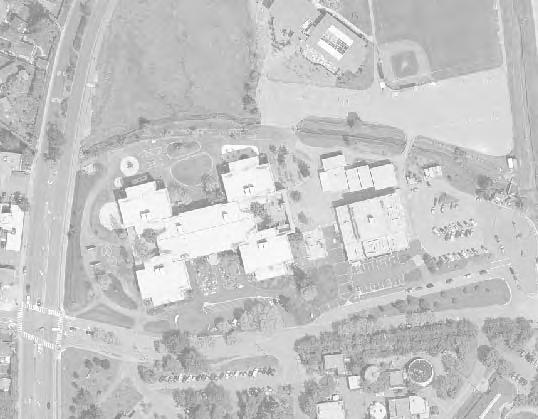
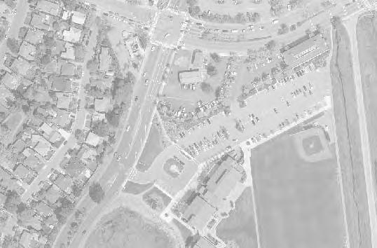
2 MITIGATION MANAGEMENT AND MONITORING PLAN BAYFRONT PARK WETLAND RESTORATION MILL VALLEY, CA A. INTRODUCTION In 1993 the City of Mill Valley was the lead agency for the then proposed development of the Mill Valley Community Center, located at the northern end of Richardson Bay. To offset loss of 0.04 acres of seasonal wetland filled by the development, the City of Mill Valley required that 3,500 square feet of seasonal wetlands be established within the Bayfront Park area. In 1999 the City had its consultant, Philip Williams & Associates, prepare a conceptual design for a tidal marsh in Bayfront Park to fulfill the wetland mitigation requirement. The Mill Valley Community Center has now been constructed. The proposed restoration will reconfigure and enhance an existing filled wetland area, creating a net gain of approximately 0.12 acres (5,280 square feet) of low, middle, and high marsh habitat, exceeding the minimum of 3,500 square feet required by the City of Mill Valley as mitigation. B. RESPONSIBLE PARTIES The City of Mill Valley is the project applicant, and the project work will be overseen by the Mill Valley Parks and Recreation Department. The project mitigation plan has been prepared by Philip Williams & Associates, Phyllis Faber, Wetlands Biologist, and Diane Renshaw, Consulting Ecologist. The City of Mill Valley will be the sole party responsible for the successful implementation and completion of this mitigation measure. C. PROJECT REQUIRING MITIGATION 1. Location: The project site is at the northern end of Bayfront Park in Mill Valley, Marin County, CA (USGS 7.5 San Rafael topographic quadrangle (37 53' 50"N, ' 27"W) (Figure 1). 2. Brief Summary of Overall Project: The proposed project will improve habitat values on the site by lowering elevations over as much of the site as is practical, implementing a conceptual wetland mitigation design prepared for the City of Mill Valley by PWA (1999) (Figure 2, 3). This will result in a greater exposure to the twice-daily tides with a resulting increase in the extent of cordgrass, pickleweed, and salt grass (Figure 5). The benefits of this downward shift of elevations include improved habitat potential for clapper rail, saltmarsh harvest mouse, and the numerous invertebrate species that live in the mud and provide food for shore BAYFRONT PARK WETLAND MITIGATION PLAN CITY OF MILL VALLEY PAGE 2
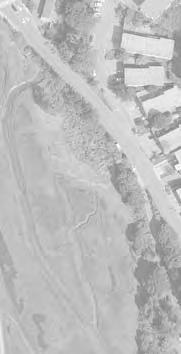
3 birds. In addition the increased tidal inundation will increase the productive contribution of the marsh to the Bay ecosystem. Existing exotic upland vegetation will be cleared and removed from the site prior to excavation activities. An area of existing marsh vegetation will be preserved on the outboard side of the project site to provide a vegetation buffer between the lowered site and the tidal channel. The majority of the earthwork and grading will be the removal of fill and excavation of material to lower the overall site to elevations at which tidal salt marsh vegetation will establish. Some of the grading and excavation will occur in existing wetland areas; these areas will be reconfigured and are expected to reestablish as lower tidal marsh habitat. Soil will be excavated and hauled off-site for disposal at a suitable upland location to be determined by the contractor. The material to be excavated consists of fill of an unknown origin. Composite soil sampling will be conducted prior to any grading activities to characterize possible pollutants at the project site. This information will be provided to the contractor to ensure proper disposal of the excavated material. Excavation activities will be conducted to minimize the potential release of sediments by timing construction in the sub-tidal zone to coincide with low tides as well as by maintaining the vegetation buffer described above. It is anticipated that construction equipment will be working from the existing upland area, but soil conditions may require the use of mats in some areas of the project site. Construction activities will be scheduled to begin outside the Clapper Rail breeding season (February 1 to August 31) and will end before October 15 to comply with City of Mill Valley grading requirements. It is anticipated that the restoration activities will be conducted between September 1 and October 15, 2007 to comply with these restrictions. 3. Site Characteristics: a. Physical characteristics The 0.3 acre (13,000 square feet) project site was historically part of a large area of salt marsh fringing upper Richardson Bay (Figure 6). Over the years the site and much of the surrounding area was filled and the hydrology modified by various urban uses. The proposed project site has been partially filled to above tidal elevations and is currently a combination of upland fill and wetland areas. The current elevation of the site ranges from approximately 1.5 feet NGVD to 7.5 feet NGVD, with the majority of the site situated within an elevation range of 3.0 feet NGVD to 7.5 feet NGVD. The length of shoreline adjacent to the project site is approximately 210 feet. b. Biological characteristics BAYFRONT PARK WETLAND MITIGATION PLAN CITY OF MILL VALLEY PAGE 3
4 Vegetation at the site is a mix of upland species and species typical of tidal estuarine salt marshes in San Francisco Bay. It includes cordgrass (Spartina foliosa), found around MSL to MHW (1.5-2 feet NGVD); pickleweed (Sarcocornia pacifica, formerly Salicornia virginica), found from MHW to MHHW (2-3.5 feet NGVD); saltgrass (Distichlis spicata), found above MHHW to EHW ( feet NGVD); and a variety of upland plants and grasses at higher elevations (>4.5 feet NGVD). Biological resources at the site were analyzed in the Mitigated Negative Declaration adopted for the Mill Valley Community Center project in Biological reports prepared by Entrix, Inc. in 1991 and 1993 looked at the tidal marshland habitat near the project site for sensitive plants and wildlife and reviewed contemporary California Department of Fish and Game Natural Diversity Data Base (CNDDB) records for sensitive species in the project site vicinity. Three species of wildlife (salt marsh harvest mouse, California clapper rail, great blue heron) and two plants (Marin knotweed, Pt. Reyes bird s beak) were reported by CNDDB from the project vicinity, but no sensitive plants or animals were found in the tidal marshland at this proposed mitigation site. D. MITIGATION DESIGN 1. Basis for Design: The mitigation site was chosen for its proximity to the original project site, because it is owned by the City of Mill Valley, and because it was historically part of a large marshland fringing upper Richardson Bay. The site has been partially filled to above tidal elevations. Because it is still adjacent to free-flowing tidal waters it presents an opportunity to restore subtidal and low tide functions through removal of artificial overburden and selective grading to lower overall elevations at the site. 2. Proposed Restoration Project: a. Proposed enhancement actions: PWA conducted vegetation surveys at and near the project site in 1999 and This information was compiled and compared to develop target vegetation criteria for mudflat, cordgrass, pickleweed, and salt grass. The elevation ranges are summarized in Table 1. Table 1: Vegetation Elevation Ranges Vegetation Range Vegetation Type (feet NGVD) unvegetated mudflat < 0.5 cordgrass (Spartina foliosa) pickleweed (Sarcocornia pacifica) salt grass (Distichlis spicata) upland vegetation >4.5 BAYFRONT PARK WETLAND MITIGATION PLAN CITY OF MILL VALLEY PAGE 4
5 Table 2 shows the area of habitat that will be created versus existing habitat that will be impacted by the restoration project. Table 2: Summary of Habitat Areas Existing Habitat Area Impacted by Project (ft 2 ) Estimated New Habitat Area Created by Project (ft 2 ) Net Area (ft 2 ) Vegetation Type unvegetated mudflat cordgrass (Spartina foliosa) 0 2,880 2,880 pickleweed (Sarcocornia pacifica) 710 3,770 3,060 salt grass (Distichlis spicata) 2,330 1, upland vegetation 10,750 5,470-5,280 Figure 2 shows the grading plan for the restoration project. b. Target vegetational communities: upland plantings, wetland communities The reconfigured wetland areas will be allowed to revegetate naturally. Based on experience at other North Bay marshes, PWA (1999) expects that pickleweed will establish in the middle marsh area within the first year, with dense coverage within about five years. Cordgrass is expected to colonize and establish in the low marsh within three to five years, with dense coverage within ten years. Over the long term (15 to 50 years) the site is expected to evolve into a dynamically stable system, with a mix of vegetation types characteristic of natural wetlands (PWA, 1999). Upland areas will be planted with a variety of native plants. The concept plan specifies the use of native vegetation that will allow the restored wetland area to be visible from the adjacent pedestrian trail. Native plants used in the mitigation plantings will be derived from local stock. Upland plantings will be irrigated as needed and maintained by the City of Mill Valley. Native shrubs and perennials that will be planted on the upland area will be selected from appropriate species, including the following: Arroyo willow (Salix lasiolepis), toyon (Heteromeles arbutifolia), California rose (Rosa californica), coyote brush (Baccharis pilularis), gumplant (Grindelia stricta), sea lavender (Limonium californicum). All restoration plantings will be raised from stock taken from local sources, or will be cuttings or seeds collected from local plant material. Other native species suitable for the upland area may be substituted on the recommendation of a qualified native plant restoration specialist. BAYFRONT PARK WETLAND MITIGATION PLAN CITY OF MILL VALLEY PAGE 5
6 Upland areas not planted with native shrubs will be seeded with a mix of saltgrass (Distichlis spicata), meadow barley (Hordeum brachyantherum), yarrow (Achillea millefolium), California brome (Bromus carinatus), annual lupine (Lupinus sp.), California poppy (Eschscholtzia californica) and/or other native species recommended by a revegetation specialist approved by the City. Time of application, application rates, and irrigation requirements will be determined by the native plant restoration specialist. d. Maintenance Upland plantings will be irrigated from an underground City-owned recycled water line already in place at the edge of the restoration area. Irrigation to the upland plantings will be installed and maintained in good working order by the Parks and Recreation Department, who will also be responsible for maintaining the plantings in a healthy condition. Irrigation will be used for the first two or three years to allow the plantings to become established, and may be discontinued when the plantings are capable of surviving without supplemental summer water. Invasive weedy species noted in the annual survey will be removed from the project site. E. Success Criteria and Monitoring 1. Success Criteria: Upland plantings will be replaced as needed to provide 50% survivorship or a satisfactory visual screen at the end of the five year monitoring program. Upland plantings are not part of the wetland mitigation requirement. The wetland mitigation will be deemed successful if, at the end of five years, there is a minimum of 3,500 square feet of low, middle, and upper marsh habitat. The presence of indicator species (Spartina foliosa, Sarcocornia pacifica, Distichlis spicata) and/or evidence of tidal inundation will define the extent of the tidal marsh habitat. 2. Monitoring: a. Methods 1. Photo documentation. Photos will be taken of the existing site before restoration work begins. Following the final grading and installation of upland plantings, a minimum of three photo stations will be established at the site. Stations will be positioned to record the low marsh area, the middle and upper marsh area, and the upland area. Stations will be marked by pvc posts sunk in the ground to a point not over six inches above ground. Photos will be taken at a fixed height from these stations, duplicating the view of prior years. Photos will be taken at the same season at least once each year for the 5-year monitoring period. Photographs will be included in an annual report to be provided to interested agencies. BAYFRONT PARK WETLAND MITIGATION PLAN CITY OF MILL VALLEY PAGE 6
7 2. Vegetation Analysis An annual survey of vegetation at the site will be undertaken in July or August (to capture maximum growth and bloom of marsh vegetation). Two transects each with 50 foot intervals will be established in the first year after grading and will record percent plant cover and species distribution. These data are expected to be adequate to determine if the project objectives are being met given that a range of elevations appropriate for species establishment is known. Pickleweed should begin to establish by the second year and cordgrass by the third or fourth year. Any weedy species will be noted for corrective action or other maintenance, as described above in section D. 2. d., Maintenance. b. Schedule Following completion of the restoration project, the restoration area will be monitored by the City of Mill Valley or by its consultant on an annual basis for a minimum of five years. c. Corrective Management If annual surveys show that the tidal wetland areas are not performing as expected, the City will consult with PWA or another qualified wetland consultant for recommended corrective measures. If, at the end of five years, the target wetland area has not been obtained, the City will consult with interested agencies and with PWA or another qualified wetland consultant, and will institute corrective measures, which may include selective regrading of the site. If performance standards are not met at the end of five years, and if corrective management is required at that time, another five year monitoring program adhering to the specifications of this document will be initiated. d. Reporting Annual monitoring will be conducted in July or August, and an annual report will be prepared by the end of October. Copies of the annual report will be kept on file at the City of Mill Valley Parks and Recreation offices. Copies of the annual report will also be provided to all interested agencies. BAYFRONT PARK WETLAND MITIGATION PLAN CITY OF MILL VALLEY PAGE 7
8 REFERENCES Entrix, Inc Impact assessment of the proposed community center for the City of Mill Valley. Prepared for the City of Mill Valley Impact assessment of the preferred site for the new Mill Valley Community Center. Prepared for the City of Mill Valley Parks and Recreation Department. Philip Williams & Associates (PWA) Mill Valley Community Center tidal wetland mitigation conceptual design. Memorandum report prepared for Don Hunter, City of Mill Valley. BAYFRONT PARK WETLAND MITIGATION PLAN CITY OF MILL VALLEY PAGE 8
9 FIGURES 1-6 BAYFRONT PARK TIDAL WETLAND RESTORATION 1. VICINITY MAP 2. GRADING PLAN 3. GRADING CROSS-SECTION 4. BCDC LIMITS 5. VEGETATION HABITAT AREAS 6. HISTORIC TIDAL MARSH BAYFRONT PARK WETLAND MITIGATION PLAN CITY OF MILL VALLEY PAGE 9
10
11
12
13
14 Vegetation Type Existing Habitat Area Impacted (ft 2 ) Total New Habitat Area Created (ft 2 ) Net Change in Habitat Area unvegetated mudflat cordgrass (Sparina foliosa) 0 2,880 2,880 pickleweed (Sarcocornia pacifica) 710 3,770 3,060 salt grass (Distichlis spicata) 2,330 1, upland vegetation 10,750 5,470-5,280 (ft 2 )
15
Subject: Sea Level Rise Constraints and Opportunities for India Basin
 Memorandum To: Monica Melkesian, Build Inc Cc: From: Leslie Lazarotti lazarotti@wra-cacom Ext 1300 Subject: Sea Level Rise Constraints and Opportunities for Date: July 8, 2015 The impetus for this study
Appendix 5 Vegetation Management of Tidal Marsh Edges, San Francisco Estuary
 Vegetation Management of Tidal Marsh Edges, San Francisco Estuary Working examples of vegetation management strategies for tidal marsh terrestrial edges 5.1. Sonoma Baylands, Sonoma County. Shoreline type:
April 11, 2016 Park Board Chair and Commissioners General Manager Vancouver Board of Parks and Recreation New Brighton Salt Marsh - Preferred Concept
 TO: FROM: SUBJECT: April 11, 2016 Park Board Chair and Commissioners General Manager Vancouver Board of Parks and Recreation New Brighton Salt Marsh - Preferred Concept RECOMMENDATION A. THAT the Vancouver
Stormwater Standards. Clackamas County Service District No. 1. Planting Guide for Buffers
 Stormwater Standards Clackamas County Service District No. 1 APPENDIX B Planting Guide for Buffers Table of Contents Appendix B - Planting Guide for Buffers... Page B.1 General... 1 B.1.1 Introduction...
Restoring Soil Ecology and Native Plant Communities in an Altered Salt Pond Ecotone
 Restoring Soil Ecology and Native Plant Communities in an Altered Salt Pond Ecotone Dylan Chapple Save The Bay/UC Berkeley dylanchapple@berkeley.edu 10/24/2012 Overview Eden Landing Ecological Reserve
Burrowing Owl Habitat Project at the Albany Plateau. (a component project of the Gilman Street Playing Fields Project City of Berkeley) March 10, 2006
 March 10, 2006") Burrowing Owl Habitat Project at the Albany Plateau (a component project of the Gilman Street Playing Fields Project City of Berkeley) March 10, 2006 Submitted by The City of Berkeley Project history During
Burrowing Owl Habitat Project at the Albany Plateau (a component project of the Gilman Street Playing Fields Project City of Berkeley) March 10, 2006 Submitted by The City of Berkeley Project history During
PRE-DESIGN CONCEPT REPORT GRAND CANAL RESTORATION
 PRE-DESIGN CONCEPT REPORT GRAND CANAL RESTORATION Project Background November 19, 2007 Executive Summary The Grand Canal is an important tidal waterway in the Venice community of Los Angeles, California,
Aquatic Park Natural Resource Management Study (NRMS)
") Aquatic Park Natural Resource Management Study (NRMS) Prepared by: Laurel Marcus & Associates Hydroikos Associates 3661 Grand Ave. Suite 204 2175 East Francisco Blvd Suite A Oakland, California 94610 San
Aquatic Park Natural Resource Management Study (NRMS) Prepared by: Laurel Marcus & Associates Hydroikos Associates 3661 Grand Ave. Suite 204 2175 East Francisco Blvd Suite A Oakland, California 94610 San
I. Executive Summary of Project Goals and Results
 I. Executive Summary of Project Goals and Results During the 12 months of this contract (April 1, 2009- March 31, 2010), the Save The Bay (STB) Shoreline Habitat Restoration Project has completed enhancement
Baylands Segment J. Bay between the Golden Gate and Segment J. Coyote Point. of For managed ponds. included habitat enhancement.
 Baylands Segment J Crissy Field Alameda Naval Air Station Heron's Head Park COLMA CREEK SFO Millbrae San Mateo BAYLANDS 2009 SAN FRANCISCO AREA san francisco area Western side of central San Francisco
ME DOT Route 3. File No.: City and State: Bar Harbor, ME
 ME DOT Route 3 File No.: 199600361 City and State: Bar Harbor, ME General Impacts: 0.28 acre tidal emergent 0.77 acre non-tidal forested 0.15 acre non-tidal emergent 0.51 acre non-tidal scrub-shrub Functions
New Brighton Park Shoreline Habitat Restoration Project
 Vancouver Board of Parks and Recreation and Port Metro Vancouver New Brighton Park Shoreline Habitat Restoration Project Conceptual Design Public Consultation August 26 September 9, 2015 Discussion Paper
Baylands Segment P. 206 The Baylands and Climate Change: What We Can Do COYOTE CREEK
 Baylands Segment P BAYLANDS coyote 2009 creek area COYOTE Southern CREEK end of San Francisco Bay AREA between Alviso Slough and Albrae Slough Southern end of San Francisco Bay Baylands between Alviso
Caler Cove Lobster Company
 File No.: 199800920 City and State: Addison, ME Caler Cove Lobster Company General Impacts: 0.17 acre tidal emergent Functions and Values Lost: Production Export Nutrient Exchange Sediment Filtration Fishery
PLANTING OF LARGE SCALE MARSH PROJECTS. Eddie Seidensticker, biologist, Natural Resources Conservation Service
 PLANTING OF LARGE SCALE MARSH PROJECTS Eddie Seidensticker, biologist, Natural Resources Conservation Service As the Houston-Galveston Navigation Channel is expanded, the Beneficial Uses Group (BUG), the
Balancing Conservation and Development on the Jordan River
 Balancing Conservation and Development on the Jordan River Jordan River Parkway Trail Regional Athletic Complex Conservation & Restoration Balancing Conservation and Development on the Jordan River Jordan
[FWS R8 R 2015 N087; FXRS282108E8PD0 156 F ] South Bay Salt Pond Restoration Project, Phase 2; Don Edwards National Wildlife
![[FWS R8 R 2015 N087; FXRS282108E8PD0 156 F ] South Bay Salt Pond Restoration Project, Phase 2; Don Edwards National Wildlife](/thumbs/84/90602803.jpg "[FWS R8 R 2015 N087; FXRS282108E8PD0 156 F ] South Bay Salt Pond Restoration Project, Phase 2; Don Edwards National Wildlife") Surname Billing Code: 4310 55 Deputy RD ARD Refuges DEPARTMENT OF THE INTERIOR Fish and Wildlife Service Solicitor Refuge Supervisor Asst. Refuge Supervisor Ch. Natural Resources Project Leader [FWS R8
Surname Billing Code: 4310 55 Deputy RD ARD Refuges DEPARTMENT OF THE INTERIOR Fish and Wildlife Service Solicitor Refuge Supervisor Asst. Refuge Supervisor Ch. Natural Resources Project Leader [FWS R8
OPPORTUNITIES AND CONSTRAINTS ANALYSIS
 OPPORTUNITIES AND CONSTRAINTS ANALYSIS ALBANY BEACH RESTORATION AND PUBLIC ACCESS FEASIBILITY STUDY EASTSHORE STATE PARK, CALIFORNIA January 14, 2011 OPPORTUNITIES AND CONSTRAINTS ANALYSIS ALBANY BEACH
Wetland Types. Grade Level: Basic. Duration: 30 minutes. Setting: Classroom
 Wetland Types Adapted from: An original Creek Connections activity created by Cassandra Hamilton. Creek Connections, Box E, Allegheny College, Meadville, PA 16335 http://creekconnections.allegheny.edu
Commercial Launch Site Addendum to Wetland Mitigation Plan. Revision 2. April 25, SpaceX Proprietary
 Commercial Launch Site Addendum to Wetland Mitigation Plan Revision 2 April 25, 2017 SpaceX Proprietary Contents 1.0 Project Information... 1 1.1 Background... 1 2.0 Compensatory Mitigation... 2 2.1 Goals
ENVIRONMENTAL INITIAL STUDY BERKELEY CITYWIDE POOLS MASTER PLAN
 ENVIRONMENTAL INITIAL STUDY FOR THE BERKELEY CITYWIDE POOLS MASTER PLAN CITY OF BERKELEY PARKS RECREATION AND WATERFRONT DEPARTMENT SEPTEMBER 1, 2009 ENVIRONMENTAL INITIAL STUDY BERKELEY CITYWIDE POOLS
Kootenai River Habitat Restoration Program June 18, 2018 Kootenai Valley Resource Initiative Update
 Kootenai River Habitat Restoration Program June 18, 2018 Kootenai Valley Resource Initiative Update Kootenai River Habitat Restoration Program Multi-year habitat restoration program Restoration treatments
Chesapeake Bay Critical Area Conservation Plan
 The Maryland-National Capital Park and Planning Commission Prince George s County Planning Department Development Review Division 301-952-3530 Note: Staff reports can be accessed at www.mncppc.org/pgco/planning/plan.htm.
Wisconsin Dept. of Transportation November 2017
 Wisconsin Dept. of Transportation November 2017 Jennifer Gibson WisDOT Environmental Coordinator Mike Helmrick WisDOT Environmental Coordinator Background on compensatory wetland mitigation Site purpose
Restoring Water Ecosystems in NYC Parks
 Restoring Water Ecosystems in NYC Parks Hooked on our Waters Con October 19, 2013 - CUNY Graduate Center Marit Larson NYC Parks Landscape and ecosystem focus Watershed Streams Freshwater wetlands Tidal
Improving Communities Through the Arroyo Seco Sustainability Campaign and Watershed Assessment
 Improving Communities Through the Arroyo Seco Sustainability Campaign and Watershed Assessment Arroyo Seco Headwaters in the San Gabriel Mountains Major tributary to the Los Angeles River 44 square mile
CONSERVATION ELEMENT GOALS, OBJECTIVES, AND POLICIES
 CONSERVATION ELEMENT GOALS, OBJECTIVES, AND POLICIES Goal 4 To conserve, manage, appropriately use and protect the natural resources of the City ensuring continued resource availability and environmental
Natural Shorelines. for Inland Lakes. A Landowner s Guide to using. to STABLIZE SHORELINES, Michigan s inland lakeshore.
 Natural Shorelines for Inland Lakes A Landowner s Guide to using NATURAL MATERIALS to STABLIZE SHORELINES, IMPROVE WATER QUALITY and ENHANCE WILDLIFE HABITAT along Michigan s inland lakeshore. Natural
Prioritizing Tidal Wetlands: A Landscape Approach
 Prioritizing Tidal Wetlands: A Landscape Approach Laura Brophy Director, Estuary Technical Group Institute for Applied Ecology Corvallis, OR College of Earth, Ocean and Atmospheric Sciences, Oregon State
County of Santa Barbara Department of Public Works. SWCA Environmental Consultants. Prepared for: Prepared by:
 for the Goleta Beach Park Bridge Replacement Project, Santa Barbara County, California 05-SB-0-CR Federal Project Number BRLO-5951 (120) Prepared for: County of Santa Barbara Department of Public Works
Section 3 Non-Structural BMPs
 3.1 Stream Buffers A stream buffer or stream setback is a designated area around a stream, lake, or wetland left in a natural, densely vegetated state so as to protect the receiving water quality and provide
A Priceless Opportunity
 AN OPPORTUNITY A Priceless Opportunity Whoever you are, wherever you live, whatever you do, access to parks and open space improves your life. FOUR RICHMOND SHORELINE JEWELS TO POINT PINOLE REGIONAL PARK
BUFFERS, TREE PROTECTION AND LANDSCAPING. Sec Purpose and Intent.
 ARTICLE 20 BUFFERS, TREE PROTECTION AND LANDSCAPING Sec. 20.1. Purpose and Intent. Trees improve air and water quality, reduce soil erosion, reduce noise and glare, provide habitat for desirable wildlife,
PLANT LIST FOR SHORELINE MANAGEMENT
 SHORELINE EVALUATION PROGRAM PLANT LIST FOR SHORELINE MANAGEMENT Following is a list of native s recommended for shoreline management. This list is not comprehensive. Rather, it lists s that are known
Shoreline Master Program Town of La Conner, Washington
 Shoreline Master Program Town of La Conner, Washington Department of Ecology approval effective Adopted September 24, 2013 by Town of La Conner Ordinance No.1106 Amended May 13, 2014 by Town of La Conner
Hunts Point Landing, Bronx, New York
 Hunts Point Landing, Bronx, New York Sustainable Shorelines in an Urban Environment John Roebig, PhD. HDR Engineering, Inc. John.Roebig@hdrinc.com Promoting Resilient Shorelines along the Hudson River
Draft TISCORNIA ESTATE SPECIFIC PLAN/EIR
 Draft TISCORNIA ESTATE SPECIFIC PLAN/EIR Submitted CONTENTS 1. PLAN SUMMARY II. INTRODUCTION IX. SPECIFIC PLAN RELATIONSHIPS X. XI. List of Figures 1. Regional Location 2. Point Richmond Area 3. Planning
BAYLANDS SAN FRANCISQUITO CREEK FLOOD CONTROL2.0. June 2016 A PRODUCT OF FLOOD CONTROL 2.0. landscape change metrics analysis
 SAN FRANCISQUITO CREEK BAYLANDS landscape change metrics analysis June 2016 PROJECT DIRECTION Robin Grossinger Scott Dusterhoff PRIMARY AUTHORS Micha Salomon Scott Dusterhoff DESIGN AND LAYOUT Ruth Askevold
Introduction to Ecology and Regulation of Tidal Wetlands in Central California and the San Francisco Bay. August 17, 2005
 Bibliography and Additional Resources for Hydrology, Soils, and Plants NERR Coastal Training Program, Workshop on Tidal Wetlands GENERAL ARTICLES Allen, J. R. L., and K. Pye. 1992. Saltmarshes : Morphodynamics,
Juneau Watershed Partnership
 Juneau Watershed Partnership Native Plant Resource Center Final Report A Partners for Fish and Wildlife Project Prepared for: U.S. Fish and Wildlife Service For Grant #F11C00552 Prepared by: The Juneau
Volume 2, Chapter 12 - Revegetation
 Volume 2, Chapter 12 - Revegetation Users Guidance: If a UDFCD Section number in this chapter is skipped: It was adopted as is; please refer to that Section in the corresponding UDFCD Manual, Volume, Chapter
HABITAT RESTORATION PLAN FOR WHITE POINT LANDSLIDE REPAIR
 HABITAT RESTORATION PLAN FOR WHITE POINT LANDSLIDE REPAIR MITIGATION OCTOBER 30, 2014 1 INTRODUCTION This habitat restoration plan was prepared for the White Point Nature Preserve, for 1.5 acres that were
A comparison of Traditional and Prefabricated Encapsulated Soil Lifts
 A comparison of Traditional and Prefabricated Encapsulated Soil Lifts Jane Herbert, Senior Extension Educator 2014 Wisconsin Lakes Convention Background on shoreline erosion control in MI KBS Shoreline
APPENDIX 1: SCOPED ENVIRONMENTAL IMPACT STATEMENT (EIS) FORM
 FORM") APPENDIX 1: SCOPED ENVIRONMENTAL IMPACT STATEMENT (EIS) FORM This form is intended for use by applicants (primarily private landowners) who need to conduct a Scoped EIS in support of minor development
APPENDIX 1: SCOPED ENVIRONMENTAL IMPACT STATEMENT (EIS) FORM This form is intended for use by applicants (primarily private landowners) who need to conduct a Scoped EIS in support of minor development
North Carolina Coastal Federation
 North Carolina Coastal Federation Erosion Control: Non-Structural Alternatives A Shorefront Property Owner s Guide Shoreline erosion and landward migration of marshes are natural processes, and are important
Rule D Wetland and Creek Buffers
 Rule D Wetland and Creek Buffers 1 Policy It is the policy of the Board of Managers to ensure the preservation of the natural resources, recreational, habitat, water treatment and water storage functions
STREAM BUFFERS
 88-415 STREAM BUFFERS 88-415-01 PURPOSE In the Kansas City region and throughout the nation, vegetated stream buffers have been clearly shown to protect stream stability and related infrastructure, improve
PHASE 3-4 PARKS SOUTH PARK AND CHANNEL PARK
 PHASE 3-4 PARKS SOUTH PARK AND CHANNEL PARK Sheet List L1.0 L2.0 L3.0 L4.0 L5.0 L6.0 L7.0 L8.0 L9.0 L10.0 L11.0 L12.0 L13.0 L14.0 L15.0 L16.0 L17.0 L18.0 L19.0 L20.0 L21.0 L22.0 Cover Open Space Context
ADDENDUM TO BIOLOGICAL SCOPING SURVEY REPORT, BOTANICAL SURVEY AND WETLAND DELINEATION
 ADDENDUM TO BIOLOGICAL SCOPING SURVEY REPORT, BOTANICAL SURVEY AND WETLAND DELINEATION FOR AVALON INN (APN 069-241-27 & -04) 1201 & 1211 NORTH MAIN STREET FORT BRAGG, CA MENDOCINO COUNTY prepared for:
MEMORANDUM OF BOG TURTLE HABITAT INVESTIGATION
 MEMORANDUM OF BOG TURTLE HABITAT INVESTIGATION 410-728-2900 Fax: 410-728-3160 www.rkk.com To: From: CC: U.S. Fish and Wildlife Service, Pennsylvania Fish and Boat Commission Jennifer A Ottenberg Miller,
Planning for Staten. Habitat Restoration and Green Infrastructure. Island s North Shore
 Habitat Restoration and Green Infrastructure Planning for Staten Island s North Shore Community Board 1 March 1, 2018 NYC Parks Forestry, Horticulture, and Natural Resources Funded by the NYS Department
ALTERNATIVE SHORELINE MANAGEMENT IN COASTAL MISSISSIPPI
 ALTERNATIVE SHORELINE MANAGEMENT IN COASTAL MISSISSIPPI Project supported via financial assistance provided by the Coastal Zone Management Act of 1972, as amended, administered by the Office of the Ocean
DRAFT MAP AMENDMENT FLU 04-4
 DRAFT MAP AMENDMENT FLU 04-4 SW 24 TH AVENUE ROADWAY CORRIDOR The University of Florida participates with the Metropolitan Transportation Planning Organization (MTPO) in its responsibilities for the continuing,
Port of San Diego Sea Level Rise Ad Hoc Committee Meeting 1 of 3.. September 18, 2018
 Port of San Diego Sea Level Rise Ad Hoc Committee Meeting 1 of 3. September 18, 2018 Agenda Welcome Introductions Rules of the Ad-Hoc Presentation Background Vulnerability Assessment Results Non-Agenda
Green Design Principles
 Green Design Principles restoration planting Ecosystem restoration, including preserving and enhancing existing vegetation and where feasible, introducing new vegetative communities, benefits the stream
CITY OF LARKSPUR, CALIFORNIA GENERAL PLAN CHAPTER 6, ENVIRONMENTAL RESOURCES CONTENTS
 CITY OF LARKSPUR, CALIFORNIA GENERAL PLAN CHAPTER 6, ENVIRONMENTAL RESOURCES CONTENTS Chapter 6, Environmental Resources Open Space Hillsides and Ridges Shoreline and Marsh Areas Balance Between Recreational
Conserving Ca[ifomiaJs Wi[tf[ife Si~e 1870
 State of California - The Resources Aqency DEPARTMENT OF FISH AND GAME huo:/ /www.dfg.ca.gov POST OFFICE BOX 47 YOUNTVillE, CALIFORNIA 94599 (707) 944-5500 ARNOLD SCHWARZENEGGER. Governor October 5,2007
Working Group Meeting
 April 4,, 2017 Parks Operations Bldg Working Group Meeting Arts Districts Overview Stormwater/RPA/Stream Considerations First Principles Agenda 7:00pm 7:05pm 7:10pm 7:40pm 8:30pm 9:40pm 9:45pm Welcome
RD:VMT:JMD 10/14/2015 RESOLUTION NO.
 RD:VMT:JMD 10/14/2015 RESOLUTION NO. A RESOLUTION OF THE COUNCIL OF THE CITY OF SAN JOSE ADOPTING THE EDENVALE AVENUE PLANNED DEVELOPMENT REZONING PROJECT MITIGATED NEGATIVE DECLARATION, FOR WHICH AN INITIAL
las vegas wash coordination committee
 las vegas wash coordination committee lvwash.org DU Wetlands No. 1 Weir Planting Plan February 2013 DU Wetlands No. 1 Weir Planting Plan SOUTHERN NEVADA WATER AUTHORITY Las Vegas Wash Project Coordination
STAFF REPORT FOR STANDARD COASTAL DEVELOPMENT PERMIT #CDP FEBRUARY 26, 2015 CPA - 1 PO BOX 238 APTOS, CA 94001
 STAFF REPORT FOR STANDARD COASTAL DEVELOPMENT PERMIT #CDP 2014-0030 FEBRUARY 26, 2015 CPA - 1 OWNER/APPLICANT: AGENT: REQUEST: HANS HEIM PO BOX 238 APTOS, CA 94001 JAMES HAY PO BOX 762 MENDOCINO, CA 95460
Department of Community Development. Planning and Environmental Review Division Revised Notice of Preparation
 Department of Community Development Michael J. Penrose, Acting Director Divisions Building Permits & Inspection Code Enforcement County Engineering Economic Development & Marketing Planning & Environmental
ReWild Mission Bay PUBLIC WORKSHOP #2
 ReWild Mission Bay PUBLIC WORKSHOP #2 What is ReWild Mission Bay? WELCOME With ReWild Mission Bay, San Diego Audubon is facilitating a three-year planning process that includes collecting community input
ReWild Mission Bay PUBLIC WORKSHOP #2
 ReWild Mission Bay PUBLIC WORKSHOP #2 WELCOME What is ReWild Mission Bay? With ReWild Mission Bay, San Diego Audubon is facilitating a three-year planning process that includes collecting community input
San Francisco Bay Area Upland Habitat Goals Project
 San Francisco Bay Area Habitat Preserving Biological Diversity for Future Generations A of the Bay Area Open Space Council funding provided by: California State Coastal Conservancy Gordon and Betty Moore
Karen A. Duhring Marine Advisory Scientist Center for Coastal Resources Management Virginia Institute of Marine Science College of William & Mary
 Karen A. Duhring Marine Advisory Scientist Center for Coastal Resources Management Virginia Institute of Marine Science College of William & Mary March 20, 2009 Low-Impact Shoreline Stabilization Cumulative
YEAR 2 FIRST QUARTER REPORT
 ENVIRONMENTAL STEWARDSHIP PROJECT YEAR 2 FIRST QUARTER REPORT DECEMBER 23, 2009 Prepared for: NATIONAL OCEANIC AND ATMOSPHERIC ADMINISTRATION Prepared by: CITY OF TACOMA 1.0 Introduction In accordance
Building Ecological Solutions to Coastal Community Hazards: Guidance and NJ Coastal Community Assistance
 Building Ecological Solutions to Coastal Community Hazards: Guidance and NJ Coastal Community Assistance Stacy Small-Lorenz National Wildlife Federation Restore America s Estuaries Summit New Orleans,
2001 Southeastern Pennsylvania Stormwater Management Symposium Villanova University. Jean K. Akers
 2001 Southeastern Pennsylvania Stormwater Management Symposium Villanova University Abstract Planting For Water Quality Incorporating plantings into stormwater BMP design to improve water quality. Jean
Ecological Restoration at the Las Vegas Springs Preserve. Von K. Winkel, Ph.D.
 Ecological Restoration at the Las Vegas Springs Preserve Von K. Winkel, Ph.D. The Las Vegas Springs Before Disturbance The springs are very large. A small creek flows from each of 3 or 4 springs and
Response to Comments (July 28, 2010 Oregon City Determination of Application Completeness Memo)
") Environmental Science & Assessment, LLC MEMORANDUM DATE: August 13, 2010 TO: Oregon City Planning CC: Jill Long Lane Powell FROM: RE: Jack Dalton Response to Comments (July 28, 2010 Oregon City Determination
Environmental Science & Assessment, LLC MEMORANDUM DATE: August 13, 2010 TO: Oregon City Planning CC: Jill Long Lane Powell FROM: RE: Jack Dalton Response to Comments (July 28, 2010 Oregon City Determination
ZANDER ASSOCIATES Environmental Consultants
 ZANDER ASSOCIATES Environmental Consultants June 23, 2011 Massy Mehdipour 1425 Dana Ave. Palo Alto, CA 94301 Supplemental Biological Resource Assessment 1170 Signal Hill Road Pebble Beach, Monterey County,
Lake Ogallala Bathometric Project
 THE CENTRAL NEBRASKA PUBLIC POWER AND IRRIGATION DISTRICT Lake Ogallala Bathometric Project Mitigation Area Vegetation Monitoring Year 2 Mark Peyton 9/20/2012 Lake Ogallala Bathometric Project Mitigation
Sustainable TamAlmonte 215 Julia Avenue Mill Valley, CA 94941
 Sustainable TamAlmonte 215 Julia Avenue Mill Valley, CA 94941 July 5, 2016 Marin County Community Development Agency, Planning Division 3501 Civic Center Dr., Room 308 San Rafael, CA 94903 Attention: Planner
Melissa McMaster Restoration Coordinator
 Melissa McMaster Restoration Coordinator wildlife habitat specific threatened and endangered species habitat grazing shade recreation water storage fire risk reduction community stewardship ecosystem resiliency
5.0 Storm Water Landscape Guidance Introduction
 5.0 Storm Water Landscape Guidance Introduction Landscaping is a critical element to improve both the function and appearance of storm water management practices. Integrated storm water landscapes can
Grave Creek Riparian Revegetation 2011 Implementation Report
 Task Order #1008 Grave Creek Riparian Revegetation 2011 Implementation Report Prepared for: Kootenai River Network P.O. Box 491 Libby, MT 59923 Prepared by: Geum Environmental Consulting, Inc. 307 State
Nature-Based Adaptation Projects Challenges and Opportunities in California Marilyn Latta, Project Manager California State Coastal Conservancy
 Nature-Based Adaptation Projects Challenges and Opportunities in California Marilyn Latta, Project Manager California State Coastal Conservancy Restore America s Estuaries California State Coastal Conservancy
Regional Restoration Planning:
 Regional Restoration Planning: A Case Study in Collaborative Restoration Science and Planning Campbell Ingram, Executive Officer NCER August 28, 2018 Co-Equal Responsibilities Act as a primary state agency
Public Review Draft Oceanside Subarea Habitat Conservation Plan/ Natural Communities Conservation Plan
 Oceanside Subarea Habitat Conservation Plan/ Natural Communities Conservation Plan Prepared for City of Oceanside Planning Department 300 N. Coast Highway Oceanside, CA 92054 Prepared by Ogden Environmental
III. PROJECT DESCRIPTION
 III. PROJECT DESCRIPTION A. PROJECT LOCATION Regional Setting The project site is located in the southeast quadrant of the City of Chico in Butte County, California and is comprised of four parcels totaling
City of Larkspur. Notice of Mitigated Negative Declaration for the 285
 Notice of Mitigated Negative Declaration for the 285 Magnolia Avenue Mixed-Use Project Date: December 2, 2013 Responsible Agency: Project Title: 285 Magnolia Avenue Mixed-Use Project Project Address: 285
Tentatively Selected Plan within Harlem River, East River and Western Long Island Sound Planning Region. First Level Costs. Federal Non-Federal Total
 HARLEM RIVER, EAST RIVER AND WESTERN LONG ISLAND SOUND PLANNING REGION Flushing Bay and Creek Ecosystem Restoration Source Feasibility Study Background Study Resolution (1994), Reconnaissance Report (1996),
APPENDIX C NATURAL RESOURCES MANAGEMENT PLAN: ACTIONS AND PRIORITIES
 APPENDIX C NATURAL RESOURCES MANAGEMENT PLAN: ACTIONS AND PRIORITIES TABLE C-1: Resource Actions and Priorities GOAL NRM-4 Objective 4.1: Restore Natural floodplain functions. Objective 4.2: Define and
Monitoring and Maintenance Permit Process
 Karen A. Duhring Marine Advisory Scientist Center for Coastal Resources Management Virginia Institute of Marine Science College of William & Mary April 9, 2010 Living Shorelines for Contractors and Project
Flat Lake, Highway 103, HADD Compensation Project (DFO HADD Authorization 03-G8-068): 2010 Vegetation Monitoring
: 2010 Vegetation Monitoring") Flat Lake, Highway 103, HADD Compensation Project (DFO HADD Authorization 03-G8-068): 2010 Vegetation Monitoring Year 5 Final Diane LaRue, Vegetation Consultant Environmental Services, NSTIR Monitored
Flat Lake, Highway 103, HADD Compensation Project (DFO HADD Authorization 03-G8-068): 2010 Vegetation Monitoring Year 5 Final Diane LaRue, Vegetation Consultant Environmental Services, NSTIR Monitored
Planning for Staten. Habitat Restoration and Green Infrastructure. Island s North Shore
 Habitat Restoration and Green Infrastructure Planning for Staten Island s North Shore Walker Park December 7, 2017 NYC Parks Forestry, Horticulture, and Natural Resources Funded by the NYS Department of
RAIN GARDEN ILLINOIS URBAN MANUAL PRACTICE STANDARD. (feet) CODE 897 DEFINITION
 CODE 897 DEFINITION") ILLINOIS URBAN MANUAL PRACTICE STANDARD RAIN GARDEN (feet) CODE 897 Source: Kendall County Soil and Water Conservation District DEFINITION Rain gardens are small, shallow, flat bottomed depressions constructed
ILLINOIS URBAN MANUAL PRACTICE STANDARD RAIN GARDEN (feet) CODE 897 Source: Kendall County Soil and Water Conservation District DEFINITION Rain gardens are small, shallow, flat bottomed depressions constructed
Ashbridges Bay Erosion and Sediment Control Project
 Ashbridges Bay Erosion and Sediment Control Project Project Brief Overview Toronto and Region Conservation Authority, in partnership with the City of Toronto, intends to carry out remedial erosion control
Table of Contents TABLE OF CONTENTS SECTION TITLE PAGE
 TABLE OF CONTENTS SECTION TITLE PAGE 1 INTRODUCTION AND OVERVIEW 1-1 1.1 Purpose and Need 1-1 1.2 Goals and Objectives 1-3 1.3 Overview of the Planning Process 1-5 1.4 Federal and State Requirements and
Bristol Marsh Heritage Conservancy
 Bristol Marsh Heritage Conservancy The Pennsylvania Environmental Council (PEC) protects and restores the natural and built environments through innovation, collaboration, education and advocacy. PEC believes
Pike River Restoration Adaptive Design: Restoring Structure and Function in an Urban Floodplain - from cabbages to cordgrass
 Pike River Restoration Adaptive Design: Restoring Structure and Function in an Urban Floodplain - from cabbages to cordgrass Alice Thompson, PWS & Heather Patti, PWS Pike River Re-imaginedfrom Cabbage
The use of heavy machinery to remove Ammophila arenaria from native sand dunes at. Point Reyes National Seashore. Ben Peterson
 Ben Peterson Point Reyes National Seashore Point Reyes National Resource Management The use of heavy machinery to remove Ammophila arenaria from native sand dunes at Point Reyes National Seashore Native
The Napa River Flood Protection Project
 The Napa River Flood Protection Project Creating Flood Protection and Restoring Geomorphic and Biological Processes Jeremy Sarrow, Napa County Flood Control & Water Conservation District June 2, 2014.
The Reedville Living Shoreline
 E The Reedville Living Shoreline Teaching Garden Garden This garden was designed to demonstrate an environmentally friendly approach to shoreline stabilization and natural landscaping. Established in 2005
TRCA Field Staking Protocol December 2016
 Page 1 of 6 TRCA Field Staking Protocol December 2016 This Protocol describes TRCA staff s current practice for field staking the physical top of bank, the physical toe of slope, and the limit of existing
ENBRIDGE GAS DISTRIBUTION INC. Proposed Relocation for Ninth Line, Markham and Whitchurch-Stouffville. Environmental Screening Report
 Page 1 of 18 ENBRIDGE GAS DISTRIBUTION INC. Proposed Relocation for Ninth Line, Markham and Whitchurch-Stouffville Environmental Screening Report July 2011 Page 2 of 18 Table of Contents 1.0 INTRODUCTION
Morro Shoulderband Snail Protocol Survey Report for the Parcel at 3093 Beachcomber Drive, Morro Bay, San Luis Obispo County, California
 Morro Shoulderband Snail Protocol Survey Report for the Parcel at 3093 Beachcomber Drive, Morro Bay, San Luis Obispo County, California Prepared for: John K. Construction Inc. Prepared by: SWCA Environmental
Habitat Improvements to the Motor Island Shoreline in the Upper Niagara River, NY: A Collaborative Approach
 Habitat Improvements to the Motor Island Shoreline in the Upper Niagara River, NY: A Collaborative Approach Edward Alkiewicz 1, Stephen Schoenwiesner 1, Jeff Gerlach 1, Morris Perot 2, Scott Ault 2, Mark
UNIVERSITY OF CALIFORNIA, SAN DIEGO
 UNIVERSITY OF CALIFORNIA, SAN DIEGO BERKELEY DAVIS IRVINE LOS ANGELES MERCED RIVERSIDE SAN DIEGO SAN FRANCISCO SANTA BARBARA SANTA CRUZ CAMPUS PLANNING 9500 GILMAN DRIVE # 0074 TEL: (858) 534 6515 LA JOLLA,