Ingram Engineering Services, Inc. 16 Hagerty Blvd. Suite 400 West Chester PA Office Fax
|
|
|
- Karen Shields
- 5 years ago
- Views:
Transcription
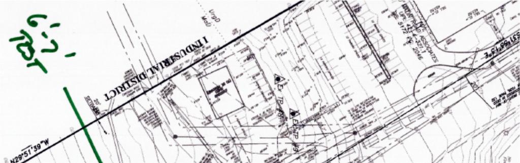
1 CLIENT: Inland Design PROJECT: 10 Malin Road REQUIREMENT: PROFESSIONAL ENGINEERING SERVICES: Geotech/SW LOCATION: 10 Malin Road, West Whiteland Township DATE: September 8, 2014 ATTENTION: Chuck Dobson, P.E. via Bo Erixxon, Project Manager via PURPOSE The purpose of this report is to present the Findings, Conclusions and Recommendations relative to the physical investigation performed at the above captioned project location. INVESTIGATION Jason Culp, P.E. and Nick Banta were present on site Friday September 5 th, 2014 to conduct a subsurface investigation at the above mentioned project location. The investigation included eight (8) double ring infiltrometer tests to be conducted within proposed infiltration areas. The exact design of the stormwater facilities was not currently known as site data was required to provide preliminary design. The findings and conclusions generated are to provide the initial broad range characteristics for design. A final more detailed investigation of the site may be required as the design proceeds further. In additional to information for the Stormwater related facilities IES was also requested to record pertinent construction costs aspects of the site such as shallow groundwater, soil suitability, rock depth etc. Testing was conducted according to the Pennsylvania Stormwater Best Management Guidelines Appendix C: Site Evaluation and Soil Testing Procedures. All double ring tests were presoaked for a minimum of one hour or two 30 minute intervals prior to recording measured infiltration readings. FINDINGS The Findings below use abbreviated nomenclature germane to soil morphology and other BMP terminology. 1
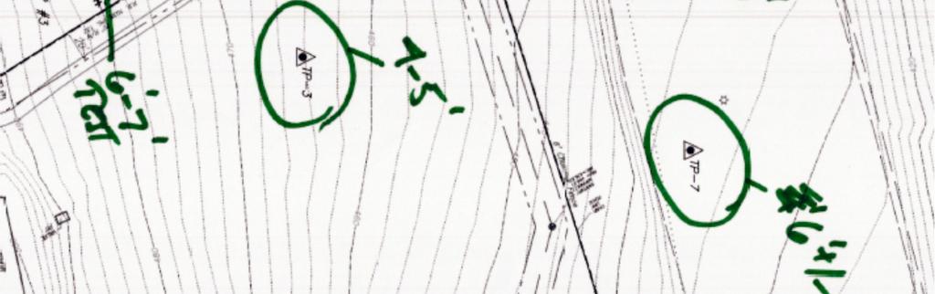
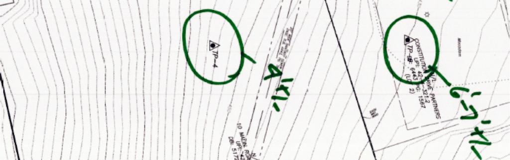
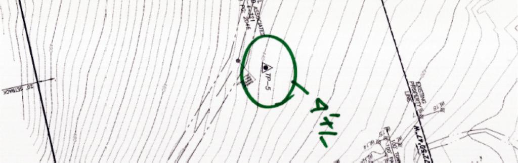
2 Test Pit Logs: TP no. 1 Tested at Topsoil Root mat 8-30 Lt. Brn. To Red Sandy SILT Decomposed Schist 80-90% Coarse Fragments, very friable coarse Fragments (Channers) can be broken with significant hand pressure to rock hammer strikes Near vertical strike dipping towards the upslope side Limiting Zone 11, lack of sufficient soil medium will require filtering TP no. 2 Tested at Topsoil Root mat Reddish Gravels and Channerrs w/ Sandy SILT Reddish Channers (schist) fragments with soil filled bedding/fracture planes Soil fill is reddish Silty SAND; coarse Fragments (Channers) can be broken with significant hand pressure to rock hammer strikes Near vertical strike dipping towards the upslope side No GW or Limiting Zone Encountered, lack of sufficient soil medium will require filtering TP no. 3 Tested at Topsoil Root mat 7-55 Reddish Brn Channery Mica SILT Tan/White Mica v.f. SAND & SILT Channery Friable coarse fragments No GW or Limiting Zone Encountered TP no BGS 0-12 Topsoil Root mat Lt. Brn Channery Sandy SILT Reddish Brn Channery Mica SILT Friable coarse fragments Tan/White Mica v.f. SAND & SILT Channery Friable coarse fragments No GW or Limiting Zone Encountered TP no BGS 0-8 Topsoil Root mat 8-89 Lt Brn Gravels/Channers & f. Sandy Mica SILT Reddish Brn Channery Mica SILT Friable coarse fragments Tan/White Mica v.f. SAND & SILT 168 No GW or Limiting Zone Encountered 2
3 TP no BGS 0-3 Asphalt Subbase 3A modified Tan Sandy SILT Previous fill Reddish Brn-Grey-Var v.f. Sandy Mica SILT Saprilite, very Friable CF s Grey Mica SILT, Saprolite Friable CF s No GW or Limiting Zone Encountered TP no BGS 0-3 Asphalt 3-8 Subbase 3A modified 8-30 Brn f. Sandy Mica SILT l/s Previous fill Gravels Grey Mica SILT S Saprolite of parent formation Grey Mica SILT, Saprolite Friable CF s No GW or Limiting Zone Encountered TP no BGS 0-3 Asphalt 3-8 Subbase 3A modified 8-65 Gravelly v.f. Sandy Mica SILT Friable CF s, Fill Grey/Tan/Var. v.f. Sandy SILT v. micaceous very steeply Very friable CF s, to near vertical bedding decomposed schist No GW or Limiting Zone Encountered Infiltration Testing TP No final stabilized reading with 10 minute intervals 24.0 inches/hour Final Stabilized 65 inches BGS TP No. 2 3 ½ 3 ½ 3 ½ 3 ½ 3 ½ 3 ½ 3 ½ final stabilized reading with 10 minute intervals 21.0 inches/hour Final Stabilized 58 inches BGS TP No. 3 ⅝ ¼ ¼ ¼ ¼ final stabilized reading with 30 minute intervals 0.25 inches/hour Final Stabilized 70 inches BGS TP No. 4 ½ ½ ½ 3/8 3/8 3/8 final stabilized reading with 30 minute intervals 0.75inches/hour Final Stabilized 74 inches BGS TP No ⅝ ½ ½ ½ ½ final stabilized reading with 30 minute intervals 3
4 1.0 inches/hour Final Stabilized 79 inches BGS TP No final stabilized reading with 30 minute intervals 2.0 inches/hour Final Stabilized 78 inches BGS TP No. 7 ¼ ¼ ¼ ¼ ¼ final stabilized reading with 30 minute intervals 0.5inches/hour Final Stabilized 78 inches BGS TP No ¼ 1¼ 1¼ 1¼ 1¼ final stabilized reading with 30 minute intervals 2.5inches/hour Final Stabilized 84 inches BGS CONCLUSIONS 1. The Design Engineer is recommended to use the above information for sizing the Proposed Stormwater Management Facilities with a slight rate reduction for subsurface infiltration facilities to ensure the longevity of the systems given the presence of fine grain soils and cohesive soil content. 2. The saprolite to residium strata that all tests were conducted within is highly variable both vertically and laterally. The majority of test areas with well draining tests was due to the near vertical bedding planes of the decomposed parent material (schist). The rapidly draining areas of test pits 1 and 2 is composed of decomposed parent rock, in this case Micaceous Schist to Gneiss. The material is highly decomposed however is in a platy, vertical orientation which promotes infiltration through the macropores of the soil/rock medium. In this area a filter layer of concrete sand will be necessary to ensure the proper filtering of pollutants to ensure water quality requirements are met. 3. We strongly recommends that a qualified Soil Engineer or representative thereof be present during infiltration facility installation to ensure the stone facility-sand-soil interface is placed at an appropriate depth to maximize recharge. Facility bottom elevation often varies as overlying soils are not uniform thus requiring over excavation in localized areas of the facility to maximize infiltration potential. 4. The geotextile fabric is recommended to not be utilized at the bottom of any infiltration facility as the liner is serving too often as a hydraulically restrictive material and creating a bath tub effect, ergo only utilize the geotextile on the sides and top of the trench. 5. Test Pit no. 1 is the only area which exhibited somewhat shallow rock refusal. All other test pits were excavated down to the maximum reach of the excavator. Most of the material is fractured and decomposed and therefore rippable, especially in a larger excavation. 4

5 6. The soils encountered are fine grained soils that are very moisture sensitive. Areas that achieve compaction will be susceptible to breakdown with repeated construction traffic on top of those areas. Additionally, the coarse fragments throughout the site are easily fractured and broken down and therefore will have similar negative effect with repeated traffic. 7. The site topography and open rapidly draining strata encountered at the upslope portion of the site may result in areas downslope receiving intermittent seepage in localized areas. This should be considered for design of retaining walls and for mitigation in any construction activities. 8. Refer to the attached laboratory data for additional information regarding the findings above. 9. Test Pit locations were provided in the field by Inland Design. Please refer to the attached image of then plan provided to IES for test pit locations. 10. Please contact IES should questions/concerns relative to subsurface geology arise during planning or construction phases of this project as actual field conditions are expected to vary and this report does not speak to all possible issues that might arise. Very Truly Yours, Jason Culp, P.E. Project Manager Ingram Engineering Services, Inc office fax Chadd W. Ingram, P.E. (DE, MD, NJ, PA), S.E.O. Principal & CEO Ingram Engineering Services, Inc office fax 5

6 Ingram Engineering Services, Inc. 6
7 7
8 8
9 9
10 10
11 11
12 12
ASCE - Philadelphia. Soils & Stormwater Management. Matthew C. Hostrander, CPSS, SEO Soil Scientist. Gilmore & Associates, Inc.
 ASCE - Philadelphia Soils & Stormwater Management Matthew C. Hostrander, CPSS, SEO Soil Scientist Gilmore & Associates, Inc. Course Overview COURSE OUTLINE Soil Science Fundamentals Discuss United States
Subsurface Infiltration Bed
 Subsurface Infiltration Bed The Subsurface Infiltration Bed BMP consists of a storage bed underlying either a vegetated or hardscaped surface for the purpose of temporary storage and infiltration of stormwater
APPENDIX A SIMPLIFIED APPROACH TO STORMWATER MANAGEMENT FOR SMALL PROJECTS. In West Sadsbury Township, Chester County, Pennsylvania
 APPENDIX A SIMPLIFIED APPROACH TO STORMWATER MANAGEMENT FOR SMALL PROJECTS In West Sadsbury Township, Chester County, Pennsylvania TABLE OF CONTENTS I. Introduction 3 II. Importance of Stormwater Management
Urban Conservation Practice Physical Effects ESTABLISHMENT, GROWTH, AND HARVEST NUTRIENT MANAGEMENT
 NOT WELL 800 - Urban Stormwater Wetlands A constructed system of shallow pools that create growing conditions for wetland plants to lessen the impacts of stormwater quality and quantity in urban areas.
PHYSICAL CHAtlACTERISTICS REPORT FOR THE PROPOSED SAND AND GRAVEL SITE AT MANOR FARM, UFFINGTON
 PHYSICAL CHAtlACTERISTICS REPORT FOR THE PROPOSED SAND AND GRAVEL SITE AT MANOR FARM, UFFINGTON Introduction Following the" request for detailed information on the physical characteristics of soil at Manor
ON LANDSCAPING, SOILS, SOIL AMENDMENTS AND PROPER SEED ESTABLISHMENT (BOTH GRASS LAWNS AND MEADOWS).
.") ON LANDSCAPING, SOILS, SOIL AMENDMENTS AND PROPER SEED ESTABLISHMENT (BOTH GRASS LAWNS AND MEADOWS). John D. Chibirka USDA-NRCS Resource Soil Scientist 1238 County Welfare Road, Suite 220 Leesport, PA
ON LANDSCAPING, SOILS, SOIL AMENDMENTS AND PROPER SEED ESTABLISHMENT (BOTH GRASS LAWNS AND MEADOWS). John D. Chibirka USDA-NRCS Resource Soil Scientist 1238 County Welfare Road, Suite 220 Leesport, PA
2.1.4 Roof Downspout Rain Gardens
 2008 SWMM, 2010 Revision City of Tacoma 2.1.4 Roof Downspout Rain Gardens Purpose and Definition Bioretention areas are shallow stormwater retention facilities designed to mimic forested systems by controlling
Mature basalt volcanic soils
 MANAGING NORTHLAND SOILS Mature basalt volcanic soils 8.1.2 Soil types in this group Kerikeri friable clay (KE) Kerikeri friable clay with large boulders (KEb) Matarau friable clay (MC, MCH*) Matarau friable
2012 FINAL SOILS AREA 2 Envirothon Questions Answer KEY
 2012 FINAL SOILS AREA 2 Envirothon Questions Answer KEY Questions 1-6 to be answered at the soil pit: 1. Soil scientists categorize soils by drainage classes. What is the drainage class of the soil at
Infiltration basin under normal conditions, with generous grassed area for water soakage (Source: WSUD in the Sydney Region)
") Practice Notes Infiltration basin under normal conditions, with generous grassed area for water soakage (Source: WSUD in the Sydney Region) Water sensitive development involves simple design and management
Practice Notes Infiltration basin under normal conditions, with generous grassed area for water soakage (Source: WSUD in the Sydney Region) Water sensitive development involves simple design and management
E R O S I O N C O N T R O L
 E R O S I O N C O N T R O L GEOTEXTILES T O U G H O V E R T I M E EROSION CONTROL 1.0 Features of PERMANENT PG 2 EROSION CONTROL 2.0 How Typar geotextiles PG 2 work 4.0 Installation guide PG 6 5.0 Overlap
My Soil Won t Drain, Can I Still Use LID? Rob Buchert, John Knutson, Erik Pruneda
 My Soil Won t Drain, Can I Still Use LID? Rob Buchert, John Knutson, Erik Pruneda Presentation Topics Background information Designing LID for cold and snow prone conditions Applying LID in Pullman s low
JULY 23, 2018 PROJECT REPORT OF GEOTECHNICAL EXPLORATIONS CASS GILBERT MEMORIAL PARK SOLAR GARDEN CAPITOL COMPLEX ST.
 This document is made available electronically by the Minnesota Legislative Reference Library as part of an ongoing digital archiving project. http://www.leg.state.mn.us/lrl/lrl.asp Independent Indepedent
Image: Montana NRCS USDA
 Vegetated Swale Vegetated Swales are broad shallow channels topped with vegetation, also known as bioswales. Swales are designed to slow runoff, promote infiltration, and filter out pollutants and sediments.
Report on a soil survey and agricultural suitability investigation of the property known as Erf 660, De Doorns.
 De Doorns erf 660 Soil Report 1 Report on a soil survey and agricultural suitability investigation of the property known as Erf 660, De Doorns. by F. Ellis September 2006 CONTENTS 1 INTRODUCTION AND TERMS
Section 1. Judging the soil pit (questions 1-4)
") CONNECTICUT ENVIROTHON 2009 SOILS QUESTIONS Please select the best response to the following questions. There are 25 questions; each question is worth 4 points. Section 1. Judging the soil pit (questions
CONNECTICUT ENVIROTHON 2009 SOILS QUESTIONS Please select the best response to the following questions. There are 25 questions; each question is worth 4 points. Section 1. Judging the soil pit (questions
Structural Storm Water Best Management Practices (BMPs)
") Structural Storm Water Best Management Practices (BMPs) Storm Water Permitting: The SWPPP Revealed By Deron Austin, PE January 11, 2006 3:30-5:00 PM Orlando, Florida Presentation Outline Preface About
Structural Storm Water Best Management Practices (BMPs) Storm Water Permitting: The SWPPP Revealed By Deron Austin, PE January 11, 2006 3:30-5:00 PM Orlando, Florida Presentation Outline Preface About
RAIN GARDEN ILLINOIS URBAN MANUAL PRACTICE STANDARD. (feet) CODE 897 DEFINITION
 CODE 897 DEFINITION") ILLINOIS URBAN MANUAL PRACTICE STANDARD RAIN GARDEN (feet) CODE 897 Source: Kendall County Soil and Water Conservation District DEFINITION Rain gardens are small, shallow, flat bottomed depressions constructed
ILLINOIS URBAN MANUAL PRACTICE STANDARD RAIN GARDEN (feet) CODE 897 Source: Kendall County Soil and Water Conservation District DEFINITION Rain gardens are small, shallow, flat bottomed depressions constructed
AASHTO M Subsurface Drainage
 Subsurface Drainage Description: This specification is applicable to placing a geotextile against the soil to allow long-term passage of water into a subsurface drain system retaining the in -situ soil.
Advanced Foundation Engineering. Soil Exploration
 Shahrood University of Technology Department of Geotechnical Engineering Advanced Foundation Engineering Soil Exploration Mohsen Keramati, Ph.D. Assistant Professor 1 - Introduction The field and laboratory
Subsoil conditions are examined using test borings, provided by soil engineer (geotechnical).
.") SOIL & FOUNDATION TYPES: Subsurface investigations: Subsoil conditions are examined using test borings, provided by soil engineer (geotechnical). Number of borings and location of borings depends on building
SOIL & FOUNDATION TYPES: Subsurface investigations: Subsoil conditions are examined using test borings, provided by soil engineer (geotechnical). Number of borings and location of borings depends on building
SMALL PROJECTS SIMPLIFIED APPROACH
 SMALL PROJECT APPLICATION AND STORMWATER MANAGEMENT DESIGN ASSISTANCE MANUAL FOR SMALL PROJECTS IN FULTON TOWNSHIP LANCASTER COUNTY, PENNSYLVANIA SMALL PROJECTS SIMPLIFIED APPROACH Prepared By: Light-Heigel
Wisconsin Contractors Institute Continuing Education
 Wisconsin Contractors Institute Continuing Education Erosion & Sediment Control Course # 12775 2 hours Wisconsin Contractors Institute N27 W23953 Paul Road, Suite 203 Pewaukee, WI 53072 Website: www.wicontractorsinstitute.com
6.2 Flow-Through Planter
 SAN MATEO COUNTYWIDE WATER POLLUTION PREVENTION PROGRAM 6.2 Flow-Through Planter Figure 6-8: At-grade flow-through planter. Source: City of Emeryville Best uses Treating roof runoff Next to buildings Dense
Structural Stormwater Best Management Practices
 Structural Stormwater Best Management Practices for Small Commercial and Residential Applications Timothy Bruno Watershed Manager PA Department of Environmental Protection What are STRUCTURAL BMPs? Physical
CHAPTER 8 SLOPE STABILITY ANALYSIS
 TM 5-818-1 / AFM 88-3. Chap. 7 CHAPTER 8 SLOPE STABILITY ANALYSIS 8-1. General. This chapter is concerned with characteristics and critical aspects of the stability of excavation slopes; methods of designing
Permeable Pavement Systems
 Permeable Pavement Systems EGRA Stone ECO Stone CONSERVATION DESIGN FORUM Permeable Pavement Presentation Outline Case Studies Benefits Hydrologic Design Engineering Design Construction Considerations
BMP #: Recharge Garden/Rain Garden/Bioretention Garden
 Structural BMP Criteria BMP #: Recharge Garden/Rain Garden/Bioretention Garden A Recharge Garden (also called a Rain Garden or a Bioretention Garden) is an excavated shallow surface depression planted
Iowa FFA Soil Career Development Event 2008
 Iowa FFA Soil Career Development Event 2008 1. In Iowa, corn suitability ratings for soil mapping units specifies a. natural weather conditions b. surface and subsurface drainage installed where needed
Soil Interpretations Erosion and Sedimentation Control Planning and Design Workshop
 Soil Interpretations Erosion and Sedimentation Control Planning and Design Workshop Presented by Richard Brooks Presentation prepared by Kristin May Resource Soil Scientists USDA-Natural Resources Conservation
FACT SHEET: Pervious Pavement with Infiltration
 FACT SHEET: Pervious Pavement with Infiltration DESCRIPTION Pervious pavement is a Green Infrastructure (GI) technique that combines stormwater infiltration, storage, and structural pavement consisting
A. Install all temporary erosion control measures (in accordance with MNDOT General Conditions 2573) prior to site disturbance.
 prior to site disturbance.") The language provided in these specifications is meant to serve as a reminder and provide a generic example of the type of language that should be provided in final construction documents. This language
The language provided in these specifications is meant to serve as a reminder and provide a generic example of the type of language that should be provided in final construction documents. This language
SIMPLIFIED APPROACH TO STORMWATER MANAGEMENT FOR SMALL PROJECTS
 SIMPLIFIED APPROACH TO STORMWATER MANAGEMENT FOR SMALL PROJECTS Introduction As required by federal and state law, the Borough of Swarthmore has adopted regulations that affect stormwater runoff and surface
Gary Person, Foundation Engineer Geotechnical Engineering Section
 Minnesota Department of Transportation MEMO Mailstop 64 14 Gervais Avenue Maplewood, MN 9 DATE: November 3 rd, 214 TO: FROM: CONCUR: Bruce Johnson, Project Manager Metro Design Hossana Teklyes, Assist.
SECTION PLANTING SOIL for SOIL CELLS. This specification defines material and performance requirements for soils which are to be used
 This specification defines material and performance requirements for soils which are to be used within the Silva Cell system. The SPECIFICATION EDITOR must select the type of soil appropriate to each particular
Soil Water Relationships
 Soil Water Relationships Dr. Aimee Taylor Soil Particles Particle Sand Silt Clay Size in mm < 2mm 0.05 mm 0.05-0.002 mm
UNIFIED FACILITIES GUIDE SPECIFICATIONS
 USACE / NAVFAC / AFCEC / NASA UFGS-02 66 00 (February 2010) ----------------------------- Preparing Activity: USACE Superseding UFGS-02 66 00 (April 2006) UNIFIED FACILITIES GUIDE SPECIFICATIONS References
5/15/2013. Basin Area. Vegetation. Rainfall & Runoff. Soil Type. Topics. Factors Influencing Erosion. Factors Influencing Erosion
 Topics Erosion, TESC and Construction sequencing Procedures and timing Remedies for failing sites Curtis Hinman WSU Extension and Bio Systems Eng. Faculty Low Impact Development Specialist chinman@wsu.edu
TP73 4PTP101 TP45 TP9 TP74 TP46 TP47 TP115 TP48 TP32 TP5 TP31 TP22 TP49 V58 TP57 4F TP50 TP51 3PD 3PD TP80 TP28 TP55
 Figure 2.1-3 - Capability Assessment Map Part of Lots 18 and 19, Concession 3 Township of Russell sified unclas TP72 TP90 TP624P V18 3D TP35 TP73 4PTP101 3D TP45 TP9 TP74 TP89 TP117 V61 V34 TP19 TP20 TP100
Geology & Soils. Appendix B. Geology & Soils
 Appendix B Geology & Soils Geology & Soils A nation that destroys its soils destroys itself. Forests are the lungs of our land, purifying the air and giving fresh strength to our people. Franklin Delano
Chapter 2 Roof Downspout Controls
 Chapter 2 Roof Downspout Controls 2.1 Description This section presents the criteria for design and implementation of roof downspout controls. Roof downspout controls are simple pre-engineered designs
Mitigation of PPP losses through runoff / erosion
 Mitigation of PPP losses through runoff / erosion Runoff Risk Diagnosis Methodology at catchment & plot scale Data collection Landscape, farm description, soil types, geology (incl. input by farmers) 1
Overview of Soil Properties
 Willie Harris apatite@ufl.edu Acknowledgments: Wade Hurt Mike Vepraskas FAESS Soil Scientists Overview of Soil Properties Website to download files of talks: wgharris.ifas.ufl.edu.hsw.htm Meaning of Soil
Overview of Soil Properties
 Willie Harris apatite@ufl.edu Acknowledgments: Wade Hurt Mike Vepraskas FAESS Soil Scientists Overview of Soil Properties Website to download files of talks: wgharris.ifas.ufl.edu.hsw.htm Meaning of Soil
September 20, 2016 Soils Investigation for Agricultural Designation Windemere Place, Missoula County, Montana
 September 20, 201 Soils Investigation for Agricultural Designation Windemere Place, Missoula County, Montana The purpose of this report is to compare on-site soils of the proposed subdivision with the
Horner-McLaughlin Woods: Soil Types
 Horner-McLaughlin Woods: Soil Types Not present at HMW Adrian Muck Conover Loam 0-4% Slopes Houghton Muck Miami Loam 2-6% Slopes Miami Loam 6-12% Slopes Miami Loam 12-18% Slopes t 0 0.125 0.25 Miles Mary
POST CONSTRUCTION STORMWATER MANAGEMENT FOR "WHITE OAK SEWER INTERCEPTOR"
 POST CONSTRUCTION STORMWATER MANAGEMENT PLAN FOR "WHITE OAK SEWER INTERCEPTOR" Located in Newberry Township, York County March 21, 2008 Prepared by: Mellott Engineering, Inc. 7500 Devonshire Heights Road
Use of Best Management Practices
 Use of Best Management Practices Presented at the ANJEC Flood Hazard Workshop Bordentown, NJ March 13, 2008 Stormwater BMPs "a technique, measure or structural control that is used for a given set of conditions
Appendix E Soils Information
 Appendix E Soils Information Soil Information: Dinkey Project The following soil information is developed from project level data published in the Polk County, Tennessee Soil Survey (NRCS, 2003). The Soil
Appendix D - Technical Design Criteria for BMPs
 Appendix D - Technical Design Criteria for BMPs City of Wayzata Page 3 On-site infiltration features Definitions and Scope: Infiltration facilities are constructed basins or depressions located in permeable
O horizon: the O-horizon is made up of organic material. The horizon is found at the soil surface.
 A Good Dirty n Soil Lab: References: Wagner & Sanford. Environmental Science. Wiley & Sons, 2005. Molnar. Laboratory Investigations for AP* Env. Science. Peoples Ed, 2005. Soil Porosity & Permeability
The following general requirements will be met for all planter box installations:
 Greenville County Technical Specification for: WQ-25 PLANTER BOX 1.0 Planter Box 1.1 Description Planter boxes are designed to capture and temporarily store stormwater runoff. Planter Boxes are intended
Guidance on Preparation of Construction and Maintenance Costs
 INVER GROVE HEIGHTS Northwest Area Appendix F Guidance on Preparation of Construction and Maintenance Costs Northwest Area (NWA) Inver Grove Heights Stormwater Manual Guidance on Preparation of Construction
Unit 1 Lesson 5 Soil Formation. Copyright Houghton Mifflin Harcourt Publishing Company
 The Dirt on Soil What causes soil to form? Soil is a loose mixture of rock fragments, organic matter, water, and air that can support the growth of vegetation. The first step in soil formation is the weathering
-AIHL NOISE UNIFIED SOIL CLASSIFICATION SYSTEM. Aqx. R CORPS OF ENGINEERS, U. S. ARMY APPENDIX A
 Aqx. R CORPS OF ENGINEERS, U. S. ARMY -AIHL NOISE THE UNIFIED SOIL CLASSIFICATION SYSTEM APPENDIX A CHARACTERISTICS OF SOIL GROUPS PERTAINING TO EMBANKMENTS AND FOUNDATIONS TECHNICAL MEMORANDUM NO. 3-357
AGRICULTURAL USE & QUALITY OF LAND NEAR MINDALE HOUSE PRESTATYN. Report 762/1
 AGRICULTURAL USE & QUALITY OF LAND NEAR MINDALE HOUSE PRESTATYN Report 762/1 11 th April, 2012 AGRICULTURAL USE & QUALITY OF LAND NEAR MINDALE HOUSE PRESTATYN F W Heaven, BSc, MISoilSci Report 762/1 Ltd
ONSITE EFFLUENT DISPOSAL ASSESSMENT AND DESIGN.
 Official Use Only DATE:.. RECEIPT: Waitaki District Council Private Bag 50058, Oamaru Tel: 03-433 0300 Fax: 03-433 0358 20 Thames Street, Oamaru New Zealand ONSITE EFFLUENT DISPOSAL ASSESSMENT AND DESIGN.
SOIL BORING LOCATION SKETCH GEOTECHNICAL EVALUATION ST. CROIX TRAVEL AND INFO CENTER POND 1-94, WEST OF STAGECOACH TRAIL LAKELAND, MINNESOTA
 F:\16\B16326.dwg,Geotech.00,3/1/17 6:17:41 PM N DENOTES APPROXIMATE LOCATION OF STANDARD PENETRATION TEST BORING 7' 0 10' SCALE: 1"= 10' Sheet: of Fig: Project No: B16326.00 Drawing No: B16326 Scale: 1"=
3.44b. Soil Classification AK & BR
 3.44b Soil Classification AK & BR Why look at soil? Because soil and its constituents are the base material for growing trees. History Why a Forestry Commission soil classification? There is a need for
2017 Iowa FFA Soil Judging CDE Exam
 2017 Iowa FFA Soil Judging CDE Exam 1. Landscape positions vary in soil composition and makeup. What landscape position would be characterized by having strata and lenses of different textures in the profile:
Tree Pits Construction Guide
 Tree Pits Construction Guide What are tree pits? Tree pits collect stormwater runoff from small carpark areas or roads. Runoff filters through the tree roots and surrounding soil mix, trapping sediment
West Norriton Township
 West Norriton Township Earth Disturbance and Drainage Permit Application 1630 W. Marshall Street Norristown, PA 19403 Phone: (610) 631-0450 Fax: (610) 630-0304 www.westnorritontwp.org A stormwater permit
Charles County, MD Low Impact Development (LID)/ Environmental Site Design (ESD) Ordinance & Design Manual
/ Environmental Site Design (ESD) Ordinance & Design Manual") Charles County, MD Low Impact Development (LID)/ Environmental Site Design (ESD) Ordinance & Design Manual Presentation Highlights Background What is LID / ESD? Why adopt LID/ESD MD SWM Act 2007 Planning
Charles County, MD Low Impact Development (LID)/ Environmental Site Design (ESD) Ordinance & Design Manual Presentation Highlights Background What is LID / ESD? Why adopt LID/ESD MD SWM Act 2007 Planning
STORMWATER MANAGEMENT DESIGN ASSISTANCE MANUAL. Guide to Choosing Stormwater BMPs
 STORMWATER MANAGEMENT DESIGN ASSISTANCE MANUAL Guide to Choosing Stormwater BMPs TABLE OF CONTENTS TABLE OF CONTENTS...2 INTRODUCTION... 5 http://www.elibrary.dep.state.pa.us/dsweb/view/collection-8305
Soil Requirements of. Healthy Urban Trees
 Soil Requirements of Healthy Urban Trees Healthy Urban Soil Trees require adequate supply of uncompacted, well aerated, and moist soil in order to thrive. These soil conditions enable tree roots to obtain
27/01/2017. This event is being run by SAC Consulting. What is Soil?
 This event is being run by SAC Consulting What is Soil? 1 Soil Texture It describes the physical composition of the soil % of sand, silt and clay Refers to the mineral fragments of the soil only water
Capillary Action Subsurface Irrigation
 Sandy Soil Layer-Green Pavement Irrigation and Drainage Grass Grid Green Pavement Grass Grid Growing Medium Geotextile Capillary Action Subsurface Irrigation Graded Gravel Geotextile WCID-Water Conservation,
Lesson 2: Stormwater Best Management Practices (BMPs)
") Lesson 2: Stormwater Best Management Practices (BMPs) Environmental Stewards Class Christopher C. Obropta, Ph.D., P.E. Extension Specialist in Water Resources 732-932-9800 ext. 6209 obropta@envsci.rutgers.edu
Lesson 2: Stormwater Best Management Practices (BMPs) Environmental Stewards Class Christopher C. Obropta, Ph.D., P.E. Extension Specialist in Water Resources 732-932-9800 ext. 6209 obropta@envsci.rutgers.edu
Shelbyville, KY Stormwater Best Management Practices. Section 2 EROSION PREVENTION AND SEDIMENT CONTROL PLAN
 Section 2 EROSION PREVENTION AND SEDIMENT CONTROL PLAN 2.1 Requirements The City of Shelbyville, KY will require an Erosion Prevention and Sediment Control (EPSC) Plan for most types of development construction.
Soil Health Practices in the Landscape
 Soil Health Practices in the Landscape Salvatore Mangiafico Rutgers Cooperative Extension Environmental and Resource Management Agent In this session... Benefits of healthy soils in the landscape Plant
Sydney Road Reclaimed Water Main, Plant City, Florida. Prepared for: Jones Edmunds & Associates, Inc.
 . Geotechnical Report Sydney Road Reclaimed Water Main, Plant City, Florida Prepared for: Jones Edmunds & Associates, Inc. Prepared by: MADRID ENGINEERING GROUP, INC. 2030 Hwy 60 E. Bartow, FL 33830 863-533-9007
Urban Stormwater Retrofit Program Highlights
 Urban Stormwater Retrofit Program Highlights Delaware Estuary Environmental Summit 2007 Prepared and Presented by: Liz Feinberg Project Funding: William Penn Foundation PA Coastal Zone Management Program
5. LOW IMPACT DEVELOPMENT DESIGN STANDARDS
 5. LOW IMPACT DEVELOPMENT DESIGN STANDARDS Low Impact Development (LID) requires a shift in stormwater management away from conveying runoff to a small number of downstream points through hydraulically
Low Impact Development Practices
 Low Impact Development Practices Michael Dietz, Ph.D. CT Nonpoint Education for Municipal Officials (NEMO) Center for Land Use Education and Research May 8, 2013 Town of Bolton Planning and Zoning Commission
Infiltration / Soakaway Systems CASE STUDY PROJECTS
 Infiltration / Soakaway Systems CASE STUDY PROJECTS Contents Benefits 03 Case Studies Auburn Rail, Auburn, NSW AUSTRALIA 04 Williamsburg, Virginia U.S.A. 06 Zayed University, Abu Dhabi U.A.E. 08 Kingsford
Test Pit Observation Report. Albertville Business Park 67th Street to 70th Street NE Albertville, Minnesota. Prepared for.
 Test Pit Observation Report Albertville Business Park 67th Street to 70th Street NE Albertville, Minnesota Prepared for Fehn Companies Professional Certification: I hereby certify that this plan, specification,
ARCHAEOLOGICAL EVALUATION AT THE FORMER WATTON GARDEN CENTRE, NORWICH ROAD, WATTON, NORFOLK OCTOBER 2003 (Accession number WAT)
") NORTHAMPTONSHIRE ARCHAEOLOGY NORTHAMPTONSHIRE COUNTY COUNCIL NOVEMBER 2003 (Planning Application No: 3PL/1997/048/0 ARCHAEOLOGICAL EVALUATION AT THE FORMER WATTON GARDEN CENTRE, NORWICH ROAD, WATTON, NORFOLK
NORTHAMPTONSHIRE ARCHAEOLOGY NORTHAMPTONSHIRE COUNTY COUNCIL NOVEMBER 2003 (Planning Application No: 3PL/1997/048/0 ARCHAEOLOGICAL EVALUATION AT THE FORMER WATTON GARDEN CENTRE, NORWICH ROAD, WATTON, NORFOLK
5.0 Storm Water Landscape Guidance Introduction
 5.0 Storm Water Landscape Guidance Introduction Landscaping is a critical element to improve both the function and appearance of storm water management practices. Integrated storm water landscapes can
2008 SWMM, 2010 Revision City of Tacoma
 2008 SWMM, 2010 Revision City of Tacoma 2.2.3.1 BMP L630 Rain Gardens Purpose and Definition Bioretention areas are shallow stormwater retention facilities designed to mimic forested systems by controlling
Technical Specification Guidelines
 SECTION I- DESIGN CONSIDERATIONS PAGE 1.01 APPLICABILITY...I.2 1.02 PROTECTION AND PRECAUTIONS...I.3 1.03 SITE AND SUBSTRATE CONSIDERATIONS...I.3 1.04 PRODUCT CONSIDERATIONS...I.8 1.05 FASTENING CONSIDERATIONS...I.9
SOILS IN URBAN / SUBURBAN LANDSCAPES. Lisa Krall Soil Scientist CT USDA NRCS Tolland, CT
 SOILS IN URBAN / SUBURBAN LANDSCAPES Lisa Krall Soil Scientist CT USDA NRCS Tolland, CT What is Urban Soil? Is This Soil? Is This Soil? active gravel pit pavement and buildings vegetated roadside areas
Reference Card S-2, Side A: Delineating Horizon Boundaries
 Reference Card S-2, Side A: Delineating Horizon Boundaries Distinguishing Soil Horizons Soil horizons are delineated based on differences in: Texture Color Structure and Consistence Redoximorphic Features
2018 Iowa FFA Soil Judging CDE Exam 1. Landscape positions characterizes the location of the soil on the landscape and identifies potential risks.
 2018 Iowa FFA Soil Judging CDE Exam 1. Landscape positions characterizes the location of the soil on the landscape and identifies potential risks. Which landscape position is considered the floodplain
Quantifying the Effectiveness of Soil Amendments in Compact Urban Soils. By Nick Olson
 Quantifying the Effectiveness of Soil Amendments in Compact Urban Soils By Nick Olson Funding provided by... Soil Compaction Residential and commercial developments requires large equipment to grade and
1 Describe the concept of soil texture and its importance. 2 Determine the texture of a soil sample.
 Interest Approach Provide students with various samples of soil. One sample should be nearly all sand, one nearly all clay, and one nearly all silt. Ask students to determine how the samples differ. Would
Girtridge Monitor Farm Meeting
 Girtridge Monitor Farm Meeting 15 th August 2018 1 Managing Soil Drainage and Compaction in Pasture Key factors for movement of water in the soil Soil Texture Soil Structure Soil Compaction 2 1 Soil Texture
Unit E: Basic Principles of Soil Science. Lesson 3: Understanding Soil Color
 Unit E: Basic Principles of Soil Science Lesson 3: Understanding Soil Color 1 Important Terms Bright-colored Color Deciduous hardwood forest Dull-colored Humus Mottle-colored Native vegetation Structure
ABBREVIATIONS. Dwg LID of 1. Abbreviations
 ABBREVIATIONS DIA DIAMETER EL ELEVATION FT2 SQUARE FOOT GAL/MIN GALLONS PER MINUTE H HORIZONTAL HDPE HIGH DENSITY POLYETHYLENE HMAC HOT MIX ASPHALT CONCRETE IE INVERT ELEVATION MAX MAXIMUM NO. NUMBER ODEQ
2016 Area 3 Envirothon Muskingum County Soils Test ANSWER KEY
 2016 Area 3 Envirothon Muskingum County Soils Test ANSWER KEY 1. The majority of the bedrock in Muskingum County is. a. sedimentary bedrock b. glacial bedrock c. igneous bedrock d. metamorphic bedrock
Specifying Soils for Plant Growth
 Specifying Soils for Plant Growth Which by coincidence reduces runoff Timothy A. Craul, CPSSc President, Craul Land Scientists The soil must be plant friendly. The soil is a natural system. All soils are
Use of Soil Survey Data in Design of Highways
 32 Use of Soil Survey Data in Design of Highways L. D. mcks, Chief Soils Engineer, North Carolina State Highway and Public Works Commission SOIL SURVEY METHODS AT the annual meeting of the Highway Research
Former Truck Maintenance Garage Soil Remediation Report
 Former Truck Maintenance Garage Soil Remediation Report Maine Yankee Decommissioning Project Corrective Measures Study February 2005 Prepared for: Maine Yankee 321 Old Ferry Road, Bailey Point Wiscasset,
WQ-23 MOUNTAINOUS AND STEEP SLOPE SITES
 Greenville County Technical Specification for: WQ-23 MOUNTAINOUS AND STEEP SLOPE SITES 1.0 Mountainous and Steep Slope Sites 1.1 Description The geographic locations of portions of Greenville County are
Geotechnical Exploration and Evaluation Report
 Geotechnical Exploration and Evaluation Report UNF Transportation Projects Osprey Ridge Road Extension Jacksonville, Florida CSI Geo Project No.: --- Arcadis Project No.: JK. Prepared by CSI Geo, Inc.
Lesson 3: Understanding Soil Color
 Lesson 3: Understanding Soil Color 1 Bright colored Color Dull colored Humus Mottle colored Native vegetation Structure Tall prairie grass Texture Deciduous hardwood forest 2 I. Soils have many features
Ivol Buildings, Woodcote Road, South Stoke, Oxfordshire
 Ivol Buildings, Woodcote Road, South Stoke, Oxfordshire An Archaeological Watching Brief For Christ Church, Oxford by Pamela Jenkins Thames Valley Archaeological Services Ltd Site Code IBSS 04/03 March
EFFECT OF RELICT JOINTS IN RAIN INDUCED SLOPE FAILURES IN RESIDUAL SOIL
 EFFECT OF RELICT JOINTS IN RAIN INDUCED SLOPE FAILURES IN RESIDUAL SOIL Neethimappiriya Tharmalingam, Student (Email: neethi_26@yahoo.com) N.W.H. Lakshamana, Student (Email: hansaka8888@yahoo.com) R.D.T.B.
Alternative Names: Erosion Control Matting, Erosion Control Netting, Rolled Erosion Control Products (RECP)
") 4.5-s EROSION CONTROL BLANKET SYSTEM Alternative Names: Erosion Control Matting, Erosion Control Netting, Rolled Erosion Control Products (RECP) DESCRIPTION Erosion control blanket systems are woven or
4.5-s EROSION CONTROL BLANKET SYSTEM Alternative Names: Erosion Control Matting, Erosion Control Netting, Rolled Erosion Control Products (RECP) DESCRIPTION Erosion control blanket systems are woven or
URBAN SOILS & SEATTLE EXAMPLES
 Class Results - Mystery Soil #1 14 12 10 8 6 4 2 0 Sandy Clay Loam Sandy Loam Silty Loam Class Results - Mystery Soil #2 6 5 4 3 2 1 0 Silty Clay Clay Loam Sandy Sandy Silty Sandy Silty Loamy Loam Clay
Soil Physical Properties
 Soil Physical Properties ESRM 311 SEFS 507 Some examples of mineral soil development eg, Rock Weathering Types of Weathering Physical/Mechanical Chemical Biological Photo by D Vogt CO 2 + H 2 O H 2 CO