TABLE OF CONTENTS. Human Habitats, 155 Dorcas St South Melbourne, Victoria 3205
|
|
|
- Myron Whitehead
- 6 years ago
- Views:
Transcription


1 TARNEIT JUNCTION Town Planning Report DECEMBER 2013
2 TABLE OF CONTENTS Table of contents Introduction SIte context and surrounds Site Features Surrounding land uses the proposal Project Vision and Master Plan Details of the Proposal Planning policy review & assessment State Planning Policy Framework Local Planning Policy Framework Zones and Overlays Particular Provisions Draft Tarneit North Precinct Structure Plan Conclusion... 27
3 1 INTRODUCTION Human Habitats have been engaged by Kumar Investments International Pty Ltd (Trading as Tarneit Junction ) to prepare this Report to accompany a 96a Application for subdivision of the land at Derrimut Road in Tarneit; the project is known as The Tarneit Junction. The Application is to run in conjunction with the Tarneit North Precinct Structure Plan coordinated by the Metropolitan Planning Authority (MPA) previously the Growth Areas Authority. The site is located within the Urban Growth Zone (UGZ) of the municipality of Wyndham. Under the Wyndham Planning Scheme this subdivision proposal required a permit for the following: To subdivide land UGZ Clause Subdivision Under Section 23 of the Subdivision Act 1988 to create, vary or remove an easement or restriction or vary or remove a condition in the nature of an easement in a Crown grant Particular Provisions Clause Easements, Restrictions and Reserves Any requirement in the schedule to the UGZ or the precinct structure plan must be met. A permit granted must: Be generally in accordance with the precinct structure plan applying to the land. Include any conditions or requirements specified in the schedule to this zone or the precinct structure plan. This Report outlines the proposed development, provides an assessment against the provisions of the Wyndham Planning Scheme and expresses our final recommendation. Submitted as part of this Application are plans prepared by Human Habitats which should be reviewed concurrently with this Report.
4
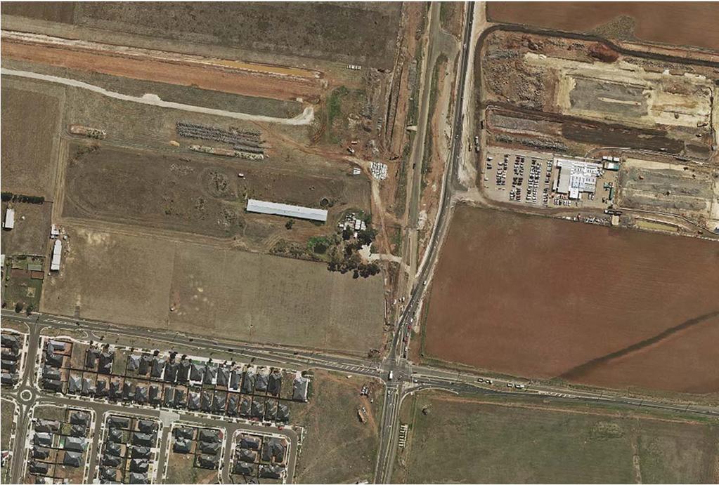
5 2 SITE CONTEXT AND SURROUNDS 2.1 Site Features The subject site of Derrimut Road is located at the north-east corner of the Leakes and Derrimut Road intersection. The site is formally known as Lot 5 on Plan of Subdivision W (575 Derrimut Rd) and Lot 4 on Plan of Subdivision W (585 Derrimut Rd); the two parcels are approximately 3.9 hectares and 3.7 hectares respectively. Site 575 currently accommodates a large shed, water tanks, and a small outbuilding with paddock surrounds. The site is currently accessed from Leakes Road. Site 585 contains a dwelling, associated outbuildings, a small dam and a large shed, with a paddock at the rear. Clusters of vegetation surround the dwelling and align the Derrimut Road frontage; scattered shrubbery exists around the large shed and across the paddock. The site s access is currently from Derrimut Road. The subject site is at the south-east corner of the Tarneit North Precinct Structure Plan (PSP). Under the proposed PSP the site is designated as residential ; the submission on behalf of Human Habitats however proposed the site as Mixed-Use. 2.2 Surrounding land uses As it currently exists, the subject site is surrounded to the north, east, and west by agricultural land; while established residential is located to the south on the opposite side of Leakes Road (R1Z). The land at the south-east corner of the Leakes and Derrimut Road intersection is zoned for future Business 1 (B1Z) use, now Commercial 1 (C1Z) following the Victorian Zoning Reforms of 2013; the site will accommodate in future the Rose Grange Shopping Centre. As detailed in the Tarneit North PSP the regional rail link is located along the subject sites northern boundary, while residential land is proposed for the adjacent property to the west. A substantial public acquisition for the purposes of road widening to Leakes Road occurs to the sites southern boundary.

6 The land to the east, on the opposite side of Derrimut Road is within the Truganina PSP which is currently at the Planning Panel stage. The parcel directly east is to planned to accommodate mixed business and residential adjacent, at the northern of that site will be Tarneit Station, with the future town centre located at the north side of the tracks. The subject site presents an opportunity for Transit Oriented Development (TOD) within a 5 minute walk of the future Tarneit Station in the form of mixed residential and business uses, complimenting the future town centre within the Truganina PSP.
7 3 THE PROPOSAL 3.1 Project Vision and Master Plan The submission prepared by Human Habitats details the proposal to identify the site as Business and Residential / Mixed Use ; it is important to note that this Report and related 96a Application only contemplates the proposal to subdivide the land. For the purposes of this Application the land is assumed to be envisaged for Business and Residential / Mixed Use, with the applied zone under the Schedule to the UGZ to be Clause Mixed Use Zone. The description of the proposed precinct submitted to be included in the PSP presents an overarching vision and reads as follows: TARNEIT JUNCTION The Tarneit Junction Precinct is bound by the railway line, Leakes Road, Derrimut Road and the property boundaries extending north from Wilandra Drive and will become a mixed-use, transitorientated development. The precinct will grow into a higher density, comprehensive development that provides a range of accommodation types for all ages. Central to the development will be an employment cluster in multi-level buildings that facilitate offices for skilled employment and delivery of services. The Tarneit Junction Precinct will generate demand for local convenience retail options that service the local residents, employees and visitors. It will have synergies with the Rose Grange neighbourhood centre on which it will rely for its full line supermarket and associated retailing. The target residential yield for the precinct is 700 dwellings. LAND USES Mixed use lower floor convenience retail with upper floor residential/office. Medical Centre and Allied Health ( >250sqm) Office - Business Cluster ( >250sqm) Retirement/Aged Care Child Care Residential medium and high density
8 Student Accommodation Accommodation short-stay, serviced apartments, hotel. Education & Training Facilities Retail Premises - convenience retail including general store Food and Drink Premises Place of Assembly ADDITIONAL DESIGN GUIDANCE Within Tarneit Junction Precinct: Wilandra Drive will extend from the south through a signalised intersection at Leakes Road and connect to an east-west orientated road through Tarneit Junction. Shared car parking facilities should be provided internally to the development and where possible, sleaved by other uses along street frontages. A landmark development with of increased scale should be provided at the Leakes Road and Derrimut Road intersection. Medium density residential uses will interface between the more intense mixed-use development along Leakes Road and the future development of VicTrack land south of the railway line. The Leaks Road frontage will consist of urban, multi-level built form with active frontages. It will provide internal connections via a central road and multiple pedestrian links. The interface with VicTrack land should allow for site access and consider the potential for various future uses, including non-complimentary railway uses associated with the rail line.
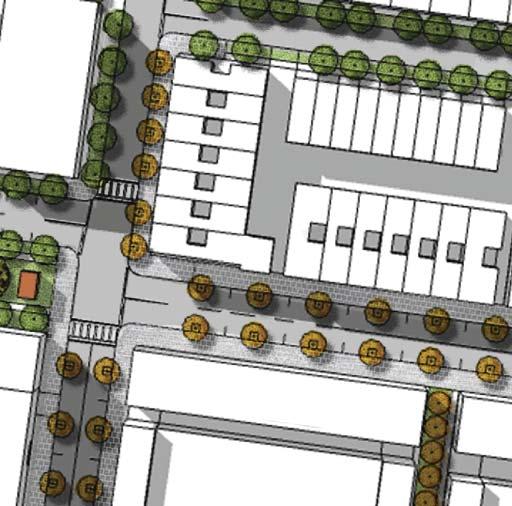
9 3.2 Details of the Proposal This Application contemplates the subdivision of the land, paving the way for future applications for use and development post PSP approval. The proposal is the subdivision of the site into 91 lots for development, a public open space area, and an internal public road layout. Access to the site is proposed via a future signalised intersection at the northern end of Wilandra Drive as it meets Leakes Road. Direct site access is additionally proposed at approximately the central point of frontage to Leakes Road, as well as further toward the Derrimut Intersection (future signalised). A private access is also proposed to Derrimut Road to service Lot 105 which is envisaged to in future accommodate a prominent, landmark mixed use building. The lots are designed to suit future use, being either for residential or mixed use. The variety in lot size creates diversity with respect to future built form and residential living. A breakdown of the lot typologies, envisaged built form, and street typologies are included in the Application document set by Human Habitats. Overall the subdivision layout provides for a variety in lot size to accommodate a range of future uses which may be contemplated under the Mixed Use Zone, it provides for future higher density residential living, demonstrates connectivity for vehicles, pedestrians and cyclists, centralizes open space areas, activates road frontages, and provides links for the future subdivision of land at the surrounds.
10
11 4 PLANNING POLIC REVIEW & ASSESSMENT 4.1 State Planning Policy Framework The State Planning Policy Framework sets out the relevant statewide planning priorities; those relevant to this Application include Clause 11 Settlement, Clause 15 Built Environment and Heritage, Clause 16 Housing, Clause 17 Economic Development, Clause 18 Transport and Clause 19 Infrastructure. Clause 11 discusses the state wide policies in relation to settlement, and seeks to ensure that a sufficient amount of land is set aside for housing, employment, recreation and open space, commercial and community facilities and infrastructure. It is an objective of this policy to facilitate the orderly development of urban areas in appropriate locations close to activity centres and other services. Clause 15 aims to ensure that careful planning and management of the urban environment and cultural heritage is achieved, through appropriate urban design, high standards of subdivision and neighbourhood design, recognition and protection of neighbourhood character and identification and protection of important European and Aboriginal Heritage sites. Clause 16 outlines the state policies in relation to Housing and essentially aims to ensure the supply of housing meets market demands and expectations by encouraging increased housing diversity. The achievement of urban consolidation objectives at key locations particularly in and around activity centres and public transportation routes is actively encouraged through this clause. Affordable housing is encouraged in proximity to employment, transport and services. Relevant to the future use of this site is Clause 17 Economic Development which aims to encourages business development to meet the community needs for retain, entertainment, office and other commercial services; providing a net benefit in relation to accessibility, efficient infrastructure use and the aggregation and sustainability of commercial facilities. Key relevant strategies include Provide new convenience shopping facilities to provide for the needs of the local population in new residential areas and within, or immediately adjacent to, existing commercial centres and Provide small scale shopping opportunities that meet the needs of local residents and workers in convenient locations. A key principle to this proposed Mixed Use site is supportable land-use in proximity to key transport;
12 this principle is supported within Clause 18 Transport. The linking objective is To create a safe and sustainable transport system by integrating land-use and transport. With the supporting strategies to provide access to all developments in accordance with forecast demand, taking advantage of all modes of transport, and coordinating improved transport including walking and cycling, concentrating key trip generators such as higher density development in and around activity centres and the principle public transport network. Clause 19, which refers to the statewide objectives for infrastructure, aims to ensure that development is provided with all necessary infrastructure including water, gas, telecommunications, electricity, sewerage and drainage. This clause also encourages the development of renewable energy facilities, such as wind and solar energy. The Tarneit North PSP is informed by the State Planning Policy Framework integrated into the Wyndham Planning Scheme; with the PSP acting as the strategic area plan it is fair to say that the urban settlement of the land and of the specific land-uses are well planned as part of the PSP process which involves landowners and all relevant agencies. Being a growth area and the evolution of the precinct from agricultural land to urban the existing character will dramatically change. The use of land will be guided by the PSP and new character areas created. Urban design will play a major part in the transformation of land-parcels; in the case of this Application the design is measured against the provisions of Clause 56 at the Appendix of this Report. The PSP process also acts to investigate areas of important European and Aboriginal Cultural heritage; the subject site is not recognised as an area of Cultural sensitivity via online mapping and is not expected to contain any European heritage. Diversity and density in appropriate locations are key objectives within the SPPF. Again, the PSP is a guiding document in this regard, identifying areas appropriate for medium and high density which would be best typified by sites which have good access to services and facilities presented by activity centres, key transport nodes, and open space provision. This subdivision proposal demonstrates the medium density outcomes toward the rear of the site, with higher density residential within the Mixed Use components to be accommodated on larger lots; the site is considered to offer a diversity of higher-density living in the growth area. The proposed subdivision maps the future development of the site for Mixed Use, including medium and high density residential with supporting convenience retail facilities, small office provision, and
13 a focus on provision of medical services; such use is considered to be well-located in terms of proximity to activity centres and public transport and is supported by economic analysis. The proposal site is considered to offer a supporting form of development to nearby activity centres which will assist in their achievement of key objectives and individual vision. The proposal is an example of integrated land-use and transport planning, locating a variety of uses and higher density residential development in a walkable catchment to key public transport services. The proposed subdivision will be serviced appropriately, building from the existing urban land to the south; some key infrastructure items are to be delivered in accordance with the PSP and Development Contributions Plan (DCP), however such detail is still to be processed with the assessment of the PSP which must take into consideration key servicing agency responses and submissions. Supporting servicing reports have been completed and are submitted with the Application set. 4.2 Local Planning Policy Framework Under the Wyndham Planning Scheme, local planning policies relevant to the proposed development include: Wyndham s Vision Objectives and Strategies Infrastructure Financing Policy Open Space Policy A summary and response to each of the above is provided below. Clause Wyndham s Vision provides objectives specific to land-use, and strategies for transport, urban development, retail centres, industry, tourism, rural land, technology precinct, and extractive industry; such uses form Council s Strategic Framework Plan forming part of this Policy. The subject site is located within a Future Residential area reflecting its Urban Growth zoning, and is subject to the PSP process. The proposed Mixed Use precinct is considered to assist in the achievement of key objectives surrounding growth area management, housing diversity, and employment opportunities. Clause details each of the land-use objectives (and strategies to achieve such) which are first listed within Clause (as above). With respect to Managing Urban Growth is it
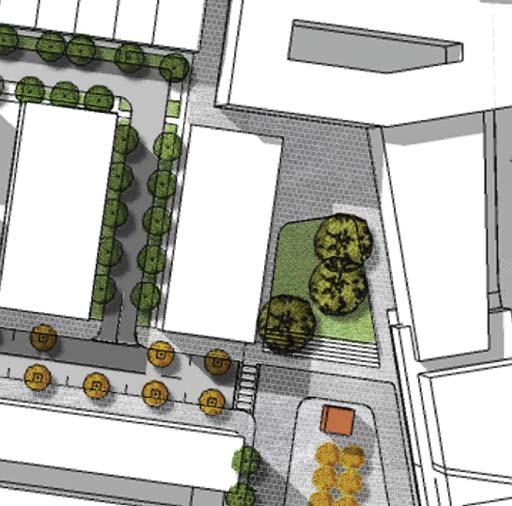
14 considered that the Tarneit North PSP process is considered to adequately manage this process, with this proposed subdivision to accord with the principles and guidelines of the PSP (outlined later in this Report). Housing diversity and integration of housing with compatible uses are key objectives achieved through the design of the subdivision. The proposal provides for stand-alone future medium density terrace built-form at the rear of the site, concentrating integrated mixed use buildings to the interfaces of Derrimut Road and Leakes Road. The integrated mixed use buildings include higher density apartment living with a variety of office, convenience retail, medical, food and drink premises, type-uses to activate ground-floor and street. The proposed subdivision creates larger lots for future built form which is to accommodate a variety of uses; such uses (other than residential) all support local employment and encourage small business opportunities. The mixed use precinct is designed to support nearby activity centres, aimed to accommodate uses not typical of activity centre development; such uses include small business, convenience retail, and medical. The precinct is ideal for the growth of home-based employment within Wyndham. Clause aims to ensure urban infrastructure is provided at a local level to be determined on a transparent and equitable basis ; the DCP to be furthered as part of the PSP process from Tarneit North is considered to be the guiding document in this regard, with infrastructure provision coordinated by the responsible authority in consultation with developers, land-owners and servicing agencies. The proposed subdivision Application is supported by servicing reports; a copy of which is included with the document set. Clause is marked by the objective To provide a range of public open space opportunities which optimise the community s need for recreation, as identified, and which is affordable in the short and longer term. Public Open Space areas are identified within the Tarneit North PSP, which includes a budgeted area of 0.25ha within the subject site. The proposed subdivision provides ha as one linear area of public open space, generally central to the site. The area is easily accessible and is offered with passive surveillance from residential and business areas. The landscape form of the public open space will be determined with future development. The site also provides for private, body-corporate controlled urban open space in the form of a future plaza; although a private space, the plaza is to encourage public use.

15 4.3 Zones and Overlays Zone The subject site is located within the Urban Growth Zone (UGZ) Wyndham Planning Scheme. 575 Derrimut Road, Tarneit 585 Derrimut Road, Tarneit The purpose of theugz is:
16 To implement the State Planning Policy Framework and the Local Planning PolicyFramework, including the Municipal Strategic Statement and local planning policies. To manage the transition of non-urban land into urban land in accordance with a precinctstructure plan. To provide for a range of uses and the development of land in accordance with a precinctstructure plan. To contain urban use and development to areas identified for urban development in aprecinct structure plan. To provide for the continued non-urban use of the land until urban development inaccordance with a precinct structure plan occurs. To ensure that, before a precinct structure plan is applied, the use and development ofland does not prejudice the future urban use and development of the land. Under the UGZ Clause Subdivision a permit is required to subdivide land. Any requirement in the schedule to this zone or the precinct structure plan must be met. A permit granted must: Be generally in accordance with the precinct structure plan applying to the land. Include any conditions or requirements specified in the schedule to this zone or the precinct structure plan. Before deciding on an application to use or subdivide land, construct a building or construct or carry out works, in addition to the decision guidelines in Clause 65, the responsible authority must consider, as appropriate: The State Planning Policy Framework and the Local Planning Policy Framework,including the Municipal Strategic Statement and local planning policies. Any relevant Growth Area Framework Plan. The precinct structure plan applying to the land, including the vision and objectivesof the precinct structure plan.
 residential development by the MPA, the submission by Human Habitats promotes the site to be")
17 Any guidelines in the schedule to this zone. Although currently envisaged for (and illustrated such) residential development by the MPA, the submission by Human Habitats promotes the site to be designated Mixed Use under the PSP; this assessment therefore references the proposed applied zone of Mixed Use.
18 The purpose of the Mixed Use Zone is: To implement the State Planning Policy Framework and the Local Planning Policy Framework, including the Municipal Strategic Statement and local planning policies. To provide for a range of residential, commercial, industrial and other uses which complement the mixed-use function of the locality. To provide for housing at higher densities. To encourage development that responds to the existing or preferred neighbourhood character of the area. To facilitate the use, development and redevelopment of land in accordance with the objectives specified in a schedule to this zone. Although the site is proposed in future to accommodate uses able to be considered under the Mixed Use Zone, no uses are contemplated as part of this Application (although the vision for the site still applies). A permit is required to subdivide land under Clause Subdivision of the Mixed Use Zone. An application to subdivide land, other than an application to subdivide land into lots each containing an existing dwelling or car parking space, must meet the requirements of Clause 56 and: Must meet all of the objectives included in the clauses specified in the following table. Should meet all of the standards included in the clauses specified in the following table. 60 or more lots - All except Clause Overlay Currently no Overlays apply to the site, however contemplated as part of the Tarneit North PSP is a supporting Development Contributions Plan (DCP); it would be expected that the subject site be affected by the Development Contributions Plan Overlay (Schedule for Tarneit North) should the PSP be approved (and associated documents incorporated into the Wyndham Planning Scheme). 4.4 Particular Provisions Under the Wyndham Planning Scheme, particular provisions relevant to the proposed development include:
19 52.01 Public Open Space Contribution and Subdivision Easements, Restrictions and Reserves 56 Residential Subdivision Clause Public Open Space Contributions The Tarneit North PSP outlines applicable open space contributions for each parcel; the subject site is budgeted to provide 0.25ha of public open space central to the site; the proposal provides for ha in accordance with the PSP. Clause Easements, Restrictions and Reserves This Particular Provision applies as the site is restricted by a covenant; this Clause is the process by which an Application for removal of restricted can be removed. A permit is required under Section 23 of the Subdivision Act 1988 to create, vary or remove an easement or restriction or vary or remove a condition in the nature of an easement in a Crown grant. Sites 575 Derrimut Road is restricted by Covenant D created in Site 585 Derrimut Road is restricted by Covenant E created in Both Covenants restrict any building or part of to be erected on the land less than sixty feet from Derrimut Road frontage. The Application includes a request for removal of the Covenant from each land. A full copy of each Title is provided with the Application set. Clause 56 Rescode Provisions The proposed subdivision development is subject to the provisions of Clause 56; a full Clause 56 assessment has been included at the Appendix to this Report and the proposal is considered to comply. 4.5 Draft Tarneit North Precinct Structure Plan The subject site is located within the TarneitNorth PSP and is identified on the proposed plan as an area designated for Mixed Use development. The proposed subdivision is designed to accommodate a variety of uses, consistent with the purpose of the Mixed Use Zone.
20 The subdivision of the land, in accordance with the PSP, enables the transition of agricultural land to urban and responds to the vision and objectives as outlined in the PSP document. Below is an assessment against the following relevant requirements of the PSP; the overall desired Outcomes for the PSP have been outlined in table form with the applicable provision and response, while the Requirements and Guidelines for specific elements have been responded to on a asrelevant basis (these include responses only and therefore should be read in conjunction with the relevant section of the PSP document): 2.2 Outcomes(Table Form) 3.1 Image, Character & Housing 3.2. Town Centres & Employment 3.3 Open Space & Community Facilities 3.4 Biodiversity & Bushfire Management 3.5 Transport & Movement 3.6 Integrated Water Management & Utilities 3.7 Infrastructure Delivery & Staging 2.2 Outcomes Section 2.2 of the Tarneit North PSP sets out the desired outcomes (via objectives) of development for the precinct and act as a guide for the vision.below is an assessment against these requirements and guidelines for the proposed subdivision. Objective Relevant Comment 01 Recognise the history, heritage and character of the Werribee Plains in a new urban environment through the protection of natural waterways, retention of significant vegetation, habitat and dry stone walls, and the promotion of heritage. Capitalise on the significant opportunities of the local context, including the Regional Rail Link, the western employment 02 corridor, and extensive inter metropolitan motorway connections. N No significant history, heritage, environment or character elements exist on the subject site. The subdivision promotes a new character based on principles of transport oriented development and Mixed Use development objectives. The site is located adjacent the Regional Rail Link, within a 5 minute walk of the future Tarneit Station, and fronts both Leakes Road and Derrimut Road which are key connections to the Princes Highway and Western Freeway. The subdivision promotes development of medium to high density
21 Ensure pre development property structure does not impede the realisation of cohesive and integrated neighbourhoods. Deliver an integrated network of local passive parks, active recreation reserves, and community infrastructure that meets the needs and aspirations of the new community. Achieve a diversity of streetscape and open space outcomes to enhance local character and amenity. residential as well as places of employment which are considered complimentary to such transport accessibility. The subject site is located adjacent VicTrack land, of which the future use is unknown. The subdivision has been designed to provide an appropriate interface to this area even with the future development unknown. The subdivision provides for a local park in accordance with the location shown in the PSP and fulfils the required area provision of 0.25ha. The public open space serves the immediate development (residents and workers), whilst also providing a level of amenity for visitors. It would be expected that this Park be delivered upon use and development of the site A demonstrated within the plan set, the subdivision provides for a variety of streetscapes which all serve a specific purpose related to the future use of the fronting lot/s Establish a landscape of connecting canopies along streets, parks and waterways. Ensure that no residents need to cross arterial roads, railway lines or waterways to access a local park. Develop a slow speed and permeable connector road network that links across arterial roads and traverses through the core of each square mile. Create a series of neighbourhoods that cluster around public open space, community hubs, and town centres. Build high density and transit oriented neighbourhoods focussed on railway stations and proposed future railway station sites. Promote greater housing choice through the delivery of a range of lots capable of accommodating a variety of dwelling typologies. Leverage off the amenity offered by waterways, open space and town centres to deliver medium and high density housing options. N The subdivision street typologies provide for street tree planting, as well as connections of space between the local park, the streets and the private (body corporate) plaza. The local park serves the immediate and surrounding catchment clear of barriers to access. No connector roads are proposed as part of the subdivision. The proposed subdivision would create a precinct centred around Mixed Use outcomes which is completely unique to the area. The subject site is ideally placed and the proposal centres around this objective. The proposed subdivision proposed a variety in lot size, however is focused on delivering medium to high density residential development; this is considered diverse in the context of the entire PSP. The proposed subdivision is considered complimentary to the future town centre within the Truganina PSP and the future Rose Grange Shopping Centre. The subdivision
22 network that connects to the Principal Public Transputure Beveridge RStation Deliver sufficient residential densities within a walkable catchment to support vibrant and viable town centres. Develop a series of town centres that each has a civic focus and an ability to adapt and evolve with the community. Ensure the design of town centres is conducive to a range of commercial enterprises including start up, small, and home based businesses. Create high amenity industrial and commercial precincts that can attract a diversity of different businesses and employers and generate a variety of local jobs. Provide a viable and attractive interface between residential and industrial or commercial land uses. Deliver an integrated water management system that reduces reliance on reticulated potable water,increases the re use of alternative water (stormwater and / or wastewater) and contributes toward a sustainable and green urban environment. Install essential services in a way that does not impede the ability to plant canopy trees in streets and along easements. Ensure that development staging is coordinated with the delivery of key local and state infrastructure. N N promotes medium to high density outcomes in a highly suitable area while also providing convenience and alternate services to that which will be provided in each of the town centres. The subject site is within a primary walkable catchment as identified within the PSP. The medium to high density residential outcome envisaged strongly supports the nearby future town centre developments. The site is not a town centre. The site is not a town centre. The proposed Mixed Use outcome on the site is individual to the precinct and provides for greater variety and capacity of services which are not suitable for town centre or industrial areas; the future businesses will provide alternative employment options to those residents within the PSP and surrounds as well as attracting visitors to the area. The subject site is located adjacent VicTrack land, of which the future use is unknown. The subdivision has been designed to provide an appropriate interface to this area even with the future development unknown. Necessary service infrastructure can be put in place as part of this subdivision to accommodate integrated water management upon development of the site. Servicing arrangements for the subdivision will be considerate of areas set aside for landscape planting; adequate reserve has been set aside to accommodate landscaping. The Staging Plan of the subdivision demonstrates that key access infrastructure will be delivered within the initial stages of the development.
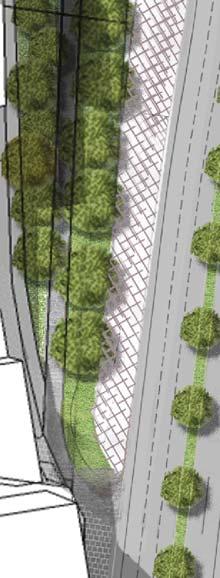
23 3.0 Implementation 3.1 Image, Character & Housing Section 3.1 of the PSP outlines the requirements and guidelines for the implementation of image, character and housing. Below is an assessment against these requirements and guidelines for the proposed subdivision. Guidelines relating to heritage are not applicable to this Application. Image & Character Requirements Guidelines Housing Requirements R1, R2, & R3: Street trees are to be provided in accordance with the requirements upon construction of public roads; street typologies have been provided in the Application set for review, while a street tree landscape plan would be expected to be required as a condition should a permit issue (which is to include provision of canopy trees of appropriate species in accordance with Wyndham Strategies, Policies and Standards). G1 & G2: The street network of the proposal subdivision provides adequate public road, cyclist and pedestrian access to the central linear open space. The linear open space contributes toward the view-line dissecting the site, linking the public space to the plaza. G5, G6, & G7: Street trees, lighting and furniture will be consistent throughout the subdivision, with a specific landscape plan to reference and respond to Council s Landscape Context Guidelines 2013 where applicable. R5, R6, & R8: The subdivision proposal demonstrates the provision of medium density housing (providing the opportunity for future built-form as a terrace build) while also providing larger lots which will accommodate business lower floors and high-density residential at upper. The subdivision layout is designed so that key buildings present to Derrimut and Leakes Road; where lots have dual-frontage requirements future builtform is to be designed with appropriate interface treatments at each side. In accordance with R8, the subdivision indicates future medium density terrace lots,
24 while creating larger lots for future multi-use including business and high-density residential; the preliminary yield calculation for the site is 700 dwellings. The street typologies submitted with the Application are considered to demonstrate safe and efficient movement of vehicles, cyclists and pedestrians through the site. Guidelines G8, G9, G10, G11, G13, & G14: The proposed site is envisaged to provide 700 dwellings which are to include medium and high density living; dwelling forms are to include terrace and apartment living (of various sizes). The subject site is in close proximity to activity centres and public transport, and is to be designates as a mixed use site, therefore it is considered to be an ideal candidate for medium and high density residential development. As demonstrated on the proposed plan of subdivision, lot sizes for terrace living range from 72 square metres to 205 square metres, while walk-up flats and apartment blocks are well above the 350 to 450+ square metre mark which accords with Table 1 Housing type by lot size G15: Specialised aged care accommodation is a component envisaged for the site, which is to integrate with the future proposed medical uses. The site is in an ideal position with supporting activity centres and public transport. The proposed subdivision presents the opportunity for future block-built form on larger lots which are to integrate such aged care accommodation into the design. 3.3 Open Space & Community Facilities Section 3.3 of the PSP outlines the requirements and guidelines for the implementation of open space. Below is an assessment against these requirements and guidelines for the proposed subdivision (where relevant). The requirements and guidelines relating to community facilities are not applicable to this Application. Open Space Requirements R23, R24, & R27: Local public open space is provided on the site in accordance with the PSP. The PSP budgets 0.25ha of open space within the site, ha is provided as a linear space central to the site in accordance with the strategic directions of the PSP. It would be expected that a condition any permit for the subdivision include
25 provision for a landscape plan (either as part of the subdivision or future built-form component of the development). Condition C2: The area of public open space proposed is to be vested in Council (transferred at no cost). 3.4 Biodiversity & Bushfire Management Section 3.4 of the PSP outlines the requirements and guidelines for the implementation of biodiversity and bushfire management. Below is an assessment against these requirements and guidelines for the proposed subdivision (where relevant). Conditions relating to Biodiversity and Natural Systems as outlined in the PSP are to be included as conditions of permit should one issue for this subdivision Application. Bushfire Management Requirements R35: The subdivision is designed to accord with as listed within the Table. R36, & R37: Provision of a Construction Management Plan and a Construction or Engineering Plan are expected as conditions of any permit issued for the subdivision and would be expected to respond to these requirements and applicable. 3.5 Transport & Movement Section 3.5 of the PSP outlines the requirements and guidelines for the implementation of transport and movement. Below is an assessment against these requirements and guidelines for the proposed subdivision (where relevant). Street Network Requirements R38 & R39: Street typologies have been submitted with the Application set and provide for safe and efficient movement throughout the subdivision. The Staging of the subdivision ensures key connections to Leakes Road is provided early, while access to neighbouring lots to the north and west are provided for future connection and integration.
26 R44: Vehicle access to Leakes Road is provided via signalised intersection or via service road. R46: Vehicle access to lots of 6 metres or less in width is provided via a rear laneway. Guidelines G37 & G40: Street block lengths are less than 240 metres and provide for a low-speed environment. Vehicle crossovers to Derrimut and Leakes Road have been minimised, while central to the site terrace lots are accessed via rear-laneway to avoid disruptions of traffic, cyclist and pedestrian movement on key routes. Conditions C7: Land required for Leakes Road widening and any intersections is to be transferred to Council at no cost as part of this Subdivison. Walking & Cycling Requirements R52 & R54: Included with the Application set are street typologies which include provision of footpaths and share paths in accordance with the directions of the PSP. 3.6 Integrated Water Management & Utilities Section 3.6 of the PSP outlines the requirements and guidelines for the implementation of integrated water management and utilities. Below is an assessment against these requirements and guidelines for the proposed subdivision (where relevant). Servicing Reports submitted as part of this Subdivision Application are considered to respond to the Requirements and Guidelines associated with Integrated Water Management and Utilities as detailed within the PSP. 3.7 Infrastructure Delivery & Staging Section 3.7 of the PSP outlines the requirements and guidelines for the infrastructure delivery and staging. Below is an assessment against these requirements and guidelines for the proposed subdivision (where relevant). The proposed subdivision works include provision of infrastructure required to accommodate future built form on the site. Supporting Servicing Reports submitted as
27 part of this Subdivision Application work through the specific detail of such service delivery with reference to the DCP for Tarneit North.
28 5 CONCLUSION It is considered that the proposal has a high level of compliance with the state and local planning policies and is consistent with the objectives of the Urban Growth Zone and the Tarneit North Precinct Structure Plan document. In conclusion the proposal is considered to: Implement the requirements and guidelines of the Precinct Structure Plan; Respond to the relevant clause of the State and Local Planning Policies; Provides for future diversity and density of housing appropriate to a mixed use site in an area that is in close proximity to activity centres and public transport; and Provides a layout that will encourage future mixed use development of the site, with key integrated business and residential buildings to front Leakes and Derrimut Road. It is therefore submitted that a permit should be issued for the subdivision.
C176. Amendment C176 Riverdale Precinct Structure Plan List of Document Changes for Planning Panels Victoria. Version th November 2013
 C176 Amendment C176 Riverdale Precinct Structure Plan List of Document Changes for Planning Panels Victoria Version 1.0 18 th November 2013 Amendment C176 Riverdale Precinct Structure Plan List of Document
SCHEDULE 10 TO THE URBAN GROWTH ZONE. Shown on the planning scheme map as UGZ10. Truganina Precinct Structure Plan. 1.0 The Plan
 SCHEDULE 10 TO THE URBAN GROWTH ZONE Shown on the planning scheme map as UGZ10 Truganina Precinct Structure Plan 1.0 The Plan Map 1 shows the future urban structure proposed in the Truganina Precinct Structure
DAREBIN PLANNING SCHEME AMENDMENT C137
 Who is the planning authority? Planning and Environment Act 1987 DAREBIN PLANNING SCHEME AMENDMENT C137 EXPLANATORY REPORT This amendment has been prepared by the Darebin City Council, who is the planning
I615. Westgate Precinct
 I615. Westgate Precinct I615.1. Precinct Description The Westgate Precinct is located approximately 18km west of the Auckland city centre. There are seven Sub-precincts in the Westgate Precinct: Sub-precinct
GREENBANK DEVELOPMENT MASTERPLAN
 DEVELOPMENT MASTERPLAN POTENTIAL TRAIN STATION COMMUNITY CENTRE Greenbank will be a connected masterplanned community providing easy access to local and surrounding amenity. Affordable quality homes, green
Keystone Business Park Precinct Structure Plan North East Industrial Precinct. Part 2 Design Principles
 Keystone Business Park Precinct Structure Plan North East Industrial Precinct Part 2 Design Principles Context Issues Services Landform Issues Geotech and contamination Ecology Traffic and access Issues
SCHEDULE THREE TO THE DEVELOPMENT PLAN OVERLAY EASTERN GOLF COURSE KEY REDEVELOPMENT SITE
 DD/MM/YY SCHEDULE THREE TO THE DEVELOPMENT PLAN OVERLAY Shown on the planning scheme map as DPO3 EASTERN GOLF COURSE KEY REDEVELOPMENT SITE 1.0 A permit may be granted before a development plan has been
Draft Western District Plan
 Powered by TCPDF (www.tcpdf.org) Draft Western District Plan Submission_id: 31440 Date of Lodgment: 15 Dec 2017 Origin of Submission: Online Organisation name: Goodman Property Services Australia Pty Ltd
EAST WERRIBEE EMPLOYMENT PRECINCT PRECINCT STRUCTURE PLAN
 3.2 East Werribee Town Centre East Werribee Town Centre Vision The East Werribee Town Centre will complement the Werribee City Centre in providing an employment, service, retail and entertainment focus
LAND AT DALESTON, MAMBOURIN
 LAND AT DALESTON, MAMBOURIN Planning Report in Support of s96a Application Application for Subdivision Daleston, Mambourin October 2014 Daleston, Mambourin Our ref: 01486 Client: Phileo Australia Limited
Introduction How to read this document Land to which this Precinct Structure Plan applies Background information...
 Introduction... 4 How to read this document... 6 Land to which this Precinct Structure Plan applies... 6 Background information... 6 Shepparton North East Development Contributions Plan... 7... 8 OUTCOMES...
North District What we heard
 What we heard Vision to 2056 and Priorities Governance and implementation Infrastructure and funding The vision for a metropolis of three cities, and the 30 minute city. Feedback emphasised: That for the
Greater Geelong Planning Scheme Proposed Planning Scheme Amendment C and 5-19 Princes Highway, Norlane
 Greater Geelong Planning Scheme Proposed Planning Scheme Amendment C253 PLANNING SUBMISSION prepared for Bunnings Group Ltd by SJB Planning Pty Ltd Level 1, Building D 80 Dorcas Street SOUTHBANK VIC 3006
SCHEDULE 12 TO THE DESIGN AND DEVELOPMENT OVERLAY GLEN WAVERLEY ACTIVITY CENTRE STRUCTURE PLAN
 DD/MM/YY Proposed C120 SCHEDULE 12 TO THE DESIGN AND DEVELOPMENT OVERLAY Shown on the planning scheme map as DDO12. GLEN WAVERLEY ACTIVITY CENTRE STRUCTURE PLAN 1.0 Design objectives DD/MM/YY Proposed
sm` Planning Report in support of s96a application KINGFISHER ESTATE - FIRST DEVELOPMENT STAGES June 170 LANCEFIELD ROAD, SUNBURY
 sm` Planning Report in support of s96a application June 2015 KINGFISHER ESTATE - FIRST DEVELOPMENT STAGES 170 LANCEFIELD ROAD, SUNBURY TPG Ref: 1595 Client: Wincity Development Pty Limited ADVISE I PLAN
S A C R A M E N T O C O U N T Y JACKSON HIGHWAY & GRANT LINE EAST VISIONING STUDY
 JACKSON HIGHWAY & GRANT LINE EAST S A C R A M E N T O C O U N T Y P L A N N I N G D E P A R T M E N T SUMMARY AND WORKBOOK November 19, 2008 History of the Visioning Study Sacramento County has two growth
CASEY PLANNING SCHEME AMENDMENT C188
 Who is the planning authority? Planning and Environment Act 1987 CASEY PLANNING SCHEME AMENDMENT C188 EXPLANATORY REPORT This amendment has been prepared by the Growth Areas Authority (now known as the
DRAFT WESTERN CITY DISTRICT PLAN PLANNING PRIORITIES AND ACTIONS
 Greater Sydney Commission DRAFT WESTERN CITY DISTRICT PLAN PLANNING PRIORITIES AND ACTIONS Issued: 26 OCTOBER 2017 Version: 1 Subject: Greater Sydney Region and District Plans This information note is
LAND USE AMENDMENT CORNERSTONE (WARD 3) 60 STREET NE AND COUNTRY HILLS BOULEVARD NE MAP 26NE BYLAW 22D2017
 60 STREET NE AND COUNTRY HILLS BOULEVARD NE MAP 26NE BYLAW 22D2017") Page 1 of 14 EXECUTIVE SUMMARY This Land Use Amendment application covers an area of 43.76 hectares ± (108.14 acres ±) located in northeast Calgary, bound by Country Hills Boulevard NE to the south and
Page 1 of 14 EXECUTIVE SUMMARY This Land Use Amendment application covers an area of 43.76 hectares ± (108.14 acres ±) located in northeast Calgary, bound by Country Hills Boulevard NE to the south and
The Proposed Auckland Unitary Plan (notified 30 September 2013)
") 3 Business zones Introduction There are 10 business zones in the Unitary Plan: City Centre Metropolitan Centre Town Centre Local Centre Neighbourhood Centre Mixed Use General Business Business Park Light
3 Business zones Introduction There are 10 business zones in the Unitary Plan: City Centre Metropolitan Centre Town Centre Local Centre Neighbourhood Centre Mixed Use General Business Business Park Light
Section 5 (S5) - Sneydes Parade
 - Sneydes Parade") EAST WERRIBEE EMPLOYMENT PRECINCT PRECINCT STRUCTURE PLAN 15m High Large Canopy Tree encouraged 41.4 6.0 4.2 2.0 0.3 300mm Kerb 3 Lane incl. dedicated bus lane 6m median (Trees at 25m spacing) 3 Lane incl.
EAST WERRIBEE EMPLOYMENT PRECINCT PRECINCT STRUCTURE PLAN 15m High Large Canopy Tree encouraged 41.4 6.0 4.2 2.0 0.3 300mm Kerb 3 Lane incl. dedicated bus lane 6m median (Trees at 25m spacing) 3 Lane incl.
Northern Territory Compact Urban Growth Policy
 Northern Territory Compact Urban Growth Policy A Reference Policy Document to clause 2.7 (Reference to Policy) of the NT Planning Scheme May 2015 Table of Contents 1 Policy Setting... 3 1.1 Context for
Appendix D: Rockbank Major Town Centre key design principles
 Appendix D: Rockbank Major Town Centre key design principles ATTRACTING INVESTMENT & SUPPORTING THE COMMUNITY Principle 1 Create a focal point for a diverse range of uses within the town centre that are
Appendix A. Planning Processes. Introduction
 1 Planning Processes Introduction This appendix outlines a number of planning processes which are used in the Auckland Region to support the effective management of development in the region s rural and
Appendix 1 Structure plan guidelines
 Appendix 1 Structure plan guidelines This appendix forms part of the regional policy statement [rps]. 1.1. Introduction Structure plans are an important method for establishing the pattern of land use
DRAFT PLANNING SCHEME AMENDMENT GC81
 Outline of changes proposes to the Melbourne and Port Phillip Planning Scheme Fishermans Bend Fishermans Bend is one of several priority precincts identified in Plan Melbourne and plays a central role
Land Use Amendment in Southwood (Ward 11) at and Elbow Drive SW, LOC
 at and Elbow Drive SW, LOC") 2018 November 15 Page 1 of 10 EXECUTIVE SUMMARY This land use amendment application was submitted by Rick Balbi Architect on 2017 August 31 on behalf of Sable Developments Ltd, and with authorization from
2018 November 15 Page 1 of 10 EXECUTIVE SUMMARY This land use amendment application was submitted by Rick Balbi Architect on 2017 August 31 on behalf of Sable Developments Ltd, and with authorization from
Urban Design Manual PLANNING AROUND RAPID TRANSIT STATIONS (PARTS) Introduction. Station Study Areas
 Introduction. Station Study Areas") 111111 PLANNING AROUND RAPID TRANSIT STATIONS (PARTS) Introduction The ION rapid transit system will link Waterloo, Kitchener and Cambridge through a central transit corridor (CTC). There are a number
111111 PLANNING AROUND RAPID TRANSIT STATIONS (PARTS) Introduction The ION rapid transit system will link Waterloo, Kitchener and Cambridge through a central transit corridor (CTC). There are a number
8.0 Design and Form of Development 43/
 42/ 8.0 Design and Form of Development 43/ Rothwells Farm, Golborne/ Development Statement Figure 7. Site Constraints Key 44/ Site Boundary 360 Bus Route/Stops Existing Trees Underground Water Pipe Sensitive
Contents of Part 6. Part 6 Zones
 Contents of Part 6 Part 6 Zones... 6-1 6.1 Preliminary... 6-1 6.2 Zone codes... 6-3 6.2.1 Low density residential zone code... 6-3 6.2.1.1 Application... 6-3 6.2.1.2 Purpose and overall outcomes... 6-3
Town Planning Report. Combined Planning Permit and Planning Scheme Amendment Request under Section 96A of the Planning and Environment Act 1987
 Town Planning Report Combined Planning Permit and Planning Scheme Amendment Request under Section 96A of the Planning and Environment Act 1987 1 Henry Street, Belmont Prepared by Tract Consultants for
CITY OF FREMANTLE LOCAL PLANNING SCHEME NO. 4 AMENDMENT NO. 68 SCHEME AMENDMENT REPORT
 CITY OF FREMANTLE LOCAL PLANNING SCHEME NO. 4 AMENDMENT NO. 68 SCHEME AMENDMENT REPORT CITY OF FREMANTLE PLANNING AND DEVELOPMENT SERVICES 8 WILLIAM STREET FREMANTLE WA 6160 PLANNING AND DEVELOPMENT ACT
I539. Smales 2 Precinct
 I539. Smales 2 Precinct I539.1. Precinct Description The Smales 2 Precinct applies to a 4.8 hectare block of land located on the southern side of Northcote Road and fronting Lake Pupuke, Takapuna. The
Altona North. Comprehensive Development Plan
 Altona North Comprehensive Development Plan June 2017 CONTENTS 1 Introduction... 2 1.1 How to read this document... 2 1.2 Land to which the Plan applies... 4 1.3 Background information... 5 1.4 Altona
Appendix H: Easement cross sections
 Appendix H: Easement cross sections SHARED PATH 1.5m FOOTPATH NATURE STRIP 7.3m CARRIAGEWAY 2.7m NATURE STRIP EXISTING PIPELINE 150mm DIA 5.0m (approx.) LOCAL ACCESS ROAD EXISTING PIPELINE 500mm DIA 2.7m
EAST VILLAGE STRATEGIC SITE NOVEMBER 2017
 EAST VILLAGE STRATEGIC SITE NOVEMBER 2017 East Village will be a sustainable, mixeduse precinct with a focus on innovative employment and education opportunities. Enhanced by green spaces and places for
Draft Eastern District Plan
 Draft Eastern District Plan Submission_id: 31238 Date of Lodgment: 13 Dec 2017 Origin of Submission: Online Organisation name: Turrulla Gardens Pty Ltd C/- Mecone Organisation type: Industry First name:
22.15 OUTDOOR ADVERTISING SIGNAGE POLICY
 22.15 OUTDOOR ADVERTISING SIGNAGE POLICY This policy applies to all land where a planning permit is required to construct or display a sign under the provisions of the Kingston Planning Scheme. 22.15-1
Official Plan Review
 Official Plan Review Summary Report - The Built Environment August 2014 Part 1: Introduction Planning for a healthy, prosperous and sustainable community is an important goal for our municipality. From
Western City District What we heard
 What we heard Vision to 2056 and Priorities Governance and implementation Infrastructure and funding The protection of the natural landscape including biodiversity and the Metropolitan Rural Area for food
Integrated Urban Structuring in Australia An Overview of Principles and Practice
 ACNU08 Brisbane Integrated Urban Structuring in Australia An Overview of Principles and Practice Wendy Morris Ecologically Sustainable Design Pty Ltd Melbourne, Australia esdesign@netspace.net.au Ecologically
Subdivision Design Criteria. Penihana North GUIDELINES TO THE RULES
 Created September 2013 Penihana North Subdivision Design Criteria GUIDELINES TO THE RULES This part of the Plan sets out the design criteria for subdivision in Penihana North. The criteria will be considered
Newcourt Masterplan. November Exeter Local Development Framework
 Newcourt Masterplan November 2010 Exeter Local Development Framework Background The Exeter Core Strategy Proposed Submission sets out the vision, objectives and strategy for the development of Exeter up
Former Rockcliffe Airbase Community Design Plan Guiding Design Vision and Principles December 4, 2013
 APPENDIX 5 - Guiding Design Vision and Principles Former Rockcliffe Airbase Community Design Plan Guiding Design Vision and Principles December 4, 2013 Vision Statement The redevelopment of the former
Amendment C147 Melton Planning Scheme Expert Evidence Statement Traffic & Transport , Taylors Road, Plumpton
 905 959, 961 1025 Taylors Road, Plumpton 16520REP001B-F 22 November 2016 onemilegrid.com.au 1/59 Keele Street, Collingwood, VIC 3066 (03) 9939 8250 onemilegrid ABN: 79 168 115 679 (03) 9939 8250 1/59 Keele
Amendment C146 Melton Planning Scheme Expert Evidence Statement Traffic & Transport Beattys Road, Plumpton
 235 311 Beattys Road, Plumpton 16585REP001C-F 21 November 2016 onemilegrid.com.au 1/59 Keele Street, Collingwood, VIC 3066 (03) 9939 8250 onemilegrid ABN: 79 168 115 679 (03) 9939 8250 1/59 Keele Street
The West Vaughan Employment Area Secondary Plan Policies
 Part 2: The West Vaughan Employment Area Secondary Plan Policies 2.1 General Policies It is the policy of Council: 2.1.1. That the West Vaughan Employment Area (the WVEA), identified on Schedule 1, will
Briefing Document of CNP. June 2017
 Cholsey Parish Council Cholsey Neighbourhood Plan Briefing Document of CNP June 2017 Cholsey Neighbourhood Plan Page! 1 of! 8 Cholsey Plan Briefing v1.4 Page Left Intentionally Blank Cholsey Neighbourhood
South District What we heard
 What we heard Vision to 2056 and Priorities Governance and implementation Infrastructure and funding Feedback supported: The vision for a metropolis of three cities, but emphasised the importance of infrastructure
Complete Neighbourhood Guidelines Review Tool
 Complete Neighbourhood Guidelines Review Tool Prepared By: City of Regina Planning Department October 2014 Page 1 of 14 Community Development Review Checklist for Secondary Plans and Concept Plans The
REVISED DRAFT NORTH DISTRICT PLAN PLANNING PRIORITIES AND ACTIONS
 Greater Sydney Commission REVISED DRAFT NORTH DISTRICT PLAN PLANNING PRIORITIES AND ACTIONS Issued: 26 OCTOBER 2017 Version: 1 Subject: Greater Sydney Region and District Plans This information note is
Welcome to the Oakridge Centre Open House
 Welcome to the Oakridge Centre Open House Why is the City hosting this event? This open house is to inform you of a rezoning application submitted to the City of Vancouver to amend the existing CD-1 (Comprehensive
MOUNT PLEASANT SECONDARY PLAN & VILLAGE BLOCK PLAN. Wednesday, March 5, 2008 Informal Public Open House
 MOUNT PLEASANT SECONDARY PLAN & VILLAGE BLOCK PLAN Wednesday, March 5, 2008 Informal Public Open House 1. Welcome & Introductions 2. Highlights of Provincial Growth Plan 3. Overview and Status Update -
Memorial Business Park Site. Proposed Future Development. Design guidelines. August
 Memorial Business Park Site Proposed Future Development Design guidelines August 2014 www.designenvironment.co.nz 0064 3 358 3040 Contents 1.0 Background 1.1 Introduction 3 1.2 Objectives 4 2.0 Context
Cardinia Creek South
 Cardinia Creek South Precinct Structure Plan March 2018 Your partner in planning great places for a growing Victoria Contents 1.0 INTRODUCTION 5 1.1 How to read this document 7 1.2 Land to which this PSP
Welcome. Walk Around. Talk to Us. Write Down Your Comments
 Welcome This is an information meeting introducing the applications for proposed redevelopment of the Yorkdale Shopping Centre site at 3401 Dufferin Street and 1 Yorkdale Road over the next 20+ years,
ADMINISTRATION RECOMMENDATION 2016 November 03. That Calgary Planning Commission recommends APPROVAL of the proposed Land Use Amendment.
 Page 1 of 12 EXECUTIVE SUMMARY This Land Use Amendment application covers an area of 75.76 hectares ± (187.20 acres ±) located in northeast Calgary, bound by Stoney Trail NE to the north, 128 Avenue NE
Shepparton North East Precinct Structure Plan. February 2018
 Shepparton North East Precinct Structure Plan February 2018 Contents 1.0 INTRODUCTION 5 1.1 How to read this document 7 1.2 Land to which this Precinct Structure Plan applies 7 1.3 Background information
1.0 Purpose of a Secondary Plan for the Masonville Transit Village
 Report to Planning and Environment Committee To: Chair and Members Planning & Environment Committee From: John M. Fleming Managing Director, Planning and City Planner Subject: Masonville Transit Village
Page 1 of 19 URBAN DESIGN FRAMEWORK FOR BOLTON STREET WATERFORD
 Page 1 of 19 URBAN DESIGN FRAMEWORK FOR BOLTON STREET WATERFORD 1.0 Introduction: The relocation of the City Council stores and depot from Bolton Street creates an exciting opportunity for development
6 Growth Management Challenges and Opportunities
 6 Growth Management Challenges and Opportunities The Town has established a goal of attaining a 50% participation rate with respect to employment opportunities versus residential population. The Town s
Tāhuhu whakaruruhau ā-taone The sheltering ridge pole
 B2. Tāhuhu whakaruruhau ā-taone - Urban growth and form B2.1. Issues Tāhuhu whakaruruhau ā-taone The sheltering ridge pole Auckland s growing population increases demand for housing, employment, business,
Town Center (part of the Comprehensive Plan)
") Town Center (part of the Comprehensive Plan) Mercer Island Town Center Looking North (2014) In 1994, a year-long process culminated in a set of design guidelines and code requirements for the Town Center
Town Center (part of the Comprehensive Plan) Mercer Island Town Center Looking North (2014) In 1994, a year-long process culminated in a set of design guidelines and code requirements for the Town Center
PMP PRINTING SITE COMMUNITY ENGAGEMENT - PHASE 2
 PMP PRINTING SITE COMMUNITY ENGAGEMENT - PHASE 2 FEBRUARY 2019 0317-0511 - PMP Printng - M001 (8 -Floors) -Final date 14.11.2018 Vision: The PMP Printing site will be transformed into a contemporary mixed-use
POLICY AMENDMENT AND LAND USE AMENDMENT TUXEDO PARK (WARD 9) CENTRE STREET N AND 26 AVENUE NE BYLAWS 36P2017 AND 234D2017
 CENTRE STREET N AND 26 AVENUE NE BYLAWS 36P2017 AND 234D2017") Page 1 of 11 EXECUTIVE SUMMARY This application proposes to redesignate a single parcel of land in the Community of Tuxedo Park from Commercial Corridor 2 (C-COR2 f1h10) District to Mixed Use Active Frontage
Page 1 of 11 EXECUTIVE SUMMARY This application proposes to redesignate a single parcel of land in the Community of Tuxedo Park from Commercial Corridor 2 (C-COR2 f1h10) District to Mixed Use Active Frontage
OUR GREATER SYDNEY A metropolis of three cities. OVERVIEW. connecting people. DRAFT Greater Sydney Region Plan
 OUR GREATER SYDNEY 2056. A metropolis of three cities. OVERVIEW. connecting people. DRAFT Greater Sydney Region Plan October 2017 This document is an overview of the draft Greater Sydney Region Plan. To
Clyde Creek & Casey Fields South PRECINCT STRUCTURE PLAN
 Clyde Creek & Casey Fields South PRECINCT STRUCTURE PLAN Major Town Centre at Clyde with potential future rail station, conservation of heritage and environmental values, diverse residential community,
Eastern City District Plan
 OUR GREATER SYDNEY 2056 Revised Draft Eastern City District Plan OVERVIEW Bayside Burwood Canada Bay City of Sydney Inner West Randwick Strathfield Waverley Woollahra Snapshot of the Eastern City District
01 the vision NEW LYNN IS WAITING FOR THE GREAT LEAP FORWARD
 [A] FRAMEWORK 01 the vision 02 the framework 03 urban design principles 04 c o n t e x t 05 issues a n d o p p o r t u n i t i e s 06 creating a t.o.d. 07 key recommendations 08 seven strategic areas of
1.0 Introduction. In preparing this statement I have:
 Table of Contents 1.0 Introduction... 3 2.0 Expert Witness Statement... 4 3.0 Summary of Evidence... 6 4.0.... 9 5.0 Planning history of land within the Precinct.... 11 6.0 The Draft Growth Corridor Plan
[PLANNING RATIONALE] For Site Plan Control and Lifting of Holding Zone By-Law 101 Champagne Avenue. May 23, 2014
![[PLANNING RATIONALE] For Site Plan Control and Lifting of Holding Zone By-Law 101 Champagne Avenue. May 23, 2014](/thumbs/75/71599615.jpg "[PLANNING RATIONALE] For Site Plan Control and Lifting of Holding Zone By-Law 101 Champagne Avenue. May 23, 2014") [PLANNING RATIONALE] For Site Plan Control and Lifting of Holding Zone By-Law 101 Champagne Avenue May 23, 2014 Contents 1.0 Introduction... 2 2.0 Site Context... 2 2.1 Adjacent Uses... 2 Figure 1: Site
[PLANNING RATIONALE] For Site Plan Control and Lifting of Holding Zone By-Law 101 Champagne Avenue May 23, 2014 Contents 1.0 Introduction... 2 2.0 Site Context... 2 2.1 Adjacent Uses... 2 Figure 1: Site
DRAFT GREATER SYDNEY REGION PLAN OBJECTIVES, STRATEGIES AND ACTIONS
 Greater Sydney Commission DRAFT GREATER SYDNEY REGION PLAN OBJECTIVES, STRATEGIES AND ACTIONS Issued: 26 OCTOBER 2017 Version: 1 Subject: Greater Sydney Region and District Plans This information note
WELCOME and introduction
 1 WELCOME and introduction Mobility Hub Locations within Burlington STUDY OVERVIEW STUDY OBJECTIVES The City of Burlington is developing four Area Specific Plans, one for each of Burlington s Mobility
CONTENTS 8.0 LAND USE 8.1 GENERAL LAND USE 8.2 RESIDENTIAL 8.3 MIXED USE 8.4 COMMERCIAL 8.5 EMPLOYMENT LANDS
 8-2 Land Use 8.0 LAND USE CONTENTS 8.1 GENERAL LAND USE 8.1.1 Uses provided for in all Land Use Designations 8.1.2 Uses prohibited in Hazardous Lands, Hazardous Sites and Special Policy Areas 8.1.3 Uses
OKEFORD FITZPAINE NEIGHBOURHOOD PLAN
 OKEFORD FITZPAINE NEIGHBOURHOOD PLAN Dear Parishioner, The Neighbourhood Plan Project Team have prepared this leaflet to summarise the full Neighbourhood Plan document. It provides a summary of the Vision,
FORMER CANADIAN FORCES BASE (CFB) ROCKCLIFFE SECONDARY PLAN. Official Plan Amendment XX to the Official Plan for the City of Ottawa
 ROCKCLIFFE SECONDARY PLAN. Official Plan Amendment XX to the Official Plan for the City of Ottawa") FORMER CANADIAN FORCES BASE (CFB) ROCKCLIFFE SECONDARY PLAN Official Plan Amendment XX to the Official Plan for the City of Ottawa 1 INDEX THE STATEMENT OF COMPONENTS PART A THE PREAMBLE PAGE Purpose...
FORMER CANADIAN FORCES BASE (CFB) ROCKCLIFFE SECONDARY PLAN Official Plan Amendment XX to the Official Plan for the City of Ottawa 1 INDEX THE STATEMENT OF COMPONENTS PART A THE PREAMBLE PAGE Purpose...
PORT WHITBY COMMUNITY
 PORT WHITBY COMMUNITY SECONDARY PLAN UPDATE COMMUNITY IMPROVEMENT PLAN URBAN DESIGN GUIDELINES September 2015 DRAFT PROPOSED AMENDMENT NUMBER # to the Whitby Official Plan PURPOSE: The intent of this Amendment
LAND USE AMENDMENT CORNERSTONE (WARD 3) COUNTRY HILLS BOULEVARD AND STONEY TRAIL NE BYLAW 9D2017
 COUNTRY HILLS BOULEVARD AND STONEY TRAIL NE BYLAW 9D2017") Page 1 of 12 EXECUTIVE SUMMARY This Land Use Amendment application covers an area of 54.92 hectares ± (135.71 acres ±) located in northeast Calgary, bound by Country Hills Boulevard NE to the north and
Page 1 of 12 EXECUTIVE SUMMARY This Land Use Amendment application covers an area of 54.92 hectares ± (135.71 acres ±) located in northeast Calgary, bound by Country Hills Boulevard NE to the north and
Municipal Development Plan Update Urban Service Area and Hamlets
 ENCLOSURE 1 Municipal Development Plan Update Urban Service Area and Hamlets Priorities Committee January 24, 2017 MUNICIPAL DEVELOPMENT PLAN UPDATE SHAPING OUR FUTURE MDP Update - Agenda MDP Update Public
Barwon Heads Road. REGIONAL ACTIVE PUBLIC OPEN SPACE - Indicative Concept Only FIGURE C. Armstrong Creek East Precinct Structure Plan
 0 50 150 metres KEY Arterial Road (existing) Walking / Cycling link Residential Conventional Mixed Use Residential Medium Density Farming Drainage and Floodway Public Open Space Armstrong Creek Watercourse
MAYFIELD WEST SECONDARY PLAN PHASE 2
 MAYFIELD WEST SECONDARY PLAN PHASE 2 Public Open House #3 February 25, 2010 Draft Preferred Land Use Scenario TOWN OF CALEDON PLANNING & DEVELOPMENT DEPARTMENT Open House Agenda TOWN OF CALEDON 1. Welcome
Kaufland supermarket and complementary uses, part 1550 Pascoe Vale Road, Coolaroo Incorporated Document (Insert date) 2019
 2019") Kaufland supermarket and complementary uses, part 1550 Pascoe Vale Road, Coolaroo Incorporated Document (Insert date) 2019 Page 1 of 7 Incorporated document pursuant to section 6(2)(j) of the Planning
Kaufland supermarket and complementary uses, part 1550 Pascoe Vale Road, Coolaroo Incorporated Document (Insert date) 2019 Page 1 of 7 Incorporated document pursuant to section 6(2)(j) of the Planning
YONGE STEELES CORRIDOR SECONDARY PLAN. Young + Wright / IBI Group Architects Dillon Consulting Ltd. GHK International (Canada) Ltd.
 Ltd.") PART A: PREAMBLE 1.0 PURPOSE The purpose of this Secondary Plan is to provide a development framework for intensification of the Yonge/ Steeles corridor including the north side of Steeles Avenue West
PART A: PREAMBLE 1.0 PURPOSE The purpose of this Secondary Plan is to provide a development framework for intensification of the Yonge/ Steeles corridor including the north side of Steeles Avenue West
PILLAR FOUR INTEGRATE LAND USE & TRANSPORTATION
 PILLAR FOUR INTEGRATE LAND USE & TRANSPORTATION 8 Scarborough Centre on the Move Transportation Master Plan 123 8 Transportation Pillar Four Integrate Land Use & The fourth pillar focuses on the relationship
Wollondilly Resilience Network (WReN) Inc. Comments on the Draft South West District Plan
 Inc. Comments on the Draft South West District Plan") Wollondilly Resilience Network (WReN) Inc. Comments on the Draft South West District Plan March 2017 About WReN Wollondilly Resilience Network (WReN) Inc. is a not for profit community association based
Wollondilly Resilience Network (WReN) Inc. Comments on the Draft South West District Plan March 2017 About WReN Wollondilly Resilience Network (WReN) Inc. is a not for profit community association based
178 Carruthers Properties Inc.
 178 Carruthers Properties Inc. Planning Rationale for 178 Carruthers Avenue Site Plan Control Application June 2014 Table of Contents 1.0 Introduction 2.0 Overview of Subject Property 3.0 Current Zoning
WELCOME GYPSY LANE. Wider Site Location plan. Proposals for the development of LAND OFF FOXLYDIATE LANE WEBHEATH. Proposals for the development of
 WELCOME The developers are preparing an outline planning application for a residential led development and need the community s views in order to develop the proposals further WHAT IS PROPOSED? A high
INCREMENTAL CHANGE AREA REVIEW March 2015 Page 1
 INCREMENTAL CHANGE AREA REVIEW March 2015 Page 1 Table of Contents Introduction... 3 Background to Review... 3 Comparison of the Schedules to the General Residential Zone... 7 Methodology... 7 Policy Context...
1.0 PLANNING MARKHAM S FUTURE CONTENTS
 1-1 Planning Markham s Future 1.0 PLANNING MARKHAM S FUTURE CONTENTS 1.1 THE PURPOSE OF THE OFFICIAL PLAN 1.2 THE MARKHAM CONTEXT 1.3 THE REGULATORY CONTEXT 1.3.1 Province of Ontario 1.3.2 York Region
elbridge Core Strategy
 C elbridge Core Strategy Celbridge is designated as a Moderate Growth Town in the RPGs. The County Development Plan reinforces this designation in its settlement strategy. Moderate Growth Towns within
GREENVALE CENTRAL PRECINCT STRUCTURE PLAN
 76 Conservation area boundary. Low Fence to exclude vehicles but allow pedestrian access Front boundary of allotment 5.0m MINIMUM SETBACK Path providing public access to dwellings fronting Conservation
DRAFT FOR YOUR FEEDBACK DRAFT LOGAN RESERVE PLAN
 DRAFT FOR YOUR FEEDBACK CONTENTS INTRODUCTION... BACKGROUND... State Government... Council... PLANNING LEGISLATION AND RULES... CONSULTATION PROCESS...... ENVIRONMENT AND CONSERVATION... HOUSING... Proposed
Plano Tomorrow Vision and Policies
 Plano Tomorrow Vision and Policies PLANO TOMORROW PILLARS The Built Environment The Social Environment The Natural Environment The Economic Environment Land Use and Urban Design Transportation Housing
South District Plan OVERVIEW
 OUR GREATER SYDNEY 2056 Revised Draft South District Plan OVERVIEW Canterbury-Bankstown Georges River Sutherland Snapshot of the South District today and into the future The Greater Sydney Commission acknowledges
Figure 1- Site Plan Concept
 Figure 1- Site Plan Concept Parking will be provided underground on three levels at rate of 1.0 space/ unit; this rate includes all visitors parking. MMM Group has prepared a parking assessment (April,
Amendment C205. Expert Urban Design Evidence. Hume Planning Scheme. Julia Bell February 2018
 Julia Bell February 2018 Instructed by KING&WOOD MALLESONS On behalf of Hume City Council Contents 1.0 Introduction... 3 2.0 Context... 4 2.1 Physical Context... 4 2.2 Strategic Context... 8 3.0 Assessment...
ELMVALE ACRES SHOPPING CENTRE MASTER PLAN
 ELMVALE ACRES SHOPPING CENTRE MASTER PLAN Contents 1.0 INTRODUCTION... 2 2.0 LOCATION... 2 3.0 EXISTING CONTEXT... 2 4.0 VISION & GUIDING PRINCIPLES... 2 5.0 LAND USE AND BUILT FORM... 4 5.1 St. Laurent
1.3 TRANSIT VISION 2040 FROM VISION TO ACTION THEME 1: PUTTING TRANSIT AT THE CENTRE OF COMMUNITIES. Fully integrate transit with community planning
 TRANSIT VISION 2040 FROM VISION TO ACTION TRANSIT VISION 2040 defines a future in which public transit maximizes its contribution to quality of life with benefits that support a vibrant and equitable society,
Public Consultation. Land at Monks Farm, North Grove. Welcome
 Welcome Welcome to our public exhibition for development on Land at Monks Farm, orth Grove. Gallagher Estates and Gleeson Strategic Land are preparing an outline planning application for new homes, open
Derry Green Corporate Business Park
 Town of Milton Derry Green Corporate Business Park Urban Design Guidelines BMI/Pace - June 2010 Draft 3 Prepared by: Brook McIlroy Planning + Urban Design / Pace Architects Suite 300-51 Camden Street Toronto,