National Infrared Operations (NIROPS) Program Overview. Tom Mellin National Infrared Program Manager
|
|
|
- Valerie George
- 6 years ago
- Views:
Transcription
")

1 National Infrared Operations (NIROPS) Program Overview Tom Mellin National Infrared Program Manager
2 Topics NIROPS organization Phoenix imaging system Aircraft Data delivery to infrared interpreters IRIN functions Product delivery to incident Image examples Future developments
3 National Infrared Operations (NIROPS) Headquartered at National Interagency Fire Center (NIFC) and consists of Phoenix Imaging Systems & IR techs (FS) Planes & Pilots (FS) Infrared Interpreters (Interagency)

4 Geographic Area Coordination Centers and GACC IR Liaisons Northern R: Lee Werth Rocky Mtn: Melinda McGann Bob Malcolm Southwest: Tom Mellin Great Basin: Hope Spriggs CA N/S: Kyle Felker Northwest: Jim Grace Southern: Scott Wilkinson Eastern: Liz McNichols Alaska: TBD


5 PHOENIX System Installation Phoenix is a digital image processing system coupled with a dual channel line scanner
6 WHY IR LINE SCANNERS? Cover extremely large areas in a very short period of time Line scanners are extremely accurate (depending on processing system) Can detect very small fires (While simultaneously) Mapping very large areas Timely delivery
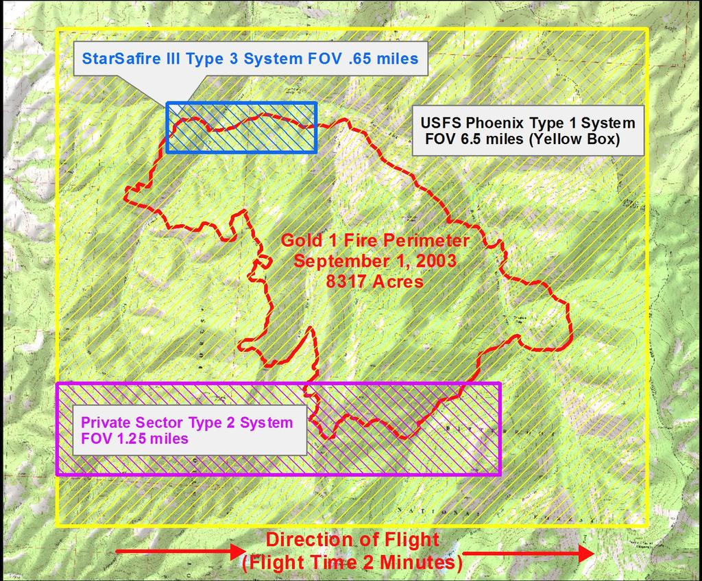
7 PHOENIX System Specifications Two channel thermal IR line scanner 3-5 μm band for intense heat 8-12 μm band for background terrain 1.25 milliradian IFOV 3.8 meter pixel at NADIR, 10,000 feet AGL FOV 6 mile swath at 10,000 feet AGL 1680 pixels per scan line 200 scan lines per second Digital image processing system 256 gray scale (256 th pixel is colored red)
8


9 Aircraft: Dedicated to IR use from April-November 144Z Cessna Citation Bravo 149Z Beechcraft 200 Super King Air National resource, can cover multiple incidents in multiple states


10 IR Data delivered from plane raw tiff Orthocorrected tiff w/ fire detects Orthocorrected color tiff Waldo Canyon Fire June 25, 2012, 2253 hrs
 dumb reduced resolution jpeg mosaic")

11 IR Data delivered from plane (cont.) dumb reduced resolution jpeg mosaic of all runs Waldo Canyon Fire June 25, 2012, 2253 hrs Heat detect point shapefile
 B = LWIR (8-12 µm) 12.")

12 Mid IR LWIR KA-B MODVOL KA-B Detection Concept A = Mid IR (3-5 µm) B = LWIR (8-12 µm) 12.5 ft Pixel 0 Deg. C Terrain 10 Inch Square 600 Deg. C Fire 100 Deg. C Asphalt Courtesy John Green, Argon ST


.")


 Corded SIP Handset (for")
 9 WiFi")
13 AIRCELL System Imagery delivered to NIFC ftp site via AIRCELL system Aircell is the company that provides in-flight Internet for commercial airlines ( GoGo ). N149Z and N144Z have the business aviation systems; a Wi-Fi hotspot in the sky Either as WinZip archive or FreeArc compressed archive (.exe) Corded SIP Handset (for maintenance ONLY) Wired Ethernet (optional) 9 WiFi Antennas AACU GPS/PCS Antenna ACPU CWAP ABS Antennas NIFC ftp site
14 AIRCELL System Advantages Fewer takeoffs and landings resulting in less spent fuel per mission and less maintenance. Safer flights due to fewer landings late at night into uncontrolled dark airports. Late night drives to pick up data by Interpreters eliminated. Less time wasted doing ftp uploads since data transfer is almost in real time from aircraft. Data arriving at NIROPS web site earlier in the mission allowing faster product delivery to incident. Less expensive than satellite based systems.


15 2011 NIROPS coverage N144Z 306 requests filled in 2011 ( filled, filled) N149Z 346 requests filled in 2011 ( filled, filled)
 N149Z -")

16 2012 NIROPS coverage (as of Aug 7) N149Z requests filled N144Z requests filled


17 Phoenix data in WinZip archive Aircell Remote IRIN Support: One IRIN, Multiple Fires Interpreter(s) located at duty station NIFC ftp site Incident NIFC ftp site


18 IRIN Pods Multiple IRINs at a single location central to multiple incidents If working in a pod A lead IRIN is assigned Each interpreter usually responsible for multiple fires, depending on size and complexity Improved coordination and flexibility Good example Redding pod from 2008
19 Roles and Responsibilities of the Infrared Interpreter Primary Objectives: Quality Control of thermal imagery Determine heat perimeter Identify areas of heat and isolated heat sources Calculate acreage of the perimeter Produce shapefiles, summary map(s) and log
20 IR Team Coordination IC NICC COD Fixed Wing Aircraft Desk GACC Fixed Wing Aircraft Desk Local/Expanded Dispatch Planning Section Chief Regional IR Coord. Situation Unit Ldr. National IR Coord. IR Interpreter IR Aircraft & Crew


21 Products Delivered to Incident daily Shapefiles, map, kmz, log
22 Aircraft vs. IRINs NIROPS aircraft are a national resource that can support multiple fires in multiple GACCs NOT assigned to the fire Fires receive the service IRINs are a single resource (overhead) that can support one or more fires Can be assigned to a Fire OR can be assigned to a GACC or Area Command to support multiple fires (usually as a member of a pod )

23 Wallow Fire Growth, 5/30 6/8, 2011

24 Wallow Fire Growth, 5/30 6/8, 2011

25 Wallow Fire Growth, 5/30 6/8, 2011

26 Wallow Fire Growth, 5/30 6/8, 2011

27 Wallow Fire Growth, 5/30 6/8, 2011

28 Wallow Fire Growth, 5/30 6/8, 2011

29 Wallow Fire Growth, 5/30 6/8, 2011

30 Wallow Fire Growth, 5/30 6/8, 2011

31 Whitewater and Baldy Fires become Whitewater-Baldy Fire, 5/22-23, 2012

32 Whitewater and Baldy Fires become Whitewater-Baldy Fire, 5/22-23, 2012
33 Wolf Den Fire 7/5/12
34 Wolf Den Fire 7/5/12

35 Wolf Den Fire 7/5/12

 3 0.52-0.60 (TM2) 4 0.60-0.62 5 0.63-0.")
 10 2.08-2.35 (TM7) 11 3.60-3.")
36 Future developments Integration of AMS on FS plane Autonomous Modular Sensor transferred to FS by NASA AMS Wildfire Sensor Band Wavelength m (TM1) (TM2) (TM3) (TM4) (TM5) (TM7) (VIIRS M12) (VIIRS M15)
 Wide Area Imager (WAI) Development funded by NASA SBIR project Operational")


37 Future developments (cont.) Wide Area Imager (WAI) Development funded by NASA SBIR project Operational Airborne prototype delivered by John Green (Xiomas) Testing over fires this summer Different concept/same result as Phoenix Cover 16 mile swath with same resolution as Phoenix system using step stare mirror with high resolution frame grabbing cameras Dual band MWIR and LWIR camera and color infrared camera Near real-time image classification and orthorectification


38 MWIR Mosaic and some zooms
39 Future developments (cont.) 3 rd existing FS aircraft for sensor deployment Testing and operational platform for various sensors including Phoenix system, AMS, WAI, etc. Would help maintain NIROPS coverage if one plane was down for extended time or Provide improved coverage during times of high fire activity and/or geographically separated fires

40 Questions? Tom Mellin National IR Program Manager (505)
Overview of Federal Wildfire Remote Sensing Support 2018
 Overview of Federal Wildfire Remote Sensing Support 2018 Everett Hinkley GIO (acting) GWIS & GOFC Fire IT Meeting October 2018 Fire Season to Date* Currently Planning Level 5 Total Fires: 48,946 (10 yr
Enhancing our Nation s Wildfire Management Capabilities Through Application of NASA Science and Technology
 Enhancing our Nation s Wildfire Management Capabilities Through Application of NASA Science and Technology Vince Ambrosia Earth Science Division. Biospherics Branch NASA-Ames Research Center 2nd Annual
ALBERTA FOREST PROTECTION THERMAL INFRARED PROGRAM
 ALBERTA FOREST PROTECTION THERMAL INFRARED PROGRAM Eleventh Biennial USDA Forest Service Remote Sensing Applications Conference Salt Lake City, Utah April 25 Ken Dutchak, P. Biol. Reconnaissance and Remote
Presentation Outline
 Presentation Outline! Background WRAP Project TFRSAC Technology Development Sensor / R/T Data Communications CDE as DSS Long-Duration Airborne Mission Capability (UAS) Western States Fire Mission Support
Use of new spatially refined satellite remote sensing fire detection data in support of advanced wildfire mapping and modeling
 Use of new spatially refined satellite remote sensing fire detection data in support of advanced wildfire mapping and modeling Dr. Wilfrid Schroeder 1 Dr. Janice Coen 2 Dr. Patricia Oliva 1 Dr. Louis Giglio
Development of a Canadian Wildland Fire Monitoring Sensor (CWFMS)
") Unclassified Development of a Canadian Wildland Fire Monitoring Sensor (CWFMS) Helena (Marleen) van Mierlo 1 Linh Ngo Phong 1 Steeve Montminy 1 Joshua M. Johnston 2 Denis Dufour 3 (1) Canadian Space Agency
Unclassified Development of a Canadian Wildland Fire Monitoring Sensor (CWFMS) Helena (Marleen) van Mierlo 1 Linh Ngo Phong 1 Steeve Montminy 1 Joshua M. Johnston 2 Denis Dufour 3 (1) Canadian Space Agency
Wildfire Mapping Using FireBIRD Data
 Wildfire Mapping Using FireBIRD Data Global Wildfire Information System (GWIS) GOFC GOLD Fire IT 20-23 rd November 2017, Cumberland Lodge Christian Fischer on behalf of the FireBIRD-Team German Aerospace
Global fire hotspots detected by NASA satellite to help United Nations
 Global fire hotspots detected by NASA satellite to help United Nations Published on 24 Sep 2010 is Image NASA's not found Moderate or type unknown Resolution Imaging Spectroradiometer (MODIS), an instrument
Colonel Paul Hargrove
 Colonel Paul Hargrove 1 PAST- MAFFS - Why was the Program Established? 1) MAFFS Program was established by Congress in 1970 after the Laguna Fire burned in San Diego County - Caused by downed power lines
Verification and Validation of OOV-TET1 Multispectral Camera Observations within the FireBIRD Project
 DLR.de Chart 1 Verification and Validation of OOV-TET1 Multispectral Camera Observations within the FireBIRD Project O. Frauenberger **, A. Börner *, E. Borg **, W Halle *, E. Lorenz *, S. Mitchell *,
Observations of the Coulson Martin Mars and FireWatch 76 Operations on the 2011 Wildfires in Mexico. Jim Thomasson Contract Report CR-TBD
 Wildfire Operations Research 1176 Switzer Drive Hinton, AB T7V 1V3 Observations of the Coulson Martin Mars and FireWatch 76 Operations on the 2011 Wildfires in Mexico Jim Thomasson 2011 Contract Report
DFPC s Toolbox. Colorado Fire Prediction System (CO-FPS)
") DFPC s Toolbox Colorado Fire Prediction System (CO-FPS) Wildfire in Colorado 68% of Colorado s forested lands are under federal jurisdiction The Wildland-Urban Interface in Colorado is currently 1.1 million
DFPC s Toolbox Colorado Fire Prediction System (CO-FPS) Wildfire in Colorado 68% of Colorado s forested lands are under federal jurisdiction The Wildland-Urban Interface in Colorado is currently 1.1 million
Bringing Smarts to Methane Emissions Detection
 Bringing Smarts to Methane Emissions Detection An Update on the DOE Smart Methane Emissions Project Maria Araujo Manager R&D Southwest Research Institute Background Fugitive emissions from compressors
S-NPP/VIIRS and Landsat-8/OLI Global Active Fire Data Sets
 S-NPP/VIIRS and Landsat-8/OLI Global Active Fire Data Sets Wilfrid Schroeder Louis Giglio, Pierre Guillevic, William Walsh (Dept of Geographical Sciences/UMD) Janice Coen (NCAR/Boulder) Ivan Csiszar (NOAA/NESDIS/STAR)
As agreed to by the members of the Routt County Multi-Agency Coordinating (MAC) Advisory and Policy Groups on March 15, 2018.
 Advisory and Policy Groups on March 15, 2018.") As agreed to by the members of the Routt County Multi-Agency Coordinating (MAC) Advisory and Policy Groups on March 15, 2018. Remember the 10 STANDARD FIRE ORDERS and the 18 situations that shout WATCH
As agreed to by the members of the Routt County Multi-Agency Coordinating (MAC) Advisory and Policy Groups on March 15, 2018. Remember the 10 STANDARD FIRE ORDERS and the 18 situations that shout WATCH
How SWIR Imaging contributes to the optimization of automatic quality control in the food industry
 How SWIR Imaging contributes to the optimization of automatic quality control in the food industry 2013 Overview Xenics in Short New Architecture Products Line Overview Visionlink Infrared Seminar 2013
Project Report. Infrared Field Users Guide and Vendor Listings. Liaison and Special Projects. Fire and Aviation Management.
 Fire and Aviation Management Project Report Liaison and Special Projects United States Department of Agriculture Forest Service Engineering Remote Sensing Applications Center October 2003 RSAC-1309-RPT1
ForestWatch. Oregon. Click to edit Master subtitle style. KEY Features 09/05/10
 ForestWatch Oregon KEY Features Range-aware, allowing Geo-referencing from a single camera. 12 Mile + detection capability and night-detection. Smart software learns the environment, drastically reducing
USDA Forest Service Fire Remote Sensing Program Update. Everett Hinkley/Brad Quayle
 USDA Forest Service Fire Remote Sensing Program Update Global Observation of Forest and Land Cover Dynamics Fire Mapping and Monitoring Implementation Team Meeting July 29 31, 2014 Everett Hinkley/Brad
From Marine Pollution to Inland. Wildfire Mapping
 From Marine Pollution to Inland Louis Armstrong Wildfire Mapping The Mobilization of the National Aerial Surveillance Program (NASP) in support of the Fort McMurray Wildfires TC Chief, Intelligence, Surveillance
Infrared Business Tips & Insight
 Infrared Business Tips & Insight 2010 Infrared Training Center. All rights reserved. Intended for use by Infrared Training Center customers and prospects only Infrared Business Tips & Insight Presenter:
DETECTION AND MONITORING OF ACTIVE FIRES USING REMOTE SENSING TECHNIQUES
 DETECTION AND MONITORING OF ACTIVE FIRES USING REMOTE SENSING TECHNIQUES Source: Unknown n.d., http://www.hotrodsandclassics.net/featuredpictures/featurepictures2.htm. by Claire Riddell DETECTION AND MONITORING
Methane to Markets Oil and Natural Gas Technology Transfer Workshop
 Methane to Markets Oil and Natural Gas Technology Transfer Workshop Detection and Measurement of Fugitive Emissions Using Airborne Differential Absorption Lidar (DIAL) Daniel Brake ANGEL Service ITT Space
Fire Information for Resource Management System (FIRMS)
") Fire Information for Resource Management System (FIRMS) Diane Davies 1, Chris Justice 1, Jacques Descloitres 2, John Latham 3 John Musinsky 4 1 Department of Geography, University of Maryland 2 SSAI /
Fire Information for Resource Management System (FIRMS) Diane Davies 1, Chris Justice 1, Jacques Descloitres 2, John Latham 3 John Musinsky 4 1 Department of Geography, University of Maryland 2 SSAI /
the EU-Japan Support Mission in the Space Sector
 Astro- und Feinwerktechnik Adlershof GmbH the EU-Japan Support Mission in the Space Sector 07 th of September 2017 Sapporo, Japan Dr.-Ing. Sebastian Scheiding s.scheiding@astrofein.com www.astrofein.com
About HGH Systemes Infrarouges About HGH
 www.hgh.fr About HGH Systemes Infrarouges About HGH More than 30 years old - started in 1982 Rene Houis Gilbert Gaussorgues Francois Hubert Headquartered at IGNY-PARIS, France Global presence & installations
DS-2TD Thermal & Optical Network Bullet Camera
 DS-2TD2836-50 Thermal & Optical Network Bullet Camera Introduction Hikvision DS-2TD2836-50 Thermal Bi-spectrum Network Bullet Camera is applied to perimeter defense and fire-prevention purposes in critical
Totally Wireless Video Security
 Totally Wireless Video Security Traditional Video Surveillance ($50,000+) vs. Event-Based Videofied Solution ($2,500) Executive Summary: Totally Wireless Video Security has been effective but cost and
Base and Deployable Automated Video Surveillance Systems
 Base and Deployable Automated Video Surveillance Systems Automated Video Surveillance test Detects & Tracks Activity Processes Video Data Compares to a User Defined Alarm Map Security Breach? A Force Multiplier
LVSS FLIR LIGHTWEIGHT VEHICLE SURVEILLANCE SYSTEM
 LVSS FLIR TM LIGHTWEIGHT VEHICLE SURVEILLANCE SYSTEM SINGLE OPERATOR. FAST DEPLOYMENT. ANYWHERE. Protecting vast and remote borders, shorelines, and forward-operating bases requires speed, mobility and
GOFC/GOLD Fire IT Strategic Planning. Day 1 - Break Out Group Discussion
 GOFC/GOLD Fire IT Strategic Planning Day 1 - Break Out Group Discussion Aims of the Fire IT refining and articulating the international requirements for fire related observations making the best possible
Interim evaluation of the New IR Sensor Technology (NIRST) as a wildfire monitoring tool
 as a wildfire monitoring tool") Interim evaluation of the New IR Sensor Technology (NIRST) as a wildfire monitoring tool Joshua Johnston Forest Fire Analyst Canadian Forest Service Great Lakes Forestry Centre Sault Ste. Marie, Ontario
Interim evaluation of the New IR Sensor Technology (NIRST) as a wildfire monitoring tool Joshua Johnston Forest Fire Analyst Canadian Forest Service Great Lakes Forestry Centre Sault Ste. Marie, Ontario
Application Note. Which characterization method is best for your application? The Future of Thermal Imaging is Here!!!
 Microsanj LLC 3287 Kifer Road Santa Clara, CA 95051 Application Note Comparing Thermoreflectance (TTI), Infrared (IR), Near Infrared Emission (EMMI), and Optical Beam Induced Resistance Change (OBIRCH)
The FireBird mission - a scientific mission for Earth observation and hot spot detection
 The FireBird mission - a scientific mission for Earth observation and hot spot detection Terzibaschian, Thomas Reile, H., Lorenz, E. DLR, Germany 9th IAA SYMPOSIUM ON SMALL SATELLITES FOR EARTH OBSERVATION,
Fire Detection and Monitoring
 Fire Detection and Monitoring Akli Benali Forest Research Center, University of Lisbon aklibenali@gmail.com Conference & Summer School on Forest Fire Management Istituto Superiore Antincendi, Rome, September
DEVELOPMENT OF THE INFRARED INSTRUMENT FOR GAS DETECTION
 DEVELOPMENT OF THE INFRARED INSTRUMENT FOR GAS DETECTION Ching-Wei Chen 1, Chia-Ray Chen 1 1 National Space Organization, National Applied Research Laboratories ABSTRACT MWIR (Mid-Wave Infrared) spectroscopy
1.1. SYSTEM MODELING
 1 INTRODUCTION Electro-optical imaging system analysis is a mathematical construct that provides an optimum design through appropriate trade studies. A comprehensive model includes the target, background,
HeliTAWS. The Pilot s Low-Level Hazard Avoidance System 2/1/12 1
 HeliTAWS The Pilot s Low-Level Hazard Avoidance System 2/1/12 1 What is HeliTAWS? HeliTAWS by Sandel is a unique indicating & alerting system for helicopter operations Performs far beyond HTAWS requirements
CDF GREEN SHEET. California Department of Forestry and Fire Protection SOUTHERN REGION CA-RSS000077
 CDF GREEN SHEET California Department of Forestry and Fire Protection SOUTHERN REGION CA-RSS000077 San Bernardino Unit Pleasant Valley 2 CA-BDU003587 April 30, 2002 Burn Over CDF Engine 3561 Lookouts Communications
Radar technology in surveillance
 White paper Radar technology in surveillance November 2018 Summary Using radar technology for detection can reduce the number of false alarms and increase detection efficiency in conditions with poor visibility.
FIREFIGHTING RESOURCES OF CALIFORNIA ORGANIZED FOR POTENTIAL EMERGENCIES
 FIREFIGHTING RESOURCES OF CALIFORNIA ORGANIZED FOR POTENTIAL EMERGENCIES PAST, CURRENT AND FUTURE DIRECTIONS A PROGRESS REPORT OCTOBER 1988 PAST, CURRENT, AND FUTURE Coordinate multi-agency resources during
Colorado Division of Fire Prevention and Control. Colorado Counties Inc. June 5, 2018
 Colorado Division of Fire Prevention and Control Colorado Counties Inc. June 5, 2018 Brief History and Background Vaughn Jones Mike Morgan The Division Background Wildfire in Colorado is a Public Safety
Threat Warning System
 Threat Warning System Objective Install an effective system to provide security monitoring and detection for borders, pipelines and critical infrastructure. The system must be: Proven Robust State of the
RON ROBERTS SUPERVISOR, FOURTH DISTRICT SAN DIEGO COUNTY BOARD OF SUPERVISORS
 RON ROBERTS SUPERVISOR, FOURTH DISTRICT SAN DIEGO COUNTY BOARD OF SUPERVISORS AGENDA ITEM DATE: September 14, 2010 TO: Board of Supervisors 20 SUBJECT: (DISTRICT: ALL) SUMMARY: Overview For the past decade,
NFPA s Standards Development Process
 NFPA s Standards Development Process Revision Cycle 104 weeks or 141 weeks Guiding Principles Due process Openness Lack of dominance Seek society s balance between: Acceptable risk Commitment of resources
ROBOTICS OPERATORS FOR IECEX/ATEX OPERATION
 WWW.EXROBOTICS.GLOBAL ROBOTICS OPERATORS FOR IECEX/ATEX OPERATION The Company, ExRobotics ExRobotics is a leading international company specialized in robotic solutions for potentially explosive facilities.
EMERGENCY SUPPORT FUNCTION #4 FIREFIGHTING
 EMERGENCY SUPPORT FUNCTION #4 FIREFIGHTING ESF Coordinator: Primary Agency: Support Agencies: Tooele County Sheriff s Office Grantsville Fire Department North Tooele County Fire Department: Erda Substation
VIIRS FIRE PRODUCTS UPDATE
 VIIRS FIRE PRODUCTS UPDATE Ivan Csiszar 1, Wilfrid Schroeder 2, Louis Giglio 2, Brad Wind 2, Evan Ellicott 2, Christopher O. Justice 2 1 NOAA/NESDIS Center for Satellite Applications and Research, Camp
A Data Set for Fire and Smoke Model Development and Evaluation-- RxCADRE
 Data Set for Fire and Smoke Model Development and Evaluation-- RxCDRE Roger Ottmar Pacific Wildland Fire Sciences Laboratory Pacific Northwest Research Station Seattle, W RxCDRE History 2007--Core Fire
THE NORTHSTAR SYSTEM: A NEW ERA IN EARTH OBSERVATION
 THE NORTHSTAR SYSTEM: A NEW ERA IN EARTH OBSERVATION Daniel O Connell 1, Derek R. Peddle 2, 6, Stewart Bain 3, Douglas W. Bancroft 4, Kjell Stakkestad 5,7 NorthStar, Montréal, Québec, Canada. http://www.northstar-data.com
BCGEU JOB DESCRIPTION MINISTRY OF FORESTS
 POSITION TITLE: Forest Protection Assistant BRANCH / REGION / DISTRICT: Protection Program, Fire Zones NOC CODE: 2223 SUPERVISOR S POSITION TITLE: Forest Protection Officer CURRENT CLASSIFICATION / GRID:
Effective Deployment of the Integrated Wireless Network Video Systems for the Homeland Security & Government Sectors
 Effective Deployment of the Integrated Wireless Network Video Systems for the Homeland Security & Government Sectors Premier Webinar Program Inscape Data Corporation June 8, 2005 1 Today s Agenda First
Wildland Fire Air Quality Response Program
 Wildland Fire Air Quality Response Program Pete Lahm Forest Service Fire and Aviation Management Washington, D.C. 202-205-1084 // 602-432-2614 cell 661-GET-1ARA Plahm@fs.fed.us // pete.lahm@gmail.com An
Office of Nonproliferation and Verification Research and Development University and Industry Technical Interchange (UITI2010) Review Meeting
 Review Meeting") Office of Nonproliferation and Verification Research and Development University and Industry Technical Interchange (UITI2010) Review Meeting Single Mode Hollow Core Waveguides for Mid-Wave and Long-Wave
Office of Nonproliferation and Verification Research and Development University and Industry Technical Interchange (UITI2010) Review Meeting Single Mode Hollow Core Waveguides for Mid-Wave and Long-Wave
T2SL technology for Mid-IR detectors
 T2SL technology for Mid-IR detectors Linda Höglund Minerva Workshop June, 30 th 1 Outline Introduction Tasks in MINERVA Starting point: MW detectors 320 256 on 30 µm pitch Technologies developed in MINERVA
FireWatch: A Citizen s Guide to Wildfire Suppression Monitoring
 FireWatch: A Citizen s Guide to Wildfire Suppression Monitoring Part One: A Guide to Online Wildfire Information Gathering by Michael Beasley and Timothy Ingalsbee Firefighters United for Safety, Ethics,
Centers for Regional Excellence. Downriver Fire Authority. Organization Committee Objective. Operations Committee Report 2007
 Centers for Regional Excellence Downriver Fire Authority Operations Committee Report 2007 Organization Committee Objective to prepare a recommended department structure for Board approval. 1 What are we
Coal Pile Fire Monitoring System
 Coal Pile Fire Monitoring System Land Instruments International Over 60 years experience Specialists in Infrared Temperature Measurement Combustion Efficiency & Environmental Emissions Monitoring Joined
Presentation Title October 18, Physical Sciences Inc. 20 New England Business Center Andover, MA Outline
 Physical Sciences Inc. Standoff detection of trace level explosive residue using passive LWIR hyperspectral imaging B.R. Cosofret, T.E. Janov, M. Costolo, S. Chang, W.J. Marinelli, R. Moro, D. Brown, and
Airborne Imagery Potential Role in Monitoring Climate Change
 PC.DEL/773/09 13 October 2009 ENGLISH only Airborne Imagery Potential Role in Monitoring Climate Change US Department of State 5 October 2009 Briefing Topics Introduction Climate Change Threats to National
Application of the FireMapper Thermal-Imaging Radiometer for Wildfire Suppression
 Application of the FireMapper Thermal-Imaging Radiometer for Wildfire Suppression Philip J. Riggan USDA Forest Service Pacific Southwest Research Station 4955 Canyon Crest Drive Riverside, CA 92507 909
TARSIER FOD DETECTION SYSTEM TARSIER AUTOMATIC RUNWAY FOD DETECTION SYSTEM
 TARSIER FOD DETECTION SYSTEM TARSIER AUTOMATIC RUNWAY FOD DETECTION SYSTEM 2 Moog Inc., a 2.5 billion dollar corporation with over 65 years of experience in aerospace and industry, is pleased to introduce
Results on verification and validation of OOV-TET1 multispectral camera observations within the FireBIRD project
 Results on verification and validation of OOV-TET1 multispectral camera observations within the FireBIRD project O. Frauenberger **, E. Borg **, A. Börner *, W Halle *, E. Lorenz *, S. Mitchell *, C. Paproth
MULTI-SPECTRAL INTRUSION SOLUTION
 SECURITY MULTI-SPECTRAL INTRUSION SOLUTION PEACE OF MIND IN ALL CONDITIONS FLIR Saros FLIR SAROS THE SAROS ADVANTAGE FLIR Saros is an advanced, all-in-one security solution designed to enhance perimeter
SIGNALS TO AIRCRAFT CHAPTER General
 5-1. General CHAPTER 5 SIGNALS TO AIRCRAFT With the introduction of the airplane and helicopter to the combined arms team, a new requirement for communication was added to the battlefield. Ground troops
Technological developments in infrared imaging: a fast growing market Dr. François Simoens, CEA-Leti, Marketing & Strategy Manager
 Technological developments in infrared imaging: a fast growing market Dr. François Simoens, CEA-Leti, Marketing & Strategy Manager Outline As a reminder, main infrared applications and technologies IR
Dräger UCF 7000 Thermal Imaging Camera
 Dräger UCF 7000 Thermal Imaging Camera Today, any call could potentially bring you into a hazardous area. The Dräger UCF 7000 thermal imaging camera is intrinsically safe and offers new levels of security
University of Puerto Rico at Mayagüez Direct Broadcast Polar Orbiter Workshop
 University of Puerto Rico at Mayagüez Direct Broadcast Polar Orbiter Workshop 27 April 2016 Lab 2 Part 4: Investigating VIIRS and MODIS Fire Detection Capabilities 1.1. Use Hydra to open the VIIRS directory
The Firefighters Perspective
 Event Type: Life First in Action Date: July 9, 2018 Location: Initial Attack in Region 2 The Firefighters Perspective What in the hell just happened? The night before had been a good night sleep-out on
DATA CENTER SECURITY. March 2017 Anton Panaitescu
 DATA CENTER SECURITY March 2017 Anton Panaitescu a-panaitescu@optex.com.pl +40 742 02 02 09 Activities Company Overview Business Domain Creation of a safer, more secure and more comfortable society. Security
Rapid Prototyping of NASA Next Generation Sensors for the SERVIR System of Fire Detection in Mesoamerica
 Rapid Prototyping of NASA Next Generation Sensors for the SERVIR System of Fire Detection in Mesoamerica Joel S. Kuszmaul, Henrique Momm, Greg Easson University of Mississippi, University, MS 38677 Timothy
Wildfire detection in western Canada: trends and innovations
 FINAL REPORT March 2014 Wildfire detection in western Canada: trends and innovations Ray Ault Wildfire Operations Research INTRODUCTION The Government of the rthwest Territories (GNWT) asked FPInnovations
GULFSTREAM G650 AIRCRAFT SPECIFICATIONS SERIAL NO: 6258
 AIRCRAFT SPECIFICATIONS SERIAL NO: 6258 06.07.2018 EXTERIOR EXTERIOR EXTERIOR DETAILS COCKPIT ENTRY FWD LAV FWD GALLEY FDW CABIN MID DIVAN CONF TABLE AFT CREW REST GULFSTREAM G650 DETAILS AFT LAV DETAILS
Office of Nonproliferation and Verification Research and Development University and Industry Technical Interchange (UITI2011) Review Meeting
 Review Meeting") Office of Nonproliferation and Verification Research and Development University and Industry Technical Interchange (UITI2011) Review Meeting Mid-Infrared Spectroscopy and Beam Delivery Using Hollow Fibers
Office of Nonproliferation and Verification Research and Development University and Industry Technical Interchange (UITI2011) Review Meeting Mid-Infrared Spectroscopy and Beam Delivery Using Hollow Fibers
Powered by HERE IS THE SOLUTION FOR YOUR NEEDS TRANSPORT SECURITY SOLUTIONS
 Powered by HERE IS THE SOLUTION FOR YOUR NEEDS TRANSPORT SECURITY SOLUTIONS Objective To secure perimeter from unauthorize intruders Monitor driver behaviour Track all vehicles through a centralised monitoring
T Mirror Cooling Specifications & Design Revision: -
 . REV - DESCRIPTION Initial Release DATE 8/28/09 BY EAW T3-3151 Mirror Cooling Specifications & Design Revision: - FILENAME: T3-3151_Mirror Cooling Spec & Design.doc LAST SAVE: 12/14/2009 11:17 AM Page
Recent Developments and Prospects for Innovative Remote Sensing of High-Temperature Events and Vegetation Fire Impacts
 Recent Developments and Prospects for Innovative Remote Sensing of High-Temperature Events and Vegetation Fire Impacts by D. Oertel, E. Lorenz, B. Zhukov German Aerospace Center, (DLR-OS) Berlin Adlershof
How the People Counter Works. Enhanced Safety, Security and Building Automation, and Improved Marketing Intelligence. 3D MLI Sensor Technology
 People Counter A high-accuracy people counting solution that: Performs a bi-directional count at each entrance and exit Offers >99% accuracy Runs on embedded software Is based on 3D MLI Sensor technology
ND280 Construction Status Report
 ND280 Construction Status Report Overview Since the last collaboration meeting, the ND280 detector project has undergone a huge transition: January 2009: most efforts focussed at home institutions July
The Apogee Scientific. Advanced Leak Detection Technology
 An Introduction to The Advanced Leak Detection Technology , Inc Innovative Technology Development Advanced Leak Detection Technologies Commercialized and Proven Oil and Gas Detection Services Leak Detection
Portable Perimeter Detection and Monitoring System - PoPDaMS
 Portable Perimeter Detection and Monitoring System - PoPDaMS The A-Team by Elijah Adedire Monique Kirkman-Bey Ehimwenma Nosakhare March 9th 2011 Outline Background Problem Definition Design Requirements
Strategic Research Agenda for. High-Altitude Aircraft and Airship. Remote Sensing Applications
 Strategic Research Agenda for USE HAAS High-Altitude Aircraft and Airship Remote Sensing Applications Christian Barbier (CSL, B), Bavo Delauré (VITO, B), Arie Lavie (CTI, Is) 1 OUTLINE 1. The USE HAAS
AVIATION TECHNOLOGY SERVICES: PIPELINE LEAK DETECTION
 DOE/RMOTC - 41006 AVIATION TECHNOLOGY SERVICES: PIPELINE LEAK DETECTION Final Report for the Period of August to November, 2006 Date Completed: January 2007 Lyle Johnson, RMOTC, Casper, WY Richard Westra,
1999 Citation X LEFLIGHT AVIATION, LLC - MR. HARRISON LEFRAK. s/n Reg. N868DM PREPARED EXCLUSIVELY FOR
 1999 Citation X s/n 750-0082 - Reg. N868DM PREPARED EXCLUSIVELY FOR LEFLIGHT AVIATION, LLC - MR. HARRISON LEFRAK 600 E. Broughton St. - Savannah, Georgia 31401 - hagertyjetgroup.com - 912.236.8500 - BUSINESS
SEE THROUGH SMOKE FROM EVERY ANGLE. FLIR Handheld, Mounted, and Aerial Thermal Imaging Cameras for Firefighting
 SEE THROUGH SMOKE FROM EVERY ANGLE FLIR Handheld, Mounted, and Aerial Thermal Imaging Cameras for Firefighting IMAGE MODES FLIR THERMAL IMAGING CAMERAS FOR FIREFIGHTING FULL FORCE COVERAGE FROM THE GROUND
Wildland fire phenomenology experiments:
 Wildland fire phenomenology experiments: 2001-2002 RIT: Bob Kremens Stef VanGorden Andy Fordham Bryce Nordgren Dave Pogolarza Adam Cisz RMSC: Dan Latham Colin Hardy Brett Butler We plan to measure unknown
A Novel Approach for a Hostile Arms Fire Sensor
 UNCLASSIFIED: Dist A. Approved for public release Joseph Rudy Montoya, PhD and Jorge Melchor US Army Research Laboratory-SLAD White Sands Missile Range, NM Venu Siddapureddy and Darryl Bryk US Army RDECOM-TARDEC
CO 2, CH 4 and CO Observa0ons from CrIS on S-NPP and JPSS-1
 CO 2, CH 4 and CO Observa0ons from CrIS on S-NPP and JPSS-1 Xiaozhen (Shawn) Xiong 1,2, Lihang Zhou 2 Antonia Gambacorta 1,3, Nick Nalli 1,2, Changyi Tan 1,2 Flavio Iturbide-Sanchez 1,2, Kexing Zhang 1,2
There are various resources and toolkits available to perform this task.
 Hands-On Exercise: Wildfires in Chile, January 2017 Task description Imagine you are analyst that has been assigned to the fire Las Maquinas burning in the vicinity of Constitución, in the Maule region
WIRELESS CCTV. Site Security & Surveillance.
 WIRELESS CCTV Site Security & Surveillance Wireless CCTV WCCTV is the UK s leading provider of rapid-deployment CCTV Towers, specifically designed to provide all-in-one site security for temporary sites
MATLAB & Simulink for Cyber Physical Systems
 MATLAB & Simulink for Cyber Physical Systems Sumit Tandon Senior Customer Success Manager, MathWorks 2017 The MathWorks, Inc. 1 Agenda Intro to MATLAB and Simulink What, where, who, how, quick demos Intro
Optech Thermal IR Sensing Solutions Expanding the Industry
 Optech Thermal IR Sensing Solutions Expanding the Industry Optech Overview Strategic Growth through acquisitions of camera manufacturers 20 Years of Patented & Proven Camera System Experience Broader Imaging
Case Study of the Modified Fire Suppression Option: Three 1997 Alaska Fires 1
 Case Study of the Modified Fire Suppression Option: Three 1997 Alaska Fires 1 Kent Slaughter 2 Abstract Flexibility in the Alaska Interagency Fire Management Plan allowed for varied responses to three
ONDULUS IR SIMULATION MATERIALIZE. CUSTOMIZE. SIMULATE
 SIMULATION ONDULUS IR MATERIALIZE. CUSTOMIZE. SIMULATE Ondulus IR gives simulations and training scenarios a critical component: physics-based infrared sensors. By adding real-time, high-quality materials-based
Aerial Urban Fire Suppression. Information proprietary to Simplex Aerospace and shall not be copied without express permission from Simplex
 Aerial Urban Fire Suppression Aerial Urban Fire Surpression 7 Most city ladders can only reach 30m (7 floors) November 2013, firefighters in Sharjah, north of Dubai, struggled to battle a blaze in a 25-storey
Technology Today. Raytheon s Command, Control, Communications and Intelligence Core Market Delivering Operational Advantages for Our Customers
 Technology Today HIGHLIGHTING RAYTHEON S TECHNOLOGY 2007 Issue 3 Raytheon s Command, Control, Communications and Intelligence Core Market Delivering Operational Advantages for Our Customers The Perimeter
WG Entire Truck & Cargo X-Ray Scanning Portal
 2B2B2B2B2B2B2B WI CODE : 11812 Telephone : +44 (01295 756300 Fax : +44 (0)1295 756302 E-Mail : info@wi-ltd.com Website : www.wi-ltd.com WG Entire Truck & Cargo X-Ray Scanning Portal 0B0B0B0B0B0B0B0B0BOWG
Flint Canyon. September 6, 2012 Wildland Fire Investigation Report. 1 P a g e. Flint Canyon Fire Investigation Report
 Flint Canyon September 6, 2012 Wildland Fire Investigation Report 1 P a g e FLINT CANYON FIRE September 6, 2012 Fire Investigation Report Location: Bureau of Land Management Idaho Falls District Idaho
ELECTRONICS & DEFENSE NEW EUROFLIR TM 410. Extend your mission, Reveal the unseen
 ELECTRONICS & DEFENSE NEW EUROFLIR TM 410 Extend your mission, Reveal the unseen SAFRAN ELECTRONICS & DEFENSE, A SAFRAN HIGH-TECH COMPANY, holds world or European leadership positions in optronics, avionics,
Aetos Overview. Mistras Internal and External Customers 03/27/2017 R1.4 D E L I V E R I N G A S S E T P R OT EC T I O N S O LU T I O N S GLO BALLY
 Aetos Overview Mistras Internal and External Customers 03/27/2017 R1.4 D E L I V E R I N G A S S E T P R OT EC T I O N S O LU T I O N S GLO BALLY OUR MISSION Cost effectively reduce or eliminate the need