The Tollgate Drain as built was $6.2 Million
|
|
|
- Neal Roberts
- 6 years ago
- Views:
Transcription

1 Case Studies

2 Traditional Options Option 1 Take storm water to the south and outlet to the Red Cedar River. Cost about 23 million dollars. Option 2 Take storm water to the west and outlet to the Grand River. Cost about 26 million dollars. Option 3 Take storm water to the north and outlet to the Looking Glass River. Cost about 29 million dollars or more. The Tollgate Drain as built was $6.2 Million
3 THE TOLLGATE DRAIN S WATERSHED 234 acre watershed 554 residential properties 20+ commercial properties 100+ apartment units The Tollgate Drain s Watershed is a densely developed neighborhood.
4 The Solution Develop Multi-objective Project Concept to address Problems Build Consensus and Stakeholder Buy In Intergovernmental Agreements Permits Easement Cost Sharing Ongoing Public Outreach
5 The Multi-objective Project Separating Sanitary and Storm Sewers Create Wetland/ Upland Retention and Water Treatment System Improve Golf Course Create Aesthetic, Environmental, and Recreational Neighborhood Amenity Education and Public Outreach

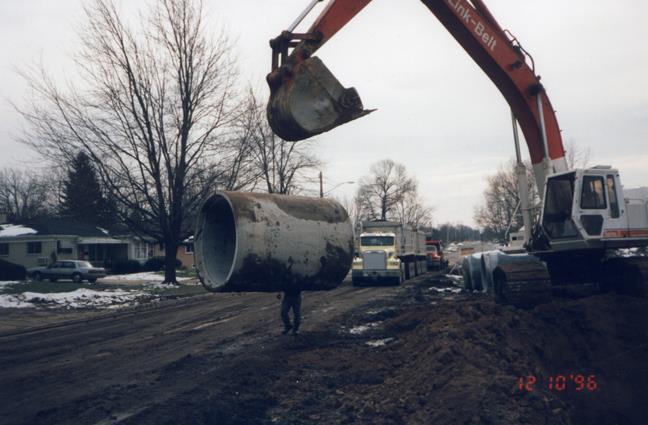


6 Separating Sanitary and Storm Sewers

7 The neighborhood streets under construction for over a year

8 Create Wetland/Upland Retention and Water Treatment System One of many water falls that are made using Lime Stone

9 Create Aesthetic, Environmental, and Recreational Neighborhood Amenities

10 The Tollgate Drain Project And Its Watershed Photo taken right after construction was finished

11 Before Construction Looking north on Fairview Street.

12 Looking north after construction on Fairview Street.

13 The first Water Fall in the treatment train right after construction.

14 Before Construction Before construction, looking south from Hopkins Street. This seven-acre site, located in Lansing Township, owned by the State of Michigan, and maintained as a park by the City of Lansing, is the site of the first set of project ponds.


15 Before construction, the seven acres were primarily a monoculture of reed canary grass. Before Construction

16 The lower pounds weeks after construction

17 After 6 months the transition is clear


18 Second waterfall draining into the peat filter

19 Water Lilies in one of the ponds at the Tollgate Drain These Lilies will trans-evaporate into the air thousands of gallons of water in a day.

20 Green Heron looking for food

21 He found some


22 Great Blue Heron with food

23 Great White Heron feeding at the Tollgate Drain


24 Water lilies and Broadleaf Arrow Head with Narrow Leaf Cattails form a scenic vista at the Tollgate Drain s wetlands. It is not uncommon to find many people of all ages with easels set up around the ponds, painting pictures of the wetlands. I call this picture the Tollgate Wetland s Monet. Pond lilies help to evaporate water by transovaporation and evaporation. They also take up nutrients from the water while providing an attractive addition to the wetlands.
25 Improve Golf Course The Tollgate Drain s Watersheds drain to the City of Lansing s Groesbeck Golf Course

26 Groesbeck Golf Course, a municipal golf course, had no water features prior to the construction of this project. This picture shows the golf course prior to construction.

27


28 Opening Day

29 Wildflower and native vegetation buffer strip around the storm water ponds

30 Flower buffers around the Golf Course ponds
31 Conclusions Urban Retrofit Opportunities for Stormwater Management: Can Meet Multi-objective Goals Can Make Good Short- and Long-Term Financial Sense Can Facilitate Social Change for Environmental Stewardship


32 Conclusions An Upfront Investment in Social Attitude and Behavior Change is a Good Investment Retrofitting Water Resource Protection into Urban Environments Will be More Successful When Accompanied by Education and Public Outreach
Chesapeake Bay Landscape Professional
 Chesapeake Bay Landscape Professional Certification Initiative Suzanne Etgen, CCLC Board Member July 10, 2014 Chesapeake Conservation Landscaping Council Who is CCLC? Local Government Stormwater Programs
Patrick E. Lindemann INGHAM COUNTY DRAIN COMMISSIONER. Towar Rain Garden Drains A Low-Impact Urban Retrofit
 : A Michigan Urban Retrofit Low Impact Stormwater Management System What Color is Your Infrastructure? 2011 LID Symposium Philadelphia September 28, 2011 Twenty percent of the world s available fresh water
City of Grande Prairie Development Services Department KENNEDY DEVELOPMENTS LTD. OUTLINE PLAN OP-09-01
 City of Grande Prairie Development Services Department KENNEDY DEVELOPMENTS LTD. OUTLINE PLAN OP-09-01 July 27, 2009 TABLE OF CONTENTS 1.0 Introduction... 1 1.1 Plan Area Location & Context... 1 1.2 Ownership
12/7/2007. Christopher B. Burke Engineering West, Ltd Aux Sable Creek Watershed Plan Update 1
 The ABC s of BMP s Aux Sable Watershed Plan St. Charles, IL Why are BMP s Important Best Management Practices (BMPs) developed as a set of practices which help to achieve goals of the Clean Water Act and
Municipal Plan*Assessment
 Municipal Plan*Assessment This tool was developed to assist in reviewing municipal master plans and in determining if these plans are consistent with smart growth principles, neighboring municipal plans,
Boardman River Watershed VILLAGE OF KALKASKA. WATER QUALITY ACTION PLAN Fall 2009
 Boardman River Watershed VILLAGE OF KALKASKA WATER QUALITY ACTION PLAN Fall 2009 Partners: The Watershed Center Grand Traverse Bay Northwestern Michigan College - Great Lakes Water Studies Institute Grand
Separate Storm Sewer System Study Questions/Answers
 1 Separate Storm Sewer System Study Questions/Answers Village of Wilmette, Illinois March 13, 2018 Green Infrastructure 2 3 Role of Green Infrastructure Green Stormwater Infrastructure (GSI) can reduce
Southeast Michigan Council of Governments
 Southeast Michigan Council of Governments SEMCOG Green Infrastructure Activities Regional Green Infrastructure Vision GLRI Green Streets EPA Technical Assistance MDOT Grants Green Infrastructure Vision
UNIVERSITY OF MICHIGAN:
 Chapter Eight UNIVERSITY OF MICHIGAN: North Campus I. Introduction The University of Michigan currently owns approximately 800 acres of land in the northeast section of Ann Arbor. North Campus refers to
STORMWATER STRATEGY PROJECTS IN ACTION
 STORMWATER STRATEGY PROJECTS IN ACTION NEW JERSEY DEPARTMENT OF ENVIRONMENTAL PROTECTION 2018 WATER QUALITY RESTORATION GRANTS FOR NONPOINT SOURCE POLLUTION PUBLIC INFORMATION SESSION JUNE 2018 319(H)
November 21, Planning Commission Charter Township of Lyon Grand River Ave. New Hudson, MI 48165
 Planning Commission Charter Township of Lyon 58000 Grand River Ave. New Hudson, MI 48165 Subject: AP-18-68; 11 Mile and Milford Road Park, Site Plan Review #1 Based on site plan dated 11/12/18 Location:
City of Missoula and Missoula County Open Space Planning Open House
 City of Missoula and Missoula County Open Space Planning Open House FEBRUARY 6, 2018 The following slides contain the display board content from the open house. Please use boards to answer questions in
Wisconsin Dept. of Transportation November 2017
 Wisconsin Dept. of Transportation November 2017 Jennifer Gibson WisDOT Environmental Coordinator Mike Helmrick WisDOT Environmental Coordinator Background on compensatory wetland mitigation Site purpose
Dwelling Units Max 12 dwelling units per acre/min 8 dwelling units per acre. Development Mix 80% non residential/20% residential
 13. OSTEEN LOCAL PLAN Background: The Osteen Local Plan area is located in southwest Volusia County along the SR 415 corridor between Lemon Bluff Road and Acorn Lake Road and includes 3,990 acres. The
319 Grant: Baker Creek & Centenary Creek Restoration Initiative
 319 Grant: Baker Creek & Centenary Creek Restoration Initiative Objectives: Overview of Watershed Characteristics: Discussion of Project Tasks: Discussion of Watershed Management Plan: Presented by: Erich
Low Impact Development. Charlene LeBleu Auburn University Landscape Architecture (334)
") Low Impact Development Charlene LeBleu Auburn University Landscape Architecture leblecm@auburn.edu (334) 844-0192 What is Low Impact Development? Infiltrate Filter Store Evaporate Detain An innovative
Low Impact Development Charlene LeBleu Auburn University Landscape Architecture leblecm@auburn.edu (334) 844-0192 What is Low Impact Development? Infiltrate Filter Store Evaporate Detain An innovative
Stormwater Low Impact Development - A Natural Solution
 Stormwater Low Impact Development - A Natural Solution Sarah U Ren Program Director The Watershed Center of Grand Traverse Bay 231-935-1514, suren@gtbay.org Our Mission: The Watershed Center advocates
AREASTRUCTURE PLAN AMENDMENT COCHRANE NORTH
 AREASTRUCTURE PLAN AMENDMENT COCHRANE NORTH In order to implement the vision outlined in the Conceptual Scheme, the following three amendments to the Cochrane North ASP are proposed: 1. Allow commercial
Green Roofs and Stormwater Management Virginia Stovin
 Green Roofs and Stormwater Management Virginia Stovin Department of Civil and Structural Engineering Pennine Water Group University of Sheffield Outline Urban stormwater management Conventional solutions,
The Benefits and Challenges Associated with Green Infrastructure Practices
 The Benefits and Challenges Associated with Green Infrastructure Practices Thomas M. Evans ASLA, LEED AP Regional Green Infrastructure Design Services Director OWEA Technical Conference, June 20, 2013
CHAPTER 4 FUTURE LAND USE AND URBAN SERVICES DISTRICTS
 CHAPTER 4 FUTURE LAND USE AND URBAN SERVICES DISTRICTS Introduction This chapter discusses how Benzie County should grow and change in the future. A community can grow and change in many different ways.
Importance of Master Planning Marcy Colclough
 Importance of Master Planning Marcy Colclough Senior Planner Southwest Michigan Planning Commission WHERE and HOW we develop Land affects Water Quality! 43.2 Acres total 20 Homes 35.8 Acres of open space
ENVIRONMENTAL STEWARDSHIP, COMMITMENTS, AND COMPLIANCE
 ENVIRONMENTAL STEWARDSHIP, COMMITMENTS, AND COMPLIANCE Russ Yurek, Maryland SHA July 20, 2015 AASHTO SOC Des Moines, IA Traditional Roadside Stewardship SHA Integrated Roadside Vegetation Management (IRVM)
Design Around Waterways and Wetlands
 Design Around Waterways and Wetlands NL Green Economy Conference Newleef-2014 NEIA, St. John s, NL October 9-10 th, 2014 Wade Lewis Amherst, Nova Scotia, w_lewis@ducks.ca DUC conserves, restores and manages
Arlington County Watershed Retrofits. Greg Hoffmann Center for Watershed Protection
 Arlington County Watershed Retrofits Greg Hoffmann Center for Watershed Protection March 18, 2010 About the Center for Watershed Protection Non-profit 501(c)3, non-advocacy organization Work with watershed
Draft Rhode Island Stormwater Design and Installation Standards Manual
 Draft Rhode Island Stormwater Design and Installation Standards Manual Summary The May 2009 Public Review Draft version of the RI Stormwater Design and Installation Standards Manual consists of approximately
Whitemarsh Township Greenway Plan
 Whitemarsh Township Greenway Plan Prepared for: Whitemarsh Township August 16, 2007 Table of Contents Table of Contents... i Introduction... 1 Study Area Setting... 2 Regional Setting... 2 Township Character...
green Infrastructure in the Milwaukee Region
 green Infrastructure in the Milwaukee Region 14 MMSD has a long history of environmental stewardship and has implemented holistic approaches to improve water quality and protect residents from the effects
Repurposing Stranded Office Parks Natural Environment
 Repurposing Stranded Office Parks Natural Environment Tavis Dockwiller/ Viridian Landscape Studio What is Green Infrastructure? Rethinking the large scale Rethinking the details Ecological Policy and Program
Stormwater & South Carolina. A Case for Low Impact Development
 Stormwater & South Carolina A Case for Low Impact Development what is stormwater? stormwater & development Volume of Water stormwater & development Peak Flow Urban Natural Peak Flow Rain Event Time Components
Conservation Development
 Acknowledgements RIDEM: Scott Millar Anthony Lachowicz-Planning and Zoning Consultant Director of Planning 1 : a creative land use technique that allows a community to guide growth to the most appropriate
Southwest Fleetwood Enclave
 Southwest Fleetwood Enclave Development Concept Plan Southwest Fleetwood Enclave 1 st Land Owners Meeting April 30 th, 2012 Presentation Overview Why the Plan? ; Overview & Purpose of Study; Constraints
Putting the Pieces Together
 Putting the Pieces Together A guided tour of the St Croix Valley's land and water resources A Guided View from the River: What are the challenges and obstacles your community is facing? 1 Site 2 Buk and
KISHWAUKEE MUNICIPALITIES PLAN FOR SUSTAINABLE DEVELOPMENT
 KISHWAUKEE MUNICIPALITIES PLAN FOR SUSTAINABLE DEVELOPMENT 4 "Natural areas, parks and open space create a high quality of life that attracts tax-paying businesses and residents to communities." Trust
Natural Shorelines. for Inland Lakes. A Landowner s Guide to using. to STABLIZE SHORELINES, Michigan s inland lakeshore.
 Natural Shorelines for Inland Lakes A Landowner s Guide to using NATURAL MATERIALS to STABLIZE SHORELINES, IMPROVE WATER QUALITY and ENHANCE WILDLIFE HABITAT along Michigan s inland lakeshore. Natural
Green Infrastructure Stormwater Management Options in an Ultra-Urban Redevelopment. Sandy Doyle-Ahern
 Green Infrastructure Stormwater Management Options in an Ultra-Urban Redevelopment Sandy Doyle-Ahern sdoyleahern@emht.com + The City of Columbus Downtown Business Plan was developed in 2002 with the goal
Deer Creek Watershed Stakeholders Committee
 Deer Creek Watershed Stakeholders Committee Stakeholder Partners East West Gateway Council of Governments Great Rivers Greenway District Local Municipalities Metropolitan St. Louis Sewer District Missouri
THREE-STEP DESIGN PROCESS FOR OPEN SPACE SUBDIVISIONS
 00216106.DOC NMA/RRK 1/30/14 THREE-STEP DESIGN PROCESS FOR OPEN SPACE SUBDIVISIONS Open space subdivisions, sometimes called cluster developments, maintain a significant portion of a development site in
Preface. City of Chardon City of Wickliffe Chardon Township Munson Township Russell Township South Russell Village
 Conceptual Mitigation Plan for Riparian Zone Restoration Project # 447-942 Presented to: Chagrin River Watershed Partners, Inc. P.O. Box 229 Willoughby Hills, Ohio 44096-0229 Prepared by: EnviroScience,
FLEET AVENUE GREEN STREET USES VACANT LOT FOR CSO REDUCTION. Thomas M. Evans, AECOM Cleveland, Ohio
 FLEET AVENUE GREEN STREET USES VACANT LOT FOR CSO REDUCTION Thomas M. Evans, AECOM Cleveland, Ohio INTRODUCTION As part of the Northeast Ohio Regional Sewer District s (Sewer District) Green Infrastructure
There are 11 different micro-ecosystems that are found in 76 different areas throughout Stoneybrook. They are divided into three major groups.
 by Larry Eichert There are 11 different micro-ecosystems that are found in 76 different areas throughout Stoneybrook. They are divided into three major groups. Wetlands Upland Mitigated sections (a term
APWA Expo August 27, Ground Water Recharge With Storm Management: A Sustainable Development
 APWA Expo August 27, 2013 Ground Water Recharge With Storm Management: A Sustainable Development Presented by: Joel S. Koenig, P.E. Andrew J. Hawkins Chris P. Dagiantis, P.E., CFM Bios Joel S. Koenig,
Planning for Staten. Habitat Restoration and Green Infrastructure. Island s North Shore
 Habitat Restoration and Green Infrastructure Planning for Staten Island s North Shore Walker Park December 7, 2017 NYC Parks Forestry, Horticulture, and Natural Resources Funded by the NYS Department of
From a Census of 680,000 Street Trees to Smart Stormwater Management: A Study of Efficacy and Economics of Street Tree Guards in New York City
 From a Census of 680,000 Street Trees to Smart Stormwater Management: A Study of Efficacy and Economics of Street Tree Guards in New York City Elliott, R. M.i., Shetty N. H.i, Culligan P. J.i Green infrastructure
include playgrounds, sports fields, community gardens and picnic areas.
 DEVELOPMENT PLAN OPEN SPACE SYSTEM OPEN SPACE SYSTEM The neighborhood provides for a range of open space types. The Village Square is an important open space in the neighborhood. It serves as a gathering
Managing Stormwater Naturally. July 17, 2013
 Managing Stormwater Naturally July 17, 2013 1 This image cannot currently be displayed. Guiding Documents 2 Stormwater Purpose Statement The City Council hereby finds, determines and declares the City
Cost Effective Low Impact Development
 Cost Effective Low Impact Development An Introductory Guide to Conserve Land, Restore Resources, Protect Water, and Save Money in Massachusetts Stefanie Covino Shaping the Future of Your Community Program
Gaining Consensus for Green Infrastructure Rain to Recreation
 Gaining Consensus for Green Infrastructure Rain to Recreation May 2nd, 2017 Tom Jacobs, PE, CFM Stormwater Engineer City of Lenexa Ronald L Norris, PE, PWLF Affiliated with Shockey Consulting Rain to Recreation:
water that enters our streams during storms. Any water the rain garden can t accept will continue into the storm sewer system.
 North Kensington Street and 32 nd Street North Green Street and Sewer Capacity Meeting Friday, July 20 and Monday, July 23, 2012 Summary of Citizen Questions and Concerns Thank you for participating in
EXHIBIT B PROJECT NARRATIVE POULSBO MEADOWS
 EXHIBIT B PROJECT NARRATIVE POULSBO MEADOWS Name of Project: Poulsbo Meadows; A Planned Residential Development (PRD)/Plat Applicants Name: PBH Group LLC/Byron Harris PO Box 1010 Silverdale, WA 98038 Description
HAMLET OF KINGMAN AREA STRUCTURE PLAN
 HAMLET OF KINGMAN AREA STRUCTURE PLAN Prepared by: Austrom Consulting Ltd. Page 1 of 19 Table of Contents TABLE OF CONTENTS... 2 1. BACKGROUND... 3 1.1 PLAN AREA... 3 1.2 PLAN PURPOSE... 3 1.3 LEGISLATIVE
COMMISSION ACTION FORM
 ITEM #: 6 DATE: 09-06-17 COMMISSION ACTION FORM REQUEST: Introduction and Initial Review of Proposed Amendments to the Ames Urban Fringe Future Land Map for the North Growth Gap Area BACKGROUND INFORMATION:
Getting Buy-in: Making the Economic Case for Watershed Planning. Jane Harrison, Ph.D. Coastal Economics Specialist North Carolina Sea Grant
 Getting Buy-in: Making the Economic Case for Watershed Planning Jane Harrison, Ph.D. Coastal Economics Specialist North Carolina Sea Grant Watershed Planning and Protection Obvious environmental benefits
VACANT TO VIBRANT : GREEN INFRASTRUCTURE & URBAN REVITALIZATION
 VACANT TO VIBRANT : GREEN INFRASTRUCTURE & URBAN REVITALIZATION Calumet Summit 2013: Connecting for Action Lauren Riga, Director City of Gary Department of Green Urbanism Gary Storm Water Management District
A.9. Cannon River. Campostella Park. Adjacent Industrial & City Facility Uses
 Campostella Park Classification: Nature Area 14 acres Character: This park is an undeveloped, heavily wooded natural open space park located along the Cannon River, just to the southwest of Babcock Park
Physical Approaches to Flood Mitigation
 Physical Approaches to Flood Mitigation ational Academy of Sciences /19/2017 Chicago Area Before Development Widespread Flooding Waterways and Marshes Absorbent Ground Early settlers came to this location
Village of Glenview Appearance Commission
 Village of Glenview Appearance Commission STAFF REPORT July 23, 2014 TO: Chairman and Appearance Commissioners CASE #: A2014-059 LOCATION: 727 Harlem Avenue FROM: Community Development Department PROJECT
VEHICULAR AND PEDESTRIAN CIRCULATION
 This perspective sketch communicates the intended character and quality of a proposed streetscape design. Locate benches near a major intersection where people tend to gather. Seating and lighting provide
Rouge River Gateway Master Plan Update: 2011
 Rouge River Gateway Master Plan Update: 2011 Environmental Stewardship Cultural Heritage Recreation Economic Development Rouge Gateway Master Plan (2001) 1 Rouge Gateway Master Plan Update (2005) Significant
Redevelopment Plan for the Former South Gifford Road Landfill
 Redevelopment Plan for the Former South Gifford Road Landfill Summary Report July 2018 Treasure Coast Regional Planing Council Former South Gifford Road Landfill Site Redevelopment Plan July 2018 prepared
Worksheet #14 Water Runoff Management
 Water Runoff Management Use this worksheet to assess how well your property minimizes the potential for water runoff and property damage.. Why should you be concerned? What can you do? Rural runoff, also
Summer Public Education and Outreach Campaign Toolkit
 Summer Public Education and Outreach Campaign Toolkit ABOUT THIS TOOLKIT The communications tools and messages included in this toolkit were developed by Bluestem Communications for the Lower DuPage River
ZONING COMPLIANCE PERMIT APPLICATION
 ZONING COMPLIANCE PERMIT APPLICATION 405 Martin Luther King Jr. Blvd phone (919) 968-2728 fax (919) 969-2014 www.townofchapelhill.org Parcel Identifier Number (PIN): Date: Section A: Project Information
LOUISIANA STATE UNIVERSITY COMPREHENSIVE & STRATEGIC CAMPUS MASTER PLAN. APPENDIX G - Stormwater Study Findings & Stormwater Solutions
 LOUISIANA STATE UNIVERSITY COMPREHENSIVE & STRATEGIC CAMPUS MASTER PLAN APPENDIX G - Stormwater Study Findings & Stormwater Solutions LSU: MP Narrative July 2017 3.5 Open Space Existing Conditions The
to the Jericho Reservoir Project Open House
 Welcome to the Jericho Reservoir Project Open House is responsible for supplying clean, safe drinking water to over 2.4 million residents in the region. Operating our vast drinking water system with a
Evaluating Urban Stormwater Retrofits in the SE US Coastal Plain
 Evaluating Urban Stormwater Retrofits in the SE US Coastal Plain 2017 Florida Stormwater Association June 14-17, 2017 Eban Z. Bean, PhD, PE Assistant Professor & Extension Specialist Agricultural and Biological
Planning & Zoning Commission Meeting Date: June 18, 2012
 Meeting Date: June 18, 2012 Request Applicant Owner Zoning Location Attachments Proposed Master Plan for 11.5 acres of undeveloped property in the Tuscan Lakes PUD. The land is platted as one lot, and
Southland Lane Detention Pond Project is a classroom for future green infrastructure projects in the City of Brookings, South Dakota
 Southland Lane Detention Pond Project is a classroom for future green infrastructure projects in the City of Brookings, South Dakota What does a pipe think of a pond? Presented by Rocky J. Keehn, PE, D.WRE,
Potential Green Infrastructure Strategies May 6, 2015 Workshop
 Potential Green Infrastructure Strategies May 6, 2015 Workshop Background The City of Cortland is developing the Tioughnioga Urban Headwaters Green Infrastructure Action Plan with funding from the National
Green Infrastructure-A New Approach to Floodplain and Stormwater Management. Presenter: Kari Mackenbach, URS
 Green Infrastructure-A New Approach to Floodplain and Stormwater Management Presenter: Kari Mackenbach, URS WHAT-WHERE-HOW-WHY? What is Green Infrastructure? Where is it being used in other communities?
Leduc Industrial Outline Plan SE W4
 Leduc Industrial Outline Plan SE 1-50-25-W4 Within the North Leduc Industrial ASP Prepared for: Leduc Energy Park Ltd. Prepared by: Stantec Consulting Ltd. File No. 1161 104655 V5 Table of Contents 1.0
METROPOLITAN COUNCIL 390 North Robert Street, St. Paul, MN Phone (651) ; TDD (651)
 ; TDD (651)") DATE: December 20, 2011 METROPOLITAN COUNCIL 390 North Robert Street, St. Paul, MN 55101 Phone (651) 602-1000; TDD (651) 291-0904 TO: Metropolitan Parks and Open Space Commission FROM: Tori Dupre, Senior
DATE: December 20, 2011 METROPOLITAN COUNCIL 390 North Robert Street, St. Paul, MN 55101 Phone (651) 602-1000; TDD (651) 291-0904 TO: Metropolitan Parks and Open Space Commission FROM: Tori Dupre, Senior
Working Group Meeting
 April 4,, 2017 Parks Operations Bldg Working Group Meeting Arts Districts Overview Stormwater/RPA/Stream Considerations First Principles Agenda 7:00pm 7:05pm 7:10pm 7:40pm 8:30pm 9:40pm 9:45pm Welcome
BERNALILLO COUNTY PLANNING COMMISSION ENVIRONMENT AND OPEN SPACE HEARING MAY 2014
 BERNALILLO COUNTY PLANNING COMMISSION ENVIRONMENT AND OPEN SPACE HEARING MAY 2014 1 PROJECT DEVELOPMENT TEAM: Garrett Development Corporation Bohannan Huston Inc. SEC Planning, LLC Consensus Planning,
Introduction to Low Impact Development. Fred Milch. East Central Florida Regional Planning Council
 Introduction to Low Impact Development Fred Milch East Central Florida Regional Planning Council Low Impact Development (LID) Low impact development (LID) is a term used to describe a land planning and
BLOOMSBURY BOROUGH. Regional Master Plan Overlay Zone Designation. 1 inch = 0.28 miles. Zone. Sub-Zone FRANKLIN TOWNSHIP GREENWICH TOWNSHIP
 Regional Master Plan Overlay Zone Designation Zone Protection Lakes Greater Than 10 acres Conservation Existing Community Sub-Zone Existing Community Environmentally Constrained Conservation Environmentally
ITEM # _ 41 _ DATE: COUNCIL ACTION FORM MAJOR FINAL PLAT FOR MENARDS SUBDIVISION BACKGROUND:
 ITEM # _ 41 _ DATE: 06-12-18 COUNCIL ACTION FORM SUBJECT: MAJOR FINAL PLAT FOR MENARDS SUBDIVISION BACKGROUND: The City s subdivision regulations are included in Chapter 23 of the Ames Municipal Code.
From and
 GREEN INFRASTRUCTURE IN PROVIDENCE, RI The Box Office From http://web.uri.edu/riss/the-box-office/ and http://www.morrisbeacon.com/media/portfolioprojects/implementation/box-office/box%20office.pdf: At
Sustainability Through Comprehensive Water Management
 Sustainability Through Comprehensive Water Management Howard S. Wertheimer, FAIA, LEED AP werth@gatech.edu Director, Capital Planning & Space Management Jason K. Gregory, RLA, LEED AP jason.gregory@cpsm.gatech.edu
Planning for and Managing Open Space and Natural Areas
 Planning for and Managing Open Space and Natural Areas Increasingly, development proposals in Delaware include large amounts of open space and natural areas. While open space is important as a community
Weston Conservation Commission
 Weston Conservation Commission Commission Roles and Responsibilities Laws that protect Wetlands What residents can do to protect wetlands and open space 1 Conservation Commission Made up of 7 volunteer
Green Infrastructure in the Greater Lansing Area
 Green Infrastructure in the Greater Lansing Area Friday May 9, 2014 David Christian, PE DC Engineering Lansing, MI Dan Christian, PE Tetra Tech Lansing, MI 1 2 Edgewood Village Center Cedar St School Harvesting
Storm Water Quality and Shoreline Restoration Improvements - Grant Funding Request City of Mound Carlson Park Bolton & Menk Project No.
 September 15, 2016 Brett Eidem Cost Share Grant Administrator Minnehaha Creek Watershed District 15320 Minnetonka Boulevard Minnetonka, MN 55345 RE: Storm Water Quality and Shoreline Restoration Improvements
2012 Saginaw Bay Watershed Conference
 2012 Saginaw Bay Watershed Conference March 16, 2012 Russ Beaubien, P.E., CFM Low Impact Development Fundamentals Summary LID overview Education on LID Fundamentals of LID Examples of LID practices Other
STORM WATER POLLUTION PREVENTION TRAINING. For Officials and Residents of Doylestown Township
 STORM WATER POLLUTION PREVENTION TRAINING For Officials and Residents of Doylestown Township THOUSANDS HAVE LIVED WITHOUT LOVE, NOT ONE WITHOUT WATER. W. H. Auden, First Things First Time for a Pop Quiz!
CHAPTER 22 Rural Open Space Community Developments
 CHAPTER 22 Rural Open Space Community Developments Section 22.1 Description and Purpose The intent of this Chapter is to offer property owners an alternative to traditional zoning requirements for rural
APPENDIX D: PARKS AND RECREATION ACTION PLAN
 APPENDIX D: PARKS AND RECREATION ACTION PLAN Goals The following goals are specific to the development, maintenance, and operation of the existing parks in the Township, as well as the acquisition and
Complete Neighbourhood Guidelines Review Tool
 Complete Neighbourhood Guidelines Review Tool Prepared By: City of Regina Planning Department October 2014 Page 1 of 14 Community Development Review Checklist for Secondary Plans and Concept Plans The
Whitemarsh Comprehensive Plan Update: Housing & Land Use. Public Workshop #3: September 20, 2018
 Whitemarsh Comprehensive Plan Update: Housing & Land Use Public Workshop #3: September 20, 2018 Agenda Welcome Process Recap What We ve Heard The Plan Framework Review of Recommended Actions Land Use Housing
Weston s Wetlands, Stormwater, & Open Space
 Weston s Wetlands, Stormwater, & Open Space Weston s Wetlands, Stormwater, & Open Space Conservation Commission Role and Responsibilities Laws that protect wetlands What residents can do to protect wetlands
continues in the watershed, additional flood control and water quality / natural system improvements may be required in the future.
 The Duck Pond Watershed is located in northern Hillsborough County in an area in which a number of land and water management issues are currently being addressed by citizen's action groups and state, regional
Section 3 Non-Structural BMPs
 3.1 Stream Buffers A stream buffer or stream setback is a designated area around a stream, lake, or wetland left in a natural, densely vegetated state so as to protect the receiving water quality and provide
DISCUSSION TOPIC: ST JOHNS RIVER & ITS TRIBUTARIES (BPII) 2030 COMPREHENSIVE PLAN POLICES AND REGULATORY FRAMEWORK
 2030 COMPREHENSIVE PLAN POLICES AND REGULATORY FRAMEWORK") DISCUSSION TOPIC: ST JOHNS RIVER & ITS TRIBUTARIES (BPII) 2030 COMPREHENSIVE PLAN POLICES AND REGULATORY FRAMEWORK St. John s River & Its Tributaries Issue Summary: The St. Johns River is an important
DISCUSSION TOPIC: ST JOHNS RIVER & ITS TRIBUTARIES (BPII) 2030 COMPREHENSIVE PLAN POLICES AND REGULATORY FRAMEWORK St. John s River & Its Tributaries Issue Summary: The St. Johns River is an important
Planning for Staten. Habitat Restoration and Green Infrastructure. Island s North Shore
 Habitat Restoration and Green Infrastructure Planning for Staten Island s North Shore Community Board 1 March 1, 2018 NYC Parks Forestry, Horticulture, and Natural Resources Funded by the NYS Department
2. Analysis. DRAFT Gerald Richards & Pleasantview Park Master Plan
 DRAFT Gerald Richards & Pleasantview Park Master Plan 19 Historic Features According to the National Register of Historic Places and the National Historic Landmarks Program, there is nothing of national
Do you know there your MS4 is?
 Do you know there your MS4 is? Understanding risk Beth Chesson, CPESC, CPSWQ September 14, 2015 Understand your MS4 Reduce your risk Nutrient management MS4 Flood management CIP Comprehensive Stormwater
When planning stormwater management facilities, the following principles shall be applied where possible.
 2.0 Principles When planning stormwater management facilities, the following principles shall be applied where possible. 2.0.1 Drainage is a regional phenomenon that does not respect the boundaries between
Information for File # MVP MMJ; Elim Care
 Information for File # MVP-217-2628-MMJ; Elim Care Applicant: Elim Care of Maple Plain Corps Contact: Melissa Jenny Address: 18 Fifth Street East, Suite 7, St. Paul, MN 5511-168 E-Mail: Melissa.m.jenny@usace.army.mil
Sustainable Storm Water Management
 Incorporating Water Management into the Community Planning Process August 16, 2012 Sustainable Storm Water Management Samantha Brown Environmental Engineer SD1 SD1 s Service Area CVG Airport SD1 Service
Design Specifications & Requirements Manual
 11 PARKS & OPEN SPACES 11.1 DEFINITIONS... 1 11.1.1 Neighbourhood Parks... 1 11.1.2 District Parks... 1 11.1.3. Sport Parks... 1 11.1.4 Urban Parks... 1 11.1.5 Civic Spaces... 1 11.1.6 Open Space System...