Land Use Plan. Strategic Plan. CHAPTER SEVEN Proposed Land Use Plan. Fort Washington Area
|
|
|
- Jesse Rice
- 5 years ago
- Views:
Transcription
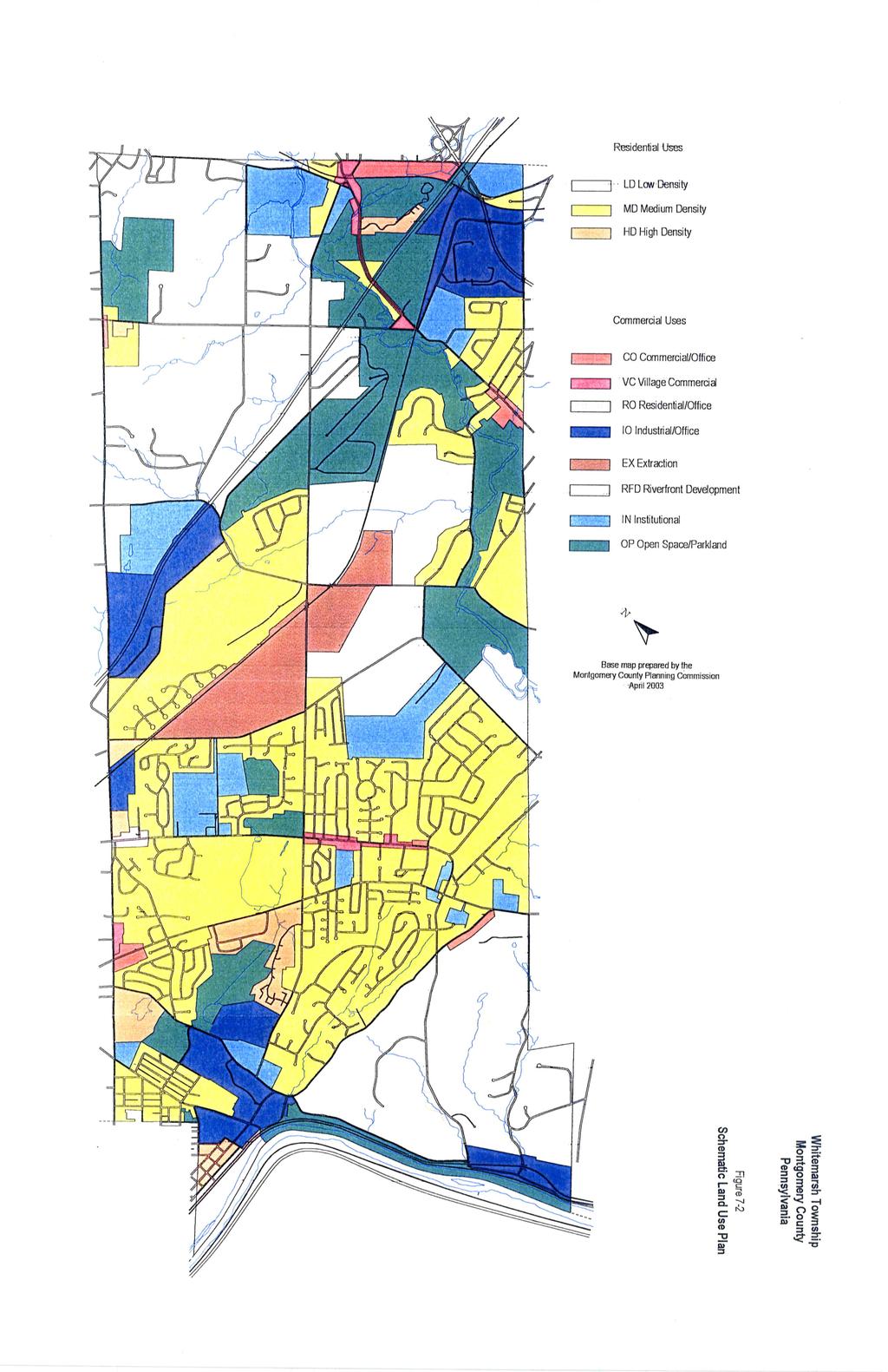
1 CHAPTER SEVEN Proposed Land Use Plan The Proposed Land Use Plan is a significant component of the Comprehensive Plan. It is Whitemarsh s land use policy statement. A policy guide for the township, it is oriented toward enhancing and protecting resources while also recommending actions to forestall land use conflicts. During the planning process, Whitemarsh s existing character as a predominately residential community with smaller, distinct nodes of commercial, office and industrial uses was acknowledged and then chosen for its future growth pattern. Continuing primarily as a residential community, future nonresidential development should be limited to providing commercial uses for the convenience of township neighborhoods, while some office and light industrial use should be developed to ensure a healthy tax base. This development should be directed to the Schuylkill riverfront redevelopment area and the undeveloped land in existing office parks, such as the Whitemarsh Business Campus. Furthermore, it was found that the township was entering its fourth century as a stable community. Older residential neighborhoods are well maintained and still desirable. New residential growth is compatible with existing density patterns. Existing commercial development is still viable, with the township s largest shopping complex, Whitemarsh Shopping Center, having recently undergone an extensive remodeling. Old, abandoned or underutilized industrial buildings along the riverfront are being converted to office uses. However, several ominous signs exist. Much of the township s rural landscape is disappearing and throughout the township potential conflicts exist where there are disparities between existing uses and the zoning designations. The township is struggling to maintain the quality of life that makes it so desirable and gives it its sense of place. Therefore, this plan is formulated to build on the township s existing strengths, while containing policies to ensure that these strengths are reinforced. Land Use Plan To implement the township s land use goals requires a two-stage process. The initial stage presents a strategy for achieving many of the goals formulated by the township. Referred to as the Strategic Plan, it is comprised of areas throughout Whitemarsh where it would be desirable to change the existing zoning to implement the township s goals and objectives. The second stage, entitled the Schematic Plan, contains the land use policies for the entire township. It is the Official Land Use Plan for Whitemarsh, yet it can only be fully achieved through enacting the changes described in the Strategic Plan. Strategic Plan The implementation of the land use/zoning changes listed below is considered particularly important to forestall land use conflicts, to preserve open space or historic resources, to further a well planned community, and to implement the township s goals and objectives contained in Chapter 6. The proposed changes are also delineated in Figure 7-1. Fort Washington Area 1. Morris Road - Across from Germantown Academy. Change the existing commercial zoning to residential. This is consistent with the surrounding area and eliminates the potential for strip commercial along this heavily traveled road. 65
2 2. Hollywood Drive - Change the existing commercial zoning on this residential street to residential. This change would prevent land use conflicts. 3. Pennsylvania Avenue - Between Bethlehem Pike and Route 309. Modify the existing zoning to permit commercial and office uses but to exclude auto-oriented commercial development such as drive-through restaurants and gas stations. With close proximity to the Turnpike, the 309 Expressway and the Fort Washington train station, it is envisioned that this area will develop as a destination area for commercial and office use. Also, given its proximity to the train station a village commercial mix that also permits residential uses is desirable. It was felt that a proliferation of strip commercial development, typically associated with auto-oriented uses, would detract from these efforts. Streetscape enhancements such as sidewalks and street trees should be a part of any development that occurs along this corridor. Traditionally the eastern edge of this corridor has been impacted by flooding by the Sandy Run. Therefore, development activity along this corridor should be concentrated in the non-flooding area toward Bethlehem Pike, while the eastern edge toward the Route 309/Turnpike interchange should be discouraged from development. However, much of this flooding was the result of a small culvert under the SEPTA tracks of the R-5 Line that caused severe ponding. Recently this culvert was replaced by a new bridge which permits greater water flow. Therefore, the severity of flooding may be reduced and a detailed floodplain reassessment of this area should be conducted. 4. Bethlehem Pike - Between Pennsylvania Avenue and Skippack Pike. Create a new commercial zoning district for the corridor that preserves and builds on its existing historic fabric. Such a district would prevent strip commercial development and the over development of a site but would allow infill development that is in keeping with the village character of the area. Cold Point Area 5. Radio Tower Site - Near the intersection of Flourtown Road and Joshua Road. With the recent rezoning of the adjacent quarries to the EX Extraction District, this site is the only parcel in this area zoned Heavy Industrial. It is entirely surrounded by zoning that permits residential uses at a density of one dwelling unit to the acre. Therefore, it is appropriate to rezone this site to a similar designation. 6. Cold Point Village - This historic village is currently suffering from the deleterious effects of traffic congestion. However, as more fully described in Chapter 8, Transportation Plan, efforts are underway to relocate Butler Pike west of the village and to realign Flourtown Road with Plymouth Road. If these are accomplished, it is envisioned that Cold Point could once again be a quiet, pleasant residential community. However, if these actions do not occur or undergo a lengthy delay, a zoning designation that would preserve the houses but allow their conversion to office or limited commercial uses should be considered. This area should be periodically monitored and a dialogue should begin between residents and the township to discuss what future land use changes, if any, are warranted. Plymouth Meeting Area 7. Butler Pike - At the Conrail Tracks. Along Butler Pike, between the Conrail tracks and the historic Plymouth Meeting village are two disparate zoning districts. Adjacent to the tracks is an industrial district that primarily contains offices, while next to this is a large underdeveloped tract, which is zoned for single-family houses. Recent development along this busy corridor has been for office campuses. To encourage this trend, the area should be rezoned to an office park designation. A large parcel, between this area and the historic houses in the village is zoned for townhouses. It would buffer office development from the village. 66
3
4 8. Plymouth Meeting Village - Because of their location on Germantown Pike many of the old houses are no longer desirable as residential properties. To help maintain their viability, a new zoning district should be created that would allow the houses to convert to offices provided the historic facades and front yards are preserved. Additions and parking would be required to be in the rear yard areas. Lafayette Hill Area 9. Germantown Pike - Between Joshua Road and Church Lane. In the area between the two shopping centers, properties fronting Germantown Pike should be rezoned to a commercial district that promotes the historic character of the area, but precludes strip commercial and assists in creating a traditional Main Street appearance for the corridor. This is similar to what is proposed for Bethlehem Pike between Pennsylvania Avenue and Skippack Pike and for Harmonville on Butler Pike near Ridge. Hector Street/North Lane Area 10. Hector Street/North Lane Area - This area is proposed to be designated the riverfront redevelopment area. In particular, along the river, the zoning will be amended to not only continue the trend toward office conversion in the old industrial buildings, but to also allow for a variety of residential dwellings and accessory commercial uses. The creation of a mixed-use urban village is envisioned. Such a district would be oriented around the Spring Mill train station and would contain regulations to allow public riverfront access, an idea proposed in the township s 1996 Open Space Plan. Cedar Heights Area 11. Either Side of Roberts Avenue - Between Hallowell and Durant Streets is zoned commercial. Not only is this inconsistent with its existing residential character but also makes all of the properties, except one, non-conforming. The area should be rezoned similar to the surrounding residential zoning. Harmonville Area 12. Butler Pike, North of Ridge Pike - Between Ridge Pike and Colonial Road. Along this corridor are a series of old houses and small buildings that contain commercial uses. Similar to what is proposed for parts of Germantown and Bethlehem Pikes, commercial zoning that is more reflective of its historic character and would preclude strip commercial development should be considered. Schematic Plan The Schematic Plan is the township s official land use plan. While largely achieved through enacting the changes proposed in the Strategic Plan, it is also reflective of existing land uses and zoning, given that much of Whitemarsh s development pattern is well established. Formulated from the township s goals and objectives, it is the township s statement regarding land use policy and the guide for future development. The Plan divides the township into the following land use categories: Residential This category is divided into two groups: the areas that would develop under traditional zoning and those that would develop under the growing greener program. Current residential densities in Whitemarsh will 69
5 remain the same regardless of the type of development allowed. Low Density (LD) is development at one dwelling unit or less per acre. It is located primarily in the Miquon and Broad Axe areas of Whitemarsh. Medium Density (MD), the largest single land use category in the township, allows a density of 1.4 to 4.3 dwelling units to the acre. It covers extensive sections of the township including most of the developed sections of Lafayette Hill, Fort Washington and Cedar Heights and much of the undeveloped land in the Broad Axe area. In both the low and medium density areas single-family detached dwellings are the only type of residential development permitted. High Density (HD) conversely permits a full range of dwelling types (single-family, townhouse and apartments) at a density of six or more dwelling units to the acre. It is designated for such areas of the township as the residences adjacent to Lee Park, an older area of Fort Washington, and along sections of Ridge and Germantown Pikes. While the high density and some of the medium density areas will continue to allow development under traditional zoning, all districts that have a density of 1.4 dwelling units to the acre or greater (the A-AAAA zoning districts) will only allow development pursuant to the growing greener program. A modified version of cluster development, known as a conservation subdivision, will provide the framework for future development in these areas. The conservation subdivision allows development at the underlying density permitted by the zoning district, but only after a certain percentage of the constrained lands, identified as the primary features on the Map of Township-Wide Potential Conservation Lands, is factored out. Development would be further regulated by requiring that a certain percent of the buildable land (say 50%) would be preserved as permanent open space. Optionally, most of this open space would contain the secondary features also found on the Map of Township-Wide Potential Conservation Lands. Optimally this open space would also be contiguous to open space on adjacent properties, to assist in the creation of a continuous band of open space. This map is the tool that assists the township in determining which land must or should be preserved. To promote flexibility and recognizing that significant differences can be found between tracts or areas, the conservation subdivision also allows several development options. These can range from density bonuses when additional land is preserved to density disincentives when a more conventional lotting arrangement is proposed. Other options available, depending upon the township s preferences, include country estates on large permanently-preserved parcels or the creation of small villages and hamlets that are surrounded by open space. Commercial Commercial and Office uses (CO) are primarily proposed along sections of major roads or at prominent intersections in the township. The range and size of the use would differ in accordance with the development regulations permitted in these areas. For example, Pennsylvania Avenue would promote high density development more urban in character, while the intersection at Ridge and Butler Pikes would contain low density suburban style development. It should be noted that in four areas, specialized commercial/offices uses are proposed. Along Bethlehem Pike from Fort Washington to the historic Whitemarsh area, along Germantown Pike in Lafayette Hill, and along Butler Pike in Harmonville, commercial segments have been designated as Village Commercial (VC), a classification designated to preserve their traditional village character and scale. Similarly in Plymouth Meeting, the historic village has been designated Residential Office (RO) which allows for small-scale office conversions in the old houses. Industrial/Office Industrial Office (IO) differs from the (CO) designation in that it would not permit commercial retail uses but does permit some light manufacturing. It is located primarily in the Spring Mill area, along Militia Hill Road between Butler Pike and Stenton Avenue, and at the McNeil Consumer Products property in Fort Washington. 70
6 Institutional The nature of Institutional land use (IN) does not easily lend itself to designation on the map. The need for such uses can arise almost anywhere, depending upon the nature of the specific institutional use. As a result, only large, established existing sites that are likely to remain for the long term, such as schools, the township buildings, long established religious facilities and medical facilities are shown. Open Space/Park Land Open Space and Park Land (OP) is designated for all existing public parks such as Fort Washington, Cedar Grove, Miles, etc. Also, it is designated for natural areas near water courses, such as along the privately held sections of the Wissahickon Creek and the Schuylkill River. EX Extraction District This area contains the Highway Materials Quarries. Under this designation, the quarries are allowed to operate until the land has been reclaimed. At that time, the area is permitted to develop with single-family houses at one dwelling unit to the acre. Riverfront District This area is currently undergoing a shift from Heavy Industrial uses to an office park community. To promote this area as a new community, a mixed-use village, zoning should be developed that permits a variety of residential dwellings, commercial uses and requires a public greenway along the river. A map delineating the Land Use Plan is shown in Figure
7
The Whitemarsh Township Greenway Plan. Appendix 5. Supporting Maps 8/16/
 The Appendix 5 Supporting Maps 8/16/2007 56 Wissahickon Natural Resource Network Primary Resources Secondary Resources Map #1 Natural Resource Network Township, FEMA, NWI, PHMC, USGS 04 02 0 04 Miles 276
6 PORT SYDNEY SETTLEMENT AREA
 Section 6 Port Sydney Page 61 6 PORT SYDNEY SETTLEMENT AREA 6.1 Basis and Principles Village of Port Sydney Waterfront Community Existing Services 6.1.1 Port Sydney is an historic settlement that has developed
Gold Line Bus Rapid Transit Transit Oriented Development (BRTOD) Helmo Station Area Plan
 Helmo Station Area Plan") Appendix F Gold Line Bus Rapid Transit Transit Oriented Development (BRTOD) Helmo Station Area Plan Introduction and Purpose of the Plan The Gold Line Bus Rapid Transit facility is an eleven-mile dedicated
Appendix F Gold Line Bus Rapid Transit Transit Oriented Development (BRTOD) Helmo Station Area Plan Introduction and Purpose of the Plan The Gold Line Bus Rapid Transit facility is an eleven-mile dedicated
AWH REPORT OF THE PLANNING AND DEVELOPMENT DEPARTMENT FOR APPLICATION FOR REZONING ORDINANCE TO PLANNED UNIT DEVELOPMENT
 AWH REPORT OF THE PLANNING AND DEVELOPMENT DEPARTMENT FOR APPLICATION FOR REZONING ORDINANCE TO PLANNED UNIT DEVELOPMENT MAY 8, 2014 The Planning and Development Department hereby forwards to the Planning
C. Westerly Creek Village & The Montview Corridor
 C. Westerly Creek Village & The VISION Community Vision When the goals of the city are achieved Westerly Creek Village, a distinctive community defined by Montview Boulevard and Westerly Creek, is a strong
Rural Land Use Designations Kittitas County December 6, 2007 Draft
 KITTITAS COUNTY COMMUNITY DEVELOPMENT SERVICES 411 N. Ruby St., Suite 2, Ellensburg, WA 98926 CDS@CO.KITTITAS.WA.US Office (509) 962-7506 Fax (509) 962-7682 Rural Land Use Designations Kittitas County
Chapter 10 IMPLEMENTATION RECOMMENDATIONS
 Chapter 10 IMPLEMENTATION RECOMMENDATIONS The recommended land use plan presented in the previous chapter provides a design for the attainment of the urban and rural development and open space preservation
NEW CASTLE COUNTY S ZONING DISTRICTS
 NEW CASTLE COUNTY S ZONING DISTRICTS This is general information about New Castle County s zoning districts. The information included is by no means exhaustive or complete. Before designing plans to develop
YONGE STEELES CORRIDOR SECONDARY PLAN. Young + Wright / IBI Group Architects Dillon Consulting Ltd. GHK International (Canada) Ltd.
 Ltd.") PART A: PREAMBLE 1.0 PURPOSE The purpose of this Secondary Plan is to provide a development framework for intensification of the Yonge/ Steeles corridor including the north side of Steeles Avenue West
PART A: PREAMBLE 1.0 PURPOSE The purpose of this Secondary Plan is to provide a development framework for intensification of the Yonge/ Steeles corridor including the north side of Steeles Avenue West
PRELIMINARY REPORT. HIGHWAY 18 CORRIDOR NEIGHBORHOOD PLAN VILLAGE OF DOUSMAN November, 2014
 PRELIMINARY REPORT HIGHWAY 18 CORRIDOR NEIGHBORHOOD PLAN VILLAGE OF DOUSMAN November, 2014 This preliminary report presents the initial recommendations for land use within the Highway 18 corridor along
CHAPTER 3 VISION, GOALS, & PLANNING PRINCIPLES. City of Greensburg Comprehensive Plan. Introduction. Vision Statement. Growth Management Goals.
 CHAPTER 3 VISION, GOALS, & PLANNING PRINCIPLES Introduction The Greensburg Comprehensive Plan is intended as a working community document. A combination of long and short-term goals, this document is intended
IMPLEMENTATION STRATEGIES. In This Chapter. Goals & Strategies 182 Project List 183 Future Land Use 186 CHAPTER 11 IMPLEMENTATION STRATEGIES
 In This Chapter Goals & Strategies 182 Project List 183 Future Land Use 186 11 IMPLEMENTATION STRATEGIES NORTH AUGUSTA, SC 2017 COMPREHENSIVE PLAN 179 Individual commitment to a group effort that is what
E. RURAL COMMERCIAL/INDUSTRIAL PARK MODEL
 E. RURAL COMMERCIAL/INDUSTRIAL PARK MODEL 1. PURPOSE The purpose of the Rural Commerce/Industrial Park Model is to provide parameters within which a grouping of business buildings with parking, loading
Planning Districts INTRODUCTION
 INTRODUCTION To facilitate detailed examination of development prospects for all areas of the community, Delano has been divided into 14 planning districts. The location of these planning districts is
QUEEN-RIVER SECONDARY PLAN
 34 QUEEN-RIVER SECONDARY PLAN 34. QUEEN RIVER SECONDARY PLAN 1. INTRODUCTION The Queen-River area is approximately 6.4 hectares and is located at the eastern edge of the Downtown as shown on Map 34-1.
Table of Contents. Elm Avenue Improvement Plan City of Waco, Texas. Introduction 1. Existing Context 1 Figure 1 2.
 Table of Contents Introduction 1 Existing Context 1 Figure 1 2 Plan Guidelines 3 Future Urban Form 4 The West-End 4 Main Street 6 The East-End 7 Figure 2 9 Public Improvement Recommendations 7 General
The transportation system in a community is an
 7 TRANSPORTATION The transportation system in a community is an important factor contributing to the quality of life of the residents. Without a sound transportation system to bring both goods and patrons
5.0 VILLAGE AREAS. February 2008 Municipality of West Elgin ~ Official Plan 5-1
 5.0 VILLAGE AREAS This section of the Official Plan deals with the villages of Rodney and West Lorne being the two largest and only fully serviced settlement areas in West Elgin and the most logical and
ALBEMARLE COUNTY CODE CHAPTER 18 ZONING SECTION 20A NEIGHBORHOOD MODEL - NMD
 CHAPTER 18 ZONING SECTION 20A NEIGHBORHOOD MODEL - NMD Sections: 20A.1 PURPOSE AND INTENT 20A.2 STATUS AS A PLANNED DEVELOPMENT DISTRICT 20A.5 CODES OF DEVELOPMENT 20A.6 PERMITTED USES 20A.7 RESIDENTIAL
Section 4 BUILDING THE MASTER PLAN
 The Master Plan 33 Section 4 BUILDING THE MASTER PLAN Figure 4:1. A collaborative effort characterized the two design workshops sponsored by DISC to create hypothetical Master Plans for the Towers Property
Section 9 NEIGHBORHOOD DESIGN
 Section 9 NEIGHBORHOOD DESIGN City of Lancaster Comprehensive Plan D u n k i n, S e f k o & A s s o c i a t e s, I n c. NEIGHBORHOOD DESIGN INTRODUCTION There are many ways in which a neighborhood can
3.5 Historic Old Town Character Area
 3.5 Historic Old Town Character Area Downtown Suwanee is characterized by two areas: Historic Old Town and Town Center. Due to their proximity and similar purposes, the two areas can function together
LAND USE TANGLEWILDE/THOMPSON PLACE PLANNING AREA. C. Identified Neighborhood Groups and Homeowner s Associations
 LAND USE TANGLEWILDE/THOMPSON PLACE PLANNING AREA I. Profile of Tanglewilde/Thompson Place Planning Area (Revised 3/5/02) A. Location The Tanglewilde/Thompson Place Planning Area is located just east of
SECTION II SECTION II STATEMENT OF GOALS, OBJECTIVES, PRINCIPLES, ASSUMPTIONS, POLICIES AND STANDARDS
 STATEMENT OF GOALS, OBJECTIVES, PRINCIPLES, ASSUMPTIONS, POLICIES AND STANDARDS 1 2 STATEMENT OF GOALS, OBJECTIVES, PRINCIPLES, ASSUMPTIONS, POLICIES AND STANDARDS INTRODUCTION The New Jersey Municipal
To ensure that resources will be available to provide a consistent level of public services to the community.
 Future Land Use Plan The land use plan is one of the most prominent chapters in the Stillwater Comprehensive Plan. It provides a visual representation of what the community is expected to look like in
SECTION UNIFIED DEVELOPMENT ORDINANCE SECTION Part 1 Ordinance. ARTICLE 1 Zoning Districts
 SECTION 1-100 UNIFIED DEVELOPMENT ORDINANCE SECTION 1-300 Part 1 Ordinance SECTION 1-100. Introduction. ARTICLE 1 Zoning Districts Crystal Lake strives to maintain a balance of various land uses for a
Executive Summary. Parks and Recreation Plan. Executive Summary
 Parks and Recreation Plan Executive Summary The Whitemarsh Township Parks and Recreation Plan sets forth a vision for how Whitemarsh Township can provide a premiere parks and recreation system reflective
DRAFT ROOSEVELT ROAD. District Recommendations. Figure 5.23 The Roosevelt Road Corridor
 CHAPTER 5 Figure 5.23 The Road Corridor Road will develop as a mixed-use corridor, emphasizing regional retail, west of the river and mixed-use development east of the river. KEY RECOMMENDATIONS 1. High
Franklin/Myrtle School Small Area Plan Adopted February 18, 2003
 Franklin/Myrtle School Small Area Plan Adopted February 18, 2003 Introduction This plan area includes properties on all four corners of the Franklin/Myrtle School intersection. The magnitude of development
LAND USE MEADOWS PLANNING AREA
 LAND USE MEADOWS PLANNING AREA I. Profile of Meadows Planning Area A. Location Meadows Planning Area is delineated by I-5 on the north, the Nisqually Bluffs representing the growth boundary on the east,
b r a n c h av e n u e tr a n s it co r r i d o r r e vita lization pl a n a m o d el fo r s u b u r ban retro fit
 b r a n c h av e n u e tr a n s it co r r i d o r r e vita lization pl a n a m o d el fo r s u b u r ban retro fit P R I N C E G EO RG E S CO U NT Y, M D ADO PTED 0 p R O J E C T C AT E G O R Y : U R B
9 th Street Sub Area Plan
 9 th Street Sub Area Plan In the 1990 s, when the Township prepared the last Master Plan, the 9 th Street corridor was studied as part of a larger 9 th Street Focus Area that included the West Main Street
The following rules shall be used to determine the precise location of any zone boundary shown on the Official Zoning Map of Auburn:
 ARTICLE III. ESTABLISHMENT OF ZONING DISTRICTS Section 300. Establishment of Zoning Districts. The City of Auburn, Alabama is hereby divided into zoning districts of such number and character as are necessary
EXECUTIVE SUMMARY DRAFT CHAPTER 1 INTRODUCTION EXECUTIVE SUMMARY
 CHAPTER 1 EXECUTIVE SUMMARY INTRODUCTION Through the joint efforts of the City of Tulsa planning staff and the Land Services division of Indian Nations Council of Governments (INCOG), the Berryhill Land
Land Use. Hardware Street Vendor Mixed-Use
 Land Use Definition Land Use is the way a piece of real estate is utilized. Existing, proposed, and adopted land uses all play a role in the planning process. Once a land use plan is adopted, the next
INTRODUCTION. b. The extent to which such problems and objectives have been reduced or have increased subsequent to such date.
 INTRODUCTION INTRODUCTION The Municipal Land Use Law directs a Planning Board to prepare a Periodic Reexamination Report every six years that identifies and describes the following: a. The major problems
Chapter IV: Development Pattern
 Chapter IV: Development Pattern Introduction The 2002 Prince George s County Approved General Plan designates three growth policy tiers Developed, Developing, and Rural as well as three center designations
BUILDER LOTS FOR SALE
 BUILDER LOTS FOR SALE NORTHERN CULPEPER - 135 ACRES RESIDENTIAL DEVELOPMENT 1256 Old Bridge Road, Amissville, VA 20106 SALE PRICE: $995,000 LOT SIZE: 135+ Acres APN #: Tax Map 2 Parcel 23 ZONING: R-1 ACCESS:
Strategic Growth Area #1 Northampton Boulevard Corridor Area
 Strategic Growth Area #1 Northampton Boulevard Corridor Area Description Strategic Growth Area #1 has established itself as a major employment center in Southside Hampton Roads. Opportunities exist to
2.0 AREA PLANS. Lakeside Business District. Lakeside Business District Land Use Categories:
 Lakeside Business District Lakeside Business District Land Use Categories: Campus Commercial Campus Commercial means a mixture of uses which includes corporate offices, office parks, hotels, commercial,
GENERAL PLAN CONSISTENCY ANALYSIS
 GENERAL PLAN CONSISTENCY ANALYSIS Prepared by Planning Staff 10/28/2013 APPLICABLE GOALS, POLICIES AND PROGRAMS FROM the LAND USE CHAPTER Goal LU-1 Policy LU-1.1 Policy LU-1.2 Goal LU-2 Protect the character
Town Center. Block 5 Existing multifamily residential units are expected to remain.
 Area Guidelines Germantown s districts should be developed as distinct communities with unique features that are supported through the guidelines. The guidelines not only help distinguish these districts
4.1.3 LAND USE CATEGORIES
 4.1.3 LAND USE CATEGORIES a. City Center District The City Center District incorporates the existing character and mix of uses in downtown Belmont to encourage redevelopment and new development in keeping
DEVELOPMENT FRAMEWORK POST 2030 LAND USE PLAN INTRODUCTION
 INTRODUCTION Oak Grove s Comprehensive Plan identifies a future Metropolitan Urban Service Area (MUSA). The Metropolitan Council does not anticipate extending utilities to this area prior to 2030. The
Outer Congress Street Land Use
 Outer Congress Street Land Use Outer Congress Street, with its historic residential district, natural resource and open space amenities, trail network, and proximity to major transportation infrastructure
Northeast Suburban Area Plan Update Recommendations
 Northeast Suburban Area Plan Update Recommendations General policies from Legacy 2030 provide the framework for recommendations in all area plans. Specific recommendations for the Northeast Suburban Area
WATERFORD Plan of Preservation, Conservation and Development Supplement Part 1 - Policy Element
 WATERFORD 2012 Plan of Preservation, Conservation and Development 2015 Supplement Part 1 - Policy Element Effective June 11, 2015 2015 Plan Update GOAL To respond to the evolving land use needs and continually
BRAMPTON FLOWERTOWN SECONDARY PLAN Area 6
 BRAMPTON FLOWERTOWN SECONDARY PLAN Area 6 October 2018 EXPLANATORY NOTES Brampton Flowertown Secondary Plan Area 6 General i. Secondary plans form part of the Official Plan and are to be read in conjunction
CHAPTER 2: FUTURE LAND USE CONCEPTS
 CHAPTER 2: FUTURE LAND USE CONCEPTS INTRODUCTION The future land use concepts presented in this chapter are an expression of community support for a viable and vital US 50 Corridor. Land use recommendations
SUSTAINABILITY KEY = MIXED-USE
 II - 16 Part II - Comprehensive Plan Elements 5. Land Use 5.1 Overview Land use in Union County has been shaped by its natural features ridges and valleys, rivers and streams, woodlands, and productive
Development Pattern Element
 Development Pattern Element Approved Master Plan and SMA for Henson Creek-South Potomac 13 14 Approved Master Plan and SMA for Henson Creek-South Potomac Land Use and Development Pattern The 2002 Prince
and services The protection and conservation of environmentally significant and sensitive natural heritage features and functions.
 6. Land Use 6.0 Preamble A healthy and livable city is one in which people can enjoy a vibrant economy and a sustainable healthy environment in safe, caring and diverse neighbourhoods. In order to ensure
PLANNING RATIONALE FOR 1127, 1128 MILL STREET AND 1125 CLAPP LANE CITY OF OTTAWA
 PLANNING RATIONALE FOR 1127, 1128 MILL STREET AND 1125 CLAPP LANE CITY OF OTTAWA Prepared by: Realty Initiatives and Development On behalf of the Manotick Mill Community Lands Development Corporation March
Section 3: Land Use M C H E N R Y K A N E. Figure 3.1: Potential Future Municipal Boundaries. Future Municipal Boundaries. County Land Use Plans
 Section 3: Land Use Figure 3.1: Potential Future Municipal Boundaries Land use and transportation are intertwined; yet, land use and transpor- tation planning are often undertaken as separate disciplines.
CITY OF COLWICH COMPREHENSIVE PLAN LAND USE LAND USE 1
 LAND USE LAND USE 1 WHAT YOU WILL FIND IN THIS CHAPTER: Discussion of today s conditions and tomorrow s projections Discussion of challenges and opportunities Discussion of the environmental quality goals,
Total acreage of Bloomsburg 3,014. Percentage of land used by intensive land uses 49.7% Percentage of land used by open space land uses 42.
 Land Use by the Numbers Total acreage of Bloomsburg 3,014 Percentage of land used by intensive land uses 49.7% Percentage of land used by open space land uses 42.8% Percentage of other lands (water) 7.5%
178 Carruthers Properties Inc.
 178 Carruthers Properties Inc. Planning Rationale for 178 Carruthers Avenue Site Plan Control Application June 2014 Table of Contents 1.0 Introduction 2.0 Overview of Subject Property 3.0 Current Zoning
CONTENTS 8.0 LAND USE 8.1 GENERAL LAND USE 8.2 RESIDENTIAL 8.3 MIXED USE 8.4 COMMERCIAL 8.5 EMPLOYMENT LANDS
 8-2 Land Use 8.0 LAND USE CONTENTS 8.1 GENERAL LAND USE 8.1.1 Uses provided for in all Land Use Designations 8.1.2 Uses prohibited in Hazardous Lands, Hazardous Sites and Special Policy Areas 8.1.3 Uses
2136 & 2148 Trafalgar Road Town of Oakville Region of Halton
 PLANNING JUSTIFICATION REPORT 2136 & 2148 Trafalgar Road Town of Oakville Region of Halton Zoning By-Law Amendment Application 2500674 Ontario Inc. November 2016 Table of Contents Page 1.0 Location/Summary
LAND USE OVERVIEW WHAT YOU WILL FIND IN THIS CHAPTER
 LAND USE WHAT YOU WILL FIND IN THIS CHAPTER Information about the City s expected population and employment growth. Description and capacity of existing and future land use designations. Policies that
Mark-up of the effect of the proposed Bronte Village Growth Area OPA No.18 on the text of section 24, Bronte Village, of the Livable Oakville Plan
 Mark-up of the effect of the proposed Bronte Village Growth Area OPA No.18 on the text of section 24, Bronte Village, of the Livable Oakville Plan Notes: This document is provided for information purposes
ARTICLE 6: Special and Planned Development Districts
 ARTICLE 6: Special and Planned Development Districts 6-10 Traditional Neighborhood Development (TND) District 6-10.10 Purpose and Intent The Traditional Neighborhood Development (TND) District provides
Sustainable Growth. Sustainable Growth
 2 Sustainable Growth Sustainable Growth SUSTAINABLE GROWTH 2.1 COMMUNITY VISION... 2-5 2.2 THE CITY SYSTEM... 2-7 2.2.1 AREAS... 2-7 2.2.2 CITY-WIDE SYSTEMS... 2-8 2.2.3 PROVINCIAL PLAN BOUNDARIES AND
Establish a network of streetscaped vehicle and pedestrian routes that connect within and outside the Plan area.
 This Plan s urban design goals are to create an urban scale, walkable community with connections to transit, parks, and services and with amenities and facilities for residents and employees. The 1992
City of Heath. Town Center Concept
 In the give-and-take of getting projects designed, financed, and approved, the famous refrain from the film Field of Dreams is heard often: if you build it, they will come. From the perspective of the
URBAN DESIGN BRIEF. 2136&2148 Trafalgar Road. Town of Oakville
 URBAN DESIGN BRIEF 2136&2148 Trafalgar Road Town of Oakville Prepared By: METROPOLITAN CONSULTING INC For 2500674 Ontario Inc November 2016 TABLE OF CONTENTS Page No. 1.0 Introduction/Description of Subject
REPORT OF THE PLANNING AND DEVELOPMENT DEPARTMENT FOR APPLICATION FOR REZONING ORDINANCE TO PLANNED UNIT DEVELOPMENT AUGUST 18, 2016
 REPORT OF THE PLANNING AND DEVELOPMENT DEPARTMENT FOR APPLICATION FOR REZONING ORDINANCE TO PLANNED UNIT DEVELOPMENT AUGUST 18, 2016 AWH The Planning and Development Department hereby forwards to the Planning
PROTOTYPE DESIGN/INTRODUCTION
 PART III: PROTOTYPE DESIGN These concepts and guidelines described earlier were used to develop a prototype design for an emerging suburban area located west of the City of Milwaukee. This was done to
FUTURE DEVELOPMENT AREAS
 FUTURE DEVELOPMENT AREAS Refer to the Future Development Map on Page 2. Suburban Residential (Less than 3 units/acre) Suburban Residential neighborhoods form the backbone of Smyrna. While growth and redevelopment
City of Chickasaw Land Use Comprehensive Plan 2030 Chapter5-Draft(2)Public review_
Public review_") Land Use Land Use refers to the activity or development characteristics of a given parcel of land. The Land Use Plan presented in the following pages, represents the City of Chickasaw s official position
Land Use Land Use refers to the activity or development characteristics of a given parcel of land. The Land Use Plan presented in the following pages, represents the City of Chickasaw s official position
ELMVALE ACRES SHOPPING CENTRE MASTER PLAN
 ELMVALE ACRES SHOPPING CENTRE MASTER PLAN Contents 1.0 INTRODUCTION... 2 2.0 LOCATION... 2 3.0 EXISTING CONTEXT... 2 4.0 VISION & GUIDING PRINCIPLES... 2 5.0 LAND USE AND BUILT FORM... 4 5.1 St. Laurent
6.0 Land Use Policies for Rural Settlements. 6.1 Rural Settlement Strategy
 6.0 Land Use Policies for Rural Settlements 6.1 Rural Settlement Strategy INTRODUCTION AMENDMENT NO. 131 PURPOSE Designated rural settlements comprise Rural Clusters, Villages and Serviced Villages as
... the real city lives on... Character Area 5: LOWER WASHINGTON
 ... the real city lives on... Character Area 5: LOWER WASHINGTON 89 Boundaries This area is bordered by the extension of Fair Way to the north, the Napa River to the south, Gerard Street/Fire Station parking
4. Shape Transitions. 4. Shape Transitions
 4. Shape Transitions 49 Zoning District Policies Overall Intent: Maintain neighborhood character by creating compatible transitions that minimize land use conflicts. Strategy: Define the character of zoning
Regional Context Statement
 Regional Context Statement REGIONAL CONTEXT STATEMENT 3. REGIONAL CONTEXT STATEMENT In 1995, the Provincial Government passed into law the Growth Strategies Act. The purpose of this provincial initiative
Access Management: An Overview
 Figures 1-5 Below Evolution of development along a highway. In the early stages, land along the road is used for farming with little traffic generated. As time passes, the highway corridor becomes a de
2025 COMPREHENSIVE PLAN PASCO COUNTY, FLORIDA
 GOAL FLU 6: PASADENA HILLS FUTURE LAND USE: PASADENA HILLS AREA PLAN GOALS, OBJECTIVES, AND POLICIES PASADENA HILLS AREA PLAN: OVERVIEW The Pasadena Hills Area Plan Goals, Objectives, and Policies are
Chapter 6: Community Character
 Chapter 6: Community Character The term "community character" covers a broad spectrum of concerns. First and foremost, community character is a visual concept. In Long Grove, however, community character
1.0 Future Land Use. 1.1 Introduction. 1.2 Future Land Use Objectives
 1.0 Future Land Use 1.1 Introduction Can Holly Springs continue to accommodate significant growth while retaining and enhancing a Village-like atmosphere? Can enough commercial land be set aside for business
ARLINGTON COUNTY, VIRGINIA
 ARLINGTON COUNTY, VIRGINIA County Board Agenda Item Meeting October 15, 2005 DATE: September 28, 2005 SUBJECT: Request to Advertise the adoption of the 2005 Clarendon Sector Plan C. M. RECOMMENDATION:
Cobb County Design Guidelines Mableton Parkway & Veterans Memorial Highway Community Design Workshop January 12, 2017
 Community Design Workshop January 12, 2017 Agenda Opening Remarks / Introductions Scope of Work Existing Conditions Key Issues / Opportunities VPS Summary Draft Vision & Goal Statement Implementation Concepts
Small Area Plan. South Gateway
 Small Area Plan Adopted May 12, 2008 South Gateway Purpose. The South Gateway Small Area Plan defines the City s expectations for the future of the southern entrance to the City at Interstate 85 and Highway
A Growing Community Rural Settlement Areas
 Town of Huntsville Official Plan Review - POLICY BACKGROUND PAPER A Growing Community Rural Settlement Areas BACKGROUND: In addition to the fully municipally-serviced Urban Settlement Area and the Hidden
Colerain Township report to. Hamilton County Regional Planning Commission. December 2, 2010, 1:00PM. t a f f r e p o r t
 Colerain Township report to Hamilton County Regional Planning Commission December 2, 2010, 1:00PM Preliminary Plan: Case No.: ZA2001-04, Forevergreen Prepared By: Amy Bancroft, Land Use Planner t a f f
NORTH COLLEGE PARK. Residential Neighborhood and Neighborhood Center OBJECTIVES EXISTING SITUATION AND ISSUES CONCEPT
 Greenbelt Metro Area Sector Plan - Subarea Design Policies and Guidelines - North College Park 119 NORTH COLLEGE PARK Residential Neighborhood and Neighborhood Center CONCEPT North College Park is envisioned
INDEPENDENCE BOULEVARD AREA PLAN
 INDEPENDENCE BOULEVARD AREA PLAN Public Meeting October 28, 2008 Tonight s Agenda Introduction 4:00 4:05 Tom Warshauer Presentation 4:05 5:00 Blake Drury Group Exercises 5:00 5:50 All Wrap Up & Next Steps
CITY PLANNING COMMISSION AGENDA. ITEM NO(s): C.1 C.3 STAFF: STEVE TUCK
: C.1 C.3 STAFF: STEVE TUCK") Page 34 CITY PLANNING COMMISSION AGENDA ITEM NO(s): C.1 C.3 STAFF: STEVE TUCK FILE NOS: CPC ZC 12-00035 QUASI-JUDICIAL CPC NV 12-00036 QUASI-JUDICIAL AR DP 12-00039 QUASI-JUDICIAL PROJECT: APPLICANT: OWNER:
Page 34 CITY PLANNING COMMISSION AGENDA ITEM NO(s): C.1 C.3 STAFF: STEVE TUCK FILE NOS: CPC ZC 12-00035 QUASI-JUDICIAL CPC NV 12-00036 QUASI-JUDICIAL AR DP 12-00039 QUASI-JUDICIAL PROJECT: APPLICANT: OWNER:
Tyvola & Archdale Transit Station Area Plan. June 5, 2008
 Tyvola & Archdale Transit Station Area Plan Second Public Meeting June 5, 2008 Presentation Outline 1. Purpose and Process 2. Station Area Overview 3. Plan Recommendations 4. Comments Received and Proposed
burlington mobility hubs study Downtown Burlington Mobility Hub
 burlington mobility hubs study Downtown Burlington Mobility Hub Draft Precinct Plan Workbook PIC #3, September 7, 2017 downtown mobility hub objectives City staff and their consultants are proposing an
Land Use. Existing Land Use. Existing Land Use Categories. Faribault Comprehensive Plan 4-1
 Land use patterns play a significant part of defining community identity. The organization of residential, business, and public uses has an influence on how people choose to live, work and play in the
Selected Area Study. Vision Plan Draft
 East Polk County Selected Area Study Draft 10.30.08 Contents Guiding Principles...4 Context Conclusions...5 Current Context...8 Scenarios...9 Scenario: Status Quo...10 Scenario: Connected & Directed Growth...12
Section4 Design Vision & Implementation Plan
 Section4 Design Vision & Implementation Plan W Woodschurch Rd 4.1 Design Focus Areas The Framework Plan is simply the starting point for directing the design and implementation of a wide range of transportation
RESOLUTION NO R
 e e RESOLUTION NO R04 0054 BE IT RESOLVED by the Mayor and City Council ofthe City ofpapillion that The Papillion Comprehensive Plan is hereby amended to incorporate the Option A Future Land Use Map Transportation
Complete Neighbourhood Guidelines Review Tool
 Complete Neighbourhood Guidelines Review Tool Prepared By: City of Regina Planning Department October 2014 Page 1 of 14 Community Development Review Checklist for Secondary Plans and Concept Plans The
SECTION TWO: Urban Design Concepts
 SECTION TWO: Urban Design Concepts The Gardnerville Plan for Prosperity shapes economic opportunities presented by regional growth. The Urban Design Concepts provide policies and concepts for land use,
CHAPTER 4 FUTURE LAND USE AND URBAN SERVICES DISTRICTS
 CHAPTER 4 FUTURE LAND USE AND URBAN SERVICES DISTRICTS Introduction This chapter discusses how Benzie County should grow and change in the future. A community can grow and change in many different ways.
New Town Mixed Use District
 New Town Mixed Use District Montgomery County Planning Commission 2009 Annual Conference PA Chapter of the American Planning Association October 6, 2009 What is NTMU? More urban style of development Complementary
Comprehensive Development Guide
 INDUSTRIAL ELEMENT Comprehensive Development Guide 1 Industrial Element 7.1 Hardin County Industrial Overview BG PKWY Fort Knox Industrial Corridor Comprised of 11 parcels totaling 720 acres of land 68
Growing Community Urban Settlement Area and Hidden Valley Settlement Area
 Town of Huntsville Official Plan Review - POLICY BACKGROUND PAPER Growing Community Urban Settlement Area and Hidden Valley Settlement Area BACKGROUND: Through the Provincial Policy Statement (PPS), the
A. WHAT IS A GENERAL PLAN?
 I. Introduction A. WHAT IS A GENERAL PLAN? A general plan is the planning guideline for the future of a city. It contains goals and policies which regulate urban development, the protection of the natural