Northeast Suburban Area Plan Update Recommendations
|
|
|
- Beverly Cummings
- 5 years ago
- Views:
Transcription
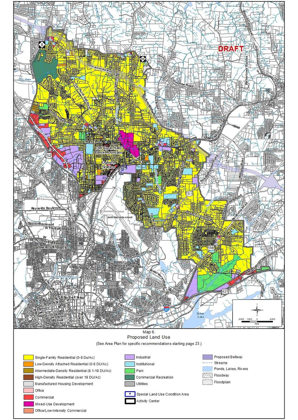
1 Northeast Suburban Area Plan Update Recommendations General policies from Legacy 2030 provide the framework for recommendations in all area plans. Specific recommendations for the Northeast Suburban Area Plan Update were developed through comments heard from citizens at public meetings in conjunction with the work of the City-County Planning Staff. *LAND USE RECOMMENDATIONS Land use recommendations serve as a guide for future development and zoning decisions in the planning area. As directed by Legacy 2030, land use recommendations designate the locations and formulate policies for compatible residential development, commercial and office uses, industrial uses and activity centers. All future recommendations are shown on the Proposed Land Use Map (Map 7 on page XX). Additionally, the Proposed Land Use Changes Map (Map 6 on page XX) identifies properties where the Proposed Land use indicated on Map 7 is different than the existing land use shown on the Existing Land Use Map (Map 3 on page XX). Proposed land use changes may or may not require a change in zoning. Determinations of the need for rezoning would be evaluated when site-specific development proposals are submitted for review. GENERAL RECOMMENDATIONS Planning policies used to develop land use recommendations for the Northeast Suburban Planning Area are: The highest intensity, mixed use development should be located in proposed activity centers. Commercial development should be concentrated in designated areas and not allowed to take the form of strip development along the major roads in the planning area. Goods and services should be available near where people live and work. The mix, type, and design of development should facilitate walking and bicycling where feasible. Industrial development should be concentrated in designated industrial areas. The revitalization of older/underutilized commercial and industrial sites and buildings is to be encouraged. Neighborhoods should be protected from inappropriate residential, commercial, industrial, and institutional encroachment. Site design should incorporate pedestrian-oriented design elements such as street trees, buildings located close to the street, building façade articulation and variety, and transparent windows and doors. Consideration should be given to protecting significant natural features, natural vegetation, historic resources and open space by clustering development on-site. *RESIDENTIAL Legacy 2030 recommends a variety of housing types throughout the county. Residential recommendations are made for housing densities, and in some cases, types of housing. Factors such as amount of land available, surrounding land uses, proximity to major roads and services and access to utilities are all considered in determining recommendations for residential uses and densities. The following are general descriptions for categories of residential land uses and specific recommendations for locations within the planning area suitable for these categories of use. The sites shown on the Proposed Land Use Changes Map and the overall Proposed Land Use Map (see Maps 6 and 7 on pages XX and XX, respectively). SINGLE-FAMILY RESIDENTIAL Single-family residential development consists mostly of single-family, detached units; however, scattered throughout neighborhoods are duplex, triplex, quadraplex, and a few multifamily developments built before zoning was established for the city and county. This plan makes no assumption on the legality of these uses. If uses are legally non-conforming, they should be allowed to remain. If they are illegal uses, this plan does not recommend rezoning these properties to legalize their nonconforming status. Single-family residential development is recommended for:
2 Existing individual lots and small tracts of land in existing single-family neighborhoods which are found throughout the majority of the planning area. Larger parcels of undeveloped residential land in many parts of the planning area, excluding uses within proposed activity centers and other designated sites. This land is generally located to the north, east and south of the planning area. LOW-DENSITY ATTACHED RESIDENTIAL Low-density attached residential development has a density of zero to eight dwelling units per acre. Generally, lowdensity attached residential land use is recommended for sites greater than two acres that are most appropriately developed with duplex, triplex, quadraplex, multifamily, and townhouse uses. Design recommendations for Multifamily Developments can be found in the Context Sensitive Multifamily Design Techniques document, available online or in the Planning and Development Services office. Low-density residential attached residential uses is recommended for: Scattered sites on Ogburn Avenue Several parcels on Mineral Avenue A parcel on Oak Summit Road Scattered parcels on Old Rural Hall Road Scattered sites on Old Hollow Road A parcel on Baux Mountain Road A parcel on Sandusky Street A parcel on Grove Avenue A parcel on Oak Haven Drive A parcel on Stanley Drive INTERMEDIATE-DENSITY RESIDENTIAL Intermediate-density residential development has a density of eight to eighteen dwelling units per acre. Generally, intermediate-density residential land use is recommended for sites greater than two acres that are most appropriately developed with multifamily or townhouse structures. Intermediate-density residential is recommended for: Parcels located on Ogburn Avenue and Ontario Street Several parcels located on Germanton Road south of Oak Summit Road Several sites on Conley Street A parcel on Lansing Drive A parcel on Oak Ridge Drive A parcel on Victoria Street HIGH-DENSITY RESIDENTIAL High-density residential development has a density of over 18 dwelling units per acre. Generally, high-density residential land use is recommended for large sites that are most appropriately developed with multifamily structures or at activity centers as part of mixed-use developments. High-density residential is recommended for: A parcel located at the intersection of Old Rural Hall Road and Motor Road A parcel on Akron Drive *OFFICE AND COMMERCIAL This plan recommends the consolidation of office and commercial uses at existing commercial/office locations, in designated activity centers, and in Special Land Use Condition Areas. All new and redeveloped commercial and office uses should be designed and developed to be compatible with nearby residential uses. OFFICE Office uses typically have few negative impacts on adjacent land uses and can provide services to area residents, making them an appropriate transitional use between residential uses and more intense uses. Small-scale office development is recommended for: A parcel located on the south side of N. Patterson Avenue 2
3 OFFICE/LOW-INTENSITY COMMERCIAL This land use category includes all office uses as well as commercial uses listed in Table 9. Land uses allowed in the Neighborhood Business (NB) District in the Winston-Salem/Forsyth County Unified Development Ordinances (UDO) would be appropriate in areas designated for office/low-intensity commercial use. This plan recommends two areas for new office/low intensity commercial and the conversion of some existing residential structures into office/low intensity commercial land use. Preserving the existing character of the older historic neighborhoods in the planning area is a priority of the plan; however, at certain locations it may be difficult to retain the existing single-family use on a specific property. Office/low-intensity commercial is recommended at the following locations: Sites at the intersection of Old Hollow Road and Germanton Road. Sites at the intersection of Reidsville Road and Old Belews Creek Road. Guidelines for Converting Existing Homes to Office or Commercial Uses can be found in Appendix C on page XX. Table 9. Defined Low-Intensity Commercial Uses Uses* Include: Adult Day Care Food/Drug store without Drive-through Residential Building, Townhouse Arts/Crafts Studio Funeral Home Restaurant without Bed and Breakfast Furniture/Home Furnishings Drive-through Child Care Drop-in Museum, Art Gallery Services A Child Day Care Center Post Office Veterinary Services Combined Use Residential Building, Multifamily Retail Store Uses* Do Not Include: Auto-related Uses Convenience Stores Clubs/bars *Uses defined in the Unified Development Ordinances. COMMERCIAL This plan calls for the creation of new commercial opportunities and the improvement of existing commercial areas to blend with existing development and not negatively impact nearby neighborhoods. Commercial areas should be compact with limited access to major thoroughfares and should not promote strip development. The reuse of vacant buildings and the redevelopment of existing undeveloped and underutilized sites is recommended, where possible. New commercial development and improvements of existing commercial areas are recommended for the following areas: Scattered sites on Old Hollow Road. Sites located along N. Patterson Avenue Multiple sites on Old Rural Hall Road near intersections with Oak Summit Road and Pine View Road Old Rural Hall Road/Baux Mountain Road Activity Center Ogburn Station Activity Center The north side of Old Walkertown Road at the intersection with Davis Road Scattered sites east of Northampton Drive Intersection of Northampton Drive and New Walkertown Road Sites on Reidsville Road at the intersection with Old Belews Creek Road Sites located along the north side of I-40 *INSTITUTIONAL Institutional uses in the planning area are an important aspect of its character, vitality and future. Institutional uses include schools, churches, government offices and services, community organizations and nonprofit agencies. Existing institutions should be permitted to grow and expand in a manner that is compatible with surrounding neighborhoods. Because of the unique nature of institutions (many of which are allowed by right in residential zoning), it is not possible to indicate on the Proposed Land Use Map all properties for which institutional use would be appropriate. Many institutional uses found in the planning area are surrounded by single-family residential uses. As these facilities grow, the potential to tear down single-family structures can be detrimental to the urban fabric of the neighborhood, 3
4 particularly in older historic areas. New construction or additions to institutional uses can have a negative effect on adjacent single-family homes because institutional uses typically have a larger building footprint and massing. This plan recommends the following: Retain existing single-family structures adjacent to institutional uses, where possible. When converting parcels to parking lots for institutional uses in residential districts, maintain neighborhood character by buffering lots with street yards. Encourage institutions owning single-family homes adjacent to their properties to maintain these structures in good condition. *PARKS/OPEN SPACE The Community Facilities Map (Map 9 on page XX) shows proposed parks and open space areas. No new parks are recommended in the plan, but existing parks should be maintained. Open space may consist of land protected by conservation easements or City-, State- or railroad-owned land (see Community Facilities Recommendations on page XX, for detailed park recommendations). *INDUSTRIAL With access to Business 40 and US-52, there are several areas suitable for industrial land use in the planning area. The plan recommends the following: New and redeveloped industrial uses should be designed in a manner that makes them compatible with nearby residential uses. Continue revitalization of vacant or underutilized industrial sites in the planning area. Existing industrial sites could be converted to other uses compatible with surrounding residential areas. Specific areas recommended for industrial development include: Sites along N. Patterson Avenue Sites on the south side of Lansing Drive next to the Smith Reynolds Airport Sites on the south side of Old Walkertown Road near the intersection with Davis Road New Walkertown Road on the east boundary line of the planning area East side of Reidsville Road just north of Business 40 Scattered sites on and near Old Greensboro Road near the intersection with Business 40 *MIXED-USE LAND USE CATEGORIES MIXED-USE DEVELOPMENT Mixed-use development typically includes a mixture of compatible commercial, office, varied residential types and densities, institutional, and recreational uses. This plan recommends mixed-use for one area located along the Motor Road Extension, shown on the Proposed Land Use Map (see Map 7 on page XX). This nearly 115 acre area is a prime for new commercial and residential development which is desired by many citizens in the planning area. More intense commercial development is recommended to be located on the south end of the site closest to Old Walkertown Road. Comprehensive residential development is recommended for the northern portion of the area and may include singlefamily or low-density attached residential towards the east with higher density multifamily development located near Baux Mountain Road. Pedestrian-friendly design and connections to the surrounding area are important site design factors here. Topographic issues such as steep slopes exist in the northeastern part of this area which may provide development challenges. These undevelopable areas may represent opportunities for a future park or open space. The concept of mixing uses is not limited to the Motor Road Extension only. Other sites may be appropriate and will need to be evaluated individually based on how they are integrated with and compliment the surrounding neighborhoods. ACTIVITY CENTERS Activity centers are compact, pedestrian-oriented, neighborhood business areas that provide needed services within walking distance of residential areas. Activity centers may serve as neighborhood gathering places. Larger activity 4
5 centers are envisioned to provide shopping and services meeting the day-to-day needs of nearby residences, and ideally contain a grocery store and a pharmacy. Activity centers may also include a housing component, especially in suburban or future growth areas where new activity centers are being proposed. Certain very large activity centers can serve as compact regional mixed-use centers for retail, office, civic and residential activity. It is important to include sidewalk connections throughout activity centers to encourage pedestrian connections between uses. The Northeast Suburban Area Plan Update identifies two activity centers: the Old Rural Hall Road/Baux Mountain Road Activity Center and the Ogburn Station Activity Center. Old Rural Hall Road/Baux Mountain Road Activity Center The Old Rural Hall Road/Baux Mountain Road Activity Center is located at the intersection of Old Rural Hall Road and Baux Mountain Road, just south of Motor Road. The area encompasses approximately 11 acres. This activity center currently contains a mixture of residential and commercial uses, including a convenience store, gas stations, restaurant, retail space, auto repair and service stations. Site issues exists in the activity area, such as unsafe and excessive curb cuts, deteriorated and vacant structures, a lack of sidewalks and proliferation of unsightly auto-related uses. There is little landscaping, street trees and lighting, creating issues for pedestrians in the area. Recommendations for the activity center are as follows: Encourage pedestrian-friendly design elements such as improved sidewalks and connections, crosswalks and landscaping. Eliminate or consolidate curb cuts to ease access. Screen dumpsters, loading docks and storage areas for commercial uses, especially auto-related uses. Use vegetation or fencing to screen the view of commercial areas from residential uses, particularly to the neighborhood west of the activity center. Improve parking lots by resurfacing, defining parking spaces and adding landscaping. Improve building facades and the structural condition of existing uses. Remove excessive signage and replace damaged or out-of-date signage. Ogburn Station Activity Center The Ogburn Station Activity Center includes the Ogburn Station Shopping Center and surrounding commercial area. The activity center is bounded on the north by Cornwallis Street, to the east by Lane Street, to the south by the Norfolk & Western Railroad, and to the west by the rear property line of the nonresidential uses fronting N. Liberty Street and Old Rural Hall Road. The entire activity center is zoned Pedestrian Business (PB). The existing land uses include retail, restaurants, a car wash, offices and auto-body shops. Single-family residential uses are found to the north and west of the activity center while industrial uses are located to the south. The west side of the activity center includes a number of urban-style storefronts that front the sidewalk and have parking to the side or rear of the properties. The east side of the activity center includes more suburban style development. In recent years, a Dollar General store was constructed on the west side of Old Rural Hall Road and façade improvements were made to the Ogburn Station Shopping Center with RUCA (Revitalizing Urban Commercial Areas) funds from the City. There are a number of vacant and deteriorating structures throughout the area, including a bank and former grocery store. Site issues include unsafe and excessive curb cuts, deteriorated parking lots and a lack of sidewalks. Recommendations for the activity center are as follows: Do not expand the existing nonresidential boundary of the area by rezoning adjacent single-family lots. Concentrate redevelopment of existing structures and encourage new mixed-use development. Attract new land uses that are needed in the area, including: A grocery store, drug store, offices and medical facilities. Encourage pedestrian-friendly design elements such as improved sidewalks and connections, crosswalks, landscaping and street trees, street furniture and lighting fixtures. Eliminate or consolidate curb cuts to ease access. Screen dumpsters, loading docks and storage areas for commercial uses, especially auto-related uses. Use vegetation or fencing to screen the view of commercial areas from residential uses. Improve parking lots by resurfacing, defining spaces and adding landscaping. Improve building facades and structural condition of existing uses. 5
6 6
7 7
8 Remove excessive signage and replace damaged or out-of-date signage. Discourage additional auto-oriented uses such as auto repair and service shops Improve transit stops with bus shelters or benches Provide a public gathering place, pedestrian plaza or park in the area to promote recreation and interaction among area citizens. *Special Land Use Conditions The Proposed Land Use Map (see Map 7 on page XX) shows recommended land uses for all undeveloped property in the planning area and changes in land use for some developed sites. In some circumstances, there are special conditions or prohibitions of certain uses. These situations are referenced on the map with a blue (star) and a lower case letter as follows: *a. Scattered Small-Scale Commercial Sites Two properties with similar characteristics are grouped under this Special Land Use Condition. These isolated businesses are currently zoned Limited Business (LB) and Highway Business (HB) and are generally surrounded by single-family residential uses. It is recommended that these nonresidential uses be prohibited from expanding onto nearby residentially zoned properties. These properties are listed as follows: A restaurant located at the intersection of Old Hollow Road and Old Rural Hall Road zoned LB. A gas station building on Old Hollow Road east of Old Rural Hall Road, currently zoned HB. The plan recommends the following for the sites listed above: Do not expand current nonresidential zoning to adjoining properties. Redevelop the existing sites under current zoning or a less intensive zoning classification. *b. Nonconforming Uses Seven properties with similar characteristics are grouped under this Special Land Use Condition. These properties are currently zones Residential Single-Family (RS-9) and have existing nonconforming commercial uses. These properties are listed as follows: An abandoned commercial building on the south side of Old Hollow Road, currently zoned RS-9. Three commercial uses, including a construction company office, barber shop and small engine repair shop, located on Old Hollow Road west of Phelps Drive. All three parcels are zoned RS-9. A gas station located on the east side of Old Rural Hall Road at the intersection with Pine View Road. The site is currently zoned RS-9. An abandoned gas station and retail building on Baux Mountain Road north of Jordan Drive, currently zoned RS- 9. A single family home with a heavy equipment garage to the rear of the property on Wakeman Drive. The site is zoned RS-9. An abandoned retail building on the corner of Carver School Road and Airport Road, zoned RS-9. The plan recommends the following for all the sites listed above: Do not rezone any of these properties to a nonresidential district. The existing commercial uses can continue to operate under their existing nonconforming status. If the nonconforming status is lost because the nonconforming use ceases to operate for a period of time, a determination to leave the property zoned for single-family residential or to rezone to a nonresidential zoning district should be made on a case-by-case basis. 8
9 *c. Old Hollow Road at Germanton Road This area includes several parcels on the north side of Old Hollow Road at the intersection with Germanton Road. Single- Family Residential (RS-9 and RS-30) and Multifamily Residential (RM-12) zoning can be found here. The site is mostly undeveloped except for the vacant Dunne s Chinese Restaurant property on the eastern portion of the site. West of the site are several commercial and auto-related businesses, and to the south is a sizable community-scale church. Recommendations include: Allow the reuse and redevelopment of the restaurant structure for commercial use. Auto-related uses are not recommended, however. Allow the rezoning and comprehensive redevelopment of the parcels between Dunne s and Germanton Road for low-intensity uses such as small-scale office and neighborhood-serving business. *d. Germanton Road South of Oak Summit Road This approximately 28-acre site is located on the east side of Germanton Road, just south of Oak Summit Road. The site is zoned for Single-Family Residential (RS-9) and is highly impacted by nearby commercial development across Germanton Road and to the south along N. Patterson Avenue, all of which are zoned Highway Business (HB). The site benefits from close proximity and access to US-52 and nearby employment centers. Recommendations for this area include: Allow for the redevelopment of this site with compatible multifamily, townhouse or clustered single-family structures with an overall density of up to 12 dwelling units per acre. Comprehensive redevelopment of this site is recommended. Provide adequate buffering and screening of the existing single-family residential to the north and east of the site. *e. Oak Summit Road and Old Rural Hall Road This site include parcels on the west side of Old Rural Hall Road at the intersection with Oak Summit Road. The site is approximately six acres in size. The western portion of the site is single-family residential zoned Limited Business (LB). The parcel on the eastern portion includes commercial structures with split-zoning: Pedestrian Business (PB) and Single- Family Residential (RS-9). Recommendations for this site include: Expansion of nonresidential zoning beyond the existing boundaries of the LB zoned land and into adjacent residential parcels is not recommended. If the LB zoned parcels are redeveloped for nonresidential uses, the preferable zoning district would be PB (Pedestrian Business) or Neighborhood Business (NB) given the character of the existing area. Auto-related uses, convenience stores and clubs/bars are discouraged at this location because of their negative visual impact and possible negative neighborhood impact. The parcel with split-zoning on the eastern portion of the site may redevelop and rezone the entire site to PB or NB. Consolidating curb cuts and improving parking areas is recommended. Expansion of nonresidential zoning beyond the existing boundaries of the PB zoned land and into adjacent residential parcels is not recommended. *f. Lansing Drive between Conrad and Henry Streets This site is located along Lansing Drive and Keehlen Avenue between Conrad Street and Henry Street. The site is about 8 acres and includes a number of homes zoned Single-Family Residential (RS-9) and General Industrial (GI). The sites are surrounded by GI zoned properties including Smith Reynolds Airport, as well as parking and warehouse facilities for the Winston-Salem/Forsyth County Schools. Recommendations for this area include: Allow the rezoning of the site for industrial use only if the parcels are comprehensively redeveloped together. No piecemeal rezoning is recommended here. 9
10 *g. Old Walkertown Road at Davis Road This site includes a mixture of commercial and residential uses on approximately eight acres zoned Highway Business (HB) and Highway Business-Special Use (HB-S). Ibrahim Elementary School is located to the north and east of the site. The Norfolk and Western railroad tracks are south of the site across Old Walkertown Road. Commercial uses here include an auto-body shop, gas station and convenience store, restaurant, daycare and storage facility. Recommendations for this area include: Expansion of nonresidential zoning beyond the existing boundaries of this site onto adjacent residential parcels is not recommended. Allow for the redevelopment of the single-family property west of the storage facility into a neighborhood-serving commercial use. *h. Old Walkertown Road east of Lasley Drive The site is approximately fourteen acres zoned Limited Industrial (LI) with a small portion of Single-Family Residential (RS-9) zoning on the southeastern corner of the property. The site may be accessed from Old Walkertown Road through the industrial property to the east. The northern half of the site is currently utilized for parking and storage, while the southern half is undeveloped and heavily wooded. The site is surrounded by residential development to the west, south and east. Recommendations for this site include: The northern portion of the site is appropriate for industrial use. However, buffering of nearby residential uses to the west and south is necessary to prevent negative impacts on the surrounding area. Expansion of nonresidential zoning beyond the existing boundaries of this site onto adjacent residential parcels is not recommended. Single-family residential development is recommended for the southern undeveloped portion of the site. Connections to existing residential development may be created at Lampan Lane or Northwoods Circle. *i. Northampton Drive and New Walkertown Road (US 311) This site has a mixture of residential and commercial uses, including a gas station and convenience store. The majority of the site is zoned Limited Business (LB) except for the rear of properties east of Northampton Drive which are currently zoned Single-Family Residential (RS-9). Recommendations for this area include: Properties to the east of Northampton Drive may have expanded LB zoning to the rear property lines of these lots. Expansion of nonresidential zoning beyond the existing boundaries of this site onto adjacent residential parcels is not recommended. Allow the single-family properties currently zoned LB to redevelop to neighborhood serving commercial uses. Auto-related uses, bars/clubs, or convenience store uses are not recommended for these properties. Allow these single-family uses to be rezoned to residential districts, preferably RS-9, if desired by the property owners. *j. Old Belews Creek Road and Reidsville Road (US 158) This site is approximately six acres of residential and commercial uses including two gas stations and a car wash. The residential uses are currently zoned Single-Family Residential (RS-9) and are surrounded on both sides by Old Belews Creek Road and Reidsville Road. The commercial uses have Pedestrian Business Special-Use District (PB-S) zoning. Recommendations for this site include: The residential properties here may be rezoned and redeveloped as office or low-intensity uses. Comprehensive development is recommended to limit curb cuts and to promote safe access onto Reidsville Road. Expansion of the existing commercial uses onto neighboring nonresidential properties is not recommended. 10
PINE CURVE REZONING. BACKGROUND Purchased as two parcels in 2001 and 2002
 BACKGROUND Purchased as two parcels in 2001 and 2002 WHAT THE PROJECT IS AND IS NOT A Rezoning establishes the land use standards for Annexed and Zoned Greater Downtown District Historic Center September
The transportation system in a community is an
 7 TRANSPORTATION The transportation system in a community is an important factor contributing to the quality of life of the residents. Without a sound transportation system to bring both goods and patrons
4.1.3 LAND USE CATEGORIES
 4.1.3 LAND USE CATEGORIES a. City Center District The City Center District incorporates the existing character and mix of uses in downtown Belmont to encourage redevelopment and new development in keeping
VILLAGE OF CLEMMONS PLANNING BOARD DRAFT STAFF REPORT
 VILLAGE OF CLEMMONS PLANNING BOARD DRAFT STAFF REPORT PETITION INFORMATION Docket # C-214 Staff Megan Ledbetter Petitioner(s) Summit Healthcare Group Owner(s) Wake Forest University Health Services Subject
ALBEMARLE COUNTY CODE CHAPTER 18 ZONING SECTION 20A NEIGHBORHOOD MODEL - NMD
 CHAPTER 18 ZONING SECTION 20A NEIGHBORHOOD MODEL - NMD Sections: 20A.1 PURPOSE AND INTENT 20A.2 STATUS AS A PLANNED DEVELOPMENT DISTRICT 20A.5 CODES OF DEVELOPMENT 20A.6 PERMITTED USES 20A.7 RESIDENTIAL
Gold Line Bus Rapid Transit Transit Oriented Development (BRTOD) Helmo Station Area Plan
 Helmo Station Area Plan") Appendix F Gold Line Bus Rapid Transit Transit Oriented Development (BRTOD) Helmo Station Area Plan Introduction and Purpose of the Plan The Gold Line Bus Rapid Transit facility is an eleven-mile dedicated
Appendix F Gold Line Bus Rapid Transit Transit Oriented Development (BRTOD) Helmo Station Area Plan Introduction and Purpose of the Plan The Gold Line Bus Rapid Transit facility is an eleven-mile dedicated
Strategic Growth Area #1 Northampton Boulevard Corridor Area
 Strategic Growth Area #1 Northampton Boulevard Corridor Area Description Strategic Growth Area #1 has established itself as a major employment center in Southside Hampton Roads. Opportunities exist to
Franklin/Myrtle School Small Area Plan Adopted February 18, 2003
 Franklin/Myrtle School Small Area Plan Adopted February 18, 2003 Introduction This plan area includes properties on all four corners of the Franklin/Myrtle School intersection. The magnitude of development
A P P E N D I X B - O P P O R T U N I T Y S I T E S
 A P P E N D I X B - O P P O R T U N I T Y S I T E S OPPORTUNITY SITES As listed in the Land Use Element, the City has identified 15 Opportunity Sites expected to be the focus of change and revitalization
Land Use Plan. Strategic Plan. CHAPTER SEVEN Proposed Land Use Plan. Fort Washington Area
 CHAPTER SEVEN Proposed Land Use Plan The Proposed Land Use Plan is a significant component of the Comprehensive Plan. It is Whitemarsh s land use policy statement. A policy guide for the township, it is
NORTH COLLEGE PARK. Residential Neighborhood and Neighborhood Center OBJECTIVES EXISTING SITUATION AND ISSUES CONCEPT
 Greenbelt Metro Area Sector Plan - Subarea Design Policies and Guidelines - North College Park 119 NORTH COLLEGE PARK Residential Neighborhood and Neighborhood Center CONCEPT North College Park is envisioned
C. Westerly Creek Village & The Montview Corridor
 C. Westerly Creek Village & The VISION Community Vision When the goals of the city are achieved Westerly Creek Village, a distinctive community defined by Montview Boulevard and Westerly Creek, is a strong
Asbury Chapel Subdivision Sketch Plan
 Asbury Chapel Subdivision Sketch Plan PART 1: PROJECT SUMMARY Applicant: NVR Inc. Project Size: +/- 76.13 acres Parcel Numbers: 02101112,02116101,02116112, 02116113 Current Zoning: Transitional Residential
SECTION UNIFIED DEVELOPMENT ORDINANCE SECTION Part 1 Ordinance. ARTICLE 1 Zoning Districts
 SECTION 1-100 UNIFIED DEVELOPMENT ORDINANCE SECTION 1-300 Part 1 Ordinance SECTION 1-100. Introduction. ARTICLE 1 Zoning Districts Crystal Lake strives to maintain a balance of various land uses for a
PINE CURVE REZONING. Property does not meet criteria for open space preservation and is not a candidate for a park
 PINE CURVE REZONING BACKGROUND Purchased as two parcels in 2001 and 2002 Annexed and Zoned Greater Downtown District Historic Center September 25, 2002 and October 7, 2002 WHAT THE PROJECT IS AND IS NOT
Appendix C: Interim Mixed-Use Evaluation Criteria
 Appendix C: Interim Mixed-Use Evaluation Criteria C-1 Appendix C: Interim Mixed-Use Evaluation Criteria PURPOSE: The implementation of numerous policies contained within the Master Plan hinges on the creation
AWH REPORT OF THE PLANNING AND DEVELOPMENT DEPARTMENT FOR APPLICATION FOR REZONING ORDINANCE TO PLANNED UNIT DEVELOPMENT
 AWH REPORT OF THE PLANNING AND DEVELOPMENT DEPARTMENT FOR APPLICATION FOR REZONING ORDINANCE TO PLANNED UNIT DEVELOPMENT MAY 8, 2014 The Planning and Development Department hereby forwards to the Planning
Additional information about land use types is given in Chapter 5. Design guidelines for Centers and Neighborhoods are given in Chapter 7.
 4. Place Types Introduction In Albemarle County s Development Areas, the Neighborhood is the fundamental unit of community planning. The County s Neighborhood Model, an adopted part of the Comprehensive
VILLAGE OF CLEMMONS PLANNING BOARD DRAFT STAFF REPORT
 VILLAGE OF CLEMMONS PLANNING BOARD DRAFT STAFF REPORT PETITION INFORMATION Docket # C-226 Staff Megan Ledbetter Petitioner(s) JBJH Properties, LLC Owner(s) JBJH Properties, LLC Subject Property 5892-49-1766
COMMUNITY DESIGN. GOAL: Create livable and attractive communities. Intent
 COMMUNITY DESIGN Intent An attractive, well-designed County will attract quality development, instill civic pride, improve the visual character of the community, and create a strong, positive image for
Metro. Activity Center Design Guidelines. Recommendations For Developing Focused, Mixed-Use Commercial/Residential Centers
 Metro Activity Center Design Guidelines Recommendations For Developing Focused, Mixed-Use Commercial/Residential Centers Metro Activity Centers What is a MAC? Legacy, the adopted guide for the future growth
2.0 AREA PLANS. Lakeside Business District. Lakeside Business District Land Use Categories:
 Lakeside Business District Lakeside Business District Land Use Categories: Campus Commercial Campus Commercial means a mixture of uses which includes corporate offices, office parks, hotels, commercial,
VILLAGE OF CLEMMONS PLANNING BOARD DRAFT STAFF REPORT. Single Family Residential, Townhomes
 VILLAGE OF CLEMMONS PLANNING BOARD DRAFT STAFF REPORT PETITION INFORMATION Docket # C-212 Staff Megan Ledbetter Petitioner(s) Peacehaven Development LLC Owner(s) Larry Jarvis, William Alexander and Peacehaven
Ten Mile Creek Planning Area
 PLANNING AREA POLICIES TEN MILE CREEK Ten Mile Creek Planning Area Location and Context The Ten Mile Creek Planning Area ( Ten Mile Creek area ) is located south of the current Boise AOCI, generally south
Obey Creek July 17, Vicinity Map. Concept Plan Submittal. No
 15/501 Fordham Blvd. 15/501 By-Pass To Downtown Chapel Hill Vicinity Map 0 1000 2000 FT Arlen Park DR. Bennett Road Mt. Carmel Church Rd. Southern Village Parkside Circle Market St. 15/501 Founder's Ridge
INSTITUTIONAL USE DESIGN COMPATIBILITY TECHNIQUES
 INSTITUTIONAL USE DESIGN COMPATIBILITY TECHNIQUES INTRODUCTION Community institutions are an important part of the character and vitality of neighborhoods in Forsyth County. Institutional uses include
SUMMERSIDE / MT. CARMEL REINVESTMENT CORRIDOR COMMUNITY DEVELOPMENT STRATEGY
 SUMMERSIDE / MT. CARMEL REINVESTMENT CORRIDOR COMMUNITY DEVELOPMENT STRATEGY FEBRUARY 2013 I. Location of the Summerside/Mt. Carmel Reinvestment Corridor The Summerside/Mt. Carmel Reinvestment Corridor
Lower Merion Commercial Districts Issues and Characteristics Handbook November 2013
 Lower Merion Commercial Districts Issues and Characteristics Handbook November 2013 DRAFT TOWNSHIP-WIDE VISION: To maintain and enhance commercial areas to complement the surrounding high-quality residential
Policies and Code Intent Sections Related to Town Center
 Policies and Code Intent Sections Related to Town Center The Town Center Vision is scattered throughout the Comprehensive Plan, development code and the 1994 Town Center Plan. What follows are sections
Chapter IV: Development Pattern
 Chapter IV: Development Pattern Introduction The 2002 Prince George s County Approved General Plan designates three growth policy tiers Developed, Developing, and Rural as well as three center designations
Community Meeting November 18, 2015
 Top Concerns We ve Heard Use of Urban Road Code Total number of units and effect on schools and transportation Land swaps with Parks Department: how do these benefit the community? Zoning classifications:
LAND USE MEADOWS PLANNING AREA
 LAND USE MEADOWS PLANNING AREA I. Profile of Meadows Planning Area A. Location Meadows Planning Area is delineated by I-5 on the north, the Nisqually Bluffs representing the growth boundary on the east,
PLANNING COMMISSION. Agenda Item # 3.
 PLANNING COMMISSION Agenda Item # 3. CASE SUMMARY Conditional District Rezoning Planning Commission February 4, 2015 CD-9-215 Jeff Walton, 341-3260, jeff.walton@wilmingtonnc.gov Staff recommendation CONDITIONAL
4. Shape Transitions. 4. Shape Transitions
 4. Shape Transitions 49 Zoning District Policies Overall Intent: Maintain neighborhood character by creating compatible transitions that minimize land use conflicts. Strategy: Define the character of zoning
ORDINANCE NO. WHEREAS, the Comprehensive Plan directs that master plans be developed for each proposed urban village (FLU-18), and
, and") ATTACHEMENT 1 ORDINANCE NO. AN ORDINANCE RELATED TO LAND USE PLANNING AND ZONING ESTABLISHING THE FOUNTAIN DISTRICT URBAN VILLAGE SUBAREA PLAN, AMENDING PORTIONS OF LAND USE AREAS 3 AND 8, AND ALL OF AREAS
ATTACHEMENT 1 ORDINANCE NO. AN ORDINANCE RELATED TO LAND USE PLANNING AND ZONING ESTABLISHING THE FOUNTAIN DISTRICT URBAN VILLAGE SUBAREA PLAN, AMENDING PORTIONS OF LAND USE AREAS 3 AND 8, AND ALL OF AREAS
A Plan Enhancement Process for the Future of Howard Design Studio 2 May 28-30, The Howard Plan
 A Plan Enhancement Process for the Future of Howard Design Studio 2 May 28-30, 2011 The Howard Plan West of Pinecrest Future Land Use Plan Velp Corridor Land Use Analysis & Recommendations Duck Creek /Quarry
12600 S Existing Conditions
 STUDY AREA BOUNDARY Study Area Boundary Study Area Context The District Riverton Meadows Vista Station Mountain View Village Market Center 2 Mile Radius 12600 S Existing Conditions 12600 S is a river of
NEW CASTLE COUNTY S ZONING DISTRICTS
 NEW CASTLE COUNTY S ZONING DISTRICTS This is general information about New Castle County s zoning districts. The information included is by no means exhaustive or complete. Before designing plans to develop
Tyvola & Archdale Transit Station Area Plan. June 5, 2008
 Tyvola & Archdale Transit Station Area Plan Second Public Meeting June 5, 2008 Presentation Outline 1. Purpose and Process 2. Station Area Overview 3. Plan Recommendations 4. Comments Received and Proposed
SECTION TWO: Urban Design Concepts
 SECTION TWO: Urban Design Concepts The Gardnerville Plan for Prosperity shapes economic opportunities presented by regional growth. The Urban Design Concepts provide policies and concepts for land use,
Tyvola & Archdale Transit Station Area Plan. May 15, 2008
 Tyvola & Archdale Transit Station Area Plan First Public Meeting May 15, 2008 Presentation Outline 1. Purpose and Process 2. Station Area Overview 3. Plan Recommendations Vision Land Use Transportation
BUILDING SCALE AND SETBACKS 5 ELEMENTS:... 5 FAÇADES (COMMERCIAL/RESIDENTIAL) 5
 5") VISION STATEMENT 3 UTILIZATION OF THE GUIDELINES 3 IMPLEMENTATION 3 PROCEDURES FOR DESIGN REVIEW 3 LAND USE AND ZONING 4 LAND USE 4 ELEMENTS:... 4 ZONING 4 ELEMENTS:... 4 BUILDING SCALE AND SETBACKS 5
VISION STATEMENT 3 UTILIZATION OF THE GUIDELINES 3 IMPLEMENTATION 3 PROCEDURES FOR DESIGN REVIEW 3 LAND USE AND ZONING 4 LAND USE 4 ELEMENTS:... 4 ZONING 4 ELEMENTS:... 4 BUILDING SCALE AND SETBACKS 5
PORT WHITBY COMMUNITY
 PORT WHITBY COMMUNITY SECONDARY PLAN UPDATE COMMUNITY IMPROVEMENT PLAN URBAN DESIGN GUIDELINES September 2015 DRAFT PROPOSED AMENDMENT NUMBER # to the Whitby Official Plan PURPOSE: The intent of this Amendment
To ensure that resources will be available to provide a consistent level of public services to the community.
 Future Land Use Plan The land use plan is one of the most prominent chapters in the Stillwater Comprehensive Plan. It provides a visual representation of what the community is expected to look like in
5 Land Use Element49
 5 Land Use Element 49 City of Forney - Comprehensive Plan Land Use Introduction Forney s Comprehensive Plan is a guide for physical and economic development in the City of Forney over the next 20-years.
4. ENVIRONMENTAL IMPACT ANALYSIS 7. LAND USE AND PLANNING
 4. ENVIRONMENTAL IMPACT ANALYSIS 7. LAND USE AND PLANNING 4.7.1 INTRODUCTION The following analysis discusses the consistency of the Proposed Project with the corresponding land use and zoning designations
Land Use Amendment in Southwood (Ward 11) at and Elbow Drive SW, LOC
 at and Elbow Drive SW, LOC") 2018 November 15 Page 1 of 10 EXECUTIVE SUMMARY This land use amendment application was submitted by Rick Balbi Architect on 2017 August 31 on behalf of Sable Developments Ltd, and with authorization from
2018 November 15 Page 1 of 10 EXECUTIVE SUMMARY This land use amendment application was submitted by Rick Balbi Architect on 2017 August 31 on behalf of Sable Developments Ltd, and with authorization from
Access Management: An Overview
 Figures 1-5 Below Evolution of development along a highway. In the early stages, land along the road is used for farming with little traffic generated. As time passes, the highway corridor becomes a de
The petition proposes the development of five townhomes on a vacant parcel between Charlotte Latin School and Providence Presbyterian Church.
 Rezoning Petition 2017-202 Final Staff Analysis June 18, 2018 REQUEST LOCATION Current Zoning: R-3 (single family residential) Proposed Zoning: UR-2(CD) (urban residential, conditional) with five-year
IMPLEMENTATION STRATEGIES. In This Chapter. Goals & Strategies 182 Project List 183 Future Land Use 186 CHAPTER 11 IMPLEMENTATION STRATEGIES
 In This Chapter Goals & Strategies 182 Project List 183 Future Land Use 186 11 IMPLEMENTATION STRATEGIES NORTH AUGUSTA, SC 2017 COMPREHENSIVE PLAN 179 Individual commitment to a group effort that is what
Section 9 NEIGHBORHOOD DESIGN
 Section 9 NEIGHBORHOOD DESIGN City of Lancaster Comprehensive Plan D u n k i n, S e f k o & A s s o c i a t e s, I n c. NEIGHBORHOOD DESIGN INTRODUCTION There are many ways in which a neighborhood can
INTRODUCTION. b. The extent to which such problems and objectives have been reduced or have increased subsequent to such date.
 INTRODUCTION INTRODUCTION The Municipal Land Use Law directs a Planning Board to prepare a Periodic Reexamination Report every six years that identifies and describes the following: a. The major problems
Staff Report and Recommendation
 Community Planning and Development Planning Services 201 W. Colfax Ave., Dept. 205 Denver, CO 80202 p: 720.865.2915 f: 720.865.3052 www.denvergov.org/cpd TO: City Council Neighborhoods and Planning Committee
STAFF REPORT SPECIAL USE DISTRICT REZONING
 STAFF REPORT SPECIAL USE DISTRICT REZONING ZONING DOCKET: K-751 PLANNING BOARD: March 13, 2017 PETITIONER: Abigaile Pittman, Agent for Owner OWNERS: Greenwood and Charles, Inc. PROPOSED ZONING AMENDMENT:
9 th Street Sub Area Plan
 9 th Street Sub Area Plan In the 1990 s, when the Township prepared the last Master Plan, the 9 th Street corridor was studied as part of a larger 9 th Street Focus Area that included the West Main Street
City of Chickasaw Land Use Comprehensive Plan 2030 Chapter5-Draft(2)Public review_
Public review_") Land Use Land Use refers to the activity or development characteristics of a given parcel of land. The Land Use Plan presented in the following pages, represents the City of Chickasaw s official position
Land Use Land Use refers to the activity or development characteristics of a given parcel of land. The Land Use Plan presented in the following pages, represents the City of Chickasaw s official position
EXHIBIT B PROJECT NARRATIVE POULSBO MEADOWS
 EXHIBIT B PROJECT NARRATIVE POULSBO MEADOWS Name of Project: Poulsbo Meadows; A Planned Residential Development (PRD)/Plat Applicants Name: PBH Group LLC/Byron Harris PO Box 1010 Silverdale, WA 98038 Description
Table of Contents. Elm Avenue Improvement Plan City of Waco, Texas. Introduction 1. Existing Context 1 Figure 1 2.
 Table of Contents Introduction 1 Existing Context 1 Figure 1 2 Plan Guidelines 3 Future Urban Form 4 The West-End 4 Main Street 6 The East-End 7 Figure 2 9 Public Improvement Recommendations 7 General
Suburban Areas Plan Suburban Neighborhoods Future Growth Area Suburban Neighborhoods Future Growth Areas Urban Neighborhoods and Downtown
 Preface Under special State enabling legislation, the City- County Planning Board of Forsyth County and Winston-Salem is responsible for preparing and maintaining a comprehensive plan for Forsyth County.
Citizen Comment Staff Response Staff Recommended Revision Planning Committee
 Citizen Comment Staff Response Staff Recommended Revision Planning Committee Area No. 1: Owner desires retail land uses. Area No. 1a: Owner of two small parcels adjacent to Area No. 1 desires retail land
and services The protection and conservation of environmentally significant and sensitive natural heritage features and functions.
 6. Land Use 6.0 Preamble A healthy and livable city is one in which people can enjoy a vibrant economy and a sustainable healthy environment in safe, caring and diverse neighbourhoods. In order to ensure
The Village. Chapter 3. Mixed Use Development Plan SPECIFIC PLAN
 The Village SPECIFIC PLAN Chapter 3 3.1 INTRODUCTION 3.1.1 Purpose This Chapter describes the development regulations applicable to the Mixed-Use and Transit Center Planning Areas. These form-based regulations
City of Farmington. Downtown Plan. Amendment to the 1998 Master Plan Adopted October 11, 2004
 City of Farmington Amendment to the 1998 Master Plan Adopted October 11, 2004 Introduction Planning Background 1 Scope and Components of the Plan Amendment 2 Concept Introduction 3 Plan Concepts 3 Conceptual
Rezoning Petition Post-Hearing Staff Analysis July 31, 2018
 Rezoning Petition 2017-050 Post-Hearing Staff Analysis July 31, 2018 REQUEST LOCATION Current Zoning: B-1 (neighborhood business) and O-1 (office) Proposed Zoning: NS (neighborhood services) Approximately
EXECUTIVE SUMMARY DRAFT CHAPTER 1 INTRODUCTION EXECUTIVE SUMMARY
 CHAPTER 1 EXECUTIVE SUMMARY INTRODUCTION Through the joint efforts of the City of Tulsa planning staff and the Land Services division of Indian Nations Council of Governments (INCOG), the Berryhill Land
Land Use. Hardware Street Vendor Mixed-Use
 Land Use Definition Land Use is the way a piece of real estate is utilized. Existing, proposed, and adopted land uses all play a role in the planning process. Once a land use plan is adopted, the next
FUTURE LAND USE ELEMENT
 FUTURE LAND USE ELEMENT GOAL I: To create and sustain a great place to live, play, and prosper Objective 1: The City of Ocala shall incorporate the principles and strategies of the Ocala 2035 Vision into
Mark-up of the effect of the proposed Bronte Village Growth Area OPA No.18 on the text of section 24, Bronte Village, of the Livable Oakville Plan
 Mark-up of the effect of the proposed Bronte Village Growth Area OPA No.18 on the text of section 24, Bronte Village, of the Livable Oakville Plan Notes: This document is provided for information purposes
Amendment to the Elderberry Neighborhood Development Plan
 Amendment to the Elderberry Neighborhood Development Plan Recommendations for Land Use, Transportation and Development July 13, 2018 City of Madison, Wisconsin Department of Planning and Community and
McKinley-Roosevelt Railroad Corridor Neighborhood Plan
 McKinley-Roosevelt Railroad Corridor Neighborhood Plan PREPARED BY: DEPARTMENT OF CITY DEVELOPMENT IN COOPERATION WITH NEIGHBORHOOD BUSINESSES, RESIDENTS, AND THE ALDERMEN FOR THE DISTRICT CITY OF KENOSHA,
EXHIBIT A. Tax Increment Reinvestment Zone No. 1 (Town Center) First Amended Project Plan 1
 First Amended Project Plan 1") EXHIBIT A Tax Increment Reinvestment Zone No. 1 (Town Center) First Amended Project Plan 1 1 As amended by Resolution No. 2008-02-001(TR1R) of the Tax Increment Reinvestment Zone No.1, and approved to
EXHIBIT A Tax Increment Reinvestment Zone No. 1 (Town Center) First Amended Project Plan 1 1 As amended by Resolution No. 2008-02-001(TR1R) of the Tax Increment Reinvestment Zone No.1, and approved to
Chapter 4: Land Use and Growth Management
 LAND USE AND GROWTH MANAGEMENT 4-1 Chapter 4: Land Use and Growth Management BACKGROUND AND INTENT Growth brings a number of benefits to a community; however, it also brings a number of impacts and costs.
PLANNING STAFF REVIEW
 Rezoning Petition 2016-087 Pre-Hearing Staff Analysis October 17, 2016 REQUEST Current Zoning: R-3 (single family residential), O-1(CD) (office, conditional), and INST (institutional) Proposed Zoning:
BE IT ORDAINED by the Board of Supervisors of Chesterfield County:
 Attachment A AN ORDINANCE TO AMEND THE CODE OF THE COUNTY OF CHESTERFIELD, 1997, AS AMENDED, BY AMENDING AND REENACTING SECTIONS 19.1-52, 19.1-53, 19.1-236, 19.1-247, 19.1-253, 19.1-263, 19.1-341, 19.1-346,
The petition proposes to rezone the site to allow all uses permitted in the B-1 (neighborhood business) district.
 district.") Rezoning Petition 2018-040 Pre-Hearing Staff Analysis June 18, 2018 REQUEST Current Zoning: R-17MF (multi-family residential) Proposed Zoning: B-1 (neighborhood business) LOCATION Approximately 0.38 acres
Rezoning Petition 2018-040 Pre-Hearing Staff Analysis June 18, 2018 REQUEST Current Zoning: R-17MF (multi-family residential) Proposed Zoning: B-1 (neighborhood business) LOCATION Approximately 0.38 acres
URBAN DESIGN BRIEF Gordon Street City of Guelph. Prepared on behalf of Ontario Inc. March 25, Project No. 1507
 URBAN DESIGN BRIEF 1131 Gordon Street City of Guelph Prepared on behalf of 1876698 Ontario Inc. March 25, 2016 Project No. 1507 423 Woolwich Street, Suite 201, Guelph, Ontario, N1H 3X3 Phone (519) 836-7526
DRAFT Land Use Chapter
 Stevens Creek Urban Village DRAFT 1 18 17 Land Use Chapter INTRODUCTION This Land Use Chapter describes how the Stevens Creek Urban Village will accommodate the growth that is planned for it in the Envision
LAND USE OVERVIEW WHAT YOU WILL FIND IN THIS CHAPTER
 LAND USE WHAT YOU WILL FIND IN THIS CHAPTER Information about the City s expected population and employment growth. Description and capacity of existing and future land use designations. Policies that
DRAFT. October Wheaton. Design Guidelines
 October 2011 DRAFT Wheaton Design Guidelines 2 Draft - Design Guidelines - Wheaton Sector Plan Contents 04 Section 1: Introduction 06 Section 2: Context 08 Section 3: Design Guidelines 09 Goal 1: Create
Planning Districts INTRODUCTION
 INTRODUCTION To facilitate detailed examination of development prospects for all areas of the community, Delano has been divided into 14 planning districts. The location of these planning districts is
Section 4 BUILDING THE MASTER PLAN
 The Master Plan 33 Section 4 BUILDING THE MASTER PLAN Figure 4:1. A collaborative effort characterized the two design workshops sponsored by DISC to create hypothetical Master Plans for the Towers Property
Be it enacted by the Town Board of the Town of Guilderland that the following new A (Transit Oriented Development (TOD) District) is adopted:
 District) is adopted:") Local Law No. 4 of 2018 (Adoption of 280-18A (Transit Oriented Development District) Be it enacted by the Town Board of the Town of Guilderland that the following new 280-18A (Transit Oriented Development
Local Law No. 4 of 2018 (Adoption of 280-18A (Transit Oriented Development District) Be it enacted by the Town Board of the Town of Guilderland that the following new 280-18A (Transit Oriented Development
Master Zoning Plan for the Northeast Property. in El Paso, Texas. Approved August Master Zoning Plan for the Northeast Property. City of.
 El Paso, Texas in El Paso, Texas Prepared for: City of Prepared by: Texas Kimley-Horn and Associates, Inc. 12700 Park Central Drive Suite 1800 Dallas, Texas 75251 Tel: (972) 770-1300 Approved August 2008
General Location Annex, Rezone & Preliminary Plat Lansdowne Addition, Unit Three
 NEWFOUNDLAND I-5 Agricultural District Subject Site SUNDANCE ANDERSON Single Family Residential CHRISTY PUD Agricultural District Highway Business General Location Annex, Rezone & Preliminary Plat Lansdowne
LAND USE ELEMENT. Purpose. General Goals & Policies
 LAND USE ELEMENT Purpose This Land Use Element contains the goals and policies necessary to support the City s responsibility for managing land resources and guiding development through implementing regulations,
PSec MCN Mahan Corridor Node District
 PSec. 10-269 MCN Mahan Corridor Node District 1. Purpose and Intent 2. Allowable District Location The Mahan Corridor Node (MCN) zoning district is intended to implement the Mahan Gateway Node Map (FLUM)
Sheridan Boulevard S TAT I O N A R E A P L A N S H E R I D A N B O U L E VA R D S TAT I O N A R E A P L A N
 Sheridan Boulevard S TAT I O N A R E A P L A N 1 City of Lakewood Adopted November, 2006 S H E R I D A N B O U L E VA R D S TAT I O N A R E A P L A N The Vision The City of Lakewood s overall vision is
Description of Preferred Alternative
 Chapter 2 Description of Preferred Alternative 2.1 Introduction This chapter of the programmatic Sammamish Town Center Sub-area Plan Final EIS provides a more detailed description of the Preferred Alternative
YONGE STEELES CORRIDOR SECONDARY PLAN. Young + Wright / IBI Group Architects Dillon Consulting Ltd. GHK International (Canada) Ltd.
 Ltd.") PART A: PREAMBLE 1.0 PURPOSE The purpose of this Secondary Plan is to provide a development framework for intensification of the Yonge/ Steeles corridor including the north side of Steeles Avenue West
PART A: PREAMBLE 1.0 PURPOSE The purpose of this Secondary Plan is to provide a development framework for intensification of the Yonge/ Steeles corridor including the north side of Steeles Avenue West
THE 355/270 CORRIDOR:
 THE 355/270 CORRIDOR: Strategic Ideas for Sustaining a Livable Work Place Project Summary ACCESS LIFE DESIGN HEALTH WORK Montgomery County Planning Department The Maryland-National Capital Park and Planning
McDonald s Restaurant - Purcellville Town of Purcellville Special Use Permit Statement of Justification July 24, 2014
 Introduction / Written Statement McDonald s Restaurant - Purcellville McDonald s Corporation is proposing to redevelop the existing McDonald s eating establishment with a drive-through located at 121 N
Wadsworth Boulevard S TAT I O N A R E A P L A N
 Wadsworth Boulevard S TAT I O N A R E A P L A N City of Lakewood Adopted November, 2006 The Vision The City of Lakewood s overall vision is to transform the area around the light rail station into a mixed-use
Note: Staff reports can be accessed at Special Exception Application No. SE Tier:
 The Maryland-National Capital Park and Planning Commission Prince George's County Planning Department Development Review Division 301-952-3530 Note: Staff reports can be accessed at www.mncppc.org/pgco/planning/plan.htm.
Minimize suburban sprawl. Increase infill development in the serviceable land area
 CHAPTER 4 Land Use Chapter 4. Land Use Goal: Facilitate land use patterns that offer a variety of housing choices and convenient access to neighborhood shopping, schools, parks, and other services; protect
VILLAGE OF SKOKIE Design Guidelines for Mixed-Use Districts NX Neighborhood Mixed-Use TX Transit Mixed-Use CX Core Mixed-Use
 VILLAGE OF SKOKIE Design Guidelines for Mixed-Use Districts NX Neighborhood Mixed-Use TX Transit Mixed-Use CX Core Mixed-Use TABLE OF CONTENTS CHAPTER 1 SITE DESIGN Purpose 1 CHAPTER 2 SITE DESIGN Streetscape
MIXED-USE VILLAGE OVERLAY FLOATING DISTRICT
 MIXED-USE VILLAGE OVERLAY FLOATING DISTRICT Zoning regulations developed by committee to the Planning Board for the Town of DeWitt, NY Issue date: 13 July 2017 revised 3/12/2018, revised 4/26/2018, 5/9/2018
Applicant Name Phone / Fax / Address City State Zip Code . Property Owner Phone / Fax / Address City State Zip Code
 Master Development Plan Application Community Development Department City of Redmond 411 SW 9 th Street Redmond, Oregon 97756 541-923-7721 541-548-0706 FAX Master Development Plan Fee $38,862.52 File Number
Zoning Interface: Districts and Forms for Sioux Falls Zoning Ordinance
 Zoning Interface: Districts and Forms for Sioux Falls Zoning Ordinance For more information about each form, click on the associated link. Single-Family Residential Districts RR Rural Residential RS Single-Family
Central City Sector Plan Update. Agenda: What is a sector plan Timeline Definition of terms Survey results Participant questions
 Central City Sector Plan Update Agenda: What is a sector plan Timeline Definition of terms Survey results Participant questions What is a Sector Plan? Furthers the General Plan goals 12 sectors within
LAND USE GOALS, OBJECTIVES AND POLICIES. Goal 1: [L] (EFF. 7/16/90)
![LAND USE GOALS, OBJECTIVES AND POLICIES. Goal 1: [L] (EFF. 7/16/90)](/thumbs/88/115018937.jpg "LAND USE GOALS, OBJECTIVES AND POLICIES. Goal 1: [L] (EFF. 7/16/90)") LAND USE GOALS, OBJECTIVES AND POLICIES Goal 1: [L] (EFF. 7/16/90) The Comprehensive Plan shall protect and enhance the quality of life in this community by providing economically sound educational, employment,
LAND USE GOALS, OBJECTIVES AND POLICIES Goal 1: [L] (EFF. 7/16/90) The Comprehensive Plan shall protect and enhance the quality of life in this community by providing economically sound educational, employment,