Richmond Hill Official Plan PART II SECONDARY PLANS
|
|
|
- Gwenda Owen
- 5 years ago
- Views:
Transcription
1 9 N O R T H L E S L I E Richmond Hill Official Plan PART II SECONDARY PLANS
2 TABLE OF CONTENTS 9.0 THE NORTH LESLIE SECONDARY PLAN 9-3 Basis The Development Concept 9.1 Introduction Purpose Location PRINCIPLES OF DEVELOPMENT Environmental Sustainability Neighbourhood Identity Housing Choices Compatibility of Development Municipal Services Transportation and Transit Financial Viability ENVIRONMENTAL AND WATER RESOURCE POLICIES General Policies Natural Environment General Natural Environmental Policies Natural Heritage System Groundwater Management Master Environment and Servicing Plan LAND USE POLICIES General Policies Residential Areas Low Density Residential Medium Density Residential Medium/High Density Residential Other Permitted Uses in Residential Designations Nursery Schools in Day Care Centres Seniors Residential and Institutional Uses Schools and Places of Worship Home Based Businesses Commercial Policies Automotive Service Commercial Mixed Use Commercial/Residential Neighbourhood Commercial Office Employment Land Policies General Policies Employment Corridor Area Policies Institutional Uses General Policies Mixed Use Institutional Institutional Schools, Places of Worship and Special Residential Uses RICHMOND HILL OFFICIAL PLAN 9-1
3 9.6.6 Parks and Open Space Uses General Policies Parks Cultural Heritage Policies Natural Environment and Protected Countryside TRANSPORTATION AND SERVICING Transportation General Policies Arterial Roads Highway 404 Overpass Major and Minor Collector Roads Local Roads Public Transportation Pedestrian and Non-Motorized Traffic Servicing Policies Regional Trunk and Servicing Capacity Holding Provisions for Services Stormwater Management Master Environmental Servicing Plan Utilities and Telecommunications Noise, Light, and Vibration Attenuation Energy Conservation 9.8 IMPLEMENTATION General Provisions Zoning By-Law and Subdivision of Land Development Charges and Cost Sharing Required Studies, Reports and Plans Land Securement and Dedication Phasing Urban Design INTERPRETATION General Provisions Definitions 9-40 SCHEDULES A B C D E Land Use Plan Environment Effective Thickness of Halton Till and Overlaying Sediments within the North Leslie Secondary Plan Area Inferred Maximum Excavation Depth without Groundwater Control within the North Leslie Secondary Plan Area Transportation 9-2 RICHMOND HILL OFFICIAL PLAN
4 9.0 THE NORTH LESLIE SECONDARY PLAN The North Leslie Secondary Plan was approved in accordance with Section 22 of the Planning Act by Order No of the Ontario Municipal Board on the 23rd day of November, 2006, and by Decision of the Ontario Municipal Board on the 16th day of March, 2010, and by Order of the Ontario Municipal Board of August, 2010, and by Decision of the Ontario Municipal Board on the 2nd day of February Section 9.0 of this Secondary Plan is for information purposes only and is intended to assist the reader to understand the basis and development concept for the North Leslie Secondary Plan Area. Section 9.0 is not an operative part of the policies of this Secondary Plan. BASIS The lands within the North Leslie Secondary Plan Area fall within both the Urban Area and, in part, the Oak Ridges Moraine Planning Area. The need for additional urban land to meet the 20-year growth projection of the Town was identified in the Town s Growth Management Study undertaken in 1999 and updated in Since the original Study was completed, the Province of Ontario has enacted the Oak Ridges Moraine Conservation Act and Plan and the Greenbelt Act and Plan, both of which have application and effect within the Study Area. With respect to development within this area, the policies of this Secondary Plan have been approved by the Ontario Municipal Board in accordance with the provisions of the Oak Ridges Moraine Conservation Act and Plan and the Greenbelt Act and Plan. Applications for development within this Secondary Plan area shall comply with the policies of this Secondary Plan and the applicable policies and regulations of the Oak Ridges Moraine Conservation Plan (recognizing the transitional status of the lands) and Greenbelt Plan. The effect of this Secondary Plan is to extend the Urban Boundary of the Town s Urban Area north to Nineteenth Avenue, including lands north of Nineteenth Avenue at Leslie Street, and including lands which are the subject of Ontario Municipal Board decisions confirming the transitional status of the lands under the Oak Ridges Moraine Conservation Plan, and to implement policies to direct the future development of the area. THE DEVELOPMENT CONCEPT The North Leslie Secondary Plan is based on the principle of Environment First which requires that protection of natural heritage systems and groundwater resources be the primary principle in determining the location, form and intensity of urban development. The policies of the Secondary Plan must address conformity with the requirements of the Oak Ridges Moraine Conservation Plan, the Greenbelt Plan and the Rouge North Management Plan as required by the Greenbelt Plan. The protection of the environmental features, surface and groundwater resources and environmental functions and processes form the basis from which all other land use policies derive. The North Leslie Secondary Plan Area is traversed by three major tributaries of the Rouge River, and includes significant woodlots and wetlands that connect to the Oak Ridges Moraine. The Environmental Schedule to the North Leslie Secondary Plan identifies a continuous Natural Heritage System with two designations, Major Tributary and Minor Watercourse. This system includes the protection of Natural Heritage Features within a continuous corridor system as part of the Natural Heritage System. The boundaries and policies applicable to the Natural Heritage System and Protected Countryside address the requirements of the Provincial Policy Statement, Greenbelt Plan, the Oak Ridges Moraine Conservation Plan and Rouge North Management Plan as required by the Greenbelt Plan. The policy framework also addresses the York Region Official Plan and the policies of the Town and Toronto and Region Conservation Authority. As a result of investigations related to the groundwater within this area, including studies undertaken by York Region in respect to the 19th Avenue/North Leslie Trunk sewer, portions of the lands within the North Leslie Secondary Plan Area have been identified as a potential discharge area where the groundwater in the Regional Oak Ridges Moraine Aquifer Complex is subject to upward hydraulic pressure causing flowing artesian conditions in some locations. RICHMOND HILL OFFICIAL PLAN 9-3
5 As this condition poses a potential constraint to excavations, Groundwater Schedules have been included in this Secondary Plan. The schedules and related policies identify areas where the groundwater is either close to or at surface, and also areas where the till cap is thin and excavation for conventional forms of development may require special conditions related to servicing and development. Following completion of required geotechnical investigations, conventional and modified forms of development can be allowed subject to conditions. The Secondary Plan imposes a Groundwater Overlay over the entire North Leslie Secondary Plan Area where studies must be completed in accordance with the governing policies before approvals for development can proceed. Subject to the environmental and water resource (surface and groundwater) protection policy requirements being met, the North Leslie Secondary Plan identifies lands within the Secondary Plan Area for development of residential, employment, office, institutional, open space and other purposes and establishes detailed policies to guide such development. A Block Plan together with Urban Design Guidelines and a Park Master Plan will form part of the revised Master Environmental Servicing Plan(s) (MESP) required by this Secondary Plan. The Secondary Plan addresses the need for collector roads through the area to connect the North Leslie community to adjacent parts of the Urban Area. School and park campuses have been identified in the Secondary Plan in accordance with the requirements of the Town s Official Plan policies. The location, intensity and form of residential development is dependent upon the ability of the lands to satisfy the environmental and water resource policies contained in the Secondary Plan. A potential mid-block collector road overpass across Highway 404 is not precluded by the land use structure of this Secondary Plan. It is estimated that the North Leslie Secondary Plan area (not including the lands identified as Exception Area 1 on Schedule A11 (Exceptions) to Part I of the Richmond Hill Official Plan) may accommodate approximately 6250 housing units with a population of approximately 19,300 people and employment of approximately 3200 jobs. These estimates are approximate as assumptions on average densities were used, and developable land areas cannot be accurately determined at the Secondary Plan stage due to the need for the limits of development to be confirmed based on the requirements of the environmental and groundwater policies of this Secondary Plan. 9.1 INTRODUCTION The following text and Schedule A (Land Use Plan), Schedule B (Environment), Schedule C (Effective Thickness of Halton Till and overlying sediments within the North Leslie Secondary Plan Area), Schedule D (Inferred Maximum Excavation Depth without groundwater control within the North Leslie Secondary Plan Area), and Schedule E (Transportation), attached hereto, constitutes Chapter 9 (North Leslie Secondary Plan) to the Richmond Hill Official Plan. 9.2 PURPOSE The purpose of this Secondary Plan is to establish principles, objectives, policies and a land use plan for the development of the North Leslie Secondary Plan area as shown on Schedule A10 (Secondary Plan Areas) to Part 1 of the Richmond Hill Official Plan. 9.3 LOCATION The lands subject to the North Leslie Secondary Plan area comprise approximately 620 hectares and are generally defined as the area bounded on the west by Bayview Avenue, on the east by Highway 404, on the south by Elgin Mills Road East and on the north by 19th Avenue but also including lands north of 19th Avenue which are the subject of Ontario Municipal Board decisions confirming the transitional status of the lands under the Oak Ridges Moraine Conservation Plan. The boundary of the North Leslie Secondary Plan area is shown on Schedule A (Land Use Plan) attached hereto, and forming part of the North Leslie Secondary Plan. 9-4 RICHMOND HILL OFFICIAL PLAN
6 9.4 PRINCIPLES OF DEVELOPMENT Environmental Sustainability The guiding principle for development in the North Leslie Secondary Plan area is Environment First. This means that development will only be approved if it can be demonstrated that the natural heritage system and its functions have been protected and the integrity of the water resource system, both surface water and ground water resources, have been protected. In order to protect for the long-term sustainability of the Natural Heritage System, the ecological features and their functions must be protected, restored and enhanced through the development of this plan. The objectives associated with this principle are: a. To meet the requirements of all of the applicable policies of the Oak Ridges Moraine Conservation Plan, the Greenbelt Plan, the Rouge North Management Plan (as required by the Greenbelt Plan), the York Region Official Plan and the Provincial Policy Statement. b. To establish a Greenbelt Natural Heritage System which preserves, enhances and sustains all of the significant environmental areas and features and the integrity of their ecological functions to ensure a sustainable natural system. c. To protect the Natural Heritage System including watercourses and wetlands, terrestrial habitats and woodlots located within and outside of the Greenbelt Natural Heritage System. d. To protect water resource areas including surface and groundwater resources to ensure the protection and maintenance of water resource functions including maintaining the base flow and to the maximum extent possible, water balance post development. e. The development form shall recognize and be compatible with subsurface conditions. f. To provide continuous ecological corridor connections that allow for the migration, dispersal and movement of plant and wildlife species between the Oak Ridges Moraine Conservation Plan Area and the Greenbelt Natural Heritage System along the Rouge River system. g. To secure and/or protect the Natural Heritage System through the development approvals process and using other land securement opportunities where appropriate. h. To provide an interconnected open space system which links natural features to the community Neighbourhood Identity The second principle is to create a connected system of neighbourhoods within the North Leslie Secondary Plan Area that are connected by road and open space systems to other parts of the community. The objectives associated with this principle are: a. To plan on the basis of the Environment First principle on which proposals for urban development will be assessed. b. To provide a range of land uses including environmental, open space, residential, employment, office, neighbourhood commercial, recreational and public use facilities such as schools. RICHMOND HILL OFFICIAL PLAN 9-5
7 c. To foster a sense of community identity by connecting neighbourhoods through public uses and open space systems. d. To provide for the extension of necessary public infrastructure subject to the principle of protecting groundwater regimes. e. To plan in a manner which is transit supportive and promotes alternative modes of transportation to the single automobile occupant Housing Choices The third principle is to provide opportunities within the North Leslie Secondary Plan area for a range and mix of housing forms and types that can accommodate a wide range of household types. The objectives associated with this principle are: a. To provide a range and mix of housing types. b. To provide housing opportunities in a form that efficiently utilizes land, infrastructure and community services and facilities Compatibility of Development The fourth principle is that development within the North Leslie Secondary Plan area shall recognize the existing uses within the area and the unique environmental resources. The objectives associated with this principle are: a. To design the neighbourhoods located adjacent to the existing Major Institutional and Park complexes in a manner that minimizes negative impacts for the residents. b. To ensure that the design, orientation and intensity of new development recognize existing land uses including private institutions within the North Leslie Secondary Planning Area Municipal Services New development shall be on full municipal services and shall be undertaken in an environmentally responsible manner, which protects the water resources including surface and groundwater, and the Natural Heritage System from negative impacts. The objectives associated with this principle are: a. In areas with upward hydraulic pressure, to provide for the safe installation and operation of municipal services. b. To maintain the ecological integrity of the hydrologic and hydrogeologic features and functions. c. To establish a stormwater management system and to implement water budget requirements in accordance with the policies of the Town and the TRCA. d. To minimize road and infrastructure requirements, especially valley crossings. 9-6 RICHMOND HILL OFFICIAL PLAN
8 9.4.6 Transportation and Transit This principle relates to the need to provide an interconnected road and transit system, which connects the neighbourhoods in North Leslie to other parts of the community both internally and externally. The objectives associated with this principle are: a. To create a system of collector roads connecting to the arterial roads in a grid system that respects and maintains the features and functions of the Natural Heritage System. b. To minimize the number of road crossings of valley systems and to locate such crossings in areas where the impact to the environment can be mitigated through design, restoration and enhancement measures. c. To encourage higher intensity uses along existing arterial roads to serve the community and to support public transit Financial Viability This principle is to ensure that new development is planned based on the financial ability to provide the necessary services and infrastructure in a cost efficient manner and with no adverse operational implications to the Town and York Region. The objectives associated with this principle are: a. To ensure that the costs of development including infrastructure required to service the development is borne by the development. b. To ensure that the costs for infrastructure and other municipal services required for the North Leslie Secondary Plan Area are included in area-specific or town-wide development charges, as appropriate in accordance with the Development Charges Act. c. To require phasing of development to ensure that necessary infrastructure is in place to accommodate the development. 9.5 ENVIRONMENTAL AND WATER RESOURCE POLICIES General Policies a. Prior to approving new development, Council shall be satisfied that the development will not have an unacceptable impact on the Natural Heritage System, surface water or groundwater regime. Except as provided in policies (b) and (a) of this Secondary Plan, this shall be demonstrated through the completion of a single comprehensive revised Master Environmental Servicing Plan (MESP) within the North Leslie Secondary Plan Area for each of the Residential and Employment Areas, and subsequent Environmental Impact Statements (EIS) and Water Resource Management Reports, including stormwater and hydrogeological studies, where required prior to zoning, draft plan of subdivision or site plan approval. These studies shall all be approved by the Town, York Region and the TRCA. The Terms of Reference for the MESPs shall be prepared in consultation with and approved by the Town, York Region and the TRCA. b. All applications for development within the North Leslie Secondary Planning Area and located within the Oak Ridges Moraine Conservation Plan Area or the Greenbelt Plan Area must demonstrate how the development meets the applicable requirements of the Oak Ridges Moraine Conservation Plan, Greenbelt Plan, and Rouge North Management Plan (as required by the Greenbelt Plan). RICHMOND HILL OFFICIAL PLAN 9-7
9 c. The planning policy regime for the North Leslie Secondary Plan Area is based on the use of Policy Area overlays. The intent of this approach is to add a layer of environmental policy over the proposed land use designations in order to ensure that natural heritage system and water resources, including surface water and groundwater resources, are protected as part of the approval process for the underlying land use designations Natural Environment General Natural Environmental Policies a. It is the intent of Council that the Natural Heritage System as shown on Schedule A (Land Use Plan) and Schedule B (Environment) to this Secondary Plan, be created within the North Leslie Secondary Plan Area to form a continuous natural system that contributes to the long-term sustainability of natural environmental features and functions within a larger Town-wide and Regional Greenlands system of interconnected corridors and natural areas. b. The Natural Heritage System shall include the lands as shown on Schedule B (Environment) to this Secondary Plan, and shall be further studied and defined through the submission of revised MESPs. The revised MESPs shall include a comprehensive analysis of the water management regime within and outside of the North Leslie Secondary Plan Area, including surface and groundwater resources. The revised MESPs shall be approved by the Town, York Region and the TRCA. c. Water resource management reports addressing groundwater and surface water resources shall be submitted on a site-specific basis prior to the approval of Zoning By-law amendments, draft plans of subdivision or site plan approval. The Terms of Reference for Water Resource Management Studies shall be prepared in consultation with and approved by the Town and TRCA. These studies shall demonstrate the steps taken to minimize impacts on the Natural Heritage System and surface water and groundwater systems to the satisfaction of the Town and the TRCA. d. EISs shall be submitted on a site-specific basis prior to draft plan approval or site plan approval as set out in Section (e) of this Secondary Plan. The EIS shall confirm the limits of the Natural Heritage System and demonstrate how the environmental features are to be preserved, protected and enhanced. Where not located within or adjacent to the Natural Heritage System shown on Schedule A (Land Use Plan) to this Secondary Plan, the EIS may be scoped to the satisfaction of the TRCA. e. The Terms of Reference for the EIS shall be approved in consultation with the Town and the TRCA prior to the undertaking of the EIS and shall include the following: i. A determination of the precise boundaries of the Natural Heritage System including Environmental Features with the required linkages based on the criteria set out in Section of this Secondary Plan. ii. Where applicable, a demonstration that the development meets the requirements of the York Region Official Plan, the Oak Ridges Moraine Conservation Plan, the Greenbelt Plan and the Provincial Policy Statement. iii. A description and map of the natural features of the site in detail including: vegetation, flora and fauna (amphibians, birds, fish and mammals). Inventories and studies will be undertaken in the appropriate season to determine breeding status of key wildlife (especially birds and amphibians) and will require at least spring and summer surveys for the flora. Studies undertaken for the revised MESPs can be used to fulfill this requirement, with updates as appropriate. 9-8 RICHMOND HILL OFFICIAL PLAN
10 iv. Identification of the significance of natural features at a Provincial and Regional level with reference to standard information sources from the Province and the TRCA. v. Identification of the environmental features potentially impacted by development. vi. A description of the proposed development including conceptual servicing and stormwater management. vii. Identification of the interdependencies between and relationship of the Natural Heritage System boundaries and the water resources regime. viii. Confirmation that the water management scheme for both surface and groundwater resources does not negatively impact on the Natural Heritage System features and functions. ix. A demonstration of how and where the proposed development can proceed without negative impact on the Natural Heritage System and features and their ecological functions, and identification of mitigation and enhancement measures where necessary. x. An evaluation of post-development impacts on the environmental features and Natural Heritage System and recommendation of mitigation and enhancement measures to minimize negative impacts. xi. An Environmental Management Plan to demonstrate how the environmental areas will be protected, enhanced and managed and how impacts will be mitigated during and after construction. xii. An EIS shall assess potential impacts associated with proposed development including: erosion and sediment control, lot grading, stormwater management and servicing. The EIS shall also demonstrate how these matters comply with the revised MESPs. The EIS may recommend as a condition of draft plan approval that plans related to tree preservation, edge management, habitat management and ecological restoration be completed, where applicable. xiii. For lands within the Oak Ridges Moraine Conservation Plan Area, or the Greenbelt Plan Area, as shown on Schedules A (Land Use Plan) and Schedule B (Environment) to this Secondary Plan, where Natural Heritage System lands are also characterized as a Key Natural Heritage Feature, the EIS shall also address the requirements of a Natural Heritage Evaluation as set out in Section 23(1) of the Oak Ridges Moraine Conservation Plan and Section 3.2.4(5) of the Greenbelt Plan. xiv. For lands within the Oak Ridges Moraine Conservation Plan Area, or the Greenbelt Plan Area, as shown on Schedules A (Land Use Plan) and Schedule B (Environment) to this Secondary Plan, where Natural Heritage System lands are also characterized as a Hydrologically Sensitive Feature, the EIS shall also address the requirements of a Hydrological Evaluation as set out in Section 26(4) of the Oak Ridges Moraine Conservation Plan and Section 3.2.4(5) of the Greenbelt Plan. xv. For lands within 120 metres of feature W3, as shown on Schedule B (Environment) to this Secondary Plan, which contains the nesting colony of Great Blue Herons, the EIS shall address any recommendations identified in the protection and mitigation plan, completed as part of the revised MESPs, and refine the evaluation of impacts on the heronry and any associated mitigation, based on the more detailed information available in any proposed Plan of Subdivision. f. Refinements to the boundaries of the Natural Heritage System, where permitted based on justification by an EIS shall not require an amendment to this Secondary Plan. The adjoining land use designation(s) shall be deemed to apply to the lands removed from an environmental area designation and relevant environmental area designations shall be deemed to apply to lands added to such designations. RICHMOND HILL OFFICIAL PLAN 9-9
11 g. The Town may designate all or a portion of a development adjacent to an environmental area subject to Site Plan Control in accordance with the provisions of the Planning Act. h. Damage or unapproved change to environmental features or areas shall not cause a change to the designation or policies for these areas. Where environmental areas are damaged, disturbed or destroyed without approval, the Town will require restoration and enhancement. i. In accordance with an Environment First approach, the first priority in applying these policies shall be the protection and maintenance of existing features. Where the impacts are unavoidable, the basis for determining the extent of acceptable environmental impact is the achievement of a net environmental benefit as determined by the Town and the TRCA. The intent of this policy is not to provide an alternative to preserving environmental features. j. The Town will seek dedication of the Natural Heritage System lands and the Protected Countryside lands for the TRCA or other appropriate agency at minimal or no cost. k. Where the Town or other public agency acquires Natural Heritage System or Protected Countryside lands at no or minimal cost, these lands shall be subtracted from the gross development area for purposes of calculating parkland dedication Natural Heritage Systems a. A Natural Heritage System will be delineated that consists of the environmental systems classified according to Major Tributary and Minor Watercourse shown on Schedule B (Environment) to this Secondary Plan. b. The limits of the Natural Heritage System will be defined as follows: i. The greater of: a. The dripline of all woodlands; b. The edge of all wetlands; c. The regional floodline; d. The bank of intermittent and permanent watercourses; or e. The valley top of bank; f. Plus a minimum of 30 metres from any of these features. The adequacy of the 30 metre buffer and potential need for a larger buffer shall be determined in the revised MESPs and/or the EIS. ii. The lands located between Bayview Avenue and Major Tributary Three of the Rouge River, and from 19th Avenue to the TransCanada Pipeline right-of- way as shown on Schedule B (Environment) to this Secondary Plan. c. Notwithstanding the policies of Section (b) of this Secondary Plan, where the Natural Heritage System provides for 100 metres of upland habitat without adding 30 metres from the Regional floodline, the Natural Heritage System limits may be reduced to a minimum width of floodline plus 10 metres subject to the findings of an EIS. Therefore, the Natural Heritage System shall not be narrower than 120 metres wide along the Major Tributaries as shown on Schedule B (Environment) to this Secondary Plan RICHMOND HILL OFFICIAL PLAN
12 d. Notwithstanding the policies of Section (b) of this Secondary Plan, for Wetland/Woodlot W6 and its associated watercourse as shown on Schedule B (Environment) to this Secondary Plan, the Natural Heritage System will be defined as: i. On the northwest corner of feature W6, the limits shall be as staked in the field on December 1, 2005, plus 30 metres. ii. Where W6 was not staked, 5 metres from the dripline of the woodlot edge or 30 metres from the wetland edge, whichever is greater. iii. The edge of the meadow marsh on the south side of W6 plus 15 metres from each edge. iv. Where a single defined watercourse occurs south of W6, 20 metres from the centre line of the watercourse. e. Notwithstanding the policies of Section (b) of this Secondary Plan, for Woodlot W10 as shown on Schedule B (Environment) to this Secondary Plan, the Natural Heritage System will be defined as being 30 metres from the regional floodline or 5 metres from the dripline of the woodlot edge, whichever is greater. f. Boundaries of features including limits of meadow marsh, wetlands, and woodlots and meander belt widths will be determined through an EIS submitted with an application for development. g. The wetland feature F20 located north of Richmond Greenhouses as shown on Schedule B (Environment) to this Secondary Plan may be removed and its wetland area and function replaced and improved within the Greenbelt subject to: i. The location, design and function being assessed in the revised MESP and through an EIS prior to approval of an application for development; ii. It is off-line from existing watercourses and associated riparian buffers; iii. The EIS will address how the function of the existing wetland is duplicated, and will include proposed vegetation establishment and long term management. iv. It is located within an existing vegetation community correctly classified as cultural, per the Ecological Land Classification. v. Approval of a water balance by the TRCA and the Town; vi. The design incorporates aquatic and amphibian habitat; vii. The wetland shall be located within the Greenbelt but beyond the hydrological floodway associated with the regional floodline. h. Breeding habitat for grassland birds will be incorporated within the Greenbelt generally located at the confluence of Major Tributary 2, as shown schematically on Schedule B (Environment) to this Secondary Plan, and the central minor tributary subject to the following: i. The grassland habitat will be a minimum of 12 continuous hectares exclusive of watercourses and riparian buffers; ii. A management plan will be developed that addresses how the area will be maintained in a mixture of open grasslands and shrubland; iii. Riparian buffers and existing hedgerows will be maintained; RICHMOND HILL OFFICIAL PLAN 9-11
13 iv. No uses, other than those associated with management for bird species of open habitat will be allowed with the exception of trails. i. Notwithstanding the policies of Section (b) of this Secondary Plan, for the lands identified as Area 1 (Sotirakos) as shown on Schedule B (Environment) to this Secondary Plan, the Natural Heritage System corridor does not need to be centred on the floodlines. The extent of the offset will be determined through an EIS to the satisfaction of the Town and the TRCA and will ensure that some buffer is provided from the floodline on the west side of the tributary. j. The colony of Great Blue Herons which is located in feature W3 as shown on Schedule B (Environment) to this Secondary Plan, shall be protected while it remains. Studies that will address protection and mitigation measures shall be undertaken as part of the revised MESPs and if necessary, an EIS as set out in policies (b) (xii) and (e) (xv) of this Secondary Plan respectively. k. No development or land disturbance shall be permitted in the Natural Heritage System except for those required for flood or stream bank erosion protection, fish, wildlife or conservation management, trails and existing uses subject to the relevant provisions of the Greenbelt Plan and the Oak Ridges Moraine Conservation Plan. Outside of the Oak Ridges Moraine Conservation Plan Area and Greenbelt Plan Area, these uses shall be subject to an EIS which demonstrates that such use can occur in an environmentally acceptable manner. l. In addition to the uses permitted in Section (k) of this Secondary Plan, infrastructure shall also be permitted to cross the Natural Heritage System, subject to the relevant provisions of the Greenbelt Plan and the Oak Ridges Moraine Conservation Plan. Infrastructure shall include sewage and water systems and lines, stormwater management facilities, electric power transmission lines, communications/telecommunications, transit and transportation corridors and facilities, and oil and gas pipelines and associated facilities. m. Stormwater Management Facilities, with the exception of such outlets from the facilities as the revised MESPs demonstrate are needed to safely and effectively convey flow from the facility to a receiving watercourse, shall not be permitted within the following features of the Natural Heritage System: i. Woodlands; ii. Wetlands; iii. Watercourses; iv. Valley top of bank; v. 100-year floodline. n. The location of Stormwater Management Facilities shown schematically on Schedule A (Land Use Plan) and Schedule B (Environment) to this Secondary Plan shall be subject to further study and confirmation regarding location and design in the revised MESPs, and in the EIS, Water Resources Management and Stormwater Management Reports submitted with site specific development applications. o. Notwithstanding the policies of Section (b) of this Secondary Plan, for Wetland / Woodlot W3 as shown on Schedule B - (Environment) to this Secondary Plan and the wetland / woodlot directly to the north of W3, within the TransCanada Pipeline Easement, the Natural Heritage System will be defined as follows: i. At the north limit of feature W3, where the Provincially Significant Wetland protrudes to the north, the wetland plus a minimum buffer of 12 metres. At the north limit of the unstaked wetland within feature W3 as of January 16, 2017, the Protected Countryside Area boundary. APPROVED BY OMB March 31, 2017 ii. For the Provincially Significant Wetland within the TransCanada Pipeline Easement, the southern limit of the TransCanada Pipeline Easement RICHMOND HILL OFFICIAL PLAN
14 9.5.3 Groundwater Management a. The occurrence of above-ground (flowing) groundwater conditions within areas of the North Leslie Secondary Planning Area necessitates that additional preliminary studies of the physical setting be undertaken in order to evaluate the potential development opportunities and constraints. In this regard, two maps Schedule C (Effective Thickness of Halton Till and Overlying Sediments within the North Leslie Secondary Plan Area) and Schedule D (Inferred Maximum Excavation Depth Without Groundwater Control within the North Leslie Secondary Plan Area) to this Secondary Plan were prepared to illustrate the following: i. The effective thickness of the low-permeability Halton Till and glaciolacustrine sediments overlying the confined artesian groundwater system, the Oak Ridges Moraine Aquifer Complex (ORMAC); shown on Schedule C - (Effective Thickness of Halton Till and Overlying Sediments within the North Leslie Secondary Plan Area); and ii. The inferred maximum excavation depth without groundwater control (that were determined by consideration of the effective confining-layer thickness and the recorded groundwater pressure) (Schedule D Inferred Maximum Excavation Depth Without Groundwater Control). Excavations must not fully penetrate the till mantle and where extending below the inferred maximum excavation depth, groundwater depressurizing must be undertaken to maintain safe construction conditions. Approval by the Town and the Ministry of the Environment shall be required prior to commencing construction. b. All of the lands within the North Leslie Secondary Plan Area shall be required to be subject to hydrogeological studies described above on a comprehensive basis prior to the approval of any development including zoning, subdivisions and site plans. c. A detailed hydrogeological and geotechnical investigation will be required for all development proposals within the North Leslie Secondary Plan Area irrespective of location. Every program will require the involvement of hydrogeological and geotechnical consultants who have the prerequisite experience and expertise in dealing with high groundwater pressures. These consultants will work with contractors who have the necessary equipment and expertise in completing boreholes and monitoring wells in flowinghead areas. All hydrogeological and geotechnical investigation programs shall be peer reviewed prior to, during and following construction by experts acting on behalf of the Town of Richmond Hill, and shall include the following considerations: i. Groundwater control during the installation of boreholes and monitor wells; ii. Decommissioning of all unused boreholes, monitors and wells, in compliance with Ministry of Environment regulations; iii. Groundwater monitoring to demonstrate adequate flowing-head controls; iv. Development of appropriate depressurizing and dewatering programs; and v. Preparation of groundwater monitoring programs including the duration, content and responsibility for monitoring to document the subsurface conditions pre, during and following construction shall be undertaken by a qualified hydrogeologist and approved by the Town and the TRCA. d. It is expected that hydrogeological and geotechnical investigations will be undertaken in two phases. The initial phase conducted as part of the revised MESPs will be designed to determine the feasibility and functionality of the proposed project. The second phase conducted prior to draft plan approval, will entail a detailed site-specific study which shall identify conditions for successful design and implementation of the project. RICHMOND HILL OFFICIAL PLAN 9-13
15 e. Given the presence of upward hydraulic gradients, the North Leslie Secondary Plan Area is not considered a significant recharge zone for the Oak Ridges Moraine Aquifer Complex (ORMAC). There is, however, recharge received by shallow sand and silt bodies situated within and above the Halton Till. Some of this recharge to the shallow subsurface contributes to groundwater discharge locally to streams and wetlands, which may also receive discharge locally from the Oak Ridges Moraine. If a surface water or natural heritage feature is identified to receive groundwater contribution that is significant with respect to its function, then investigations conducted during the revised MESPs and/or EIS will address the need for maintenance of the flow regime Master Environmental and Servicing Plan a. A MESP dated December 2000 was submitted by a group of landowners in support of applications for Official Plan Amendment and had not been revised or updated at the time of approval of this Secondary Plan. E. Manson Investments submitted a MESP for those lands within the North Leslie Secondary Plan Area, located north of 19th Avenue, west of Leslie Street, in February 2003 and updated the MESP through an Addendum in August Bawden-Wood submitted a MESP for its lands east of Leslie Street in February A number of studies and details were not considered complete and the land use plan on which the MESPs were based has changed through the approval of this Secondary Plan. b. For the lands designated as residential, one comprehensive revised MESP must be completed and approved within the North Leslie Secondary Planning Area by the Town and the TRCA, in consultation with York Region, prior to approval of zoning by-law amendments, draft plans of subdivision, draft plans of condominium or site plans. A separate MESP may be prepared for those lands designated as Employment. Notwithstanding the above requirements and Section (a) of this Secondary Plan, at the Town Council s sole discretion, the Bawden-Wood property and lands located at the northeast corner of Bayview Avenue and Elgin Mills Road may each proceed by way of a separate MESP. The revised MESPs shall be prepared on the basis of subwatersheds and have regard for all aspects of the subwatershed water resources regime including surface water and environmental features. The revised MESPs shall, in addition to other matters, provide the following information: i. A comprehensive hydrological, hydrogeological and geotechnical analysis which addresses groundwater recharge and discharge, aquifer vulnerability, and water budget; ii. An identification of the external water and waste water infrastructure and servicing capacity constraints in effect at the time of the preparation of the revised MESPs and an assessment of potential timing of completion of required works; iii. Analysis of internal servicing requirements including size and location of stormwater management facilities, and water and sanitary sewer infrastructure; iv. Natural heritage and/or hydrological evaluations for any development within the minimum area of influence of a Key Natural Heritage or Hydrologically Sensitive Feature within the Oak Ridges Moraine Conservation Plan Area as required by the Oak Ridges Moraine Conservation Plan and Section 2.5(9) of Regional Official Plan Amendment 41 of York Region; v. Environmental evaluation of lands within the Natural Heritage System of the Greenbelt Plan in accordance with Section 3.2.4(5) of the Greenbelt Plan; vi. Studies as required by the policies of this Secondary Plan including groundwater, surface water and environmental studies including the identification of the Natural Heritage System and limits of development; vii. Heritage and phase one archaeological inventory and analysis including the identification as to how these resources can be protected; 9-14 RICHMOND HILL OFFICIAL PLAN
16 viii. An assessment of transportation systems including roads, water course crossings, transit, traffic calming design solutions, pedestrian and bicycle facilities, including the completion of a Transit Plan in cooperation with York Region Transit; ix. A Block Plan which incorporates the land use concepts from the Urban Design Guidelines and Park Master Plan and indicates how the proposed development implements the planning policies in the Secondary Plan; x. A demonstration of how the Natural Heritage System in the North Leslie Secondary Plan Area contributes to the larger landscape; xi. The inter-dependencies between the functions and processes of the groundwater system and the Natural Heritage System; and xii. For lands within 120 metres of feature W3, as shown on Schedule B (Environment) to this Secondary Plan, which contains the nesting colony of Great Blue Herons, a satisfactory protection and mitigation plan shall be completed that will recommend measures to protect and minimize impact to the heronry. Issues to be addressed will include: buffers, nesting period and impacts from adjacent development. The protection and mitigation plan may recommend additional investigations and evaluation of impacts be undertaken through an EIS prior to draft plan of subdivision approval. 9.6 LAND USE POLICIES General Policies a. The community structure of the North Leslie Secondary Plan Area is based on achieving a balanced community, which includes areas identified for residential, employment, commercial and public uses. b. In consideration of the unique environmental conditions and circumstances of the North Leslie Secondary Plan area, new development must be undertaken in accordance with the principles, objectives and policies outlined in Sections 9.4 and 9.5 of this Secondary Plan. c. Although desirable, the ability to connect neighbourhoods within this area may be limited by the overarching considerations of the environment and therefore, the development of the community will be based on a collection of small neighbourhoods. d. It is intended that community wide urban design guidelines will be prepared as part of the MESPs for the North Leslie Secondary Plan area in accordance with the policies of this Secondary Plan Residential Areas Low Density Residential a. The predominant use of land in areas designated Low Density Residential as shown on Schedule A (Land Use Plan) to this Secondary Plan shall be for single detached, semi-detached, duplex, triplex, quadraplexes, street townhouses and other low density housing types which are ground oriented. b. In areas designated Low Density Residential, a minimum density of 17 units per net residential hectare (7 units per net acre) and a maximum density of 35 units per net residential hectare (14 units per net acre) shall be permitted. c. Except as otherwise provided in this Secondary Plan, the maximum height of any residential building shall not exceed 3 ½ storeys. RICHMOND HILL OFFICIAL PLAN 9-15
17 Medium Density Residential NORTH LESLIE SECONDARY PLAN a. The predominant use of land in areas designated as Medium Density Residential as shown on Schedule A (Land Use Plan) to this Secondary Plan shall be for single detached, semi-detached, duplex, triplex, quadraplexes, street townhouses, block townhouses, back to back townhouses and other low rise housing forms which conform to the density requirements. However, single detached dwellings shall not exceed 25% of the housing units within a medium density residential designation contained in a given plan of subdivision. b. In areas designated Medium Density Residential, a minimum density of 35 units per net residential hectare (14 units per net acre) and a maximum density of 60 units per net residential hectare (25 units per net acre) shall be permitted. c. The maximum building height in areas designated Medium Density Residential shall be 4 storeys. d. Prior to zoning of any lands for residential or other sensitive uses, between the Town s works yard and the minor watercourse to the west, a noise study, as set out in Policy of this Secondary Plan, shall be completed to address mitigation and or buffering requirements required to minimize noise impacts from the municipal works yards including warning clauses inserted within the registerable parts of plans of subdivision Medium/High Density Residential a. The predominant use of land in areas designated Medium/High Density Residential as shown on Schedule A (Land Use Plan) to this Secondary Plan shall be townhouses, stacked townhouses, back to back townhouses, low-rise to mid-rise apartment buildings and other similar housing forms which conform to the density and height requirements of this Secondary Plan. b. Lands within each Medium/High Density Residential designation shall be subject to applications for rezoning and shall only be permitted where a comprehensive site plan is prepared showing a range and mix of housing types intended to be developed. c. Mixed use developments including retail, office, personal services and residential uses within one building may be permitted within the Medium/High Density Residential designation provided that such uses are compatible with adjacent development and the non-residential uses are subject to applications for rezoning in order to ensure they meet zoning performance standards. d. Mixed use developments shall be located on arterial roads, major collector roads or minor collector roads. e. The maximum height shall be 10 storeys. f. The minimum density shall be 1.0 F.A.R and the maximum density shall not exceed 2.0 F.A.R. g. Buildings in excess of 4 storeys in height shall be stepped at minimum intervals of 2 storeys where they abut a Low or Medium Density Residential designation or existing development. h. Where adjacent lands are designated Low or Medium Density Residential, the height of all new buildings, within 25 metres of the property line of these designations, shall not be greater than 2 storeys above the existing adjacent buildings, or, if vacant, 2 storeys above the maximum permitted height in the adjacent designation. i. Underground or structured parking shall be required for any buildings in excess of 4 storeys subject to policy (e) and policy of this Secondary Plan RICHMOND HILL OFFICIAL PLAN
18 j. Medium/High Density Residential developments shall be subject to site plan control and architectural design review at the applicant s expense. k. Alternative concept plans including computer generated perspectives showing the massing, orientation and urban design of the building as well as streetscape within the context of the site shall be required as part of any application for Medium/High Density Residential development together with traffic, parking, hydrogeological, shadowing, servicing and planning justification studies Other Permitted Uses in Residential Designations The following uses may also be permitted in all Residential designations on Schedule A (Land Use Plan) to this Secondary Plan in accordance with the following policies Nursery Schools and Day Care Centres Applications for amendments to the Zoning By-law to permit nursery schools and day care centres may be permitted in Residential designations subject to the following criteria: i. the development has access to an arterial, major collector or minor collector road; ii. the development is adjacent to a commercial or institutional use or community facility; iii. the facility is licensed under the Day Nurseries Act; iv. the area of the site is sufficient to provide for adequate parking, circulation of traffic, drop off and pick up areas and outdoor amenity space Seniors Residential and Institutional Uses Applications for amendments to the Zoning By-law to permit seniors residential and institutional developments may be permitted subject to the following provisions: i. the development has access to an arterial, major collector or minor collector road; ii. the site is of sufficient size to provide for adequate setbacks, parking and transition from adjacent uses; and iii. the site is adjacent to other institutional uses or community facilities Schools and Places of Worship a. Applications for amendment to the Zoning By-law to permit elementary schools operated by the York Region District School Board and the York Catholic District School Board will be assessed on the basis of conformity with the following criteria: i. frontage and access on a collector road; ii. the site is situated on a straight segment of roadway with good visibility and with sufficient frontage to meet the standards of the respective school board; iii. the school forms a campus with parks or other public facilities wherever possible; and iv. residential driveways directly opposite school sites are minimized wherever possible in order to minimize conflicts with local traffic. RICHMOND HILL OFFICIAL PLAN 9-17
19 b. Applications for amendment to the Zoning By-law to permit secondary schools operated by the York Region District School Board and the York Catholic District School Board will be assessed on the basis of conformity with the following criteria: i. the school is located at an intersection of an arterial and a collector road with access via the collector road; ii. the school forms a campus with parks or other public facilities wherever possible; iii. residential driveways directly opposite school sites shall be minimized wherever possible; and iv. the location has good visibility and sufficient frontage on a straight segment of the roadway to meet the standards of the respective school board. c. Applications for amendment to the Zoning By-law to permit private schools will be assessed on the basis of conformity with the following criteria: i. such uses shall be located on arterial roads and preferably at the intersection of collector and arterial roads; ii. a minimum of two (2) access points shall be provided; iii. the sites shall be a minimum of 1 hectare (2.47 acres) and a maximum of 2.5 hectares (6.18 acres) and sites in excess of 2.5 hectares (6.18 acres) in designated urban areas shall require an Official Plan Amendment; iv. traffic and parking studies shall be submitted to the Town which demonstrate that such use will not adversely impact the existing or proposed traffic network satisfactory to the Town; v. the impact on adjacent residential developments is minimized through the incorporation of adequate parking, landscaping, setback and buffering provisions in the Zoning By-law; and, vi. adequate measures to address vehicular drop-off and pick-up through features such as lay-bys are provided. d. Applications to amend the Zoning By-law to permit places of worship in residential areas will be assessed on the basis of conformity with the following criteria: i. such uses shall be located at intersections of arterial roads or at the intersection of collector and arterial road. Mid-block sites may be considered where they abut other institutional or commercial uses and where shared facilities such as parkingmay be available; ii. traffic and parking studies shall be submitted which demonstrate to the satisfaction of the Town that such a use in that location will not adversely impact the existing or proposed traffic network; iii. the impact on adjacent residential developments is minimized through the provision of adequate parking, landscaping, setback and buffering provisions in the Zoning By-law; and iv. all such developments are to be subject to site plan control and architectural design control RICHMOND HILL OFFICIAL PLAN
20 Home Based Businesses Home occupations and businesses may be permitted in Residential designations without amendment to the Zoning By-law subject to the following criteria: i. the home business and occupation is carried on by an occupant of the dwelling; ii. the home occupation constitutes a secondary use and is carried on entirely within the dwelling unit; Commercial Policies iii. the business does not generate traffic on a daily or routine basis which exceeds the residential parking standard; iv. there is no outside storage of goods or materials; v. the residential façade and appearance of the dwelling unit is maintained; vi. signage is consistent with the residential requirements in the Sign By-law; vii. the home occupation does not include retail sales from the dwelling; and viii. medical and animal clinics are not permitted Automotive Service Commercial a. Automotive Service Commercial developments will only be permitted subject to applications for zoning by-law amendment and site plan control in accordance with the policies of this section. b. The location of Automotive Service Commercial shall be restricted to the intersection of two arterial roads or the intersection of an arterial road with a collector road. No more than two automotive service commercial developments shall be allowed at each intersection, with no more than one such development on each side of the intersecting roads. c. The site area for such developments shall not be less than 0.4 hectares. d. The development of Automotive Service Commercial sites shall be in accordance with Council s approved Guidelines for Automotive Service developments Mixed Use Commercial/Residential a. Lands designated Mixed Use Commercial/Residential are shown on Schedule A (Land Use Plan) to this Secondary Plan. b. Mixed Use Commercial/Residential designations shall generally be located at the intersection of two arterial roads or the intersection of an arterial road with a collector road and may include a mix of uses that may include commercial and residential uses and live-work built forms. c. The intent of the Mixed Use Commercial/Residential designation is to provide a low-rise form of development that addresses the street. d. The residential permissions and densities shall reflect those of the Medium Density Residential designation. e. The permitted commercial uses shall include population-serving office and service commercial uses, RICHMOND HILL OFFICIAL PLAN 9-19
21 including: clinics, medical offices, accountants and lawyers offices, real estate office, travel agent, hair dresser, restaurants, copy shops, post offices, drycleaners, convenience retail and small scale professional offices. In no case shall this designation include stand-alone single user developments in excess of 929 sq. metres (10,000 square feet) which are more appropriately located on the lands located at Bayview and Elgin Mills Road and Elgin Mills Road and Leslie Street. f. Drive-through restaurants and automotive service stations shall not be permitted in the mixed use commercial/residential designation. g. The maximum height in the Mixed Use Commercial/Residential Area shall be 4 storeys. h. Where commercial uses are proposed, they may be mixed with residential uses on the same site and shall be implemented through a site-specific amendment to the Zoning By-law. i. Applications for development will be subject to Urban Design/Architectural Control. j. Notwithstanding policy (b) of this Secondary Plan, for the lands designated Mixed Use Commercial/ Residential east of Leslie Street, north and east of Major Tributary 2, and south of the Storm Water Pond, the development may include a mix of uses which must include commercial or other employment uses and may include live-work built forms. Different combinations of use are intended for certain portions of the development as follows: Firstly, for the portion of the Mixed Use Commercial/Residential lands (located east of Leslie Street, north of Tributary Two and south of the York Children s School), which portion has frontage on either side of the proposed east-west collector road, that these main street lands be permitted for retail/commercial uses at grade and either residential or offices (business or professional) for any level above that. Secondly, for the portion of these Mixed Use Commercial/Residential lands which lie north of main street lands just described and south of the York Children s School, that these lands be permitted to be used for business and professional offices and accessory retail uses to serve the office uses (such as printing shops, etc.) but that residential uses not be permitted Neighbourhood Commercial a. Lands designated as Neighbourhood Commercial as shown on Schedule A (Land Use Plan) to this Secondary Plan may take the form of a shopping centre, individual stores, a group of stores and buildings clustered on one site or as a mixed use development, and may include the following: i. personal service shops; ii. convenience stores; iii. dry cleaning depot; iv. restaurants; v. financial institutions; vi. offices; vii. supermarket; viii. retail stores; 9-20 RICHMOND HILL OFFICIAL PLAN
22 ix. nursery schools and day care centres subject to Section of this Secondary Plan; x. municipal fire halls, libraries and municipal recreational facilities such as community centres and arenas; xi. neighbourhood parks, community parks, parkettes and tot lots subject to the provisions of Section of this Secondary Plan; xii. private schools subject to Section (c) of this Secondary Plan; xiii. places of worship; xiv. Medium/High Density Residential uses subject to Section of this Secondary Plan; xv. Automobile Service Commercial development and car wash establishments subject to Section of this Secondary Plan; xvi. home-based businesses subject to Section of this Secondary Plan; and xvii. existing non-conforming uses legally in effect as of adoption of this Secondary Plan. b. Where any commercial development is within, adjacent to, or in immediate proximity to a residential area, potential adverse impacts between the uses shall be mitigated through building setbacks, visual screening, landscaping, fencing and other forms of buffering. c. Urban design guidelines will be prepared for the lands designated for Neighbourhood Commercial use and will form the basis for the evaluation of applications for commercial development including Architectural Control. d. All Neighbourhood Commercial Areas shall be subject to site plan control. e. No open storage of goods, materials, machinery or equipment is permitted. However, an outdoor sales area associated with and subordinate to a primary retail use may be permitted subject to appropriate development standards. f. The lands designated Neighbourhood Commercial at Bayview Avenue and Elgin Mills Road shall be planned comprehensively as one development and with joint accesses. g. The lands designated Neighbourhood Commercial at the southeast corner of Leslie Street and William Bell Parkway shall also permit clinics as a permitted use. h. For each designated Neighbourhood Commercial site, the aggregate floor area of those uses listed in policy (a) (i) to (v), (vii) and (viii) of this Secondary Plan, shall not exceed 5,575 square metres (60,000 square feet) Office a. Lands designated Office are shown on Schedule A (Land Use Plan). b. Permitted primary uses shall include major office and office uses. c. In addition to the permitted uses in b) above, on the lands designated Office located south of 19th Avenue and north of the Trans Canada Pipeline as shown on Schedule A (Land Use Plan), hotels, convention centres, banquet facilities and private schools shall also be permitted primary uses. RICHMOND HILL OFFICIAL PLAN 9-21
23 d. In addition, ancillary institutional, retail and service uses and day care facilities related to the aforementioned primary uses in b) and c) above may be permitted. e. The maximum height shall be 10 storeys. f. The minimum density shall be 1.0 F.A.R and the maximum density shall be 2.0 F.A.R. g. Ancillary uses may be located within the same building as the primary uses, or in a free-standing building not larger than 1,000 square metres in floor area. For each of the following areas designated Office as shown on Schedule A (Land Use Plan): the lands located south of 19th Avenue and north of the Trans Canada Pipeline, and the lands located south of the Trans Canada Pipeline, the total floor area of such free-standing buildings shall not exceed the lesser of 2,000 square metres or 20% of the total floor area of buildings existing or under construction. h. Development of lands within the Office designation shall be subject to applications for rezoning which shall be supported by comprehensive plans showing the building(s) and uses intended to be developed on the site, demonstrating full build-out in accordance with the densities set out in f. above, and showing how the buildings and uses on the proposed rezoning site will be co-ordinated through the development and its phases, if any. Such rezoning applications shall also satisfy all applicable study requirements with respect to traffic, parking, hydrogeological, servicing and planning matters. i. Development within the Office designation shall be subject to site plan control and architectural design review at the applicant s expense. j. Concept plans including perspectives showing the massing, orientation and urban design of the building as well as streetscape within the context of the site shall be required as part of any site plan approval application for development within the Office designation Employment Land Policies General Policies a. The Lands designated Employment Corridor as shown on Schedule A (Land Use Plan) to this Secondary Plan are to accommodate a range of high performance industrial and office use developments. b. It is intended that the use, form and design of buildings in the North Leslie Business Park be consistent with and compatible with the high quality of employment land development in the Headford and Beaver Creek Business Parks located to the south of North Leslie, along the Highway 404 Corridor Employment Corridor Policies a. The permitted uses in the Employment Corridor designation shall include the following: i. Major office development including research and development facilities; ii. High performance industrial uses contained within wholly enclosed buildings including activities such as manufacturing, assembling, processing, fabricating, warehousing, wholesaling, training facility and enclosed storage of goods RICHMOND HILL OFFICIAL PLAN
24 iii. Limited types of institutional, retail and personal service uses which serve the office and industrial uses such as banks, financial institutions, business and professional offices, restaurants, private clubs, day care facilities and similar compatible uses provided that the predominant use of the North Leslie Business Park remains for employment use and the retail and service uses are intended to serve the needs of employees within the North Leslie Business Park. iv. Retail and personal service uses which serve the office and industrial uses shall only be permitted where they are located within a centre of complementary and compatible uses and in no case shall any of these uses be stand alone and in excess of 500 m 2. v. Places of worship and private schools may be permitted subject to the policies and criteria set out in Policy of this Secondary Plan. vi. The development of institutional, retail and personal service uses which serve the office and industrial uses shall be restricted to locations at the boundary of the business park adjacent to arterial roads and shall be developed as mixed use development. vii. Limited sales of retail goods up to 15% of the total ground floor area of any building may be permitted provided that the goods are manufactured, processed and/or assembled on the premises. viii. Automotive service stations may locate on lands designated Employment Corridor subject to the criteria set out in Section of this Secondary Plan. APPROVED BY OMB ix. A municipal recreation centre. October 13, 2015 b. It is intended that Urban Design Guidelines, similar to those adopted by Council for the Headford Business Park will be adopted to ensure that the buildings and development of the lands retains a high quality of design and landscaping. c. No outdoor storage shall be permitted. d. Loading areas and rooftop ventilation systems shall be screened. e. Wherever possible, the Town will encourage developers of prestige buildings in the Employment Corridor designation to consider incorporating Green Building elements in the design of the building, parking areas and/or site landscaping. f. Applications for development will be subject to Urban Design/Architectural Control Institutional Uses General Policies a. Institutional uses permitted under Sections and of this Secondary Plan and not specifically identified on Schedule A (Land Use Plan) to this Secondary Plan shall only be permitted subject to applications for Zoning By-law amendments that demonstrate conformity with the policies of this Secondary Plan. b. In general, institutional uses shall be located along arterial and/or collector roads. RICHMOND HILL OFFICIAL PLAN 9-23
25 Mixed Use Institutional NORTH LESLIE SECONDARY PLAN a. The lands located west of Leslie Street, north of Elgin Mills Road south of the proposed extension of William F. Bell Parkway are designated Mixed Use Institutional. The uses permitted in this area shall include all Town and York Region related public uses including emergency services, public works yards, publicly owned buildings and services and all related uses, a secondary high school and library and Richmond Green Major Park. b. Given the range of existing and proposed uses within this designation, development on adjacent lands including residential development may be required to include a warning clause, inserted within the registerable parts of plans of subdivision, advising future residents of the potential noise, traffic, lighting and other negative impacts normally associated with public works yards, emergency services and major park facilities including lit playing fields and special events. A noise study may also be required for new residential development west of the works yard to address mitigation and or buffering requirements Institutional a. The lands designated Institutional on Schedule A (Land Use Plan) to this Secondary Plan are currently developed as institutional uses. Future expansion and development beyond the existing sites may require applications for Official Plan and Zoning By-law Amendment in accordance with Section of this Secondary Plan. b. Long-term care and retirement homes, and other residential uses and facilities serving the elderly including Residential Medium/High Density uses as per Section of this Secondary Plan may be permitted on the vacant site located east of 980 and 990 Elgin Mills Road in addition to major public facilities including secondary schools, government, health care, religious, recreation, social welfare and cultural purposes, subject to a site specific application for rezoning. Secondary uses including residential and personal service uses, which form part of the institutional use shall also be permitted subject to a site specific application for rezoning. Such seniors residential development may contain traditional apartment units, institutional type units or small apartment units with kitchenettes singularly or in combination. Common dining facilities may also be provided. As well, in addition to the secondary uses permitted in this policy, retail stores, personal service shops, restaurants, drug stores, small scale food stores, fitness facilities and medical and professional offices catering to the site residents may also be permitted within institutional or residential buildings. Applications for rezoning, for the additional uses permitted under this policy, shall require the preparation of: i. a comprehensive site plan for the property; ii. concept plans, including computer generated perspectives, showing the massing, orientation and urban design of the buildings as well as streetscape within the context of the site and the means to provide a transition of height and densities to adjacent uses; iii. traffic and parking studies; iv. site specific hydrogeological investigation to confirm that groundwater conditions allow for safe excavation for the purposes of underground parking; v. shadowing impact study on adjacent uses; 9-24 RICHMOND HILL OFFICIAL PLAN
26 vi. site specific servicing and storm water management study; and vii. planning justification study. c. Where the building known municipality as 980 Elgin Mills Road East has been destroyed or demolished by fire or other causes, the building or structure may be constructed or erected on the footprint of the previous building provided the re-development occurs within 5 years of the structure s demolition or destruction and, if applicable, a permit has been issued by the Toronto and Region Conservation Authority in accordance with Ontario Regulation 166/06. Any change in use from those already permitted under the Major Institutional designation as of the date of the approval of this policy will require the approval of the Town of Richmond Hill and the Toronto and Region Conservation Authority prior to construction. After the said five-year period, any such redevelopment will be considered as new development. The Natural Heritage policies for the Rouge River will then apply Schools, Places of Worship and Special Residential Uses a. Existing and proposed schools and places of worship are shown on the attached Schedule A (Land Use Plan) to this Secondary Plan. Applications to amend the Zoning By-law for new schools, places of worship and special residential uses shall be considered in accordance with the policies in Sections , and of this Secondary Plan. b. The location, size, and configuration of the school sites identified in Schedule A (Land Use Plan) to this Secondary Plan are conceptual only and will be confirmed in consultation with the School Boards during the preparation of the Block Plan. The number and location of school sites on the land use schedule may be modified without an amendment to this Secondary Plan. c. Where any site designated for a school on Schedule A (Land Use Plan) to this Secondary Plan is declared surplus or where a school designation is relocated, the site may be utilized for uses permitted by, and in accordance with the policies for, the underlying land use designation of the Secondary Plan without amendment to this Secondary Plan Parks and Open Space Uses General Policies a. The Open Space and Parks system within the North Leslie Secondary Plan Area shall be designed to include an interconnected network of the Richmond Green Major Park, neighbourhood parks, parkettes and tot lots together with other public uses including public schools and stormwater management ponds. The linkages between these facilities shall be implemented through the development of a natural trail system which includes the Trans Canada Pipeline as well as connections to the Rouge North Park to the south of the Secondary Plan area. Pedestrian andbicycle linkages will also be developed in coordination with an overall parks and open space system for the North Leslie Secondary Plan Area. b. The Town, in cooperation with the Public and Separate School Boards, shall encourage campus type developments. c. Public parkland shall be dedicated at a rate of up to 5% of gross residential development or, alternatively, up to 1 hectare per 300 residential units in accordance with the alternate parkland dedication provisions set out in the Planning Act, plus 2% of commercial lands where applicable. As set out in Section of this Secondary Plan, Parkland includes community parks, neighbourhood parks, parkettes and tot lots. d. The exact location, boundaries and extent of parkland dedication or cash-in-lieu of parkland dedication shall be confirmed at the time of subdivision approval. RICHMOND HILL OFFICIAL PLAN 9-25
27 e. Lands dedicated to the Town shall be subject to a Phase I Environmental Site Assessment, and confirmation of conformity with the Oak Ridges Moraine Conservation Plan and Greenbelt Plan. f. The calculation of parkland required in accordance with the Planning Act will be net of environmental and open space lands dedicated or to be dedicated at no charge to the TRCA or other public agency Parks a. The park system planned for the North Leslie Secondary Plan Area is as generally shown on Schedule A (Land Use Plan) to this Secondary Plan and shall consist of Richmond Green Major Park, neighbourhood parks, parkettes and tot lots. The location and size of parks may change without amendment to this plan. b. The number, location and size of neighbourhood parks and parkettes in the North Leslie Secondary Plan area will be reviewed during the revised MESPs and Block Plan preparation, in concert with the preparation of the Park Master Plan required in Section of this Secondary Plan, and implemented during the Zoning By-Law amendment and subdivision approval stages. c. It is intended that Neighbourhood Parks provide active playing areas and fields to meet the needs of local area residents. d. Neighbourhood parks shall be provided at a rate of 1.0 hectare per 1,000 population and have a minimum size of 1.6 hectares. e. In addition to the Town s major park at Richmond Green, the Town may require the identification and dedication of a Community Park to serve the needs of the North Leslie Secondary Plan Area. If required, a Community Park shall be provided at a rate of not less than 1.6 hectares per 1,000 population and have a minimum size of 5 hectares. The location and general configuration of both Community and Neighbourhood Parks shall be determined through the revised MESPs and Park Master Plan. f. The TransCanada Pipeline lands are identified as a major open space link through the North Leslie Secondary Plan Area and may be used for passive parkland purposes subject to TransCanada s easement rights and private landowner permission. The TransCanada Pipeline lands will not be accepted as part of the required parkland dedication under the Planning Act. g. The provision of parkland shall be determined comprehensively on a concession block basis and not on an individual ownership basis. h. Where the standards referred to in section (d) and (e) of this Secondary Plan exceed the required parkland dedication in section (c) of this Secondary Plan, the Town may choose to acquire additional lands within the North Leslie Secondary Plan Area to meet the standards Cultural Heritage Policies a. The provisions of Section of this Secondary Plan shall apply to lands within all land use designations. b. Regard shall be had for the conservation of architectural, historic, archaeological and scenic features when Council considers any development proposals and pubic works. Conservation of cultural heritage resources include structures, sites or areas which have historic or architectural value and shall be consistent with the following provisions. c. It is Council s intent that buildings which have been identified on the Town s Inventory of Architectural and Historical Importance be retained and conserved on their original sites, based on their architectural and/or historical significance, subject to the requirements of the Ontario Heritage Act RICHMOND HILL OFFICIAL PLAN
28 d. Buildings identified on the Inventory of Architectural and Historical Importance may be designated pursuant to Part IV of the Ontario Heritage Act. Designated buildings shall be preserved and protected from alteration where such alteration is likely to affect the reason for the designation of the building(s). The right of an owner to make alterations to a designated building(s) shall not be restricted, provided that such alterations do not affect the reason for the designation and provided that such alterations are in keeping with the policies of this Secondary Plan, and meet the requirements of the Zoning By-law and Building Code. e. Council will encourage the landowners to incorporate the buildings of historic or architectural value into their development proposals with uses consistent with the designation of the surrounding area. Where all reasonable methods of incorporating the building(s) into a development have been investigated and it is not possible to achieve this objective, methods will be examined to encourage the movement of such building(s) to another site. Council may consider the relocation of some or allof the existing heritage structures where the landowners within the block have identified and set aside blocks or lots where such structures can be relocated subject to financial securities to ensure the safe relocation and redevelopment of the heritage structure. f. The Town will not accept heritage structures through dedication without approval by Council. Where the Town is prepared to accept the structure, the landowner may be required to provide sufficient financial securities to ensure that the building can be restored to a use consistent with the underlying land use designation. Methods of obtaining funding for the conservation and restoration of buildings of historic or architectural value through the assistance of the Ontario Heritage Foundation and other appropriate authorities will be investigated. g. Heritage buildings may not be included in blocks identified as Park or Open Space nor will they be accepted in satisfaction of the required Parkland dedication under the Planning Act. h. As a condition of subdivision approval, landowners will be required to complete a Phase I Archaeological Assessment to the satisfaction of the Town and the Archaeology and Heritage Planning Unit of the Ministry of Culture. Prior to obtaining the necessary approval, the landowner may not undertake grading, servicing or disturb the lands in any manner. Excavation or development of identified burial sites will meet the requirements of the Cemeteries Act Natural Environment and Protected Countryside a. There are two land use designations shown on Schedule A (Land Use Plan) to this Secondary Plan which fall within the Greenbelt Plan Area: Natural Heritage System including Major Tributaries 1 3 and Protected Countryside. In addition, there are two minor watercourses identified which are subject to the environmental policies in Section 9.5 of this Secondary Plan. b. It is intended that lands within the Natural Heritage System and the Protected Countryside are to be set aside for environmental protection and eventually be acquired by the Town or other appropriate public agency. c. Lands identified as part of the Natural Heritage System shall be zoned in an appropriate environmental protection zone satisfactory to the Town at such time as applications for Zoning Bylaw Amendment and Draft Plan of Subdivision are submitted and subject to the development limits being approved in a revised MESP and EIS. d. Road crossings, where necessary, may be permitted within the areas designated Major Tributary and Natural Heritage System subject to the completion of appropriate studies under Section 9.5 of this Secondary Plan and provided that the need and appropriate location of the road has been addressed in the revised MESP. RICHMOND HILL OFFICIAL PLAN 9-27
29 e. Lands within the Greenbelt Plan Area but lying outside of the Natural Heritage System have been identified on Schedule A (Land Use Plan) to this Secondary Plan as Protected Countryside. f. Permitted uses in Protected Countryside shall be governed by the Greenbelt legislation. g. The Town is not required to, but may, accept the dedication of Protected Countryside lands or Natural Heritage System lands in fulfilment of parkland dedication requirements under the Planning Act. h. Lands identified as part of the Protected Countryside shall be zoned in an appropriate environmental protection or open space zone satisfactory to the Town at such time as applications for Zoning Bylaw Amendment or Draft Plan of Subdivision are submitted. Prohibited uses in the Protected Countryside area shall include any urban use or any use associated with, accessory to or serving, an urban use, such as schools, community centres, arenas, libraries, parks, condominiums and subdivisions. i. Stormwater Water Management Ponds may be permitted within the Protected Countryside designation subject to the following criteria: i. the stormwater management facility is appropriate to its location, design and sizing in respect of achieving best management practices; ii. the location, dimensions, design and technical requirements for stormwater management facilities are addressed in the revised MESPs on a community wide basis; iii. the stormwater management facility is designed to enhance the adjacent context of the neighbourhood and maintains the environmental and ecological integrity of the Natural Heritage System; iv. the stormwater management facility has sufficient road access to allow for the maintenance of the pond; v. the design and location of the stormwater facility is designed to form a linkage between the neighbourhood and Natural Heritage System; and vi. the requirements of Section of the Greenbelt Plan have been addressed. j. For the lands on the east side of Bayview Avenue south of the TransCanada pipeline, a full range of institutional, recreational and tourism uses but excluding any forms of residential accommodation are permitted subject to the policies of Section (3) and (4) and of the Greenbelt Plan. 9.7 TRANSPORTATION AND SERVICING Transportation General Policies a. The roads plan and road classification is shown on Schedule A (Land Use Plan) and Schedule E (Transportation) to this Secondary Plan. The road classification consists of Arterial Roads, Major Collector Roads, Minor Collector Roads and Local Roads. b. It is the Town s intention to require traffic calming initiatives to be implemented in the design of roads throughout the Secondary Plan Area to reduce traffic infiltration into adjacent neighbourhoods. c. In the event that traffic volumes are excessive on any of the arterial roads surrounding the North Leslie Secondary Plan Area, the Town of Richmond Hill may request the York Region to prepare a traffic management plan which may include turning movement restrictions RICHMOND HILL OFFICIAL PLAN
30 Arterial Roads a. Bayview Avenue, 19th Avenue, Leslie Street and Elgin Mills Road East are the Arterial Roads providing direct service to the North Leslie Secondary Plan Area. b. The right-of-way widths for the Arterial Roads will be 36 metres. Additional widenings may be required at intersections and at locations that require cutting and filling to improve vertical alignments. c. All development adjacent to Arterial Roads shall be designed to avoid direct access through parallel service roads, private rear lanes or other access alternatives wherever possible. Reverse lotting shall be discouraged. Commercial and mixed use properties may be permitted direct access but such access shall be controlled with regard to the geometric requirements for visibility, grades and curvatures so as not to create a safety hazard and shall be subject to the Town and York Region approval. d. Sidewalks shall be provided along Arterial Roads within the North Leslie Secondary Plan Area to the satisfaction of the Town Highway 404 Overpass APPROVED BY OMB March 31, 2017 a. A potential mid-block overpass across Highway 404 connecting to future development in the Town o Markham has been identified. The determination of need and specific location will be subject to further study through an Environmental Assessment to be undertaken jointly by York Region, the Town of Markham and the Town of Richmond Hill. The land use structure in this Plan precludes the connection through the Bawden-Wood property but does not preclude the connection through any other property. b. The Town will require that development proponents identify the alignment and that sufficient lands be reserved to accommodate the overpass through the development approval process. c. Development of the lands within the general vicinity of the overpass may only receive final approval following the final determination of the overpass location and alignment. Development that identifies the overpass but does not prejudice the selection of alternative alignments may be approved to proceed in phases Major and Minor Collector Roads a. The Collector Roads are categorized into Major and Minor classifications according to their function and use. The Collector road network is shown on Schedule A (Land Use Plan) and Schedule E (Transportation) to this Secondary Plan. b. The alignment and location of Major and Minor Collector Roads and intersections with the arterial road system shall be determined in the revised MESPs without amendment required to this Secondary Plan. Where such Major and Minor Collector Roads cross or are in proximity to the Natural Heritage System identified on Schedule A (Land Use Plan) and Schedule B (Environment) to this Secondary Plan, their alignment and design shall be determined through the preparation of the transportation components of a revised MESP including consideration of vehicular and non-vehicular traffic, transit, emergency services and maintenance requirements. c. The right-of-way width shall be 26 metres for Major Collector Roads and 23 metres for Minor Collector Roads. The applicable right-of-way width for Collector roads within Employment Corridor areas shall be up to 26 metres. Additional widenings may be required on Major and Minor Collector Roads at intersections with arterial roads and major collector roads. RICHMOND HILL OFFICIAL PLAN 9-29
31 d. The intersection of Local Roads with Major and Minor Collector Roads shall be spaced to prevent interference with the safe and efficient operation of the road system. Plans of subdivision shall be reviewed to assess the suitability of the Local Road and Collector Road intersection points. e. Access onto Major and Minor Collector Roads shall be permitted subject to minimum distance requirements to major intersections, driveways or other traffic requirements. f. Transit routes have not yet been defined. However, it is expected that transit vehicles may operate on both Major and Minor Collector Roads. Homebuyers on such roads shall be advised that those roads may be public transit routes in the future through the subdivision approval process. g. Sidewalks shall be provided on both sides of Major and Minor Collector Roads to the satisfaction of the Town. h. Schedule A (Land Use Plan) and Schedule E (Transportation) to this Secondary Plan, include a Minor Collector crossing of Major Tributary 2 north of the Major Collector (William Bell Parkway) and east of Leslie Street. The need, location and form of this crossing and the location and operation of its intersection with William Bell Parkway will be determined as part of the traffic component of the revised MESP, to the satisfaction of the Town and the Region. i. In addition to the Major and Minor Collectors shown on Schedule A (Land Use Plan) and Schedule E (Transportation) to this Secondary Plan, in the area shown as Subject to policy (i) of this Secondary Plan on those Schedules, Minor Collector(s) may be added, without amendment to this Secondary Plan, in order to provide additional connectivity between 19th Avenue and Leslie Street, including crossing(s) of the Natural Heritage System. The need, location, and form of such Minor Collector(s) and associated crossing(s) of the Natural Heritage System, and the location and operation of intersections, will be determined as part of the traffic and servicing components of the applicable revised MESP, to the satisfaction of the Town and the Region. j. The exact location of the minor collector road shown south and west of the 19 th Avenue/ APPROVED BY OMB October 13, 2015 Leslie Street intersection shall be determined through approval of plans of subdivision in the area Local Roads a. Local Roads are intended for residential access only. They shall be designed to discourage through traffic. b. The rights-of-way shall generally be 20 metres. However, narrower widths may be permitted in order to satisfy other goals of this Secondary Plan and where such width is not detrimental to the movement of traffic and the provision of utilities. c. In general, sidewalks shall be provided on one side of local roads and may or may not be required on short cul-de-sac streets subject to the satisfaction of the Town. Sidewalks on both sides of certain local roads may be required in the vicinity of schools to ensure the safety of students. d. On-street parking may be allowed, subject to applicable by-laws as approved by Council from time to time, except in locations where it will create a conflict between pedestrian and vehicular traffic or interfere with the safe operation of vehicular traffic. e. Due to the pattern of land ownership, there are certain parcels of land that may become inaccessible as a result of the development of adjoining lands. The Town shall ensure, in the plan of subdivision, rezoning or site plan approval process that appropriate access is provided to all lands RICHMOND HILL OFFICIAL PLAN
32 f. The Block Plan as set out in the revised MESP shall delineate the general location and alignment of local roads. Revisions to the local road pattern through approved draft plans of subdivision shall be permitted provided the overall intent of the MESP is maintained. g. The potential road connection on the east side of Bayview Avenue, referenced on Schedule A (Land Use Plan) to this Secondary Plan, is to line up with Subrisco Road in the location of the current access to Richmond Greenhouses. The width and function of the road will be determined through the revised MESP Public Transportation a. The Town will work with York Region Transit, GO Transit and the Province to develop a coordinated transit system that encourages residents to use transit as an alternative. b. The arterial and collector road system has been designed so that most residents will be within an acceptable walking distance to potential public transit routes. In the plans of subdivision, the local road and pedestrian walkway systems shall be designed to minimize walking distances to potential transit stops. c. Transit transfer points should be provided at the intersection of all arterial and collector roads. Collector roads shall be designed to structural standards to allow for bus traffic. d. The Town is actively pursuing the extension of the current GO Rail service north of its current terminus at Major Mackenzie Drive. This extension may include additional tracks along the rail line to provide a regular all day two-way service of the GO Rail service. This expanded service may include additional GO Rail stations along the rail line and a layover site for GO trains. This new service and additional facilities will be done through the applicable environmental assessment studies Pedestrian and Non-Motorized Traffic Consideration shall be given to pedestrian and other non-motorized forms of movement through the design and location of sidewalks, walkways and bicycle paths within the North Leslie Secondary Plan Area Future Highway Interchange (19 th ) a. The future Highway 404 and 19th Avenue interchange as shown on Schedule E (Transportation) to this Secondary Plan is conceptual and shall be subject to further review through an environmental assessment. Notwithstanding, the Town shall require sufficient lands be reserved to accommodate the interchange through the development approval process for lands in the area of the interchange. b. Development that identifies the interchange and does not prejudice the alternative alignments may be approved to proceed in phases Servicing Policies Regional Trunk and Servicing Capacity Proposed infrastructure additions to the York Durham Servicing System (YDSS) and/or the York Water System (YWS) are subject to Environmental Assessments to be approved by the Province of Ontario in order to provide additional capacity. Until such time as the revised MESP is completed, all other studies required prior to draft plan approval are completed, and the infrastructure and servicing capacity needed to accommodate additional residential development in the Town has been approved and is within four years of completion (or other suitable arrangements to provide such infrastructure are determined to the satisfaction of York Region and the Town), zoning by-laws and draft plans of subdivision will not be approved. Until York Region has approved water and wastewater capacity to the Town, the approval of zoning by-law amendments shall be subject to a hold, in RICHMOND HILL OFFICIAL PLAN 9-31
33 accordance with policy of Part 1 of the Richmond Hill Official Plan, and site plans shall not be approved. Draft plans of subdivision shall require as conditions of approval that servicing capacity be allocated Holding Provisions for Services a. In accordance with Section 36 of the Planning Act, the Town may zone any lands within the North Leslie Secondary Planning Area to a specific zoning category and include as a prefix the holding symbol H. The holding symbol may be removed when the Town, in consultation with the York Region, is satisfied that there is sufficient servicing capacity for water and/or sanitary sewer services, and Council has allocated the sanitary sewer and/or water capacity to allow such development to proceed. b. Where a holding zone pursuant to this section is in effect, the by-law may provide that: i. no building or structure may be constructed on the site unless permitted by Council; ii. the owner may not construct or locate on the lands, a sales pavilion/centre or office which offers to sell or agrees to sell lands based on an unregistered plan of subdivision, plan of condominium or site plan; iii. The owner may not grade or pre-service the lands for the purpose of providing municipal services for an unregistered plan of subdivision, plan of condominium or site plan. c. Where a holding zone pursuant to this section is in effect, no building or structure may be built on the site, unless permitted by Council, or until the holding zone designation is removed Stormwater Management a. Locations of stormwater management facilities are conceptually identified on Schedule A (Land Use Plan) to this Secondary Plan. The conceptual locations of stormwater management facilities may be deleted, relocated, or added to without the need to amend this Secondary Plan. Should an identified location illustrated on Schedule A (Land Use Plan) to this Secondary Plan not be used for stormwater management purposes then the adjacent urban land use designation illustrated on Schedule A (Land Use Plan) to this Secondary Plan shall apply unless within the Protected Countryside area of the Greenbelt Plan or within a buffer of a Natural Heritage System designation, then the Protected Countryside designation or the Natural Heritage System designation shall apply respectively. b. Stormwater Treatment measures (SWT) shown on Schedule A (Land Use Plan) to this Secondary Plan shall be used for development pockets too small to provide a stormwater management pond. Such treatment facilities shall address Best Management Practices (BMPs) for water quality such as infiltration trenches or water quality manholes. c. The general location and function of the stormwater management facilities shall be described and assessed in the revised MESPs. The specific location and design of each facility shall be addressed in a Stormwater management report completed prior to draft plan approval of the subdivision(s) for which the facility serves. d. Best management practices shall be applied and shall be the highest level determined to be technically and economically feasible and shall meet the following criteria: i. no net reduction in surficial aquifer recharge or discharge to water reliant features; ii. minimize potential for contamination of groundwater and surface water; iii. minimize alterations to the natural drainage boundaries; 9-32 RICHMOND HILL OFFICIAL PLAN
34 iv. no creation of new flood or erosion problems or aggravation of existing flood or erosion problems; v. minimize pollutant loadings to the watercourses; vi. net gain of fish habitat; vii. minimize changes to base flow quality and quantity in receiving watercourses; viii. stormwater treatment facilities may be permitted in the Natural Heritage System designation where the findings of the revised MESPs and/or the EIS demonstrate no significant negative impacts and demonstrate that they do not bisect the natural corridor or minimize its ecological function; and ix. minimize the number of stormwater treatment facilities. e. Stormwater management practices shall be applied to ensure no increase in predevelopment peak flows, as per the updated Rouge River hydrologic model prepared by the TRCA. Further, an erosion study, to be completed prior to draft plan approval, will be undertaken to verify the applicability of the 25 mm 48-hour erosion protection criterion. Should the results of the erosion study reveal that this criterion is insufficient, the stormwater management practices will be adjusted to mitigate downstream erosion impacts resulting from the proposed development. f. The quality of stormwater run-off is to be managed to achieve the quality control target of 80% removal of suspended solids in accordance with the Ministry of Environment 2003 Stormwater Management Planning and Practices Manual Master Environmental Servicing Plan a. Prior to the approval of implementing Zoning By-laws and draft plan approval of any subdivision or site plan, a single comprehensive revised MESP must be completed within the North Leslie Secondary Plan Area for those lands designated as Residential to the satisfaction of York Region, the Town and the TRCA. A separate single revised MESP may be completed for those lands designated as Employment Corridor to the satisfaction of York Region, the Town and the TRCA. The MESPs submitted in December 2000, and February 2003, are not considered complete or approved and must be updated to the satisfaction of York Region, the Town and the TRCA prior to the approval of Zoning By-law amendments and draft approval of plans of subdivision. Notwithstanding the above requirements and Section (a) of this Secondary Plan, at the Town Council s sole discretion, the Bawden-Wood property and lands at the northeast corner of Bayview Avenue and Elgin Mills Road may each proceed by way of a separate MESP. b. Prior to the approval of Zoning By-law amendments and draft plans of subdivision within the Oak Ridges Moraine Conservation Plan Area and the Greenbelt Plan Area, proponents shall demonstrate that all applicable requirements of the Oak Ridges Moraine Conservation Plan and Greenbelt Plan have been satisfied. c. The revised MESPs shall address the requirements as outlined in Section 9.5 of this Secondary Plan Utilities and Telecommunications a. The Town will require that public and private utilities be planned in a comprehensive and coordinated manner. Utility and telecommunication facilities shall be planned to be located underground within public road allowances or within appropriate easements and shall be grouped wherever possible. b. Easements for above ground utility facilities may not be located on lands intended to be dedicated to a public agency. RICHMOND HILL OFFICIAL PLAN 9-33
35 c. Wherever possible utility and telecommunication facilities will be located in the same public right-of-way and the requisite utility company or companies may be required to enter into servicing agreements with the Town to ensure the sharing and coordination of utility infrastructure. d. A TransCanada Pipelines Limited right-of-way crosses the North Leslie Secondary Plan Area. The National Energy Board has a number of requirements regulating development in proximity to the pipelines within the right-of-way. This includes approval requirements for certain activities within 30 metres of the right-ofway for such matters as excavation, blasting and movement of heavy equipment. The Town shall require early consultation with TransCanada, or its designated representative, for any development proposals within 200 metres of its right-of-way. e. A setback of 7 metres shall be required from the limits of the TransCanada Pipeline right-of-way for all permanent structures and excavations. A reduction in the 7 metre setback will be considered if it can be demonstrated, to TransCanada s satisfaction, that it will not compromise the safety and integrity of the pipeline and if all necessary municipal approvals are obtained Attenuation of Noise, Light, Vibration and other Potential Effects a. Where residential development is located within proximity to a Provincial Highway, an arterial road, industrial use or commercial facility including the Town s works yard, proponents will be required to undertake noise and/or vibration analysis reports using recognized noise and prediction techniques and incorporate appropriate mitigation measures to minimize any incompatibility between land uses. The Noise and Vibration Analysis Reports are to be prepared to the satisfaction of the Town in consultation with the York Region, where applicable. b. The Noise and/or Vibration Analysis Report shall contain an assessment of noise levels to which the proposed uses will be subjected before and after abatement measures are installed, for the existing and anticipated situation during both day time and night time hours. c. Where anticipated indoor and/or outdoor sound levels in a proposed development will exceed the Ministry of Environment noise level guidelines, tenants or purchasers shall be notified through a warning clause inserted within the registerable parts of plans of subdivision. d. As a condition of draft plan approval, applications for plans of subdivisions bordering the boundary of Richmond Green will be required to undertake studies to assess the impact of overhead lighting in Richmond Green and identify appropriate mitigation measures necessary to protect the adjacent residential area. e. Where sensitive land uses (including residential uses) and employment uses are existing or planned in proximity to each other, additional studies may be required in accordance with Ministry of the Environment Guidelines D-1 and D-6 to recommend appropriate mitigation to offset the potential effects of dust, odours, particulate matter, lighting or other adverse effects Energy Conservation a. The Town will encourage development within the North Leslie Secondary Plan Area that is consistent with programs to conserve energy, reduce waste and encourage transit ridership. b. The Town may consider Section 37 Bonus provisions for developments that implement Green Building initiatives (for example achieving LEED Gold or Silver Certification) as part of their site and/or building design RICHMOND HILL OFFICIAL PLAN
36 9.8 IMPLEMENTATION General Provisions a. Implementation of the policies of this Secondary Plan shall be in accordance with the Planning Act, the applicable provisions of the Oak Ridges Moraine Conservation Act, and the Greenbelt Act, 2005, other applicable Provincial legislation and the York Region Official Plan. b. Implementation shall also be in accordance with the policies of the Richmond Hill Official Plan, as amended from time to time. Where a conflict exists between the policies of this Secondary Plan and the Town s Official Plan, the policies of this Secondary Plan shall apply. c. The implementation of the North Leslie Secondary Plan is expected to occur over a ten-year time frame when the necessary Regional infrastructure and servicing capacity has been completed and allocated to the Town of Richmond Hill Zoning By-Law and Subdivision of Land a. Prior to the approval of draft plans of subdivision and zoning by-law amendments, the Town and the TRCA shall have approved a revised MESP that demonstrates that development can proceed without negative impact to the groundwater system and the Natural Heritage System. b. The Zoning By-law may contain provisions for holding zones as provided for in Section 36 of the Planning Act in recognition of the need to ensure the availability of required servicing capacity and required servicing infrastructure. c. Accordingly, it is the intent of Council to enact a By-law, and amend existing By-laws, in accordance with the provisions of this Secondary Plan, which utilizes the holding provisions of Section 36 of the Planning Act. The Zoning By-law shall define and incorporate a holding symbol that shall be the letter H, which shall precede the use and density provisions contained in any such By-law. d. No development shall occur on lands zoned with a Holding symbol until the Holding H symbol has been removed. An amendment to the By-law will be required and shall not be adopted until the following conditions have been satisfied: i. Council has been satisfied as to the suitability and capacity of a site for the intended uses including the availability of required servicing capacity and required servicing infrastructure; ii. a plan of subdivision has been draft approved and a related subdivision agreement has been executed; or iii. a consent has been granted by the Committee of Adjustment and a Development Agreement with the Town has been executed; or iv. a Site Plan Control application has been submitted and reviewed by Council, in accordance with the Town s Site Plan Control By-law, and a Site Plan Agreement has been executed. e. The division of land by way of consent or exemption from part lot control shall only be permitted where the Town is satisfied that the division or conveyance does not prejudice the future development of the remaining lands or abutting lands. f. Development in the North Leslie Secondary Plan Area is subject to subdivision control and part lot control. RICHMOND HILL OFFICIAL PLAN 9-35
37 g. In addition to the provisions of the Planning Act, Council must be satisfied that proposed draft plans of subdivision meet the following conditions: i. conform with the applicable provisions of the Oak Ridges Moraine Conservation Plan, Greenbelt Plan and this Amendment; ii. can be provided with adequate services and facilities as required by the Region and the Town; iii. do not prejudice the development of adjacent lands; and iv. are not premature Development Charges and Cost Sharing a. Prior to any development approval, the Town shall have enacted development charge by-laws identifying the Town-wide and area specific development charges that may be applicable to land with the North Leslie Secondary Plan Area. b. Prior to approval of any development, the Region shall have enacted such development charge bylaw(s) that may be applicable, identifying the Regional development charges that may be applicable to the provision of Regional infrastructure necessary to allow for the servicing of the lands. c. Prior to any development approval, the Town in consultation with the Region shall be satisfied that the arterial roads are planned and identified for improvement within the planning time frame including the completion of any Environmental Assessments necessary to widen the boundary roads. d. The location of park sites and sites for other community facilities have been selected without regard to property ownership. In order to ensure that property owners contribute equally towards the provision of these community facilities, the costs of these facilities and works, which are not paid for through the Townwide or area specific development charges, shall be equitably apportioned through an agreement among benefiting landowners within the North Leslie Secondary Plan Area. Such costs may include, but are not limited to: i. the costs of community use lands such as school sites and parkland, as well as the costs for preparation of parkland for dedication; ii. local infrastructure, roads and works adjacent to community use lands; iii. other local infrastructure which is demonstrated to benefit more than one individual development; iv. entry features; and v. the costs of the revised MESPs. Such costs shall not include costs incurred prior to approval of this Secondary Plan or costs associated with the Natural Heritage System. e. To apportion the costs referred to in Section (d) of this Secondary Plan, landowners shall be required to enter into a cost sharing agreement or agreements relating to the community use lands and facilities and local infrastructure, facilities or works. It is recognized that the cost sharing agreement(s) will establish rights for adjacent landowners to connect to the services of the North Leslie Secondary Plan Area provided such landowners pay their fair share of the aforementioned costs. Furthermore, it is recognized that adjacent landowners may seek to secure 9-36 RICHMOND HILL OFFICIAL PLAN
38 easements rights across the properties in the North Leslie Secondary Plan Area in order to provide the necessary municipal services to adjacent lands. The Trustee of the cost sharing agreement shall be notified by the Town of any applications for plan of subdivision, zoning or development approval in the North Leslie Secondary Plan Area. As a condition of approval, the Trustee shall notify the Town that the landowner is a member, in good standing, of the cost sharing agreement. In a situation where agreement among affected landowners is not reached regarding cost sharing agreement(s), the provisions of Section are not intended to interfere with the holding of a hearing by the Ontario Municipal Board, or to fetter the discretion of the Board in any way whatsoever respecting the merits of a consent or subdivision, or the conditions of approval thereof, including cost sharing conditions, brought before it in accordance with the Planning Act Required Studies, Reports and Plans a. This Secondary Plan identifies a number of studies, reports and plans which must be completed and reviewed prior to the adoption of a Zoning By-law and approval of draft plan of subdivision, condominium or site plan agreement. It is intended that most of these studies will be completed and approved as part of the comprehensive revised MESPs. b. Studies, reports and plans required by this Secondary Plan shall be completed in accordance with terms of reference prepared by or approved by the Town and will be completed by qualified professionals having the appropriate technical knowledge, experience and credentials to complete the studies identified. c. If the Town determines that a peer review of any study, report or plan required by this Plan is necessary, the proponent may be required to provide the necessary funding to allow the Town to obtain the peer review Land Securement and Dedication a. The Town will seek the dedication of the Natural Heritage System including the buffers required by the Oak Ridges Moraine Conservation Plan or the Greenbelt Plan at the time of draft plan approval at minimal or no cost by the TRCA or other appropriate public agency. b. The Town may secure lands, whether for environmental or other purposes, through one or more of the following mechanisms: i. acquisition in accordance with the Planning Act and the Development Charges Act; ii. working with the Oak Ridges Moraine Foundation, Provincial Government, York Region, TRCA and adjacent municipal partners to use all funds available to acquire land; iii. encouraging landowners to dedicate or bequeath environmental lands; iv. density transfers and/or bonuses; v. expropriation as provided for in the Municipal Act, 2001; vi. negotiation as a condition of development approval; vii. land exchanges with the Town and/or other landowners; viii. easements for protection of natural heritage registered on title; RICHMOND HILL OFFICIAL PLAN 9-37
39 ix. public purchase; and NORTH LESLIE SECONDARY PLAN Phasing x. any other available means for protecting environmental and natural heritage areas with minimal impact to the Town s financial resources. a. Development permitted by this Secondary Plan shall proceed in an orderly and logical sequence with respect to availability of infrastructure, so that extensions or improvements of roads and services are made available in a timely and efficient manner. It is not anticipated that this requirement will necessitate the identification of individual development parcels or areas according to a rigorous and detailed phasing programme. Reasonable flexibility should be maintained so as not to interfere with competition and variety in the production of new housing stock and commercial and industrial developments, as those markets require. In the event that core services are extended throughout the North Leslie Secondary Plan Area, individual development parcels shall proceed without necessity for an established sequence provided other policies in this section are met. b. The provision of needed infrastructure shall be co-ordinated through the development approval process, so that those facilities required to satisfy the needs of the new development for servicing capacity, storm water management, road access and transportation shall be concurrently provided Urban Design To support the principles for development in the North Leslie Secondary Plan Area, Urban Design Guidelines will be developed that provide direction to ensure that the North Leslie Secondary Plan Area will be a distinct community with well-defined cohesive neighbourhoods that promote a sense of identity. Urban Design Guidelines for the North Leslie Secondary Plan Area, including a Park Master Plan and Block Plan shall be undertaken and approved by the Town as part of the comprehensive revised MESPs, as set out in Section of this Secondary Plan, prior to consideration of individual draft plans of subdivision. These Urban Design Guidelines shall be based on the following policies: a. Subject to site-specific considerations of environmental sustainability, the Natural Heritage System will be integrated with the urban fabric so that it is visually prominent within the community. b. Measures will be taken to integrate Richmond Green, an existing major urban park, into the fabric of the community. In addition, efforts to minimize the impacts from lighting, traffic and other nuisance effects through urban design initiatives shall be undertaken as a condition of draft approval for those lands abutting the park. c. Schools and parks will be located to act as visual and physical focal points and to maximize accessibility within neighbourhoods and, where possible, will be campused together. d. Special attention will be paid to the architecture and massing of civic and institutional buildings to reinforce their role as community landmarks and focal points. e. The structure of the plan will be based on a modified grid pattern of streets with appropriate allowances for protection of natural features and topographic features. f. There will be a clear hierarchy of local and collector roads that encourage connectivity to internal and external amenities, transit facilities and public spaces. g. Block lengths will be carefully arranged to create a network of roads that supports connectivity, pedestrian access to transit services and avoids long monotonous streetscapes RICHMOND HILL OFFICIAL PLAN
40 h. Priority locations for special streetscape treatments will include entrance roadways leading into the community, focal points within the community, areas adjacent to scenic or environmental features, and locations that provide a vista or special point of relationship with open spaces. i. Regardless of their size and function, all roads will be designed to be safe, supportive of social interaction, and pedestrian-friendly. j. Special regard shall be given to the design of buildings in highly visible priority locations adjacent to valley corridors, natural features, parks, schools, community entrances, perimeter arterial roads and Highway 404. k. Streetscape design guidelines include consideration of: i. variety in built form and massing; ii. attractive landscaping, street furniture and streetlighting; iii. pedestrian friendly environments; and iv. shelters for pedestrians at transit stops. 9.9 INTERPRETATION General Provisions a. The boundaries between land use designations shown on Schedule A (Land Use Plan) to this Secondary Plan are approximate except where they coincide with arterial roads, collector or existing local roads. Minor boundary adjustments shall not require amendments to this Secondary Plan as long as the general intent of its policies is maintained. b. The alignments of roads, except where they correspond with existing roads, are approximate. Minor adjustments to the alignment and location of roads will not require amendment to this Secondary Plan as long as the general intent of its policies are maintained. c. The designations of schools and parks, on Schedule A (Land Use Plan) to this Secondary Plan, are conceptual and indicate the general location rather than precise boundaries. The precise location of school sites and parks will be delineated in the comprehensive revised MESPs in consultation with the respective school boards and affected landowners. d. The provisions of the Official Plan, as amended from time to time, regarding the interpretation of the Richmond Hill Official Plan apply in regard to this Secondary Plan. e. Text references to street names in this Secondary Plan may be revised in the future, without the need for amendment to this Plan. f. The alignments of roads shown on Schedule E (Transportation) to this Secondary Plan are approximate, except where they correspond with existing roads. Minor adjustments to the alignments and location of roads shall not require amendments to this Secondary Plan, as long as the general intent of its policies is maintained. RICHMOND HILL OFFICIAL PLAN 9-39
41 9.9.2 Definitions NORTH LESLIE SECONDARY PLAN Gross Floor Area shall mean the aggregate of the floor areas of a building above or below established grade, measured between the exterior faces of the exterior walls of the building at each floor level but excluding car parking areas within the building, loading areas and any space with a floor to ceiling height of less than 1.8 metres. Gross Leasable Floor Area shall mean the total floor area occupied by a commercial facility for its exclusive use including all seating areas associated with any restaurant use, food court, or eating establishment permitted by this by-law, basements, mezzanines, upper storey areas and integral storage areas, but in a shopping centre shall not include public or common areas such as malls, corridors, stairways, elevators, machine or equipment rooms, washrooms, or garbage rooms, or storage areas located below grade. Net Residential Area shall mean the area of land measured in hectares utilized for residential dwelling units including the lot area and local residential roads. Gross Residential Hectare shall mean the area of land measured in hectares utilized for residential dwelling units including the lot area, local residential roads, local parks, including walkways and bicycle ways; public and separate elementary schools; churches and other institutions such as day care centres and nursing homes; convenience commercial facilities and local municipal facilities such as fire halls. This area excludes major arterial roads and required widening thereto where identified, hazard lands and collector roads. accessory use means a use of land, buildings or structures that is normally incidental or subordinate to the principal use, building or structure located on the same lot. agriculture-related uses means commercial and industrial uses that are, a. small-scale, b. directly related to a farm operation, and c. required in close proximity to the farm operation; aquifer vulnerability means an aquifer s intrinsic susceptibility, as a function of the thickness and permeability of overlying layers, to contamination from both human and natural impact on water quality. area of natural and scientific interest (earth science) means an area that has been, a. identified as having earth science values related to protection, scientific study or education, and b. further identified by the Ministry of Natural Resources using evaluation procedures established by that Ministry, as amended from time to time; area of natural and scientific interest (life science) means an area that has been, a. identified as having life science values related to protection, scientific study or education, and, b. further identified by the Ministry of Natural Resources using evaluation procedures established by that Ministry, as amended from time to time; bed and breakfast establishment means an establishment that provides sleeping accommodation (including breakfast and other meals, services, facilities and amenities for the exclusive use of guests) for the travelling or vacationing public in up to three guest rooms within a single dwelling that is the principal residence of the proprietor of the establishment; 9-40 RICHMOND HILL OFFICIAL PLAN
42 connectivity means the degree to which key natural heritage features are connected to one another by links such as plant and animal movement corridors, hydrological and nutrient cycling, genetic transfer, and energy flows through food webs; development means the creation of a new lot, a change in land use, or the construction of buildings and structures, any of which require approval under the Planning Act, the Environmental Assessment Act, or the Drainage Act, but does not include, a. the construction of facilities for transportation, infrastructure and utilities uses, as described in section 41, by a public body, or b. for greater certainty, i. the reconstruction, repair or maintenance of a drain approved under the Drainage Act and in existence on November 15, 2001, or ii. the carrying out of agricultural practices on land that was being used for agricultural uses on November 15, 2001; dwelling unit means one or more habitable rooms, occupied or capable of being occupied as an independent and separate housekeeping establishment, in which separate kitchen and sanitary facilities are provided for the exclusive use of the Occupants; earth science values means values that relate to the geological, soil and landform features of the environment; ecological integrity, which includes hydrological integrity, means the condition of ecosystems in which, a. the structure, composition and function of the ecosystems are unimpaired by stresses from human activity, b. natural ecological processes are intact and self-sustaining, and c. the ecosystems evolve naturally; endangered species means any native species, as listed in the regulations under the Endangered Species Act, that is at risk of extinction throughout all or part of its Ontario range if the limiting factors are not reversed; farm vacation home means an establishment that provides sleeping accommodation (including participation in farm activities, meals, services, facilities and amenities for the exclusive use of guests) for the travelling or vacationing public in up to three guest rooms within a single dwelling that is located on a farm and is the principal residence of the proprietor of the establishment; fish habitat means the spawning grounds and nursery, rearing, food supply and migration areas on which fish depend directly or indirectly in order to carry out the life processes, as further identified by the Department of Fisheries and Oceans (Canada); forest access road means a one or two -lane unpaved road that is designed to provide access to and within a woodland for wildlife, fish and forest management purposes; forest management means the management of woodlands, including accessory uses such as the construction and maintenance of forest access roads and maple syrup production facilities, a. for the production of wood and wood products, including maple syrup, b. to provide outdoor recreation opportunities, RICHMOND HILL OFFICIAL PLAN 9-41
43 c. to maintain, and where possible improve or restore, conditions for wildlife, and d. to protect water supplies; habitat of endangered, rare and threatened species means land that, a. is an area where individuals of an endangered species, a rare species or a threatened species live or have the potential to live and find adequate amounts of food, water, shelter, and space needed to sustain their population, including an area where a species concentrates at a vulnerable point in its annual or life cycle and an area that is important to a migratory or non-migratory species, and b. has been further identified, by the Ministry of Natural Resources or by any other person, according to evaluation procedures established by the Ministry of Natural Resources, as amended from time to time; hazardous waste has the same meaning as in Regulation 347 of the Revised Regulations of Ontario, 1990; home business means an occupation that, a. involves providing personal or professional services or producing custom or artisanal products, b. is carried on as a small-scale accessory use within a single dwelling by one or more of its residents, and c. does not include uses such as an auto repair or paint shop or furniture stripping; hydrological cycle means the circulation of water from the atmosphere to the earth and back through precipitation, runoff, infiltration, groundwater flow and evapotranspiration, including the occurrence, circulation, distribution, and chemical and physical properties of water on the surface of the land, in the soil and underlying rocks, and in the atmosphere, and water s interaction with the environment including its relation to living things; hydrological features means, a. permanent and intermittent streams, b. wetlands, c. kettle lakes and their surface catchment areas, d. seepage areas and springs, and e. aquifers and recharge areas; hydrological functions means the functions of the hydrological cycle that include the occurrence, circulation, distribution, and chemical and physical properties of water on the surface of the land, in the soil and underlying rocks, and in the atmosphere, and water s interaction with the environment including its relation to living things; hydrological integrity means the condition of ecosystems in which hydrological features and hydrological functions are unimpaired by stresses from human activity; hydrologically sensitive feature means a hydrologically sensitive feature as described in section 26 of the Oak Ridges Moraine Conservation Plan (Ontario Regulation 140/02); 9-42 RICHMOND HILL OFFICIAL PLAN
44 impervious surface means a surface that does not permit the infiltration of water, such as a rooftop, sidewalk, paved roadway, driveway or parking lot; kettle lake means a depression formed by glacial action and permanently filled with Water; key natural heritage feature means a key natural heritage feature as described in section 22; landform features means distinctive physical attributes of land such as slope, shape, elevation and relief; landform conservation area means a landform conservation area as described in section 30 of the Oak Ridges Moraine Conservation Plan (Ontario regulation 140/02); life science values means values that relate to the living component of the environment; liquid industrial waste has the same meaning as in Regulation 347 of the Revised Regulations of Ontario, 1990; lot means a parcel of land that is, a. described in a deed or other document legally capable of conveying an interest in the land, or b. shown as a lot or block on a registered plan of subdivision; major development means development consisting of, a. the creation of four or more lots, b. the construction of a building or buildings with a ground floor area of 500 m² or more, or c. the establishment of a major recreational use as described in section 38; mineral aggregate means gravel, sand, clay, earth, shale, stone, limestone, dolostone, sandstone, marble, granite, rock or other material prescribed under the Aggregate Resources Act, but does not include metallic ores, asbestos, graphite, kyanite, mica, nepheline syenite, talc, wollastonite, or other material prescribed under that Act; mineral aggregate operation means, a. an operation, other than a wayside pit, conducted under a license or permit under the Aggregate Resources Act, and b. associated facilities used in the extraction, transportation, beneficiation, processing or recycling of mineral aggregate or the production of related byproducts; original half lot means half of an original lot that contained 80.9 hectares (200 acres), more or less; original lot means a township lot shown on a plan certified by the Surveyor General of Ontario as being the original plan of an original survey; partial service means connections linking a building to, a. a communal sewage or water service or a full municipal sewage or water service, and b. an individual on-site sewage or water system; RICHMOND HILL OFFICIAL PLAN 9-43
45 rapid infiltration basin means a basin or system of basins at or below surface grade that is constructed in porous soil and punctures through a relatively impermeable layer to gain access to a more permeable sand or gravel layer, so as to rapidly infiltrate into the ground, at a single point or area of concentration, surface runoff collected from impervious surfaces. rapid infiltration column means a column or system of columns at or below surface grade that is constructed in porous soil and punctures through a relatively impermeable layer to gain access to a more permeable sand or gravel layer, so as to rapidly infiltrate into the ground, at a single point or area of concentration, surface runoff collected from impervious surfaces. rare species means a native species that is not currently at risk of becoming threatened but, because of its limited distribution, small population or specialized habitat needs, could be put at risk of becoming threatened through all or part of its Ontario range by changes in land use or increases in certain types of human activity; self-sustaining vegetation means vegetation dominated by plants that can grow and persist without direct human management, protection, or tending; significant means identified as significant by the Ministry of Natural Resources, using evaluation procedures established by that Ministry, as amended from time to time; single dwelling means a building containing only one dwelling unit; site means the land subject to an application; site alteration means activities such as filling, grading and excavation that would change the landform and natural vegetative characteristics of land, but does not include, a. the construction of facilities for transportation, infrastructure and utilities uses, as described in section 41 of the ORMCP, by a public body, or b. for greater certainty, i. the reconstruction, repair or maintenance of a drain approved under the Drainage Act and in existence on November 15, 2001, or ii. the carrying out of agricultural practices on land that was being used for agricultural uses on November 15, 2001; subwatershed means an area that is drained by a tributary or some defined portion of a Stream; surface catchment area means the area including and surrounding a kettle lake or wetland, from which surface runoff drains directly into the kettle lake or wetland; sustainable, when used with respect to a natural resource, means that the natural resource is able to support a particular use or activity without being adversely affected; threatened species means any native species that is at risk of becoming endangered throughout all or part of its Ontario range if the limiting factors are not reversed; unserviced park means a park that provides recreational opportunities and facilities, including playing fields, but without outdoor lighting, accessory commercial facilities, paved parking lots or permanent water or sewer facilities; 9-44 RICHMOND HILL OFFICIAL PLAN
46 valleyland means a natural area that occurs in a valley or other landform depression that has water flowing through or standing for some period of the year; watershed means an area that is drained by a river and its tributaries; wayside pit means a temporary pit opened or used by or for a public body solely for the purpose of a particular project of road construction and not located on the road right of way; wellhead protection area means the surface and subsurface area surrounding a water well or well field that supplies a public water system and through which contaminants are reasonably likely to move so as eventually to reach the water well or well field; wetland means land such as a swamp, marsh, bog or fen (not including land that is being used for agricultural purposes and no longer exhibits wetland characteristics) that, a. is seasonally or permanently covered by shallow water or has the water table close to or at the surface, b. has hydric soils and vegetation dominated by hydrophytic or water-tolerant plants, and c. has been further identified, by the Ministry of Natural Resources or by any other person, according to evaluation procedures established by the Ministry of Natural Resources, as amended from time to time; wildlife habitat means land that, a. is an area where plants, animals and other organisms live or have the potential to live and find adequate amounts of food, water, shelter and space to sustain their population, including an area where a species concentrates at a vulnerable point in its annual or life cycle and an area that is important to a migratory or non-migratory species, and b. has been further identified, by the Ministry of Natural Resources or by any other person, according to evaluation procedures established by the Ministry of Natural Resources, as amended from time to time; woodland means a treed area, woodlot or forested area, other than a cultivated fruit or nut orchard or a plantation established for the purpose of producing Christmas trees. RICHMOND HILL OFFICIAL PLAN 9-45
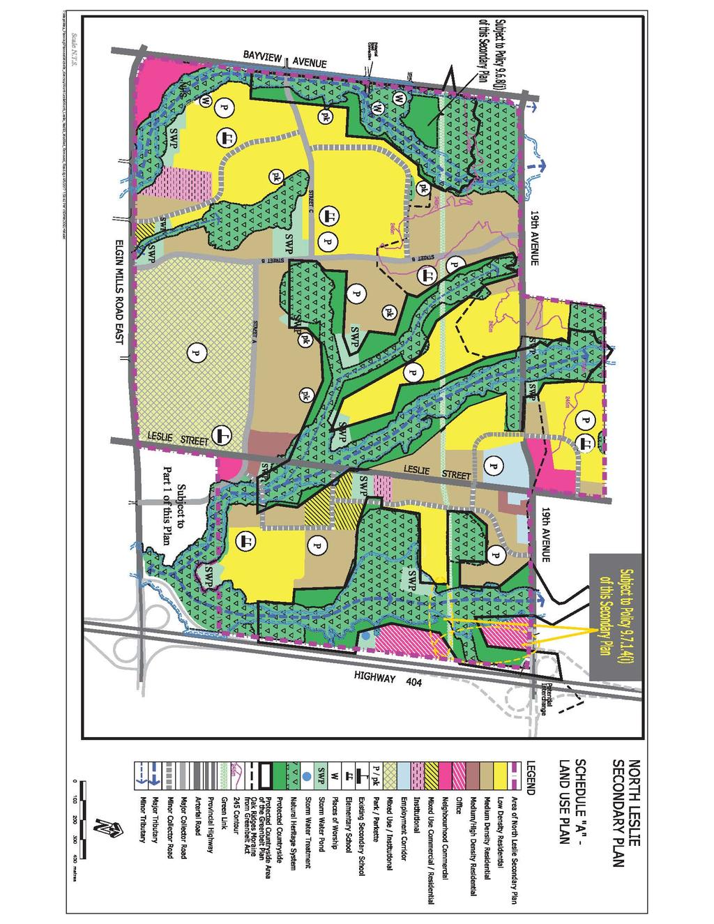
47
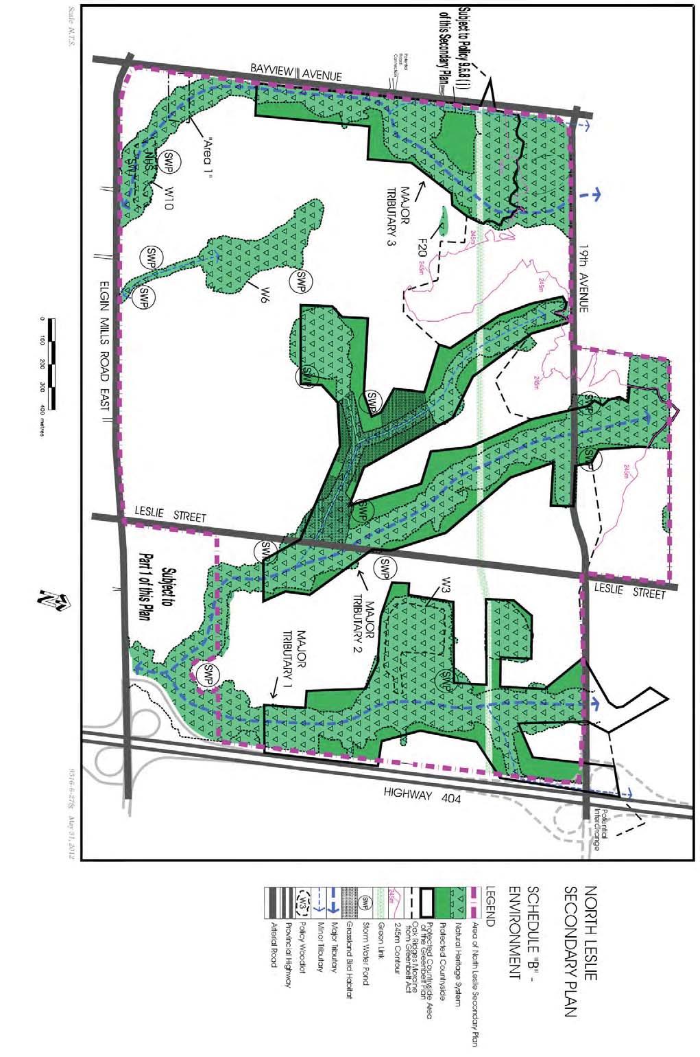
48
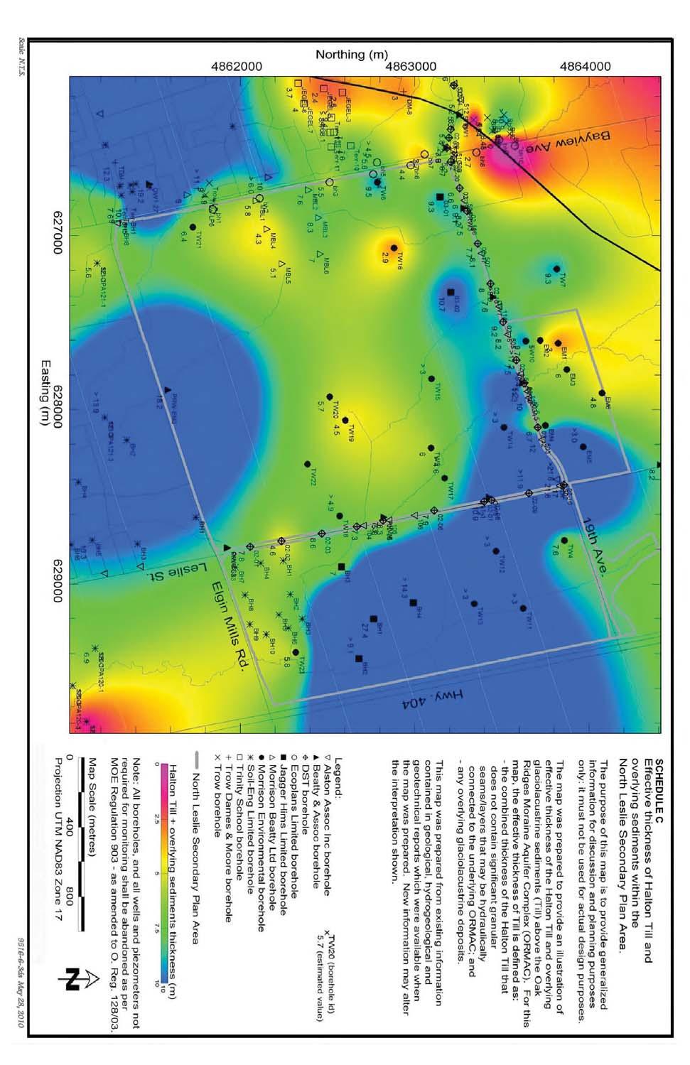
49

50
51
 771-8910 fax: (905) 771-2404 email: officialplan@richmondhill.ca web: www.richmondhill.ca/officialplan")
52 RICHMOND HILL OFFICIAL PLAN Planning and Regulatory Services Department Town of Richmond Hill Official Plan 225 East Beaver Creek Road Richmond Hill, ON L4B 3P4 tel: (905) fax: (905) web:
13. VANDORF-PRESTON LAKE SECONDARY PLAN 13.1 INTRODUCTION
 13. VANDORF-PRESTON LAKE SECONDARY PLAN 13.1.1 Purpose 13.1 INTRODUCTION The Vandorf-Preston Lake Secondary Plan establishes the principles, objectives and general policies, as well as specific strategies
AMENDMENT NO. 30 TO THE OFFICIAL PLAN OF THE TOWN OF MILTON
 AMENDMENT NO. 30 TO THE OFFICIAL PLAN OF THE TOWN OF MILTON Subject: Boyne Survey Secondary Plan and Related Official Plan Amendments The following text and schedules constitute Amendment No. 30 to the
3-2 Environmental Systems
 3-2 Environmental Systems 3.0 ENVIRONMENTAL SYSTEMS CONTENTS 3.1 GREENWAY SYSTEM 3.1.1 General Policies 3.1.2 Natural Heritage Network 3.1.3 Natural Heritage Network Enhancement Lands 3.1.4 Rouge Watershed
11. BALLANTRAE-MUSSELMAN LAKE AND ENVIRONS SECONDARY PLAN
 11. BALLANTRAE-MUSSELMAN LAKE AND ENVIRONS SECONDARY PLAN 11.1 PURPOSE The Ballantrae-Musselman Lake and Environs Secondary Plan Area includes two small existing settlement areas, Ballantrae and Musselman
OFFICE CONSOLIDATION SECONDARY PLAN AREA 48. CHAPTER 48(b) COUNTRYSIDE VILLAGES SECONDARY PLAN
 COUNTRYSIDE VILLAGES SECONDARY PLAN") OFFICE CONSOLIDATION SECONDARY PLAN AREA 48 CHAPTER 48(b) COUNTRYSIDE VILLAGES SECONDARY PLAN October 2016 TABLE OF CONTENTS (Part II, Chapter 48(b)) Purpose. 1.0 Location 2.0 Effect of this Chapter and
OFFICE CONSOLIDATION SECONDARY PLAN AREA 48 CHAPTER 48(b) COUNTRYSIDE VILLAGES SECONDARY PLAN October 2016 TABLE OF CONTENTS (Part II, Chapter 48(b)) Purpose. 1.0 Location 2.0 Effect of this Chapter and
11.4 Highway 400 North Employment Lands Secondary Plan APPROVED BY THE ONTARIO MUNICIPAL BOARD ON NOVEMBER 21, 2011
 11.4 Highway 400 North Employment Lands Secondary Plan APPROVED BY THE ONTARIO MUNICIPAL BOARD ON NOVEMBER 21, 2011 11.4.1 General 11.4.1.1. as approved by the Ontario Municipal Board on November 21, 2011,
The West Vaughan Employment Area Secondary Plan Policies
 Part 2: The West Vaughan Employment Area Secondary Plan Policies 2.1 General Policies It is the policy of Council: 2.1.1. That the West Vaughan Employment Area (the WVEA), identified on Schedule 1, will
CONTENTS 8.0 LAND USE 8.1 GENERAL LAND USE 8.2 RESIDENTIAL 8.3 MIXED USE 8.4 COMMERCIAL 8.5 EMPLOYMENT LANDS
 8-2 Land Use 8.0 LAND USE CONTENTS 8.1 GENERAL LAND USE 8.1.1 Uses provided for in all Land Use Designations 8.1.2 Uses prohibited in Hazardous Lands, Hazardous Sites and Special Policy Areas 8.1.3 Uses
PORT WHITBY COMMUNITY
 PORT WHITBY COMMUNITY SECONDARY PLAN UPDATE COMMUNITY IMPROVEMENT PLAN URBAN DESIGN GUIDELINES September 2015 DRAFT PROPOSED AMENDMENT NUMBER # to the Whitby Official Plan PURPOSE: The intent of this Amendment
11.4 Highway 400 North Employment Lands Secondary Plan
 11.4 Highway 400 North Employment Lands Secondary Plan APPROVED BY THE ONTARIO MUNICIPAL BOARD ON NOVEMBER 21, 2011 11.4.1 General 11.4.1.1. The following policies and Schedules A - I form Official Plan
COMMUNITY, DISTRICT AND SPECIAL STUDY AREA PLANS
 1.8 RIVER OAKS COMMUNITY - FIGURE "O" a) Background The River Oaks Community is bounded by Dundas Street on the north; the Sixteen Mile Creek on the west; Upper Middle Road on the south; and Trafalgar
Leonard s Beach Secondary Plan (Alcona North) Official Plan Amendment
 Official Plan Amendment") Leonard s Beach Secondary Plan (Alcona North) Official Plan Amendment Public Meeting Presentation August 14, 2013 Note: This document is for presentation purposes only. Please see Staff Report DSR-135-13
Leonard s Beach Secondary Plan (Alcona North) Official Plan Amendment Public Meeting Presentation August 14, 2013 Note: This document is for presentation purposes only. Please see Staff Report DSR-135-13
12 AMENDMENT NO. 149, TOWN OF MARKHAM HIGHWAY 404 NORTH SECONDARY PLAN
 12 AMENDMENT NO. 149, TOWN OF MARKHAM HIGHWAY 404 NORTH SECONDARY PLAN The Planning and Economic Development Committee recommends the adoption of the recommendation contained in the following report August
TERRESTRIAL NATURAL HERITAGE SYSTEM STRATEGY APPENDIX F: MODEL POLICIES FOR THE IMPLEMENTATION OF THE TARGET TERRESTRIAL NATURAL HERITAGE SYSTEM
 TERRESTRIAL NATURAL HERITAGE SYSTEM STRATEGY APPENDIX F: MODEL POLICIES FOR THE IMPLEMENTATION OF THE TARGET TERRESTRIAL NATURAL HERITAGE SYSTEM C H A P T E R 1 M O D E L P O L I C I E S F O R I M P L
FORMER CANADIAN FORCES BASE (CFB) ROCKCLIFFE SECONDARY PLAN. Official Plan Amendment XX to the Official Plan for the City of Ottawa
 ROCKCLIFFE SECONDARY PLAN. Official Plan Amendment XX to the Official Plan for the City of Ottawa") FORMER CANADIAN FORCES BASE (CFB) ROCKCLIFFE SECONDARY PLAN Official Plan Amendment XX to the Official Plan for the City of Ottawa 1 INDEX THE STATEMENT OF COMPONENTS PART A THE PREAMBLE PAGE Purpose...
FORMER CANADIAN FORCES BASE (CFB) ROCKCLIFFE SECONDARY PLAN Official Plan Amendment XX to the Official Plan for the City of Ottawa 1 INDEX THE STATEMENT OF COMPONENTS PART A THE PREAMBLE PAGE Purpose...
DAVENPORT VILLAGE SECONDARY PLAN
 27 DAVENPORT VILLAGE SECONDARY PLAN 27. DAVENPORT VILLAGE SECONDARY PLAN 1. VISION FOR THE DAVENPORT VILLAGE SECONDARY PLAN Davenport Village, municipally known as 830, 940, 980 and 1100 Lansdowne Avenue,
3 Development Process 3.1 Stage One page Stage Two page Stage Three page CENTRAL PICKERING DEVELOPMENT PLAN
 3 Development Process 3.1 Stage One page 24 3.2 Stage Two page 25 3.3 Stage Three page 28 22 CENTRAL PICKERING DEVELOPMENT PLAN The Central Pickering Development Plan establishes the key elements of new
HURON COMMUNITY PLAN
 CITY OF KITCHENER DEPARTMENT OF DEVELOPMENT AND TECHNICAL SERVICES PD 94/7 HURON COMMUNITY PLAN Recommended by Planning and Economic Development Committee: October 31, 1994 Adopted by Kitchener City Council:
BRAMPTON FLOWERTOWN SECONDARY PLAN Area 6
 BRAMPTON FLOWERTOWN SECONDARY PLAN Area 6 October 2018 EXPLANATORY NOTES Brampton Flowertown Secondary Plan Area 6 General i. Secondary plans form part of the Official Plan and are to be read in conjunction
The lands identified as Residential Areas on Schedule A1, Urban Structure, represent the areas that provide for stable residential communities.
 Livable Oakville Part D: Land Use Designations and Policies 11. RESIDENTIAL 11.1 General The lands identified as Residential Areas on Schedule A1, Urban Structure, represent the areas that provide for
KING CITY COMMUNITY PLAN
 KING CITY COMMUNITY PLAN TOWNSHIP OF KING JANUARY 27, 2000 AMENDMENT NO. 54 to the OFFICIAL PLAN for the TOWNSHIP OF KING PLANNING AREA THE COMMUNITY PLAN TABLE OF CONTENTS PAGE PART 1 INTRODUCTION 1.1
150 Eighth Street Zoning By-law Amendment Application Preliminary Report
 REPORT FOR ACTION 150 Eighth Street Zoning By-law Amendment Application Preliminary Report Date: March 27, 2019 To: Etobicoke York Community Council From: Director, Community Planning, Etobicoke York District
AMENDMENT NO. 38 TO THE CITY OF BARRIE OFFICIAL PLAN SALEM SECONDARY PLAN. June 2014
 AMENDMENT NO. 38 TO THE CITY OF BARRIE OFFICIAL PLAN SALEM SECONDARY PLAN June 2014 AMENDMENT NO. 38 TO THE OFFICIAL PLAN OF THE BARRIE PLANNING AREA TABLE OF CONTENTS Page Introduction 1 Part A - The
240 and 242 Finch Avenue West Zoning By-law Amendment Application Preliminary Report
 REPORT FOR ACTION 240 and 242 Finch Avenue West Zoning By-law Amendment Application Preliminary Report Date: March 1, 2019 To: North York Community Council From: Director, Community Planning, North York
Township of Adjala-Tosorontio Official Plan Review. Natural Heritage
 Township of Adjala-Tosorontio Official Plan Review 13 Natural Heritage Introduction What is an Official Plan? An official plan is a municipal policy document which sets out the community s vision and strategies
THE STRUCTURE OF THE PLAN...
 TABLE OF CONTENTS THE STRUCTURE OF THE PLAN... 1 A1 THE COMMUNITY VISION... 3 A2 GOALS AND OBJECTIVES... 3 A2.1 THE NATURAL ENVIRONMENT... 3 A2.1.1 Goal... 3 A2.1.2 Objectives... 3 A2.2 GROWTH AND SETTLEMENT...
OFFICE CONSOLIDATION CHAPTER 47 HIGHWAY 427 INDUSTRIAL SECONDARY PLAN
 OFFICE CONSOLIDATION CHAPTER 47 HIGHWAY 427 INDUSTRIAL SECONDARY PLAN NOTE: This Secondary Plan is partially in effect. Highlighted sections are under appeal. August 2017 1 EXPLANATORY NOTE Office Consolidation
TRCA Field Staking Protocol December 2016
 Page 1 of 6 TRCA Field Staking Protocol December 2016 This Protocol describes TRCA staff s current practice for field staking the physical top of bank, the physical toe of slope, and the limit of existing
OFFICE CONSOLIDATION SECONDARY PLAN AREA 22 THE BRAMALEA SOUTH INDUSTRIAL SECONDARY PLAN
 OFFICE CONSOLIDATION SECONDARY PLAN AREA 22 THE BRAMALEA SOUTH INDUSTRIAL SECONDARY PLAN November 2010 EXPLANATORY NOTES (Secondary Plan Area 22) General (pertaining to all secondary plan office consolidations)
280 Manse Road - Official Plan Amendment, Zoning Amendment, Draft Plan of Subdivision Applications - Preliminary Report
 STAFF REPORT ACTION REQUIRED 280 Manse Road - Official Plan Amendment, Zoning Amendment, Draft Plan of Subdivision Applications - Preliminary Report Date: March 11, 2014 To: From: Wards: Reference Number:
Secondary Plan for the Samac Community
 Secondary Plan for the Samac Community (Section 6.2 of the Official Plan of the former Planning Area of the City of Oshawa) Office Consolidation Copy of the Secondary Plan for the Samac Community This
STAFF REPORT. December 20, North York Community Council. Director, Community Planning, North York District
 STAFF REPORT December 20, 2005 To: From: Subject: North York Community Council Director, Community Planning, North York District Preliminary Report Application to Amend the Official Plan and Zoning By-law
Master Environmental Servicing Plan & Secondary Plan
 East Side Lands Stage 2 1 Master Environmental Servicing Plan & Secondary Plan Public Information Centre #1 June 16, 2016 Welcome! Today s Agenda Please sign in at the front desk. 5:30 pm 6:30 pm: Open
C.10 Boyne Survey Secondary Plan
 C.10 Boyne Survey Secondary Plan SECONDARY PLAN July 2017 C.10 BOYNE SURVEY SECONDARY PLAN C.10.1 C.10.1.1 GENERAL PURPOSE The purpose of the Boyne Survey Secondary Plan is to establish a more detailed
QUEEN-RIVER SECONDARY PLAN
 34 QUEEN-RIVER SECONDARY PLAN 34. QUEEN RIVER SECONDARY PLAN 1. INTRODUCTION The Queen-River area is approximately 6.4 hectares and is located at the eastern edge of the Downtown as shown on Map 34-1.
SPECIAL COMMITTEE OF THE WHOLE DECEMBER 9, 2002 BLOCK 12 BLOCK PLAN FILE BL CASTAN BATHURST TESTON CORPORATION ET AL PRELIMINARY REPORT
 SPECIAL COMMITTEE OF THE WHOLE DECEMBER 9, 2002 BLOCK 12 BLOCK PLAN FILE BL.12.99 CASTAN BATHURST TESTON CORPORATION ET AL PRELIMINARY REPORT Recommendation The Commissioner of Planning recommends: THAT
Mark-up of the effect of the proposed Bronte Village Growth Area OPA No.18 on the text of section 24, Bronte Village, of the Livable Oakville Plan
 Mark-up of the effect of the proposed Bronte Village Growth Area OPA No.18 on the text of section 24, Bronte Village, of the Livable Oakville Plan Notes: This document is provided for information purposes
10 Park Lawn Rd - Zoning Amendment Application- Preliminary Report
 STAFF REPORT ACTION REQUIRED 10 Park Lawn Rd - Zoning Amendment Application- Preliminary Report Date: March 9, 2012 To: From: Wards: Reference Number: Etobicoke York Community Council Director, Community
OFFICIAL PLAN FOR THE TOWN OF NEW TECUMSETH
 OFFICIAL PLAN FOR THE TOWN OF NEW TECUMSETH Approved by Simcoe County- March 10, 2010 TABLE OF CONTENTS PAGE# 1.0 TITLE AND COMPONENTS... 5 2.0 INTRODUCTION... 6 2.1 Purpose... 6 2.2 Organization of the
4780 Eglinton Avenue West - Zoning By-law Amendment and Draft Plan of Subdivision Applications - Preliminary Report
 STAFF REPORT ACTION REQUIRED 4780 Eglinton Avenue West - Zoning By-law Amendment and Draft Plan of Subdivision Applications - Preliminary Report Date: May 29, 2014 To: From: Wards: Reference Number: Etobicoke
Rowntree Mill Road Zoning and Plan of Subdivision Applications Final Report
 STAFF REPORT ACTION REQUIRED 148-156 Rowntree Mill Road Zoning and Plan of Subdivision Applications Final Report Date: March 13, 2007 To: From: Wards: Reference Number: Etobicoke York Community Council
2136 & 2148 Trafalgar Road Town of Oakville Region of Halton
 PLANNING JUSTIFICATION REPORT 2136 & 2148 Trafalgar Road Town of Oakville Region of Halton Zoning By-Law Amendment Application 2500674 Ontario Inc. November 2016 Table of Contents Page 1.0 Location/Summary
and services The protection and conservation of environmentally significant and sensitive natural heritage features and functions.
 6. Land Use 6.0 Preamble A healthy and livable city is one in which people can enjoy a vibrant economy and a sustainable healthy environment in safe, caring and diverse neighbourhoods. In order to ensure
SECTION 2 - GENERAL POLICIES
 SECTION 2 - GENERAL POLICIES 2.1 General Development a) Goals i) To accommodate the population and development anticipated for the Town in the planning period. ii) To provide the necessary services and
6 PORT SYDNEY SETTLEMENT AREA
 Section 6 Port Sydney Page 61 6 PORT SYDNEY SETTLEMENT AREA 6.1 Basis and Principles Village of Port Sydney Waterfront Community Existing Services 6.1.1 Port Sydney is an historic settlement that has developed
599 Kennedy Road - Official Plan Amendment and Zoning Amendment Application - Preliminary Report
 STAFF REPORT ACTION REQUIRED 599 Kennedy Road - Official Plan Amendment and Zoning Amendment Application - Preliminary Report Date: March 7, 2017 To: From: Wards: Reference Number: Scarborough Community
MORNINGSIDE HEIGHTS COMMUNITY SECONDARY PLAN
 3 MORNINGSIDE HEIGHTS COMMUNITY SECONDARY PLAN 3. MORNINGSIDE HEIGHTS COMMUNITY SECONDARY PLAN The following policies and principles apply to the area referred to as the Morningside Heights Community,
Prepared for: Ontario Limited
 Application for Zoning By-law Amendment and Plan of Subdivision 1353 Scharfgate Drive Planning Rationale Report Prepared for: 1384341 Ontario Limited November 28, 2014 Revised August 18, 2015 Planning
Bressa Developments Limited. Planning Justification Report. Revised Draft Plan of Subdivision and Zoning By-Law Amendment
 Bressa Developments Limited Revised Draft Plan of Subdivision and Zoning By-Law Amendment Planning Justification Report Part of Lots 7 & 8 Concession 1, North of Dundas Street Town of Oakville September,
PART III LAND USE POLICIES URBAN PLANNING AREA
 To be read with other parts of the Plan 1.0 INTRODUCTION *D9 This part of the Plan presents the principles, objectives and policies for the land use designations identified on the Settlement Pattern and
1.0 INTRODUCTION AND BACKGROUND
 1.0 INTRODUCTION AND BACKGROUND 1.1 INTRODUCTION / BACKGROUND The Regional Municipality of York (hereafter referred to as York Region ) has completed a Municipal Class Environmental Assessment (Class EA)
North Oakville East Parks Facilities Distribution Plan. November, 2009
 North Oakville East November, 2009 POLICY CONTEXT 1) Purpose a) The purpose of this document is to be a guide for the location, configuration, design and development of the parks system for the North Oakville
2450 Victoria Park Avenue Official Plan Amendment Application Preliminary Report
 STAFF REPORT ACTION REQUIRED 2450 Victoria Park Avenue Official Plan Amendment Application Preliminary Report Date: December 19, 2012 To: From: Wards: Reference Number: Planning and Growth Management Committee
8 Oak Street - Official Plan and Zoning By-law Amendment Application - Preliminary Report
 STAFF REPORT ACTION REQUIRED 8 Oak Street - Official Plan and Zoning By-law Amendment Application - Preliminary Report Date: March 17, 2014 To: From: Wards: Reference Number: Planning and Growth Management
Dufferin Street and Centre Street Area Specific Policies
 12.XX 12.XX.1 12.XX.1.1. 12.XX.2. 12.XX.2.1. 12.XX.2.2 Dufferin Street and Centre Street Area Specific Policies Goals The goal of this Plan is to provide the necessary land use and development policies
CITY OF NIAGARA FALLS. By-law No
 CITY OF NIAGARA FALLS By-law No. 2018- A by-law to provide for the adoption of Amendment No. 128 to the City of Niagara Falls Official Plan (OPA #128). THE COUNCIL OF THE CORPORATION OF THE CITY OF NIAGARA
a) recognize agriculture as the primary activity and land use; b) maintain and preserve the agricultural resource base of the Town;
 recognize agriculture as the primary activity and land use; b) maintain and preserve the agricultural resource base of the Town;") PA RT E E1 AGRICULTURAL AREA E1.1 OBJECTIVES It is the objective of this designation to: a) recognize agriculture as the primary activity and land use; b) maintain and preserve the agricultural resource
PA RT E E1 AGRICULTURAL AREA E1.1 OBJECTIVES It is the objective of this designation to: a) recognize agriculture as the primary activity and land use; b) maintain and preserve the agricultural resource
Tremaine Dundas Secondary Plan (Draft May 2017)
") PB-52-17 Appendix A Tremaine Dundas Secondary Plan (Draft May 2017) Page 2 Tremaine Dundas Secondary Plan (Draft May 2017) This page has been left blank intentionally Page 3 Tremaine Dundas Secondary Plan
PB-52-17 Appendix A Tremaine Dundas Secondary Plan (Draft May 2017) Page 2 Tremaine Dundas Secondary Plan (Draft May 2017) This page has been left blank intentionally Page 3 Tremaine Dundas Secondary Plan
1296 Kennedy Road - Zoning Amendment Application - Preliminary Report
 STAFF REPORT ACTION REQUIRED 1296 Kennedy Road - Zoning Amendment Application - Preliminary Report Date: January 15, 2016 To: From: Wards: Reference Number: Scarborough Community Council Acting Director,
5. Spring Garden Planning Area (Secondary Plan added by OPA #05 11/29/2002)
") 5. Spring Garden Planning Area (Secondary Plan added by OPA #05 11/29/2002) 5.0 Preamble THE PLANNING AREA FRAGMENTED OWNERSHIP PATTERN EMERGING LAND USE ISSUES IMPLEMENT STUDY FINDINGS The Spring Garden
5. Spring Garden Planning Area (Secondary Plan added by OPA #05 11/29/2002) 5.0 Preamble THE PLANNING AREA FRAGMENTED OWNERSHIP PATTERN EMERGING LAND USE ISSUES IMPLEMENT STUDY FINDINGS The Spring Garden
Land Use Policies. North Aldershot Area Land Use Policies. 10 North Aldershot Area
 Land Use Policies North Aldershot Area Land Use Policies 10 North Aldershot Area This page has been left intentionally blank LAND USE POLICIES NORTH ALDERSHOT 10.1 SECTORS... 10-5 10.1.1 CENTRAL SECTOR...
The protection of the agricultural resources of the Province;
 PART II INTRODUCTION An Official Plan is a policy document, which is intended to serve as the basis for making land use decisions and managing change in any municipality in Ontario. According to the Planning
Director, Community Planning, Etobicoke York District
 STAFF REPORT April 25, 2006 To: From: Subject: Etobicoke York Community Council Director, Community Planning, Etobicoke York District Refusal Report Rezoning Application 04 203855 WET 07 OZ Plan of Subdivision
Brampton. Secondary Plan. Review. Bram West. A New Direction in Planning & Public Consultation
 Brampton Bram West Secondary Plan Review A New Direction in Planning & Public Consultation Introduction The Bram West Secondary Plan Review offers an important opportunity for the community to define a
DRAFT Northeast Quadrant of Kipling Avenue and Highway 7 DRAFT AUGUST 29, Goals Land Use. The goals of this Plan are to:
 AUGUST 29, 2017 12.15 Northeast Quadrant of Kipling Avenue and Highway 7 12.15.1 Goals 12.15.2 Land Use The goals of this Plan are to: 12.15.2.1 General Provisions: a) Ensure the development of a compact
Bloor St. W. Rezoning - Preliminary Report
 STAFF REPORT ACTION REQUIRED 1638-1644 Bloor St. W. Rezoning - Preliminary Report Date: April 1, 2008 To: From: Wards: Reference Number: Toronto and East York Community Council Acting Director, Community
Planning Justification Report. Milton Meadows Properties Ltd. Milton Meadows South IN SUPPORT OF ZONING BY-LAW AMENDMENT & DRAFT PLAN OF SUBDIVISION
 Planning Justification Report Milton Meadows Properties Ltd. Milton Meadows South IN SUPPORT OF ZONING BY-LAW AMENDMENT & DRAFT PLAN OF SUBDIVISION For Part of Lot 3, Concession 1 Town of Milton HUMPHRIES
1071 King Street West Zoning Amendment Application - Preliminary Report
 STAFF REPORT ACTION REQUIRED 1071 King Street West Zoning Amendment Application - Preliminary Report Date: August 9, 2012 To: From: Wards: Reference Number: Toronto and East York Community Council Director,
CONSULTING SERVICES FOR THE WHITEBELT VISIONING EXERCISE ADDENDUM TO THE GTA WEST LAND USE STUDY WORK PROGRAM
 CONSULTING SERVICES FOR THE WHITEBELT VISIONING EXERCISE ADDENDUM TO THE GTA WEST LAND USE STUDY 1. Introduction WORK PROGRAM The Town of Caledon is a large, local municipality located in the Greater Toronto
Environment and Sustainability. Environment and Sustainability
 4 Environment and Sustainability Environment and Sustainability ENVIRONMENT AND SUSTAINABILITY 4.1 CLIMATE CHANGE AND AIR QUALITY... 4-5 4.1.1 OBJECTIVES... 4-6 4.1.2 POLICIES... 4-6 4.2 NATURAL HERITAGE
Background Summary Report
 Background Summary Report May 2014 Submitted by Macaulay Shiomi Howson Ltd. In association with AMEC MMM Group Brook McIlroy Inc. Hemson Consulting Ltd. Table of Contents 1. Introduction... 1 2. Why is
Official Plan Amendment Number 272
 Official Plan Amendment Number 272 to the Official Plan of The Corporation of the Town of Oakville NORTH OAKVILLE EAST SECONDARY PLAN Town of Oakville Official Plan Amendment 272 Part 1, Constitutional
4155 Yonge Street Official Plan Amendment and Rezoning Application Preliminary Report
 STAFF REPORT ACTION REQUIRED 4155 Yonge Street Official Plan Amendment and Rezoning Application Preliminary Report Date: May 5, 2011 To: From: Wards: Reference Number: North York Community Council Director,
AMENDMENT NO. TO THE CITY OF BARRIE OFFICIAL PLAN HEWITT S SECONDARY PLAN
 AMENDMENT NO. TO THE CITY OF BARRIE OFFICIAL PLAN HEWITT S SECONDARY PLAN OFFICIAL PLAN FOR THE CITY OF BARRIE Amendment No. Amendment No. to the was prepared by the Barrie General Committee and was recommended
1.0 PLANNING MARKHAM S FUTURE CONTENTS
 1-1 Planning Markham s Future 1.0 PLANNING MARKHAM S FUTURE CONTENTS 1.1 THE PURPOSE OF THE OFFICIAL PLAN 1.2 THE MARKHAM CONTEXT 1.3 THE REGULATORY CONTEXT 1.3.1 Province of Ontario 1.3.2 York Region
NOTE: PLEASE REFER TO CITY PLAN FOR ADDITIONAL CITY-WIDE POLICIES WHICH APPLY TO THIS DISTRICT.
 NOTE: THE POLICIES IN THIS DOCUMENT ARE SPECIFIC TO THE SHERIDAN RESIDENTIAL PLANNING DISTRICT OF, AND MUST BE READ IN CONJUNCTION WITH ALL THE POLICIES OF CITY PLAN PLEASE REFER TO FOR ADDITIONAL CITY-WIDE
OFFICE CONSOLIDATION SECONDARY PLAN AREA 49 VALES NORTH SECONDARY PLAN
 OFFICE CONSOLIDATION SECONDARY PLAN AREA 49 VALES NORTH SECONDARY PLAN July 2014 EXPLANATORY NOTES Chapter 49 General (pertaining to all secondary plan office consolidations) i. Secondary plan office consolidations
Figure 1- Site Plan Concept
 Figure 1- Site Plan Concept Parking will be provided underground on three levels at rate of 1.0 space/ unit; this rate includes all visitors parking. MMM Group has prepared a parking assessment (April,
SECTION 7A: WHAKARONGO RESIDENTIAL AREA
 SECTION 7A: WHAKARONGO RESIDENTIAL AREA CONTENTS 7A.1 Introduction 1 7A.2 Resource Management Issues 1 7A.3 Objectives and Policies 1 7A.4 Methods 4 7A.5 Residential Zone 4 7A.5.1 Rules: Controlled Activities
Table of Contents 1.0 Introduction
 Table of Contents 1.0 Introduction..1 2.0 Site Description and Surrounding Land Uses 1 3.0 Redevelopment Proposal..3 4.0 Provincial, Regional and Municipal Policy Context... 10 4.1 The Provincial Policy
ARTICLE 6: Special and Planned Development Districts
 ARTICLE 6: Special and Planned Development Districts 6-10 Traditional Neighborhood Development (TND) District 6-10.10 Purpose and Intent The Traditional Neighborhood Development (TND) District provides
THE CITY OF VAUGHAN BY-LAW BY-LAW NUMBER
 THE CITY OF VAUGHAN BY-LAW BY-LAW NUMBER 123-2013 A By-law to designate the whole of the City of Vaughan as a Site Plan Control Area, and to adopt site development guidelines and rules of procedure for
PART III LAND USE POLICIES URBAN PLANNING AREA
 To be read with other parts of the Plan 1.0 INTRODUCTION *D9 This part of the Plan presents the principles, objectives and policies for the land use designations identified on the Settlement Pattern and
From: Director, Community Planning, Etobicoke York District
 STAFF REPORT ACTION REQUIRED 4208, 4210 and 4214 Dundas Street West - Official Plan Amendment and Zoning By-law Amendment Application - Preliminary Report Date: July 22, 2014 To: Etobicoke York Community
6. REGIONAL AND COMMUNITY FACILITIES DESIGNATIONS 6.1. OBJECTIVES FOR REGIONAL AND COMMUNITY FACILITIES LAND USE DESIGNATIONS
 6. REGIONAL AND COMMUNITY FACILITIES DESIGNATIONS INTRODUCTION The Regional and land use designations provide the primary locations for uses which satisfy the health, education and other service needs
URBAN DESIGN BRIEF. 2136&2148 Trafalgar Road. Town of Oakville
 URBAN DESIGN BRIEF 2136&2148 Trafalgar Road Town of Oakville Prepared By: METROPOLITAN CONSULTING INC For 2500674 Ontario Inc November 2016 TABLE OF CONTENTS Page No. 1.0 Introduction/Description of Subject
6 RURAL RESIDENTIAL. 6.1 Rural Use. Rural Use (RU) Goals and Objectives. Policy Goal
 Goals and Objectives. Policy Goal") 6 RURAL RESIDENTIAL The vast majority of East Hants 466,426 acres are considered rural in nature and are characterized by a great diversity of uses. Because of this, land use policies in rural areas of
6 RURAL RESIDENTIAL The vast majority of East Hants 466,426 acres are considered rural in nature and are characterized by a great diversity of uses. Because of this, land use policies in rural areas of
THE CITY OF VAUGHAN BY-LAW BY-LAW NUMBER A By-law to adopt Amendment Number 1 to the Official Plan of the Vaughan Planning Area.
 THE CITY OF VAUGHAN BY-LAW BY-LAW NUMBER 015-2014 A By-law to adopt Amendment Number 1 to the Official Plan of the Vaughan Planning Area. NOW THEREFORE the Council of the Corporation of the City of Vaughan
Planning and Growth Management Committee. Chief Planner and Executive Director, City Planning Division. Pg12013 (File No NNY 34 OZ)
") 865 York Mills Road Official Plan Amendment Application Preliminary Report STAFF REPORT ACTION REQUIRED Date: February 28, 2012 To: From: Wards: Reference Number: Planning and Growth Management Committee
865 York Mills Road Official Plan Amendment Application Preliminary Report STAFF REPORT ACTION REQUIRED Date: February 28, 2012 To: From: Wards: Reference Number: Planning and Growth Management Committee
PLANNING RATIONALE. Shadow Ridge Estates Subdivision, Phase Two. In Support of a Proposed Zoning By-Law Amendment. Report Number: R
 PLANNING RATIONALE Shadow Ridge Estates Subdivision, Phase Two In Support of a Proposed Zoning By-Law Amendment Report Number: R-2011-222 Prepared for: Donwel Land Inc. Prepared by: Novatech Engineering
Trafalgar Road Corridor Planning Study Open House
 Trafalgar Road Corridor Planning Study Open House June 24, 2013 6:30-8:30 p.m. Oakville & Trafalgar Rooms Overview The Livable Oakville Plan identifies the lands along Trafalgar Road, between the QEW and
2 STATUTORY PUBLIC MEETING AND INFORMATION REPORT FOR PUBLIC MEETING ON AMENDMENT NO. 62 TO THE YORK REGION OFFICIAL PLAN
 2 STATUTORY PUBLIC MEETING AND INFORMATION REPORT FOR PUBLIC MEETING ON AMENDMENT NO. 62 TO THE YORK REGION OFFICIAL PLAN Pursuant to Section 17(15) of the Planning Act, as amended, the Regional Planning
Edward R. Sajecki Commissioner of Planning and Building. Land Use Review- Former Parkway Belt West Lands- Fieldgate Drive and Audubon Boulevard
 Corporate Report Clerk s Files Originator s Files CD.04.FOR DATE: November 15, 2011 TO: FROM: SUBJECT: Chair and Members of Planning and Development Committee Meeting Date: December 5, 2011 Edward R. Sajecki
9 CITY OF VAUGHAN OFFICIAL PLAN AMENDMENT NO BOCA EAST INVESTMENTS LIMITED
 9 CITY OF VAUGHAN OFFICIAL PLAN AMENDMENT NO. 631 - BOCA EAST INVESTMENTS LIMITED The Planning and Economic Development Committee recommends the adoption of the recommendations contained in the following
5959 Yonge Street Rezoning Application - Preliminary Report
 STAFF REPORT ACTION REQUIRED 5959 Yonge Street Rezoning Application - Preliminary Report Date: February 23, 2011 To: From: Wards: Reference Number: North York Community Council Director, Community Planning,
THE CORPORATION OF THE CITY OF WINDSOR Office of the City Solicitor Planning Department
 THE CORPORATION OF THE CITY OF WINDSOR Office of the City Solicitor Planning Department REPORT TO THE CITY OF WINDSOR PLANNING ADVISORY COMMITTEE DATE OF REPORT: August 19, 2010 SUBJECT: Official Plan
Staff Report for Committee of the Whole Meeting
 Agenda Item 26 Staff Report for Committee of the Whole Meeting Department: Division: Subject: Planning and Regulatory Services Development Planning Request for Approval Official Plan Amendment, Zoning
523, 525 and 525A Adelaide Street West - Zoning Amendment Application - Preliminary Report
 STAFF REPORT ACTION REQUIRED 523, 525 and 525A Adelaide Street West - Zoning Amendment Application - Preliminary Report Date: May 12, 2012 To: From: Wards: Reference Number: Toronto and East York Community
URBAN DESIGN BRIEF URBAN DESIGN BRIEF 721 FRANKLIN BLVD, CAMBRIDGE August 2018
 URBAN DESIGN BRIEF URBAN DESIGN BRIEF 721 FRANKLIN BLVD, CAMBRIDGE August 2018 DESIGN BRIEF CONTENTS PART A 1.0 INTRODUCTION 2.0 DESCRIPTION & ANALYSIS OF SITE CONTEXT 3.0 DESIGN CONSTRAINTS AND OPPORTUNITIES
and Richmond Street West - Official Plan Amendment Application - Preliminary Report
 STAFF REPORT ACTION REQUIRED 822-838 and 860-862 Richmond Street West - Official Plan Amendment Application - Preliminary Report Date: August 14, 2017 To: From: Wards: Reference Number: Toronto and East