Proposed Ranked List of Projects for Capital Budget Funding
|
|
|
- Aubrey Charles
- 5 years ago
- Views:
Transcription


1 Proposed Ranked List of Projects for Capital Budget Funding Ecology Publication #: October 2014


2 Ecology Publication #: October 2014
3 Focus on Proposed Projects for FY Floodplains by Design Funding Budget Request The Department of Ecology is requesting continued funding at the $50 million level for Floodplains by Design in the FY State budget. This program supports projects across the state that address vital flood risk reduction and habitat improvement in our floodplains. This is a list of identified and ranked projects to support Ecology's $50 million budget request for Floodplain by Design grants for the Biennial Budget. Funding will depend on legislative approval of the budget request, which will be determined in the spring of Some projects were submitted to multiple state funding programs. If listed projects are funded through another source or if projects are withdrawn, the cutoff line will be adjusted accordingly to fund additional project(s) on the ranked list depending on the amount of funding provided by the Legislature. Background In 2013 the Department of Ecology and its partners, the Puget Sound Partnership and The Nature Conservancy, were successful in securing legislative funding through the Floodplain by Design effort. Ecology was given $33 million to advance integrated floodplain projects in Puget Sound and an additional $11 million for a statewide floodplain management and control competitive grant program. For the biennium the Department of Ecology conducted a competitive process to create a ranked project list, supporting the agency's Floodplains by Design budget proposal to continue funding at $50 million. In May 2014 Ecology solicited pre-applications for the FY FbD program. Of the 71 submittals, 36 projects were invited to submit full grant applications. The applications were submitted September 8. A team of technical and policy experts from state and federal agencies reviewed the 30 submitted applications and recommend the following projects for funding. Below is the ranked list of projects that supports Ecology s request for continued funding at the $50 million level in FY The $50 million cutoff line is identified. All the projects on this list are considered to be highly qualified for this funding program. MORE INFORMATION Floodplains by Design (FbD) is a partnership led by Ecology, Puget Sound Partnership and The Nature Conservancy to coordinate investment in the management of the lands along Washington s major rivers, home to a host of our region s most valuable assets. There are two goals of the Floodplains by Design program: 1. Promote the reduction of flood risks and floodplain ecosystem recovery while maintaining or improving agricultural production, water quality, and open space/recreation. 2. Improve the coordination of public funding for floodplain efforts. Contact Department of Ecology Tom Clingman tom.clingman@ecy.wa.gov The Nature Conservancy org Special accommodations If you need this document in a format for the visually impaired, call Shorelands & Environmental Assistance at Persons with hearing loss can call 711 for Washington Relay Service. Persons with a speech disability can call Ecology Publication #: October 2014
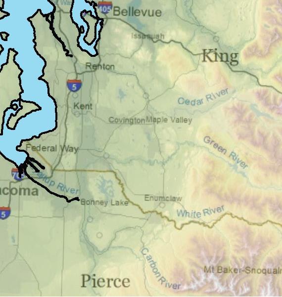
4 Ecology FY Proposed Floodplain by Design Project List Rank Project Description Cost Running Total FbD Staffing $1,662,986 $1,662,986 Cultural Resource Protection $200,000 $1,862,986 Yakima FP Management Program: Rambler's Park Phase IV 1 and Trout Meadows Phase II $2,358,000 $4,220,986 2 Puyallup Watershed Floodplain Reconnections - Tier 1 $10,240,000 $14,460,986 3 Lower Dungeness River Floodplain Restoration $9,501,600 $23,962,586 4 Boeing Levee/Russell Road Improvements & Floodplain Restoration $4,900,000 $28,862,586 5 South Fork Nooksack - Flood, Fish and Farm Conservation $3,216,958 $32,079,544 Middle Green River/Porter Gateway Protection and 6 Restoration $3,648,926 $35,728,470 7 Cedar River Corridor Plan Implementation $5,000,000 $40,728,470 Sustainable Management of the Upper Quinault River 8 Floodplain $560,000 $41,288,470 9 Manastash Creek Corridor Plan Phase II $1,460,000 $42,748, Yakima and Teanaway Reach Scale Flood Hazard Management Plans $1,375,000 $44,123,470 Skagit Delta Farm, Fish & Flood Initiative - Phase 2: Preliminary Design and Feasibility $397,075 $44,520,545 Boise Creek Habitat Restoration and Flood Attenuation Project $3,507,894 $48,028, Lower Big Quilcene Preliminary Design: A Community Approach to Restoration $908,616 $48,937,055 14a Snoqualmie Riverfront Project $1,062,945 $50,000,000 Qualified project proposals below $50,000,000 funding line 14b Snoqualmie Riverfront Project $457,575 $50,457, Downey Farmstead Restoration $4,735,940 $55,193, Puyallup Watershed Floodplain Reconnections - Tier 2 $10,600,000 $65,793, Yakima River Nine Mile 30 Levee Removal $480,000 $66,273, Pysht River Floodplain Restoration and Flood Reduction $1,830,000 $68,103, Anderson Property - Yakima River Floodplain Restoration $151,164 $68,254, Upper Nisqually Community Channel Migration Protection Project $140,000 $68,394, Entiat River Stormy Floodplain Reconnection Project $500,000 $68,894, Lower Klickitat Floodplain Enhancement Assessment $180,000 $69,074,679 Ecology Publication #: October 2014

5 1. Yakima Floodplain Management Program: Rambler's Park Phase 4 and Trout Meadows Phase 2 Proponent: Yakima County County: Yakima Requested Amount: $2,358,000 Legislative District: 14 River: Yakima Match: $592,000 Primary Objectives: Flood Risk Reduction; Salmon Habitat Restoration Project Summary: The Rambler s Park and Trout Meadow projects are part of a broadly supported vision and strategy to develop and implement a package of floodplain management projects geared at improved ecosystem function, salmon recovery and increased flood protection for the Yakima River. The work at Rambler s Park will be the final phase of a project aimed at reducing flood risk and restoring fish passage and habitat around Nelson Dam. It will include a new fish-friendly boulder bed overflow channel around Nelson Dam while ensuring two bridges are protected. The Trout Meadows project is also the second and final phase of work to reconnect and restore floodplain habitat while reducing risk to the McCormick Levee which has been breeched at low level flows. The project will reduce pressure on McCormick levee, reduce flood heights in the immediate vicinity, and reconnect approximately 60 acres of quality floodplain habitat. Ecology Publication #: October 2014

6 2. Puyallup Watershed Floodplain Reconnections Tier 1 Proponent: Pierce County County: Pierce Requested Amount: $10,240,000 Legislative District: 2, 25 River: Puyallup Match: $2,544,250 Primary Objectives: Flood Risk Reduction; Salmon Habitat Restoration; Agricultural Viability Project Summary: The Puyallup River Watershed Floodplain Reconnections plan is a broadly supported multiyear strategy that serves as a model for the scale and level of effort necessary to achieve the Floodplains by Design vision. Tier I acquisition and construction projects include: the design and construction of Puyallup River floodplain protection such as engineered log jams or flood fences at Kapowsin Creek; land acquisition for Orville Road Channel Migration Protection in preparation for later phases; land acquisition and structure removal in the Neadham Road flood hazard area in preparation for future levee setback; and land acquisition and structure removal in the Clear Creek/Lower Puyallup River floodplain, in preparation for later phases which will reconnect over 500 acres of floodplain that have been subject to recent flooding dramatically reducing flood risk while restoring critical tidal marsh habitat. 3. Lower Dungeness River Floodplain Restoration Proponent: Clallam County County: Clallam Requested Amount: $9,501,600 Legislative District: 24 River: Dungeness Match: $2,375,400 Primary Objectives: Flood Risk Reduction; Salmon Habitat Restoration; Agricultural Viability Project Summary: This project is a key element of the Dungeness River Management Plan to improve flood protection and ecosystem benefits along the Dungeness River while supporting local farms and other interests. This project would continue implementation of this larger floodplain management strategy, including a levee setback and habitat restoration to reconnect 112 acres of floodplain while reducing downstream flood risk. Ecology Publication #: October 2014
7 4. Boeing Levee/Lower Russell Road Improvements and Floodplain Restoration Proponent: King County Flood Control District County: King Requested Amount: $4,900,000 Legislative District: 11, 33 River: Green Match: $24,400,000 Primary Objectives: Flood Risk Reduction; Salmon Habitat Restoration; Water Quality Improvement; Public Access and Open Space Project Summary: This project is focused on meeting the goals of the Lower Green River System Wide Improvement Framework (SWIF). It will raise the existing levee to provide a higher level of protection to existing development and restore floodplain habitat on the right bank of the lower Green River. The project will replace and upgrade the existing levee to provide a higher level of flood risk reduction; restore 60 acres of floodplain; 4,400 feet of riparian buffer (4.6 acres); improve salmon habitat; and improve public access by integrating the new levee, road and reconnected floodplain with existing parks, the Green River Trail and open space. 5. South Fork Nooksack--Flood, Fish, and Farm Conservation Integration Proponent: Whatcom Land Trust County: Whatcom Requested Amount: $3,216,958 Legislative District: 42 River: Nooksack Match: $811,090 Primary Objectives: Flood Risk Reduction; Salmon Habitat Restoration; Agricultural Viability Project Summary: This project supports coordinated public investment to implement floodplain conservation, flood protection improvements and restoration actions on the South Fork Nooksack River. It includes permanent protection of up to 200 acres of floodplain habitat and 200 acres of farmland; improving salmon habitat through the removal of artificial constraints and restoration of log jams; and pre-construction work for future phases of shoreline armoring removal or setback to reduce flood hazard to Acme and other communities. It includes hydraulic modeling, alternatives analysis and engineering design. 6. Middle Green River/Porter Gateway Protection and Restoration Proponent: King County County: King Requested Amount: $3,648,926 Legislative District: 7 River: Green Match: $1,737,373 Primary Objectives: Flood Risk Reduction; Salmon Habitat Restoration; Agricultural Viability Project Summary: The project will protect long-term agricultural uses, reducing flood risks to an existing arterial road and adjacent farmland. It will be the culmination of 14 years of restoration projects and consist of removal of the 1400-foot long defunct Porter Levee; reconstruction of a raised gravel Ecology Publication #: October 2014

8 berm with placement of log structures to protect arterial road; restoration of floodplain forest; and purchase of development rights on 112 acres of farmland. 7. Cedar River Corridor Plan Implementation Proponent: King County County: King Requested Amount: $5,000,000 Legislative District: 5,11 River: Cedar Match: $3,000,000 Primary Objectives: Flood Risk Reduction; Salmon Habitat Restoration; Water Quality Improvement; Public Access and Open Space Project Summary: This project advances implementation of the long-term Cedar River Corridor Plan to improve ecosystem functions, flood protection, water quality, recreation and other local interests. The project will reduce flood hazard to Kent, Highway 169 and the associated fiber optic line while improving salmon habitat. Project activities include the development of a final design and permitting package for the contiguous Riverbend, Cavanaugh Pond and Herzman Levee Setback and Restoration projects; preparation work at the Riverbend site for future levee setback; and acquisition of up to 15 key properties that are high priority acquisition targets for subsequent floodplain reconnection projects on the lower Cedar River. 8. Sustainable Management of the Upper Quinault River Floodplain Proponent: Quinault Indian Nation County: Jefferson and Grays Harbor Requested Amount: $560,000 Legislative District: 24 River: Quinault Match: $140,000 Primary Objectives: Flood Risk Reduction; Salmon Habitat Restoration; Public Access and Open Space; Agricultural Viability Project Summary: The project will provide access roads to an economically important part of the Olympic Peninsula. The Upper Quinault River road system provides public access to Olympic National Park, private property and public recreation sites. However, these roads are located in high-risk areas within the channel migration zone and floodplain of the Upper Quinault River. The road system artificially constrains natural channel migration and floodplain processes. Road washouts and emergency repairs have been a chronic, costly problem for decades. This project will assess the issues and develop a plan to improve public safety, Ecology Publication #: October 2014
9 restore fish and wildlife habitat and reduce the annual costs to the National Park Service, counties, and state. Alternative locations for existing roads and alternative access to the area will be assessed. Proponent: Kittitas County Flood Control Zone District 9. Manastash Creek Corridor Plan Phase II County: Kittitas Requested Amount: $1,460,000 Legislative District: 13 River: Yakima Match: $565,680 Primary Objectives: Flood Risk Reduction; Salmon Habitat Restoration; Project Summary: The project will remove existing floodplain structures and ensure permanent protection of critical habitat as identified in the Manastash Creek Corridor Plan. Activities include hydraulic, hydrology & sediment analysis to support implementation of multiple projects identified in the plan; acquisition of three high-risk properties and the purchase of one conservation easement at the confluence of Manastash Creek and the Yakima River; increased public access to the creek; removal of Reed Diversion Dam to improve natural function and habitat conditions. 10. Yakima and Teanaway Reach Scale Flood hazard Management Plans Proponent: Kittitas County Flood Control Zone District County: Kittitas Requested Amount: $1,375,000 Legislative District: 13 River: Yakima, Teenaway Match: $404,000 Primary Objectives: Flood Risk Reduction; Salmon Habitat Restoration Project Summary: Update Kittitas County s Comprehensive Flood Hazard Management Plan by performing smaller assessments within specific areas of the county. The planning process will include landowner and agency involvement in order to develop permit-ready projects when funding becomes available. The Upper Yakima River and Teanaway River (West, Middle and North Forks) have both been previously identified as high priority areas. The project will also analyze protection of the Hanson Ponds, the South Cle Elum Way Bridge and the Teanaway River Bridge. Ecology Publication #: October 2014
10 11. Skagit Delta Farm, Fish, and Flood Initiative Phase 2 Proponent: The Nature Conservancy County: Skagit Requested Amount: $397,075 Legislative District: 40 River: Skagit Match: $99,275 Primary Objectives: Flood Risk Reduction; Salmon Habitat Restoration; Agricultural Viability Project Summary: A ranked suite of projects meeting fish, flood and farm objectives will be identified, along with outreach to landowners. This project continues previously identified work to identify and assess projects that restore fish habitat, and improve flood protection and agricultural viability in the Skagit Delta. Phase 1 was funded by an EPA Puget Sound National Estuary Program grant. Phase 2 will model the complex freshwater/saltwater system in this area to develop a ranked suite of projects based on their ability to meet the multiple objectives. The project includes outreach to landowners to evaluate, measure and assess the costs and benefits for private property owners to participate in salmon recovery and flood risk reduction projects. 12. Boise Creek Habitat Restoration and Flood Attenuation Project Proponent: King County County: King Requested Amount: $3,507,894 Legislative District: 7 River: White Match: $957,000 Primary Objectives: Flood Risk Reduction; Salmon Habitat Restoration; Agricultural Viability Project Summary: This project will reduce flooding of agricultural lands, improve salmon habitat by implementing the Boise Creek Restoration Plan (part of Puyallup River floodplains reconnection effort), and increase capacity of the creek through bridge reconstruction and channel restoration, including side channel habitat. Boise Creek is one of the most productive salmon areas in the Puyallup River system and is a key to improving salmon production on the White River. Project includes constructing two new bridges to reduce flood risk and increase sediment conveyance; improved drainage on private land; reduced animal access to the creek; revegetation along the creek; and purchase of development rights to 80 acres of farmland. Ecology Publication #: October 2014

11 13. Lower Big Quilcene Preliminary Design: A Community Approach to Restoration Proponent: Jefferson County County: Jefferson Requested Amount: $908,616 Legislative District: 24 River: Big Quilcene Match: $227,154 Primary Objectives: Flood Risk Reduction; Salmon Habitat Restoration; Shellfish Viability, Recreational Access, Water Quality Improvement Project Summary: Develop a preliminary design to achieve integrated floodplain management objectives in the lower reach of the Big Quilcene River by identifying a suite of actions that increase flood protection, improve ecosystem functions and address other community needs and priorities, including shellfish compatibility, recreational access, education of local students about the natural resources of the river and bay, and economic vitality. The project will acquire 1-3 floodplain parcels in the area at highest risk for flooding, including structure demolition and habitat improvements. 14. Snoqualmie Riverfront Project Phase 1 Proponent: City of County: King Requested Amount: $1,520,520 Snoqualmie Funded $1,062,945 above cutoff (A) Funded $457,575 below cutoff (B) Legislative District: 5 River: Snoqualmie Match: $304,104 Primary Objectives: Flood Risk Reduction; Habitat Restoration; Public Access and Open Space; Economic Vitality Project Summary: This is the first of three phases of the Snoqualmie Riverfront Project, part of a longstanding community effort to address flooding in an area that has the highest number of flood damage claims in Washington State. It will reduce flood risk, improve habitat, create public access and enhance livability and tourism in the city. This phase of implementation includes acquiring 5 high-risk parcels in the designated floodway and removing flood-prone structures; removing invasive plant species and replanting with native vegetation on 2.55 acres; and designing a trail for the south bank of river. Note: The following projects are below the current proposed funding cutoff line. They may be funded if projects above receive funding from another source or other conditions change. Ecology Publication #: October 2014

12 15. Downey Farmstead Restoration Proponent: City of Kent County: King Requested Amount: $4,735,940 Legislative District: 33 River: Green Match: $1,183,988 Primary Objectives: Flood Risk Reduction; Salmon Habitat Restoration; Water Quality Improvement Project Summary: This project will restore side channel and wetland habitat, move a farm access road away from the river s edge, and create additional flood storage in a frequently flooded area on the Green River. Habitat restoration will improve conditions for salmon. Frager Road will be relocated away from the river s edge, and existing recreational parking will be relocated west of the project site. 16. Puyallup Watershed Floodplain Reconnections Tier 2 Proponent: Pierce County County: Pierce Requested Amount: $10,600,000 Legislative District: 2, 25 River: Puyallup Match: $2,120,000 Primary Objectives: Flood Risk Reduction; Salmon Habitat Restoration; Agricultural Viability Project Summary: This project would support the Tier 2 components of the Puyallup River Watershed Floodplain Reconnections plan, including property acquisition and structure removal in preparation for the Horse Haven Creek levee setback project; property acquisition and structure removal in preparation for the Clear Creek floodplain reconnection project; and deconstruction and setback of the Needham Road levee. Additional funds would be applied to further top tier acquisition priorities, additional floodplain reconnection implementation, and implementation of agricultural program efforts such as identifying alternative land use strategies and addressing the long-term impacts of seasonal flooding on agricultural lands. Ecology Publication #: October 2014
13 17. Yakima River Nine Mile 30 Levee Removal Proponent: Yakima County County: Yakima Requested Amount: $480,000 Legislative District: 14 River: Naches Match: $120,000 Primary Objectives: Flood Risk Reduction; Salmon Habitat Restoration Project Summary: This project is part of Yakima County s long-term efforts to reduce flood risks and recurrent flood damages while restoring ecosystem functions and recovering salmon habitat throughout the Naches River corridor. The project focuses on an island in the river, and includes acquisition of 15 acres of high-risk land; removal of 700 feet of levee; opening up and restoration of existing side channels, floodplains, and high priority habitat; and removal or demolition of the structure on island. 18. Pysht River Floodplain Restoration and Flood Reduction Proponent: Lower Elwha Klallam Tribe County: Clallam Requested Amount: $1,830,000 Legislative District: 24 River: Pysht Match: $442,000 Primary Objectives: Flood Risk Reduction; Salmon Habitat Restoration Project Summary: The Pysht River project is a collaboration between the Makah and Lower Elwha Klallam tribes, Washington Department of Transportation, and private citizens who reside along the river to reduce flood hazards to State Highway 112 and nearby houses, and to improve spawning and rearing habitat for native salmon. The project will include reactivating the floodplain by installing engineered log jams, log revetments and flood fencing in a 1.8-mile reach of Pysht River. 19. Anderson Property Yakima River Floodplain Restoration Proponent: Trout Unlimited County: Kittitas Requested Amount: $151,164 Legislative District: 13 River: Yakima Match: $43,000 Primary Objectives: Flood Risk Reduction; Salmon Habitat Restoration; Agricultural Viability Project Summary: This project will develop a suite of actions that will better balance flood protection, ecosystem improvement efforts and agricultural viability in rural Kittitas County. The project will include assessments of reshaping and rebuilding a 3000-foot levee; removing smaller downstream levees and restoring floodplain and historic side channels; floodplain and riparian forest restoration to about 100 acres of cottonwoods; irrigation ditch removal and piping options; and protecting a farm operation. Ecology Publication #: October 2014

14 20. Upper Nisqually Community Channel Migration Protection Project Proponent: Nisqually Land County: Pierce, Requested Amount: $140,000 Trust Lewis Legislative District: 2, 20 River: Nisqually Match: $35,000 Primary Objectives: Flood Risk Reduction; Salmon Habitat Restoration Project Summary: This project will further decades of work by stakeholders in the Nisqually River system to protect and restore habitat while actively keeping new floodplain structures from being developed in harm s way. Specifically, it will acquire two parcels totaling 130 acres of flood-prone land in the channel migration zone of the Nisqually River. The acquisition of these parcels may eliminate the need to do future flood protection efforts in Pierce County and bring flood hazard areas in Lewis County into conservation ownership for habitat and flood storage management. The acquisition of this project is also critical to maintaining the flexibility of the channel migration of the Nisqually River, one of the state s most dynamic and scenic rivers. 21. Entiat River Stormy Floodplain Reconnection Project Proponent: Chelan County County: Chelan Requested Amount: $500,000 Legislative District: 12 River: Entiat Match: $590,000 Primary Objectives: Flood Risk Reduction; Salmon Habitat Restoration; Agricultural Viability, Water Quality Project Summary: This project will improve natural channel and floodplain processes and prevent future flood risks to the Entiat River, a Columbia River tributary, through acquisition of development rights, levee and road removal and habitat restoration. The U.S. Bureau of Reclamation and Bonneville Power Administration are currently funding design for this broadly supported, reach-based project. The Chelan-Douglas Land Trust has secured an option and funding to purchase approximately 100 acres of adjoining floodplain. Specifically, this project will remove part of the existing levee, access road and Ecology Publication #: October 2014
15 associated shoreline armoring; replant 12 acres of floodplain area behind the levee; and install engineered log jams to facilitate lateral channel migration. Lower Klickitat Floodplain Enhancement Assessment Proponent: Central Klickitat Conservation District County: Klickitat Requested Amount: $180,000 Legislative District: 14 River: Klickitat Match: $45,000 Primary Objectives: Flood Risk Reduction; Salmon Habitat Restoration; Water Quality Improvement; Agricultural Viability Project Summary: This basin-wide effort will develop conceptual designs for several projects to reduce flood hazard and improve floodplain habitat and water quality on the Little Klickitat River, a Columbia River tributary. The project will include detailed modeling of hydrologic and hydraulic conditions; landowner outreach and education; and identification of potential floodplain enhancement projects over 16 miles of the Little Klickitat River. Ecology Publication #: October 2014
Regional Open Space Conservation Plan. Regional Staff Committee January 18, 2018
 Regional Open Space Conservation Plan Regional Staff Committee January 18, 2018 Schedule We are here Task 1 - Stakeholder Input & Work Plan Dev. v z 2016 2017 2018 Oct Nov Dec Jan Feb Mar Apr May Jun Jul
STEWARDSHIP OF LONG ISLAND SOUND S ECOLOGICAL AND RECREATIONAL RESOURCES
 STEWARDSHIP OF LONG ISLAND SOUND S ECOLOGICAL AND RECREATIONAL RESOURCES Robin Kriesberg, Save the Sound, Inc. Thomas Halavik, US Fish and Wildlife Service Coastal Program An Initiative to Identify, Protect
An Ambitious Plan: Transforming the blighted South Platte River and surrounding environment into Denver s greatest natural resource.
 CONNECTING THE PEOPLE TO THEIR RIVER SOUTH PLATTE RIVER VISION IMPLEMENTATION PROGRAM: GRANT-FRONTIER PARK TO OVERLAND POND PARK REACH The South Platte River Vision Implementation Program (River Vision)
Washington State s Growth Management Act
 Washington State s Growth Management Act A Framework for Smart Growth Anne Aurelia Fritzel, AICP Growth Management Services Department of Community, Trade and Economic Development The GMA A Framework for
Improving Communities Through the Arroyo Seco Sustainability Campaign and Watershed Assessment
 Improving Communities Through the Arroyo Seco Sustainability Campaign and Watershed Assessment Arroyo Seco Headwaters in the San Gabriel Mountains Major tributary to the Los Angeles River 44 square mile
Planning for Staten. Habitat Restoration and Green Infrastructure. Island s North Shore
 Habitat Restoration and Green Infrastructure Planning for Staten Island s North Shore Community Board 1 March 1, 2018 NYC Parks Forestry, Horticulture, and Natural Resources Funded by the NYS Department
Green Infrastructure. NYS Department of Environmental Conservation
 Green Infrastructure Green infrastructure is an interconnected network of natural areas and open spaces that sustains ecosystems. Benedict, M.A. and E.T. McMahon. 2006. Green Infrastructure Linking Landscapes
Regional Restoration Planning:
 Regional Restoration Planning: A Case Study in Collaborative Restoration Science and Planning Campbell Ingram, Executive Officer NCER August 28, 2018 Co-Equal Responsibilities Act as a primary state agency
Member Service Plan Sierra Nevada AmeriCorps Partnership
 Member Service Plan Sierra Nevada AmeriCorps Partnership Service plans lay the framework for what each Member will be doing during their service. Service plans detail the major projects and expected results
NJ Department of Environmental Protection
 NJ Department of Environmental Protection COASTAL AND LAND USE PLANNING New Jersey Coastal Management Program Covers NJ coastal waters to limit of tidal influence including 239 municipalities in 19 counties,
Call for Artists for: Design and Construction of Environmental Art Activation Story Mill Community Park, Bozeman, MT
 Call for Artists for: Design and Construction of Environmental Art Activation Story Mill Community Park, Bozeman, MT Seeking artists to design, fabricate and install art elements in the nature sanctuary
This page intentionally blank.
 This page intentionally blank. Parks, Recreation, and Open Space Chapter Relationship to Vision Vision Parks, Recreation and Open Space Chapter Concepts County Government. County government that is accountable
APPENDIX C NATURAL RESOURCES MANAGEMENT PLAN: ACTIONS AND PRIORITIES
 APPENDIX C NATURAL RESOURCES MANAGEMENT PLAN: ACTIONS AND PRIORITIES TABLE C-1: Resource Actions and Priorities GOAL NRM-4 Objective 4.1: Restore Natural floodplain functions. Objective 4.2: Define and
Middle Mississippi River. Regional Corridor
 Middle Mississippi River St. Louis District Regional Corridor Lessons Learned from a Collaborative Planning Study Brian Johnson US Army Corps of Engineers 12 th Biennial Governor s Conference on the Management
Libby Zemaitis October 18, 2017 Climate Outreach Specialist, NYS DEC Hudson River Estuary Program
 1 Supporting Hudson Riverfront communities as Climate-Adaptive Leaders Libby Zemaitis October 18, 2017 Climate Outreach Specialist, NYS DEC Hudson River Estuary Program The Hudson River Estuary Program
Yadkin River Greenway Feasibility Study Fact Sheet Village of Clemmons, Town of Lewisville, Town of Bermuda Run
 Fact Sheet Village of Clemmons, Town of Lewisville, Town of Bermuda Run Project Background The Yadkin River Greenway Feasibility Study is a joint project with the Village of Clemmons, the Town of Bermuda
Fisher Slough Tidal Marsh Restoration Project Scaling Down the Restoration Planning & Analysis Framework to Evaluate Project Alternatives
 Fisher Slough Tidal Marsh Restoration Project Scaling Down the Restoration Planning & Analysis Framework to Evaluate Project Alternatives Project Sponsor/Partners The Nature Conservancy Dike District #3
North Branch of Cypress Creek Ecological Restoration: A Comprehensive Approach to Stream Restoration
 North Branch of Cypress Creek Ecological Restoration: A Comprehensive Approach to Stream Restoration Rocky Powell Clear Creeks Consulting, LLC Keith D. Tate, P.E. BayLand Consultants & Designers, Inc.
STREAM BANK STABILIZATION THORPS MORTIMER RECREATION AREA Grandfather Ranger District SITE LOCATION & DRAINAGE AREA
 STREAM BANK STABILIZATION THORPS CREEK @ MORTIMER RECREATION AREA SITE LOCATION & DRAINAGE AREA SITE LOCATION Drainage Area = 1.14 sq. miles STREAM BANK STABILIZATION THORPS CREEK @ MORTIMER RECREATION
National Association of Conservation Districts. Kris Hoellen Vice President, Sustainable Programs The Conservation Fund September 19, 2013
 National Association of Conservation Districts Kris Hoellen Vice President, Sustainable Programs The Conservation Fund September 19, 2013 Our Mission The Conservation Fund forges partnerships to conserve
Shoreline Master Program Town of La Conner, Washington
 Shoreline Master Program Town of La Conner, Washington Department of Ecology approval effective Adopted September 24, 2013 by Town of La Conner Ordinance No.1106 Amended May 13, 2014 by Town of La Conner
RECREATION, OPEN SPACE AND GREENWAYS ELEMENT GOALS, OBJECTIVES, AND POLICIES
 RECREATION, OPEN SPACE AND GREENWAYS ELEMENT GOALS, OBJECTIVES, AND POLICIES GOAL R-1: DEVELOP A RECREATION, OPEN SPACE AND GREENWAYS SYSTEM AS AN INTEGRAL COMPONENT OF AN OVERALL, COUNTY-WIDE ECONOMIC
Restoring Water Ecosystems in NYC Parks
 Restoring Water Ecosystems in NYC Parks Hooked on our Waters Con October 19, 2013 - CUNY Graduate Center Marit Larson NYC Parks Landscape and ecosystem focus Watershed Streams Freshwater wetlands Tidal
Development of a Resource Planning Index for Washington's Scenic and Recreational Highways
 Development of a Resource Planning Index for Washington's Scenic and Recreational Highways WA-RD 740.1 Kevin Ramsey February 2010 WSDOT Research Report Office of Research & Library Services Final Technical
Working together to leverage limited Funds
 Working together to leverage limited Funds ARAPAHOE COUNTY OPEN SPACES 10 County Budget Conference September 20, 2013 The Power of Partnerships 2013 SORP Conference 5/23/2014 Why Talk About Open Space?
G. RECREATION AND OPEN SPACE ELEMENT. The following summarizes the Recreation and Open Space Element:
 G. RECREATION AND OPEN SPACE ELEMENT The purpose of the Element is to provide the framework and direction for a comprehensive system of public and private sites for recreation, including, but not limited
April 11, 2016 Park Board Chair and Commissioners General Manager Vancouver Board of Parks and Recreation New Brighton Salt Marsh - Preferred Concept
 TO: FROM: SUBJECT: April 11, 2016 Park Board Chair and Commissioners General Manager Vancouver Board of Parks and Recreation New Brighton Salt Marsh - Preferred Concept RECOMMENDATION A. THAT the Vancouver
The Illinois Department of Transportation and Lake County Division of Transportation. Route 173, including the Millburn Bypass
 The Illinois Department of Transportation and Lake County Division of Transportation welcome you to this Public Hearing for U.S. Route 45 from Illinois Route 132 to Illinois Route 173, including the Millburn
Whitemarsh Township Greenway Plan
 Whitemarsh Township Greenway Plan Prepared for: Whitemarsh Township August 16, 2007 Table of Contents Table of Contents... i Introduction... 1 Study Area Setting... 2 Regional Setting... 2 Township Character...
CONSERVATION ELEMENT GOALS, OBJECTIVES, AND POLICIES
 CONSERVATION ELEMENT GOALS, OBJECTIVES, AND POLICIES Goal 4 To conserve, manage, appropriately use and protect the natural resources of the City ensuring continued resource availability and environmental
ELIGIBILITY CRITERIA CHECKLIST OPEN SPACE CLASSIFICATION
 THURSTON COUNTY DEVELOPMENT SERVICES OPEN SPACE TAX PROGRAM ELIGIBILITY CRITERIA CHECKLIST OPEN SPACE CLASSIFICATION Use this checklist to help you determine whether your property is eligible for open
I. STAFF POLICY RECOMMENDATIONS. The following RMP policy strategies are proposed by staff in support of a Scenic Resource Protection Program:
 Policy Consideration: Scenic Resource Protection Program Status: For Consideration by the Highlands Council at September 14, 2006 Work session Date: September 12, 2006 I. STAFF POLICY RECOMMENDATIONS The
Clallam County Shoreline Master Program Update. Salt Creek and Tongue Point, 2006
 Clallam County Shoreline Master Program Update Salt Creek and Tongue Point, 2006 Presentation to the Sequim Association of Realtors 23 February 2011 Why Shoreline Master Program? Accommodate future development
AMENDMENT NO. 30 TO THE OFFICIAL PLAN OF THE TOWN OF MILTON
 AMENDMENT NO. 30 TO THE OFFICIAL PLAN OF THE TOWN OF MILTON Subject: Boyne Survey Secondary Plan and Related Official Plan Amendments The following text and schedules constitute Amendment No. 30 to the
TOWN OF SPRINGFIELD, NEW HAMPSHIRE
 TOWN OF SPRINGFIELD, NEW HAMPSHIRE NATURAL RESOURCES INVENTORY EXECUTIVE SUMMARY March 2008 Prepared by: Watershed to Wildlife, Inc. Natural Resource Consultants 42 Mill Street, Suite 3 Littleton, NH 03561
(Exhibit A) Site Plan Adoption Detail and Support Information
 Site Plan Adoption Detail and Support Information") McCormick Park Master Site Plan (Exhibit A) Site Plan Adoption Detail and Support Information July, 2003 McCormick Park Site Plans.... 2-3 McCormick Park Site Plan Comparison... 4 Basic Assumptions about
McCormick Park Master Site Plan (Exhibit A) Site Plan Adoption Detail and Support Information July, 2003 McCormick Park Site Plans.... 2-3 McCormick Park Site Plan Comparison... 4 Basic Assumptions about
Open Space, Natural Areas, Parks, and Recreation
 Open Space, Natural Areas, Parks, and Recreation WHAT ARE THE CITY S CURRENT VALUES? This section addresses open spaces, natural areas, parks and recreation, and stormwater multi-use projects under separate
Objective: Resolution to recommend adoption of the Big Thompson Assessment to the Planning Commission
 Type of Meeting: Administrative Matters Name of requestor: Zac Wiebe - 619-4534, Kerri Rollins - 619-4577, Gary Buffington - 619-4560 Department: Natural Resources Preferred appearance date: 8/18/2015
PICTURE CANYON Planning Riparian-Wetland Refugia in an Urban Setting
 PICTURE CANYON Planning Riparian-Wetland Refugia in an Urban Setting Rio De Flag Existing Conditions. Ephemeral stream; Limited riparian plants, habitats.. & Opportunities Water (effluent) available Restore
Carrboro Greenways Commission January 9 th, 2007
 Carrboro Greenways Commission January 9 th, 2007 Statewide The flooding of Crabtree Valley in the early 1970 s (right before Crabtree Valley Mall was set to open) caused city, state, and federal officials
Santa Cruz River Master Plan. Presented to the Arizona Floodplain Management Association Spring Conference June 8-10, 2011
 Santa Cruz River Master Plan Presented to the Arizona Floodplain Management Association Spring Conference June 8-10, 2011 Introduction Who is FICO? 2 Project Team Kimley-Horn and Associates, Inc. River
PARKS AND RECREATION
 PARKS AND RECREATION WHAT YOU WILL FIND IN THIS CHAPTER: Background information on the development of the Park, Recreation, and System Plan (PRSP). General overview of Ellensburg s parks and recreation
Stream Corridor Management Plan
 Stream Corridor Management Plan A unified and comprehensive approach to protecting, restoring and managing the Upper Delaware River Graydon Dutcher Delaware County Soil and Water Conservation District
TOWN OF BETHLEHEM OPEN SPACE CONSERVATION PLAN PUBLIC MEETING: OCTOBER 12, 2017
 TOWN OF BETHLEHEM OPEN SPACE CONSERVATION PLAN PUBLIC MEETING: OCTOBER 12, 2017 Welcome and Agenda 6:00 6:45: Open House, Part One 6:45 7:15: Presentation and Questions 7:15 8:00: Open House, Part Two
Introduction. Integrating Ecological Restoration of Estuarine Shorelines with Urban Community Revitalization Efforts. Ed Morgereth Biohabitats, Inc.
 Introduction Integrating Ecological Restoration of Estuarine Shorelines with Urban Community Revitalization Efforts Ed Morgereth Biohabitats, Inc. 5 th National Conference & Expo on Coastal and Estuarine
Once Upon a Gravel Pit: Reconnecting Floodplain through Aggregate Extraction
 Once Upon a Gravel Pit: Reconnecting Floodplain through Aggregate Extraction 5 th International Conference on Natural Channel Systems September 26, 2016 1 The Story of Snyder s Flats Historical influences
Pittsfield Action Plan (West Branch of the Housatonic River)
") An initiative of the Massachusetts Executive Office of Energy and Environmental Affairs in partnership with the City of Pittsfield Pittsfield Action Plan (West Branch of the Housatonic River) The spring
An initiative of the Massachusetts Executive Office of Energy and Environmental Affairs in partnership with the City of Pittsfield Pittsfield Action Plan (West Branch of the Housatonic River) The spring
Rural Land Use Designations Kittitas County December 6, 2007 Draft
 KITTITAS COUNTY COMMUNITY DEVELOPMENT SERVICES 411 N. Ruby St., Suite 2, Ellensburg, WA 98926 CDS@CO.KITTITAS.WA.US Office (509) 962-7506 Fax (509) 962-7682 Rural Land Use Designations Kittitas County
FAQ S about Restoration Planning FROM THE Department of Ecology WEBSITE:
 FAQ S about Restoration Planning FROM THE Department of Ecology WEBSITE: http://www.ecy.wa.gov/programs/sea/sma/st_guide/smp/restoration/qanda.html Notations in parentheses are staff notes directing you
Juneau Watershed Partnership
 Juneau Watershed Partnership Native Plant Resource Center Final Report A Partners for Fish and Wildlife Project Prepared for: U.S. Fish and Wildlife Service For Grant #F11C00552 Prepared by: The Juneau
CHAPTER ONE INTRODUCTION
 1.0 Introduction Bellingham s central waterfront is in a state of transition from its long history as an active industrial site to a new mixed-use neighborhood. Over the past several years, the Port of
Is a Riparian Restoration Still Viable After 100-year Storm Events Alter the Original Design?
 Is a Riparian Restoration Still Viable After 100-year Storm Events Alter the Original Design? Sarah Spear Cooke, Ph.D. Seattle, Washington Presentation Outline Introduction The site pre-restoration Restoration
Chapter 5: Natural Resources and Environment
 NATURAL RESOURCES AND ENVIRONMENT 5-1 5 Chapter 5: Natural Resources and Environment BACKGROUND AND INTENT Urban expansion represents the greatest risk for the future degradation of existing natural areas,
Stream Restoration: Working with Nature?
 Stream Restoration: Working with Nature? Greg Jennings, PhD, PE jenningsenv@gmail.com Ecosystem Restoration activities that initiate or accelerate the recovery of ecosystem health, integrity, and sustainability
Stream Restoration: Working with Nature? Greg Jennings, PhD, PE
 Stream Restoration: Working with Nature? Greg Jennings, PhD, PE jenningsenv@gmail.com Ecosystem Restoration activities that initiate or accelerate the recovery of ecosystem health, integrity, and sustainability
The Benefits and Challenges Associated with Green Infrastructure Practices
 The Benefits and Challenges Associated with Green Infrastructure Practices Thomas M. Evans ASLA, LEED AP Regional Green Infrastructure Design Services Director OWEA Technical Conference, June 20, 2013
I-494 Rehabilitation Project SP (I-394 to Fish Lake Interchange) June 2014 Section 4(f) De Minimis Determination
 June 2014 Section 4(f) De Minimis Determination") I-494 Rehabilitation Project SP 2785-330 (I-394 to Fish Lake Interchange) June 2014 Section 4(f) De Minimis Determination State Project Number 2785-330 Federal Project No. NHPP-I494 (002) Trunk Highway:
I-494 Rehabilitation Project SP 2785-330 (I-394 to Fish Lake Interchange) June 2014 Section 4(f) De Minimis Determination State Project Number 2785-330 Federal Project No. NHPP-I494 (002) Trunk Highway:
2011 ASLA Design Awards. Westside Creeks Restoration Plan Merit Award AECOM, Fort Collins. Planning & Urban Design
 2011 ASLA Design Awards Westside Creeks Restoration Plan Merit Award AECOM, Fort Collins Planning & Urban Design Project Fact Sheet Category of Entry: Rotating Specialty Award: 2011 2011 ASLA Colorado
2015 PROGRESS REPORT
 2015 PROGRESS REPORT TABLE OF CONTENTS 3 Introduction 4 Agriculture 6 Forests 8 Natural Heritage & Stewardship 10 Parks & Recreation 12 Rural Cities, Towns & Communities 14 Cities & Neighborhoods 16 Waters
Town of Lyons Parks Flood Recovery Planning Process. Photograph courtesy of Ed Bruder
 Town of Lyons Parks Flood Recovery Planning Process Photograph courtesy of Ed Bruder Lyons Parks and Recreation Flood Recovery Update 1. Meadow Park Phase II - Project PW20B1 Estimated Completion: Summer
STREAM BUFFERS
 88-415 STREAM BUFFERS 88-415-01 PURPOSE In the Kansas City region and throughout the nation, vegetated stream buffers have been clearly shown to protect stream stability and related infrastructure, improve
PURPOSE: The purpose is to provide commercial facilities in the Vancouver and Clark County vicinity.
 US Army Corps of Engineers Seattle District Joint Public Notice Application for a Department of the Army Permit and a Washington Department of Ecology Water Quality Certification and/or Coastal Zone Management
Introduction to the Seahurst Park Ecosystem Restoration Project: A Process of Transformation. Presented by Peter Hummel, ASLA, LEED AP
 Introduction to the Seahurst Park Ecosystem Restoration Project: Presented by Peter Hummel, ASLA, LEED AP September 16, 2014 Environmental Science Center Public Education Series 0 Acknowledgements Project
Big Thompson River Restoration Master Plan. Stakeholder Kick off Meeting and Workshop April 12, 2014
 Big Thompson River Restoration Master Plan Stakeholder Kick off Meeting and Workshop April 12, 2014 AGENDA 1:30 to 2:10 Information 2:10 to 2:35 Questions 245t 2:45 to 4:00 400 Worksession in Cafeteria
Restoration in the Sky Islands:
 Restoration in the Sky Islands: Bringing volunteers, landowners, practitioners and agencies together to benefit wildlife and habitats in a global biodiversity hotspot Sky Island Alliance Dedicated to the
Oakland County s Green Infrastructure Vision. L. Brooks Patterson Oakland County Executive
 Oakland County s Green Infrastructure Vision L. Brooks Patterson Oakland County Executive Southeast Michigan 20 miles northwest of Detroit Consists of 910 square miles Population of 1.2 million More than
Community Conservation Workshop. Saranac River Basin Communities
 Community Conservation Workshop Saranac River Basin Communities 2 Community Conservation Program Welcome! We have designed a Community Conservation Program that listens to the needs of community members.
Staff will be providing an overview of the project need, purpose and intent for consideration as part of the Amendment cycle.
 Agenda Item D-2 City of Tacoma Planning and Development Services To: Planning Commission From: Stephen Atkinson, Planning Services Division Subject: Open Space Corridors Project Meeting Date: March 1,
Pine Flat Lake Master Plan Update FACT SHEET September 2014
 Pine Flat Lake Master Plan Update FACT SHEET September 2014 PURPOSE AND OBJECTIVE The U.S. Army Corps of Engineers Sacramento District is revising the 1976 Pine Flat Lake Master Plan and is seeking public
CHAPTER 1 Introduction
 CHAPTER 1 Introduction From sea to summit, Lane County covers almost 4,800 square miles of diverse Oregon landscape. Stretching from the Pacific Ocean through the Coastal Range, the Willamette Valley to
The Napa River Flood Protection Project
 The Napa River Flood Protection Project Creating Flood Protection and Restoring Geomorphic and Biological Processes Jeremy Sarrow, Napa County Flood Control & Water Conservation District June 2, 2014.
Brice Prairie Master Plan
 Brice Prairie Master Plan Town of Onalaska Community Meeting #1 Sand Lake Elementary School January 28, 2006 9 am 11 am Agenda Background What is a Master Plan? Brice Prairie Capacity Reports Starter Ideas
{Best Practices. Summary of Tools, Strategies and Best Practices from 11 Michigan Case Study Communities
 Case Studies Michigan Coastal Community Working Waterfronts { Summary of Tools, Strategies and from 11 Michigan Case Study Communities Table of Contents Zoning...2 Community and Stakeholder Collaboration
Supporting Hudson Riverfront Communities as Climate-Adaptive Leaders. Libby Zemaitis November 17, 2017 NYS DEC Hudson River Estuary Program
 1 Supporting Hudson Riverfront Communities as Climate-Adaptive Leaders Libby Zemaitis November 17, 2017 NYS DEC Hudson River Estuary Program The Hudson River Estuary Program 2 Working to achieve 6 key
San Diego River Coalition 2012 Work Plan
 San Diego River Coalition 2012 Work Plan Adopted November 18, 2011 The mission of the San Diego River Coalition is preserve and enhance the San Diego River, its watershed, and its natural, cultural and
Portage County Parks, Trails and Greenways Plan
 Portage County Parks, Trails and Greenways Plan Agenda for Local Planning Meeting Introductory Presentation Why we need a Plan Plan project goals and process Benefits Overview of local planning region
Tentatively Selected Plan within Harlem River, East River and Western Long Island Sound Planning Region. First Level Costs. Federal Non-Federal Total
 HARLEM RIVER, EAST RIVER AND WESTERN LONG ISLAND SOUND PLANNING REGION Flushing Bay and Creek Ecosystem Restoration Source Feasibility Study Background Study Resolution (1994), Reconnaissance Report (1996),
DISCUSSION TOPIC: ST JOHNS RIVER & ITS TRIBUTARIES (BPII) 2030 COMPREHENSIVE PLAN POLICES AND REGULATORY FRAMEWORK
 2030 COMPREHENSIVE PLAN POLICES AND REGULATORY FRAMEWORK") DISCUSSION TOPIC: ST JOHNS RIVER & ITS TRIBUTARIES (BPII) 2030 COMPREHENSIVE PLAN POLICES AND REGULATORY FRAMEWORK St. John s River & Its Tributaries Issue Summary: The St. Johns River is an important
DISCUSSION TOPIC: ST JOHNS RIVER & ITS TRIBUTARIES (BPII) 2030 COMPREHENSIVE PLAN POLICES AND REGULATORY FRAMEWORK St. John s River & Its Tributaries Issue Summary: The St. Johns River is an important
3. VISION AND GOALS. Vision Statement. Goals, Objectives and Policies
 Vision Statement Queen Creek s interconnected network of parks, trails, open spaces and recreation opportunities provide safe and diverse activities and programs that sustain its unique, small town, equestrian
SUSTAINABILITY PLAN OTTAWA COUNTY PARKS AND RECREATION COMMISSION FALL 2017
 SUSTAINABILITY PLAN OTTAWA COUNTY PARKS AND RECREATION COMMISSION FALL 2017 Table of Contents Introduction Natural Resources Quality of Life Community Continuing the Mission Sustainability Measuring Sustainability
COASTAL CONSERVANCY. Staff Recommendation March 25, 2004 LOS ANGELES GREEN VISION PLAN. File No.: Project Manager: Marc Beyeler
 COASTAL CONSERVANCY Staff Recommendation March 25, 2004 File No.: 04-014 Project Manager: Marc Beyeler RECOMMENDED ACTION: Authorization to disburse up to $50,000 to the University of Southern California
New Partners for Smart Growth Conference February 5, 2010
 Dan Stroh, Planning Director City of Bellevue Planning and Community Development Bellevue, WA New Partners for Smart Growth Conference February 5, 2010 Summary of Project Long-range plan update for Bel-Red
Riparian Buffer on the Bushkill Creek. Policies
 Riparian Buffer on the Bushkill Creek Riparian buffers provide numerous benefits to landowners and the community by protecting groundwater recharge areas, providing flood control, providing stormwater
Holland Country Club Golf Course to Wetlands
 Holland Country Club Golf Course to Wetlands John Scholtz, Director Ottawa County Parks & Recreation Commission Amy A. Berry, Project Manager Niswander Environmental, LLC OTTAWA COUNTY PARKS: Focusing
Linking Ecological Restoration and Economic Recovery at a Great Lakes Area of Concern: Muskegon Lake, MI. Heather Braun Great Lakes Commission
 Linking Ecological Restoration and Economic Recovery at a Great Lakes Area of Concern: Muskegon Lake, MI Heather Braun Great Lakes Commission Why Here? Restoration in urban centers: Muskegon Lake AOC Why
Arlington, Virginia is a worldclass
 EXECUTIVE S U M M A RY Arlington maintains a rich variety of stable neighborhoods, quality schools and enlightened land use policies, and received the Environmental Protection Agency s highest award for
Planning for and Managing Open Space and Natural Areas
 Planning for and Managing Open Space and Natural Areas Increasingly, development proposals in Delaware include large amounts of open space and natural areas. While open space is important as a community
Bristol Marsh Heritage Conservancy
 Bristol Marsh Heritage Conservancy The Pennsylvania Environmental Council (PEC) protects and restores the natural and built environments through innovation, collaboration, education and advocacy. PEC believes
4. What are the goals of the Kawarthas, Naturally Connected project? 7. What are watersheds and why are they being used as the project boundaries?
 Frequently Asked Questions (FAQs) 1. What are Natural Heritage Systems (NHS)? 2. Why are they important? 3. Which areas of the province have undertaken NHS projects? 4. What are the goals of the Kawarthas,
Presentation to Parks and Open Space Advisory. Committee September 22, 2016
 Flood Planning & Preliminary Design Services for South St. Vrain Creek Restoration at Hall Ranch Presentation to Parks and Open Space Advisory Prepared for: Boulder County, Colorado Committee September
INTERMOUNTAIN WEST JOINT VENTURE Strengthening Alliances for Conservation
 INTERMOUNTAIN WEST JOINT VENTURE Strengthening Alliances for Conservation THE PEOPLE OF THE IWJV The people of the Intermountain West are our greatest asset. We, at the IWJV, believe in forging productive,
Town of Vershire Road Erosion Inventory Report
 Town of Vershire Road Erosion Inventory Report Taylor Valley Road. Photo taken by TRORC staff. Prepared by: 128 King Farm Road Woodstock, VT 05091 Inventory and report funded by the Vermont Agency of Transportation
3-2 Environmental Systems
 3-2 Environmental Systems 3.0 ENVIRONMENTAL SYSTEMS CONTENTS 3.1 GREENWAY SYSTEM 3.1.1 General Policies 3.1.2 Natural Heritage Network 3.1.3 Natural Heritage Network Enhancement Lands 3.1.4 Rouge Watershed
Terra Nova Rural Park Plan
 Terra Nova Rural Park Plan Part 1 Getting to know the land The Surrounding Area North Side Airport, River, Trail East Side - Residential West Side- Sturgeon Banks, West Dyke Trail South Side:Terra Nova
Overview of Southwestern Pennsylvania Commission s (SPC) 2040 Long Range Transportation Plan (LRTP)
 2040 Long Range Transportation Plan (LRTP)") Overview of Southwestern Pennsylvania Commission s (SPC) 2040 Long Range Transportation Plan (LRTP) Presented to Pennsylvania Agency Coordination Meeting May 27, 2015 Doug Smith & Ryan Gordon 1 Southwestern
Overview of Southwestern Pennsylvania Commission s (SPC) 2040 Long Range Transportation Plan (LRTP) Presented to Pennsylvania Agency Coordination Meeting May 27, 2015 Doug Smith & Ryan Gordon 1 Southwestern
Parks, Trails, and Open space Element
 Parks, Trails, and Open space Element Parks, Trails, and Open Space element Parks, Recreation, and Open Space are important components of the quality of life desired by the residents of Elk Grove. This
Central Lake Ontario Conservation Conservation Lands Master Plan
 Conservation Lands Master Plan Top 13 Frequently Asked Questions 1. What are conservation lands? Where are these conservation lands located in the Central Lake Ontario Conservation watershed? Conservation
Development Reviews. An overview of the Commission s review process, primarily in Klickitat County. March 13, 2018
 Development Reviews An overview of the Commission s review process, primarily in Klickitat County March 13, 2018 Who should a landowner work with? Oregon Counties Washington Counties Multnomah County Land
Figure 1. Proposed Strategic Habitat Conservation Areas for Florida
 Figure 1. Proposed Strategic Habitat Conservation Areas for Florida Critical Lands and Waters Identification Project (CLIP) Cooperative Effort Century Commission for Sustainable Florida Florida Natural
Southeast Michigan Council of Governments
 Southeast Michigan Council of Governments SEMCOG Green Infrastructure Activities Regional Green Infrastructure Vision GLRI Green Streets EPA Technical Assistance MDOT Grants Green Infrastructure Vision