2011 ASLA Design Awards. Westside Creeks Restoration Plan Merit Award AECOM, Fort Collins. Planning & Urban Design
|
|
|
- Samuel Elliott
- 5 years ago
- Views:
Transcription


1 2011 ASLA Design Awards Westside Creeks Restoration Plan Merit Award AECOM, Fort Collins Planning & Urban Design
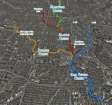
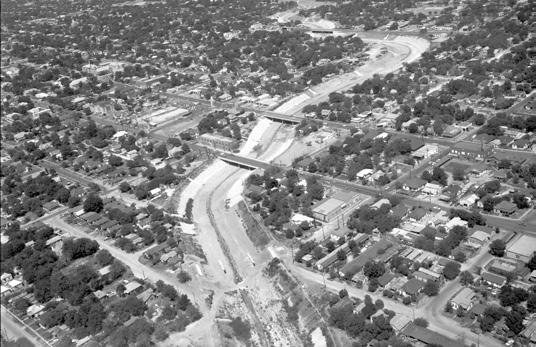
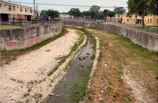
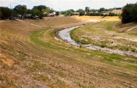
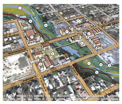
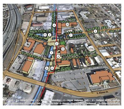
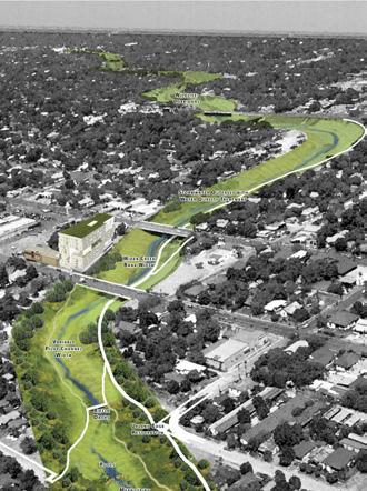
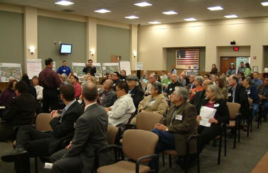
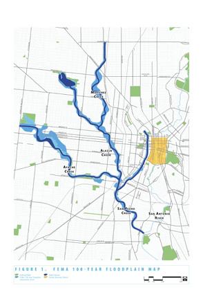
2 Project Fact Sheet Category of Entry: Rotating Specialty Award: ASLA Colorado Chapter Design Awards Program Environmental Restoration and Reclamation Project Name: Westside Creeks Restoration Plan Project Location, if applicable: San Antonio, Texas 3-5 Sentence Quick Project Summary: The Westside Creeks are heavily urbanized watersheds located predominantly west and northwest of downtown San Antonio, Texas. San Antonio s west side has been built-out for several decades, and the creeks traverse many historic and active neighborhoods. The Westside Creeks Restoration Project identified restoration regimes, flood acquisition strategies, neighborhood redevelopment and sustainability concept designs for Alazán, Apache, Martínez and San Pedro Creeks, offering design alternatives and community enhancement to these areas which were channelized by the U.S Army Corps of Engineers (USACE) during the 1960s. Purpose of Project: The Westside Creeks Restoration Project was a community-based planning effort initiated in 2008 with support from the San Antonio River Authority s Board of Directors. The project's mission was to develop concepts for restoration of the Alazán, Apache, Martínez and San Pedro Creeks, maintain or enhance the current flood control components of these creeks, improve water quality, increase biological diversity, provide increased opportunities for people to enjoy these urban creeks and suggest potential redevelopment opportunities along their margins. Through a lengthy and intensive public process, the following goals were established for the Westside Creeks Restoration Project: environmental enhancement; aquatic and riparian restoration; flood control enhancement; recreational uses for all ages; water quality enhancement; low maintenance and sustainable design; fluvial geomorphology concepts; continuous hike and bike trails; transportation connectivity; public gathering places; cultural/historical awareness; public art; economic development; and neighborhood and business connections. San Antonio s Westside Creeks run through the heart of the City s inner west side, which is rich in culture and history. During each of the public workshops and meetings, local residents recalled using these creeks (Alazán, Apache, Martínez and San Pedro) for recreation and enjoyment, and shared stories of learning to swim and fish in the creeks, as well as picking plants for cooking. History has shown these creeks have also been subject to some of the City s worst flooding. In 1921, flood waters claimed the lives of 51 people and left behind an estimated $3.7 million in property damage. Twenty-five years later in 1946, another flood claimed the lives of six people and an estimated $2.1 million in property damage. Following the 1946 flood, the San Antonio River Authority (SARA) began working with the USACE and the Natural Resource Conservation Services (NRCS) to develop strategies to address flooding within the Westside Creeks and San Antonio River, ultimately resulting in the straightening and channelization of approximately 31 miles of the San Antonio River and Westside Creeks. Recently, SARA has looked to apply more modern, environmentally sensitive and aesthetic construction methodologies to enhance the flood carrying capacity of the eight miles of San Antonio River that were channelized. This Mission Reach project will restore much of the native habitat that once thrived along the river, as well as provide recreational amenities and environmental improvements to the San Antonio River. The Westside Creeks Restoration Project builds upon the successes and lessons learned from the ongoing Mission Reach Project. As part of the next generation of restoration within the watershed, the Alazán, Apache, Martínez and San Pedro Creeks have offered opportunities for ecosystem restoration, enhanced flood control and to serve as a catalyst for revitalization of the surrounding community.
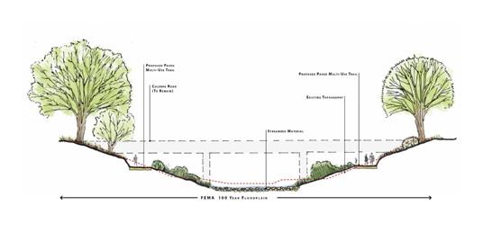
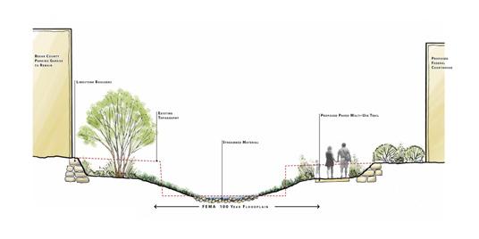
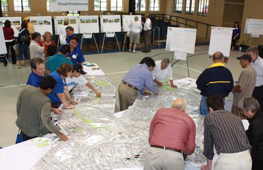
3 Construction Budget Amount: N/A Role of landscape architect / entrant vs. the role of other participants, including owner / client and collaborators. The Landscape Architect served as project manager for this intensive project. Not only did the Landscape Architect lead within a design capacity, but also led and coordinated a large team of biologists, hydrologic engineers and public involvement consultants. Special Factors: Not just Ecological Restoration. While the primary focus of this project was on the ecological restoration of the streams, mitigation of existing flood hazards and access along and across the streams, the surrounding land uses stand to benefit from these improvements through community revitalization and economic development opportunities. Considerable effort was expended by community members in the long range planning of economic opportunities that should be available as a result of this project. A number of long-term, land use-based design elements were developed to address connectivity and security. These elements were designed to increase access and usage by the public while maintaining the flood hazard reduction and ecological functions of the restored creeks. Social restoration design included the development of amenitized catalyst sites based on public workshops and stakeholder input. Significance: Plan Process. Again, because the project was not only a restoration process, but also an intensive design effort, the project was divided into Inventory + Analysis, Vision, Restoration Concepts, Catalysts Sites, Design Elements and Implementation. While the first and third phases focused on hydrology, hydraulics and restoration, the remaining phases included more focus on design and social restoration, highlighting community amenities and design elements that combine flood mitigation, stream restoration, neighborhood redevelopment and recreation enhancement and serve as catalysts for the revitalization of the community. The implementation plan identified opportunities to coordinate with other community development initiatives (flood mitigation, trails and parks, transportation, economic development), providing a more integrated concept for the future of the Westside Creeks area. Community Vision. While the Westside Creeks have attracted humans for over 10,000 years, from Native Americans to Spaniards, to a variety of European settlers, to San Antonio's current residents, the community significance of the creeks has been reduced since their channelization by the USACE in the 1960s and 70s to reduce flooding. While most restoration projects are scientifically based and limit involvement to engineers and scientists, this project included an extensive public process. This plan involved the community through three public workshops, a week-long stakeholders charrette, and continual involvement by the Westside Creeks Restoration Oversight Committee as well as by individual Creek Advisory Subcommittees. The resulting vision was founded on four core philosophies Water, Restoration, Connections and Security. The plan and its concepts are founded on the story of water and its importance to residents. Watershed hydrology, existing flood hazards and structural constraints dictate the range of feasible restoration concepts. The restoration concepts are predicated on the fluvial geomorphology, native local ecosystem, practical constraints and the desired final condition of each stream. Integrated with the restoration concepts are connections consisting of trails, crossings and wildlife corridors. Redevelopment nodes created along these connections capitalize on new and enhanced recreational amenities and on economic development opportunities that engage the water and land interface of the stream corridors. To complete the vision, the Plan emphasizes public and neighborhood security though appropriate design elements, stewardship, patrols and maintenance.
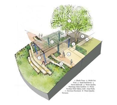
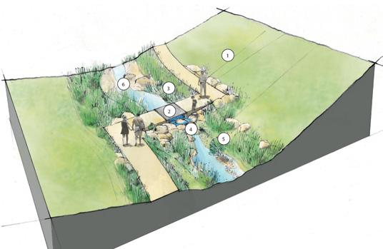
4 These philosophies and community vision materialize in physical form through the restoration plan and catalyst sites. The restoration regimes include both project-wide and creek-specific concepts for flood hazard mitigation and stream restoration. Eleven neighborhood catalyst sites within the restoration framework describe multi-purpose projects that combine many of the vision elements to serve as the seeds of community revitalization. Within each catalyst site are typical design elements, representing smaller areas where people interact with the creek and include key design features such as trails, crossings, plazas and stormwater best management practices.
5
6
2011 ASLA Design Awards. Coyote Gulch Honor Award and Land Stewardship Designation Valerian LLC. Environmental Restoration and Reclamation
 2011 ASLA Design Awards Honor Award and Land Stewardship Designation Valerian LLC Environmental Restoration and Reclamation Project Name: Category : Project Location: 5 2011 Environmental Restoration and
PUBLIC ENGAGEMENT & SIX THEMES OF THE PLAN
 Connecting the heart of Eagle to the soul of the river - Kathy Chandler-Henry, Commissioner Eagle County CHAPTER 1 PUBLIC ENGAGEMENT & SIX THEMES OF THE PLAN town of eagle - river corridor plan 1 PUBLIC
2011 ASLA Design Awards. Top of the Rockies National Scenic and Historic Byway Merit Award Bluegreen. Planning & Urban Design
 2011 ASLA Design Awards Top of the Rockies National Scenic and Historic Byway Merit Award Bluegreen Planning & Urban Design ASLA Colorado 2011 Design Awards Category 2: Planning Project Fact Sheet Project
Parks, Open Space and Trails
 Introduction Parks have often been referred as the lungs of our cities, cleansing the air of pollutants and particulate matter. Parks are also gathering places for families and community. They offer spaces
STEWARDSHIP OF LONG ISLAND SOUND S ECOLOGICAL AND RECREATIONAL RESOURCES
 STEWARDSHIP OF LONG ISLAND SOUND S ECOLOGICAL AND RECREATIONAL RESOURCES Robin Kriesberg, Save the Sound, Inc. Thomas Halavik, US Fish and Wildlife Service Coastal Program An Initiative to Identify, Protect
Arlington, Virginia is a worldclass
 EXECUTIVE S U M M A RY Arlington maintains a rich variety of stable neighborhoods, quality schools and enlightened land use policies, and received the Environmental Protection Agency s highest award for
INTRODUCING THE BALTIMORE CITY GREEN NETWORK VISION PLAN
 INTRODUCING THE BALTIMORE CITY GREEN NETWORK VISION PLAN GOALS OF THE GREEN NETWORK PLAN Protect and enhance the unique ecological resources of our city Support economic growth and sustainable redevelopment
An Ambitious Plan: Transforming the blighted South Platte River and surrounding environment into Denver s greatest natural resource.
 CONNECTING THE PEOPLE TO THEIR RIVER SOUTH PLATTE RIVER VISION IMPLEMENTATION PROGRAM: GRANT-FRONTIER PARK TO OVERLAND POND PARK REACH The South Platte River Vision Implementation Program (River Vision)
Otay Regional Trail Alignment Study. Public Workshop March 14 th, 2017 from 5:30-8 p.m.
 Public Workshop March 14 th, 2017 from 5:30-8 p.m. Purpose of the Study A multi-agency planning effort to create a coordinated and sustainable trail system that enhances recreation and provides trail connections
3. VISION AND GOALS. Vision Statement. Goals, Objectives and Policies
 Vision Statement Queen Creek s interconnected network of parks, trails, open spaces and recreation opportunities provide safe and diverse activities and programs that sustain its unique, small town, equestrian
Howard W. Peak Greenway Trails
 Howard W. Peak Greenway Trails Program Beginnings 1998 - Mayor Howard Peak and other Council members initiated and supported idea of creating linear parks along San Antonio creekways. 1999 - Program plan
Arkansas River Corridor
 Planning for Access Welcome to the Access Project. This project is a recreational planning effort in response to an interest by regional communities along the Arkansas River corridor. The project plan
The Five Components of the McLoughlin Area Plan
 The Five Components of the McLoughlin Area Plan This documents contains the complete language of the five components of the McLoughlin Area Plan: The Vision Statement The Values The Guiding Principles
Westside Creeks. Elmendorf Lake Park and Linear Creekway Trails Project
 Westside Creeks Elmendorf Lake Park and Linear Creekway Trails Project August 11, 2015 Elmendorf Lake Park Project Project Partners City of San Antonio Bexar County Our Lady of the Lake University San
Lake O the Pines Master Plan Revision Public Information Meeting April 25 & 27, 2017
 Lake O the Pines Master Plan Revision Public Information Meeting April 25 & 27, 2017 Presented By Matthew Like, Lake Manager U.S. Army Corps of Engineers Fort Worth District US Army Corps of Engineers
Public Information Meeting
 Lavon Lake Master Plan Revision Public Information Meeting March 10, 2015 Presented By Michael Kinard Lake Manager U.S. Army Corps of Engineers Fort Worth District US Army Corps of Engineers Purpose of
Joe Pool Lake Lake Master Plan Public Information Meeting Presentation of Final Draft Revision July 31, 2018
 Joe Pool Lake Lake Master Plan Public Information Meeting Presentation of Final Draft Revision July 31, 2018 Presented By Jeremy Spencer Lake Manager U.S. Army Corps of Engineers Fort Worth District US
New Partners for Smart Growth Conference February 5, 2010
 Dan Stroh, Planning Director City of Bellevue Planning and Community Development Bellevue, WA New Partners for Smart Growth Conference February 5, 2010 Summary of Project Long-range plan update for Bel-Red
U.S. Army Corps of Engineers, Los Angeles District Prado Basin Project Updates
 U.S. Army Corps of Engineers, Los Angeles District Prado Basin Project Updates Host: Inland Empire Utilities Agency January 19, 2017 10:00 a.m. Purpose: To provide project overviews and updates to regional
A larger version of this map is located on the last page of this PDF.
 MAP Committee Input McLoughlin Area Draft Vision Map A larger version of this map is located on the last page of this PDF. 1. The map above is intended to portray a vision for the McLoughlin area. It highlights
2011 ASLA Design Awards
 2011 ASLA Design Awards Interstate 70 Mountain Corridor Aesthetic Guidance Honor Award Design Workshop, Aspen / THK Associates, Inc. / CH2MHill Planning and Urban Design Project Title: Interstate70 Mountain
Template for Restoration in a Lake Superior Area of Concern. Template for Restoration in a Lake Superior Area of Concern
 Keith Bowers, Principal Ivette Bolender, Great Lake Bioregion Team Leader Presentation outline: Project background Master planning process Habitat restoration approach Lessons learned Hog Island and Newton
2011 ASLA Design Awards. Centennial Park Merit Award Design Concepts CLA, Inc. Design over $500,000 Construction Budget
 2011 ASLA Design Awards Centennial Park Merit Award Design Concepts CLA, Inc. Design over $500,000 Construction Budget 2011 ASLA Colorado Professional Design Awards Project Name: Category: Location: Const.
Canyon Lake Master Plan Revision Public Information Meeting March 18, 2016
 Canyon Lake Master Plan Revision Public Information Meeting March 18, 2016 Marcus Schimank Canyon Lake Manager Capital Regional Office U.S. Army Corps of Engineers Fort Worth District US Army Corps of
Ivywild On The Creek PRELIMINARY CREEK DISTRICT MASTER PLAN
 Ivywild On The Creek PRELIMINARY CREEK DISTRICT MASTER PLAN Introduction: Rejuvenating an extraordinary Creekside neighborhood THE CREEKSIDE DISTRICT The Ivywild On The Creek Neighborhood District Master
Improving Communities Through the Arroyo Seco Sustainability Campaign and Watershed Assessment
 Improving Communities Through the Arroyo Seco Sustainability Campaign and Watershed Assessment Arroyo Seco Headwaters in the San Gabriel Mountains Major tributary to the Los Angeles River 44 square mile
ARISE: The Rock Renaissance Area Redevelopment & Implementation Strategy
 2014 Professional Awards 1 ARISE: The Rock Renaissance Area Redevelopment & Implementation Strategy Janesville, WI Completed December 2014 Analysis & Planning Purpose of Project 2 The purpose of the Rock
A Delta Renewed: A Guide to Science Based Ecological Restoration in the Delta
 A Delta Renewed: A Guide to Science Based Ecological Restoration in the Delta J. Letitia Grenier, San Francisco Estuary Institute, letitia@sfei.org Julie Beagle, San Francisco Estuary Institute, julieb@sfei.org
Stream Corridor Management Plan
 Stream Corridor Management Plan A unified and comprehensive approach to protecting, restoring and managing the Upper Delaware River Graydon Dutcher Delaware County Soil and Water Conservation District
National Association of Conservation Districts. Kris Hoellen Vice President, Sustainable Programs The Conservation Fund September 19, 2013
 National Association of Conservation Districts Kris Hoellen Vice President, Sustainable Programs The Conservation Fund September 19, 2013 Our Mission The Conservation Fund forges partnerships to conserve
T O W N O F H I G H R I V E R
 T O W N O F H I G H R I V E R o p e n s p a c e p l a n The Town of High River, 30 minutes South of Calgary, still retains much of its distinctive small town character and provides residents with a high
ADOPTION OF THE REVISED OPEN SPACE AND CONSERVATION ELEMENT OF THE GENERAL PLAN
 TO: FROM: SUBJECT: Honorable Mayor and City Council Planning Department ADOPTION OF THE REVISED OPEN SPACE AND CONSERVATION ELEMENT OF THE GENERAL PLAN RECOMMENDATION: It is recommended that the City Council:
NORTHEAST RIVER CROSSING FUNCTIONAL PLANNING STUDY
 WELCOME Northeast River Crossing Functional Planning Study Phase 2 Public Meeting 4 to 8 PM Informal drop-in format and discussion tables Meeting Purpose Introduce the Northeast River Crossing Functional
Steering Committee 3. September 17, :30-7:30pm. Welcome.
 Steering Committee 3 September 17, 2015 5:30-7:30pm Welcome DOG RIVER www.makingwatershedswork.org Agenda 1. Welcome 2. Scientific Research: Water Quality 3. Current and Relevant Planning 4. Community
Open Space, Natural Areas, Parks, and Recreation
 Open Space, Natural Areas, Parks, and Recreation WHAT ARE THE CITY S CURRENT VALUES? This section addresses open spaces, natural areas, parks and recreation, and stormwater multi-use projects under separate
City of Missoula and Missoula County Open Space Planning Open House
 City of Missoula and Missoula County Open Space Planning Open House FEBRUARY 6, 2018 The following slides contain the display board content from the open house. Please use boards to answer questions in
San Francisco Bay Pilot: Sausal Creek Community Leader Charrette May 11, 2016 Marcus Griswold
 San Francisco Bay Pilot: Sausal Creek Community Leader Charrette May 11, 2016 Marcus Griswold 1 Overview Project Overview Watershed Context Assets and Challenges Opportunities Green Streets Creek Access
Corridor Vision. 1Pursue Minnehaha-Hiawatha Community Works Project. Mission of Hennepin County Community Works Program
 1Pursue Minnehaha-Hiawatha Community Works Project Minnehaha-Hiawatha Community Works is a project within the Hennepin Community Works (HCW) program. The mission of the HCW program is to enhance how the
Joe Pool Lake Master Plan Revision Public Information Meeting May 23, 2017
 Joe Pool Lake Master Plan Revision Public Information Meeting May 23, 2017 Presented By Jason Owen Lake Manager U.S. Army Corps of Engineers Fort Worth District US Army Corps of Engineers Purpose of this
CHAPTER 8 ISSUES, CONCERNS, CONSTRAINTS AND OPPORTUNITIES
 CHAPTER 8 ISSUES, CONCERNS, CONSTRAINTS AND OPPORTUNITIES Introduction This River Conservation Plan was developed during a time of tremendous activity and effort in planning the transformation of the Delaware
City of Iowa City Department of Neighborhood and Development Services Department of Parks and Recreation Department of Public Works City Manager s
 RFP Pre-submittal meeting December 18, 2015 City of Iowa City Department of Neighborhood and Development Services Department of Parks and Recreation Department of Public Works City Manager s Office Background
4. What are the goals of the Kawarthas, Naturally Connected project? 7. What are watersheds and why are they being used as the project boundaries?
 Frequently Asked Questions (FAQs) 1. What are Natural Heritage Systems (NHS)? 2. Why are they important? 3. Which areas of the province have undertaken NHS projects? 4. What are the goals of the Kawarthas,
G. RECREATION AND OPEN SPACE ELEMENT. The following summarizes the Recreation and Open Space Element:
 G. RECREATION AND OPEN SPACE ELEMENT The purpose of the Element is to provide the framework and direction for a comprehensive system of public and private sites for recreation, including, but not limited
Lewisville Lake Master Plan Revision Public Information Meeting May 2 & 4, 2017
 Lewisville Lake Master Plan Revision Public Information Meeting May 2 & 4, 2017 Presented By Rob Jordan Lake Manager U.S. Army Corps of Engineers Fort Worth District US Army Corps of Engineers Purpose
Member Service Plan Sierra Nevada AmeriCorps Partnership
 Member Service Plan Sierra Nevada AmeriCorps Partnership Service plans lay the framework for what each Member will be doing during their service. Service plans detail the major projects and expected results
Working together to leverage limited Funds
 Working together to leverage limited Funds ARAPAHOE COUNTY OPEN SPACES 10 County Budget Conference September 20, 2013 The Power of Partnerships 2013 SORP Conference 5/23/2014 Why Talk About Open Space?
Committee Meeting: Downtown Today & Concept Refinement September 11, 2017
 Committee Meeting: Downtown Today & Concept Refinement September 11, 2017 AGENDA 1. Brief Input Update 2. Comprehensive Plan Principles 3. Downtown Today 4. Concept Updates 5. Future Schedule What is a
WARM SPRINGS PARK MASTER PLAN
 TABLE OF CONTENTS page 1.0 Introduction and Overview 1 2.0 Information Gathering 2 3.0 Conceptual Alternative Development 8 4.0 Master Plan Development 14 5.0 Construction Cost Estimates 19 LIST OF FIGURES
Mendota Heights 2040 Comprehensive Plan Draft Vers
 4 Parks and Trails The City of Mendota Heights boasts a variety of recreational and open space opportunities. Few cities can claim access to regional trails, riverside and lakeside parks, scenic bluffs
West Broadway Transit Study Initial Screening of Alternatives Memo
 West Broadway Transit Study Initial Screening of Alternatives Memo 5/22/2015 Prepared by the SRF Consulting Group Team for Table of Contents Purpose... 1 Methodology... 1 Screening... 5 Screening Criteria...
CHAPTER 1. Ms. Guajardo s Class - Central Elementary CH 1 1
 INTRODUCTION CHAPTER 1 Ms. Guajardo s Class - Central Elementary CH 1 1 1.1 SETTING South Centre City is a linear corridor south of Downtown Escondido paralleling Centre City Parkway and South Escondido
Bristol Marsh Heritage Conservancy
 Bristol Marsh Heritage Conservancy The Pennsylvania Environmental Council (PEC) protects and restores the natural and built environments through innovation, collaboration, education and advocacy. PEC believes
Shared History, Shared Future
 Open Space is Shared History, Shared Future Builds upon past and current regional planning: PSP Action Agenda, Vision 2040, the Cascade Agenda, and Mountains to Sound Greenway The ROSS Approach Building
Introduction. Integrating Ecological Restoration of Estuarine Shorelines with Urban Community Revitalization Efforts. Ed Morgereth Biohabitats, Inc.
 Introduction Integrating Ecological Restoration of Estuarine Shorelines with Urban Community Revitalization Efforts Ed Morgereth Biohabitats, Inc. 5 th National Conference & Expo on Coastal and Estuarine
Toronto Parks Renaissance Strategy
 Toronto Parks Renaissance Strategy Overview, Emerging Themes and Directions Presentation to EDPC, May 4, 2006 Parks Renaissance Strategy Presentation Agenda Project Overview Emerging Themes and Directions
Presentation to Parks and Open Space Advisory. Committee September 22, 2016
 Flood Planning & Preliminary Design Services for South St. Vrain Creek Restoration at Hall Ranch Presentation to Parks and Open Space Advisory Prepared for: Boulder County, Colorado Committee September
Middle Mississippi River. Regional Corridor
 Middle Mississippi River St. Louis District Regional Corridor Lessons Learned from a Collaborative Planning Study Brian Johnson US Army Corps of Engineers 12 th Biennial Governor s Conference on the Management
San Diego River Coalition 2012 Work Plan
 San Diego River Coalition 2012 Work Plan Adopted November 18, 2011 The mission of the San Diego River Coalition is preserve and enhance the San Diego River, its watershed, and its natural, cultural and
edmonton.ca/ribbonofgreen #ribbonofgreen
 WHAT IS THE RIBBON OF GREEN? The Ribbon of Green is Edmonton s entire river valley and ravine system. The Ribbon of Green (2018) Project will provide strategic guidance for the southwest and northeast
SAN RAFAEL GENERAL PLAN 2040 INTRODUCTION AND OVERVIEW
 SAN RAFAEL GENERAL PLAN 2040 INTRODUCTION AND OVERVIEW Steering Committee Presentation February 14, 2018 Purpose of General Plan Guide land use and development decisions Coordinate transportation, infrastructure,
April 11, 2016 Park Board Chair and Commissioners General Manager Vancouver Board of Parks and Recreation New Brighton Salt Marsh - Preferred Concept
 TO: FROM: SUBJECT: April 11, 2016 Park Board Chair and Commissioners General Manager Vancouver Board of Parks and Recreation New Brighton Salt Marsh - Preferred Concept RECOMMENDATION A. THAT the Vancouver
Rapid Transit Implementation Working Group
 Rapid Transit Implementation Working Group October 12, 2017 1 Agenda 1. Consultation Update 2. Technical Work Update 3. LTC Rapid Transit Integration 4. Next Steps 2 Consultation Update 3 Consultation
Knowing Home. Apache Creek - A sustainable process for community revitalization. A Place Centered Exploration
 Project Bridge Cultural Arts and Humanities Services 1205 Loma Vista San Antonio, Texas 78207 (210) 436-7113 P Knowing Home Apache Creek - A sustainable process for community revitalization. A ancient
The bottom urban structure and guidelines City Council Briefing
 The bottom urban structure and guidelines City Council Briefing 4.1.2015 1 Provide information on the studio s community planning and design efforts for The Bottom Review process to date Review plan recommendations
A Vision for Walnut Creek
 A Vision for Walnut Creek Photo: City of Clive Walnut Creek Booklet 8 of 8 Greater Des Moines Water Trails and Greenways 1 Table of Contents Booklet 1: Water Trails Strategies and Policies Booklet 2: Beaver
Introduction to the Shoreline Master Program (SMP) Update. City of Bellingham Planning Department 2005
 Update. City of Bellingham Planning Department 2005") Introduction to the Shoreline Master Program (SMP) Update City of Bellingham Planning Department 2005 Purpose of tonight s meeting: Specify which water-bodies are subject to the SMP. Identify the State
Introduction to the Shoreline Master Program (SMP) Update City of Bellingham Planning Department 2005 Purpose of tonight s meeting: Specify which water-bodies are subject to the SMP. Identify the State
COASTAL CONSERVANCY. Staff Recommendation March 25, 2004 LOS ANGELES GREEN VISION PLAN. File No.: Project Manager: Marc Beyeler
 COASTAL CONSERVANCY Staff Recommendation March 25, 2004 File No.: 04-014 Project Manager: Marc Beyeler RECOMMENDED ACTION: Authorization to disburse up to $50,000 to the University of Southern California
California State Parks
 California State Parks State Parks and Natural Resources 94% of land base is un-developed 31% of the state s endangered, threatened or rare species 19 units with national or international recognition
Smart Growth for Dallas
 Smart Growth for Dallas Data-driven decisions for the future of Dallas parks, open spaces, and green infrastructure Dallas Park and Recreation Board March 10, 2016 Agenda I. Welcome and Introductions II.
SUSTAINABILITY PLAN OTTAWA COUNTY PARKS AND RECREATION COMMISSION FALL 2017
 SUSTAINABILITY PLAN OTTAWA COUNTY PARKS AND RECREATION COMMISSION FALL 2017 Table of Contents Introduction Natural Resources Quality of Life Community Continuing the Mission Sustainability Measuring Sustainability
Dolores River Restoration Partnership. A Collaborative Approach to River Restoration and the Development of a New Generation of Land Stewards
 Dolores River Restoration Partnership Dolores Public Lands A Collaborative Approach to River Restoration and the Development of a New Generation of Land Stewards Project Area From McPhee Reservoir to the
Albion Hills Conservation Area Master Plan: Project Summary
 Albion Hills Conservation Area Master Plan- Project Summary December 9, 2014 Albion Hills Conservation Area Master Plan- Project Summary December 9, 2014 Albion Hills Conservation Area Master Plan: Project
RIVER RECREATION AND CONSERVATION: LESSONS FROM COLORADO S 2013 FLOODS
 RIVER RECREATION AND CONSERVATION: LESSONS FROM COLORADO S 2013 FLOODS SORP RMIS May 2016 L O G A N S I M P S O N Agenda Why Are You Here? Land Use Resiliency Public Outreach Dialogue Recreation and Land
The transportation system in a community is an
 7 TRANSPORTATION The transportation system in a community is an important factor contributing to the quality of life of the residents. Without a sound transportation system to bring both goods and patrons
Regional Open Space Conservation Plan. Regional Staff Committee January 18, 2018
 Regional Open Space Conservation Plan Regional Staff Committee January 18, 2018 Schedule We are here Task 1 - Stakeholder Input & Work Plan Dev. v z 2016 2017 2018 Oct Nov Dec Jan Feb Mar Apr May Jun Jul
Planning for Staten. Habitat Restoration and Green Infrastructure. Island s North Shore
 Habitat Restoration and Green Infrastructure Planning for Staten Island s North Shore Community Board 1 March 1, 2018 NYC Parks Forestry, Horticulture, and Natural Resources Funded by the NYS Department
Call for Artists for: Design and Construction of Environmental Art Activation Story Mill Community Park, Bozeman, MT
 Call for Artists for: Design and Construction of Environmental Art Activation Story Mill Community Park, Bozeman, MT Seeking artists to design, fabricate and install art elements in the nature sanctuary
Wetland Design Manual. A1: Vision, core outcomes and aspirational outcomes
 Wetland Design Manual A1: Vision, core outcomes and aspirational outcomes Table of contents Introduction 5 Vision 6 Core outcomes 7 Effective pollutant removal and flow management... 7 Community safety...
This page intentionally blank.
 This page intentionally blank. Parks, Recreation, and Open Space Chapter Relationship to Vision Vision Parks, Recreation and Open Space Chapter Concepts County Government. County government that is accountable
The Benefits and Challenges Associated with Green Infrastructure Practices
 The Benefits and Challenges Associated with Green Infrastructure Practices Thomas M. Evans ASLA, LEED AP Regional Green Infrastructure Design Services Director OWEA Technical Conference, June 20, 2013
SUN-B11-From Gray to Green; Revitalizing Milwaukee s Industrial Heart
 Session Title: Description: Learning Objectives: SUN-B11-From Gray to Green; Revitalizing Milwaukee s Industrial Heart Over the past 15 years the City of Milwaukee transformed the Menomonee Valley, Milwaukee's
GUIDELINES FOR ECOLOGICAL PERFORMANCE
 3 Landscape........................................... 3.2 Stormwater Management................................... 3.3 Hardscape........................................... 3.4 Streetscape..........................................
Photo by Carlton Ward Jr. Executive Summary
 Photo by Carlton Ward Jr. Executive Summary The Cooperative Conservation Blueprint (Blueprint) is a multi-partner strategic conservation process developed by the Florida Fish and Wildlife Commission (FWC)
The John Bartram Association Action Plan to advance the 10 year Strategic Plan
 The John Bartram Association 2013-2015 Action Plan to advance the 10 year Strategic Plan We are poised to take significant leaps with the opportunities that surround us. In the next three years we are
I-1 COMMENCEMENT. History
 COMMENCEMENT Nature connects us to each other. All of creation has developed from natural processes, and thus by instinct, we are drawn back into them. Whether it be a forest, prairie, beach or community
PARKS AND RECREATION
 PARKS AND RECREATION WHAT YOU WILL FIND IN THIS CHAPTER: Background information on the development of the Park, Recreation, and System Plan (PRSP). General overview of Ellensburg s parks and recreation
RECONNECTING A COMMUNITY TO THE CREEK
 RECONNECTING A COMMUNITY TO THE CREEK 0 The J.J. Seabrook Stream Restoration, Rain Garden, and Urban Trail Project Kristin K. Pipkin, P.E. Michelle Adlong, EI.T. TXSER/TRA Joint Conference November 2,
Vaughan Metropolitan Centre (VMC) Black Creek Renewal CLASS ENVIRONMENTAL ASSESSMENT
 Black Creek Renewal CLASS ENVIRONMENTAL ASSESSMENT") PUBLIC INFORMATION CENTRE Vaughan Metropolitan Centre (VMC) Black Creek Renewal Wednesday, May 10, 2017 6:00 p.m. to 8:00 p.m. Add photo Project Management, Environmental Assessment, Stormwater Management
PUBLIC INFORMATION CENTRE Vaughan Metropolitan Centre (VMC) Black Creek Renewal Wednesday, May 10, 2017 6:00 p.m. to 8:00 p.m. Add photo Project Management, Environmental Assessment, Stormwater Management
Research Projects on Governors Island
 Research Projects on Governors Island The Opportunity With over 130 acres of open space including a new park designed to adapt to a changing climate, Governors Island offers an unparalleled platform for
Potential Green Infrastructure Strategies May 6, 2015 Workshop
 Potential Green Infrastructure Strategies May 6, 2015 Workshop Background The City of Cortland is developing the Tioughnioga Urban Headwaters Green Infrastructure Action Plan with funding from the National
Bourne Downtown Site Planning
 Prepared for: The Town of Bourne, MA In Cooperation with: Bourne Financial Development Corporation Prepared by:, Inc. June 24, 2009 Table of Contents Introduction and Summary... 1 Site Existing Conditions...
Executive Summary Purpose of the Plan Defining Open Space and Greenways
 Executive Summary Bucks County possesses a vast array of open space resources including natural areas, parks, farmland and historic and cultural resources that contribute to a high quality of life valued
ADOPTED CAPITAL IMPROVEMENT PROGRAM BUDGET ARROYO PROJECTS
 ADOPTED CAPITAL IMPROVEMENT PROGRAM BUDGET ARROYO PROJECTS HAHAMONGNA FY 212-216 Capital Improvement Program Priority Description Total Estimated Costs Appropriated Through FY 211 Adopted FY 212 FY 213
Ship Creek Redevelopment
 Ship Creek Redevelopment Three Concepts May 2013 Cambridge ARCHITECTURE Philadelphia ENGINEERING Raleigh INTERIORS San Francisco PLANNING Washington, DC www.klingstubbins.com contact@klingstubbins.com
Chapter 3 Community Involvement
 Chapter 3 Community Involvement Public involvement has been a vital component of the planning process in the preparation of this master planning document. The purpose of this citizen-led effort was to
CITY OF GAINESVILLE PARKS, RECREATION AND CULTURAL AFFAIRS DEPARTMENT VISION 2020
 CITY OF GAINESVILLE PARKS, RECREATION AND CULTURAL AFFAIRS DEPARTMENT VISION 2020 A BLUE PRINT FOR THE NEXT 20 YEARS The PRCA Vision 2020 Master Plan, adopted in November 2012, addresses the current state
Phase 1 : Understanding the Campus Context. Phase 2 : APPROACHES - Alternates & Preferred Plan
 Introduction MASTER PLAN PURPOSE WHY A CAMPUS MASTER PLAN? The purpose of the Master Plan at the University of Illinois at Chicago is to translate UIC s strategic goals and objectives into a compelling
Concord Community Reuse Project Goals and Guiding Principles. Overarching Goals (OG)
") Concord Community Reuse Project Goals and Guiding Principles Overarching Goals (OG) No priority is implied by the order of presentation of the goals and guiding principles. Overarching goals for the Concord
Concord Community Reuse Project Goals and Guiding Principles Overarching Goals (OG) No priority is implied by the order of presentation of the goals and guiding principles. Overarching goals for the Concord
Authority of the General Plan
 Authority of the General Plan This La Habra Heights General Plan will serve as the blueprint for future planning and development in the City. This General Plan describes the City s vision for the future
PROGRAMMING & PUBLIC INVOLVEMENT
 PROGRAMMING & PUBLIC INVOLVEMENT G O A L S & O B J E C T I V E S vision statement Promoting community by establishing an exemplary Greenway along Little Sugar Creek connecting people and neighborhoods