Public Information Meeting
|
|
|
- Juliet Turner
- 5 years ago
- Views:
Transcription


1 Lavon Lake Master Plan Revision Public Information Meeting March 10, 2015 Presented By Michael Kinard Lake Manager U.S. Army Corps of Engineers Fort Worth District US Army Corps of Engineers


2 Purpose of this Meeting Fully describe the purpose and intent of a Master Plan Describe the revision process Answer questions you may have Ask for your participation Explain why the Lavon Lake Master Plan is in need of revision and how it may affect nearby communities and the public at large Lavon Lake Dedication
3 National Environmental Policy Act of 1969 Applies to all Federal Actions, including Master Plan Revisions Requires Federal agencies to CONSIDER and DOCUMENT the environmental impacts of their proposed actions as part of an agency s OVERALL planning and decision-making Requires Federal agencies to cooperate with Federal, state and local governments, and other concerned public and private organizations and citizens during project planning Scoping is where the agency asks for initial iti input from the public (agencies, governments, citizens, non-profits) with information about the project area, resources, etc


4 Purpose and Intent of Master Plans The Corps defines a Master Plan as The strategic land use management document that guides the comprehensive management and development of all project recreational, natural and cultural resources throughout the life of the water resource development project. Source: Chapter 3 of EP available at
5 Key Points Regarding Master Plans Main focus is stewardship of natural and cultural resources and provision of high quality outdoor recreation facilities and opportunities Proposed effective life of a Master Plan is 25 years Recreational use of the water surface is addressed Master Plans do not address in detail the technical aspects of water management for flood risk management or water supply
6 Additional Key Points Key sections of the Master Plan Revision include resource management objectives, revised land use classifications and a conceptual management plan for each land classification Potential outcomes could be designation of lands for resort development, new marinas, and utility corridors Stakeholder and public input is critical Protection of environmentally sensitive areas is given priority it
7 What Will Not be Addressed By regulation, privately owned boat docks are not allowed at Lavon Lake and will not be addressed in the Master Plan National policy places strict t limitations it ti on the proposed construction of new public roads on Corps lands. With few exceptions road proposals that would cross Federal land will not be addressed


8 What About the Drought? Master Plans cannot change how water in the lake is managed Natural resources and recreation management must be implemented within the constraints of the primary missions of flood risk management and water conservation FM 3286 Bridge, Summer 2014
9 Why Revise the Lavon Lake Master Plan? Current Master Plan is dated May 13, 1972 has exceeded its useful life Collin County and adjacent Rockwall and Denton Counties each experienced more than 50% population growth during the census period Residential development around Lavon Lake is expanding rapidly, especially on the west side The Master Plan must be revised to address current and future growth in the region
10 The Corps Vision for Lavon Lake The land, water surface and recreational resources of Lavon Lake will be managed to protect, conserve, and sustain natural and cultural l resources, especially environmentally sensitive resources, and provide outdoor recreation opportunities that complement overall project purposes for the benefit of present and future generations.


11 Lavon Lake Missions Flood Risk Management Water Conservation Environmental Stewardship Public Outdoor Recreation
12 Fast Facts about Lavon Lake The original Lavon Dam and Lake was completed in 1954 The Lavon Lake enlargement was completed in 1975 almost doubling the size of the lake At conservation (normal) pool elevation the lake covers 21,357 acres At the 100-year flood pool elevation the lake covers 32,700 acres The federal property boundary line is 155 miles long
13 More Fast Facts Lavon Lake is the primary source of water for the North Texas Municipal Water District which supplies water to 1.6 million people The federal lands and water surface of Lavon Lake represent the largest, and perhaps most important, outdoor recreation venue in Collin County and the northeastern counties comprising NCTCOG 16,158 acres of land above conservation pool 849 acres of flowage easement
14 Master Plan Revision Process Accomplished by a team of Corps employees with input from other agencies Public and stakeholder input will be carefully considered An Environmental Assessment of the Master Plan will be prepared and appended to the plan
15 The Master Planning Process Data Collection Agency/Public Scoping 10 Mar 2015 Resource Analysis Development of Land Classifications and Resource Objectives Agency/Public Review Finalize Master Plan Based on Comments Received Adoption of Master Plan Revision Where we are today
16 What Major Changes Are Needed in the Current Master Plan? Reclassify all project lands and water surface Some currently designated parks may be reclassified as wildlife or low intensity recreation lands New or expanded high density recreation areas could be designated Anticipate significant lands being classified as environmentally sensitive areas Decide where, if any, new marinas or resort may be located Designate utility corridors
17 Additional Major Changes Prepare new Resource Objectives Need current recreation objectives that reflect major trends identified by TPWD and through public input Need current natural resource objectives that reflect major habitat and open space needs identified by TPWD, NCTCOG, and public input
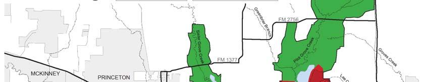
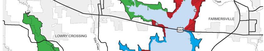
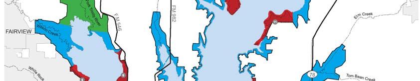
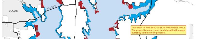
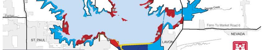
18 Lavon Lake Land Classification Now and Proposed Current Land Classifications Project Operations Proposed New Land Classifications Project Operations Recreation Lands Operations Recreation Intensive Use Operations Recreation Low Density Use Operations Wildlife Operations Natural Area High Density Recreation Environmentally Sensitive Areas Multiple Resource Management Low Density Recreation Wildlife Management Vegetation Management Future/ Inactive Recreation Areas Water Surface

19 BUILDING STRONG
20 Land Classification Project Operations High Density Recreation Multiple l Resource Management Environmentally Sensitive Areas Easement Lands Definition Those lands required for the dam, operations center, office, maintenance compound and other areas that t are used solely l for project operations Land developed for intensive recreational activities by the visiting public, including developed recreation areas and areas for marinas and related concessions, and resorts Recreation Low Density: Activities such as hiking, primitive camping, wildlife observation, and hunting Wildlife Management General: Fish and wildlife management activities Vegetative Management: Management activities for the protection and development of a specific vegetative cover Inactive and/or Future Recreation Areas: Recreation areas planned for the future or that have been temporarily closed Areas where scientific, ecological, cultural or aesthetic features have been identified. These areas must be considered by management to ensure they are not adversely impacted All land for which USACE holds an easement interest but not fee title. Planned use and management of easement lands will be in strict accordance with the terms and conditions of the easement estate acquired for the project Definitions from USACE Engineer Pamphlet : Recreation Operations and Maintenance Guidance and Procedures
21 Water Surface Classification Restricted t Designated No Wake Fish and Wildlife Sanctuary Open Recreation Definition Water areas restricted for project operations, safety, and security purposes To protect environmentally sensitive shoreline areas, recreational water access areas fromdisturbance, and for public safety Annual or seasonal restrictions on areas to protect fish andwildlife species during periods ofmigration, resting, feeding, nesting, and/or spawning Those waters available for year round or seasonal water based recreational use Definitions from USACE Engineer Pamphlet : Recreation Operations and Maintenance Guidance and Procedures


22 Land Classifications Project Operations - This category includes those lands required for the dam, spillway, switchyard, levees, dikes, offices, maintenance facilities, and other areas that are used solely for the operation of the project


23 Land Classifications High Density Recreation - Lands developed for intensive recreational activities iti for the visiting iti public including day use areas and/or campgrounds. These could include areas for concessions (marinas, comprehensive resorts, etc)


24 Land Classifications Environmentally Sensitive Areas - Areas where scientific, ecological, l cultural l or aesthetic ti features have been identified. d Designation of these lands is not limited to just lands that are otherwise protected by laws such as the Endangered Species Act, the National Historic Preservation Act or applicable State statutes. These areas must be considered by management to ensure they are not adversely impacted Examples may include mature bottomland forests, river and stream corridors, scenic bluffs, and native prairie.


25 Land Classifications Low Density Recreation - Lands with minimal development or infrastructure t that t support passive public recreational use (e.g. primitive camping, fishing, hunting, trails, wildlife viewing, etc.)


26 Land Classifications Wildlife Management - Lands designated for stewardship of fish and wildlife resources


27 Land Classifications Vegetative Management - Lands designated for stewardship of forest, prairie, i and other native vegetative ti cover


28 Water Classifications Water Surface- Restricted Water Surface-Designated No Wake Water Surface-Fish and Wildlife Sanctuary Water Surface- Open Recreation


29 Utility Corridors Linear strips of Federal land used for consolidation of multiple utility lines Establish only where no viable alternative to crossing Federal land exists Main purpose is to reduce negative environmental Impacts Generally follow existing roads or utility lines
30 Examples of Resource Objectives Recreation Objective: Expand existing trails and create new trails for a variety of users Extend key boat ramps to accommodate low lake levels Natural Resource Objective: Restore degraded prairie sites to support a diversity of native grasses and forbs Implement a zebra mussel control program General Objective: Reduce encroachments and trespass through improved boundary marking and surveillance

 Send us an e-mail at: (lavonlakemp@usace.")

31 How Can I Participate? Attend Meetings Visit our website at: ( Send us an at: (lavonlakemp@usace.army.mil) Visit with our lake staff Tell your friends Fill out a comment card now or take it home and send later Lavon Lake Dedication Ceremony 1954
32 Master Plan Next Steps Typical lake master plan update will take 12 to 18 months to finalize. Lavon Lake Master Plan update is in the initial stage of development. 30 day public comment - 10 Mar 10 Apr Draft MP document months Draft MP / EA public meeting Final document months


33 The End Please use our remaining time to visit with staff members, ask questions and help us produce an excellent Master Plan
Canyon Lake Master Plan Revision Public Information Meeting March 18, 2016
 Canyon Lake Master Plan Revision Public Information Meeting March 18, 2016 Marcus Schimank Canyon Lake Manager Capital Regional Office U.S. Army Corps of Engineers Fort Worth District US Army Corps of
Lewisville Lake Master Plan Revision Public Information Meeting May 2 & 4, 2017
 Lewisville Lake Master Plan Revision Public Information Meeting May 2 & 4, 2017 Presented By Rob Jordan Lake Manager U.S. Army Corps of Engineers Fort Worth District US Army Corps of Engineers Purpose
Joe Pool Lake Master Plan Revision Public Information Meeting May 23, 2017
 Joe Pool Lake Master Plan Revision Public Information Meeting May 23, 2017 Presented By Jason Owen Lake Manager U.S. Army Corps of Engineers Fort Worth District US Army Corps of Engineers Purpose of this
Lake O the Pines Master Plan Revision Public Information Meeting April 25 & 27, 2017
 Lake O the Pines Master Plan Revision Public Information Meeting April 25 & 27, 2017 Presented By Matthew Like, Lake Manager U.S. Army Corps of Engineers Fort Worth District US Army Corps of Engineers
Joe Pool Lake Lake Master Plan Public Information Meeting Presentation of Final Draft Revision July 31, 2018
 Joe Pool Lake Lake Master Plan Public Information Meeting Presentation of Final Draft Revision July 31, 2018 Presented By Jeremy Spencer Lake Manager U.S. Army Corps of Engineers Fort Worth District US
EAU GALLE PROJECT MASTER PLAN APPENDIX C PUBLIC INVOLVEMENT
 EAU GALLE PROJECT MASTER PLAN APPENDIX C PUBLIC INVOLVEMENT SPRING VALLEY, WISCONSIN April 2019 1 Introduction EAU GALLE PROJECT MASTER PLAN APPENDIX C PUBLIC INVOLVEMENT The master planning process recognizes
U.S. Army Corps of Engineers, Los Angeles District Prado Basin Project Updates
 U.S. Army Corps of Engineers, Los Angeles District Prado Basin Project Updates Host: Inland Empire Utilities Agency January 19, 2017 10:00 a.m. Purpose: To provide project overviews and updates to regional
Raystown Lake Master Plan Revision. Public Meeting April 25 & 26, 2018 How does the revision process work?
 Raystown Lake Master Plan Revision Public Meeting April 25 & 26, 2018 How does the revision process work? What is a Master Plan? The Master Plan is the strategic land use management document that guides
Pine Flat Lake Master Plan Update FACT SHEET September 2014
 Pine Flat Lake Master Plan Update FACT SHEET September 2014 PURPOSE AND OBJECTIVE The U.S. Army Corps of Engineers Sacramento District is revising the 1976 Pine Flat Lake Master Plan and is seeking public
City of Missoula and Missoula County Open Space Planning Open House
 City of Missoula and Missoula County Open Space Planning Open House FEBRUARY 6, 2018 The following slides contain the display board content from the open house. Please use boards to answer questions in
Parks and Open Space Preservation and Dedication. January 26, 2016 Fort Worth City Council Pre-Council Meeting Randle Harwood and Richard Zavala
 Parks and Open Space Preservation and Dedication January 26, 2016 Fort Worth City Council Pre-Council Meeting Randle Harwood and Richard Zavala Purpose How does the City of Fort Worth preserve and protect
2011 ASLA Design Awards. Westside Creeks Restoration Plan Merit Award AECOM, Fort Collins. Planning & Urban Design
 2011 ASLA Design Awards Westside Creeks Restoration Plan Merit Award AECOM, Fort Collins Planning & Urban Design Project Fact Sheet Category of Entry: Rotating Specialty Award: 2011 2011 ASLA Colorado
Lake Arlington Master Plan. Presented by Randle Harwood, Planning and Development Director October 27, 2015
 Lake Arlington Master Plan Presented by Randle Harwood, Planning and Development Director October 27, 2015 1 Land Use Strategy 4 Land Use Strategy Typical Residential Development New residential development
Summary of Changes in the DRAFT Rivers Project Natural Resource Master Plan from the 2001 approved plan to 2014 plan
 Summary of Changes in the DRAFT Rivers Project Natural Resource Master Plan from the 2001 approved plan to 2014 plan The entire Master Plan format and layout has been changed to comply with regulation
CLACKAMAS COUNTY ZONING AND DEVELOPMENT ORDINANCE
 704 RIVER AND STREAM CONSERVATION AREA (RSCA) 704.01 PURPOSE Section 704 is adopted to: A. Maintain the integrity of the rivers and streams in the County by minimizing erosion, promoting bank stability,
PARTF Scoring System for Grants
 PARTF Scoring System for Grants The members of the N.C. Parks and Recreation Authority use the PARTF scoring system as one of several tools to select grant recipients. Please provide all of the information
MASTER PLAN TRAINING MODULE 1: INTRODUCTION
 MASTER PLAN TRAINING MODULE 1: INTRODUCTION 237 237 237 217 217 217 200 200 200 80 119 27 252 174.59 255 255 255 0 0 0 163 163 163 131 132 122 239 65 53 110 135 120 112 92 56 62 102 130 102 56 48 130 120
Welcome. to the Bull Shoals Lake Master Plan Revision Open House
 Welcome to the Bull Shoals Lake Master Plan Revision Open House At the open house you can: Learn about the project Provide comments on the Draft Master Plan and Draft Environmental Assessment (EA) Watch
PARKS AND RECREATION
 PARKS AND RECREATION WHAT YOU WILL FIND IN THIS CHAPTER: Background information on the development of the Park, Recreation, and System Plan (PRSP). General overview of Ellensburg s parks and recreation
STEWARDSHIP OF LONG ISLAND SOUND S ECOLOGICAL AND RECREATIONAL RESOURCES
 STEWARDSHIP OF LONG ISLAND SOUND S ECOLOGICAL AND RECREATIONAL RESOURCES Robin Kriesberg, Save the Sound, Inc. Thomas Halavik, US Fish and Wildlife Service Coastal Program An Initiative to Identify, Protect
1. Parks & Recreation Neighborhood Parks Community Parks Special Use Sites 2. Open Space 3. Trails
 Appendix A: Park Classifications The intent of parks and recreation classifications is to aid in making acquisition and design decisions for park sites, facilities and the organization of recreation space
Chapter 5: Natural Resources and Environment
 NATURAL RESOURCES AND ENVIRONMENT 5-1 5 Chapter 5: Natural Resources and Environment BACKGROUND AND INTENT Urban expansion represents the greatest risk for the future degradation of existing natural areas,
G. RECREATION AND OPEN SPACE ELEMENT. The following summarizes the Recreation and Open Space Element:
 G. RECREATION AND OPEN SPACE ELEMENT The purpose of the Element is to provide the framework and direction for a comprehensive system of public and private sites for recreation, including, but not limited
Department of Community Development. Planning and Environmental Review Division Revised Notice of Preparation
 Department of Community Development Michael J. Penrose, Acting Director Divisions Building Permits & Inspection Code Enforcement County Engineering Economic Development & Marketing Planning & Environmental
DRAFT MAP AMENDMENT FLU 04-4
 DRAFT MAP AMENDMENT FLU 04-4 SW 24 TH AVENUE ROADWAY CORRIDOR The University of Florida participates with the Metropolitan Transportation Planning Organization (MTPO) in its responsibilities for the continuing,
2.4 FUTURE LAND USE ELEMENT Goals, Objectives and Policies
 GOAL 1: To create developmental patterns that direct future growth to appropriate areas on campus, in a manner that promotes the educational mission of the University, the protection of environmentally
This page intentionally blank.
 This page intentionally blank. Parks, Recreation, and Open Space Chapter Relationship to Vision Vision Parks, Recreation and Open Space Chapter Concepts County Government. County government that is accountable
RECREATION AND OPEN SPACE ELEMENT GOALS, OBJECTIVES, AND POLICIES
 RECREATION AND OPEN SPACE ELEMENT GOALS, OBJECTIVES, AND POLICIES Goal 7 To provide park facilities, recreation programs, and open space resources that are safe, adequate, and accessible to all City residents,
Mendota Heights 2040 Comprehensive Plan Draft Vers
 4 Parks and Trails The City of Mendota Heights boasts a variety of recreational and open space opportunities. Few cities can claim access to regional trails, riverside and lakeside parks, scenic bluffs
Please read the entire document
 projects impacting the waterfront revitalization area. The waterfront revitalization area of the town will have to subareas to the west and east of the village. Page 6 of 6 Wayfinding master plan create
Chapter PROJECT AUTHORIZATIONS
 Chapter 1 1.1. PROJECT AUTHORIZATIONS The Mississippi River Nine-Foot Channel Navigation Project was originally authorized by the River and Harbor Act of 1930 (Seventy-First Congress, Session 2, Chapter
Arkansas River Corridor
 Planning for Access Welcome to the Access Project. This project is a recreational planning effort in response to an interest by regional communities along the Arkansas River corridor. The project plan
Provide and maintain sufficient public parks, recreation facilities, and open space to meet the recreational needs of County residents and visitors.
 (ROS) Goal Provide and maintain sufficient public parks, recreation facilities, and open space to meet the recreational needs of County residents and visitors. OBJECTIVE ROS.01 The County shall acquire,
Town of Lyons Parks Flood Recovery Planning Process. Photograph courtesy of Ed Bruder
 Town of Lyons Parks Flood Recovery Planning Process Photograph courtesy of Ed Bruder Lyons Parks and Recreation Flood Recovery Update 1. Meadow Park Phase II - Project PW20B1 Estimated Completion: Summer
RECREATION, OPEN SPACE AND GREENWAYS ELEMENT GOALS, OBJECTIVES, AND POLICIES
 RECREATION, OPEN SPACE AND GREENWAYS ELEMENT GOALS, OBJECTIVES, AND POLICIES GOAL R-1: DEVELOP A RECREATION, OPEN SPACE AND GREENWAYS SYSTEM AS AN INTEGRAL COMPONENT OF AN OVERALL, COUNTY-WIDE ECONOMIC
DISCUSSION TOPIC: ST JOHNS RIVER & ITS TRIBUTARIES (BPII) 2030 COMPREHENSIVE PLAN POLICES AND REGULATORY FRAMEWORK
 2030 COMPREHENSIVE PLAN POLICES AND REGULATORY FRAMEWORK") DISCUSSION TOPIC: ST JOHNS RIVER & ITS TRIBUTARIES (BPII) 2030 COMPREHENSIVE PLAN POLICES AND REGULATORY FRAMEWORK St. John s River & Its Tributaries Issue Summary: The St. Johns River is an important
DISCUSSION TOPIC: ST JOHNS RIVER & ITS TRIBUTARIES (BPII) 2030 COMPREHENSIVE PLAN POLICES AND REGULATORY FRAMEWORK St. John s River & Its Tributaries Issue Summary: The St. Johns River is an important
Staff will be providing an overview of the project need, purpose and intent for consideration as part of the Amendment cycle.
 Agenda Item D-2 City of Tacoma Planning and Development Services To: Planning Commission From: Stephen Atkinson, Planning Services Division Subject: Open Space Corridors Project Meeting Date: March 1,
Community Conservation Workshop. Lake Placid
 Community Conservation Workshop Lake Placid 2 Community Conservation Program Welcome! We have designed a Community Conservation Program that listens to the needs of community members. We are conducting
EXHIBIT A CITY OF FORT WALTON BEACH, FLORIDA COASTAL MANAGEMENT & CONSERVATION
 EXHIBIT A CITY OF FORT WALTON BEACH, FLORIDA INTRODUCTION The Coastal Management and the Conservation Elements required by Chapter 9J-5.012 and 5.013, F.A.C., respectively, have been combined into one
OPEN SPACE CHAPTER 7: OVERVIEW. Preserve open space to protect natural resources, enhance character and provide passive recreation opportunities
 CHAPTER 7: OPEN SPACE OVERVIEW Ridgefield has made tremendous progress permanently preserving areas of town as open space. Open space preservation can serve many important purposes, including: protect
Pinellas County Greenways
 Pinellas County Greenways USING GREENWAYS TO LINK OPEN SPACES The Florida Greenways Commission has defined a greenway as...a corridor of protected open space that is managed for conservation and/or recreation.
San Diego River Coalition 2012 Work Plan
 San Diego River Coalition 2012 Work Plan Adopted November 18, 2011 The mission of the San Diego River Coalition is preserve and enhance the San Diego River, its watershed, and its natural, cultural and
Portage County Parks, Trails and Greenways Plan
 Portage County Parks, Trails and Greenways Plan Agenda for Local Planning Meeting Introductory Presentation Why we need a Plan Plan project goals and process Benefits Overview of local planning region
1. Executive Summary. SECTION 1 Executive Summary. City of Arlington Lake Arlington Master Plan
 1. In December 2009, the engaged the environmental engineering and science consulting fi rm of Malcolm Pirnie to assist the City in developing a master plan for Lake Arlington (the Project ). Over a period
Chapter 5: Recreation
 Chapter 5: Recreation Introduction and Setting Recreational opportunities within Nevada County are varied, ranging from public parks with intensively used active recreational facilities, to vast tracts
Dwelling Units Max 12 dwelling units per acre/min 8 dwelling units per acre. Development Mix 80% non residential/20% residential
 13. OSTEEN LOCAL PLAN Background: The Osteen Local Plan area is located in southwest Volusia County along the SR 415 corridor between Lemon Bluff Road and Acorn Lake Road and includes 3,990 acres. The
Master Plan Objectives and Policies
 Master Plan Objectives and Policies Introduction This chapter identifies the Park issues and recommended policies established by this Master Plan. The issues were identified through meetings with staff,
Shoreline Master Program Town of La Conner, Washington
 Shoreline Master Program Town of La Conner, Washington Department of Ecology approval effective Adopted September 24, 2013 by Town of La Conner Ordinance No.1106 Amended May 13, 2014 by Town of La Conner
CHAPTER 4 FUTURE LAND USE AND URBAN SERVICES DISTRICTS
 CHAPTER 4 FUTURE LAND USE AND URBAN SERVICES DISTRICTS Introduction This chapter discusses how Benzie County should grow and change in the future. A community can grow and change in many different ways.
This chapter describes the purpose of the Plan, introduces how the Plan is organized and provides contextual background for the Plan.
 Chapter 1: INTRODUCTION Purpose of a Comprehensive Plan The 2040 Comprehensive Plan establishes Medina s vision as a community and sets goals and objectives which guide future decisions and policies. The
ELIGIBILITY CRITERIA CHECKLIST OPEN SPACE CLASSIFICATION
 THURSTON COUNTY DEVELOPMENT SERVICES OPEN SPACE TAX PROGRAM ELIGIBILITY CRITERIA CHECKLIST OPEN SPACE CLASSIFICATION Use this checklist to help you determine whether your property is eligible for open
Central Lake Ontario Conservation Conservation Lands Master Plan
 Conservation Lands Master Plan Top 13 Frequently Asked Questions 1. What are conservation lands? Where are these conservation lands located in the Central Lake Ontario Conservation watershed? Conservation
Chapter 6: Community Character
 Chapter 6: Community Character The term "community character" covers a broad spectrum of concerns. First and foremost, community character is a visual concept. In Long Grove, however, community character
Draft Stillwater 2030 Comprehensive Plan- Goals and Policies
 Draft Stillwater 2030 Comprehensive Plan- Goals and Policies Instructions- Review each goal and policy and discuss with group any changes, deletions for additions to the list using your groups pen. Keep
STREAM BUFFERS
 88-415 STREAM BUFFERS 88-415-01 PURPOSE In the Kansas City region and throughout the nation, vegetated stream buffers have been clearly shown to protect stream stability and related infrastructure, improve
Silverwood Masterplan Kickoff Meeting. Jim Neidhart Dane County Parks Planning
 Silverwood Masterplan Kickoff Meeting Jim Neidhart Dane County Parks Planning 608-224-3614 January 30, 2014 Silverwood County Park Public Information Meeting Notice Sent notice to all landowners adjacent
A Growing Community Rural Settlement Areas
 Town of Huntsville Official Plan Review - POLICY BACKGROUND PAPER A Growing Community Rural Settlement Areas BACKGROUND: In addition to the fully municipally-serviced Urban Settlement Area and the Hidden
Yadkin River Greenway Feasibility Study Fact Sheet Village of Clemmons, Town of Lewisville, Town of Bermuda Run
 Fact Sheet Village of Clemmons, Town of Lewisville, Town of Bermuda Run Project Background The Yadkin River Greenway Feasibility Study is a joint project with the Village of Clemmons, the Town of Bermuda
CHAPTER 13 RECREATION AND OPEN SPACE ELEMENT
 CHAPTER 13 RECREATION AND OPEN SPACE ELEMENT Page 1 of 15 G:\Comp\Adopted Comprehensive Plans\15. Cylce 16-2 and 16-3\Elements not changed\ Rec & Open Space CHAPTER 13 RECREATION AND OPEN SPACE A. OVERVIEW
The Trust for Public Land. in Minnesota
 The Trust for Public Land in Minnesota Protecting Minnesota s Natural Legacy In Minnesota, The Trust for Public Land (TPL) is protecting strategic land and water resources for people to enjoy as parks,
RE: Application for FERC Project No , Scott s Mill dam hydropower proposal
 RE: Application for FERC Project No. 14425, Scott s Mill dam hydropower proposal To Whom It May Concern: James River Association (JRA) is a conservation organization that has been solely dedicated to restoring
Peoria Riverfront Development (Ecosystem Restoration) Upper Mid-sized Island Critical Restoration Project (September 2011)
 Upper Mid-sized Island Critical Restoration Project (September 2011)") Peoria Riverfront Development (Ecosystem Restoration) Upper Mid-sized Island Critical Restoration Project (September 2011) Description The Corps of Engineers, Rock Island District (District) and the Illinois
Peoria Riverfront Development (Ecosystem Restoration) Upper Mid-sized Island Critical Restoration Project (September 2011) Description The Corps of Engineers, Rock Island District (District) and the Illinois
Regional Open Space Conservation Plan. Regional Staff Committee January 18, 2018
 Regional Open Space Conservation Plan Regional Staff Committee January 18, 2018 Schedule We are here Task 1 - Stakeholder Input & Work Plan Dev. v z 2016 2017 2018 Oct Nov Dec Jan Feb Mar Apr May Jun Jul
The City shall enhance and improve the accessibility of parks and recreational facilities while protecting their quality. by:
 GOALS, OBJECTIVES AND POLICIES GOAL 1: To provide open space and recreation as an essential element needed for the betterment of the City s character and quality of urban life. The City shall plan for
Best Practices Appendix: Waterfront Communities
 Redevelopment Ready Communities Best Practices Appendix: Waterfront Communities revised September 2014 Waterfront RRC defined The purpose of these additional criteria is to provide waterfront communities
Map Development 5/15/2012. New Virginia Modeling Tools
 Regional Green Infrastructure Base Map Development 5/15/2012 RRRC Land Use & Environment Committee New Virginia Modeling Tools VA Natural Landscape Assessment Forest Habitats Cultural Model Historic Resources
{Best Practices. Summary of Tools, Strategies and Best Practices from 11 Michigan Case Study Communities
 Case Studies Michigan Coastal Community Working Waterfronts { Summary of Tools, Strategies and from 11 Michigan Case Study Communities Table of Contents Zoning...2 Community and Stakeholder Collaboration
TOWN OF SPRINGFIELD, NEW HAMPSHIRE
 TOWN OF SPRINGFIELD, NEW HAMPSHIRE NATURAL RESOURCES INVENTORY EXECUTIVE SUMMARY March 2008 Prepared by: Watershed to Wildlife, Inc. Natural Resource Consultants 42 Mill Street, Suite 3 Littleton, NH 03561
Preface. Erie. Scranton. Allentown. Pittsburgh. Harrisburg. Philadelphia
 The Southern Alleghenies Region The Southern Alleghenies Region spans the Laurel Highlands and Allegheny Front in the west across the Appalachians to the east. It is comprised of Blair, Bedford, Cambria,
Wisconsin downtown action council Downtown project case study profile
 Wisconsin downtown action council Downtown project case study profile Project Name Onalaska Waterfront Project Location City of Onalaska Project Type (check all that apply) g Residential g Commercial g
CHAPTER 1 Introduction
 CHAPTER 1 Introduction From sea to summit, Lane County covers almost 4,800 square miles of diverse Oregon landscape. Stretching from the Pacific Ocean through the Coastal Range, the Willamette Valley to
FOREST SERVICE MANUAL NATIONAL HEADQUARTERS (WO) WASHINGTON, DC
 WASHINGTON, DC") Page 1 of 11 FOREST SERVICE MANUAL NATIONAL HEADQUARTERS (WO) WASHINGTON, DC FSM 2300 RECREATION, WILDERNESS, AND RELATED RESOURCE MANAGEMENT Amendment No.: 2300-2011-2 Effective Date: October 19, 2011
Page 1 of 11 FOREST SERVICE MANUAL NATIONAL HEADQUARTERS (WO) WASHINGTON, DC FSM 2300 RECREATION, WILDERNESS, AND RELATED RESOURCE MANAGEMENT Amendment No.: 2300-2011-2 Effective Date: October 19, 2011
Support the implementation of Cape Coral's Comprehensive Plan. Protect and utilize the unique natural resources in the City.
 7.0 OVERVIEW - RECOMMENDATIONS Chapter 7 The preparation of the Cape Coral Parks and Recreation Master Plan spanned a period of approximately 12 months. Plan preparation included the input of a wide range
Master Plan for Preservation and Scenic Conservation (1995)
") 3.2 Master Plan for Preservation and Scenic Conservation (1995) The Master Plan for Preservation and Scenic Conservation was developed under the direction of the Guilford Preservation Alliance in the 1980s
3.2 Master Plan for Preservation and Scenic Conservation (1995) The Master Plan for Preservation and Scenic Conservation was developed under the direction of the Guilford Preservation Alliance in the 1980s
edmonton.ca/ribbonofgreen #ribbonofgreen
 WHAT IS THE RIBBON OF GREEN? The Ribbon of Green is Edmonton s entire river valley and ravine system. The Ribbon of Green (2018) Project will provide strategic guidance for the southwest and northeast
Executive Summary Purpose of the Plan Defining Open Space and Greenways
 Executive Summary Bucks County possesses a vast array of open space resources including natural areas, parks, farmland and historic and cultural resources that contribute to a high quality of life valued
WELCOME! 8 8:30 6: TH STREET IMPROVEMENTS. Open House. Presentation & Q&A
 WELCOME! 168 TH STREET IMPROVEMENTS 6:30 Open House 7 8 Presentation & Q&A 8 8:30 Open House WELCOME Todd Pfitzer City of Omaha Engineer Bob Stubbe City of Omaha Public Works Director Jon Meyer Project
Town of Peru Comprehensive Plan Executive Summary
 Town of Peru Comprehensive Plan Executive Communities that plan grow by choice, not by chance. A plan makes growth thoughtful, understandable, and predictable. A plan shows that a community is managing
ADOPTION OF THE REVISED OPEN SPACE AND CONSERVATION ELEMENT OF THE GENERAL PLAN
 TO: FROM: SUBJECT: Honorable Mayor and City Council Planning Department ADOPTION OF THE REVISED OPEN SPACE AND CONSERVATION ELEMENT OF THE GENERAL PLAN RECOMMENDATION: It is recommended that the City Council:
SECTION IV: DEVELOPMENT CONCEPT
 80 SECTION IV: DEVELOPMENT CONCEPT Section IV: DEVELOPMENT CONEPT This section provides an overall understanding and rationale for what is envisioned in The Preserve, the intended quality and character
City of Iowa City Department of Neighborhood and Development Services Department of Parks and Recreation Department of Public Works City Manager s
 RFP Pre-submittal meeting December 18, 2015 City of Iowa City Department of Neighborhood and Development Services Department of Parks and Recreation Department of Public Works City Manager s Office Background
Rural Land Use Designations Kittitas County December 6, 2007 Draft
 KITTITAS COUNTY COMMUNITY DEVELOPMENT SERVICES 411 N. Ruby St., Suite 2, Ellensburg, WA 98926 CDS@CO.KITTITAS.WA.US Office (509) 962-7506 Fax (509) 962-7682 Rural Land Use Designations Kittitas County
glenwood canyon design process I-70 Statement of Direction TRG Recreation Subcommittee Colorado Division of Highways August 11, 1976 prepared by the
 glenwood canyon I-70 design process Statement of Direction TRG Recreation Subcommittee August 11, 1976 prepared by the TRG Recreation Subcommittee for the Colorado Division of Highways glenwood canyon
LAND USE ELEMENT. Purpose. General Goals & Policies
 LAND USE ELEMENT Purpose This Land Use Element contains the goals and policies necessary to support the City s responsibility for managing land resources and guiding development through implementing regulations,
City Council March 27, Parks, Recreation, and Trails Master Plan
 City Council March 27, 2018 Parks, Recreation, and Trails Master Plan Planning Process Develop Goals and Objectives Inventory of Areas and Facilities Needs Assessment And Identification Public Participation
2011 ASLA Design Awards. Coyote Gulch Honor Award and Land Stewardship Designation Valerian LLC. Environmental Restoration and Reclamation
 2011 ASLA Design Awards Honor Award and Land Stewardship Designation Valerian LLC Environmental Restoration and Reclamation Project Name: Category : Project Location: 5 2011 Environmental Restoration and
Zoning Ordinance Article 3
 Article 3 Natural Resources Protection Section 301 Natural Resources Protection 301.1. Purpose - The following natural resources protection standards are established to protect the public health, safety
Green Infrastructure Policies and Ordinances
 Green Infrastructure Policies and Ordinances October 23, 2013 By Karen Firehock, Green Infrastructure Center 2013 Georgia Urban Forest Council s 23 rd Annual Conference The mission of the nonprofit Green
HAZARD MITIGATION GOALS AND OBJECTIVES
 SEWRPC Community Assistance Planning Report No. 282, 2nd Edition CITY OF MILWAUKEE ALL HAZARDS MITIGATION PLAN UPDATE Chapter IV HAZARD MITIGATION GOALS AND OBJECTIVES [NOTE: Throughout this plan update
State Parks and Wildlife Conservation Trust Fund Act
 State Parks and Wildlife Conservation Trust Fund Act The People of the State of California find and declare all of the following: (1) California s natural resources and wildlife must be preserved and protected
(Exhibit A) Site Plan Adoption Detail and Support Information
 Site Plan Adoption Detail and Support Information") McCormick Park Master Site Plan (Exhibit A) Site Plan Adoption Detail and Support Information July, 2003 McCormick Park Site Plans.... 2-3 McCormick Park Site Plan Comparison... 4 Basic Assumptions about
McCormick Park Master Site Plan (Exhibit A) Site Plan Adoption Detail and Support Information July, 2003 McCormick Park Site Plans.... 2-3 McCormick Park Site Plan Comparison... 4 Basic Assumptions about
4.1 LAND USE AND HOUSING
 4.1 This section provides a project-level analysis of potential impacts to land use, Shorelines of the State (shorelines), and housing. The study area for the land use and housing analysis in the Final
City of Nogales General Plan
 Open Space, Parks, Recreation and Trails City of Nogales General Plan Residents of Nogales place a high priority in the development of a comprehensive system of open space, parks, recreation and trails
Courthouse Planning Area
 Courthouse Planning Area Current Reality The Courthouse Planning Area is the characterized by expansive suburbanscale residential areas as well as the community resource planned area of athletic, educational,
APPENDIX C Township 9 Consistency with Applicable Plans
 Township 9 Consistency with Applicable Plans 1985 American River Parkway Plan Policies Project Consistency Policy 4.14: The following activities and facilities, which are incompatible with the Parkway,
TOWN OF BRUDERHEIM Report to the capital region board
 TOWN OF BRUDERHEIM Report to the capital region board Introduction to the Town of Bruderheim Municipal Development Plan amendment and Relation to the CRB Evaluation Criteria 02 march 2017 1 Introduction
LICENSES FOR UTILITY CROSSINGS OF PUBLIC LANDS AND WATERS ACCORDING TO MINNESOTA RULES CHAPTER [Rules Effective July 1, 2004]
![LICENSES FOR UTILITY CROSSINGS OF PUBLIC LANDS AND WATERS ACCORDING TO MINNESOTA RULES CHAPTER [Rules Effective July 1, 2004]](/thumbs/78/77546780.jpg "LICENSES FOR UTILITY CROSSINGS OF PUBLIC LANDS AND WATERS ACCORDING TO MINNESOTA RULES CHAPTER [Rules Effective July 1, 2004]") LICENSES FOR UTILITY CROSSINGS OF PUBLIC LANDS AND WATERS ACCORDING TO MINNESOTA RULES CHAPTER 6135 [Rules Effective July 1, 2004] Minnesota Department of Natural Resources Division of Lands and Minerals
LICENSES FOR UTILITY CROSSINGS OF PUBLIC LANDS AND WATERS ACCORDING TO MINNESOTA RULES CHAPTER 6135 [Rules Effective July 1, 2004] Minnesota Department of Natural Resources Division of Lands and Minerals
Middle Mississippi River. Regional Corridor
 Middle Mississippi River St. Louis District Regional Corridor Lessons Learned from a Collaborative Planning Study Brian Johnson US Army Corps of Engineers 12 th Biennial Governor s Conference on the Management
BASS PONDS, MARSH, & WETLAND HABITAT RESTORATION PROJECT
 FACT SHEET BASS PONDS, MARSH, & WETLAND HABITAT RESTORATION PROJECT MINNESOTA VALLEY NATIONAL WILDLIFE REFUGE, MINNESOTA ENVIRONMENTAL MANAGEMENT PROGRAM LOCATION Three areas located on the Minnesota Valley
National Association of Conservation Districts. Kris Hoellen Vice President, Sustainable Programs The Conservation Fund September 19, 2013
 National Association of Conservation Districts Kris Hoellen Vice President, Sustainable Programs The Conservation Fund September 19, 2013 Our Mission The Conservation Fund forges partnerships to conserve