Making Context Sensitive Design an Everyday Part Of Geometric Design Practice
|
|
|
- Abraham Hardy
- 5 years ago
- Views:
Transcription
1 Making Context Sensitive Design an Everyday Part Of Geometric Design Practice Author John Collings, Collings Johnston Inc. With workshop presenters: Roy Biller, ISL Engineering and Land Services Leonard Ng, Region of York Tim Neuman, CH2MHill John Robinson, McCormick Rankin Corporation Paper prepared for presentation at the Applied Human Factors in the Geometric Design of Roads Session of the 2007 Annual Conference of the Transportation Association of Canada Saskatoon, Saskatchewan
2 Abstract At the last TAC meeting in 2006 in Charlottetown, a full morning was devoted to a workshop on Context Sensitive Design (CSD) practices. Nearly 100 people participated in the workshop. Four presentations were made on different aspects of CSD by Messrs. John Robinson, Tim Neuman, Roy Biller and Leonard Ng. Each presentation was followed by informed comments and suggestions from the participants. The focus was on moving CSD into mainline practise. This paper, presented by the Chair of the Workshop, is a synopsis of the main points raised in the workshop session. The overall message was one of acceptance of CSD and the need to advance the science by taking certain explicit initiatives and including the subject of CSD in the TAC Geometric Guide. In his presentation, John Robinson stressed the need for designers to dwell on the possible and never to refrain from action because it s not in the book. He appealed for: a greater use of heuristics and better understanding amongst practitioners about the derivation of design elements and parameters; increasing design flexibility by understanding speed management and for practitioners to know more about the way geometric elements limit speeds; more use of risk management for designers to recognize the risks inherent in their designs and how these can be evaluated. Tim Neuman gave a good background on USA applications of CSD. He pointed out that CSD must equally address safety, mobility, scenic values, history and the environment. Key to successful development is: understanding the problem; communicating decisions; and showing technical leadership in making trade-offs. He stressed the need for roads to convey traffic and asked, who advocates mobility? Roy Biller spoke on corridor applications of CSD and focused on designing to meet historical, social and political goals. He suggested treating sight distance separately from operating speeds. He also stressed the need for better articulation of values in the value engineering process. Finally, Leonard Ng spoke about CSD in suburban communities. He stressed the design need for: respecting historical context; a better understanding of visual clues in the roadside environment so as to moderate driver expectations; and for creativity in deriving solutions to meet the objectives of both the community and the owner. The paper expands on the issues raised during the workshop and relates them to Human Factors. It proposes a new chapter or supplement to the TAC Geometric Design Guidelines. 2
3 Table of Contents 1. Introduction Context Sensitive Design Using Human Factors to Understand Driver Behaviour Incorporating Context Sensitive Design into Everyday Practice: Summary of Presentations Made at the Charlottetown Workshop John Robinson s Presentation on CSD Issues in the Canadian Design Context Tim Neuman s Presentation on Achieving Practical Context Sensitive Solutions Roy Biller s Presentation on Context Sensitive Design Leonard Ng s Presentation on CSD in Suburban Communities Future Direction of CSD in Canada References
4 1. Introduction Context Sensitive Design (CSD) is an approach that has been used in the geometric design profession for the last ten years. It is an approach that the Geometric Design Standing Committee of the Transportation Association of Canada (TAC) would like to make part of everyday practice. CSD requires practitioners to use design guidelines in a flexible and innovative manner. In order to facilitate CSD, the Geometric Design Standing Committee scheduled a four-hour workshop on the subject at the 2006 conference in Charlottetown. This paper has been prepared by the Chair of the workshop and reviews CSD and its relationship to human factors. It summarizes the four presentations that were made at the workshop, and proposes that TAC supplement their Geometric Design Guidelines with either a chapter or addendum on CSD. 2. Context Sensitive Design CSD and its complementary context sensitive solutions are understood by different practitioners in different ways. Urban planners think of CSD as the incorporation of ambient planning and landscaping features into road designs. Municipal engineers think of CSD as a way of incorporating a sense of community into a road design. Geometric designers think of CSD as designing roads to influence rather than to accommodate driver behaviour. The CSD approach to highway design emphasizes interdisciplinary collaboration in order to develop transportation facilities that not only address issues of safety, capacity and mobility, but are also responsive to the constraints of the physical setting. This incorporates the user needs of communities and the preservation of aesthetic, cultural, historic and environmental resources. CSD attempts to influence driver behaviour using TAC geometric design procedures in a consistent yet flexible manner. This requires: always addressing safety and reliability; providing long-term mobility; protecting environmental and community interests; accommodating commercial interests along with recreational objectives; preserving aesthetic, visual, cultural and historic resources; and minimizing capital and maintenance costs of highway improvements. CSD demands that the designer always be cognizant of influence that the design has on the behaviour of all road users: drivers, pedestrians, cyclists, transit users and transit operators. Design is targeted at explicit safety; in other words: safety that can be supported scientifically rather than anecdotally. Community values, the natural and landscaped environment and vehicular mobility are equally important considerations. CSD requires knowledge of the background of contemporary geometric design practices, traffic engineering and human factors. It also requires a clear understanding of community values and the socio-environmental context. CSD entails the flexible use of design guidelines. Flexibility in design incorporates the Canadian concept of the design domain that provides for a ranges of design values to be used to facilitate designs in corridor and community environments. 4
5 Flexibility is not the random use of guideline design parameters which have been worked out using Newtonian physics. Instead, flexible use of guidelines implies a firm understanding of design elements and the knowledge and circumstance of when certain design values can be reduced because of prevailing contexts. Such adjustments usually necessitate some form of peer review. The reasons for reducing parameters must be documented in a professional manner. The use of design values that differ from prevailing road engineering practice usually arises from different interpretations of design speeds. Most road design values have been calculated using designated vehicular speeds. This design speed may not comply with the preferred operating speed of a particular road. When the road design requires drivers to use slower operating speeds, other measures than the use of design manuals need to be employed. These other measures usually involve making use of speed management. This approach is in its infancy. Its techniques involve the use of behaviour-predictive modelling and the incorporation of human factors. Such modelling requires site-specific experience and the ability to demonstrate that a new or reconstructed facility will experience fewer collisions. It is unlike the procedures that have been generally used in North American practice where the designers try to accommodate, rather than design for, specific driver behaviour. Table 1 demonstrates the use of design domains in the flexible application of design values. Table 1. Alignment Ranges of Design Dimensions for Anticipated Operating Speeds Anticipated 85 th Percentile Operating Speed (km/h) Horizontal Curvature Minimum Curve Radii (m) Curve Spirals (m) Maximum Superelevation 6% - 8% 4% - 6% Tangent Cross-Slope 2% - 3% Weaving Distance (m) Minimum Stopping Sight Distance (m) Decision Sight Distance (m) Lane Widening Verify requirements for WB-20 design vehicle Vertical Curvature Maximum Grade 5% 6% Sag K Factor Crest K Factor Vertical Clearance M CSD recognizes that operating speeds may vary over the length of a highway corridor, depending on the community, physical or environmental context. CSD further takes the position that greater safety is afforded from design dimensions that consistently and closely conform to the design guidelines for the 85 th percentile speed on any particular section of highway. Common wisdom has supposed that greater safety is derived by exceeding the dimensions of the design guidelines for particular design speeds. Current research has shown that narrower, 5
6 rather than wider, cross-section dimensions and limiting curve radii give the driver a clearer perspective of the path and the speed of travel. CSD acknowledges the need to provide for clear and visible cues for transitions between two sections of contextual operating speed. This can be achieved by using a number of visual techniques. In urban conditions, roads are usually curbed with sidewalks and driveways, while in inter-urban conditions, roads are usually provided with open shoulders and wide verges. Transition treatments include facilities like gates, portals, textured paving and transitional geometrics. These treatments require familiarity in applying such techniques as well as observational research to determine their impacts on human behaviour. In concentrating the designer s attention on user behaviour and contextual cues, CSD provides an approach to flexible designs that meet the goals of the public in the communities they serve. By using design domains and consistently applying geometric dimensions and visual clues, safe, acceptable facilities can be provided. A summary of familiar layouts which the driver looks for as clues include: portals, gateways or entrances that signify a change of conditions, from slow to fast or from fast to slow; the width of lanes and the perceived dangers of the roadside which require appropriate speed choices; the sharpness of curves that signify the driver s ability to operate at certain speeds; and peripheral objects such as trees, driveways, signage, parked vehicles which indicate the likelihood of an unexpected occurrence. If designers can embrace the need for consistency and provide these features in their layouts, the resulting roads will exhibit consistent speeds and this usually results in fewer crashes. 6


7 3. Using Human Factors to Understand Driver Behaviour One of the key requirements of CSD is an understanding of how human factors influence design behaviour. The ability of drivers to process roadway information in a timely manner is essential to safe driving conditions. The goal of human factors in traffic safety is to use knowledge of driver abilities and limitations to optimize the design of highways and traffic control devices. Another goal is to minimize errors which cause crashes. More specifically, human factors provide information on the ability of the road user (driver, cyclist or pedestrian) to undertake the following. Search a rapidly changing roadway and roadside environment. Process the roadway and roadside information. This involves road geometry, the movement of other traffic, the presence of cyclists and pedestrians, and the information of traffic control devices. The information enables users to make accurate and timely assessments of appropriate lane position, speed, headway and direction. Carry out required manoeuvres in a safe and timely manner. This involves negotiating curves, changing lanes and making emergency stops. 7
8 In assessing road user behaviour, human factors also consider the impact on performance of age, inexperience, impairment, familiarity with conditions, fatigue and other stress factors. It has been estimated that 90% of the information used by drivers is visual. While the visual field of the human eye is large, only a small portion requires accurate vision. The central area covers a cone of 2-4 which is an area about the size of a quarter held at arm s length. The quality of vision falls off rapidly from the central area. A driver searches the road ahead in a series of fixations, looking at successive objects of interest. While driving, fixations on lane position and peripheral objects take less than one third of a second. Longer fixations of up to two seconds are used for estimating sufficient gap distance, the effect of cross traffic and for reading signs. At 80 km/h, a driver moves two metres during the shorter fixations and 45 m or more during a longer fixation. This demonstrates that a driver is limited in the number of fixations that can be made and the number of objects that can be identified. The driver s field of vision is determined by the demands of the driving task. Studies show that most driver fixations are concentrated in an area which extends approximately 10 degrees horizontally and six degrees vertically. When closely following another vehicle, a driver s fixations become even more concentrated, with focus mainly on the vehicle ahead. When approaching a traffic light or preparing to make a left turn, a driver has high visual workload and must check oncoming traffic, sometimes in two or three lanes. Each glance takes time, which means that two seconds or more can elapse between glances at any given area. Fast-moving vehicles, cyclists or pedestrians can appear out of nowhere. (Bahar and Smiley, 2000) On tangent sections, drivers can maintain path and lane position by looking ahead and using peripheral vision to maintain lane position. On curves, a driver s visual workload can double. The driver must look ahead and to the left and right to determine the road path and speed. Sign information should appear on tangents because the driver s visual workload makes signs incidental on curves. Not only are drivers limited in how many places they can look, they are also limited in how much information they can take in from the road environment. In any one second, drivers are presented with thousands of pieces of information. A driver can only be consciously aware of a small proportion and must select these judiciously in order to drive safely. The higher the speed, the simpler the road design must be for the average driver to cope. At highway speeds, a driver s information processing capabilities are severely challenged. For this reason, freeways have the simplest and most consistent design with no pedestrians, cyclists or at-grade intersections. Drivers are also limited in their ability to pay continuous attention. When drivers have some degree of experience, driving becomes an automated task. When there is little traffic and visual tasks are not demanding, a driver can maintain control of the vehicle while thinking or doing other things. Under such conditions, drivers are particularly vulnerable to error and errors do occur in situations where road design is unusual or traffic control devices are placed in unexpected locations. CSD recognises that designing roads in a consistent manner with recognizable cues is critical, because, as demonstrated above, drivers are limited in what information they can process. 8
9 In applying design values in a flexible manner, designers must understand that drivers cope by looking for familiar patterns of road geometry, roadside features and signage. Drivers respond rapidly to operational cues for higher or lower speeds. Speed and traffic conditions only allow a driver the time to look for information in familiar places and to respond in familiar ways. High rates of crashes occur in locations where drivers encounter unexpected conditions like left exits or unfamiliar objects. When designs correspond to expectations, drivers react quicker and more accurately. 4. Incorporating Context Sensitive Design into Everyday Practice: Summary of Presentations Made at the Charlottetown Workshop In order to bring attention to the need to incorporate CSD as an everyday designer task, TAC held a workshop in Charlottetown at the 2006 conference. Four practising designers made presentations on different aspects and experiences with CSD. John Robinson, one of the principal authors of the current TAC Design Guide, spoke on design flexibility in Canadian conditions. He highlighted the need for designers to understand the heuristics of design considerations and to dwell on possible solutions that might not be in the book. Tim Neuman, one of the leading practitioners and researchers of geometric design in the United States, spoke about achieving practical context sensitive solutions and illustrated them with USA applications. Roy Biller, a principal with a leading Western Canadian design firm spoke about the application of CSD on road corridors with the need to meet historical, social and political goals. Leonard Ng, a transportation manager with York Region, one of Canada s largest municipalities, spoke about CSD in suburban communities, where the majority of Canadians live and travel. 4.1 John Robinson s Presentation on CSD Issues in the Canadian Design Context John Robinson, spoke about CSD in terms of the multiplicity of trade-offs that the average designer has to make. These trade-offs include: Mobility Environmental impacts Capital costs Safety Aesthetics Maintenance costs Vehicle operating costs ---and many others--- 9

 safety can meet criteria while being substantively")

10 He summarized the concept of the design domain, which is a uniquely Canadian approach to flexibility in geometric design. Highway design requires a multiplicity of trade-offs. The more complex and creative the design, the greater will be the design domain. CSD assumes flexibility and a thorough understanding of design engineering. He focused his presentation on nominal and substantive safety and said that nominal (or anecdotal) safety can meet criteria while being substantively unsafe. Safety is not the only factor governing the flexible use of design parameters. He described a trade-off continuum between compliant substantive safety, non-compliant nominal safety and the functional changes that may occur in a typical road design. In order to illustrate the trade-off continuum, John Robinson introduced the following six heuristics as a means of searching for answers in the right places. 10


11 John Robinson made particular reference to speed management and risk management. He encouraged a better understanding of the benefits of speed management. This will enhance use of the road by alternative modes and aesthetic considerations while reducing: The need for clear zones; Requirements for barriers; Radii of horizontal and vertical curvature; Cross-section domains; and Environmental impacts. In referring to risk management, which he called the dark side of highway design, he presented a series of steps for recognizing risks, evaluating risks and choosing appropriate design measures to balance risk. Risk management requires monitoring of the completed facility and documentation of the designer s intent. We have to recognize that all design carries a risk. We must learn better how to evaluate risk and to adjust our designs while still maintaining flexibility. Monitoring performance on newly-designed highways and highway corridors is essential but seldom undertaken. By monitoring, we learn from our mistakes and how respond to risks. 11
12 CSD can influence driver behaviour by introducing a layered approach to their designs. Providing driver cues Reinforcing the cues Providing clear transitions between domains Provide for speed adaptation John Robinson concluded by appealing to designers always to dwell on the possible, to be flexible in their designs, to respond to society s demands, to gather contextual information collaboratively and to be explicit in the execution of designs while recognizing the need for safety. 4.2 Tim Neuman s Presentation on Achieving Practical Context Sensitive Solutions Tim Neuman spoke about his experiences with CSD and some of the solutions that are being commonly used in the USA. He introduced the technical report that he had helped author, NCHRP Report A Guide to Best Practices for Context Sensitive Solutions. This guide addresses the current needs for roads to be assets to communities and to be compatible with natural and built environments. He went on to say that the key to successful design development is the ability to address equally the need for safety, mobility, scenic values, history and the environment. He said that the keys to successful design development are: An appreciation of the problem; An ability to communicate decisions; The showing of technical leadership; and An ability to apply trade-offs. In CSD, technical creativity involves Equating low speeds and high quality; Exercising choice; Providing designs to meet community needs; and To be able to apply not only that which is required but also to answer why we are providing a certain design. Fundamental to a road project is the need to ask questions about its need and purpose. CSD addresses equally the requirements for safety, mobility and the preservation of scenic, aesthetic, historic, environmental and other community values. This requires collaboration and an inter-disciplinary approach in which communities become a part of the design team. He said that the keys to successful development of practical solutions involve: agreement among stakeholders; communication between decision makers and communities; 12


13 technical leadership especially in advocating mobility; and the ability to provide trade-offs between engineering and community needs. He illustrated the keys to successful development in the following figures. Tim Neuman emphasised that a commitment to CSD does not mean relinquishing ownership of the project. Decisions remain with the owner s agency and meaningful public involvement is a process of information gathering for both owners and the public who will use the facility. Professional challenges include: equating low speed with mobility; sometimes narrower or fewer lanes are better; mobility can be achieved by means other than the use of typical sections; understanding that design is a series of choices; thinking of pedestrians in the context of mobility; getting beyond the model that standards are safe ; and using meaningful safety information as part of the design process. 13


14 Tim Neuman illustrated solutions to these challenges with the following examples. Tim Neuman reported on recurring issues at AASHTO with best solutions for the design of urban arterials, as illustrated in the slide above: the safety of having trees planted in the roadside environment; accommodation of pedestrians; definitions of design speed and operating speed; intersection safety and automated enforcement. 14


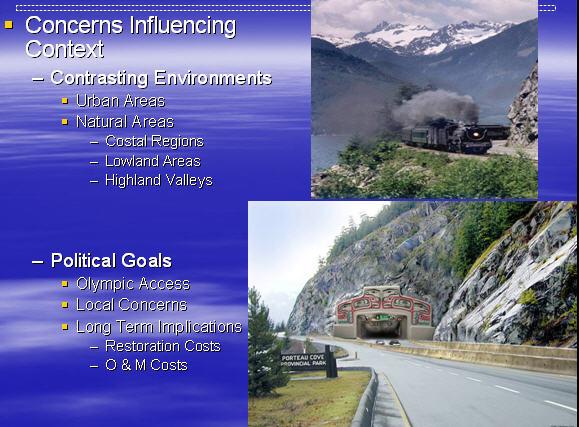
15 He concluded his presentation with the following two exhibits. 4.3 Roy Biller s Presentation on Context Sensitive Design Roy Biller, a consulting engineer in Western Canada specializing in geometric design, addressed CSD in road corridors. He emphasised the need for designers to understand the historical, social and political contexts of corridors and to design highways that satisfy their location and character. Aesthetics is only one feature of good design. A driver should be able to recognize a road by the corridor through which it passes. He illustrated this with two examples. The Sea-to-Sky Highway in British Columbia which will be the main access to the snow events of the 2010 Olympics. The corridor is well-defined by the mountainous character and the steepness of the terrain. The highway, which is currently being upgraded through this corridor, responds to the need for roadside views, scenic pull-offs and slower driving conditions. The use of 2+1 roads is a first in Canada and is intended to satisfy the demands of capacity and mobility while providing safe driving conditions in areas where it is difficult to build wide roads. The 23rd Ave corridor in Edmonton, which is a suburban corridor, through what could be a ubiquitous urban landscape across flat terrain. 23rd Ave, which crosses Edmonton from east to west, maintains a consistency of design in terms of roadside berms and plantings, curvilinear alignment, bicycle and pedestrian accommodation and consistent treatments of driveways and intersections. As part of Roy Biller s presentation, he presented the following examples from the above two corridors. 15


16 16


17 4.4 Leonard Ng s Presentation on CSD in Suburban Communities Leonard Ng spoke from the perspective of a manager of the roads and streets for the York Region in Ontario. He described CSD in one of Canada s largest suburban municipalities. A suburban municipality could be described as urban sprawl, characterized by shopping plazas, single family dwellings and high-speed arterials. York has taken the initiative of highlighting the heritage and environmental character of the region. Roads have been designed to enhance wetlands and to enhance flora and fauna. Speed management techniques characterize many of York s arterials. Each community center or shopping center within the Region has defined entry points. Arterial boulevards provide some curvilinear alignments and are naturally landscaped. Bus shelters contain heritage themes which have been reflected in road signs and at community gateways. Leonard Ng illustrated York as an example of how road design has been used to characterize a community and to provide transportation facilities for all road users. As part of his presentation, he presented the following examples of CSD in suburban areas. A newly constructed arterial 20 years ago Man-made Wetland, 2003 Construction Yonge St, Newmarket Elgin Mills Rd, Richmond Hill 17


18 A bus stop with heritage theme Walkability on St. John s St, Aurora Public Praise for a new Road Project 5. Future Direction of CSD in Canada Over 100 people attended the CSD workshop in Charlottetown and there was considerable discussion between presenters and participants on the direction that the design profession in Canada could be taking with CSD. Points made during discussion included the following. The need to make road design part of the community and not only a conduit for vehicles. The need to involve communication experts with public involvement and an understanding of community context and evolving expectations. The question of safety; what is safe if we are flexible with our design guidelines? The question of speed management, how it can be applied and whether innovative design really does slow traffic speeds. The question of human factors, which are poorly understood by design engineers. Mitigating risk and a need for practitioners to better understand the dynamics of new infrastructure. The need to ensure that designers continue to provide mobility and that roads are not an exercise in creative landscape architecture. 18
19 Workshop participants strongly supported ongoing discussion and education with CSD and the need to update the TAC Geometric Design Guidelines to include a chapter or supplement on the topic of CSD. Such an addition to the TAC Guidelines could include some of the following topics. Figure 1. Suggested Table of Contents 19
20 References 1. Geometric Design Guide for Canadian Roads, Transportation Association of Canada, September, A Policy on Geometric Design of Highways and Streets, American Association of State Highway and Transportation Officials (AASHTO), (the Green Book), Highway Design and Traffic Safety Engineering Handbook, R. Lamm, B. Psarianos, and T. Mailaender, NCHRP Report 480, A Guide to Best Practices for Achieving Context Sensitive Solutions, National Cooperative Highway Research Program, September NCHRP Synthesis 299, Recent Geometric Design Research for Improved Safety and Operations, National Cooperative Highway Research Program, Transportation Research Board/National Research Council, July NCHRP, Geometric Design: Past, Present and Future, National Cooperative Highway Research Program, Transportation Research Board/National Research Council, Context Sensitive Design: Speed Control, Roadways within a Community. A CSDapproach from Denmark, Germany, Great Britain, Holland and Switzerland, Basil Psarianos, National Technical University of Athens, Greece, the Transportation Research Board, July, Geometric Design Practices for European Roads, US Department of Transportation, International Technology Exchange Program, June, Synthesis of Safety Research Related to Speed and Speed Management, J. Stuster, Z. Coffman, D. Warren, Office of Safety and Traffic Operations R&D, Federal Highway Administration and Office of Traffic Injury Control Programs, National Highway Traffic Safety Administration, FHWA-RD , July, Literature Review and Analysis of Lane Widths, E. Hauer, The Integration of Human Factors and Explicit Safety in Highway Geometric Design, G. Bahar, A. Smiley, TRB
Transportation Research Center
 Increasing Design Flexibility in the AASHTO Green Book Your Department Name Presentation to AASHTO Subcommittee on Design Doug Harwood, MRIGlobal July 2017 Transportation Research Center Resolution of
Green Book 7 th Edition Summary of Changes. Jim Rosenow NCITE Geometric Design Committee August 30, 2018
 Green Book 7 th Edition Summary of Changes Jim Rosenow NCITE Geometric Design Committee August 30, 2018 Outline 1. The drama 2. Chapter 1 rewrite 3. The rest of the book 2 Outline 1. The drama 2. Chapter
Creating Complete Roadway Corridors:
 Creating Complete Roadway Corridors: The AASHTO Guide to Transportation Landscape Architecture and Environmental Design NCHRP Project 15-33 Status Report AASHTO Standing Committee on Design Technical Committee
CITY OF CHARLOTTESVILLE, VIRGINIA CITY COUNCIL AGENDA
 CITY OF CHARLOTTESVILLE, VIRGINIA CITY COUNCIL AGENDA Agenda Date: December 16, 2013 Action Required: Adoption of Resolution Presenter: Staff Contacts: Title: James E. Tolbert, AICP, Director of NDS James
Report to: Development Services Committee Report Date: April 24, 2017
 SUBJECT: Cornell Rouge National Urban Park Gateway - Report on Design Charrette and Next Steps PREPARED BY: Lilli Duoba, MES, MCIP, RPP, Manager, Natural Heritage (ext. 7925) REVIEWED BY: Marg Wouters,
38 Queen s University Campus Master Plan Part 1
 38 Queen s University Campus Master Plan Part 1 46 The Campus at the City Scale Chapter 4 The Campus at the City Scale 39 Queen s is an urban University centrally located in Kingston. Decisions made by
Chapter 1 - General Design Guidelines CHAPTER 1 GENERAL DESIGN GUIDELINES
 CHAPTER 1 GENERAL DESIGN GUIDELINES 1.0 INTRODUCTION This Publication has been developed to provide current, uniform procedures and guidelines for the application and design of safe, convenient, efficient
Integration of Trees into Roads Policy - the road to success -
 Integration of Trees into Roads Policy - the road to success - Trees, People and the Built Environment 3 City of Birmingham, UK April 5 th, 2017 Ian Buchanan Natural Heritage and Forestry Regional Municipality
Executive Summary. NY 7 / NY 2 Corridor
 Executive Summary NY 7 / NY 2 Corridor Transportation and Land Use Study December 2005 Prepared for: Town of Colonie Capital District Transportation Committee Prepared by: Introduction: Land use decisions
Commissioners Road West Realignment Environmental Assessment
 City of London Commissioners Road West Realignment Environmental Assessment Public Information Centre No. 1 March 30, 2017 Welcome to the Public Information Centre This first Public Information Centre
Access Management: An Overview
 Figures 1-5 Below Evolution of development along a highway. In the early stages, land along the road is used for farming with little traffic generated. As time passes, the highway corridor becomes a de
Toronto Complete Streets Guidelines
 c. DTAH 58 60 3.1 70 3.2 Performance Measurement 71 3.3 Exceptions Chapter 3 describes the five general steps in the street design process. Not all projects follow these steps, as the number of steps and
1.4 TRANSIT VISION 2040 FROM VISION TO ACTION THEME 1: PUTTING TRANSIT AT THE CENTRE OF COMMUNITIES. Fully integrate transit with community design
 TRANSIT VISION 2040 FROM VISION TO ACTION TRANSIT VISION 2040 defines a future in which public transit maximizes its contribution to quality of life with benefits that support a vibrant and equitable society,
9 th Street Sub Area Plan
 9 th Street Sub Area Plan In the 1990 s, when the Township prepared the last Master Plan, the 9 th Street corridor was studied as part of a larger 9 th Street Focus Area that included the West Main Street
DRAFT Subject to Modifications
 TREASURE COAST REGIONAL PLANNING COUNCIL M E M O R A N D U M To: Council Members AGENDA ITEM 8 From: Date: Subject: Staff May 19, 2017 Council Meeting Florida Department of Transportation Complete Streets
THAT the attached Terms of Reference for the Thornhill Centre Street Study be approved.
 COMMITTEE OF THE WHOLE AUGUST 18, 2003 THORNHILL CENTRE STREET STUDY PLANNING FILE: 15.92 Recommendation The Commissioner of Planning recommends: THAT the attached Terms of Reference for the Thornhill
Route 1 Corridor Study
 Route 1 Corridor Study Westbrook, Connecticut A Vision for the Connecticut Shoreline Public Informational Meeting July 28, 2015 Lower Connecticut River Valley Council of Governments Fitzgerald & Halliday,
The Vision. Photo provided by The Minervini Group. 46 Vision, Objectives & Strategies
 Vision, Objectives & Strategies The is the public framework and guide for future development of the Grand Traverse Commons. The establishes public polices for infrastructure, the preservation of natural
CITY OF VAUGHAN EXTRACT FROM COUNCIL MEETING MINUTES OF JUNE 7, 2016
 Item 5, Report No. 26, of the Committee of the Whole (Working Session), which was adopted without amendment by the Council of the City of Vaughan on June 7, 2016. 5 MUNICIPAL CLASS ENVIRONMENTAL ASSESSMENT
MONTANA DEPARTMENT OF TRANSPORTATION (MDT) ROAD DESIGN MANUAL (RDM) UPDATE: INCORPORATING PERFORMANCE BASED DESIGN
 ROAD DESIGN MANUAL (RDM) UPDATE: INCORPORATING PERFORMANCE BASED DESIGN") Hermanus Steyn and Julia Knudsen 0 0 MONTANA DEPARTMENT OF TRANSPORTATION (MDT) ROAD DESIGN MANUAL (RDM) UPDATE: INCORPORATING PERFORMANCE BASED DESIGN Submission Date: November, Corresponding Author:
Hermanus Steyn and Julia Knudsen 0 0 MONTANA DEPARTMENT OF TRANSPORTATION (MDT) ROAD DESIGN MANUAL (RDM) UPDATE: INCORPORATING PERFORMANCE BASED DESIGN Submission Date: November, Corresponding Author:
This Review Is Divided Into Two Phases:
 Semiahmoo Town Centre Review The purpose of this review: To review the Semiahmoo Town Centre Concept Plan, originally approved in 1993, to ensure that this centre will continue to serve the needs of South
Town of Oakville Streetscape Strategy
 Town of Oakville Streetscape Strategy Endorsed by PDC on February 10, 2014 (PD-011-14) Town of Oakville Streetscape Strategy [endorsed by PDC February 10, 2014] 0 Town of Oakville Streetscape Strategy
Town Center (part of the Comprehensive Plan)
") Town Center (part of the Comprehensive Plan) Mercer Island Town Center Looking North (2014) In 1994, a year-long process culminated in a set of design guidelines and code requirements for the Town Center
Town Center (part of the Comprehensive Plan) Mercer Island Town Center Looking North (2014) In 1994, a year-long process culminated in a set of design guidelines and code requirements for the Town Center
New-Cast Mixed-use Development Proposal King Street West, Newcastle, Ontario
 URBAN DESIGN BRIEF New-Cast Mixed-use Development Proposal King Street West, Newcastle, Ontario TABLE OF CONTENTS: 1.0 Executive Summary 2.0 Creating Vibrant and Sustainable Urban Places: Excerpts from
COMPLETE GREEN STREET CHECKLIST
 COMPLETE GREEN STREET CHECKLIST This document was developed to dissect the structure of an urban street and explore opportunities to make our streets more complete while also integrating green street strategies.
Implementation Guide Comprehensive Plan City of Allen
 Implementation Guide 2030 Comprehensive Plan City of Allen DRAFT 2015 Implementation Guide Allen 2030 Comprehensive Plan INTRODUCTION The Comprehensive Plan serves as a guide for the growth and development
KEY MAP DEVELOPMENT PERMIT AREA MAP. Sunnymede North Sub-Area Plan
 Richmond Official Community Plan BROADMOOR AREA SUNNYMEDE NORTH SUB-AREA PLAN Bylaw 7100 Schedule 2.6C SUNNYMEDE NORTH SUB-AREA PLAN SUNNYMEDE NORTH SUB-AREA PLAN SUNNYMEDE NORTH SUB-AREA PLAN KEY MAP
The Illinois Department of Transportation and Lake County Division of Transportation. Route 173, including the Millburn Bypass
 The Illinois Department of Transportation and Lake County Division of Transportation welcome you to this Public Hearing for U.S. Route 45 from Illinois Route 132 to Illinois Route 173, including the Millburn
Design Speed / Target Speed Primer. Jim Rosenow AASHTO Technical Committee on Geometric Design June 12, 2018
 Design Speed / Target Speed Primer Jim Rosenow AASHTO Technical Committee on Geometric Design June 12, 2018 Predecessor research NCHRP Project 15-25 NCHRP Project 15-47 2 Predecessor research NCHRP Project
WELLINGTON STREET WEST COMMUNITY DESIGN PLAN
 36 3.CDP POLICIES 37 Wellington Street West CDP Vision Statement 38 3.1 Introduction 3.1.1 Purpose The development of buildings and public spaces is influenced by a variety of factors over time. City of
Toronto Complete Streets Guidelines
 Toronto Complete Streets Guidelines 108 110 7.1 Green Infrastructure Design Principles 112 7.2 Context-Sensitive Green Streets 114 7.3 Key Green Street Elements Green infrastructure refers to natural and
TORONTO COMPLETE STREETS GUIDELINES
 TORONTO COMPLETE STREETS GUIDELINES Presentation by Fiona Chapman, Manager, Pedestrian Projects Public Realm Section, Transportation Services, City of Toronto June 2017 PURPOSE OF THE PROJECT To develop
Summary of Heritage Input
 Summary of Heritage Input Commonwealth is providing services to the City of Ottawa, as heritage expert in the Lansdowne Revitalization project recognizing not only that Lansdowne accommodates designated
Local Growth Planning in North Central Green Line Communities
 2018 April 30 Page 1 of 6 EXECUTIVE SUMMARY This report outlines a high-level scope for local growth planning for north central Green Line communities. The catalyst for this review is the significant investments
Designing INSIDE the Box
 Designing INSIDE the Box Using the ITE/CNU Walkable Urban Thoroughfares Manual to Build Complete Streets National Association of Regional Councils Raleigh, NC June 8, 2015 G. Wade Walker, P.E. Principal
URBAN DESIGN BRIEF URBAN DESIGN BRIEF 721 FRANKLIN BLVD, CAMBRIDGE August 2018
 URBAN DESIGN BRIEF URBAN DESIGN BRIEF 721 FRANKLIN BLVD, CAMBRIDGE August 2018 DESIGN BRIEF CONTENTS PART A 1.0 INTRODUCTION 2.0 DESCRIPTION & ANALYSIS OF SITE CONTEXT 3.0 DESIGN CONSTRAINTS AND OPPORTUNITIES
Appendix I. Access Management & Land Use Zoning Strategies Memo
 Appendix I ` Access Management & Land Use Zoning Strategies Memo Route 96 Access Management and Land Use/Zoning Strategies The Town of Victor has access management guidelines in Section 5.0 of the 2014
ELMVALE ACRES SHOPPING CENTRE MASTER PLAN
 ELMVALE ACRES SHOPPING CENTRE MASTER PLAN Contents 1.0 INTRODUCTION... 2 2.0 LOCATION... 2 3.0 EXISTING CONTEXT... 2 4.0 VISION & GUIDING PRINCIPLES... 2 5.0 LAND USE AND BUILT FORM... 4 5.1 St. Laurent
Second Line West Pedestrian/Cyclist Crossing of Highway 401 Class EA. Second Line West Pedestrian/Cyclist Crossing of Highway 401 Class EA
 1 1 Purpose of Public Information Centre #2 To provide interested and/or potentially affected stakeholders with an opportunity to participate in the planning and decision-making process for this Municipal
Chapter 2: Vision, Goals and Strategies
 Chapter 2: Vision, Goals and Lake Elmo Today & Tomorrow Comprehensive Plan 2040 2 VISION, GOALS & STRATEGIES - DRAFT 4-6-2018 INTRODUCTION Comprehensive Plan Purpose Perhapse the most important objective
13 THORNHILL YONGE STREET STUDY IMPLEMENTATION CITY OF VAUGHAN OPA 669 AND TOWN OF MARKHAM OPA 154
 13 THORNHILL YONGE STREET STUDY IMPLEMENTATION CITY OF VAUGHAN OPA 669 AND TOWN OF MARKHAM OPA 154 The Planning and Economic Development Committee recommends the adoption of the recommendations contained
4-Town Comprehensive Plan DRAFT 7/30/07
 4-Town Comprehensive Plan DRAFT 7/30/07 Acknowledgements ning Committee Town of Harrisburg Norman Roof Randy Nicol Town of Martinsburg Terry Thisse Paul Kelly Town of Montague Jan Bagdanowicz Wendy Perry
Animating the Rideau Canal December 2013
 Executive Summary Animating the Rideau Canal December 2013 Why study the Rideau Canal? The Rideau Canal has been an important part of Ottawa throughout its history, and has shaped and been shaped by the
1.0 Purpose of a Secondary Plan for the Masonville Transit Village
 Report to Planning and Environment Committee To: Chair and Members Planning & Environment Committee From: John M. Fleming Managing Director, Planning and City Planner Subject: Masonville Transit Village
Meeting Purpose: Date and Time: Location: Attendance: Handouts:
 Meeting Purpose: Date and Time: Location: Attendance: Handouts: PA Turnpike / I-95 Interchange Project Design Advisory Committee (DAC)/Public Officials Meeting #8 April 12, 2012 at 1:30 p.m. Project Office,
URBAN DESIGN POLICY DEVELOPMENT STEP 1: BACKGROUND RESEARCH
 URBAN DESIGN POLICY DEVELOPMENT STEP 1: BACKGROUND RESEARCH Final Report August 2016 P2. A. OVERVIEW, METHODOLOGY & ENGAGEMENT The City of Toronto s Urban Design Policy Development Background Research
South Yonge Street Corridor
 South Yonge Street Corridor Streetscape Master Plan Study Draft Final Executive Summary Prepared by: January 2012 In Partnership with: Introduction The Future... Yonge Street is at the forefront of York
John M. Fleming Managing Director, Planning and City Planner. Old East Village Dundas Street Corridor Secondary Plan Draft Terms of Reference
 Report to Planning and Environment Committee To: From: Subject: Chair and Members Planning & Environment Committee John M. Fleming Managing Director, Planning and City Planner Old East Village Dundas Street
City of Farmington. Downtown Plan. Amendment to the 1998 Master Plan Adopted October 11, 2004
 City of Farmington Amendment to the 1998 Master Plan Adopted October 11, 2004 Introduction Planning Background 1 Scope and Components of the Plan Amendment 2 Concept Introduction 3 Plan Concepts 3 Conceptual
Clair-Maltby Community visioning
 Clair-Maltby Community visioning workshop #1 Summary April 27th, 2017 Table of Contents INTRODUCTIon 1 PURPOSE 1 CONSULTATION STRUCTURE 2 PARTICIPANT FEEDBACK 3 VISIONING EXERCISE 8 ONLINE SURVEY RESULTS
FDOT D4 Complete Streets
 FDOT D4 Complete Streets Context Sensitive Solutions Directs that complete street solutions will complement the context of the community. Collaborative approach to decision making, project development,
Mid-Rise Buildings on Toronto s Avenues Responding to the Public Realm Andrea Oppedisano, City of Toronto
 Mid-Rise Buildings on Toronto s Avenues Responding to the Public Realm Andrea, City of Toronto Introduction The Avenues and Mid-Rise Buildings Study explores opportunities to encourage a built form that
Complete Neighbourhood Guidelines Review Tool
 Complete Neighbourhood Guidelines Review Tool Prepared By: City of Regina Planning Department October 2014 Page 1 of 14 Community Development Review Checklist for Secondary Plans and Concept Plans The
TRANSPORTATION AND LAND USE
 CHAPTER 10 TRANSPORTATION AND LAND USE Transportation and land use are intimately linked. The expansion of a highway typically spurs housing, employment growth and land development in the communities that
DRAFT Northeast Quadrant of Kipling Avenue and Highway 7 DRAFT AUGUST 29, Goals Land Use. The goals of this Plan are to:
 AUGUST 29, 2017 12.15 Northeast Quadrant of Kipling Avenue and Highway 7 12.15.1 Goals 12.15.2 Land Use The goals of this Plan are to: 12.15.2.1 General Provisions: a) Ensure the development of a compact
SCARBOROUGH SUBWAY EXTENSION. Scarborough Subway Extension. Final Terms of Reference
 Scarborough Subway Extension Final Terms of Reference 1 1.0 Introduction and Background 1.1 Introduction Toronto City Council recently confirmed support for an extension of the Bloor-Danforth Subway from
TENNESSEE STATE ROUTE 109 CORRIDOR MANAGEMENT AGREEMENT MEMORANDUM OF UNDERSTANDING CORRIDOR MANAGEMENT ALONG STATE ROUTE 109
 TENNESSEE STATE ROUTE 109 CORRIDOR MANAGEMENT AGREEMENT MEMORANDUM OF UNDERSTANDING CORRIDOR MANAGEMENT ALONG STATE ROUTE 109 I. Purpose The purpose of this Agreement is to provide a framework for the
7Page 91 CLEMMONS COMMUNITY COMPASS 7 COMMUNITY CHARACTER
 7 Community Character The beauty of Clemmons won t necessarily be a reflection of our past, but our future. This quote from Comprehensive Plan Steering Committee member Wayne Dodson captures the essence
Tricia Millington, RLA New York State Department of Transportation
 Tricia Millington, RLA New York State Department of Transportation pmillington@dot.state.ny.us Context Sensitive Principles: Context Sensitive Solutions is a philosophy wherein safe transportation solutions
Courtice Main Street Study Community Vision Workshop PLANNING SERVICES DEPARTMENT
 Courtice Main Street Study Community Vision Workshop PLANNING SERVICES DEPARTMENT July 22, 2009 Tonight s Meeting 7:00 pm Introduction David Crome, Director of Planning 7:05 Presentation Stasia Bogdan,
Definitions. Average Daily Traffic Demand (ADT): The actual number or projected number of cars that pass a point in a 24-hour period.
: The actual number or projected number of cars that pass a point in a 24-hour period.") Definitions Access Management: A combination of physical techniques and transportation policies used to control the flow of traffic between roads and the surrounding lands. Alternative City Form Scenarios:
Definitions Access Management: A combination of physical techniques and transportation policies used to control the flow of traffic between roads and the surrounding lands. Alternative City Form Scenarios:
CITY OF VAUGHAN EXTRACT FROM COUNCIL MEETING MINUTES OF NOVEMBER 15, 2016
 Item 11, Report No. 38, of the Committee of the Whole, which was adopted without amendment by the Council of the City of Vaughan on November 15, 2016. Regional Councillor Di Biase declared an interest
Former Rockcliffe Airbase Community Design Plan Guiding Design Vision and Principles December 4, 2013
 APPENDIX 5 - Guiding Design Vision and Principles Former Rockcliffe Airbase Community Design Plan Guiding Design Vision and Principles December 4, 2013 Vision Statement The redevelopment of the former
Welcome. Walk Around. Talk to Us. Write Down Your Comments
 Welcome This is an information meeting introducing the applications for proposed redevelopment of the Yorkdale Shopping Centre site at 3401 Dufferin Street and 1 Yorkdale Road over the next 20+ years,
10.0 Open Space and Public Realm
 10.0 Open Space and Public Realm 10.0 Open Space and Public Realm The Public Open Space System is comprised of: outdoor spaces available for public use that are either publicly owned (e.g., parks and
North York Centre South Service Road
 North York Centre South Service Road Municipal Class Environmental Assessment Addendum Potential Changes to Doris Avenue, Bonnington Place & Tradewind Avenue Study Summary (June 11, 2015) toronto.ca/nyc-south-road.
Blueprint Denver Task Force Meeting #
 Blueprint Denver Task Force Meeting #1 6.23.16 1. Welcome and Introductions Your name and affiliation Name 1 thing you love about Denver Name 1 thing you d change about Denver All in 30 seconds! Ready,
Town of Weston Guardrail Overview Report
 Town of Weston Guardrail Overview Report July 28, 2016 Prepared for: Town of Weston Weston, MA 02493 Submitted by: Nitsch Engineering 2 Center Plaza, Suite 430 Boston, MA 02108 Nitsch Engineering Project
Study Process / Planning Policy Issues
 Memorandum Date: March 13 th, 2009 To: From: Reference: Subject: Murray Thompson, URS Canada Tyler Drygas, Senior Environmental Planner, URS Canada Detroit River International Crossing Study Response to
Workshop on the Management of Historic Urban Landscapes of the XXth century, December 2007 Chandigarh, India
 Workshop on the Management of Historic Urban Landscapes of the XXth century, 18-21 December 2007 Chandigarh, India INTRODUCTION The participants of the International Workshop on the Management of Historic
URBAN DESIGN BRIEF. 2136&2148 Trafalgar Road. Town of Oakville
 URBAN DESIGN BRIEF 2136&2148 Trafalgar Road Town of Oakville Prepared By: METROPOLITAN CONSULTING INC For 2500674 Ontario Inc November 2016 TABLE OF CONTENTS Page No. 1.0 Introduction/Description of Subject
STREETSCAPE MANUAL ONLINE TRAINING SESSION 1: Background
 TRAINING SESSION 1: The Urban Design Streetscape Manual is a reference tool developed to help implement City policy and guide the design, construction and maintenance of streetscape improvements in Toronto.
3. VISION AND GOALS. Vision Statement. Goals, Objectives and Policies
 Vision Statement Queen Creek s interconnected network of parks, trails, open spaces and recreation opportunities provide safe and diverse activities and programs that sustain its unique, small town, equestrian
This page left intentionally blank.
 July 2012 This page left intentionally blank. Table of Contents Appendix A : Project Development Checklist Appendix B: At-Grade Rail Crossings Appendix C: Maintenance and Operations Examples Appendix D:
Creating a Supportive Organizational and Policy Framework Luisa Paiewonsky. John D. Pagini, AICP USDOT CCAPA PDO
 Creating a Supportive Organizational and Policy Framework Luisa Paiewonsky USDOT John D. Pagini, AICP CCAPA PDO Provides guidelines for the planning, design, and construction of: State Highways Local roads
What We Heard Report: Westmount Architectural Heritage Area Rezoning Drop-in Workshop
 What We Heard Report: Westmount Architectural Heritage Area Rezoning Drop-in Workshop August 2018 What We Heard Report: Westmount Architectural Heritage Area Rezoning Drop-in Workshop Executive Summary
Hockessin Community Redevelopment Plan
 Hockessin Community Redevelopment Plan 3.1 Introduction The Community Redevelopment Plan for the Village of Hockessin is the result of the people s vision for a distinct village center that serves as the
Municipal Class EA Study Public Information Centre No. 1 December 13, :00 pm 7:00 pm. Please sign in so we can keep you updated on this study
 Reconstruction of Regional Road 45 (Creek Road) Between Regional Road 27 (River Road) and Regional Road 63 (Canborough Road) in the Township of Wainfleet Municipal Class EA Study Public Information Centre
Don Mills Crossing Study and Celestica Lands Development Application Community Meeting, Open House, and Breakout Discussions
 Consultation Summary Don Mills Crossing Study and Celestica Lands Development Application Community Meeting, Open House, and Breakout Discussions This report is not intended to provide a verbatim transcript
CITY COUNCIL AGENDA REPORT
 CITY COUNCIL AGENDA REPORT Subject: COUNCIL MOTION LRT ALIGNMENT REMOVAL FROM THE TRANSPORTATION MASTER PLAN On February 10, 2016 Councillor Hughes provided notice in accordance with Section 23 of Procedure
I. INTRODUCTION. Project Background and Study Area
 I. INTRODUCTION Project Background and Study Area Freedom Parkway is a key east-west corridor connecting I-25 on the west to the Town of Kersey on the east, running approximately one to two miles south
Uptown Rideau Street Secondary Plan [Amendment #166, January 12, 2016]
![Uptown Rideau Street Secondary Plan [Amendment #166, January 12, 2016]](/thumbs/76/73760497.jpg "Uptown Rideau Street Secondary Plan [Amendment #166, January 12, 2016]") [Amendment #166, January 12, 2016] The policies of this Secondary Plan are in effect, save and except for the property at 560 Rideau Street, for which there remains a site specific appeal to this Secondary
[Amendment #166, January 12, 2016] The policies of this Secondary Plan are in effect, save and except for the property at 560 Rideau Street, for which there remains a site specific appeal to this Secondary
Public input has been an important part of the plan development process.
 Lakewood s Comprehensive Plan recognizes that transportation helps shape the community, and that the way the community provides for the safe and efficient movement of people affects the character of the
I-70 Corridor Enhancement Plan
 i - Table of Contents Table of Contents Chapter I Overview Chapter II Bridge and Roadway Improvements Chapter III Landscape Enhancements Chapter IV Riparian Corridors Chapter V Showcase Missouri Plan Chapter
Iowa s Statewide Urban Design Standards Promote Improved Access Management
 Iowa s Statewide Urban Design Standards Promote Improved Access Management David J. Plazak and Dale S. Harrington Center for Transportation Research and Education Iowa State University 2901 South Loop
SDOT DPD. SDOT Director s Rule DPD Director s Rule DCLU DR SED DR of 7 CITY OF SEATTLE
 SDOT SDOT Director s Rule 2-07 DPD Applicant: CITY OF SEATTLE Page 1 of 7 Supersedes: DCLU DR 11-93 SED DR 93-4 Seattle Department of Transportation (SDOT) Department of Planning and Development (DPD)
INTERIM ADVICE NOTE 143/11
 INTERIM ADVICE NOTE 43/ Supplementary Advice and requirements for the Accessibility during planning, design, construction and handover of Improvement Schemes Summary This document provides additional advice
c. DTAH Toronto Complete Streets Guidelines
 c. DTAH Toronto Complete Streets Guidelines 164 166 C.1 Project Delivery Process 168 C.5 This section provides a summary of the overarching process for delivering street projects in Toronto. The conclusion
implementation r expression in landscape
 6 ubc okanagan implementation campus plan r expression in landscape 68 6 implementation campus plan sections The Campus Plan supports the academic mission, values and commitments of the University by providing
The transportation system in a community is an
 7 TRANSPORTATION The transportation system in a community is an important factor contributing to the quality of life of the residents. Without a sound transportation system to bring both goods and patrons
Public Meeting #3 May 9, 2009 MVVA Team
 Public Meeting #3 May 9, 2009 MVVA Team Welcome to the third Public Meeting for the Lower Don Lands Municipal Class Environmental Assessment (EA) Infrastructure Master Plan and Keating Channel Precinct
Purpose of Open House #3
 Public Meeting #3 May 9, 2009 MVVA Team Purpose of Open House #3 The main purpose of this Open House is to present and seek input on the: Evaluation of transportation and infrastructure design alternatives
Presentation Overview
 DETROIT RIVER INTERNATIONAL CROSSING STUDY Presentation to Windsor Rotary Club October 23, 2006 1 Presentation Overview 1. Overview 2. Progress Update Technical Work Program Environmental Work Program
PROJECT BACKGROUND. Preliminary Design Scope and Tasks
 PROJECT BACKGROUND Preliminary Design Scope and Tasks The purpose of this Study is the development of preliminary designs for intersection improvements for Trunk Highway (TH) 36 at the intersections of
A Compendium Survey of International Access Management Practices and Concepts
 A Compendium Survey of International Access Management Practices and Concepts { Kristine Williams (USA) Basil Psarianos (Greece) Contributors : 1) China: Zhen Yang, Tongji University and Zhongren Wang,
VALLEY COUNTY MINIMUM STANDARDS FOR PRIVATE ROAD DESIGN AND CONSTRUCTION
 MINIMUM STANDARDS FOR PRIVATE ROAD DESIGN AND CONSTRUCTION Adopted November 28, 2005 TABLE OF CONTENTS DEFINITION OF TERMS...II I. DESIGN CRITERIA... 1 A. GENERAL DESIGN CRITERIA... 1 B. ROADWAY CLASSIFICATION...
COMMUNITY DESIGN. GOAL: Create livable and attractive communities. Intent
 COMMUNITY DESIGN Intent An attractive, well-designed County will attract quality development, instill civic pride, improve the visual character of the community, and create a strong, positive image for
MEMO 1. INTRODUCTION PURPOSE & PROCESS REQUEST
 MEMO Date: August 22, 2017 To: Board of Commissioners From: Jason Burdette, Planning Director Re: Davidson Commons East Hotel Stakeholder Feedback 1. INTRODUCTION PURPOSE & PROCESS This memorandum summarizes
V. Vision and Guiding Principles
 V. Vision and Guiding Principles The Master Plan for the Powers Ferry Corridor seeks a foundation in the desires of the community. At times, various elements of the community offered opposing viewpoints,
Workshop 3. City of Burlington Waterfront Hotel Planning Study. September 14, The Planning Partnership
 Workshop 3 City of Burlington Waterfront Hotel Planning Study September 14, 2017 The Planning Partnership The Waterfront Hotel Planning Study 01 The Brant & Lakeshore Planning Study will establish a Strategic