Planning and Growth Management Committee. Chief Planner and Executive Director, City Planning
|
|
|
- Edward Knight
- 5 years ago
- Views:
Transcription


1 PG18.6 STAFF REPORT ACTION REQUIRED Unilever Precinct Planning Study Status Update 21 Don Valley Parkway and 30 Booth Avenue Zoning Amendment and Subdivision Applications Preliminary Report Date: February 7, 2017 To: From: Wards: Reference Numbers: Planning and Growth Management Committee Chief Planner and Executive Director, City Planning Ward 30 Toronto-Danforth STE 30 OZ (2015 OPA, Planning Study) STE 30 OZ; STE 30 SB (2016 Rezoning and Subdivision) SUMMARY This report addresses two related matters within the approximately 24.9 hectare block of lands bounded by the Don Valley Parkway, Lake Shore Boulevard, Booth Avenue and Eastern Avenue, referred to henceforth as the Unilever Precinct. First, the report provides an update on work to date on the Unilever Precinct Planning Study and sets out staff's proposed work program, including a preliminary consultation work plan. The Unilever Precinct Planning Study will comprehensively consider and consult on a transformative vision initially advanced by a private developer, First Gulf, for a new major employment node focused on office employment, with a substantial retail component. The City's analysis will also consider an expanded range of nonresidential employment uses, including post-secondary institutions, studios, research facilities, and supportive uses. In order to successfully transform, the Precinct requires investment in planned
2 transit and other infrastructure elements. The second purpose of this report is to provide preliminary information on the applications by First Gulf for zoning amendments and subdivision for the properties they own within the Precinct, 21 Don Valley Parkway and 30 Booth Avenue. These applications also include a resubmission of First Gulf's October 2015 Official Plan Amendment ("OPA") application for the entire Precinct, and continue to advance the vision presented in the OPA for a new, dense, vibrant, predominantly office node with a substantial retail component, providing over 50,000 jobs, which First Gulf has branded "East Harbour". The development of this employment node, with the concurrent investment in infrastructure for flood protection; Gardiner Expressway and Lake Shore Boulevard realignment; transit infrastructure through Regional Express Rail, SmartTrack, the Relief Line, and the extension of Broadview Avenue with streetcar service into the Port Lands; and stormwater infrastructure, would transform the South of Eastern employment area. This development would bringing a level of office and retail employment intensity east of the Don River that until now has only been found in Toronto within the Downtown Core and the Centres. First Gulf's aspirations for this project, as well as their efforts to mobilize enabling infrastructure, are compelling. Providing additional, attractive office and related employment space well connected to transit could strategically and significantly contribute to the future potential of the City. In initiating a Planning Study for the Precinct and collaborating with First Gulf on master planning, the City has engaged with this unique City-building opportunity, while acknowledging that its challenges are commensurate with its size and ambition. This report seeks direction from the Planning and Growth Management Committee on community consultation process for the Precinct Planning Study and First Gulf's applications. It also seeks to advance funds to commence the Eastern and Broadview Flood Protection Municipal Class Environmental Assessment, to assess removing from flood risk approximately 8 hectares of land, much of which is within the Precinct Plan "Area of Influence" north of the Metrolinx rail embankment, east of the Don Valley Parkway and south of Sunlight Park Road/Eastern Avenue. RECOMMENDATIONS The Chief Planner and Executive Director, City Planning, recommends that: 1. The Chief Planner and Executive Director, City Planning, be directed to advance community consultation on the Unilever Precinct Planning Study for the Precinct area, including the proposed East Harbour SmartTrack Station, in accordance with 2
3 the consultation work plan set out in this report, including scheduling a community meeting for the lands at 21 Don Valley Parkway and 30 Booth Avenue, in consultation with the Ward Councillor. 2. Notice for community consultation meetings be given to landowners and residents within 120 metres of the Precinct, in consultation with the Ward Councillor. 3. Notice for public meetings under the Planning Act be given according to the regulations of the Planning Act. 4. The Deputy City Manager, Cluster B, be directed to commence, together with the Toronto and Region Conservation Authority and Waterfront Toronto, the Eastern and Broadview Flood Protection Municipal Class Environmental Assessment. 5. Subject to approval of Recommendation 4, the Deputy City Manager & Chief Financial Officer be directed to create a capital sub-project, the "Eastern and Broadview Flood Protection Municipal Class Environmental Assessment," with 2017 cash flows of $2.0 million, funded from development charges from Reserve Fund XR2120 ($1.8 million) and $0.200 million in approved funding from the Waterfront Revitalization Initiative's Capital Budget and Plan CWR ($0.130 million) and CWR ($0.070 million) resulting in a $1.8 million net increase in the Budget Committee recommended Waterfront Revitalization budget. Financial Impact The creation of a sub-project within the Waterfront Revitalization Initiative's Capital Budget and Plan for the Eastern and Broadview Flood Protection Municipal Class Environmental Assessment (EA) is recommended with 2017 cash flows of $2.0 million based on preliminary cost estimate developed by the Toronto and Region Conservation Authority (TRCA), working with the City and Waterfront Toronto. $1.8 million is available from development charge recoveries for development studies and the $0.2 million is available for reallocation from the Waterfront projects noted above based on a review of 2017 expenditure requirements compared to funding available from the combination of 2017 approved cash flows and 2016 unspent cash flows. The proposed Eastern and Broadview Flood Protection Municipal Class EA will be separate from the Port Lands Flood Protection project that is included in the Capital Budget and Plan. Despite flood protection investments in the Port Lands, approximately 8 hectares of employment lands, much of which is located within the "Area of Influence" of the Unilever Precinct, will remain at flood risk. Together with area landowners and the City, the TRCA has undertaken initial exploratory work on a further flood protection Municipal Class EA to understand this risk. The addition of flood protection infrastructure would improve development potential, facilitate the future Eastern and Broadview Relief Line subway station and the East 3
4 Harbour SmartTrack station, as well as simplify street access into the Unilever Precinct and continuation of Broadview Avenue south into the Port Lands. Capital funding is not included for any flood protection investments that may be recommended in the EA, however like the Port Lands Flood Protection project, recommended investments may be eligible for cost-shared arrangements with the other orders of government, in addition to standard recoveries from development charges and landowner contributions. The Deputy City Manager & Chief Financial Officer has reviewed this report and agrees with the financial impact information. DECISION HISTORY First Gulf's East Harbour Applications In February 2016, Planning and Growth Management Committee considered a preliminary report on First Gulf Don Valley Limited's submitted Official Plan Amendment for their proposed "East Harbour" development in the Unilever Precinct. Staff were directed to prepare a community consultation work plan in consultation with the Ward Councillor and integrating economic development considerations, as well as to report back to the Planning and Growth Management Committee on the process that the City will undertake to lead comprehensive planning for the Precinct, in collaboration with the applicant, landowners and stakeholders. The Committee's direction may be viewed here: Port Lands and South of Eastern In January 2012, City Council requested the Chief Planner and Executive Director, City Planning Division, to consider a planning framework for the South of Eastern Employment District and report to Planning and Growth Management Committee. A status update report on the South of Eastern Strategic Direction, dated July 10, 2014 was prepared for Planning and Growth Management Committee and can be found here: Key to the unlocking of the employment potential of the South of Eastern Employment Area is an increase in the transit and transportation capacity, including cycling infrastructure. This has been assessed concurrently with the Strategic Direction Study under the Port Lands Acceleration Initiative, through the Port Lands and South of Eastern Transportation and Servicing Master Plan EA. Details on the Port Lands and South of Eastern Transportation and Servicing Master Plan EA can be viewed here: 4
5 Municipal Comprehensive Review In December 2013, City Council considered a report on draft Official Plan policies and designations for employment, prepared as part of the five-year Official Plan and Municipal Comprehensive Reviews (MCR). The MCR was completed, resulting in Official Plan Amendment No. 231 (OPA 231). OPA 231 designates the site at 21 Don Valley Parkway General Employment Areas, the remainder of the Precinct Core Employment Areas, and includes Site and Area Specific Policy (SASP) No. 426 for 21 Don Valley Parkway and 30 Booth Avenue. Council's decision may be viewed here: On July 9, 2014 the Ministry of Municipal Affairs (MMA) approved, with some modifications, the majority of OPA 231; however, it has been appealed by a number of parties to the Ontario Municipal Board (OMB) and is not yet in full effect. Although the MMA approved the Precinct's underlying OPA 231 designations, the Minister's decision was withheld for any site specific policies and employment land conversion designation changes applying to lands located within the flood plain of the Lower Don Special Policy Area (SPA), of which this Precinct is a part. At the request of the Province, City Planning staff submitted additional supportive land use material for the outstanding SASPs within the Lower Don SPA. This material remains under review by the MMA and the Ministry of Natural Resources. The Minister's Decision may be viewed here: isters%20decision%20on%20opa%20231.pdf The Minister's Decision regarding OPA 231 has been appealed by multiple parties, on both a site-specific and City-wide basis. Both First Gulf and the previous owners of 30 Booth Avenue are parties to these appeals. At a June 20, 2016 Hearing on this matter, the OMB partially approved OPA 231, including bringing into force the underlying Core Employment Area and General Employment Area land use designations and mapping, and portions of the non-policy text. The partially approved designations and non-policy text are not in effect for lands that have appeals to OPA 231. The Board's records on this matter may be viewed at: Transit In July 2016, City Council considered a report on Toronto's transit network plan to 2031, which included recommendations on SmartTrack/RER new station locations and a Pape- Eastern-Queen Relief Line alignment. 5
6 Council's direction may be viewed here: In November 2016, City Council considered a further report on the transit network plan and financial strategy, which included recommendations requiring that the City, in partnership with the Toronto Transit Commission, the Province of Ontario and Metrolinx, complete planning and design for new SmartTrack stations. Council's direction may be viewed here: Flood Protection In November 2016, City Council directed the City Manager and Deputy City Manager, Cluster B, to request the Government of Canada and Province of Ontario provide funding commitments for the Port Lands Flood Protection Project by the second quarter of Council also directed that the City identify funding for the City of Toronto's $401 million, one-third share of the balance of funding for the Port Lands Flood Protection Project through the capital budgeting and planning process, and approved funding through 2019 for the Essroc Quay Lake Filling and Naturalization capital project. Council's direction may be viewed here: Gardiner East At its meeting of March 31, 2016, City Council approved Hybrid Alternative Design 3 as the Preferred Design for the Gardiner East Environmental Assessment. The preferred design entails the demolition and relocation (west of the Don River) of the Gardiner Expressway's easternmost on/off ramp. This reconfiguration removes a significant barrier between the South of Eastern and Port Lands areas. The Gardiner East Environmental Assessment ("Gardiner East EA") was submitted to the Ministry of Environment and Climate Change (MOECC) on January 27, 2017, and is currently the subject of a public review and comment period. MOECC staff expect publication of the formal Ministry Review of the Gardiner East EA report in May 2017, with a final Minister's Decision expected by September Implementation of the Gardiner East EA is a component of the broader Gardiner Expressway Revised Strategic Rehabilitation Plan. The most recent report on the implementation approach for the rehabilitation plan went to Council in December 2016, and can be viewed here: 6
7 Don River and Central Waterfront Wet Weather Flow Project In March 2014, Public Works and Infrastructure Committee adopted a report on the contract award for engineering design services and contract administration related to the Don River and Central Waterfront Wet Weather Flow Project. The Committee's decision can be viewed here: Pre-Application Consultation A series of pre-application meetings were held with the applicant to discuss complete application submission requirements for their rezoning and subdivision applications. In addition, meetings occurred following First Gulf Don Valley Limited's October 2015 Official Plan Amendment application, focused on the emerging master plan. First Gulf held a series of pre-application community consultation meetings throughout 2015 and 2016: four public community workshops facilitated by Hardy Stevenson & Associates, focused respectively on engagement, visioning, infrastructure and First Gulf's preliminary master plan; and seven focused stakeholder advisory committee workshops, providing updates on the emerging master plan as well as soliciting feedback. Further information on these sessions may be found in the Planning & Design Rationale Report dated December 22, 2016, provided by First Gulf Don Valley Limited and Don Valley Booth Limited in support of the 21 Don Valley Parkway and 30 Booth Avenue rezoning and subdivision applications. UNILEVER PRECINCT The Precinct: Area, Initiatives, Applications, Planning Study The Unilever Precinct is bounded by the Don River in the west, Lake Shore Boulevard East in the south, Booth Avenue in the east and Eastern Avenue and the Metrolinx rail embankment in the north. It is located at the western end of the South of Eastern employment area, and is approximately 24.9 hectares in size. Table 1 below provides a description of the Unilever Precinct ownership, and Attachment 1 provides an Ownership Map. 7
8 Table 1: Unilever Precinct Land Ownership Property Address 1, 5 & 9 Don Valley Parkway, 6 Booth Ave. 21 Don Valley Parkway Area Property Owner (hectares) 2.49 Toronto Port Lands Company /City of Toronto Economic Development Corporation First Gulf Don Valley Limited Current Use Rail spur lines to service Ashbridges Bay Wastewater Treatment Plant, and other facilities in the Port Lands. Former Unilever manufacturing plant. Currently used for outdoor auto storage and warehousing. CineSpace Film Studios 30 Booth Ave Don Valley Booth Limited 433*, 447* 5.59 City of Toronto Booth Works Yard Eastern Ave. & 50 Booth Ave. 415 Eastern Ontario Avenue Road Home Furnishing Ave.* Inc. Showroom 405 Eastern Ave The Consumers' Gas Company Enbridge Station B Distribution Facility - Site Plan Application submitted for one-storey addition (File No: STE 30 SA) 385 Eastern Ave Ontario Limited 385 Eastern Ave Ontario Limited SA) 385 Eastern Ave Eastern Self Vacant Storage Limited 0 Eastern Ave Ontario Telecommunication Tower Inc. *Buildings are listed on the City's Inventory of Heritage Properties Surrounding land uses are as follows: Vacant Site Plan Application submitted for 2-storey auto repair garage (File No: STE 30 North: Metrolinx rail corridor, automobile dealerships and small scale commercial uses. Immediately to the north-east of the Precinct is the former Weston Bakery factory, site of applications for a mixed-use mid-rise building with residential units. South: Portions of the Lower Don Recreation Trail, Gardiner Expressway ramps (to be removed and relocated through implementation of the Gardiner East EA), and Lake Shore Boulevard. South of Lake Shore Boulevard are the Port Lands. East: Immediately east of Booth Avenue, there is a site plan application to construct a five-storey self-storage facility. Continuing east along Eastern Avenue, there are a variety of low-rise industrial and office buildings, including a concentration of film studios and supportive uses. There is also an existing low-rise residential community south of Eastern fronting on Logan Avenue, Morse Street and Carlaw Avenue, as well as the Morse Street Playground. 8
9 West: To the immediate west are the Don Valley Parkway and the Don River. West of the river, the Unilever Precinct faces Corktown Common and the West Don Lands. While the primary Precinct area is south of the Metrolinx rail corridor, an "Area of Influence" has been identified north of the rail corridor and west along the river edge. The lands to the north, currently a car dealership, are in consideration for flood protection through the proposed Eastern and Broadview Flood Protection Municipal Class EA. These lands will also be bisected by a future Broadview Avenue extension, and may also be bookended in the north and south by connected future major transit stations (a future Eastern and Broadview Relief Line station and East Harbour SmartTrack Station). The extension of the "Area of Influence" along the Don River edge recognizes the importance of these lands as a connection to the river valley and Green Space System, as well as their future flood mitigation function. Taking its name from the most significant parcel, the former Unilever factory site, the Precinct is a large block of contiguous employment lands with very limited accessibility. Despite limited access, it is adjacent to the Central Waterfront, emerging and existing communities, and a substantial number of major infrastructure and public realm projects planned within the short-to-medium timeframe. Infrastructure initiatives: - Partial demolition and reconstruction of the Gardiner Expressway East in accordance with Council's decision to advance the Hybrid Three option - Construction to implement the approved Port Lands Flood Protection Project, and potential additional future flood protection works in the Area of Influence - Construction of major transit projects: a new SmartTrack Station and a Relief Line Station - Extension of Broadview Avenue southwards from Eastern Avenue into the Port Lands, as well as other road and cycling infrastructure advanced through the Port Lands and South of Eastern Transportation and Servicing Master Plan EA - Construction of significant stormwater management infrastructure through the Don River and Central Waterfront Project - Metrolinx Regional Express Rail, delivering two-way, all day service at 15 minute intervals throughout the electrified Metrolinx rail network - A significant number of public realm, trail and park improvement initiatives being advanced in relation to the Port Lands and South of Eastern Transportation and Servicing Master Plan EA, improvements to the Lower Don Trail System, and implementation of the Gardiner East EA This infrastructure investment is of regional importance, and represents a generational leap forward in transportation, transit, flood mitigation, servicing and open space improvements for the eastern waterfront. It also creates an opportunity to unlock underutilized lands within the South of Eastern employment area, one of two "shoulder 9
10 areas" being considered concurrently through office market analyses supporting the Downtown Secondary Plan "TOcore" Study, for significant employment development. In recognition of this opportunity, and through early discussions with area landowners in the context of the Official Plan Municipal Comprehensive Review process, a Site and Area Specific Policy (Attachment 2) was included in OPA 231 to, among other matters, require that the Unilever Precinct be comprehensively planned, with direction about what the plan should include. First Gulf initiated this process with a conceptual Official Plan Amendment application filed in October This application advanced a Precinct-wide vision for an employment hub with up to 1.2 million square metres of office and commercial development and 50,000 jobs, supported by a Planning Rationale and an Office Market Analysis. In close collaboration with First Gulf, as well as with partner City divisions and agencies engaged in infrastructure planning, the City has initiated the Unilever Precinct Planning Study. The Precinct Planning Study arises from First Gulf's proposal for a new major employment node focused on office employment, with a substantial retail component. It seeks to assess, advance and engage with these aspirations from a City-building lens, while considering an expanded range of non-residential employment uses, including postsecondary institutions, studios, research facilities, and supportive uses. The Study will ensure integration of concurrent planning and infrastructure initiatives; plan to integrate the site with adjacent properties and set a cohesive planning and policy context for the development; and provide a venue for extensive public and stakeholder engagement. Along with commencement of the Precinct Planning Study, staff have continued to engage in master plan-level discussions with First Gulf and a diverse matrix of City staff, agencies and stakeholders, to frame and advance the master plan approach and inform the completion of the OPA application as well as the rezoning and subdivision applications submitted in December Staff have also engaged in related discussions with area landowners, including Real Estate Services and Toronto Port Lands Corporation in their representative capacity as City "landowners" of the Booth Works Yard and Keating Rail Lands; and Waterfront Toronto, recognizing the Precinct's location adjacent to the Port Lands and Waterfront Toronto's leadership role in revitalization, including flood protection and waterfront public realm and precinct planning. PLANNING POLICY CONTEXT Planning Act Section 2 of the Planning Act addresses matters of Provincial Interest and requires municipal Councils to have regard to matters such as: 10
11 (d) the conservation of features of significant architectural, cultural, historical, archaeological or scientific interest; (e) the supply, efficient use and conservation of energy and water; (f) the adequate provision and efficient use of communication, transportation, sewage and water services and waste management systems; (k) the adequate provision of employment opportunities; (l) the protection of the financial and economic well-being of the province and its municipalities; (m) the coordination of planning activities of public bodies; (o) the protection of health and safety; (p) the appropriate location of growth and development; and (q) the promotion of development that is designed to be sustainable, to support public transit and to be oriented to pedestrians. Provincial Policy Statement The Provincial Policy Statement (PPS), 2014 provides policy direction on matters of provincial interest related to land use planning and development. These policies support the goal of enhancing the quality of life for all Ontarians, acknowledging that this depends upon planning for sustainability, resiliency, a clean and healthy environment, and a strong and competitive economy. Key policy objectives include: building strong healthy communities; wise use and management of resources and protecting public health and safety. The PPS recognizes that local context and character are important. Policies are outcomeoriented, and some policies provide flexibility in their implementation provided that provincial interests are upheld. City Council's planning decisions are required to be consistent with the PPS. The Province recognizes the importance of consultation with Aboriginal communities on planning matters that may affect their rights and interests. Consultation will include engagement with these communities. Growth Plan for the Greater Golden Horseshoe The Growth Plan for the Greater Golden Horseshoe provides a framework for managing growth in the Greater Golden Horseshoe including: directions for where and how to grow; the provision of infrastructure to support growth; and protecting natural systems and cultivating a culture of conservation. City Council s planning decisions are required to conform, or not conflict with, the Growth Plan. The Growth Plan requires the City to maintain an adequate supply of lands providing locations for a variety of appropriate employment uses in order to accommodate the employment growth forecasts of the Plan. Section of the Growth Plan, respecting Employment Lands, requires municipalities to promote economic development and competitiveness by: 11
12 a. providing for an appropriate mix of employment uses including industrial, commercial and institutional uses to meet long-term needs; b. providing opportunities for a diversified economic base, including maintaining a range and choice of suitable sites for employment uses which support a wide range of economic activities and ancillary uses, and take into account the needs of existing and future businesses; c. planning for, protecting and preserving employment areas for current and future uses; and d. ensuring the necessary infrastructure is provided to support current and forecasted employment needs. The Growth Plan includes a definition for Major Office, as "freestanding office buildings of 10,000m 2 or greater, or with 500 jobs or more", and requires at Section that such be located in urban growth centres, major transit station areas, or areas with existing frequent transit service, or existing or planned higher order transit service. Official Plan Until OPA 231 is brought into full force and effect for the Unilever Precinct, it remains an Employment District, with the western and southern edges of the Precinct adjacent to the Green Space System, as identified on Map 2, the Urban Structure Map. The primary Official Plan land use designation is Employment Areas, as shown on the Land Use Plan Map 18 (Attachment 3), with designated Park along the western and southern edges and a designated Utility Corridor delineated along the rail corridor. While the following policies have been particularly important in staff's preliminary master plan review of First Gulf's proposal, the Official Plan will be considered comprehensively as the East Harbour proposal is reviewed. The Official Plan is available here: Employment Districts (2.2.4) Employment Districts are large districts comprised exclusively of lands where the Employment Areas land use designation applies. Employment Districts can accommodate substantial growth in jobs and meet the needs of key economic clusters. Employment Districts are protected and promoted exclusively for economic activity. Employment Areas (4.6) Section 4.6 of the Official Plan describes Employment Areas as "hothouses where we grow our enterprises and jobs", and recognizes that businesses increasingly require flexibility in order to compete effectively in the global economy. A broad and inclusive approach to employment uses in Employment Areas is needed for the City's economic future. Uses that support the prime economic function of Employment Areas, such as parks; small scale retail stores and services to meet the daily 12
13 needs of business and employees; and restaurants must also be readily accessible within Employment Areas. Uses that detract from the economic function of these lands will not be permitted to locate in Employment Areas. Built Environment (3.1) Public Realm (3.1.1) Section of the Official Plan describes policies related to the Public Realm, including a series of policies on quality, streets and views requiring that: new development will enhance the quality of the public realm enjoyment of valleys and ravines will be protected by ensuring appropriate proximities with development (esp. height and massing) to preserve views and vistas from the valley City streets are significant public open spaces, intended to incorporate a complete streets approach, as well as providing building access and address, view corridors, sky view and sunlight Toronto s concession road grid is a major organizing element to be maintained, improved development will preserve and enhance scenic views and routes The Public Realm policies also specifically address connections with retail, requiring in Policy that, "interior shopping malls, underground concourses, plaza walkways, and private mid-block connections will be designed to complement and extend, but not replace, the role of the street as the main place for pedestrian activity. They should be accessible, comfortable, safe and integrated into the local pattern of pedestrian movement with direct, universal physical and visual access from the public sidewalk and clear pathfinding within. Additional infrastructure needed for the building of new communities will be laid out and organized to reinforce the importance of public streets and open space as the structural framework that supports high quality City living." The Official Plan outlines a series of obligations related to new streets, including that new streets be designed to provide connections with adjacent neighbourhoods; promote a connected grid of streets that offers safe and convenient travel options; extend sight lines and view corridors; divide larger sites into smaller development blocks; implement the Complete Streets approach; and improve the visibility, access and prominence of unique natural and human-made features. Policies are clear that new streets should be public streets, and that private streets, where they are appropriate, should be designed to integrate into the public realm and meet the design objectives for new streets. Respecting new blocks, design objectives include that blocks should have an appropriate size and configuration for the proposed land use, scale of development and intended form of buildings and open space; promote street-oriented development with buildings fronting onto street and park edges; and allow for incremental, phased development. Design objectives related to new parks and open spaces require that these connect and extend, wherever possible, existing parks, natural areas and other open spaces; provide a 13
14 comfortable setting for community events as well as individual use; provide appropriate recreational space and emphasize and improve unique aspects of the area's natural and human-made heritage. Parks and open spaces should also front onto a street for good visibility, access and safety. Built Form (3.1.2 and 3.1.3) The Official Plan requires that new development be located and organized to fit within its existing and/or planned context, and includes direction on building and entrance siting, ground floor uses, and parking and vehicular access. Massing is also required to fit harmoniously into the existing and/or planned context, limit its impact on surrounding areas, and create appropriate transitions in scale, including limiting shadowing and uncomfortable wind conditions. New development is required to provide amenity for adjacent streets and open spaces, including streetscape improvements, weather protection, landscaped edges and integral landscaped open space, and provision of public art. Taller buildings are required to be located in such as way to ensure adequate access to sky view for the proposed and future use. The Official Plan acknowledges the larger civic responsibility associated with tall buildings; defines objectives for the base, middle and top of buildings; and requires such to address key urban design considerations related to civic structure, built form and context. Public Art (3.1.4) The Official Plan encourages the inclusion of public art in all significant private sector developments across the City, and the dedication of one per cent of the capital budget of all major municipal structures to public art. Heritage Resources (3.1.5) Among the obligations outlined in the heritage policies, the adaptive reuse of City-owned heritage properties is required where such is no longer needed for its current use. Toronto's Green Space System and Waterfront (2.3.2) The Official Plan prioritizes actions to improve, preserve and enhance the Green Space System, including improving public access and enjoyment of lands under public ownership, and maintaining and increasing public access to privately owned lands where appropriate. The principle of co-operative stewardship of lands and water is highlighted. Establishing new, and enhancing existing, green linkages is prioritized. Opportunities to expand the Green Space System by acquiring new linkages and lands, or easements over lands in private ownership, is desirable. While waterfront-related policies make particular reference to Lake Ontario, in this instance there is opportunity to create visual linkages to the renaturalized Mouth of the Don River, as well as visual and physical linkages to the river itself. 14
15 Natural Environment (3.4) and Special Policy Areas (2.68 of the Official Plan for the former City of Toronto) Official Plan Natural Environment policies set out best practices for new development related to environmental efficiencies, hazards and ecosystem health. Special Policy Areas are also referenced the entire site lies within the Lower Don River flood plain and the Special Policy Area identified on Map 10 of the Official Plan, however Official Plan policies relating to the Special Policy Area have not yet been approved by the Ontario Municipal Board and therefore the policies of the 1994 (former) City of Toronto Official Plan remain in full force and effect with respect to the Special Policy Areas. Section 2.68 of the Official Plan for the former City of Toronto states that development may be permitted in the Lower Don Special Policy Area on condition that the development is flood protected to at least the 1:350 year level, in which case no building or structure will be subject to a risk of flooding in excess of 25 percent over an assumed life of 100 years. Economic Health (3.5) The Official Plan includes policies which support the foundations of competitiveness, intended to nurture and expand Toronto's economy. These include policies aimed at attracting new and expanding employment clusters that are important to Toronto's competitive advantage, promoting international investment in Toronto, and stimulating transit-oriented office growth adjacent to existing and approved and funded higher order transit. Investment in enabling infrastructure is contemplated by key agencies as well as through partnership agreements supporting its maintenance, improvement and extension to support current and future employment needs. Investment in cultural capital is also advanced, including policies supporting the inclusion of new, not-for-profit arts and cultural facilities in development. Five-Year Official Plan Review and Municipal Comprehensive Review City Planning has completed the five-year Official Plan Review and the Municipal Comprehensive Review (MCR) of employment lands required under Provincial statute, resulting in Council-approved Official Plan Amendment 231. OPA 231 designates 21 Don Valley Parkway as General Employment Areas and the remaining properties which make up the Unilever Precinct as Core Employment Areas (Attachment 4). In addition to the Core and General Employment Area policies of the Official Plan, SASP No. 426 includes policies regarding considerations for redevelopment of the Precinct, phasing provisions and safety considerations of the Enbridge distribution facility and the City of Toronto works yard, and policies to ensure that adequate flood mitigation measures have been planned and that development is compatible to the planned naturalization of the Don River. While Site and Area Specific Policy No. 426 applies to 21 Don Valley Parkway and 30 Booth Avenue, it further seeks to ensure that a comprehensively planned employment precinct includes consideration of the relationship and connections to nearby properties including 1, 5, 9 and 21 Don Roadway, 6, 30 Booth 15
16 Avenue, and 385, 405, 415, and 433 Eastern Avenue. While not in force, OPA 231 and SASP No. 426 represent Council's current policy direction respecting the Unilever Precinct. Central Waterfront Secondary Plan The Central Waterfront Secondary Plan (CWSP) (OPA 257) was adopted by City Council on April 16, OPA 257 identifies key public priorities, opportunities and an implementation process for the central waterfront. The CWSP is built of four core principles: A. Removing Barriers/Making Connections; B. Building a Network of Spectacular Waterfront Parks and Public Spaces; C. Promoting a Clean and Green Environment; and D. Creating Dynamic and Diverse New Communities. The CWSP is subject to various appeals, is partially approved, and has been modified by the Ontario Municipal Board. The Unilever Precinct is adjacent to the CWSP boundary. The Precinct is affected by the CWSP through Map A Roads Plan, and Map B Transit Plan, both of which include infrastructure connections beyond the plan boundary area. CWSP mapping illustrates the extension of Broadview Avenue southward through the Precinct and into the Port Lands. An online version of the CWSP, as modified, may be viewed here: ontent/files/cwsp07.pdf. The previous owner of the manufacturing plant at 21 Don Valley Parkway appealed the CWSP, objecting to the alignment of the Broadview extension through its lands. Their appeal letter indicated that the proposed Broadview alignment would separate the manufacturing plant from essential parking and trucking requirements. In purchasing 21 Don Valley Parkway and the manufacturing plant on those lands, First Gulf assumed the previous owner's CWSP appeal. The City is engaged in an ongoing effort to resolve CWSP appeals. As the Unilever facility is no longer in operation, and as First Gulf is reliant on the Broadview Avenue extension to implement all phases of its proposed development, the 21 Don Valley Parkway appeal may be resolved. Planning Studies South of Eastern Strategic Direction In response to Council's 2012 Direction, the City Planning Division, together with the Economic Development and Culture Division, has worked towards preparing a threepronged South of Eastern Strategic Direction. This Strategic Direction is intended to 16
17 address South of Eastern's economic potential, the resulting transportation needs and the urban design implications and opportunities. Staff retained a consulting team, led by SvN (formerly planningalliance) and supported by Hemson Consulting Ltd. (for economic development) and Parsons Brinckerhoff (to advise on transportation-related matters), to complete an economic and urban design background study. The consultant was also asked to provide input to the Port Lands and South of Eastern Transportation and Servicing Master Plan EA, described in more detail in the Infrastructure Planning Context discussion below. The consulting team has completed their analysis, and their final report with appendices may be viewed at Key findings have been organized under the economic development, transportation and urban design headings, as follows: Economic Development a. Strategic Economic Development Encourage as much new office, creative industries and supportive retail as can be accommodated given transportation access/capacity. b. Adaptive Re-use of Buildings Recognize the building assets within South of Eastern and introduce new uses. Allow for adaptive re-use of buildings to facilitate affordable and sustainable development. Transportation c. Transit to Support Employment Use Investment in higher order transit allows for greater intensity of employment development. Allow for redevelopment in keeping with the level of transit service. d. Bike Network Implement a cycling network that reflects the role of Eastern Avenue as a major east-west connection to the heart of Downtown, and cycling infrastructure that connects key origins, destinations and transit access. Urban Design e. A Series of Green Spaces Enhance existing and develop new green spaces to provide amenity for the people that work, visit and live in the South of Eastern area. f. Animated, Pedestrian-friendly Streets Plan and design an attractive public realm that connects and provides continuous access to buildings, streets, parks and transit. g. Built Form Parameters Provide guidelines to encourage active building frontages, appropriate setbacks, massing and transition between buildings and adjacent sites. 17
18 h. Branding, Public Art, Wayfinding and Signage Implement an integrated branding, public art, wayfinding and signage program that identifies the South of Eastern Area. The consultant team also produced a series of demonstration scenarios, to illustrate how the application of these key recommendations might shape development in the South of Eastern area, and suggested potential policy, guideline and initiative approaches to facilitate their implementation. The South of Eastern Strategic Direction consultants' final report, including implementation recommendations, will be considered as part of the Unilever Precinct Plan. Unilever Precinct Planning Study In response to the Preliminary Report on First Gulf's conceptual Official Plan Amendment, Planning and Growth Management Committee directed staff to prepare a community consultation work plan in consultation with the Ward Councillor; and to report back to Planning and Growth Management Committee on the process that the City will undertake to lead comprehensive planning for the Precinct, in collaboration with the applicant, landowners and stakeholders. Community consultation is discussed in more detail at the end of this report. Respecting comprehensive planning, the Unilever Precinct Planning Study will incorporate detailed review of First Gulf's East Harbour applications, while also advancing comprehensive planning for the Precinct. Linkages to the broader South of Eastern Employment Area, the Port Lands, the Downtown Core, and relationships with adjacent stable neighbourhoods are primary considerations in the City's analysis. The Precinct Planning Study will also: knit together and reflect the outcomes of prior planning studies (the emerging direction of the South of Eastern Strategic Direction, the direction of the Port Land and South of Eastern Transportation and Servicing Master Plan EA), and ensure integration of concurrent planning and infrastructure initiatives contribute to and link with the Eastern and Broadview Flood Protection Municipal Class EA build on the policy direction of OPA 231 Site and Area Specific Policy No. 426, including planning to integrate the site with adjacent properties and setting a cohesive planning and policy context for the development reflect and incorporate discussions which have occurred in relation to First Gulf's East Harbour conceptual OPA, and conversations that have occurred to date in the spirit of collaboration on Precinct Planning Staff anticipate that the Precinct Planning Study will advance through a phased strategy, with Phase 1 to include significant background research, stakeholder and initiation of public consultation; Phase 2 to include synthesis of research, precedent analysis, 18
19 formation of preliminary area-specific guidelines and directions for policy instruments, ongoing coordination with infrastructure and flood mitigation work, and a full review of First Gulf's applications; and Phase 3 to include reporting on recommendations respecting both the Study and First Gulf's applications, including relevant infrastructure information, policy instruments and design guidelines. Zoning The north and eastern portions of the Unilever Precinct are zoned E 5.0 (x314) and UT under the City-wide Zoning By-law , which is currently under appeal at the Ontario Municipal Board (OMB). The E (Employment) zone permits a range of employment uses while the UT (Utility and Transportation) zone permits utility and transportation uses. These same properties are zoned I2 D5 and Tr under Zoning By-law , permitting similar uses. The western portion of the Precinct (21 Don Valley Parkway and some parcels adjacent to the rail corridor) is not subject to Zoning By-law These lands are zoned I3 D5 under Zoning By-law (Attachment 5). Site Plan Control Development within the Unilever Precinct will be subject to site plan control. An application linked to First Gulf's East Harbour proposal has not yet been submitted. It is anticipated that individual applications aligning with the development's phasing plan will be submitted. City-Wide Tall Building Design Guidelines In May 2013, Toronto City Council adopted the updated City-wide Tall Building Design Guidelines and directed City Planning staff to use these Guidelines in the evaluation of all new and current tall building development applications. The Guidelines establish a unified set of performance measures for the evaluation of tall building proposals to ensure they fit within their context and minimize their local impacts. The City-wide Guidelines are available at Complete Streets Guidelines The City's Complete Street Guidelines are now available, and will be considered by the Public Works and Infrastructure Committee. These guidelines focus on improving safety and accessibility for all street users in Toronto, and acknowledge the vital role streets play in creating a sense of place. They are intended to assist in implementing the vision for Toronto's streets set out in the City's Official Plan. The Complete Streets Guidelines are available at Draft Privately Owned Publicly-Accessible Space ("POPS") Guidelines Guidelines respecting the design and development of POPS were presented to Planning and Growth Management Committee in These guidelines assist in the 19
20 interpretation of the OP Public Realm and Built Form policies related to shaping private open spaces. The POPS Guidelines are available at Lower Don Valley The history of the Unilever Precinct and the lower Don Valley are linked through their shared industrial history and channelization of the lower Don River. The restoration in the lower Don contemplated through the Don Mouth Naturalization Plan Environmental Assessment, and opportunities for new open spaces and connections to the valley, are important themes for the Precinct Plan and the review of First Gulf's applications. Creation of new park space adjacent to the valley and connections to the valley through the Precinct will align with the City's Ravine Strategy. The Unilever Precinct Planning Study and review of First Gulf's applications will also include consideration of opportunities for pilot projects to create ravine portals or gateways that are consistent with the Ravine Strategy. Lower Don Special Policy Area The entire Unilever Precinct lies within the Lower Don River flood plain and the Special Policy Area identified on Map 10 of the Official Plan. Official Plan policies relating to the Special Policy Area have not yet been approved by the Ontario Municipal Board; therefore, the policies of the 1994 (former) City of Toronto Official Plan remain in full force and effect with respect to the Special Policy Areas. Section 2.68 of the Official Plan for the former City of Toronto states that development may be permitted in the Lower Don Special Policy Area on condition that the development is flood protected to at least the 1:350 year level, in which case no building or structure will be subject to a risk of flooding in excess of 25 percent over an assumed life of 100 years. Tree Preservation The lands addressed by the East Harbour applications are subject to the City of Toronto Private Tree By-law. A permit is required to remove, cut down or injure a tree with a diameter of 30 cm or more on private property. An arborist report and tree preservation plan has been submitted with the application. Urban Forestry staff are reviewing this material. INFRASTRUCTURE PLANNING CONTEXT Port Lands and South of Eastern Transportation and Servicing Master Plan Environmental Assessment To inform the Port Lands Planning Framework and the South of Eastern Strategic Direction, the City of Toronto is developing a Transportation and Servicing Master Plan 20
21 for the Port Lands (excluding the Lower Don Lands) and South of Eastern areas under the Municipal Class EA process to: Confirm the major streets required to support revitalization in the Port Lands Identify required connections between the Port Lands, the South of Eastern area, and the City Identify the street connections required to support continued employment growth of the South of Eastern area and the Port Lands Confirm future transit rights-of-ways Identify servicing requirements to support development The transportation assessment recommended preferred alignments for new streets (including the Broadview Extension, the main north-south street through the Precinct, and a central east-west street through the Precinct), with findings presented to the public in November of City staff, with Waterfront Toronto and the TRCA, have been addressing feedback received on the preferred solutions. A final report is anticipated in the second quarter of Conversations with First Gulf and other landowners and users on the emerging preferred alignments were held though the summer and fall of The Conceptual Master Plan advanced by First Gulf in their December 2016 submissions (Attachment 6) generally advances these alignments. Respecting Broadview particularly, the preferred alignment reflects discussions with First Gulf, Pinewood Toronto Studios, and provides a larger site for 300 Commissioners Street. The alignment enables and does not impact existing Pinewood Studio operations. Transit Planning The provision of significant higher-order transit access is critical to unlocking the development potential of the Unilever Precinct. The existing transportation system cannot support the intensity of development First Gulf envisions for the Precinct. In order to successfully transform the area into a major employment node, including a substantial supportive retail component, the Unilever Precinct will be served by several planned transit infrastructure elements: In November 2016, City Council confirmed a commitment to pursue development of East Harbour SmartTrack Station on the Stouffville/Lakeshore East GO Rail corridor within the Unilever Precinct, subject to City Council's further confirmation of a refined plan and cost estimate in a Stage Gate Process. In December 2016, the Metrolinx Board also approved moving forward with this Station. In July 2016, City Council approved the preferred alignment for the Relief Line subway including a station at the intersection of Eastern and Broadview Avenues, immediately north of the Unilever Precinct. 21
22 The extension of Broadview Avenue south of Eastern Avenue will facilitate a planned extension of the Broadview streetcar in a dedicated right-of-way, which will provide service into the Port Lands with stops within the Unilever Precinct. The extension of the Broadview streetcar service will also provide a link between the Port Lands and South of Eastern area (including the Unilever Precinct) to the existing subway network (Line 2 Broadview Station). These three higher order transit services will form a transit hub at the northern edge of the Unilever Precinct; the transit services will be well integrated to provide strong interchange connection and will make this one of the most transit-accessible locations in the City. The transit stations and facilities planned to serve the Unilever Precinct are an integral component of the development. The East Harbour SmartTrack Station and the Broadview Extension will need to be operational concurrent with the occupancy of the first phase of First Gulf's proposed development to facilitate travel demand to the Precinct. The City and Metrolinx are working together with First Gulf on developing the station concept design and establishing a public-private funding mechanism. The planning and design of the transit facilities serving the Unilever Precinct will occur in a concurrent and coordinated manner with the planning and design of individual buildings and the Precinct as a whole. The connectivity and integration between the three transit lines and First Gulf's proposed development will be critical to its success as a transit-oriented development. First Gulf's design team is involved in the design development of both the Precinct Plan (through their master planning efforts) and the development applications. The station design is an integrated component of the Precinct Plan, and will also form an important component of the review of First Gulf's development applications. Flood Protection The proposed Eastern and Broadview Flood Protection Municipal Class EA will be a separate undertaking from Port Lands Flood Protection. The Port Lands Flood Protection project will transform the existing mouth of the Don River into a naturalized river outlet into the Toronto Inner Harbour and Lake Ontario, while at the same time removing the risk of flooding to just under 290 hectares of urban land to the east and south of the river. The project implements the approved Don Mouth Environmental Assessment (DMEA) for flood protection. The formal submission of the DMEA preceded the resolution of a number of current infrastructure project concepts, such as the Broadview extension, the Relief Line subway and the SmartTrack station. Completion of the DMEA therefore did not include full flood protection for the lands north of the Metrolinx rail embankment. Council has now committed to funding the city's one-third share of the cost of Port Lands Flood Protection Project and City staff have been directed to seek commitments from the Federal and Provincial governments for their share. 22
23 Approximately 8 hectares of employment lands, much of which is located within the "Area of Influence" of the Unilever Precinct (north of the Metrolinx rail embankment, east of the Don Valley Parkway and south of Sunlight Park Road/Eastern Avenue) will remain at flood risk as the Port Lands Flood Protection project is implemented. Together with area landowners and the city, the TRCA has undertaken initial exploratory work on a further flood protection Municipal Class EA to address this issue, tentatively called the Eastern and Broadview Flood Protection Municipal Class EA. The provision of flood protection would improve the development potential of numerous landowners and better facilitate the future Eastern and Broadview Relief Line subway station and the East Harbour SmartTrack station. It would simplify Broadview Avenue street access into the Unilever Precinct and the extension of Broadview south into the Port Lands. The Municipal Class EA is currently unfunded, and this report seeks direction to advance funding for it in the current calendar year. Gardiner East At its meeting on March 31 and April 1, 2016, City Council approved the Hybrid Alternative Design 3 as the Preferred Design for the Gardiner East Environmental Assessment and directed staff to report to the Budget Committee on implementation funding for the preferred EA alternative design following completion of Class C cost estimates. Hybrid Alternative Design 3, shown in Figure 1 below, maintains a continuous, elevated link to the Don Valley Parkway, shifts the expressway away from the Keating Channel and as close to the existing rail corridor as is feasible, and removes and relocates the on/off ramp currently located south of the subject property. This design also includes reconfiguration of Lake Shore Boulevard through the Keating Precinct, and the construction of a new bridge crossing over the Don River. 23

24 Figure 1: Plan view of Gardiner East Hybrid Alternative Design 3 The EA report was formally submitted to the MOECC on January 27, 2017, and is currently the subject of a public review and comment period. The report may be viewed at Upon Ministerial approval, the project will proceed to detailed design and implementation, led by the City's Engineering and Construction Services Division. Don River and Central Waterfront Project In 2008, the Don and Waterfront Trunk Sewers and combined sewer outflows (CSO) Control Strategy Municipal Class Environmental Assessment (also referred to as the Don River and Central Waterfront Project) was initiated to provide a comprehensive systems integration approach, in one complete project, to incorporate: i. the wet weather flow control projects identified in Study Area 1 of the City-wide Wet Weather Flow Master Plan (WWFMP) for combined sewer overflows and stormwater discharges to the Don River and the Central Waterfront ii. infrastructure upgrades necessary to ensure operational security for the Coxwell Sanitary Trunk Sewer iii. upgrades necessary to meet the longer term servicing needs within the Don Trunk and Waterfront Interceptor Sewer System (to support the future growth requirements in accordance with the City s Official Plan and Waterfront Revitalization Plan) 24
25 The Class EA was completed in 2012, with a preferred solution that is now being implemented, Alternative 2B. This solution includes a series of integrated underground tunnels and storage shafts, plus associated connections to the existing CSO and storm water conveyance/outfall systems, which will capture, store and transport stormwater and combined sewer overflows for treatment at the Ashbridges Bay Treatment Plant complex. Preliminary design of the entire wet weather flow project is complete, and detailed design of the first stage (the Coxwell Bypass tunnel and associated storage shafts) is now substantially advanced. The preliminary design has resulted in siting of two significant storage shafts in the south-west corner of the Precinct, with one of these shafts to be constructed in Stage 1. These shafts are anticipated to be 20 metres in diameter, projecting 2 metres or more above grade, and extending below grade to an underground tunnel at a depth of 50 metres. Design and integration of the shafts into the Precinct and the emerging landscaped boulevard along Lake Shore, including the expanded Park frontage adjacent to the existing recreational trail, will be advanced through the Precinct Planning process. EAST HARBOUR APPLICATIONS First Gulf's 2015 Official Plan Amendment application advanced conceptually a proposal for a substantial new office employment node encompassing the entirety of the Unilever Precinct, with approximately 1 million square metres of office and similar employment uses and 200,000 square metres of retail and supportive uses, on a new network of streets and blocks, integrally linked to the proposed new East Harbour SmartTrack station, and supported by a network of public and privately-owned open spaces. The vision for how this could be deployed was further articulated by First Gulf and their consultants through the summer and fall of 2016, and is generally reflected in the December 2016 application package. The December 2016 applications provide additional detail for the entire Precinct area, complete the 2015 Official Plan Amendment, and advance rezoning and subdivision applications for those lands within First Gulf's ownership, 21 Don Valley Parkway and 30 Booth Avenue. These two parcels constitute approximately 13.8 hectares of the Unilever Precinct lands. The rezoning and subdivision applications contemplate 829,833 square metres of employment development: 690,732 square metres of office and similar employment uses, and the remaining 139,101 square metres of retail and supportive uses. All of First Gulf's applications presume the construction of the Broadview Avenue extension southwards to Lake Shore Boulevard, implementation of naturalization of the Don Mouth and the successful conclusion of the Eastern and Broadview Flood Protection Municipal Class EA, the construction of the East Harbour SmartTrack station at its currently proposed location, and completion of the Gardiner Hybrid Alternative Design 3 option. 25
26 What follows are key additional details about the First Gulf 2016 rezoning and subdivision applications, with complementary additional information on First Gulf's Precinct-wide vision. Built Form First Gulf has proposed a conceptual master plan in its December 2016 rezoning and subdivision submission with the following proposed building heights Precinct-wide: 12 tall buildings of between 12 and 45 storeys with podiums of 3 to 6 storeys. Towers are proposed to be separated by 20 metres or greater. Tall buildings are generally concentrated on the lands within First Gulf's ownership as well as along the Lake Shore frontage in the south owned by the Toronto Port Lands Company. 8 mid-rise buildings of between 4 and 11 storeys, generally concentrated on the City's Booth Works Yard (433 Eastern Avenue) lands. 3 low-rise buildings, including a proposed cultural space within the central plaza. Retention and adaptive reuse of the 3 listed heritage buildings along the Eastern frontage. A large transit station building with integral retail over the rail corridor and extending southwards along the Broadview Avenue extension. Heights are generally proposed to be highest adjacent to East Harbour SmartTrack Station and along the Don River valley edge, tapering lower moving south and east through the Precinct. See Attachment 6 for First Gulf's proposed building configuration and heights illustrated, and the attached elevations and perspective drawings at Attachments 7 and 8. Development Phasing First Gulf has proposed that development of the Precinct occur in three phases, as noted in the following Table 2 and further illustrated on Attachment 9: Table 2: Phasing Phase 1 Phase 2 Phase 3 Total Total Office 345,104m2 251,348m2 424,593m2 1,021,046m2 GFA (including 63,089 m2 hotel with +/-400 rooms Projected 15,000 8,000 19,000 42,000 Employees Retail GFA 89,255m2 38,185m2 72,452m2 199,892m2 A proposed plan of subdivision, illustrated at Attachment 10, sets out development blocks and public streets within the First Gulf lands. 26
27 Pedestrian Connections and Retail First Gulf's Precinct-wide master plan contemplates a series of weather-protected pedestrian connections linking development internally throughout the Precinct, as well as linking to the proposed East Harbour SmartTrack Station. These connections are proposed below, at, and above grade. The most significant concentration of retail is proposed within and adjacent to the proposed East Harbour SmartTrack Station. Retail is also proposed to wrap buildings fronting streets at grade throughout the Precinct. Transportation Infrastructure First Gulf's transportation consultants identify the following transportation infrastructure requirements for Phase 1 of the proposed East Harbour development to proceed: 4-lane Broadview Avenue extension southwards from Eastern Avenue to Lake Shore Boulevard East 4-lane East Harbour Boulevard between Don Roadway and Booth Avenue Gardiner Expressway East realignment as per Hybrid Design Alternative 3 Signalization of all main intersections of the public street network, between Don Roadway, Lake Shore, Booth, Eastern and the central east-west street SmartTrack East Harbour Station with all-day two-way GO service Improved TTC bus connections along Eastern Avenue Potential Broadview Streetcar southerly extension with on-street connections to Waterfront Transit Cycling infrastructure on Broadview Avenue extension, east-west central street and Booth Avenue The proposed Relief Line Station at Eastern Avenue and the Broadview Extension, and future expanded surface transit routes, are also noted by First Gulf's transportation consultant as required to implement full build-out of the East Harbour proposal. The proposed new East Harbour SmartTrack station is contemplated in City and Metrolinx transit reporting from the fourth quarter of 2016 (as noted in Decision History above), with the proposed station location currently shown east of the Don River centred over the southerly extension of Broadview Avenue, illustrated in Figure 2 below. A pedestrian and cycling bridge is proposed to span the Don River, providing station access; it is not currently clear whether this bridge is separate from the proposed rail span over the Don. The station location and components are the subject of ongoing discussions between the City, Metrolinx and First Gulf. 27

28 Figure 2: East Harbour Station Location Source: Metrolinx, December 2016 The East Harbour proposal integrates the alignment for the extension of Broadview Avenue southwards into the Port Lands consistent with the Port Lands and South of Eastern Transportation and Servicing Master Plan, although First Gulf proposes a 40 metre right-of-way. City staff have noted concerns with the 40 metre right-of-way and discussions with respect to this continue. First Gulf's plan also generally reflects the alignments of an east-west street central to the Precinct and a north-south street at the Precinct's easterly edge. The remaining proposed network of local roads are envisioned by the applicant to be private. Parking, Loading and Bicycle Parking At full build-out, 5,690 vehicular parking spaces and approximately 110 loading spaces are proposed to serve office, retail and hotel uses. While the parking is eventually proposed to be substantively accommodated below grade, the applications do contemplate interim at and above grade parking in some instances in development Phases 1 and 2. Bicycle parking is proposed to be provided in accordance with Zoning By-law requirements for office and retail development at each phase of the development, with a final provision of 3,848 bicycle parking spaces for office uses and 976 bicycle parking spaces for retail uses. This level of bicycle parking provision is anticipated to be able to accommodate a cycling modal share of 10%, and the applicant proposes ongoing 28
29 monitoring of cycling demand to determine whether additional cycling infrastructure should be incorporated. Capitalizing on the bridge connection across the Don River envisioned through East Harbour SmartTrack Station, the applicant also proposes a concentration of bicycle parking and cycling amenities in the site's northwest quadrant. Central Plaza, Park and Open Spaces At the centre of the proposed Precinct-wide master plan, First Gulf shows a significant central plaza, bisected by the Broadview Avenue extension and serving as the forecourt to East Harbour SmartTrack Station. In addition to this central space, the master plan proposes a new City-owned park along the Eastern Avenue frontage adjacent to the rail embankment and incorporating part of the current Enbridge facility; a naturalized open space along the western edge of the Precinct, atop and adjacent to flood risk mitigation infrastructure; and a series of mid- and through-block connections. Attachment 11 Landscape Plan illustrates the proposed open spaces. Taken together, the various forms of open space proposed in the master plan represent approximately one third of the land area in the Precinct. Within the proposed central plaza, the landowner has proposed a cultural space, with details, size, use, and specifics to be determined through the forthcoming process. Reasons for the Applications The scope of the East Harbour proposal and the level of intensification of employment uses is greater than had been previously been contemplated by the in-force Official Plan. Achieving the full development potential of these lands will require investment in flood protection, transportation, and transit infrastructure which may need to be reflected in the Official Plan. A comprehensive system of open spaces and linkages will also be required, related to and integrating with the surrounding context. In addition, approved but not yet in-force OPA 231 SASP No.426 for 21 Don Valley Parkway and 30 Booth Avenue requires a comprehensive plan that includes consideration of the relationship and connections all the properties within the Unilever Precinct, among other matters. While this policy already contemplates an extended range of employment and supportive uses, the mix of uses proposed by First Gulf may require further review. Implementing policy is appropriate in this instance. A zoning by-law amendment is required to address the various components of the proposed employment node which are not provided for by the current zoning. A zoning by-law amendment is also required to establish appropriate development standards such as building heights, density, setbacks, landscaping, open space and parking requirements, as well as to establish an appropriate system of Holding provisions linked to infrastructure and other thresholds, and to secure appropriate community benefits. A plan of subdivision application is required in order to ensure the orderly development of land, including the provision of new public roads and infrastructure to support development such as public parks. 29
30 COMMENTS Application Submission The following reports/studies were submitted with the application: Planning and Design Rationale Report, including a Community Consultation Report and a Draft Official Plan and Zoning By-law Computer Generated Building Mass Model Arborist's Report Archaeological Assessment Contaminant Management Plan Community Services and Facilities Study Drawings and Plans, including Perspective Drawings, Sun/Shadow Study, Site and Landscape Plans, Subdivision Concept Plan, Grading Plan, Public Utilities Plan, Surveys D-6 Compatibility Assessment Employment and Fiscal Impact Analysis Functional Servicing Report Geotechnical Study Natural Heritage Impact Study Noise and Vibration Feasibility Study Pedestrian Level Wind Study Retail Market Study Retail Overview Stormwater Management Report Sustainability Strategy Tree Inventory Protection and Removals Plan Urban Transportation Considerations Report A Notification of Complete Applications for the 2015 Official Plan Amendment and 2016 Rezoning and Subdivision was issued on January 20, Preliminary Principles and Vision In response to the October 2015 Official Plan Amendment application, staff have engaged with First Gulf as well as relevant City divisions and agencies to workshop on a preliminary basis the proposed East Harbour master plan. Several useful insights emerged through these discussions, which provide a starting point for further detailed conversations about the East Harbour rezoning and subdivision applications as well as for forthcoming broader engagement. First Gulf established at the outset of master planning six guiding principles: 1. Ease of movement (multiple, connected circulation paths) 2. Accessible public places (high quality, safe and vibrant outdoor destinations) 3. Pedestrian comfort (sidewalks and public places that are physically comfortable) 4. Diversity of non-residential uses throughout the precinct 30
31 5. Good urban form (context at a human scale) 6. Leading edge resiliency and sustainability Through review of the initial master plan concept, staff identified preliminary urban form design principles: 1. Streets will be linkages and connections. In particular, Broadview should be a new civic spine centrally located in the Unilever Precinct and Port Lands, terminating at what is envisioned in future to be a Hearn destination point. 2. A grid-based transportation system will be established within the Precinct, linking to existing and emerging area street fabric. Buildings will front on to public streets. The Precinct will employ a range of complete street typologies, as contemplates through the Port Lands and South of Eastern Transportation and Servicing Master Plan EA. 3. The development will fit, and complement, the area's existing and emerging context. Linkages will be created to new waterfront communities in the West Don Lands, and to the Port Lands. The Precinct will be well-integrated into the City fabric, through transit as well as through design and public realm components. A quality of place equivalent to Core and the waterfront will be achieved. 4. Spectacular parks, public realm and POPS will define and frame the Precinct. Open spaces will be planned as key structural components of the master plan. Sun, shadow, shade and wind will be integral considerations in siting open spaces. 5. Leading-edge resiliency and sustainability will be implemented. Design will reflect the current City Official Plan policy direction, implemented through Official Plan Amendment No Opportunities for thermal networks will be pursued. Vision Concept Taken together, these preliminary principles inform an initial vision concept for First Gulf's development ambitions within the Unilever Precinct, with key focus areas being connectivity, permeability and quality. The feel of the Precinct may be grand, but should reflect the historic industrial and natural context, and be pleasant year-round for people walking, cycling and enjoying Precinct open spaces. While significant density is contemplated, this will be located and massed such that the experience is still of an 31
32 authentic place which works as both a destination and an organic outshoot of its surroundings, at a human scale. Issues to be Resolved The First Gulf East Harbour applications will be reviewed concurrently with work on the Unilever Precinct Planning Study, and will build upon preliminary discussions which occurred prior to and following the submission of the October 2015 conceptual Official Plan Amendment application. On a preliminary basis, the following matters have been identified as warranting detailed study, at the Precinct Planning level as well as linked to application review. Precinct Plan Policy The Precinct Planning exercise takes its preliminary direction from Site and Area Specific Policy No. 426 to OPA 231. Review of governing policy in the Precinct and that proposed through the First Gulf applications is a foundational task. Underlying this analysis is a City-wide lens related to office growth projections, including linkages to the Downtown Core, future Port Lands development, and the TOcore study; and to the proposed level of retail and related uses. Similarly, the proposed parks and open space network and provision of appropriate employmentservicing community services and facilities have implications beyond the Precinct boundaries and require detailed policy analysis. Vibrancy First Gulf and the City share a common goal of planning for a vibrant Precinct which is lively and animated beyond typical office business hours. While significant office is a key component of the proposal, the additional highlighted uses beyond office in OPA 231 SASP No. 426 post-secondary colleges/universities/trade schools, hotels, studios, and research facilities will support vibrancy and will be encouraged. Similarly, for the supporting uses of recreation, entertainment, retail and service commercial, Precinct Planning will consider emerging trends in the retail environment with a focus of viability and vibrancy. Cultural facilities, public art and landscape strongly support animation, and can define destinations. Precinct Planning will prioritize opportunities to feature these elements. Connections The Port Lands and South of Eastern Transportation and Servicing Master Plan EA has articulated the City's vision for primary and secondary connections through South of Eastern, including within the Unilever Precinct. The key principle remains providing great connectivity through the Precinct, and to its existing and planned context. 32
33 Transit The level of intensity proposed in the Unilever Precinct is directly tied to East Harbour SmartTrack Station planning, including station design and functionality. In addition, linkages between East Harbour SmartTrack Station, the future Eastern and Broadview Relief Line Station, implementation of Regional Express Rail, and the future extension of the Broadview Streetcar are important considerations. Other Infrastructure A very significant level of infrastructure coordination will be required to concurrently construct and deliver the series of projects proposed within this geography: the Gardiner East and Lake Shore Boulevard reconstruction, DMNP EA implementation, the future Eastern and Broadview Flood Protection Municipal Class EA, and servicing and stormwater infrastructure, in addition to the transit and roadway infrastructure projects mentioned above. Additional Environmental Assessments may be required. Landowner responsibilities for infrastructure design, coordination and construction will need to be determined and secured as appropriate through the subdivision process. Transportation First Gulf's East Harbour proposal is of a size and intensity that itself warrants detailed area transportation analysis, particularly given that the Precinct is currently virtually inaccessible. At a much smaller scale, there are a series of other area developments at various stages in the approvals process. Cumulative impacts of current proposed and approved developments east of the Don River on existing neighbourhoods and main streets require detailed study. First Gulf East Harbour Master Plan and Applications Place-Making Consideration of First Gulf's East Harbour proposal requires balancing the introduction of a new employment-focused centre with the need to overcome the barriers to access and to create a sense of place that exemplifies best contemporary urban design practice. Key success factors will be its legibility at a human scale, and its sense of Toronto, with placemaking that captures essential qualities of nature, heritage, and the urban context found in proximity to the site. Context and Connections The fit of the proposed development with its existing and planned context, as well as connections to, through and beyond the proposed development, are crucial master planning considerations from the City's perspective. Creating a contextually responsive streets and blocks design that provides a long term, resilient basis for a well-defined public realm and street related development is the necessary first step in achieving this. There may need to be specific negotiations among Precinct landowners for full street network connectivity. 33
34 Intensity, Uses and Phasing The intensity and deployment of the various categories of uses within each development phase, as well as cumulatively, requires detailed analysis. On the proposed intensity of office uses, the proposal is being considered in the context of ongoing work on TOcore, with the City also undertaking a peer review of the applicant's office market analysis. Peer review costs will be borne by the applicant. Other primary employment uses contemplated in OPA 231 SASP No. 426 postsecondary institutions, studios, research facilities, and supportive uses will also be carefully considered, with particular interest in engendering vibrancy. Particularly related to retail, the OPA 231 SASP No. 426 parameters on retail and related uses inform this review. Retail geometry and intensity, including the configuration of retail below, at, and above grade, and deployment of retail in the proposed East Harbour SmartTrack Station, are key built form tenants which underlie the proposed master plan as currently advanced. The appropriate deployment of retail in the master plan, as well as what a supportable level of retail intensity is, are matters for substantive analysis. A City consultant peer review of the provided analysis will be undertaken. Peer review costs will be borne by the applicant. East Harbour SmartTrack Station The layout of the proposed East Harbour SmartTrack Station, including relationships to the public realm and entrance locations and conditions, will be advanced through detailed review of the East Harbour applications, in close collaboration with Metrolinx. Station design elements, including location, height, massing, depth, integration with development, relationship with the Broadview extension, and overall design of the proposed canopy and its function as a key component of the Precinct's public realm, will be reviewed. Public Realm The public realm components of the proposed East Harbour development, including location, size and configuration of spaces, use profile and ownership of spaces, and comfort (sun, wind, weather protection, cold-weather suitability), will be assessed as key structural components of the master plan. The objective is to create a viable open space system where a great public realm, supported by a connecting network of public open spaces, supports an active Precinct with 24/7, four-season activity. The public realm should also legibly link beyond the Precinct, to great existing and emerging civic spaces. Flood Protection A solution needs to be designed, in consultation with the appropriate authorities, for appropriate flood protection mitigation onsite. The TRCA has requested additional information from the landowner to allow for full consideration of the proposed development. 34
35 Achieving the eventual flood protection solution will also have off-site impacts, and First Gulf's and other landowners' responsibilities for off-site flood protection measures needs to be defined and secured. Sustainability In addition to conformity with the environmental performance measures of the Toronto Green Standard, application review will consider how to embed sustainability, resiliency and energy performance in all design discussions. A Precinct Sustainability Strategy, which includes an Energy Strategy, will be advanced, with Terms of Reference designed in consultation with City staff and informed by public consultation. Built Form First Gulf's rezoning and subdivision applications provide a built form, height and density vision for East Harbour which needs to be carefully assessed. Components of this assessment will include the existing and planned context of the area; providing appropriately for transition to its surroundings; podium height, configuration, setbacks and ground floor uses; tower heights, articulation, floorplates, and separation distances; and the relationship to the public realm. Heritage Celebrating and commemorating the area's industrial heritage, including integral and adjacent heritage buildings and structures, will contribute to the proposed development's sense of place and authenticity. Creating visual and physical linkages to the surrounding natural system, including the Don River valley and the renaturalizing Don River Mouth, supports this objective. Transportation Capacity The ability of the existing and planned transportation system (considered holistically including pedestrian, cycling, transit and street networks) serving the site to support the movement of people and goods for the nature and density of the development proposed requires detailed study. Policies linked to phasing and Holding provisions will be employed to ensure planned transportation infrastructure is available when development occurs. An appropriate physical structure of the proposed development, employing a traditional, fine-grained, grid-based system of transportation corridors to improve connectivity and legibility while also embracing the ambition and scale of the proposal, underlies this capacity analysis. The transportation analysis will also incorporate consideration of vehicular transportation arrangements in the context of the Port Lands and South of Eastern Transportation and Servicing Master Plan Environmental Assessment, including proposed street network, right of way widths, signalization, ownership, number and configuration of parking and loading spaces; cycling infrastructure, including cycle tracks, bicycle parking and 35
36 facilities; and pedestrian infrastructure, including generous pedestrian clearways, street furniture, connections and comfort. Non-motorized methods of transportation will be equally weighted with vehicular transportation in all analyses, reflecting the vision for the Precinct as a place which is highly accessible through transit, cycling and pedestrian routes. Rail Separation Appropriate separation and mitigation measures adjacent to the railway will be assessed, including a City consultant peer review of the applicant's forthcoming Rail Safety Study. Peer review costs will be borne by the applicant. Noise In accordance with obligations set out in OPA 231 SASP No. 426, the proposed development must demonstrate appropriate noise mitigation measures. A City consultant peer review of the provided analysis will be undertaken. Peer review costs will be borne by the applicant Community Services and Facilities Location and nature of on-site community services and facilities is being assessed in the context of the additional employment intensity being proposed beyond what was previously projected in the City's own studies and analyses. The applicant's community services and facilities study will be assessed, with the approach to community services and facilities provision to reflect the City's best practices. Phasing and Interim Conditions Interim landscaping, parking, and access arrangements for Phases 1 and 2 of the proposed development will be reviewed, seeking to provide for attractive and functional conditions at all stages, coordinated with construction staging and management. Site Servicing Infrastructure Review of the applications will include an assessment of site servicing, including stormwater management, in the context of the Port Lands and South of Eastern Transportation and Servicing Master Plan Environmental Assessment. On-site stormwater management, including use of landscape and "green streets" features, will be pursued. Community Benefits Application review will include as appropriate consideration of Section 37 of the Planning Act to secure appropriate community benefits. Additional issues may be identified through the review of the application, agency comments and the community consultation process. 36

37 Consultation Work Plan As part of Council's decision on the Preliminary Report responding to First Gulf's October 2015 Official Plan Amendment application, staff were directed to prepare a community consultation work plan and schedule such in consultation with the area Councillor. Pre-application and master plan level preliminary discussions have occurred, however a full formal consultation program has not yet commenced. Staff have mapped out a preliminary consultation strategy, to be supported by external public consultation/facilitation experts, which the City is in the process of retaining. Figure 3: Proposed Consultation Approach This consultation program will be designed with input from our consultants, the area Councillor, existing staff and agency teams, and stakeholders, and would also meet Official Plan and statutory requirements where relevant. The consultation program could include the following components: 1. Striking a Stakeholder Advisory Committee, and meeting with it regularly 2. Public Open House meeting(s), incorporating information on related infrastructure projects 3. Targeted outreach to key communities, including Indigenous communities, area landowners and businesses, arts and cultural groups, leadership of Business Improvement Areas in the community, and community groups working on restoration of the Don River and Don Valley 4. Introductory and key update meetings on the Precinct Planning Study, East Harbour SmartTrack Station and First Gulf applications 5. Theme-specific meetings on key focus areas of the Precinct Planning Study, which could include the transit station, urban structure, streets and blocks, public realm and transit station linkages, community services and facilities, and built form. 37
38 6. Design exercises focused on the Precinct, East Harbour SmartTrack Station and the First Gulf applications All consultation activities will be summarized and posted online at an enhanced project website. Next Steps In consultation with the area Councillor, staff will commence the formal consultation program on the Unilever Precinct Planning study, and on the First Gulf East Harbour applications in Q2 of Staff are also in the process of retaining consultants with expertise in office market analysis, retail analysis and community consultation. These consultants are intended to support staff working on the Unilever Precinct Planning Study, as well as the detailed review of First Gulf's applications. Staff are working closely to coordinate enabling infrastructure studies and future construction adjacent to the Unilever Precinct with the review of the First Gulf applications, including, as appropriate, consideration of construction sequencing. CONTACT Carly Bowman, MCIP, RPP, MScPl Senior Planner Tel. No Fax No SIGNATURE Jennifer Keesmaat, MES, MCIP, RPP Chief Planner and Executive Director City Planning Division ATTACHMENTS Attachment 1: Ownership Map Attachment 2: OPA 231 SASP No. 426 Attachment 3: Official Plan 38
39 Attachment 4: OPA 231 Attachment 5: Zoning Attachment 6: Conceptual Master Plan Attachment 7: Elevations Attachment 8: Perspective Drawings Attachment 9: Phasing Drawing Attachment 10: Subdivision Plan Attachment 11: Landscape Plan Attachment 12: Application Data Sheet 39

40 Attachment 1: Ownership Map 40
41 Attachment 2: OPA 231 Site and Area Specific Policy No. 426 Chapter 7, Site and Area Policies, is amended by adding Site and Area Specific Policy No. 426 for the lands known municipally in 2012 as 21 Don Roadway, as follows: ' Don Roadway and 30 Booth Avenue a. A comprehensively planned employment precinct that is fully integrated and connected to the surrounding area and that encompasses a broad variety of nonresidential land uses should be created on the subject lands. A mixture of non-residential uses are permitted, with a majority of the development consisting of offices, post-secondary colleges/universities/trade schools, hotels, studios, and research facilities. Uses which will support the viability of the precinct's employment uses noted above, such as recreation, entertainment, retail, and service commercial are permitted. These uses will provide amenities for the precinct's current and future employees, and will create a vibrant and animated urban district. b. Proposals which include major retail of 6,000 square metres or more of retail gross floor area will be permitted when such uses are planned to be physically connected and/or functionally integrated with structures and/or open spaces associated with the precinct's employment uses. Proposals for major retail development will be subject to the development criteria set out in subsections a) to e), g) and h) of Policy At grade parking associated with major retail development will only be used as an interim measure and will not be located between the retail uses and the public sidewalk and will be located at the flank or rear of the building. c. A comprehensive plan for a new employment precinct that includes consideration of the relationship and connections to nearby properties including 1, 5, 9 and 21 Don Roadway, 6, 30 Booth Avenue, and 385, 405, 415, and 433 Eastern Avenue will only be implemented by way of an implementing zoning by-law. In addition to the General Employment Area policies of the Official Plan, the following policies apply: i. the comprehensive plan for the redevelopment of the precinct will address land use, built form, land division, interim development conditions, public realm connections and appropriate transition in 41
42 built form to low-scale residential uses north of Eastern Avenue. The comprehensive plan will include a transportation and servicing infrastructure plan that identifies new infrastructure and improvements to existing infrastructure and also identifies transportation demands and impacts and any necessary mitigation measures. ii. iii. iv. the City will secure phasing of development and infrastructure improvements to ensure orderly development and to ensure that development of the precinct's employment uses accompanies development of the other permitted uses. At full build-out of the employment precinct, no more than 20 per cent of the total gross floor area is to be devoted to retail, major retail, service commercial, recreation and entertainment uses. proposed development for the precinct will include a mix of nonresidential land uses which are consistent with the objectives of the Official Plan's policies for Employment Areas and the City of Toronto's Economic Development Strategy. prior to the enactment of any zoning by-law amendment a study will be submitted by the applicant to the satisfaction of the City of Toronto in consultation with the Ministry of the Environment, that evaluates how potentially sensitive uses such as post secondary colleges, universities, trade schools, hotels, recreation and entertainment uses within 1,000 metres of the existing Enbridge facility located at 405 Eastern Avenue and the City works yard located at 433 Eastern Avenue, would affect the ability of those facilities to carry out normal business activities. The study will also evaluate whether the anticipated users will potentially be subject to adverse effects from on-site contamination or from odour, noise and other contaminants that could be discharged from the Enbridge facility and City works yard and recommend to the satisfaction of the City any necessary mitigation and/or buffering measures to be undertaken by the proponent. v. the City, the TRCA, and the province will be satisfied that adequate flood mitigation and reduction measures can be provided. The proposal will also be compatible, and sensitively integrated with the planned naturalization of the Don River. d. The City will review this policy within five years of it coming into effect. Prior to review and before the next Municipal Comprehensive Review, the City may initiate Official Plan Amendments as necessary for the purpose of facilitating comprehensive infrastructure and precinct planning to 42
43 extend the employment land use permissions and requirements of sub-policies a) through c) inclusive to adjoining lands located at 6 Booth Avenue, 385, 405, 415 and 433 Eastern Avenue and 1, 5 and 9 Don Roadway subject to the following conditions: i. the proposed amendment is not intended to add any residential, including live/work, permissions to the lands; and ii. the owners and operators of the adjoining lands have been consulted. 43

44 Attachment 3: Official Plan 44

45 Attachment 4: OPA

46 Attachment 5: Zoning 46
47 Attachment 6: Conceptual Master Plan 47
48 Attachment 7: Elevations 48
49 49

50 Attachment 8: Perspective Drawings 50
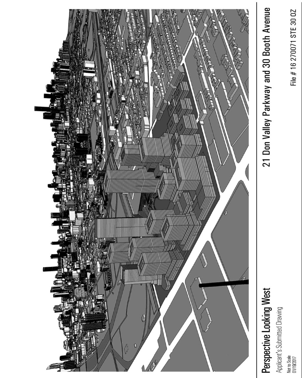
51 51

52 Attachment 9: Phasing Drawing 52
53 Attachment 10: Subdivision Plan 53

54 Attachment 11: Landscape Plan 54
Planning and Growth Management Committee. Chief Planner and Executive Director, City Planning Division
 PG10.7 STAFF REPORT ACTION REQUIRED 1, 5, 9 & 21 Don Valley Parkway; 6, 30 & 50 Booth Avenue; 0, 385, 405, 415, 433 & 447 Eastern Avenue - Official Plan Amendment Application - Preliminary Report Date:
South of Eastern Strategic Direction Status Update
 STAFF REPORT ACTION REQUIRED South of Eastern Strategic Direction Status Update Date: July 10, 2014 To: From: Planning and Growth Management Committee Chief Planner and Executive Director, City Planning
Official Plan Review: Draft Built Form Policies
 PG.30.1 REPORT FOR ACTION Official Plan Review: Draft Built Form Policies Date: May 15, 2018 To: Planning and Growth Management Committee From: Chief Planner and Executive Director, City Planning Division
Eglinton Avenue East & 50 Thermos Road - Official Plan Amendment Application Preliminary Report
 STAFF REPORT ACTION REQUIRED 1966 2050 Eglinton Avenue East & 50 Thermos Road - Official Plan Amendment Application Preliminary Report Date: March 15, 2016 To: From: Wards: Reference Number: Scarborough
30 and 44 Zorra Street - Zoning By-law Amendment Application - Preliminary Report
 STAFF REPORT ACTION REQUIRED 30 and 44 Zorra Street - Zoning By-law Amendment Application - Preliminary Report Date: March 14, 2016 To: From: Wards: Reference Number: Etobicoke York Community Council Director,
Bloor St. W. Rezoning - Preliminary Report
 STAFF REPORT ACTION REQUIRED 1638-1644 Bloor St. W. Rezoning - Preliminary Report Date: April 1, 2008 To: From: Wards: Reference Number: Toronto and East York Community Council Acting Director, Community
Planning and Growth Management Committee. Chief Planner and Executive Director, City Planning Division. Pg12013 (File No NNY 34 OZ)
") 865 York Mills Road Official Plan Amendment Application Preliminary Report STAFF REPORT ACTION REQUIRED Date: February 28, 2012 To: From: Wards: Reference Number: Planning and Growth Management Committee
865 York Mills Road Official Plan Amendment Application Preliminary Report STAFF REPORT ACTION REQUIRED Date: February 28, 2012 To: From: Wards: Reference Number: Planning and Growth Management Committee
Unilever Precinct Planning Study and East Harbour Application Review Update Report. Planning and Growth Management Committee
 PG24.1 STAFF REPORT ACTION REQUIRED Unilever Precinct Planning Study and East Harbour Application Review Update Report Date: October 24, 2017 To: From: Planning and Growth Management Committee Acting Chief
10 Park Lawn Rd - Zoning Amendment Application- Preliminary Report
 STAFF REPORT ACTION REQUIRED 10 Park Lawn Rd - Zoning Amendment Application- Preliminary Report Date: March 9, 2012 To: From: Wards: Reference Number: Etobicoke York Community Council Director, Community
112 College Street Zoning Amendment Application Preliminary Report
 ~TORONTO REPORT FOR ACTION 112 College Street Zoning Amendment Application Preliminary Report Date: January 25, 2019 To: Toronto and East York Community Council From: Director, Community Planning, Toronto
Director, Community Planning, Toronto and East York District
 Lower Yonge Precinct Plan Update STAFF REPORT ACTION REQUIRED Date: October 16, 2012 To: From: Wards: Reference Number: Toronto and East York Community Council Director, Community Planning, Toronto and
Town of Cobourg Heritage Master Plan. Statutory Public Meeting
 Town of Cobourg Heritage Master Plan Statutory Public Meeting April 25 th 2016 Presentation Overview 1. Introduction 2. Project background and schedule overview 3. Review of strategic direction content
350, 370, and 390 Queens Quay West Official Plan Amendment and Zoning Amendment Applications - Preliminary Report
 STAFF REPORT ACTION REQUIRED 350, 370, and 390 Queens Quay West Official Plan Amendment and Zoning Amendment Applications - Preliminary Report Date: April 22, 2016 To: From: Wards: Reference Number: Toronto
St. Lawrence Neighbourhood Focused Area - Official Plan Amendment Status Report
 STAFF REPORT ACTION REQUIRED St. Lawrence Neighbourhood Focused Area - Official Plan Amendment Status Report Date: May 21, 2015 To: From: Wards: Reference Number: Toronto and East York Community Council
8 Oak Street - Official Plan and Zoning By-law Amendment Application - Preliminary Report
 STAFF REPORT ACTION REQUIRED 8 Oak Street - Official Plan and Zoning By-law Amendment Application - Preliminary Report Date: March 17, 2014 To: From: Wards: Reference Number: Planning and Growth Management
PG30.5 REPORT FOR ACTION
 PG30.5 REPORT FOR ACTION Unilever Precinct Planning Study Secondary Plan and Planning Framework, and East Harbour Official Plan and Zoning By-law Amendment Applications Final Report Date: May 24, 2018
QUEEN-RIVER SECONDARY PLAN
 34 QUEEN-RIVER SECONDARY PLAN 34. QUEEN RIVER SECONDARY PLAN 1. INTRODUCTION The Queen-River area is approximately 6.4 hectares and is located at the eastern edge of the Downtown as shown on Map 34-1.
1071 King Street West Zoning Amendment Application - Preliminary Report
 STAFF REPORT ACTION REQUIRED 1071 King Street West Zoning Amendment Application - Preliminary Report Date: August 9, 2012 To: From: Wards: Reference Number: Toronto and East York Community Council Director,
SCARBOROUGH SUBWAY EXTENSION. Scarborough Subway Extension. Final Terms of Reference
 Scarborough Subway Extension Final Terms of Reference 1 1.0 Introduction and Background 1.1 Introduction Toronto City Council recently confirmed support for an extension of the Bloor-Danforth Subway from
Welcome. Walk Around. Talk to Us. Write Down Your Comments
 Welcome This is an information meeting introducing the applications for proposed redevelopment of the Yorkdale Shopping Centre site at 3401 Dufferin Street and 1 Yorkdale Road over the next 20+ years,
844 Don Mills Road & 1150 Eglinton Avenue East - Official Plan Amendment Application - Preliminary Report
 STAFF REPORT ACTION REQUIRED 844 Don Mills Road & 1150 Eglinton Avenue East - Official Plan Amendment Application - Preliminary Report Date: July 10, 2014 To: From: Wards: Reference Number: Planning and
The Master Plan Framework
 The Master Plan Framework The East Harbour Master Plan advances the development of 60 acres of former industrial lands east of the Don River. The Master Plan outlines a vision for a vibrant, transit-oriented
Public Open House. Overview of the Downtown Plan Official Plan Amendment April 23, 2018
 Public Open House Overview of the Downtown Plan Official Plan Amendment April 23, 2018 1 A 25-Year Plan for Downtown To ensure growth contributes positively to Toronto s Downtown as a great place to live,
4780 Eglinton Avenue West - Zoning By-law Amendment and Draft Plan of Subdivision Applications - Preliminary Report
 STAFF REPORT ACTION REQUIRED 4780 Eglinton Avenue West - Zoning By-law Amendment and Draft Plan of Subdivision Applications - Preliminary Report Date: May 29, 2014 To: From: Wards: Reference Number: Etobicoke
WELCOME TO THE SOUTH OF EASTERN OPEN HOUSE
 WELCOME TO THE SOUTH OF EASTERN OPEN HOUSE Providing for Good Jobs and Supporting Services in the South of Eastern Area City Planning has initiated the Unilever Precinct Planning Study to comprehensively
Edward R. Sajecki Commissioner of Planning and Building
 Corporate Report Clerk s Files Originator s Files CD.03.POR DATE: TO: FROM: SUBJECT: Chair and Members of Planning and Development Committee Meeting Date: February 27, 2012 Edward R. Sajecki Commissioner
SUBJECT: GO Station Mobility Hubs Preferred Concepts: Aldershot GO, Burlington GO and Appleby GO. Planning and Development Committee - Public Meeting
 Page 1 of Report PB-76-17 SUBJECT: GO Station Mobility Hubs Preferred Concepts: Aldershot GO, Burlington GO and Appleby GO TO: FROM: Planning and Development Committee - Public Meeting Planning and Building
Wellington Street West - Zoning Amendment Application - Preliminary Report
 STAFF REPORT ACTION REQUIRED 485-489 Wellington Street West - Zoning Amendment Application - Preliminary Report Date: September 26, 2016 To: From: Wards: Reference Number: Toronto and East York Community
523, 525 and 525A Adelaide Street West - Zoning Amendment Application - Preliminary Report
 STAFF REPORT ACTION REQUIRED 523, 525 and 525A Adelaide Street West - Zoning Amendment Application - Preliminary Report Date: May 12, 2012 To: From: Wards: Reference Number: Toronto and East York Community
9 CITY OF VAUGHAN OFFICIAL PLAN AMENDMENT NO BOCA EAST INVESTMENTS LIMITED
 9 CITY OF VAUGHAN OFFICIAL PLAN AMENDMENT NO. 631 - BOCA EAST INVESTMENTS LIMITED The Planning and Economic Development Committee recommends the adoption of the recommendations contained in the following
1296 Kennedy Road - Zoning Amendment Application - Preliminary Report
 STAFF REPORT ACTION REQUIRED 1296 Kennedy Road - Zoning Amendment Application - Preliminary Report Date: January 15, 2016 To: From: Wards: Reference Number: Scarborough Community Council Acting Director,
Queen Street West - Zoning Amendment Application - Preliminary Report
 STAFF REPORT ACTION REQUIRED 944-952 Queen Street West - Zoning Amendment Application - Preliminary Report Date: February 6, 2013 To: From: Wards: Reference Number: Toronto and East York Community Council
30 Bay Street and 50 Harbour Street - Zoning Amendment Application - Preliminary Report
 STAFF REPORT ACTION REQUIRED 30 Bay Street and 50 Harbour Street - Zoning Amendment Application - Preliminary Report Date: May 18, 2018 To: From: Wards: Reference Number: Toronto and East York Community
SUBJECT: Proposed Downtown Mobility Hub Precinct Plan and Proposed Official Plan Policies
 Page 1 of Report PB-81-17 SUBJECT: Proposed Downtown Mobility Hub Precinct Plan and Proposed Official Plan Policies TO: FROM: Committee of the Whole Planning and Building Department Report Number: PB-81-17
SUBJECT: Waterfront Hotel Planning Study Update TO: Planning and Development Committee FROM: Department of City Building. Recommendation: Purpose:
 Page 1 of Report PB-23-18 SUBJECT: Waterfront Hotel Planning Study Update TO: Planning and Development Committee FROM: Department of City Building Report Number: PB-23-18 Wards Affected: 2 File Numbers:
150 Eighth Street Zoning By-law Amendment Application Preliminary Report
 REPORT FOR ACTION 150 Eighth Street Zoning By-law Amendment Application Preliminary Report Date: March 27, 2019 To: Etobicoke York Community Council From: Director, Community Planning, Etobicoke York District
Report to: Development Services Committee Report Date: September 11, 2017
 ~RKHAM Report to: Development Services Committee Report Date: September 11, 2017 SUBJECT: PREPARED BY: Conceptual Master Plan for the Future Urban Area - Community Structure Plan and Key Policy Direction
and Richmond Street West - Official Plan Amendment Application - Preliminary Report
 STAFF REPORT ACTION REQUIRED 822-838 and 860-862 Richmond Street West - Official Plan Amendment Application - Preliminary Report Date: August 14, 2017 To: From: Wards: Reference Number: Toronto and East
5959 Yonge Street Rezoning Application - Preliminary Report
 STAFF REPORT ACTION REQUIRED 5959 Yonge Street Rezoning Application - Preliminary Report Date: February 23, 2011 To: From: Wards: Reference Number: North York Community Council Director, Community Planning,
Welcome to the Oakridge Centre Open House
 Welcome to the Oakridge Centre Open House Why is the City hosting this event? This open house is to inform you of a rezoning application submitted to the City of Vancouver to amend the existing CD-1 (Comprehensive
599 Kennedy Road - Official Plan Amendment and Zoning Amendment Application - Preliminary Report
 STAFF REPORT ACTION REQUIRED 599 Kennedy Road - Official Plan Amendment and Zoning Amendment Application - Preliminary Report Date: March 7, 2017 To: From: Wards: Reference Number: Scarborough Community
77-79 East Don Roadway and Queen Street East Zoning Amendment Applications Final Report
 STAFF REPORT ACTION REQUIRED 77-79 East Don Roadway and 661-677 Queen Street East Zoning Amendment Applications Final Report Date: October 23, 2015 To: From: Wards: Reference Number: Toronto and East York
Yonge Street Zoning Amendment Application - Preliminary Report
 STAFF REPORT ACTION REQUIRED 341-355 Yonge Street Zoning Amendment Application - Preliminary Report Date: March 24, 2011 To: From: Wards: Reference Number: Toronto and East York Community Council Director,
King-Spadina Secondary Plan Community Consultation Meeting. Michelle Knieriem, City Planner October 11, 2017
 King-Spadina Secondary Plan Community Consultation Meeting Michelle Knieriem, City Planner October 11, 2017 Agenda 6:30 Welcome 6:35 Presentation 7:15 Question and Answer Session 8:15 Closing Remarks HOW
TOcore: Downtown Plan Official Plan Amendment
 PG29.4 REPORT FOR ACTION TOcore: Downtown Plan Official Plan Amendment Date: April 17, 2018 To: Planning and Growth Management Committee From: Chief Planner and Executive Director, City Planning Wards:
Report to: Development Services Committee Report Date: April 24, 2017
 SUBJECT: Cornell Rouge National Urban Park Gateway - Report on Design Charrette and Next Steps PREPARED BY: Lilli Duoba, MES, MCIP, RPP, Manager, Natural Heritage (ext. 7925) REVIEWED BY: Marg Wouters,
Figure 1- Site Plan Concept
 Figure 1- Site Plan Concept Parking will be provided underground on three levels at rate of 1.0 space/ unit; this rate includes all visitors parking. MMM Group has prepared a parking assessment (April,
280 Manse Road - Official Plan Amendment, Zoning Amendment, Draft Plan of Subdivision Applications - Preliminary Report
 STAFF REPORT ACTION REQUIRED 280 Manse Road - Official Plan Amendment, Zoning Amendment, Draft Plan of Subdivision Applications - Preliminary Report Date: March 11, 2014 To: From: Wards: Reference Number:
5 TOWN OF MARKHAM OFFICIAL PLAN AMENDMENT NO. 144 MILLIKEN MAIN STREET SECONDARY PLAN
 5 TOWN OF MARKHAM OFFICIAL PLAN AMENDMENT NO. 144 MILLIKEN MAIN STREET SECONDARY PLAN The Planning and Economic Development Committee recommends the following: 1. The communication from Brendan O Callaghan,
646 Kingston Road - Official Plan Amendment and Zoning Amendment Applications - Preliminary Report
 STAFF REPORT ACTION REQUIRED 646 Kingston Road - Official Plan Amendment and Zoning Amendment Applications - Preliminary Report Date: December 8, 2014 To: From: Wards: Reference Number: Toronto and East
Chairman and Members of the Planning and Development Committee. Thomas S. Mokrzycki, Commissioner of Planning and Building
 LA.09.TOR (Toronto) DATE: TO: FROM: SUBJECT: Chairman and Members of the Planning and Development Committee Thomas S. Mokrzycki, Commissioner of Planning and Building Central Waterfront Secondary Plan
SECTION ONE: INTRODUCTION. introduction
 introduction 1 INTRODUCTION Since it was first established in 1843 as a trading post for the Hudson s Bay Company, Victoria has evolved into a Provincial capital city that is recognized across Canada and
1.0 Purpose of a Secondary Plan for the Masonville Transit Village
 Report to Planning and Environment Committee To: Chair and Members Planning & Environment Committee From: John M. Fleming Managing Director, Planning and City Planner Subject: Masonville Transit Village
333 College Street and 303 Augusta Avenue - Official Plan Amendment, Zoning Amendment Applications - Preliminary Report
 STAFF REPORT ACTION REQUIRED 333 College Street and 303 Augusta Avenue - Official Plan Amendment, Zoning Amendment Applications - Preliminary Report Date: March 12, 2015 To: From: Wards: Reference Number:
240 and 242 Finch Avenue West Zoning By-law Amendment Application Preliminary Report
 REPORT FOR ACTION 240 and 242 Finch Avenue West Zoning By-law Amendment Application Preliminary Report Date: March 1, 2019 To: North York Community Council From: Director, Community Planning, North York
CITY OF VAUGHAN EXTRACT FROM COUNCIL MEETING MINUTES OF NOVEMBER 15, 2016
 Item 11, Report No. 38, of the Committee of the Whole, which was adopted without amendment by the Council of the City of Vaughan on November 15, 2016. Regional Councillor Di Biase declared an interest
7437, 7439 and 7441 Kingston Road - Zoning By-law Amendment and Site Plan Control Applications - Preliminary Report
 STAFF REPORT ACTION REQUIRED 7437, 7439 and 7441 Kingston Road - Zoning By-law Amendment and Site Plan Control Applications - Preliminary Report Date: August 13, 2015 To: From: Wards: Reference Number:
YONGE STEELES CORRIDOR SECONDARY PLAN. Young + Wright / IBI Group Architects Dillon Consulting Ltd. GHK International (Canada) Ltd.
 Ltd.") PART A: PREAMBLE 1.0 PURPOSE The purpose of this Secondary Plan is to provide a development framework for intensification of the Yonge/ Steeles corridor including the north side of Steeles Avenue West
PART A: PREAMBLE 1.0 PURPOSE The purpose of this Secondary Plan is to provide a development framework for intensification of the Yonge/ Steeles corridor including the north side of Steeles Avenue West
The West Vaughan Employment Area Secondary Plan Policies
 Part 2: The West Vaughan Employment Area Secondary Plan Policies 2.1 General Policies It is the policy of Council: 2.1.1. That the West Vaughan Employment Area (the WVEA), identified on Schedule 1, will
Complete Neighbourhood Guidelines Review Tool
 Complete Neighbourhood Guidelines Review Tool Prepared By: City of Regina Planning Department October 2014 Page 1 of 14 Community Development Review Checklist for Secondary Plans and Concept Plans The
4155 Yonge Street Official Plan Amendment and Rezoning Application Preliminary Report
 STAFF REPORT ACTION REQUIRED 4155 Yonge Street Official Plan Amendment and Rezoning Application Preliminary Report Date: May 5, 2011 To: From: Wards: Reference Number: North York Community Council Director,
49 to 51 Camden St - Zoning Amendment Application - Preliminary Report
 STAFF REPORT ACTION REQUIRED 49 to 51 Camden St - Zoning Amendment Application - Preliminary Report Date: October 23, 2015 To: From: Wards: Reference Number: Toronto and East York Community Council Director,
393, 395, 397, 399, 401 and 403 Spring Garden Avenue Official Plan and Zoning By-law Amendment Application Preliminary Report
 STAFF REPORT ACTION REQUIRED 393, 395, 397, 399, 401 and 403 Spring Garden Avenue Official Plan and Zoning By-law Amendment Application Preliminary Report Date: March 29, 2010 To: From: Wards: Reference
6 Growth Management Challenges and Opportunities
 6 Growth Management Challenges and Opportunities The Town has established a goal of attaining a 50% participation rate with respect to employment opportunities versus residential population. The Town s
2161 Yonge Street - Zoning Amendment Application - Preliminary Report
 STAFF REPORT ACTION REQUIRED 2161 Yonge Street - Zoning Amendment Application - Preliminary Report Date: September 29, 2017 To: From: Wards: Reference Number: Toronto and East York Community Council Director,
1151 Queen Street East - Zoning Amendment Application - Preliminary Report
 STAFF REPORT ACTION REQUIRED 1151 Queen Street East - Zoning Amendment Application - Preliminary Report Date: June 12, 2018 To: From: Wards: Reference Number: Toronto and East York Community Council Acting
1 Introduction. Chapter. In this chapter:
 Chapter 1 Introduction In this chapter: 1.1 A Snapshot of the Region 1.2 Towards a Sustainable Region 1.3 The Provincial Context 1.4 Purpose and Organization The Regional Municipality of York Official
PART 1. Background to the Study. Avenue Study. The Danforth
 The Danforth 1.1/ Study Purpose & Key Municipal Goals 1.2/ The Local Advisory Committee 1.3/ The Project Team 1.4/ Study Process/Summary of Method 1.5/ Summary of Consultation 1.1 Study Purpose and Key
808 Mount Pleasant Road Zoning Amendment Application Request for Interim Direction Report
 STAFF REPORT ACTION REQUIRED 808 Mount Pleasant Road Zoning Amendment Application Request for Interim Direction Report Date: June 15, 2018 To: From: Wards: Reference Number: Toronto and East York Community
Tippett Road Area Regeneration Study Final Report. Planning and Growth Management Committee
 PG8.6 STAFF REPORT ACTION REQUIRED Tippett Road Area Regeneration Study Final Report Date: October 23, 2015 To: From: Wards: Reference Number: Planning and Growth Management Committee Chief Planner and
The Corporation of the Town of Milton
 Report To: From: Council Barbara Koopmans, Commissioner, Planning and Development Date: May 7, 2018 Report No: Subject: Making it Possible Positioning the Town s Strategy for Growth and Economic Development
251 Manitoba Street- Official Plan Amendment and Zoning By-law Amendment Application- Preliminary Report
 STAFF REPORT ACTION REQUIRED 251 Manitoba Street- Official Plan Amendment and Zoning By-law Amendment Application- Preliminary Report Date: February 5, 2014 To: From: Wards: Reference Number: Etobicoke
Emery Village Road 2A Municipal Class Environmental Assessment Study
 PW12.11 STAFF REPORT ACTION REQUIRED Emery Village Road 2A Municipal Class Environmental Assessment Study Date: March 30, 2016 To: From: Wards: Reference Number: Public Works and Infrastructure Committee
4800 Yonge Street - Official Plan Amendment, Zoning Amendment and Site Plan Applications - Request for Direction Report
 STAFF REPORT ACTION REQUIRED 4800 Yonge Street - Official Plan Amendment, Zoning Amendment and Site Plan Applications - Request for Direction Report Date: April 16, 2018 To: From: Wards: Reference Number:
158, 164, 181 and 200 Sterling Rd - Official Plan Amendment and Zoning Amendment Applications - Preliminary Report
 STAFF REPORT ACTION REQUIRED 158, 164, 181 and 200 Sterling Rd - Official Plan Amendment and Zoning Amendment Applications - Preliminary Report Date: November 16, 2011 To: From: Wards: Reference Number:
CITY CLERK. Parkland Acquisition Strategic Directions Report (All Wards)
") CITY CLERK Clause embodied in Report No. 10 of the, as adopted by the Council of the City of Toronto at its meeting held on November 6, 7 and 8, 2001. 10 Parkland Acquisition Strategic Directions Report
CITY CLERK Clause embodied in Report No. 10 of the, as adopted by the Council of the City of Toronto at its meeting held on November 6, 7 and 8, 2001. 10 Parkland Acquisition Strategic Directions Report
4121 Lawrence Avenue East Rezoning Application Preliminary Report
 STAFF REPORT ACTION REQUIRED 4121 Lawrence Avenue East Rezoning Application Preliminary Report Date: October 11, 2011 To: From: Wards: Reference Number: Scarborough Community Council Director, Community
2450 Victoria Park Avenue Official Plan Amendment Application Preliminary Report
 STAFF REPORT ACTION REQUIRED 2450 Victoria Park Avenue Official Plan Amendment Application Preliminary Report Date: December 19, 2012 To: From: Wards: Reference Number: Planning and Growth Management Committee
Workshop 3. City of Burlington Waterfront Hotel Planning Study. September 14, The Planning Partnership
 Workshop 3 City of Burlington Waterfront Hotel Planning Study September 14, 2017 The Planning Partnership The Waterfront Hotel Planning Study 01 The Brant & Lakeshore Planning Study will establish a Strategic
1350 Ellesmere Road and 1560 Brimley Road Zoning Amendment Application - Preliminary Report
 STAFF REPORT ACTION REQUIRED 1350 Ellesmere Road and 1560 Brimley Road Zoning Amendment Application - Preliminary Report Date: December 6, 2017 To: From: Wards: Reference Number: Scarborough Community
GARDINER EXPRESSWAY AND LAKE SHORE BOULEVARD EAST RECONFIGURATION ENVIRONMENTAL ASSESSMENT Planning, Urban Design, Public Realm and Socio- Economic
 GARDINER EXPRESSWAY AND LAKE SHORE BOULEVARD EAST RECONFIGURATION ENVIRONMENTAL ASSESSMENT Socio- Economic Background Conditions Report - 2014 Socio-Economic Background Conditions Report 2014 TABLE OF
Mark-up of the effect of the proposed Bronte Village Growth Area OPA No.18 on the text of section 24, Bronte Village, of the Livable Oakville Plan
 Mark-up of the effect of the proposed Bronte Village Growth Area OPA No.18 on the text of section 24, Bronte Village, of the Livable Oakville Plan Notes: This document is provided for information purposes
A BLUEPRINT FOR BROCKTON A CITY-WIDE COMPREHENSIVE PLAN
 A BLUEPRINT FOR BROCKTON A CITY-WIDE COMPREHENSIVE PLAN Public Meeting October 2016 1 Plan Summary and Discussion Public Meeting May 4 2017 City of Brockton Bill Carpenter, Mayor Department of Planning
Town Center (part of the Comprehensive Plan)
") Town Center (part of the Comprehensive Plan) Mercer Island Town Center Looking North (2014) In 1994, a year-long process culminated in a set of design guidelines and code requirements for the Town Center
Town Center (part of the Comprehensive Plan) Mercer Island Town Center Looking North (2014) In 1994, a year-long process culminated in a set of design guidelines and code requirements for the Town Center
Pearl Street and 15 Duncan Street - Zoning Amendment Application - Request for Direction Report
 STAFF REPORT ACTION REQUIRED 150-158 Pearl Street and 15 Duncan Street - Zoning Amendment Application - Request for Direction Report Date: April 16, 2018 To: From: Wards: Reference Number: Toronto and
LAND USE AMENDMENT DOWNTOWN COMMERCIAL CORE (WARD 7) MACLEOD TRAIL SE AND 5 AVENUE SE BYLAW 254D2017
 MACLEOD TRAIL SE AND 5 AVENUE SE BYLAW 254D2017") Page 1 of 10 EXECUTIVE SUMMARY This Land Use Amendment application seeks to redesignate a full downtown block (currently the YWCA site) from a Direct Control based on the CM-2 District (Land Use Bylaw
Page 1 of 10 EXECUTIVE SUMMARY This Land Use Amendment application seeks to redesignate a full downtown block (currently the YWCA site) from a Direct Control based on the CM-2 District (Land Use Bylaw
Official Plan Review
 Official Plan Review Summary Report - The Built Environment August 2014 Part 1: Introduction Planning for a healthy, prosperous and sustainable community is an important goal for our municipality. From
60-64 Queen Street East and Church Street - Zoning Amendment Application - Preliminary Report
 STAFF REPORT ACTION REQUIRED 60-64 Queen Street East and 131-135 Church Street - Zoning Amendment Application - Preliminary Report Date: March 15, 2018 To: From: Wards: Reference Number: Toronto and East
DOWNTOWN PARKS & PUBLIC REALM PLAN
 DOWNTOWN PARKS & PUBLIC REALM PLAN CHALLENGES The Parks and Public Realm Strategy addresses challenges associated with a growing Downtown, including: GOALS 3.3 New buildings will fit within their existing
ELMVALE ACRES SHOPPING CENTRE MASTER PLAN
 ELMVALE ACRES SHOPPING CENTRE MASTER PLAN Contents 1.0 INTRODUCTION... 2 2.0 LOCATION... 2 3.0 EXISTING CONTEXT... 2 4.0 VISION & GUIDING PRINCIPLES... 2 5.0 LAND USE AND BUILT FORM... 4 5.1 St. Laurent
THE TOWN OF WASAGA BEACH
 THE TOWN OF WASAGA BEACH Downtown Development Master Plan Committee of the Whole Presentation January 26 th 2017 Uses within this designation should reflect a dependence on tourism as opposed to the permanent
Stanley Greene District Downsview (80 Carl Hall Road) Zoning By-law Amendment and Draft Plan of Subdivision Applications Request for Direction Report
 Zoning By-law Amendment and Draft Plan of Subdivision Applications Request for Direction Report") STAFF REPORT ACTION REQUIRED Stanley Greene District Downsview (80 Carl Hall Road) Zoning By-law Amendment and Draft Plan of Subdivision Applications Request for Direction Report Date: December 16, 2011
STAFF REPORT ACTION REQUIRED Stanley Greene District Downsview (80 Carl Hall Road) Zoning By-law Amendment and Draft Plan of Subdivision Applications Request for Direction Report Date: December 16, 2011
770 Don Mills Road and 805 Don Mills Road - Official Plan Amendment and Zoning By-law Amendment Application Preliminary Report
 REPORT FOR ACTION 770 Don Mills Road and 805 Don Mills Road - Official Plan Amendment and Zoning By-law Amendment Application Preliminary Report Date: To: From: Wards: June 22, 2018 North York Community
From: Director, Community Planning, Etobicoke York District
 STAFF REPORT ACTION REQUIRED 4208, 4210 and 4214 Dundas Street West - Official Plan Amendment and Zoning By-law Amendment Application - Preliminary Report Date: July 22, 2014 To: Etobicoke York Community
1-17 Anndale Drive, Bales Avenue and Glendora Avenue Zoning Amendment Application Preliminary Report
 STAFF REPORT ACTION REQUIRED 1-17 Anndale Drive, 31-35 Bales Avenue and 22-70 Glendora Avenue Zoning Amendment Application Preliminary Report Date: August 20, 2007 To: From: Wards: Reference Number: North
13 THORNHILL YONGE STREET STUDY IMPLEMENTATION CITY OF VAUGHAN OPA 669 AND TOWN OF MARKHAM OPA 154
 13 THORNHILL YONGE STREET STUDY IMPLEMENTATION CITY OF VAUGHAN OPA 669 AND TOWN OF MARKHAM OPA 154 The Planning and Economic Development Committee recommends the adoption of the recommendations contained
THE CITY OF VAUGHAN BY-LAW BY-LAW NUMBER A By-law to adopt Amendment Number 1 to the Official Plan of the Vaughan Planning Area.
 THE CITY OF VAUGHAN BY-LAW BY-LAW NUMBER 015-2014 A By-law to adopt Amendment Number 1 to the Official Plan of the Vaughan Planning Area. NOW THEREFORE the Council of the Corporation of the City of Vaughan
2494 Danforth Avenue - Official Plan Amendment and Zoning Amendment Application - Preliminary Report
 STAFF REPORT ACTION REQUIRED 2494 Danforth Avenue - Official Plan Amendment and Zoning Amendment Application - Preliminary Report Date: March 15, 2018 To: From: Wards: Reference Number: Toronto and East
URBAN DESIGN BRIEF. 2136&2148 Trafalgar Road. Town of Oakville
 URBAN DESIGN BRIEF 2136&2148 Trafalgar Road Town of Oakville Prepared By: METROPOLITAN CONSULTING INC For 2500674 Ontario Inc November 2016 TABLE OF CONTENTS Page No. 1.0 Introduction/Description of Subject
Committee of the Whole Report
 Item: Committee of the Whole Report DATE: Monday, September 17, 2018 WARD: 4 TITLE: ZONING BY-LAW AMENDMENT FILE Z.17.036 SITE DEVELOPMENT FILE DA.17.083 IVANHOE CAMBRIDGE VICINITY OF JANE STREET AND RUTHERFORD