Bray Town Council. 00 Chapter heading
|
|
|
- Katherine West
- 5 years ago
- Views:
Transcription

1 Bray Town Council 00 Chapter heading Development Plan 2005 to 2011

2 Bray Town Council 00 Chapter heading Development Plan 2005 to 2011 Bray Town Council Comhairle Baile Bhré Civic Offices Main Street Bray County Wicklow Telephone: Fax: VPN: Copyright Bray Town Council 2005
3 Chapter 1: Introduction Contents 1.1 Introduction to Bray Development Plan ( ) Structure of Bray Development Plan The Written Statement Maps National Plans, Policies and Strategies Financial Considerations Plan Period Plan Implementation 5 Chapter 2: Overall Strategy 2.1 Strategic Vision and Policy Objectives of the Bray Development Plan Strategic Vision Strategic Policy Objectives Demographic and Socio-Economic Context Population Age and Sex Household Structure and Size Employment Strategic Planning Context National Spatial Strategy Regional Planning Guidelines, Greater Dublin Area Sustainable Development Local Planning Context Factors Impacting on Development Town Function and Role 16 Chapter 3: Housing 3.1 Vision Context Bray Town Council Housing Strategy Introduction Statutory Requirements Review of Bray Housing Strategy and Proposed Amendments Housing Strategy Housing Demand Projection Capacity of Supply Social and Affordable Housing Requirements Direct Provision of Social Housing Including Special Needs 22
4 Contents Provision of Social and Affordable Housing through Part V of the 25 Planning and Development Act Policy for the Implementation of the Housing Strategy Planning Permissions and Part V of the Planning and Development Act, Integrated Framework Plan for Land Use and Transportation Promoting the Role of Housing Agencies Social Housing Housing Mix Special Needs Housing Countering Social Segregation Other Policy High Residential Densities Infill Residential Development Quality Residential Environments Sustainability and Energy Efficiency Protecting Civic, Community and Educational Lands Ardbrae Park 32 Chapter 4: Retail and Town Centre 4.1 Vision Context Strategy Policy Retail Strategy Bray Town Centre Vitality and Viability Town Centre Expansion Living Over the Shop Shopfronts Laneways Large Foodstores Discount Foodstores Local Convenience Shops Retail Warehouses Local Neighbourhood Centres Opportunity Sites Derelict Sites 42
5 Contents Chapter 5: Economic Development and Tourism 5.1 Vision Context Strategy Policy Economic Development Office Development Knowledge-Based Industries Bray Enterprise Centre Small and Medium Enterprises Tourism The Film Industry 49 Chapter 6: Community 6.1 Vision Context Strategy Policy County Development Strategy Community Development Childcare The Arts Festivals Libraries Social Inclusion Equality Proofing The Disabled Public Participation and Consultation Crime and Anti-Social Behaviour Education and Health Services Burial Grounds Development Contribution Scheme 58
6 Contents Chapter 7: Transport 7.1 Vision Context Strategy Policy Implementation of D.T.O. Policy Integrating Land Use and Transportation Policies Bray and Environs Transportation Study Traffic Management in Town Centre Car Parking Control Cycling and Walking Public Transport Road Development Road Signage Access for the Mobility Impaired Traffic Calming Luas/Metro Rights of Way Purchase of Road Making Materials 68 Chapter 8: Natural, Architectural and Archaeological Heritage 8.1 Vision Context Strategy Policy Wicklow County Heritage Plan Promoting Public Knowledge Views and Prospects Natural Heritage Architectural Heritage Archaeological Heritage Bray Heritage Centre 80
7 Contents Chapter 9: Recreation and Open Space 9.1 Vision Context Strategy Policy The Dargle River Bray Beach and Seafront Naylor s Cove Play Facilities Open Space Floodlighting and Recreational Facilities Sport and Recreation Bray Swimming Pool 87 Chapter 10: Public Services 10.1 Vision Context Strategy Policy Waste Management Litter Water Supply Waste Water Collection and Disposal Flooding Energy and Communication Networks Management of Watercourses 93 Chapter 11: Bray Seafront Area 11.1 Context Development Objectives The B2 and B3 Zone Open Space (E1 Zone) and Beach 96
8 Contents Chapter 12: Development Control Standards and Guidelines 12.1 Introduction General Site Development Standards Plot Ratio Site Coverage Building Lines Building Height Control Residential Development General Guidelines Open Space Apartments Subdivision of Dwelling into Flats Granny/Family Flat Retail and Commercial Development General Guidelines Take Aways, Fast Food Outlets, Amusement Centres, Night Clubs/ 107 Licensed Premises, Open Air Concerts, Charity Outlets and Discount Outlets Bookmaking Offices Taxi Offices Shopfronts Industrial/Employment Developments Storage Requirements Advertising and Signage Advertising Hoardings Advertising on Bus Shelters Petrol Filling Stations Automated Teller Machines Roads and Transportation Facilities Parking and Loading Cycle Facilities Mobility Management Plans Environmental Pollution Air Pollution Noise Emissions or Vibrations Major Accident Hazards Utilities Mobile Telecommunications Infrastructure Other Utility Infrastructure Septic Tanks Nursing Homes Guidelines for Access for People with Disabilities 116
9 Contents Chapter 13: Land Use Zoning Objectives 13.1 Land Use Zoning Objectives Non-conforming Uses Transitional Areas Phased Development Not Normally Permitted but Open for Consideration Not Permitted Acceptability of Uses in Each Zone Acceptability of Uses in the A1: Primarily Residential Zone Acceptability of Uses in B1: Primarily Town Centre Uses Zone Acceptability of Uses in the B2: Primarily Seafront Uses Zone Acceptability of Uses in the B3: Primarily Seafront Uses Zone Acceptability of Uses in the C: Employment Uses Zone Acceptability of Uses in the C1: Employment Uses Zone Acceptability of Uses in the D1: Primarily Civic, Community 124 and Educational Uses Zone Acceptability of Uses in the D2: Solely Educational Uses Zone Acceptability of Uses in the E1: Solely Open Space Zone Acceptability of Uses in the E2: Solely Open Space Zone Acceptability of Uses in the E3: Solely Open Space Zone Acceptability of Uses in the E4: Solely Open Space Zone Acceptability of Uses in the F2: Mixed Use Development Zone Acceptability of Uses in the G: Local Neighbourhood Centre Zone Acceptability of Uses in the G1: Local Neighbourhood Centre Zone 128 Chapter 14: Bray Golf Club Lands Area Action Plan 14.1 Introduction Context Action Plan Objectives Transport Flooding Protection of Existing Trees Zone 1: Town Centre Zone 2: Open Space and Community Zone 3: Residential Planning Applications 136
10 Contents Chapter 15: Bray Harbour and North Beach Area Action Plan 15.1 Introduction Action Plan Objectives Zone 1: Harbour and Marina Zone 2: Residential Open Space and Recreational Planning Applications 144 Chapter 16: Rehills Land Area Action Plan 16.1 Introduction Context Action Plan Objectives Zone 1: Mixed Use Zone 2: Active and Passive Open Space Zone 3: Residential Planning Applications 152 Appendices Appendix 1: Strategic Environmental Assessment 156 Appendix 2: Area Action Plan: Details to accompany submission of 158 planning application

11 1 Introduction
12 1 Introduction 1.1 Introduction to Bray Development Plan ( ) The Bray Development Plan will set out an overall strategy for the proper planning and sustainable development of the administrative area of Bray Town Council for the period 2005 to The Plan will provide for, and control, the physical, economic and social development of the town, in the interests of the overall common good. It will provide the means by which the specific objectives and activities of the private and public sector will be co-ordinated, to ensure that they are implemented in a mutually integrated, consistent, sustainable and supportive manner. It will promote and encourage development, conserve and protect the environment and make the best possible use of resources. The Planning and Development Act, 2000 indicates the mandatory objectives that must be included in the Bray Development Plan. To this accord, the Plan includes objectives for: the zoning of land for particular land use purposes; the provision of infrastructure including transport, energy and communication facilities, water supplies, waste recovery and disposal facilities, waste water services and ancillary facilities; the conservation and protection of the environment including archaeological and natural heritage, and the conservation and protection of sites; the integration of the planning and sustainable development of the area with the social, community and cultural requirements of the area and its population; the preservation of the character of the landscape where the proper planning and sustainable development of the area requires it, including the preservation of views and prospects and the amenities of places and features of natural beauty or interest; the protection of structures, or parts of structures, which are of special architectural, historical, archaeological, artistic, cultural, scientific, social or technical interest; the development and renewal of areas in need of regeneration; the provision of accommodation for Travellers, and the use of particular areas for that purpose; the preservation, improvement and extension of amenities and recreational amenities; the control of establishments affected by the provisions of the Major Accidents Directive; the provision of services for the community including schools, crèches and other education and childcare facilities. 2
13 1 Introduction 1.2 Structure of Bray Development Plan The Plan consists of a written statement and a series of maps, which provide the development objectives for the area The Written Statement The written statement comprises a series of chapters, which outline the development objectives for the administrative area of Bray Town Council. The written statement is made up of the following elements: The Overall Strategy provides the Strategic Vision and Strategic Policy Objectives of the Plan. These are framed within the general planning and development context within which the Plan is set. The core of the Plan is made up of numerous chapters that focus specifically on providing detailed development objectives in relation to the following land uses: Housing Retail and Town Centre Economic Development and Tourism Community Transport Natural, Architectural and Archaeological Heritage Recreation and Open Space Public Services Bray Seafront Area Each of the above chapters includes the following elements: Vision: This identifies the overall vision for the proper planning and sustainable development of the particular development type. Context: This outlines the national, regional and local context within which each chapter is framed. It provides the relevant strategies and guidelines to which the Plan shall have regard. Strategy: The Strategy identifies the existing situation within Bray and provides the background and reasoning for the specific policies and objectives. Policies: The policies set out the specific and detailed aims of the Council for the proper planning and sustainable development of the town. Chapters 12 and 13 provide the Development Control Standards and Guidelines and the Land Use Zoning Objectives for the Plan. Chapters include Area Action Plans, which provide specific standards and guidelines for the development of mixed-use areas, including Bray Golf Club Lands, Bray Harbour and North Beach, and Rehills Land. The final component of the Plan comprises Appendices. 2 Lorem ipsum dolor sit amet, 3
14 1 Introduction Maps The maps provide a graphic representation of the written statement of the Plan. They indicate land use and other development standards together with various objectives of the Council. The maps do not purport to be accurate survey maps from which site dimensions or other survey data can be measured. Should any conflict arise between the written statement and the map, the written statement shall prevail. The Plan relates to the functional area of Bray Town Council, as delineated on the map. Parts of the built-up area of Bray are located in the adjoining functional areas of Wicklow County Council and Dun Laoghaire-Rathdown County Council and the planning and development of these areas is governed by the appropriate Development Plans of these Councils. 1.3 National Plans, Policies and Strategies The Plan will, in so far as is practicable, be consistent with such national plans, policies or strategies as the Minister determines relate to proper planning and sustainable development. These plans, policies and strategies provide the national and regional context within which the Plan is made. The relevant documents relating to the formulation of policies are provided in the Context section of each Chapter. The Planning and Development Act, 2000 states that in making a Development Plan, a planning authority shall have regard to the Development Plans of adjoining planning authorities and shall co-ordinate the objectives in the Development Plan with the objectives in the Plans of those authorities, except where the planning authority considers it to be inappropriate or not feasible to do so. The development objectives included in the Development Plans for Wicklow County and Dun Laoghaire-Rathdown County have been considered along with the potential significant effects that the implementation of the Bray Development Plan will have on the areas of Wicklow County Council and Dun Laoghaire- Rathdown County Council. 1.4 Financial Considerations This Development Plan has taken account of prevailing economic conditions as they affect public and private investment. The nature of the statutory Development Plan process is such that no budget is agreed in advance for the implementation of the Development Plan and no funding is guaranteed. The implementation of the Development Plan is dependent on factors largely outside the control of Bray Town Council; on the one hand the funding of major infrastructural projects by Central Government and on the other hand by the willingness of the private sector to invest in new developments. Given the degree of difficulty in predicting the allocation of state funding in future years, the various policy measures and objectives put forward in this Plan will be subject to regular review. Particular objectives may be modified or deleted and new works, which may become necessary, and are not included in the specific objectives, may be initiated, depending on the availability of finance and the sanctioning of works by Central Government. 4
15 1 Introduction 1.5 Plan Period Although set within the context of a twenty year planning horizon, the period of this Plan is six years from the date of adoption, unless circumstances dictate that the Plan should be reviewed earlier, or a variation of the Plan is made. 1.6 Plan Implementation The implementation of the Bray Development Plan will secure the future development of Bray and its environs in a sustainable and integrated manner. The Plan will provide a platform for the development of a healthy economy and environment, which in turn will create conditions for social progress and a better quality of life. These benefits will be realised in a manner that meets the requirements of the town s present population, while also safeguarding the physical, economic and social environment of the town for the enjoyment of future generations. Any publications or standards referred to in this Plan that are required to be complied with, are those relevant at the time of drafting the Plan. The requirements of succession or other relevant documents produced subsequently, should also be complied with. 5

16 2 Overall Strategy
17 2.1.1 Vision It is the Vision of Bray Town Council to provide in full for the development needs of Bray in accordance with the principle of sustainable development, so that Bray becomes a thriving community, sustaining a high quality of life for all, while its valuable environment and heritage is safeguarded.
18 2 Overall Strategy 2.1 Strategic Vision and Policy Objectives for the Bray Development Plan The Strategic Vision and Strategic Policy Objectives of the Bray Development Plan ( ) provide the overall strategy of Bray Town Council for the proper planning and sustainable development of Bray for the period up to The Vision and Policy Objectives are framed within the demographic, socio-economic, and strategic and local planning contexts within which the town s future development is mapped out Strategic Policy Objectives It is the policy of Bray Town Council to: promote Bray as a regional centre of economic, social, cultural and ecological growth; ensure an adequate supply of zoned and serviced land is provided, to meet anticipated development needs; consolidate the urban form of the town through: promoting the use of under-utilised physical and social infrastructure via the redevelopment of brownfield and derelict sites; promoting a more intensive use of existing residential, community and industrial stock, via the promotion of increased densities, Living Over The Shop (LOTS), infill housing and development of employment zoned areas; regeneration of declining residential and industrial areas. improve the economic competitiveness of Bray through: increasing the quantity and quality of retail development, particularly within the town centre; facilitating the expansion and diversification of the existing employment base via the development of industry, commerce and other economic activity. retain the town s population through providing a sufficient amount of affordable residential units in the town, and facilitating the development of infrastructure, services, employment and social opportunities to meet the needs of the population; improve the image and attractiveness of Bray Town Centre through improving the appearance, amenity, accessibility and shopping environment; reduce the demand for travel and support the development of sustainable modes of transport; promote sustainable land use and transportation objectives through promoting the development of neighbourhood centres and mixed use developments, and through increasing accessibility to public transportation and integration between transport modes; provide for the orderly and timely provision of public infrastructure and facilities, including transportation and roads, water and sewerage, and community and recreational facilities; 8
19 2 Overall Strategy further develop the tourism and recreational potential of the town; preserve and enhance the natural, architectural and archaeological heritage of the town; improve the natural and built environment of the town; protect and enhance the quality of residential amenity; promote a more inclusive and fairer society; the Council, in consultation with the Office of Public Works, will identify those areas of the town prone to flooding which must be reserved for flood protection. Only developments which are consistent with that function will be permitted in these areas. 2.2 Demographic and Socio-Economic Context Population As evidenced by Table 2.1, the population of Bray and its environs has increased significantly since the 1960s. In 2002, the population within the boundaries of Bray Town Council reached 26,244 and the population of the town s environs within the counties of Wicklow and Dun Laoghaire-Rathdown reached 4,707. Since 1996, the environs have witnessed enormous population growth, while the growth within the jurisdiction of Bray Town Council has remained relatively muted. It is projected that the population of both the town and its environs will continue to grow. However due to the lack of available greenfield sites within the boundaries of the Town Council, it is likely that population growth in the environs will continue at a faster rate. Indicative figures estimate that the population of the Town Council area will reach 31,000 by the year Table 2.1: Population change in Bray and environs, Bray Town Environs* Total % Change in %Change in Council Town Council Environs , ,615 N/A N/A , , ,467 1,374 15, ** 21, , , , ,686 1,417 26, ,096 1,857 26, ,252 2,671 27, ,244 4,707 30, *Environs comprise parts of the census districts in Dun Laoghaire-Rathdown and Wicklow County. **Boundary extension Age and Sex The 2002 census results on the age and sex structure of the town s population indicate that there are slightly more females than males in the town. In addition, the town is witnessing other demographic changes, such as a reduction in the birth rate, an aging population and a reduction in the amount of elderly people residing in the town. 9
20 2 Overall Strategy Household Structure and Size Between 1996 and 2002, the number of private households in the town and its environs increased by 1,276 or 14.7%. The figures provided in Table 2.2 indicate that there is a wide variety of different forms of household composition in the town, ranging from one person households, which increased in numbers by 7.4% since 1996, to households comprising two or more family units, which increased by 43.6% during the same period. The figures indicate that there is a growing demand for a variety of different types of residential accommodation, to meet the needs of the wide array of household compositions within the town. Table 2.2: Private Household Composition in Bray and environs, Household Composition Number of Households Change % One person 1,679 1, Couple* 1,317 1, Couple* with children 3,524 3, Couple* with other persons Couple* with children and other persons Lone parent with children 927 1, Lone parent with children and other persons Two or more family units Non-family households TOTAL 8,666 9, *Includes both married and co-habiting couples. Source: Census 2002 Household sizes have dropped significantly in recent years. At present the average household size in Bray is Under the Regional Planning Guidelines for the Greater Dublin Area , household size is projected to decrease to 2.5 by Employment The 2002 Census provides figures on the total number of persons, inside and outside the labour force. The labour force consists of persons who are at work, unemployed or seeking regular work for the first time. Those outside the labour force consist mainly of students, persons looking after the home/family and retired persons. The Census figures for Bray indicate that there are a total of 14,485 persons in the labour force, of which 92% of these are at work. As indicated on Table 2.3, the vast majority of employment in the town is provided in the employers/managers, professional and service sectors. 7.3% of people in the labour force are unemployed. This compares with an overall unemployment rate of 8.8% for the State (these figures are based on the principle economic status category method of calculation). 10
21 2 Overall Strategy Table 2.3 Employment in Bray, classified by Sector, 2002 Sector Percent Managerial, Professional and Services 74.9 Industry 17.3 Agriculture 0.2 Other 7.6 Source: Census Strategic Planning Context The spatial pattern of development in Bray must conform to the strategies outlined in the National Spatial Strategy (2002) and the Regional Planning Guidelines for the Greater Dublin Area, All forms of development must conform with the principles of sustainable development National Spatial Strategy The strategic vision for the spatial development of Ireland for the forthcoming twenty years is outlined in the National Spatial Strategy (NSS). This Strategy aims to achieve balanced regional development over the country of Ireland within the period up to 2020, in a way that is internationally competitive, socially cohesive and environmentally sustainable. Under the Strategy, Bray is located within the metropolitan area of the Greater Dublin Area (GDA). The strategic national role of the GDA is to consolidate its area. To facilitate this physical consolidation, the following actions are required: Provision of housing and other suitable uses on vacant, derelict and under-utilised land, particularly on areas in or close to public transport corridors and areas with under-utilised physical and social infrastructure. Use of the Derelict Sites Act (1991) to assemble fragmented sites and to encourage the relocation to more suitable sites where there is inappropriate land use. Ensure the effective use of the existing housing stock, for example by promoting Living over the Shop schemes and by seeking opportunities for infill housing. Prepare urban design plans in renewal areas, to establish a framework for buildings and public spaces. Examine the potential of declining industrial and warehouse estates for re-development for new economic activity. 11
22 2 Overall Strategy Regional Planning Guidelines, Greater Dublin Area, It is a policy of the Council to facilitate the implementation of the Regional Planning Guidelines, Greater Dublin Area, The core principles for the sustainable development of the GDA, as established in the NSS, are incorporated in the Regional Planning Guidelines, Greater Dublin Area, These Guidelines provide a long-term strategic planning framework for the development of the Greater Dublin Area. Under these Guidelines, the strategic vision for the future development of the GDA is used as a primary starting point: The City-Region is to excel as an international competitor where all areas located within the Greater Dublin Area collectively contribute to its success and in turn draw their individual strengths from the City-Region. The settlement strategy for the Greater Dublin Area includes a strategy for the Metropolitan area, in which Bray is located, and the Hinterland area. As outlined in the Guidelines development within the Metropolitan Area will be consolidated, with a much-enhanced multi-modal transport system. Outside Dublin City Centre, towns will be consolidated with an increase in overall residential development densities particularly in proximity to public transport corridors. Under the Guidelines Bray is designated a Metropolitan Consolidation Town, which will be a main growth area within the Metropolitan Area. The Guidelines advise that these towns should be developed to a relatively large scale as part of the strategy for the Metropolitan Area involving its consolidation. Table 2.4 indicates the size of catchments for services and employment appropriate to Metropolitan Consolidation Towns, such as Bray. Table 2.4: Settlement Hierarchy for Metropolitan Consolidation Towns (RPG, 2004) Population Range Accessibility Typical distance from Economic Function higher-level settlement 40,000 to 100,000 Quality Bus Corridors/ Close to City Centre Main attractor for Rail/ Major radial routes major investment. Strong international marketing. Under the Guidelines, Greystones has been designated a Large Growth Town. Due to the strong inter-urban relationship and dynamism that exists between the towns of Bray and Greystones, they constitute a Primary Dynamic Cluster. The longer-term goal of the Guidelines is that the cluster should build in a mutually dependent way, so that the amenities and economies of the whole cluster are greater than the sum of the parts. In summary, the development approach put forth in the Guidelines, as relevant to Bray, is one which calls for an increase in overall residential densities with a high priority on the creation of elegant and exciting urban places. The approach also includes the location of quality employment, residential developments and amenities in proximity to each other in order to reduce the need to travel and the dependence on private transport. The Guidelines emphasise the need to provide adequate transportation and services infrastructure; social, community and cultural facilities; and to ensure the preservation and protection of the environment and its amenities, including the archaeological, architectural and natural heritage. 12
23 2 Overall Strategy Sustainable Development It is important to note that all planning and development is obliged to conform to principles of sustainable development, as outlined in documents such as Sustainable Development: A Strategy for Ireland (DoE, 1997) and Making Ireland s Development Sustainable (DoELG, 2002). Sustainable development has been defined as development that meets the needs of the present generation without compromising the ability of future generations to meet their own needs. In essence, it is about present and future generations all over the world being afforded the opportunity to enjoy economic prosperity, social progress and a high quality environment. Sustainable development must encompass economic and social development, along with environmental protection, in an integrated manner and on the basis that it is a process in which these three objectives are addressed on an equal footing and are mutually reinforcing. Citizen participation is a key factor in the achievement of these goals. In applying these principles, the quality of life of present and future generations can be improved by: keeping the economy competitive in a rapidly changing world; providing a strong basis for further economic prosperity; pursuing greater eco-efficiency; bringing about a fairer and more inclusive Ireland; promoting and securing a high quality environment; contributing to sustainable development at the global level. These measures must be embedded in strategic land use and social, economic and environmental development policies. From the point of view of strategic spatial planning, sustainable development will, among other things mean: maximising access to and encouraging the use of public transport, cycling and walking; developing sustainable urban and rural settlement patterns and communities to reduce distance from employment, services and leisure facilities and to make better use of existing and future investments in public services, including public transport; promoting cost-effective provision of public services like roads, drainage, waste management facilities, lighting, public amenities and schools; contributing to the evolution of socially integrated communities in both urban and rural areas; minimising the consumption of non-renewable resources like soils, groundwater and agricultural land; avoiding adverse impacts on environmental features such as landscapes, habitats and protected species, river catchments, the maritime environment and cultural heritage; ensuring that construction design is of a high quality and appropriate to the scale and context of its surroundings. 13
24 2 Overall Strategy 2.4 Local Planning Context Factors Impacting on Development Identification of the main strengths, weaknesses, opportunities and threats that are impacting on Bray s current and future development is vital in order to establish the local context within which the Plan is prepared. Strengths Bray is located in the metropolitan area of the GDA and thereby yields benefits in terms of its enhanced economic competitiveness and from its proximity to a variety of infrastructural, social and cultural facilities that are available in the Dublin area. In addition, it is the largest town in County Wicklow and it is the principal service centre for the north of the county. The town is easily accessible to Dublin and County Wicklow by good transportation links and services, in the form of the N11/M11, DART, Dublin Bus and Bus Eireann services. The community/voluntary sector in the town is active and strong, comprising a multitude of community and voluntary groups. Volunteering benefits civil society as an expression of active citizenship. The area comprising Bray Head, the Seafront and the Esplanade is rich in natural and architectural heritage. The area provides an important economic, recreational, natural and historic amenity, which is enjoyed by residents and visitors alike. The town and its environs have a large population of 31,000, which is projected to continue increasing in the forthcoming years. This large population ensures the future provision of services and facilities within the town. The town is well served by a wide variety of leisure and recreation facilities, such as the Mermaid Centre, Bray Cineplex, the Leisure Bowl, National Sealife Centre, Star Leisure Complex, Peoples Park, Ballywaltrim Recreation area and the River Dargle. In addition, the future development of the Bray Swimming Pool will significantly improve the range and quality of public leisure facilities. The presence of Ardmore Studios means that Bray is an important centre for film-making. Weaknesses There is an insufficient supply of houses to match demand. This has resulted in upward pressure on house prices, forcing the house-buying public to locate outside the town. Bray is designated a Major Town Centre in the GDA, however the quantum and quality of the town s retail floorspace lags significantly behind other Major Town Centres. Unless this problem is addressed, the leakage of comparison expenditure 1 from the town will continue. There is a lack of employment opportunities in the town to cater for the needs of the Bray and North Wicklow community. The future development of the town is physically constrained by the lack of green field sites available in the town and by the pattern of the town s existing urban form and buildings. Increased car use, a lack of routes across the river, and a shortfall of car parking facilities has resulted in traffic congestion. 1 Comparison goods include items such as clothing, footwear, furniture, household equipment, medical and pharmaceutical products and educational and recreational equipment and accessories. 14
25 2 Overall Strategy Opportunities As the functional urban area of the town extends significantly beyond the existing boundaries of the Town Council, into the jurisdictions of Wicklow and Dun Laoghaire- Rathdown County Councils, the opportunity exists to extend the planning and administrative boundaries of the Town Council. This would enable the land use and infrastructure planning of Bray s functional area to be dealt with in a more integrated, strategic and holistic manner. The impending development of the Golf Club Lands and Florentine Centre will contribute enormously to the success of the town. In particular, the development of the Golf Club Lands will yield significant benefits for the town in terms of alleviating the enormous housing pressure within the town and in facilitating the provision of expanded employment, retail, leisure, social and cultural opportunities for the town s residents. The opportunity exists to unlock the development potential of under-utilised sites around the town, such as the Herbert Road car park and the Health Centre on the Killarney Road. Greater consideration could be given to the needs of disabled and elderly people during the design and planning of the built environment. The opportunity exists to realise the full amenity and development potential of the Seafront, harbour and river areas of the town, so that full benefit is gained from these important, yet under-utilised assets. The general appearance of the town centre could be improved through quality urban design and landscaping. This would enhance the vitality and viability of the area. In order to solve the waste management crisis currently affecting the town, the opportunity exists to improve recycling facilities and to encourage the greater uptake of recycling practices among the town s residents. The water quality of the beach and harbour area should be improved and the Council should aim to secure a Blue Flag. The image of the town can be improved. This would translate in economic and social gains for the town. The opportunity exists to improve the permeability of the town through improving links, for example, between residential areas and commercial/employment/leisure facilities. This would enhance the permeability and legibility of the urban living environment. The opportunity exists to incorporate a land use element of retail warehousing in suitable locations within the town. The opportunity exists to provide employment facilities to cater for the employment needs of the Bray and North Wicklow communities. 15
26 2 Overall Strategy Threats Rapid population growth has resulted in increased pressure on existing physical and social infrastructure. The strain being experienced by the town may stunt its long-term social, economic and cultural development. Historically, the economy of the Seafront area is dependent on tourist trade. In recent years, the amount of long-stay tourists visiting the town has reduced and this has negatively impacted on the viability of the hotel industry. Unless the area faces up to the challenge confronting it, the future vitality and viability of the area is put at risk. The uncertain economic outlook facing the nation has far reaching implications for the future development of the town. Development progress will be retarded if the national economy experiences a down turn. The administrative boundaries of the town do not reflect the functional area which the town realistically services. This impedes the ability of Bray Town Council to plan the future development of the town in a holistic and strategic manner. In essence, the points raised in the above analysis indicate that although the town has numerous strengths, largely associated with its location within the GDA, its large and growing population and its abundance of rich natural and built heritage, the town is suffering from a number of problems that have surfaced in recent years as a result of the economic and population growth which the GDA has experienced. These main problems include a lack of affordable residential accommodation, increased traffic congestion, and increased pressure on social and physical infrastructure. Other problems that are particular to Bray relate to the continued leakage of retail revenue as shoppers continue to travel outside the town for comparison goods and the relative failure of the town s tourist industry to attract enough long-stay tourists to make the hotel industry viable. Addressing these problems, which are stunting the sustainable development of the town are key determining factors in the formulation of policies in the Development Plan Town Function and Role The role of Bray in the context of the broad settlement structure for the GDA is considered, with the following conclusions: Its location within the metropolitan area of the GDA means that it is a centre of regional importance. This means that the town must consolidate its future development in a way that accommodates the further development of business, residential accommodation and the provision of services. Bray is the administrative, retail/commercial, educational and transportation hub of County Wicklow. The town is ranked in a position of primary importance at the top of the County Wicklow Settlement Hierarchy as a Metropolitan Area Settlement. Bray is a large residential centre, providing a commuting base for a large number of workers who travel to Dublin for employment. Bray is an important employment centre, providing a valuable local and sub-regional source of employment. Bray is a seaside and tourist town, and a centre for leisure and recreational activities. Bray is a heritage town, rich in natural and built heritage. Bray provides a gateway to the County of Wicklow. 16

27 3 Housing
28 3 Housing 3.1 Vision To ensure that there is an adequate supply of genuinely available housing land in locations where people wish to live and to create safe, healthy and attractive opportunities for urban living.
29 3 Housing 3.2 Context Wicklow County Housing Action Plan County Wicklow Housing Strategy (Working Paper) Residential Density: Guidelines for Planning Authorities (DoELG, 1999) Wicklow County Council/Bray Town Council Traveller Accommodation Programme Part V of the Planning and Development Act, 2000: Housing Supply Guidelines for Planning Authorities (DoELG, 2000) National Spatial Strategy (DoELG, 2002) Strategic Planning Guidelines for the Greater Dublin Area (1999, 2000, 2001, 2002) Regional Planning Guidelines, Greater Dublin Area, DTO Strategy : A Platform for Change Outlook: The Ten Year Strategic Plan for County Wicklow (Wicklow County Development Board, 2002) Social Housing Design Guidelines (DoELG, 1999) Part M Building Regulations (DoELG, 2000) Planning and Development Act ( ) 3.3 Bray Town Council Housing Strategy Introduction In accordance with Section 94(1) of the Act, the County Wicklow Housing Strategy (Draft) for the period has been prepared as a joint strategy between Wicklow County Council, Wicklow Town Council, Arklow Town Council and Bray Town Council. Reference should be made to Chapter 4: Housing Strategy of the Wicklow County Development Plan and to the County Wicklow Housing Strategy Working Paper for a detailed description of the County Housing Strategy, which refers to the four planning authorities within the county. It should be noted that the Bray Town Council Housing Strategy, as provided in this chapter takes precedence over the Wicklow County Housing Strategy, as provided in the Wicklow County Development Plan The Bray Town Council Housing Strategy shall relate to the period Where the Manager considers that new or revised housing needs have been identified, the Manager may recommend that the Housing Strategy be varied accordingly. 19
30 3 Housing Statutory Requirements Part V of the 2000 Planning and Development Act states that a local authority must prepare a Housing Strategy and incorporate it into the Development Plan. A Housing Strategy must take into account the following: The existing need and the likely future need for housing. The need to ensure that housing is available for persons who have different levels of income. The need to ensure that a mixture of house types and sizes is developed to reasonably match the requirements of different categories of households, as may be determined by the planning authority, and including the special requirements of elderly persons and persons with disabilities. The need to counteract undue social segregation in housing between persons of different social backgrounds. Overall, the strategy aims to encourage mixed and balanced housing development, and to provide for more sustainable patterns of development by ensuring that as far as possible, housing development is designed and located so as to make full use of public transport and to give access to education, employment, health and other services Review of Bray Housing Strategy and Proposed Amendments While the Housing Strategy for the period was introduced in 2001, as yet it has not yielded a sufficient amount of social and affordable housing for Bray. This is due mainly to the restrictions of Part V of the 2000 Act, which mean that it can only be applied to: (a) land zoned for residential or mixed development, (b) developments of more than 4 houses, or for developments on land of more than 0.1ha, and (c) land which is the subject of planning applications submitted after the commencement of the 2000 Act. Since the introduction of the Housing Strategy, most residential development in Bray has not fallen within these categories. In addition, the shortfall of free development land in the town has inhibited the Council s efforts with regard to the direct provision of social and affordable housing by the Housing Authority of Bray Town Council. The Housing Strategy for the period and policies for the implementation of the Strategy will aim to overcome the problems that have restricted the effectiveness of the out-going Strategy. 20
31 3 Housing Housing Strategy The Housing Strategy to be employed by the Council over the period of this Plan will: determine the overall housing needs that exist within Bray at present, and the projected need over the life of the current Development Plan; detail changes that are required to ensure that sufficient zoned and serviced land is available within the town and its environs to accommodate the estimated housing requirements of the Bray urban area during the lifetime of the Plan; ensure that an appropriate mix of dwelling types and sizes is planned to cater for a range of housing needs (e.g. smaller household sizes, first time buyers, single person households, people with disabilities, the elderly); ensure that the necessary social and affordable housing is provided through the implementation of Part V of the Planning and Development Act, 2000; encourage the development of mixed and balanced communities in order to counteract social segregation; set out an active role for the voluntary and co-operative housing sector Housing Demand Projection Household need over the period will arise from: an increase in the number of households; obsolescence of the existing stock (including existing habitable dwellings that become second homes); additional houses required to facilitate movement of persons within the stock of housing. Of these, the first is the most significant in Bray, where the number of households is rising rapidly. Between , the population of the town and its environs 1 has increased by 10.8%, from 27,923 to 30,951. The majority of the new housing development within this period has been on the Bray Southern Cross Route, which is mostly outside the jurisdiction of Bray Town Council. During the same period, the number of households in the town and its environs increased by 14.7% from 8,666 in 1996 to 9,942 in The projected increase in population from is 14%. However, the projected increase in households is 30%. This greater proportional increase is as a result of decreasing average household size. Housing demand within the period will require the provision of approximately 2,600 units. Table 3.1: Projected population and households in Bray Town Council Year Population Household Numbers Average Household Size (ratio of total population to private households ,244 8, ,000 11, ,000 12, (Source: Strategic Planning Guidelines for the Greater Dublin Area) 1 The Bray environs comprise parts of Dun Laoghaire-Rathdown and Wicklow County Councils 21
32 3 Housing Capacity of Supply Despite the significant increase in density and plot ratio proposed in this Development Plan, there will not be sufficient zoned and serviced land available within the jurisdiction of Bray Town Council, to meet the needs of the expected increase in households over the period to Due to the shortfall of available land within the confines of Bray Town Council, the Integrated Framework Plan for Land Use and Transportation (Refer to Section 3.4.2) will be prepared and implemented by Bray Town Council in conjunction with Wicklow County Council and Dun Laoghaire-Rathdown County Council. This Plan will provide a strategy to accommodate a large proportion of the future housing needs of the town up to 2011 and beyond. This additional land bank will be used to provide additional social and affordable housing Social and Affordable Housing Requirements The anticipated future social and affordable housing requirements of the town have been calculated on a county-wide basis, in the County Wicklow Housing Strategy (Working Paper) Currently, there are approximately 800 people on the Bray Town Council housing list. On a county-wide basis, it is anticipated that future social and affordable housing needs up to 2010 will be an average of 42% of all households per annum. It is envisaged that Bray Town Council will achieve a reduction in the numbers seeking social and affordable housing, mainly through the provisions of Part V of the Planning and Development Act, Direct Provision of Social Housing Including Special Needs It is recognised that there will continue to be a demand for social housing in Bray. The Council will continue to endeavour to meet the needs of households through a range of social housing options, including its own direct house building programme and assistance to other housing agencies. The Council is committed to promoting and facilitating the use of the full range of social housing options, as set out below Provision of New Social Housing Between the period , 250 new social houses were provided in Bray. Starts for 2005 are projected to average 25 units, which will be provided mainly at Richmond Hill. 29 units at Schools Road (former Council Depot site) started Completions are assumed to average dwellings, annually, over the period of the Plan. Within the functional area of the Town Council, housing schemes have recently been completed in Sycamore Drive (Fassaroe), Riverview (Upper Dargle Road), Oldcourt Close (Oldcourt) and Phase 2 Ballymorris (Killarney Road). Due to the lack of available land within the town, the opportunities for providing new social housing schemes are limited. However, it is envisaged that the future social housing requirements over the period of the Plan will mainly be provided through requiring 20% of new residential developments to be reserved for social/affordable housing. The Council will continue its efforts to identify suitable sites within the town for the provision of social housing. 22
33 3 Housing Housing Acquisition Programme Each year as part of its housing programme, and where it proves economical to do so, the Council acquires dwellings at various locations throughout the town. To date a number of ex-council and private houses have been acquired for this purpose. Acquisitions are expected to be approximately 7 houses per annum over the duration of the Plan Other Social Housing Options A number of other schemes are available to eligible candidates, including: traditional housing loans; mortgage allowance scheme; extensions to Council houses; essential repairs grants; improvement works in lieu of local authority housing; tenant purchase scheme. A contribution to the stock of available social housing is also made through returns to stock, where a vacancy has arisen because the previous occupant is now housed in a dwelling obtained on the open purchase or rental market. An annual contribution of 20 units is estimated for all Wicklow Authorities combined over the lifetime of the Plan, covering the net returns to stock as defined above as well as the budgetary impact of tenant purchase The Role of the Voluntary Housing and Co-operative Sector There are nine groups currently active in the Voluntary Housing Sector in Wicklow: Bray Women s Refuge, Sunbeam House Service, St. Vincent de Paul, Ardee Cheshire Homes, Peacehaven Trust, Newgrove Housing Association, Kare, Suaimhneas and Respond. There are various schemes at different stages from planning; to consideration; to Department of Environment, Heritage and Local Government approval received; to under-construction. It is expected that the role of the voluntary housing sector (voluntary housing associations, co-operative associations, and community associations) will feature strongly over the course of the Development Plan. The Housing Strategy has been based on the expectation that through the implementation of Part V of the Planning and Development Act, 2000, planning authorities can work more closely with the voluntary housing sector to expand significantly their contribution to construction capacity across the town. This expectation of an enhanced role for the voluntary housing sector is in turn based on a belief that the sector has remained somewhat under-developed to date. Specifically, voluntary housing bodies are assisted under the Capital Assistance Scheme with non repayment capital funding, and the Rental Subsidy Scheme, to provide accommodation to meet the special housing needs such as those of the elderly, people with disabilities, homeless persons or small families. Bray Town Council recognises the potential role of the voluntary sector in the provision of housing for special needs categories such as the elderly, people with disabilities and homeless people. Bray Town Council will aim to play a key enabling and administrative role in the operation of the Capital Funding Schemes in order to assist approved Voluntary Housing Bodies. 23
34 3 Housing Revitalisation of Existing Areas of Social Housing Housing Estate Management: To date four residents associations have been established or re-organised through the office of the Council s Estate Development Officer. These include Fassaroe, Oldcourt, Deerpark/Ard na Greine/Heatherwood/White Oaks and Giltspur Heights. The R.A.P.I.D. Programme (Revitalise Areas by Planning Investment and Development) has been in operation since late Bray is the only town in County Wicklow that has been designated under this programme. In Bray five local authority housing estates have been included in the RAPID Programme. They include Fassaroe, Oldcourt, Ballywaltrim Heights, Kilbride Grove and Ard Na Greine/Heatherwood/White Oaks/Deerpark/Cois Sleibhe. An Area Implementation Team (AIT) was established, which draws its membership from statutory agencies, community representatives and community organisations. The AIT has responsibility to implement the RAPID strategy at local level. The AIT has produced the Bray RAPID Programme Baseline Action Plan which was submitted to Central Government in December Special Needs Accommodation This includes the needs of the elderly, the physically disabled and persons with learning disabilities. Purpose built dwellings will continue to be provided for these persons in accordance with need, either as part of the local authority housing programme or through the voluntary and co-operative sector Homeless Persons 2 The needs of Bray s homeless people are wide ranging. Services required include initial accommodation, but also settlement and outreach services, health, education, training and social welfare services. A Wicklow Homeless Strategy has been adopted. Under it, the local authority is responsible for the accommodation needs of the homeless. The role of the Homeless Forum, established as part of the Strategy, is to oversee the implementation of the Action Plan in the County Traveller Accommodation Wicklow County Council/Bray Town Council have adopted the Traveller Accommodation Programme The Programme addresses the accommodation needs of existing roadside families and prospective needs over a five year period. In order to deal adequately with illegal camping, the Council will have an ongoing programme of providing suitable accommodation for Travellers through measures including the provision of standard housing, halting sites and temporary/emergency sites. 2 A person shall be regarded by the housing authority as being homeless if: (a) there is no accommodation available which, in the opinion of the authority, he, together with any other person who normally resides with him or who might reasonably be expected to reside with him, can reasonably occupy or remain in occupation, of, or (b) he is living in a hospital, county home, night shelter or other such institution, and is so living because he has no accommodation of the kind referred to in paragraph (a), and he is, in the opinion of the authority, unable to provide accommodation from his own resources. (Section 2, Housing Act, 1988). 24
35 3 Housing Provision of Social and Affordable Housing through Part V of the Planning and Development Act, 2000 Based on projections for the annual rate of household formation and the numbers of households from these new formations who will meet the affordability criteria set out in Section 93 (1) of the 2000 Act, it is anticipated that future social and affordable housing need up to 2010 will be an average of 42% of all households per annum. The Council proposes to vigorously pursue the provisions of Part V of the Planning and Development Act, 2000, in order to facilitate the provision of such social/affordable housing alongside private sector developments throughout the town. This will be done through requiring a 20% quota of social/affordable housing to be provided from each housing development within the town, on zoned lands for residential use or a mixture of residential and other uses (Refer to Section3.4.1). 3.4 Policy for the Implementation of the Housing Strategy In pursuit of its Housing Strategy, Bray Town Council will, in the execution of its own programmes, as well as in considering the planning applications and programmes of other agencies, developers and individuals, apply the policies set out in this section Planning Permissions and Part V of the Planning and Development Act, 2000 It is the policy of the Council to require a 20% quota of social/affordable housing, (in accordance with Part V, Planning and Development Act, 2000) to be provided from each housing development within the town, on zoned lands for residential use or mixture of residential and other uses. This requirement will be included as a condition of development, with the exception of an application for development of 4 or less houses, or for housing on land of 0.1 hectares or less (as specified in Section 97, Planning and Development Act, 2000 and as amended by the Planning and Development Act, 2002). It will be necessary for applicants to have pre-planning discussions with the Bray Town Council Housing Section, to ascertain the type and size of housing required, and to incorporate those housing types and floor areas (in accordance with the DoEHLG specifications) into the planning application drawings and specifications. Any application submitted otherwise will be treated as invalid. 25
36 3 Housing The Council will operate Part V of the Planning and Development Act, in a way that encourages and facilitates a level of supply, which will meet the demands of all sectors of the market. It would frustrate the objectives of the Housing Strategy if its implementation were to result in any undue slow-down, interruption of housing supply, or disruption of the housing market. Conditions attached to planning permissions for residential development to which the 20% social/affordable quota applies will require developers to enter into an agreement with the Council to transfer to the Council either: (a) 20% of the land of the site, or (b) 20% of the floor area of the housing units Only in exceptional circumstances will the Council consider alternative agreements. The only alternative agreements which the Council may consider, include a transfer to the Council of either: (c) a number of fully or partially serviced housing sites to the Council at an agreed cost, or (d) The provision of (a), (b) or (c) above at another area within County Wicklow. or (e) Money The ratio of social to affordable houses to be provided, shall be assessed on a case by case basis, having regard to local housing needs, but at all times the 20% requirement shall be met. In so far as it is known at the time of the agreement, the Council will indicate to the developer its intentions in relation to the provision of social/affordable housing, including a description of the proposed houses, on the land or sites to be transferred, where such lands form part or parts of the lands which are subject to the application for permission as is, or are specified by the agreement as being parts required to be reserved for the provision of housing. It will be the Council s objective to finalise the agreement within two months at the latest of the grant of permission, in order to avoid delaying the start of housing development Integrated Framework Plan for Land Use and Transportation It is the policy of the Council to prepare and implement an Integrated Framework Plan for Land Use and Transportation (IFPLUT) for Bray and its environs, in conjunction with Wicklow County Council and Dun Laoghaire-Rathdown County Council. The Integrated Framework Plan for Land Use and Transportation (IFPLUT) will provide for the integrated, strategic and holistic development of the area of Bray Town Council and its environs. The Plan will have regard to the existing and future patterns and scales of development of the area in terms of local transport, housing, employment uses, retail and other land use requirements. It is envisaged that it will provide a strategy to accommodate a large proportion of the future housing needs of the town up to 2011 and beyond. 26
37 3 Housing The existing boundaries of the administrative area of Bray Town Council will be reviewed with a view to extending them to include areas of the environs of the town which are currently located within the jurisdictions of the adjoining local authorities. It is a particular objective of this plan that the town boundary is extended to include the entire area of the Southern Cross. An emphasis will be placed on achieving a joined-up and co-ordinated approach between the three relevant planning authorities such that the Bray Environs Area may in future be perceived as a single entity Promoting the Role of Housing Agencies It is the policy of the Council to work in co-operation with voluntary and co-operative housing agencies in order to identify and agree opportunities for their participation in the construction of social and affordable houses Social Housing It is the policy of the Council to promote and encourage the provision of housing accommodation in accordance with proposals outlined in the document Action on Housing 2000 and to seek an element of social housing in all new development areas Housing Mix It is the policy of the Council to encourage a wide variety of different house types and sizes to meet the needs of different categories of households, in all new residential developments. The Council will require all residential schemes of 25 units or more to provide a variety of house types and sizes. In addition, the Council will encourage smaller schemes to provide a mix of appropriate dwellings. Apartments, duplexes, terraces, semi-detached, detached, retirement complexes and special needs housing should all be considered as possible elements of a housing mix. 27
38 3 Housing Special Needs Housing Accommodation of the Travelling Community It is the policy of the Council to provide an adequate amount of suitable accommodation for Bray s Travelling Community through the implementation of the Wicklow County Council/Bray Town Council Traveller Accommodation Programme: , or as subsequently amended. The Council will ensure that one in every sixteen local authority houses are provided for a member of the Travelling Community. In addition, it is proposed to redevelop and refurbish the existing 5 bay Silverbridge Halting site with a view to improving the living accommodation and facilities on site Accommodation for Homeless People It is the policy of the Council to provide appropriate residential accommodation for homeless people, in conjunction with the relevant authorities and bodies. In order to provide suitable accommodation for homeless people in the town, the Council will undertake the following measures: In conjunction with the relevant authorities, the Council will continue its effort to find a suitable location for the development of a hostel which will provide sheltered accommodation for homeless people within the town. In conjunction with housing associations, the Council will construct dwellings at appropriate locations to provide transitional accommodation which will provide temporary housing solutions for homeless people and other groups with special housing needs Accommodation of People with Disabilities It is the policy of the Council to facilitate the provision of suitable accommodation for people with disabilities. People with disabilities include people with physical/mobility disabilities, people who are blind or visually impaired, people who are deaf or hearing impaired, and people with learning disabilities. It is estimated that one in ten of the population has a disability. 28
39 3 Housing The Council recognises the needs of the disabled, and provision for people with disabilities is generally made in new social housing developments for a number of adapted dwelling units which are designed to cater for these households. In addition, Wicklow County Council currently administers a Disabled Persons Grant Scheme to assist home owners and to enable any necessary/reasonable adaptations to a house, to accommodate the specific needs of a disabled resident. In addition, there is also a Disabled Persons (New House) Grant by which a grant can be paid to the homeowner by the Local Authority. It is the policy of the Council that a certain percentage of social and affordable housing provision through Part V shall be set aside for people with mental, physical and intellectual disability, in particular on lands that may come available adjacent to disability services Elderly People It is the policy of the Council to facilitate the alteration of dwellings to suit the needs of elderly people, and where appropriate, to re-locate elderly people to alternative accommodation which is more suited to their needs. Special attention will be given to the elderly on low incomes in substandard, privately rented accommodation when planning and allocating accommodation for the elderly. Wherever possible, elderly people will be housed in the vicinity of their own area. Bray Town Council recently completed a housing development comprising 18 units designed for the elderly at Ballymorris. It is the policy of the Council to develop further schemes designed specifically for the elderly. The Council will examine the possibility of introducing a scheme that would facilitate elderly people transferring their homes to the Council in exchange for more suitable accommodation Key Considerations in the Provision of Housing for the Mobility Impaired Where possible, all new housing for the mobility impaired (e.g. disabled, elderly) should meet the following requirements: Location Be accessible to public transport Access Pedestrian safety and ease of access should be catered for by ensuring that pavements are dished and best access practice is adhered to. Accessible Design Should suit the requirements of individual tenants and therefore requires direct and on-going consultation with the prospective tenant (with respect to size, design and accessories). In addition, Part M of the Building Regulations (DoELG, 2000) will be enforced Refer to Section of Chapter 12: Development Control Standards and Guidelines. 29
40 3 Housing Countering Social Segregation It is the policy of the Council to encourage the development of sustainable communities in local authority housing estates, so as to avoid areas of social exclusion. The problems of social exclusion are most prevalent in the local authority housing estates of the town. To counter balance the causes and effects of social exclusion, the Council will undertake the following measures in local authority housing estates: Estate Management The Council will engage in an active programme of pro-active estate management with the aim of building better communities, promoting tenant involvement and counteracting anti-social behaviour. The Council will continue to establish residents associations in all local authority estates and to extend the role of tenants in the management of their own areas. RAPID The Council will continue to support the RAPID scheme. Community Facilities The lack of appropriate community facilities has been detrimental in the social development of housing estates and the establishment of sustainable communities. The Council will continue to develop new community facilities and maintain existing facilities, including community buildings, children s play areas etc. The Council will engage in public consultation with those directly affected by such facilities and will pursue joint partnership with the local community. It should be noted that problems of social exclusion requires the involvement of a variety of sectors and authorities, including the relevant policing, health, employment and education authorities. Neighbourhood renewal must be approached in a holistic fashion, taking regard of education, employment, crime and health factors, as well as the physical refurbishment of housing and open areas. Renewal of these estates must be done in partnership with local residents. 3.5 Other Policy High Residential Densities It is the policy of the Council to promote higher overall residential densities. In order for Bray to consolidate, overall residential densities must be increased, [as recommended under the terms of the Residential Density Guidelines for Planning Authorities' (DoELG, 1999)], in addition to the delivery of well designed urban environments and priority for public transport. In time this will lead to a more compact urban form, relative to the size of the population, and will reduce the growth in overall demand for travel through supporting the provision and use of public transport. As a general rule the minimum and maximum density for new residential developments shall be 20 and 50 units per acre (i.e., 49 and 124 units per hectare) respectively. These densities may not be appropriate in all instances but will serve as a general guidance rule for developers particularly in A1 zoning areas. The Council will only allow higher densities up to 50 units per acre at appropriate sites. 30
41 3 Housing The Council will only permit developments at higher residential densities where it is satisfied that the proposed development is of a very high quality, it protects residential amenity and it satisfies the relevant criteria, including in particular those provided in the Residential Density Guidelines for Planning Authorities (DoELG, 1999) Infill Residential Development It is the policy of the Council to encourage infill housing developments on appropriate sites where there is adequate and appropriate access for public and other services and where the proposals respect the existing character of the area. Potential sites for infill development may range from small gap infill, unused or derelict land and backland areas, up to larger sites that are assembled from a multiplicity of ownerships. Infill housing should have regard to the surrounding environment and the existing character of the street and/or immediate area in terms of height, mass, proportion, density and materials used, and should require adequate and appropriate access for public and other services. Generally, proposals will be required to maintain existing building lines and to respect existing roof pitches, fenestration and other details. Infill housing will not always be appropriate in Victorian and Edwardian townscapes, which are high quality areas, rich in built heritage. Intensifying the scale and massing of buildings in such areas may adversely affect local character and damage the local heritage of the area Quality Residential Environments It is the policy of the Council to promote high quality residential environments. The creation and maintenance of quality residential environments is dependent on the delivery of well designed residential environments. Good design can help promote sustainable development, improve the quality of the existing environment, attract business and investment, and reinforce civic pride and a sense of place. It can help secure public acceptance of new development and higher densities. The Council will promote quality residential development that: create places for people which are attractive, locally distinctive and appropriate to their surroundings, and which are safe, convenient, adaptable and easy to maintain; respect and enhance features of value and local character and promote biodiversity; reduce reliance on the private car, support movement by pedestrians and cyclists, provide adequate and convenient access to public transport and connect well with the wider locality; respect residential amenity and privacy. In implementing this policy the Council will evaluate proposals for new residential development in accordance with the criteria set out in Chapter 12: Development Control Standards and Guidelines. 31
42 3 Housing Sustainability and Energy Efficiency It is the policy of the Council to promote sustainable building designs and materials that optimise the energy efficiency of buildings. During the design process, regard should be had to the implications for the sustainability and energy efficiency of all aspects of building design. Appropriate design decisions in relation to layout, levels of insulation, amount and orientation of glazing, utilisation of solar energy, heating system and fuel type, construction materials and measures to limit the use of potable water can contribute greatly to ensuring sustainability. The Council encourages the minimisation of waste production during the construction process and the recycling of construction waste Protecting Civic, Community and Educational Lands It is the policy of the Council to retain D type zoned land that is reserved for civic, community and educational uses and to retain these institutions and the open character of their lands. Bray contains a number of sites that are reserved for civic, community and educational uses and which are located on open lands. Due to the lack of residential accommodation in Bray, these sites have come under increased pressure to transfer portions of land for housing purposes. In light of the projected population increase of the town, the Council considers that the majority of D type zoned land must be maintained and preserved in order to ensure that a sufficient amount of civic, community and educational services are available to meet future demand for these services. In circumstances where an existing institution wishes to terminate, reduce or relocate its activities, the Council will endeavour to reserve the use of the lands for other institutional uses Ardbrae Park It is the policy of the Council to promote and facilitate the development of Ardbrae Park, as identified on the Land Use Zoning and Specific Objectives Map, in accordance with the Ardbrae Park Action Plan. 32

43 4 Retail & Town Centre
44 4 Retail & Town Centre 4.1 Vision To create an attractive and accessible retailing environment in which people can enjoy themselves and benefit from a choice of high quality shops which are on offer within the nucleus of the town centre.
45 4 Retail and Town Centre 4.2 Context Retail Planning: Guidelines for Planning Authorities (Department of the Environment and Local Government(DoELG), 2000) Retail Planning Strategy for the Greater Dublin Area (DTZ Pieda Consulting, 2001) Wicklow County Retail Strategy (DTZ Pieda Consulting, 2004) Regional Planning Guidelines for the Greater Dublin Area, Bray Main Street Shopfronts Study (Murray O Laoire Associates, 1991) 4.3 Strategy Bray is regarded as the primary retail, commercial and service centre in the County of Wicklow. Its retail base is predominantly made up of comparison floorspace 1, and with just over 50% of the County s total comparison floorspace located in the town, it is marked out above other centres in the County. Retailing in the town centre is concentrated along the Main Street and Quinsborough Road, and at Castle Street Shopping Centre. Outside the town centre, retailing is focused in local neighbourhood centres along the Boghall Road, Vevay Road, and Dublin Road. Despite the fact that the town is the largest settlement and retail centre in the County, the quantum and quality of Bray s retail floorspace is not comparable to other major town centres in the Greater Dublin Area (GDA). Bray s proximity to competing centres and its accessibility to Dublin City Centre mean that, unless this issue is addressed, Bray will continue to lag behind with resultant increasing leakage of comparison expenditure from the town and County. In addition, the success of the town centre s retailing environment is challenged by factors including (i) the limited opportunities for any major increase in retail floorspace within the existing town centre due to the tight nature of the built up area, (ii) traffic congestion, and (iii) a poor quality shopping environment. 4.4 Policy Retail Strategy It is the policy of the Council to promote and encourage the major enhancement and expansion of retail floorspace and town centre activities in Bray Town Centre, in order to sustain its competitiveness as a Major Town Centre in the GDA. In achieving this, the Council will have regard to the Retail Planning Strategy for the Greater Dublin Area, the Wicklow County Retail Strategy and the Retail Planning Guidelines for Planning Authorities. The retail policies and development control objectives of this Plan are framed within the Retail Planning Strategy for the Greater Dublin Area (2001) and the Wicklow County Retail Strategy (2004). These strategies are designed to ensure that there will be sufficient retail floorspace to accord with population and expenditure growth, and that it is provided in an efficient, equitable and sustainable manner. Under the retail hierarchy of the GDA Retail Strategy, Bray is classified as a Major Town 1 Comparison goods include items such as clothing, footwear, furniture, household equipment, medical and pharmaceutical products and educational and recreation equipment and accessories. 35
46 4 Retail and Town Centre Centre, which is the second highest designation after Dublin City Centre. As such, it is in a position to attract a variety of different shopping outlets, including high, middle and low order comparison outlets, superstores and supermarkets, as well as attracting the cultural, social and employment opportunities that are associated with high ranking centres: The Major Town Centres embrace the most important centres in the Metropolitan Area beyond Dublin City Centre. They will tend to serve catchment areas well beyond their immediate locality, they should have the potential for significant comparison floorspace and some already have, including some higher order shopping, and offer a wide range of nonretail services. (GDA Retail Strategy) As a result of Bray s designation as a Major Town Centre in the GDA, the town will retain and strengthen its role to become a regional and County centre for retail and commercial services and development. The Council will have regard to Retail Planning Guidelines for Planning Authorities (DoELG, 2000), or as subsequently amended, in dealing with applications for retail developments. These Guidelines outline a number of strategic policy objectives which seek to accommodate additional development in a way that is efficient, equitable and sustainable. The role of the town centre and adherence to sustainable land use and transportation principles are central tenets of the Guidelines Bray Town Centre It is the policy of the Council to promote the town centre as the primary retailing and commercial sector location in the town. Retailing will be promoted as the core function of the town centre. Bray Town Centre consists of the area of land which is zoned B1: Primarily Town Centre Uses, which extends in a north/south direction from the Dublin Road to Market Square, and in an easterly direction, encompassing Quinsborough Road, Florence Road, Bray Dart Station and part of Novara Avenue. It is the area of the town that provides a broad range of facilities and services and which fulfils a function as a focus for both the population of Bray and public transport. As far as possible, new retail and commercial development is to be sited within Bray Town Centre. The Council will follow the sequential approach to the location of these developments. This essentially means that the preferred location for new retail and commercial development, where practicable and viable, is within the town centre. If town centre locations are not readily available within a reasonable and realistic development timescale then edge of centre sites should be looked to, i.e. sites that are within metres of the core retail area. Only after the options for town centre and edge of centre are exhausted should out of centre locations and sites be considered. The core retail area of the town centre is the area including and immediate to the prime pitch. This is the area that achieves the highest rentals, best yields, is highest in demand from operators, is overwhelmingly retail floorspace and has the highest footfall of shoppers. The current core retail area of Bray includes Castle Street, Main Street, Quinsborough Road and the section of Florence Road that extends from the junction of Main Street to the junction of Eglington Road. The Council considers that the quality of shops in the town centre should be improved and will particularly favour the development of specialist, niche-type shops, which could perform an important function with regard to improving Bray s shopping environment and enhancing its image as a unique, high quality and attractive town to shop in. 36 The Council will promote office developments at appropriate locations within the town centre.
47 4 Retail and Town Centre Vitality and Viability It is the policy of the Council to promote the vitality and viability of the town centre so that it becomes a high quality environment for shopping, working and visiting. In order to ensure that Bray has a healthy town centre, the vitality and viability of it will be maintained and enhanced through the following objectives; It is the policy of the Council to: sustain and improve retail competitiveness; strengthen the range and quality of retail outlets on offer; ensure an equitable, efficient and sustainable spatial distribution of retail development; ensure that the retail needs of the town s residents are met as fully as possible within Bray; encourage and facilitate innovation and diversification; enhance the image of the town centre; improve the quality, amenity and safety of the shopping environment; improve accessibility to retail developments. The Council will look unfavourably on new developments that have an adverse impact on the vitality and viability of the town centre. Proper planning and development includes promoting healthy town centres, in the public interest. Where new developments compromise this planning goal, they will be rejected Town Centre Expansion It is the policy of the Council to expand the town centre into a significant portion of the Golf Club Lands. In order for Bray to elevate its level of retail offer and attraction in accordance with the Wicklow and GDA Retail Strategies, it will require significant improvement in the quantum and quality of retail offer. Significant enhancement to the scale required cannot be achieved within the existing town centre. Therefore, the town centre will be expanded to include a significant component of the Golf Club Lands. The new town centre must be connected to, and complement the current town centre. This is an appropriate edge of town centre location with strong links to the core retail area. The expansion of the town centre into this area will substantially enhance the town s profile and importance within the GDA hierarchy. 37
48 4 Retail and Town Centre Living Over the Shop It is the policy of the Council to promote the concept of Living Over the Shop in the town centre (B1 zone) and in local neighbourhood centres (G zone). The concept of Living Over the Shop (LOTS) aims to promote the conversion of vacant space over commercial premises into residential accommodation. In Bray, the promotion of LOTS will have added benefits in terms of relieving pressure on housing supply and in assisting the creation of a living town centre environment, which will make the town centre a safer and more vibrant place to be in during periods of the day when commercial trading has concluded. To accommodate the introduction of this residential component in the town centre, the height of buildings in the town centre will be allowed to increase. The height of buildings will only be allowed to increase in a manner that does not compromise the scale and character of the existing buildings and streetscape of the town. Specific criteria relating to height standards in the town centre and G-zoned neighbourhood centres are provided in Section /3 of Chapter 12: Development Control Standards and Guidelines Shopfronts It is the policy of the Council to facilitate and promote the visual appearance of shopfronts in the town centre, and in G and G1 zoned local neighbourhood centres. The Council considers that the quality of shopfronts in the town centre and in local neighbourhood centres, such as the Vevay Road and Dublin Road, need to be improved. Improving the quality of shopfronts will significantly contribute to improving the quality of the towns shopping environment and to enhancing its image. In turn, this will ensure that trade in the town flourishes. Bray contains a number of traditional shopfronts, which contribute to the distinctive character of the town. The Council will encourage the preservation and refurbishment of existing traditional shopfronts and name plates, and the development of new shopfronts in traditional designs. Non-traditional designed shopfronts will be considered. However these must be designed to the highest standards. Modern shopfronts can interpret traditional design principles in innovative ways so as not to detract from the property or area. It is accepted that retailers wish to trade on the basis of house colours and styles. However a retailer s corporate identity should be balanced against the need to enhance the quality of an individual property or shopping area. Compatibility with individual buildings and with the street scene will be considered more important than uniformity between the branches. The development of a new shopfront requires planning permission. Proposed developments will be assessed according to the criteria laid down in Section 12.5 of Chapter 12: Development Control Standards and Guidelines. In addition, the Bray Main Street Shopfronts Study (1991) provides useful design guidelines for the refurbishment and upgrade of shopfronts. 38
49 4 Retail and Town Centre Laneways It is the policy of the Council to promote the development of laneways in the town centre. The main streets of Bray Town Centre are intersected at numerous locations by a number of laneways. The Council considers that these laneways are an under-utilised resource as they offer enormous development potential for the expansion of retail and service outlets. The development of laneways can offer potential benefits in terms of enhancing the permeability of the town centre, and in the development of attractive, unique and pedestrian friendly urban spaces Large Foodstores It is the policy of the Council to facilitate the provision of a wide distribution of large foodstores in appropriate locations, where the appropriate criteria are satisfied. Large foodstores comprising supermarkets, superstores or hypermarkets are an accepted component of the retail hierarchy. They serve mainly the large weekly convenience goods 2 shopping requirements of families. They require large clear areas of floorspace together with adjacent car parking as the majority of families undertake their weekly bulk convenience shopping by car. Large foodstores will only be permitted in locations that are accessible by car and where the road network has the capacity for additional traffic and service vehicles. Priority will be given to places that are serviced by good public transport. In accordance with the Retail Planning Guidelines (DoELG, 2000), the size cap on sales floorspace for large foodstore developments within the town is set at 3,500 square metres. This floorspace cap applies to new development or extensions to existing schemes which will result in an aggregate increase in the sales floorspace. The Council will permit the development of a supermarket on G1 zoned land (Southern Cross), in conjunction with appropriate local based retail and service outlets Discount Foodstores It is the policy of the Council to permit the development of a discount foodstore 3 in the G1 zoned solely local service area. 2 Convenience goods include food, alcoholic and non-alcoholic beverages, tobacco and other non-durable goods. 3 A Discount Foodstore is defined as a single level, self-service store normally of between 1,000-1,500m 2 of gross floorspace selling a limited range of goods at competitive prices, often with adjacent parking. 39
50 4 Retail and Town Centre Local Convenience Shops It is the policy of the Council to facilitate the provision of small local convenience shops and other suitable locally based service outlets in appropriate residential areas, providing that the relevant criteria are satisfied. Local convenience shops and service outlets play a vital economic and social role in communities and are important for essential day to day needs, with their accessibility to the less mobile sectors of the community of particular importance. Local convenience shops will only be permitted in locations where: there is no significant damage to residential amenity; increased traffic, pedestrian and cycle flows can be accommodated, with particular priority being given to pedestrian movement for areas within its walking catchment; it can be demonstrated that there is a deficiency of retail provision in the area Retail Warehouses It is the policy of the Council to permit the development of retail warehouses 4 at appropriate locations in C1 zoned employment areas. The Council will require applications for retail warehouses to include information on the type and range of goods to be sold in the proposed development. The Council will not favourably consider developments where the majority of goods proposed to be sold are non-bulky items that could be sold as easily in the town centre, and would add to the shopping experience, vitality and viability of the town centre. 4 A Retail Warehouse is defined as a large single-level store specialising in the sale of bulky household goods such as carpets, furniture and electrical goods, and bulky DIY items, catering mainly for car-borne customers. 40
51 4 Retail and Town Centre Local Neighbourhood Centres It is the policy of the Council to facilitate the provision of appropriate local based retail and service outlets in G zoned local neighbourhood centres, subject to the protection of residential amenity. Local neighbourhood centres, which cater particularly for the daily needs of nearby residents and those passing by, perform an important function in local urban areas. They are aimed at ensuring that all residential areas are adequately serviced by local facilities and services, and comprise retail and commercial outlets, such as foodstores, pharmacies and hairdressers. Since they reduce the need to travel, foster community development and encourage local economic enterprise, they are sustainable and successful nodes for the local community. Retail and service outlets will only be permitted in G zoned locations where: there is no significant damage to residential amenity; increased traffic and pedestrian flows can be accommodated; the economic viability and vitality of the primary retailing role of the town centre is not compromised. The Council will promote the use of space over retail premises for offices and for conversion into residential accommodation Opportunity Sites It is the policy of the Council to promote the re-development and intensification of use of opportunity sites. The Council considers that there are a number of prime sites in the town centre and adjoining residential areas, which are under-utilised in terms of their development potential, and as such they should be upgraded and revitalised. These sites are capable of being marked by the presence of business or residential development with a notable architectural input and of a scale befitting their location. The sites are located at critical gateways or entry points to the town, and as such are highly visible and are suitable for landmark buildings 5. As the development of these sites will help set the tone for the town, and influence the public perception of it, a high quality of urban design and innovative architectural design solutions will be sought at these locations. In assessing re-development proposals for Opportunity Sites, the Council shall have regard to the general development standards and guidelines outlined in Chapter 12. The Council will prepare an Area Action Plan for the Herbert Road Car Park. 5 The term landmark building refers to a building, which provides a strategic gateway point. It is intended that they will close vistas and mark important corners or new civic spaces. They should be of exceptional architectural quality, and bring benefits in terms of re-vitalising, regenerating and enlivening areas. The height of a landmark building shall be considered with regard to the context of the site and in accordance with the relevant height standards, in particular those set out in Section and Section
52 4 Retail and Town Centre Table 4.1: Opportunity Sites Site Location Zoning Acceptable Use No. 1 Herbert Road B1- Primarily Town Mixed-use development comprising multi-storey Car Park Centre Uses car park, town centre uses on ground floor and above, and residential units on upper floors. 2 Fatima House, B1- Primarily Office type development with commercial Quinsborough Town Centre Uses recreation/leisure/public house/restaurant/cafe Road at ground floor to link with use of Carlisle Grounds as a recreation facility. This site would be suitable for the development of a hostel. 3 The Value Centre, B1- Primarily Town Office type development or mix of office opposite Bray Centre Uses with upper floors of residential. Dart Station Commercial on ground floor 4 Bray DART B2- Primarily Mixed-use development comprising multi-storey Station Carpark Seafront Uses car park, commercial units on ground floor and residential units on upper floors 5 Health Centre, B1- Primarily A public car park including development with Killarney Road Town Centre Uses ground floor- commercial/community/ cultural use, and upper floors-office/residential 6 Heitons, Dublin B1- Primarily Mixed-use development comprising commercial Road Town Centre Uses units on ground floor and office/residential units on upper floors. 7 Central Garage, B1- Primarily Mixed-use development comprising commercial Main Street Town Centre Uses units on ground floor and office/residential units on upper floors. 8 Bray Head Hotel B2- Primarily Mixed-use development comprising commercial Seafront Uses tourist/recreational uses at the north of the existing building and residential uses at the south of the existing building. Commercial tourist/ recreational uses shall comprise a minimum of 25% of the total gross building floor area of the development. The height shall be limited to 4 storeys 9 Star Leisure/ B2- Primarily Mixed use development comprising commercial Dawson s Seafront Uses tourist/recreational uses at the east of the site and Amusement residential uses at the west of the site. Commercial tourist/recreational uses shall comprise a minimum of 60% of the total gross building floor area of the development site area. This land-use ratio shall be maintained at all phases of development. Any development proposal shall include the removal of the existing buildings. The height shall be limited to 4 storeys Derelict Sites It is the policy of the Council to prepare a register of derelict land and buildings and to secure the improvement/redevelopment of such sites. The Council shall acquire derelict areas within the town or so much of such areas as may be necessary to secure the satisfactory redevelopment of the areas using their powers under the 1990 Derelict Sites Act. The Council will impose a levy charge on the owners of Derelict Sites if it is considered necessary. 42

53 5 Economic Development & Tourism
54 5 Economic Development & Tourism 5.1 Vision To build on Bray s distinctive qualities so that it develops a dynamic, regionally competitive economy that creates wealth and provides quality sustainable work opportunities for all the residents of the town and its environs.
55 5 Economic Development & Tourism 5.2 Context National Spatial Strategy Outlook: The Ten Year Strategic Plan for County Wicklow (Wicklow County Development Board, 2002) A Platform for Change: DTO Strategy National Development Plan The Mid-Term Evaluation of the National Development Plan and Community Support Framework for Ireland, Regional Planning Guidelines for the Greater Dublin Area, Strategy Bray has a strong and expanding economic base, which is grounded on the town s competitive economic and social infrastructure. The town s competitive advantages include its strategic and accessible location, in close proximity to Dublin City Centre, a well-developed transportation network, a large resident population and workforce, an IDA business park on the Southern Cross and an attractive urban environment. In addition, the town has a well-established economic base comprising a large number of small to medium size enterprises, a wide range of commercial activities, an increasing number of high-tech industries, and a concentration of manufacturing and warehousing activity in the southern part of the town. Consistent with figures for the Greater Dublin Area (GDA), most employment in the town is provided in the employers/managers, professional and service sectors. The Council recognises the important contribution that service and office based industry makes to the economy of the town and will seek to provide additional opportunities for the development of these sectors. While not as significant as before, the manufacturing industry will remain an important employment base in the town. However, there will be a need to provide for the replacement of existing manufacturing industry producing commodity goods with high-tech and service industries. Although still important, the economic contribution of the tourist industry has reduced in recent years. Bray has a labour force that exceeds the jobs available in the town. The pattern of commuting to the city is well established. From the viewpoint of economic and settlement sustainability, it would be highly desirable that more jobs are created in the town. The priority for economic policy in the GDA is outlined in the Regional Planning Guidelines for the GDA, as follows: attracting and developing new high-tech manufacturing and internationally traded services sector inward investment; enhancing the scale and competitiveness of indigenous firms; expanding the research and technological development capacity of the regional economy as a whole. To promote the economic development of the town in line with the above policies, it is the strategy of the Council to: 45
56 5 Economic Development & Tourism ensure the provision of adequately zoned and serviced industrial and commercial sites, at high quality locations, which are attractive to industry; promote the delivery of a high quality built environment to ensure the attractiveness of the town to employers; provide good educational facilities in appropriate locations; encourage and foster local enthusiasm, enterprise and initiative; support the speedy implementation of key infrastructural projects, especially those in the transport and communications sector; encourage mixed use developments, in which jobs and residences are relatively close, thus encouraging short trips and greater use of walk and cycle modes, while discouraging longer trip lengths and dispersed settlement patterns that result in extensive car use; develop the town s capacity for tourism, thereby providing additional employment. 5.4 Policy Economic Development It is the policy of the Council to facilitate and encourage the economic development of Bray, in co-operation with the relevant authorities, so that it becomes an economic driver for County and regional success. In order to ensure that current employment levels are safeguarded and the creation of new employment is promoted, the Council will facilitate the provision of employment opportunities at appropriate locations in the town centre, local neighbourhood centres and in C and C1 zoned employment areas. The Council will have regard to sustainable land use and travel patterns, and will particularly favour developments that are well served by public transport facilities. The Council considers that economic development is important in order to raise the quality of life for the people of Bray. A vibrant economy must be created, to produce employment and wealth for the future, if a cohesive, inclusive and just society is to be achieved. The large-scale development of additional employment opportunities within the town is stifled by the lack of available land within the jurisdiction of the Town Council. In response to this shortfall of land availability, the Council will promote the intensification of existing land uses to provide additional employment, and will work with adjacent local authorities in order to develop opportunities for the provision of suitable sites in the environs of the town, for additional employment opportunities. The Council will seek to provide a better balance in the ratio between the number of people who both live and work in Bray, and those who reside in the town and commute to other locations outside the jurisdiction. 46
57 5 Economic Development & Tourism Office Development It is the policy of the Council to encourage and facilitate the provision of office development above commercial premises at appropriate locations in town centre (B1 zone), neighbourhood centre (G zone) and G1 zoned areas. Office development will be permitted at appropriate locations within C and C1 zoned Employment areas. The development of local or small scale offices in neighbourhood centres (G and G1 zoned areas) can reinforce the existing service function of these centres, as well as create new opportunities for local employment in locations that are accessible to residential areas. The Council will permit office development in appropriate C and C1 zoned Employment locations that are deemed suitable with regard to sustainable traffic and land-use considerations and which are well served by public transport facilities. The Council will require all planning applications for large-scale offices to include a Mobility Management Plan - refer to Section of Chapter 12: Development Control Standards and Guidelines Knowledge-Based Industries It is the policy of the Council to encourage and facilitate the development of knowledge-based industries and to support and strengthen the capability and quality of research and development functions. The Council recognises that Bray can benefit from the development of a competitive, innovative, knowledge-based economy where there are plentiful employment opportunities and a population equipped to grasp them. Engineering and high technology type businesses, such as those found in ICT and biotechnology can contribute to the town s competitiveness by promoting innovation and improved business practices. The Council will promote developments, which have benefits in terms of inward investment, research and development (R&D), enterprise and the Information Society 1, so that the innovation capacity of the town is promoted Bray Enterprise Centre It is the policy of the Council to facilitate the development of an Enterprise Centre in an appropriate location, on either C or C1 zoned land, or on the Golf Club Lands, in association with other agencies and in the context of local need. The development of an Enterprise Centre in Bray will provide a valuable facility for the development of economic and community enterprise, and thereby employment opportunities. The centre shall include an on-site childcare facility. 1 Information Society is the term that is used to capture the increasing contemporary influence of information and communication technologies. 47
58 5 Economic Development & Tourism Small and Medium Enterprises It is the policy of the Council to encourage the use of industrial space for small and medium enterprises. The Council will require the provision of incubator/starter units in all major planning applications on C zoned Employment land. The provision of small-scale incubator and workshop space increases the capacity of the local economy to spur new enterprise and entrepreneurial activity and ensures a balance in the economic base of the town Tourism It is the policy of the Council to build up Bray s capacity for tourism and to develop the potential of undeveloped resources, so that the town becomes a major tourist destination. The Council will direct appropriate tourism related development to the Seafront and to other suitable locations within the town, subject to the protection of residential amenity and environmental quality. Tourism makes a positive contribution to the economic and social wellbeing of Bray. The town has a very strong tourism resource base, comprising rich natural and built heritage, primarily associated with the Seafront and Bray Head area of the town. Although historically Bray has been a major tourist destination, the number of long-stay visitors to the town has reduced. Despite this, the town remains an important destination for a large number of daytrippers who travel from Dublin and County Wicklow to enjoy the tourist resources and leisure facilities of the town. In addition, it is important that Bray continues to provide a sufficient amount of short-stay overnight accommodation for the needs of visitors who wish to stay in the town, due to its advantageous location as a gateway to the Garden of Ireland and its accessibility to Dublin city. In co-operation with the appropriate agencies, the Council will seek to promote Bray as a tourist destination for day-trippers, who come to sample the rich natural and historic heritage of the town through their participation in a wide variety of recreational and leisure activities, such as walking, swimming, fishing, boating, canoeing and visiting amusement arcades. The Council recognises that the Seafront and Bray Head area is the primary focus for tourist activity and will accordingly continue to promote and enhance this area as the primary tourist centre of the town. Specific objectives relating to the development of appropriate tourist based initiatives in the Seafront are outlined in Chapter 11: Bray Seafront Area. 48
59 5 Economic Development & Tourism The Council will support the development of other areas, such as the Dargle River, where significant potential for tourism based development exists but has not developed yet, particularly with regard to opportunities for the development of fishing activities. In order to draw visitors to the retail and commercial centre of the town, the Council will facilitate the development of suitable tourism based facilities in the town centre. Tourism related development will only be permitted in appropriate locations where the proposed development will not have a detrimental effect on the character, quality and amenity of the natural and built environment The Film Industry It is the policy of the Council to facilitate proposals for the further development of the film industry in Bray. Bray is an important centre for film making, based largely on the presence of Ardmore Studios. The industry contributes significantly to direct and indirect employment and also contributes to the international image of Bray. The Council will encourage the on-going development of the industry in Bray. 49

60 6 Community
61 6.1 Vision To promote a sustainable and socially inclusive community, whereby every individual has equal opportunity to citizenship rights, such as education, employment, health, housing, leisure and social services.
62 6 Community 6.2 Context Outlook: The Ten Year Strategic Plan for County Wicklow (Wicklow County Development Board, 2002) Childcare Facilities Guidelines for Planning Authorities (DoELG, 2001) Wicklow County Childcare Committee Strategic Plan: County Wicklow Arts Plan: Wicklow County Council Library Development Plan: Sharing in Progress: National Anti-Poverty Strategy (1997) Opportunities, Challenges and Capacities for Choice (The National Economic and Social Council, 1999) Sustainable Development A Strategy for Ireland (DoE, 1997) Local Authorities and Sustainable Development: Guidelines on Local Agenda 21 (DoE, 1995) Making Ireland s Development Sustainable (DoELG, 2002) National Spatial Strategy Bray Family Childcare Needs Analysis, 2004 The National Children s Strategy-Our Children-Their Lives, Strategy Despite the increased economic prosperity enjoyed in recent years, the disparities between the haves and the have-nots in society have increased, rather than decreased. The most disadvantaged members of our society find it increasingly difficult to access basic citizenship rights, such as education, housing, leisure and basic social services. The National Economic and Social Council in Opportunities, Challenges and Capacities for Choice (1999) stated that: Citizenship rights encompass not only the core civil and political rights and obligations but also social, economic and cultural rights and obligations which are embedded in our political culture and which underpin equality of opportunity, and policies on access to education, housing and social services. Barriers to inclusion in society are most readily felt by disadvantaged groups, such as the long term unemployed, homeless people, refugees and asylum seekers, people with disabilities, substance mis-users, older people and lone parents. These groups experience difficulties in participating in the labour and housing markets and in accessing basic healthcare, childcare, training and educational services. Their resultant marginalisation from society contributes to disadvantage, exclusion and deprivation, which stagnates community development and social progress and reduces overall levels of quality of life. Promoting the development of a sustainable and socially inclusive community is about enabling people to play a role in shaping the society of which they are part. It works towards assisting individuals and groups to identify needs and to express viewpoints, which will influence the policies, services and processes that affect their lives. It is also about ensuring that there is an adequate provision of services and facilities, such as public transport, housing, health care, telecommunications, waste disposal, leisure and educational opportunities, and that these are affordable and accessible, so that every individual has the means and capability to access them. 52
63 6 Community 6.4 Policy County Development Strategy It is the policy of the Council to facilitate the implementation of the Wicklow County Development Board s Outlook: The Ten Year Strategic Plan for County Wicklow The Wicklow County Development Board was established to co-ordinate the plans and activities of public sector organisations in County Wicklow. The Board s strategy for the social, economic and cultural development of the County over a ten year period from 2002 is presented in Outlook. The implementation of this strategy is required for the betterment of the people of the entire County, including Bray. The Bray Development Plan and County Development Strategy shall operate in parallel to one another to ensure the creation of sustainable communities. While Outlook assesses the needs of the County and provides actions to address these needs, the Bray Development Plan provides specific development policies for the proper planning and sustainable development of the town Community Development It is the policy of the Council to support the development of a diverse and representative range of community groups and organisations. The Council will develop additional and improved community centres to accommodate community based development programmes and activities. It is recognised that community based projects, such as women s groups, arts projects, youth projects and education projects have a key role to play in the rejuvenation of local communities. The planning and development of all community centres shall be carried out in consultation with the members of the community, in particular young people and relevant interest groups, which that facility will serve. The long-term management and operation of community based facilities will not be the responsibility of Bray Town Council. However, the Council will remain involved, through the provision of strategic management and guidance. Where appropriate, it is a policy of the Council to encourage the use of existing community facilities for multi-purposes, so that these facilities can be used by a wide number of relevant interest groups for different community related activities. The Council will support the development of a Volunteer Bureau to match volunteers to prospective voluntary agencies. 53
64 6 Community Childcare It is the policy of the Council to encourage the provision of purposebuilt crèches and playschools in residential areas, places of employment, educational establishments, neighbourhood centres and in locations convenient to public transport facilities. The Council will permit the conversion of part of existing dwellings to such uses, where the bulk of the building remains in residential use, subject to residential amenity and traffic considerations. It is the policy of the Council to require all new residential developments to provide one childcare facility per 75 dwellings. In addition, the Council will require large commercial, industrial and retail developments to provide childcare facilities in appropriate locations. The threshold for provision will be established having regard to the existing geographical distribution of childcare facilities and the emerging demographic profile of local areas. In recognition of the role that childcare provision plays in addressing social disadvantage and exclusion, there is a need to increase the number of childcare places and facilities available and to improve the quality of childcare services. The provision of childcare facilities has an important economic role in terms of providing direct employment and in terms of promoting equality of access to employment facilities. In dealing with planning applications, the Council will have regard to Childcare Facilities: Guidelines for Planning Authorities, issued by the Department of the Environment and Local Government in In particular, regard will be paid to the location and accessibility of a proposed childcare facility, and the private open space associated with it. Facilities should be designed and located so that they will not cause nuisance to existing or future residents, and that customer vehicles can turn without causing a traffic hazard or congestion. Regard will also be paid to the provision of adequate parking for staff and customers. So that all children will have access to a range of high quality childcare that will nurture their development, the Council will support the strategic objectives of the Wicklow County Childcare Strategic Plan , issued by the Wicklow County Childcare Committee. In conjunction with the relevant authorities and interest groups, the Council will seek to develop community childcare facilities at Little Bray and the Southern Cross. Funding for the development of this scheme shall be provided in part from Class 3 of the Bray Town Council Development Contribution Scheme for the period
65 6 Community The Arts It is a policy of the Council to support the development of local arts. In particular, the Council will encourage the advancement of public art throughout the town. The provision of appropriate works of art and/or arts projects will be required within public places as part of large development proposals (this shall be conditioned as part of planning applications). The Council will support the work of the Mermaid Arts Centre and all other relevant interest groups that are involved in the development of the arts. The Council will support the implementation of the key policy objectives included in the County Wicklow Arts Plan: , issued by Wicklow County Council. The policy objectives of the County Wicklow Arts Plan are: to support and develop individual arts practice; to enhance arts provision for artists and the community through the provision of, and assistance to, organisations and venues; to encourage and increase access to and participation in the arts; to develop a vibrant and imaginative Public Art Programme. The Council will encourage the development of suitable murals on appropriate walls and public walkways throughout the town. The development of murals will require planning permission. Funding to support the work of the Mermaid Arts Centre shall be provided in part from Class 3 of the Bray Town Council Development Contribution Scheme for the period Festivals It is the policy of the Council to support the development of festivals and to encourage the establishment of new festivals that celebrate community creativity and identity. 55
66 6 Community Libraries It is the policy of the Council to support the expansion of the library service. The Council will support the implementation of the Library Development Plan: , issued by Wicklow County Council. Funding for the implementation of this Plan, as relevant to Bray, shall be provided in part from Class 3 of the Bray Town Council Development Contribution Scheme for the period Social Inclusion It is the policy of the Council to create a more inclusive society and to promote every individual s full participation in social, community and economic life, irrespective of gender, marital status, family status, age, disability, race, sexual orientation, religious belief or membership of the Traveller community. This involves the removal of barriers that contribute to social exclusion and the active promotion of opportunities to increase access to core citizenship rights. Social exclusion is described as cumulative marginalisation from production (unemployment), from consumption (income poverty), from social networks (community, family and neighbours), from decision making and from an adequate quality of life Equality Proofing It is the policy of the Council to incorporate the Equality Authority s equality proofing guidelines in reviews and in the preparation of future plans, strategies and policies. Through the alleviation of poverty and building an inclusive society, multiple benefits will be yielded by reducing the direct cost of social exclusion, improving the quality of life generally and allowing people to contribute to the wealth of the town and share in the benefits of economic and social development. 56
67 6 Community The Disabled It is the policy of the Council to promote the inclusion of people with disabilities. Bray Town Council will proof its services, policies and procedures to ensure that not only do they not impede the lives of people with disabilities but that they proactively assist and enable them. It is the policy of the Council to support and be involved in the implementation of the Barcelona Declaration Project through the Wicklow County Implementation Plan. Bray Town Council adopted the Barcelona Declaration Project in The Council will develop an implementation plan for the Barcelona Declaration Project. This underlines the Council s commitment to the promotion of greater access to services by people with disabilities. In addition, Bray Town Council will establish an Access Promotion Committee involving local people with disabilities and their advocates to advise and support the Council in considering accessibility and adaptability issues relating to new developments in the town. Specific policies and guidelines relating to improved access in the public realm for people with disabilities are included in Section of Chapter 7: Transport and Section of Chapter 12: Development Control Standards and Guidelines Public Participation and Consultation It is the policy of the Council to improve consultation with local communities and to improve their participation in public initiatives that affect their physical, social and economic environment. The Council will support the preparation and implementation of the Citizen s Charter, under the authority of Wicklow County Development Board which will draw up a model of good practice and guidelines, regarding the conducting of public consultations by all public bodies. The Council will promote and use the widespread use of user-friendly language in all public documents. The Council will improve the information and services provided on the local authority website Crime and Anti-Social Behaviour It is the policy of the Council to work with relevant authorities to reduce crime and anti-social behaviour. It is the policy of the Council to continue to promote the usage of CCTV cameras along the main streets in the town centre, in appropriate locations. An environment of natural surveillance can be created in new residential and commercial development, through the use of appropriate design provisions. Applications for planning permission will have to demonstrate that the physical layout of any proposed development will achieve such an environment. 57
68 6 Community Education and Health Services It is the policy of the Council to co-operate with relevant State authorities and voluntary/community groups in the provision and development of quality educational and health services in the town. All facilities must be built to the highest standard of design. It is the policy of the Council in conjunction with other relevant authorities to promote the establishment of a special second chance school for early school leavers. It is the policy of the Council to support lifelong learning. The Council will facilitate the establishment of an IT centre at an appropriate location in the town. Where lands are zoned for educational use, the Council will facilitate proposed developments for a mix of educational (primary, secondary, third level and adult education) uses. Where land is zoned for employment use, the Council will facilitate the development of training facilities that are ancillary to the main development. The development of educational and health facilities will only be permitted at appropriate locations where: adequate provision has been made in terms of access, parking and servicing requirements; appropriate set-down facilities are provided; pedestrian and road safety is not compromised; and the existing road network can satisfactorily accommodate any additional traffic from the proposal; there is no significant damage to the amenity of the area in terms of noise, nuisance and general disturbance; the proposal is of a high quality design and layout, and appropriate landscaping/open space is provided Burial Grounds It is the policy of the Council to improve the visual appearance of burial grounds in the town Development Contribution Scheme It is the policy of the Council to implement the Bray Development Contribution Scheme to provide for the development of community and recreational infrastructure projects. 58

69 7 Transport
70 7 Transport 7.1 Vision To enhance the environment of the town by providing adequate infrastructure for pedestrian, cycling, public and private transport; and by reducing traffic congestion; improving accessibility; and by encouraging the use of sustainable modes of transport.
71 7 Transport 7.2 Context Sustainable Development A Strategy for Ireland (DoE, 1997) A Platform for Change, Final Report, An Integrated Transportation Strategy for the Greater Dublin Area (Dublin Transportation Office, 2001) Regional Planning Guidelines for the Greater Dublin Area, Regional Planning Guidelines, Greater Dublin Area: Implementing the National Spatial Strategy National Spatial Strategy (DoELG, 2002) National Climate Change Strategy (DoELG, 2000) Bray Safe Routes to School Study (Bray U.D.C./D.T.O., 1998) Chapter 1-6 of the Bray and Environs Transportation Study, and amendments (Clifton Scannell Emerson Associates/Bray Town Council, as adopted 10th June 2003) Dublin Transportation Initiative Final Report (DTI, 1994) 7.3 Strategy The availability of an efficient transport system is vital for the development of Bray Town and its environs. The primary role of Bray Town Council, in relation to transportation, is the improvement and maintenance of local roads, the promotion of road safety and the implementation of standards and guidelines for parking, traffic control, public transport, cycling and walking. Traffic conditions have noticeably deteriorated in Bray over recent years with increased volumes of vehicles using a limited road network leading to widespread congestion. If mitigating measures are not put in place, the scale and extent of the traffic problems will deteriorate as car ownership and general economic prosperity continue to increase, creating yet more demand for travel on a transportation system which is already stretched to cater for existing travel demand. To facilitate the increased population and demand for trips on the existing streets of Bray, more efficient use of the available street space must be made. This can only be achieved by increasing the use of sustainable modes of transport and by reducing the reliance on the private car, particularly at peak periods. In line with the objectives of the D.T.O. Strategy A Platform for Change, the Regional Planning Guidelines for the Greater Dublin Area, , and the National Spatial Strategy for the metropolitan area of the GDA, the following are the strategic transportation objectives for Bray: maximise access to and encourage use of public transport, cycling and walking; discourage private car based travel; develop an extensive, effective, high quality and integrated network for rail, bus, road, cycling and walking; integrate land use and transportation planning objectives so that sustainable urban patterns and communities are formed, where the distance between employment, residential, leisure and commercial land uses are reduced; develop an improved mesh of roads, which are safe and provide for the needs of all road users. 61
72 7 Transport The cumulative effect of implementing this strategy will: reduce average journey times; reduce traffic accidents; reduce congestion; promote a reduction in travel demand; create a sustainable balance between public and private transport modes; reduce energy consumption and green house gas emissions; improve quality of life; improve residential and environmental amenity; reduce environmental impact of transport (air pollution, water, soil and land resources, congestion, noise, as well as impacts on neighbourhoods, habitats and landscapes); improve accessibility to local services. 7.4 Policy Implementation of D.T.O. Policy It is the policy of the Council to promote, facilitate and co-operate with other agencies in securing the implementation of the transportation strategy for the Dublin Region as set out in the Dublin Transportation Office Strategy Platform for Change To underpin the implementation of the Strategic Planning Guidelines for the Greater Dublin Area, A Platform for Change provides the transportation strategy for the GDA up to The Strategy provides a comprehensive framework for addressing accessibility and connectivity within the metropolitan area of the GDA and connectivity between the metropolitan areas and the main settlements in the hinterland area. The Council will support and facilitate the implementation of the proposals contained in the Platform for Change under its two complementary and interdependent elements Infrastructure and Service Improvements and Demand Management and will have regard to the D.T.O. guidance on complementary land use policies. Infrastructure and service improvements will increase the supply of transport, including a substantial expansion of the public transport network, some strategic road construction and traffic management. Demand management measures will reduce the growth in travel through the application of complementary land use and other policies, which are designed to encourage a transfer of trips, especially at peak periods, from the private car to sustainable modes of transport. The ambitious mode share targets set out in the Platform for Change for public transport is supported in principle. The implementation of the Strategy will create extensive, high quality, fully accessible and integrated networks for road, rail, bus, cycling and walking forms of transportation. The main elements of the Strategy, as it affects Bray include: extension of the existing Quality Bus Network to Bray; upgrade of the existing DART/suburban rail network; upgrading and expansion of bus network; 62
73 7 Transport provision of park and ride facilities at strategic locations; development of traffic management measures; promotion of cycling and walking as important means of transport. These objectives are an important component for the consolidation of development within the metropolitan area and for the sustainable growth of Bray. When assessing planning applications, the Council shall pay due regard to relevant Advice Notes, which are published by the D.T.O Integrating Land Use and Transportation Policies It is the policy of the Council to implement complementary land use and transportation policies. The Council recognizes the fundamental link between transport and land use. In this regard, the D.T.O. Strategy provides the following guidance that is relevant to the development of Bray: the resource of public transport corridors should be maximised by concentrating development along these corridors at public transport nodes (rail stations, bus stops and interchanges); development should be phased to maximise the utility of existing public transport services and to avail of new services as they come on stream; reservations for public transport should be protected in the design of new developments; development near public transportation nodes should comply with the following principles: neighbourhood centres should be located with good access to public transport; detailed layouts and design of developments which reflect the importance of walking and cycling as transportation modes by providing safe and direct access to local services (retailing, schools, employment and leisure) and public transport nodes; increased density should be promoted close to public transport nodes; mixed-use developments should be encouraged; development of the rail station should support local residential areas by providing services. The Council supports this guidance and will require all developments to have regard to it. The resultant land use patterns will be consistent with the aim of consolidating development as proposed in the Strategic Planning Guidelines and will support the development of alternative modes of travel to the private car Bray and Environs Transportation Study It is the policy of the Council to promote, facilitate and co-operate with other agencies in securing the implementation of Chapters 1 to 6 of the Bray and Environs Transportation Study, or as subsequently amended. 63
74 7 Transport The Bray and Environs Transportation Study comprises an integrated package of measures, which will deliver the following vision for Bray: improved accessibility; increased mobility for all; enhanced environmental amenity; improved public transport; better cyclist and pedestrian facilities; provision for commercial enterprise and development. Chapters 1-6 of the Bray and Environs Transportation Study, with amendments was adopted by Bray Town Council on 10th June Although D.T.O. funding for the implementation of the scheme has not been secured, the Council remains supportive of the overall objectives of the Study. It will review the study to ensure that it caters for future developments in the town. Any review will have regard to the findings of the Integrated Framework Plan for Land Use and Transportation Study (also called North Bray Environs Land Use and Transportation Study (LUTS)). Funding for the implementation of Chapters 1-6 of the Study, or as subsequently amended, shall be provided in part from Class 1 of the Bray Town Council Development Contribution Scheme for the period Traffic Management in Town Centre It is the policy of the Council to reduce the level of through-traffic in the town centre and to improve access for local needs, through sustainable modes of transportation. Chapter 6 of the Bray and Environs Transportation Study includes objectives and measures to reduce the level of traffic in the town centre and to improve access to the town centre through the utilization of sustainable modes of transport. The Council supports the overall objectives of this chapter and will promote, facilitate and co-operate with other agencies in securing the implementation of recommendations for traffic reduction and management in the town centre. The Council will support the implementation of appropriate measures, which are based on the following objectives: bus priority in the town centre; improved pedestrian and cyclist facilities; an environment conducive to pedestrians and cyclists; enhanced environmental amenity; an opportunity for a high-quality urban streetscape link between the Main Street, the DART station and Strand Road via Quinsborough Road; direct access to off-street parking in the town centre from both north and south of Bray; discouraging traffic with no business in the town centre from travelling through the town centre. The Council will not support the proposed extension of the existing Quality Bus Network to Bray without the implementation of appropriate measures, as outlined in the Bray and Environs Transportation Study, or as subsequently amended. 64
75 7 Transport Car Parking Control It is the policy of the Council to discourage commuter parking and to provide adequate public parking facilities to meet the short term parking requirements of local residents for shopping, business and leisure use. Where appropriate, the Council will seek to increase offstreet parking provision and to reduce the number of on-street parking spaces. The Council will continually review parking requirements and introduce new or amended measures to effectively control parking throughout the Town Council district. It is the policy of the Council, in co-operation with other agencies and subject to the availability of the necessary finance, to undertake the following objectives: the introduction of the town centre proposals for bus priority, cycle lanes and improved environmental amenity will require the removal of some on-street spaces. Increases in offstreet parking provision on sites such as the Herbert Road and Florentine Centre, will provide an opportunity to reduce the number of on-street spaces and, hence, help reduce congestion and improve the environment for pedestrians and cyclists; in order to encourage short term parking in public car parks, the Council will impose a ban on long term parking or a sliding scale of charges in these car parks; the Council will seek to reduce the negative effects of heavy goods vehicles in the town centre by imposing weight and time limits; the Council will support the development of a park and ride scheme located on the Southern Cross Route on land that is zoned as G1; the Council recognises the opportunity presented by the development of the Golf Club Lands to provide additional car-parking facilities to meet the current shortfall in the town Herbert Road Car Park It is the policy of the Council to develop a multi-storey car park on the site of the existing Herbert Road car park 1. As part of this mixed-use development, town centre uses shall be permitted on the ground floor and above, with some residential units on upper floors. The Herbert Road Car Park is included as an Opportunity Site, under Section of Chapter 4: Retail and Town Centre. 1 Funding for the implementation of this scheme shall be provided in part from Class 1 of the Bray Town Council Development Contribution Scheme for the period
76 7 Transport Cycling and Walking It is the policy of the Council to encourage and promote cycling and walking as a more comfortable, convenient and safe method of transport and to provide adequate public cycle parking at appropriate locations throughout the town centre and other trip attracting locations. It is the policy of the Council to provide footpaths along all roads and in particular to prioritise footpaths to areas where houses front directly onto roads. The Council recognises that cycling and walking are cost effective, non-polluting and highly flexible transportation modes that reduce congestion, foster improved health and are accessible to young people. To this end, it is the policy of the Council to introduce a network of cycle tracks and footpaths. Pedestrian and cycle routes should present the following attributes to all users: Security Coherence Directness Attractiveness Comfort It is the policy of the Council, in co-operation with other agencies and subject to the availability of the necessary finance to provide enhanced and safe cycling and walking facilities/infrastructure on all roads which have in excess of 5,000 CPU s (car passenger units) per hour in the urban area of the Town Council. It is an objective of the Plan to review the 1998 Safe Routes to School Report and to implement its recommendations where possible Public Transport It is the policy of the Council to encourage and facilitate the development of an efficient, extensive, high quality, fully accessible and integrated public transport network and to promote its maximum use by the travelling public, in conjunction with the relevant authorities. The Council recognises that a well developed and efficient public transport system is essential to reduce dependence on private transport and to facilitate the large segments of the population without access to private transport. Bray is connected by rail and bus to Dublin and Wicklow, which is particularly important to the development of the commercial and tourism sectors. 66
77 7 Transport The Council will continue to support the operation of local bus services connecting the outlying residential neighbourhoods of the town with one another and with the town centre. The Council will work with the relevant authorities so that the existing local bus service is expanded so that every area within Bray is within walking distance (i.e minutes walk) of a frequent and efficient local bus service, which will connect to the town centre and the DART station for interchange to rail and other bus services. The Council will encourage public transport providers to display service information in public car parks. The Council recognises that if public transport is to provide an attractive and viable alternative to private car commuting, public transport must be supported by effective, onstreet bus priority measures and complementary land use policy and practice Road Development It is the policy of the Council to provide additional road capacity, subject to environmental and conservation considerations, in order to remove the volume of through traffic from central streets of the town, and to improve circulation within the town centre. Wicklow County Council is the Roads Authority for the National and Regional roads in the town area. The Town Council co-operates with Wicklow County Council and the National Roads Authority in seeking to provide a safe and efficient road network. The existing major road network will be improved and developed to accommodate the increasing volume of motor traffic. The main purpose of the urban road network will be to facilitate a more even distribution of traffic flows throughout the town and to improve accessibility between the various districts. The planning authority will continue to improve certain existing roads and streets by the removal of bottlenecks and the alteration of intersections. Where necessary and appropriate, building and frontage lines of development sites will be set back to provide for long-term road improvements, provision of sight lines and improvements of traffic flows. During the currency of this Plan, the Council will pursue the road works that are to be implemented under Class 1 of the Bray Town Council Development Contribution Scheme' for the period The objectives of the Scheme provide for the improvement of the road network to meet the town s expansion and the anticipated increase in vehicle ownership. It is increasingly recognised however, that the provision of roads and car parking will not, of itself, promote a healthy and vibrant town. A balance needs to be struck between the demands of car users and pedestrians and between the provision of adequate roads infrastructure and the protection of the urban fabric. The above works objectives are based on the needs identified and predicted for the lifetime of this Plan and beyond. The Plan does not prevent the carrying out of other works which are essential to achieve the objectives and policies expressed elsewhere in this Plan Road Signage It is the policy of the Council to improve signage at appropriate locations throughout the town. 67
78 7 Transport Access for Mobility Impaired It is the policy of the Council to improve accessibility and facilities for people with mobility impairments and/or disabilities on the road network and in any new development. The Council will require all development proposals for transport to address the real transport needs of all mobility impaired and disabled people, including elderly people and parents with small children. These needs must form part of development proposals from their initiation, not an adjunct to be tagged on in the later stages of development. These needs should be addressed as an integral part of the preparation of designs, specifications etc. The Council will support the implementation of the general principles and specific recommendations outlined in Annex 3: Facilities for People with Disabilities and/or Mobility Impairments of the Dublin Transportation Initiative Final Report (1994), and other relevant policy documents Traffic Calming It is the policy of the Council to introduce traffic calming measures at appropriate locations throughout the town Luas/Metro It is the policy of the Council to facilitate and support the Railway Procurement Agency in works relating to the potential extension of LUAS/METRO services to Bray Rights of Way It is the policy of the Council to protect and preserve all existing rights of way Purchase of Road Making Materials It is the policy of the Council, specifically in relation to road-making materials (e.g. concrete, stone & tarmac), to purchase materials from contractors who are fully planning compliant. 68

79 8 Natural, Architectural & Archaeological Heritage
80 8 Natural, Architectural & Archaeological Heritage 8.1 Vision To provide the highest quality environment containing impressive architecture and natural features, with a distinctive townscape, where heritage contributes strongly to the character and identity of the town, and to the quality of life of residents and workers.
81 8 Natural, Architectural & Archaeological Heritage 8.2 Context National Heritage Plan (Department of Arts, Heritage, Gaeltacht and the Islands, 2002) National Biodiversity Plan (Department of Arts, Heritage, Gaeltacht and the Islands, 2002) Architectural Heritage Protection: Guidelines for Planning Authorities (DRAFT) Framework and Principles for the Protection of the Archaeological Heritage (Department of Arts, Heritage, Gaeltacht and the Islands, 1999) Tree Preservation- Guidelines for Planning Authorities (DoE, 1994) Framework and Principles for the Protection of the Archaeological Heritage (Dept. Arts, Heritage, Gaeltacht and the Islands, 1999) National Monuments Acts Regional Planning Guidelines, Greater Dublin Area, Strategy Heritage comprises monuments, archaeological and heritage objects, architectural heritage, wrecks, inland waterways, landscapes, seascapes, geology, flora, fauna and wildlife habitats. Bray has both a rich and diverse natural and architectural heritage, comprising important natural landmarks such as Bray Head and seafront, and a number of structures of historical and architectural importance, which date back to the Victorian era. This heritage provides the town with a resource of tremendous social, educational, recreational and aesthetic value. In economic terms, it is of fundamental importance to the maintenance and development of the town s tourism industry. For present and future generations who will live and visit the town, the historic, cultural and natural heritage of the town has the ability to enhance and enrich the context of everyday existence. In recent years, significant economic growth and changing population, consumption and settlement patterns have impacted on the environmental quality of the town. In light of the increased pressure that the town s heritage is under, and of the greater awareness of the value of the resource, the heritage of Bray must be vigorously protected and enhanced. 8.4 Policy Wicklow County Heritage Plan It is the policy of the Council to support the implementation of the County Wicklow Heritage Plan Protection of heritage begins at the local level, requiring everybody to become actively involved in the preservation and enhancement of it. In recognition of this fact, Wicklow County Council has adopted the County Wicklow Heritage Plan. This is a five year strategy and action plan which seeks to advance protection, increase awareness and collect information of heritage in the county. The Council is one of a number of bodies represented on the Wicklow Heritage Forum ( a partnership committee responsible for implementing the Plan). The Council has a significant role to play in ensuring the implementation of actions contained in the Heritage Plan. 71
82 8 Natural, Architectural & Archaeological Heritage Promoting Public Knowledge It is the policy of the Council to promote public knowledge of heritage and biodiversity, in conjunction with the relevant authorities. For conservation strategies to be successful, it is vital that local communities are fully aware of the importance of what is being protected, why it has this importance, and how the activities of local people can impact on conservation. The Council will raise public awareness of heritage and biodiversity through education based initiatives, with the involvement of local schools, the Library Service, and through the establishment of an Internet based section on heritage and biodiversity on the Bray Town Council website. A well informed population is more likely to support local initiatives and to create pressure for wider environmental improvements Views and Prospects It is the policy of the Council to preserve the views and prospects that are identified in Table 8.1, through restricting development that would intrude significantly on or materially alter the view or prospect. Bray s landscape contains a number of sites, areas and vantage points from which views over local landmarks, lands and the sea may be obtained. In addition to scenic views, the town contains a number of important prospects. These are areas of special amenity value or interest, and prominent landscapes that are visible from the surrounding area. In evaluating planning applications located in the foreground of identified views and prospects, consideration will be given to the effect that such development may have on the view or prospect. Table 8.1 Protected Views and Prospects 1 The view of Bray Head and the Little Sugar Loaf from the town generally. 2 The prospect towards the River Dargle, its flood plain and adjoining steep-sided wooded slopes from N11. 3 The prospect of the town s steep western wooded slopes between St. Valery s Bridge and Kilcroney, from the N11 4 The view down the Swan River Valley, from both sides of the bridge on Killarney Road. 5 The view down the River Valley from below Granite Cottage off Boghall Road towards Oldcourt House. 6 The prospect of the Western side of Bray Head from Killarney Road (between Springfield Cemetery and Fairy Hill). 7 The prospect of the western side of Bray Head from the Southern Cross route. 8 The view from below Fiddler s Bridge leading to Bray Head back along the Esplanade towards Martello Terrace and the Sailing Club, particularly of the houses along Strand Road. 9 The view from Hedge End on Herbert Road across the wooded area towards King Edward Road. 10 The view from the fenced area above Mount Herbert on Herbert Road towards Fassaroe. 11 The view from the high ground near the Sunnybank Inn of the churches in Bray namely, St. Paul s, the Holy Redeemer and Christ Church. 72
83 8 Natural, Architectural & Archaeological Heritage 12 The view from the Harbour Bridge of the Maltings and the former power station chimney. 13 The view from Oldcourt Drive towards the Sugar Loaf Mountain and Little Sugar Loaf. 14 The view of Loreto Convent and the spire of Christ Church from Fiddler s Bridge on Bray Head Natural Heritage Protection of Natural Habitats It is the policy of the Council to protect important natural wildlife habitats. The Council will strive to ensure the protection and enhancement of important features such as the coast, cliffs, rivers, trees, parkland, and boundaries comprising hedgerows, ditches and stone walls. These features form an important network of habitats and corridors which allow wildlife to exist and flourish. The Council will adopt any necessary measures to achieve this objective Tree Protection It is the policy of the Council to protect trees, in particular native and broadleaf species, which are of conservation, and/or amenity value. The Council will seek to preserve and enhance the amenity of the town by preserving in so far as possible, that part of its appearance attributable to trees, woodlands and hedgerows. Due to the nature of their particular conservation or amenity importance, the Council will consider making Tree Preservation Orders (TPO s) (in accordance with Section 205, Planning and Development Act, 2000) for the groups of trees that are listed in Table 8.2 below. The Council will discourage the felling of mature trees to facilitate development, and will encourage tree surgery rather than felling where possible. Development that requires the felling of mature trees of special interest, even though they may not be listed in the Development Plan, will be discouraged. The Council will require existing mature trees that are worthy of preservation to be incorporated into any proposed development, where this is appropriate. In such cases, development to be occupied by people will not be permitted within falling distance of such trees. Where development is proposed in landscapes of which mature trees are a feature, the Council may request the submission of a comprehensive tree survey with the application. Details to be included in the survey will include: the location and type of all trees of 3 metres in height or more; the girth and spread of each tree; the height and the species of each tree; a report from a competent tree specialist regarding the condition of the trees. Where the survey identifies trees that are suitable for preservation, the Council may require that they be protected by the erection of a 1.5m high railing or fence (during construction) around the area at the drip line (or at any other such area as may be agreed with the Council). In some instances, the Council may require a detailed landscaping scheme to accompany the planning application. Planting details will be required, including the type and density of species to be planted and a likely timescale within which this would be completed. 73
84 8 Natural, Architectural & Archaeological Heritage Table 8.2 Proposed Tree Preservation Orders 1 Kilbride (generally) 2 Violet Hill 3 Brook House School and Killarney Glen, Herbert Road 4 Kilbride Hill 5 Ballywaltrim Grove, Killarney Road 6 Oldcourt House and Vevay House, Swan River Valley 7 Grounds of Loreto Convent 8 Grounds of Presentation College 9 Bray Head 10 Church Road (including along Eastern Side of the Church Road/Killarney Road junction) 11 Duncairn Terrace, Quinsborough Road 12 Swan River to Bray Bridge (The Maltings) 13 Small woodland on the ecclesiastical remains, Fairyhill housing estate 14 Florence Road 15 Ballywaltrim Lane 16 Group of trees at entrance of Elgin Wood, Killarney Road 17 Wooded slopes east of River Dargle 18 Wooded slopes from St. Valery s Bridge to Kilcroney 19 Ledwidge Crescent Bray Head It is the policy of the Council to protect and enhance the character, setting, and natural and geological heritage of Bray Head in order to ensure its existing and future amenity, recreational and scientific value is secured. In recognition of the area s scenic value and vulnerability to development pressure, it is the policy of the Council to secure a Special Amenity Area Order (SAAO) designation for Bray Head in consultation with Wicklow County Council. In order to implement the proposal to designate Bray Head as a SAAO it is an objective of the Council to complete this objective within the lifetime of the Plan. Bray Head is one of the most important natural and amenity assets in Bray and accordingly, it must be preserved as open space and protected from development pressures. Owing to the presence of important coastal habitats of sea cliffs and dry heath, and due to its high scenic value, Bray Head has long been recognised as an area of prime importance for nature conservation. It is an area of local, National and European importance, and as such is afforded strict protection due to its designation under the EU Habitats Directive as a Candidate Special Area of Conservation (csac) and as a proposed Natural Heritage Area (NHA). In addition, the area is also a site of geological and geomorphological importance. 74
85 8 Natural, Architectural & Archaeological Heritage Bray Head is an area of enormous recreational and social value, and is frequented regularly by the town s residents and visitors. Care must be taken to ensure that the damaging effects of overuse, in terms of erosion and pollution are mitigated, and to ensure that the area is sustainably managed for its future conservation and preservation. In order to protect Bray Head from the harmful effects of overuse, the Council will, in consultation with Wicklow County Council, secure a Special Amenity Area Order (in accordance with Sections 202 and 203 of the Planning and Development Act, 2000) for the area. SAAO s are made for areas of outstanding beauty or areas of special recreational value, having regard to any benefits for nature conservation. The Order must state the objectives of the planning authority in relation to the preservation or enhancement of the character or special features of the area, including objectives for the prevention or limitation of development in the area. Regard will be paid to the recommendations of the SRUNA Report in the preparation of the SAAO. The Council is committed to ensuring that access by the public to Bray Head via the existing Public Rights of Way is retained, protected and preserved. In particular, the Council is committed to ensuring that the Cliff Walk is retained, maintained and improved. This will require commitment and co-operation on behalf of Bray Town Council, Wicklow County Council, Greystones Town Council and other relevant authorities/bodies. The Council will develop a public nature park on the lands which were formerly a public par 3 golf course and protect access to Raheenaclig as the oldest known building in Bray. The Council will require any development proposal in the vicinity of, or affecting in any way Bray Head, to provide sufficient information to show how the proposal will impact upon the area, and will include proposals for appropriate amelioration. The Council will consult the National Parks and Wildlife Service of the Department of Environment, Heritage and Local Government (DoEHLG) regarding any proposals for development which may have an impact on the conservation value of the area Architectural Heritage Record of Protected Structures It is the policy of the Council to preserve and protect structures included in the Record of Protected Structures (RPS). This includes protecting the character and setting of the protected structure through the control of the design of new developments in the vicinity, by protecting adjoining streetscapes, site features and views to and from, where appropriate. In determining applications for the development of any structure on the RPS, regard will be paid to Architectural Heritage Protection: Guidelines for Planning Authorities. All planning applications for the development of protected structures will be referred to the Heritage Section of the Department Environment, Heritage and Local Government (DoEHLG), prior to the making of a decision. 75
86 8 Natural, Architectural & Archaeological Heritage A Record of Protected Structures (RPS) (Table 8.3) has been compiled to protect the architectural heritage structures of the town which are of special architectural, historical, archaeological, artistic, cultural, scientific, social or technical interest. In relation to a protected structure, the meaning of the term structure includes the interior of the structure, the land lying within the curtilage of the structure, and any other structures lying within that curtilage and their interiors, and all fixtures and features which form part of the interior or exterior of these structures. The Council will strongly resist the demolition of protected structures unless the Council is satisfied that exceptional circumstances exist. In the context of the protection of the architectural heritage, the term character should be taken as referring to the exact (as opposed to the generalised) appearance of a structure, and also to the settlement, toning-down and colouration of a material or finish due to age or weathering. The character of a particular structure that is protected should emanate from, but not be limited to, the elements that contribute to its special architectural, historical, archaeological, artistic, cultural, scientific, social or technical interest. This includes the interior and rear of these structures. It is recognised that the best method of conserving historic buildings and prolonging their functional and cultural life is to keep them in active use. While a degree of compromise will be required in adapting a protected structure to meet the requirements of modern living, it is important that its special interest is not damaged. There may be some structures which are of such rarity or quality that they cannot be altered without unacceptable damage to their character and special interest. The planning authority will consider whether it is appropriate in such cases to permit any alterations to the protected structure. In order to prolong their cultural life, it may be necessary for protected structures to accommodate change or new uses. Change may be necessitated by the requirement that a structure yields an economic return to pay at least for its maintenance, that it be made safe from fire for its occupants, or that improvements be made in access to it or in its security. It will often be necessary to permit new extensions to structures that are protected, in order to make them fit for modern living and to keep them in viable economic use. Extensions shall only be permitted when it is considered that the new extension is necessary. Extensions should complement the original structure in terms of scale, materials, and detailing design while reflecting the values of our time. Any proposed material change of use of protected structures should be compatible with the fabric, character and special interest of the structure. There are many structures in the town which do not merit inclusion to the RPS, however have some degree of architectural, historical, archaeological, artistic, cultural, scientific, social or technical interest, or contribute to the amenity or character of the town. The opportunity should always be taken of examining the possibility of re-using and integrating such structures in new developments. The planning authority may, at any time review the RPS to make an addition or deletion to the list. On foot of the publication of the National Inventory of Architectural Heritage Survey for the town, the Council will consider the Survey with a view to including additional structures to the RPS. Any additions or deletions will be considered with regard to the relevant guidelines: Architectural Heritage Protection: Guidelines for Planning Authorities (Draft). 76
87 8 Natural, Architectural & Archaeological Heritage Table 8.3: Record of Protected Structures RPS Number Location Street Number 1 Adelaide Road No.1-8 Waverley Terrace 2 Boghall Road Belcourt Lodge 3 Boghall Road Copper Lodge 4 Boghall Road Granite Lodge 5 Church Road Pembroke Lodge/Lansdowne 6 Church Road Christchurch 7 Church Road Ryecroft 8 Church Road The Rectory (Former) 9 Church Terrace No.1-5 Church Terrace 10 Dublin Road No.29 and 30 Dublin Road (Pace Institute) 11 Eglington Road No.1-11 (including No.1-5 Longford Tce) 12 Fairyhill Housing Estate Ecclesiastical remains 13 Florence Road No Florence Terrace 14 Florence Road Methodist Church 15 Florence Road Arno 16 Galtrim Road No.1-7 Novara Terrace 17 Galtrim Road No.1-14 Galtrim Road 18 Herbert Road Mount Herbert 19 Herbert Road Ardmore 20 Herbert Road St. Bricins 21 Herbert Road The Olde Rectory (B&B) 22 Herbert Road Brook House 23 Herbert Road (Kilbride) Violet Hill 24 Herbert Road (Kilbride) Kilbride Hill 25 Kilbride Church of Ireland Church 26 Killarney Road (Kilbride) Masey Cottage 27 Killarney Road Ardcairn 28 Killarney Road No. 1-7 Pembroke Cottages, Killarney Villas 29 Killarney Road Glenlucan 30 King Edward Road Ard Soluis 31 King Edward Road Ard na Greine 32 King Edward Road Silverdale 33 King Edward Road Cambrae 34 King Edward Road Kylemore 35 King Edward Road, Stone Boundary Walls Killarney Road, Vevay Road and Church Road 36 Little Bray St. Peter s Church and old graveyard (excluding new graveyard) 37 Lower Dargle Road An Lar (Dry Rain) 77
88 8 Natural, Architectural & Archaeological Heritage 38 Main Street (Junction Victorian Pillar Boxes of Sidmonton Road and Loreto Avenue, and elsewhere) 39 Main Street Town Hall and Wyvern 40 Main Street Heritage Centre and monument 41 Main Street No.90- F. Doyle 42 Main Street Church of the Holy Redeemer 43 Main Street St. Paul s Church 44 Main Street No.4 (Gaffneys) and No.5 (Kings) 45 Main Street No.108 (Former Offices of Alliance and Dublin Consumers Gas Co.) 46 Meath Road Dargan Court 47 Meath Road Earlsbrook House 48 Meath Road No.1-8 Milward Terrace 49 Meath Road Richmond Terrace, including St. Albans and Bayview 50 Meath Road No.1-2 Claremont Terrace 51 Mill Lane The Maltings 52 Novara Avenue No.1-11 Alexandra Terrace 53 Novara Avenue Wellington 54 Novara Avenue Sidmonton Cottage 55 Novara Avenue Ferndale 56 Oldcourt Oldcourt House 57 Oldcourt Sunbeam House 58 Oldcourt Oldcourt Castle 59 Parnell Road No.2-4 Old Brighton Terrace 60 Putland Road Presentation College 61 Quinsborough Road No.1-12 Prince of Wales Terrace 62 Quinsborough Road St. Andrew s Presbyterian Church 63 Quinsborough Road No.9- H.Taylor and Company (Ladbrokes) 64 Quinsborough Road Former Manse of Presbyterian Church 65 Quinsborough Road No.1-12 Goldsmith Terrace 66 Quinsborough Road No.1-10 Duncairn Terrace 67 Quinsborough Road No.15 (Lawlors Pharmacy) 68 Quinsborough Road Bray Post Office 69 Seapoint Road Seapoint House 70 Seapoint Road No.1 Seapoint Road 71 Sidmonton Place Toner House 72 Sidmonton Square No.1-6 Sidmonton Square 73 Station Road Railway Station (off Quinsborough Road) 74 St. Laurence s Terrace Brabazon Cottages 75 Strand Road The Esplanade Hotel (including former Lacey s Hotel) 76 Strand Road Bella Vista 77 Strand Road No.1-8 Martello Terrace 78 Strand Road Martello Tower 78
89 8 Natural, Architectural & Archaeological Heritage 79 Strand Road No.1-5 Royal Marine Terrace 80 Strand Road No.1-12 Brennan s Terrace 81 Strand Road The Porterhouse 82 Strand Road Jim Doyles and Sons 83 Strand Road Seanchara Restaurant and B&B 84 Strand Road No.1-4 Esplanade Terrace 85 Strand Road Strand Hotel 86 Strand Road Dunluce 87 Strand Road Tree of Idleness 88 Strand Road Altona 89 Strand Road Neptune House 90 Strand Road Kelly s Bath House 91 Strand Road No.1-4 Mount Norris Villas 92 Strand Road Bray Head Hotel 93 Strand Road No.1-6 Fontenoy Terrace 94 Strand Road The Battery 95 Off Strand Road St. Mary s Terrace 96 Vevay Road Conservatory and Loreto Convent 97 Vevay Road St. Patrick s NS (Royal Drumond Institute) 98 Vevay Road/Church Road Marino Centre 99 Wyndham Park Culloden 100 Wyndham Park No.1-7 Wyndham Park Architectural Conservation Areas It is the policy of the Council to consider making Architectural Conservation Areas to preserve the character of areas of special interest. The Council shall designate a place, area, group of structures or townscape, that is of special architectural, historical, archaeological, artistic, cultural, scientific, social or technical interest, or that contributes to the appreciation of a protected structure, as an Architectural Conservation Area (A.C.A.). Having regard to the requirements of Part IV of the Planning and Development Act, 2000, the Council will investigate the designation of A.C.A. s for the following areas: (i) Sidmonton Square (ii) King Edward Road If the Council considers that all or part of these areas are of special importance to the civic life; or the architectural, historical, cultural or social character of Bray; a scheme may be prepared setting out the development objectives of the preservation and enhancement of the A.C.A. 79
90 8 Natural, Architectural & Archaeological Heritage Archaeological Heritage It is the policy of the Council to secure the preservation (i.e. preservation in-situ or, as a minimum preservation by record) of all archaeological monuments included in the Record of Monuments and Places and of sites, features and objects of archaeological interest generally. The archaeological heritage of Bray includes structures, constructions, groups of buildings, developed sites, recorded monuments as well as their contexts, and moveable objects, situated on land and underwater. Archaeological heritage is not confined to the archaeological sites within the Record of Monuments and Places. It includes any archaeological site that may not have been recorded yet, as well as archaeology beneath the ground surface, as well as the context of any site. It is an objective of the Council to undertake the following: secure the preservation of all sites and features of historical and archaeological interest; preserve the integrity of existing archaeological monuments in their settings; ensure that development in the vicinity of a site of archaeological interest shall not be detrimental to the character of the archaeological site or its setting by reason of its location, scale, bulk or detailing. Under Section 12 of the National Monuments (Amendment) Act, 1994 the townlands of Bray, Little Bray, Bray Commons (within Bray Town Council) and Ravenswell are included on the Record of Monuments and Places (Sheet No.004, Monument Number WI ). All applications for proposed developments that may have serious implications for archaeological heritage shall include an archaeological assessment, which includes measures to avoid or minimise potential effects on archaeological heritage. In assessing planning applications, the planning authority will have regard to areas of archaeological potential, as outlined in The Urban Archaeological Survey of County Wicklow. In securing the preservation of archaeological heritage, the planning authority will have regard to the advice and recommendations of the National Monuments Section of the Department of Environment, Heritage and Local Government, both in respect of whether or not to grant permission and in respect of the conditions to which permission, if granted, should be granted. In addition, the Council will have regard to the guidelines provided in Framework and Principles for the Protection of Archaeological Heritage (Department of the Arts, Heritage, Gaeltacht and Islands, 1999) Bray Heritage Centre It is the policy of the Council to further develop and improve the resources of the Bray Heritage Centre, in conjunction with the relevant authorities. The Council will support the development of the Bray Heritage Centre, so that it becomes a centre for cataloging the history of Bray, particularly in relation to its history as a Victorian seaside town. 80

91 9 Recreation & Open Space
92 9 Recreation & Open Space 9.1 Vision To create attractive open spaces and a range of facilities to provide for leisure and relaxation throughout Bray.
93 9 Recreation & Open Space 9.2 Context Wicklow County Play Policy County Wicklow Sports and Recreation Policy (DRAFT), 2004 Residential Density: Guidelines for Planning Authorities (DoELG, 1999) National Spatial Strategy Ready, Steady, Play-A National Play Policy 9.3 Strategy The Council attaches great importance to the retention and creation of areas of recreational and amenity open space. It is important for physical and mental health that everyone, particularly children, the elderly and those with disabilities should have easy access to public open space. Attractive open space, whether or not there is public access to it, is also important for its contribution to the quality of urban life by providing important green lungs and visual breaks in built-up areas. Open space can enhance the character of residential areas and protected structures. It can also help to attract business and tourism and can contribute to the process of urban regeneration. Recreation forms an important component of life and encompasses many activities with major land use implications. The Council recognizes the increasing concern felt by many communities that open space with recreational and amenity value should be protected from development and adequate provision made for future use. 9.4 Policy The Dargle River It is the policy of the Council to promote the use of the Dargle riverbank, between La Vallee and Bray Harbour, as a leisure and natural amenity area, through the development of a Dargle River Walk. In particular, the Council will promote the area between The Maltings and Bray Harbour as a focal point for leisure and recreational activities. The Council will control the location, layout and design of development that may have an adverse effect on the character, amenity and natural environment of the Dargle riverbank. Bray is located on the River Dargle, which is an important natural amenity. As the river has a strong visual relationship with the built environment of the town, it forms an attractive setting that is rich in flora and fauna. Unfortunately, the recreational amenity and development potential of the riverbank has not yet been fully exploited and it remains an underutilised resource. The Council aims to facilitate the appropriate development of the area so that the full potential of the area can be utilised to the benefit of the town s economic, recreational and natural environment. 83
94 9 Recreation & Open Space It is the policy of the Council to encourage the provision of pedestrian and cycle access along the Dargle Riverbank, while protecting the residential amenity of adjoining properties. The Council will reserve lands free from development to facilitate such access. In conjunction with the relevant authorities and interest groups, the Council will seek to develop a neighbourhood park and associated leisure and play facilities as part of the Dargle River Walk. Funding for the development of the scheme shall be provided in part from Class 3 of the Bray Town Council Development Contribution Scheme for the period A Dargle River Walk Management Plan will be prepared and implemented by the Council, in conjunction with all relevant authorities, interest groups and members of the public. This plan will include relevant measures that relate to the development of the walkway. This Plan will include provision for matters relating to conservation, developing amenity/recreational potential, funding, management, maintenance, security etc. In particular, the Plan will include appropriate measures to ensure that existing residential amenity of residents in the vicinity of the proposed walkway is not impinged on. The Plan will seek to develop a neighbourhood park and associated leisure and play facilities as part of the Dargle River Walk. The Council recognises that the Dargle river bank is an important natural habitat for flora and fauna. All development that may affect these habitats will be strictly controlled so as to ensure that they are protected and enhanced Bray Beach and Seafront It is the policy of the Council to promote the use of Bray beach and the Seafront area for amenity and recreational use. Specific objectives relating to the promotion of Bray beach and Seafront area for amenity and recreational use are outlined in Chapter 11: Bray Seafront Area Naylors Cove It is the policy of the Council to prepare and implement a plan for the development of Naylors Cove as a recreational amenity area, in conjunction with the relevant authorities and members of the public. Naylors Cove has long been identified as an under-utilised recreational amenity asset, which has strong links to the town s primary recreational assets of Bray Seafront and Bray Head. Funding for the development of Naylors Cove shall be provided in part from Class 3 of the Bray Town Council Development Contribution Scheme for the period The Plan for the development of the Cove will include appropriate conservation provisions to ensure that its character, setting and natural and geological heritage is protected and enhanced and that the plan for development is appropriate in SAAO area. 84
95 9 Recreation & Open Space Play Facilities It is the policy of the Council to create a child friendly environment through the provision of safe, attractive, accessible and enjoyable play areas that are available to all children. The provision of a child friendly environment will be promoted in accordance with the Wicklow County Play Policy and Ready, Steady, Play-A National Play Policy In recognition of the fact that the natural environment is becoming less accessible to the children of the town and in acknowledgement of the importance of play for child development, the Council will implement the Wicklow County Play Policy and Ready, Steady, Play-A National Play Policy. The Council will endeavour to provide additional play facilities in local neighbourhoods through the provision of additional and improved Local Equipped Areas for Play (LEAPs) and Local Areas for Play (LAPs). All play facilities must be accessible to children with disabilities Local Equipped Areas for Play (LEAPs) Equipped play areas will be located on sites that are easily and safely accessible, they will include at least five pieces of equipment on safety surfacing and will be surrounded by dogproof safety open fencing. The distance between a play area and the nearest residential boundary should be a minimum of 30m/reasonable distance to avoid disturbance of nearby residence caused by users of the play areas. Areas in particular need for upgraded or new play facilities include the Fassaroe/Palermo, Fairy Hill/Ardmore/Killarney Road, Dargle, Peoples Park and Seafront Areas. These facilities will be provided in consultation with local communities and will be constructed according to the appropriate standards. Funding for the development of play facilities shall be provided in part from Class 3 of the Bray Town Council Development Contribution Scheme for the period Local Areas for Play (LAPs) The issue of play is not limited to the provision of play equipment. Informal play space, such as parks, urban woodlands, green areas and natural features, such as trees and bushes are important play area for children. The Council will facilitate the provision of open space that is not laid out for defined, formal sport, recreation or play space, but is accessible, available and safe for informal use by children and adults for such purpose. The Council will require all new housing developments to provide informal open space, in appropriate locations that are overlooked by nearby housing (Refer to Section of Chapter 12: Development Control Standards and Guidelines ). 85
96 9 Recreation & Open Space Open Space It is the policy of the Council to protect, enhance and maintain existing open space. The Council will not normally permit development that will result in the loss of public or private playing fields, parks, children s play space, amenity open space or land zoned for recreational or open space purposes. The Council will provide additional public open space in appropriate locations. Open space is essential for active and passive recreation. It contributes to the character of the town, and provides valuable green areas for wildlife corridors and habitats. Use of land, as open space is therefore no less important than other uses. It is a valuable resource and the Council attaches great importance to its retention, for once built on the value and amenity of open space is almost certainly lost to the community forever. The Council will not normally permit development that would result in a loss of open space within the Town Council, except where specifically provided for in this Development Plan. Land has been reserved for public open space as part of the Area Action Plans for the Golf Club Lands, Harbour and North Beach area and Rehills Land E1 Zoned Solely Open Space On E1 zoned areas, it is the policy of the Council to protect and provide for recreation, open space and amenity provision. The areas included in this zoning objective cover both private and public open space and are dispersed throughout the town. The aims of this land use zoning objective include: to protect and provide for recreation, open space and amenity provision; to protect and maintain public open space; to preserve private open space; to provide open space recreation facilities; to protect existing trees and natural features. It is a policy of this Council to make a variation to the Development Plan which will zone such areas referred to in the above paragraph E1: Solely Open Space and to indicate these areas on maps attached to the variation. Open space in housing estates, designated in their respective planning permissions, which has or has not been taken in charge by Bray Town Council, cannot be built upon. Development will not be permitted on land zoned as E1 on the east side of the Strand Road from Martello Terrace to Bray Head E3 Zoned Solely Open Space The area included in this zoning objective is Bray Head. The zoning provides for open space provision. Existing agricultural practices will continue to be allowed and other reasonable development proposals in relation to agriculture will be considered on their merits. 86
97 9 Recreation & Open Space E4 Zoned Solely Open Space On E4 zoned land, it is the policy of the Council to preserve continuous open space along the Swan River Valley. This zoning provides for the preservation of the open space along the river valley as well as the preservation of trees and streams Floodlighting of Recreational Facilities The Council will normally only permit proposals for the floodlighting of recreational facilities where the amenities of adjacent residents will not be significantly impaired and the visual amenity and character of the locality will not be adversely affected Sport and Recreation The Council will support the implementation of the County Wicklow Sports and Recreation Policy (DRAFT), in co-operation with the relevant authorities. In conjunction with the relevant authorities and interest groups, the Council will seek to develop all-weather sporting pitches adjacent to the proposed Swimming Pool site (Refer to Section 9.4.8: Bray Swimming Pool). In addition, appropriate play facilities should be provided in line with the policies outlined in Section 9.4.4: Play Facilities. Funding for the development of this scheme shall be provided in part from Class 3 of the Bray Town Council Development Contribution Scheme for the period The Council will work in partnership and co-operation with organisations and the community to maximise provision, maintenance and usage of sport and recreation facilities Bray Swimming Pool It is the policy of the Council to facilitate the development of a swimming pool at the site adjacent to the Ballywaltrim Changing Rooms, in conjunction with the relevant authorities. Bray has been allocated funding for the development of a swimming pool under the Local Authority Swimming Pool Programme. In addition, funding shall be provided in part from Class 3 of the Bray Town Council Development Contribution Scheme for the period The Council anticipates that this facility will be provided in the near future at the site identified at the Ballywaltrim Changing Rooms. The National Building Agency is currently preparing contract documents for this facility. The Council will continue to liaise with local groups and to undertake public consultation to develop the facility. 87

98 10 Public Services
99 10.1 Vision To have reliable and effective water, drainage, energy, waste management and communications infrastructure to service the existing and future development needs of the town, in an environmentally sustainable manner.
100 10 Public Services 10.2 Context Sustainable Development- A Strategy for Ireland (DoELG, 1997) National Spatial Strategy, (DoELG, 2002) Windfarm Development, Guidelines for Planning Authorities (DoE, 1996) The National Climate Change Strategy (DoELG, 2000) Telecommunications Antennae and Support Structures, Guidelines for Planning Authorities (DoELG, 1996) National Hazardous Waste Management Plan (DoELG) Regional Planning Guidelines, Greater Dublin Area Dublin Region Water Conservation Programme Greater Dublin Strategic Drainage Study County Wicklow Waste Management Plan 10.3 Strategy In recent years, against the backdrop of increasing population levels and significant housing demand and supply, the existing service infrastructure in Bray has experienced a dramatic increase in pressure. In response, significant levels of investment have been directed into services infrastructure by the Council in association with the relevant government departments. The Strategy in relation to services infrastructure is to promote and facilitate the provision of the necessary infrastructure to fully accommodate the existing and future residential and economic needs of the town in a manner that does not negatively impact on the quality of the environment Policy Waste Management It is the policy of the Council to carry out waste management in conjunction with Wicklow County Council. The Council will conform to the European Union and National waste management hierarchy in the undertaking of waste prevention, waste recycling and, energy recovery and disposal. In particular, the Council will encourage, enable and facilitate Wicklow County Council to provide recycling facilities and services in the town. 90
101 10 Public Services Waste Recycling Facility It is the policy of the Council to establish a bring centre for a wide range of recyclables including garden waste Litter It is the policy of the Council to reduce the amount of litter in the town. Bray Town Council is responsible for the operation of litter collection in Bray. The Council recognises that littering and illegal dumping are serious problems. To this accord the Council will, in co-operation with the relevant agencies, and in consultation with the public, prepare and implement a Litter Action Plan. It is envisaged that this Plan will put in place policies and initiatives to combat the problems of litter and illegal dumping. In particular, the Plan will focus on developing initiatives in local authority estates, where the problems are most clearly evident Water Supply It is the policy of the Council to provide adequate high quality drinking water throughout the Town Council area through the provision of additional storage facilities, as proposed under the Bray North Water Scheme, and to continue the development and improvement of the network as proposed under the Bray Water Supply Scheme. At present Bray Town Council is well served with water. Supply for the town is taken from Dublin City Council reservoir at Vartry. Current water storage facilities particularly at the north of the town are insufficient. Under the Dublin Region Water Conservation Programme, major works have been carried out over the last number of years to replace leaking pipes particularly in the town centre area Waste Water Collection and Disposal It is the policy of the Council to collect, treat and dispose of waste water in accordance with the provisions of EU Directive 91/271/EEC. Bray Town Council s drainage network is predominantly a combined system. Under the Bray Catchment Report, proposals have been set out to separate the combined sewers in the town thus relieving the pressure on both the sewer network and treatment plant. In accordance with the requirements of EU Directive 91/271/EEC on Urban Waste Water Treatment, Bray Town Council has joined with Dun Laoghaire-Rathdown County Council to seek the provision of a secondary treatment plant at Shanganagh. A sub-ground storage tank is required in the vicinity of the current Bray Pumping Station and it is in this regard that a location is reserved within the Golf Club Lands (Refer to Chapter 14: Bray Golf Club Lands Area Action Plan). 91
102 10 Public Services In accordance with the Greater Dublin Strategic Drainage Study, it is the Council s intention to: have regard to the Sustainable Urban Drainage System (S.U.D.S.). All new developments will be required to incorporate best management practices for the disposal of storm water drainage; encourage the decommissioning of septic tanks for individual dwellings in areas, which are served by main drainage; implementation of the Department of the Environment and Local Government Water Pricing Framework Flooding It is the policy of the Council to ensure that no development will be permitted at any location, unless the Council and the Office of Public Works are entirely satisfied that all lands throughout the town, that are located in proximity to watercourses, are not put at a new or increased risk from potential flooding. All new development must be constructed in compliance with the Greater Dublin Strategic Drainage Study document entitled New Development Policy, Technical Guidance Document. The Council, in consultation with the Office of Public Works, will identify those areas of the town prone to flooding which must be reserved for flood protection. Only developments, which are consistent with that function, will be permitted in these areas. It is the policy of the Council that a Flood Risk Assessment must accompany applications for planning permission for all significant developments to ensure that the development does not increase the flood risk in the relevant catchment. For small developments less than 0.25 hectares, a certificate from a competent person stating that the development will not contribute to flooding within the relevant catchment must accompany applications for planning permission. A Flood Impact Assessment shall identify potential loss of floodplain storage and how it would be offset in order to minimize impact on the river flood regime. It shall also take account of the possible effect on the natural resources of the river. For developments adjacent to watercourses of a significant conveyance capacity any structures must be set back from the edge of the watercourse to allow access for channel cleaning/maintenance Energy and Communication Networks Electricity and Gas It is the policy of the Council to support and facilitate the provision of improved energy supplies to the town in order to support economic and social development. 92
103 10 Public Services Energy Conservation It is the policy of the Council to promote a culture of energy conservation in its own activities and in the provision of services. The Council will support national and local initiatives in the development of energy conservation. The Council will support and facilitate developments that conform to the following principles: protect the environment; maximise efficiency in generation; emphasise the use of renewable energy sources; promote a culture of energy conservation by all users; minimise emissions of greenhouse gases and other pollutants; maintain local air quality; limit or reduce the local contribution to regional, national and global environmental problems Telecommunications Infrastructure It is the policy of the Council to promote and facilitate the provision of telecommunications infrastructure at appropriate locations. Planning applications for telecommunications infrastructure shall be assessed with regard to Telecommunications Antennae and Support Structures: Guidelines for Planning Authorities (DoELG, 1996) Broadband Rollout It is the policy of the Council to support and facilitate the development of broadband infrastructure and services at appropriate locations. The Council wishes to ensure the widespread availability of open-access, affordable, alwayson, broadband infrastructure and services for businesses and citizens within the town Management of Watercourses It is the policy of the Council to protect, maintain, improve and enhance the character of all watercourses, thus enriching biodiversity and natural heritage. Proposals pertaining to development along watercourses shall have regard to the document Requirements for the Protection of Fisheries Habitat during Construction and Development Works at River Sites (Eastern Regional Fisheries Board). 93

104 11 Bray Seafront area
105 11 Bray Seafront area 11.1 Context The Seafront area is defined as the area included in the B2, B3 and E1 zones, which run parallel to Bray beach. Bray Seafront is a locally distinctive and significant area in the town. It is rich in architectural and natural heritage, comprising the beach, Esplanade and many fine architectural structures dating to Victorian times. The area has huge symbolic, cultural, social and economic importance and as such, its character must be preserved to ensure that its amenity and economic value is safeguarded for existing and future generations. In order to respond to the changing viability of the town s hotel industry, it is envisaged that the introduction of a residential land use component in the B3 area will yield significant benefits in terms of providing much needed residential accommodation and in increasing the attractiveness, vibrancy and safety of the area Development Objectives The B2 and B3 Zones In the B2 and B3 zoned Seafront areas, a proposed development will only be permitted where it does not negatively impinge on: the amenity and character of the area; its natural and built heritage; protected views and prospects; protected structures. While having regard to the above, the Council will consider permitting developments comprising modern, innovative designs, where the character and setting of historically important buildings is not compromised. In the B2 and B3 zoned Seafront area, the following development standards shall apply: Maximum plot ratio = 2.75 Maximum site coverage = 65% Generally, a maximum height of 4 storeys above ground level is appropriate. However the Council may permit heights above this, where the specific context of the site and the design of the building allows it. While it is recognised that it is the overriding objective of the Council to promote the Seafront area as the primary tourist, leisure and recreational centre of the town, the Council appreciates that there is a significant resident population living in the B2 and particularly B3 zones. As such, proposed developments in these zones, which would significantly depreciate the quality of residential amenity enjoyed by residents will not be permitted. 95
106 11 Bray Seafront area B2 Zone In the B2 Zone, the following objective shall apply: To protect and enhance the character of the seafront area and to provide for the development and improvement of appropriate tourism and leisure uses, consistent with the protection of residential amenity. The Seafront area shall be promoted as the primary tourist, recreational and leisure centre of the town. Refer to Opportunity Sites, Section , site number 8 for acceptable use of Bray Head Hotel. B3 Zone The B3 zone has been designated from the Seanchara Restaurant/B+B to Convent Avenue. In this zone, the following objective shall apply: To protect and enhance the character of the seafront area and to provide for mixed-use development including appropriate tourism, leisure and residential uses. The Seafront area shall be promoted as the primary tourist, recreational and leisure centre of the town Open Space (E1 Zone) and Beach In the open space and beach area of the Seafront, it is the objective of the Council to: develop and improve the beach and open space for amenity and recreational use; implement the recently adopted Beach Master Plan to improve the facility and to safeguard the area from flooding and erosion. Funding for the implementation of the Beach Master Plan shall be provided in part from Class 3 of the Bray Town Council Development Contribution Scheme for the period ; acquire a Blue Flag for the beach, in conjunction with the Bray Shanganagh Sewage Treatment Works. This will require the achievement of stringent water quality standards, the provision of facilities and the provision of environmental education and information relating to the beach and surrounding area; improve the appearance, attraction and amenity of the area through Seafront Improvement Schemes and develop guidelines for this area; promote the use of existing kiosks for appropriate tourist, leisure based uses; create access to the sea across the shingle by providing walkways and a diving float; facilitate the development of a boat slip for the boating club at the south end of the seafront. Development will not be permitted on land zoned as E1 on the east side of the Strand Road from Martello Terrace to Bray Head. 96

107 12 Development Control Standards & Guidelines
108 12 Development Control Standards & Guidelines 12.1 Introduction The Development Control section of the Plan sets out the detailed objectives, policies and standards that will be used by the planning authority in assessing individual development proposals. As the Development Plan cannot include policies to comprehensively cover all development, the development control system allows for reasonable discretion by the planning authority in the evaluation of proposals including a flexible application of prescribed standards and controls in certain circumstances. Discussions with the planning authority prior to the submission of planning applications are useful in helping to clarify policies and issues for both the planning authority and developer. Any such discussions would take place without prejudice to the decision of the planning authority on the individual or other development proposals. Development proposals may be subject to other regulations and statutes, including the Building Regulations, Public Health Acts, Fire Regulations, Air and Water Pollution Legislation, Environmental Impact Assessment Regulations and EU Directives and policies. It should be noted that it is not the function of Bray Town Council s planning authority to monitor compliance with the relevant Building Regulations. This is a matter for the Building Control Section of Wicklow County Council. The planning authority, taking into consideration the capital expenditure necessary for the provision of infrastructure required to facilitate development, will require financial contributions in accordance with the Bray Town Council Development Contribution Scheme (prepared under Section 48 of the Planning and Development Act, 2000). Developers will be required to lodge a cash deposit for the satisfactory completion of residential and other developments and their ancillary services. In cases where development has commenced or is being carried out without planning permission or in breach of a permission, the Council will take enforcement action General Site Development Standards Plot Ratio Plot ratio expresses a relationship between the area of a site and the total gross floor area of the building/s whether existing or intended to be erected on it. The maximum plot ratio throughout the Town Council is This is in accordance with the recommendations of the Residential Density Guidelines for Planning Authorities (DoELG, 1999) for inner suburban areas. The Council considers that higher plot ratios, in the region of , are more suitable in locations that are within close proximity to the B1, Town Centre Zone. However, development proposals will be considered on the individual merits of each case. This standard is not applicable in zoning E1, E3 and E4. The only exceptions to this standard include the following: Zoning B1: Primarily Town Centre Uses, where the maximum plot ratio is 2.75; Zoning B2: Primarily Seafront Uses, where the maximum plot ratio is 2.75; Zoning G: Local Neighbourhood Centres, where the maximum plot ratio is 2. 98
109 12 Development Control Standards & Guidelines Calculating Plot Ratio Plot ratio is determined by the following equation: Gross floor area of building/s = plot ratio Site area Gross floor area is the sum of floorspace within the external walls of the buildings, excluding plant and tank rooms, covered recycling units and car parking areas. The gross floor area only includes floorspace at ground level or above. Site area relates to the area of the development site and in the case of greenfield sites would include access roads, car parking areas and open spaces within the site Site Coverage Site coverage should reflect traditional patterns of usage within the area of a proposed development. Site coverage is determined by dividing the total area of ground covered by the building/s by the total ground area within the curtilage of the building/s excluding any land lying between the building line and the public street. The maximum site coverage is 55%. This standard is not applicable in zoning E1, E3 and E4. The only exceptions to this standard include the following: Zoning B1: Primarily Town Centre Uses, where the maximum site coverage is 80%. Zoning B2: Primarily Seafront Uses, where the maximum site coverage is 65%. Zoning G: Local Neighbourhood Centres, where the maximum site coverage is 80% Building Lines Building lines in the urban environment are intended to provide protection from the noise and fumes associated with traffic, to allow for the provision of off-street car parking and future road development, and to preserve the existing character of an area. Generally, in determining applications for development works the Council will seek to ensure that development is not carried out in front of established building lines or in a position where it would be in conflict with the building lines determined by the Council to be appropriate for that area. Maintenance of the traditional street line is of particular importance in the town centre. However, in specific situations, it may not be in the interests of good planning to enforce a rigid standard for building lines. Consequently, the planning authority, in the interests of maintaining a good townscape, will examine each application on its own merits Building Height Control The Council will control high buildings. A high building is a building that is significantly higher than neighbouring or surrounding development. In a number of locations, particularly within the town centre and local neighbourhood centres, the Council will permit developments in which an increase in roof heights is proposed, in accordance with the appropriate plot ratio standards, especially where this provides added definition to the streetscape. 99
110 12 Development Control Standards & Guidelines General Guidelines The building height of proposed developments will generally be considered in terms of the extent and location of the site, its relationship to open space and its setting within the town. The Council will not permit proposed development that will have a significant negative effect in terms of the following: the degree of overshadowing and consequent loss of light; the degree of overlooking (particularly of residential property) and consequent loss of privacy to surrounding premises; the disruption to the scale of an existing streetscape; a detraction from the structures or spaces of architectural or historic importance, and important landmarks; the detrimental effect on any existing building having special visual identity; the degree of obtrusion to/from significant vantage points; The degree of obtrusion on the skyline; The visual relationship as well as the scale of the building in relation to open space, and the effects of the building on the quality of the space; the area of the site and whether it is large enough to provide a visual transition from the scale of surrounding development; whether the purpose or civic importance of the building would justify its prominence; whether the building may be used as the site for any advertising structure and the possible effect of such a structure on the amenity and environmental quality of the adjoining area. An advertisement will only be permitted on a high building if it is accepted that it forms part of, or is complimentary to the design of the building and is otherwise compatible with the land use zoning objective Guidelines for the Core Retail Area The Core Retail Area of the Town Centre is a particularly appropriate location for high buildings. In assessing development proposals for increased heights in the Core Retail Area (as defined in Section of Chapter 4: Retail and Town Centre), the following standards and guidelines shall apply. These standards shall only apply to buildings fronting onto the streets in the Core Retail Area. Elsewhere the General Guidelines above shall apply: at its highest point, no building shall reach higher than 12 metres above ground level; no building shall detract from structures or spaces of architectural or historic importance or important landmarks. In particular, the Council will not look favourably on proposed developments that detract from the landmark/focal point position and character of the Town Hall; the quality of overall design must be of a particularly high quality Guidelines for Local Neighbourhood Centres In G zoned, Local Neighbourhood Centres, generally a maximum height of three storeys above ground level is considered appropriate. 100
111 12 Development Control Standards & Guidelines 12.3 Residential Development General Guidelines The planning authority will have regard to Residential Density Guidelines for Planning Authorities (DoELG, 1999) in determining planning applications for residential developments. All proposals for residential development will be expected to conform to the following criteria: the development has regard to the relevant controls and standards e.g. plot ratio, site coverage, open space, parking, height etc.; the development respects the surrounding context and is appropriate to the character and topography of the site in terms of layout, scale, proportions, massing, bulk and appearance of buildings, structures and landscaped and hard surfaced areas; features of the archaeological and built heritage, and landscape features are identified and, where appropriate, protected and integrated in a suitable manner into the overall design and layout of the development; adequate provision is made for public and private open space and landscaped areas as an integral part of the development. Where appropriate, planted areas or discrete groups of trees will be required along site boundaries in order to soften the visual impact of the development and assist in its integration with the surrounding area; a movement pattern is provided that supports walking and cycling and permeability by those modes within and between residential developments, meets the needs of people whose mobility is impaired, respects existing public rights of way, provides adequate and convenient access to public transport and incorporates traffic calming measures; adequate and appropriate provision is made for parking which in principle should be operationally and physically unobtrusive; adequate and appropriate provision is made for storage of waste and recyclables; the design of the development draws upon the best local traditions of form, materials and detailing; the layout and design of the development deters crime and promotes personal safety; infrastructure has the capacity to absorb the demands of the proposed development. Infrastructure works may include roads, cycleways and footways, water, sewerage and land drainage, and other services such as electricity, gas or telecommunications. The specific requirements for each site will depend on local circumstances; adjoining residential amenity and privacy is respected; the development of gated communities in existing or proposed apartment/town house/housing estate schemes will not be permitted. Any proposal for residential development which fails to produce an appropriate quality of design and which fails to conform to these and other relevant criteria will not be permitted. 101
112 12 Development Control Standards & Guidelines Residential Development in Established Residential Areas In established residential areas, proposals for housing development will be permitted only where the development does not significantly impinge negatively on the local character of an area and on the environmental quality, amenity and privacy enjoyed by existing residents, for example through inappropriate design or over-development. Infill housing should be compatible with the existing densities of adjoining residential areas and with other criteria, such as plot ratio, building lines etc. In addition, it should provide adequate and appropriate access for public and other services. Particular account will be taken of the spacing between buildings, the safeguarding of privacy, the scale and massing of buildings, the use of materials, impact on existing vegetation and landscape design. The design and layout of extensions to houses should have regard to the amenities of adjoining properties particularly as regards sunlight and privacy. The character and form of the existing and adjoining buildings should be respected and external finishes and window types should match the existing. In particular the Council will not permit development that has a significant overlooking, overshadowing or overbearing effect on adjoining properties, where this effect significantly reduces the residential amenity and privacy of adjoining properties. New dwellings that closely overlook the rear curtilage of existing dwellings will not normally be permitted. Houses located in a piecemeal fashion to the rear of existing houses, with inadequate independent road frontage and that do not form part of a comprehensive Development Plan for a particular area are considered to represent sub-standard development and will not normally be permitted Quality in New Residential Development Planning permission will only be granted for new residential development where it is demonstrated that the proposal will create a quality and sustainable residential environment. The Council will require the submission of a Design Brief to accompany all planning applications for large scale residential developments or for development on sites that are in a sensitive location. The Design Brief shall demonstrate how a developer will deliver a quality residential environment on a particular site. Quality design proposals should emerge from a careful analysis of the site s location, surrounding context and the specific characteristics of the site itself. The Statement should outline in writing the overall design concept and objectives for the site, based on the appraisal of the site and its context. Some or all of the following will be required in the Brief: an appraisal of the site context highlighting those features in the vicinity of the site which influence the design of the scheme; an appraisal of the characteristics of the site identifying features within the site and how they influence the design of the scheme. This should include landscape features, an analysis of existing flora and fauna and the location of any archaeological or built heritage features or sites of nature conservation importance; 102
113 12 Development Control Standards & Guidelines an indicative layout of the proposed scheme including for example the siting of buildings, existing and proposed public transport facilities, pedestrian and cycle routes, the layout of streets, access arrangements and traffic calming measures proposed. Provisions must be included to account for the specific requirements of the mobility impaired; sketch details of the design of buildings; a comprehensive and readily understood structure of the open space and landscape elements of the scheme including proposals for its subsequent management and maintenance, and the type and location of any necessary local neighbourhood facilities, such as crèches (refer to Section of Chapter 6: Community ) and play facilities (refer to Section of Chapter 9: Recreation and Open Space ) Guidelines for New Housing Developments The Council will encourage high quality urban designs and layouts in the development of residential estates. In new housing development schemes, the Council shall apply the following principles: Housing layouts should have regard to the design guidelines, as laid out in Recommendations for Site Development Works in Housing Areas (DoELG, 1998); Schemes should be architecturally diverse; The use of varied building heights is a useful device in creating urban enclosure and in forging a strong sense of place; In accordance with Section of Chapter 3: Housing, an appropriate mix of dwelling types should be provided throughout the development; Good natural light makes dwellings more attractive, pleasant and energy efficient. Housing layouts should be designed to maximise daylight and sunlight to dwellings as far as possible, but not to the exclusion of other considerations, such as privacy, existing residential amenity or the achievement of an attractive streetscape; Developers should integrate the most interesting features of the site into the overall layout; New housing estates and layouts will allow for the inclusion of waste storage and collection facilities deemed appropriate for households and estates; The development of innovative housing layouts based on a hierarchy of roads ranging from narrow cul-de-sacs to wider distributor roads, facilitating the provision of clustered groups of houses, will be promoted by the Council. The layout should be designed to avoid the creation of through roads, however designs must be permeable in terms of facilitating ease of pedestrian and cycle access to local neighbourhood and public transport facilities. In all residential developments, the safety of pedestrians and quality of life should be given priority over vehicular traffic. Layouts should be prepared having regard to DTO/DoE Traffic Management Guidelines. In general, all residential developments shall incorporate the following minimum road standards: 1.8m wide footpaths with wheelchair access ramps and dishing at all crossing points; A minimum road width of 4.8m serving up to 20 dwellings, and 6m for up to 200 units; Each dwelling shall be provided with car parking and cycle requirements in accordance with Sections and 12.12; 103
114 12 Development Control Standards & Guidelines Cycleways shall be provided where predicted traffic volumes exceed 250 vehicles per hour; Geometric layouts should be designed to ensure a 20 mile per hour speed in the development by the inclusion of appropriate traffic calming devices in the design; Road-side planting should form part of the design layout; Street lighting should be in accordance the recommendations made in the ESB publication Public Lighting in Residential Estates. All electrical, telephone, gas and television services shall be placed underground in housing areas and developers will be required to provide the necessary underground ducts to bring the services into each dwelling. The use of low pressure sodium lighting and full cut off lighting shall be encouraged for environmental, economic and road safety reasons; It shall be a condition of a planning permission for new housing schemes that the developer will submit a scheme for the naming and numbering of the estate prior to the commencement of the development. The naming of housing estates shall reflect in as far as possible the local context in which it is located. On approval of the naming of the scheme, the developer will be required to provide nameplates and numbers, as required by the Council. Indicator plates will also be required to be erected to show the positions of water pipe fittings, hydrants, etc Building Regulations Part M The aim of Part M of the Building Regulations 2000 is to ensure that buildings are accessible and usable by everyone, including people with disabilities. The Regulations provide mandatory instructions that all new housing (private, affordable and social) greater than 45m 2 must be designed to enable adaptable/lifelong housing. Accordingly, all relevant new housing shall conform to the requirements of these Regulations. Refer to Section for guidelines for access for people with disabilities Open Space Private Open Space Standards All houses (terraced, semi-detached, detached) should have an area of private open space behind the building line. The requirement shall be 60-75m 2 minimum for 3/4/5 bedroom houses. For one or two bedroom houses a standard of 48m 2 per dwelling shall be acceptable. A minimum standard of 22 metres between directly opposing first floor windows shall generally be observed. This will normally result in a minimum rear garden depth of 11 metres. However, where a sufficient alternative private open space is available, this depth may be reduced to 7 metres for single storey dwellings, subject to the maintenance of privacy. It shall be required that, in the case of apartment and duplex style schemes, private open space will be provided in the form of landscaped areas, courtyards, terraces/patios and balconies. Roof gardens shall also be considered, provided that they are easily accessible, secure and attractively landscaped. Special attention should be paid to the potential overlooking effect of balconies and roof gardens on adjoining residential properties. The following minimum standards shall apply: 104
115 12 Development Control Standards & Guidelines Table 12.1: Minimum Standards for the provision of private open space in apartment and duplex developments. Number of bedrooms In/within 100m of the B1 zone (Town Centre), in the All other areas B2 zone (Seafront Area), and in G zones (Local Neighbourhood Centres) and in Zone 1 of Golf Club Lands 1 10m 2 20m m 2 30m Public Open Space Standards in Residential Schemes Qualitative Standards Quality public open spaces shall be provided in all residential development schemes. Details of the proposed landscaping, hard and soft, shall be provided with planning applications. Public open space shall be: visually and functionally accessible to the maximum number of dwellings in a residential area; adequately overlooked, supervised and accessible; where appropriate, natural features should be maintained; hard landscaping elements such as paving, cobbled areas etc., should play an increasingly important role in the design and presentation of open space concepts. Hard play areas such as all-weather surfaces should also be taken into account when assessing new proposals. Quantitative Standards In new residential development schemes, the Council will require the provision of public open space at the minimum rate of 10-14% of the total site area. This space should be designed and located so as to complement residential layout and should be visually as well as functionally accessible to the maximum number of dwellings within the housing area. The Council will consider reducing the rate of public open space where more intensive recreational facilities are provided in lieu of open space, to the satisfaction of the Council. Public open space requirements do not apply to Living Over the Shop schemes Apartments The Council will facilitate the development of high quality apartments on appropriate sites subject to them meeting the relevant requirements: it is a requirement of the Council that generally the following minimum sizes for apartments shall apply: one bedroom unit 50m 2, two bedroom unit 70m 2 and a three bedroom unit 90m 2. In apartment developments, every apartment shall have at least one bedroom of a minimum of 10.2m 2 in floor area; where apartment blocks are proposed in existing residential areas, their height should respect surrounding developments. Blocks higher than the surrounding properties will be considered on their merits, but uncharacteristically high structures will not be permitted where they are considered to interfere with the scale, amenity or visual quality of existing developments; 105
116 12 Development Control Standards & Guidelines it is a requirement of the Council that the design of apartment developments be of high quality incorporating bicycle parking facilities and refuse storage areas for the use of all residents and where possible, laundry facilities. Adequate internal storage areas within each unit shall also be provided; it is a requirement of the Council that apartment blocks incorporate a separate refuse and recyclable material storage area; all living rooms, kitchens and bedrooms should minimise overlooking of adjoining/adjacent residences, and should be so located so as to avoid facing towards nearby high boundary or gable walls; all buildings should receive adequate daylight and sunlight. All habitable rooms should be naturally ventilated and lit; the Council requires that the appropriate amount of private and public open space is provided for residents; apartment schemes shall be designed to promote a sense of place and community well being Subdivision of Dwellings into Flats In general, houses suited to family accommodation may not be converted to flats. In particular, such sub-division will not normally be acceptable in suburban estates of two storey houses suitable for single family accommodation. However, the subdivision of larger houses that are located on primary traffic routes, especially in locations within close proximity to public transport, may be considered under certain circumstances, such as where houses are impractical for modern family use. The maximum number of units to be permitted in a sub-division will be decided with regard to the character of the area, the suitability of the dwelling for sub-division, the availability of services, parking provision, private open space and other relevant factors. It is a requirement of the Council that the following minimum sizes should apply: one bedroom unit 50m 2, two bedroom unit 70m 2 and a three bedroom unit 90m 2. Where possible, parking should be provided at the rate of 1 no. space per unit. The Council may grant permission in exceptional circumstances for the conversion of a property without on-site parking, such as in locations in close proximity to public transport, but will require the developer to make a contribution towards the provision of parking elsewhere Granny/Family Flats The development of a granny/family flat to be occupied by a member of the occupant family is generally acceptable, provided it is not a separate detached unit and there is direct access to the remainder of the house. The flat shall not be let or sold, other than as part of the overall property and shall revert to being part of the original house when no longer occupied by a family member. The design should ensure that the flat forms an integral part of the main dwelling unit capable of reintegration for single family use. 106
117 12 Development Control Standards & Guidelines 12.4 Retail and Commercial Development General Guidelines The criteria to be considered in the assessment of proposed retail and commercial developments will include: Compliance with the relevant controls and standards (e.g. plot ratio, site coverage, parking, heights, etc); Testing the proposal against the sequential approach and that other options have been considered; The impact on the town centre, including cumulative impact; There is demonstrable need for development; The relationship of the application to any Development Plan policy; Its contribution to town centre improvement; Its contribution to site and/or area regeneration; The quality of access by all modes of transport and by foot and bicycle; Its role in improving the competitiveness of the town and County; Its role in sustaining local communities; The extent to which it is relevant to consider the imposition of restrictions on the range of goods permitted for sales; The likely effects on the amenity of the shopping area and residents within it; The possibility of the proposal causing parking and/or traffic difficulties with associated congestion and inconvenience, thereby jeopardising the safety of road users; The period for which the premises have been vacant, and the general level of vacancy in the area. This will be dependent of the merits of each individual case; The attractiveness of the proposed development; Impact on residential amenity and privacy Take Aways, Fast Food Outlets, Amusement Centres, Night Clubs/Licensed Premises, Open Air Concerts, Charity Outlets and Discount Outlets In order to maintain an appropriate mix of uses and protect night-time amenities in a particular area, it is the objective of the Council to prevent an excessive concentration of the above uses and to ensure that the intensity of any proposed use is in keeping with both the scale of the building and the pattern of development in the area. The provision of any of the above will be strictly controlled, having particular regard to the following, where appropriate: the amenities of nearby residents i.e. noise, general disturbance, hours of operation, litter and fumes; the need to safeguard the vitality and viability of shopping areas in the town and to maintain a suitable mix of retail uses; 107
118 12 Development Control Standards & Guidelines traffic considerations; the number/frequency of such facilities/events in the area; the operators come to satisfactory arrangement with the Council in relation to litter control; larger leisure complexes which contain a mix of uses, e.g. cinema, bowling and restaurant will be treated on their merits; the intensity, design and scale of use must be in keeping with the scale of the building and be appropriate to the pattern of development in the area Bookmaking Offices Bookmaking offices, by the nature of the activities carried on, generate a certain amount of noise, litter and disturbance, which may be detrimental to the amenities of an area. These factors are valid planning considerations. The question of loss of retail floor space and the fact that the proximity of bookmaking offices may discourage the location of certain types of retail outlet will be considered when appropriate. In some instances it may be possible for bookmaking offices to locate on the upper floors of a building thus avoiding the problems associated with breaks in the continuity of shopping frontage. The Council will pay particular attention to design to ensure that it does not mar the street frontage and that the nature and colour of external finishes are compatible with the surrounding properties. Designs that are fundamentally alien to the existing character of an area or building are not acceptable Taxi Offices The Council will carefully consider the effect of a proposed taxi office on adjoining residential properties. The Council will not favour the development of taxi offices in wholly residential areas, due to the noise and disturbance, which is likely to be incurred Shopfronts The Council will encourage good shopfront design in the development of new shopfronts and the refurbishment of existing shopfronts, in accordance to the following principles: the level of workmanship is a significant contributing factor in shopfront design. High quality detailing is necessary in order to maintain a good appearance in shopfronts; the design of new shopfronts should relate primarily to the architectural characteristics of the buildings of which they form part. Where features such as ornamental pilasters, string courses, friezes, brackets, stall risers or plinths, window frames, mullions, cornice or other mouldings are of a very high quality, these features should be retained, even where it is acceptable for the remainder of the shopfront to be changed; new shopfront design must respect the scale and proportions of the streetscape by maintaining the existing grain of development along the street and respecting the appropriate plot width. It is important to relate to the fascia heights of adjacent shops; it is important to create a good visual frame for the shopfront; 108
119 12 Development Control Standards & Guidelines the quality, texture and the colour of materials used are of paramount importance. Materials must complement the architectural character of the building and integrate with the overall visual unity of the street scheme. The painting of natural brick or stone is generally unacceptable. Where elements of the original shopfront framework remain, efforts should be made to retain them in order to assist in integrating the new shopfront with the building as a whole. Where new or replacement shopfronts are proposed, the use of traditional materials, such as timber or stone will be favoured. Illuminated plastic or neon signs are generally not considered appropriate. Materials, such as plastics, reconstituted stone and aluminum can be improved with the effective use of modeling, detailing and the use of appropriate features; shopfronts must include well designed street numbers; fascia panels should be provided as an integral part of the shopfront and should be of a depth appropriate to the size of the building and the proportion and the length of the shopfront. The construction of fascias should not extend above the level of the first floor window sill or obscure windows or other architectural details; fascia lettering should generally be individually mounted or hand painted. If shoplights are used, the arms should be short and the hoods of the lights treated to match with the background; strong colours are a feature of traditional shopfronts and should be used appropriately, in harmony with the rest of the building and streetscape; projecting signs will be acceptable where they are not detrimental to the character of buildings and environmental quality; alarm boxes should be sensitively designed and located on the building; roller shutters are not exempted development and require planning permission. External roller shutters will not be permitted in the town centre. Shutters must be recessed to provide for a window display area. Where possible shutters should be of lattice type and of a colour in keeping with the main shopfront; canopies and awnings should be made of durable and traditional materials and should not cause a cluttered appearance. Only traditional style canvas, open ended blinds are acceptable; in new shopfronts, appropriate access should be made for disabled, elderly and those with children in prams and pushchairs Industrial/Employment Developments In assessing planning applications, the Council is more likely to grant permission for an industrial, storage/distribution or business/office development if it is satisfied that the development proposal meets the following criteria: It is compatible with the relevant controls and standards, e.g. plot ratio, site coverage, parking etc; It is compatible with the character of the surrounding area; It is compatible with adjacent land uses; It will not damage features of nature conservation interest or man-made heritage; It will not cause or exacerbate flooding; It will not create a noise nuisance; It is capable of dealing satisfactorily with any emission or effluent; 109
120 12 Development Control Standards & Guidelines The layout and design of all buildings are of high quality; Appropriate boundary treatment and means of enclosure are provided; Any areas of outside storage proposed will be adequately screened from public view; Satisfactory landscaping arrangements will be provided; It will not result in a significant increase in traffic congestion or be a hazard to road safety; Adequate access, parking and manoeuvering areas will be provided; A Mobility Management Plan is provided to shift the emphasis from car borne commuting to increased use of sustainable transportation modes. The Plan should include aims and specific works objectives which supports walking and cycling, meets the needs of people whose mobility is impaired, respects existing public rights of way and provides adequate and convenient access to public transport; It will not have a significant impact on residential amenity and privacy Storage Requirements In order to comply with the Packaging Waste Regulations 1998, all new or expanding commercial/industrial businesses shall provide for adequate covered storage space which will allow the storage of recyclable goods for at least one week s duration Advertising and Signage The Council accepts that advertising is an integral part of commercial and industrial development. However, in considering applications for advertising structures, it remains the primary concern of the Council to protect the essential character of the town. The Council is opposed to advertisements in residential areas, on or near buildings of architectural or historical importance, adjacent to amenity and recreational areas (except appropriate advertising in sports stadia), in open space or near the river or coast. As advertising is an accepted part of commercial and shopping activity, appropriate levels and types of it will generally be allowed in the retail and commercial core of the Town Council. Control will be exercised to prevent clutter in any location and to limit the size and number of signs on any building. Proposals for signs and advertising structures must be: In scale and harmony with the surrounding environment; Not interfere with the safety and free flow of traffic; Not obscure traffic signs; Not impair the amenities of the area; Not interfere with windows or other features of a building façade; Not project or obtrude, in whole or part, above the eaves of the building or skyline Advertising Hoardings Advertising hoardings, including tri-vision and three-dimensional signs, inappropriately located can constitute one of the most obtrusive elements of all forms of outdoor advertisement. As such, permissions for advertising hoardings will be severely restricted. 110
121 12 Development Control Standards & Guidelines Advertising on Bus Shelters Large, internally-illumuinated advertising panels on bus shelters can detract from the visual appearance of protected structures and residential dwellings and will not generally be permitted in close proximity to these. In considering applications for bus shelters, the planning authority will have regard to the particular circumstances of each case, such as location, scale and type of advertising proposed and the effect on the amenities of the area and streetscape Petrol Filling Stations There are a number of petrol filling stations and associated forecourt shops located outside of the main commercial core of the town. The Council considers that, in general, motor fuel filling stations are most appropriately located on the town periphery. Petrol filling stations can provide a wide range of retail goods in an associated shop. These shops should, in general remain ancillary to the use of the site as a petrol filling station. A shop of up to 100m 2 (net) retail floorspace is considered acceptable when associated with a petrol filling station. Above this threshold, the sequential test approach will be applied, i.e. the retail element of the development should be assessed by the planning authority in the same way as would an application for retail development (without petrol filling facilities) in the same location. Workshops for minor servicing (tyre changing, puncture repairs, oil changing, etc.) may only be acceptable where it would not adversely affect adjacent residential amenity. In assessing planning applications, the Council will have regard to the following factors: (i) (ii) (iii) (iv) (v) (vi) Impact on residential amenity; Safe access for customer and delivery vehicles, ensuring that all such vehicles using the facilities may be accommodated clear of the public road at all times; Proximity to existing retail developments in the area; Safety aspects of circulation and parking within the station forecourt; Suitable screening to minimise visual impact may be required; The impact of canopies and advertising on amenity. Innovative approaches to design can reduce this impact Automated Teller machines The Council are aware that the provision of ATMs at certain locations can cause a traffic hazard and where possible, a parking or lay-by facility should be available adjacent to the ATM. Where an ATM is proposed to be located on the external wall of a protected structure very careful consideration will be given to its impact on the building before permission is granted. 111
122 12 Development Control Standards & Guidelines Roads and Transportation Facilities The design standards required for carriageways, gradients, footpaths, junctions, road drainage, cul-de-sacs, sight lines, boundary walls, vehicle accesses, service roads, bus laybys, rear lanes, pedestrian ways, cycleways, screen walls, public lighting, water supply, drainage and other underground services, street furniture etc., vary according to the scale, intensity, layout, design and location of the proposal. The Council s general roads requirements will be based on Geometric Design Guidelines RT 180 and 181 (An Foras Forbartha) and the D.T.O./DoE Traffic Management Guidelines. Recommendations for Site Development Works for Housing Areas (Department of the Environment and Local Government, 1998) shall apply for all residential developments Parking and Loading In all developments whether residential, commercial, industrial, employment or otherwise the planning authority will require the provision of car parking spaces within or convenient to the site of the development. The car parking standards are based on the extent to which the development is likely to generate demand for parking spaces. Where, in a particular development, it may be impracticable for individual developers to provide for parking, the planning authority may impose a special contribution (as provided by Section 48(2)(c) of the Planning and Development Act, 2000) towards the cost of public car parking provision in lieu of the direct provision of parking spaces. In the case of Living Over the Shop Schemes, planning permission will not be refused solely on the basis of a lack of parking facilities. The following minimum car parking standards shall apply: Table 12.2: Minimum Car Parking Standards Type of Development Dwelling/flat (A1 Zone) Dwelling/flat (all other zones) Shops Supermarkets and large stores Offices Industry (including science and technology based) Industrial/Distribution Warehousing Theatres, cinema, stadia Hotels Lounge bars Restaurants Ballrooms, dance halls, clubs Playing fields Primary schools Secondary schools/third level or higher education Nursing homes Crèche/nursery/Montessori Retail Warehouse Minimum Car Parking Standard 1.2 car spaces per dwelling unit 1 car space per dwelling unit 1 car space per 20m 2 of gross floor space 1 car space per 20m 2 of gross floor space 1 car space per 50m 2 of gross floor space 1 car space per 50m 2 of gross floor space 1 car space per 100m 2 of gross floor space 1 car space per 20m 2 of gross floor space 1 car space per bedroom 1 car space per 4m 2 public space 1 car space per 10m 2 of gross floor space 1 car space per 20m 2 of gross floor space 15 car spaces per pitch 1.2 car spaces per classroom 2 car spaces per classroom 1 car space per 4 residents 1-2 car spaces per classroom equivalent 1 car space per 25m 2 of gross floor space 112
123 12 Development Control Standards & Guidelines Each new premises proposed for commercial or industrial use must include within the curtilage of the building one or more loading bays of a size adequate to cater for its specific needs and the requirements of the type of vehicle serving the premises. The location of these loading bays must be such as not to obstruct the circulation of vehicles on the site or other required parking space. Where parking is permitted in the view of the general public, adequate soft landscaping must be provided to soften the appearance of parking areas Cycle Facilities The planning authority will require the provision of a minimum level of cycle parking facilities in association with new development and a change of use. Cycle parking facilities should be located so as to maximise convenience to the main entrance of buildings, and positioned so as to ensure safety, security and supervision. Where a large number of cycle facilities are required, these facilities should be covered. The Design Manual for Cycle Facilities, issued by the DTO (currently being reviewed) provides design criteria and guidelines for the design and construction of cycle routes and parking facilities. The following minimum cycle parking standards shall apply: Type of Development Dwelling/flats accessible by cycle Shops Supermarkets and large stores Offices Cycle Parking Standard 1 stand for every flat and all other residential dwellings 1 stand per 50m 2 of gross floor space 1 stand per 200m 2 of gross floor space 1 stand per 30m 2 of gross floor space Industry (including science and technology based) 1 stand per 100m 2 of gross floor space Industrial/Distribution Warehousing Theatres, cinema, stadia Hotels Lounge bars Restaurants Ballrooms, dance halls, clubs Playing fields Schools/higher education Nursing homes Retail Warehouse 1 stand per 250m 2 of gross floor space 1 stand for every 20 seats 1 stand per 8 bedrooms 1 stand per 30m 2 public space 1 stand per 30m 2 of gross floor space 1 stand per 30m 2 of gross floor space 4 stands per pitch 1 stand for every 10 pupils 1 stand for every 8 members of staff 1 stand per 100m 2 of gross floor space Note: Large-scale developments may be assessed separately with regard to the circumstances Mobility Management Plans The Council shall require all planning applications for large employment based developments, where the Council considers that a significant level of peak and/or off peak travel will be generated, to include a Mobility Management Plan. Developments for which mobility management could be applied include: office, including office based industrial; retail (e.g. large one-off stores), including retail warehouse and distribution; places of education. 113
124 12 Development Control Standards & Guidelines A Mobility Management Plan is an integrated strategy designed with the common aim of addressing the total mobility requirements of the development in a sustainable way. Its aim is to shift the emphasis from car borne commuting to increased use of sustainable transportation modes. The Plan should include aims and specific works objectives which minimise the impact on traffic of a development through: providing appropriate parking spaces; optimising links with the public transport system; providing facilities for cyclists and pedestrians; meeting the needs of people whose mobility is impaired; respecting existing public rights of way; encouraging modes of transport other than personal travel by private car. In preparing a Mobility Management Plan, reference should be made to the D.T.O. Advice Note: Mobility Management Environmental Pollution Air Pollution The Council will have regard to the Environmental Protection Agency Act, 1992 (Ambient Air Quality Assessment and Management), the Air Quality Standards Regulations, 2002, and other relevant standards/guidelines issued by the Environmental Protection Agency and the Minister for the Environment, Heritage and Local Government Noise Emissions and Pollution The Council will have regard to the proposed EU Directive on Environmental Noise when issued, and to the recommendations/requirements of the Environmental Protection Agency Major Accidents Hazards Control of Major Accident Hazards Involving Dangerous Substances (as defined under Seveso II Directive 96/82/EC) Where development is proposed which involves the use of dangerous substances as defined under Directive 96/82/EC, such facilities shall be located so as to maximise distance and to minimise the threat of major accidents. In particular, establishments shall be controlled with respect to: transportation links; locations frequented by the public; residential areas; areas of particular natural sensitivity or interest. In the event of the modification of any existing establishments/storage facility or process of the nature or quantity of dangerous substances which could have any significant repercussions on major accidents, such additional steps shall be taken as are necessary to ensure that there is no increased risk to people and the environment. Guidance shall be sought from the relevant authorities on the location of all such developments. 114
125 12 Development Control Standards & Guidelines Utilities Mobile Telecommunications Infrastructure To facilitate the evaluation of development proposals for the erection of antennae and support structures, applicants/developers/operators will be required to: submit a reasoned justification as to the need for the particular development at the proposed location in the context of the operators overall plans to develop a network in County Wicklow and contiguous counties; indicate what other sites or locations were considered; submit evidence of consultations, if any, with other operators with regard to the sharing of sites and/or support structures; submit proposals to mitigate the visual impact of the proposed development including the construction of access roads, additional poles and structures; furnish a statement of compliance with the International Radiation Protection Association (IRPA) Guidelines or the equivalent European Pre-Standard Other Utility Infrastructure Public utility (electricity, gas, telephone, television/telecommunications) services must be ducted underground. Where an exceptional and demonstrable need exists, the Council will permit the development of overhead transmission lines in locations where they do not significantly detract from visual or residential amenity. ESB substations, pump houses and other public service installations, public light standards and other street furniture should be carefully located in unobtrusive locations. They must not cause unnecessary obstruction for the visually or mobility impaired. Trees must not be planted directly over underground services Septic Tanks Septic tanks will not generally be permitted, and all development should discharge to public sewers. In exceptional circumstances and where connection to the public sewer is not practicably feasible, the Council may permit the installation of a septic tank where it complies with the relevant standards as per the Environmental Protection Agency Waste Water Treatment Manuals Treatment Systems for Single Houses (2000) Nursing Homes The Council recognises the continuing and growing need for nursing homes in the town. The planning authority will, subject to protecting residential amenity, consider the location of nursing homes in residential areas and on sites considered adequate in size to cater for all generated needs of the development. The development of nursing homes should not involve significant changes to the street scene involving the loss of trees, hedges, walls etc. The overdevelopment of sites will not be permitted. 115
126 12 Development Control Standards & Guidelines In assessing planning applications for the development of a nursing home the Council will have particular regard to the following considerations: the character of the area in which the proposal is to be located and the compatibility of use in such an area; traffic aspects, i.e. access requirements, parking and servicing requirements and whether or not the existing road network can satisfactorily accommodate any additional traffic from the proposal; the effect of the proposal on the amenity of the area in terms of noise, nuisance and general disturbance; design and layout; landscaping; the impact of fire escape facilities on the visual amenity of the area Guidelines for Access for People with Disabilities All new buildings which provide for public access must conform with the design guidelines set out in Access for the Disabled Minimum Design Criteria (1998) and the Technical Document Part M of the Building Regulations, In particular, reasonable provision should be made to enable disabled persons and mobility impaired persons to have safe and independent access to a building and to those parts of the building to which it is appropriate to have access to and are usable by people with disabilities or mobility impairments. It is also a requirement that new dwellings are visitable and accessible by people with disabilities or mobility impairments, and that houses are designed as Lifetime Homes for an aging population. The main features of these requirements include: the provision of a level, gently sloped ramp approach access to the dwelling from the entrance point to the site or from a suitable parking spot; a level access at one entry point to the dwelling; front door and living room door wide enough to accommodate a wheelchair; circulation space for wheel-chair at entry storey; ground floor toilet located so as to be usable by wheelchair users and other people with disabilities or mobility impairment. Where sanitary conveniences are provided in public buildings, reasonable provision shall be made for disabled persons and the mobility impaired. In the case of community centres and buildings which are commonly used by disabled persons, the mobility impaired or the elderly for social activities, the planning authority will require at least one W.C. compartment in the building to be usable by wheelchair bound people. Bray Town Council will meet these criteria for its buildings within the period of this Development Plan. Access considerations will be spread to the public realm with the position of street furniture, dished footpaths at junctions, tactile paving surfaces, pedestrian crossings and other elements being assessed on an ongoing manner. Car parking provision shall be provided for the disabled and mobility impaired in all car parking developments and should be located in the most convenient locations for ease of use. The minimum criteria for such parking provisions are detailed in You Can Park Here Guidelines, published by the National Rehabilitation Board in

127 13 Land Use Zoning Objectives
128 13 Land Use Zoning Objectives 13.1 Land Use Zoning Objectives The purpose of land use zoning is to indicate the development objectives for all the lands within the Town Council. Zoning aspires to promoting the orderly development of the town, to eliminating potential conflicts between incompatible land uses, and to establishing an economic basis for investment in public infrastructure and facilities. The land use zoning objectives are detailed below and are shown on the Land Use Zoning and Specific Objectives Maps. The following tables list the land use activities most commonly encountered in the town, together with an indication of their acceptability in the different land use zones Non-conforming Uses Throughout the Town Council there are uses that do not conform to the zoning objectives for the area. These are uses that were in existence on 1 October 1964, that subsequently received planning permission. The improvement of premises accommodating non-conforming uses, including residential properties, will generally be permitted, where the development does not seriously injure the amenities of the area. Proposals for the extension of premises accommodating non-conforming uses, including residential properties, will be considered on their merits and may be permitted where the development does not seriously injure the amenities of the area and is otherwise in accordance with the proper planning and development of the area Transitional Areas While the zoning objectives indicate the different uses permitted in each zone it is important to avoid abrupt transitions in scale and use at the boundary of adjoining land use zones. In these areas it is necessary to avoid developments that would be detrimental to amenity. In zones abutting residential areas, particular attention will be paid to the use, scale, density and appearance of development proposals and to landscaping and screening proposals in order to protect the amenities of residential properties Phased Development Bray Town Council will continue to control the phasing of development as necessary. Large scale development may be best considered in terms of a phased programme of development. This will allow a systematic and co-ordinated approach to development at a sustainable level Not Normally Permitted but Open for Consideration Land uses designated under each zoning objective as Not Normally Permitted but Open for Consideration are not normally acceptable. However, uses may be permitted where the planning authority is satisfied that the use would be compatible with the overall policies and objectives for the zone, it would not have undesirable effects, and it would otherwise be consistent with the proper planning and sustainable development of the area. 118
129 13 Land Use Zoning Objectives Not Permitted Land uses which are not indicated as Permitted in Principle or Not Normally Permitted but Open for Consideration will not be permitted Acceptability of Uses in each Zone Acceptability of Uses in the A1: Primarily Residential Zone To protect existing residential amenity; to provide for appropriate infill residential development; to provide for new and improved ancillary services. Acceptability Permitted in Principle Description of Use Church Crèche/Nursery School Open Space Private Garage Public Services Residential Not Normally Permitted but Open for Consideration Bed and Breakfast Commercial Recreational Buildings Community Facility Cultural Use Doctor/Dentist Education Guest House Halting Sites Health Centre Local Neighbourhood Services Local Convenience/Neighbourhood Shops Public House Recreational Facility/Sports Club Residential Institution Restaurant Retirement Home Small Home Based Economic Activity 119
130 13 Land Use Zoning Objectives Acceptability of Uses in B1: Primarily Town Centre Uses Zone To provide for the development and improvement of appropriate town centre uses including retail, commercial, office and civic use, and to provide for Living Over the Shop (LOTS) residential accommodation. Acceptability Permitted in Principle Description of Use Bed and Breakfast Betting Office Car Park Commercial Recreational Buildings Cultural Use Doctor/Dentist Guest House Health Centre Hotel Local Neighbourhood Services Offices Open Space Public House Public Services Residential Restaurant Recycling facilities Shops-Major Shops-Neighbourhood Not Normally Permitted but Open for Consideration Advertisements and Advertising Structure Church Community Facility Crèche/Nursery School Discount Foodstore Night Club/Discotheque Education Enterprise Centre Funeral Home Garden Centre Hospital Light Industry Private Garage Retail Warehouse Small Home Based Economic Activity Wholesale Outlet 120
131 13 Land Use Zoning Objectives Acceptability of Uses in the B2: Primarily Seafront Uses Zone To protect and enhance the character of the seafront area and to provide for the development and improvement of appropriate tourism and leisure uses, consistent with the protection of residential amenity. The seafront area shall be promoted as the primary tourist, recreational and leisure centre of the town. Acceptability Permitted in Principle Description of Use Bed and Breakfast Commercial Recreational Buildings Cultural Use Guest House Hotel Night Club/Discotheque Open Space Public House Recreational Facility/Sports Club Public Services Residential Restaurant Shops-Neighbourhood Not Normally Permitted but Open for Consideration Advertisements and Advertising Structure Betting Office Car Park Community Facility Crèche/Nursery School Education Health Centre Small Home Based Economic Activity Offices Private Garage Acceptability of Uses in the B3: Primarily Seafront Uses Zone To protect and enhance the character of the seafront area and to provide for mixed-use development including appropriate tourism, leisure and residential uses. The seafront area shall be promoted as the primary tourist, recreational and leisure centre of the town. 121
132 13 Land Use Zoning Objectives Acceptability Permitted in Principle Not Normally Permitted but Open for Consideration Description of Use Bed and Breakfast Commercial Recreational Buildings Cultural Use Guest House Hotel Open Space Public House Recreational Facility/Sports Club Public Services Residential Restaurant Shops-Neighbourhood Advertisements and Advertising Structure Betting Office Car Park Community Facility Crèche/Nursery School Education Health Centre Small Home Based Economic Activity Offices Private Garage Shops-Major Acceptability of Uses in the C: Employment Uses Zone To provide for economic development and employment Acceptability Permitted in Principle Description of Use Crèche/Nursery Enterprise Centre Industry-Light Industry-Other Offices Open Space Private Garages Public Services Recycling Facilities Science and Technology Based Industry Training Facility 122
133 13 Land Use Zoning Objectives Not Normally Permitted but Open for Consideration Abattoir Advertisements and Advertising Structure Boarding Kennels Car Park Cash and Carry Community Facility Concrete Asphalt etc. Plant Garden Centre Heavy Vehicle Park Motor Fuel Filling Station Motor Sales Outlet Residential Retail Warehouse Scrap Yard Service Garage Warehousing Acceptability of Uses in the C1: Employment Uses Zone To provide for economic development and employment, including the provision of retail warehousing. Acceptability Permitted in Principle Description of Use Crèche/Nursery Enterprise Centre Garden Centre Industry-Light Industry-Other Offices Open Space Private Garages Public Services Recycling Facilities Retail Warehouses Science and Technology Based Industry Training Facility Not Normally Permitted but Open for Consideration Advertisements and Advertising Structure Cash and Carry Community Facility Car Park Motor Sales Outlet Residential Service Garage Warehousing 123
134 13 Land Use Zoning Objectives Acceptability of Uses in the D1: Primarily Civic, Community and Educational Uses Zone To provide for civic, community and educational facilities. Acceptability Permitted in Principle Description of Use Church Community Facility Crèche/Nursery School Doctor/Dentist Education Health Centre Open Space Public Services Recreational Facility/Sports Club Recycling Facilities Not Normally Permitted but Open for Consideration Commercial Recreational Buildings Cultural Use Residential Institution Acceptability of Uses in the D2: Solely Educational Uses Zone To provide for solely educational facilities. Acceptability Permitted in Principle Description of Use Crèche/Nursery School Education Open Space Public Services Not Normally Permitted but Open for Consideration Church Commercial Recreational Buildings Community Facility Cultural Use Doctor/Dentist Health Centre Recreational Facility/Sports Club Residential Institution 124
135 13 Land Use Zoning Objectives Acceptability of Uses in the E1: Solely Open Space Zone To protect and provide for recreation, open space and amenity provision. Acceptability Permitted in Principle Description of Use Open Space Public Services Not Normally Permitted but Open for Consideration Agriculture Community Facility Recreational Facility/Sports Club Acceptability of Uses in the E2: Solely Open Space Zone To protect and provide for recreation and open space provision and commercial related activities. Acceptability Permitted in Principle Description of Use Appropriate Advertisement Structure in Sports Stadia Associated Commercial Sports Related Activities Open Space Not Normally Permitted but Open for Consideration Community Facility Recreational Facility/Sports Club Acceptability of Uses in the E3: Solely Open Space Zone To protect and provide for open space provision. Acceptability Permitted in Principle Description of Use Agriculture Open Space Not Normally Permitted but Open for Consideration Recreational Facility/Sports Club 125
136 13 Land Use Zoning Objectives Acceptability of Uses in the E4: Solely Open Space Zone To preserve continuous open space along the river valley. Acceptability Permitted in Principle Description of Use Cemetery Open Space Not Normally Permitted but Open for Consideration Agriculture Car Park Church Commercial Recreational Buildings Community Facility Cultural Use Education Private Club Private Garage Recreational Facility/Sports Club Acceptability of Uses in the F2: Mixed Use Development Zone To provide for appropriate business and commercial use in a landscaped setting. Acceptability Permitted in Principle Description of Use Light Industry Offices Open Space Public Services Science and Technology Based Industry Not Normally Permitted but Open for Consideration Cultural Use Commercial Recreational Buildings Enterprise Centre Hospital Hotel Private Garage Restaurant 126
137 13 Land Use Zoning Objectives Acceptability of Uses in the G: Local Neighbourhood Centre Zone To protect, provide for and/or improve local neighbourhood centre facilities. Acceptability Permitted in Principle Description of Use Bed and Breakfast Betting Office Commercial Recreational Buildings Cultural Use Doctor/Dentist Guest House Health Centre Home Based Economic Activity Local Neighbourhood Services Offices Open Space Public House Public Services Residential Restaurant Recycling Facilities Shops-Neighbourhood Not Normally Permitted but Open for Consideration Advertising and Advertising Structure Car Park Church Community Facility Crèche/Nursery School Discount Foodstore Education Funeral Home Garden Centre Hotel Motor Sales Outlet Private Garage Retail Warehouse Service Garage Shops-Major 127
138 13 Land Use Zoning Objectives Acceptability of Uses in the G1: Local Neighbourhood Centre Zone To provide for a neighbourhood retail development, comprising of a supermarket of not more than 2,500m 2 of net retail floorspace, and other ancillary neighbourhood uses. The zoning also provides for a park and ride development as well as car sales/petrol retail use on a site of approximately 1.5 acres adjacent to the Southern Cross Route. Acceptability Permitted in Principle Description of Use Betting Office Discount Foodstore Doctor/Dentist Health Centre Home Based Economic Activity Large Foodstore Local Neighbourhood Services Motor Fuel Filling Station Motor Sales Outlet Offices Open Space Park and Ride Scheme Public House Public Services Restaurant Recycling facilities Shops-Neighbourhood Not Normally Permitted but Open for Consideration Advertising and Advertising Structure Bed and Breakfast Church Commercial Recreational Buildings Community Facility Crèche/Nursery School Cultural Use Night Club/Discotheque Education Funeral Home Garden Centre Guest House Hotel Private Garage Retail Warehouse Service Garage 128
139 14 Bray Golf Club Area Action Plan
140 14 Bray Golf Club Area Action Plan 14.1 Introduction The Bray Golf Club Lands Area Action Plan pertains to the area of land zoned F1 on the Land Use Zoning and Objectives Map. Map A illustrates an Area Action Plan for the Bray Golf Club Lands. This map is strictly indicative only and the Council will consider modifications, so long as (i) the area of each zone is provided, (ii) the overriding objectives for each zone are complied with, and (iii) the modifications comply with the proper planning and sustainable development of the area. The Action Plan provides a planning framework in which the development of the Golf Club Lands may be facilitated, and appropriate proposals developed. Due regard shall be given to the general development standards and other general provisions of Chapters 1-13 of the Bray Development Plan, However, in the event of inconsistency between these general provisions and the objectives of the Bray Golf Club Lands Action Area Plan, the latter shall take precedence Context The Bray Golf Club Lands comprise a large area of land, the majority of which are within Bray Town Council s jurisdiction and the remaining within Dun Laoghaire-Rathdown County Council s jurisdiction. This Action Plan only pertains to that portion of the site, which is within the jurisdiction of Bray Town Council, however the Dun Laoghaire-Rathdown County Development Plan, has been taken into consideration in the formulation of Action Plan objectives. Development of the Golf Club Lands and adjoining Industrial Yarn Site, which is located in the jurisdiction of Dun Laoghaire-Rathdown, should be undertaken in a joined-up and co-ordinated manner. The boundaries of the site are formed by: the Dublin-Bray DART and mainline railway line to the east; the northern bank of the Dargle River to the south; adjoining residential properties; Ravenswell National School and St. John of Gods; the county boundary to the north; The site is in a pivotal location, with good potential links to the existing town centre, public transport nodes and the amenities of the River Dargle and Harbour area. The site is: within 200m of the existing primary retail facility at the Castle Street Shopping Centre and the commercial, retail and community facilities on the Main Street and Quinsborough Road; well serviced by existing and emerging public transport services, including DART (c.700m from the centre of the site) and several bus routes, including the proposed Quality Bus Corridor along the site s frontage to Dublin Road/Castle Street; currently accessed from Ravenswell Road, while the Industrial Yarns site is accessed via the Dublin Road. The development of the land can aid in the provision of housing to satisfy the needs identified in the Housing Strategy, and facilitate the provision of expanded employment, retail, leisure, social and cultural opportunities for the town s residents. 130
141 14 Bray Golf Club Area Action Plan 14.3 Action Plan Objectives a) To provide an extension to Bray Town Centre that compliments and enhances the existing functions of the town centre by providing a suitable range and mix of uses including retail, offices, community, recreational/leisure, amenity, residential and town centre car parking. The development of the subject lands should be linked both physically and functionally with the existing town centre, to create commercial synergy and generate sustainable movements within the town, thereby improving the vitality and viability of Bray town centre. b) To provide a public park for the enjoyment of the town s residents. c) To provide high density residential developments, which are developed to the highest quality urban design criteria Transport Access to the site is currently via Ravenswell Road. The following future vehicular links shall be provided: A new link to the Industrial Yarns Site A new link to Sunnybank Junction A link to the harbour area A new eastern link should be provided to the southern side of the River Dargle. The use of this link shall be strictly restricted so that it is used exclusively for pedestrians and cyclists. Private motor vehicles will not be permitted to use the link. The link is required in order to provide access to the DART station and in order to promote sustainable transportation modes and permeability between the Golf Club Lands and adjoining areas. The site has the capacity to accommodate the combined parking demand of the uses within the development, plus overflow parking from the existing town centre which currently has a shortage of car parking supply. Car parking standards shall comply with the requirements provided in Section of Chapter 12: Development Control Standards and Guidelines. A public pedestrian walk shall extend along the River Dargle, linking the amenities of the river, the harbour and the coastal area with the town centre. A pedestrian footbridge shall link the existing town centre with the new town centre on the site. Where appropriate, new pedestrian links should be provided to link existing areas adjoining the Golf Club Lands with new development undertaken therein Flooding A site must be reserved for a sub-ground storm tank for the Bray Shanganagh Sewage Treatment Works; All development proposals must include appropriate measures for the protection of the subject site and other lands in its vicinity, from flooding; 131
142 14 Bray Golf Club Area Action Plan No development shall be permitted at any location on the Golf Club Lands until the Council and the Office of Public Works are entirely satisfied that all lands throughout the town, that are located in proximity to the riverbank, are not put at a new or increased risk from potential flooding associated with the development of the Golf Club Lands; Before there is any development on the Golf Club Lands Bray Town Council shall obtain its own expert advice from a competent hydrologist and other experts and from the OPW and permission on the said site shall not be granted unless all reports indicate that the land is suitable for development Protection of Existing Trees Existing mature trees that are worthy of preservation should, where possible, be incorporated into any proposed development. In particular, the existing trees located on the rocky escarpment should be maintained Zone 1: Town Centre (16.5 acres) A minimum of 35,000m 2 of retail floorspace shall be built in the initial stage of the development; The retail element must be included and completed in the first phase of the development of the Golf Club Lands; Retail, commercial, commercial recreational/leisure and tourist based land use activities shall be provided at ground floor; Residential development shall be ancillary to all other uses and should preferably be provided in the form of Living Over the Shop. Residential development shall be permitted to comprise a maximum of 35% of the total gross building floor area of the zone; Office development should preferably be provided at upper floor level; A civic square shall be provided; Landmark buildings shall be constructed at key locations; There shall be strong pedestrian links to the existing town centre and transport nodes; An appropriate work of art at a suitable location; Taking Zone 1 as a whole, the following standards shall apply: Plot ratio = 3.0 Site Coverage = 80% Generally a maximum height of 5 storeys above ground level is appropriate in Zone 1. However the Council may permit heights above this, where the specific context of the site and the design of the building allows it. A maximum of 2 storeys above ground level shall be permitted in locations that are adjoining existing residential developments. At these locations, development must respect the character and amenity of existing residential properties; 132
143 14 Bray Golf Club Area Action Plan Notwithstanding the guidelines provided in Section 12.5: Shopfronts, the development of new shopfronts in Zone 1, which comprise modern, innovative designs, will be permitted, where the character and setting of the existing town centre is not compromised; During Phase 1, the developer shall prepare and implement a plan for the environmental enhancement of Dwyer Park and adjoining residential properties on Ravenswell Road. This Plan shall include objectives to ensure that the development of the Golf Club Lands does not impinge on the residential amenity of these areas. This Plan shall be prepared in conjunction with the residents of these areas, and it shall be subject to the agreement of the planning authority. Existing trees located to the rear of Dwyer Park shall be maintained; The Council will require a 20% quota of social/affordable housing (in accordance with Part V, Planning and Development Act, 2000) in all mixed developments if incorporating residential development. Acceptability of Uses in Zone 1 Acceptability Permitted in Principle Description of Use Bed and Breakfast Betting Office Car Park Commercial Recreational Buildings Cultural Use Doctor/Dentist Enterprise Centre Guest House Health Centre Hotel Local Neighbourhood Services Offices Open Space Public House Public Services Residential Restaurant Shops-Major Shops-Neighbourhood Not Normally Permitted but Open for Consideration Advertisements and Advertising Structure Church Community Facility Crèche/Nursery School Nightclub/Discotheque Education 133
144 14 Bray Golf Club Area Action Plan Funeral Home Garden Centre Hospital Light Industry Private Garage Retail Warehouse Small Home Based Economic Activity Wholesale Outlet 14.8 Zone 2: Open Space & Community (16.5 acres) An appropriate range and mix of community facilities shall be provided to support future residential and working communities. As a minimum requirement, and in addition to the requirement set out in the point below, the developer shall provide childcare facilities (including crèche) and a community/youth centre in Zone 2; 6.4 acres of Zone 2 shall be reserved for the use of an educational facility/institution and 10.1 acres of Zone 2 shall be reserved for the use of a sporting/active recreational facility/institution. In the event of the sports facility not taking up its option, a minimum of 10 acres shall be reserved for educational uses and the overall area of Zone 2 shall remain at 16.5 acres; The residential amenity of Corke Abbey shall be protected. Acceptability of Uses in Zone 2 Acceptability Permitted in Principle Description of Use Community Facility Crèche/Nursery School Doctor/Dentist Education Enterprise Centre Health Centre Open Space Public Services Recreational Facility/Sports Club Recycling facilities 134
145 14 Bray Golf Club Area Action Plan 14.9 Zone 3: Residential (8 acres) Generally a maximum height of 4 storeys above ground level is appropriate in Zone 3. However the Council may permit heights above this, where the specific context of the site and the design of the building allows it. A maximum of 2 storeys above ground level shall be permitted in locations that are adjoining existing residential developments. At these locations, development must respect the character and amenity of existing residential properties. High quality urban design will be required within residential layouts for the purpose of protecting the environmental quality and amenity of the area. Developments shall promote the creation of socially mixed communities and cater for varied lifestyle requirements, building types and settings. A variety of different house types and sizes will be required. Taking Zone 3 as a whole, the following standards shall apply: Plot ratio = 1.0 Site Coverage = 55% Maximum density = 55 units/acre Acceptability of Uses in Zone 3 Acceptability Permitted in Principle Description of Use Church Crèche/Nursery School Open Space Private Garage Public Services Residential Not Normally Permitted but Open for Consideration Bed and Breakfast Commercial Recreational Buildings Community Facility Cultural Use Doctor/Dentist Education Guest House Halting Sites Health Centre Hotel Local Neighbourhood Services Neighbourhood Shops Public House Recreational Facility/Sports Club Residential Institution Restaurant Retirement Home Small Home Based Economic Activity 135
146 14 Bray Golf Club Area Action Plan Planning Applications Where appropriate, planning applications in respect of the above Action Plan must be accompanied by the following: Design Brief/Urban Design Strategy/Landscaping Scheme/Tree Survey Mobility Management Plan Retail Impact Assessment Flood Impact Assessment Traffic Impact Assessment Environmental Impact Statement Area Action Plan-Details to accompany submission of planning application Any other information which the planning authority considers appropriate Proposed developments must link with/take account of development objectives for the adjoining Harbour and Seafront Areas, as outlined in Chapter 15: Bray Harbour and North Beach Area Action Plan and Chapter 11: Bray Seafront Area. 136
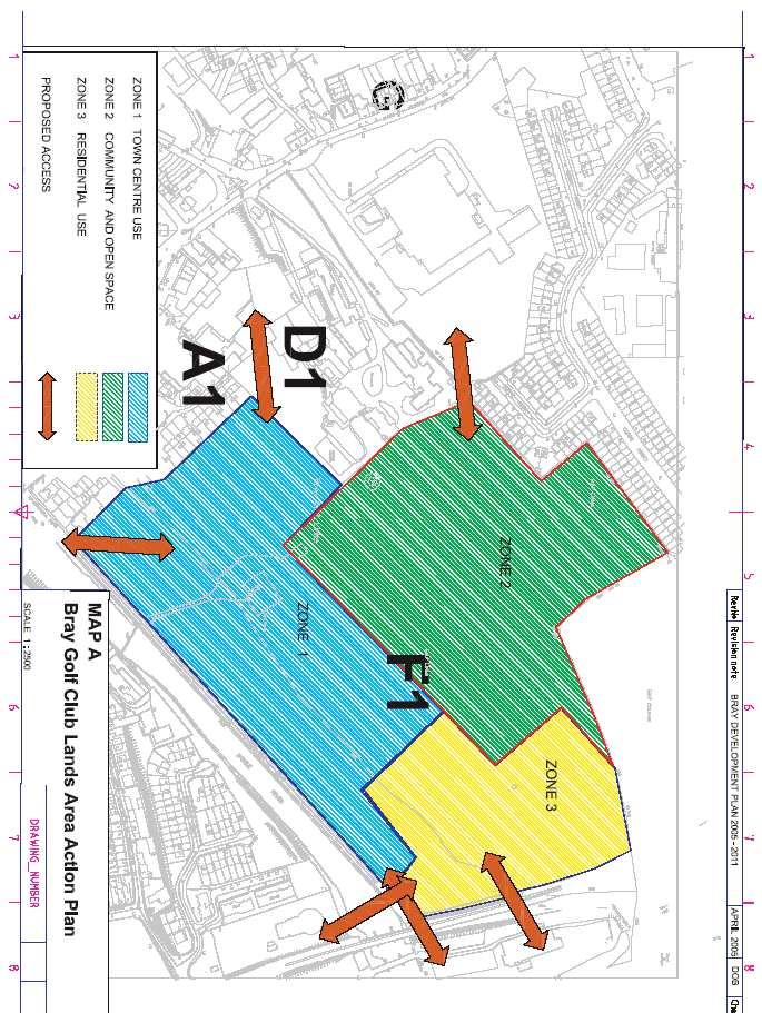
147
148 15 Bray Harbour & North Beach Area Action Plan
149 15 Bray Harbour & North Beach Area Action Plan 15.1 Introduction The Bray Harbour and North Beach Area Action Plan pertains to the area of land zoned F5 on the Land Use Zoning and Objectives Map. As illustrated on the map, the site encompasses the harbour, the industrial units north of the harbour and the proposed reclaimed land and breakwater. Proposals within the Dun Laoghaire-Rathdown area are subject to their agreement. Map B illustrates an Area Action Plan for the Bray Harbour and North Beach area. This map is strictly indicative only and the Council will consider modifications, so long as (i) the area of each zone is provided, (ii) the overriding objectives for each zone are complied with, and (iii) the modifications comply with the proper planning and sustainable development of the area. The Action Plan provides a planning framework in which the development of the Bray Harbour and North Beach area may be facilitated, and appropriate proposals developed. Due regard shall be given to the general development standards and other general provisions of Chapters 1-13 of the Bray Development Plan, However, in the event of inconsistency between these general provisions and the objectives of the Bray Harbour and North Beach Area Action Plan, the latter shall take precedence Action Plan Objectives To provide a high quality integrated harbour/marina mixed-use development with pedestrian and/or vehicular links to the Bray Golf Club Lands and Strand Road. The Council envisages that the harbour area will become synonymous as a high-class centre for water based outdoor/recreational pursuits and civic/social amenities. The development shall provide the following land uses: W ater based outdoor/recreational pursuits; Ground floor retail; Café/restaurant; Leisure facilities (private and communal); Open space; Civic social amenity/community clubs; Berths (circa 300 berths); Residential; Artisan and crafts quarter; Provide public access to the North beach. The development will involve substantial land reclamation north of the existing harbour. It is essential that the necessary coastal protection works are provided to preserve the reclaimed and existing land from erosion in the future. The residential amenity of North Strand Road/Seapoint Road area shall be protected. The development shall be planned so as to ensure that public access to the area is maximised, through the development of quality and legible public access links, which link to all adjoining areas. Vehicular access to the North beach development will be through the Golf Club Lands. 140
150 15 Bray Harbour & North Beach Area Action Plan Taking Zone 1, 2 & 3 (as defined in Map B) as a whole, the following development standards shall apply: Maximum plot ratio = 1.0 Maximum site coverage = 55% Maximum density = 55 units/acre 15.3 Zone 1: Habour and Marina (29 acres) Integrated harbour and marina comprising: marina basin with potential for circa 300 berths; leisure harbour with easy access to the sea; promenade access; harbour entrance with wave absorbing basin; generally a maximum height of 4 storeys above ground level is appropriate in Zone 1. However the Council may permit heights above this, where the specific context of the site and the design of the building allows it; the height of any proposed developments adjacent to existing residential developments, shall be consistent with the height of these existing structures; throughout Zone 1, the ground level of the site should be consistent with the current ground level of the area; the provision of marine based community clubs and facilities in a waterside location with direct access to a launching beach and slipways. The facilities should provide appropriate clubhouse and boatyard facilities. In addition, commercial recreational based developments should be provided; pedestrian priority; underground parking; residential component ancillary to all other uses; an architectural competition shall take place for the design and development of a landmark building; vehicular access to the Bray harbour and beach area north of the Dargle river will be from the Golf Club lands; a boat pen shall be provided; at an appropriate location, boat slip way facilities shall be provided. Provision of the harbour and marina would involve marine construction, dredging and land reclamation works above and below high water mark. The harbour and marina development shall incorporate an area for marine-based enterprise and for light industrial and commercial use associated with boat building and maintenance. At the early stages of the preparation of a scheme, the developers of the Harbour area shall consult with all relevant interest groups in the town that are associated with marine-based activities. The aim of this consultation shall be to ensure that the development, where appropriate, is undertaken in a manner that meets the needs of all types of marine based activities in harbour and marina based developments. 141
151 15 Bray Harbour & North Beach Area Action Plan Permitted In Principle Uses in Zone 1 Use Illustrative Type Commercial Entertainment Bars Restaurants Café Food Outlets Accommodation Hotel Holiday Accommodation Retail Ships Chandlers Marine Related Stores Clothing and Specialist Clothing Arts and Crafts Book Shop/Art Gallery/Records/CDs Gift Shop/Souvenir Hairdresser Florist Convenience Store/Food Leisure Health and Fitness Club Spa Water based outdoor/recreational pursuits Business Harbour Master and Marina Reception Office Small Offices Residential Residential development ancillary to other uses Civic and Social Amenities Cultural Art Gallery Tourist and Heritage Centre Library Museum Conference and Exhibition Community Primary Healthcare Crèche Public toilets/showers/changing facilities 142
152 15 Bray Harbour & North Beach Area Action Plan 15.4 Zone 2: Residential (8.5 acres) Provide for residential development, subject to the following standards and limitations: High quality urban design will be required within residential layouts for the purpose of protecting the environmental quality and amenity of the area; Developments shall promote the creation of socially mixed communities and cater for varied lifestyle requirements, building types and settings. A variety of different house types and sizes will be required; Minimisation of impact of development on coastal views; Generally, a maximum height of 4 storeys above ground level with penthouse, is appropriate in Zone 2, however the Council may permit heights above this, where the specific context of the site and the design of the building allows it; Good vehicular access with adequate car parking; It is essential that the necessary coastal protection works are provided to preserve the reclaimed land from erosion in the future. Acceptability of Uses in Zone 2 Acceptability Permitted in Principle Description of Use Crèche/Nursery School Open Space Private Garage Public Services Residential Not Normally Permitted but Open for Consideration Bed and Breakfast Commercial Recreational Buildings Community Facility Cultural Use Doctor/Dentist Education Guest House Halting Sites Health Centre Hotel Local Neighbourhood Services Neighbourhood Shops Public House Recreational Facility/Sports Club Residential Institution Restaurant Retirement Home Small Home Based Economic Activity 143
153 15 Bray Harbour & North Beach Area Action Plan 15.5: Open Space and Recreational Amenities Land adjoining Zones 1 and 2 is located within the jurisdiction of Dun Laoghaire-Rathdown County Council. This land is zoned F: To preserve and provide for open space and recreational amenities under the Dun Laoghaire-Rathdown County Development Plan Planning Applications Where appropriate, planning applications in respect of the above Action Plan must be accompanied by the following: Design Brief/Urban Design Strategy/Landscaping Scheme/Tree Survey; Mobility Management Plan; Environmental Impact Assessment; Area Action Plan-Details to accompany submission of planning application; Any other information which the planning authority considers appropriate. Proposed developments must link with/take account of development objectives for the adjoining Golf Club Lands and Seafront Area, as outlined in the Chapter 14: Bray Golf Club Lands Area Action Plan and Chapter 11: Bray Seafront Area. 144
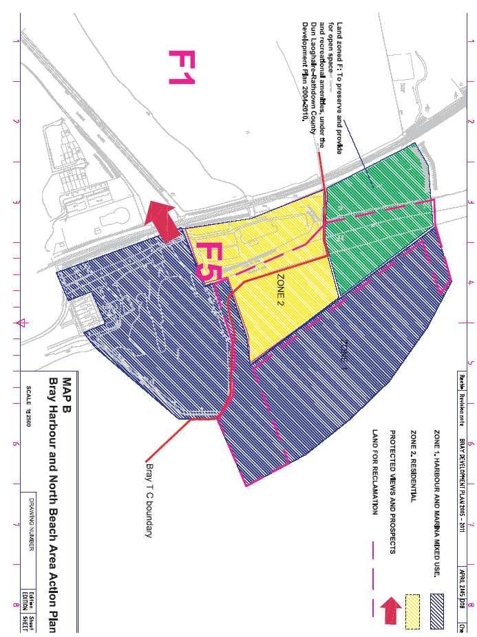
154
155 16 Rehills Land Area Action Plan
156 16 Rehills Land Area Action Plan 16.1 Introduction The Rehills Land Area Action Plan pertains to the area of land zoned F4 on the Land Use Zoning and Objectives Map. Map C illustrates an Area Action Plan for the Rehills Land area. This map is strictly indicative only and the Council will consider modifications, so long as (i) the area of each zone is provided, (ii) the overriding objectives for each zone are complied with, and (iii) the modifications comply with the proper planning and sustainable development of the area. The Action Plan provides a planning framework in which the development of the Rehills Land area may be facilitated, and appropriate proposals developed. Due regard shall be given to the general development standards and other general provisions of Chapters 1-13 of the Bray Development Plan, However, in the event of inconsistency between these general provisions and the objectives of the Rehills Land Area Action Plan, the latter shall take precedence Context Rehills Land is located on the eastern side of the River Dargle at the edges of the western boundary of the Town Council. The site is bounded to the east by a steep sloped wooded area, zoned E1, and on all other sides by the River Dargle and a residential component. The adjacent woods and river mean that the site is defined by significant natural amenity assets. At present the site is not accessible in terms of pedestrian/vehicular traffic, although land has been reserved for the construction of a bridge on the northern side of the La Vallee Office Block (within the F2 zoned area). This will ensure that the site will be accessible from the Dargle Road Action Plan Objectives To provide for a mixed use development including tourist/hotel, leisure, recreational, office, open space and residential land uses. The development must be of an exceptionally high urban design quality. In particular, proposals must take account of the special natural characteristics of the site and its surrounding context. The development must respect the residential amenity of adjoining residential areas, as well as the protected views and prospects from the N11. In order to ensure no damage to the River Dargle, all development proposals must include appropriate measures for the protection of the riverbank. In addition, all development proposals must include a flood impact assessment. Where appropriate, this assessment shall include appropriate measures for the protection of the subject site and other lands in its vicinity, from flooding. The only access to the site shall be from the new bridge on the Dargle Road. Taking the F4 zone as a whole, the following development standards shall apply: Maximum plot ratio = 0.6 Maximum site coverage = 55% Maximum density = 50/acre 148
157 16 Rehills Land Area Action Plan 16.4 Zone 1: Mixed Use (4.5 acres) In Zone 1, the following standards and principles shall apply: A maximum height of 4 storeys above ground level shall be permitted in Zone 1. Residential development shall only be permitted as ancillary to all other uses. Residential development shall be permitted to comprise a maximum of 15% of the gross building floor area of the zone. Residential units should be strategically located in order to provide overlooking and security throughout the zone. Recreation facilities, restaurant/café, Hotel and commercial recreational facilities should have easy access to/overlook the public park (Zone 2) and should take advantage of the riverside location. Public walkways, plazas and open spaces with continuity, ease of movement and legibility. An appropriate work of art at a suitable location. Utilisation of sound design principles and variety in built form to create a sense of place with its own identity. Acceptability of Uses in Zone 1 Acceptability Permitted in Principle Description of Use Commercial Recreational Buildings Cultural Use Hotel Open Space Offices Recreation Facility Residential Restaurant/Café Recycling facilities Sports Club Not Normally Permitted but Open for Consideration Crèche/nursery school Enterprise centre Health care 149
158 16 Rehills Land Area Action Plan 16.5 Zone 2: Active and Passive Open Space (6 acres) Creation of an attractive, landscaped public park to include: provision of new landscaped public park; appropriate planting, walkways, signage, picnic areas and seating to form a pleasant and successful outdoor public open space; provision of road access and public car parking with suitably located toilet and washroom facilities; the park is to be of contemporary design, which will attract wide public use; the park will run adjacent to the River Dargle, so that the amenity/leisure potential of the river is realised. The park shall link into the River Dargle pedestrian/cycle path that runs along the southern banks of the Dargle riverbank, linking the Harbour/Town Centre area of the town to development in Zone 1; a pedestrian bridge shall be constructed from the Dargle Road. Acceptability of Uses in Zone 2 Acceptability Permitted in Principle Description of Use Open Space Public Services Recycling facilities 16.6 Zone 3: Residential (3 acres) This zone is to provide for new residential development in accordance with the policies of the Development Plan. The following specific requirements shall apply: high quality urban design will be required within residential layouts for the purpose of protecting the environmental quality and amenity of the area; developments shall promote the creation of socially mixed communities and cater for varied lifestyle requirements, building types and settings. A variety of different house types and sizes will be required; a maximum height of 4 storeys above ground level shall be permitted at riverside locations in Zone 3. A maximum height of 2 storeys above ground level shall be permitted in locations that are adjoining existing residential developments; where appropriate, buildings shall face onto public open space to ensure supervision. 150
159 16 Rehills Land Area Action Plan Acceptability of Uses in Zone 3 Acceptability Permitted in Principle Description of Use Crèche/Nursery School Open Space Private Garage Public Services Residential Not Normally Permitted but Open for Consideration Bed and Breakfast Commercial Recreational Buildings Community Facility Cultural Use Doctor/Dentist Education Guest House Halting Sites Health Centre Hotel Local Neighbourhood Services Neighbourhood Shops Public House Recreational Facility/Sports Club Residential Institution Restaurant Retirement Home Small Home Based Economic Activity 151
160 16 Rehills Land Area Action Plan 16.7 Planning Applications Where appropriate, planning applications in respect of the above Area Action Plan must be accompanied by the following: Design Brief/Urban Design Strategy/Landscaping Scheme/Tree Survey Mobility Management Plan Environmental Impact Statement Flood Impact Statement Area Action Plan Details to accompany submission of planning application Any other information, which the planning authority considers appropriate. 152

161
162 Appendices
163 Appendices Appendix 1 Strategic Environmental Assessment Section 10(5)(a) of the Planning and Development Act 2000 requires planning authorities to include in their Development Plans information on the likely significant effects on the environment of implementing the plan. This process is called a Strategic Environmental Assessment (SEA) and it evaluates the likely consequences of a Plan upon the environment. It is similar to an Environmental Impact Assessment (EIA) in that it aims to influence proposed actions in order to minimise potential adverse environmental impacts. However, SEA is concerned with the implementation of an entire Development Plan, rather than an individual project. SEA is a new process, which provides a useful simple tool or checklist to help ensure that the full scope of environmental considerations is dealt with in the plan, and to influence proposed actions in order to minimise adverse environmental effects. The process has the additional benefit of raising awareness of the consequences of a plan. The SEA Process The process for preparing the Strategic Environmental Assessment involves: (i) setting strategic environmental objectives (ii) appraising the main planning goals and strategic development principles against these objectives. Topic SEA Objective Score Commentary 1. Protect and enhance X Although it is envisaged that there will be a loss Biodiversity biodiversity, including of biodiversity during the currency of the Plan, due characteristic habitats to the anticipated development of large tracks and species throughout of undeveloped land (e.g. Rehills Land, Golf Club their range Lands), the impact on biodiversity will be mitigated through the imposition of stringent development control standards and requirements. 2. Improve the health The policies of the Plan promote greater use of public Population and well being of the transport, walking and cycling. Open space has been and Human population through protected, enhanced and extended. The development of Health the creation of a safe, additional recreational facilities has been encouraged. healthy and high The realisation of these policies will improve quality of quality environment life and health. 3. Safeguard soil quality X The geology type in the Plan area is not particularly Soils and quantity noteworthy. With urban development, the soil will be affected, though as the area is not noted for tillage and intensive agriculture, the impact is considered to be minimal. The geological heritage of Bray Head is protected. 4. Improve water quality X The envisaged development of the Golf Club lands Water and the function of and Rehills land may have an impact on the water watercourses and to quality of the River Dargle. It is accepted that all future provide flood warning development has the potential to increase the rate of and flood control facilities surface water run off and thus increase the potential where possible for flooding. All planning applications will however be required to include a detailed flooding assessment with their proposals where necessary. 156
164 Appendices 5. Conserve and enhance Acquisition of a Blue Flag for Bray beach, in Marine the marine environment conjunction with the Bray Shanganagh Sewage Environment Treatment Works will require the achievement of significantly higher water quality standards. This will have a positive effect on the marine environment around Bray. 6. Maintain/promote O Higher residential densities, increased accessibility to Air continuing improvement public transport, a cycle and pedestrian network and in air quality. Reduce improved provision of local employment, services and greenhouse gas emission facilities can help reduce the need to travel and have a positive effect on air quality. The plan promotes sustainable building designs and materials, which optimise the energy efficiency of buildings. Despite the positive impact that these developments will have on improving air quality, the development of the Golf Club Lands will increase the level of traffic in the town, thereby balancing the gains made in other areas. The Council will require any planning applications to be accompanied by a Traffic Impact Statement and Mobility Management Plan. 7. Make best use of existing Material assets include the existing infrastructure in Material material assets the area including water, roads and sewerage Assets infrastructure and the built environment. No significant impacts are expected to material assets. Improvements to the existing infrastructure and road network are planned. The plan aims to maximise the development potential of existing infrastructure by concentrating development. Improved public transport and accessibility to major facilities and services would help make best use of the material assets in the built environment. 8. Value and protect Policies and development control requirements have Architectural diversity and local been included to ensure that the architectural and and Cultural distinctivenes cultural integrity of the town is protected and Heritage enhanced. In recognition of the strong development pressure, which the town is under, new additions have been made to the RPS and 2 No. ACA s are proposed. 9. Preserve archaeological A new policy has been included in the Plan to ensure Archaeological sites and other heritage the preservation of archaeological heritage. Heritage features 10. Protect and enhance X It is envisaged that undisturbed land (Golf Club Lands, Landscape landscape character Rehills Land) will be developed with a slight negative effect on open landscape/scenic quality. However, this is deemed acceptable in order to provide increased housing, employment, facilities and services. Area Action Plans for these areas ensure that an element of open space is preserved in tandem with the future development of sites. The landscape amenity of Bray Head is protected. 11. Reduce waste generation A Litter Action Plan will be prepared to Waste and increase recycling reduce the amount of litter in the town. Management activity Waste management is the responsibility of Wicklow and Recycling County Council. O X Beneficial effect Neutral effect Adverse effect 157
165 Appendices Appendix 2 Area Action plan Details to accompany submission of planning application The following details will be required as a minimum: 1. A written statement should be submitted which should include the following: i. Details of how the issues identified in the Area Action Plans have been addressed. ii. iii. iv. How the overall development is to be phased and how the elements such as open space/schools etc. will be tied into the phasing. Details of all the landowners. Written confirmation addressing the input that all landowners have had in the submission, i.e. confirming they have seen written statement and maps and are in favour of the submission. It should also detail those who have had no input and/or who are not in favour. Signature of those in favour/not in favour should be submitted. v. Details of the level of consultation that has taken place with the members of the public and the Local Authority. 2. A map should be submitted which would satisfy the following (more than one map may be required): i. To a scale no greater than 1:2500 and should show existing contours, existing features (trees, hedgerows, buildings), i.e. Area Action Detail Map. ii. iii. iv. Address all the issues identified in the Area Action Plan as appropriate. Indicate the use of each area (zoning) and show the size of the area involved. Details of phasing. v. Details of landowners ownership should be shown on a separate map to the Area Action Detail Map. vi. vii. viii. ix. Indicate roads objectives. Indicate reservation of lands for sanitary services (as necessary). Indicate all entrances/access points to service lands off public roads and areas serviced by each access point delineated (note a second map may be necessary to avoid confusion). Details of setback of development off public roads to comply with the relevant requirements. 3. An Area Action Catchment Drainage assessment should include the following items: i. Projected run-off including permeable and impermeable calculations and relevant return period calculations. ii. iii. iv. Historical Flood Information. Projects discharge and receiving points for foul and surface water. Water storage proposals. 158
166 Key to land use zoning & objectives maps A1 Primarily Residential To protect existing residential amenity; to provide for appropriate infill residential development; to provide for new and improved ancillary services. B1 Primarily Town Centre Uses To provide for the development and improvement of appropriate town centre uses including retail, commercial, office and civic use, and to provide for Living Over the Shop (LOTS) Residential Accommodation. B2 Primarily Seafront Uses To protect and enhance the character of the seafront area and to provide for the development and improvement of appropriate tourism and leisure uses, consistent with the protection of residential amenity. The seafront area shall be promoted as the primary tourist, recreational and leisure centre of the town. B3 Primarily Seafront Uses To protect and enhance the character of the seafront area and to provide for mixed-use development including appropriate tourism, leisure and residential uses. The seafront area shall be promoted as the primary tourist, recreational and leisure centre of the town. C Employment Uses To provide for economic development and employment. C1 Employment Uses To provide for economic development and employment including the provision of retail warehousing. D1 Primarily civic, community & educational uses To provide for civic, community and educational facilities. D2 Solely educational uses To provide for solely educational facilities. E1 Solely open space To protect and provide for recreation, open space and amenity provision. E2 Solely open space To protect and provide for recreation and open space provision and commercial related activities. E3 Solely open space To protect and provide for open space provision. E4 Solely open space To preserve continuous open space along the river valley. F1 Bray Golf Club Lands To provide for mixed-use development in accordance with the Bray Golf Club Lands Area Action Plan.
167 F2 Mixed use development To provide for appropriate business and commercial use in a landscaped setting. F3 Film industry To provide for the development of the film industry. F4 Reserved Site To provide for mixed-use development, in accordance with the Bray Harbour and North Beach Area Action Plan. F5 Bray Harbour & North Beach To provide appropriate mixed-use development, in accordance with the Bray Harbour and North Beach Area Action Plan. G Local Neighbourhood Centre To protect, provide for and/or improve local neighbourhood centre facilities. G1 Local Neighbourhood Centre To provide for a neighbourhood retail development, comprising of a supermarket of not more then 2500sq.m of net retail floor space, and other ancillary neighbourhood uses. The zoning also provides for a park and ride development as well as car sales/petrol retail use on a site of approximately 1.5 acres adjacent to the Southern Cross route. Town Council boundary Trees, groups of trees and woodland to be preserved Views and prospects to be preserved Preserve access Proposed pedestrian circulation Ardbrae Park Indication of Protected Structures Graphic indication of the location of a protected structure. Should any conflict arise between the written statement & the map, the written statement shall prevail.
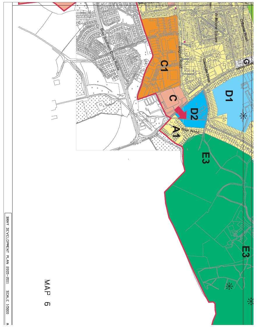
168

169
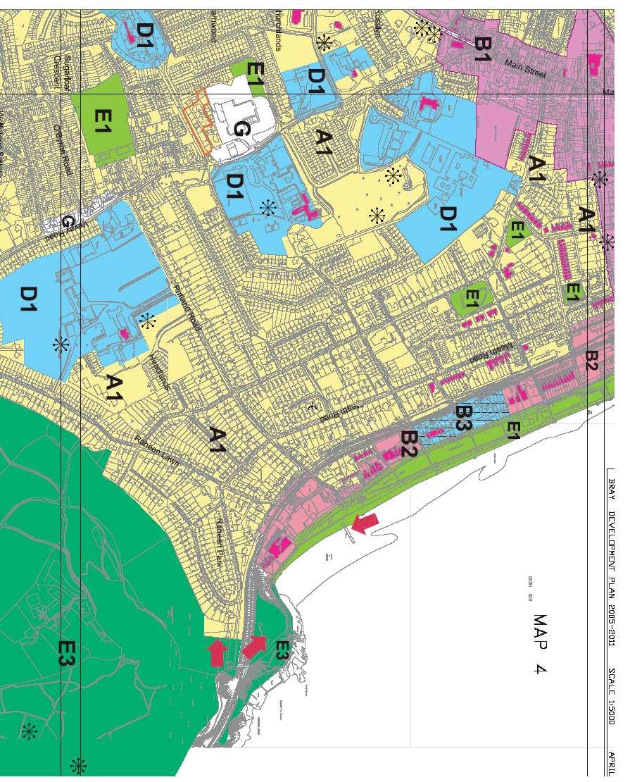
170

171

172
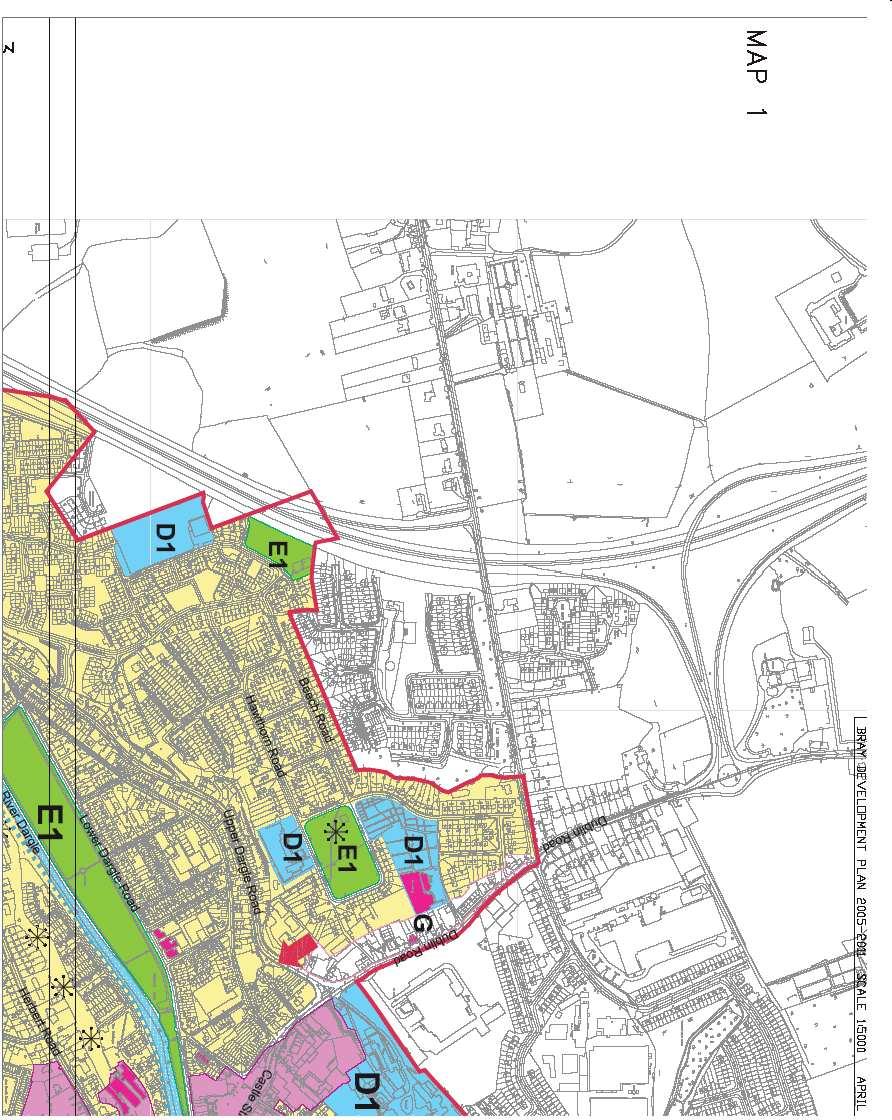
173

174
DUBLIN DOCKLANDS MASTER PLAN AND RELATIONSHIP WITH OTHER PLANS
 .1 National Policy and Programmes.1.1 Sustainable Development A Strategy for Ireland, 1997.1.2 National Climate Change Strategy, 2007-2012.1. National Development Plan 2007-201.1.4 National Spatial Strategy,
Chapter 3 Core Strategy
 Chapter 3 Core Strategy 3.0 Introduction The core strategy sets out how the development objectives in the Development Plan are consistent with the National Spatial Strategy and the Regional Planning Guidelines.
Tāhuhu whakaruruhau ā-taone The sheltering ridge pole
 B2. Tāhuhu whakaruruhau ā-taone - Urban growth and form B2.1. Issues Tāhuhu whakaruruhau ā-taone The sheltering ridge pole Auckland s growing population increases demand for housing, employment, business,
elbridge Core Strategy
 C elbridge Core Strategy Celbridge is designated as a Moderate Growth Town in the RPGs. The County Development Plan reinforces this designation in its settlement strategy. Moderate Growth Towns within
WINCHESTER TOWN 3.1 LOCATION, CHARACTERISTICS & SETTING
 WINCHESTER TOWN 3.1 LOCATION, CHARACTERISTICS & SETTING 3.1.1 The area referred to by the City Council, as Winchester Town, consists of the Winchester Wards plus the adjoining built up areas of Badger
A Growing Community Rural Settlement Areas
 Town of Huntsville Official Plan Review - POLICY BACKGROUND PAPER A Growing Community Rural Settlement Areas BACKGROUND: In addition to the fully municipally-serviced Urban Settlement Area and the Hidden
City Regions Ireland
 City Regions Ireland 01 CITY REGIONS IRELAND COMPRISES OF CORK CHAMBER, DUBLIN CHAMBER, LIMERICK CHAMBER, WATERFORD CHAMBER AND GALWAY CHAMBER, ALL MEMBERS OF CHAMBERS IRELAND. 5 CITIES 8 PRINCIPLES A
Variation No 1: Dundalk & Environs Development Plan Core Strategy
 Variation No 1: Dundalk & Environs Development Plan 2009-2015 Core Strategy Adopted on 29 th August 2011 CONTENTS Page Section 1 1.0 Synopsis 1 1.1 Background Document 1 1.2 Variation of Dundalk and Environs
EVALUATION OF MASTER PLAN ALTERNATIVES
 7 The Environmental Report is required to identify, describe and evaluate reasonable alternatives, taking into account the objectives and geographical scope of the Master Plan 2008. Three plan alternatives
Plan Modification to Chapter B2 of the Auckland Unitary Plan(AUP) Operative in part (15 November 2016)
 Operative in part (15 November 2016)") UNITARY PLAN UPDATE REQUEST MEMORANDUM TO FROM Phill Reid Linley Wilkinson DATE 25 September 2018 SUBJECT Plan Modification to Chapter B2 of the Auckland Unitary Plan(AUP) Operative in part (15 November
UNITARY PLAN UPDATE REQUEST MEMORANDUM TO FROM Phill Reid Linley Wilkinson DATE 25 September 2018 SUBJECT Plan Modification to Chapter B2 of the Auckland Unitary Plan(AUP) Operative in part (15 November
2.0 Strategic Context 4
 2.0 Strategic Context 4 2.1 The Area Action Plan is a non-statutory plan, which forms a corporate policy document, expressing particular issues and areas of concern while also providing a vision for the
Submission to the Kildare County Council Development Plan North Kildare Chamber. Executive Summary
 ` 28 th May 2015 Submission to the Kildare County Council Development Plan 2017-2023 North Kildare Chamber Executive Summary North Kildare Chamber s mission is to work with businesses, community groups,
Great Easton Neighbourhood Plan Statement of Basic Conditions
 Great Easton Neighbourhood Plan 2017-2031 Statement of Basic Conditions OCTOBER 2016 GREAT EASTON PARISH COUNCIL Contents 1.0 Introduction....Page 2 2.0 Summary of Submission Documents and Supporting Evidence..
Strategic Environmental Assessment Screening Report. Dublin Port Masterplan Review 2017
 Strategic Environmental Assessment Screening Report Dublin Port Masterplan Review 2017 Table of Contents 1 Introduction... 1 2 Purpose of the Masterplan... 2 3 Task 1.1 Pre-Screening Check... 5 4 Task
Plean Forbairt Development Plan
 1 COMHAIRLE THOGHLACH DHROICEAD ATHA DROGHEDA BOROUGH COUNCIL Plean Forbairt 2005 2011 Development Plan 2005-2011 2 Project Team: Planning Terence Savage: Senior Executive Planner (Acting) - Drogheda Borough
Sustainability Statement. Whitby Business Park Area Action Plan
 Sustainability Statement Whitby Business Park Area Action Plan November 2014 Contents Page 1. Introduction 1 2. Scoping 3 3. Sustainability Appraisal of Options 6 4. Assessment of Draft Area Action Plan
Rochford District Council Allocations Development Plan Document: Discussion and Consultation Document Sustainability Appraisal
 Option SWH1 Balanced Communities Option SWH1 1 To ensure the delivery of high quality sustainable communities where people want to live and work Will it ensure the phasing of infrastructure, including
Brighton Marina Neighbourhood Forum AGM. City Plan Part Two - Draft Plan
 Brighton Marina Neighbourhood Forum AGM City Plan Part Two - Draft Plan 16 May 2018 Sandra Rogers Planning Manager Carly Dockerill & Robert Davidson Principal Planning Officers Presentation outline: Context
Newcourt Masterplan. November Exeter Local Development Framework
 Newcourt Masterplan November 2010 Exeter Local Development Framework Background The Exeter Core Strategy Proposed Submission sets out the vision, objectives and strategy for the development of Exeter up
Schedule of Planning Applications Committee Date: 23 May Reference: 06/17/0726/F Parish: Hemsby Officer: Mr J Beck Expiry Date:
 Schedule of Planning Applications Committee Date: 23 May 2018 Reference: 06/17/0726/F Parish: Hemsby Officer: Mr J Beck Expiry Date: 22-05-2018 Applicant: Proposal: Site: Mr Gillett Change of use to the
4 RESIDENTIAL ZONE. 4.1 Background
 4 RESIDENTIAL ZONE 4.1 Background The residential areas within the City are characterised by mainly lowrise dwellings sited on individual allotments. Past architectural styles, settlement patterns and
Killarney Town Development Plan ISSUES PAPER
 Killarney Town Development Plan 2015-2021 ISSUES PAPER 1 Introduction The Killarney Town Development Plan sets out the overall strategy for the proper planning and development of the town. The existing
Poolbeg West SDZ Draft Planning Scheme
 Poolbeg West SDZ Draft Planning Scheme Introduction/vision Housing Community Economy/Employment Movement/transport Infrastructure green infrastructure /open space Land-use and phasing Public Realm Urban
INTRODUCTION BACKGROUND
 INTRODUCTION 1 1 INTRODUCTION 18 INTRODUCTION 1 1.1 BACKGROUND The Dublin Docklands Development Authority (DDDA) is required to conduct a Strategic Environmental Assessment (SEA) of the review of the Draft
Appendix 1 Structure plan guidelines
 Appendix 1 Structure plan guidelines This appendix forms part of the regional policy statement [rps]. 1.1. Introduction Structure plans are an important method for establishing the pattern of land use
Our City Centre is a vibrant, creative and welcoming destination, with a modern business, cultural, shopping, leisure and residential offer
 3. Sheffield in 2034 Our City sits at the heart of a strong, distinctive and internationally successful City Region economy which supports innovation and enterprise Our City Centre is a vibrant, creative
Appendix A: Retail Planning Assessment
 Rotherham Town Centre Masterplan Appendix A: Retail Planning Assessment 139 Appendix A Rotherham Town Centre Masterplan Retail Planning Background and Policy Context 1. Introduction 1.1 The Masterplan
The Gwennap Parish Vision Statement
 QUICK GUIDE What is a Neighbourhood Development Plan? Ultimately it is a document used by developers or anyone wishing to submit a planning application that describes the vision, strategy, plans, regeneration,
Official Plan Review
 Official Plan Review Summary Report - The Built Environment August 2014 Part 1: Introduction Planning for a healthy, prosperous and sustainable community is an important goal for our municipality. From
Stratford Neighbourhood Plan Questionnaire
 Stratford Neighbourhood Plan Questionnaire Please tick the appropriate box or answer in the space provided. If you require further copies of the questionnaire, as more than one person in the household
STATEMENT OF OBJECTION TO THE PROPOSED DEVELOPMENT OF LAND AT CHURCH CLIFF DRIVE FILEY
 STATEMENT OF OBJECTION TO THE PROPOSED DEVELOPMENT OF LAND AT CHURCH CLIFF DRIVE FILEY You will be aware that Scarborough borough council have adopted a new local plan that includes land at Church Cliff
Page 1 of 19 URBAN DESIGN FRAMEWORK FOR BOLTON STREET WATERFORD
 Page 1 of 19 URBAN DESIGN FRAMEWORK FOR BOLTON STREET WATERFORD 1.0 Introduction: The relocation of the City Council stores and depot from Bolton Street creates an exciting opportunity for development
The Proposed Auckland Unitary Plan (notified 30 September 2013)
") 3 Business zones Introduction There are 10 business zones in the Unitary Plan: City Centre Metropolitan Centre Town Centre Local Centre Neighbourhood Centre Mixed Use General Business Business Park Light
3 Business zones Introduction There are 10 business zones in the Unitary Plan: City Centre Metropolitan Centre Town Centre Local Centre Neighbourhood Centre Mixed Use General Business Business Park Light
Meath County Development Plan. Variation No. 1 to Volume 1 Written Statement
 Meath County Development Plan 2013 2019 Variation No. 1 to Volume 1 Written Statement 2 Core Strategy Adopted Variation No. 1-04/11/2013 2.3.3 Residential Zoned Land Provision Table 2.4 details the requirement
DAREBIN PLANNING SCHEME AMENDMENT C137
 Who is the planning authority? Planning and Environment Act 1987 DAREBIN PLANNING SCHEME AMENDMENT C137 EXPLANATORY REPORT This amendment has been prepared by the Darebin City Council, who is the planning
ROCHFORD LOCAL DEVELOPMENT FRAMEWORK: Sustainability Appraisal/ Strategic Environmental Assessment. Rochford Core Strategy Preferred Options Document
 ROCHFORD LOCAL DEVELOPMENT FRAMEWORK: Sustainability Appraisal/ Strategic Environmental Assessment Non Technical Summary Rochford Core Strategy Preferred Options Document October 2008 SUSTAINABILITY APPRAISAL
5.0 TOURISM, RETAIL AND EMPLOYMENT
 5.0 TOURISM, RETAIL AND EMPLOYMENT 5.1 Vision 5.2 Employment 5.2.1 Context 5.2.2 E m p l o y m e n t P ro f i l e 5.2.3 S t r a t e g y 5.2.4 E m p l o y m e n t P o l i c i e s 5.2.5 Development Control
UDF PLANS AND GUIDELINES
 UDF PLANS AND GUIDELINES 5 Land Use Land Use Development Plan Plan no. 3 Land Use Development Mixed Use Retail / Leisure Residential Civic and Institutional Proposed Zoning Table Development Edges Plan
Guidelines for Planning Authorities and Part V of the Planning and Development Act 2000: December 2000
 Slide 1 Slide 2 Slide 3 Slide 4 As a planner in practice, whether within the Local Authority, private practice or An Bord Pleanala, due regard must be given to the guidance provided by the Department in
Dunboyne/Dunboyne North/ Clonee/ Local Area Plan
 Dunboyne/Dunboyne North/ Clonee/ Local Area Plan Strategic Policy SP 1 To operate an Order of Priority for the release of residential lands in compliance with the requirements of CS OBJ 6 of the County
OKEFORD FITZPAINE NEIGHBOURHOOD PLAN
 OKEFORD FITZPAINE NEIGHBOURHOOD PLAN Dear Parishioner, The Neighbourhood Plan Project Team have prepared this leaflet to summarise the full Neighbourhood Plan document. It provides a summary of the Vision,
2. Spatial Portrait, Vision and Objectives
 VISION & OBJECTIVES 2. Spatial Portrait, Vision and Objectives Introduction 2.1 This section sets out the spatial portrait of Uttlesford, the vision we have for the future of the area and the objectives
DUNSFOLD NEIGHBOURHOOD PLAN Site Selection Policies
 DUNSFOLD NEIGHBOURHOOD PLAN Site Selection Policies The criteria for assessing sites for future housing and business development in Dunsfold are set out below. (Development criteria, covering what it is
The Meath County Development Plan will provide the main public statement of planning policies and objectives at county level.
 Meath County Council are delighted to engage in this public consultation process in relation to the review of the Meath County Development Plan 2007-2013 and the preparation of the next County Development
Chapter 2: OUTLINE PLANNING APPLICATION PROPOSALS. A New Garden Neighbourhood Matford Barton 17
 Chapter 2: OUTLINE PLANNING APPLICATION PROPOSALS A New Garden Neighbourhood Matford Barton 17 2.1. SUMMARY AND STATUS OF THE PROPOSALS 2.1.1. The parameter plans and associated wording in this chapter
SECTION ONE: INTRODUCTION. introduction
 introduction 1 INTRODUCTION Since it was first established in 1843 as a trading post for the Hudson s Bay Company, Victoria has evolved into a Provincial capital city that is recognized across Canada and
EXTRACT FROM THE CUDDINGTON NEIGHBOURHOOD PLAN The Policies
 EXTRACT FROM THE CUDDINGTON NEIGHBOURHOOD PLAN The Policies Environment and Landscape Policy 1 - Landscape Setting Development should respect and wherever possible enhance the landscape setting of Cuddington
Parish of Repton NEIGHBOURHOOD DEVELOPMENT PLAN
 Parish of Repton NEIGHBOURHOOD DEVELOPMENT PLAN BASIC CONDITIONS STATEMENT December 2018 CEF 4 Legal Requirements This statement has been produced by the NDP Working Group on behalf of Repton Parish Council
Appendix A. Planning Processes. Introduction
 1 Planning Processes Introduction This appendix outlines a number of planning processes which are used in the Auckland Region to support the effective management of development in the region s rural and
Rathmolyon Written Statement
 Settlement Rathmolyon Position in Settlement Hierarchy Village - Local centre for services and local enterprise development Position in Retail Strategy Fourth tier retail centre Population (2011) Census
Chapter 2 Core Strategy
 Chapter 2 Core Strategy 11-24 2.1 Introduction 2.2 Strategic Planning Approach 2.3 Growth Consistency with the National Spatial Strategy & Regional Planning Guidelines 2.1 Introduction The overall strategy
Chapter 5 Urban Design and Public Realm
 5.1 Introduction Public realm is all areas of the urban fabric to which the public have access. It is where physical interaction takes place between people. It therefore, includes buildings and their design,
Design Guidance. Introduction, Approach and Design Principles. Mauritius. November Ministry of Housing and Lands. .. a
 sig evelo r D Mauritius s. Utilities.. Individu a s. er itects.to ls chpers.po e Public. T. h rban D Sc U e me Promot e h ners. A Design Guidance o.h Planne rs n w iticians r l useholde National Development
Northern Territory Compact Urban Growth Policy
 Northern Territory Compact Urban Growth Policy A Reference Policy Document to clause 2.7 (Reference to Policy) of the NT Planning Scheme May 2015 Table of Contents 1 Policy Setting... 3 1.1 Context for
WELCOME GYPSY LANE. Wider Site Location plan. Proposals for the development of LAND OFF FOXLYDIATE LANE WEBHEATH. Proposals for the development of
 WELCOME The developers are preparing an outline planning application for a residential led development and need the community s views in order to develop the proposals further WHAT IS PROPOSED? A high
2040 LUP is a part of the Comprehensive Plan and carries the same legal authority. Economic Challenges
 1.1. Guiding Anchorage s Growth Where will new residents settle over the next two decades? Where will people work, shop, and play? Will there be enough room to grow? How will Anchorage look? Will growth
3. Neighbourhood Plans and Strategic Environmental Assessment
 1. Introduction This report sets out a draft Screening Determination for the Preston Parish Council s Neighbourhood Plan and has been prepared by rth Hertfordshire District Council. The purpose of the
Edward R. Sajecki Commissioner of Planning and Building
 Corporate Report Clerk s Files Originator s Files CD.03.POR DATE: TO: FROM: SUBJECT: Chair and Members of Planning and Development Committee Meeting Date: February 27, 2012 Edward R. Sajecki Commissioner
Planning Proposal Charlestown Swim and Leisure Centre LEP Amendment
 Planning Proposal Charlestown Swim and Leisure Centre LEP Amendment Amendment No. 4 to Lake Macquarie Local Environmental Plan 2014 (PP_2014_LAKEM_005_00) Local Government Area: Name of Draft LEP: Lake
INCREMENTAL CHANGE AREA REVIEW March 2015 Page 1
 INCREMENTAL CHANGE AREA REVIEW March 2015 Page 1 Table of Contents Introduction... 3 Background to Review... 3 Comparison of the Schedules to the General Residential Zone... 7 Methodology... 7 Policy Context...
Planning and Sustainability Statement
 Land adjacent to Manor Farm, Catterick Village Pallett Hill Sand and Gravel Co Ltd Proposed 10 new dwellings, (6 No market dwellings and 4 No affordable dwellings) with access, associated car parking and
PSRC REVIEW REPORT & CERTIFICATION RECOMMENDATION
 PSRC REVIEW REPORT & CERTIFICATION RECOMMENDATION KITSAP COUNTY COUNTYWIDE PLANNING POLICIES July 2, 2012 BACKGROUND A major emphasis of the Washington State Growth Management Act (GMA) is the need to
Regional Context Statement
 Regional Context Statement REGIONAL CONTEXT STATEMENT 3. REGIONAL CONTEXT STATEMENT In 1995, the Provincial Government passed into law the Growth Strategies Act. The purpose of this provincial initiative
NOVEMBER 2013 CARRICK ON SUIR TOWN DEVELOPMENT PLAN Carrick on Suir Town Council
 NOVEMBER 2013 CARRICK ON SUIR TOWN DEVELOPMENT PLAN 2013 Carrick on Suir Town Council Effective from the 26 th November 2013 TABLE OF CONTENTS Table of Figures... 6 List of Tables... 7 Schedule of Policies...
Appendix. Statement Outlining Compliance with Ministerial Guidelines
 18 Appendix Statement Outlining Compliance with Ministerial Guidelines A18 Statement Outlining Compliance with Ministerial Guidelines Under section 28 of the Planning and Development Act 2010, Meath County
Meath County Development Plan. Proposed Draft Variation No. 1 to Volume 1 Written Statement
 Meath County Development Plan 2013 2019 Proposed Draft Variation No. 1 to Volume 1 Written Statement 2 Core Strategy Proposed Draft Variation No. 1!" #$ % & ' % $ ($ &' ) $) * (' &+( &' % $ * $ $ * %
Draft Island Development Plan
 Draft Island Development Plan February 2015 Written Statement Contents Part One 1 About the Island Development Plan What is the Island Development Plan? What is the Island Development Plan used for? Structure
A. The sites in Table 16 below, as identified on the Policies Map, are allocated for retail-led development:
 SWDP 44: Worcester City Centre A. The sites in Table 16 below, as identified on the Policies Map, are allocated for retail-led development: Table 16: Sites Allocated for Retail-Led Development Policy Reference
Ireland 2040 Our Plan Press Release
 Ireland 2040 Our Plan Press Release Today the Government published Ireland 2040 Our Plan for its final round of public consultations. Over the next number of weeks, until 3 November, the public will have
Birmingham. Summer study!!
 Birmingham Summer study!! Urban Change in the UK - Birmingham - Part 1 Location / Facts - Birmingham is located in the centre of England - It is the 2nd largest city with a population of around 1 million
Wallingford Neighbourhood Plan
 Wallingford Neighbourhood Plan Introduction What is neighbourhood planning? Neighbourhood planning was introduced by the Localism Act 2011 to give local people more influence over how development comes
Vigo Neighbourhood Plan Basic Conditions Statement
 Vigo Neighbourhood Plan Basic Conditions Statement Plan Period: 2016 to 2028 Status: Submission Version Qualifying Body: Vigo Parish Council Glossary of Some Terms & Abbreviations Used in this Document
A VISION FOR SOUTH DUBLIN S FUTURE. Proposed Variation No. 2. Vacant Site Levy. Planning Report
 A VISION FOR SOUTH DUBLIN S FUTURE Proposed Variation No. 2 Vacant Site Levy Planning Report February 2018 Proposed Variation No. 2 South Dublin County Council County Development Plan 2016-2022 This is
2A District-wide Policies
 2A Introduction This Chapter contains policies which are relevant to subdivision, use and development activities occurring across all zones and areas of the District. The policies in this Chapter implement
Ipswich Issues and Options for the Ipswich Local Plan Review, August 2017, Public Consultation
 Ipswich Issues and Options for the Ipswich Local Plan Review, August 2017, Public Consultation Having reviewed the issues and options documents, the Society has made the following response: Part 1 Strategic
Ballivor Written Statement
 Settlement Ballivor Position in Settlement Hierarchy Village - Local centre for services and local enterprise development Position in Retail Strategy Fourth tier retail centre Population (2011) Census
Local Development Scheme
 Local Development Scheme 2012 2016 The Local Development Scheme (LDS) is a project plan that outlines how and when the Authority will update its planning policies and other associated documents. It ensures
Land Use Amendment in Southwood (Ward 11) at and Elbow Drive SW, LOC
 at and Elbow Drive SW, LOC") 2018 November 15 Page 1 of 10 EXECUTIVE SUMMARY This land use amendment application was submitted by Rick Balbi Architect on 2017 August 31 on behalf of Sable Developments Ltd, and with authorization from
2018 November 15 Page 1 of 10 EXECUTIVE SUMMARY This land use amendment application was submitted by Rick Balbi Architect on 2017 August 31 on behalf of Sable Developments Ltd, and with authorization from
SUSTAINABLE URBAN DEVELOPMENT AND COHESION POLICY EUROPEAN COMMISSION. Urban Policy within the framework of EU Cohesion Policy
 Urban Policy within the framework of EU Cohesion Policy 2007-2013 16/09/2007 SUSTAINABLE URBAN DEVELOPMENT AND COHESION POLICY 2007-2013 Marco Orani European Commission Directorate General for 1 SUSTAINABLE
BLETCHLEY PARK AREA - DEVELOPMENT FRAMEWORK
 ANNEX A To Item 9 REVISED TEXT: additions shown bold and underlined, deletions in (brackets and in italics). BLETCHLEY PARK AREA - DEVELOPMENT FRAMEWORK This framework sets out the key objectives and requirements
1.0 PLANNING MARKHAM S FUTURE CONTENTS
 1-1 Planning Markham s Future 1.0 PLANNING MARKHAM S FUTURE CONTENTS 1.1 THE PURPOSE OF THE OFFICIAL PLAN 1.2 THE MARKHAM CONTEXT 1.3 THE REGULATORY CONTEXT 1.3.1 Province of Ontario 1.3.2 York Region
Copyright Nigel Deeley and licensed for reuse under this Creative Commons Licence
 1 Copyright Nigel Deeley and licensed for reuse under this Creative Commons Licence Prepared by the Neighbourhood Plan Steering Group on behalf of Garway Parish Council with assistance from 2 Table of
Revised draft District Plan for Council
 Revised draft District Plan for Council June 2012 1 Chapter 1: Background to the revised draft District Plan 1.1 This revised draft District Plan has been written in the context of the Localism Act and
KELLS DEVELOPMENT PLAN
 KELLS DEVELOPMENT PLAN 2013-2019 J Statement Outlining Compliance with Ministerial Guidelines Adopted 7th October 2013 APPENDIX J STATEMENT OUTLINING COMPLIANCE WITH MINISTERIAL GUIDELINES Under section
and also to consider how Luas Line A1 will contribute to good planning and sustainable development in the area it serves.
 .0 PLANNING AND POLICY CONTEXT.1 INTRODUCTION The purpose of this chapter is to provide some relevant background information in relation to planning and transport policy under the following headings: Background
Edenderry Local Area Plan
 Edenderry Local Area Plan 2017-2023 MATERIAL ALTERATIONS TO DRAFT EDENDERRY LOCAL AREA PLAN Public Display Document Section 1: Introduction 1.1 Introduction This report focuses on the proposed material
Economy Vision Statements: Social Wellbeing Vision Statements: Natural Environment Vision Statements:
 Economy Vision Statements: 1. Our business environment makes us a region of choice for new employers as we encourage entrepreneurship and have a vibrant, diversified and resilient regional economy. 2.
WHITELEY TOWN COUNCIL NORTH WHITELEY DEVELOPMENT SEPTEMBER 2014
 WHITELEY TOWN COUNCIL NORTH WHITELEY DEVELOPMENT SEPTEMBER 2014 Dear Resident This Special Edition of the Whiteley Voice which has been prepared in conjunction with the North Whiteley Consortium is to
Welcome to the Oakridge Centre Open House
 Welcome to the Oakridge Centre Open House Why is the City hosting this event? This open house is to inform you of a rezoning application submitted to the City of Vancouver to amend the existing CD-1 (Comprehensive
K. SMART ASSOCIATES LIMITED
 Planning Justification Report Zoning By-Law Amendment 185 King Street North Waterloo, Ontario April 7th, 2017 Project Reference Number 16-245 K. SMART ASSOCIATES LIMITED CONSULTING ENGINEERS AND PLANNERS
Draft Western District Plan
 Powered by TCPDF (www.tcpdf.org) Draft Western District Plan Submission_id: 31440 Date of Lodgment: 15 Dec 2017 Origin of Submission: Online Organisation name: Goodman Property Services Australia Pty Ltd
MEATH COUNTY COUNCIL Dunboyne, Clonee & Pace Local Area Plan
 MEATH COUNTY COUNCIL Dunboyne, Clonee & Pace Local Area Plan 2009-2015 Adopted 22 September 2009 Planning Department Dunboyne/Clonee/Pace Local Area Plan 2009-2015 Adopted 22 nd September 2009 Prepared
28. Coolaney-Rockfield Mini-Plan
 28. Coolaney-Rockfield Mini-Plan 28. Coolaney-Rockfield Mini-Plan Community facilities Community facilities in Coolaney-Rockfield consist of a primary school, crèche, community centre, sports field and
1 Introduction. Chapter. In this chapter:
 Chapter 1 Introduction In this chapter: 1.1 A Snapshot of the Region 1.2 Towards a Sustainable Region 1.3 The Provincial Context 1.4 Purpose and Organization The Regional Municipality of York Official
Welford-on-Avon Neighbourhood Plan Consultation Event Sunday, 6 April Your name Your address
 Welford-on-Avon Neighbourhood Plan Consultation Event Sunday, 6 April 2014 Your name Your email address Please either: - complete this feedback form and put it in the box before leaving the Memorial Hall
Dublin Mountains Project Q & A
 01 What is the background to the project? What is the Project? Why is the needed now? Why Hellfire/Masseys? What has happened so far? What is the project status now? Why is the planning application for
Basic Conditions Statement
 POTTON NEIGHBOURHOOD DEVELOPMENT PLAN Basic Conditions Statement Date: 19/10/2018 Version: 1 Status: draft Table of Contents 1 INTRODUCTION... 3 1.1 POTTON NEIGHBOURHOOD PLAN DESIGNATED AREA... 3 1.2 PREPARATION
About 10% of the Borough's population lives in the seven rural parishes. Population figures from the 1991 census are given below:-
 8. THE DISTRICT VILLAGES 8.1 Population About 10% of the Borough's population lives in the seven rural parishes. Population figures from the 1991 census are given below:- Village No. of Persons Cottingham
The protection of the agricultural resources of the Province;
 PART II INTRODUCTION An Official Plan is a policy document, which is intended to serve as the basis for making land use decisions and managing change in any municipality in Ontario. According to the Planning
CITY VIEW OBJECTIVES
 SECTION 2: CITY VIEW OBJECTIVES CONTENTS 2.1 Introduction 1 2.2 Strategic Direction 1 2.3 The City View Resource Management Issues for the City 1 2.4 The Goal 3 2.5 The City View Objectives 3 Palmerston