REPORT TO THE CALGARY PLANNING COMMISSION DP NO:
|
|
|
- Domenic Griffin
- 5 years ago
- Views:
Transcription


1 REPORT TO THE CALGARY PLANNING COMMISSION DEVELOPMENT PERMIT ITEM NO: 05 CPC DATE: 2007 December 13 DP NO: DP BELTLINE (Ward 8 - Alderman Mar) Page 1
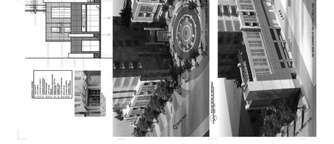
2 DP CPC 2007 December 13 PROPOSAL: Apartment Building (207 Units) with retail and restaurant-licensed at grade. APPLICANT: Poon McKenzie Architects MUNICIPAL ADDRESS: 1302 and Avenue SW EXISTING LAND USE DISTRICT(S): OWNER: Homburg Management LEGAL DESCRIPTION: Plan A1, Block 61, Lots 21 to 29 (Map 16C) DC 10Z2007 AREA OF SITE: ha ± (0.676 ac ±) CURRENT DEVELOPMENT: Vacant Land, Single Storey Building ADJACENT DEVELOPMENT: NORTH: Two and four storey commercial development, surface parking lot; SOUTH: Five storey office building (Red Cross), single storey warehouse, surface parking lot; EAST: WEST: Two storey commercial buildings; and Single and two storey commercial buildings. DEVELOPMENT SUMMARY RULE BYLAW STANDARD PROPOSED RELAXATION DENSITY A maximum of 12.0 FAR 9.54 FAR None PARKING 1.0 stalls for residential Development (207 stalls) 0.15 stalls for visitors (31 stalls) 1 stall per 100 metres of gross floor area for all other uses (6 stalls) Total required 244 stalls 347 stalls None EXTERIOR FINISH MATERIALS Podium: Granite base with transparent glazing, aluminium spandrel panels Tower: Glass and spandrel glass panels. Page 2
3 DP CPC 2007 December 13 PLANNING EVALUATION Introduction This development permit is for a 207 unit apartment building in the Beltline, with a podium comprised of retail, restaurants, and apartment units. Site Context The site is located on the northwest corner of 11 Avenue and 12 Street SW. The area is a mix of high density residential, two storey commercial, and mid rise office buildings. There are two high rise residential developments within 200 metres of the site Vantage Pointe located one block to the west along 11 Avenue, and Stella/Nova towers, located two blocks southeast of the project. A third, the Kai towers, is under construction across the street from this site. Legislation & Policy Development of this site is guided by the policies of the Beltline Area Redevelopment Plan (Approved by Council 2006 May). The application is contained within the Urban Mixed Use area of the Plan. Within this area, the policy calls for: 1. Promotion of live-work units in a variety of configurations; 2. Vibrant, pedestrian-friendly streets that provide activity throughout the daytime and evening hours; and 3. Street front elevations that are highly permeable and transparent by providing doorway entrances to the street, allowing for views directly into the business along the majority of the façade. As well, the policy identifies key design initiatives for development such as: 1. Front setbacks should incorporate trees and other urban planting/hard surface treatments and should accommodate a variety of commercial activities, including restaurant patios; 2. Building edges that are oriented toward a public right of way should be lined with uses that create activity and provide natural surveillance; 3. All parking areas shall be concealed from view from public spaces and ideally are located underground; 4. Building bases are encouraged to use masonry or other durable materials and other architectural details that establish a strong visual rhythm with human scaled elements; 5. All rooftops, including podium and tower tops are encouraged to incorporate landscape amenities or green roofs in order to achieve aesthetic and environmental benefits; 6. The minimum horizontal separation between any two tall buildings shall be 24 metres for buildings taller than 36 metres; and 7. Particular attention should be given to the lighting of public and private areas at-grade to provide effective and attractive at-grade light. Special effects, including flood lighting of the tower portion and tower top portion may be included if it does not negatively impact Page 3
4 DP CPC 2007 December 13 surrounding properties. This site is also located within the Design District of the character areas defined in the Beltline ARP, where a combination of land uses and buildings have combined to create areas that are identifiable as having special or unique qualities different from neighbouring areas. The intent of policy for this area is to encourage eclectic and innovative design of buildings within the area. Land Use District The Direct Control District accommodating this project was approved by City Council in 2006 May. Contained within those guidelines are provisions for yards, building design, and landscaping. Density has been determined through application of the Density Bonusing system contained in the Beltline Area Redevelopment Plan. This bonus system allows for additional floor area if certain public amenity features are provided. The proposed project complies with this policy direction. The overall density proposed is 9.54 FAR. The following table illustrates how areas have been apportioned to the various bonus categories. BONUS F.A.R. Base Density 8.0 Publicly accessible Private Open Space 0.94 Green Roof 0.5 Reduction in the use of Potable water for irrigation 0.1 TOTAL 9.54 As part of the application, open space has been provided in accordance with the density provisions in the Beltline ARP (See Site Layout and Building design below for details). Prior to release of the development permit, the applicant will be required to submit a public access easement agreement to delineate the limits of the plaza space (publicly accessible private open space). The applicant has chosen sustainable features for the remainder of the density. The amount of additional density proposed is supportable given the site access and its location within the Beltline as well as the design merits of the building. Site Layout & Building Design The project is a 207 unit apartment building, with a podium of retail, restaurants, and apartment units. The mix of residential units includes one bedroom (21%), two bedroom (76%) and penthouse suites (6%). Many optional schemes for massing and development of the site were entertained during review of this application. A key feature of this project is the plaza space at grade. The option to provide a significant portion of the site as a public plaza was seen as an opportunity to frame and enliven this emerging area of the Beltline as well as increase density. This plaza space is comprised of flowering trees and grasses planted in a circular pattern. This circular pattern is enhanced through the use of hard landscaping and seating arranged within the grassed area. The central feature of the space is a large water fountain. This water piece would be operational during the summer months, and then frozen in the winter months as an ice sculpture. The applicant has been encouraged to contact The City s Public Art Consultants as part of the project. Page 4
5 DP CPC 2007 December 13 At grade, the project has restaurants (with outdoor patios) and retail located along 11 Avenue SW, with the main door for the project located along the plaza space. Along 12 Avenue, there is a second small restaurant with an outdoor patio. Transparent glazing has been provided along with options for multiple doorways to allow for small scale retail as envisioned in the Beltline ARP. A small amenity space is provided along the plaza area in addition to the restaurants and patios. Apartment units are located on the second and third floors for the project. Materials used for the base of the project are granite on the main floor, with aluminium spandrel panels on the second and third floors. Materials for the tower are glass and spandrel glass. A decorative metal roof element screens the mechanical penthouse for the project. The plaza feature results in less site area over which the proposed F.A.R. could be distributed. Due to the area devoted to the plaza, the tower floor plate has been slightly expanded over the maximum of 750 square metres to 754 square metres. The Beltline A.R.P. makes provisions for a maximum floor plate of 750 m2 in the Urban Mixed-Use Area where the impacts of shadow casting, tower separation and cumulative building mass have been satisfactorily mitigated. Reacting to this smaller area over which F.A.R. can be distributed, this application proposes a 3 metre setback from the lane along the north property line for the residential tower with no stepback to a smaller floor plate above the 36 metre height mark. Contemplating the benefits of revitalization of under-developed inner city blocks, Administration weighed the potential consequences associated with varying from the recommended setbacks for towers. As part of the analysis, Administration tasked the applicant to provide a study that would identify the impacts associated with shadow casting and tower separation as it relates to the broader context of the area. In response, the applicant has provided a model showing one potential scenario for build-out of the surrounding block. The model acknowledges that the increase in floor plate size potentially compromises the 18 metre and 24 metre separation distances between towers on a north-south axis, but would maintain separation in an east-west axis. While this scenario for development cannot be guaranteed, it does however suggest that, if assembled as a block, the potential for redevelopment of up to five towers maintaining required separation could be accomplished. Finding the proposed setbacks for this project do not appear to adversely impact public open space or important green space within the vicinity and that the remainder of the block does not appear to be compromised by the massing, Administration supports the proposed setbacks. Urban Design Review Panel The application was circulated to the Urban Design Review Panel (see complete comments in APPENDIX III). The following table lists the main comments of the panel and how they were addressed during the review of this application. Urban Design Review Panel Comment The Panel recommends that the entry plaza be pedestrian only, and only used by emergency vehicles. Panel recognizes that a unique design solution to accommodate this requirement will need to be developed; The Panel recommends a better transition from narrow sidewalk at the corner to wider sidewalk on the street where the plaza features intercept the sidewalk be created. Applicants Response Original application had the plaza space being used as a vehicular entry. The applicant has revised this to delete the vehicular entry for the project. Noted and completed by the applicant Page 5
6 DP CPC 2007 December 13 Landscaping / Sustainable Design Features The applicant has indicated a desire to shadow LEED certified rating for this project. While LEED certification has not yet been mandated by The City of Calgary, The City Centre Plan recognizes and rewards sustainability in design and construction through the bonus program. A total of up to 1.0 F.A.R. may be granted for a package of sustainable building features such as a green roof, mixed uses and use of water efficient landscaping/elimination of potable water for irrigation. Beyond the plaza space landscaping at grade, landscaping has been provided for the project in two other locations. These locations are used to qualify the project as a green roof under the Beltline ARP provisions for density bonusing. Intended to provide environmental benefits such as improved air quality, storm water management and green space, the third floor includes a planting of prairie grasses along the western and northern edges of the project adjacent to active office uses including patios. The second concentration of green roof treatment is on the fourth floor of the project along the east and west ends of the podium. The eastern space, including a manicured lawn, will be available to the residents of the tower via an internal corridor. The western space will be an active edge fronting living units. A combination of Colorado spruce trees and shrubs have been provided along with native grasses. In order to qualify for the density bonusing, the project must eliminate the use of potable water for irrigation. Site Access & Traffic There is one vehicular access for this project located off the rear lane. A loading space has also been provided off the rear lane. The requirements for a Transportation Impact Assessment were completed and accepted through the Land use Amendment for the site. Parking The parking provisions for the Beltline area stipulate a minimum of 0.9 parking stalls per living unit. The applicant has provided 1.48 stalls per unit based upon a unit size ratio. According to the applicant, this parking ratio is a consequence of bringing higher income purchasers to the inner city where accommodating the parking needs of this type of buyer is critical to attracting them to the downtown. The parking ratio for this project uses a baseline of 1 parking stall per unit. Approximately sixtyseven percent (67%) of the two bedroom suites will have the opportunity for two parking stalls. Additionally, each of the six penthouse suites would have an additional parking stall. In reviewing this proposal, Administration looked at other recent examples in the Downtown/Beltline where parking has been structured around unit sizing, as well as The City of Calgary Transportation Planning s analysis of the ratio. Contemplating unit size as an expression of tripgeneration may not necessarily be revealing in this area of the Downtown. Within close proximity to entertainment venues, employment and bus transit as well as other modes of travel, Administration recognizes that the pattern of automobile use may be different in this location. The City s Transportation Planning Division has stated support for a maximum of 1.5 parking stalls with this proposal. All parking will be within the five levels of underground parkade with the exception of six retail stalls at grade, accessed from the lane. Bicycle storage facilities have been provided at grade and on the first floor of the parkade. Page 6
7 DP CPC 2007 December 13 Site Servicing for Utilities Services are available for the proposed development. The developer is responsible for any required upgrades to the existing services including a contribution to the Centre City Development Levy. Environmental Site Assessment No concerns arose through the review of this application. Community Association Comments A letter of support was received from the Beltline Community Association (See APPENDIX II). They were supportive of the plaza space as long as there was no vehicular access for the project. As well, they were supportive of some of the initiatives taken for sustainability for the project. The Beltline Planning Group commented on the requirement for four sided buildings, with the rear lane being as active and safe as possible. While there is not as much activity along the rear lane at grade as other projects, measures have been taken to ensure this area is as safe as possible. They also commented on a narrowing of the carriageway along 12 Street SW. This is outside the scope of the Development Permit. While there is discussion about bylawed setbacks on other streets, there has been no intent to narrow carriageways within the Beltline. Adjacent Neighbour Comments No Comments Received. CONCLUSION: The proposal is supported for the following reasons: 1. The project aligns with the development goals of the Beltline Area Redevelopment Plan. 2. This high density development is compatible with adjacent development along 10 Avenue and 7 Street SW. 3. The plaza space provided is a unique compliment to the area, and provides for an urban amenity in a high density neighbourhood. CORPORATE PLANNING APPLICATIONS GROUP RECOMMENDATION: APPROVAL The Corporate Planning Applications Group recommends APPROVAL with the following conditions: Prior to Release Requirements: If this development permit is approved, the following requirements shall be met prior to the release of the permit. All requirements shall be resolved to the satisfaction of the Approving Authority. Page 7
8 DP CPC 2007 December 13 Planning: 1. The developer shall execute a Public Access Easement Agreement for the plaza space to the satisfaction of the Manager of Urban Development; Urban Development: 2. Submit amended plans to the File Manager to specifically address the requirements of the Business Unit(s) as listed below: Calgary Roads a. Indicate the new curb alignment (lip of gutter 3.76m) dimensioned from the bylawed setback line; b. Removal of encroachments (outdoor café and bike parking) from within the bylawed setback; and c. Relocate the tree planting along 11 AV SW into tree trenches adjacent to the back of curb; 3. The developer shall remit payment for the Centre City Utility Levy, in the amount of $272,300.00, to Urban Development. This off-site levy is for Community Recreation, Transportation, Parks Upgrading, Greenways and the construction, upgrading and replacement of water and sanitary sewer mains required for or impacted by the proposed development in The Centre City Area. The Utility Levy amount above is determined by using $3,970 per meter of site frontage (on the avenues only) of the proposed development; 4. The developer shall consolidate the subject parcels onto a single title and provide a copy of the Certificate of Title; 5. The developer shall remit payment, in the form of a certified cheque, bank draft, or letter of credit. An estimate of the costs will be prepared by the City and provided to the applicant. The estimate will be prepared once the applicable comments relating to the Business Unit(s) noted below are resolved on the plans. Calgary Roads a. Sidewalks b. Wheelchair ramps c. Concrete lane paving d. Streetlight upgrading e. Rehabilitation of existing driveway crossings, sidewalks, curb and gutter, etc., should it be deemed necessary through a site inspection by Calgary Roads personnel; 6. The developer shall execute Public Access Easement Agreement for the metre bylawed setback and corner cut areas to the satisfaction of the Manager of Urban Development; Transportation: 7. Curb cuts which are no longer required shall be closed and remediated at the client s expense. Indicate this on the plans; Page 8
9 DP CPC 2007 December Provide signage at grade indicating that parking for visitors is available within the parkade and indicate on the site plan the locations of this signage; 9. The developer shall provide a package outlining the custom transit shelter details. Contact Calgary Transit (Darlene Whiting, ) for submission requirements. Any custom shelter approved by Calgary Transit shall be supplied and installed at the developer s expense to the satisfaction of the Director, Calgary Transit. Alternatively, provide Calgary Transit a certified cheque for the current cost of an installed transit shelter if a custom shelter design cannot be agreed upon; Parks: 10. Provide a landscape construction detail of the tree grate for the street trees on 12 Street SW and 11 Avenue SW; Permanent Conditions Planning: 11. The development shall be completed in its entirety, in accordance with the approved plans and conditions; any changes to the approved plans (including non-completion of the development) shall be submitted for approval to the Development Authority; 12. No changes to the approved plans shall take place unless authorized by the Development Authority; 13. A Development Completion Permit shall be applied for, and approval obtained, prior to any occupancy. Call the Development Field Inspection Group at to request that a Field Inspector conduct a site inspection and sign the Development Completion Permit; 14. Upon completion of the main floor subfloor, proof of the geodetic elevation of the constructed subfloor must be submitted to and approved by the Development Authority prior to any further construction proceeding; 15. All enclosed parking areas shall have walls and ceilings painted a white or light colour and have a lighting system to meet the average minimum lighting illumination of 54 LUX; 16. The seven retail, 32-visitor, and 307 residential parking stall(s) must be provided and maintained during the life of the development in the numbers and locations as shown on the approved plan released with this development Permit. All parking, visitor and loading stalls must be made available for the sole use of the retail operators, residents and their visitors to the site. All stalls must be properly marked indicating its use to the satisfaction of he D Authority; 17. Any trees and shrubs indicated on the site plan or on the podium levels which die after completion of the project must be replaced on a continuing basis with trees or shrubs of a comparable species and size; Urban Development: 18. If during construction of the development, the applicant, the owner of the development, or any of their agents or contractors becomes aware of any contamination: Page 9
10 DP CPC 2007 December 13 a. The person discovering such contamination shall forthwith report the contamination to Alberta Environment, the Calgary Health Region and The City of Calgary; b. The applicant shall submit a current Phase II Environmental Site Assessment report to The City of Calgary; and c. If required, the applicant shall submit a Remedial Action Plan and/or a Risk Management Plan to The City of Calgary. Prior to issuance of a Development Completion Permit, a letter from the qualified professional who prepared the Remedial Action Plan and/or a Risk Management Plan is to be issued to The City of Calgary in which the qualified professional certifies that the Remedial Action Plan and/or Risk Management Plan has been implemented. All reports are to be prepared by a qualified professional and shall be to the satisfaction of The City of Calgary (Environmental Management); 19. The developer shall be responsible for the cost of public work adjacent to the site in City rights-of-way, as required by the Manager of Urban Development, including but not being limited to: a. Removal of any existing facilities not required for the new development (old driveways and redundant services, etc.); b. Relocation of works (survey monuments and underground/overhead utilities, etc.) c. Upgrading of works (road widening and watermain upgrading, etc.); d. Construction of new works (lane, paving, sidewalks, curbs, etc.); and e. Reconstruction of City facilities damaged during construction. All work performed on public property shall be done in accordance with City Standards and include, but not necessarily be limited to driveways, walks, curbs, gutters, paving, retaining walls, stairs, guard rails, street lighting, traffic signs and control devices, power and utility poles, electrical vaults, transformers, power lines, gas lines, communication lines, water lines, hydrants, sanitary lines, storm sewer lines, catch basins, manholes, valves, chambers, service connections, berms, swales, fencing and landscaping. Every effort will be made to identify the cost of public works associated with this development in advance of work proceeding; however, in some cases, this will be impossible to predict. Where the actual cost exceeds the estimate, the developer shall pay the difference, upon receipt pf notice, to The City; 20. Indemnity Agreements are required for any work to be undertaken adjacent to or within the City right-of-way or setback areas for purpose of shoring, tie-backs, piles, sidewalks, lane paving, lay-bys, utility work, +15 bridges, culverts, etc. All temporary shoring, etc., installed in City rights-of-way and setback areas must be removed to the satisfaction of the Manager of Urban Development, at the developer s expense, upon completion of foundation work; Page 10
11 DP CPC 2007 December The developer, and those under their control, shall develop an erosion and sediment control drawing and implement good housekeeping practices to protect onsite and offsite storm drains, and to prevent or mitigate the offsite transport of sediment by the forces of water, wind and construction traffic (mud-tracking). Some examples of good housekeeping include stabilization of stockpiles, stabilized and designated construction entrances and exits, lot logs and perimeter controls, suitable storm inlet protection and dust control. The developer, or their representative, shall designate a person to inspect all controls and practices every seven days and within 24 hours of precipitation or snowfall events. Please refer to the current edition of The City of Calgary Guidelines for Erosion and Sediment Control for more information; and 12. The developer shall submit an As Constructed Grade Certificate signed and sealed by a Professional Engineer, registered Architect, or a Professional Land Surveyor confirming that the development has been constructed in functional compliance with the Development Site Servicing Plan. Certification is to be completed within the timelines specified in the Lot Grading Bylaw 32M2004. Functional compliance is solely determined by The City to mean compliance with all City Bylaws, Standards, Specifications and Guidelines. Dwayne Drobot 2007 December Page 11


12 CPC 2007 December 13 DP APPENDIX I Page 1


13 CPC 2007 December 13 DP APPENDIX I Page 2


14 CPC 2007 December 13 DP APPENDIX I Page 3


15 CPC 2007 December 13 DP APPENDIX I Page 4


16 CPC 2007 December 13 DP APPENDIX I Page 5


17 CPC 2007 December 13 DP APPENDIX I Page 6

18 CPC 2007 December 13 DP APPENDIX I Page 7
19 CPC 2007 December 13 DP APPENDIX I Page 8
20 CPC 2007 December 13 DP APPENDIX I Page 9
21 CPC 2007 December 13 DP APPENDIX I Page 10

22 CPC 2007 December 13 DP APPENDIX I Page 11


23 CPC 2007 December 13 DP APPENDIX I Page 12

24 CPC 2007 December 13 DP APPENDIX I Page 13
25 CPC 2007 December 13 DP APPENDIX I Page 14

26 CPC 2007 December 13 DP APPENDIX I Page 15

27 CPC 2007 December 13 DP APPENDIX I Page 16
28 CPC 2007 December 13 DP APPENDIX I Page 17
29 CPC 2007 December 13 DP APPENDIX I Page 18
30 CPC 2007 December 13 DP APPENDIX I Page 19

31 CPC 2007 December 13 DP APPENDIX I Page 20
32 CPC 2007 December 13 DP APPENDIX I Page 21
33 CPC 2007 December 13 DP APPENDIX I Page 22
34 CPC 2007 December 13 DP APPENDIX I Page 23
35 CPC 2007 December 13 DP APPENDIX I Page 24


36 CPC 2007 December 13 DP APPENDIX I Page 25


37 CPC 2007 December 13 DP APPENDIX I Page 26

38 CPC 2007 December 13 DP APPENDIX I Page 27


39 CPC 2007 December 13 DP APPENDIX I Page 28
40 CPC 2007 December 13 DP APPENDIX I Page 29
41 CPC 2007 December 13 DP APPENDIX I Page 30
42 CPC 2007 December 13 DP APPENDIX I Page 31


43 CPC 2007 December 13 DP APPENDIX I Page 32

44 CPC 2007 December 13 DP APPENDIX I Page 33

45 CPC 2007 December 13 DP APPENDIX I Page 34

46 CPC 2007December 13 DP APPENDIX II Page 1

47 CPC 2007December 13 DP APPENDIX II Page 2
48 CPC 2007 December 13 DP APPENDIX III Page 1 ITEM NO. : 3 (2:30 pm) COMMUNITY: FILE NUMBER: MUNICIPAL ADDRESS: APPLICANT: DESCRIPTION: Dwayne Drobot BELTLINE DP Avenue SW Poon McKenzie Apartment Building (207 Units) Mixed Use Comments Provided by the Panel: The Panel commends the applicant for a creative and quality project; The Panel recommends that the entry plaza be pedestrian only, and only used by emergency vehicles. Panel recognizes that a unique design solution to accommodate this requirement will need to be developed; and The Panel recommends a better transition from narrow sidewalk at the corner to wider sidewalk on the street where the plaza features intercept the sidewalk be created.


49 CPC 2007 December 13 DP APPENDIX IV Page 1

50 CPC 2007 December 13 DP APPENDIX IV Page 2

51 CPC 2007 December 13 DP APPENDIX IV Page 3

52 CPC 2007 December 13 DP APPENDIX IV Page 4
53 CPC 2007 December 13 DP APPENDIX IV Page 5
DEVELOPMENT PERMIT ITEM NO: 06 DP NO:
 REPORT TO THE CALGARY PLANNING COMMISSION DEVELOPMENT PERMIT ITEM NO: 06 CPC DATE: 2007 December 13 DP NO: DP2006-3404 KINGSLAND (Ward 11 Alderman Pinncott) Page 1 DP2006-3404 CPC 2007 December 13 PROPOSAL:
(DC1) Direct Development Control Provision DC1 Area 4
 Direct Development Control Provision DC1 Area 4") . General Purpose (DC) Direct Development Control Provision DC Area 4 The purpose of this Provision is to provide for an area of commercial office employment and residential development in support of the
. General Purpose (DC) Direct Development Control Provision DC Area 4 The purpose of this Provision is to provide for an area of commercial office employment and residential development in support of the
DEVELOPMENT PERMIT ITEM NO: 06 DP NO:
 REPORT TO THE CALGARY PLANNING COMMISSION DEVELOPMENT PERMIT ITEM NO: 06 CPC DATE: 2007 May 17 DP NO: DP2006-4189 HAYSBORO (Ward 12 Rick McIver) Page 1 DP2006-4189 CPC 2007 May 17 PROPOSAL: Two Office
DEVELOPMENT PERMIT ITEM NO: 06
 REPORT TO THE CALGARY PLANNING COMMISSION DEVELOPMENT PERMIT ITEM NO: 06 FILE NO: DP2012-0285 CPC DATE: October 11 2012 BELTLINE (Ward 8- Alderman Mar) ISC: Protected Page 1 DP2012-0285 CPC 2012 October
Highland Village Green Design Guidelines
 Highland Village Green Design Guidelines Publishing Information Title Highland Village Green Design Guidelins Author The City of Calgary Status DRAFT - Proposed document subject to changes Additional Copies
ROAD CLOSURE AND LAND USE AMENDMENT SILVER SPRINGS (WARD 1) NORTHEAST OF NOSEHILL DRIVE NW AND SILVER SPRINGS ROAD NW BYLAWS 2C2018 AND 29D2018
 NORTHEAST OF NOSEHILL DRIVE NW AND SILVER SPRINGS ROAD NW BYLAWS 2C2018 AND 29D2018") Page 1 of 19 EXECUTIVE SUMMARY This application proposes redesignating two parcels in the community of Silver Springs from Special Purpose Future Urban Development (S-FUD) District and undesignated road
Page 1 of 19 EXECUTIVE SUMMARY This application proposes redesignating two parcels in the community of Silver Springs from Special Purpose Future Urban Development (S-FUD) District and undesignated road
LAND USE AMENDMENT DOWNTOWN COMMERCIAL CORE (WARD 7) MACLEOD TRAIL SE AND 5 AVENUE SE BYLAW 254D2017
 MACLEOD TRAIL SE AND 5 AVENUE SE BYLAW 254D2017") Page 1 of 10 EXECUTIVE SUMMARY This Land Use Amendment application seeks to redesignate a full downtown block (currently the YWCA site) from a Direct Control based on the CM-2 District (Land Use Bylaw
Page 1 of 10 EXECUTIVE SUMMARY This Land Use Amendment application seeks to redesignate a full downtown block (currently the YWCA site) from a Direct Control based on the CM-2 District (Land Use Bylaw
Regency Developments. Urban Design Brief. Holyrood DC2 Rezoning
 Regency Developments Urban Design Brief Holyrood DC2 Rezoning Stantec Consulting Ltd. 7-31-2017 1. Overview Regency Developments intends to rezone the lands located at 8510 and 8511 93 Avenue, within the
Uptown Rideau Street Secondary Plan [Amendment #166, January 12, 2016]
![Uptown Rideau Street Secondary Plan [Amendment #166, January 12, 2016]](/thumbs/76/73760497.jpg "Uptown Rideau Street Secondary Plan [Amendment #166, January 12, 2016]") [Amendment #166, January 12, 2016] The policies of this Secondary Plan are in effect, save and except for the property at 560 Rideau Street, for which there remains a site specific appeal to this Secondary
[Amendment #166, January 12, 2016] The policies of this Secondary Plan are in effect, save and except for the property at 560 Rideau Street, for which there remains a site specific appeal to this Secondary
POLICY AMENDMENT AND LAND USE AMENDMENT KILLARNEY/GLENGARRY (WARD 8) NW CORNER OF RICHMOND ROAD AND 33 STREET SW BYLAWS 1P2015 AND 7D2015
 NW CORNER OF RICHMOND ROAD AND 33 STREET SW BYLAWS 1P2015 AND 7D2015") Page 1 of 13 EXECUTIVE SUMMARY This application seeks to redesignate an RC-2 (Residential Contextual One/Two Dwelling) parcel to MC-Gd72 (Multi-Residential Contextual Grade-Oriented) to allow for multi-residential
Page 1 of 13 EXECUTIVE SUMMARY This application seeks to redesignate an RC-2 (Residential Contextual One/Two Dwelling) parcel to MC-Gd72 (Multi-Residential Contextual Grade-Oriented) to allow for multi-residential
ADMINISTRATION RECOMMENDATION(S) 2018 January 25. That Calgary Planning Commission recommend APPROVAL of the proposed Land Use Amendment.
 2018 January 25. That Calgary Planning Commission recommend APPROVAL of the proposed Land Use Amendment.") Page 1 of 9 EXECUTIVE SUMMARY This land use amendment proposes to redesignate a parcel from DC Direct Control District to Multi-Residential Contextual Grade-Oriented (M-CG) District to allow for multi-residential
Page 1 of 9 EXECUTIVE SUMMARY This land use amendment proposes to redesignate a parcel from DC Direct Control District to Multi-Residential Contextual Grade-Oriented (M-CG) District to allow for multi-residential
TABLE OF CONTENTS 1.0 INTRODUCTION... 3
 TABLE OF CONTENTS 1.0 INTRODUCTION... 3 1.1. BACKGROUND... 3 1.2. THE PROPOSAL... 5 2.0 EXISTING POLICY FRAMEWORK... 5 2.1. PROVINCIAL POLICY STATEMENT (PPS)... 5 2.2. CITY OF LONDON OFFICIAL PLAN (OP)...
POLICY AMENDMENT AND LAND USE AMENDMENT TUXEDO PARK (WARD 9) CENTRE STREET N AND 26 AVENUE NE BYLAWS 36P2017 AND 234D2017
 CENTRE STREET N AND 26 AVENUE NE BYLAWS 36P2017 AND 234D2017") Page 1 of 11 EXECUTIVE SUMMARY This application proposes to redesignate a single parcel of land in the Community of Tuxedo Park from Commercial Corridor 2 (C-COR2 f1h10) District to Mixed Use Active Frontage
Page 1 of 11 EXECUTIVE SUMMARY This application proposes to redesignate a single parcel of land in the Community of Tuxedo Park from Commercial Corridor 2 (C-COR2 f1h10) District to Mixed Use Active Frontage
BYLAW C A Bylaw of Rocky View County to amend Land Use Bylaw C
 BYLAW C-7720-2017 A Bylaw of Rocky View County to amend Land Use Bylaw C-4841-97. The Council of Rocky View County enacts as follows: PART 1 TITLE This Bylaw shall be known as Bylaw C-7720-2017. PART 2
DRAFT. 1. General Purpose. 2. Area of Application. 3. Uses CLIFTON PLACE AREA A DC2 (DRAFT)
") CLIFTON PLACE AREA A DC2 () May 1, 2017 1. General Purpose To accommodate a high rise, high density residential Tower and podium that will accommodate a potential mix of commercial and residential uses,
CLIFTON PLACE AREA A DC2 () May 1, 2017 1. General Purpose To accommodate a high rise, high density residential Tower and podium that will accommodate a potential mix of commercial and residential uses,
DEVELOPMENT PERMIT ITEM NO: 04 CPC DATE: 2012 May 10 DP NO:
 REPORT TO THE CALGARY PLANNING COMMISSION DEVELOPMENT PERMIT ITEM NO: 04 CPC DATE: 2012 May 10 DP NO: DP2008-3576 DOWNTOWN (Ward 7- Alderman Farrell) ISC: Protected Page 1 DP2008-3576 CPC 2012 May 10 PROPOSAL:
PLANNING RATIONALE FOR THE PROPOSED RIVERSIDE SOUTH ELEMENTARY SCHOOL 715 BRIAN GOOD AVENUE, OTTAWA, ON
 PLANNING RATIONALE FOR THE PROPOSED RIVERSIDE SOUTH ELEMENTARY SCHOOL 715 BRIAN GOOD AVENUE, OTTAWA, ON Conseil des écoles publiques de l'est de l'ontario (CEPEO) French Public School Board TABLE OF CONTENTS
STAFF REPORT TO COUNCIL PLANNING AND DEVELOPMENT
 DATE: April 29, 2013 STAFF REPORT TO COUNCIL PLANNING AND DEVELOPMENT 1100 Patricia Boulevard, Prince George, B.C., V2L 3V9 TO: FROM: SUBJECT: MAYOR AND COUNCIL JESSE DILL, PLANNER Development Variance
1. General Purpose. 3. Uses
 1. General Purpose The purpose of this DC1 Provision is to facilitate the development of a pedestrian friendly Community Commercial Centre that may accommodate a range of commercial, residential, office,
Bylaw A Bylaw to amend Bylaw 12800, as amended, The Edmonton Zoning Bylaw Amendment No. 2239
 Bylaw 17672 A Bylaw to amend Bylaw 12800, as amended, The Edmonton Zoning Bylaw Amendment No. 2239 WHEREAS City Council at its meeting of February 22, 2001, gave third reading to Bylaw 12800, as amended;
Urban Design Manual 2.0 DRIVE-THROUGH FACILITIES. Background. Urban Design Challenges
 222221 2.0 DRIVE-THROUGH FACILITIES Background In recent years, drive-through facilities have grown significantly in popularity with drive-through restaurants, in particular, being established on numerous
MEMORANDUM. This memo deals with proposed amendments to previously issued Development Permit No for Park Royal North.
 MEMORANDUM Date: August 28, 2015 Our File: 1010-20-15-062 To: Design Review Committee From: Lisa Berg, Senior Community Planner Re: Amendment to Development Permit for Park Royal North This memo deals
Urban Design Brief to 1557 Gordon Street & 34 Lowes Road West
 Urban Design Brief 1533 to 1557 Gordon Street & 34 Lowes Road West Reid s Heritage Homes Ltd. & 883928 Ontario Ltd. and RHH Property Management Ltd. City of Guelph Zoning By-law Amendment November 2017
This Review Is Divided Into Two Phases:
 Semiahmoo Town Centre Review The purpose of this review: To review the Semiahmoo Town Centre Concept Plan, originally approved in 1993, to ensure that this centre will continue to serve the needs of South
APPLICATION BRIEFING Prepared For: Submitted by: Date: Subject:
 Planning & Development APPLICATION BRIEFING Prepared For: Submitted by: Date: Subject: Planning Advisory Committee Jason Fox, Director of Planning & Development Development Agreement application by Godfrey
WEST LOOP DESIGN GUIDELINES CHECKLIST
 WEST LOOP DESIGN GUIDELINES CHECKLIST Section 1.0 General Strategies 1.1 DESIGN EXCELLENCE: ENCOURAGE HIGH QUALITY AND INNOVATIVE DESIGN OF NEW BUILDINGS WITHIN THE WEST LOOP WITHOUT BEING PRESCRIPTIVE
Mark-up of the effect of the proposed Bronte Village Growth Area OPA No.18 on the text of section 24, Bronte Village, of the Livable Oakville Plan
 Mark-up of the effect of the proposed Bronte Village Growth Area OPA No.18 on the text of section 24, Bronte Village, of the Livable Oakville Plan Notes: This document is provided for information purposes
Clairtrell Area Context Plan
 Clairtrell Area Context Plan March 2005 Urban Development Services City Planning Contents 1. Introduction... 4 2. Development Structure... 6 2.1 Streets... 7 2.1.1 Sheppard Avenue and Bayview Avenue...
599 Kennedy Road - Official Plan Amendment and Zoning Amendment Application - Preliminary Report
 STAFF REPORT ACTION REQUIRED 599 Kennedy Road - Official Plan Amendment and Zoning Amendment Application - Preliminary Report Date: March 7, 2017 To: From: Wards: Reference Number: Scarborough Community
REPORT TO THE CHIEF ADMINISTRATIVE OFFICER FROM THE DEVELOPMENT AND ENGINEERING SERVICES DEPARTMENT
 REPORT TO THE CHIEF ADMINISTRATIVE OFFICER FROM THE DEVELOPMENT AND ENGINEERING SERVICES DEPARTMENT ON REZONING APPLICATION NO. REZ00587 DEVELOPMENT PERMIT APPLICATION NO. DPM00559 1430 SUMMIT DRIVE OWNER/APPLICANT:
Approved: CITY OF ARDEN HILLS, MINNESOTA PLANNING COMMISSION WEDNESDAY, AUGUST 5, :30 P.M. - ARDEN HILLS CITY HALL
 Approved: CITY OF ARDEN HILLS, MINNESOTA PLANNING COMMISSION WEDNESDAY, AUGUST 5, 2015 6:30 P.M. - ARDEN HILLS CITY HALL PLANNING CASES A. Planning Case 15-016; Final Planned Unit Development Arden Plaza;
Land Use Amendment in Southwood (Ward 11) at and Elbow Drive SW, LOC
 at and Elbow Drive SW, LOC") 2018 November 15 Page 1 of 10 EXECUTIVE SUMMARY This land use amendment application was submitted by Rick Balbi Architect on 2017 August 31 on behalf of Sable Developments Ltd, and with authorization from
2018 November 15 Page 1 of 10 EXECUTIVE SUMMARY This land use amendment application was submitted by Rick Balbi Architect on 2017 August 31 on behalf of Sable Developments Ltd, and with authorization from
Figure 1- Site Plan Concept
 Figure 1- Site Plan Concept Parking will be provided underground on three levels at rate of 1.0 space/ unit; this rate includes all visitors parking. MMM Group has prepared a parking assessment (April,
ELMVALE ACRES SHOPPING CENTRE MASTER PLAN
 ELMVALE ACRES SHOPPING CENTRE MASTER PLAN Contents 1.0 INTRODUCTION... 2 2.0 LOCATION... 2 3.0 EXISTING CONTEXT... 2 4.0 VISION & GUIDING PRINCIPLES... 2 5.0 LAND USE AND BUILT FORM... 4 5.1 St. Laurent
PLANNING JUSTIFICATION REPORT
 PLANNING JUSTIFICATION REPORT 55 DELHI STREET CITY OF GUELPH PREPARED FOR: VESTERRA PROPERTY MANAGEMENT PREPARED BY: LABRECHE PATTERSON & ASSOCIATES INC. SCOTT PATTERSON, BA, CPT, MCIP, RPP PRINCIPAL,
6. REGIONAL AND COMMUNITY FACILITIES DESIGNATIONS 6.1. OBJECTIVES FOR REGIONAL AND COMMUNITY FACILITIES LAND USE DESIGNATIONS
 6. REGIONAL AND COMMUNITY FACILITIES DESIGNATIONS INTRODUCTION The Regional and land use designations provide the primary locations for uses which satisfy the health, education and other service needs
CITY OF KITCHENER CONDITIONS REQUIRED FOR ISSUANCE OF SITE PLAN APPROVAL
 CITY OF KITCHENER CONDITIONS REQUIRED FOR ISSUANCE OF SITE PLAN APPROVAL The following is a list of conditions requiring completion to the City s Satisfaction prior to Site Plan Approval being granted
HIGHLAND VILLAGE GREEN URBAN DESIGN PRINCIPLES/GUIDELINES
 URBAN DESIGN GUIDING PRINCIPLES/GUIDELINES CONTEXT/CHARACTER The City of Calgary s Municipal Development Plan (MDP), Transit-Oriented Development (TOD) Policy Guidelines and Main Street/Corridor policy
SITE PLAN SUBMISSION AND APPROVAL GUIDELINES
 SITE PLAN SUBMISSION AND APPROVAL GUIDELINES May, 2004 (last updated Jan 2019) 808 2 nd Avenue East Owen Sound, ON N4K 2H4 (519) 376-1440 TABLE OF CONTENTS SITE PLAN APPROVAL... 1 Mandate and Benefits
appendix and street interface guidelines
 appendix five: building and street interface guidelines appendix 5 building and street interface guidelines BOULEVARDS Boulevards are generally characterized by higher levels of traffic movement at higher
ADMINISTRATION RECOMMENDATION(S) 2017 June 15. That Calgary Planning Commission recommends APPROVAL of the proposed Land Use Amendment.
 2017 June 15. That Calgary Planning Commission recommends APPROVAL of the proposed Land Use Amendment.") Page 1 of 7 EXECUTIVE SUMMARY The proposed land use amendment seeks to redesignate a Special Purpose Future Urban Development (S-FUD) District parcel in Residual Ward 3 Sub Area 3H to Industrial Outdoor
Page 1 of 7 EXECUTIVE SUMMARY The proposed land use amendment seeks to redesignate a Special Purpose Future Urban Development (S-FUD) District parcel in Residual Ward 3 Sub Area 3H to Industrial Outdoor
REPORT TO THE CHIEF ADMINISTRATIVE OFFICER FROM THE DEVELOPMENT AND ENGINEERING SERVICES DEPARTMENT
 REPORT TO THE CHIEF ADMINISTRATIVE OFFICER FROM THE DEVELOPMENT AND ENGINEERING SERVICES DEPARTMENT ON DEVELOPMENT PERMIT APPLICATION NO. DPM00592 1393 9TH AVENUE/915 MCMURDO DRIVE OWNER/APPLICANT: 1393
30 and 44 Zorra Street - Zoning By-law Amendment Application - Preliminary Report
 STAFF REPORT ACTION REQUIRED 30 and 44 Zorra Street - Zoning By-law Amendment Application - Preliminary Report Date: March 14, 2016 To: From: Wards: Reference Number: Etobicoke York Community Council Director,
1071 King Street West Zoning Amendment Application - Preliminary Report
 STAFF REPORT ACTION REQUIRED 1071 King Street West Zoning Amendment Application - Preliminary Report Date: August 9, 2012 To: From: Wards: Reference Number: Toronto and East York Community Council Director,
DRAFT Northeast Quadrant of Kipling Avenue and Highway 7 DRAFT AUGUST 29, Goals Land Use. The goals of this Plan are to:
 AUGUST 29, 2017 12.15 Northeast Quadrant of Kipling Avenue and Highway 7 12.15.1 Goals 12.15.2 Land Use The goals of this Plan are to: 12.15.2.1 General Provisions: a) Ensure the development of a compact
Community Design Plan
 Gardena General Plan 2006 Authority While the is not a required element of a General Plan, it is included because improving the community appearance and image is paramount to the overall quality of life
Re: Development Permit Panel Meetings Held on January 27,2016, October 12, 2016 and June 14, 2017
 City of, Richmond Report to Council To: From: Richmond City Council Joe Erceg, MCIP Chair, Development Permit Panel Date: September 21, 2017 File: Re: Development Permit Panel Meetings Held on January
CITY PLANNING COMMISSION AGENDA. ITEM NO(s): C.1 C.3 STAFF: STEVE TUCK
: C.1 C.3 STAFF: STEVE TUCK") Page 34 CITY PLANNING COMMISSION AGENDA ITEM NO(s): C.1 C.3 STAFF: STEVE TUCK FILE NOS: CPC ZC 12-00035 QUASI-JUDICIAL CPC NV 12-00036 QUASI-JUDICIAL AR DP 12-00039 QUASI-JUDICIAL PROJECT: APPLICANT: OWNER:
Page 34 CITY PLANNING COMMISSION AGENDA ITEM NO(s): C.1 C.3 STAFF: STEVE TUCK FILE NOS: CPC ZC 12-00035 QUASI-JUDICIAL CPC NV 12-00036 QUASI-JUDICIAL AR DP 12-00039 QUASI-JUDICIAL PROJECT: APPLICANT: OWNER:
PLANNED UNIT DEVELOPMENT Date: April 5, 2018
 PLANNED UNIT DEVELOPMENT Date: April 5, 2018 DEVELOPMENT NAME SUBDIVISION NAME LOCATION Robert Myers Robert Myers 2955 and 2989 Dauphin Street (Southeast corner of Dauphin Street and Sage Avenue) CITY
CITY OF VAUGHAN EXTRACT FROM COUNCIL MEETING MINUTES OF MAY 27, 2014
 CITY OF VAUGHAN EXTRACT FROM COUNCIL MEETING MINUTES OF MAY 27, 2014 Item 6, Report No. 21, of the Committee of the Whole, which was adopted without amendment by the Council of the City of Vaughan on May
PRESENTED: April 15, 2008 FILE: DP No. 273/ Development Permit No Government Road Townhomes
 DISTRICT OF SQUAMISH REPORT TO: Council FOR: Regular PRESENTED: April 15, 2008 FILE: DP No. 273/2007-26 FROM: SUBJECT: Planning Department Development Permit No. 273 40126 Government Road Townhomes Recommendation
Welcome. Walk Around. Talk to Us. Write Down Your Comments
 Welcome This is an information meeting introducing the applications for proposed redevelopment of the Yorkdale Shopping Centre site at 3401 Dufferin Street and 1 Yorkdale Road over the next 20+ years,
CITY OF MERCER ISLAND DESIGN COMMISSION STAFF REPORT
 CITY OF MERCER ISLAND DESIGN COMMISSION STAFF REPORT Agenda Item: 2 March 9, 2011 Project: Description: Applicant: DSR11-004 The applicant is requesting approval to replace the existing exterior wood framed
AIRPORT BUSINESS PARK
 PIER MAC PETROLEUM INSTALLATION LTD. AIRPORT BUSINESS PARK DEVELOPMENT APPLICATIONS March 2003 4.1 Airport Business Park Development Permit Area 4.1.1 Justification/Design Concept The design concept envisioned
Gas Stations ottawa.ca
 Urban Design Guidelines for Gas Stations ottawa.ca Ce document est disponible en français sur ottawa.ca. This document is available in French on ottawa.ca. Approved by City Council May 24, 2006 City of
Bel-Air Lexus Automobile Service Station
 Bel-Air Lexus Automobile Service Station Design Brief 443-447 McArthur Avenue Ottawa April 30, 2015 14-1299-MCA Site Details Application: Site Plan Control Legal Description and Municipal Addresses: 443
Yonge Eglinton Centre Urban Design Guidelines
 Yonge Eglinton Centre Urban Design Guidelines City Planning Urban Design January 2009 YONGE EGLINTON CENTRE INTRODUCTION.................................................... 1 GENERAL SITE PLAN OBJECTIVES......................................
CRESCENT RESOURCES INC.
 CRESCENT RESOURCES INC. Due Diligence Checklist Project Name: Client: Project No. Date: 1 Survey Review survey for compliance with Crescent Resources, Inc. s Instructions to Surveyors (see below): All
SITE PLAN REVIEW APPLICATION
 SITE PLAN REVIEW APPLICATION CITY OF THE DALLES Community Development Department 313 Court Street The Dalles, OR 97058 (541) 296-5481, ext. 1125 Fax (541) 298-5490 www.ci.the-dalles.or.us Date Filed File#
LAND USE ASSESSMENT REPORT (LUAR) PROPOSED AFFORDABLE HOUSING COMPLEX MAIN ROAD PDE FILE NUMBER: REZ
 PROPOSED AFFORDABLE HOUSING COMPLEX MAIN ROAD PDE FILE NUMBER: REZ") LAND USE ASSESSMENT REPORT (LUAR) PROPOSED AFFORDABLE HOUSING COMPLEX 560-564 MAIN ROAD PDE FILE NUMBER: REZ13-00008 PREPARED FOR P.O. BOX 908 ST. JOHN'S, NL CANADA A1B 4C4 PROPONENT BROOKSIDE DEVELOPMENTS
LAND USE ASSESSMENT REPORT (LUAR) PROPOSED AFFORDABLE HOUSING COMPLEX 560-564 MAIN ROAD PDE FILE NUMBER: REZ13-00008 PREPARED FOR P.O. BOX 908 ST. JOHN'S, NL CANADA A1B 4C4 PROPONENT BROOKSIDE DEVELOPMENTS
1296 Kennedy Road - Zoning Amendment Application - Preliminary Report
 STAFF REPORT ACTION REQUIRED 1296 Kennedy Road - Zoning Amendment Application - Preliminary Report Date: January 15, 2016 To: From: Wards: Reference Number: Scarborough Community Council Acting Director,
URBAN DESIGN BRIEF. 2136&2148 Trafalgar Road. Town of Oakville
 URBAN DESIGN BRIEF 2136&2148 Trafalgar Road Town of Oakville Prepared By: METROPOLITAN CONSULTING INC For 2500674 Ontario Inc November 2016 TABLE OF CONTENTS Page No. 1.0 Introduction/Description of Subject
Mixed Use Centres Development Permit Guidelines
 1 Mixed Use Centres Development Permit Guidelines Area Commercial or Mixed Use development occurring in City Centre, Urban Centre, Neighbourhood Centre, or Institutional Complex land use designations is
Policies and Code Intent Sections Related to Town Center
 Policies and Code Intent Sections Related to Town Center The Town Center Vision is scattered throughout the Comprehensive Plan, development code and the 1994 Town Center Plan. What follows are sections
Bank Street Secondary Plan
 1.1 Introduction The is a guide to the long term design and development of the portion of Bank Street between Riverside Drive and Ledbury Park, and provides direction on land use, built form, design, parking,
SITE PLAN REVIEW APPLICATION AND CHECKLIST
 SITE PLAN REVIEW APPLICATION AND CHECKLIST PROJECT SUMMARY: Project Name: City/ETA Location: City ETA (Application fee & number of copies needed are based on location) Property Location (Legal Description
REPORT TO: Council FOR: Regular Meeting. PRESENTED: April 1, 2008 FILE: , Byl 1932 & 1936
 DISTRICT OF SQUAMISH REPORT TO: Council FOR: Regular Meeting PRESENTED: April 1, 2008 FILE: 2006-08, Byl 1932 & 1936 DEPARTMENT: Planning Department SUBJECT: First and Second Readings for Bylaws 1932 (rezoning)
150 Eighth Street Zoning By-law Amendment Application Preliminary Report
 REPORT FOR ACTION 150 Eighth Street Zoning By-law Amendment Application Preliminary Report Date: March 27, 2019 To: Etobicoke York Community Council From: Director, Community Planning, Etobicoke York District
[PLANNING RATIONALE] For Site Plan Control and Lifting of Holding Zone By-Law 101 Champagne Avenue. May 23, 2014
![[PLANNING RATIONALE] For Site Plan Control and Lifting of Holding Zone By-Law 101 Champagne Avenue. May 23, 2014](/thumbs/75/71599615.jpg "[PLANNING RATIONALE] For Site Plan Control and Lifting of Holding Zone By-Law 101 Champagne Avenue. May 23, 2014") [PLANNING RATIONALE] For Site Plan Control and Lifting of Holding Zone By-Law 101 Champagne Avenue May 23, 2014 Contents 1.0 Introduction... 2 2.0 Site Context... 2 2.1 Adjacent Uses... 2 Figure 1: Site
[PLANNING RATIONALE] For Site Plan Control and Lifting of Holding Zone By-Law 101 Champagne Avenue May 23, 2014 Contents 1.0 Introduction... 2 2.0 Site Context... 2 2.1 Adjacent Uses... 2 Figure 1: Site
Official Community Plan Bylaw No. 4360, 2004, Amendment Bylaw No. 4897, 2016 (Sewell s Landing)
") District of West Vancouver Official Community Plan Bylaw No. 4360, 2004, Amendment Bylaw No. 4897, 2016 (Sewell s Landing) Effective Date: 1089612v1 District of West Vancouver Official Community Plan Bylaw
District of West Vancouver Official Community Plan Bylaw No. 4360, 2004, Amendment Bylaw No. 4897, 2016 (Sewell s Landing) Effective Date: 1089612v1 District of West Vancouver Official Community Plan Bylaw
Sierra Springs Regional Commercial Master Site Plan Airdrie, Alberta Hopewell Development Corporation Project No May 26, 2010
 Sierra Springs Regional Commercial Master Site Plan Airdrie, Alberta Hopewell Development Corporation Project No. 205-077 May 26, 2010 TABLE OF CONTENTS Purpose... 2 Master Site Plan Guidelines... 3 Overall
Application for Site Plan Review
 Application for Site Plan Review City of Pontiac Office of Land Use and Strategic Planning 47450 Woodward Ave, Pontiac, MI 48342 T: 248.758.2800 F: 248.758.2827 Property/Project Address: Sidwell Number:
McDonald s Restaurant - Purcellville Town of Purcellville Special Use Permit Statement of Justification July 24, 2014
 Introduction / Written Statement McDonald s Restaurant - Purcellville McDonald s Corporation is proposing to redevelop the existing McDonald s eating establishment with a drive-through located at 121 N
URBAN DESIGN BRIEF Gordon Street City of Guelph. Prepared on behalf of Ontario Inc. March 25, Project No. 1507
 URBAN DESIGN BRIEF 1131 Gordon Street City of Guelph Prepared on behalf of 1876698 Ontario Inc. March 25, 2016 Project No. 1507 423 Woolwich Street, Suite 201, Guelph, Ontario, N1H 3X3 Phone (519) 836-7526
PORT WHITBY COMMUNITY
 PORT WHITBY COMMUNITY SECONDARY PLAN UPDATE COMMUNITY IMPROVEMENT PLAN URBAN DESIGN GUIDELINES September 2015 DRAFT PROPOSED AMENDMENT NUMBER # to the Whitby Official Plan PURPOSE: The intent of this Amendment
Commercial Development Proposal Tenth Line Road. Planning Rationale Report. Minto Developments Inc.
 Commercial Development Proposal 2168 Tenth Line Road Report September 2015 Prepared for Minto Developments Inc. Paquette Planning Associates Ltd. 56 Hutchison Avenue Ottawa, Ontario K1Y 4A3 PH: 613-722-7217
Queen Street West - Zoning Amendment Application - Preliminary Report
 STAFF REPORT ACTION REQUIRED 944-952 Queen Street West - Zoning Amendment Application - Preliminary Report Date: February 6, 2013 To: From: Wards: Reference Number: Toronto and East York Community Council
REQUEST Current Zoning: O-15(CD) (office) Proposed Zoning: TOD-M(CD) (transit oriented development mixed-use, conditional)
 (office) Proposed Zoning: TOD-M(CD) (transit oriented development mixed-use, conditional)") Rezoning Petition 2016-117 Zoning Committee Recommendation January 4, 2017 REQUEST Current Zoning: O-15(CD) (office) Proposed Zoning: TOD-M(CD) (transit oriented development mixed-use, conditional) LOCATION
Rezoning Petition 2016-117 Zoning Committee Recommendation January 4, 2017 REQUEST Current Zoning: O-15(CD) (office) Proposed Zoning: TOD-M(CD) (transit oriented development mixed-use, conditional) LOCATION
EXISTING COMPREHENSIVE PLAN
 EXISTING COMPREHENSIVE PLAN Town Center Land Use Element: V. LAND USE POLICIES Town Center Mercer Island's business district vision as described in "Your Mercer Island Citizen-Designed Downtown" was an
WINDSOR GLEN DESIGN GUIDELINES
 WINDSOR GLEN DESIGN GUIDELINES Adopted by Council, 2006 WINDSOR GLEN REDEVELOPMENT DESIGN GUIDELINES August 2006 1.0 Master Plan Organization For this area of the Coquitlam Town Centre, a mix of high,
240 and 242 Finch Avenue West Zoning By-law Amendment Application Preliminary Report
 REPORT FOR ACTION 240 and 242 Finch Avenue West Zoning By-law Amendment Application Preliminary Report Date: March 1, 2019 To: North York Community Council From: Director, Community Planning, North York
Planning & Development. Background. Subject Lands
 Planning & Development APPLICATION BRIEFING Prepared For: Planning Advisory Committee Submitted by: Jason Fox, Director of Planning & Development Date: Subject: Development Agreement Application by Brentwood
Dufferin Street and Centre Street Area Specific Policies
 12.XX 12.XX.1 12.XX.1.1. 12.XX.2. 12.XX.2.1. 12.XX.2.2 Dufferin Street and Centre Street Area Specific Policies Goals The goal of this Plan is to provide the necessary land use and development policies
URBAN DESIGN BRIEF 305, 309, & 315 SOUTHDALE ROAD WEST LONDON ONTARIO
 URBAN DESIGN BRIEF 305, 309, & 315 SOUTHDALE ROAD WEST LONDON ONTARIO CARVEST PROPERTIES LTD. December 2013 Section 1 - Land Use Planning Context 1.1 Subject Lands The subject lands are located immediately
Downtown / Ballough Road Redevelopment Board
 Agenda Item 5 CONDITIONAL USE DEV2014-095 Pai in the Sky Downtown / Ballough Road Redevelopment Board Staff Report TO: Downtown / Ballough Road Board Members FROM: Jason Jeffries, Project Manager DATE:
Bloor St. W. Rezoning - Preliminary Report
 STAFF REPORT ACTION REQUIRED 1638-1644 Bloor St. W. Rezoning - Preliminary Report Date: April 1, 2008 To: From: Wards: Reference Number: Toronto and East York Community Council Acting Director, Community
5959 Yonge Street Rezoning Application - Preliminary Report
 STAFF REPORT ACTION REQUIRED 5959 Yonge Street Rezoning Application - Preliminary Report Date: February 23, 2011 To: From: Wards: Reference Number: North York Community Council Director, Community Planning,
CITY OF VAUGHAN EXTRACT FROM COUNCIL MEETING MINUTES OF SEPTEMBER 26, 2017
 Item 6, Report No. 31, of the Committee of the Whole, which was adopted without amendment by the Council of the City of Vaughan on September 26, 2017. 6 SITE DEVELOPMENT FILE DA.17.027 2523360 ONTARIO
City of Surrey PLANNING & DEVELOPMENT REPORT File:
 City of Surrey PLANNING & DEVELOPMENT REPORT PROPOSAL: Development Permit Planning Report Date: March 10, 2008 Development Variance Permit in order to permit the development of a commercial building and
Architectural Style. The utilization of forms from any of the following traditional styles are acceptable: Craftsman Prairie French Country
 A G A 207 Introduction Walden is a naturally inspired community, located on the south edge of Calgary, on land that encompasses standing groves of trees and wetlands. The community is named for the book
Revitalization Guidelines for Corridors, Villages and Town Centres
 Revitalization Guidelines for Corridors, Villages and Town Centres July 2017 Updated May, 2018 Publishing Information Title: Prepared by: Revitalization Guidelines for Corridors, Villages and Town Centres
2. What is required if I want to put some patio/bistro tables and chairs on the sidewalk and remove them at the end of each day?
 DOWNTOWN SEASONAL PATIOS The establishment and use of seasonal patios in downtown Cranbrook will be regulated by City of Cranbrook Downtown Seasonal Patio Bylaw No. 3860, 2016. This bylaw provides regulations
DP-2 Development Permit Application
 Development Permit Application For Office Use Only Received By: Date: PROPOSED DEVELOPMENT: ITEM INFORMATION PROVIDED BY VAA PROVIDED (VAA USE ONLY) 1 LOCATION PLAN at a scale of 1:1250 or 1:2500 with
FORMER CANADIAN FORCES BASE (CFB) ROCKCLIFFE SECONDARY PLAN. Official Plan Amendment XX to the Official Plan for the City of Ottawa
 ROCKCLIFFE SECONDARY PLAN. Official Plan Amendment XX to the Official Plan for the City of Ottawa") FORMER CANADIAN FORCES BASE (CFB) ROCKCLIFFE SECONDARY PLAN Official Plan Amendment XX to the Official Plan for the City of Ottawa 1 INDEX THE STATEMENT OF COMPONENTS PART A THE PREAMBLE PAGE Purpose...
FORMER CANADIAN FORCES BASE (CFB) ROCKCLIFFE SECONDARY PLAN Official Plan Amendment XX to the Official Plan for the City of Ottawa 1 INDEX THE STATEMENT OF COMPONENTS PART A THE PREAMBLE PAGE Purpose...
PUBLIC HEARING May 18, 2010 SUMMARY AND RECOMMENDATION
 PUBLIC HEARING May 18, 2010 SUMMARY AND RECOMMENDATION 7. REZONING: 5912-5970 Oak Street Summary: To rezone from RS-1 (single-family) to Comprehensive Development (CD-1) District to permit a 27-unit townhouse
QUEEN-RIVER SECONDARY PLAN
 34 QUEEN-RIVER SECONDARY PLAN 34. QUEEN RIVER SECONDARY PLAN 1. INTRODUCTION The Queen-River area is approximately 6.4 hectares and is located at the eastern edge of the Downtown as shown on Map 34-1.
THE CITY OF VAUGHAN BY-LAW BY-LAW NUMBER
 THE CITY OF VAUGHAN BY-LAW BY-LAW NUMBER 123-2013 A By-law to designate the whole of the City of Vaughan as a Site Plan Control Area, and to adopt site development guidelines and rules of procedure for
Project phasing plan (if applicable) 12 copies of site plan
 12 copies of site plan") SITE PLAN REVIEW PERMIT APPLICATION City of Grand Haven, 11 N. Sixth Street, Grand Haven, MI 49417 Phone: (616) 847-3490 Fax: (616) 844-2051 Website: www.grandhaven.org 1. Project Information Address/location
SITE PLAN REVIEW PERMIT APPLICATION City of Grand Haven, 11 N. Sixth Street, Grand Haven, MI 49417 Phone: (616) 847-3490 Fax: (616) 844-2051 Website: www.grandhaven.org 1. Project Information Address/location
URBAN DESIGN BRIEF URBAN DESIGN BRIEF 721 FRANKLIN BLVD, CAMBRIDGE August 2018
 URBAN DESIGN BRIEF URBAN DESIGN BRIEF 721 FRANKLIN BLVD, CAMBRIDGE August 2018 DESIGN BRIEF CONTENTS PART A 1.0 INTRODUCTION 2.0 DESCRIPTION & ANALYSIS OF SITE CONTEXT 3.0 DESIGN CONSTRAINTS AND OPPORTUNITIES
PLANNED UNIT DEVELOPMENT APPLICATION
 PLANNED UNIT DEVELOPMENT APPLICATION CITY OF THE DALLES Community Development Department 313 Court Street The Dalles, OR 97058 (541) 296-5481, ext. 1125 Fax (541) 298-5490 www.ci.the-dalles.or.us Date