URBAN DESIGN BRIEF 305, 309, & 315 SOUTHDALE ROAD WEST LONDON ONTARIO
|
|
|
- Beverley Elliott
- 6 years ago
- Views:
Transcription


1 URBAN DESIGN BRIEF 305, 309, & 315 SOUTHDALE ROAD WEST LONDON ONTARIO CARVEST PROPERTIES LTD. December 2013

2 Section 1 - Land Use Planning Context 1.1 Subject Lands The subject lands are located immediately south of Southdale Road West, west of Singleton Avenue and immediately east of the existing Tricar high density condominium tower and townhomes at 317, 325, and 335 Southdale Road West. The site includes an irregular shaped parcel with a total area of 1.72 ha (4.25 ac). The subject site is approximately 190 metres in depth and is approximately 133 metres wide at its widest point. The Pincombe Drain is immediately adjacent to a portion of the eastern property line, as is an open space block and trail that buffers the drain from the single-family homes on Singleton Avenue. The vacant land directly south of the site will be developed with high density condominium towers also by Tricar. Other developments in the area include the Village of Glendale Crossing Nursing Home east of the site on Singleton Avenue, and townhomes to the north on the opposite side of Southdale Road West. Figure 1: SUBJECT SITE 2


3 Currently the subject lands are undeveloped open space with a relatively flat topography across the property. No structures currently exist on the site. Looking southwest from Southdale Road West Looking southeast from Southdale Road West towards Singleton Ave 3

4 Looking west from Singleton Ave 4
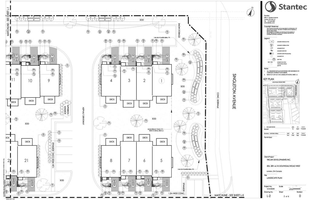
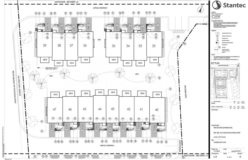
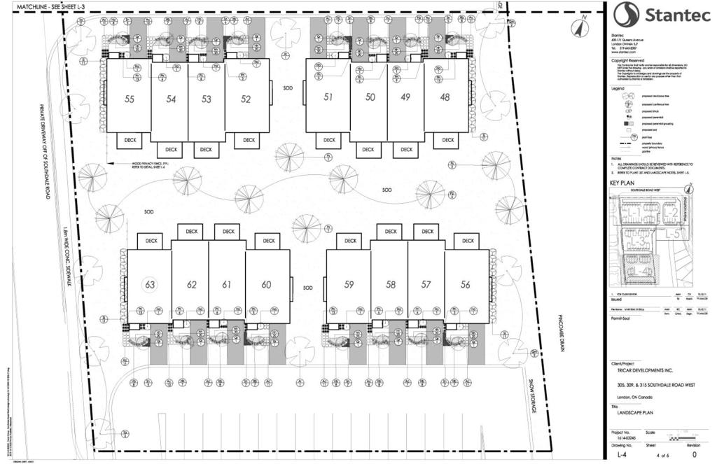
5 1.2 Proposed Development The site is currently zoned R5-4, UR4, ER, OS4, and R9-7*H40. The current Official Plan land use designation on the subject property is Multi-Family Medium Density Residential, Multi-Family High Density Residential, and Open Space. However, a combined official plan and zoning amendment application has been made to change the current zoning to R5-4, and convert the Multi-Family High Density Residential and Open Space designations to Medium Density Residential. Carvest Properties Ltd., the owner of the subject property, is proposing to develop a 63 unit townhome block. The addition of the proposed medium density homes will compliment the existing single-family homes and future 12-storey condominium towers in the neighbourhood, and will contribute to a range of housing densities in the Andover Trails Community. Figure 2: SITE PLAN 5
6 Project Goals and Objectives The goals and objectives of the proposed development include establishing an overall site design that respects the urban design principles for this area by: Providing a residential development that, through the combination of its massing, orientation, pedestrian entrances, architectural detailing, and material selection, will blend well with the vision for the community; Providing multiple access points between the development and the arterial/collectors will serve the traffic needs and eliminate the potential for short-cutting; Creating an attractive interface between the units and existing and future Tricar towers by designing an enhanced landscape that compliments the buildings and transitions activity within the property to the public realm; Adopting a land use plan that is consistent with the Official Plan. 1.3 Design Response to City Documents The design policies relevant to the proposed development are taken from the City of London Official Plan (Chapter 11), as amended by Official Plan Amendment No The subject lands are currently designated Multi-Family High Density Residential, Multi-Family Medium Density Residential, and Open Space under the City of London Official Plan (Schedule A). The policies that are relevant to the proposed development are outlined below Medium Density Residential Policies The Official Plan establishes the following policies with regard to Multi-family, Medium Density residential development: i) Support the development of multi-family, medium density residential uses at locations which enhance the character and amenity of a residential area, and where there is safe and convenient access to public transit, shopping, public open space, recreation facilities and other urban amenities. ii) Encourage the development of well-designed and visually attractive forms of multi-family, medium density housing. iii) Promote the retention of desirable natural features through the appropriate location of buildings and parking areas Bostwick East Area Plan Under section of the Official Plan, specific policies are described for development of the Bostwick East Area Plan. These policies were taken into consideration in the planning and conceptualization of the proposed development. 6
7 1.3.3 Urban Design Policies The urban design principles, as set out under Section 11.1 of the Official Plan, that are relevant to the subject site are discussed below: a) Natural Features There are no significant natural features associated with the subject site. Currently the subject lands are undeveloped with a relatively flat topography across the property. No mass grading is proposed, as the site is designed to match existing grading and respect the existing surrounding developments. b) Open Views There are open views into the site from the public realm, off of both Southdale Road West and Singleton Avenue. However, privacy of residents will be maintained by strategic landscape plantings that will act as visual barriers into front, rear, and side yards. c) High Design Standards Given that the proposed development is located near a significant commercial hub, as well as a major gateway to the city, it is anticipated that a high standard of design will be implemented. Such design standards include, but are not limited to: safe access for pedestrians, public space amenities to facilitate interaction among neighbours, best practices for built form design, and a landscape plan designed to enhance connectivity, proximity, and synergy with adjacent land uses and built form. d) Streetscape Site access is provided off of Southdale Road West via a shared private lane to the existing Tricar tower and townhomes. Units in the north side of the site will be accessible via Singleton Avenue and the private laneway to the west. A landscaped window street parallel to Southdale Road West will share the streetscape and contribute to the aesthetic of the adjacent public realm. No noise attenuation measures are proposed along the arterial road. e) Pedestrian Traffic Areas Pedestrian traffic to and within the proposed development is facilitated by a network of concrete sidewalks of varying widths. Pedestrian transit is offered via Singleton Avenue to the east and the private laneway to the west, both servicing Southdale Road West. Internally, a concrete sidewalk bisects the site in an east-west orientation and services the superbox/gazebo. 7
8 f) Access to Sunlight The proposed units will reach three storeys in height once constructed, and will be separated from the existing development to the west by a shared laneway. This is the only existing or proposed development directly adjacent to the subject site. As such, the proposed units will not impact neighbouring properties access to sunlight. g) Landscaping Detailed planting beds are proposed for the front of each unit and will utilize a combination of perennials, ornamental grasses, shrubs, and ornamental trees. Landscaping is proposed along the visible side of building façades, between rear and side yards, and as visual barriers to preserve the privacy of residents and block vehicle headlights. Shade trees will be planted along the perimeter of the property and where adequate space allows. h) Building Positioning The buildings have been positioned to create defined, secure, and attractive open space areas, and facilitate efficient vehicular and pedestrian circulation both within the development and in transition to adjacent circulation routes. i) Parking and Loading Surface parking will be provided on site as required by the zoning by-law. 8

9 1.4 Spatial Analysis The subject site is comprised of an irregularly shaped parcel that is located within a concentration of various residential and commercial developments inside the urban growth boundary. The lands west of the property along Southdale Road West are zoned for existing and future commercial uses. The existing community located southeast of the subject lands includes low density residential uses. Figure 3: LAND USE PLAN 9

10 1.4.1 Site Spatial Analysis (400m) The community context within 400m of the subject lands is mostly developed, or in the process of being developed, and open space. There are currently high, medium, and low-density residential opportunities, existing and future commercial developments, and transit connectivity including automobile, cycling, and pedestrian routes. Existing developments directly adjacent to the subject lands are designated high and medium-density residential and open space. Andover Trails subdivision, located south and east of the proposed development, is comprised of low density residential homes, the Village of Glendale Crossing Nursing Home, open space trails, and a neighbourhood park. The subdivision north of Southdale Road West contains a mix of medium and low density family homes. Barely within the 400m radius of the proposed development is the commercial node elaborated under the subsequent heading Regional Spatial Analysis (800m). Figure 4: SPATIAL ANALYSIS at 400 metre radius 10

11 Regional Spatial Analysis (800m) The community context within 800m of the subject lands is similar to the use of lands within the 400m radius in that it contains a mix of developed and under-development residential land; however there are some additional land uses dispersed beyond the 400m boundary. Low and medium density residential developments primarily occur north and east of the subject site. To the south and southeast of the site, there are residential lands currently under development, an existing storm water management pond, a designated park block, and a designated school block. There is also some light industrial and commercial land uses towards Bradley Ave and Wharncliffe Road. The commercial nodes at Wonderland Road and Southdale Road West fall directly west of the proposed development, extending north and south of Southdale Road West on both sides of Wonderland Road, and includes a mix of service and retail oriented commercial opportunities and small scale offices, such as Bates Law and the Animal Care Centre on Pine Valley Boulevard. Westmount Public Library and Westview Baptist Church are also within the 800m radius. Further west, the 800m radius just encroaches on vacant land designated primarily for residential use, but also including commercial, light industrial, and open space land uses. Figure 5: SPATIAL ANALYSIS at 800 metre radius 11
12 SWOT Analysis An analysis of the Strengths, Weaknesses, Opportunities and Threats (SWOT) presented by the neighbourhood context and the proposed development can be summarized as follows: Strengths Appropriate location for Medium Density development; Located within a currently designated High and Medium Density residential area, which is adjacent to mixed use developments, including Low and Medium Density residential; Designated open space/parkland immediately to the east provides opportunities for recreational activities; Accessible from both Singleton Avenue and Southdale Road West (via a shared laneway); Within walking distance to neighbourhood commercial nodes, including a range of amentities, such as Loblaws, Fresh Co., Home Depot, Winners, Canadian Tire, the LCBO, Westmount Public Library, Palasad South, Westview Baptist Church, gas stations, and a multitude of dining establishments; Designated small office zoning in the neighbourhood offers local professional services and encourages future business endeavors; Public transit is currently available along Wonderland and Southdale Roads, with bus stops located on Southdale Road West within the 400m radius in both eastbound and westbound directions. Within the 800m radius, there are both northbound and southbound bus stops on Wonderland Road; A proposed window street along the north property line will provide a spatial separation between proposed residences fronting on Southdale Road West, negating the need for a noise wall or wood privacy fences; Several ingress/egress points will augment accessibility by emergency vehicles and can also provide a means for Paratransit to service the site. Weaknesses Directly adjacent to a major arterial route and thus requiring mitigation to the exposure to traffic-related noise; Potentially limited access to sunlight due to shadowing from existing apartment building to the west and future building to the south; Setbacks required from high pressure gas line. Opportunities Provides an opportunity to develop the proposed Medium Density designation in a complimentary plan that will increase residential concentration in a rapidly developing district; Provides potential pedestrian connection to the existing commercial hub along Wonderland Road; 12
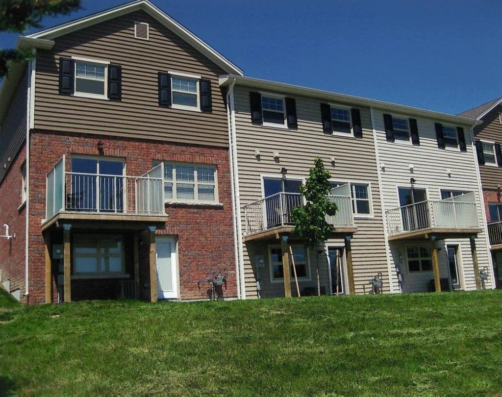
13 Facilitates infill within the urban growth boundary in accordance with Official Plan policies. Threats There are no perceived threats at this stage of the development Neighbourhood Character and Compatibility The neighbourhood character in this area of the city is a mixture of single family subdivisions together with medium and high density residential development. The area also environs a major commercial hub at the Wonderland Road and Southdale Road West intersection in all directions. Wonderland Road is also a significant gateway into London and a major arterial route through the city. Section 2 - Design Principles and Design Responses 2.1 Conceptual Design The design objectives for the subject lands are: i. Create a development that is sympathetic to the land uses existing and planned in the neighbourhood. ii. Create a development that will adhere to a high standard of urban design and architectural principles. iii. Provide well-connected landscape treatment and employ appropriate landscape architectural design principles. The goals outlined above have been achieved through appropriate building scale, the placement of various elements on-site and inclusion of landscaped site elements. Townhome Units The proposed townhome units will be located within an internal block with access along an existing joint private laneway off of Southdale Road West and a proposed private laneway off of Singleton Avenue. The townhomes will be three storeys high with a single car garage. The architectural elements of the proposed units will consist of a mix of brick and siding. A mix of window design will enhance the look of the townhomes by avoiding continuity and provide an aesthetically pleasing appearance to the proposed units. There will be no shadow impact on existing residential developments west of the development or proposed residential developments to the south. Landscape Design and Fencing Detailed planting beds are proposed for the front of each unit. Each unit s planting scheme will utilize a combination of perennials, ornamental grasses, shrubs, and ornamental trees to enhance the front 13
14 façade and highlight the building s architectural features. Additional landscaping is proposed along the visible side building elevations to add interest to the built form and facilitate site plan approval requirements for landscape components. Deciduous and coniferous trees are strategically located to provide screening and separation between the units where necessary. Planting beds comprised of ornamental shrubs and grasses along Southdale Road West will both contribute to the aesthetic of the adjacent public realm and provide visual screening to maintain the privacy of window street units. Consideration has been given to both the height and aesthetic properties of the ornamental shrubs and grasses to preserve the foregoing design intent. These plantings will also provide delineation of the property boundary in the place of a wood or ornamental fence. Along Singleton Avenue, low berms planted with ornamental shrubs and grasses, as well as coniferous trees, will screen views into side and rear lots of Units 1 to 8. Wood privacy fences flanking rear corners of the proposed buildings will provide visual barriers into rear yards from the private laneway to the west and Singleton Avenue to the east. Given the depth of the Pincombe Drain and potential for access by the public, chain link fencing was considered along the development bordering the drain, but was not added as this is not standard practice for stormwater management facilities. 2.2 Public Realm Proposed units along the northern perimeter will front onto Southdale Road West, thereby alluding to an enhanced public realm and permitting strategic sightlines into and out of the subject site. Lands within the proposed development will be owned by the future condominium corporation. 2.3 Sustainability Sustainability measures for the proposed development could include the following strategies for the building and the site: Energy efficient appliances (Energy Star appliances, windows and doors; low flow toilets, etc.); High efficiency HVAC (individual air handlers with ERVs and unit air conditioner); Installation of native and drought tolerant plants; Strategic location of trees to provide shade for building and parking lots, which reduces cooling costs and urban heat island effect; Recycling and waste management; Site is fully serviced; Close to proposed schools and recreational opportunities. 14

15 Appendix A - Site Plan

16 Appendix B - Landscape Plan
17
18
19
20
21

22 Appendix C - Elevations
Urban Design Brief December 23, 2015 Southside Construction Group Official Plan & Zoning By-Law Amendment
 Urban Design Brief Proposed Official Plan & Zoning By-Law Amendment 3244, 3263 and 3274 Wonderland Road South Southside Group December 23, 2015 TABLE OF CONTENTS Page No. INTRODUCTION... 1 SECTION 1 LAND
Urban Design Brief 1576 Richmond Street City of London
 Urban Design Brief City of London Treadstone Developments October 31, 2014 Urban Design Brief October 31, 2014 TABLE OF CONTENTS Page No. INTRODUCTION... 1 SECTION 1 LAND USE PLANNING CONCEPT... 1 1.1
URBAN DESIGN BRIEF URBAN DESIGN BRIEF 721 FRANKLIN BLVD, CAMBRIDGE August 2018
 URBAN DESIGN BRIEF URBAN DESIGN BRIEF 721 FRANKLIN BLVD, CAMBRIDGE August 2018 DESIGN BRIEF CONTENTS PART A 1.0 INTRODUCTION 2.0 DESCRIPTION & ANALYSIS OF SITE CONTEXT 3.0 DESIGN CONSTRAINTS AND OPPORTUNITIES
Urban Design Brief. 27 Centre Street London, ON. Prepared for: The Escalade Property Corp. Box 37 Lambeth Station London ON N6P 1P9
 Urban Design Brief 27 Centre Street London, ON Prepared for: The Escalade Property Corp. Box 37 Lambeth Station London ON N6P 1P9 Prepared by: Stantec Consulting Ltd. 600-171 Queens Avenue London, ON N6A
Urban Design Brief Fanshawe Park Road. Competition Toyota
 Urban Design Brief 1300 Fanshawe Park Road Competition Toyota May 2, 2014 TABLE OF CONTENTS Page No. INTRODUCTION... 1 SECTION 1 LAND USE PLANNING CONTEXT... 1 1.1 The Subject Lands... 1 1.2 The Proposal...
URBAN DESIGN BRIEF. 2136&2148 Trafalgar Road. Town of Oakville
 URBAN DESIGN BRIEF 2136&2148 Trafalgar Road Town of Oakville Prepared By: METROPOLITAN CONSULTING INC For 2500674 Ontario Inc November 2016 TABLE OF CONTENTS Page No. 1.0 Introduction/Description of Subject
Urban Design Brief Woodland Cemetery Funeral Home 493 Springbank Drive
 Urban Design Brief Woodland Cemetery Funeral Home The Incorporated Synod of the Diocese of Huron April 15, 2016 Urban Design Brief April 15, 2016 TABLE OF CONTENTS Page No. INTRODUCTION... 1 SECTION 1
URBAN DESIGN BRIEF. April FREEPORT Street TOWNHOUSES. 711 FREEPORT St., LONDON
 URBAN DESIGN BRIEF April 2013 FREEPORT Street TOWNHOUSES 711 FREEPORT St., LONDON TABLE OF CONTENTS 1.0 Land Use Planning Context...... pg. 1 1.1 Subject Lands... pg. 1 1.2 Proposed Development... pg.
URBAN DESIGN BRIEF NORTHVIEW FUNERAL HOME HIGHBURY AVE N, LONDON, ON
 URBAN DESIGN BRIEF NORTHVIEW FUNERAL HOME - 1490 HIGHBURY AVE N, LONDON, ON 1.1Purpose The intent of the following report is to identify an opportunity for redevelopment of two residential properties within
Urban Design Brief. Watson Parkway North & Watson Road North Guelph, Ontario. Prepared by Coletara Development
 Urban Design Brief Watson Parkway North & Watson Road North Guelph, Ontario Prepared by Coletara Development December, 2013 Urban Design Brief, Coletara Development 1 Introduction This Urban Design Brief
ELMVALE ACRES SHOPPING CENTRE MASTER PLAN
 ELMVALE ACRES SHOPPING CENTRE MASTER PLAN Contents 1.0 INTRODUCTION... 2 2.0 LOCATION... 2 3.0 EXISTING CONTEXT... 2 4.0 VISION & GUIDING PRINCIPLES... 2 5.0 LAND USE AND BUILT FORM... 4 5.1 St. Laurent
Urban Design Brief. 583, 585 and 589 OXFORD STREET EAST. Salt Clinic Canada Inc.
 Urban Design Brief 583, 585 and 589 OXFORD STREET EAST Salt Clinic Canada Inc. February 3, 2013 TABLE OF CONTENTS Page No. INTRODUCTION... 1 SECTION 1 LAND USE PLANNING CONCEPT... 1 1.1 The Subject Property...
Urban Design Brief to 1557 Gordon Street & 34 Lowes Road West
 Urban Design Brief 1533 to 1557 Gordon Street & 34 Lowes Road West Reid s Heritage Homes Ltd. & 883928 Ontario Ltd. and RHH Property Management Ltd. City of Guelph Zoning By-law Amendment November 2017
Urban Design Brief Proposed Residential Development 5219 Upper Middle Road City of Burlington
 Urban Design Brief Proposed Residential Development 5219 Upper Middle Road City of Burlington Prepared by Weston Consulting Prepared for BLOOMFIELD DEVELOPMENT INC. Date: March 2017 Table of Contents 1.
URBAN DESIGN BRIEF 181 Burloak Drive, Oakville
 URBAN DESIGN BRIEF 181 Burloak Drive, Oakville February 2017 Our File: 1730B 230-7050 WESTON ROAD / WOODBRIDGE / ONTARIO / L4L 8G7 / T: 905 761 5588/ F: 905 761 5589/WWW.MHBCPLAN.COM TABLE OF CONTENTS
Regency Developments. Urban Design Brief. Holyrood DC2 Rezoning
 Regency Developments Urban Design Brief Holyrood DC2 Rezoning Stantec Consulting Ltd. 7-31-2017 1. Overview Regency Developments intends to rezone the lands located at 8510 and 8511 93 Avenue, within the
420 FANSHAWE PARK ROAD EAST London, ON
 420 FANSHAWE PARK ROAD EAST London, ON URBAN DESIGN BRIEF, CHARACTER STATEMENT & COMPATIBILITY REPORT April 2016 Prepared by MHBC Planning 630 COLBORNE STREET SUITE 202 LONDON, ON N6B 2V2 TABLE OF CONTENTS
URBAN DESIGN BRIEF REPORT
 URBAN DESIGN BRIEF REPORT PREPARED FOR 2568401 ONTARIO INC NEW GASBAR, CONVENIENCE STORE & CARWASH DEVELOPMENT @ 1509 FANSHAWE PARK ROAD WEST LONDON, ONTARIO GAMA ENGINEERING INC. PROJECT NUMBER 1669 PREPARED
URBAN DESIGN BRIEF 1435 Beaverbrook Road On behalf of Wonderland Commercial Centre Inc.
 URBAN DESIGN BRIEF 1435 Beaverbrook Road On behalf of Wonderland Commercial Centre Inc. Knutson Development Consultants Inc. Development Engineering (London) Ltd. K & L Construction and Arthur Lierman
Southwest Area Secondary Plan (SWAP) Concept 1 Land use Policies
 Concept 1 Land use Policies") Purpose and Use of the proposed draft land use policies: The purpose of the Secondary Plan is to establish a vision, principles and policies for the evolution of the southwest planning area to a vibrant
Purpose and Use of the proposed draft land use policies: The purpose of the Secondary Plan is to establish a vision, principles and policies for the evolution of the southwest planning area to a vibrant
Commercial Development Permit Area
 City of Kamloops KAMPLAN Commercial Development Permit Area PURPOSE The purpose of this Development Permit Area (DPA) is to establish objectives and provide guidelines for the form and character of commercial
Urban Design Manual 2.0 DRIVE-THROUGH FACILITIES. Background. Urban Design Challenges
 222221 2.0 DRIVE-THROUGH FACILITIES Background In recent years, drive-through facilities have grown significantly in popularity with drive-through restaurants, in particular, being established on numerous
FRUITVALE TRANSIT VILLAGE (Phase 2) Residential Project
 Residential Project") FRUITVALE TRANSIT VILLAGE (Phase 2) Residential Project DEVELOPER: SIGNATURE PROPERTIES ARCHITECT: HKIT ARCHITECTS April 23, 2010 TABLE OF CONTENTS 3 Vision 4 Description of Site 5 Guiding Concepts 6
FRUITVALE TRANSIT VILLAGE (Phase 2) Residential Project DEVELOPER: SIGNATURE PROPERTIES ARCHITECT: HKIT ARCHITECTS April 23, 2010 TABLE OF CONTENTS 3 Vision 4 Description of Site 5 Guiding Concepts 6
Proposed for Vic West Neighbourhood Plan. Design Guidelines for Intensive Residential Development - Townhouse and Attached Dwelling
 Proposed for Vic West Neighbourhood Plan Design Guidelines for Intensive Residential Development - Townhouse and Attached Dwelling Design Guidelines for Intensive Residential Development - Townhouse and
Westwind Developments Ltd. PIONEER LANDS AREA STRUCTURE PLAN - PROPOSED AMENDMENT
 FEBRUARY 2013 TABLE OF CONTENTS 1.0 BACKGROUND... 1 1.1 Amendment... 1 2.0 LOCATION & CONTEXT... 2 2.1 Land Ownership... 2 3.0 POLICY CONTEXT... 3 3.1 Municipal Development Plan... 3 3.2 Capital Region
Tel: (705) Fax: (705)
 Fax: (705)") 521 and 525 Essa Road City of Barrie Tel: (705) 812-3281 Fax: (705) 812-3438 Email: INFO@IPSCONSULTINGINC.com 1 5 0 D U N L O P S T R E E T E A S T, S U I T E 2 0 1, B A R R I E O N T A R I O L 4 M 1 B
521 and 525 Essa Road City of Barrie Tel: (705) 812-3281 Fax: (705) 812-3438 Email: INFO@IPSCONSULTINGINC.com 1 5 0 D U N L O P S T R E E T E A S T, S U I T E 2 0 1, B A R R I E O N T A R I O L 4 M 1 B
Bel-Air Lexus Automobile Service Station
 Bel-Air Lexus Automobile Service Station Design Brief 443-447 McArthur Avenue Ottawa April 30, 2015 14-1299-MCA Site Details Application: Site Plan Control Legal Description and Municipal Addresses: 443
URBAN DESIGN BRIEF.. on behalf of the owner..sunningdale Commercial Inc.
 URBAN DESIGN BRIEF.. on behalf of the owner..sunningdale Commercial Inc.. in support a Site Plan Approval Application to permit a Shopping Areas commercial centre. at 1830 Adelaide Street North, in the
Clairtrell Area Context Plan
 Clairtrell Area Context Plan March 2005 Urban Development Services City Planning Contents 1. Introduction... 4 2. Development Structure... 6 2.1 Streets... 7 2.1.1 Sheppard Avenue and Bayview Avenue...
URBAN DESIGN BRIEF. Saginaw Subdivision 124 SAGINAW PARKWAY, CAMBRIDGE OCTOBER 2015 OUR FILE 1422A
 URBAN DESIGN BRIEF Saginaw Subdivision 124 SAGINAW PARKWAY, CAMBRIDGE OCTOBER 2015 OUR FILE 1422A Contents 1.0 INTRODUCTION AND SITE DESCRIPTION... 1 2.0 MUNICIPAL DESIGN DIRECTION... 7 3.0 MASTER CONCEPT
City of Vaughan Urban Design Guidelines for Infill Development in Established Low-Rise Residential Neighbourhoods
 City of Vaughan Urban Design Guidelines for Infill Development in Established Low-Rise Residential Neighbourhoods DRAFT - September 2016 Contents 1. Introduction 1 2. Policy Context 3 3. Characteristics
LIST OF FIGURES APPENDIX. Urban Design Brief: Proposed Townhouse Development, 299 Tartan Drive (City of London ON)
") URBAN DESIGN BRIEF PROPOSED TOWNHOUSE COMPLEX 299 TARTAN DRIVE, LONDON ON December 2013 TABLE OF CONTENTS 3.0 Neighbourhood Character Statement... pg. 14 1.0 Land Use Planning Context...... pg. 1 1.1 Subject
URBAN DESIGN BRIEF PROPOSED TOWNHOUSE COMPLEX 299 TARTAN DRIVE, LONDON ON December 2013 TABLE OF CONTENTS 3.0 Neighbourhood Character Statement... pg. 14 1.0 Land Use Planning Context...... pg. 1 1.1 Subject
New-Cast Mixed-use Development Proposal King Street West, Newcastle, Ontario
 URBAN DESIGN BRIEF New-Cast Mixed-use Development Proposal King Street West, Newcastle, Ontario TABLE OF CONTENTS: 1.0 Executive Summary 2.0 Creating Vibrant and Sustainable Urban Places: Excerpts from
178 Carruthers Properties Inc.
 178 Carruthers Properties Inc. Planning Rationale for 178 Carruthers Avenue Site Plan Control Application June 2014 Table of Contents 1.0 Introduction 2.0 Overview of Subject Property 3.0 Current Zoning
Urban Design Brief. 1198, 1202, 1206 & 1212 Commissioners Road West. Prepared for: Tricar Group. Prepared by: Stantec Consulting Ltd.
 Urban Design Brief 1198, 1202, 1206 & 1212 Commissioners Road West Prepared for: Tricar Group Prepared by: Stantec Consulting Ltd. Table of Contents 1.0 LAND USE PLANNING CONTEXT... 1.1 1.1 INTRODUCTION...
QUEEN-RIVER SECONDARY PLAN
 34 QUEEN-RIVER SECONDARY PLAN 34. QUEEN RIVER SECONDARY PLAN 1. INTRODUCTION The Queen-River area is approximately 6.4 hectares and is located at the eastern edge of the Downtown as shown on Map 34-1.
Urban Design Brief. 875 Wellington Road. Proposed One-Storey Fast Food Restaurant and Two-Storey Restaurant. Wellington Harlech Centre Inc.
 Urban Design Brief 875 Wellington Road Proposed One-Storey Fast Food Restaurant and Two-Storey Restaurant Wellington Harlech Centre Inc. Prepared By: (519) 433-7587 info@yorkdev.ca May 3 rd 2013 1 Table
REPORT TO THE CHIEF ADMINISTRATIVE OFFICER FROM THE DEVELOPMENT AND ENGINEERING SERVICES DEPARTMENT
 REPORT TO THE CHIEF ADMINISTRATIVE OFFICER FROM THE DEVELOPMENT AND ENGINEERING SERVICES DEPARTMENT ON DEVELOPMENT PERMIT APPLICATION NO. DPM00592 1393 9TH AVENUE/915 MCMURDO DRIVE OWNER/APPLICANT: 1393
Housing and Coach House Guidelines - Ladner
 Housing and Coach House Guidelines - Ladner Policy D.8: Encourage Compatible Housing Design Encourage housing design that is sensitive to existing single family housing neighbourhoods by requiring a design
URBAN DESIGN BRIEF Audi London 481 Wharncliffe Road South, London, Ontario. October, 2013
 URBAN DESIGN BRIEF 481 Wharncliffe Road South, London, Ontario October, 2013 Urban Design Brief Table of Contents Section 1 Land Use Planning Context 1.1 Subject Lands 1.2 Proposed Development 1.3 Design
East Bayshore Road Neighbourhood
 East Bayshore Road Neighbourhood Northridge Property Management Urban Design Brief 3195 East Bayshore Road City of Owen Sound January 2016 East Bayshore Road Neighbourhood Northridge Property Management
Complete Neighbourhood Guidelines Review Tool
 Complete Neighbourhood Guidelines Review Tool Prepared By: City of Regina Planning Department October 2014 Page 1 of 14 Community Development Review Checklist for Secondary Plans and Concept Plans The
Highland Village Green Design Guidelines
 Highland Village Green Design Guidelines Publishing Information Title Highland Village Green Design Guidelins Author The City of Calgary Status DRAFT - Proposed document subject to changes Additional Copies
Commercial Development Proposal Tenth Line Road. Planning Rationale Report. Minto Developments Inc.
 Commercial Development Proposal 2168 Tenth Line Road Report September 2015 Prepared for Minto Developments Inc. Paquette Planning Associates Ltd. 56 Hutchison Avenue Ottawa, Ontario K1Y 4A3 PH: 613-722-7217
Urban Design Guidelines Townhouse and Apartment Built Form
 Urban Design Guidelines Townhouse and Apartment Built Form Town of Wasaga Beach Table of Contents 1. Introduction 1.1. Purpose 1.2. Urban Design Principles 1.3. Application of Guidelines 2. Site Design,
URBAN DESIGN BRIEF New Street Burlington, ON
 3225-3237 New Street Burlington, ON MARCH 2017 Prepared for: Royal Living Development Group Inc. Prepared by: adesso design inc. 218 Locke Street South, 2nd Floor Hamilton, ON L8P 4B4 t. 905.526.8876 3225-3237
2.5 Roads. Loading and service areas adjacent to Highway 401 should be screened through architectural walls and/or landscape buffer planting.
 N HIGHWAY OFF RAMP 2.5 Roads A legible road network with a clear hierarchy will help create a connected community, both within and surrounding the Milton Heights. The following section outlines the proposed
I539. Smales 2 Precinct
 I539. Smales 2 Precinct I539.1. Precinct Description The Smales 2 Precinct applies to a 4.8 hectare block of land located on the southern side of Northcote Road and fronting Lake Pupuke, Takapuna. The
CONTENTS 8.0 LAND USE 8.1 GENERAL LAND USE 8.2 RESIDENTIAL 8.3 MIXED USE 8.4 COMMERCIAL 8.5 EMPLOYMENT LANDS
 8-2 Land Use 8.0 LAND USE CONTENTS 8.1 GENERAL LAND USE 8.1.1 Uses provided for in all Land Use Designations 8.1.2 Uses prohibited in Hazardous Lands, Hazardous Sites and Special Policy Areas 8.1.3 Uses
PLANNING RATIONALE FOR THE PROPOSED RIVERSIDE SOUTH ELEMENTARY SCHOOL 715 BRIAN GOOD AVENUE, OTTAWA, ON
 PLANNING RATIONALE FOR THE PROPOSED RIVERSIDE SOUTH ELEMENTARY SCHOOL 715 BRIAN GOOD AVENUE, OTTAWA, ON Conseil des écoles publiques de l'est de l'ontario (CEPEO) French Public School Board TABLE OF CONTENTS
Planning Board Briefing
 Planning Board Briefing Why Now? The Sector Plan Implementation Chapter States: Before Stage 1 begins, the following must occur: Approval of the Sectional Map Amendment. Approval of the Greater Lyttonsville
4 RESIDENTIAL ZONE. 4.1 Background
 4 RESIDENTIAL ZONE 4.1 Background The residential areas within the City are characterised by mainly lowrise dwellings sited on individual allotments. Past architectural styles, settlement patterns and
Revitalization Guidelines for Corridors, Villages and Town Centres
 Revitalization Guidelines for Corridors, Villages and Town Centres July 2017 Updated May, 2018 Publishing Information Title: Prepared by: Revitalization Guidelines for Corridors, Villages and Town Centres
PORT WHITBY COMMUNITY
 PORT WHITBY COMMUNITY SECONDARY PLAN UPDATE COMMUNITY IMPROVEMENT PLAN URBAN DESIGN GUIDELINES September 2015 DRAFT PROPOSED AMENDMENT NUMBER # to the Whitby Official Plan PURPOSE: The intent of this Amendment
DRAFT Northeast Quadrant of Kipling Avenue and Highway 7 DRAFT AUGUST 29, Goals Land Use. The goals of this Plan are to:
 AUGUST 29, 2017 12.15 Northeast Quadrant of Kipling Avenue and Highway 7 12.15.1 Goals 12.15.2 Land Use The goals of this Plan are to: 12.15.2.1 General Provisions: a) Ensure the development of a compact
TABLE OF CONTENTS 1.0 INTRODUCTION... 3
 TABLE OF CONTENTS 1.0 INTRODUCTION... 3 1.1. BACKGROUND... 3 1.2. THE PROPOSAL... 5 2.0 EXISTING POLICY FRAMEWORK... 5 2.1. PROVINCIAL POLICY STATEMENT (PPS)... 5 2.2. CITY OF LONDON OFFICIAL PLAN (OP)...
PROPOSED REDEVELOPMENT OF THE GLEN ABBEY GOLF CLUB. STREETSCAPE DESIGN STUDY (excerpt from the Urban Design Brief) TOWN OF OAKVILLE.
 TOWN OF OAKVILLE.") PROPOSED REDEVELOPMENT OF THE GLEN ABBEY GOLF CLUB STREETSCAPE DESIGN STUDY (excerpt from the Urban Design Brief) TOWN OF OAKVILLE OCTOBER, 2016 for 2.4.2 STREETS Streets are the single largest component
PROPOSED REDEVELOPMENT OF THE GLEN ABBEY GOLF CLUB STREETSCAPE DESIGN STUDY (excerpt from the Urban Design Brief) TOWN OF OAKVILLE OCTOBER, 2016 for 2.4.2 STREETS Streets are the single largest component
TRAFALGAR ROAD
 158-2192 TRAFALGAR ROAD URBAN DESIGN BRIEF PREPARED BY KLM PLANNING PARTNERS INC. FOR DUNPAR DEVELOPMENTS INC. TOWN OF OAKVILLE JUNE 2012 TABLE OF CONTENTS 1 INTRODUCTION 1.1 Project Description...1 1.1.1
6. REGIONAL AND COMMUNITY FACILITIES DESIGNATIONS 6.1. OBJECTIVES FOR REGIONAL AND COMMUNITY FACILITIES LAND USE DESIGNATIONS
 6. REGIONAL AND COMMUNITY FACILITIES DESIGNATIONS INTRODUCTION The Regional and land use designations provide the primary locations for uses which satisfy the health, education and other service needs
URBAN DESIGN BRIEF. on behalf of the owner 1331 Hyde Park Road Inc.
 URBAN DESIGN BRIEF. on behalf of the owner 1331 Hyde Park Road Inc.. in support a Site Plan Approval Application to permit a Mainstreet retail commercial centre.. At 1331 Hyde Park Road, in the City of
AIRPORT BUSINESS PARK
 PIER MAC PETROLEUM INSTALLATION LTD. AIRPORT BUSINESS PARK DEVELOPMENT APPLICATIONS March 2003 4.1 Airport Business Park Development Permit Area 4.1.1 Justification/Design Concept The design concept envisioned
Urban Design Brief 32, 36 and 40 York Street City of London
 Urban Design Brief 32, 36 and 40 York Street City of London 161413372 Prepared for: Tricar Developments Inc. Prepared by: Stantec Consulting & Kasian Architecture Ontario Inc. July 18, 2017 URBAN DESIGN
Gas Stations ottawa.ca
 Urban Design Guidelines for Gas Stations ottawa.ca Ce document est disponible en français sur ottawa.ca. This document is available in French on ottawa.ca. Approved by City Council May 24, 2006 City of
*** DRAFT 2 FOR PUBLIC REVIEW ***
 6.7 The area is generally bounded by the Red Hill Valley Parkway to the west, Lake Avenue to the east, the Queen Elizabeth Way (QEW) to the north, and by the properties just south of Queenston Road to
New Street Proposed Redevelopment Architecture & Urban Design Brief
 2130 2136 New Street Proposed Redevelopment Architecture & Urban Design Brief Prepared By: Cynthia Zahoruk Architect Inc. 3077 New Street, Burlington, ON, L7N 1M6 TABLE OF CONTENTS Background and Objective
599 Kennedy Road - Official Plan Amendment and Zoning Amendment Application - Preliminary Report
 STAFF REPORT ACTION REQUIRED 599 Kennedy Road - Official Plan Amendment and Zoning Amendment Application - Preliminary Report Date: March 7, 2017 To: From: Wards: Reference Number: Scarborough Community
Toronto Complete Streets Guidelines
 Toronto Complete Streets Guidelines 108 110 7.1 Green Infrastructure Design Principles 112 7.2 Context-Sensitive Green Streets 114 7.3 Key Green Street Elements Green infrastructure refers to natural and
FRASER LANDS CD-1 GUIDELINES (BLOCKS 68 AND 69) Adopted by City Council April 1989
 Adopted by City Council April 1989") $1 City of Vancouver Land Use and Development Policies and Guidelines Community Services, 453 W. 12th Ave Vancouver, BC V5Y 1V4 F 604.873.7344 fax 873.7060 planning@city.vancouver.bc.ca FRASER LANDS CD-1
$1 City of Vancouver Land Use and Development Policies and Guidelines Community Services, 453 W. 12th Ave Vancouver, BC V5Y 1V4 F 604.873.7344 fax 873.7060 planning@city.vancouver.bc.ca FRASER LANDS CD-1
Community Information Meeting
 Queensborough Eastern Community Information Meeting July 24, 2014 Cameron Chalmers, MCIP, RPP Platform Properties Meeting Format Purpose Format The purpose of the meeting is to invite the community to
Urban Design Manual PLANNING AROUND RAPID TRANSIT STATIONS (PARTS) Introduction. Station Study Areas
 Introduction. Station Study Areas") 111111 PLANNING AROUND RAPID TRANSIT STATIONS (PARTS) Introduction The ION rapid transit system will link Waterloo, Kitchener and Cambridge through a central transit corridor (CTC). There are a number
111111 PLANNING AROUND RAPID TRANSIT STATIONS (PARTS) Introduction The ION rapid transit system will link Waterloo, Kitchener and Cambridge through a central transit corridor (CTC). There are a number
Figure 3-1: Public Realm Plan
 3 Public Realm Figure 3-1: Public Realm Plan 3.1 Public Realm Concept The public realm concept for the Little Mountain site integrates a clear and accessible movement network with public spaces for social
WINDSOR GLEN DESIGN GUIDELINES
 WINDSOR GLEN DESIGN GUIDELINES Adopted by Council, 2006 WINDSOR GLEN REDEVELOPMENT DESIGN GUIDELINES August 2006 1.0 Master Plan Organization For this area of the Coquitlam Town Centre, a mix of high,
4. INDUSTRIAL 53 CASTLE ROCK DESIGN
 4. INDUSTRIAL 53 CASTLE ROCK DESIGN CASTLE ROCK DESIGN 54 4. INDUSTRIAL Overview Well-designed and attractive industrial centers are the product of blending economic realities with both functional and
Metro. Activity Center Design Guidelines. Recommendations For Developing Focused, Mixed-Use Commercial/Residential Centers
 Metro Activity Center Design Guidelines Recommendations For Developing Focused, Mixed-Use Commercial/Residential Centers Metro Activity Centers What is a MAC? Legacy, the adopted guide for the future growth
burlington mobility hubs study Downtown Burlington Mobility Hub
 burlington mobility hubs study Downtown Burlington Mobility Hub Draft Precinct Plan Workbook PIC #3, September 7, 2017 downtown mobility hub objectives City staff and their consultants are proposing an
RIVERSIDE DESIGN CD-1 GUIDELINES. Adopted by City Council August 9, 1983
 $1 City of Vancouver Land Use and Development Policies and Guidelines Community Services, 453 W. 12th Ave Vancouver, BC V5Y 1V4 F 604.873.7344 fax 873.7060 planning@city.vancouver.bc.ca RIVERSIDE DESIGN
PUBLIC OPEN HOUSE SEPTEMBER 8 TH, 2010 CITY OF LETHBRIDGE DEVELOPMENT SERVICES
 PUBLIC OPEN HOUSE SEPTEMBER 8 TH, 2010 CITY OF LETHBRIDGE DEVELOPMENT SERVICES INTRODUCTION Why is the City creating the West Lethbridge Employment Centre Area Structure Plan? West Lethbridge Urbanization
4.0 Design Guidelines For The Village Centre. South fields Community Architectural Design Guidelines Town of Caledon
 4.0 Design Guidelines For The Village Centre 4.0 Design Guidelines for the Village Centre The Village Centre is the focal point of the entire South Fields Community and is designed as a traditional commercial
Multi family Residential Development Permit Area
 City of Kamloops KAMPLAN Multi family Residential Development Permit Area PURPOSE The purpose of this Development Permit Area (DPA) is to establish objectives and provide guidelines for the form and character
LIST OF TABLES, FIGURES AND APPENDICES
 LIST OF TABLES, FIGURES AND APPENDICES Chapter Page 2 INTERPRETATION FIGURE 2.1 SAMPLE AWNING...2.8 FIGURE 2.2 SAMPLE LOW-RISE APARTMENT DESIGN...2.9 FIGURE 2.3 SAMPLE DUPLEX DESIGN...2.10 FIGURE 2.4 SAMPLE
2136 & 2148 Trafalgar Road Town of Oakville Region of Halton
 PLANNING JUSTIFICATION REPORT 2136 & 2148 Trafalgar Road Town of Oakville Region of Halton Zoning By-Law Amendment Application 2500674 Ontario Inc. November 2016 Table of Contents Page 1.0 Location/Summary
YONGE STEELES CORRIDOR SECONDARY PLAN. Young + Wright / IBI Group Architects Dillon Consulting Ltd. GHK International (Canada) Ltd.
 Ltd.") PART A: PREAMBLE 1.0 PURPOSE The purpose of this Secondary Plan is to provide a development framework for intensification of the Yonge/ Steeles corridor including the north side of Steeles Avenue West
PART A: PREAMBLE 1.0 PURPOSE The purpose of this Secondary Plan is to provide a development framework for intensification of the Yonge/ Steeles corridor including the north side of Steeles Avenue West
Gold Line Bus Rapid Transit Transit Oriented Development (BRTOD) Helmo Station Area Plan
 Helmo Station Area Plan") Appendix F Gold Line Bus Rapid Transit Transit Oriented Development (BRTOD) Helmo Station Area Plan Introduction and Purpose of the Plan The Gold Line Bus Rapid Transit facility is an eleven-mile dedicated
Appendix F Gold Line Bus Rapid Transit Transit Oriented Development (BRTOD) Helmo Station Area Plan Introduction and Purpose of the Plan The Gold Line Bus Rapid Transit facility is an eleven-mile dedicated
A. Background Summary of Existing Challenges and Potential Possibilities. 1. Summary of Existing Assets and Potential Opportunities
 A. Background 1 A Main Street Master Plan Study was performed and completed in October of 2007. The study was initiated to review current land uses and development patterns along Main Street, from Parrish
Wide asphalt driveway abutting school property. garage built with incompatible materials, too close to park. incompatible fencing materials
 Wide asphalt driveway abutting school property incompatible fencing materials garage built with incompatible materials, too close to park Lack of plantings as a buffer between private property and open
13 THORNHILL YONGE STREET STUDY IMPLEMENTATION CITY OF VAUGHAN OPA 669 AND TOWN OF MARKHAM OPA 154
 13 THORNHILL YONGE STREET STUDY IMPLEMENTATION CITY OF VAUGHAN OPA 669 AND TOWN OF MARKHAM OPA 154 The Planning and Economic Development Committee recommends the adoption of the recommendations contained
(DC1) Direct Development Control Provision DC1 Area 4
 Direct Development Control Provision DC1 Area 4") . General Purpose (DC) Direct Development Control Provision DC Area 4 The purpose of this Provision is to provide for an area of commercial office employment and residential development in support of the
. General Purpose (DC) Direct Development Control Provision DC Area 4 The purpose of this Provision is to provide for an area of commercial office employment and residential development in support of the
URBAN DESIGN + ARCHITECTURAL CONTROL GUIDELINES
 Appendix I BRESLAU SETTLEMENT PLAN URBAN DESIGN + ARCHITECTURAL CONTROL GUIDELINES Table of Contents 1.0 INTRODUCTION 1 2.0 DESIGN GUIDELINES FOR THE PUBLIC REALM 2 2.1 General Design Principles 2 2.2
Guidelines. Building. The minimum setback of an attached garage from the lot line shall be 6m. 4. Zoning Provision
 Objectives Create dwellings that are compatible with the neighborhood in scale, function and character Create pedestrian friendly neighborhood Prevent garage dominated streetscape Strengthen the dwelling
KEY MAP DEVELOPMENT PERMIT AREA MAP. Sunnymede North Sub-Area Plan
 Richmond Official Community Plan BROADMOOR AREA SUNNYMEDE NORTH SUB-AREA PLAN Bylaw 7100 Schedule 2.6C SUNNYMEDE NORTH SUB-AREA PLAN SUNNYMEDE NORTH SUB-AREA PLAN SUNNYMEDE NORTH SUB-AREA PLAN KEY MAP
URBAN DESIGN BRIEF Gordon Street City of Guelph. Prepared on behalf of Ontario Inc. March 25, Project No. 1507
 URBAN DESIGN BRIEF 1131 Gordon Street City of Guelph Prepared on behalf of 1876698 Ontario Inc. March 25, 2016 Project No. 1507 423 Woolwich Street, Suite 201, Guelph, Ontario, N1H 3X3 Phone (519) 836-7526
Re: 1110 Fisher Avenue Proposed Residential Development Revised Proposal File D PLANNING RATIONALE ADDENDUM
 October 23, 2014 Prestige Design & Construction 50 Camelot Drive Ottawa, ON K2G 5X8 Attention: Mr. Enzo DiChiara Dear Mr. DiChiara Re: 1110 Fisher Avenue Proposed Residential Development Revised Proposal
WEST LOOP DESIGN GUIDELINES CHECKLIST
 WEST LOOP DESIGN GUIDELINES CHECKLIST Section 1.0 General Strategies 1.1 DESIGN EXCELLENCE: ENCOURAGE HIGH QUALITY AND INNOVATIVE DESIGN OF NEW BUILDINGS WITHIN THE WEST LOOP WITHOUT BEING PRESCRIPTIVE
SCHEDULE 12 TO THE DESIGN AND DEVELOPMENT OVERLAY GLEN WAVERLEY ACTIVITY CENTRE STRUCTURE PLAN
 DD/MM/YY Proposed C120 SCHEDULE 12 TO THE DESIGN AND DEVELOPMENT OVERLAY Shown on the planning scheme map as DDO12. GLEN WAVERLEY ACTIVITY CENTRE STRUCTURE PLAN 1.0 Design objectives DD/MM/YY Proposed
AGINCOURT SECONDARY PLAN
 1 AGINCOURT SECONDARY PLAN 1. AGINCOURT SECONDARY PLAN The following policies and principles apply to the area herein referred to as Agincourt, as outlined on Map 1-1. 1. GENERAL POLICIES 1.1 This Secondary
Little Mountain UDP Presentation
 Summary of UDP Evaluation of Dec 2015 Plan Dec 2015 Site Plan Transitional edges work well Central spine and permeability are strong Tree retention is good Establish Big Idea Sameness of built form contributes
URBAN DESIGN BRIEF. Terms of Reference. Purpose. When is an Urban Design Brief Required
 Purpose An Urban Design Brief (UDB) is intended to describe and illustrate proposed designs for new development projects and demonstrate how the City s Urban Design Guidelines and other City policies have
3.1 community vision. 3.3 required plan elements
 Chapter 3 Community Form 3.1 community vision 3.2 Parks & landscaping concepts 3.3 required plan elements D R A F T 20 Community Form Chapter 3 3.0 Community form 3.1 community vision The Specific Plan
FORMER CANADIAN FORCES BASE (CFB) ROCKCLIFFE SECONDARY PLAN. Official Plan Amendment XX to the Official Plan for the City of Ottawa
 ROCKCLIFFE SECONDARY PLAN. Official Plan Amendment XX to the Official Plan for the City of Ottawa") FORMER CANADIAN FORCES BASE (CFB) ROCKCLIFFE SECONDARY PLAN Official Plan Amendment XX to the Official Plan for the City of Ottawa 1 INDEX THE STATEMENT OF COMPONENTS PART A THE PREAMBLE PAGE Purpose...
FORMER CANADIAN FORCES BASE (CFB) ROCKCLIFFE SECONDARY PLAN Official Plan Amendment XX to the Official Plan for the City of Ottawa 1 INDEX THE STATEMENT OF COMPONENTS PART A THE PREAMBLE PAGE Purpose...
Subarea 4 Indian Creek. Vision The combination of park networks and transportation amenities make Subarea 4 the greenest hub in the Corridor.
 indian creek 180 extends south from 101st Street to I-435. The I-435 and Metcalf intersection is one of the primary intersections in the Kansas City Metro Area. The area includes several residential neighborhoods