Urban Design Brief December 23, 2015 Southside Construction Group Official Plan & Zoning By-Law Amendment
|
|
|
- Aubrie Patrick
- 6 years ago
- Views:
Transcription

1 Urban Design Brief Proposed Official Plan & Zoning By-Law Amendment 3244, 3263 and 3274 Wonderland Road South Southside Group December 23, 2015
2
3 TABLE OF CONTENTS Page No. INTRODUCTION... 1 SECTION 1 LAND USE PLANNING CONTEXT The Subject Lands The Proposal Design Goals and Objectives Design Response to Official Plan Urban Design Principles and Southwest Area Plan Urban Design Guidelines Spatial Analysis Community Context 400 metres Community Context 800 metres SECTION 2 DESIGN PRINCIPLES AND DESIGN RESPONSES Conceptual Design Public Realm Sustainability Techniques... 16
4 INTRODUCTION The purpose of this Urban Design Brief is to provide the design details for a proposed development by Southside Group consisting of a big box / new format retail development located on vacant lands on both the east and west sides of Wonderland Road South in the Bostwick neighborhood. The retail development will be occupied by a mix of multi-unit and stand alone retail buildings. SECTION 1 LAND USE PLANNING CONTEXT 1.1 THE SUBJECT LANDS The subject lands are located on the east and west sides of Wonderland Road South, immediately south of the planned extension of Bradley Avenue (Figure 1). The subject lands are comprised of a portion of two rectangular parcels on the east side of Wonderland Road South and two rectangular parcels on the west side of Wonderland Road South. The parcels on the east side of Wonderland Road South have a combined frontage of approximately meters (51.29 feet) along Wonderland Road South (Figure 1). Only a portion of these parcels is subject to the application and therefore, only metres of the total meters (1, feet) property depth is included, for a total site area of approximately 3.63 hectares (8.97 acres) in area. The parcels on the west side of Wonderland Road South have a combined frontage of approximately metres ( feet) along Wonderland Road South and a depth of approximately metres ( feet), totaling approximately 3.75 hectares (9.27 acres) in area. The total area proposed for an expanded range of commercial uses is approximately 7.38 hectares (18.24 acres). The subject lands are known municipally as 3244, 3263 and 3274 Wonderland Road South. A municipal address has not yet been assigned to the northerly parcel on the west side of Wonderland Road South. The subject lands are predominately vacant with the exception of the southerly parcel on the east side of Wonderland Road South, which is the site of a former motor vehicles sales establishment that included two commercial buildings and a separate detached dwelling. 1

")

5 Figure 1 Subject Lands Figure 2 Subject Lands (west side of Wonderland Road South) Figure 3 Subject Lands (east side of Wonderland Road South) 2

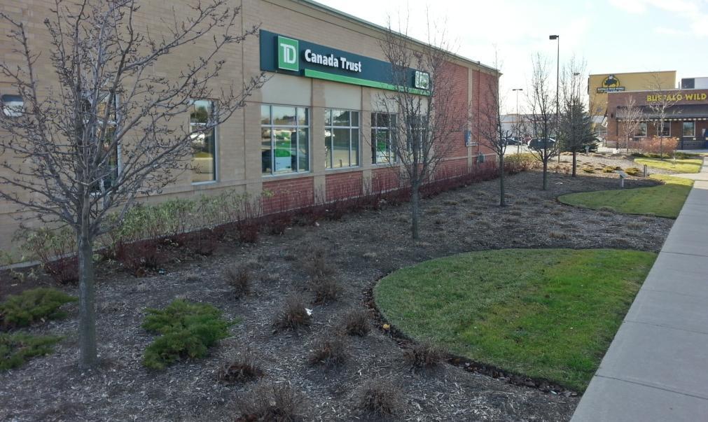
6 1.2 THE PROPOSAL The development proposal for the subject lands is for a big box / new format retail development, similar to the existing built form to the north of the subject lands. The conceptual design for the subject lands provides for a total of 18,689 sq. m (201,166 sq. ft.) of retail floor space spread over four large, retail units, and a number of stand alone buildings with opportunities for multiple tenants (Figure 4). Figure 4 Conceptual Development Plan The general layout and building placement is in keeping with the layout of the lands to the north; stand alone buildings are placed close to the road frontages of Wonderland Road South and Bradley Avenue while larger spaces for anchor retailers are placed further to the rear. Vehicular access is provided by five, full-turn accesses on Bradley Avenue (including a service access at the easterly property limit) and three, right-in-right-out (RI/RO) accesses on Wonderland Road South (two for the easterly lands and one for the westerly lands). Pedestrian linkages are anticipated along both Bradley Avenue and Wonderland Road. On-site pedestrian linkages are facilitated by wide pedestrian boulevards in front of the retail plazas, similar to what currently exists to the north of the subject lands at the Winners/Homesense/JYSK plaza (Figure 5). Extensive landscaping is proposed for these areas to provide a high quality pedestrian environment. 3

7 Figure 5 Pedestrian Boulevard 1.3 DESIGN GOALS AND OBJECTIVES The overall goal of the development proposal is to construct a retail environment that contributes to an attractive street presence within the Wonderland Boulevard and the existing commercial development to the north. The design is intended to benefit the City s southwesterly Wonderland Road South gateway, and to be compatible with the surrounding neighbourhood. In order to effectively achieve this goal for the subject lands, the following design objectives have been identified: Create street-oriented development that reinforces the spatial enclosure of the street and addresses all abutting streetscapes. Enhance the aesthetic quality of the residential and commercial neighbourhoods in the vicinity of the subject lands by utilizing architectural elements, such as building massing, articulation, materials and colours that are attractive and complement the existing buildings. 4
8 Appropriately screen the associated parking areas from public view. Provide a high quality pedestrian environment by providing pedestrian walkways and crossings lined with landscaped features. Provide high quality site and building design at the southwest gateway to the City of London. Provide for a development of the subject lands that will be supportive of investments in public transit and provide convenient access for pedestrians and cyclists as well as those arriving by car. 1.4 DESIGN RESPONSE TO OFFICIAL PLAN URBAN DESIGN PRINCIPLES AND SOUTHWEST AREA PLAN URBAN DESIGN GUIDELINES The City of London Official Plan includes urban design principles that are to be applied to new developments city-wide. Section in the Official Plan lists the urban design principles that are to be promoted in the preparation of development proposals. In addition to these urban design principles, the Ontario Municipal Board approved the Southwest Area Plan (SWAP) in April 2014, which contains additional design guidelines to be applied to new developments within the southwesterly area of the city. Section of SWAP lists the design guidelines that are to be promoted in the preparation of development proposals. The urban design principles and guidelines contained in the above mentioned documents do not always apply to each specific development and are dependent upon the location and characteristics of the proposal. The urban design principles and guidelines frequently focus on common themes and, where appropriate, we have addressed the urban design principles and guidelines together according to these common themes. The urban design principles and guidelines relevant to this development proposal by Southside Group and how they are addressed are described in the following: Trees - Official Plan Section ii) The subject lands currently contain sporadic groups of trees. Existing trees will be conserved where possible to enhance the look of the site. Strategic tree-forms and tree-types will be planted to achieve specific functions on the site. For example, deciduous shade trees are proposed along 5
9 all bounding streets on private property adjacent to the public sidewalk and will assist in the spatial enclosure and delineation of the street-line and will provide for an attractive and comfortable pedestrian environment along the public sidewalks. Parking islands internal to the site will be landscaped with deciduous shade trees and a mix of shrubs, perennials and ornamental grasses to visually break up large parking areas. The wide pedestrian boulevards internal to the site will be defined by broad landscaped areas in a similar fashion to the pedestrian boulevards to the north of the subject lands. High Design Standards Official Plan Section iv) The proposed commercial campus has been designed to respond to the obligation to provide an attractive streetscape and high quality design and landscaping proximate to gateways to the City, districts or neighborhoods as elaborated below in discussion of gateways. Architectural Continuity Official Plan Section vi) Common architectural elements such as building massing, articulation, materials and colours bring consistency and continuity to the grouping of buildings that comprise the proposed commercial campus. These architectural elements as proposed will also be compatible with, and complement, existing buildings in the vicinity of the subject lands. The proposed buildings have a low-rise, moderate massing that is compatible with the existing commercial node to the north and is of an appropriate pedestrian scale recognizing the planned pedestrian orientation of the bounding streets according to the Southwest Area Plan. The proposed buildings are one-storey in height, also consistent with the existing commercial buildings to the north. The proposed building elevations are highly articulated through a variety of means (i.e. changes in the cladding materials, entrance and window placement, the use of datum/ cornice lines, building projections and recesses). A similar level of attention will be paid to all elevations in terms of articulation. The proposed materials selection will include a masonry base, brick middle, and stucco top for most buildings which will complement the similar use of materials that clad existing buildings to the north. Colours will be selected based on a range of colours that will complement existing buildings, north of Bradley Avenue. 6
10 Streetscape Official Plan Section vii) The proposed commercial campus will position buildings within close proximity to Wonderland Road to minimize the building setback and thereby provide a strong and consistent built edge that contributes in part to the spatial enclosure and delineation of the street-line. The positioning of the proposed buildings allows for most of the associated parking areas to be located internal to the site behind the proposed buildings and screened from public view, contributing to an attractive street presence. The highly articulated building elevations will ensure that blank walls are not featured in the streetscape. The rear and side building elevations that will face bounding streets are highly articulated and have a similar level of architectural detail as the front or principal building elevations. The highly articulated building elevations will provide visual interest and punctuation at the prominent corner locations. Public sidewalks are planned along the bounding streets, and several direct connections from the on-site pedestrian walkways to the public sidewalks are proposed. Pedestrian Circulation Official Plan Section viii) A series of pedestrian walkways and crossings will facilitate pedestrian circulation through the site from Wonderland Road and Bradley Avenue, as well as link the on-site buildings. The pedestrian walkway connections with the public sidewalk are available for use by those who will access the site by foot, bicycle or public transit. The pedestrian walkways and connection through the site will ensure that a convenient pedestrian circulation route is provided For pedestrians traversing the parking areas internal to the site, the pedestrian walkways and crossing through the site will provide areas of refuge. Access to Sunlight Official Plan Section ix) The shadow impact from the proposed commercial campus onto adjacent lands and streets will be negligible given the low-rise and moderate massing of the proposed buildings. Clear glazing is proposed for the front or principal building elevations and there is an opportunity for both clear glazing and spandrel glazing on the side and rear building elevations to suit tenant layouts. Landscaping Official Plan Section x) Landscaping will unify and enhance all elements of the proposed commercial campus including building design, pedestrian circulation, parking and views into the site from the bounding streets 7
11 (Figure 19). A layered approach to landscaping (i.e. deciduous shade trees and a mix of shrubs, perennials and ornamental grasses) is used in several areas to soften the transition to the proposed buildings, screen parking areas and visually break up large parking areas. It is important to note that landscaping along the bounding streets will contribute to an attractive street presence and internal to the site will reinforce the presence of pedestrian walkways and crossings through the site and link buildings. Building Positioning Official Plan Section xi) As elaborated above in the discussion of streetscape, the proposed commercial development will position buildings within close proximity to Wonderland Road to minimize the building setback and thereby provide a strong and consistent built edge that contributes in part to the delineation of the street-line. The positioning of the proposed buildings allows for most of the associated parking areas to be located internal to the site behind the proposed buildings and screened from public view contributing to an attractive street presence. Accessibility Official Plan Section xii) The proposed commercial campus will be built to provide for universal accessibility. Ramps have been incorporated into the design of the pedestrian walkways providing barrier free access to and from the parking areas. Accessible parking spaces have also been provided throughout the site at various locations in close proximity to most building entrances. Parking and Vehicular Access Official Plan Section xiii) As elaborated above in the discussion of streetscape and building positioning, most of the associated parking areas will be located internal to the site behind the proposed buildings and screened from public view. All required vehicular parking can be accommodated on-site, applying the rate for anticipated uses for the commercial development. Due to the expanse of on-site parking required, the site is divided into smaller parking areas through the use of landscaped parking islands and pedestrian walkways and crossings though the site. The associated parking areas will be accessed by driveways off Wonderland Road and Bradley Avenue to provide vehicular access to the site. The use of a right-in/right-out accesses along Wonderland Road is intended to reduce the potential traffic conflicts on the arterial road. 8
12 The loading associated with the proposed commercial buildings can predominately be addressed by the standard on-site vehicular parking spaces and through standard pedestrian entrances to the proposed buildings. Privacy Official Plan Section xiv) There are no existing residential developments adjacent to the subject lands that would require privacy protection. Waste Management Official Plan Section xix) All waste materials are proposed to be stored in on-site Molok containers that are a preferred alternative to standard dumpsters contained and screened by purpose-built enclosures. With most of the Molok containers capacity located underground less developable space is consumed by waste management; compaction results from the natural force of gravity; and fewer odours result due to cooler underground temperatures. As such, it is expected that the Molok containers will be emptied less often than standard dumpsters, reducing the private truck traffic associated with waste management. Strategic locations for the Molok containers have been identified on the site plan. Resource Conservation Official Plan Section xx) The proposed development of the subject lands will make efficient use of urban land and investment in existing and planned infrastructure (i.e. roads, water-mains, sanitary and storm water sewers) and services (i.e. public transportation). The proposed commercial development will make use of best-practice techniques of current construction practices to ensure the resulting buildings are energy efficient. Gateways Official Plan Section xxi) The Wonderland Road corridor functions as a southerly gateway to the City. The proposed commercial development has been designed to respond to the obligation to provide an attractive street presence and high quality design and landscaping proximate to gateways to the City, districts or neighborhoods. As elaborated above, buildings will be positioned within close proximity to Wonderland Road to create a strong and consistent built-edge on a currently vacant portion of the roadway. The massing and articulation of these buildings will enhance the planned pedestrian orientation of Wonderland Road. 9
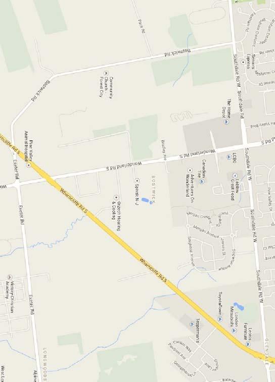
13 Buildings and Site Design Southwest Area Plan Section iii)b) entrances to the smaller buildings are located facing the street, with direct pedestrian connections out to the City sidewalk; windows and signage will be incorporated into the building design facing the street, consistent with the existing commercial node to the north; buildings facing the street will accommodate various architectural elements to provide weather protection; parking and drive aisles are located between the street and buildings, consistent with existing commercial development to the north; however, a special policy has been applied for to address this through the OPA; the proposed buildings provide setbacks consistent with the existing commercial node to the north; parking for the larger-scale retail buildings has been located to the rear of the smaller, street facing buildings, out of view from the public realm; the drive aisle pattern is consistent with existing development, providing an extension of the drive aisles within the existing commercial node to the north. Pedestrian walkways are provided throughout the site, with linkages to building entrances and the City sidewalk; and the buildings at the Wonderland Road and Bradley Avenue intersection have been sited along the Bradley street frontage to anchor the corner and mirror the layout of the existing buildings on the north side of the intersection. The rear and side building elevations that will face bounding streets will be highly articulated and have a similar level of architectural detail as the front or principal building elevations (including the range of materials to be used masonry base, brick middle, and stucco top; building projections with a corresponding raised parapet detail and recesses; and ample-sized windows). The highly articulated building elevations will provide visual interest and punctuation at the prominent corner location. The articulation of the proposed building elevations is also used to emphasize the location of main entrances by locating the entrances on portions of the front or principal elevations that project and include raised parapet details. 1.5 SPATIAL ANALYSIS An appropriate scale for the spatial analysis of the subject lands includes the lands bounded by Southdale to the north, Singleton Avenue to the east, Wharncliffe Road South to the south and Pack Road to the west (Figure 6). 10
 is")
14 Figure 6 Spatial Analysis Community Context 400 metres Within the 400 metre community context of the subject lands Wonderland Road South is an arterial road while the Bradley Avenue extension (dashed yellow line) is identified as a future arterial road according to Schedule C Transportation Corridors to the City of London Official Plan, placing the subject lands at the future intersection of two arterial roads. Two bus routes service this section of Wonderland Road South (28 Lambeth and 12 Wharncliffe). Land uses within the 400 metre community context of the subject lands include a mix of lowdensity residential uses, including single-detached residential dwellings and cluster townhouse dwellings (northeast, east); industrial (south), large-format commercial (north), high-density residential (northeast), commercial/industrial (south), open space (east), and agricultural (west). Lands to the north have developed as a big-box format regional commercial node, consisting of large anchor stores located to the rear of the lands and smaller, stand-alone buildings occupied by a range of uses located close to the street line. These lands provide high quality landscaping along Wonderland Road South, including trees, armour stone, ornamental grasses, and shrubs (Figure 7) Lands to the northeast have recently developed for a range of residential uses including single detached dwellings, cluster townhouses, fourplexes, and high-rise apartment buildings. Lands to 11

15 the east, south of the existing developed residential lands, are expected to develop for a similar range of residential uses in the near future. Figure 7 Landscaping along Wonderland Road South An open space corridor to the east runs north/south and includes stormwater management areas proximate to the subject lands and multi-use trails. A hydro corridor, containing high voltage power lines and transmission towers, is located adjacent to the west of the subject lands and runs north/south. Agricultural uses (cultivation) are the dominant land use to the west of the hydro corridor, although long-term uses are expected to be a range of residential uses. Within the 400m context there is are public sidewalks along both sides of Wonderland Road South and a portion of the Bradley Avenue extension Community Context 800 metres Within the 800 metre community context of the subject lands there are three additional arterial roads; Southdale Road West to the north; Wharncliffe Road South to the west; and, Bostwick 12
16 Road to the west, according to Schedule C Transportation Corridors to the City of London Official Plan. Land uses within the 800m community context of the subject lands are similar to the land uses within the 400m community context with the notable additions that the 800m community context includes a range of commercial/industrial uses to the south, comprised of self-storage establishments, a London Transit Commission bus depot, a business park, and building supply outlets. It is noted that the long term plan for these lands (on both sides of Wonderland Road South) is for a commercial corridor, similar to the existing commercial node to the north of the subject lands. SECTION 2 DESIGN PRINCIPLES AND DESIGN RESPONSES 2.1 CONCEPTUAL DESIGN The conceptual development plan for the subject lands provides for a built form that is generally consistent with the existing commercial node to the north. Large-format retail anchor stores are positioned to the rear of each parcel with wide pedestrian boulevards linking each individual retailer. Smaller, stand-alone buildings placed close to the street frontage, creating a defined street edge. This building arrangement allows for the floor areas required by large retail establishments while maintaining smaller, pedestrian scaled buildings at the street. Parking for the proposed development is provided in accordance with the parking requirements set out in the City of London Zoning By-Law Z.-1 for shopping centres. A double-loaded parking area is provided in front of the stand-alone buildings, consistent with the parking arrangement of the lands to the north. Access to the proposed development is facilitated largely from driveways onto Bradley Avenue, with only one right-in/right-out access proposed onto Wonderland Road South. Internal linkages to lands to the south may be possible, given that these lands are anticipated to develop in a similar format as the subject lands. 2.2 PUBLIC REALM The proposed development features the placement of small, stand-alone buildings close to the street line to provide a pedestrian-scaled environment. Enhanced landscaping, consisting of trees, ornamental grasses, and shrubs will be implemented along the Wonderland Road South and Bradley Avenue frontages, consistent with the landscape treatments on developed lands to 13

. This development concept has proved be a successful pedestrian-oriented environment, facilitating pedestrian travel between on-site retailers.")
17 the north. The combination of pedestrian scaled commercial buildings and enhanced landscaping will provide a positive pedestrian environment along the two arterial roads. Wide pedestrian boulevards are proposed in front of the large anchor stores on both portions of the subject lands, similar to the ones found to the north of the subject lands (Figure 5). This development concept has proved be a successful pedestrian-oriented environment, facilitating pedestrian travel between on-site retailers. Enhanced landscaped treatments are proposed for these pedestrian boulevards (Figures 5, 7, Figure 8 Landscaped pedestrian boulevard Figure 9 Landscaped pedestrian boulevard 14


18 Figure 10 Landscaped pedestrian boulevard Figure 11 Landscaped pedestrian boulevard Figure 12 Landscaped pedestrian boulevard 15
 and services (i.")
19 Public sidewalks will be constructed on both sides of Wonderland Road South as well as the south side of Bradley Avenue. Figure 7 Internal pedestrian walkway 2.3 SUSTAINABILITY TECHNIQUES The proposed development of the subject lands will make efficient use of urban land and investment in existing and planned infrastructure (i.e. roads, water-mains, sanitary and storm water sewers) and services (i.e. public transportation). The proposed commercial development will make use of best-practice techniques of current construction practices to ensure the resulting buildings are energy efficient. 16
20
Urban Design Brief Fanshawe Park Road. Competition Toyota
 Urban Design Brief 1300 Fanshawe Park Road Competition Toyota May 2, 2014 TABLE OF CONTENTS Page No. INTRODUCTION... 1 SECTION 1 LAND USE PLANNING CONTEXT... 1 1.1 The Subject Lands... 1 1.2 The Proposal...
Urban Design Brief 1576 Richmond Street City of London
 Urban Design Brief City of London Treadstone Developments October 31, 2014 Urban Design Brief October 31, 2014 TABLE OF CONTENTS Page No. INTRODUCTION... 1 SECTION 1 LAND USE PLANNING CONCEPT... 1 1.1
URBAN DESIGN BRIEF 305, 309, & 315 SOUTHDALE ROAD WEST LONDON ONTARIO
 URBAN DESIGN BRIEF 305, 309, & 315 SOUTHDALE ROAD WEST LONDON ONTARIO CARVEST PROPERTIES LTD. December 2013 Section 1 - Land Use Planning Context 1.1 Subject Lands The subject lands are located immediately
Urban Design Brief. 583, 585 and 589 OXFORD STREET EAST. Salt Clinic Canada Inc.
 Urban Design Brief 583, 585 and 589 OXFORD STREET EAST Salt Clinic Canada Inc. February 3, 2013 TABLE OF CONTENTS Page No. INTRODUCTION... 1 SECTION 1 LAND USE PLANNING CONCEPT... 1 1.1 The Subject Property...
URBAN DESIGN BRIEF REPORT
 URBAN DESIGN BRIEF REPORT PREPARED FOR 2568401 ONTARIO INC NEW GASBAR, CONVENIENCE STORE & CARWASH DEVELOPMENT @ 1509 FANSHAWE PARK ROAD WEST LONDON, ONTARIO GAMA ENGINEERING INC. PROJECT NUMBER 1669 PREPARED
Urban Design Brief Woodland Cemetery Funeral Home 493 Springbank Drive
 Urban Design Brief Woodland Cemetery Funeral Home The Incorporated Synod of the Diocese of Huron April 15, 2016 Urban Design Brief April 15, 2016 TABLE OF CONTENTS Page No. INTRODUCTION... 1 SECTION 1
URBAN DESIGN BRIEF URBAN DESIGN BRIEF 721 FRANKLIN BLVD, CAMBRIDGE August 2018
 URBAN DESIGN BRIEF URBAN DESIGN BRIEF 721 FRANKLIN BLVD, CAMBRIDGE August 2018 DESIGN BRIEF CONTENTS PART A 1.0 INTRODUCTION 2.0 DESCRIPTION & ANALYSIS OF SITE CONTEXT 3.0 DESIGN CONSTRAINTS AND OPPORTUNITIES
Urban Design Brief. 58 Sunningdale Road West City of London. Barvest Realty Inc.
 Urban Design Brief City of London Barvest Realty Inc. June 8, 2016 TABLE OF CONTENTS Page No. INTRODUCTION... 1 SECTION 1 LAND USE PLANNING CONCEPT... 1 1.1 The Subject Lands... 1 1.2 The Development Proposal...
TABLE OF CONTENTS 1.0 INTRODUCTION... 3
 TABLE OF CONTENTS 1.0 INTRODUCTION... 3 1.1. BACKGROUND... 3 1.2. THE PROPOSAL... 5 2.0 EXISTING POLICY FRAMEWORK... 5 2.1. PROVINCIAL POLICY STATEMENT (PPS)... 5 2.2. CITY OF LONDON OFFICIAL PLAN (OP)...
URBAN DESIGN BRIEF. 2136&2148 Trafalgar Road. Town of Oakville
 URBAN DESIGN BRIEF 2136&2148 Trafalgar Road Town of Oakville Prepared By: METROPOLITAN CONSULTING INC For 2500674 Ontario Inc November 2016 TABLE OF CONTENTS Page No. 1.0 Introduction/Description of Subject
Urban Design Brief to 1557 Gordon Street & 34 Lowes Road West
 Urban Design Brief 1533 to 1557 Gordon Street & 34 Lowes Road West Reid s Heritage Homes Ltd. & 883928 Ontario Ltd. and RHH Property Management Ltd. City of Guelph Zoning By-law Amendment November 2017
URBAN DESIGN BRIEF. April FREEPORT Street TOWNHOUSES. 711 FREEPORT St., LONDON
 URBAN DESIGN BRIEF April 2013 FREEPORT Street TOWNHOUSES 711 FREEPORT St., LONDON TABLE OF CONTENTS 1.0 Land Use Planning Context...... pg. 1 1.1 Subject Lands... pg. 1 1.2 Proposed Development... pg.
ELMVALE ACRES SHOPPING CENTRE MASTER PLAN
 ELMVALE ACRES SHOPPING CENTRE MASTER PLAN Contents 1.0 INTRODUCTION... 2 2.0 LOCATION... 2 3.0 EXISTING CONTEXT... 2 4.0 VISION & GUIDING PRINCIPLES... 2 5.0 LAND USE AND BUILT FORM... 4 5.1 St. Laurent
East Bayshore Road Neighbourhood
 East Bayshore Road Neighbourhood Northridge Property Management Urban Design Brief 3195 East Bayshore Road City of Owen Sound January 2016 East Bayshore Road Neighbourhood Northridge Property Management
New-Cast Mixed-use Development Proposal King Street West, Newcastle, Ontario
 URBAN DESIGN BRIEF New-Cast Mixed-use Development Proposal King Street West, Newcastle, Ontario TABLE OF CONTENTS: 1.0 Executive Summary 2.0 Creating Vibrant and Sustainable Urban Places: Excerpts from
Urban Design Brief. Watson Parkway North & Watson Road North Guelph, Ontario. Prepared by Coletara Development
 Urban Design Brief Watson Parkway North & Watson Road North Guelph, Ontario Prepared by Coletara Development December, 2013 Urban Design Brief, Coletara Development 1 Introduction This Urban Design Brief
URBAN DESIGN BRIEF.. on behalf of the owner..sunningdale Commercial Inc.
 URBAN DESIGN BRIEF.. on behalf of the owner..sunningdale Commercial Inc.. in support a Site Plan Approval Application to permit a Shopping Areas commercial centre. at 1830 Adelaide Street North, in the
URBAN DESIGN BRIEF 181 Burloak Drive, Oakville
 URBAN DESIGN BRIEF 181 Burloak Drive, Oakville February 2017 Our File: 1730B 230-7050 WESTON ROAD / WOODBRIDGE / ONTARIO / L4L 8G7 / T: 905 761 5588/ F: 905 761 5589/WWW.MHBCPLAN.COM TABLE OF CONTENTS
Urban Design Guidelines Townhouse and Apartment Built Form
 Urban Design Guidelines Townhouse and Apartment Built Form Town of Wasaga Beach Table of Contents 1. Introduction 1.1. Purpose 1.2. Urban Design Principles 1.3. Application of Guidelines 2. Site Design,
Urban Design Brief. 875 Wellington Road. Proposed One-Storey Fast Food Restaurant and Two-Storey Restaurant. Wellington Harlech Centre Inc.
 Urban Design Brief 875 Wellington Road Proposed One-Storey Fast Food Restaurant and Two-Storey Restaurant Wellington Harlech Centre Inc. Prepared By: (519) 433-7587 info@yorkdev.ca May 3 rd 2013 1 Table
Clairtrell Area Context Plan
 Clairtrell Area Context Plan March 2005 Urban Development Services City Planning Contents 1. Introduction... 4 2. Development Structure... 6 2.1 Streets... 7 2.1.1 Sheppard Avenue and Bayview Avenue...
DRAFT Northeast Quadrant of Kipling Avenue and Highway 7 DRAFT AUGUST 29, Goals Land Use. The goals of this Plan are to:
 AUGUST 29, 2017 12.15 Northeast Quadrant of Kipling Avenue and Highway 7 12.15.1 Goals 12.15.2 Land Use The goals of this Plan are to: 12.15.2.1 General Provisions: a) Ensure the development of a compact
THE CITY OF VAUGHAN BY-LAW BY-LAW NUMBER A By-law to adopt Amendment Number 1 to the Official Plan of the Vaughan Planning Area.
 THE CITY OF VAUGHAN BY-LAW BY-LAW NUMBER 015-2014 A By-law to adopt Amendment Number 1 to the Official Plan of the Vaughan Planning Area. NOW THEREFORE the Council of the Corporation of the City of Vaughan
Tel: (705) Fax: (705)
 Fax: (705)") 521 and 525 Essa Road City of Barrie Tel: (705) 812-3281 Fax: (705) 812-3438 Email: INFO@IPSCONSULTINGINC.com 1 5 0 D U N L O P S T R E E T E A S T, S U I T E 2 0 1, B A R R I E O N T A R I O L 4 M 1 B
521 and 525 Essa Road City of Barrie Tel: (705) 812-3281 Fax: (705) 812-3438 Email: INFO@IPSCONSULTINGINC.com 1 5 0 D U N L O P S T R E E T E A S T, S U I T E 2 0 1, B A R R I E O N T A R I O L 4 M 1 B
4. INDUSTRIAL 53 CASTLE ROCK DESIGN
 4. INDUSTRIAL 53 CASTLE ROCK DESIGN CASTLE ROCK DESIGN 54 4. INDUSTRIAL Overview Well-designed and attractive industrial centers are the product of blending economic realities with both functional and
URBAN DESIGN BRIEF NORTHVIEW FUNERAL HOME HIGHBURY AVE N, LONDON, ON
 URBAN DESIGN BRIEF NORTHVIEW FUNERAL HOME - 1490 HIGHBURY AVE N, LONDON, ON 1.1Purpose The intent of the following report is to identify an opportunity for redevelopment of two residential properties within
420 FANSHAWE PARK ROAD EAST London, ON
 420 FANSHAWE PARK ROAD EAST London, ON URBAN DESIGN BRIEF, CHARACTER STATEMENT & COMPATIBILITY REPORT April 2016 Prepared by MHBC Planning 630 COLBORNE STREET SUITE 202 LONDON, ON N6B 2V2 TABLE OF CONTENTS
URBAN DESIGN BRIEF Gordon Street City of Guelph. Prepared on behalf of Ontario Inc. March 25, Project No. 1507
 URBAN DESIGN BRIEF 1131 Gordon Street City of Guelph Prepared on behalf of 1876698 Ontario Inc. March 25, 2016 Project No. 1507 423 Woolwich Street, Suite 201, Guelph, Ontario, N1H 3X3 Phone (519) 836-7526
URBAN DESIGN BRIEF 1435 Beaverbrook Road On behalf of Wonderland Commercial Centre Inc.
 URBAN DESIGN BRIEF 1435 Beaverbrook Road On behalf of Wonderland Commercial Centre Inc. Knutson Development Consultants Inc. Development Engineering (London) Ltd. K & L Construction and Arthur Lierman
Urban Design Brief Proposed Residential Development 5219 Upper Middle Road City of Burlington
 Urban Design Brief Proposed Residential Development 5219 Upper Middle Road City of Burlington Prepared by Weston Consulting Prepared for BLOOMFIELD DEVELOPMENT INC. Date: March 2017 Table of Contents 1.
Bel-Air Lexus Automobile Service Station
 Bel-Air Lexus Automobile Service Station Design Brief 443-447 McArthur Avenue Ottawa April 30, 2015 14-1299-MCA Site Details Application: Site Plan Control Legal Description and Municipal Addresses: 443
5.1 Site Plan Guidelines
 5. Community Core Guidelines Development of the Community Core will take place by plan of subdivision and site plan approval. It will occur in a phased manner that will reflect the timing of residential
11.4 Highway 400 North Employment Lands Secondary Plan APPROVED BY THE ONTARIO MUNICIPAL BOARD ON NOVEMBER 21, 2011
 11.4 Highway 400 North Employment Lands Secondary Plan APPROVED BY THE ONTARIO MUNICIPAL BOARD ON NOVEMBER 21, 2011 11.4.1 General 11.4.1.1. as approved by the Ontario Municipal Board on November 21, 2011,
Mark-up of the effect of the proposed Bronte Village Growth Area OPA No.18 on the text of section 24, Bronte Village, of the Livable Oakville Plan
 Mark-up of the effect of the proposed Bronte Village Growth Area OPA No.18 on the text of section 24, Bronte Village, of the Livable Oakville Plan Notes: This document is provided for information purposes
Proposed for Vic West Neighbourhood Plan. Design Guidelines for Intensive Residential Development - Townhouse and Attached Dwelling
 Proposed for Vic West Neighbourhood Plan Design Guidelines for Intensive Residential Development - Townhouse and Attached Dwelling Design Guidelines for Intensive Residential Development - Townhouse and
Southwest Area Secondary Plan (SWAP) Concept 1 Land use Policies
 Concept 1 Land use Policies") Purpose and Use of the proposed draft land use policies: The purpose of the Secondary Plan is to establish a vision, principles and policies for the evolution of the southwest planning area to a vibrant
Purpose and Use of the proposed draft land use policies: The purpose of the Secondary Plan is to establish a vision, principles and policies for the evolution of the southwest planning area to a vibrant
Revitalization Guidelines for Corridors, Villages and Town Centres
 Revitalization Guidelines for Corridors, Villages and Town Centres July 2017 Updated May, 2018 Publishing Information Title: Prepared by: Revitalization Guidelines for Corridors, Villages and Town Centres
Regency Developments. Urban Design Brief. Holyrood DC2 Rezoning
 Regency Developments Urban Design Brief Holyrood DC2 Rezoning Stantec Consulting Ltd. 7-31-2017 1. Overview Regency Developments intends to rezone the lands located at 8510 and 8511 93 Avenue, within the
LIST OF FIGURES APPENDIX. Urban Design Brief: Proposed Townhouse Development, 299 Tartan Drive (City of London ON)
") URBAN DESIGN BRIEF PROPOSED TOWNHOUSE COMPLEX 299 TARTAN DRIVE, LONDON ON December 2013 TABLE OF CONTENTS 3.0 Neighbourhood Character Statement... pg. 14 1.0 Land Use Planning Context...... pg. 1 1.1 Subject
URBAN DESIGN BRIEF PROPOSED TOWNHOUSE COMPLEX 299 TARTAN DRIVE, LONDON ON December 2013 TABLE OF CONTENTS 3.0 Neighbourhood Character Statement... pg. 14 1.0 Land Use Planning Context...... pg. 1 1.1 Subject
599 Kennedy Road - Official Plan Amendment and Zoning Amendment Application - Preliminary Report
 STAFF REPORT ACTION REQUIRED 599 Kennedy Road - Official Plan Amendment and Zoning Amendment Application - Preliminary Report Date: March 7, 2017 To: From: Wards: Reference Number: Scarborough Community
Urban Design Brief. Garden Drive Townhouse Development Matas Development Group. Oakville, Ontario
 Garden Drive Townhouse Development Matas Development Group Oakville, Ontario February 8, 2013 Urban Design and Architecture 2 Introduction This Urban Design Brief has been prepared in support of a rezoning
appendix and street interface guidelines
 appendix five: building and street interface guidelines appendix 5 building and street interface guidelines BOULEVARDS Boulevards are generally characterized by higher levels of traffic movement at higher
[PLANNING RATIONALE] For Site Plan Control and Lifting of Holding Zone By-Law 101 Champagne Avenue. May 23, 2014
![[PLANNING RATIONALE] For Site Plan Control and Lifting of Holding Zone By-Law 101 Champagne Avenue. May 23, 2014](/thumbs/75/71599615.jpg "[PLANNING RATIONALE] For Site Plan Control and Lifting of Holding Zone By-Law 101 Champagne Avenue. May 23, 2014") [PLANNING RATIONALE] For Site Plan Control and Lifting of Holding Zone By-Law 101 Champagne Avenue May 23, 2014 Contents 1.0 Introduction... 2 2.0 Site Context... 2 2.1 Adjacent Uses... 2 Figure 1: Site
[PLANNING RATIONALE] For Site Plan Control and Lifting of Holding Zone By-Law 101 Champagne Avenue May 23, 2014 Contents 1.0 Introduction... 2 2.0 Site Context... 2 2.1 Adjacent Uses... 2 Figure 1: Site
*** DRAFT 2 FOR PUBLIC REVIEW ***
 6.7 The area is generally bounded by the Red Hill Valley Parkway to the west, Lake Avenue to the east, the Queen Elizabeth Way (QEW) to the north, and by the properties just south of Queenston Road to
Cit of Kitchener Ur 6 an Design Manual PARTA. Desi n for _--::
 Cit of Kitchener Ur 6 an Design Manual Date PARTA Year ) Desi n for k Nodes Corridors _--:: Section Page 01 of 12 2 INTRODUCTION Purpose & Application Nodes and Corridors have been identified as key intensification
DRAFT. 1. General Purpose. 2. Area of Application. 3. Uses CLIFTON PLACE AREA A DC2 (DRAFT)
") CLIFTON PLACE AREA A DC2 () May 1, 2017 1. General Purpose To accommodate a high rise, high density residential Tower and podium that will accommodate a potential mix of commercial and residential uses,
CLIFTON PLACE AREA A DC2 () May 1, 2017 1. General Purpose To accommodate a high rise, high density residential Tower and podium that will accommodate a potential mix of commercial and residential uses,
Westwind Developments Ltd. PIONEER LANDS AREA STRUCTURE PLAN - PROPOSED AMENDMENT
 FEBRUARY 2013 TABLE OF CONTENTS 1.0 BACKGROUND... 1 1.1 Amendment... 1 2.0 LOCATION & CONTEXT... 2 2.1 Land Ownership... 2 3.0 POLICY CONTEXT... 3 3.1 Municipal Development Plan... 3 3.2 Capital Region
CONTENTS 8.0 LAND USE 8.1 GENERAL LAND USE 8.2 RESIDENTIAL 8.3 MIXED USE 8.4 COMMERCIAL 8.5 EMPLOYMENT LANDS
 8-2 Land Use 8.0 LAND USE CONTENTS 8.1 GENERAL LAND USE 8.1.1 Uses provided for in all Land Use Designations 8.1.2 Uses prohibited in Hazardous Lands, Hazardous Sites and Special Policy Areas 8.1.3 Uses
built form design guidelines
 built form design guidelines Derry Green Corporate Business Park 17 built form design guidelines.1 Built Form Design Guidelines Section : Built Form Design Guidelines is intended to be used by both developers
10 COPE DRIVE. May 08, 2018 Planning Rationale and Design Brief. Site Plan Control
 10 COPE DRIVE May 08, 2018 Planning Rationale and Design Brief Site Plan Control Prepared for: Taggart Realty Management 225 Metcalfe Street, Suite 708 Ottawa, ON K2P 1P9 taggart.ca Prepared by: Fotenn
AIRPORT BUSINESS PARK
 PIER MAC PETROLEUM INSTALLATION LTD. AIRPORT BUSINESS PARK DEVELOPMENT APPLICATIONS March 2003 4.1 Airport Business Park Development Permit Area 4.1.1 Justification/Design Concept The design concept envisioned
4.0 Design Guidelines For The Village Centre. South fields Community Architectural Design Guidelines Town of Caledon
 4.0 Design Guidelines For The Village Centre 4.0 Design Guidelines for the Village Centre The Village Centre is the focal point of the entire South Fields Community and is designed as a traditional commercial
178 Carruthers Properties Inc.
 178 Carruthers Properties Inc. Planning Rationale for 178 Carruthers Avenue Site Plan Control Application June 2014 Table of Contents 1.0 Introduction 2.0 Overview of Subject Property 3.0 Current Zoning
URBAN DESIGN BRIEF. Saginaw Subdivision 124 SAGINAW PARKWAY, CAMBRIDGE OCTOBER 2015 OUR FILE 1422A
 URBAN DESIGN BRIEF Saginaw Subdivision 124 SAGINAW PARKWAY, CAMBRIDGE OCTOBER 2015 OUR FILE 1422A Contents 1.0 INTRODUCTION AND SITE DESCRIPTION... 1 2.0 MUNICIPAL DESIGN DIRECTION... 7 3.0 MASTER CONCEPT
I615. Westgate Precinct
 I615. Westgate Precinct I615.1. Precinct Description The Westgate Precinct is located approximately 18km west of the Auckland city centre. There are seven Sub-precincts in the Westgate Precinct: Sub-precinct
1. General Purpose. 3. Uses
 1. General Purpose The purpose of this DC1 Provision is to facilitate the development of a pedestrian friendly Community Commercial Centre that may accommodate a range of commercial, residential, office,
TRAFALGAR ROAD
 158-2192 TRAFALGAR ROAD URBAN DESIGN BRIEF PREPARED BY KLM PLANNING PARTNERS INC. FOR DUNPAR DEVELOPMENTS INC. TOWN OF OAKVILLE JUNE 2012 TABLE OF CONTENTS 1 INTRODUCTION 1.1 Project Description...1 1.1.1
PLANNING RATIONALE FOR THE PROPOSED RIVERSIDE SOUTH ELEMENTARY SCHOOL 715 BRIAN GOOD AVENUE, OTTAWA, ON
 PLANNING RATIONALE FOR THE PROPOSED RIVERSIDE SOUTH ELEMENTARY SCHOOL 715 BRIAN GOOD AVENUE, OTTAWA, ON Conseil des écoles publiques de l'est de l'ontario (CEPEO) French Public School Board TABLE OF CONTENTS
EXISTING COMPREHENSIVE PLAN
 EXISTING COMPREHENSIVE PLAN Town Center Land Use Element: V. LAND USE POLICIES Town Center Mercer Island's business district vision as described in "Your Mercer Island Citizen-Designed Downtown" was an
Sierra Springs Regional Commercial Master Site Plan Airdrie, Alberta Hopewell Development Corporation Project No May 26, 2010
 Sierra Springs Regional Commercial Master Site Plan Airdrie, Alberta Hopewell Development Corporation Project No. 205-077 May 26, 2010 TABLE OF CONTENTS Purpose... 2 Master Site Plan Guidelines... 3 Overall
From: Director, Community Planning, Etobicoke York District
 STAFF REPORT ACTION REQUIRED 4208, 4210 and 4214 Dundas Street West - Official Plan Amendment and Zoning By-law Amendment Application - Preliminary Report Date: July 22, 2014 To: Etobicoke York Community
T O W N O F A J A X URBAN DESIGN GUIDELINES FOR MOTOR VEHICLE GAS BARS / SERVICE CENTRES
 T O W N O F A J A X URBAN DESIGN GUIDELINES FOR MOTOR VEHICLE GAS BARS / SERVICE CENTRES June 2006 Table of Contents TABLE OF CONTENTS... 1 1.0 INTRODUCTION... 2 1.1 Purpose... 2 1.2 Organization of the...
WEST LOOP DESIGN GUIDELINES CHECKLIST
 WEST LOOP DESIGN GUIDELINES CHECKLIST Section 1.0 General Strategies 1.1 DESIGN EXCELLENCE: ENCOURAGE HIGH QUALITY AND INNOVATIVE DESIGN OF NEW BUILDINGS WITHIN THE WEST LOOP WITHOUT BEING PRESCRIPTIVE
B. Blocks, Buildings and Street Networks
 B. Blocks, Buildings and Street Networks Figure IV.4 A rational block pattern with connected streets Introduction The single most important element in the physical and functional integration of mixed use
Urban Design Brief. 27 Centre Street London, ON. Prepared for: The Escalade Property Corp. Box 37 Lambeth Station London ON N6P 1P9
 Urban Design Brief 27 Centre Street London, ON Prepared for: The Escalade Property Corp. Box 37 Lambeth Station London ON N6P 1P9 Prepared by: Stantec Consulting Ltd. 600-171 Queens Avenue London, ON N6A
4780 Eglinton Avenue West - Zoning By-law Amendment and Draft Plan of Subdivision Applications - Preliminary Report
 STAFF REPORT ACTION REQUIRED 4780 Eglinton Avenue West - Zoning By-law Amendment and Draft Plan of Subdivision Applications - Preliminary Report Date: May 29, 2014 To: From: Wards: Reference Number: Etobicoke
11.4 Highway 400 North Employment Lands Secondary Plan
 11.4 Highway 400 North Employment Lands Secondary Plan APPROVED BY THE ONTARIO MUNICIPAL BOARD ON NOVEMBER 21, 2011 11.4.1 General 11.4.1.1. The following policies and Schedules A - I form Official Plan
Urban Design Brief Milton Thompson Developments Limited
 Urban Design Brief Milton Thompson Developments Limited Mixed Use Node Louis St. Laurent Avenue at Thompson Rd. Milton, Ontario September 11, 2014 Prepared by MSAi Michael Spaziani Architect Inc. 1 INTRODUCTION
2418 KHALSA GATE, OAKVILLE URBAN DESIGN BRIEF APPLICATION FOR ZONING BY-LAW AMENDMENT. Prepared for: Golden Arch Tech Investment Corporation
 APPLICATION FOR ZONING BY-LAW AMENDMENT Prepared for: Golden Arch Tech Investment Corporation NOVEMBER 2015 I TABLE OF CONTENTS INTRODUCTION... 1 SECTION 1... 2 Contextual Analysis... 2 Oakville Official
Bank Street Secondary Plan
 1.1 Introduction The is a guide to the long term design and development of the portion of Bank Street between Riverside Drive and Ledbury Park, and provides direction on land use, built form, design, parking,
Urban Design Manual PLANNING AROUND RAPID TRANSIT STATIONS (PARTS) Introduction. Station Study Areas
 Introduction. Station Study Areas") 111111 PLANNING AROUND RAPID TRANSIT STATIONS (PARTS) Introduction The ION rapid transit system will link Waterloo, Kitchener and Cambridge through a central transit corridor (CTC). There are a number
111111 PLANNING AROUND RAPID TRANSIT STATIONS (PARTS) Introduction The ION rapid transit system will link Waterloo, Kitchener and Cambridge through a central transit corridor (CTC). There are a number
Commercial Development Proposal Tenth Line Road. Planning Rationale Report. Minto Developments Inc.
 Commercial Development Proposal 2168 Tenth Line Road Report September 2015 Prepared for Minto Developments Inc. Paquette Planning Associates Ltd. 56 Hutchison Avenue Ottawa, Ontario K1Y 4A3 PH: 613-722-7217
URBAN DESIGN BRIEF New Street Burlington, ON
 3225-3237 New Street Burlington, ON MARCH 2017 Prepared for: Royal Living Development Group Inc. Prepared by: adesso design inc. 218 Locke Street South, 2nd Floor Hamilton, ON L8P 4B4 t. 905.526.8876 3225-3237
Commercial Development Permit Area
 City of Kamloops KAMPLAN Commercial Development Permit Area PURPOSE The purpose of this Development Permit Area (DPA) is to establish objectives and provide guidelines for the form and character of commercial
Arterial Mainstreets ottawa.ca
 Urban Design Guidelines for Development along Arterial Mainstreets ottawa.ca Ce document est disponible en français sur ottawa.ca. This document is available in French on ottawa.ca. Approved by City Council
WINDSOR GLEN DESIGN GUIDELINES
 WINDSOR GLEN DESIGN GUIDELINES Adopted by Council, 2006 WINDSOR GLEN REDEVELOPMENT DESIGN GUIDELINES August 2006 1.0 Master Plan Organization For this area of the Coquitlam Town Centre, a mix of high,
I. Introduction. Prior Approvals
 Statement of Justification First National Bank 19790 Crystal Rock Drive, Germantown, Maryland Application for Site Plan and Limited Preliminary Plan Amendment I. Introduction DPH Architecture, for First
Chapter 3: Office & Office Mixed-Use Project Types
 Chapter Contents Purpose... 3-2 Applicability and Use Types...3-3 (1) Site Design...3-4 Building Placement and Orientation...3-5 Circulation and Vehicle Parking...3-6 Bicycle/Pedestrian Amenities...3-8
Figure 3-1: Public Realm Plan
 3 Public Realm Figure 3-1: Public Realm Plan 3.1 Public Realm Concept The public realm concept for the Little Mountain site integrates a clear and accessible movement network with public spaces for social
Welcome. Walk Around. Talk to Us. Write Down Your Comments
 Welcome This is an information meeting introducing the applications for proposed redevelopment of the Yorkdale Shopping Centre site at 3401 Dufferin Street and 1 Yorkdale Road over the next 20+ years,
Community Design Plan
 Gardena General Plan 2006 Authority While the is not a required element of a General Plan, it is included because improving the community appearance and image is paramount to the overall quality of life
FORMER CANADIAN FORCES BASE (CFB) ROCKCLIFFE SECONDARY PLAN. Official Plan Amendment XX to the Official Plan for the City of Ottawa
 ROCKCLIFFE SECONDARY PLAN. Official Plan Amendment XX to the Official Plan for the City of Ottawa") FORMER CANADIAN FORCES BASE (CFB) ROCKCLIFFE SECONDARY PLAN Official Plan Amendment XX to the Official Plan for the City of Ottawa 1 INDEX THE STATEMENT OF COMPONENTS PART A THE PREAMBLE PAGE Purpose...
FORMER CANADIAN FORCES BASE (CFB) ROCKCLIFFE SECONDARY PLAN Official Plan Amendment XX to the Official Plan for the City of Ottawa 1 INDEX THE STATEMENT OF COMPONENTS PART A THE PREAMBLE PAGE Purpose...
11.3 Steeles West Secondary Plan
 11.3 Steeles West Secondary Plan ADOPTED BY VAUGHAN CITY COUNCIL NOT YET APPROVED BY THE ONTARIO MUNICIPAL BOARD 11.3.1 Introduction This Secondary Plan recognizes that it will take a number of years for
URBAN DESIGN BRIEF. on behalf of the owner 1331 Hyde Park Road Inc.
 URBAN DESIGN BRIEF. on behalf of the owner 1331 Hyde Park Road Inc.. in support a Site Plan Approval Application to permit a Mainstreet retail commercial centre.. At 1331 Hyde Park Road, in the City of
LIST OF TABLES, FIGURES AND APPENDICES
 LIST OF TABLES, FIGURES AND APPENDICES Chapter Page 2 INTERPRETATION FIGURE 2.1 SAMPLE AWNING...2.8 FIGURE 2.2 SAMPLE LOW-RISE APARTMENT DESIGN...2.9 FIGURE 2.3 SAMPLE DUPLEX DESIGN...2.10 FIGURE 2.4 SAMPLE
DAVENPORT VILLAGE SECONDARY PLAN
 27 DAVENPORT VILLAGE SECONDARY PLAN 27. DAVENPORT VILLAGE SECONDARY PLAN 1. VISION FOR THE DAVENPORT VILLAGE SECONDARY PLAN Davenport Village, municipally known as 830, 940, 980 and 1100 Lansdowne Avenue,
Urban Design Guidelines for Large-Format Retail
 Urban Design Guidelines for Large-Format Retail May 2006 Compte tenu de la nature de ce document, il n'est disponible qu'en anglais. La Ville pourra, sur demande, traduire ce document au complet ou en
Design Brief and Planning Rationale. for Site Plan Control Application. Harmony Subdivision, Stage 1, Block 104
 Design Brief and Planning Rationale for Site Plan Control Application Harmony Subdivision, Stage 1, Block 104 4025 Strandherd Drive, Minto Communities Inc. Prepared By: NOVATECH Suite 200, 240 Michael
1296 Kennedy Road - Zoning Amendment Application - Preliminary Report
 STAFF REPORT ACTION REQUIRED 1296 Kennedy Road - Zoning Amendment Application - Preliminary Report Date: January 15, 2016 To: From: Wards: Reference Number: Scarborough Community Council Acting Director,
Urban Design Brief. Proposed Development 699 Wonderland Road North London, Ontario. Submi ed by The MBTW Group. June 27,
 Urban Design Brief Proposed Development 699 Wonderland Road North London, Ontario Submi ed by The MBTW Group www.mbtw-wai.com June 27, 2013 BEAVERBROOK AVE Submi ed To: Corpora on of the City of London
Multi family Residential Development Permit Area
 City of Kamloops KAMPLAN Multi family Residential Development Permit Area PURPOSE The purpose of this Development Permit Area (DPA) is to establish objectives and provide guidelines for the form and character
Urban Design Manual 2.0 DRIVE-THROUGH FACILITIES. Background. Urban Design Challenges
 222221 2.0 DRIVE-THROUGH FACILITIES Background In recent years, drive-through facilities have grown significantly in popularity with drive-through restaurants, in particular, being established on numerous
DESIGN GUIDELINES FOR: INTENSIVE RESIDENTIAL DEVELOPMENT TOWNHOUSE AND ROWHOUSE
 DESIGN GUIDELINES FOR: INTENSIVE RESIDENTIAL DEVELOPMENT TOWNHOUSE AND ROWHOUSE 1. Introduction Townhouse and Rowhouse Building Typologies Within these guidelines, the term rowhouse means a single row
FRUITVALE TRANSIT VILLAGE (Phase 2) Residential Project
 Residential Project") FRUITVALE TRANSIT VILLAGE (Phase 2) Residential Project DEVELOPER: SIGNATURE PROPERTIES ARCHITECT: HKIT ARCHITECTS April 23, 2010 TABLE OF CONTENTS 3 Vision 4 Description of Site 5 Guiding Concepts 6
FRUITVALE TRANSIT VILLAGE (Phase 2) Residential Project DEVELOPER: SIGNATURE PROPERTIES ARCHITECT: HKIT ARCHITECTS April 23, 2010 TABLE OF CONTENTS 3 Vision 4 Description of Site 5 Guiding Concepts 6
GUIDELINES REPLACEMENT HOUSING GUIDELINES LOCATION INTRODUCTION URBAN DESIGN GUIDELINES
 Replacement housing in the former City of North York will be consistent with the following urban design guidelines. They provide a framework for residential re-development in the former City of North York
HIGHLAND VILLAGE GREEN URBAN DESIGN PRINCIPLES/GUIDELINES
 URBAN DESIGN GUIDING PRINCIPLES/GUIDELINES CONTEXT/CHARACTER The City of Calgary s Municipal Development Plan (MDP), Transit-Oriented Development (TOD) Policy Guidelines and Main Street/Corridor policy
URBAN DESIGN + ARCHITECTURAL CONTROL GUIDELINES
 Appendix I BRESLAU SETTLEMENT PLAN URBAN DESIGN + ARCHITECTURAL CONTROL GUIDELINES Table of Contents 1.0 INTRODUCTION 1 2.0 DESIGN GUIDELINES FOR THE PUBLIC REALM 2 2.1 General Design Principles 2 2.2
Derry Green Corporate Business Park
 Town of Milton Derry Green Corporate Business Park Urban Design Guidelines BMI/Pace - June 2010 Draft 3 Prepared by: Brook McIlroy Planning + Urban Design / Pace Architects Suite 300-51 Camden Street Toronto,
ADDENDUM to the August 2012 Urban Design Brief
 NIXON MEDICAL CLINIC at 510,518, and 526 Southdale Road East at Nixon Avenue, City of London. APRIL 201 ADDENDUM to the August 2012 Urban Design Brief Prepared by: Endri Poletti. Architect Kirkness Consulting
BENSON / HUNT TERTIARY PLAN
 BENSON / HUNT TERTIARY PLAN TABLE OF CONTENTS 1.0 INTRODUCTION 1.1 Purpose 2 1.2 How to Read This Plan 3 1.3 Tertiary Plan Context 3 1.4 Vision and Principles 5 1.5 Public Consultation 5 2.0 PLANNING CONTEXT