NAI Principles In Gwinnett County
|
|
|
- Isabella Roberts
- 5 years ago
- Views:
Transcription

1 NAI Principles In Gwinnett County By Cornelius Ani, LSIT, CFM Contributors: Adena Fullard, P.E., CPSWQ Rudresh Bihalli, P.E., CFM Ken Kagy, P.E., CPESC, CPSWQ Ligia Negru, M. Sc., CFM Maja Radovic, CPESC, CFM
2 No Adverse Impact (NAI) NAI provides tools for communities to provide a higher level of protection for their citizens and to prevent increased flooding now and in the future. 1 1
3 No Adverse Impact (NAI) Floodplain management is an approach that ensures the action of any community or property owner, public or private, does not adversely impact the property and rights of others 1 2
4 2011 Major Disaster Declaration How many major Federal Disaster Declarations has occurred since the beginning of 2011? 8 How many of these Declarations involved flooding? 5
")
5 NAI Principles In Gwinnett County Hazard Mitigation and Flood Mapping Education and Public Outreach Planning Regulations and Development Standards Master Planning and Monitoring Mitigation Actions (Corrective Actions) Infrastructure


6 Hazard Mitigation and Flood Mapping Continuous update stream miles in less than a decade Add l 400 miles between 2006 & 2009 LOMA and LOMR attachment to Parcel
7 Hazard Mitigation and Flood Mapping Flood Insurance Rate Maps (FIRM) Drainage easements Flowage easement 150 feet on NRCS dams Existing/natural swales 20 feet to natural swales 6
8 Hazard Mitigation and Flood Mapping SWM review all Building Permit for properties within the SFHA Big Haynes Creek 7 mile radius 100 feet buffer 150 impervious setback
9 Hazard Mitigation and Flood Mapping No detention required when stormwater discharge directly into the floodplain Sheet flow over 100 feet Delayed effect on peak discharge Flood study 10-year future conditions Cut and Fill Compensation
10 Education and Public Outreach Training: local, FEMA etc Mandated yearly training hours Publications in professional journals 9

11 Education and Public Outreach One on One Through SWM Customer service plan review On the phone

12 Education and Public Outreach Gwinnett County Flood Information Portal Depicts the existing flood hazard zones over Google Maps. View flood hazard information at the structure level Provides user access to hydraulic and hydrologic models used for the flood hazard information


13 Education and Public Outreach Dedicated Resource for Request for Floodplain Information Fax In person/ Phone

14 Education and Public Outreach Dedicated Resource for Public outreach Approximately 7 workshops per year depending on demand Target audience County residents Developers Engineers & Surveyors General public


15 Rain Garden Education and Public Outreach Capture runoff from impervious areas Slow seepage into the ground Reduce flows into the floodplain
16 Planning Multi Objective Management (MOM) Parks and Recreation Planning & Development Gwinnett County Emergency Management Department of Water Resources 15
 About 3.")
17 Planning Parks & Recreation Four Year Finalist Voted the best park in 2008 by National Recreation & Park Association Nearly 50 sites About 9000 acres 2.7 miles of greenways (interconnected?) About 3.2 % dedicated permeable surface and conservation
18 Regulations and Development Standards More stringent Regulation 3 feet above BFE 50 feet undisturbed buffer 25 feet impervious setback Big Haynes Creek 7 mile radius 100 feet buffer 150 impervious setback 17
19 Regulations and Development Standards Zoning Resolution includes a Conservation Subdivision Ordinance) 3.0 density units per acre- 50% open space 2.3 density units per acre- 40% open space Open Space Conservation for Gwinnett County Greenways Compensatory storage Engineered foundations No rise Certification No Rise: (GC-0.01 feet Vs NFIP standard) Stormwater credit for water quality, channel protection and detention 18
20 Regulations and Development Standards NRCS Dams - Rehabilitation of Flood Control Structures Continue operation and maintenance Upgrade to meet modern dam safety design criteria Rehabilitate to balance flood control, safety and aesthetics Emergency spillway rehabilitation (2009 Flooding)


21 Master Planning and Monitoring New master plan by Dewberry Davis State led contract currently underway Restudy the Upper Chattahoochee River Basin Provide water surface elevation grids for numerous rainfall events countywide Probability of flooding of structures within a 30 yr period 20
22 Mitigation Actions (Corrective Actions) Master Flood Protection Planning Continuity Of Operation Plan (COOP) 21

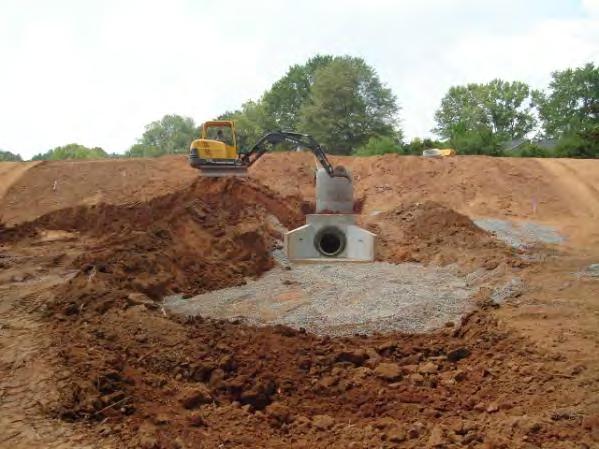
23 Infrastructure Sizing of new bridges and culverts Sizing of existing bridges and culverts replacement Identified over 250 road crossings Developed conceptual Capital Improvement Project designs Master ranking of structures to prioritize construction schedule Land Acquisition 22

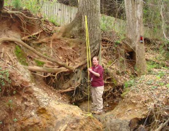
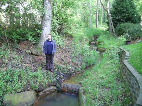
24 Stream Restoration Stream bed Stream bank Infrastructure During construction After Before After
25 Emergency Services Pre Disaster Policy development Access vulnerability Reduce vulnerability 24
26 Emergency Services Post disaster Mitigation Procedures Residential Substantial Damage Estimator Mitigation Funding Increased Cost of Compliance Sustainability
27 NAI Principles In Gwinnett County Questions?
28 CRS-NAI Linkage Source of Help Hazard Identification Filling the data gaps Building Block/Tool 1 Toolkit CRS State State Page Section NFIP EMA FEMA # # Detailed data in approximate A Zones a x x Detailed data in X Zones a x Better base map a x Cooperating Technical Partner f x x Mapping other flood-related hazards f x x Higher mapping criteria Future conditions hydrology b x More restrictive floodway standard c x
29 CRS-NAI Linkage Source of Help Toolkit CRS State State Building Block/Tool 1 Page Section NFIP EMA FEMA # # # # Prevent Loss or storage/increase in velocity 21 x CTP cost-sharing on studies f x x Education and Outreach Outreach Projects Provide FIRM Information x

30 Youtube MVGP1Q w_6am0&feature=related
Stormwater Regulations & Considerations Morse Study Area. Pam Fortun, P.E. CFM Senior Stormwater Treatment Engineer Engineering Services Division
 Stormwater Regulations & Considerations Morse Study Area Pam Fortun, P.E. CFM Senior Stormwater Treatment Engineer Engineering Services Division Stormwater Regulations Development Considerations Floodplain
City of East Point Comprehensive Floodplain Management Program
 City of East Point Comprehensive Floodplain Management GAFM 2012, 7 th Annual Technical Conference Reza Aral, CFM, CPESC (City of East Point, GA) Shayne Wood, P.E. (CDM Smith) March, 28, 2012 Agenda Overview
No Adverse Impact. A Proposed National Standard. Association of State Floodplain Managers Annual Conference Kansas City, MO.
 No Adverse Impact A Proposed National Standard Association of State Floodplain Managers 2017 Annual Conference Kansas City, MO May 3, 2017 Ronald D. Flanagan, CFM Flanagan & Associates, LLC Environmental
7th Avenue Creek Master Plan Development Project. City of St. Charles, IL. IAFSM CONFERENCE March 14, 2018 MARKET
 7th Avenue Creek Master Plan Development Project MARKET City of St. Charles, IL IAFSM CONFERENCE March 14, 2018 7 TH AVENUE CREEK PROJECT AREA 2 2008 RAIN EVENT 3 RESIDENTIAL STRUCTURE FLOODING COMMERCIAL
When planning stormwater management facilities, the following principles shall be applied where possible.
 2.0 Principles When planning stormwater management facilities, the following principles shall be applied where possible. 2.0.1 Drainage is a regional phenomenon that does not respect the boundaries between
Draft Rhode Island Stormwater Design and Installation Standards Manual
 Draft Rhode Island Stormwater Design and Installation Standards Manual Summary The May 2009 Public Review Draft version of the RI Stormwater Design and Installation Standards Manual consists of approximately
Post Construction BMPs
 Post Construction BMPs Why are Post Construction BMPs important? With increased development brings the increase of impervious cover Parking lots, rooftops, driveways Storm water runoff volume increases
SOUTH FOX MEADOW STORMWATER IMPROVEMENT PROJECT
 VILLAGE OF SCARSDALE WESTCHESTER COUNTY, NEW YORK COMPREHENSIVE STORM WATER MANAGEMENT SOUTH FOX MEADOW STORMWATER IMPROVEMENT PROJECT In association with WESTCHESTER COUNTY FLOOD MITIGATION PROGRAM Rob
FLOODPLAIN USE PERMIT APPLICATION COMMUNITY DEVELOPMENT DEPARTMENT W. Ten Mile Road Novi, MI (248)
") FLOODPLAIN USE PERMIT APPLICATION COMMUNITY DEVELOPMENT DEPARTMENT 45175 W. Ten Mile Road Novi, MI 48375 (248) 347-0415 Office Use Only Permit Number: Date Issued: Processed By: Type of Permit: Date: Project
FLOODPLAIN USE PERMIT APPLICATION COMMUNITY DEVELOPMENT DEPARTMENT 45175 W. Ten Mile Road Novi, MI 48375 (248) 347-0415 Office Use Only Permit Number: Date Issued: Processed By: Type of Permit: Date: Project
CHECKLIST FOR PHASE II DRAINAGE REPORT
 I. COVER SHEET CHECKLIST FOR PHASE II DRAINAGE REPORT A. Name of Project B. Address C. Owner D. Developer E. Engineer F. Submittal date and revision dates as applicable II. GENERAL LOCATION AND DESCRIPTION
Hazard Mitigation Planning. Association of New Jersey Environmental Commissions Workshop Edison, New Jersey October 20, 2012
 Hazard Mitigation Planning Association of New Jersey Environmental Commissions Workshop Edison, New Jersey October 20, 2012 Mitigation Planning NJ Hazard Mitigation Plan? What is the status of the HMP
Problem Understanding
 Introduction...2-1 Previous Data and Mapping...2-2 Known Problem Areas...2-3 Resident Survey.2-3 Introduction The Village of Downers Grove stormwater system includes storm sewers, streams, wetlands, roadway
KYTC and NFIP: Bridging Floodplain Management and Design KAMM CONFERENCE AUGUST 25, 2015
 KYTC and NFIP: Bridging Floodplain Management and Design KAMM CONFERENCE AUGUST 25, 2015 KYTC STATEWIDE DRAINAGE DESIGN Provide Drainage Design Services on an as needed basis: Perform hydraulic analysis
Part 4: CRS Stormwater Management Activity (450) and Urban Flooding Best Practices
 and Urban Flooding Best Practices") Coastal Resilience through Community Engagement Webinar Series Part 4: CRS Stormwater Management Activity (450) and Urban Flooding Best Practices 1:00 2:30pm CT 8 Today s Moderator Chad Berginnis, CFM
Coastal Resilience through Community Engagement Webinar Series Part 4: CRS Stormwater Management Activity (450) and Urban Flooding Best Practices 1:00 2:30pm CT 8 Today s Moderator Chad Berginnis, CFM
City of Norfolk Coastal Flood Mitigation Program. March 13, 2013
 City of Norfolk Coastal Flood Mitigation Program March 13, 2013 Topics Brief overview of Norfolk s Coastal Flood Program Data-driven analysis and decision making City-wide vulnerability, project concepts,
The Benefits and Challenges Associated with Green Infrastructure Practices
 The Benefits and Challenges Associated with Green Infrastructure Practices Thomas M. Evans ASLA, LEED AP Regional Green Infrastructure Design Services Director OWEA Technical Conference, June 20, 2013
Mapping and the 2013 Colorado Floods. Mapping before, during, and after
 Mapping and the 2013 Colorado Floods Mapping before, during, and after Presented by Outline 2013 Floods Floodplain Mapping Before During After 20 counties 21,000 households 6000 sq. mi. 2,132 NFIP claims
Appendix E Preliminary Location Hydraulic Study
 Appendix E Prepared for: State of Alaska Department of Transportation and Public Facilities Prepared by: HDR Alaska, Inc. 2525 C Street, Suite 305 Anchorage, Alaska 99503 February 2014 This page intentionally
City of Waco Stormwater Management Regulations
 1.0 Applicability: City of Waco Stormwater Management Regulations These regulations apply to all development within the limits of the City of Waco as well as to any subdivisions within the extra territorial
What Can We Do to Reduce the Impact of Floods? Joe Barron, P.E. Fletcher Group, Inc. 148 River St. Suite 220 Greenville, S.C.
 What Can We Do to Reduce the Impact of Floods? Joe Barron, P.E. Fletcher Group, Inc. 148 River St. Suite 220 Greenville, S.C. 29601 1 Historical highlights of flood management attempts 1726 first New Orleans
Going Green with the NYS Stormwater Design Standards
 Going Green with the NYS Stormwater Design Standards Shohreh Karimipour, P.E. NYSDEC History of Stormwater Management Ancient Greek Cisterns Water Cistern Systems in Greece from Minoan to Hellenistic Period,
Please highlight flow chart where applicable and return with Form 2 and Form 3 (tab 1) to the City of St. Charles Engineering Department.
 to the City of St. Charles Engineering Department.") Please highlight flow chart where applicable and return with Form 2 and Form 3 (tab 1) to the City of St. Charles Engineering Department. A $50 Permit Application fee should accompany the Permit Application.
Please highlight flow chart where applicable and return with Form 2 and Form 3 (tab 1) to the City of St. Charles Engineering Department. A $50 Permit Application fee should accompany the Permit Application.
MANUAL OF DESIGN, INSTALLATION, AND MAINTENANCE REQUIREMENTS FOR STORMWATER MANAGEMENT PLANS
 MANUAL OF DESIGN, INSTALLATION, AND MAINTENANCE REQUIREMENTS FOR STORMWATER MANAGEMENT PLANS May 2007 SECTION 1 Responsibility of Applicant TABLE OF CONTENTS A. Stormwater Management Plan Required Information
Floodplain Management Strategies in Forsyth County Georgia Association of Floodplain Management 7 th Annual Technical Conference March 2012
 Floodplain Management Strategies in Forsyth County Georgia Association of Floodplain Management 7 th Annual Technical Conference March 2012 Renee Hoge, P.E., CFM Forsyth County Department of Engineering
PCE PRELIMINARY DRAINAGE ANALYSIS REPORT FOR WESTWOOD MIXED USE NEIGHBORHOOD PROJECT 772 NORTH FOREST ROAD TOWN OF AMHERST, ERIE COUNTY, NEW YORK
 PCE PRELIMINARY DRAINAGE ANALYSIS REPORT FOR WESTWOOD MIXED USE NEIGHBORHOOD PROJECT 772 NORTH FOREST ROAD TOWN OF AMHERST, ERIE COUNTY, NEW YORK MAY 19, 2014 Prepared By: Timothy M. Lavocat, P.E., CFM
Getting the Locals to Go Along. Keys to Tulsa s Successful Floodplain Management
 Getting the Locals to Go Along Keys to Tulsa s Successful Floodplain Management Presented by: Ronald D. Flanagan, CFM Principal Planner Flanagan & Associates, LLC Land-Use & Natural Hazards Planning Consultants
Overall Drainage Report
 Overall Drainage Report Date: May 3, 2016 Project: Attn: Gateway at Prospect Overall Development Plan Fort Collins, Colorado Mr. Shane Boyle Fort Collins Utilities 700 Wood Street Fort Collins, Colorado
Richton Park Western Development Corridor Green Infrastructure Development Plan August 18, 2017
 Richton Park Western Development Corridor Green Infrastructure Development Plan August 18, 2017 Conservation Design Forum Geosyntec Consultants 403 W. St. Charles Road 1420 Kensington Road, Suite 103 Lombard,
Riparian Buffer on the Bushkill Creek. Policies
 Riparian Buffer on the Bushkill Creek Riparian buffers provide numerous benefits to landowners and the community by protecting groundwater recharge areas, providing flood control, providing stormwater
1. Project Description
 To: By: Checked By: Jimmy Vilce, E.I. (FOT istrict 1 Project Manager) Jennifer Nunn, P.E. (The Balmoral Group) Lori Stanfill, P.E. (The Balmoral Group) Memorandum ate: July 10, 2018 Subject: In May of
Tennessee Stormwater Management Program. Stormwater Management Site Assessment and Inventory Checklist. Quick Check o Vicinity Map within Watershed
 Tennessee Stormwater Management Program Project Name: Location: File Number: Reviewer: Date of Submittal: Review Date: Project Meeting Chronology: Type of Meeting: Date: Stormwater Management Site Assessment
Lower Meramec Multi-Jurisdictional Floodplain Management Plan Public Involvement (Results of Early Public Engagement) 27 June 2018
 27 June 2018") Lower Meramec Multi-Jurisdictional Floodplain Management Plan Public Involvement (Results of Early Public Engagement) 27 June 2018 Public Involvement Summary: The planning process includes opportunities
Lower Meramec Multi-Jurisdictional Floodplain Management Plan Public Involvement (Results of Early Public Engagement) 27 June 2018 Public Involvement Summary: The planning process includes opportunities
Importance of Master Planning Marcy Colclough
 Importance of Master Planning Marcy Colclough Senior Planner Southwest Michigan Planning Commission WHERE and HOW we develop Land affects Water Quality! 43.2 Acres total 20 Homes 35.8 Acres of open space
Structural Project (stream daylighting) Property Protection (elevation) PREVENTION NATURAL RESOURCE PROTECTION STRUCTURAL PROJECTS PUBLIC EDUCATION
 Property Protection (elevation) PREVENTION NATURAL RESOURCE PROTECTION STRUCTURAL PROJECTS PUBLIC EDUCATION") NEW MITIGATION GOALS, STRATEGIES, ACTIONS PREVENTION STRUCTURAL PROJECTS NATURAL RESOURCE Structural Project (stream daylighting) PROPERTY PUBLIC EDUCATION EMERGENCY SERVICES Property Protection (elevation)
NEW MITIGATION GOALS, STRATEGIES, ACTIONS PREVENTION STRUCTURAL PROJECTS NATURAL RESOURCE Structural Project (stream daylighting) PROPERTY PUBLIC EDUCATION EMERGENCY SERVICES Property Protection (elevation)
Existing Conditions and Environmental Consequences Floodplains
 3.9 Environmental Consequences 3.8 3.8.1 WHAT ARE FLOODPLAINS? are low-lying areas adjacent to rivers, streams, and other waterbodies that are susceptible to inundation (flooding) during rain events. These
Physical Approaches to Flood Mitigation
 Physical Approaches to Flood Mitigation ational Academy of Sciences /19/2017 Chicago Area Before Development Widespread Flooding Waterways and Marshes Absorbent Ground Early settlers came to this location
Stream Restoration: Working with Nature?
 Stream Restoration: Working with Nature? Greg Jennings, PhD, PE jenningsenv@gmail.com Ecosystem Restoration activities that initiate or accelerate the recovery of ecosystem health, integrity, and sustainability
Stream Restoration: Working with Nature? Greg Jennings, PhD, PE
 Stream Restoration: Working with Nature? Greg Jennings, PhD, PE jenningsenv@gmail.com Ecosystem Restoration activities that initiate or accelerate the recovery of ecosystem health, integrity, and sustainability
CRITICALFACILITIESASSESSMENT IN SOUTHEASTERN CONNECTICUT STRATEGIES FOR ALL HAZARDS RESILIENCE
 CRITICALFACILITIESASSESSMENT IN SOUTHEASTERN CONNECTICUT STRATEGIES FOR ALL HAZARDS RESILIENCE Presented by: David Murphy, P.E., CFM, Milone & MacBroom, Inc. October 25, 2017 Agenda Project Background
5. LOW IMPACT DEVELOPMENT DESIGN STANDARDS
 5. LOW IMPACT DEVELOPMENT DESIGN STANDARDS Low Impact Development (LID) requires a shift in stormwater management away from conveying runoff to a small number of downstream points through hydraulically
I. INTRODUCTION. identify long-term capital improvements and rehabilitation measures for the existing drainage system;
 I. INTRODUCTION The Town of Windsor, Colorado is presently experiencing rapid growth and development within the boundaries of several of its major drainage basins. As growth continues within these basins,
Hydrology And Floodplain Analysis 5th Edition Solution
 We have made it easy for you to find a PDF Ebooks without any digging. And by having access to our ebooks online or by storing it on your computer, you have convenient answers with hydrology and floodplain
Washington County, Maryland Division of Public Works Policy Manual
 Washington County, Maryland Division of Public Works Policy Manual Subject: Downstream Drainage Easement Category: Land Development Engineering Number: 7-4.1 Date: June 1, 2009 (effective) PURPOSE: The
Checklists. Project Name: Location: File Number: Date of Submittal: Reviewer: Date: Applicant: Contact Name: Phone Number:
 Applicant: Contact Name: Phone Number: Email: Project Name: Location: File Number: Date of Submittal: Reviewer: Date: Concept Plan Requirements: I. General Project Information 1. Address or parcel number
Adapting Floodplain Ordinances to New Mapping in Historically Modified Floodplains for Urban Areas
 Adapting Floodplain Ordinances to New Mapping in Historically Modified Floodplains for Urban Areas By: Raymond J. Wilke, P.E., CFM City of Atlanta Watershed Director, Senior Bureau of Engineering Services
Adopting the Manual of Best Management Practices for Stormwater Quality. Facts for Communities
 Adopting the Manual of Best Management Practices for Stormwater Quality Facts for Communities Adopting the Manual of Best Management Practices for Stormwater Quality September 2006 prepared for the Mid-America
Appendix I. Checklists
 Appendix I Checklists Town of Greenwich Drainage Manual Department of Public Works - Engineering Division Town Hall - 101 Field Point Road, Greenwich, CT 06836-2540 Phone 203-622-7767 - Fax 203-622-7747
Radnor Township. Factors affecting storm water issues.
 Radnor Township Factors affecting storm water issues. Climate Changes and Changing Weather Patterns Intensity of rains over the last 7 to 10 years. Larger number of smaller storms delivering greater amounts
Managing Stormwater within the Road Right-of-Way: An Urban NAI Approach
 Turgay Dabak, Joni Calmbacher, Sara DeGroot, Andrea Ryon Managing Stormwater within the Road Right-of-Way: An Urban NAI Approach Presentation Outline Project Background Project Overview BMPs Evaluated
EXHIBIT A CITY OF FORT WALTON BEACH, FLORIDA COASTAL MANAGEMENT & CONSERVATION
 EXHIBIT A CITY OF FORT WALTON BEACH, FLORIDA INTRODUCTION The Coastal Management and the Conservation Elements required by Chapter 9J-5.012 and 5.013, F.A.C., respectively, have been combined into one
Reducing Runoff with Green Infrastructure. Lake George, NY May 5, 2011
 Reducing Runoff with Green Infrastructure Lake George, NY May 5, 2011 The Duties of a Stormwater Designer: Reduce Peak Runoff Rates Remove Pollutants from Runoff Reduce Runoff Volume Runoff Reduction from
FLOOD ISSUE 62 INTRODUCTION
 V I S I O N 2 0 3 0 Southwest Missouri is known for its extreme range in weather that can cause flash flooding in a moment s notice. This flooding can unfortunately lead to extreme damage and serious injury,
MEMORANDUM. September 10, 2018
 September 10, 2018 MEMORANDUM TO: Chad Bird, City of Decorah FROM: Larry Weber and Dan Gilles, Iowa Flood Center, IIHR Hydroscience & Engineering COPY TO: Dana Werner, St. Paul District Corps of Engineers,
Article 20 Stormwater Management
 Article 20 Section 20.01 Intent Article 20 The purpose of this Article is to protect the health, safety, and general welfare of the citizens by requiring compliance with accepted standards and practices
NDIA Environment, Energy, and Sustainability Symposium & Exhibition Denver, Colorado May 2009
 Energy Independence and Security Act of 2007 (Energy Conservation, Water Conservation, and Community Development) NDIA Environment, Energy, and Sustainability Symposium & Exhibition Denver, Colorado May
APPENDIX A SIMPLIFIED APPROACH TO STORMWATER MANAGEMENT FOR SMALL PROJECTS. In West Sadsbury Township, Chester County, Pennsylvania
 APPENDIX A SIMPLIFIED APPROACH TO STORMWATER MANAGEMENT FOR SMALL PROJECTS In West Sadsbury Township, Chester County, Pennsylvania TABLE OF CONTENTS I. Introduction 3 II. Importance of Stormwater Management
Section 3 Non-Structural BMPs
 3.1 Stream Buffers A stream buffer or stream setback is a designated area around a stream, lake, or wetland left in a natural, densely vegetated state so as to protect the receiving water quality and provide
Chapter 3 Site Planning and Low Impact Development
 CHAPTER 3 Site Planning and Low Impact Development Chapter 3 Site Planning and Low Impact Development 3.0 Introduction The City of Charleston requires that major residential, large commercial (>1 acre),
8.5 FLOODING. Environmental Setting
 8.5 FLOODING This section evaluates flooding impacts associated with the proposed General Plan, including whether implementing the plan will: (1) permit the construction of housing within a 100-year Flood
STORMWATER GREEN INFRASTRUCTURE AND PLANNING/ZONING BOARDS
 STORMWATER GREEN INFRASTRUCTURE AND PLANNING/ZONING BOARDS Source: Center for Watershed Protection, 2007 Southern Tier Central Regional Planning & Development Board Chemung County Stormwater Team OUTLINE
Drexel, Barrell & Co.
 Drexel, Barrell & Co. June 18, 2018 Engineers/Surveyors Boulder Colorado Springs Greeley 3 South 7 th Street Colorado Springs, Colorado 80905-1501 719 260-0887 719 260-8352 Fax El Paso County Planning
APPENDIX E. Flood Plain Management
 APPENDIX E Flood Plain Management The Comprehensive Plan incorporates policies of the City s Drainage and Flood Plain Management Plans with the long-term goals of the City. This Appendix provides an overview
Arlington County Watershed Retrofits. Greg Hoffmann Center for Watershed Protection
 Arlington County Watershed Retrofits Greg Hoffmann Center for Watershed Protection March 18, 2010 About the Center for Watershed Protection Non-profit 501(c)3, non-advocacy organization Work with watershed
Metropolitan Water Reclamation District of Greater Chicago. Supervising Civil Engineer
 Metropolitan Water Reclamation District of Greater Chicago Green and Gray Infrastructure John P. Murray, P.E., CFM Supervising Civil Engineer STORMWATER MANAGEMENT District conveyed authority in November
Fixer Upper. MS4 Post-Construction and Redevelopment. Anthony Betters, CSI City of Waco Environmental Storm Water Compliance
 Fixer Upper MS4 Post-Construction and Redevelopment Anthony Betters, CSI City of Waco Environmental Storm Water Compliance Polly Porter TCEQ Small Business and Local Government Assistance Curtis Beitel,
Introduction to Low Impact Development. Dr Kathy Chaston Coral & Coastal Management Specialist NOAA Office of Ocean & Coastal Resource Management
 Introduction to Low Impact Development Dr Kathy Chaston Coral & Coastal Management Specialist NOAA Office of Ocean & Coastal Resource Management http://hawaii.gov/dbedt/czm/resource/publication.php A Comprehensive
Modeling Cumulative LID Features for Floodplain Impacts in an Urban Watershed in Houston, TX
 Modeling Cumulative LID Features for Floodplain Impacts in an Urban Watershed in Houston, TX Christina Hughes, Phil Bedient cmhughes@rice.edu May 2, 2014 1 Modeling Cumulative LID Features for Floodplain
ARIZONA WATER COMPANY
 ARIZONA WATER COMPANY East Sedona Water Storage Facility February 21, 2018 Community Meeting STORMWATER RUNOFF Issue: Runoff sometimes flows out of the wash at bottlenecks in front of several homes on
Sustainable Stormwater Management through Green Infrastructure. Jersey City Public School #5
 Green Infrastructure Site Evaluation Friday, October 25 th, 2013 Sustainable Stormwater Management through Green Infrastructure Jersey City Public School #5 FORMAT: (15 minutes) An Introduction to Stormwater
STORMWATER UTILITY FREQUENTLY ASKED QUESTIONS
 STORMWATER UTILITY FREQUENTLY ASKED QUESTIONS What is Stormwater? Stormwater is water that falls to the ground during a precipitation event. When land is undeveloped or covered with vegetative surface,
Drexel, Barrell & Co.
 Drexel, Barrell & Co. December 21, 2018 Engineers/Surveyors Boulder Colorado Springs Greeley 3 South 7 th Street Colorado Springs, Colorado 80905-1501 719 260-0887 719 260-8352 Fax El Paso County Planning
Planning the BMP. Region 2000 Planning District Commission Lynchburg, VA December 13, 20013
 Planning the BMP Region 2000 Planning District Commission Lynchburg, VA December 13, 20013 PLANNING THE BMP AGENDA BMP Selection BMP Design SWM Plan Preparation 2 BMP SELECTION Types of BMPs Structural
IMPLEMENTING STORMWATER MANAGEMENT REQUIREMENTS FOR DEVELOPMENT
 IMPLEMENTING STORMWATER MANAGEMENT REQUIREMENTS FOR DEVELOPMENT 4.1 Overview Description: Requirements and standards for controlling runoff from development are critical to addressing water quantity and
Village of Forest Park. July 27, Sewer Separation Evaluation
 Village of Forest Park July 27, 2015 Sewer Separation Evaluation Presentation Overview Study Background Historic Nature of Forest Park Drainage Scale of Flooding Problem Forest Park Sewer System Background
Section 11 Grading and Drainage Standards
 Section 11 Grading and Drainage Standards 11.1 INTRODUCTION The proper grading, conveyance, storage and release of storm water is critical to maintain the integrity of the Property. Drainage facilities,
Northern Branch Corridor DEIS December 2011
 16 Floodplains 161 Chapter Overview 1611 Introduction The flowing chapter identifies floodplains found within the Northern Branch Corridor in accordance with Executive Order 11988, Floodplain Management
River Corridor Overlay Zone (RCOZ) Article 5
 Article 5") River Corridor Overlay Zone (RCOZ) Article 5 The site is in one of two designated districts. The first is the CBD (central business district) River District, which recognizes the urban character and unique
River Corridor Overlay Zone (RCOZ) Article 5 The site is in one of two designated districts. The first is the CBD (central business district) River District, which recognizes the urban character and unique
SHEFFIELD PARK Paulding County, GA DRI #588
 SHEFFIELD PARK Paulding County, GA DRI #588 Supplemental Information for RDC s DRI (Form 2) Review August 16, 2004 Prepared for: Mr. David Howerin Coosa Valley RDC 1 Jackson Hill Drive Rome, GA 30161 P.O.
Pollutant Removal Benefits
 Bioswales Bioswales Similar to biocells, but have a slight, but positive grade toward an outlet Designed to convey the WQv event at very low velocities Promote filtration through native vegetation, infiltration
Floodplain Technical Memorandum
 Southeast Extension Project Lincoln Station to RidgeGate Parkway Prepared for: Federal Transit Administration Prepared by: Denver Regional Transportation District May 2014 Table of Contents Page No. Chapter
Gaining Consensus for Green Infrastructure Rain to Recreation
 Gaining Consensus for Green Infrastructure Rain to Recreation May 2nd, 2017 Tom Jacobs, PE, CFM Stormwater Engineer City of Lenexa Ronald L Norris, PE, PWLF Affiliated with Shockey Consulting Rain to Recreation:
PROJECT SCOPE OF WORK CITY OF TOWN AND COUNTRY STORMWATER PROGRAM
 PROJECT SCOPE OF WORK CITY OF TOWN AND COUNTRY STORMWATER PROGRAM Project Name: 362 Featherstone Dr Project ID Number: 27-3 Problem: Anecdotal evidence suggests a natural spring exists in the backyard
- Phase. Project. areas using. project from. Project Type: Project is
 Model Community Watershe ed Development - Phase I / Marais des Cannes Location: Lafayette Parish / Scott, LA Client: State of Louisiana / Office of Community Development Disaster Recovery Unit Design Firm(s):
GREEN STREETS & INFRASTRUCTURE: A COUNTY APPROACH. Mimicking Nature to Manage Stormwater in Developed Areas
 GREEN STREETS & INFRASTRUCTURE: A COUNTY APPROACH Mimicking Nature to Manage Stormwater in Developed Areas Jennifer Gonzalez, Environmental Planner Passaic County Depar tment of Planning & Economic Development
Green Infrastructure Modeling in Cincinnati Ohio. Small Scale Green Infrastructure Design Using Computer Modeling
 Green Infrastructure Modeling in Cincinnati Ohio Small Scale Green Infrastructure Design Using Computer Modeling Presenters Jason Abbott is a Design Engineer with over 17 years of experience. Jason is
Community LID Workgroup Issue Paper #6
 Community LID Workgroup Issue Paper #6 Topic: Hard and Impervious Surface Coverage Limits Objective: Minimize the amount of hard and impervious surfaces in developments to allow more stormwater to infiltrate
Plan Maintenance Process
 Plan Maintenance Process 4.1 Overview 4.2 Monitoring, Evaluating & Updating the Plan 4.3 Incorporating into Existing Planning Mechanism 4.4 Funding Resources Planning Maintenance Process 267 4.1 Overview
City of Fort Worth. December 1, 2004
 City of Fort Worth December 1, 2004 Storm Water Issues in our Region Disappearing water features and habitat Erosion and degradation of natural streams Flooding in new and old developed areas Pollutants
 NOTES: 1.) THE BOGGY CREEK RD. AND SIMPSON RD. IMPROVEMENTS DEPICTED ON THIS PLAN ARE BASED ON RECORD CONSTRUCTION PLANS AND HAVE NOT BEEN SURVEYED. 2.) EXISTING RESIDENTIAL BUILDING STRUCTURES AND ANCILLARY
 PSLS Surveyors' Conference Workshop Information Form Workshop Number: (leave blank if unknown) Hours: Workshop Title: Workshop Description: Suggested Speaker(s), affiliation/contact information 1. 2. 3.
EXCERPTS. Sep City and County of Denver (CCD) Storm Drainage Master Plan
 Storm Drainage Master Plan") EXCERPTS Acronyms in Document: CCD- City and County of Denver (the City, the Mayor and his Administration) CDOT- Colorado Department of Transportation CPGC- City Park Golf Course (Detention, part of P2PH)
EXCERPTS Acronyms in Document: CCD- City and County of Denver (the City, the Mayor and his Administration) CDOT- Colorado Department of Transportation CPGC- City Park Golf Course (Detention, part of P2PH)
Project Narrative For Fruita RV Resort Conditional Use Permit
 Project Narrative For Fruita RV Resort Conditional Use Permit Date: November 18, 2016 Prepared by: Robert W. Jones, II, P.E. Vortex Engineering & Architecture, Inc. 2394 Patterson Rd., Ste. 201 Grand Junction,
Huntington Stormwater Utility
 Huntington Stormwater Utility Stormwater Management & Sediment and Erosion Control Requirements for Construction Sites Authorized by Huntington City Code Articles: 971, 970, 930, 935, 955, Revised April
Appendix 6-A. Site Plan Preparation and Submission as Part of the Land Development Process
 Appendix 6-A Site Plan Preparation and Submission as Part of the Land Development Process Table of Contents Appendix Section Headings 6-A.1.0 INTRODUCTION 6-A-2 6-A.2.0 THE STORMWATER MANAGEMENT PLAN 6-A-6
September 7, Mr. Brant Gary Director of Public Works City of Bellaire 7008 S. Rice Avenue Bellaire, Texas 77401
 September 7, 2016 Mr. Brant Gary Director of Public Works City of Bellaire 7008 S. Rice Avenue Bellaire, Texas 77401 Re: City of Bellaire, Texas FY 2016 Drainage Study Dear Mr. Gary: ARKK Engineers, LLC
CAMA LAND USE PLAN TOWN OF KITTY HAWK IMPLEMENTATION STATUS REPORT 2013
 Post Office Box 549 101 Veterans Memorial Drive Kitty Hawk, NC 27949 Phone (252) 261-3552 Fax (252) 261-7900 www.townofkittyhawk.org CAMA LAND USE PLAN TOWN OF KITTY HAWK IMPLEMENTATION STATUS REPORT 2013
LID CASE STUDY DESIGN WORKSHOP HSG B/D SOIL EXAMPLE SINGLE FAMILY SUBDIVISION WITH OUTPARCEL
 LID CASE STUDY DESIGN WORKSHOP HSG B/D SOIL EXAMPLE SINGLE FAMILY SUBDIVISION WITH OUTPARCEL B Y : M A R T Y W A N I E L I S T A A N D E R I C L I V I N G S T O N August, 2016 ACKNOWLEDGEMENTS The Low
LOUISIANA STATE UNIVERSITY COMPREHENSIVE & STRATEGIC CAMPUS MASTER PLAN. APPENDIX G - Stormwater Study Findings & Stormwater Solutions
 LOUISIANA STATE UNIVERSITY COMPREHENSIVE & STRATEGIC CAMPUS MASTER PLAN APPENDIX G - Stormwater Study Findings & Stormwater Solutions LSU: MP Narrative July 2017 3.5 Open Space Existing Conditions The
CREDITS. Wenk Associates Elati Street, Denver CO / Bill Wenk, FASLA Principal Jonah Weiss Landscape Designer
 CREDITS This report was prepared by Wenk Associates, in partnership with Clarion Associates, for the City of Fort Collins Stormwater Utility Department, with assistance from: Clarion Associates (Prime
Stormwater Management Techniques WMPF LAND USE TRAINING INSTITUTE MARCH 14, 2018
 Stormwater Management Techniques WMPF LAND USE TRAINING INSTITUTE MARCH 14, 2018 Potential Impacts of New Development Urban development can significantly increase stormwater runoff Water quality considerations