South Worcestershire Design Guide Supplementary Planning Document
|
|
|
- Mae Dennis
- 6 years ago
- Views:
Transcription

1 South Worcestershire Design Guide Supplementary Planning Document Part 1 Overarching Design Principles Consultation Draft July 2017 Malvern Hills District Council
2 Contents Consultation Timetable Consultation Timetable 2 Introduction Introduction 3 PART 1 Overarching Design Principles PART 1 Overarching Design Principles 1 Preparing and submitting a planning application 2 Achieving good design in new development 3 Developing the Design Concept - Design Principles 4 Respecting the Natural and Historic Environment 5 The Public Realm and Urban Design Annexe Note 1: General Design Principles for Extensions Note 2: Market Housing Mix Position Statement (May 2017) Appendices Further Reading Glossary 68 70
3 Consultation Timetable Consultation Timetable The South Worcestershire Councils (SWCs), Malvern Hills, Worcester City and Wychavon, published and consulted on a scoping paper to help inform the content of this draft Supplementary Planning Document (SPD) in February This first draft of the SPD is subject to consultation in line with the Town and Country Planning (Local Planning) (England) Regulations 2012.The statutory requirement at this stage is to consult for four weeks. However the Statement of Community Involvement (SCI) for the SWCs prescribes a longer consultation period. Therefore this document is subject to a six week statutory consultation (Regulation 13). The draft SPD was approved for consultation by the relevant SWC committees in July 2017, with the consultation period from Friday 31 July to Monday 4 September The draft SPD and representations form can be viewed online on each of the council s websites and the SWDP website Customer Services Centres/libraries in Malvern, Tenbury Wells and Upton upon Severn. Customer Contact Centres and libraries in Pershore, Evesham and Droitwich Spa as well as Broadway library. The hub at The Hive, Worcester and at libraries in St Johns and Warndon. Statutory bodies, interested parties and relevant groups, as well as individuals have been notified of the publication and opportunity to comment on this document. All responses received within the consultation period will be considered by officers and the draft SPD will be amended as appropriate. Further to this the final draft SPD, and consultation responses will be presented to each SWCs for adoption. The timetable for the adoption of this SPD is as follows: Date July 2017 July 2017 Late Aug Sept 2017 October 2017 November 2017 Stage Approval from relevant Committees to publish draft SPD for six weeks public consultation Draft SPD published for consultation Incorporate comments and produce draft for adoption Approval from relevant Committees to adopt the SPD Publish adopted South Worcestershire Design Guide SPD 2
4 Introduction Introduction Purpose and structure This South Worcestershire Design Guide Supplementary Planning Document (SPD) aims to encourage a higher standard of design in all aspects of the built environment across south Worcestershire. The guide does not set prescriptive standards rather instead it identifies principles of good design that are considered to be best practice. It should be used alongside the appropriate national planning policies, local plan policies in the South Worcestershire Development Plan (SWDP) and adopted neighbourhood plans policies. Status of the Design Guide The requirement to produce this document is set out in the South Worcestershire Councils (SWC) Local Development Schemes (2016) and its status is as a SPD within the Local Development Framework (LDF). It has been prepared to supplement policies in the SWDP, adopted in February 2016, in particular SWDP 2 Development Strategy and Hierarchy and SWDP 21 Design. As such, it is a material consideration for the decision taker in the determination of planning applications and planning appeals. The SWC will expect planning applications, as appropriate, to demonstrate how these guidelines have been taken into account e.g. within a masterplan, Design and Access Statement, and/or a Heritage Statement. Without detailed, relevant justification, those proposals for development which do not reflect the guidelines set down in this document are unlikely to be acceptable to the SWCs. The SPD should be read in conjunction with the following documents and any additional or revised documents which may supersede them: Existing national planning policy i.e. the National Planning Policy Framework (NPPF), in particular Section 6 Delivering a wide choice of high quality homes and Section 7 Requiring good design as well as advice and standards set down in the Building Regulations. Existing local planning policy, i.e. in the SWDP and neighbourhood plans. Although without statutory weight regard should be had to any relevant parish plans and village design statements that may contain useful guidance on design and local character. How to Use the Design Guide Due to the diverse and widespread area to which the SPD applies the approach has been to initially provide overarching design principles and guidance in Part 1 of the SPD (Figure 1). This allows for more detailed character and design guidance for the rural and urban areas of south Worcestershire in Part 2, and within the Annexe a series of topic related advice notes, e.g. on household extensions. Part 2 of the SPD is currently in development and the topic related advice notes, e.g. covering housing layout, commercial, retail, and urban design will be produced as and when required. The first in the series of notes, Note 1: General Design Principles for Extensions and Note 2: Market Housing Mix Position Statement has been published within Part 1 of the SPD. 3

5 Introduction Figure 1: Structure of Supplementary Planning Document Part 1 of the SPD is structured to assist with the careful process that an applicant should follow when submitting an application for all types of development. It starts with Section 3 providing advice on preparing and submitting a planning application, which describes the requirements for submitting an application and provides guidance on getting to grips with the context and setting within which development is being proposed. There are three logical stages that an applicant would need to follow to ensure that developments achieve a high quality of design: 1. As part of this process it is essential that the emerging design is based on thorough research and understanding of the context in which development is being proposed. 2. The applicant should refer specifically to the detailed guidance contained in Section 4, Achieving good design in new development, when working up the initial design of a scheme. 3. Finally Section 5, Developing the Design Concept, covers the urban design principles that should be considered when working up schemes. The principles can be used when working up the design at the early stages of the process. Section 6 provides advice on designing in the context of the natural and historic environment and the Section 7 sets out guidance on urban design and designing for the public realm. 4
6 Introduction Part 2 of the SPD will set out a character analysis of Worcester City and the rural districts i.e Malvern Hills and Wychavon of south Worcestershire. This provides detailed information on the context of the different areas within south Worcestershire and will assist applicants in undertaking character analysis and developing locally distinctive designs. The table below shows which subsections feed into each element of the design process to assist applicants in providing a comprehensive design approach. Requirements for providing a comprehensive design approach Process Relevant sections of the SPD Section reference Demonstrate how the site context has been assessed, Context Analysis 2.2 including physical, social and economic characteristics and relevant planning policies. Site Analysis 2.4 Demonstrate how account has been taken of community involvement. Identifying Local Needs and Communities 2.5 Show how the scheme has emerged from rigorous process of assessment, involvement, evaluation and design. The statement should therefore explain the Local Character/Distinctiveness 2.6 design out come not simply present it. Developing the Design 3 Concept Use Use of buildings and spaces. Amount How much would be built on the site. The appropriateness of the density. Can the neighbourhood services support the amount of development planned. Mixed uses and living over the shop. Appropriate Density Context Analysis Layout How the buildings and public spaces will be arranged Connecting Places 3.1 on the site, and the relationship between them and the buildings and space around the site. Creating Mixed Use 3.2 Respecting the Natural and Historic Environment 4 Demonstrate how the design incorporates crime prevention measures. Sustainable Design The Public Realm A Safe Environment
7 Introduction Requirements for providing a comprehensive design approach Scale How big the buildings and spaces would be (height, width, and length) Relevant sections of the SPD Detailed Design Responding to the Setting Section reference Part 2/Annexe Part 2 Explain how this relates to the sites surroundings. Explain how the scale of buildings features fit comfortably. Landscaping (inc. both hard and soft landscaping) The purpose of landscape design, including both hard materials and planting, often used together to create the required quality of setting. Rural Urban Design Design Principles Respecting the Natural and Historic Environment Part 2/Annexe How open spaces will be an inclusive part of the The Public Realm 5 design, the creation of new space and how space is treated to enhance and protect the character of a place. Amenities 3.7 Appearance The visual impression a place or building makes, including the external built form of the development, its architecture, materials, decoration, lighting, colour and texture and its setting within both the new design and surrounding existing landscape and/or townscape. Access Local Character/Distinctiveness A Role for Modern Architecture and Contemporary Design Sustainable Design Detailed Design Part 2/Annexe The same process should be followed with regard to Connecting Places 3.1 access. Access refers to access to the development, not just the internal aspects of individual buildings. Creating Mixed Uses 3.2 Adaptability 3.5 Explain how access arrangements would ensure that all users would have equal and convenient access to buildings and spaces, parking and the public transport network. The Public Realm Amenities
8 Introduction Requirements for providing a comprehensive design approach Listed Buildings and Conservation Areas Relevant sections of the SPD Section reference 4 Part 2/Annexe Appraising archaeology and the historic environment Integrating new buildings within the historic environment Site Appraisal Historic Environment
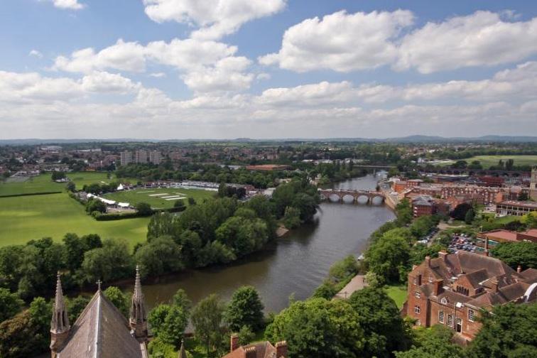
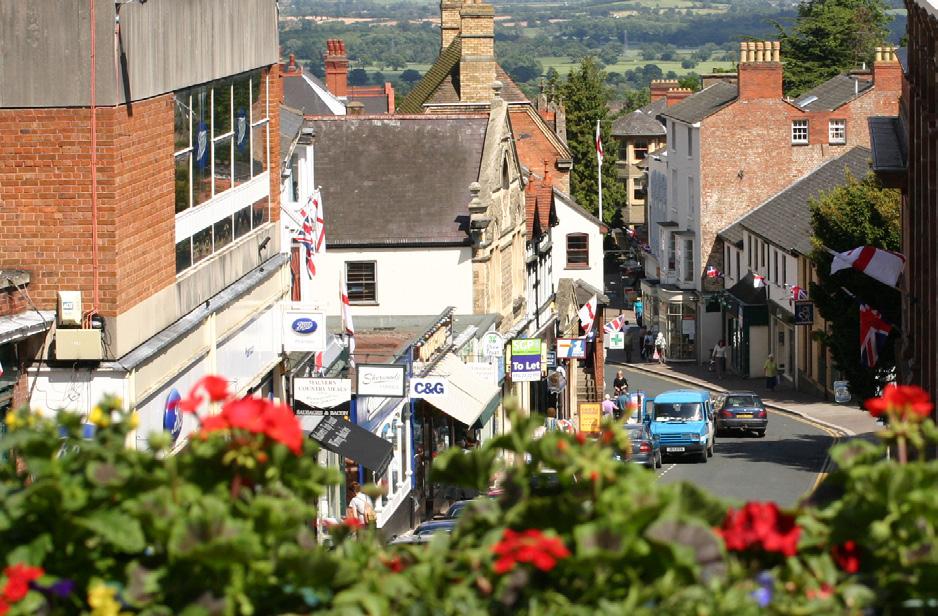
9 PART 1 Overarching Design Principles PART 1 Overarching Design Principles South Worcestershire Context The area covered by the SPD in terms of design character is extremely diverse and complex. Clearly the rural districts of Malvern Hills and Wychavon, transitional in nature from north to south, are mirrored by the complex over layering of the areas of Worcester city from the historic core to the urban fringe. All are important areas for consideration when developing locally distinctive design. This applies not only in all Conservation Areas in the villages, towns and city, but also in terms of contemporary designs, where the selection of materials and the detailed choices need to be carefully considered. More detail on the character appraisal of south Worcestershire is provided in Part 2 of the SPD. However by way of context south Worcestershire refers to the geographic area incorporated into the joint planning framework contained within the South Worcestershire Development Plan (SWDP). This provides planning policies covering Worcester City and the predominantly rural districts of Malvern Hills and Wychavon. Worcester The City of Worcester is a small and almost entirely urban district, which does however enjoy a coherent and highly valued green infrastructure network and notable biodiversity. Worcester lies on the River Severn; its historic city centre and core has Roman, Anglo-Saxon and medieval origins and there are many historic buildings, especially from the 16 th to 19 th centuries. Following the expansion of the city at the beginning of the 19 th century the city experienced phases of development similar to those seen in most English cities. The most recent suburban development has been at Warndon Villages and St Peters at the turn of the 21 st century, and two substantial new urban extensions are allocated in the SWDP to the south (SWDP45/1)and west (SWDP45/2) of the city which are to meet Worcester s employment land and housing requirement to Malvern Hills Malvern Hills district is situated in the western part of south Worcestershire and includes the principal towns of Malvern, Upton-upon-Severn and Tenbury Wells, as well as a high number of villages. It is a relatively large, predominantly rural district broadly characterised in landscape terms by principal timbered and timbered plateau farmlands to the north and west, settled farmlands with pastoral use and enclosed commons to the south and principal timbered farmlands and wooded estate lands to the east. There are over 1,800 listed buildings and 21 conservation areas in the district, with the Malvern Hills being the principal feature of the district to the west. There is a range of architectural styles in Malvern, including Victorian, Edwardian and Georgian buildings, as well as more modern post-war development. The district also features a large number of farmsteads, (converted) barns and cottages. Wychavon Wychavon is a large and predominantly rural district characterised by numerous villages and hamlets as well as the three market towns of Evesham, Droitwich Spa and Pershore. The area has a rich and diverse historic built environment with over 2,500 listed buildings and 66 Conservation Areas. This distinctive character has provided a wealth of architectural styles and properties that are greatly valued, and are a legacy that current development can draw 8
10 PART 1 Overarching Design Principles upon. As with Malvern Hills the district contains both low lying, rolling landscape of woodland and farms in the Severn, Avon and Evesham Vales as well as the Cotswold escarpment and Bredon Hill. Buildings and settlement patterns reflect this landscape with a combination of isolated farmsteads and hamlets, expanded villages and historic market towns. Aims and Objectives The primary aim of the guide is to improve the overall quality of built design within south Worcestershire by providing the necessary guidance in a series of reference documents. It is important that buildings from the 21 st century make an impact on built and urban design and become valued buildings and places of the future. locally distinctive design. design that respects and enhances local character. design that incorporates contemporary and sustainable approaches to development; and design that adheres to the latest best practice in layout and built form, including external spaces and landscaping. The guide is aimed at all new build schemes including; large and small scale residential developments, small in-fill housing sites, extensions, commercial and employment buildings, retail developments and the public realm related schemes. The design principles it endorses can be applied to different types and scales of development and can be used when submitting applications or masterplanning for the following: Residential Extensions Single house in-fill Small developments Major developments Commercial/Retail Office and inward investment sites High Street regeneration and retail parks Employment and B use class developments Public realm Urban design and regeneration schemes Masterplans and development briefs This part of the guide can be used to assist all those involved in the development process, (including architects, designers, public and private sector developers, house builders, planners, parish councils, engineers and other interested parties) to implement and achieve high quality development across south Worcestershire. The main objectives of the SPD are to: 9
11 PART 1 Overarching Design Principles Raise the standard of design through development that enhances local character and distinctiveness using traditional, locally distinctive and contemporary techniques. Create places where people want to live and spend time by improving the public realm with access to outdoor spaces and by protecting private amenity. Incorporate sustainable design techniques to minimise energy consumption and reduce greenhouse gas emissions. Deliver a diverse mix of dwelling types including affordable homes to meet local needs and to create active and vibrant communities. Deliver adaptable buildings that can be altered to meet the changing demands of the occupant, society and the climate. Create a safer environment through effective design to help reduce crime and the fear of crime. Respect the historic environment through development that enhances and protects heritage above and below ground. Respect the natural environment through development that enhances and protects biodiversity. Ensure new development reduces and manages the risk of flooding. Promote development in accessible locations where existing services and facilities can be accessed safely on foot or bicycle. Incorporate measures to improve connectivity throughout new schemes to promote walking, cycling and the use of public transport, to reduce the reliance on the motor vehicle. Provide Health and Wellbeing benefits through improvements to the built and natural environment that encourage healthier lifestyles. New development needs to be sensitive to its surroundings, but this does not mean it should copy existing styles. Instead it can draw on the local built environment to produce innovative and inspiring contemporary designs that are built to modern sustainable standards and are adaptable to the changing demands of society and the climate. Adapting to climate change is essential to ensure our communities remain desirable places to live and work and is a critical consideration in achieving sustainable development. Regard should also be had to the latest (both existing and emerging) national guidance and strategies (Appendix 1).This should ensure that collectively we create buildings and places where people really want to spend time and that leaves a legacy for the future. 10
12 Preparing and submitting a planning application 1 1 Preparing and submitting a planning application 1.1 Planning Submission Requirements The requirements for submitting a planning application vary according to the location and type of permission being applied for. It is advised that applicants visit the relevant SWC websites below in the first instance to identify the type of application they are required to submit and the accompanying documentation that is required. Please refer to the appropriate checklist on the relevant SWC website before final submission so that no omissions are made, and to ensure that your application can be validated, processed and determined as quickly as possible. Failure to supply all the necessary documentation and information with an application can result in a delay in processing and reaching a planning decision. For application information please follow the link to the relevant SWC. Malvern Hills District Council Worcester City Council Wychavon District Council Should applicants have any queries prior to making a submission please contact the relevant council s planning department. In many instances it is advisable to seek pre-application advice (chargeable save for employment development proposals), for further information please see the relevant council s webpage on pre-application procedures and, where relevant, fees. With this in mind any application for a significant level of development is likely to benefit from a Development Team Approach whereby a team of officers from within the council and other outside agencies can provide a more coordinated approach to dealing with development proposals. For large scale development proposals applicants are encouraged to contact the relevant Development Management Teams as early as possible prior to a formal application being submitted so that comprehensive and consistent advice can be given to developers at an early stage. It should be noted there is a charge for this service on residential planning applications. For pre-application information please follow the link to the relevant SWC. Malvern Hills District Council Worcester City Council Wychavon District Council In the case of residential extensions and alterations to existing dwellings there are some types of development that are 'permitted development' and do not require planning permission. Where a building is listed any extensions and alterations will require Listed Building consent. 11
13 1 Preparing and submitting a planning application Once again it is advised that the applicant checks online using the Planning Portal website or contacts the relevant planning department directly before commencing with any work. 1.2 Planning Policy Context National Policy and Guidance Any development that takes place within south Worcestershire, at whatever scale, needs to be consistent with national planning policy as set out in the National Planning Policy Framework (the Framework) and National Planning Practice Guidance (NPPG).The Government attaches great importance to the design of the built environment and the Framework puts great emphasis on design. always seek to secure high quality design and a good standard of amenity Core Principles, paragraph 17 Section 7 Requiring good design (para 56) of the Framework states that: Good design is a key aspect of sustainable development, is indivisible from good planning and should contribute positively to making places better for people. paragraph 56 Permission should be refused for development of poor design that fails to take the opportunities available for improving the character and quality of an area and the way it functions paragraph 64 However given the broad nature of the national policies it is imperative that guidance at a local level is provided to ensure new development meets these requirements. South Worcestershire Development Plan The South Worcestershire Development Plan (SWDP), adopted in February 2016, contains policies that either directly or indirectly seek to promote good design.the Vision in the SWDP states: High quality development has incorporated innovative, environmentally friendly solutions that have helped to reduce resource consumption, achieve sustainable communities and lessen the effects of extreme climatic impacts. 12
14 Preparing and submitting a planning application 1 The relevant SWDP objectives are: B C E Stronger Communities A Better Environment for Today and Tomorrow Communities that are Safe and feel Safe SWDP 21 Design Policy SWDP 21 Design of the SWDP encourages higher standards of design. All proposals for new buildings must demonstrate a high standard of design and make a positive contribution to the visual quality of the environment. In the consideration of development proposals, the following design aspects will be taken into account: Siting and Layout Relationship to Surroundings and Other Development The Settings of the City and Towns Neighbouring Amenity Settlement Character Mix of Uses Flexible Design Scale, Height and Massing Links, Connectivity and Access Detailed Design and Materials Appropriate Facilities Landscaping, green assets and biodiversity Public Realm Creating a Safe and Secure Environment Advertisements However the SPD is also relevant to the following additional SWDP policies: SWDP4 Moving around South Worcestershire SWDP5 Green Infrastructure SWDP 6 Historic Environment 13
15 1 Preparing and submitting a planning application SWDP10 Protection and Promotion of Centres and Local Shops SWDP13 Effective Use of Land SWDP14 Market Housing Mix SWDP16 Rural Exception Sites SWDP18 Replacement Dwellings in the Open Countryside SWDP19 Dwellings for Rural Workers SWDP20 Housing to Meet the Needs of Older People SWDP22 Biodiversity and Geodiversity SWDP23 The Cotswolds and Malvern Hills Areas of Outstanding Natural Beauty SWDP24 Management of the Historic Environment SWDP25 Landscape Character SWDP27 Renewable and Low Carbon Energy SWDP29 Sustainable Drainage Systems SWDP30 Water Resources, Efficiency and Treatment 1.3 Design and Access Statements A Design and Access Statement is a concise report accompanying and supporting a planning application to illustrate the process that has led to the development proposal and to explain the proposal in a structured way. The statements are important as they can provide a way for applicants to set out how an application has evolved and to justify the design details of their proposal. This enables planning officers, statutory consultees, local communities and other interested parties to better understand the impacts and implications of a proposal. Design and Access Statements are now only required for certain types of development. With regard to residential development this is where the number of dwellings is in excess of 10, the site area is 0.5ha or above. In other types of development where the floor space is 1,000 square metres or more, or the site area is 1ha or above. The SPD can be used to inform the process for creating Design and Access Statements and assist in achieving higher standards of development that have considered the social, economic and environmental impacts that are intrinsic to achieving sustainable development. Please note that applications for householder extensions are not required to provide a Design and Access Statement unless they are within a conservation area or require listed building consent. 14
16 Preparing and submitting a planning application 1 Checklists for the information required for each type of application can also be found on the relevant SWC website, please see the Planning Submission Requirements section for each council s relevant links. 1.4 Heritage Statement Heritage statements are required where a development may affect a designated or undesignated heritage asset.they should fulfil the requirements of the Framework (para.128), whereby local planning authorities should require an applicant to describe the significance of any heritage assets affected, including any contribution made by their setting. Heritage statements should include sufficient information to understand the potential impact of proposals on the significance of any heritage assets affected; the level of detail should be proportionate to the asset s importance. As a minimum the relevant Historic Environment Record should be consulted (Worcester City or Worcestershire County Council). Guidance on the content of a heritage statement should be sought from the relevant SWC. 1.5 Building for Life 12 The Building for Life 12 standard (2015) is supported and endorsed at a national level by Design Council CABE, Home Builders Federation, and Design for Housing and is considered to be an appropriate standard to apply when assessing the design quality of new homes and residential development. As such the SWC encourage the use of this standard to assist in the assessment of residential applications. CABE design reviews, endorsed by the Design Council, are invaluable in independently assessing design quality and sustainability of important and/or sensitive schemes. The Building for Life standard comprises 12 questions that can be used as a basis for writing development briefs, and can be used by officers and members to assess the quality of residential developments. It is important that applicants consider all of the questions when submitting their design and access statements particularly in schemes of 5 dwellings or more. Applicants with smaller schemes will also be encouraged to respond to these questions. We will seek higher standards through Building for Life 12 and use it to assess the quality of proposed designs. It should also help to speed up the the processing of planning applications. For further guidance on this standard and examples of well designed schemes please see the Design Council website ( -life-12-third-edition). In the case of affordable housing development there are a number of additional specifications / standards that need to be met as a prerequisite of any affordable housing grant funding received from the Homes and Community Agency. These are set out in the 2007 Design Quality Standards and include reference to Housing Quality Indicators, and Building for Life Design Review Design Review is a tried and tested method of promoting good design and is an effective way to improve quality and its use by both local planning authorities and developers is reinforced by the Framework (para. 62). The Design Review process provides impartial expert advice to applicants and local authorities on design issues in relation to important new 15
17 1 Preparing and submitting a planning application development schemes and proposals for public spaces. Schemes can include minor applications, major planning applications and pre-application development proposals. A panel will comprise of a group of independent, multi-disciplinary construction professionals working in the field of the built environment. Panel members must not have a prejudicial interest in schemes they are assessing. The panel recommendations can be used to improve design quality in proposals and have as much value to emerging schemes prior to submission of a planning application to a review of a live application in advance of any determination to grant permission. A proposal that has been through the Design Review process is far less likely to be refused planning permission on the grounds of poor design and therefore its use is encouraged. The Midlands Architecture Centre (MADE) provides an independent Design Review service and more details on this can be found via the following link 16
18 Achieving good design in new development 2 2 Achieving good design in new development 2.1 The Design Process Clearly inspirational and creative ideas form the basis of good design, but equally this must also be based on a full understanding of the site, locality and specific needs of the users. Therefore, the design process can be broken down into three stages which if followed should ensure that residential developments achieve a high quality of design appropriate to their context and setting, and deliver sustainable and durable buildings for the future. 1. Context Analysis 2. Developing the Design Concept 3. Detailed Design Each development presents a unique opportunity to design a scheme, which makes positive use of the site characteristics and the local context. Developers are encouraged to seek design solutions appropriate to each site taking into account the location, type, size and density of development proposed. The key objective in designing for new development is the creation of buildings and places that are sustainable, attractive, safe and convenient to live in. To achieve this, careful consideration must be given to all the constituent elements making up the whole environment including the: internal and external design of the buildings. surrounding uses. spaces between the buildings. streets that provide access. historic environment, landscape and ecology; and how these relate to each other. This is best achieved through the following: 2.2 Context Analysis The design process should begin with a full analysis of the site and the context in which it is set. A developer needs to demonstrate a clear understanding of the existing situation, including the surrounding land and land uses. The information gathered at this stage is critical to informing the design concept and final detailed design for a scheme. 17
19 2 Achieving good design in new development In order to give development identity and maintain the existing character of the locality, the overall design of any scheme should address the desired relationships between existing built or landscape features and the new development. Consequently, an understanding of the local context is fundamental to achieving good design. There are essentially two stages in undertaking a context analysis: Site Appraisal an understanding of the nature of the wider context that surrounds the site in terms of both the natural and built environment; and Site Analysis covers site specifics and how this relates to the wider context. 2.3 Site Appraisal The starting point of every development is a detailed study of its physical context. Architects, urban designers and developers need to understand the specific physical characteristics of the site being developed. The design concept for each site will vary depending upon these characteristics. Equally important is that every development site forms part of a wider context and therefore should never be seen in isolation. It is important to establish how the proposed site relates to surrounding land, and the site appraisal forms a key part of that process. This applies to whether the design relates to housing, commercial, retail, or public realm. This stage should involve the collection of qualitative and quantitative information to establish a comprehensive profile of the site and the locality through the combination of information gathering, survey and analysis, i.e. desk appraisal and site survey. Existing environmental assets on the site may also be important and should wherever possible inform and complement the new design. Desk Appraisal This can be divided into two types of work. The initial desk appraisal is a routine research process which focuses on information gathering that is publicly and easily accessible. The second requires specialist technical input, e.g. from those with ecology, landscape, environmental, archaeological, built heritage, transport, and public health expertise. Standard Appraisal the following steps should be undertaken as part of the desk appraisal: 1. Review of all national and local policy documents and guidance forming part of the Local Development Framework. 2. Previous and current land use/buildings, planning history, access, Tree Preservation Orders, historic assets/archaeology, landscape and biodiversity (especially including, but not exclusive to, protected species and habitats). 3. Connections to neighbouring and existing communities and settlements. 4. Wider assessment of the site can make reference to historical records/maps and aerial photographs to assess the type of activities carried out. 5. Finally information should be gathered on the local services, site capacity/densities, land ownership, ground conditions and legal issues. 18
20 Achieving good design in new development 2 Technical Material outlined below are those studies that are more likely to be required to support certain types of development: Environmental Impact Assessment This is a legal requirement, usually only for very large development or if development will impact on a sensitive location. It provides information about the likely environmental effects of a proposal as required by The Infrastructure Planning (EIA) Regulations May Full details of what can be required is set out in the regulations and the scope of the Environmental Statement can be discussed with the local planning authority at the pre-application stage. However, a summary is provided below: A description of the proposed development including information about the site, design size or scale. Data necessary to identify and assess the main environmental effects of the development. A description of the likely significant impacts, both direct and indirect of the proposals by reference to a range of environmental indicators. Description of any measures to mitigate any significant adverse effects. A non-technical summary of all the detailed technical reports. Landscape and Visual Impact In accordance with SWDP25 Landscape Character, development proposals must take into account the latest Landscape Character Assessment and guidelines. Proposals should conserve, and where appropriate, enhance the primary characteristics and important features of the Land Cover Parcel, and take the available opportunity to enhance the landscape. SWDP25 also requires a Landscape and Visual Impact Assessment (LVIA) for all major development proposals and other proposals where they are likely to have a detrimental impact on a significant attribute; irreplaceable landscape features, or landscape as a resource. In assessing character individual landscape elements should be identified; which are of inherent exceptional or high landscape value and which should be retained; areas within the site which have some landscape character or elements that are important but that could accommodate some development; areas with little or no existing landscape structure and that need positive improvement or enhancement to create a new landscape or improvements to existing landscapes. Further information on the landscape character of south Worcestershire can be found in the County Landscape Character Assessment on Worcestershire County Council s website via the following link: landscape-character-assessment.aspx 19
21 2 Achieving good design in new development Historic Environment Development proposals within the context of the historic environment should adhere to the policies in SWDP6 Historic Environment and SWDP24 Management of the Historic Environment. All sites have historic character although the significance of this will vary. The historic environment and historic character should form part of any site appraisal. Buried archaeological remains may form part of the site s character though these are most usually addressed through investigation of archaeological potential through assessment or field evaluation as part of a planning application. For initial appraisal for design purposes, online resources may provide sufficient information. These include: Historic England, National Heritage List for England (details of all designated heritage assets apart from conservation areas). Heritage Gateway (provides partial access to the Worcestershire and Worcester City Historic Environment Records (HERs). Local Lists of heritage assets: Worcester; Malvern Hills and Wychavon. Conservation area listings, designation reports and appraisals. Ecology/Biodiversity Development proposals should be supportive of SWDP22:Biodiversity and Geodiversity. Wildlife habitats adjacent to the site must be identified at a very early stage to assess the short and long-term effects of development. The desk appraisal and pre-application discussions with the relevant officers will establish how ecologically sensitive the site and its surroundings, e.g. if there are any known: Internationally designated or proposed sites. South Worcestershire currently contains two Special Area of Conservation (SAC); Bredon Hill (within Wychavon) and Lyppard Grange, Worcester. National designations, e.g. Sites of Special Scientific Interest (SSSIs). Regionally significant sites containing viable areas of threatened species; and Locally significant nature conservation sites ranging from high value sites, e.g. ancient semi-natural woodland, local nature reserves, Special Wildlife Sites, and other potentially undesignated sites of value, for example those contributing to Green Infrastructure. Where appropriate, an ecological appraisal should be undertaken to identify key habitats and species on site and the immediate vicinity and establish the key constraints to development of the site and opportunities for potential habitat improvements. Where a proposed development site is surrounded by nature conservation designations, off-site adjoining areas should be investigated in the context of nature conservation policy constraints. 20
22 Achieving good design in new development 2 Useful information can be accessed via the Worcestershire Biological Records Centre Land Contamination/ground conditions Development proposals should be supportive of SWDP31:Pollution and Land Instability. Where it is considered that the land could be contaminated by previous uses, or were former landfill sites, detailed historical information for the site, and for the surrounding area, should be reviewed. In these instances the environmental setting needs to be assessed for any potential environmental risk posed by past or current operations at or in the locality of the site. This should include: Reviewing the relevant contaminated land register. Appraisal of geological and hydrological conditions. Local borehole and ground/surface water flow conditions. Review of data held by British Geological Survey. Request for supplementary information from the Environment Agency. Transport Assessment Development proposals need to satisfy SWDP4: Moving Around South Worcestershire, in particular the need for all development proposals to minimize demand for travel, as well as a Travel Plan and Transport Assessment Strategy for all major development. Therefore a Transport Assessment may need to be carried out and this can be raised with the county council as the highway authority early on at the pre-application discussion stage. Where required, a Transport Assessment would need to include the following aspects and use a methodology and strategy that is appropriate to the scale of development: An assessment of trip generation and distribution by all different modes of transport. A detailed study of access by all modes of transport and to key services and facilities. A catchment area assessment. A passenger transport solutions plan for up to 20 years. A Safety Assessment. A Traffic Impact Assessment, including an assessment of emissions and air quality. An assessment of the geographical scope of the proposal and impacts on the surrounding and adjoining areas. Further information on preparing a transport assessment and the minimum requirements can be found at: -for-transportassessment10.pdf 21
23 2 Achieving good design in new development Health and Wellbeing (Health Impact Assessment) As part of the design process, applicants or prospective applicants should be guided by the Planning for Health SPD to undertake a Health Impact Assessment where developments meet the suggested threshold levels. Health Impact Assessment (HIA) ensures that the effects of development on both health and health inequalities are considered and addressed during the planning process. HIA is undertaken to predict the health implications on a population of implementing a plan, policy, programme or project, and in doing so aids the decision-making process. HIA should aim to enhance the potential positive aspects of a proposal through assessment, while avoiding or minimising any negative impacts, with particular emphasis on disadvantaged sections of communities that might be affected. Linking this process up when considering design could provide a key opportunity to assess and/or find solutions to any design and health implications/impacts at an early stage. For further information relating to the Planning for Health SPD and HIA, please see the SWDP website. Summary From all of this initial work a thorough understanding of the area will emerge with regard to the type(s) and magnitude of potential constraints and opportunities on and off-site. The information collected at this stage will form a basis for establishing priorities and objectives and generating initial design concepts. 2.4 Site Analysis New development must relate well, functionally and visually to the site and its setting. This relationship can be achieved if the site is analysed and recorded to identify the elements on or around the site that have a valuable or potentially detrimental impact on the proposed development. The site analysis will look in detail at the existing characteristics of the development site, examples of features to note being: Existing characteristics Existing entrances vehicle, pedestrian, cycle etc. Existing routes through the site public footpaths, desire lines, safeguarded routes and links to wider access and transport networks. Boundary treatments. Historic layouts and uses. Existing buildings assessment of quality, heritage significance and the desirability of retention within any development. 22
24 Achieving good design in new development 2 Landscape features within the site, e.g. trees, hedges or water features and the desirability to retain and manage within any development. Existing and potential wildlife habitats. Green corridors/amenity/recreation opportunities. Views in to and out of the site. Orientation for solar gain. Changes in ground levels. Natural drainage. Position of the development site Is it an entrance to a settlement or a gateway site. Is it or should it be a focal point. Is the site in a prominent location. Architectural form of surrounding buildings. Is the site within or adjacent to a designated area or area of special character e.g. a Conservation Area, Area of Outstanding Natural Beauty (AONB) or Special Landscape Area etc. Movement networks / accessibility The layout and hierarchy of surrounding roads and footpaths or cycle ways. The location of public transport. The accessibility of the site in terms of the location of any services and facilities. Adjacent land uses. The location of visible landmarks. Building layouts Patterns in road and car park layouts (grid sizes and arrangement). The arrangement of buildings perimeter block sizes and shapes. Treatment of road hierarchy, e.g. width, building lines, length of front gardens. 23
25 2 Achieving good design in new development Streetscape The use of materials. Relationship between buildings and streets vistas. Prevailing patterns in building design. Distinctive features in building design (vertical and horizontal rhythms). Natural landscape assessment Topography and changes in ground levels. Views and vistas into and across the site. Surrounding landscape features. Open spaces, footpaths and green spaces. Identification of existing and potential wildlife habitats, protected species and green corridors with potential ecological value, as well as amenity use. Detailed building design The design and appearance of surrounding buildings in terms of features such as: Form. Scale. Materials. Roof, window and doorway design. It is recognised that in some locations the surrounding environment will provide few contextual clues or positive features where any attempt at integrating the development could mean reinforcing the mediocre or worse. In these instances designers should draw inspiration from the wider context and aim to create an innovative and visually attractive development that will make a positive contribution to development in the locality, leading the way for better development in the future. 2.5 Identifying Local Needs and Communities Effective collaboration between planners, investors/developers and the local community for significant development, and indeed for any proposals in general is critical to the design, approval and successful implementation of new development. 24
26 Achieving good design in new development 2 The planning and development management process involves early and effective engagement and consultation with key parties and local communities. In the first instances reference should be made to the SWCs Statement of Community Involvement (2017) This sets out what is expected from applicants in terms of consultation on development proposals over and above the basic statutory requirements. It includes the best practice methods, identification of key stakeholders and matches appropriate techniques to the scale of particular proposals. Crucial to any process of engagement, on larger sites and especially significant urban extension is to produce a consultation strategy at the outset. It should be noted this process is more than publicity and awareness raising, rather a two-way exchange of views and opportunities for all groups involved to influence design outcomes, understand how decisions have been reached and to try and achieve a consensus around a development proposal. Therefore a consultation strategy should set out: Who will be delivering the process? The aims, benefits and risks associated with the process. Identification of key groups. Stages at which it will be carried out. Type of techniques to be used, appropriate to the scale of development. Integration to a parallel communication/publicity or marketing strategy and feedback. The Statement of Community Involvement (SCI) provides some guidance on this and it will vary dependent on the complexity of the development proposals. A complex site, with a range of interests groups will require a different approach compared with a relatively straightforward development. Central to the process is that differing objectives need to be reconciled in order to achieve good design outcomes and inevitably compromise is part of this. That said, local knowledge of the site, or surroundings and awareness of issues and needs held by the community is a valuable source of knowledge and should be sought out early in the process to avoid initial nonviable solutions. Typically, workshop style events to gather information early on, or develop a vision followed by more hands on design forums, e.g. Enquiry by Design or Planning for Real to explore options and refine development proposals with a range of stake holders would be appropriate for significant schemes. These are time consuming and require careful planning but can pay dividends in setting out principles and getting people on board. Alternatively, simple communication of information is needed for different groups, investors and local politicians at an early stage to gain support for the proposals. 25
27 2 Achieving good design in new development With the introduction of neighbourhood plans and the potential for these to allocate sites for development there are opportunities to work with local communities to formulate site development briefs and masterplans that can form part of a final adopted neighbourhood plan. 2.6 Local Character and Distinctiveness Local distinctiveness is what shapes the personality of a place. It is the combination of characteristics and qualities that combine to give a place its own particular identity and atmosphere and provides people with a sense of pride in where they live, work or spend their leisure time. Specifically it is about: How a place looks and feels. Its architecture and detail. Rhythm of buildings (the pattern and flow of the street frontages). Local materials. Boundary treatments. Landscaping and biodiversity. The pattern of characteristics that contribute to landscape character. The turning and marking of corners. Public open spaces. Views and Vistas. These factors are important in attracting people to live, work, visit and invest in a locality. However, increasingly these qualities are being eroded; by globalisation e.g. many high streets contain the same national retailers; loss of local character; by use of standard designs; and erosion of the connection between people and their local environment. Therefore, it is important that any new development recognises and responds to its setting. A full understanding of the neighbourhood and the local context of the site is vital to ensure that new development integrates successfully into the community. New development proposals must demonstrate a full appreciation of the local area to assist in nurturing local distinctiveness. This includes identifying and responding to the local climate, urban form, culture, landscape character topography, local architecture, built form and materials that are characteristic of the area. This should be used to inform the Design and Access Statement if required. By understanding the history of an areas growth and expansion, and the ways in which these patterns are layered on the landscape it is possible to inform future design in a positive way. The county council has information about landscape character to assist with defining different village types in the rural areas of south Worcestershire, the county and city, HERS include 26
28 Achieving good design in new development 2 Historic Landscape Characteristics (HLC) coverage of the whole area. In the case of conservation areas there are a number of detailed conservation area appraisals available via the relevant SWC webpages. The SWC do not wish to promote pastiche developments (i.e. imitations of existing styles or replicas), instead by understanding the context and setting there is an opportunity to reinforce local character and to create places with a sense of identity. This is particularly applicable to larger schemes where a sense of identity and place is critical. Smaller infill schemes provide the opportunity to add to the character and quality of an area and further enhance the context and setting. It may not always be appropriate for the applicant to provide an extremely detailed analysis of the context of an area, for example where the existing design and built form is poor in quality. On the other hand development in Conservation Areas will require a thorough understanding of the local context and this should be addressed in the Design and Access Statement and Heritage Statement if required. In analysing the character of the surrounding context it is important to consider: Layout of streets and spaces (this could include the use of a figure ground plan). Block size and shape. Streets and other routes. Relationship of buildings to streets. Relationship of buildings and streets to topography. Scale and massing of buildings. Building types. Materials and detailed designs. Landscape character. Historic character. The character appraisal is the way in which local distinctiveness will be analysed and applicants will be expected to provide evidence that both the existing pattern of development and its special qualities have been examined and the detailed design solution, whether contemporary, or otherwise positively responds to these findings. 2.7 A Role for Modern Architecture and Contemporary Design The SWC support the use of innovative design, which enhances the overall quality of the townscape and landscape either in established core areas, or as extensions to more recent development. Consequently the SWC wish to encourage the best of contemporary design and leave a legacy of architecture for future generations to value. 27
29 2 Achieving good design in new development It is not always easy to introduce modern architecture into a city setting or adjacent to historic towns, villages and conservation areas. Often the inclination is to imitate the existing styles that can lead to a poverty of ambition and failure to match the quality of design and craftsmanship of the surrounding buildings. Likewise, in terms of recent large-scale residential development the tendency has been to deliver off the peg design solutions that are often variations on the Victorian vernacular, neo-georgian theme, or pastiche of early to mid 20 th century housing types that more or less mimic the residential areas within the locality. Such development can often display a lack of affinity with established buildings, layouts and street patterns as well as a trend towards uniformity with development in other parts of the country. In design terms for most of the 20th century, architectural styles drew on a range of influences that led to the exploration of many new technologies including combinations of flat roofs, steel, glass and concrete. Although popular opinion has characterised some architecture from this period with a negative image, good examples have led to architectural styles clearly characteristic of a particular era, as distinctive in many ways to preceding buildings from Edwardian, Victorian, Georgian and earlier periods. All these styles were contemporary in their day, and contemporary design is that which makes best use of the most up-to-date materials and ideas in both the technical and aesthetic sense as well as incorporating sustainable building principles to a high standard. The fact that it may draw on past styles, to a certain extent grounds the building or buildings as locally distinctive. Town and city centre redevelopment and regeneration sites can be the most challenging locations to bring forward successful schemes for a variety of reasons, including finding the most appropriate design solution. These locations however can also offer the potential to secure increased value through contemporary and innovative design. High Streets often contain the widest variety of architectural styles from the late medieval to the late twentieth century. Development in these locations should aspire to the highest design standards and secure landmark development that has the potential to be the built heritage of the future. A number of opportunity zones are identified within the SWDP (SWDP44). These are the areas which could most easily be re-developed to secure an increased density of development with a much wider variety of uses than exist at present. Parts of these opportunity zones have a design context, e.g. the former Vulcan Engine Works at Shrub Hill while other parts, e.g. the former town gas site between Tolladine Road and Rainbow Hill have very little existing built form to guide the design of any proposed re-development. Early engagement with heritage officers at the city council is advised after any initial appraisal of these sites and before a design solution reaches an advanced stage or agreement between developer and architect. As such a contemporary design can involve new materials and technology used in a traditional format; the use of traditional materials in a new and innovative design or it can be a combination of both. In any event it will enable originality and utility in the building or new development, although unlikely to look much like existing buildings in the vicinity, can sympathetically fit and also is an expression of the time. Where adventurous new designs have been tried they can become valued local landmarks and make a positive contribution to the locality including through higher land values. Innovative designs can be particularly successful when integrated into conservation areas or as an extension to historical buildings and do not need to be confined to areas outside of these designations. 28
30 Achieving good design in new development 2 The SWC do not wish to prescribe an approach to achieving good quality contemporary architecture, but will work with architects and designers in a positive manner when schemes come forward. 29
31 3 Developing the Design Concept - Design Principles 3 Developing the Design Concept - Design Principles 3.1 Connecting Places Having completed a full analysis of the site and character of the area the next stage is to develop a design concept which needs to be based on established urban design principles. The most successful designs explore all the options available in order to establish the most suitable option for a site. It is important when designing any new development that consideration is given to how the development connects both visually and physically with its surroundings. There are two key principles that need to be considered under the theme of connectivity: 1. A development should be well integrated and connected to its surroundings and the existing network of streets. 2. A development should have good levels of connectivity and ease of movement through the site itself, which is particularly relevant for larger schemes. Existing routes and connections It is important that new development has good links to existing or proposed public transport facilities and service centres. This is fundamental to achieving more sustainable patterns of movement and to reducing reliance on the car. A well integrated network of green routes (which can include Green Infrastructure) can also assist in providing alternative routes for pedestrians and cyclists as well as providing health and wellbeing benefits and protection/enhancement of wildlife and biodiversity. Applicants will be required to submit a masterplan, or scheme layout for smaller scale developments, that demonstrates that the proposal is well integrated with existing facilities. Sites that are not well linked will have been identified at the site appraisal stage and are unlikely to be appropriate for residential development without significant investment in infrastructure. Close consultation and liaison with Worcestershire County Council as the Highway Authority is recommended from a very early stage to ensure that connectivity is fully maximised. Where the provision of links to existing routes and facilities is restricted developers will be expected to enhance or subsidise public transport facilities. Any upgrades to public rights of way will need to be undertaken at the developers expense i.e. surfacing, lighting etc. and will require consultation with, and the agreement of the county councils Public Rights of Way team. Principles that should be followed to successfully connect developments to existing networks New developments should create a designed sequence of spaces. New development must connect with and relate to the pattern of spaces already present to provide continuity and links to the existing street network and facilities in the area. 30
32 Developing the Design Concept - Design Principles 3 It is important that new development overlooks existing routes. Existing public rights of way need to be identified and the level of usage recognised so that suitable links are incorporated into new schemes. These can provide an opportunity to encourage more sustainable forms of transport through improved pedestrian and cycling access. Green corridors should be incorporated into schemes to benefit wildlife and to provide access routes for pedestrians and cyclists which in turn help to promote healthier lifestyles. These should link effectively to any existing or proposed Green Infrastructure beyond the site boundary. Established desire lines should be integrated into the new scheme, e.g. views along the street. On a larger scale long distance views of distinctive features within the skyline, or views of a significant landscape or architectural features e.g. Worcester Cathedral, Malvern, Evesham and Pershore Abbey and views of and from The Malvern Hills Area of Outstanding Natural Beauty (AONB) and Bredon Hill in the Cotswolds AONB should be integrated. Ease of Movement It is important that movement within a proposed site is carefully planned and that priority is given to the most sustainable forms of transport to help reduce car dependency and to satisfy the needs of pedestrians and cyclists. The table below demonstrates how pedestrians and cyclists should be considered first, followed by consideration for other road users. Disability legislation also requires that the needs of disabled people should be considered before any other road user so all applications need to demonstrate that all routes through a development are accessible to all. Principles that should be followed to enhance ease of movement through a site New routes may include pedestrian and cycle only paths, open spaces and green corridors, and more traditional streets where there is provision for motor vehicles. Provision of secure cycle storage. It is important that routes connect with places that people want and need to visit, e.g. schools, shops and open spaces, so that all homes are well connected throughout the scheme. Reflecting best practice where possible access to a range of services should be walkable, i.e. within a 10 minute walk (approximately 800 metres) to enable comfortable access on foot and to minimise car dependency. It is desirable for dwellings to be within 250 metres of a bus stop to access facilities further afield. 31
33 3 Developing the Design Concept - Design Principles In residential development cul-de-sacs, if used, should be short and straight and part of a linked layout, however alternative layouts are preferable. Routes must be accessible to all, including those with disabilities to ensure that they can easily and comfortably negotiate their way around the development. Provision of benches and level access can assist in delivering this principle. Pedestrian routes should not be isolated; walkways and cycle routes should be overlooked to encourage natural surveillance. Where vehicular access is required measures need to be incorporated to reduce traffic speeds along new streets to assist in creating pedestrian friendly environments. The maximum design speed should be 20mph through residential areas so it is imperative that traffic calming is considered from the outset and not added as an afterthought. Please note that the Highway Authority do not accept vertical changes in alignment (ramps) as a means of achieving this. For further information please see estershire.gov.uk/downloads/file/1847/highways_design_guide For larger schemes, street design could be developed using the concept of shared space where there are fewer street signs, road markings or edge of pavement barriers and the same space is designed to be used by a range of different users. Please see the Department for Transports Manual for Streets and Manual for Streets 2 for further information. For most large schemes a safety audit / risk assessment may be necessary to ensure that the street design is safe for all users, and in some cases it will be necessary to carry out a wider quality audit to ensure the design is meeting the needs of the potential future users. It is important that the design is able to accommodate access for emergency and waste service vehicles, as well as providing sufficient parking for those that live in the development. Parking provision should be overlooked to encourage natural surveillance but there should not be large clusters of car parking e.g. garage courts, instead smaller parking areas should be dispersed through the scheme (see Section 5.4 covering Amenities). For larger schemes applicants are required to include a Travel Plan to clearly demonstrate how sustainable transport measures have been incorporated into the scheme. Please see the following link to obtain information on preparing travel plans. shire.gov.uk/cms/transport-and-streets/transport/plans-and-strategies/travel-plans.aspx 3.2 Creating Mixed Use and a Range of Dwelling Types In order to assist with delivering sustainable development it is important to consider mixed use development where residential, commercial, retail, leisure and other uses are developed alongside each other. This type of development is typical of many urban and suburban areas and where appropriate can be very successful. It is also imperative in these types of schemes 32
34 Developing the Design Concept - Design Principles 3 to incorporate a mix of dwelling types and tenures to help to create socially diverse communities. Further guidance on this for Wychavon and Malvern is provided in the Annexe Note 2: Market Housing Mix Position Statement (May 2017) There are many benefits to mixed use developments as they provide easy access to services and facilities and can help to create vibrant and diverse places to live and work. They offer the opportunity to have an improved quality of life with convenient access to facilities, resulting in reduced commuting and congestion, and greater opportunities for social interaction. Streets and facilities that are well used throughout the day and evening can also provide safer feeling communities and are generally more desirable places to live. Further benefits can be experienced through improved energy efficiency with buildings having shared uses, and in urban areas where land is limited, space and buildings can be put to use more effectively and efficiently. Principles that should be followed to successfully deliver mixed use schemes Create schemes that have a mix of type, size and tenure. Include family housing where possible and affordable housing to assist in achieving a mixed and sustainable community, these should be well dispersed to avoid clustering. Provide a mix of units that allow people to stay within the development but change the size of their accommodation should the need arise. In city, town, district and neighbourhood centre developments make full use of the upper floors and consider using the ground floor for commercial, retail or cultural activities. Developments that ignore the potential for additional floors for uses separate from the ground floor use are unlikely to be supported. Where possible and appropriate residential developments are situated above other uses, they should have a separate access from street level, for safety reasons and to ensure that each use has its own address. The compatibility of different uses within a development and how they interact with, and support one another needs to be carefully considered. Where there are conflicts between different uses, mitigation measures must be in place to reduce the impact, for example by the use of screening, building orientation and noise insulation. Separate refuse and recycling facilities should be provided for the commercial elements of the development to the residential. Within larger developments developers should consider providing facilities that benefit both resident and non-residents such as shops, café s, gymnasiums etc. Retail and commercial uses benefit from being sited along main routes so they have the opportunity to attract passing trade making them more viable. Create walkable neighborhoods, ensuring that residents can reach a range of services on foot, or at least gain quick and easy access to public transport. (See Connecting Places chapter for acceptable distances). 33
35 3 Developing the Design Concept - Design Principles 3.3 Appropriate Residential Density In new residential development it is important that consideration is given to the density of the proposal. In some locations it is appropriate to build to higher densities, and in some instances increased development density can enhance economic viability, support public transport and social amenities and improve the vitality of an area. Equally there will also be instances where low density development sits more comfortably with the existing street scene, hence the importance of achieving appropriate density. In terms of determining the appropriate density and design for new development it is important to respond sensitively to the scale, form and massing of existing development. This can be identified through the context analysis (see section 2.2). This is of greatest significance in Conservation Areas and areas of heritage value, where compatibility with existing scale and massing is essential. In terms of making the best use of land density levels should be guided by SWDP13 Effective Use of Land. As well as considering the existing built form in determining appropriate density, it is also important to consider landscape features and where necessary provide buffers to protect existing habitats and features of importance. In addition to this, developments should allocate sufficient space for green infrastructure, in accordance with SWDP5 Green Infrastructure standards, within and around the edge of developments. This will have a corresponding impact on the density of development. Delivering higher densities does not mean that all the housing has to be the same; instead a range of dwelling types needs to be incorporated so that the varying designs can cater for people at different stages of life. With good design it is possible to achieve higher densities without overcrowding, congestion and loss of residential amenity. Principles that should be followed to achieve appropriate density in varying locations Developments in town centres or in public transport corridors where there is access to good facilities and services can normally cater for higher density developments. Higher density developments must have good quality insulation between dwellings. Higher density developments require some usable private outside space, such as balconies or patios. Surrounding building heights and styles need to be responded to sensitively. Create a varied streetscape. Ensure that adequate parking provision is made without dominating the street scene or creating large garage courts. Space should be allocated for green infrastructure within and around the edge of developments. Density should respect local character as far as possible, and this may be especially important in rural areas and village locations. 34
36 Developing the Design Concept - Design Principles Sustainable Design This section deals with the design issues that need to be considered as a result of climate change including guidance on adapting to climate change, energy efficiency, resource management, sustainable building techniques, flood risk and water management. As a result of climate change it is predicted that the UK will experience changing weather patterns, including rising sea levels and increased frequency and intensity of extreme weather events leading to hotter and drier summers and milder and wetter winters. South Worcestershire could see more severe flooding episodes and increased occurrences of heat waves and drought events, all of which have negative social and economic impacts. It is important that we create homes of the future that are durable and can deal with these changing demands. Predicted growth will undoubtedly put an additional strain on resources including water and energy supply, so it is critical that we create buildings that are water and energy efficient and do not put further pressure on finite resources. Further detail on this aspect of design is set out in the SWC Renewable and Low Carbon Energy SPD and the Water Management and Flooding SPD. Adapting to Climate Change It is vital that the effects of climate change are given full consideration in terms of the lifetime of a new development in particular in the choice of location, design, the type of materials used and to ensure that ecological integrity, i.e. a measure of how intact or complete an ecosystem is, can be maintained. As climate change effects occur during the development lifetime (significant changes will occur for example in the next 50 years and most schemes would expect to last that long at least) the scheme must be able to withstand those changes in the way it is designed, and also so that it does not have an adverse effect on ecology and the environment over that time. Energy Efficiency Reducing the demand for energy and improving energy efficiency is an important starting point for achieving sustainable design and can assist in reducing fuel poverty in new developments. This can be achieved by introducing a number of measures into the scheme, and these are is especially important for industrial/employment uses. Designs should incorporate and maximise the use of renewable energy sources and demonstrate energy efficient methods of heating, lighting and ventilation.this can be achieved by using passive solar design features to harness renewable sources of heat and light without relying on energy consuming technologies such as pumps. Natural daylight can be used to light and heat a building, and as such careful consideration should be given to the orientation of a building and the position and size of windows. Correctly positioning buildings can also maximise solar gain from any solar devices incorporated into a scheme. In the summer months where solar gain can be excessive there are design techniques that can be used to minimise this. Options include wide overhanging eaves or sun louvres, or brie solar, to block out the sun when it is high in the sky in the summer, whilst allowing the low winter sun to penetrate. 35
37 3 Developing the Design Concept - Design Principles In order to maximise solar gain and reduce overshadowing the space between buildings needs to be considered. General principles that should be followed to avoid overshadowing are detailed in the following table along with the principles to follow to optimise passive solar gain. Principles to follow for optimising passive solar gain Buildings should be orientated so that the elevation with the most glazing faces within 30 of due south to take advantage of sun exposure and absorption of heat by the building. Larger windows should be carefully sited to the south of the building to assist in reducing the demand for space heating, although designs should try to minimise solar gain in the summer. Natural daylight should be exploited wherever possible to reduce the demand for artificial light. This can be achieved through the installation of sun pipes as well as conventional windows and glazed doors. In residential development living rooms and bedrooms are best placed to the south of buildings to benefit from solar gain. Bathrooms are better placed to the north side of buildings as they benefit little from sunlight. Buildings should be located to minimise overshadowing from other buildings and structures. Minimise shading by locating taller buildings to the north of a site or to the south of car parks, road junctions or open spaces. To prevent overshadowing avoid projections from the south elevation and staggered siting of buildings as this can prevent sunlight getting to parts of the building. Consider the height and pitch of the roofs, lower pitched roofs reduce overshadowing. Tree planting should be carefully considered, any trees that will grow and overshadow buildings should be deciduous so that they provide shade in the warmer summer months but allow sunlight to penetrate through the branches in the winter. Incorporate wide overhanging eaves or sun louvres to block out the high summer sun, whilst allowing the low winter sun to penetrate. Parking and garaging is best placed to the north of housing as these do not benefit from exposure to sunlight. Prevailing wind direction needs to be taken into account when orientating buildings as it can also have an impact on the energy efficiency of a building as well as affecting how comfortable the living environment can be. 36
38 Developing the Design Concept - Design Principles 3 Principles to follow for effectively managing the wind in design Building layout should seek to harness the positive effects of airflow and mitigate against the negative impacts. New buildings should be designed to maximise natural ventilation so that during the summer warm breezes can assist the ventilation of a building and the outside environment. This can be achieved through positioning windows or air vents on opposite walls to draw fresh air through the building. Thermal buffering needs to be considered in the design e.g. atriums, porches and integral garages, as cold winds in the winter months can increase the loss of heat from a building. Within larger developments and urban extensions the layout, design and mix of buildings needs to deter wind funneling and the creation of eddies. For example widely spaced buildings force winds downwards potentially making open spaces uncomfortable and can result in heat loss, especially if there is an isolated taller building. It is better to use integrated street patterns of low dense developments so that wind passes smoothly over buildings, rather than between structures. Taller buildings and higher densities are better sited to the north of a site to help provide shelter from the colder north winds in the winter. Part L1A and L2A (2016) Building Regulations, applied by Building Control currently works to ensure that energy efficient measures are implemented at the construction stage. However, consideration of climate conscious aspects of design at the planning application stage can ensure that more opportunities are exploited to maximise the energy efficiency of homes. Additional opportunities for maximising energy efficiency It is critical that walls, floors and roofs are insulated to best practice specifications. Where possible developers should use dense materials to absorb solar gains and to even out temperature swings making new buildings more efficient to run and saving on energy costs. Consideration at the design stage should also be given to the installation of energy efficient appliances and the amount of space needed to accommodate them. The Energy Saving Trust is an excellent source for the latest information on these types of appliances including high efficiency condensing boilers. In achieving higher levels of insulation it is important that ventilation is carefully considered in the design. To avoid significant energy loss it may be appropriate to install Mechanical Heat Recovery Ventilation (MHRV). Smart Grid / smart energy should be incorporated and facilitated for the future where possible. Further guidance can be sought on this from both Building Regulations or from the Energy Saving Trust website. 37
39 3 Developing the Design Concept - Design Principles Renewable Energy Development proposals should adhere to the policies in SWDP27 and the guidance in the Renewable and Low Carbon Energy SPD. The location and scale of a development will influence the success of sustainable energy solutions as different technologies are better suited to certain situations. It is important that applicants have regard to the opportunities and constraints that different sites offer and develop an approach that maximises energy efficiency and production, again this is very important for commercial schemes. Green Roofs and Walls - A green or living roof can be defined as a system where vegetation is incorporated into a roof, usually supported by a growing medium, filter sheet, rainage/reservoir layer, root barrier and waterproof membrane.there is a spectrum of different types of green roof, broadly ranging from intensive to extensive a reference to the degree of maintenance they require. Intensive roofs (roof gardens) consist of lush vegetation on a comparatively deep and relatively nutrient rich substrate which can accommodate shrubs and trees. Load bearing capacity should always be checked and some management may be required, however green roofs are a good sustainable solution for both domestic and larger industrial buildings, with several excellent examples in the county. They can also assist in sustainable drainage schemes (see next section). Extensive roofs often have a shallow to medium depth substrate and are designed to be relatively self-sustaining. They require minimal maintenance and often only initial irrigation for establishment purposes. In addition, there are numerous permutations for intermediate treatments typically referred to as semi-intensive or simple-intensive green roofs. Native green roofs are also good for biodiversity (for example especially when incorporating pollinator species), and useful in certain locations. They can be used to assist the setting when integral to building design in combination with compatible choice of other materials. More information on green roofs can be found via the following link. Green walls are another effective solution, either as part of a building, a retaining structure or free standing wall.there are many types and they can assist in the setting and appearance of a building, provide biodiversity and also help with insulation, albedo and microclimate around a sustainable scheme. Water Management and Conservation Development proposals should adhere to the policies in SWDP28, 29, 30 and guidance in the Water Management and Flooding SPD. Any proposed development must consider the implications it may have on flood risk and include effective measures to manage the water cycle. All applications for development are required to submit a water management plan. It is important that sustainable drainage principles are adhered to, and applicants are encouraged to integrate the re-use and recycling of water into proposed schemes. Applicants are advised to refer to the Water Management and Flooding SPD for further guidance on this issue, as already vulnerable communities must not be put under any further pressure from flood risk whether it is from surface water run-off or existing water courses. 38
40 Developing the Design Concept - Design Principles Residential Adaptability New homes need to be designed so that they can be readily adapted in the future. An adaptable home is one that can be changed or modified to suit the changing needs of the occupants. These changes can include the need to run a business from home, the provision of a workshop or garage, a growing family, caring for relatives or adapting a home to maintain mobility and independence. An adaptable home can remove the need to relocate to alternative accommodation. Principles that should be followed to ensure homes are adaptable Wider doorways and level entrances to allow for wheelchair access, and stairways should also be wide enough to allow for a lift or stair lift to be fitted should the need arise. Where appropriate there should be scope to extend either backwards or upwards into the roof space should the occupant require more space. Provision of a suitably sized garden for new houses should allow for the addition of a conservatory in the future whilst retaining sufficient outside space. External walls of houses and apartments should carry the structural loads allowing the internal layout to be flexible, this enables occupants to add or remove partitions to suit their needs. Room sizes should be sufficiently large to ensure that they can be used for a range of uses and not restrict the occupant, for example the room could be a workspace, a bedroom, a playroom or a study. Homes should conform where practicable to the sixteen Lifetime home principles which support future adaptation should the need arise. Please see the Lifetime Homes Guide (2011) at A Safe Environment Designing out crime should be considered as early as possible within the development process. This allows for an integrated approach with density, layout, massing, access and other primary design decisions being made with consideration of their potential to reduce crime.this can help reduce problems such as remote isolated spaces, unobserved alleyways, illegible routes and inappropriate housing layouts that cannot be easily reversed once implemented. The layout of streets, buildings and public spaces can have an important influence on pedestrian activity. In general, layouts that provide clear, direct and well-overlooked routes and spaces allowing for natural surveillance make neighbourhoods safer as well as more attractive places in which to live. Badly designed footpaths, roads and spaces have the potential to aid the criminal and create fear in the public that are using connecting routes. Landscape design plays an important role in creating an attractive environment that reinforces identity and enjoyment of a place, as well as generating a sense of pride and ownership. Poor landscape design can compromise the safety and security of its users and the surrounding properties. A higher standard of external space design is essential. 39
41 3 Developing the Design Concept - Design Principles Principles to follow to create a safe environment A clear definition between public and private spaces helps to increase the awareness of intrusion. Public realm should be accessible, attractive and have a clear function to avoid becoming neglected and a target area for crime. In residential schemes (as required by SWDP 14) a mix housing types help create the opportunity for a cluster of homes to be occupied at different times during the day; encouraging community interaction, control and surveillance of the area by the residents. Development blocks should be designed so that they enclose (internally) essentially private activity whilst providing a clear active frontage to public routes. Housing should overlook each other without interrupting personal space. Access routes to properties should be kept to a minimum and be as straight as possible. Additionally defined ownership space (where possible) such as extra frontage and driveways can help to minimise the confusion over space management and maintenance. Houses with gardens that share back-to-back common fencing with greenery can act as a subtle barrier to intruders. Flat roofs on porches, extensions or garages where they can be used to gain access to the upper floors of buildings should be avoided. Security measures taken to prevent crime should not result in a poorer urban environment, for example increased wall heights that enclose and impose on spaces and create blank elevations. Quality doors and windows and their associated locks should be fitted from the outset and if seeking Secured by Design accreditation should comply with the 'Police Preferred Specification' scheme. Where appropriate good quality lighting provision can help to improve the quality of the built environment and increase pedestrian activity after dark, as well as increased levels of natural surveillance. It is essential that landscape design is considered at the start of the project and that safety, ownership and maintenance issues are addressed. Where possible car parking built within the curtilage is preferred, as this encourages more effective control and ownership of the vehicles. Where resident parking is designed between dwellings, a window placed in the gable end of one of the units is recommended providing a view over the parked vehicles. Suitable (automatically switched) lighting to cover this space is required. Communal garage blocks should be avoided. Past experience shows that they become play areas for youths particularly if the garages have flat roofs. 40
42 Developing the Design Concept - Design Principles 3 Rainwater downpipes should be designed so they cannot be used as climbing aids. Where a garage or parking space is positioned at the end of the back garden, the boundary fence should be 1.8 metres high with a viewing panel at a suitable height to allow observation from the dwelling by the owner. Where detached garages are provided and space is available, the entrance should be positioned so that the resident and/or neighbours have an unrestricted view over the parking area. 3.7 Residential Amenities It is important that sufficient outdoor space is provided for in the creation of new development. This amenity space helps to create an attractive environment in which to live and must be usable. This space can be for communal use, particularly in the case of apartments, but also for individual use and is an essential requirement in enhancing the occupants quality of life. The type and level of provision of outdoor space will vary according to the characteristics of the development, the site and its context. It should be an integral part of the design rather than an optional extra, and especially not be the space left over following all other aspects of a layout. In a residential context access to outdoor space is required for a number of purposes all of which need to be catered for e.g. drying space for washing, play areas for children as well as areas for sitting and relaxing outside. Principles to follow to successfully integrate private amenity space All development must provide some form of private amenity space, whether it is communal or individual, accessible to its residents. All new build dwellings must have access to at least one area of usable private amenity space; this can include front or back gardens, roof gardens, decks or balconies. These should not be overshadowed, directly overlooked, steeply sloping or awkwardly spaced and in the case of balconies must be wide enough for seating. As far as possible this space should be protected from noise, air pollution and overlooking. All outdoor private spaces need to be safe and secure. All family homes require a private garden that is sufficiently sized to allow for seating and play. Developments of 5 or more dwellings need to consider the play needs of children (SWDP39) either through the provision of a play area on the site or through contributions to an adjacent facility. 41
43 3 Developing the Design Concept - Design Principles There must be a clear distinction between public and private amenity space, this can be achieved through the use of railings, hedges, low walls and fences that do not obstruct the natural surveillance onto a street. Where there are existing hedges and walls these should be retained as far as possible to contribute to the character and sustain the biodiversity of the site. Principles to follow to successfully integrate communal amenity space Such spaces must be considered from the outset and adequate mechanisms and resources must be put in place to ensure the satisfactory future management of all communal spaces. Have regard for safety and be positioned to allow for natural surveillance from the development. Offer a variety of facilities for residents including space to play, seating, bedding and lighting and should be designed to allow for a range of uses by different types of users. Depending on maintenance arrangements areas that are to be used for play should be landscaped so that growth will not interfere with natural surveillance. Developments of 5 or more dwellings should provide allotments, either on or off site, (SWDP39). The allocation, subdivision, and future maintenance of allotments will need to be considered. Other amenities and facilities that need to be included in design are concerned with parking and management of services for example dealing with refuse and recycling. Access and parking for cars, bicycles and service vehicles is an integral part of any development. There are several ways in which car parking can be successfully managed within a scheme. Principles for successfully integrating residential parking For larger schemes a mix of parking layouts should be used that provide sufficient spaces per dwelling as required by the county councils' 2015 parking standards. Parking+Standards+Adopted.pdf/e603f a-4db1-ba09-9f b77 Avoid car parking courts of more than 12 spaces and ensure they are integrated into the public realm and well overlooked. Minimise the impact of cars parked within the curtilage of a dwelling.this can be achieved by providing spaces between properties and integral garaging where there is sufficient space. Off-site garaging should be avoided. 42
44 Developing the Design Concept - Design Principles 3 On street parking should be clearly defined and well landscaped to offset the visual impact. On street car parking can help to slow vehicle speeds in low traffic areas. On street parking can run parallel to housing, but where there are space restrictions and in the interests of landscaping it may be beneficial to look at positioning the spaces perpendicular to the built form and using wider street plans and planting to create an attractive public realm. The distance from the car parking space to the home should be kept to a minimum and should be level or gently sloping. In terms of the width of a car parking space, where only the minimum requirement is met there must be scope for extending these should the need arise to allow for disabled access. All new dwellings must provide space to securely store bicycles (SWDP4). Electric vehicle charging points should be provided on schemes within town centres and throughout south Worcestershire where considered appropriate. For further advice on laying out car parking spaces please see Worcestershire County Councils interim parking standard /APPENDIX+-+Interim+Parking+Standards+Adopted.pdf/e603f a- 4db1-ba09-9f b77 Another amenity consideration in the design of access to, from and around new developments is the provision of sufficient space for occupants to neatly store and sort refuse, including recycling and composting facilities. Requirements for bin storage should be considered before the detailed design work to ensure that suitable provision can be made. Principles to follow for dealing with waste disposal in residential development The location of bin storage should be easily accessible and secure. Bin storage areas, both communal and individual, should be screened so they do not have a negative impact on the street scene. For housing there should be sufficient space for 2 wheelie bins and a small food waste bin. In apartment developments applicants should provide communal recycling and waste disposal facilities which will need to be agreed with the relevant waste collection service. 43
45 4 Respecting the Natural and Historic Environment 4 Respecting the Natural and Historic Environment Development in south Worcestershire needs to respond to and respect the natural and historic environment. The environment is a valuable and fragile resource that needs to be considered sensitively when planning and designing both large and small residential schemes. Accordingly development proposals should adhere to the policies in SWDP5, SWDP22, SWDP23, SWDP24 and SWDP Natural Environment The quality of the natural environment is an important factor in achieving quality of life and for maintaining and improving health (the Framework); as such it is extremely important that the local environment is a key consideration in development proposals. A network of green routes and spaces should be considered from the outset. The county is rural in nature with urban areas set within this broad character. Developments should respond to the wider green infrastructure it is set within, and also in many cases have integral Green Infrastructure (GI) within and part of the development, (linking effectively with external GI).The larger the scheme the more important this will be. Worcester displays a coherent GI which has been defined to sustain both biodiversity and linked green spaces intended to contribute good quality of life in a small urban district. Having evolved as a city, Worcester is predominantly built over but has significant green assets including remnant areas of rural character, woodland and other open green areas. Some are designated at local and national level; some are not, but in total forms the coherent city green network as per the NPPF. Beyond the city, the districts of Malvern Hills and Wychavon are predominantly rural with a rich and diverse natural environment and are home to a wide variety of species of flora and fauna. This is supported by a number of designated sites that are recognised at a local, regional and national level. It is critical that new development responds to the physical environment including the ranging topography, views and expanses of open space that are characteristic of the area, as well as ensuring that biodiversity and the quality of the natural environment is conserved and where possible enhanced. In order for development to become more sustainable the landscape needs to be a fully functioning system as well as a visual resource. Applicants are advised to consult the county council s Landscape Character Assessment to ensure that the natural environment is a major consideration in the design of a scheme. Issues that will need to be considered include: Areas of open space should be incorporated into schemes in line with SWDP5 to improve quality of life and to provide opportunities for wildlife habitats to be established. An ecological survey will normally be necessary, to different levels depending on the site concerned. A minimum level may be to ensure protected species and habitats are not adversely affected, all the way up to a full ecological survey. A tree survey will be necessary if there are trees on the site and any Tree Preservation order will need to be adhered to. 44
46 Respecting the Natural and Historic Environment 4 Instances where trees are not covered by TPO any existing trees or groups of trees should be considered site assets and incorporated in the design. For example they could form part of a focus for required open space, site GI, or to sustain/enhance biodiversity. Wildlife corridors must be retained, enhanced and where necessary created, including hedgerows and ditches; a wide green corridor on one side of an access route is preferable to two narrow corridors on both sides. Any new planting must be sympathetic to the surroundings and native species should be used. Views both into and out of the site and the visual impact of development on the surroundings should be considered. Any valued landscape features need to be retained, conserved and enhanced. 4.2 Landscape Design As well as an effective way to enhance and sustain the natural environment, the landscape design of a scheme is fundamental to its character and sense of place. Greenery in general is appreciated by the public as adding to the quality of life, and is proven to have benefits to mental and physical health, especially in urban areas. Therefore all proposals should demonstrate high quality, properly funded landscape design from the outset, and never as an add on if affordable.this applies to all schemes ranging from a single dwelling to multiuse commercial developments and employment uses. The following will be important to consider: The choice of plants appropriate for the site and local area, and their robust quality for public areas. The balance of colour and texture as well as seasonal variation and consideration of aspect. How to influence local microclimate with planting. Climate change adaptability and contribution to ameliorative effect. Provision of biodiversity and wildlife habitat. Definition and quality of open space. Manageability. Local distinctiveness. The setting of new architecture within its surroundings; and Importantly to allow enough space in the design and layout for the above to be effective. 45
47 4 Respecting the Natural and Historic Environment 4.3 Historic Environment Development proposals should adhere to the policies in SWDP6 and SWDP24. In addition the SWC are also supportive of a range of approaches and initiatives that support and promote good quality design and endorse the following principles, from Historic England s The Building in Context Toolkit. These provide a basis for delivery, particularly in a historic setting; development schemes are more likely to be successful where the proposal: is based on an assessment of the value of retaining what is there. relates well to the geography and history of the place and lie of the land. the character and form of the design and identity are appropriate to its use and context. sits happily in the pattern of existing development and the routes through and around it. respects the important views. respects the scale of neighbouring buildings. employs material and construction methods which are at least as high in quality as existing. adds value to the townscape by creating new views, add variety and texture to the setting. These principles should not be seen as a checklist, and it should be noted that design solutions are by definition related to a specific locality or site and they may not be readily transferable. The key design requirement is for a solution which addresses each characteristic of an individual site appraisal. Through the use of common materials it is possible to create harmony with existing old buildings and the street scene whether this is part of a contemporary or more traditional design. There may also be some circumstances where traditional designs need to be followed very carefully, this can be the case in conservation areas or with extensions to listed buildings. Additional advice can be sought from the relevant SWC Heritage and Conservation teams and further advice is provided in the forthcoming Part 2 of the SPD on detailed design and local distinctiveness. 46
48 The Public Realm and Urban Design 5 5 The Public Realm and Urban Design Good public realm design will emerge from a creative response to site analysis and context appraisal. It should display a network of sheltered, safe, accessible spaces with different functions and a clear definition between public, semi-public and private space. Existing landscape features will be maintained to reinforce these aspects and will give the development a sense of place and local identity. For significant residential, mixed use development, and regeneration schemes a public realm strategy must be integral to, and a guiding aspect of any spatial masterplan. Essentially this should allow for a clear interpretation and understanding of what the public spaces the streets, squares, and greenspaces will be like and how they will be connected to each other. 5.1 Principles for successfully delivering a public realm strategy The aim of a public realm strategy, and these principles are equally relevant to smaller developments, are described below: The public realm should provide structure and a sense of identity to a development. These spaces should be easily navigable and provide a network of linked open spaces that are organised in a logical hierarchy. For example the scale of these spaces should increase towards the local or neighbourhood centre. The public realm may include major access avenues or boulevards, tree-lined streets and nodal points (e.g. where foot, vehicle, and cycle/public transport routes meet such as public squares). Elements of the space may include structural planting, a range of formal and informal spaces including public and private spaces and can be complimented by landmark features such as public art where appropriate. Water features and waterways can also be used to define space. Each area within the development should have its own identify so that people know and recognise where they are within the site. Existing landscape features and natural elements can provide shape and structure to the public realm, for example wildlife corridors and linear parks/play spaces can improve connectivity between areas of open space as well as providing usable open space. The spaces provided should be appropriate to their function, with respect to size, location, orientation, shelter, and management. Public spaces that are too large or poorly designed can be unwelcoming and instill a sense of unease by those using them. In some instances smaller, higher quality spaces are more favourable, but this depends on the context. Enclosed spaces that are well overlooked and have multiple uses provide a friendly place where people can meet and relax and reduce the fear of crime through natural surveillance. 47
49 5 The Public Realm and Urban Design Concentrate activities at focal points as activity and a varied mix of building or land uses can increase footfall past shops, businesses and services and ensure vitality and viability. Public spaces must be accessible to all with consideration given to all disability groups. Consultation with potential future user groups can provide information essential to the delivery of a successful scheme. Accessibility can effect decisions on length of pedestrian routes, gradients, level changes and shelter. Signage and other methods of information and hazard warning are also important. The public realm should provide the opportunity for play and relaxation as well as attractive and lively meeting places to ensure that a wide range of people and activities are catered for. Public spaces can be designed for an individual use or to accommodate a wide range of users. Integrated seating, visibility and lighting is crucial and can be developed with several end user groups in mind. Integrated public art can double for informal play opportunities with seating arranged for good observance, safety and interaction. Spaces can also allow for performance activity, either delivered as part of a civic event, or informally by such activities as skateboarding or busking. When not in use these areas contribute to a sense of place and add visual interest and variety to the street scene. 5.2 Street Design Access Ease of movement by all modes is essential to successful places; the forced segregation of modes should be avoided in all but exceptional circumstances. Access by more sustainable modes of travel should be prioritised in street designs over easy of movement by motor vehicles. Trees All new streets with the exception of local access roads should include street trees in there design. The type of tree selected should when fully grown be appropriate to the location. All new trees should be planted with appropriate root barriers if required, in order to minimise future damage as the tree matures. Materials Materials used in the construction of new streets or the refurbishment of existing streets should contribute to a sense of place.the use of different materials to signify entry to a place and re-enforce way finding is essential in all new development. 48
50 The Public Realm and Urban Design 5 Layout The design of streets should reflect the planned function and the design of the planned development. The development should lead the street and road layout design. Place making should not be compromised by an inflexible or overly engineering approach to highway design and layout. Residential and town centre streets should be designed for low speeds, less than 20mph and not to allow motor traffic to achieve the maximum speed limit applicable in any particular location. Layouts should use the minimum number of design features necessary to allow the street to work. Maintaining a high quality public realm Any necessary changes to the streetscape (e.g. raised or lowered kerbs and repaving) associated with a development will be paid for by the developer and completed before first occupation of the premises. Parking The ability to park safely at both ends of a car trip is a significant factor in determining mode choice. Parking provision within new development should discourage car use for short trips (less than three miles). Where there are adequate public parking facilities such as within town centres no parking provision (other than essential operational parking) should be included within new commercial premises. Travel plans should contain measures to both limit and control the number of trips by car and the creative management of car parking provision to discourage car use. All development proposals should include the provision of secure cycle parking facilities. Parking for larger commercial and retail schemes Where this is required, given all other policy issues for sustainable transport, large car parking areas (e.g. supermarkets) should be sensitively designed and incorporate high quality landscaping design including tree planting to soften large areas of cars and tarmac surfacing. Trees both add visual amenity value, biodiversity and shad opportunity in a time of climate change, as well as air purification qualities especially in such areas of high emission concentration. 5.3 Way Finding and Legibility Permeability, Connectivity, Route Choice and Desire Lines Every opportunity to increase the permeability of south Worcestershire settlements should be included in new developments. An increased choice of routes and the ability to follow desire lines increases the opportunities for short trips. Short trips are more likely to involve more sustainable modes. A rigid adherence to local road hierarchies should not be a reason to limit permeability for any mode. 49
51 Note 1: General Design Principles for Extensions Note 1: General Design Principles for Extensions 1. Introduction Extensions to existing dwellings are required usually because of the changing space requirements of the occupants. However, these additional space requirements need to take into account fully the amenities of adjacent householders and the appearance of the extended property.the aim of this guidance is to direct applicants, architects and designers to consider the design principles which help achieve suitable extensions. The standards which apply to new residential development with respect to spacing, privacy, garden provision and parking are not always applicable to home extensions. Therefore this guidance will be used to evaluate planning applications for residential extensions. The guidance in this note will help to ensure that applications for extensions are considered favourably by the council, but before submitting a planning application: Check with the planning department that planning permission is required as some extensions and alterations to existing dwellings may not require planning permission and are permitted development. Discuss proposals with a planning officer, and if living within a Conservation Area or a Listed Building the councils Conservation Officer. Seek professional help from an architect and/or building surveyor. Consult with neighbour(s) as potential problems could be addressed before being identified by the neighbours or planning officer. 2. General Design Principles for Extensions There are a number of general principles which constitute good practice when extending a dwelling, as well as a number of issues which arise with particular types of extension. Therefore many of the principles that are mentioned in Part 1 of the SPD can be applied, however there are some specific principles that help deliver good design that respects the existing building and reflects the character of the surrounding area. The following design points will help achieve extension design which does not adversely affect both the character of a street/area and the original dwelling and which does not compromise the privacy of neighbouring households. The following points should therefore be considered when creating the detailed design: The type of housing in the locality. The positioning of the dwelling within the locality. Ground levels e.g. normally greater impact if ground level higher than neighbouring properties. The design of the proposed extension in relation to the dwelling and neighbouring dwellings. 50
52 Note 1: General Design Principles for Extensions The plot's existing landscape features e.g. important trees. The proposed extension's impact on parking provision. Look at the proposed extension from the viewpoint of neighbour(s) i.e. would you object if a similar extension was built next to your property? Proposals which do not fully reflect these design points are unlikely to be acceptable. 3. Specific design considerations All extensions should adhere to the relevant design principles in Part 1 of the SPD, but in addition the following specific considerations will apply. 3.2 Size and style The character and style of an extension are important design points as they determine whether the extension fits in with neighbouring dwellings and whether the privacy of neighbouring dwellings is significantly reduced. Fig. 1 demonstrate that size alone may not determine an extension's environmental impact as the following design elements need to be considered: Extensions should be subordinate to the host dwelling. Where visible from public vantage points design breaks should be used between existing and proposed built form. Positive consideration should be given to the introduction of design breaks. Roof heights should normally be lower than original. Roof pitches should normally be the same as the original. Eaves details should be replicated wherever possible. Windows - should complement the original and be of similar proportions. Materials - should in general match the existing unless used as a design feature and justified within supporting documentation. Car parking - extensions should not reduce on site car parking capacity to less than the standards set out in the county council s guidance on parking. It may be necessary to provide additional car parking where extra bedrooms are being provided. The extension should be visually subordinate to, and not dominate, the original dwelling, and have similar or complimentary design elements. Design breaks e.g. step backs (Fig 1) can sometimes prevent an extension appearing as a disproportionate addition over and above the size of the original dwelling. It can also serve to help disguise different brick course heights, avoids damage to bonding with an existing face and maintain the separation of eaves detail. 51


53 Note 1: General Design Principles for Extensions Figure 1 Figure 2 Merely incorporating design breaks, however, may not resolve fundamental difficulties and there will be situations where it is not possible to design an extension which would satisfy the criteria. Any extension should normally reflect, in its design and materials, the character and style of the original dwelling as shown in Fig 2. Unsympathetic additions can often spoil the proportion and balance of the original dwelling and, consequently, have a visually detrimental impact. Roof extensions and dormer windows are two common areas where poor design can easily have a visually unsatisfactory result. For example, large horizontally proportioned dormer windows as shown in Fig 8 are likely to detrimentally impact on the character of the dwelling and will look out of place. Any extension should normally reflect, in its design and materials, the character and style of the original dwellings shown in Fig 2 Unsympathetic additions can often spoil the proportion and balance of the original dwelling and, consequently, have a visually detrimental impact. 3.3 Types of Extensions Front extension It is the front elevation of a building which is usually the most vulnerable to unsympathetic extension. Front extensions can be prominent and therefore require a particularly sensitive design which relate in scale and size to the existing dwelling. They should have a positive impact on the street and not look out of place to make them acceptable. Generally only small extensions which are in keeping with the character of the existing building will be allowed. It may be a more acceptable solution to incorporate a front extension where there is no obvious building line. Front porches may require planning permission and the general design principles in section 2 of the main guide should apply. Furthermore where a building has a bay window, porches should be separated from it in order to retain the integrity of the bay. 52


54 Note 1: General Design Principles for Extensions Similarly any features on the building, e.g. decorative lintels, should not be partially covered by extensions, either the feature should be entirely covered or left wholly exposed. Decorative features, such as projecting brick string courses, corbelling or dentil courses should be repeated on the extension at the appropriate level Fig. 3. Figure 3 Figure 4 Side extension Side extensions to a house can mean existing rooms remain unaltered, and a non-centrally located staircase provides access to any first floor. The width of the front elevation of the extension should be proportionate to the host dwellings front elevation. Extensions to the side of detached and semi-detached buildings can produce a terraced effect, as shown in Fig. 4, because of the loss of the visual gap between adjacent dwellings. To protect the character and amenity of detached and semi-detached dwellings the council will normally require that side extensions should be set back and be at least 1 metre off the shared boundary at first floor level. Also important here is the relationship of the proposed extension to the boundary and the adjoining property. Building on or close to your boundary/common wall could make future maintenance access difficult and also have legal implications. Reference should be made to The Party Wall Act Rear extensions The privacy of neighbouring properties is important and therefore any extension incorporating rooms (other than toilets/bathrooms) with a window should respect this privacy by maintaining a minimum distance of 5 metres per storey between the window and an adjoining private shared boundary. A distance of approximately 12 metres should be maintained to a blank gable wall for rear extensions. 53

55 Note 1: General Design Principles for Extensions The distance required on flat sites between a first floor extension window and neighbouring direct facing windows should normally be at least 20 metres. The actual separation distance required will depend on several factors notably the differences in ground levels, the relationship between the buildings and design features incorporated which minimize the impact on window to window privacy. Extensions which overlook a neighbouring private garden are likely to be refused. Non-opening obscure glazed windows could minimise the impact to a more acceptable level. Extensions can intrude on the privacy of neighbours. In order to avoid situations which diminish the privacy of neighbour s property the council will resist balconies, first floor conservatories and flank windows which permit views into private amenity areas. Oppressive extensions, on or close to shared boundaries, which are visually dominant and impact on amenity levels of neighbouring properties will be resisted. Private garden spaces (normally to the rear of a property) are a positive part of a dwelling's amenity and generally should be sufficient to meet the likely needs of the occupiers (current and future). Garden space should be compatible with the overall size of the property, for normal domestic activities, such as bin storage, clothes drying, sitting out and playspace. This space should enjoy a high degree of privacy from surrounding gardens or properties, the public street and from any other public places. In order to ensure that a usable garden space is retained a standard of 20 sq. metres per bedroom (inc. rooms identified as study/hobby rooms at first floor levels) is sort. Therefore for extensions to a 3 bedroom dwelling there should be at least 60 sq. metres of private garden area remaining following construction. Clearly this may not be achievable in all instances, e.g. in town centre schemes where it may only be possible to achieve a yard or patio, and therefore the loss of private space should be proportionate to the scale of the extension and host building. Figure Daylight and Sunlight Extensions can significantly reduce the amount of daylight and sunlight received by the host property and neighbouring properties. Daylight and sunlight are valuable in improving a dwelling's amenity as they help provide a satisfactory living environment. In assessing extension proposals, the council will use the Building Research Establishment's report Site Layout - Planning for Daylight and Sunlight, a Guide to Good Practice. 54
56 Note 1: General Design Principles for Extensions The 45 code shown in Fig. 6 will be used to help assess the impact of proposed extensions on adjacent dwellings. The code is designed to protect the amenities of dwellings from over-shadowing or obstruction of outlook which can be caused by extensions on or close to a boundary. The amount of overshadowing will depend on the length and height of the extension, its orientation, and any difference in ground levels. Figure 6 For single storey extensions, the code works by drawing an imaginary line at an angle of 45 degrees from the mid point of the nearest habitable (normally excludes bathrooms, halls, landings and garages) room window which would be affected by the proposed extension. If the nearest window is a bay or bow window the measurement is taken from the mid point at the back of the window where it joins the main wall. The proposed extension should not cross the 45 line for a distance of 12 metres. For two storey extensions the line is drawn at an angle of 45 from the closest quarter point from the nearest room window. The impact of a two storey extension is normally greater than of a single storey, particularly on narrow fronted properties, so even though a proposal satisfies the 45 rule it could still be unacceptable because of its impact on the adjoining property. For side extensions the 45 Code is applied if the extension protrudes beyond the front or back of the neighbour's house. Conservatories are subject to the 45 rule. The amount of see through materials in the proposal will influence the extension s impact on neighbouring properties. If the neighbouring property has an extension principally constructed from see through materials the 45 line will be drawn from the centre point of the original window opening in the wall. Satisfying the 45 Code does not necessarily make a proposal acceptable as it must satisfy the other design principles in this guide. The council will also use the 25 Code, as shown in Fig. 7, in order to assess applications to see if they would cause a significant reduction in daylight and/or privacy to/of adjoining properties. The 25 line should be taken from the mid point of the lowest window, or 1.6 metres from ground level in the case of French windows or patio doors. 55

 An extension or alteration to a dwelling to provide further accommodation for use by a dependent relative is usually acceptable provided that the proposal")
57 Note 1: General Design Principles for Extensions Figure Other considerations Roof extensions Dormers should generally have pitched roofs, be physically small and set into the roof slope and reflect traditional styles of the locality. Where they are less visible larger additions may be acceptable but over dominant box-like extensions can visually detract from the overall appearance and character of the dwelling. Figure 8 Dependent relative (Granny Annexe) An extension or alteration to a dwelling to provide further accommodation for use by a dependent relative is usually acceptable provided that the proposal meets the requirements of the extensions design guidance, and it is designed to demonstrate dependency on the host property. The form and layout should be such that the development could be used in future as part of the main residential property. Ancillary accommodation should only provide limited accommodation and it should share facilities with the main property (e.g. kitchens, outside amenity space, parking) and be physically linked. 56

58 Note 1: General Design Principles for Extensions Garages and outbuildings Buildings within the residential curtilage, such as, garages, shed and greenhouses can often require as much care in sitting and design as works to the existing residential property. They should be subordinate in scale and similar in style to the existing property, taking account of materials, the local character and the level of visibility of the building from surrounding public areas. Garges and/or outbuildings wholly located in front gardens or those that extend in front of the established building line can over-dominate the front of the property and detract from the street scene and will therefore need careful consideration. Garages must also be set back a minimum of 6 metres from the back of the pavement to allow a car to pull clear of the highway prior to opening the garage door. Figure 9 As well as adhering to the general design principles for outbuildings/garages, the building should be sited close the main residential property, have a size and scale to reflect its ancillary function, have a shared curtilage and shared facilities and it should be designed in a way to allow it to be used as part of the main dwelling at a later date. In addition the occupant should have a connection with the main dwelling (e.g. relation or be employed within the site) an outbuilding which could viably operate as an independent dwelling will not be acceptable. Any outbuilding proposed particularity outside of adopted settlement boundaries will need to be considered carefully to ensure it does not result in a proposal which could effectively be creating a new independent dwelling. In rural areas, ancillary buildings should be designed as part of the overall layout to result in an integrated group of buildings in close proximity to the dwelling house. As such the conversion or construction of a new outbuilding to be used as a residential annexe will generally be resisted unless a clear ancillary use can be demonstrated. 57
South Worcestershire Design Guide Supplementary Planning Document
 South Worcestershire Design Guide Supplementary Planning Document Overarching Design Principles Adopted March 2018 Malvern Hills District Council Adoption Statement Adoption Statement South Worcestershire
South Worcestershire Development Plan. South Worcestershire Design Guide Supplementary Planning Document
 South Worcestershire Development Plan South Worcestershire Design Guide Supplementary Planning Document Statement of Consultation: Early Engagement Scoping Paper February 2017 1. Introduction 1.1 This
Neighbourhood Planning Local Green Spaces
 Neighbourhood Planning Local Green Spaces Introduction... 2 1. Why green space is important... 4 2. Neighbourhood plans and green space... 6 3. Evidence... 8 Statutory designations... 9 Green space audit...
Great Easton Neighbourhood Plan Statement of Basic Conditions
 Great Easton Neighbourhood Plan 2017-2031 Statement of Basic Conditions OCTOBER 2016 GREAT EASTON PARISH COUNCIL Contents 1.0 Introduction....Page 2 2.0 Summary of Submission Documents and Supporting Evidence..
12 TH ANNUAL CHILTERNS AONB PLANNING CONFERENCE ENGLISH HERITAGE: HISTORIC ENVIRONMENT GOOD PRACTICE ADVICE
 12 TH ANNUAL CHILTERNS AONB PLANNING CONFERENCE ENGLISH HERITAGE: HISTORIC ENVIRONMENT GOOD PRACTICE ADVICE MARTIN SMALL HISTORIC ENVIRONMENT PLANNING ADVISER ENGLISH HERITAGE Policy ENGLISH HERITAGE GOOD
Cotswolds AONB Landscape Strategy and Guidelines. June 2016
 Cotswolds AONB Landscape Strategy and Guidelines June 2016 Cotswolds AONB Landscape Strategy and Guidelines Introduction The evolution of the landscape of the Cotswolds AONB is a result of the interaction
9 Pershore. Introduction. Pershore Abbey
 118 Introduction 9.1 The historic town of Pershore lies on the River Avon and has a population of 7,000 (2009 Mid-Term Population Estimates). The main areas of the town are centred on the Abbey, the bustling
3. Neighbourhood Plans and Strategic Environmental Assessment
 1. Introduction This report sets out a draft Screening Determination for the Preston Parish Council s Neighbourhood Plan and has been prepared by rth Hertfordshire District Council. The purpose of the
INTRODUCTION NORTH HEYBRIDGE GARDEN SUBURB
 INTRODUCTION This event is being hosted by the promoters of the proposed North Heybridge Garden Suburb who are working with Maldon District Council and other key stakeholders on the preparation of a comprehensive
ROCHFORD LOCAL DEVELOPMENT FRAMEWORK: Sustainability Appraisal/ Strategic Environmental Assessment. Rochford Core Strategy Preferred Options Document
 ROCHFORD LOCAL DEVELOPMENT FRAMEWORK: Sustainability Appraisal/ Strategic Environmental Assessment Non Technical Summary Rochford Core Strategy Preferred Options Document October 2008 SUSTAINABILITY APPRAISAL
Babergh and Mid Suffolk Joint Draft Local Plan Consultation, August 2017, Public Consultation
 Babergh and Mid Suffolk Joint Draft Local Plan Consultation, August 2017, Public Consultation Having reviewed the documents, the Society has made the following response: Housing Delivery Q 7. Do you agree
STATEMENT OF OBJECTION TO THE PROPOSED DEVELOPMENT OF LAND AT CHURCH CLIFF DRIVE FILEY
 STATEMENT OF OBJECTION TO THE PROPOSED DEVELOPMENT OF LAND AT CHURCH CLIFF DRIVE FILEY You will be aware that Scarborough borough council have adopted a new local plan that includes land at Church Cliff
Planning and Regulatory Committee 20 May Applicant Local Councillor Purpose of Report
 Planning and Regulatory Committee 20 May 2014 7. APPLICATION FOR PLANNING PERMISSION FOR THE CARRYING-OUT OF DEVELOPMENT PURSUANT TO PLANNING PERMISSION REFERENCE NUMBER 603451 DATED 28 FEBRUARY 2007 WITHOUT
Kibworth Harcourt. Introduction. Introduction
 Introduction Introduction Welcome to this public exhibition on the proposals for the delivery of new homes on land at The Kibworths. The purpose of today s exhibition is to give you the opportunity to
Scottish Natural Heritage. Better places for people and nature
 Scottish Natural Heritage Better places for people and nature Contents Summary... 3 SNH approach... 5 Place-making in policy and practice... 6 Developing the contribution of the natural heritage to place-making...
Schedule of Planning Applications Committee Date: 23 May Reference: 06/17/0726/F Parish: Hemsby Officer: Mr J Beck Expiry Date:
 Schedule of Planning Applications Committee Date: 23 May 2018 Reference: 06/17/0726/F Parish: Hemsby Officer: Mr J Beck Expiry Date: 22-05-2018 Applicant: Proposal: Site: Mr Gillett Change of use to the
Settlement Boundaries Methodology North Northumberland Coast Neighbourhood Plan (August 2016)
") Introduction This background paper sets out a methodology for the definition of settlement boundaries in the North Northumberland Coast Neighbourhood Plan. The neighbourhood plan is planning positively
Introduction This background paper sets out a methodology for the definition of settlement boundaries in the North Northumberland Coast Neighbourhood Plan. The neighbourhood plan is planning positively
Site Assessment Technical Document Appendix A: Glossary
 Central Bedfordshire Council www.centralbedfordshire.gov.uk Site Assessment Technical Document Appendix A: Glossary July 2017 1.1.11-1 - ii Appendix A: Glossary Term Agricultural Land Classification AONB
Sustainability Statement. Whitby Business Park Area Action Plan
 Sustainability Statement Whitby Business Park Area Action Plan November 2014 Contents Page 1. Introduction 1 2. Scoping 3 3. Sustainability Appraisal of Options 6 4. Assessment of Draft Area Action Plan
Wildlife and Planning Guidance: Neighbourhood Plans
 Wildlife and Planning Guidance: Neighbourhood Plans This Leaflet is one of a series of 4 Wildlife and Planning Guidance Leaflets and is intended to provide useful information to assist you to campaign
Barvills Solar Farm Environmental Statement Non-Technical Summary
 Barvills Solar Farm Environmental Statement Non-Technical Summary 13 March 2015 Produced for Prepared by St John s House Queen Street, Manchester M2 5JB Contents Contents... 2 1 Introduction... 3 1.1 Development
DUNSFOLD NEIGHBOURHOOD PLAN Site Selection Policies
 DUNSFOLD NEIGHBOURHOOD PLAN Site Selection Policies The criteria for assessing sites for future housing and business development in Dunsfold are set out below. (Development criteria, covering what it is
Longbridge Town Centre Phase 2 Planning Application
 Longbridge Town Centre Phase 2 Planning Application Non-Technical Summary of the Environmental Statement December 2013 Introduction A full application for Planning Permission has been submitted to Birmingham
Planning and Sustainability Statement
 Land adjacent to Manor Farm, Catterick Village Pallett Hill Sand and Gravel Co Ltd Proposed 10 new dwellings, (6 No market dwellings and 4 No affordable dwellings) with access, associated car parking and
Droitwich Spa 6. Reasoned Justification
 87 Droitwich Spa 6 Reasoned Justification 6.1 Droitwich Spa is identified in the settlement hierarchy (Policy SWDP1) as a main town being the largest settlement in Wychavon District with an estimated population
Annex B: SWDP Objectives mapped against Worcestershire SCS Objectives. Annex B: SWDP Objectives mapped against Worcestershire SCS Objectives
 Annex B: SWDP mapped against SCS Annex B: SWDP mapped against SCS in SCS Economic Success That Is Shared By All 1. A skilled prosperous economy 1. Development that focuses on improving A. Enhanced prosperity
Appendix 1 Structure plan guidelines
 Appendix 1 Structure plan guidelines This appendix forms part of the regional policy statement [rps]. 1.1. Introduction Structure plans are an important method for establishing the pattern of land use
Plumpton Neighbourhood Development Plan Revised Pre Submission Document - Regulation 14 Consultation
 REPRESENTATIONS... Plumpton Parish Council Plumpton Neighbourhood Development Plan Revised Pre Submission Document - Regulation 14 Consultation Representations submitted on behalf of: Cala Homes (South
Parish of Repton NEIGHBOURHOOD DEVELOPMENT PLAN
 Parish of Repton NEIGHBOURHOOD DEVELOPMENT PLAN BASIC CONDITIONS STATEMENT December 2018 CEF 4 Legal Requirements This statement has been produced by the NDP Working Group on behalf of Repton Parish Council
LANDSCAPE CHARACTER ASSESSMENT
 THE COUNTY DURHAM LANDSCAPE CHARACTER ASSESSMENT FOREWORD The landscape of County Durham is one of great contrast and diversity. From the North Pennines in the west to the Durham Coast in the east it contains
Case Officer: Sarah Kay File No: CHE/14/00515/REM Tel. No: (01246) Plot No: 2/6132 Ctte Date: 15 th September 2014 ITEM 1
 Plot No: 2/6132 Ctte Date: 15 th September 2014 ITEM 1") Case Officer: Sarah Kay File No: CHE/14/00515/REM Tel. No: (01246) 345786 Plot No: 2/6132 Ctte Date: 15 th September 2014 ITEM 1 APPROVAL OF RESERVED MATTERS FROM APPLICATION CHE/12/00234/OUT (1) LAYOUT,
Case Officer: Sarah Kay File No: CHE/14/00515/REM Tel. No: (01246) 345786 Plot No: 2/6132 Ctte Date: 15 th September 2014 ITEM 1 APPROVAL OF RESERVED MATTERS FROM APPLICATION CHE/12/00234/OUT (1) LAYOUT,
SOUTH CAMBRIDGESHIRE DISTRICT COUNCIL. REPORT TO: Planning Committee 1 April 2015 Planning and New Communities Director
 SOUTH CAMBRIDGESHIRE DISTRICT COUNCIL REPORT TO: Planning Committee 1 April 2015 AUTHOR/S: Planning and New Communities Director Application Number: Parish(es): Proposal: Site address: Applicant(s): Recommendation:
Replacement Golf Course Facilities and Residential Development, Churston. Environmental Statement Non-Technical Summary
 Replacement Golf Course Facilities and Residential Development, Churston Environmental Statement Non-Technical Summary July 2011 Reproduced from the Ordnance Survey s map with the permission of the Controller
Chapter 2: OUTLINE PLANNING APPLICATION PROPOSALS. A New Garden Neighbourhood Matford Barton 17
 Chapter 2: OUTLINE PLANNING APPLICATION PROPOSALS A New Garden Neighbourhood Matford Barton 17 2.1. SUMMARY AND STATUS OF THE PROPOSALS 2.1.1. The parameter plans and associated wording in this chapter
Evesham 7. Reasoned Justification
 95 Reasoned Justification 7.1 Evesham is situated within the Vale of Evesham and has an estimated population of 22,800 (2009 Mid-Term Population Estimates). As a main town it provides a wide range of services
Perth and Kinross Council Development Management Committee 8 June Pre-Application Report by Development Quality Manager
 Perth and Kinross Council Development Management Committee 8 June 2016 5(3)(i) 16/259 Pre-Application Report by Development Quality Manager Residential development at St Martins Road, Land 120 metres West
Stantonbury Neighbourhood Plan
 Stantonbury Neighbourhood Plan 2018-2031 Basic Conditions Statement October 2018 Intentionally blank 1.0 Basic Conditions Statement Introduction 1.1 This statement has been prepared by Stantonbury Parish
WELCOME GYPSY LANE. Wider Site Location plan. Proposals for the development of LAND OFF FOXLYDIATE LANE WEBHEATH. Proposals for the development of
 WELCOME The developers are preparing an outline planning application for a residential led development and need the community s views in order to develop the proposals further WHAT IS PROPOSED? A high
The Place Solar Farm
 The Place Solar Farm Environmental Statement Non-Technical Summary 28 August 2014 Produced for Prepared by St John s House Queen Street, Manchester M2 5JB Contents Contents... 2 1 Introduction... 3 1.1
Change Paper / Date CAIRNGORMS NATIONAL PARK AUTHORITY
 Change Paper / Date CAIRNGORMS NATIONAL PARK AUTHORITY Title: Prepared by: REPORT ON CALLED-IN PLANNING APPLICATION FIONA MURPHY (PLANNING OFFICER DEVELOPMENT MANAGEMENT) DEVELOPMENT PROPOSED: REFERENCE:
OKEFORD FITZPAINE NEIGHBOURHOOD PLAN
 OKEFORD FITZPAINE NEIGHBOURHOOD PLAN Dear Parishioner, The Neighbourhood Plan Project Team have prepared this leaflet to summarise the full Neighbourhood Plan document. It provides a summary of the Vision,
WHITELEY TOWN COUNCIL NORTH WHITELEY DEVELOPMENT SEPTEMBER 2014
 WHITELEY TOWN COUNCIL NORTH WHITELEY DEVELOPMENT SEPTEMBER 2014 Dear Resident This Special Edition of the Whiteley Voice which has been prepared in conjunction with the North Whiteley Consortium is to
Newcourt Masterplan. November Exeter Local Development Framework
 Newcourt Masterplan November 2010 Exeter Local Development Framework Background The Exeter Core Strategy Proposed Submission sets out the vision, objectives and strategy for the development of Exeter up
Rochford District Council Allocations Development Plan Document: Discussion and Consultation Document Sustainability Appraisal
 Option SWH1 Balanced Communities Option SWH1 1 To ensure the delivery of high quality sustainable communities where people want to live and work Will it ensure the phasing of infrastructure, including
PART 1. Background to the Study. Avenue Study. The Danforth
 The Danforth 1.1/ Study Purpose & Key Municipal Goals 1.2/ The Local Advisory Committee 1.3/ The Project Team 1.4/ Study Process/Summary of Method 1.5/ Summary of Consultation 1.1 Study Purpose and Key
Statement of Community Involvement LAND OFF SOUTHDOWN ROAD HORNDEAN, HAMPSHIRE
 LAND OFF SOUTHDOWN ROAD HORNDEAN, HAMPSHIRE CONTENTS Page 1. Introduction 3 2. Pre-application Discussions 4 3. The Consultation Process 5 4. Consultation Feedback 7 5. Responses to Consultation Feedback
Marinas, Mooring and Boating Facilities 23
 195 Marinas, Moorings and Waterfronts 23.1 The valleys of the River Severn, River Avon, River Teme and their tributaries significantly define the natural character of South Worcestershire, whilst the canal
Examination of South Cambridgeshire Local Plan
 Matter SC6A - Policy SS/5 Waterbeach New Town Historic England( formerly English Heritage) 874 Rep Nos 59748, 60250, 60253 Examination of South Cambridgeshire Local Plan Historic England, Hearing Statement
Welcome. Land adjacent Sandy Lane WALTHAM CHASE THE PROPOSED SITE
 Land adjacent Sandy Lane WALTHAM CHASE Existing Linden Homes developments Welcome Welcome to Linden Homes Southern s ( Linden ) public exhibition about its proposals for a range of high-quality homes for
Local Development Scheme
 Local Development Scheme 2012 2016 The Local Development Scheme (LDS) is a project plan that outlines how and when the Authority will update its planning policies and other associated documents. It ensures
Description Details submitted pursuant to discharge of condition 5 (Design Code) attached to planning permission 13/01729/OUT.
 attached to planning permission 13/01729/OUT.") ITEM 9 Application Number: 18/00266/DISCON Description Details submitted pursuant to discharge of condition 5 (Design Code) attached to planning permission 13/01729/OUT. AT The Point, 602 Midsummer Boulevard,
ITEM 9 Application Number: 18/00266/DISCON Description Details submitted pursuant to discharge of condition 5 (Design Code) attached to planning permission 13/01729/OUT. AT The Point, 602 Midsummer Boulevard,
Linden Homes Proposals for land off Ringwood Road, Verwood
 Welcome Welcome to Linden Homes first public exhibition displaying proposals for new homes on land off Ringwood Road in Verwood. Award-winning house builder Linden Homes, part of the Galliford Try Group,
Design Guidance. Introduction, Approach and Design Principles. Mauritius. November Ministry of Housing and Lands. .. a
 sig evelo r D Mauritius s. Utilities.. Individu a s. er itects.to ls chpers.po e Public. T. h rban D Sc U e me Promot e h ners. A Design Guidance o.h Planne rs n w iticians r l useholde National Development
Neighbourhood Plan Representation
 Date: 10 th November 2017 Neighbourhood Plan Representation Land to the east of Callow Hill Road, Alvechurch Introduction This representation has been prepared by RPS Planning and Development on behalf
WOKING DESIGN SUPPLEMENTARY PLANNING DOCUMENT (SPD)
") Agenda Item No. 5 EECUTIVE - 15 JANUARY 2015 Executive Summary WOKING DESIGN SUPPLEMENTARY PLANNING DOCUMENT (SPD) The report outlines the various responses to the consultation on the Design Supplementary
Agenda Item No. 5 EECUTIVE - 15 JANUARY 2015 Executive Summary WOKING DESIGN SUPPLEMENTARY PLANNING DOCUMENT (SPD) The report outlines the various responses to the consultation on the Design Supplementary
Draft Hailey Neighbourhood Plan
 Persimmon Homes (Wessex) Draft Hailey Neighbourhood Plan Representations to West Oxfordshire District Council s Regulation 16 Consultation December 2018 2 Copyright 2018 Persimmon Homes Ltd. All rights
A VISION FOR BLAIRGOWRIE
 Welcome to the Westpark Partnership and Lidl UK GmbH Community Presentation. The purpose of this presentation is for you to view and comment upon the revised and updated proposals for the allocated development
Wildlife and Planning Guidance: Local Plans
 Wildlife and Planning Guidance: Local Plans This Leaflet is one of a series of 4 Wildlife and Planning Guidance Leaflets and is intended to provide useful information to assist you to campaign effectively
Town of Cobourg Heritage Master Plan. Statutory Public Meeting
 Town of Cobourg Heritage Master Plan Statutory Public Meeting April 25 th 2016 Presentation Overview 1. Introduction 2. Project background and schedule overview 3. Review of strategic direction content
High Speed Rail (London- West Midlands)
") High Speed Rail (London- West Midlands) Draft Environmental Minimum Requirements Annex 3: Draft Heritage Memorandum November 2013 ESA 4.4 High Speed Rail (London- West Midlands) Draft Environmental Minimum
High Speed Rail (London- West Midlands) Draft Environmental Minimum Requirements Annex 3: Draft Heritage Memorandum November 2013 ESA 4.4 High Speed Rail (London- West Midlands) Draft Environmental Minimum
ASSESSMENT OF LOCAL GAPS IN BREDON PARISH
 ASSESSMENT OF LOCAL GAPS IN BREDON PARISH Revised May 2016 1. Introduction 1.1 Bredon Parish Council has set out to identify s along the connecting roads between settlements in the parish, which either
Policy DM19: Development and Nature Conservation
 Avonmouth Wetland Habitat Project October 2010 and December 2011 (the Cresswell study). Policy Links Bristol Local Plan Core Strategy Lead Policy BCS4: Avonmouth and Bristol Port BCS9: Green Infrastructure
Development in the setting of the Cotswolds AONB
 COTSWOLDS CONSERVATION BOARD POSITION STATEMENT Development in the setting of the Cotswolds AONB.1. Introduction Areas of Outstanding Natural Beauty (AONBs) are designated by the Government for the purpose
Copyright Nigel Deeley and licensed for reuse under this Creative Commons Licence
 1 Copyright Nigel Deeley and licensed for reuse under this Creative Commons Licence Prepared by the Neighbourhood Plan Steering Group on behalf of Garway Parish Council with assistance from 2 Table of
Oxford Green Belt Study. Summary of Final Report Prepared by LUC October 2015
 Oxford Green Belt Study Summary of Final Report Prepared by LUC October 2015 Project Title: Oxford Green Belt Study Client: Oxfordshire County Council Version Date Version Details Prepared by Checked by
Assessing the impact of smallscale wind energy proposals on the natural heritage
 Scottish Natural Heritage Assessing the impact of smallscale wind energy proposals on the natural heritage Guidance March 2016 Version 3 1 Contents 1. Introduction. 3 2. Encouraging a spatial approach
1.0 Purpose of a Secondary Plan for the Masonville Transit Village
 Report to Planning and Environment Committee To: Chair and Members Planning & Environment Committee From: John M. Fleming Managing Director, Planning and City Planner Subject: Masonville Transit Village
Land at Rampton Road. Cottenham
 Land at Rampton Road Cottenham Introduction TEP is preparing an outline planning application for 54 dwellings on 6.9 hectares of land adjacent to Rampton Road, Cottenham on behalf of the owners Cambridgeshire
Briefing Document of CNP. June 2017
 Cholsey Parish Council Cholsey Neighbourhood Plan Briefing Document of CNP June 2017 Cholsey Neighbourhood Plan Page! 1 of! 8 Cholsey Plan Briefing v1.4 Page Left Intentionally Blank Cholsey Neighbourhood
Welcome to our exhibition
 Welcome to our exhibition The Homes & Communities Agency (HCA) welcomes you to this public exhibition explaining our proposals for the redevelopment of the former Lea Castle Hospital site. About the Homes
DEVELOPMENT MANAGEMENT REPORT
 ITEM A08-1 DEVELOPMENT MANAGEMENT REPORT TO: BY: DATE: DEVELOPMENT: SITE: WARD: APPLICATION: APPLICANT: Development Management Committee Development Manager Proposed live/work unit in connection with existing
Tāhuhu whakaruruhau ā-taone The sheltering ridge pole
 B2. Tāhuhu whakaruruhau ā-taone - Urban growth and form B2.1. Issues Tāhuhu whakaruruhau ā-taone The sheltering ridge pole Auckland s growing population increases demand for housing, employment, business,
Enclosures Appendix 1: Draft Golders Green Station Planning Brief. Summary
 Policy and Resources Committee 23 February 2017 Title Report of Wards Status Urgent Key Golders Green Station Draft Planning Brief Cath Shaw Commissioning Director - Growth & Development Interim Deputy
Fixing the Foundations Statement
 Fixing the Foundations Statement 13 th August 2015 The Heritage Alliance is the largest coalition of non-government heritage interests in England, bringing together 98 national organisations which are
CA//17/02777/FUL. Scale 1:1,250. Planning Services Canterbury City Council Military Road Canterbury Kent CT1 1YW
 O CA//17/02777/FUL Scale 1:1,250 Map Dated: 15/03/2018 Planning Services Canterbury City Council Military Road Canterbury Kent CT1 1YW AGENDA ITEM NO 16 PLANNING COMMITTEE APPLICATION NUMBER: SITE LOCATION:
DRAFT STRATEGIC ENVIRONMENTAL ASSESSMENT REPORT
 DRAFT STRATEGIC ENVIRONMENTAL ASSESSMENT REPORT Published by Limpsfield Parish Council in accordance with EU Directive 2001/42 on Strategic Environmental Assessment and with the Environmental Assessment
UTT/17/2075/FUL - (BERDEN) (Referred to Committee by Councillor Janice Loughlin. Reason: In the Public Interest)
 (Referred to Committee by Councillor Janice Loughlin. Reason: In the Public Interest)") UTT/17/2075/FUL - (BERDEN) (Referred to Committee by Councillor Janice Loughlin. Reason: In the Public Interest) PROPOSAL: LOCATION: APPLICANT: Amendments to the design of a scheme for a 49.99MW battery
UTT/17/2075/FUL - (BERDEN) (Referred to Committee by Councillor Janice Loughlin. Reason: In the Public Interest) PROPOSAL: LOCATION: APPLICANT: Amendments to the design of a scheme for a 49.99MW battery
ABOUT CALA HOMES CALA HOMES
 WELCOME Welcome to this public consultation event for our proposed development on land to the east of Salisbury Road, in Hungerford. Thank you for taking the time to come along today. Homes and Wates Developments
Reserved Matters application for a site that straddles the boundary between CBC and BBC
 BBC APPLICATION 15/02682/MAR NUMBER CBC APPLICATION CB/15/04294/RM NUMBER LOCATION Wixams Land at former storage depot, Bedford Road, Wilstead Bedfordshire PROPOSAL Reserved Matters Application for Strategic
PLANNING COMMITTEE DATE: 07/09/2015 REPORT OF THE SENIOR MANAGER PLANNING AND ENVIRONMENT SERVICE CAERNARFON. Number: 4
 Number: 4 Application Number: C15/0034/37/LL Date Registered: 21/05/2015 Application Type: Full - Planning Community: Llanaelhaearn Ward: Llanaelhaearn Proposal: Location: Summary of the Recommendation:
Everton s Neighbourhood Plan. Site Allocation - Assessment Criteria
 Everton s Neighbourhood Plan Site llocation - ssessment Criteria Introduction 1.1 This report assesses all the sites identified through the emerging Neighbourhood Plan for Everton and their potential for
building with nature - a new benchmark for green infrastructure
 building with nature - a new benchmark for green infrastructure Danielle Sinnett, Gemma Jerome, Sarah Burgess, Nick Smith and Roger Mortlock outline the aims, development and proposed operation of Building
MATURE SUBURBS RESIDENTIAL DEVELOPMENT GUIDELINES
 MATURE SUBURBS RESIDENTIAL DEVELOPMENT GUIDELINES DRAFT FEBRUARY 2005 BIRMINGHAM CITY COUNCIL 1 Introduction Mature Suburbs Residential Development Guidelines - Interim Supplementary Planning Advice -
PUBLIC REALM STRATEGY
 CONSULTATION DRAFT PUBLIC REALM STRATEGY Trenchard Street & Frogmore Street City Design Group Place Directorate Public Realm Strategy Trenchard Street & Frogmore Street Contents 1. Introduction 2. Understanding
Introduction. Grounds of Objection
 Planning application ref. number 18/04496/APP Planning application to Aylesbury Vale District Council for the erection of 17 dwellings and associated works to the South of Hogshaw Road Granborough. Granborough
CENTRAL BEDFORDSHIRE COMMITTED TO WORKING TOGETHER WITH LOCAL COMMUNITIES
 WELCOME Thank you for coming to our consultation event to find out more about our emerging proposals for Hayfield Park, a residential development jointly promoted by the Hayfield Consortium: Martin Grant
... on the draft Arden Vision & Framework
 April 2017 Integrated world-class urban renewal Feedback... on the draft Arden Vision & Framework On 1 September 2016 the Victorian Planning Authority (VPA) released the draft Arden Vision & Framework
Carterton Construction Ltd is bringing forward plans for up to 85 new family homes and extra care facilities on land east of Burford.
 Welcome Carterton Construction Ltd is bringing forward plans for up to 85 new family homes and extra care facilities on land east of. We are at the early stages of designing our proposals and have a number
Suffolk Coastal Local Plan Review Issues and Options, August 2017, Public Consultation
 Suffolk Coastal Local Plan Review Issues and Options, August 2017, Public Consultation Having reviewed the issues and options documents, the Society has made the following response: Part 1 - Strategic
Public Consultation. Land at Monks Farm, North Grove. Welcome
 Welcome Welcome to our public exhibition for development on Land at Monks Farm, orth Grove. Gallagher Estates and Gleeson Strategic Land are preparing an outline planning application for new homes, open
Housing Development at Balloonagh Tralee Co Kerry
 Design Statement Housing Development at Balloonagh Tralee Co Kerry Area of site 10,400m2 24 houses-12no 3 bed, 12no 2 bed and 4 single bed apartments total residential area of 2411m2 Open space provided
A. The sites in Table 16 below, as identified on the Policies Map, are allocated for retail-led development:
 SWDP 44: Worcester City Centre A. The sites in Table 16 below, as identified on the Policies Map, are allocated for retail-led development: Table 16: Sites Allocated for Retail-Led Development Policy Reference
Welcome to the Oakridge Centre Open House
 Welcome to the Oakridge Centre Open House Why is the City hosting this event? This open house is to inform you of a rezoning application submitted to the City of Vancouver to amend the existing CD-1 (Comprehensive
Welford-on-Avon Neighbourhood Plan Consultation Event Sunday, 6 April Your name Your address
 Welford-on-Avon Neighbourhood Plan Consultation Event Sunday, 6 April 2014 Your name Your email address Please either: - complete this feedback form and put it in the box before leaving the Memorial Hall
LAND EAST OF SUDBURY ROAD, HALSTEAD PUBLIC CONSULTATION. Proposed Residential Development
 LAND EAST OF SUDBURY ROAD, HALSTEAD PUBLIC CONSULTATION Proposed Residential Development YOUR VIEW MATTERS TO US PROPOSED RESIDENTIAL DEVELOPMENT AREA Thank you for taking the time to read this information
University Park, Worcester Non Technical Summary December 2011
 University Park, Worcester Non Technical Summary December 2011 Introduction UW Wrenbridge LLP, a Joint Venture Company of the University of Worcester and Wrenbridge Land Ltd (the Applicants ) intend to
Interim Advice Note 76 / 06 ASSESSMENT PART 1 AIMS AND OBJECTIVES OF ENVIRONMENTAL ASSESSMENT. Contents
 Interim Advice Note 76 / 06 VOLUME 11 SECTION 1: ENVIRONMENTAL ASSESSMENT INTRODUCTION PART 1 AIMS AND OBJECTIVES OF ENVIRONMENTAL ASSESSMENT Contents 1. Introduction and Application 2. Aims and Objectives
WELCOME TO THE NEW WILTON PARK
 WELCOME TO THE NEW WILTON PARK VISION HISTORY OF WILTON PARK TOWARDS A PLANNING APPLICATION Our objective is to create a truly outstanding environment at Wilton Park. At the heart of our proposals is a
Welcome to our exhibition
 Welcome to our exhibition housing development A46 Wildmoor Alcester Road Canal Quarter A422 Town Centre housing development Warwickshire-based IM Properties, one of the UK s largest privately owned property
PROPOSED RESIDENTIAL DEVELOPMENT LAND AT GREEN LANE, YARM
 PROPOSED RESIDENTIAL DEVELOPMENT LAND AT GREEN LANE, YARM PUBLIC CONSULTATION YOUR VIEW MATTERS TO US LOCATION PLAN Thank you for taking the time to read this information leaflet regarding a proposed residential