City of Marina Local Coastal Program Volume I Land Use Plan
|
|
|
- Avis Burke
- 6 years ago
- Views:
Transcription

1 Local Coastal Program Volume I Land Use Plan Certified by California Coastal Commission April 20, 1982 Approved, Adopted, and Certified by City Council Resolution No October 27, 1982 Reformatted to Include Post- Certification Amendments November 2013
2 Local Coastal Program Volume I Land Use Plan Certified by the California Coastal Commission April 20, 1982 Approved, Adopted, and Certified by City Council Resolution No October 27, 1982 Amended by Resolution No (October 11, 1988), (June 20, 1989), and (September 5, 1989) Approved by Coastal Commission via LCP No (Major) (October 10, 1989) Amended by Resolution No (October 16, 2001) Approved by Coastal Commission via LCP No (Major) (November 14, 2001) Amended by Resolution No (November 20, 2007) Approved by Coastal Commission via LCP No. MAR-MAJ-1-07-Part 1 (April 10, 2008) LCP Land Use Plan 1
3 BACKGROUND On February 17, 1981 and June 2, 1981, the City Council of the, California, adopted Resolution 81-8 and approving in concept the land use and implementation plans of the City s Local Coastal Program. Amendments to the land use plan were made on January 19, 1982 and March 16, Final certification by the California Coastal Commission occurred after a public hearing on April 20, Section of the California Coastal Commission Local Coastal Program Regulations adopted May 17, 1977, as revised November 18, 1980, lists the items which a local government must include when submitting its Local Coastal Program to the Coastal Commission for action. The list of items is: (1) summary of public participation including a list of people and agencies contacted; (2) reproducible copy of plan being submitted; (3) analysis of plan s conformity to the Common Methodology of the Commission as set out in the Regulations (Section 00040); (4) indication of zoning measures; and (5) environmental review. At the request of the City, Central Coastal Commission staff was responsible for preparing the Marina Local Coastal Land Use and Implementation Plans. The planning tasks were accomplished under contract: but the Commission retained the administrative and supervisorial responsibilities during plan preparation. The City as well as the Commission staffs reviewed all documents before their release for public review. Summary of Public Participation Focus of citizen input in developing the Marina Local Coastal Program was on a sequence of Workshops and conclusion meetings held at key points in the six month plan development process. These meetings were widely publicized by the Central Coastal Commission staff. One hundred-twenty-three interested persons, agencies and organizations were notified for the first workshop held July 19, The meeting itself was attended by 4 of the 5 City Council members, all of the Planning Commissioners as well as a large number of City staff members, who served as resource people, and interested residents. A summary report of the conclusions of the policy workshop was mailed to all participants and those on the mailing list. A second workshop focusing on land use alternatives was held September 6, One hundred-thirty received notice of this meeting. The workshop was well attended by City officials and staff as well as by interested residents, organizations, and agencies. A conclusions report was prepared and distributed at a joint study session of the Council and Planning Commission December 19, All persons on the mailing list were notified. At the joint study session the Draft Local Coastal Land Use Plan was also presented and discussed. On January 19, 1981, the Planning Commission held a duly noticed public hearing on the Marina Local Coastal Land Use Plan. Again those on the mailing list LCP Land Use Plan 2
4 received notice. Representatives of three sand companies with operations in Marina and the Sierra Club commented on the draft plan. On February 3, 1981, the City Council held a duly noticed public hearing on the Marina Local Coastal Land Use Plan. Representatives of three sand mining companies, the Sierra Club and the California Native Plant Society as well as three interested citizens commented. The hearing was closed. The City Council approved in concept the Marina Local Coastal Land Use Plan on February 17, On March 16, 1981 the Planning Commission held its duly noticed public hearing on the Marina Local Coastal Implementation Plan. All persons on the mailing list received notice of this meeting and of the availability of the draft document. The representatives of the three sand companies, the Sierra Club and the California Native Plant Society commented on the plan. On June 2, 1981, the City Council held its duly noticed public hearing on the Marina Local Coastal Implementation Plan. All persons on the mailing list were notified directly of the meeting. The representatives of the three sand mining companies commented on the draft. The hearing was closed and after review the City Council adopted the revisions to the zoning ordinance (pages 20 through 35) and approved in concept for submission to the State Coastal Commission the remainder of the Implementation Plan on June 2, The attachments to this submittal include a copy of the mailing list and correspondence received by the Planning Commission and City Council on the Land Use Plan. Responses to these written comments are also included. Marina Local Coastal Land Use and Implementation Plans Attached to this submittal are copies of the Marina Local Coastal Program Land Use Plan and Local Coastal Implementation Plan and the addenda which include the revisions made by the Planning Commission and City Council. The documents approved in concept for California Coastal Commission review consist of the Draft Plan documents and their addenda. Commission Common Methodology RE Marina Local Coastal Land Use Plan The is a community of 14,500 located at the northern boundary of Fort Ord on Monterey Bay. The City has about 3 miles of coastline generally divided north and south by Reservation Road. The predominant coastal use in the area to the south of Reservation Road is State beach. To the north the ownership is private and the primary current use is sand mining, chiefly from the tidal zone but also from the dunes. At one time the coastal zone in Marina extended inland to Del Monte Blvd., but in 1978 the boundary was redrawn retaining only the open areas and vernal ponds between LCP Land Use Plan 3
5 Del Monte and Highway 1 within the City s coastal zone. Today only two of the vernal ponds in this area have not been protected. The plan provides for protection of these two ponds. The critical coastal planning issues in Marina focused on the future of the dunes, including the role of sand mining; the future of the vernal ponds; and on establishing uses which would be compatible with the existing environmental sensitive habitat constraints present in the City s coastal zone as well as with the 1976 Coastal Act. The policies of the plan as well as the land use designations address these concerns and resolve them in terms of the mandates of the California Coastal Act. The plan includes clearly identifiable sections addressing local coastal program policy, public access to and along the beach (in an Access Component) and land use designations, both graphic and verbal, which are consistent with the policies of the local plan and Coastal Act. Public facilities were not a critical issue in preparation of the Marina Local Coastal Land Use Plan. The State Coastal Commission had already reviewed and issue permits for improvements to the two major public facilities located in the City s coastal zone: Highway 1 and the Marina County Water District s sewer treatment plant. These improvements provided adequate capacity to meet the regional access and local sewage treatment needs anticipated by the land uses as proposed in the Local Coastal Land Use Plan. Impacts from the regional plans available at the time of preparation were also considered. The Central Coastal Commission recently approved a permit for the location of a new City corporation yard in the Coastal Zone. This facility is the only other development in the public works facilities category anticipated in the Marina Coastal Zone. Regional recreation facilities are an important aspect of coastal planning in Marina. Recently the State purchased about 160 acres of the Marina sand dunes for a State Beach (area between Reservation Road and the south City Boundary). The State Department of Parks and Recreation has proposed new recreational development in this area since acquisition. But in its LCP land use plan the City is anticipating the kind and character of recreation facilities which would be suitable. The emphasis in the City s planning is maximum public access consistent with the environmental sensitivity of the dune habitat and resident rare and endangered species (plants and animals). Coordination with the State Department of Parks and Recreation was initiated. Park access would be focused at two points where present access is available but in need of improvement and possibly expansion. Developed visitor serving facilities, including an interpretive center, improved rest stop facilities and a visitor center are also proposed. However, direct access to the dune vegetation is recommended to be limited to the level of use that the vegetation can withstand. LCP Land Use Plan 4
6 A national wildlife preserve is located north of the at the mouth of the Salinas River. Some dune area is included in this preserve. Monterey County proposes that the dune adjacent to the preserve be protected; and the proposes, in its plan protection of the northern most of these dunes, adjacent to those in Monterey County. Within Marina, these northern most dunes are the best preserved of the dune habitat. The plan proposed continued preservation by public and/or private means and continued restriction of access which is so destructive to this particular area. Wide ranging public access opportunities are available at the State Beach one mile to the south of the protected dunes, further south on the Monterey Peninsula, and two or so miles to the north at the wildlife preserve. Lateral access along the sandy beach in front of the dunes will not be restricted and as a result, limited access to these dunes for the ambitious, on foot, will be possible. The land use designations and maps and land use description and access component of the LCP Land Use Plan provide greater detail on these aspects of the Local Coastal Program in Marina as well as on the scope of the land use plan. Zoning Indications The specific zoning measures to implement the proposed land use designations and are presented in the Marina LCP Implementation Plan. The Implementation Plan also addresses specific planning issues of beach access implementation, standards for coastal protection measures, habitat protection, housing and administrative procedures for issuing coastal permits. In addition to implement the intent of the land use designations it was necessary to revise the subdivision and grading ordinances, as well as to prepare a new city ordinance providing for surface mining reclamation. In the zoning ordinance to implement the policies of the Marina plan a CP Coastal permit overlay district was created. To achieve balance among continuation of the coastally dependent sand mining, public access and future use, a Coastal Dependent zoning district was created to be applied in the area designated Coastal Dependent Development to the LCP Land Use Plan, and a Sand Mining Reclamation Ordinance was developed. Protection of the vernal ponds is achieved through the revisions to the open space zoning district, revisions to the grading ordinance and through the Coastal Permit district. The Coastal Access component is implemented by the adopted land use description and maps, the detailed access component in the LCP Land Use Plan, the section on beach access in the LCP Implementation Plan, and Open Space Zoning district the revision to the Subdivision Ordinance and by the Coastal Permit overlay district. The role of public facilities is clarified in the Implementation Plan by the creation of a Public Facilities zoning designation. These areas will be rezoned to be consistent with the Coastal Land Use map. The long term function of local recreation resources is clarified by the amendments made to the City s Open Space Zoning district; and the subsequent rezoning of the established recreation areas to Open Space. The addition of a reclassification LCP Land Use Plan 5
7 section to the Open Space district will allow future areas designated as open space as a dedication as a part of development to be subsequently rezoned to Open Space and clearly held for the future. In part the preservation of the vernal ponds will be achieved by use of this procedure. Revisions to the ordinances also tie the ordinance standards clearly to the LCP Land Use Plan. This linkage will be an additional mechanism to protecting the more pristine coastal dune area adjacent to Monterey County. Environmental Review No environmental review is required. Summaries of data, conclusions of analysis and maps of habitats, hazards and other factors affecting coastal planning in Marina are included in the approved LCP land use plan report. Measures to effectuate the land use plan are included in LCP Implementation Plan. LCP Land Use Plan 6
8 TABLE OF CONTENTS INTRODUCTION 9 Coastal Zone Definition 9 Plan Approval Process and Certification 9 Background Data 10 Existing Land Use 10 POLICIES 11 PLANNING GUIDELINES 14 Rare and Endangered Species: Habitat Protection 14 Wetlands Protection 16 Management Plan for the Marina Ponds 16 Geotechnical 21 Preservation and Enhancement of Coastal Views 22 Shoreline Protection Structures 22 Coastal-Conservation and Development 23 Visitor Oriented Commercial 24 Housing 25 Community Service Requirements 25 Small Boat Harbor 26 Agriculture 26 LAND USE DESCRIPTION BY PLANNING AREA 27 Land Use Designations 27 Marina State Beach Planning Area 38 Vernal Pond-Brown Bulb Ranch Planning Area 32 North of Reservation Road Planning Area 36 Coastal Sphere of Influence 43 ACCESS COMPONENT 43 Regional Access 44 City Access 45 Access Guidelines 49 Areas Where No Development Accessways are Proposed 51 Timing 52 Maintenance 52 Signing 52 Page LCP Land Use Plan 7
9 BACKROUND DATA FOR COASTAL PLANNING 55 Population Characteristics 55 Ford Ord 56 Service Capabilities 56 Environmental Capabilities 58 Geotechnical and Physical Hazards 61 Access 66 PLAN APPEALS 68 Categorical Exclusion 69 PLAN AMENDMENTS 69 Page ILLUSTRATIONS AND TABLES Table 1 Marina Geotechnical Concerns Evaluation 64 Figure 1 - Existing Land Use and Ownership Map 71 Figure 2 - Marina State Beach Planning Area Map 72 Figure 3 - Vernal Pond-Brown Bulb Ranch Planning Area Map 73 Figure 4 - North of Reservation Road Planning Area Map 74 Figure 5 - Disturbed Vegetation Map 75 Figure 6 - Natural Habitats Map 76 Figure 7 - Potential Wildlife Habitat Map 77 Figure 8 - Geology Map 78 Exhibit A Habitat Definitions 79 Exhibit B Figure 9: Least Disturbed Dune Habitat Areas Map 87 LCP Land Use Plan 8
10 INTRODUCTION In September 1978, three years after incorporation, the Marina City Council adopted the City s first General Plan. Aware of the State requirement for a Coastal Land Use and Implementation Plan, the General Plan stated that a specific plan for the Marina Coastal Zone would be prepared. The General Plan went on to say that the Local Coastal Program will further define the (Land Use) classifications (of the General Plan) by providing development guidelines and criteria, with special attention to those areas of environmental significance. 1 The Coastal Land Use Plan as a specific or special area plan becomes, after approval, a part of the City s General Plan. Like the General Plan, it establishes appropriate land uses by type and density, as well as establishing a policy framework for plan implementation. The policy framework of the Local Land Use Plan includes the policy statements, the plan guidelines, the land use map, verbal description of the land use map and the access component. In case of conflicts between policy statements, the policy most protective of the coastal resource shall prevail. The Local Coastal Program also requires the development of an Implementation Plan. This second phase includes review and, where necessary to achieve the ends of the plan, amendment of existing ordinances zoning and other City standards. Marina s Local Coastal Land Use Plan is organized into six basic sections: policies, planning guidelines, land use plan (map and narrative description by planning area), access component, background data, and amendment and appeals procedure. The Implementation Plan has been prepared separately. In the final draft, the two plans will be combined in a single document. Coastal Zone Definition The s Coastal Zone includes Highway 1 and all lands west of Highway 1 within the incorporated limits. In addition the Zone includes two other areas: those vacant lands west of Del Monte Boulevard, between Reservation Road and the City s southern boundary, including coastal dunes, cultivated acreage, and some substantial vernal ponds with associated wetlands; and a narrow strip about two miles long west of Highway 1 within the Ford Ord boundary, including the coastal bikeway and the Southern Pacific Railroad tracks. Plan Approval Process and Certification The objective of the coastal planning process is certification. This means that the local jurisdiction receives authority to issue Coastal Development Permits as per the requirements of the California Coastal Act of All development, including subdivision of land, in Marina s Coastal Zone must receive a Coastal Development Permit before the activity can legally commence. 1, Marina 2000: A General Plan, September 5, 1978, p. 28. LCP Land Use Plan 9
11 In order to receive coastal permit-issuing authority, the must have certified Local Coastal Land Use and Implementation Plans. Steps in this certification process include: review and approval of the draft plans by the Marina City Planning Commission and City Council, and review and certification by the State Coastal Commission. It is the policy of this Land Use Plan to insure that concurrent with the approval of the Coastal Development Permit, zoning for the project site shall be in conformance with the Marina Local Coastal Program. Background Data Marina s Local Coastal Planning program is based on substantial data. Technical reports are available for public review at the City Planning Department and the Coastal Commission offices in Santa Cruz. In addition, a synthesis of this background information was made widely available to the public at large in the Policy and Alternative Workshop workbooks: limited copies of these are available at Marina City Hall and at the Coastal Commission offices. Aspects of the background data most applicable to planning decisions have been included under land use constraints in the Planning Guidelines section of this plan. The s Housing Element (1980), also a part of the City s General Plan, includes an exhaustive review of demographic and other data, including population projections. A synopsis of the pertinent data from this housing report appears in the Background Data section. For a detailed analysis, readers may refer to the Housing Element. Because of environmental constraints, currently assigned land use intensities in the City s General Plan and the character of the City s Coastal Zone, future use of the Coastal Zone land is not likely to have a substantial impact on Marina s population projects or holding capacity. For these reasons, except in the case of housing by value, the Coastal Plan is less concerned with demographic trends and is able to rely on previously completed and approved studies. Existing Land Use When originally designated, the Coastal Zone in Marina included the entire area west of Del Monte Boulevard. In 1979, the State Legislature passed a bill redrawing Marina s Coastal Zone boundary. The new boundary line excluded most of the area west of Del Monte Boulevard which was developed with housing. This left the vernal ponds, their associated wetlands, the coastal dune areas and some vacant and cultivated parcels with the Coastal Zone. A review of the Existing Land Use Map shows about 12 dwelling units in the Coastal Zone. In addition, there are Marina County Water District offices and sewage treatment plan; three sand mining operations with on-site improvements, one without on-site improvements; a 33-space recreation vehicle park; and an unused animal shelter. About 165 acres of the Coastal Zone is owned and operated by the California Department of LCP Land Use Plan 10
12 Parks and Recreation as Marina State Beach. There is an on-site Park Ranger but no part improvements have been made beyond what was present on the site at the time of acquisition. The owns acreage on the east side of Lake Court and part of Vernal Pond No. 4 west of Highway 1, adjacent to the Marina County Water District plant. The Department of Fish and Game owns about seven acres at Vernal Pond Number 1. The remainder of the area, except for CalTrans right-of-way, is in private ownership, including the Brown Bulb Ranch, a hang glider service facility, and commercial broadcast radio towers (KIDD) in Vernal Pond Number 2. POLICIES These policies are statements of intent. They express the purpose and concerns of Marina in planning for its coastal zone in a broad range of areas including sand mining, protection of rare and endangered species and their habitats, providing public access and protecting views. Implementation of these policies will sometimes mean achieving a balance among the policies which best effectuates the City s Local Coastal Land Use Plan. The policy of the shall be: 1. To insure access to and along the beach, consistent with the recreational needs and environmental sensitivity of Marina s Coastal area. 2. To provide beach access and recreational opportunities consistent with public safety and with the protection of the rights of the general public and of private property owners. 3. To provide beach access in conjunction with the new development where it is compatible with public safety, military security and natural resources protection; and does not duplicate similar access nearby. 4. To provide adequate parking at designated beach access points to allow public access at a level consistent with the protection of the natural resource. 5. To encourage and place priority on passive recreational opportunities on the beach and dune areas. 6. To provide for a level of recreation use which is consistent with the ability to operate, maintain, police and protect the beach and dune environment. 7. To prohibit the use of off-road vehicles on the beach and dunes. 8. To prohibit further degradation of the beach environment and conserve its unique qualities. LCP Land Use Plan 11
13 9. To provide adequate public-serving beach facilities, concentrated in one area, to reduce the impact on the overall coastal area. 10. To promote housing development which is consistent with the City s Housing Element and the Coastal Act. 11. To encourage water-oriented recreational activities unique to Marina s Coast and to the ocean. 12. To provide suitable and sufficient area for recreation use and supportive public and private development. 13. To give priority to visitor-serving commercial and recreational uses in order to fully develop the unique Coastal-oriented recreational activities of Marina and still protect the natural resource. 14. To reinforce and support Coastal recreational and visitor-serving activities in the inland area, where appropriate, to the extent the support activities would complement, not destroy, the Coastal resource. 15. To consider the feasibility of a boat harbor in light of environmental and fiscal effects. 16. To insure the protection of marine resources for long-term commercial, recreational, scientific and educational purposes. 17. To insure protection and restoration of the ocean s water quality and biological productivity. 18. To encourage and support wastewater reclamation, where consistent with public health objectives. 19. To promote reclamation and protection of native dune habitat and vegetation except in areas presently being mined. 20. To seek assistance and direction in protecting Marina s beach resources from destruction by oil spills and other hazardous substances. 21. To develop effective standards for cleaning up oil and other hazardous material which will affect Marina s beaches. 22. To discourage new development except for a boat harbor along the Coast which would require seawall, rip rap or other protective structure or regular dredging for maintenance. LCP Land Use Plan 12
14 23. To support continuation of the Coastal-dependent sand mining operations as long as they are economically feasible and their operations are managed with sensitivity to the adjacent dune environment. 24. To protect and encourage the restoration of the vernal ponds to their original state and allow only those uses adjacent which will reinforce and conserve the unique habitat qualities of these ponds. 25. To protect the habitat of recognized rare and endangered species found in the Coastal dune area. 26. To regulate development in areas adjacent to recognized rare and endangered species or their habitats so that they will not threaten continuation of the species or its habitat. 27. To encourage all future development within the Coastal Zone to be served with public water. 28. To support agricultural use in the Coastal Zone. 29. To provide incentives to retain agricultural activities within the Coastal Zone. 30. To allow conversion from agricultural use to more intensive land uses in an orderly way, progressing sequentially within and from already urbanized areas of the City. 31. To preserve and encourage those aspects of Marina s Coastal area which are cornerstones of community pride and identity. 32. To minimize adverse environmental affects, by concentrating new development within or adjacent to areas of existing development in the Coastal Zone. 33. To protect scenic and visual qualities of the Coastal area including protection of natural landforms, views to and along the ocean, and restoration and enhancement of visually-degraded areas except in areas presently being mined. 34. To provide for local and community recreational needs within the Coastal Area. 35. To encourage continued and improved service by mass transit within the Coastal Zone. 36. To provide and promote the role of Marina as the physical and visual gateway to the Monterey Peninsula. LCP Land Use Plan 13
15 37. To promote bicycle, horse and other alternative modes of access, except offroad vehicles, within the Coastal Zone. 38. To regulate development in order to minimize the risks to life and property in the Coastal Zone. 39. To encourage development which keeps energy consumption to the lowest level possible. 40. To accommodate public works facilities which are consistent with the environmental capability of the Coastal area. 41. To give priority to Coastal-dependent development on or near the shoreline and ensure that environmental effects are mitigated to the greatest extent possible. 42. To allow oil, gas and other energy developments and/or support facilities only when they meet the requirements of public safety and adequate environmental protection, and can be shows to be economically feasible and necessary for the national good. PLANNING GUIDELINES Planning is a continuing process that should be responsive to community needs and circumstances which change over time. Since coastal plans will be required over the years to adapt to these changes it is important to set forth the basic principles and primary objectives which the Coastal Plan seeks to protect. If the fundamental objectives of the plan are clearly understood, then future changes can be made without undermining the foundation of the plan. Some coastal plans deal with vast acreages requiring a rather gross analysis in the land use map and text. This is not the case in Marina. The City s incorporated limits include only three miles of coastline. As a result, the Coastal Land Use Plan text includes a high degree of specificity about use, objectives and policies for each site. However, where Marina s Coastal Zone is unique, planning objectives and some additional detail on protection or conservation is needed to guide site planning. The Planning Guidelines section provides this detail. Rare and Endangered Species: Habitat Protection In Marina s Coastal Zone, the foredune, dune and grassy inland areas all contain potential habitat for rare and endangered plants and animals. The precise range for each plant and animal is not known because intensive site-specific study throughout the area was not financially possible. However, the potential for various rare and endangered habitats has been identified and mapped (see Environmental Capability section) to provide a guide to LCP Land Use Plan 14
16 the locations where more intensive study is required. Because site-specific study is needed in many areas before any development can take place the following policies apply to all of the areas indicated on the map or meeting the definitions of Exhibit A [primary and secondary habitat] as being potential habitats for rare and endangered plants and animals. Before any use or change in use, areas identified as potential habitat for rare and endangered plant or animal species shall be investigated by a qualified biologist to determine the physical extent of the primary habitat areas for the specific rare and endangered plants and animals on that site. Primary habitat areas shall be protected and preserved against any significant disruption of habitat values and only uses dependent on those resources shall be allowed within those areas. All development must be sited and designed so as not to interfere with the natural functions of such habitat areas. Management and enhancement opportunities should be incorporated into use or development proposals; potential impacts shall be fully mitigated, including the assurance of long term mitigation and maintenance of habitat through the use of appropriate acreage replacement/restoration ratios for any unavoidable direct impacts to habitat areas. [Resolution No (October 16, 2001); approved by CCC November 14, 2001] Potential secondary or support habitat areas to the primary habitats identified on the site should also be defined. Secondary habitat investigation should include identification of the role and importance of the secondary area to the primary habitat area and should stress the impact of use or development in the secondary area on the primary habitat. All development in this area must be designed to prevent significant adverse impacts on the primary habitat areas. In concert with State law, City ordinances shall require environmental review and appropriate mitigation of identified impacts for all development in the Coastal Zone, including the assurance of long term mitigation and maintenance of habitat through the use of appropriate acreage replacement/restoration ratios for any unavoidable direct impacts to habitat areas. [Resolution No (October 16, 2001); approved by CCC November 14, 2001] Development in wetlands shall be prohibited. Access for nature observation shall be the only exception; and this access should not be permitted unless a qualified biologist determines that the impacts of construction and human observation can be sufficiently mitigated to insure continuation of the rare and endangered species and/or its habitat. Available evidence indicates that dune vegetation is more resilient than previously thought, and areas damaged by illegal use or negligence shall be considered restorable and eligible for restoration. LCP Land Use Plan 15
17 Where habitats of rare and endangered species are located on any parcel, owners and/or operators shall, at such time that development is proposed, develop and execute a Management Plan which will protect identified rare and endangered plant and animal communities. Each plan shall be drawn up by a qualified biologist in co-operation with the property owner/developer. Wetlands Protection Despite their seasonal nature the Vernal Ponds are considered to be coastal wetlands. There are several Vernal Ponds remaining in Marina s Coastal Zone; all but one supports a marsh. Most of the ponds are brackish and, except in the very wettest years, most are dry for some part of the year. The following shall be applied when planning in or near the Vernal Ponds: Because of their fragile geology, no new structures shall be allowed within the Vernal Pond itself. The only new structure allowed in the wetland area should be those designed for public access for nature observation. No access structure should be allowed without thorough investigation by a qualified biologist and geologist. Design should include mitigation for all impacts identified by these specialists. New development within the drainage areas of the natural Vernal Ponds should be approved without investigation by a qualified biologist. No development within the drainage areas of a Vernal Pond shall be approved without investigation by a qualified biologist as well as other necessary specialists. Grading setbacks, reduction of impervious surface coverage, siltation basins, and other appropriate measures shall be employed to protect the ponds and their wetlands. A 100 foot riparian setback shall be established from the edge of all wetlands. The City should encourage State participation in the preservation and restoration of the historic Vernal Ponds and their wetlands. Management Plan for Marina Ponds A comprehensive Management Plan shall be prepared for the coastal and vernal ponds within the. The plan will identify guidelines for the preservation, management, and enhancement of the region s wetland resources and will present various techniques that can be used to achieve these objectives. The plan will incorporate the existing management plan for the KIDD pond (Pond #2) and the plan currently being prepared for the ponds at Beach Road and Reservation Road as part of the Marina Landing project. The plan will include both public and privately-owned ponds, including those owned and/or managed by the, the California Department of Parks and Recreation, and the Marina County Water District. LCP Land Use Plan 16
18 To this objective an advisory Task Force of all resource agencies will be established by the City during the preparation of the Management Plan to give input and direction to the formation of the plan. Representatives from the California Department of Fish and Game, California Department of Parks and Recreation, California Coastal Conservancy, California Coastal Commission, Planning Department, Parks and Recreation Department, Public Works Department, the Marina County Water District, Monterey County, and the Marina Dune Task Force shall be invited to participate. The Coastal/Vernal Pond Task Force shall meet periodically to review the results and recommendation of the Management Plan. The Management Plan shall be reviewed by all management agencies with an interest or responsibility in the management of coastal/vernal pond resources. These agencies shall include (but are not limited to) the Coastal Commission, U.S. Fish and Wildlife Service, U.S. Corps of Engineers, California Department of Fish and Game, California Department of Parks and Recreation, California Coastal Conservancy, the Environmental Protection Agency (pursuant to Section 404, B1), and the Monterey Peninsula Regional Parks District. Other interested parties will be invited to review and comment on the Management Plan. The City shall consider all information from the reviewing agencies before approval of a recommended Management Plan. Prior to the approval of the plan by the City, it shall be approved by the Department of Fish and Game. The Pond Management Plan will be used as guidance to City and State agency staff and other interested parties in reviewing development plans adjacent to the ponds or within their watershed and providing the baseline information for future enhancement and management programs and regulations. Components of Management Plan Seven vernal and/or coastal ponds are identified within the s Local Coastal Plan (LCP, 1982) and will be the focus of the regional plan: Number Location Current Ownership/Management 1 West of Lake Drive 2 Reservation Road and Seaside Avenue 3 Reservation Road and Beach Road Private/City 4 North of Reservation Road, west of Hwy Marina Water District 1 5 South of Reservation Road, west of Hwy 1 Calif. Department of Parks and Recreation 6 West of Hwy 1 Private (unincorporated land outside of jurisdiction) 7 West of Lake Drive LCP Land Use Plan 17
19 Inventory of Resources Existing Biotic Resources The plan shall identify the existing biological resources of each of the ponds, utilizing information from existing documents, other local informational sources, and field observations. Information shall include: a) A list of existing plant and wildlife species observed and or predicted to occur within each pond area. Previous lists prepared for other projects shall be incorporated and their sources identified, as available. b) A description of each of the habitat types within the pond system(s) including their distribution, acreage, plant composition and wildlife use. A series of maps showing the location of each pond. The maps will include topographic relief of 1 foot contour interval or better. The maps will be at a sufficient graphic scale to accurately portray the distribution of wetland and upland habitat. Habitats such as cat-tail marsh, riparian, brackish-water marsh, herbaceous wetland, and upland grassland will be portrayed. c) A review of the ponds from a historical perspective. Utilizing historic aerial photos, mapped data, and other historical accounts, as available, the historical extent of perennial wetland and/or seasonal wetland resources will be presented. Identification of Known or Potential Occurrences of Plant or Wildlife Species of Concern Each pond site and its environs shall be assessed for the potential occurrence of plant or animal species of concern, including locally unique, rare, threatened, or endangered species. Information on potential or known presence will be determined through consultation with the California Natural Diversity Data Base, City records, other local informational sources, and field observations. Seasonal field surveys shall be conducted at least through a one year cycle. Hydrologic Conditions The plan shall include hydrological studies identifying the existing hydrologic regime of each pond. This shall include a record of seasonal inundation levels, water sources, water quality (incl. salinity) and drainage patterns. Existing water supply, including a map of each pond watershed shall be prepared for each pond. Annual fluctuations and duration in water depths shall be investigated and graphically plotted for each pond. LCP Land Use Plan 18
20 Enhancement and Restoration of Biotic Resources Opportunities for the enhancement and restoration of vegetation and wildlife habitat, including habitat for species of concern, will be identified for the ponds and shown on appropriate exhibits, as applicable. Measures to be considered shall include, but shall not be limited to, the restoration and/or revegetation of degraded areas, increased diversity of habitat types, or the restoration of area to a preferred habitat type. The enhancement measures designed and approved for the KIDD and Marina Landing ponds shall be incorporated into the management plan. Guidelines and implementation techniques for the recommended enhancement measures will be prepared. Water Supply, Drainage, and Sedimentation The plan shall develop management recommendations as to appropriate amounts of water to continue to support the wetlands, identify the appropriate salinity and other water quality standards for the water supply, and other water resources concerns. The plan shall describe the following items and provide drawings as needed: a) Recommended water supply structures such that the wetlands will receive a dependable, sufficient supply of water, based on the type of habitat present and/or desired. Annual fluctuations and duration in water depths shall be recommended if desirable. b) Recommended on-site drainage structures to regulate water levels in the wetlands as per the objectives established for each pond. If the pond is vernal, drainage criteria will be such that ponded water will not be present too long for the support of seasonal wetland vegetation. Likewise, if the objective of the pond is for permanent water, drainage criteria will be established for that regime. c) Recommended off-site drainage structures from adjacent developed areas such that they are designed to deliver appropriate amounts of water to the ponds (if needed) and to avoid an over-supply of water. d) Existing and recommended measures to minimize the impacts on wetlands due to potential sedimentation and pollutants from urban run-off shall be discussed. Recommendations for additional necessary development standards (setbacks, drainage improvements, grading controls, etc.) to the Land Use Plan and additions or revisions to the implementing ordinances shall be made where necessary to support the results of the background studies. LCP Land Use Plan 19
21 Protection from Disturbances by People and Domestic Animals The plan shall include the following components: Buffer Areas a) Existing and recommended measures to minimize access and disturbances to wetland areas by people and domestic animals, such as fences, other barriers, vegetative screening, signs, and educational programs. b) Existing and recommended measures to insure habitat values of the wetland area and adjacent buffer zones, i.e. periodic patrolling of pond area, enforcement of seasonal closures or hours open to the public. c) Guidelines and locations, where possible, for the construction of trails and/or bicycle pathways, observation platforms, or other related facilities such that there is minimal disturbance to wildlife and wetland habitat, including recommended setback distances of trail facilities from wetlands and/or buffer zone, seasonal closures, etc. The plan shall specify guidelines for the establishment of buffer areas between developed areas and the pond habitat (including any habitat area known to be occupied by a plant or animal species of concern), using setback guidelines specified in the Local Coastal Plan as minimum standards. Ponds that currently have designated buffer areas will be observed as to their effectiveness in preserving habitat values. Implementation and Management Operations and Maintenance The plan shall provide specifications for the following: a) Measures to control and/or remove concentrations of invasive non-native species of plants and animals that have the potential of degrading the wetland habitat (i.e. pampas grass, acacia, feral ducks, feral cats). b) Maintenance of fences, interpretive structures, trails, protective structures, etc. c) Maintenance and adjustment of water supply and drainage facilities. d) Any other measures necessary to maintain the enhanced and newly created habitats in good condition, such as monitoring programs. LCP Land Use Plan 20
22 Management Organization The plan shall also identify the interim and/or long-term management organization to which the pond areas should be assigned. Recommendations for management options will be discussed for each pond. Compliance with the Objectives of the Local Coastal Plan The detailed wetlands management plan shall comply with the objectives and standards of the City s Local Coastal Plan and the LCP shall be amended as necessary by the recommendations in the approved management plan. [Resolution No (June 20, 1989), approved by CCC on October 10, 1989]. Geotechnical Marina s shoreline is subject to a number of hazards: wave erosion, wind erosion, tsunami inundation, and shaking from earthquakes. Currently there is virtually no development along Marina s shoreline or within the tsunami run-up zone. Therefore, the presence of the potential hazards has little effect. However new development, if allowed on the ocean-side of the dunes, could be subject to these hazards. In addition, wind erosion is a serious problem not only where it occurs on the dunes but in inland areas where the sand settles. For these reasons some objectives are outlined: Structural development shall not be allowed on the ocean-side of the dunes, in the area subject to wave erosion in the next 50 years, or in the tsunami run-up zone. The only exception to this would be essential support facilities to a coastallydependent industry, and in these areas the city will not undertake any liability for property damage due to hazards. Because of the fragile character of the dune vegetation, new development in this area shall be restricted to already-disturbed areas. Development in areas where the natural dune remains shall not alter the basic configuration of the natural dune landform, and shall provide for site reclamation. To reduce wind erosion, disturbed areas not being actively used by coastaldependent industries should be revegetated with native plants. Revegetation will be required of all new development on the dunes. Before development is permitted in the Coastal Zone, a geotechnical report appropriate to the specific proposal shall be prepared for that development in the dunes or in the vicinity of any vernal pond. The report shall include at least geologic and seismic stability, liquefaction potential, identification of an appropriate hazard setback to protect the economic life of structures, and specific recommendations on drainage, irrigation and mitigation of identified problems. LCP Land Use Plan 21
23 Report contents shall comply with guidelines of the California Division of Mines and Geology. Preservation and Enhancement of Coastal Views Marina s coastal view has been called the Gateway to the Monterey Peninsula. The coastal dunes rise high on the west side of Highway 1 virtually eliminating the view of the ocean. Inland from Highway 1 is gently rolling terrain dotted with vernal ponds, single family homes and isolated groves of trees. View protection is an important aspect of coastal planning in Marina. The primary view is from Highway 1 which is elevated through much of the City. Views from the beach are important as well. From the inland areas of the Coastal Zone east of highway, coastal views are primarily of vegetated dune ridge-lines and vernal ponds and their marshes. Views of the dunes from Highway 1 and the beach shall be protected by keeping development off of the primary ridgeline. Development below the ridgelines shall be limited in height and mass to blend into the face of the dunes: generally structures should be hidden from public view where physical and habitat constraints allow. Where this is not possible, structures shall be clustered and sited to be as inconspicuous as possible. Trails and public access across the dunes shall be designed to protect fragile vegetation and reduce effects of wind erosion. Revegetation of disturbed areas, particularly those which are highly visible, shall be a priority. In areas where mining activity or blowouts have removed sand dune landforms, new development shall not extend above the height of the nearest adjacent sand dunes and shall be clustered so as to preserve access views across its site from Highway One. All off-road vehicles, except those necessary for rescue, shall be prohibited on the dunes. Similar measures are appropriate to protect public views centered on vernal ponds which are highly visible from Highway 1 and local coastal access roadways. These include Pond Number 1 as seen from Highway 1; Pond Number 2 as seen from Reservation Road; Pond Number 3 as seen from Beach and Reservation Roads; and Pond Number 4 as seen from Dunes Drive. Shoreline Protection Structures There are no shoreline protection structures along the Marina coastline. LCP Land Use Plan 22
24 No new development shall be permitted which will require the construction of shoreline protection structures unless such development is in accordance with the provisions of the Small Boat Harbor section of this Land Use Plan, or when such structures are necessary to serve coastal dependent uses (as defined in the Coastal Act) or to protect publicly owned beaches from erosion. Coastal Conservation and Development Uses Existing coastal-dependent industrial and public works facilities include the surf zone mining operations and the Marina County Water District outfall. Proposed new coastaldependent uses include a commercial kelp-growing facility west of Dunes Drive. While the surf zone and dredge pond sand mining operations may be coastal-dependent, recent excavations of the Flandrian dunes at Lapis and west of Dunes Drive may not be coastally dependent. Reclamation should be considered as a part of the coastal dependent use in areas where sand mining occurs in the future. Reclamation should address the combined process of land treatment which minimizes adverse effects of mining operations so that the mined areas are reclaimed to a useable condition which is readily adaptable for alternative land uses consistent with the policies and recommendation of the coastal land use and implementation plans and which create no danger to public health and safety. Recreational beach use in Marina is extensive with activity focused on beachcombing, fishing, hang-gliding and horseback riding. Swimming is not suitable because of treacherous currents. The weather in Marina is also less conductive to beach activities than elsewhere in the Monterey Bay. Strong on-shore winds and fog are typical of the weather patterns. Coastal Conservation and Development uses shall be allowed on the west side of Dunes Drive. These activities shall include, but not be limited to, marine agriculture (Mariculture); off-shore and surf-zone sand mining, and other commercial activities dependent for economic survival on proximity to the ocean, salt water or other elements only available in this particular environment. Coastal dependent development in this area will be allowed in already disturbed areas (see Sensitive Habitat section). Coastal Conservation and Development uses shall not be allowed without thorough environmental analysis of the site by qualified professionals. Recommended mitigations from this analysis shall be included in any permitted project. Existing Coastal Conservation and Development uses shall comply with all State regulations governing operation and use of the site. Revegetation of areas disturbed by development, including sand mining, is a City priority for these uses (see Hazards section). LCP Land Use Plan 23
25 Existing surf zone sand mining operations, as established coastal-dependent uses, shall be permitted to continue at their existing locations in substantially the same manner as they are currently being conducted, and have been conducted in the past. All provisions of the Marina Local Coastal Program (including the Implementation Plan) relating to mining shall be construed and applied in a manner that supports such continuation of existing surf zone sand mining operations so long as such existing surf zone sand mining operations are in accordance with this Local Coastal Program. Visitor Oriented Commercial The Marina Coastal Plan anticipates future development oriented toward less intensive, lower cost visitor facilities than those available in the more intensively developed coastal areas to the north and south. Two kinds of commercial uses are anticipated: one visitororiented and one exclusively dependent on ocean proximity. (See North of Reservation Road Planning Area). The objective of these designations is to provide as many opportunities to visitors as possible, while encouraging those visitor activities not requiring location on the coast itself to be located in nearby inland areas. While many tourists pass through Marina on their way to Monterey/Carmel or Santa Cruz, generally they are too close to their destination to stop. As a result, Marina s coastal activities must have a strong local attraction as well as a regional one. Over time a strong visitor base will be developed; but local coastal activities will still be economically dependent upon City residents and residents and employees of adjacent Fort Ord. Visitor-oriented commercial activities shall have precedence on the east side of Dunes Drive. Priority shall be given to support facilities for the following activities which are dependent on the unique coastal recreation opportunities available in Marina because of its isolated beaches and not available elsewhere in coastal locations in the Monterey Bay area: horseback riding, overnight camping, hang-gliding, surf-fishing and individualized beach activities. Since it is really only accessible from Dunes Drive, any development in the meadowland area in the Monterey County Coastal Zone adjacent to the end of Dunes Drive should be compatible with uses allowed on the east side of Dunes Drive in Marina (visitor-oriented commercial). At the northern edge of this area are Vernal Ponds. Visual and habitat preservation objectives must be emphasized here; not only is this the scenic first impression of Marina, but also the best remaining example of Pre-Flandrian dune habitat in the California Coastal Zone, and an agricultural use area (grazing). Development in the dunes west of the meadowland shall be strictly regulated in accordance with these Habitat and Visual objectives as well (see North of Reservation Road and Sphere of Influence Planning Areas). Visitor-serving commercial uses should be located and designed so that they reinforce one another and meet a range of visitor needs. LCP Land Use Plan 24
26 For economic success, visitor-oriented commercial uses should be designed and priced to be attractive and meet the needs of local and nearby residents as well as the needs of regional visitors. Housing As a result of a change in the Coastal Zone boundary in Marina, there are very few residential units in the City s Coastal Zone. Those which are left are scattered and most are substandard. The Local Coastal Plan applies the residential land use designation only in the area east of Highway 1 known as the Vernal Pond-Brown Bulb Ranch Planning Area. Residential land uses are appropriate as long as visual resource objectives are met and proper setbacks and protection are provided to the vernal ponds and their adjacent wetlands. (See section on Wetlands, Hazards, and Sensitive Habitats). In 1980 over 40 percent of Marina s housing is affordable to low and moderate income households. Because of Marina s historic role in providing a significant share of affordable housing to the region, it is important that the City not become further impacted relative to its housing market area. Thus, the focus on providing affordable housing in the local Coastal Plan is on the implementation of the City s Housing Element. Targets established and adopted in this element are determined on the basis of regional need and the jurisdiction s regional obligation. The s Housing Element housing programs shall be applied in the areas designated for residential use in the Coastal Zone. These include emphasis on conservation, rehabilitation, code enforcement, encouragement of higher-cost housing, and support of public and private development of housing in the period. The City shall work with agencies which subsidize affordable housing to seek out funding for qualified locations and projects in the Coastal Zone. The City is committed to meeting its regional fair share of new lower-income housing by 1985 and will assist developers to locate appropriate sites. Relocation of occupants of substandard housing now in the Coastal Zone to affordable housing elsewhere in the City will be encouraged when the site of the existing dwelling units are reused. New housing units in the Coastal Zone shall be designed on the site to protect existing sensitive habitat areas, reduce the cost of the unit and conserve energy. Clustering and other techniques of minimizing visual impacts and enhancing the feasibility of desirable forms of housing may be required. Community Service Requirements Water and sewer service are provided to most of the City s Coastal Zone by the Marina County Water District. The current systems have the capability of serving all LCP Land Use Plan 25
27 development proposed in the Local Coastal Land Use Plan. However, the dune area generally north of the end of Dunes Drive is not within the District s service area. All future development in Marina s Coastal Zone shall be required to have public water connections. Small Boat Harbor Over the years there has been discussion in Marina about a small boat harbor. Such a harbor would be primarily for recreational boaters. Difficult currents and meager knowledge about sand movement have previously deterred serious exploration of a harbor opportunity in Marina. However, completion of necessary studies and a change in economic priorities in the future may make a harbor feasible. If a harbor is ever seriously determined to be feasible as a coastal-dependent commercial use, several factors should be considered: Harbor development should include adequate public parking, continuous public access to and along the waterfront, area for ocean viewing and commercial fishermen as well as recreational boating facilities, all designed to be compatible. Harbor-support uses and visitor-oriented commercial uses should be compatible with the harbor so that they can reinforce one another, creating a coastallyoriented visitor center. The extent of dredging of channels determined to be necessary for the on-going use of a harbor should be studied and clearly understood prior to development. An EIR should be prepared outlining possible impacts of off-shore protection structures on existing coastal-dependent activities and the necessary mitigations, initially and on-going, to dredging activities. Harbor development should be designed to enhance public access to and along the coast and adjacent sandy beach, subject only to habitat protection constraints. Agriculture Agriculture is not a dominant land use in Marina s Coastal Zone. Currently there is one ± 25 acre area under cultivation. The primary crop is begonias. The soil type is not prime. Local residents enjoy the colorful view of the fields of flowers in bloom and regard the bulb ranch as a point of community identity. Nearby, the visually important fields adjacent to Pond No. 2 are used for grazing sheep. In addition, the extreme westerly edges of the extensive grazing and cultivated croplands on the north side of the City fall within the Marina Coastal Zone. The following should be considered in allowing conversion of agricultural lands to other uses in Marina s Coastal Zone. LCP Land Use Plan 26
28 New development shall be concentrated in urban areas adjacent to existing development and roads within the Coastal Zone, to protect the economic viability of agricultural lands in the non-urban areas. Prime agricultural lands and cultivatable lands which are uniquely suited to one or more crops which cannot be economically grown elsewhere in the region should be protected for such use. On site clustering of new development is necessary for maintaining existing urban open space now in agricultural use at the Bulb Ranch and Pond No. 2. Conversion of agricultural land to other uses shall be permitted only when agriculture is no longer economically feasible. LAND USE DESCRIPTION BY PLANNING AREA The Land Use section consists of a list of land use designation definitions, area maps which illustrate the proposed land uses, and a written description which carefully outlines the intended use of each area designated on the map. The map and the description are intended to be used together. In the case of Coastal planning, the land use description includes more than the detail of land use, it also addresses Coastal access and the policy parameters of the Coastal Act being met by each assigned use. Land Use Designations General Commercial indicates land designated for a broad range of commercial uses in suitable areas for service to coastal visitors and others. These uses include retail stores and shops of light commercial character conducted within a building, such as appliance stores, banks, barber shops, beauty parlors, bookstores, food stores, furniture shops, millinery shops, offices radio sales, restaurants, shoe shops, studios, tailor shops, hotels, clubs, lodges, churches, and public and quasi-public uses and buildings, public utility uses and buildings, service stations, drive-in banks, dancing academies, retail plant nurseries, drive-in restaurants, and other uses with similar characteristics and which will not be detrimental or obnoxious to the neighborhood in which they are to be located. [Resolution No (October 11, 1988); approved by CCC October 10, 1989] Low-Density Residential indicates an average density of development five to eight dwelling units to the acre. The specific density within the range and the type of units will be determined by site conditions. Visitor-Oriented Commercial indicates a variety of commercial uses serving the coastal visitor, but also attractive to nearby and local residents. Among these uses would be hang-gliding equipment sales, commercial overnight campgrounds, riding stables, inns and commercial uses dependent upon existing resources and recreational opportunities available in the area. LCP Land Use Plan 27
29 Coastal Conservation and Development uses, including coastal research and education uses; developed public access and other coastally dependent recreation uses; coastal dependent industrial uses including but not limited to marine aquaculture (mariculture), dredge ponds, surf zone and offshore sand extraction; in severely disturbed areas and those portions of parcels currently subject to dune mining activity, dune mining; and on parcels where other coastal conservation and development uses are not feasible, visitor serving uses, such as visitor accommodations. Agriculture land in grazing use or under cultivation and/or suitable for cultivation where the priority planning use is agriculture. Public Service Facilities - indicates lands suitable for location of necessary public service improvements. Among these uses would be the wastewater treatment plant and pump station(s); corporation yard; city, state, or district offices; and State Highway One. Park and Open Space lands both in public and private ownership on which development either will not occur or will be minimal because of habitat or scenic values or hazards present. Includes all sandy beach, dedicated portions of subdivisions, and portions of the Marina and Salinas River dunes. Public recreation facilities are permitted which enhance use of the open space areas, such as parking, access improvements, restrooms, interpretive center and visitor contact stations. Marina State Beach Planning Area The Marina State Beach planning area includes State Highway Route 1 and the area west of Highway 1 from Reservation Road south to the City limit within Fort Ord. The State has purchased ± 165 acres of coastal dunes in this area to create a State beach operated by the California Department of Parks and Recreation. Outside of the park in this planning area is a strip of City-owned land between Lake Court and the freeway right-of-way, generally 160 wide including the street and adjacent vacant land. South of this City property on Lake Court are several vacant parcels and four single-family houses in private ownership. A two mile strip of Marina s Coastal Zone extends to the south of this area on the west side of Highway 1 on to Fort Ord property. Contained within this strip, assigned to Marina s Coastal Zone, Highway 1, a bicycle pathway and the Southern Pacific railroad tracks. The Coastal dune vegetation and animal life within the State beach area have been disturbed in the past by off-road vehicles. Recent fencing and a resident park ranger have reduced this illegal activity. Despite past abuse, the dunes still provide habitat for rare and endangered plant and animal species. Soil is thin and ground cover is sensitive to trampling. When the sand is exposed, wind erosion accelerates causing further decline in habitat potential. The landward side of the Coastal dune in this area is highly visible from Highway 1, particularly to south-bound traffic. The area on the east side of Lake Court is much less visible because the Highway is elevated adjacent to this area. On the west side of Lake Court, in the State park below the dune ridge line is a gently sloping LCP Land Use Plan 28
30 area and a grove of trees. Generally only the tops of these trees are visible from the Highway. Marina State Beach The ± 165 acres now in the State Beach should be designated park and open space. A park ranger should continue to be present on the site. In addition, the State Department of Parks and Recreation should develop facilities to accommodate the public recreation activities which now occur at the beach: walking, picnicking, hang-gliding, ocean viewing, and fishing. Other beaches nearby provide ample opportunity for the more intensive, commercialized public beach experience. At the south end of the State park ownership adjacent to Lake Court, is a less steep, sheltered area on the lee side of the dunes. Because it is the only sheltered area easily accessible by car, this area should be developed as a part of the State Beach as a picnicplay area. Because both the dune and meadow areas are potential habitats for rare and endangered species, the intensity and type of recreation development in this area must be limited, and should be justified by a site specific plan based on biological and geotechnical study as well as access roadway capacity from Reservation Road. Among the facilities which should be considered are: parking, picnic tables, braziers, restrooms, nature interpretive facility, formal/developed dune access with viewing platform at the highest point, and a play area. A ranger residence or visitor contact station might also be appropriate on this site and/or where Lake Drive passes under the freeway bridge. Since this is a day use area, when private uses are no longer present on Lake Court, a gate could be placed across Lake Drive at the eastern edge of the freeway for management purposes. At Reservation Road, State Beach facilities should include parking; modern restrooms; ranger residence/visitor contact station; and an interpretive center to educate beach visitors about the unique geology, vegetation and animals of the Marina Dunes Complex. New facilities should encourage beach viewing and promote more individualized and small group recreation activities including suitable developed beach access and an appropriate level of hang-gliding activity. (See also Public Access Component). All environmentally sensitive habitat areas within Marina State Beach shall be evaluated for sensitivity to visitor use and managed accordingly; where warranted such habitat areas should receive natural preserve designation. Throughout the planning area, care must be given to avoid introduction of aggressive, non-native plant species which could threaten the survival of endangered native dune flora within the State Beach. Given the land use designation and criteria outlines, the proposed use is consistent with the following Coastal Act policies: (Maximum Public Access); (Low Cost Visitor Opportunities); (Water Oriented Recreation Opportunities); (Recreation Use of Ocean Front Land); (Marine Resources); (Protect Sensitive Habitat Areas); and (Scenic and Visual Qualities). LCP Land Use Plan 29
31 City-Owned Land East of Lake Court At the south end of this planning area, east of Lake Court, is an area in mixed public/private ownership. The northern portion of this area is owned by the City of Marina and is proposed for a City corporation yard which is intended to ultimately expand to the entire area on the east side of Lake Court including the street right-of-way. This use would be suitable, and compatible with a developed recreation area on the sheltered State Beach area landward of the dunes, provided the corporation yard is screened and landscaped, daytime noise levels are reasonable, and truck traffic does not compete with recreational traffic. Major beach recreation activities take place in Marina on the weekends. Equipment housed in the corporation yard would not usually be employed on these days. The corporation yard at this location also would enable shared policing of the adjacent recreation area by the City and State. Moreover, the location of this site is minimally visible from Highway 1 and does not disturb coastal views in any way. The corporation yard should not, however, be allowed to expand on to the dune-influenced land on the west side of the existing Lake Court paving. If the city determines that the corporation yard will ultimately require space occupied either by Lake Court or private lands, commitment to acquisition of all private lands must precede initial installation of the yard. If a corporation yard is not developed, a non-vehicular (tent) campground is the preferred use. Private Land East of Lake Court South of the proposed corporation yard site is a subdivided area in private ownership and partial residential use. The priority use for this area is for expansion of the City s corporation yard. This will enable protection of all the adjacent dune areas which are potential habitat for several rare and endangered species and on which development is inappropriate. Public ownership of all the lands requiring Lake Court access will, additionally, enhance possible management measures for this sensitive area, such as nighttime closure of the road. In the absence of public acquisition, this area should be permitted to build out with one residence per existing parcel provided that water requirements can be met. Low-intensity non-vehicular recreation uses should also be permitted (such as a tent campground). If the residential uses are removed, comparably priced housing elsewhere in the western portion of the City is currently available. The public service facilities designation in this area is consistent with the following Coastal Act policies: (Not Interfere with Access); (Protect Water Quality); (Protect Sensitive Habitat Areas); (Location of New Development); (Scenic and Visual Qualities); and (Public Health, Safety and Welfare). Access There are two Coastal access points in this planning area, both on State beach property. An undeveloped access is located at Lake Court. Currently there is a pedestrian gate in the fence. This fence is frequently cut by people illegally driving off-road vehicles to the dunes. From the gate an unimproved trail can be seen up the steep face of the dune. This LCP Land Use Plan 30
32 trail continues across the dune to the sandy beach frontage. Just south of this access is Fort Ord. For the public s safety, the dune and beach on Fort Ord s side are posted no trespassing. The rifle range is adjacent to this Fort Ord shoreline. Because it is little know to outsiders and is unimproved and steep, the Lake Court access is infrequently used. However, the area on the landward side of the dunes in this area is one of the few sheltered areas on the State beach property; and would make an attractive picnic and play area. Parking would be required for any improvement on the lee side of the dunes (see Access Component). If recreation facilities are improved at this location, several factors should be considered: an improved trail should be designed which would encourage visitors to use it; the park area should be designed to discourage random dune scrambling and to prevent off-road vehicle use, as well as to facilitate easy policing; sufficient parking should be provided to allow no more than twenty cars unless a site-specific environmental assessment determines that a greater number will not result in degradation of the fragile dunes. The second beach access in this planning area is at Reservation Road, about one mile north of Lake Court. Reservation Road is the main entrance to the State Beach. This access is closed from 10 p.m. to 7 a.m. daily. A ± 55 car parking lost, restrooms and Ranger s residence are currently located here. Handicapped access is now possible because the parking lot extends to the sandy beach frontage. The existing improvements predate State beach acquisition and need improvement and/or replacement. Among the problems are inadequate number and quality of restrooms; the access road to the sewer treatment plant goes through the beach parking lot (See Reservation Road North Planning Area); parking spaces are not marked; on heavy beach use days there are not enough parking spaces; and there is no signing on approach roadways. An unused County animal shelter and the adjacent City-owned Vernal Pond No. 4 could effectively enhance beach access through renovation of the shelter as an interpretive center and observation area for the pond. Bicycle Access Bicycle access to Marina s oceanfront should be developed along Reservation Road. Bicycle racks should be provided at the beach parking lot. A separated bicycle pathway should be extended along Reservation Road from Del Monte Boulevard to the beach parking lot. This pathway would connect at Del Monte to the City s proposed northsouth route along Del Monte Boulevard and its eastern route which parallels Reservation Road east of Del Monte. Vehicular Access Automobile access to this planning area is via Highway 1 and the Reservation Road interchange. No improvement to the newly-built four-lane freeway is foreseen in the City s regional access requirements. Much of Reservation Road in the Coastal Zone was also rebuilt as a part of Highway 1 construction; so, other than pedestrian/bicycle improvements, no other improvements are necessary at this time. Local roadway access LCP Land Use Plan 31
33 to Lake Court is adequate to accommodate limited use. Beach access signing is needed for both the Reservation Road and Lake Court access routes. Vernal Pond-Brown Bulb Ranch Planning Area The Vernal Pond-Brown Bulb Ranch Planning Area includes the vacant and cultivated area east of Reservation Road, several Vernal Ponds and existing undeveloped area around the ponds and west of Lake Drive. Also in the planning area is the freeway rightof-way and dunes along the east side of Highway 1. The residentially developed sections of this neighborhood, along with the Sand Hill Nursery site and Marina Del Mar School, are excluded from the Coastal Zone. Vernal Ponds 1, 2, 3, and 7 are within this planning area. All but Pond 3 support wetlands. Pond Number 1, the Pond closest to Highway1 at the southern end of the planning area, has been dedicated to the State, fenced and declared an environmental preserve. KIDD, a local radio station, as built transmission towers in Vernal Pond Number 2 adjacent to Reservation Road at Lake Drive. In previous plans the Pond Number 2 area was designated for a community park. There are five single-family homes in the planning area, all but one on Seaside Avenue. Three of these houses are associated with existing agricultural uses. The ± 25 acre Brown Bulb Ranch, a recognized local landmark, is the major cultivated acreage. The primary crop is begonia bulbs. All the existing land uses adjacent to the Coastal Zone properties are residential or residential related (church and school), except on the Sand Hill Nursery acreage where neighborhood and visitor-oriented commercial uses have been approved. The primary area of biological and geological sensitivity in this planning area are the Vernal Ponds. These are seasonal ponds which expand during the wet season and support marshy wetlands much of the year. The fresh and brackish ponds are unique along California s Coast and occur usually when a combination of circumstances such as a depression within the fast-draining sandy soils, a lens of less pervious soil and high water table occur simultaneously. These ponds and their wetlands can be highly sensitive to human use which can break up less pervious soils or cause drainage of poor quality, oil laden water into the pond creating a different kind of seal on the pond s bottom during the dry season. The wetlands and ponds provide habitat and cover for migratory waterfowl and a number of animals, one of which is the rare and endangered Black Legless Lizard. The grasslands of this planning area and the Coastal Zone are also potential habitat of the rare and endangered Salinas Kangaroo Rat. Highway 1 is elevated along much of the western boundary of this neighborhood. The area is more visible to northbound traffic which gets a panoramic view of the Vernal Ponds, rooftops of existing houses and flashes of color through the grove of trees on the Bulb Ranch. To the west and going south on Highway 1, the principal view is of the dunes along both sides of the highway. The remnant dunes within this planning area are generally protected as dedicated open space, and should be managed in accordance with the same standards as the open space areas in the Marina State Beach Planning Area. LCP Land Use Plan 32
34 Three areas within the Vernal Pond-Brown Bulb Ranch planning area are in public ownership: the Highway 1 right-of-way, Vernal Pond Number One and its marsh, and Vernal Pond Number Seven and its marsh. These areas should be given an open space land use designation to protect them. This designation is consistent with Coastal Act policies: (Distribute Public Facilities); (Protection of Supportive Upland Areas); (Protect Water Quality); (Protect Sensitive Habitat Areas); and (Protect Scenic and Visual Qualities). Vernal Pond Number One Area The privately-owned area adjacent to Vernal Pond Number One should be developed in low density residential uses compatible with those nearby. This site should be developed as a unit with allowed residential uses set back from the vernal pond. The vernal pond and its support area have been conveyed to the California Department of Fish and Game and placed in an ecological reserve. Habitat protection and restoration of both the pond and adjacent dune area shall be the primary resource management objective at this location. Adjacent development shall be designed to provide adequate setbacks for habitat protection, preclude unauthorized access to the ecological reserve, and provide for interception of street drainage and other measures required for maintenance of water quality in the pond. The low density residential designation of this site is consistent with Coastal Act policies: (Development Not to Interfere With Public Access); (Housing Consistent With Local Housing Element); (Biological Productivity of Wetlands); (Dredging of Wetlands); (Sensitive Habitat Protection); (Scenic and Visual Qualities); (Public Health, Safety and Welfare); and (Public Facilities). Vernal Pond Number Two Area Between Reservation Road and Seaside Avenue is a large sloping area dominated by Vernal Pond Number 2 and two radio transmission towers. The preferred use for the Pond, wetland and slope of this hillside is for a City community park. However, funding is not now available. Therefore, if development is proposed before public funds are available for acquisition, residential uses should be permitted, clustered along the Seaside Avenue/Marina Drive frontage. If such use is permitted, the entire area should be designated and developed as a unit. Vehicular access should be limited to Seaside Ave. & Marina Dr. The overall residential density of this area should be limited to low density (5-8 dwelling units to the acre). This site is suitable for moderately priced housing, which should be encouraged as a part of a clustered development. The remainder of the site, vernal pond, wetland and, as much as possible of the hillside slope, shall be left open and undeveloped as common area. There shall be at least a 100 foot wetland setback. A public access walkway compatible with the resource should be provided along the pond frontage at Reservation Road, to create an opportunity to observe the wildlife of the City s most extensive Coastal Vernal Pond. An environmental impact report shall precede site development and should address such factors as wetland setback, habitat LCP Land Use Plan 33
35 protection, presence of rare and endangered plants and animals, scenic views from Reservation Road, drainage, water quality and appropriate level of public access. If public purchase of the pond and the slope above is possible, an environmental assessment should be undertaken to evaluate the level of public access which the pondwetland area can support. The remaining Seaside frontage should be allowed to develop in low-density residential uses. The low density land use proposed is consistent with the following Coastal Act policies: (Development Not Interfere With Public Access); (Encourage and Provide New Opportunities Where Feasible, Housing Consistent With Local Housing Element); (Biological Productivity of Wetlands); (Dredging of Wetlands); (Sensitive Habitat Protection); (Scenic and Visual Qualities); (Local Recreation Facilities); (Hazards) and (Public Facilities). Brown Bulb Ranch Area The Brown Bulb Ranch dominates the area between Seaside Avenue and Beach Road. The preferred use for the Bulb Ranch is agriculture, specifically flower bulb farming. If any other use is to be considered, it would be optimum to have the entire area general commercial and it should be designed and developed as a unit. Access to Reservation Road in this area is poor and the Reservation Road slope is highly visible; development should therefore be oriented to the Beach Blvd. Road, Marina Drive, and Seaside Avenue frontages. More intensive use of this property will and to accommodate future traffic projected by the City s Transportation Plan may require realignment of the Beach Road and Marina Drive intersection in order to improve visibility for traffic, safety and egress and may require reconfiguration of the Beach Road and Reservation Road Intersection. [Resolution No (October 11, 1988) and No (September 5, 1989); approved by CCC October 10, 1989]. Vernal Pond Number 3, in the northwest corner of the area shall be protected from encroachment. and the visually prominent grove stands of Monterey Cypress trees on the Bulb Ranch shall be preserved whenever possible. In the absence of a continuation of farming, the appropriate land use for this entire area is low density residential, carefully designed to fit the site. Clustering is desirable to afford maximum protection to the site s resources and to maintain open space. Should farming continue, the Reservation Road and Seaside frontage areas of the non-farm parcels should be developed with clustered low density residential uses. No direct access to Reservation Road should be allowed. No development should be allowed without an environmental assessment and appropriate protection and enhancement provided to Vernal Pond Number Three. Visitor-commercial activities will be provided opposite the Reservation Road frontage in an area adjacent to the Coastal zone, and along Dunes Drive (see North Reservation Road Planning Area). Both sections of Vernal Pond Number Three, the southern portion on the northwest corner of the Brown Bulb Ranch and the northern portion across Beach Road, shall be protected from encroachment by any road improvement including protection of 100 foot buffer setbacks in which no development may take place where such undeveloped areas now exist. LCP Land Use Plan 34
36 However, the area of the ponds now on opposite sides of Beach Road may be combined if this would provide improved wildlife habitat and it would be consistent with a new alignment of Beach Road approved by the City. Notwithstanding the above, an increase in site coverage from 25% to 30% shall be allowed and a new alignment for Beach Road providing an improved Beach Road/Reservation Road intersection shall be allowed to encroach upon the southerly portion of Pond #3 pursuant to the following provisions: 1. As part of a larger management and restoration program for the City of Marina coastal/vernal ponds as described in the Management Plan for Marina Ponds on page 11 of this Land Use Plan document (as amended August 1989) and agreed to by the, the developer, and the Coastal Commission in a Memo of Understanding for Development of a Management Plan for Marina Ponds. 2. Pond #3 Area. Beach Road may be relocated to the south of Vernal Pond #3 provided that the area of the pond now on opposite sides of the current alignment of Beach Road be combined consistent with the Schematic Plan and Guidelines for the Marina Landing Pond Enhancement (Habitat Restoration Group, John Stanley and Associates, April 24, 1989, July 11, 1989, on file at Commission office) and that the pond across Reservation Road which currently receives overflow from the Beach Road right-of-way pond will be included as a non-contiguous but integral element of a restoration and enhancement plan for the combined ponds. Encroachment on Pond #3 will be allowed provided it is the minimal necessary (no sidewalks on the north side of Beach Road, minimal lane widths, dividers, etc.) to allow safe traffic visibility and flow. That the City enter into an agreement, such as a Memo of Understanding, with the Department of Fish and Game for oversight of the approval, implementation and monitoring of a final, detailed pond enhancement plan for Pond #3. [Resolution No (October 11, 1988) and No (September 5, 1989); approved by CCC October 10, 1989]. The visually prominent stands of Monterey Cypress trees on the Bulb Ranch shall be preserved whenever possible. Visitor-commercial activities will be provided opposite the Reservation Road frontage in an area adjacent to the Coastal Zone, and along Dunes Drive (see North Reservation Road Planning Area). The agriculture and low-density residential park and open space and commercial designations of this area are consistent with Coastal Act policies: (Housing Consistent with the Local Housing Element); (Biological Productivity of Waters Restore Quality of Coastal Wetlands); (Sensitive Habitat Protection); (Protection of Agricultural Lands); (Contiguous Development); (Scenic and LCP Land Use Plan 35
37 Visual Quality); (Provide Adequate Resident Recreation); (Public Health, Safety and Welfare); and (Public Facilities) [Resolution No (October 11, 1988); approved by CCC October 10, 1989]. Access Because this planning area is separated from the ocean by Highway One shoreline access is not an issue. However, the vernal ponds and wetlands present in this planning area are unique along the California Coast. For this reason public access, at levels which protect these environments, is an important Coastal issue. In the plan description of the State Beach Planning Area it is recommended that the State convert an existing animal shelter to an interpretive center and that the City and Water District allow the adjacent Vernal Pond No. 4 to be included in this facility. The center could include descriptions and directions to the other Vernal Ponds within the Coastal Zone. On their own initiative, Coastal visitors could walk, bicycle or drive to view the other ponds and wetlands. Scenic Vernal Pond Number 2 is the most extensive and most easily accessible. Because of the pond s location on Reservation Road, this would be the frontage most appropriate for observation. Bicycle Access A separated pedestrian/bicycle pathway is proposed along the edge of Reservation Road. This pathway would connect at its eastern end at Del Monte Boulevard with the City s north-south and eastern bicycle routes. Vehicular Access Reservation Road, which traverses this planning area provides direct access to Highway 1. All portions of the planning area have good access to Reservation Road. Highway 1 is recently developed in this area and needs no improvements other than beach access signing. Only the northern edge of Reservation Road right-of-way is within the Coastal Zone. This roadway shall not be expanded within the Coastal Zone in such a manner as to encroach onto or significantly impact any vernal pond. Access to the large parcels within this planning area should be oriented to the existing collector streets, Beach, Seaside and Lake, as much as possible. Because of its curving alignment and the speed of traffic, unrestricted access to Reservation Road should be avoided. If access from development directly to Reservation Road is necessary, access for several properties should be combined as much as possible. Roadway alignments must be designed not to disrupt vernal ponds or their wetlands, and shall be designed so that storm water drains away from the vernal ponds or is first intercepted and filtered. North of Reservation Road Planning Area The planning area North of Reservation Road includes a large strip of land west of Highway 1, within the City limits, to the north of Reservation Road. Currently within LCP Land Use Plan 36
38 this area are three sand mining operations, an inactive sand mine, the Marina County Water District sewage treatment plant, Vernal Pond Number 4, a park ranger s residence and a County-owned, unused animal shelter. East of Dunes Drive is a privately-owned and operated 33-space recreational vehicle park. This planning area contains about two miles of the Marina Dune Complex. The portion of these dunes north of the Lone Star Lapis Sand Plant is the best preserved. Undisturbed portions of these dunes support a number of rare and endangered, as well as threatened plants and animals. The vegetation in the area is sensitive to trampling and damage from off-road vehicle use. Such disturbance results in increased wind erosion and blowing sand. The height of the dunes protects the inland area from tsunami danger. In addition, the lack of structural development on the seaward side of the foredunes has eliminated wave erosion as a public safety concern. The Marina County Water District office and wastewater treatment plant is set back far enough that wave erosion is not a concern. These massive Coastal dunes are highly visible, particularly to southbound traffic on Highway 1. This area is thought of as the scenic gateway to the Monterey Peninsula. Going north, the views are oriented more inland, and the Coastal dunes play a less dominant visual role. Within the high Flandrian dune area, appropriate uses include salt water aquaculture commercial hang gliding facilities, horseback riding facilities, and other activities specifically dependent upon proximity to the ocean. In approval of appropriate activities, a number of factors must be considered, such as: retaining uninterrupted lateral access along the sandy beach frontage; restricting new uses to areas already disturbed by sand mining operations; retaining parcel sizes adequate in size, location and accessibility for uses defined in the Coastal Conservation and Development designation or where none of these uses are feasible, viable visitor-oriented uses; all parcels must contain adequate shoreline frontage; identification and protection of rare and endangered plants and animals and their habitats found on the site at the time of reuse; visibility of new uses from Highway 1 and from the water s edge; public safety and vulnerability to wave erosion; tsunami and other Coastal hazards; and protection and continued provision of public access from the nearest public roadway to the ocean. Structures necessary for the functioning of any Coastal Conservation and Development use (e.g. dredgelines, sewer outfall lines) may cross the sandy beach designated Park and Open Space provided lateral beach access is not significantly blocked. At the same time development is proposed, site-specific Coastal planning factors as described above shall be identified and mitigated if necessary, as required in any environmental review. North of the Water District s treatment plant, the shoreline is owned by several different sand mining interests. However, only informal, undeveloped beach access is currently available, through a pedestrian gate across the Standard Resources Inc. property at the north end of Dunes Drive. The preferred location for a developed accessway in this area would be at the existing informal Standard Resources access site: development of beach LCP Land Use Plan 37
39 access at this location would eliminate the need for separate accessways on each beachfront property. Optimally, adjacent landowners would cooperate to secure dedication of the Standard Resources location for this purpose. (see Section on Access). Otherwise, those properties not providing accessways will be required to meet their Coastal Act access obligations through provision of beach-oriented parking as approved by the City or by paying a fee in-lieu instead of dedicating land and developing a formal beach access way. The Coastal Conservation and Development designation for this area is consistent with Coastal Act policies: (Public Access); (Development Not Interfere with Access); (Access From Nearest Public Roadway); (Distribute Public Facilities); (Oceanfront Land for Recreation Activities); (Use of Private Lands); (Diking, Dredging and Filling); (Sensitive Habitats); (New Development Contiguous); (Scenic and Visual Qualities); (Enhance Public Access); (Public Health, Safety and Welfare); (Coastal-Dependent Priority); and (Coastal-Dependent Industries). The Marina County Water District offices and wastewater treatment (primary and secondary) facilities are located at the south end of this planning area. Recently expanded, the capacity of this plant is calculated to be adequate to handle all proposed new development within the existing district. Moreover, because of public purchase of land which was anticipated to be developed at the same time of plant construction, the District s service area could be expanded in most cases to serve the City s entire Coastal Zone without exceeding current plant capabilities. The only limitation would be a new use which would generate wastes of unusual composition. Current access to the District s office and wastewater treatment facility is through the State Beach parking lot. Because of the increased potential conflicts between beach users and District vehicles in the future, another access road is recommended. One new alignment could take traffic north or the vernal pond and bring it into the north side of the treatment facility. Access to this roadway would be from Dune Drive rather than from Reservation Road. Such an alignment would entail the cooperation of the Monterey Sand Company or future users of this site located on the north side of the District s facility. The Water District s facilities should have a land use designation of public service facility which is consistent with Coastal Act policies: (Interference With Access); (Distribute Public Facilities); (Protect Water Quality); (Diking, Dredging and Filling); (Public Health, Safety and Welfare); and (Public Facilities). Adjacent to the Marina County Water District facilities is a building previously used as a County animal shelter. An adjacent single-family house serves as a park-ranger s residence. Behind this area is Vernal Pond Number 4. All of these parcels should be combined and conveyed to the State as a part of the State Beach facilities. The animal shelter structure could be renovated to serve as a visitor interpretive center. The Vernal Pond, its associated wetland and the adjacent dune area should be designated as a natural LCP Land Use Plan 38
40 preserve; easily observable habitat for several rare and endangered plant and animal species, as well as an excellent example of coastal vernal ponds, would thereby be protected through appropriate management. (See State Beach Planning Area). These three areas should be given a park and open space land use designation which would be consistent with Coastal Act policies: (Public Access); (Low Cost Visitor Facilities); (Recreation Use of Oceanfront Land); (Sensitive Habitat Protection); and (Scenic and Visual Qualities). Between Dunes Drive and Highway 1 is a long strip of privately owned land. A recreation vehicle park is located in the northern half of this area. The remainder of the area is vacant. Because of its proximity to Highway 1 and the Reservation Road access ramp, this area should be developed with visitor-oriented commercial uses. Following the trend already established by the existing recreation vehicle park, these uses shall include those dependent on the kind of coastal resources and recreation activities available in Marina, such as overnight camping and other accommodations for visitors. The portion of this area north of Dunes Court is visible from Highway 1; the area south of Dunes Court is generally less visible. Development in this area shall be sited and designed to protect the view of the dunes from Highway 1, particularly to southbound traffic, and to promote the individualized beach experience opportunities available in this portion of Marina s coastal zone. The visitor-oriented commercial use designated for this area is compatible with Coastal Act policies: (No Interference With Public Access); (Priority For Commercial Recreation); (Location of New Development); (Scenic and Visual Qualities); (Reduce Traffic); and (Public Health, Safety and Welfare). West of Dunes Drive are three large parcels which are, or have been, mined for sand. As an existing use in this location, surf zone and beach sand mining have priority, however, if such sand mining ceases, as is the case with Standard Resources, Inc. operation, guidance for alternative uses is necessary. In the event of termination of sand mining and infeasibility of other coastal dependent uses, visitor-oriented commercial uses should be allowed on the properties with frontage on the west side of Dunes Drive. Within this area visitor oriented uses shall be confined to those vegetation is disturbed or natural topography substantially altered. Change of use from coastally dependent development will be subject to proper zoning, environmental analysis, submission of a site plan consistent with environmental protection, the LCP land use and implementation plans, provision of appropriate levels of public access and issuance of a Coastal Development Permit. It is the intent of the to require that the initial burden of proof lie with a project proponent to demonstrate by substantial evidence, that coastal dependent land use is infeasible. If the decision making body finds, upon considering the applicant s and any other evidence available to it, that a coastal dependent land use is infeasible, the burden of proof shall shift to and lie with any project opponent or other interested person to demonstrate, by submitting substantial evidence in a timely and diligent manner, that a LCP Land Use Plan 39
41 coastal dependent land use is feasible. In the event of such a conflict, the decision making body shall consider all evidence submitted and make a final decision regarding feasibility based upon the evidence. Coastal Conservation and Development shall include such uses as are dependent upon salt water, the unique coastal-marine environment found in Marina, and/or on resources present only in this portion of Marina s Coastal Zone. Development shall be sited in already disturbed areas. Access roadways shall be kept to the minimum necessary to serve the proposed sensitive habitats and views of the coastal dunes. No development shall be allowed in this area without proper environmental assessment by qualified professionals. The findings and recommendations of the environmental assessment shall be incorporated into project plans. Most of the dune area north of Dunes Drive to the City limits is undeveloped. The Lone Star Lapis Sand Plant is operating near the center of this area. A dwelling, several large structures and dredge ponds are associated with the sand mining operation. Lapis Road provides access to the Sand Plant. Between the north side of the area disturbed by the sand mining operation and the City boundary is a large area of virtually undisturbed dunes. This dune area is the best preserved of the Marina Dune native habitat. Its preservation is due, in part, to its inaccessibility. Between the Lone Star Lapis Sand Plant and the properties fronting on Dunes Drive is another undeveloped stretch of dune. The native environment of this area has been more disturbed by unauthorized use than the northernmost dunes, but still retains much of its original character. The future use of this entire area has environmental significance because of the dwindling amount of the unique, undisturbed Marina Dune plant and animal habitat. In addition there are, at the south end of this property adjacent to the Standard Resource parcel several smaller areas which are virtually undisturbed (see Exhibit B ). These areas shown on Exhibit B shall be surveyed and protected. Since the current sand mining operation is dependent on access to Coastal sands, it will continue to operate on this site. However, it is important to recognize the relationship of the sand mining operation to its surroundings. In terms of land use, the highest priority is placed on preserving the vegetated dunes to the north of the Lapis Sand Plant by public acquisition. Future development should be focused on this property on the more disturbed area south of the Sand Plant. If use of the southern area is necessary to preserve the area to the north of the sand plant, it should be carefully sited and designed to be as protective as possible of the fragile plant and animal habitats and visual amenities from Highway 1. Designated land use should be Coastal Conservation and Development. Any extension of Dunes Drive to provide access to the area should be limited to local access needs, so that it does not become a frontage road to Highway 1. A recent coastal permit allowed an outfall line from the regional sewer treatment plant to be extended through the existing disturbed area at the sand plant. This pipe will carry treated effluent for the entire Monterey Bay Area a mile or more off shore. The line will be buried through the sand plant site. LCP Land Use Plan 40
42 Sand mining in this location is extensive. Permits for future mining activity shall incorporate appropriate dune stabilization measures as operations need to move to a new location. In order to comply with the spirit and intent of the California Coastal Act, Coastal Permits shall be required for all new mining activities. In order to limit the amount of exposed sand at any one time, mining activities should be planned and phased to provide for revegetation in a logical progression. Sand mining operations should be directed to the surf zone and already-disturbed areas (generally south of the Lapis Sand Plant) for future sand supply. New surf zone or beach sand mining (which includes but is not limited to dragline and dredge pond mining) shall be allowed only pursuant to City approval of a Reclamation Plan and a Mining Permit. New surf zone or beach sand mining shall also be required to obtain a Coastal Permit. The City shall also establish in its Implementation Plan a method of monitoring shoreline erosion along the Marina coast for the purpose of establishing a continuing project impact analysis. This analysis shall consist of the submission by sand mining operations, on an annual basis, of meaningful information on shoreline retreat by way of a benchmark program or other equally effective measurement. The City shall not approve or renew a Mining Permit and or Coastal Permit for new surf zone or beach sand mining if it finds that such new sand mining, either individually or cumulatively, will have significant adverse impacts on shoreline erosion. Such determination shall be made upon consideration of the results of the continuing project impact analysis, available evidence on the impact of beach and surf zone sand mining on coastal erosion and other relevant social, economic, environmental and technological factors. Any Mining Permit and/or Coastal Permit shall be issue subject to a condition that will permit the City to require that new sand mining activity be reduced to previous levels (prior to the issuance of a Mining Permit and/or Coastal Permit) or terminated in the event of a new sand mining operation if the continuing project impact analysis or other available evidence on the impact of beach and surf zone sand mining on shoreline erosion shows that such operations have a significant adverse impact on shoreline erosion. Should mining be discontinued in this area, the future use should be other coastal conservation and development although visitor serving commercial way may be appropriate as a secondary use. To the extent possible, structures shall be placed in the areas already disturbed. Vertical public access to the dunes area north of the Lapis Sand Plant should not be provided in Marina. Vertical access is available to this area now through the Wildlife Refuge at the mouth of the Salinas River (See Access Component). Regulating human use is an important factor in preserving this dune habitat. Lateral access for the entire length of the shoreline of this site will insure Coastal visitors continued access to the area at the same level now available but will encourage increased use. LCP Land Use Plan 41
43 Priority for public acquisition along with the continuation of the existing land use and future Coastal Conservation and Development land use designation are consistent with Coastal Act policies: (Public Access); (Development Not Interfere with Access); (Access from Nearest Public Roadway); (Distribute Public Facilities); (Ocean Front Land for Recreation Activities); (Use of Private Lands); (Diking, Dredging and Filling); (Sensitive Habitats); (New Development Contiguous); (Scenic and Visual Qualities); (Enhance Public Access); (Public Health, Safety and Welfare); (Coastal-Dependent Priority) and (Coastal-Dependent Industries). Access There is one undeveloped vertical access in this planning area. It crosses privatelyowned, but unused land. This access extends from Dunes Drive about one-quarter of a mile to the sea. Because of sensitivity to human use of the dune vegetation, no beach access is proposed north of Dunes Drive. Since a primary use at this access is for horseback riders, it is important in locating the vertical access in this area that it be north of the Monterey Sand Company drag line. While access across any of the properties is appropriate, development of a formal accessway at the Standard Resources site would make further accessway development unnecessary in this area. Those property owners who do not provide access shall pay to the City a fee-in-lieu of accessway development and/or shall be required to provide public beach parking. Bicycle Access Bicycle Access to this area is from Reservation Road. Because of heavy truck traffic associated with the sand mining operations, a separated pedestrian/bicycle pathway should be placed along the east side of Dunes Drive at least as far as Dunes Court. Vehicular Access There is a good highway access to this planning area from Highway 1. The Reservation Road exit is one block to the east. The individual pockets of development within this area are independently served by local roadways. No connected network exists. Any future development in this area between the Lone Star Lapis Sand Plant and the north end of Dunes Drive would require roadway access. The objective in providing this access should be two-fold: provide the most direct access possible and discourage creating a frontage road through the Dunes parallel to the west side of Highway 1. The location of future development will determine whether these objectives are best achieved by a realignment of Lapis Road or an extension of Dunes Drive. Because of the circuitous route of Lapis Road and its length, an extension of Dunes Drive is preferred. Dunes Drive should not be extended through the Dunes to connect to Lapis Road. LCP Land Use Plan 42
44 Coastal Sphere of Influence There is a substantial area parallel to the Marina City boundary, between the landward edge of the Dunes and Highway 1, which is located in Monterey County s Coastal Zone. Currently this area is in agricultural use and the City has no authority over it. However, the future use of this area can have a substantial impact on the objectives of Marina s Local Coastal Plan. In addition, it is very likely that the may be asked to consider annexation of this area. In terms of coastal planning, the critical factors in the future use of this area are that the adjacent environmentally sensitive dune habitat and agricultural resource be protected. This means that development of coastal access through the Salinas Dunes not be promoted. A frontage road traversing the dunes would be inappropriate and agricultural use, particularly of the area north of Lapis Road, should be encouraged to continue. Highway 1 is a limited access roadway through this entire area. Appropriate future development may require access from Dunes Drive on the landward side of the dunes; this would enable development on the landward side of the dunes to be directly connected to the. Impacts of future development can be minimized through clustering at the end of Dunes Drive. For protection of the City s investment in the visitor-oriented commercial uses along Dunes Drive, it is important that future uses of this adjacent agricultural area be designed to protect existing scenic views which are afforded from Highway 1; that the Flandrian and pre-flandrian dune habitats and vernal ponds north of Dunes Drive be protected; and that no development be allowed unless it can be shown to progress in a timely and logical fashion. ACCESS COMPONENT The California Coastal Act requirement of Section is for a public access component in each local coastal program. The identification and protection of public access therefore becomes an important part of local coastal planning. The access issue will be addressed in this section in terms of movement to and along the shoreline. In Marina three east-west accessways (from the closest public roadway to the shore) have been identified. In addition, almost uninterrupted north-south access is available laterally, along the length of the Marina coastline. The kind and availability of shoreline access points elsewhere in the Monterey Bay Area also influence access choices in the. Within its City limits, Marina has developed specific policies to safeguard coastal access. These reflect the City s desired posture and platform for planning recommendations. The policies are: 1. To insure access to and along the beach, consistent with the recreational needs and environmental sensitivity of Marina s coastal area. 2. To provide beach access and recreational opportunities consistent with public safety and with the protection of the rights of the general public and of private LCP Land Use Plan 43
45 property owners. 3. To provide beach access in conjunction with new development where it is compatible with public safety, military security and natural resource protection; and does not duplicate similar access nearby. 4. To provide adequate parking at designated beach access points to allow public access at a level consistent with the protection of the natural resource. The has approximately three miles of coastal frontage. The southern third is State-owned beach property on which two accessways now exist: one developed and one undeveloped. Remaining ownership of beachfront property is in various private holdings. The mid-section area (immediately north of Reservation Road to the Lapis Lone Star Sand Plant) is currently zoned for industrial uses. Several land mining plants operate here. One informal access on private property exists in the area. The northernmost portion of the City s coast north of the Lone Star Sand Plant is part of the Salinas Dunes and has the best preserved Flandrian dune environment. A priority for public acquisition has been placed on this property with the intent of leaving the area undeveloped. In studying the existing conditions, the needs and character of Marina have emerged. First, the coastal area is dominated by fragile, Flandrian dunes, many of which have been severely disturbed. The need to preserve these dunes and to protect the fragile habitats is a major consideration in the City s access program. The three existing accessways provide adequate access for the s coastline given the sensitivity of the area and visitor needs. Each accessway will be designed to accommodate and encourage specific beach uses appropriate to each location. Regional Access Outside of Marina s Coastal Zone there is beach access both north and south. The Salinas River Wildlife Refuge is located immediately north of the City boundary. This is a publicly owned (U.S. Fish and Wildlife) preserve operated by the California Department of Fish and Game. Picnicking and parking facilities are available, although available parking is limited to 15 spaces to regulate use. Visitors may view the habitat; gain access to the shore; and generally enjoy passive recreational experiences. Pier fishing is available further north at Moss Landing, 12 miles from Marina. On the Fort Ord property, which abuts the City s southern boundary, the Stilwell Hall access is available to the public. This spot is frequented by licensed fishermen. Traveling further south, several information view points are evident. A highly visible and convenient strip of sandy beach is located off of the intersection of Highways 1 and 218 in Seaside, approximately six miles south of Marina. This is a rolling, sandy beach where swimming is possible. In the past, the beach has been abused by dune buggies. LCP Land Use Plan 44
46 City Access Three identified accesses are proposed: Lake Court and Reservation Road (on State Beach lands) and Dunes Drive (in private ownership). The City will encourage specific beach uses appropriate to each of the three locations. This will allow each accessway to be developed according to its own natural character and constraints while offering beach users several different choices for beach experiences in close proximity. Lake Court Location: Just north of Ford Ord at the City s southern boundary. Lake Court is a culde-sac off Lake Drive which is approximately one mile south of Reservation Road. Ownership: State of California; designated State Beach. CalTrans owns the right-of-way on an adjacent small strip and constructed the fence. Area between CalTrans and State Beach ownerships belong to the City south to the single-family homes. At the south end of the area are two acres of subdivided land, some lots with homes on them. Existing Beach Use: Fishing, viewing, walking. Overall use of this access is light. Preferred Beach Use: Walking, viewing, exploration, isolated beach experience, fishing. Topography and Natural Environment: Steep Coastal dunes which rise to 150 feet at high points. Rugged terrain increases in steepness. The existing vegetation has been abused but the area is still habitat for rare, endangered and threatened vegetation and wildlife. Public Safety: Hazardous. The hike is rugged, lengthy and slow. Emergency access is neither available nor feasible. Area is proximate to Fort Ord s rifle range to the south. Existing Access: CalTrans has fenced this entire area; pedestrian access is accommodated through a special gate. The informal trail starts on flat ground, rising quickly. The one-half mile distance to the beach is long and arduous. It is evident that in order to ease the walk, users have trampled the vegetation. Existing Parking: There is no designated parking, although there is limited parking available on the street. Land Use: Southeast of the park of Lake Court is a subdivided area with several small single-family dwellings. Within the park area are the remains of a former stable and dwellings. The adjacent area is being considered as a possible site for a new City corporation yard. Nearby on Fort Ord property will be a regional wastewater pumping station. LCP Land Use Plan 45
47 Local Roadway Access: Via Lake Drive which intersects Reservation Road. Mass Transit: Nearest bus stop is one-sixth mile away near Marina del Mar School on Lake Drive; about 5-10 minute walk. Recommendation 1. Focus on specific uses of picnicking, viewing, walking, exploration, isolated beach experience and fishing. 2. Encourage the State to develop a sheltered picnic/play area and public parking lot in the least sensitive portion of the site. If possible, the picnic/play area would be designed to accommodate informal recreational use (such as touch football, Frisbee, etc.) with limited facilities provided, i.e., parking, restrooms, tables and fire rings. Hedgerow plantings of Monterey cypress would shelter the site from both wind and highway views. The perimeter of the picnic area should be fenced in such a way to focus access onto the developed trail and away from the dunes in general. Access to the dune trail would be gained through a pedestrian gate. The size and intensity of recreational use and parking will be determined by site-specific geotechnical and biological studies and approved park site plan. The area might include a ranger s residence if a suitable site can be identified. 3. The State should develop a formal beach access trail which includes a viewing platform at its highest point for those interested in observing whale migration and other natural events. 4. Non-vehicular commercial overnight camping (tenting) could be encouraged on the private land adjacent to the State Beach Park on Lake Court. 5. Designate rare and endangered species habitat areas within the park as Natural Preserves. 6. Develop an access roadway and site signing program. 7. Provide a connection from the Lake Court accessway to the bicycle path parallel to Highway 1. Since lateral access is not safe along Fort Ord s coastline, regional recreationists will have to traverse Fort Ord along this pathway. Reservation Road Location: At the western end of Reservation Road at the north end of the Marina State Beach. The access is about mid-way along the City s Coastal Zone, one mile from Lake Court and one-half mile from Dunes Drive. LCP Land Use Plan 46
48 Ownership: State of California; designated State Beach. Existing Beach Use: Ocean viewing, hang-gliding, fishing, walking, picnicking, sunbathing. Overall usage is high; estimated one-half million in Topography and Natural Environment: Rolling, sandy dunes. Flatter, more compacted sand available immediately along the shore; the remaining beach area is steeply banked. Public Safety: No special access hazard since the parking lot goes right up to the sandy beach. Dangerous surf and rip currents make the area unsuitable for swimming. Beach users are susceptible to any tsunami or high wave action that could occur. Existing Access: Reservation Road, a signed exit from Highway 1, terminates in a beachfront parking lot. Good pedestrian, equestrian or bicyclist s access is not available along Reservation Road. Existing Parking: Existing lot has estimated capacity for 55 automobiles. However, the lot is not striped and actual counts have been as high as 75 cars. Land Use: Beach oriented activities; no development. The sewer treatment plant is north, adjacent to the parking lot and uses the parking lot for access. Local Roadway Access: Reservation Road. Mass Transit: Bus stop at corner of Beach and Cardoza which leaves a 5-10 minute walk to the beach. There are, however, no sidewalks. Trail Access: Informal, in Reservation Road right-of-way. Recommendations: 1. Maintain informal, non-commercial beach uses now prevalent in the area; provide additional facilities for the handicapped where possible. 2. Continue hang-gliding opportunities now available if they are proven to be compatible with the existing dune environment. State Parks is currently evaluating the effects of this sport on the Marina due environment. If determined to be a favorable activity, provide appropriate facilities for hanggliders. 3. Construct an adequate pathway for pedestrians and bicyclists from the intersection of Del Monte and Reservation Road to the State Beach. A bicycle parking area should be provided within the State Beach area. LCP Land Use Plan 47
49 4. Redesign existing restrooms to accommodate more users and the handicapped; maintain a clean and inviting appearance. 5. Redesign existing parking facility to maximize auto capacity at 100 cars. Stripe the lot. Develop an alternate access to the Marina County Water District offices and wastewater treatment plant. 6. Maintain ranger station. 7. Convert unused animal shelter to nature interpretive center; transfer management responsibility for adjacent Vernal Pond Number 4 to the State Beach; realign existing fence in Pond to location away from wetland; designate wetland, Coast wallflower, and Smith s Blue butterfly habitat as natural preserve. 8. Develop a roadway and site signing program. Dunes Drive Location: Northern end of Dunes Drive; one-half mile north of Reservation Road. Ownership: Private. Land owned by Standard Resources, Inc. Existing Beach Use: Sand mining operations drag lines cross the beach between this point and Reservation Road. Beach use includes walking, viewing, horseback riding, picnicking, fishing. Preferred Beach Use: Fishing, horseback riding, walking. Topography and Natural Environment: Pre-flandrian and Flandrian Dunes. Compacted roadway exists for the first 50 yards; beyond the first dunes, trail across shifting sands makes foot travel slow and difficult. Public Safety: Potential hazard from derelict buildings. Existing Access: Although the area is fenced, an opening exists for walkers. The quarter-mile walk over the dunes to the beach is not steep, although the absence of compacted sand on half the trail makes walking difficult. Existing Parking: No formal parking lot exists. On-street parking and parking at the end of the street is available. Land Use: Derelict buildings from closed-down sand mining plant remain. The rest of the area is not in use. Local Roadway Access: Dunes Drive via Reservation Road. LCP Land Use Plan 48
50 Mass Transit: Bus stop at corner of Cardoza and Beach. Approximately 20 minute walk. Trail Access: Existing informal access through the opening in the fence. Recommendations: 1. Insure that existing access opportunity is preserved upon future development in the area. 2. Focus access point development on use by equestrians, fishing and beachcombing. 3. Designate this access area for equestrian use and restrict horses from other City accessways. 4. Pay specific attention in trail design to compatible use by pedestrians and equestrians. 5. Provide at least 15 public parking spaces. Additional spaces may be required as new beach oriented development occurs in the Dunes Drive area. Since only one new vertical access is required and there is more than one property involved, those who are not required to provide an access easement and improvements will be required to pay an in-lieu fee. These fees will be deposited into a restricted fund established by the City Council to be used for access improvement, maintenance, beach parking and access identification. The primary access objective in the Dunes Drive area is for the one improved access. This access may be provided by cooperation among property owners potentially required to provide access. If no cooperation occurs, at the time of development each property owner must grant an access easement to the City. The City may in turn determine at the time it issues the Coastal Development Permit, which easement or easements should be developed and which retained for future access needs. If a developed access already exists at the time a development proposal is filed, the property owner may pay a fee in lieu of providing an access easement providing the fee is determined by the City to be appropriate. These fees will be deposited into a restricted fund established by the City Council to be used for access improvement, maintenance and beach parking. Access Guidelines The three existing accessways that have been identified will require varying degrees of improvement. The level of development will be determined by several factors, the most significant being the native environment. The existing unofficial use of the identified accessways has already disturbed the dune area to a large degree. In an effort to preserve the area and protect it from future damage, as well as to offer various types of use, the LCP Land Use Plan 49
51 has set several standards for guiding new development. The following are guidelines of a general nature which should apply to all three access points: 1. A site specific environmental study must be prepared prior to any improvements to a dune area; appropriate mitigations must be included in the project. 2. Any imposed structure must meet not only the geologic criteria developed, but must maintain an aesthetic standard complementary to the dune environment. Any design developed for the dune environment must take utmost care to accommodate natural conditions, such as shifting sand, wave erosion, tsunami hazard, etc. 3. Keen development compatible with the limitations of the environment including protection of views. These next guidelines are relevant to specific access points: Lake Court 1. Any structural modifications to the access should be kept to an absolute minimum (e.g., boardwalk, stairway, observation deck). 2. The design should be intended to guide and maintain walking patterns towards the trail thus discouraging the easier route of trampling over adjacent vegetation. Reservation Road 1. Any improvements made here will need to maintain the existing low profile of current beach-related facilities. Design must be made compatible with the parking lot and nearby structures. 2. Handicapped access must be provided, since this is the only City access where it s feasible. 3. Hang-gliding staging area should be designed according to the observations and studies now being pursued by State Department of Parks and Recreation. Dunes Drive 1. Any access improvements shall be designed to the minimum standard necessary to serve the development and the public. 2. Improvements must focus on the equestrian/pedestrian use. Horses are affected by walking in soft sand, much like people. Easy walking is not LCP Land Use Plan 50
52 Lateral Access hazardous, but cantering could injure the horse. Trail surfacing should not be too compact. Natural surfaces are favored; and given the use of the accessway, an access similar to the existing one could be most efficient. Lateral access easements or dedications should extend inland from the water line to include the inland edge of the sandy beach frontage. The depth and extent of this area may vary along the beach but it can be easily identified by a qualified professional. Therefore, the depth of the easements should be determined by the City at the time alternative use or development is proposed for a particular site. Sand mining companies are currently extracting sand from or across this area. They should allow pedestrians through be filing a letter of permissive access with the City, but they should not be required to dedicated a defined easement in areas they are actively mining until their property is proposed for some alternative use. It shall be the City s intent to require that continuous public lateral access shall be maintained along the shoreline. All beachfront parcels, including all parcels north of Dunes Drive, that are presently used for sand extraction, a coastal dependent industrial development, shall be required to provide lateral access from the mean high tide line to be required to provide lateral access from the mean high tide line to the inland edge of the sandy beach as a condition of any mining permit and/or coastal permit issued for new beachfront development. New development includes, but is not limited to any significant increase in the rate of extraction or a relocation of mining activity by an existing sand mining operation. So long as these beach front parcels are used for sand mining the requirement for lateral access shall be met by a deed restriction on the property. The deed restriction shall consist of a covenant executed by the property owner which shall be recorded on the title to the property and shall bind all successors-in-interest and shall run with the land until such time as a use other than sand mining is approved. The deed restrictions shall contain provisions limiting public access to protect the safety of the public and to ensure that the use of the property for sand mining is not inhibited, but only to the extent that such limitations are reasonable and necessary for the safe conduct of the sand mining operations. At such time as a use other than sand mining is approved the property owner shall execute and record in an irrevocable offer to dedicate a lateral access easement from the mean high tide line to the inland extent of the sandy beach frontage. The depth and extent of this area may vary along the beach but it can be easily identified by a qualified professional. Areas Where No Developed Accessways Are Proposed The City anticipates no development in that portion of the Salinas Dunes area north of the Lone Star Lapis Sand Plant. The City s first priority choice for this area is public ownership. Any developed access provided to this environmentally sensitive area should LCP Land Use Plan 51
53 move through the Wildlife Refuge to the north; and be carefully monitored. To protect the area no developed access is being proposed. The State Map Act provides that the public must not be restricted in its access to the beach. However, accessways may not be required nor desired over certain property. In this event, the property owner/developer will be required to pay a fee-in-lieu of access to the City which will be applied to provide or maintain access elsewhere. These funds will be managed by the City by deposit in a restricted account and allocated only for improvement, operation and/or maintenance of Coastal accessways or directly-related support facilities. Timing Any improvements made at the Lake Court and Reservation Road accessways will be dependent on budget allocations of the State Parks Department. It is anticipated that the current levels of access will be maintained until the State completes its beach facility plans for Marina State Beach. The Dunes Drive access as it now exists crosses private property. However, the three owners with property fronting on Dunes Drive all share in the responsibility for the accessway from the area. Although the accessway now in use actually crosses Standard Resources, Inc. property, the developed accessway may not. Section of the State Map Act mandates public access to the beach. Under this provision all three landowners (Standard Resources, Inc., Monterey Sand and Granite Rock Co.) would be obliged to provide access. However, local need and desire is for only one accessway in the area. Therefore, to be equitable, the other property owners shall be required to provide support facilities such as parking or a fee-in-lieu to the City. Any developed improvements will be timed according to any new development that takes place on any of the three properties. The accessway improvements, then, would be designed into the new development and would be a binding condition of development. Maintenance Two access points are within the State-owned beach property and their maintenance will be the responsibility of the State. There are three maintenance options for the accessway over private property: 1) application of fees-in-lieu; 2) private owner maintenance; or 3) convey to City or State after construction and City or State provides maintenance. The recommended option is the first one. Signing Proper identification is an important aspect of public beach access, even where intensive beach use is not intended. In Marina there is a need for directional signs from regional access routes to local access trails. There is also a need for informational signing to point out features such as the head of a trail, parking and no-swimming areas. Signs should be LCP Land Use Plan 52
54 distinctive and uniform in design, color and material to make the access signs easy for the uninitiated to follow. The following guidelines are suggested to assist the City in effective signing. Sign Guidelines 1. Signs should be place to allow safe pedestrian clearance and should avoid conflict with door opening or vehicular operation. Signs should be located to be easily read, and placed to provide safe stopping or turning distance. Height should normally be 40 inches from the ground to the bottom of a single sign and 36 inches from the ground to the bottom of a double sign. Signs along walkways should be set back a minimum of 18 inches. 2. Signing should be consolidated wherever possible: it is preferable to have one sign with three messages that three signs on three separate posts with separate messages. Signs can be combined with other fixtures such as lights to reduce unnecessary posts and cluttering of the landscape or view. However, types of signs should not be mixed; warning or regulatory signs especially should not be mixed with other types. 3. The abstract person in the wheelchair symbol is used internationally to indicate special provisions of access for handicapped people. 4. Wooden signs are most compatible with the natural environment and are economical to manufacture. Metal signs might be used where vandalism is a problem or at interfaces with public roadways. Wooden signs are normally brown with white lettering. There should be enough contrast between the background and the letters for the message to be legible. 5. The style for lettering should be standardized throughout the signing system. 6. The use of international, pictorial symbols can also be an integral part of a standardized signing program for accessways. The use of symbols rather than phrases or sentences has a number of advantages: symbols are more explicit than words; sign size can be reduced; and symbols are more explicit than words; sign size can be reduced; and symbols are universally understood. When located correctly, signs using symbols are universally understood. When located correctly, signs using symbols can stand alone, with little or no additional explanation. When used consistently throughout the accessway signing system, the symbols can be used in conjunction with additional written information to provide a quick index to the types of activity, the regulations for use and the location of accessways which are part of the system. Symbol signs have been standardized and are readily available from most sign companies. LCP Land Use Plan 53
55 Types of Signs There are four basic types of sign. The kind of information which a sign is conveying determines its placement, design and use. Directional Signs: These signs should be used intersections with roads or trails and at trailheads. Use of too many directional signs should be avoided. However, where it is necessary to use a number of directional signs, they can be effectively clustered. To indicate a change in route or confirmation of a correct direction, an arrow should be included in a directional sign. Informational Signs: Informational signs are used for organizing a series of elements, i.e., location of water, telephone, rest area. Informational signs should be placed at a natural gathering spots and included in the design of the accessway. Regulatory Signs: A regulatory sign should differ in shape from other signs and give operational requirements, restrictions or warnings. Graphic symbols are useful in transmitting messages quickly. Textured paving may be used to warn of imminent hazards such as abrupt changes of grade, stairs, ramps, etc. Identification Signs: Identification signs give specific location information, i.e. Reservation Road. Implementation of Access Signing The California Coastal Commission has developed a program of accessway signing. Every Coastal jurisdiction in the State is eligible to participate in this program. To extend their funds, the State Coastal Commission is cooperating with CalTrans and with the California Conservation Corps for the preparation and placement of signs. A Coastal access signing program request must be initiated by the local jurisdiction. The program may include signing on freeways (generally at the access ramp), signing on local roadways used to reach beach access points, and signing at and on the access trails themselves. An access signing program request can include use (equestrian trail) and hazard warning (no swimming). When participating in the State program, the local jurisdiction determines what is to be displayed on all the signs placed on local roadways and at access trails. The signs are made of redwood with contrasting yellow writing. Installation is provided, at no charge, by the California Conservation Corps. CalTrans provides and installs the signing on State Highways. These are standard reflective green and white highway signs. Local jurisdictions are encouraged, but not required, to participate in the State-sponsored program. Each jurisdiction may develop its own signing program on local roadways. However, the cost of obtaining installing, maintaining and replacing signs is then borne by the local community. LCP Land Use Plan 54
56 Jurisdiction need not wait until their Local Coastal Plan is certified to participate in the State signing program for existing accessways. The Coastal Commission program will provide signing up to the property line of another State agency facility (such as the California Department of Parks and Recreation) but the responsibility of on-site signing in these cases rests with the other responsible State agency. Sign Maintenance For local jurisdictions participating in the State accessway signing program, replacement signs will be provided at no cost. However, the local jurisdiction, in most cases, will be responsible for installing the replacement sign. Jurisdictions will also have to keep track of the condition and replacement needs of their signs and initiate the request for replacement. When the signing is wholly local, the cost of making the sign as well as the installation is the jurisdiction s responsibility. BACKGROUND DATA FOR COASTAL PLANNING Population Characteristics Since incorporation of 1975, Marina s population has grown by an estimated 19 percent to 14,427 outside the boundaries of Fort Ord. Population projections prepared for the City in indicate that the City s population is expected to increase by another 72 percent to 24,850, outside of Fort Ord, by the year These projections indicate that not only will the City s size increase but the proportion of Monterey County s population living in Marina will also increase. In 1976, 9.45 percent of the County s population lived in Marina, outside of Fort Ord; by 2000 it is estimated that percent of the County s total population will live in the City. Between 1970 and 1980 the average household size in Marina declined substantially from 3.63 to an estimated 3.14 persons. There was, however, considerable variation among planning areas in located west of Del Monte Boulevard, there is considerable difference. The average household size was 3.49 in the area north of Reservation Road, west of Del Monte Boulevard (northwest Planning Area) in To the southwest of Del Monte Boulevard the household size was The average for the City in 1976 was Generally Marina s population is young with an average age of 24 years. Almost 40 percent are 19 years or younger; only 5 percent are over 60. In 1976 less than three percent of the City s population was handicapped. Based on 1976 County data, more than one-third (37.7 percent) of the City s households could be termed low and moderate income. Of these 1,419 households, 60 percent, or 2, Draft Housing Element, June , Draft Housing Element, June 1980, page 2-9. LCP Land Use Plan 55
57 865, fell into the low and very low income category. About one-third of the City s residents rent their residences; and over 40 percent of the City s dwelling units were affordable 4 to households with low to moderate 5 incomes in Employers of City residents are generally located outside of the City: Fort Ord, Salinas and Monterey. As Fort Ord shifted from a training facility to a Division Headquarters, the City s population has become less transient. Fort Ord The is located on the north side of Fort Ord. The military reservation surrounds the City on the south and east sides. One of the major housing areas for military personnel stationed at the base is located adjacent to the. When the City was incorporated in 1975, this residential area was included in the City s limits; however, because of its Federal ownership, the City has no municipal authority over this area. Generally, population projections and other City data, such as income, exclude this area. However, the presence of Fort Ord is important to Marina. The Fort is a major employer of City residents both civilian and military. On-base facilities compete with private commercial and entertainment opportunities in Marina. Many retired military personnel live in Marina in order to take advantage of the proximity to the base. The shift in the Fort s activities from training to a Division Headquarters has had a substantial settling effect on the age composition and length of time residents live in Marina. Service Capabilities Water Except for the area north of Dunes Drive, the Marina Coastal Zone is served by the Marina County Water District. New development in this area is required to be served by water lines (i.e., no new private wells). Salt water intrusion into the underground fresh water supply is a problem in Marina. The intrusion problem has not reached major proportions and the Water District has not had to abandon any of its wells, but the District s new wells are being drilled to deeper depths. All existing Water District wells are located east of Highway 1, outside of the Coastal Zone. In discussing salt water intrusion it is important to note that this is a regional problem which most directly affects the communities adjacent to the sea. The Marina County Water District s pumping may aggravate the local problem, but it does not create a substantial problem itself. In Marina s case it is the intensive pumping of water for 4 Households paying 25 percent or less of gross annual income for housing. 5 Low income is a gross annual income of percent of County median income. LCP Land Use Plan 56
58 agricultural uses in the Salinas Valley which is thought to be the major cause in upsetting the balance of fresh and salt water along the edge where they meet underground. Marina cannot solve this regional problem with only local action. Cooperative action must be taken. The City can assist in the management of the problem by requiring that new development be served by piped water from District wells. The effect of this would be two-fold. First, development closest to the ocean would not risk losing its water source in the near term because of salt water intrusion. Second, a larger entity has more capacity and resources to plan and take action to find alternative well locations or sources of water should this become necessary in the future. Sewage Treatment The Marina County Water District owns and operates a 2.0 million gallon per day (MGD) sewage treatment plant. This plant serves all of the City s Coastal Zone except the area north of the Monterey Sand Company plant. Development in this northern area is now served by septic tanks. Currently there is a 0.8 MGD excess capacity in the sewer treatment plant. This is more than enough capacity to serve the buildout of the Water District s service area as planned in the 1978 Marina General Plan. Salinas, Castroville and the communities of the Monterey Peninsula have been actively discussing the sewage treatment and disposal issue. These communities supported the Monterey Regional Water Pollution Control Authority s application to build a regional treatment plant as a cooperative effort. The site being considered for the regional plant is in the Sanitary District s landfill. This site is located on the south side of the Salinas River in the area the defines as potential for annexation. Recently (1980) the California Coastal Commission approved a permit for the regional wastewater outfall line to be built through the Lone Star Lapis Sand Plant. The outfall would extend off-shore a mile or more into Monterey Bay. It has not been determined whether the Marina County Water District would participate as a member of this regional effort. A pumping station for the sewage transmission line would be located just south of the City on Fort Ord property probably in the area of Lake Court. Police and Fire The has a Public Safety Department which provides both fire and police protection. Since development in the Coastal Zone is limited, there has been little demand for regular fire protection services. However, last year the City s rescue squad was called out about once a month. Because the treacherous waters are well known, drownings are infrequent along Marina s Coast. However, hang gliding accidents occur with increased frequency as this sport becomes more popular in the area. LCP Land Use Plan 57
59 In past years the greatest policing problem in Marina s Coastal Zone was controlling offroad vehicles. Since the State Park area was purchased and a full-time ranger assigned, coupled with a crackdown by local police, off-road vehicle violations have been substantially reduced. In the past year, the Marina police have been called about ten (10) times a month to back up the State Park Ranger. About 60 percent of these calls are alcohol-related, 35 percent are vehicle code violations. Vehicle theft and vandalism at beach access points, frequently cited as a problem in other north Monterey County beach areas, are not problems in Marina. More development, including public and private recreation, commercial and recreational uses in the Coastal Zone, is not anticipated by the Public Safety Department to create unusual policing problems. Some additional staffing may be necessary, but no more than would be required by additional population and development elsewhere in the City. Environmental Capabilities There are three areas of particular environmental concern in Coastal planning: the visual environment; the plant and animal habitat; and geological conditions, particularly existing and potential hazards. Each of these factors can present limits for development. Visual Marina s Coastal visual qualities are important both as a local resource and as the gateway to the unique scenic character of the Monterey Peninsula. The undisturbed and visually extensive Coastal dune areas provide a distinct contrast to the pattern of urban development visible inland. This contrast, if managed properly, will contribute greatly to the overall image of the City in the future. The primary views had in Marina is from Highway 1. There are two striking features of the view from this roadway. First, the view going south differs substantially from that going north. Second, the view of the inland area, particularly around the Vernal Ponds, will become increasingly important as infill occurs within the area excluded from the Coastal Zone. The height of the Coastal dunes also offers important view of the distant edges of inland mountains and expanses of valley. View protection involves a number of aspects. It involves protecting natural visual barriers such as edges of dunes and protecting natural ground cover and texture. In those locations where development is appropriate, it must fit in scale, mass and height with existing terrain. View protection does not preclude the symmetry of extensive urban development, but it would require that new development blend into the existing pattern and not conflict in bulk or height. Views of the water and sandy beach from inland, within Marina s Coastal Zone, are limited to a considerable extent by the height and depth of the dunes. The fundamental questions in future planning are: How should development relate to views from the beach; views of Vernal Ponds from Highway 1 and Reservation Road; views of the dunes and water from Highway 1; views from the top of Coastal dunes? LCP Land Use Plan 58
60 Biological In Marina the biological data relates closely to the visual data because the groundcover is so important to the character of the dunes and Vernal Ponds. To simplify the presentation of the biological planning constraints, the information will be reviewed by area. The focus in this data collection is on habitat potential. In most cases, detailed site investigation will be necessary to determine if rare and endangered plans and animals are currently resident in these areas. Marina State Beach. The State Beach has experienced extensive damage from uncontrolled use of recreation vehicles (RV s). Presence of a park ranger and conscientious enforcement by Marina police since incorporation has reduced RV abuse of the area. At the water s edge in this area, there is no vegetation. At the back of the exposed sandy beach are bare sandy blowouts (pockets of wind erosion) alternated with what is termed Coastal Flandrian Foredune. Behind this area and extending virtually to Highway 1 is Coastal Flandrian lee dune and scrub vegetation. This lee dune and scrub vegetation is visually prominent from Highway 1. At Lake Court there are two groves of introduced trees (Monterey cypress, blue gums) within the State Park property; and two smaller groves on the east side of the road near the existing houses. Introduced annual grasslands form a fringe along the Reservation Road-Highway 1 access. The center of this grassland area is dominated by a small Vernal Pond (Number 5), which supports a small brackish marsh. Virtually the entire State Beach dune area is potential or know locale for rare and endangered plant and animal species. The back or lee dune area is potential habitat for the Smith s Blue Butterfly and the Black Legless Lizard, both endangered species. The grassland area is a potential habitat for the Salinas Kangaroo Rat. Finally, the front edge of the dunes, adjacent to the exposed sandy beach is a potential habitat for the Globose Dune Beetle. Threats to the State Beach habitat area include recreational overuse, encroachment by aggressive non-native plan species (e.g., Hottentot fig, statice), and possible shoreline erosion. Vernal Pond-Brown Bulb Ranch. South of the KIDD Vernal Pond (Number 2) the area remaining in the Coastal Zone is generally undeveloped. North of the KIDD Vernal Pond the hillside is intensively grazed. This area has been proposed as the site for a housing project for the elderly. North of the pasture is the Brown Bulb Ranch used for a rotation of flower crops. There are four Vernal Ponds located in this area. Three of these ponds have substantial brackish marsh areas around them. The large pond (Number 1) located westerly of Lake Drive, will be designated a State Ecological Reserve. The northernmost pond (Number LCP Land Use Plan 59
61 3), split by Beach Road, does not have a surrounding marsh. Outside of the pond marshes and the cultivated Bulb Ranch, the predominant vegetation is introduced annual grassland. Groves of Cypress/Blue Gum are interspersed throughout the Bulb Ranch and KIDD Pond areas. In addition, portions of the Flandrian lee dune habitat area, cut off during construction of the freeway, border the inland side of Highway 1. Potential habitat for rare and endangered animals is more pervasive than plant locales in this area. Along the freeway there is potential habitat for Smith s Blue Butterfly and the Black Legless Lizard; and at the north end of the area, the Salina Kangaroo Rat. In the vicinity of the southernmost two Vernal Ponds and adjacent to the east side of Reservation Road there is potential for the Black Legless Lizard and the Salinas Kangaroo Rat. Confirmed habitat for rare and endangered flora appears limited to the Flandrian dunes bordering Highway 1. Threats to this overall habitat area include filling, dumping, sedimentation and pollution of ponds; harassment of wildlife by pets and humans; and, on the dunes, encroachment of non-native vegetation and trampling. North of Reservation Road. About half of the dune area in Marina is located north of Reservation Road. Adjacent to Reservation Road the vegetation and habitat has been disturbed by development. However, tucked within this developed area is a very symmetrical Vernal Pond (Number 4). The dunes seaward of Dunes Drive have been disturbed both by sand mining and off-road vehicles. The principal cause of dune disturbance north of the abandoned Standard Resources sand plant to the Lone Star Lapis sand mining operation is off-road vehicle abuse. This abuse has been substantially reduced in recent years. The least disturbed dunes of the Marina Dune Complex exist north of the Lone Star Lapis Sand Mining operation. At the south end of this planning area in the vicinity of the sewage treatment plant the vegetation is highly varied including Coastal Flandrian lee dune scrub, Coast wallflower habitat, brackish marsh around Pond Number 4, and two small clusters of introduced Monterey Cypress. On the east side of Dunes Drive vegetation are introduced grasses and scattered plantings of mature Monterey Cypress trees. On the west side of Dunes Drive north to the Lone Star Sand Plant the vegetation is similar to that in the State Beach area. Exposed sandy beach is packed by Coastal Flandrian foredune. Behind this is extensive Coastal Flandrian lee dune scrub intermixed, particularly at the north end, with expanses of bare sand. Introduced grasslands form the eastern edge of the area. A small Cypress Grove has been planted on the south side of Lapis Road; and dredge ponds are located at the back of the exposed sandy beach seaward of Lapis Road. North of Dunes Drive this pre- Flandrian grassland is mostly undisturbed and represents potential Salinas Kangaroo Rat habitat; however, only a small portion lies within Marina s Coastal Zone. The Salinas Dunes area north of the area now being mined by Lone Star Lapis is one of the largest unaltered coastal dune habitat areas remaining in California. The pristine condition of these dunes is best indicated by the fact that there are fewer areas of bare LCP Land Use Plan 60
62 sand. The vegetation character progresses logically and naturally; exposed sandy beach, Coastal Flandrian foredune, Coastal Flandrian lee dune scrub, Pre-Flandrian introduced annual grassland, rotational cropland. The undeveloped areas within these dunes are all potential locales for rare and endangered plant species. However, the area with the greatest potential within the planning area, is the Salinas Dunes area. Habitat potential for rare and endangered animals is slightly more localized. At the south end of the planning area in the vicinity of the sewage treatment plant and Vernal Pond there is potential habitat for the Smith s Blue Butterfly and Black Legless Lizard, as well as the Salina Kangaroo Rat in the grassland area. The undisturbed dune areas within and between the sand plants and the Salinas Dunes may support the Smith s Blue Butterfly and Black Legless Lizard. The undisturbed front edge of all the dunes in this area could support the Globose Dune Beetle. In most cases, specific site investigation will be needed to determine the location, extent and quality of the habitat and location of species on any specific site. Geotechnical and Physical Hazards There are a number of potential geotechnical concerns in the Marina area: wave erosion, wind erosion, tsunami, ground shaking and liquefaction, vernal pond degradation and sand mining. Each of these areas of concern has its own impacts on the Coastal user and on future land use choices. To assist in planning decision-making, each area of concern and its impact is briefly reviewed. Wave Erosion The area most susceptible to wave erosion is the Flandrian dune sand; less susceptible is the Pre-Flandrian dune sand. Although a recent storm episode destroyed important components of the Monterey Sand Company operation, the overall risk to development of wave erosion on this terrain is moderate. Due to the absence of shoreline structures, there is no serious current threat to the coastal users from wave erosion. Any development approval should be preceded by geotechnical investigation. Risk can be mitigated through requiring development to be set back far enough from the shoreline that no erosion loss will occur within the economic lifetime of the project. Wind Erosion Marina s dunes are stabilized by their native (or sometimes introduced) plant cover. When this protective mat is lost, the strong onshore winds drive the denuded dunes inland to threaten endangered species habitats, public facilities (including Highway 1), homes, and agricultural lands adjacent to Marina s Coastal Zone. The sands most susceptible to wind erosion are the active dune and Flandrian dune sands. Vehicle traffic, and to a lesser extent, foot traffic increases wind erosion in these areas. The most effective method of reducing aggravation of the erosion by Coastal users is to concentrate access on planned and established routes. The impact of development on LCP Land Use Plan 61
63 areas already subject to wind erosion problems is low to moderate and can be mitigated through the permit process (e.g., geotechnical investigation prior to permitting development, revegetation with appropriate groundcovers, provision of boardwalk accessways, sand fences, etc.) Tsunami Hazard Tsunamis are seismic sea waves, often erroneously called tidal waves. Because of the height and depth of the Coastal dunes in Marina, inland areas are not within the tsunami hazard zone. The areas most subject to tsunami in Marina are the sandy beaches and dunes. With an adequate tsunami warning system, there is no significant tsunami threat to beach users. Since there is little development within the tsunami run-up zone, there is little present threat. Future development should not occur in the tsunami run-up zone (on the sandy beaches and foredune area). Ground shaking and Liquefaction Hazard All land in the Marina Coastal Zone is subject to potential ground shaking from earthquakes. The risk to structures is moderate and can be effectively reduced by application of the standards in the Uniform Building Code (required of all new construction). Risks to Coastal users from ground shaking are low and no special protection is needed. Liquefaction is a condition which accompanies ground shaking when sandy soils become saturated with water. The effect is that the soil loses some of its strength to support structures. The potential for liquefaction occurring in various areas of the Coastal Zone is uncertain. Since water is an important factor in causing liquefaction, areas where there is standing water or the water table is close to the surface are more susceptible. Key among these areas are the Vernal Ponds, particularly during the wet season. However, the potential for liquefaction is highly site specific and should be determined by geotechnical investigation prior to permitting development. If development is permitted, it should be designed to account for possible ground failure. Vernal Pond Degradation The Vernal Ponds and their surrounding wetlands are unique environments. Use of these areas either by construction or pedestrians can be very detrimental to the geologic conditions. For this reason, it is important to establish trails and restrict users to these trails. These areas are very sensitive to structural development. In addition, storm water run-off from developed areas and roadways can affect both the percolation character 6 of the pond and the water quality. For this reason, drainage from developed areas should not be allowed to directly enter natural Vernal Ponds; installation and regular 6 Storm water from developed areas and roadways frequently carries oil and decomposing vegetation which collects on the bottom of the pond as the water evaporates and causes over time an impervious seal on the pond bottom. This seal affects the ponds natural percolation in subsequent years. LCP Land Use Plan 62
64 maintenance of catch basins to intercept such non-point source pollutants would provide partial mitigation of drainage impacts. Sand Mining Sand mining occurs on the beach and Flandrian dune sands along Marina s Coast. As long as movement along the beach is not obstructed and operations are safely run, the mining of sand presents no special hazard to beach users. However, the mining of sand has a significant impact on the land itself. It is interesting to note from aerial photographs that, except for the Granite Rock operation, the area disturbed by sand mining operations in Marina has not changed substantially over the past 25 years. Because of the potential impact of mining, some limits should be established for existing mining operations. In addition, the regulations of the Surface Mining and Reclamation Act should be applied to insure minimum impact, both present and future, on adjacent lands. A related issue is the relationship between sand mining and shoreline erosion along the margin of Monterey Bay. A variety of causes have been hypothesized for beach erosion in the area, among them the loss of normal annual flood cycles on the Salinas River; prior to the construction of major dams of the river, millions of cubic yards of sediments were flushed downstream to replenish the beaches. The degree to which surf zone sand mining aggravates this shoreline erosion problem has not been firmly established and therefore, remains an unsolved issue. Geotechnical Risk Factor Each area of geotechnical concern has its own probability or level of risk. The amount of potential damage in many cases is dependent upon the intensity of existing development or the occurrence of development in the future. The Geotechnical Concerns Evaluation Table indicates, for each type of hazard, the potential impacts and the kinds of actions necessary to reduce future risk from each type of hazard (See Geotechnical Concerns Evaluation Table). LCP Land Use Plan 63
65 Geotechnical Concern TABLE 1: MARINA GEOTECHNICAL CONCERNS EVALUATION Geologic Terrain Level of Coastal User Land Use Affected (See Map) Concern for Risk Level Mitigation Risk Level Mitigation Terrain (Effect by User) Wave Erosion Sandy Beach Flandrian Dune Sand Pre-Flandrian Dune Intermediate High Low None None needed Moderate Land planning, geotechnical investigations, adequate shoreline setbacks Wind Erosion Sandy Beach Active Dune Sand Flandrian Dune Sand Pre-Flandrian Dune Low High High Low None (Vehicular Traffic: high Foot traffic: Moderate) None needed (Limit access to established and planned routes) Low to Moderate on-site; High off-site Land planning, geotechnical investigations, revegetation, boardwalks, sand fences Tsunami Hazard Sandy Beach Flandrian Dune Sand Pre-Flandrian Dune High Intermediate Low Low to Moderate Establish effective warning system Low to Moderate Land planning, geotechnical investigations minimum elevation requirement Ground Shaking Hazard All Terrain Units Intermediate Low None Needed Moderate Apply latest Uniform Bldg. Code based on a geotechnical investigation LCP Land Use Plan 64
66 Geotechnical Concern TABLE 1: MARINA GEOTECHNICAL CONCERNS EVALUATION Geologic Terrain Level of Coastal User Land Use Affected (See Map) Concern for Risk Level Mitigation Risk Level Mitigation Terrain (Effect by User) Liquefaction Hazard Flandrian Dune Sand Pre-Flandrian Dune Unknown Low None needed Uncertain; High near ponds Geotechnical investigation, setbacks from ponds Vernal Pond Degradation Salt Water Intrusion Pre-Flandrian Dune High Low (Moderate to high) Signs and patrol (Control use to established trails) Uncertain Monitor water quality High Uncertain Intercept and filter runoff water from developed areas Relocate water wells and/or offset overdraft Groundwater Contamination Uncertain Monitor water quality Uncertain Control sources and means of contamination Sand Mining Sandy Beach Flandrian Dune Uncertain High None None needed High Limit to existing quarries and presently disturbed land; apply Surface Mining and Reclamation Act LCP Land Use Plan 65
67 Access The concept of access is complex and includes Highway access; local road access; recreation access, vertical (perpendicular from closest public roadway to the ocean) and lateral (parallel to the ocean s side); and modal access bicycle, equestrian, mass transit. In all types of access, the underlying theme is to provide unrestricted public access at a level which protects the Coastal environment and at an intensity which suits the Coastal resources. There are two (2) issues in access: the adequacy of the existing level of each of these accesses; and the future public access needs for each type. Access is reviewed here by type. Current status is reviewed and needs identified. Vertical access is detailed in the Public Access element. Highway Access Highway access is provided to Marina s Coastal Zone by State Highway 1. The portion of this highway in Marina is new, with limited access and two lanes in each direction. The highway provides good visual access for through traffic. An off-ramp is provided on Reservation Road, the main access to Marina State Beach. Currently there are no signs on Highway 1 or Reservation Road indicating the access to Marina State Beach. Generally, views of the Coastal dunes are attractive, but erosion has caused areas of exposed sand which are less attractive and result in blowing sand. Highway 1 is the major accessway to the Monterey Peninsula. As such, the views from the Highway in Marina are important as the gateway to this important visitor destination. Local Roadway Access Three local roads now provide access to beach trails: Lake Court, Reservation Road and Dunes Drive. Of these three local streets, Lake Court is the most difficult to find. None of these streets, or the collectors or arterials they connect to, are signed to indicate that they provide access to the beach. Modal Access: Bicycle, Equestrian, Mass Transit Each of these modes of access are or can be a substantial means of getting to Marina beaches in the future. The public will choose its alternative. However, consideration needs to be given to each alternative in order to ensure that the option remains for the future. Bicycle. In addition to the formal bikeway within Fort Ord, the Marina City Council has designated two bikeways (both outside of the Coastal Zone). One bikeway extends from Highway 1 at the southerly City limit northward along Del Monte Boulevard. The second extends from Del Monte Boulevard along Reservation Road to the easterly City limit. LCP Land Use Plan 66
68 Currently in the Coastal Zone, bicyclists ride on the shoulder of Reservation Road from Del Monte Boulevard to the beach. Although there have been few accidents reported to the Marina Police, the winding character and fast travel speed on Reservation Road makes this a dangerous place to walk or ride. Since a frequently used separated bicycle pathway parallels Highway 1 within the Fort Ord portion of Marina s Coastal Zone and the City s proposed bikeway will connect both to Highway 1 and Reservation Road, the City s major east-west arterial, a separated bikeway paralleling Reservation Road west to the beach would complete a core bikeway system. In addition, this western link would encourage local and inter-community bicyclists to use the coastal area. Local roadways used to reach Lake Court are not so heavily traveled that a separated bicycle path is needed. Dunes Drive intersects Reservation Road. Because Dunes Drive provides the access for truck traffic to the sand mining operations, it would be appropriate to provide a separated bicycle pathway. This could be built as a part of the future development on the east side of the Dunes Drive, connecting to the bikeway on Reservation Road. In the Coastal Zone, the bikeways could also be used by pedestrians. Equestrian Access. Horseback riding is a frequent activity on the Marina Beach. There is little conflict with other beach uses because of the low intensity of use and the character of the beach area. Although not strictly enforced, horseback riding is not permitted on State beaches. In addition, the dragline for Monterey Sand Plant is more difficult for horses to cross than pedestrians. For these reasons, it seems appropriate to discourage equestrian access at Lake Court and Reservation Road and to encourage it at Dunes Drive, which is located north of the Monterey Sand Plant. To accomplish this focus of activity, the accessway at Dunes Drive would have to be improved to allow safe equestrian use. Riders would be able to ride north along the beach several miles to the mouth of the Salinas River if they desire. The dragline will discourage riding south of the Dunes Drive accessway on the State Beach property. Mass Transit. Monterey Salinas Transit (MST) provides bus service to Marina. Lines 7 and 12 specifically serve Marina s Coastal Zone. Line 7 covers Reservation Road east of Del Monte and Seacrest. This line connects Marina with Fort Ord and Peninsula cities. Line 12 serves Marina and Fort Ord and includes west of Del Monte; DeForest, Beach, Marina, Healy, Abdy, Cardoza, Reservation Road, Lake Drive and Palm. Both lines operate hourly headways six days a week. Only Line 12 operates on Sundays; and then just on local Marina streets. Line 12 has the closest stops to the beach: Reservation Road at Cardoza and Reservation Road at Beach. These stops would place a rider one-quarter to one-half a mile from the beach. Line 12, which offers the best beach access, is also primarily a local service route. Peninsula residents outside of Marina would have a more difficult time reaching Marina s Coast by bus. The MST anticipates expanding Line 12 to downtown Monterey and reducing headways to one-half hour on Line 7, when they receive delivery of ten new buses in These LCP Land Use Plan 67
69 route changes will increase recreational access. Currently MST finds demand for recreational travel by transit to Marina s beaches to be extremely low. Transit supervisors report requests for access to Marina beaches to be rare. According to MST, until the need is evidenced to be considerably greater, a high level of transit service cannot be justified. In the interim, service will continue to be oriented around local service, particularly connecting Fort Ord and Peninsula cities with Marina. Recreation Access Lateral Marina s entire shoreline comprises sandy beach on the shore of Monterey Bay. Except for the inconvenience of crossing the Monterey Sand Company dragline, there is no physical impediment to pedestrian access along the shoreline within City limits. Because the dragline operator will slack the lines for pedestrians to cross, the sand mining operation does not presently present a barrier to pedestrian use northward from the Reservation Road vertical access. However, military security and public safety concerns preclude shoreline access south of Marina State Beach; coastal hikers must use the Fort Ord bikeway to continue southward. A satisfactory connection between the Lake Court access and the north end of the Fort Ord bikeway is needed. PLAN APPEALS After certification, Coastal development permit-issuing authority passes from the State to the. However, there will be an area within the City s current Coastal Zone over which the State will retain permit appeal jurisdiction. This area is called the Coastal Appeals Zone. The State Coastal Commission will map this area for the City and provide a method of determining the exact boundary on a property-by-property basis. State law establishes rules for determining this appeals area. Any locally-issued Coastal permit within this appeals area may be appealed to the State Coastal Commission on the basis of violating one or more of six conditions established in Section 30603(b) and (c) of the Public Resources Code: The development fails to provide adequate physical access or public or private commercial use or interferes with such uses. Development fails to protect public views from any public road or from a recreation area to, and along, the Coast. The development is not compatible with the established physical scale of the area. The development may significantly alter existing natural land forms. The development does not comply with shoreline erosion and geologic setback requirements. LCP Land Use Plan 68
70 Development is not in conformity with the certified Local Coastal Program. If only a portion of a parcel is located within the Coastal Appeals Zone, then only the use proposed on that portion of the parcel can be appealed. Categorical Exclusion There is a provision in the State law which allows certain areas within the local coastal permit-issuing zone to be exempted from required coastal permits with the Coastal Commission s approval. Categorical exclusion is granted by the State Commission as a part of Implementation Plan certification. Generally, categorical exclusion is allowed in areas already fully developed at the time of LUP certification or in which the plan does not anticipate any substantial change in land use. Categorically excluded areas located within the Appeals Zone are also exempt from appeal. However, should an owner or the City wish to change the permitted use of any property from that designated in the Local Coastal Plan, a LCP Land Use Plan amendment would be required and the categorical exclusion would lapse. Application for categorical exclusion areas is generally initiated by the local jurisdiction during the implementation phase of the Local Coastal Program. PLAN AMENDMENTS Once Marina s LCP is certified, any change to the Coastal Zone Special Area Plan (Local Coastal Land Use Plan) or change to any City ordinances included in the LCP Implementation Plan will be considered an LCP amendment. All amendments will require action by the State Coastal Commission. Some will be determines to be less significant changes and will be classified as minor modifications. 7 Minor modifications can be approved by the Executive Director of the State Commission. All other modifications, including any change in allowable land use, will be considered major and will have to be approved by action of the State Coastal Commission. All amendments (Local Coastal Plan or related ordinances) will require action by the local jurisdiction. Public notice will be made and appropriate public hearings held. After City Council action, the amendment will be forwarded to the State Coastal Commission for action. If determined to be a minor amendment, and agreed to by the State Coastal Commission Executive Director, it will go into effect ten working days after its approval. Major changes, including any change in use, will require public hearings before the State Coastal Commission and certification according to the process used when the original LCP was certified. 8 7 Specific determination of which changes will be minor and which major has not yet been decided by the State Coastal Commission 8 Approval of the amendment by the City Council; transmission of the approval resolution to the Coastal Commission; hearings by the Central (if still in existence) and State Coastal Commissions; and action recommending certification pending City Council action; and final action by the City Council LCP Land Use Plan 69
71 There are two other types of amendments to the LCP which are more unique. One is amendment to accommodate public works and energy facilities; the other is five-year evaluation of the Local Coastal Program. The State Coastal Act allows the Coastal Commission to overrule a local jurisdiction s denial of a region-serving public works or energy facility if the project was not considered and rejected during the original LCP preparation or if the Commission rules that to deny the project would adversely affect the public welfare, or that the need for the project is greater than the area served by the Local Coastal Plan, and there is no feasible, less environmentally-damaging way to meet the need. The Coastal Act (Section ) requires that the Coastal Commission evaluate the implementation of each Local Coastal Program at least every five (5) years after certification. If the Coastal Commission determines that the Local Coastal Program is not being carried out in conformance with any Coastal Act policy, it will make recommendations to the City for action. These recommendations can include amendments to the Local Coastal Land Use Plan, zoning or other portions of the Local Coastal Program. If the amendments are not made within one year, the local jurisdiction must report its reason to the Commission. The Commission will review the response. If the reasons are not satisfactory, the Coastal Commission can request further legislative action by the State Legislature to clarify the policy and required local action. The Legislature may not amend the Local LCP directly, but could consider changes to the Coastal Act which would require local jurisdictions to comply. State law limits the number of times a year a City s General Plan can be amended to three. A similar regulation has been adopted for Local Coastal Plan amendments. Initial adoption of the Local Coastal Program by the however, will not limit the number of General Plan Amendments that may be adopted in LCP Land Use Plan 70
72 Figure 1 Existing Land Use and Ownership Map LCP Land Use Plan 71
73 Figure 2 - Marina State Beach Planning Area Map LCP Land Use Plan 72
74 Figure 3 - Vernal Pond-Brown Bulb Ranch Planning Area Map LCP Land Use Plan 73
75 Figure 4 - North of Reservation Road Planning Area Map LCP Land Use Plan 74
76 Figure 5 - Disturbed Vegetation Map LCP Land Use Plan 75
77 Figure 6 - Natural Habitats Map LCP Land Use Plan 76
78 Figure 7 - Potential Wildlife Habitat Map LCP Land Use Plan 77
79 Figure 8 - Geology Map LCP Land Use Plan 78
80 EXHIBIT A HABITAT DEFINITIONS Primary habitat. This term includes all of the environmentally sensitive habitat areas in Marina. These are as follows: 1. Habitat for all identified plant and animal species which are rare, endangered, threatened, or are necessary for the survival of an endangered species. These species will be collectively referred to as rare and endangered. 2. Vernal ponds and their associated wetland vegetation. The Statewide Interpretive Guideline for Wetlands and Other Wet Environmentally Sensitive Habitat Areas (California Coastal Commission, February 14, 1981) contains technical criteria for establishing the inland boundary of wetland vegetation. 3. All native dune vegetation, where such vegetation is extensive enough to perform the special role of stabilizing Marina s natural sand dune formations. 4. Areas otherwise defined as secondary habitat that have an especially valuable role in an ecosystem for sensitive plant or animal life., as determined by a qualified biologist approved by the City. [Resolution No (October 16, 2001); approved by CCC November 14, 2001] Secondary habitat. This term refers to areas adjacent to primary habitat areas within which development must be sited and designed to prevent impacts which would significantly degrade the primary habitat. The secondary habitat area will be presumed to include the following, subject to more precise determination upon individual site investigation: 1. The potential/known localities of rare and endangered plan species as shown on Disturbed Vegetation map in the Marina Local Coastal Program. 2. The potential wildlife habitats as shown Potential Wildlife Habitats map in the Marina Local Coastal Program. 3. Any area within 100 feet of the landward boundary of a wetland primary habitat area. Rare and endangered species. This term will apply to those plant and animal species which are rare, endangered, threatened or are necessary for the survival of such species. The Environmental Analysis Report prepared for the Marina Local Coastal Program identified such species in the dune habitat areas. While future scientific studies may result in addition or deletion of species, the list presently includes: LCP Land Use Plan 79
81 1. Smith s Blue Butterfly (Shijimiaeoides enoptes smithi) 2. Globose Dune Beetle (Coelus globosus) 3. Black Legless Lizard (Anniella pulchra nigra) 4. Salinas Kangaroo Rat (Dipodomys Heermanni Goldmani) 5. Seaside Painted Cup (Castilleja latifolia ssp. Latifolia) 6. Monterey Spine Flower (Chorizanthe pungens var. pungens) 7. Eastwood s Ericameria (Ericameria fasciculate) 8. Coast Wallflower (Erysimum ammophilum) 9. Menzies Wallflower (Erysimum menziesii) 10. Coastal Dunes Milk Vetch (Astragalus tener var. titi) 11. Dune Gilia (Gilia tenuiflora var. arenaria) 12. Wild Buckwheat (Eriogonum latifolium)* 13. Wild Buckwheat (Eriogonum parvifolium)* 14. Bush Lupine (Lupinus ssp.)+ * only within the range of Smith s Blue Butterfly. + only within the range of the Black Legless Lizard. LCP Land Use Plan 80
82 Exhibit B Figure 9 Least Disturbed Habitat Areas Map LCP Land Use Plan 81
83
84
85
86
87
88
89
90
91
92
93
94
95
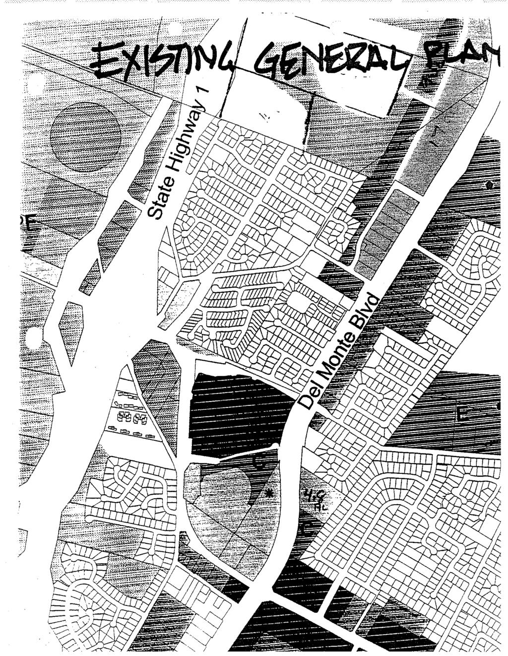
96
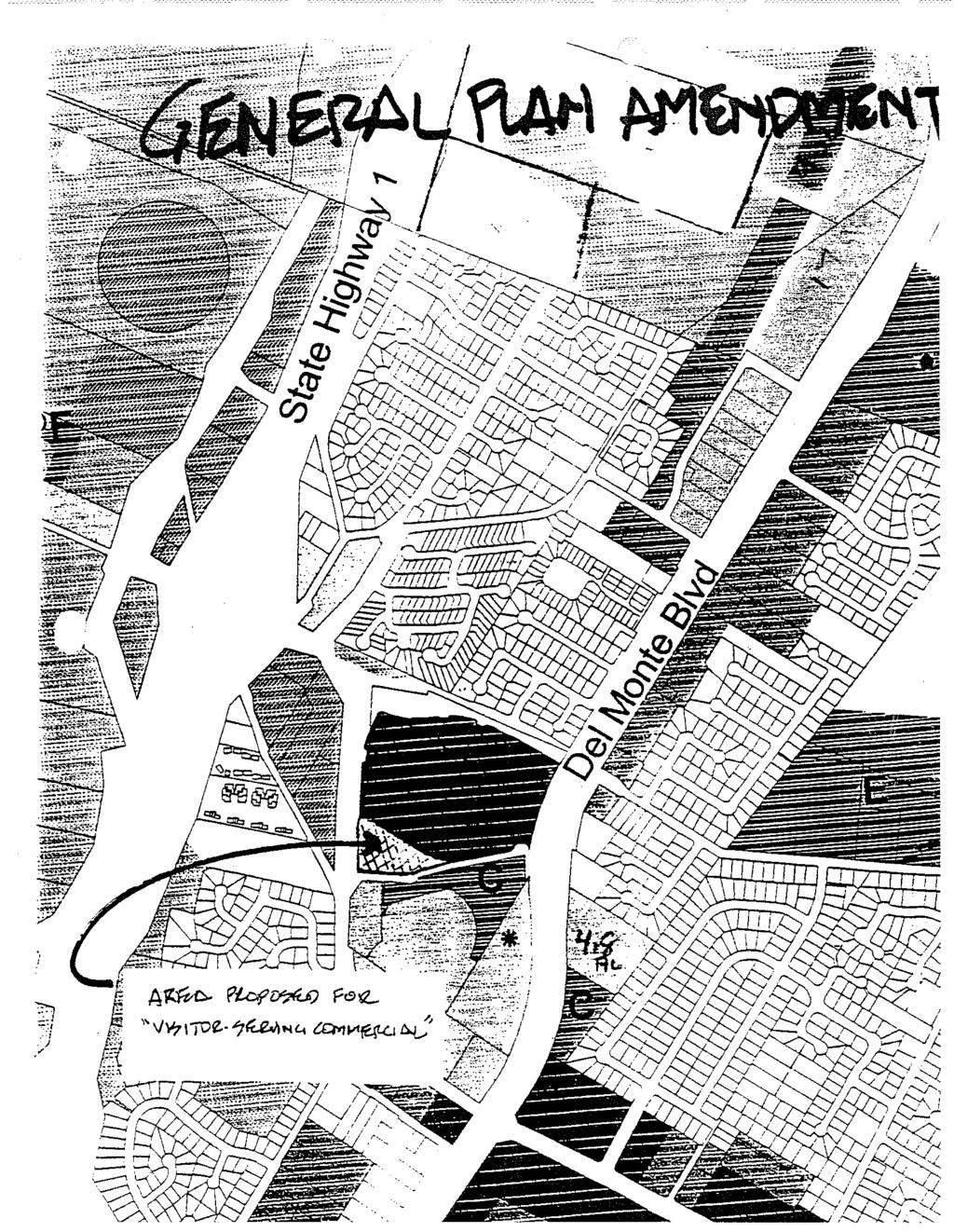
97
98
99
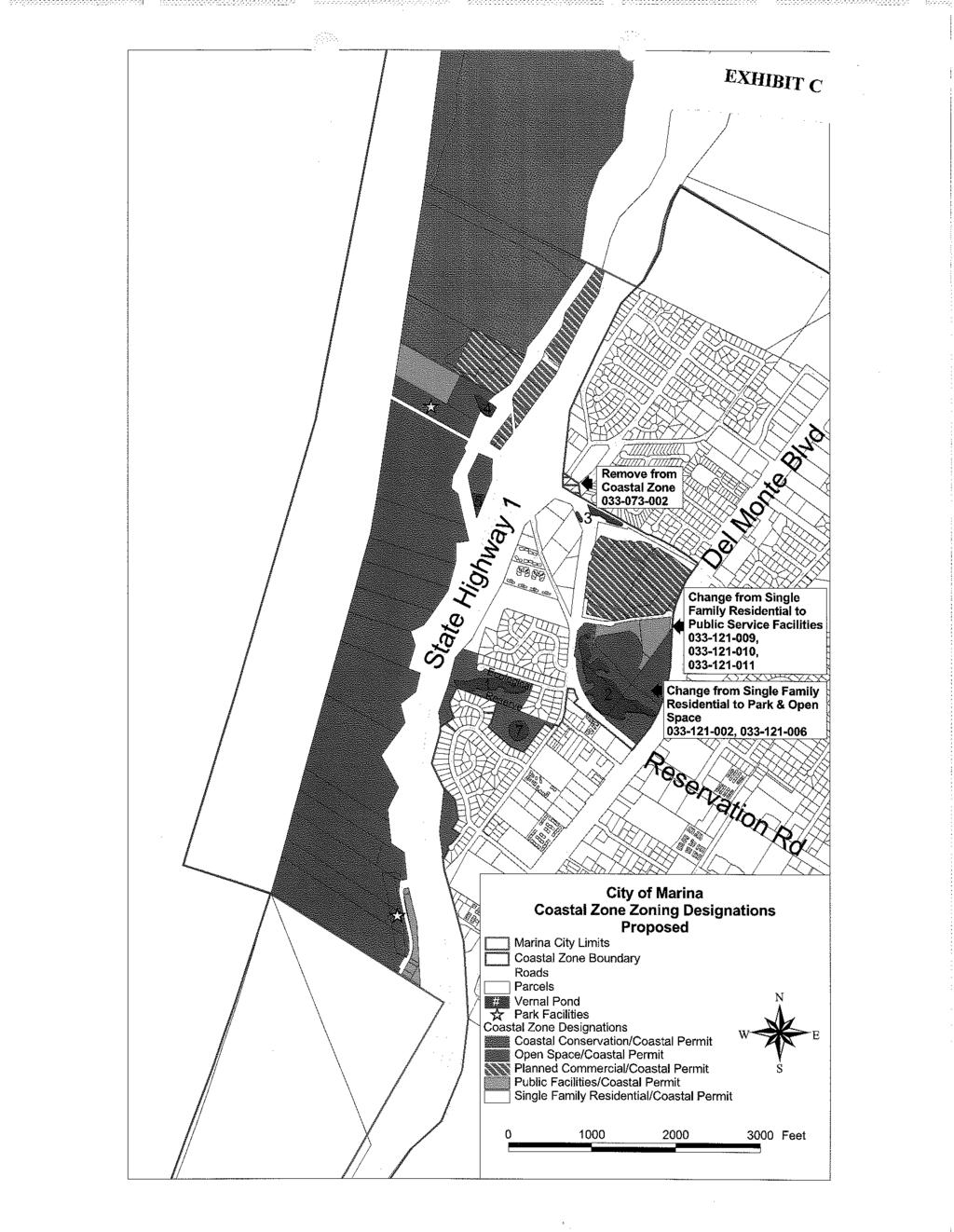
100
CONSERVATION ELEMENT GOALS, OBJECTIVES, AND POLICIES
 CONSERVATION ELEMENT GOALS, OBJECTIVES, AND POLICIES Goal 4 To conserve, manage, appropriately use and protect the natural resources of the City ensuring continued resource availability and environmental
INTRODUCTION. 1.1 What is a General Plan? 1.2 Requirements for a General Plan. 1.3 Introduction to Monterey County
 1.1 What is a General Plan? INTRODUCTION California state law requires each city and county to adopt a comprehensive, long-term general plan for the physical development of the county or city, and any
Venice Pumping Plant Dual Force Main Project Draft EIR
 City of Los Angeles 5.9 LAND USE PLANS 5.9.1 Environmental Setting Venice Pumping Plant Dual Force Main Project Draft EIR The Project lies within the bounds of Los Angeles County and the City of Los Angeles.
3.10 LAND USE SETTING PROJECT SITE EXISTING LAND USE DESIGNATIONS AND ZONING. General Plan Land Use Designations.
 This section of the Draft EIR addresses the existing land uses on and adjacent to the project site and discusses the potential impacts of the proposed project on existing land uses. Key issues addressed
Master Plan Objectives and Policies
 Master Plan Objectives and Policies Introduction This chapter identifies the Park issues and recommended policies established by this Master Plan. The issues were identified through meetings with staff,
Memorandum Planning. Thursday, January 8, 2015
 Memorandum Planning Thursday, January 8, 2015 7.A. To: Coastal Advisory Committee From John Ciampa, Associate Planner Subject: Review Draft Local Coastal Program Copies: James Pechous, City Planner Purpose
A. WHAT IS A GENERAL PLAN?
 I. Introduction A. WHAT IS A GENERAL PLAN? A general plan is the planning guideline for the future of a city. It contains goals and policies which regulate urban development, the protection of the natural
Options for addressing City of Edmonds Alternatives to Ecology s Required Changes addressing Edmonds Marsh Buffers and Setbacks.
 Options for addressing City of Edmonds Alternatives to Ecology s Required Changes addressing Edmonds Marsh Buffers and Setbacks. This document presents Ecology s response to the City of Edmonds alternatives
LOS ANGELES AIRPORT/EL SEGUNDO DUNES Specific Plan
 LOS ANGELES AIRPORT/EL SEGUNDO DUNES Specific Plan Ordinance No. 167,940 Effective June 28, 1992 TABLE OF CONTENTS MAP Section 1. Section 2. Section 3. Section 4. Section 5. Section 6. Specific Plan Area
STAFF REPORT FOR STANDARD COASTAL DEVELOPMENT PERMIT #CDP FEBRUARY 26, 2015 CPA - 1 PO BOX 238 APTOS, CA 94001
 STAFF REPORT FOR STANDARD COASTAL DEVELOPMENT PERMIT #CDP 2014-0030 FEBRUARY 26, 2015 CPA - 1 OWNER/APPLICANT: AGENT: REQUEST: HANS HEIM PO BOX 238 APTOS, CA 94001 JAMES HAY PO BOX 762 MENDOCINO, CA 95460
Planning Commission Report
 Planning Commission Report To: From: Subject: Planning Commission Meeting: January 6, 2016 Agenda Item: 8-B Planning Commission David Martin, Planning & Community Development Director Introduction to the
F. The following uses in the HR District: attached single-family dwellings, condominiums, and institutional uses; and
 1102 DESIGN REVIEW 1102.01 PURPOSE AND APPLICABILITY Section 1102 is adopted to provide standards, criteria, and procedures under which design review may be approved. Design review is required for: A.
ARTICLE IV: DEVELOPMENT STANDARDS 404 MASTER PLANNING
 IV 13 404 MASTER PLANNING Master Planning through the Site Analysis (Master Planning Site Analysis) or Planned Development (Master Planning Planned Development) is provided to encourage development which
EXHIBIT A CITY OF FORT WALTON BEACH, FLORIDA COASTAL MANAGEMENT & CONSERVATION
 EXHIBIT A CITY OF FORT WALTON BEACH, FLORIDA INTRODUCTION The Coastal Management and the Conservation Elements required by Chapter 9J-5.012 and 5.013, F.A.C., respectively, have been combined into one
DRAFT MAP AMENDMENT FLU 04-4
 DRAFT MAP AMENDMENT FLU 04-4 SW 24 TH AVENUE ROADWAY CORRIDOR The University of Florida participates with the Metropolitan Transportation Planning Organization (MTPO) in its responsibilities for the continuing,
THREE-STEP DESIGN PROCESS FOR OPEN SPACE SUBDIVISIONS
 00216106.DOC NMA/RRK 1/30/14 THREE-STEP DESIGN PROCESS FOR OPEN SPACE SUBDIVISIONS Open space subdivisions, sometimes called cluster developments, maintain a significant portion of a development site in
CHAPTER 10-D GREATER MONTEREY PENINSULA AREA PLAN
 CHAPTER 10-D GREATER MONTEREY PENINSULA AREA PLAN GREATER MONTEREY PENINSULA AREA PLAN SUPPLEMENTAL POLICIES 1.0 - Land Use GMP-1.1 GMP-1.2 GMP-1.3 GMP-1.4 GMP-1.5 GMP-1.6 GMP-1.7 GMP-18.6 The County shall
-MENDOCINO COUNTY PLANNING AND BUILDING SERVICES- DIVISION II OF TITLE 20--COASTAL ZONING CODE
 CHAPTER 20.504 VISUAL RESOURCE AND SPECIAL TREATMENT AREAS Sec. 20.504.005 Applicability. Sec. 20.504.010 Purpose. Sec. 20.504.015 Highly Scenic Areas. Sec. 20.504.020 Special Communities and Neighborhoods.
Master Plan for Preservation and Scenic Conservation (1995)
") 3.2 Master Plan for Preservation and Scenic Conservation (1995) The Master Plan for Preservation and Scenic Conservation was developed under the direction of the Guilford Preservation Alliance in the 1980s
3.2 Master Plan for Preservation and Scenic Conservation (1995) The Master Plan for Preservation and Scenic Conservation was developed under the direction of the Guilford Preservation Alliance in the 1980s
WASHINGTON COUNTY OREGON
 WASHINGTON COUNTY OREGON LONG RANGE PLANNING DIVISION North Bethany Subarea Stream Corridors: Existing Regulations In Oregon, there is a distinct difference between the land use rules that apply in rural
Shoreline Master Program Town of La Conner, Washington
 Shoreline Master Program Town of La Conner, Washington Department of Ecology approval effective Adopted September 24, 2013 by Town of La Conner Ordinance No.1106 Amended May 13, 2014 by Town of La Conner
CHAPTER 10-D GREATER MONTEREY PENINSULA AREA PLAN
 CHAPTER 10-D GREATER MONTEREY PENINSULA AREA PLAN GREATER MONTEREY PENINSULA AREA PLAN SUPPLEMENTAL POLICIES 1.0 - Land Use GMP-1.1 GMP-1.2 GMP-1.3 GMP-1.4 GMP-1.5 GMP-1.6 GMP-1.7 The County shall overlay
City of Lafayette Study Session Staff Report Design Review Commission
 ++ City of Lafayette Study Session Staff Report Design Review Commission Meeting Date: January 08, 2018 Staff: Subject: Chris Juram, Planning Technician SS12-17 Miramar Homebuilders, R-20 Zoning: Request
Authority of the General Plan
 Authority of the General Plan This La Habra Heights General Plan will serve as the blueprint for future planning and development in the City. This General Plan describes the City s vision for the future
CLACKAMAS COUNTY ZONING AND DEVELOPMENT ORDINANCE
 704 RIVER AND STREAM CONSERVATION AREA (RSCA) 704.01 PURPOSE Section 704 is adopted to: A. Maintain the integrity of the rivers and streams in the County by minimizing erosion, promoting bank stability,
COMMUNITY DESIGN. GOAL: Create livable and attractive communities. Intent
 COMMUNITY DESIGN Intent An attractive, well-designed County will attract quality development, instill civic pride, improve the visual character of the community, and create a strong, positive image for
Ashbridges Bay Erosion and Sediment Control Project
 Ashbridges Bay Erosion and Sediment Control Project Project Brief Overview Toronto and Region Conservation Authority, in partnership with the City of Toronto, intends to carry out remedial erosion control
City of Lafayette Study Session Staff Report Design Review Commission
 City of Lafayette Study Session Staff Report Design Review Commission Meeting Date: April 24, 2017 Staff: Payal Bhagat, Senior Planner Subject: HDP18-15 & HDP31-15 Ramesh Patel & Melcor Development (Owners),
City of Lafayette Staff Report
 City of Lafayette Staff Report For: By: Design Review Commission Greg Wolff, Senior Planner Meeting Date: April 27, 2015 Subject: SS03-15 Gundi & Peter Younger (Owners), R-40 Zoning: Request for a Study
SAN RAFAEL GENERAL PLAN 2040 INTRODUCTION AND OVERVIEW
 SAN RAFAEL GENERAL PLAN 2040 INTRODUCTION AND OVERVIEW Steering Committee Presentation February 14, 2018 Purpose of General Plan Guide land use and development decisions Coordinate transportation, infrastructure,
PARK CITY MUNICIPAL CODE TABLE OF CONTENTS TITLE 15 LAND MANAGEMENT CODE - CHAPTER 2.21
 PARK CITY MUNICIPAL CODE TABLE OF CONTENTS TITLE 15 LAND MANAGEMENT CODE - CHAPTER 2.21 TITLE 15 - LAND MANAGEMENT CODE CHAPTER 2.21 - SENSITIVE LAND OVERLAY ZONE (SLO) REGULATIONS 15-2.21-1. PURPOSE...1
AWH REPORT OF THE PLANNING AND DEVELOPMENT DEPARTMENT FOR APPLICATION FOR REZONING ORDINANCE TO PLANNED UNIT DEVELOPMENT
 AWH REPORT OF THE PLANNING AND DEVELOPMENT DEPARTMENT FOR APPLICATION FOR REZONING ORDINANCE TO PLANNED UNIT DEVELOPMENT MAY 8, 2014 The Planning and Development Department hereby forwards to the Planning
COLVER ROAD INDUSTRIAL CONCEPT PLAN
 COLVER ROAD INDUSTRIAL CONCEPT PLAN A CONCEPTUAL LAND USE AND TRANSPORTATION PLAN FOR TA-4 AN URBAN RESERVE AREA OF THE CITY TALENT City of Talent Adopted by City Council Resolution No., June, 2015 PART
Minnesota Department of Natural Resource - Natural Resource Guidance Checklist Conserving Natural Resources through Density Bonuses
 Minnesota Department of Natural Resource - Natural Resource Guidance Checklist Conserving Natural Resources through Density Bonuses NRDB Why Use Density Bonuses & This Checklist Local units of government
Commercial Launch Site Addendum to Wetland Mitigation Plan. Revision 2. April 25, SpaceX Proprietary
 Commercial Launch Site Addendum to Wetland Mitigation Plan Revision 2 April 25, 2017 SpaceX Proprietary Contents 1.0 Project Information... 1 1.1 Background... 1 2.0 Compensatory Mitigation... 2 2.1 Goals
Department of Community Development. Planning and Environmental Review Division Revised Notice of Preparation
 Department of Community Development Michael J. Penrose, Acting Director Divisions Building Permits & Inspection Code Enforcement County Engineering Economic Development & Marketing Planning & Environmental
Glenborough at Easton Land Use Master Plan
 Implementation 114 9.0 IMPLEMENTATION 9.1 OVERVIEW This chapter summarizes the administrative procedures necessary to implement the proposed land use plan, infrastructure improvements, development standards,
ARTICLE VI: SITE PLAN REVIEW
 Section 6.01 - Site Plan Review (All Districts) ARTICLE VI: SITE PLAN REVIEW Site plans give the Planning commission an opportunity to review development proposals in a concise and consistent manner. The
Chapter Master Planned Communities (MPC) District
 District") Sections 14.53.010 Purpose and Intent 14.53.020 Applicability 14.53.030 Procedure 14.53.040 MPC Standards 14.53.050 Required Findings 14.53.010 Purpose and Intent Chapter 14.53 Master Planned Communities
Sections 14.53.010 Purpose and Intent 14.53.020 Applicability 14.53.030 Procedure 14.53.040 MPC Standards 14.53.050 Required Findings 14.53.010 Purpose and Intent Chapter 14.53 Master Planned Communities
DRAFT SCOPE FOR THE DRAFT ENVIRONMENTAL IMPACT STATEMENT FOR HUDSON HIGHLANDS RESERVE TOWN OF PHILIPSTOWN, NEW YORK June 5, 2018
 DRAFT SCOPE FOR THE DRAFT ENVIRONMENTAL IMPACT STATEMENT FOR HUDSON HIGHLANDS RESERVE TOWN OF PHILIPSTOWN, NEW YORK June 5, 2018 Project Name: Project Location SEQRA Classification of Project: Lead Agency:
Appendix E Section 4(f) Evaluation
 Evaluation") Appendix E Section 4(f) Evaluation Appendix E Draft Section 4(f) Evaluation E.1 Introduction This appendix addresses a federal regulation known as Section 4(f), which protects parks, recreation areas,
Appendix E Section 4(f) Evaluation Appendix E Draft Section 4(f) Evaluation E.1 Introduction This appendix addresses a federal regulation known as Section 4(f), which protects parks, recreation areas,
Rural Land Use Designations Kittitas County December 6, 2007 Draft
 KITTITAS COUNTY COMMUNITY DEVELOPMENT SERVICES 411 N. Ruby St., Suite 2, Ellensburg, WA 98926 CDS@CO.KITTITAS.WA.US Office (509) 962-7506 Fax (509) 962-7682 Rural Land Use Designations Kittitas County
LAND USE ELEMENT. Purpose. General Goals & Policies
 LAND USE ELEMENT Purpose This Land Use Element contains the goals and policies necessary to support the City s responsibility for managing land resources and guiding development through implementing regulations,
Part 5. Environmental Protection Overlay District Regulations
 Part 5 Environmental Protection Overlay District Regulations Section 501. Statement of Intent. As established through the goals, objectives and policies of the Amity Township Comprehensive Plan, it is
Mitchell Ranch South MPUD Application for Master Planned Unit Development Approval Project Narrative. Introduction
 Mitchell Ranch South MPUD Application for Master Planned Unit Development Approval Project Narrative Introduction Mitchell Ranch South is a proposed single family (detached) residential development on
Planned Development Review Revisions (Project No. PLNPCM )
") Planned Development Review Revisions (Project No. PLNPCM2014-00139) Standard residential development Planned Development Example: Smaller lot sizes than what is allowed to create open space amenity. What
Planned Development Review Revisions (Project No. PLNPCM2014-00139) Standard residential development Planned Development Example: Smaller lot sizes than what is allowed to create open space amenity. What
When planning stormwater management facilities, the following principles shall be applied where possible.
 2.0 Principles When planning stormwater management facilities, the following principles shall be applied where possible. 2.0.1 Drainage is a regional phenomenon that does not respect the boundaries between
Humber Bay Shores Precinct Plan Final Report
 STAFF REPORT ACTION REQUIRED Humber Bay Shores Precinct Plan Final Report Date: May 21, 2010 To: From: Wards: Reference Number: Etobicoke York Community Council Director, Community Planning, Etobicoke
SPECIFIC PLAN Requirements
 CITY OF LANCASTER PLANNING DEPARTMENT 44933 Fern Avenue, Lancaster, California 93534 (661) 723-6100 SPECIFIC PLAN Requirements Purpose The purpose of a specific plan is to provide for the logical development
6 PORT SYDNEY SETTLEMENT AREA
 Section 6 Port Sydney Page 61 6 PORT SYDNEY SETTLEMENT AREA 6.1 Basis and Principles Village of Port Sydney Waterfront Community Existing Services 6.1.1 Port Sydney is an historic settlement that has developed
RECOMMENDATION REPORT
 DEPARTMENT OF CITY PLANNING RECOMMENDATION REPORT City Planning Commission Case No.: CPC-2012-1165-GPA-ZC Date: August 9, 2012 Time: After 8:30 AM Place: City Hall, Room 350 Public Hearing: Required CEQA
PRE-DESIGN CONCEPT REPORT GRAND CANAL RESTORATION
 PRE-DESIGN CONCEPT REPORT GRAND CANAL RESTORATION Project Background November 19, 2007 Executive Summary The Grand Canal is an important tidal waterway in the Venice community of Los Angeles, California,
TOWNSHIP OF LOGAN SOIL & FILL IMPORTATION AND PLACEMENT APPLICATION SUBMITTAL CHECKLIST
 TOWNSHIP OF LOGAN SOIL & FILL IMPORTATION AND PLACEMENT APPLICATION SUBMITTAL CHECKLIST Applications: 5 copies of application - Applicant will reproduce the copies at his/her costs. The Township Clerk
CHAPTER Committee Substitute for Senate Bill No. 1472
 CHAPTER 2007-99 Committee Substitute for Senate Bill No. 1472 An act relating to beaches and shores; amending s. 161.021, F.S.; amending a definition; amending s. 161.085, F.S.; restricting the use of
Intergovermental Coordination
 Intergovermental Coordination CITY OF WINTER PARK CHAPTER 8: INTERGOVERNMENTAL COORDINATION ELEMENT INTERGOVERNMENTAL COORDINATION ELEMENT GOAL 8-1: PROVIDE FOR IMPROVED INTERGOVERNMENTAL COORDINATION
Gadsden County Planning Commission Agenda Request
 Date of Meeting: November 16, 2017 To: From: Through: Subject: Gadsden County Planning Commission Agenda Request Honorable Chairperson and Members of the Board Jill A. Jeglie, AICP, Senior Planner Clyde
Chesapeake Bay Critical Area Conservation Plan
 The Maryland-National Capital Park and Planning Commission Prince George s County Planning Department Development Review Division 301-952-3530 Note: Staff reports can be accessed at www.mncppc.org/pgco/planning/plan.htm.
CITY OF CYPRESS 5275 Orange Avenue Cypress, California (714) DESIGN REVIEW COMMITTEE PERMIT PROCESS
 DESIGN REVIEW COMMITTEE PERMIT PROCESS") CITY OF CYPRESS 5275 Orange Avenue Cypress, California 90630 (714) 229-6720 DESIGN REVIEW COMMITTEE PERMIT PROCESS 1. Discuss project with Planning staff to determine zoning regulations, any unusual characteristics
CITY OF CYPRESS 5275 Orange Avenue Cypress, California 90630 (714) 229-6720 DESIGN REVIEW COMMITTEE PERMIT PROCESS 1. Discuss project with Planning staff to determine zoning regulations, any unusual characteristics
CHAPTER 12 IMPLEMENTATION
 CHAPTER 12 IMPLEMENTATION The 2010 Town of Denton Comprehensive Plan is intended to capture a vision of the future of Denton. As such, it provides a basis for a wide variety of public and private actions
RECREATION AND OPEN SPACE ELEMENT GOALS, OBJECTIVES, AND POLICIES
 RECREATION AND OPEN SPACE ELEMENT GOALS, OBJECTIVES, AND POLICIES Goal 7 To provide park facilities, recreation programs, and open space resources that are safe, adequate, and accessible to all City residents,
2.4 FUTURE LAND USE ELEMENT Goals, Objectives and Policies
 GOAL 1: To create developmental patterns that direct future growth to appropriate areas on campus, in a manner that promotes the educational mission of the University, the protection of environmentally
Example Codes. City of Brentwood, Tennessee Brentwood Hillside Protection Overlay District Summary
 Example Codes City of Brentwood, Tennessee Brentwood Hillside Protection Overlay District Summary The City of Brentwood in July 2007 adopted a Hillside Protection (HP) Overlay District to address the problems
Zoning Ordinance Article 3
 Article 3 Natural Resources Protection Section 301 Natural Resources Protection 301.1. Purpose - The following natural resources protection standards are established to protect the public health, safety
East Panorama Ridge Concept Plan Amendment
 Page 1 of 7 L003 : East Panorama Ridge Concept Plan Amendment Corporate NO: L003 Report COUNCIL DATE: March 4, 2002 REGULAR COUNCIL LAND USE TO: Mayor & Council DATE: February 27, 2002 FROM: General Manager,
ELIGIBILITY CRITERIA CHECKLIST OPEN SPACE CLASSIFICATION
 THURSTON COUNTY DEVELOPMENT SERVICES OPEN SPACE TAX PROGRAM ELIGIBILITY CRITERIA CHECKLIST OPEN SPACE CLASSIFICATION Use this checklist to help you determine whether your property is eligible for open
CITY OF SEASIDE STAFF REPORT
 Item 12 CITY OF SEASIDE STAFF REPORT TO: FROM: BY: Honorable Mayor and City Council Ray Corpuz, City Manager Diana Ingersoll, Deputy City Manager, Resource Management Services Rick Medina, Senior Planner
RECREATION, OPEN SPACE AND GREENWAYS ELEMENT GOALS, OBJECTIVES, AND POLICIES
 RECREATION, OPEN SPACE AND GREENWAYS ELEMENT GOALS, OBJECTIVES, AND POLICIES GOAL R-1: DEVELOP A RECREATION, OPEN SPACE AND GREENWAYS SYSTEM AS AN INTEGRAL COMPONENT OF AN OVERALL, COUNTY-WIDE ECONOMIC
3. VISION AND GOALS. Vision Statement. Goals, Objectives and Policies
 Vision Statement Queen Creek s interconnected network of parks, trails, open spaces and recreation opportunities provide safe and diverse activities and programs that sustain its unique, small town, equestrian
Gold Line Bus Rapid Transit Transit Oriented Development (BRTOD) Helmo Station Area Plan
 Helmo Station Area Plan") Appendix F Gold Line Bus Rapid Transit Transit Oriented Development (BRTOD) Helmo Station Area Plan Introduction and Purpose of the Plan The Gold Line Bus Rapid Transit facility is an eleven-mile dedicated
Appendix F Gold Line Bus Rapid Transit Transit Oriented Development (BRTOD) Helmo Station Area Plan Introduction and Purpose of the Plan The Gold Line Bus Rapid Transit facility is an eleven-mile dedicated
NEW CASTLE COUNTY S ZONING DISTRICTS
 NEW CASTLE COUNTY S ZONING DISTRICTS This is general information about New Castle County s zoning districts. The information included is by no means exhaustive or complete. Before designing plans to develop
SENSITIVE LANDS OVERLAY
 SENSITIVE LANDS OVERLAY Chapter 22 Sensitive Lands Overlay 22.1 PURPOSE 22.2 APPLICATION AND ANALYSIS REQUIREMENTS 22.3 SENSITIVE LAND REGULATIONS 22.4 ADMINISTRATIVE PROVISIONS 22.5 DESIGN STANDARDS 22.6
COMPLIANCE CHECKLIST HILLSIDE RESIDENTIAL DESIGN GUIDELINES MANUAL
 COMPLIANCE CHECKLIST HILLSIDE RESIDENTIAL DESIGN GUIDELINES MANUAL The following checklist summarizes development guidelines and standards. See the appropriate section for a complete explanation of the
PSRC REVIEW REPORT & CERTIFICATION RECOMMENDATION
 PSRC REVIEW REPORT & CERTIFICATION RECOMMENDATION KITSAP COUNTY COUNTYWIDE PLANNING POLICIES July 2, 2012 BACKGROUND A major emphasis of the Washington State Growth Management Act (GMA) is the need to
Table of Contents TABLE OF CONTENTS SECTION TITLE PAGE
 TABLE OF CONTENTS SECTION TITLE PAGE 1 INTRODUCTION AND OVERVIEW 1-1 1.1 Purpose and Need 1-1 1.2 Goals and Objectives 1-3 1.3 Overview of the Planning Process 1-5 1.4 Federal and State Requirements and
ADDENDUM TO BIOLOGICAL SCOPING SURVEY REPORT, BOTANICAL SURVEY AND WETLAND DELINEATION
 ADDENDUM TO BIOLOGICAL SCOPING SURVEY REPORT, BOTANICAL SURVEY AND WETLAND DELINEATION FOR AVALON INN (APN 069-241-27 & -04) 1201 & 1211 NORTH MAIN STREET FORT BRAGG, CA MENDOCINO COUNTY prepared for:
SUBMITTAL REQUIREMENTS: FINAL PLAN REVIEW- PROJECT DEVELOPMENT PLAN (PDP)
") 1) Application form and filing fee. Application Form.pdf Development Review Guide STEP 6 of 8 SUBMITTAL REQUIREMENTS: FINAL PLAN REVIEW- PROJECT DEVELOPMENT PLAN (PDP) 2) Transportation Development Review
1) Application form and filing fee. Application Form.pdf Development Review Guide STEP 6 of 8 SUBMITTAL REQUIREMENTS: FINAL PLAN REVIEW- PROJECT DEVELOPMENT PLAN (PDP) 2) Transportation Development Review
Chapter 5: Recreation
 Chapter 5: Recreation Introduction and Setting Recreational opportunities within Nevada County are varied, ranging from public parks with intensively used active recreational facilities, to vast tracts
Chapter 14. Shorelines
 Chapter 14 Shorelines Contents City of Spokane Comprehensive Plan 14.1 INTRODUCTION... 7 14.2 SPOKANE S SHORELINE MASTER PROGRAM...11 14.3 ENVIRONMENTS AND MANAGEMENT POLICIES...15 14.5 GOALS AND POLICIES...22
Major Subdivision Sketch Plan Checklist
 This checklist provides specific requirements that are apart of the Sketch process. The entire process is described by the Huntersville Subdivision Review Process which details all the submittal and resubmittal
COUNTY COUNCIL OF PRINCE GEORGE'S COUNTY, MARYLAND SITTING AS THE DISTRICT COUNCIL 2010 Legislative Session. Council Members Dernoga and Olson
 DR- COUNTY COUNCIL OF PRINCE GEORGE'S COUNTY, MARYLAND SITTING AS THE DISTRICT COUNCIL 00 Legislative Session Bill No. CB--00 Chapter No. Proposed and Presented by Introduced by Co-Sponsors The Chairman
EXECUTIVE SUMMARY DRAFT CHAPTER 1 INTRODUCTION EXECUTIVE SUMMARY
 CHAPTER 1 EXECUTIVE SUMMARY INTRODUCTION Through the joint efforts of the City of Tulsa planning staff and the Land Services division of Indian Nations Council of Governments (INCOG), the Berryhill Land
Chapter 5: Natural Resources and Environment
 NATURAL RESOURCES AND ENVIRONMENT 5-1 5 Chapter 5: Natural Resources and Environment BACKGROUND AND INTENT Urban expansion represents the greatest risk for the future degradation of existing natural areas,
Re: Application Type: Proposed Highlands Redevelopment Area Designation
 CHRIS CHRISTIE Governor KIM GUADAGNO Lt. Governor State of New Jersey Highlands Water Protection and Planning Council 100 North Road (Route 513) Chester, New Jersey 07930-2322 (908) 879-6737 (908) 879-4205
TABLE OF CONTENTS HISTORIC PRESERVATION ELEMENT I. INTRODUCTION HP. A. Purpose HP B. Assessment and Conclusions...
 TABLE OF CONTENTS HISTORIC PRESERVATION ELEMENT I. INTRODUCTION... 1 - HP A. Purpose... 1 - HP B. Assessment and Conclusions... 1 - HP II. GOAL, OBJECTIVES AND POLICIES... 3 - HP GOAL 1: PROTECTION AND
12 January 12, 2011 Public Hearing APPLICANT: TAILWIND DEVELOPMENT GROUP,LLC PROPERTY OWNER: CITY OF VIRGINIA BEACH
 12 January 12, 2011 Public Hearing APPLICANT: TAILWIND DEVELOPMENT GROUP,LLC PROPERTY OWNER: CITY OF VIRGINIA BEACH STAFF PLANNER: Faith Christie REQUEST: Conditional Change of Zoning (from PD-H1 Planned
STEWARDSHIP OF LONG ISLAND SOUND S ECOLOGICAL AND RECREATIONAL RESOURCES
 STEWARDSHIP OF LONG ISLAND SOUND S ECOLOGICAL AND RECREATIONAL RESOURCES Robin Kriesberg, Save the Sound, Inc. Thomas Halavik, US Fish and Wildlife Service Coastal Program An Initiative to Identify, Protect
HALF MOON BAY LOCAL COASTAL PROGRAM. d), JOHN M. St>NGER ASSOCIATES INC S.F.' CA EIOO VISUAL RESOURCES OVERLAY.
, JOHN M. St>NGER ASSOCIATES INC S.F.' CA EIOO VISUAL RESOURCES OVERLAY.") VISUAL RESOURCES OVERLAY Old Downtown Jl&& Scenic Hillsides Ocean Views from Highway 1 HALF MOON BAY LOCAL COASTAL PROGRAM d), JOHN M. St>NGER ASSOCIATES INC S.F.' CA. 94114 EIOO 217 CHAPTER 7: VISUAL
VISUAL RESOURCES OVERLAY Old Downtown Jl&& Scenic Hillsides Ocean Views from Highway 1 HALF MOON BAY LOCAL COASTAL PROGRAM d), JOHN M. St>NGER ASSOCIATES INC S.F.' CA. 94114 EIOO 217 CHAPTER 7: VISUAL
HAZARD MITIGATION GOALS AND OBJECTIVES
 SEWRPC Community Assistance Planning Report No. 282, 2nd Edition CITY OF MILWAUKEE ALL HAZARDS MITIGATION PLAN UPDATE Chapter IV HAZARD MITIGATION GOALS AND OBJECTIVES [NOTE: Throughout this plan update
PC RESOLUTION NO
 PC RESOLUTION NO. 14-01-14-02 TENTATIVE TRACT MAP fttm) 17441. REZONE {RZ) 13-003, ARCHITECTURAL CONTROL (AC) 13-003, TREE REMOVAL PERMIT (TRP) 13-052. GRADING PLAN MODIFICATION (GPM) 13-002. CONDITIONAL
Baumgarten MPUD. Exhibit 3 Evaluation Criteria
 Pursuant to LDC subsections 10.02.13 B, 10.02.08 F and Chapter 3 G. of the Administrative Code, staff s analysis and recommendation to the Planning Commission, and the Planning Commission s recommendation
ARTICLE 6: Special and Planned Development Districts
 ARTICLE 6: Special and Planned Development Districts 6-10 Traditional Neighborhood Development (TND) District 6-10.10 Purpose and Intent The Traditional Neighborhood Development (TND) District provides
17.18 SENSITIVE AREAS
 17.18 SENSITIVE AREAS 17.18.010 Purpose...1 17.18.020 Definitions...1 17.18.030 Review Process...1 17.18.040 Sensitive Areas Analysis...2 17.18.050 Standards and Development Plan...3 17.18.060 Geotechnical
Chapter WAC SHORELINE MASTER PROGRAM GUIDELINES. Table of Contents WAC AUTHORITY, PURPOSE AND EFFECTS OF GUIDELINES.
 Chapter 173-26 WAC SHORELINE MASTER PROGRAM GUIDELINES Table of Contents WAC 173-26-171 AUTHORITY, PURPOSE AND EFFECTS OF GUIDELINES. 5 WAC 173-26-176 GENERAL POLICY GOALS OF THE ACT AND GUIDELINES FOR
Rule D Wetland and Creek Buffers
 Rule D Wetland and Creek Buffers 1 Policy It is the policy of the Board of Managers to ensure the preservation of the natural resources, recreational, habitat, water treatment and water storage functions
This chapter describes the purpose of the Plan, introduces how the Plan is organized and provides contextual background for the Plan.
 Chapter 1: INTRODUCTION Purpose of a Comprehensive Plan The 2040 Comprehensive Plan establishes Medina s vision as a community and sets goals and objectives which guide future decisions and policies. The
A Guide to Open Space Design Development in Halifax Regional Municipality
 A uide to Open Space Design Development in Halifax Regional Municipality May 2007 1 Introduction Pursuant to Section 3.5 of the Regional Municipal Planning Strategy (RMPS), subdivision of land may proceed
CITY OF CHARLOTTESVILLE, VIRGINIA CITY COUNCIL AGENDA
 CITY OF CHARLOTTESVILLE, VIRGINIA CITY COUNCIL AGENDA Agenda Date: December 16, 2013 Action Required: Adoption of Resolution Presenter: Staff Contacts: Title: James E. Tolbert, AICP, Director of NDS James
COASTAL CONSERVANCY. Staff Recommendation March 25, 2004 LOS ANGELES GREEN VISION PLAN. File No.: Project Manager: Marc Beyeler
 COASTAL CONSERVANCY Staff Recommendation March 25, 2004 File No.: 04-014 Project Manager: Marc Beyeler RECOMMENDED ACTION: Authorization to disburse up to $50,000 to the University of Southern California
City of Westbrook. 2 York Street Westbrook, Maine (207) Fax:
 Fax:") City of Westbrook DEPARTMENT OF PLANNING & CODE ENFORCEMENT 2 York Street Westbrook, Maine 04092 (207) 854-0638 Fax: 1-866-559-0642 WESTBROOK PLANNING BOARD TUESDAY, JANUARY 2, 2018, 7:00 P.M. WESTBROOK
City of Westbrook DEPARTMENT OF PLANNING & CODE ENFORCEMENT 2 York Street Westbrook, Maine 04092 (207) 854-0638 Fax: 1-866-559-0642 WESTBROOK PLANNING BOARD TUESDAY, JANUARY 2, 2018, 7:00 P.M. WESTBROOK
Draft TISCORNIA ESTATE SPECIFIC PLAN/EIR
 Draft TISCORNIA ESTATE SPECIFIC PLAN/EIR Submitted CONTENTS 1. PLAN SUMMARY II. INTRODUCTION IX. SPECIFIC PLAN RELATIONSHIPS X. XI. List of Figures 1. Regional Location 2. Point Richmond Area 3. Planning