Coastal Permit Administrator 4/27/2017
|
|
|
- Vivian Gibbs
- 6 years ago
- Views:
Transcription

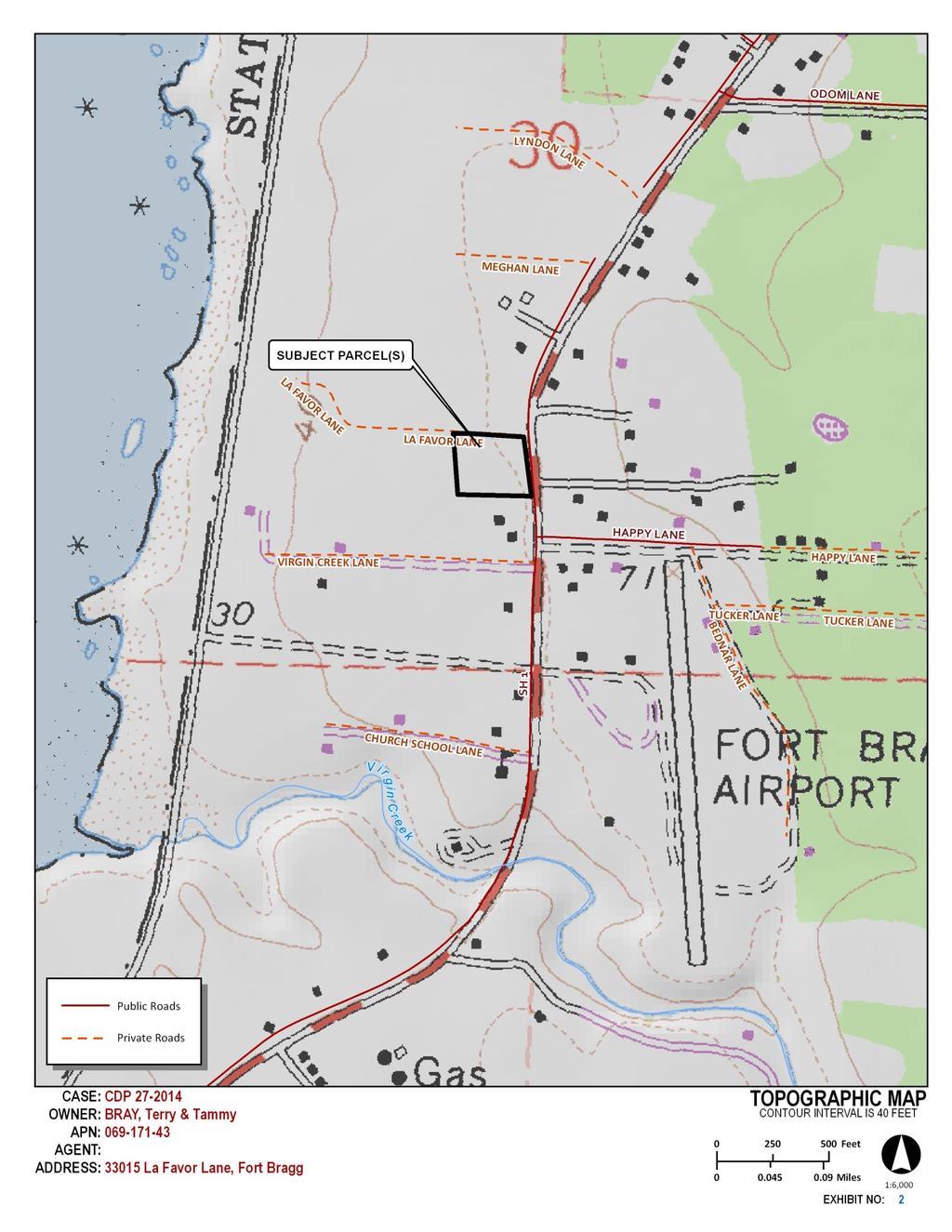
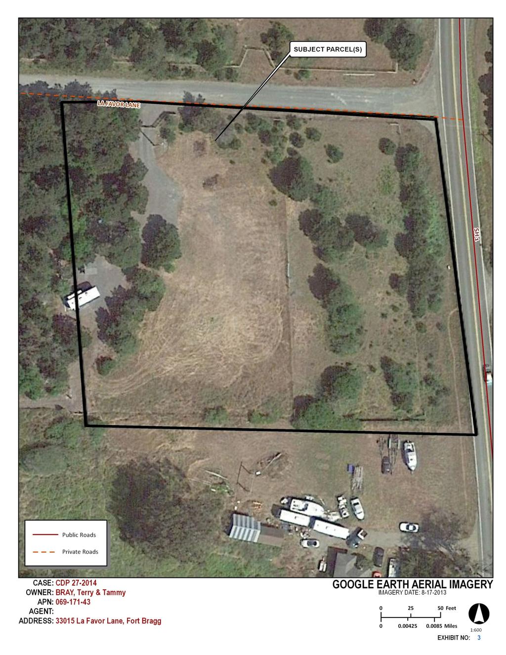
1 Coastal Permit Administrator 4/27/2017 STAFF REPORT- CDP_STANDARD CDP_ SUMMARY OWNER/APPLICANT: AGENT: REQUEST: TAMMY BRAY, TERRY BRAY 5959 HIGHWAY 175 HOPLAND, CA WYNN COASTAL PLANNING 703 N MAIN STREET FORT BRAGG, CA A Coastal Development Standard Permit request for the construction of a 1,109-square-foot single-family residence, 399-square-foot attached garage, 132- square-foot deck, septic system, water storage tank, driveway, and temporary use of a camp trailer during construction. DATE DEEMED COMPLETE: LOCATION: TOTAL ACREAGE: GENERAL PLAN: ZONING: APPEALABLE: La Favor Lane is located on the southwest intersection of Highway 1 and La Favor Lane, which is 2- miles north of the City of Fort Bragg (APN ). 2 acres Rural Residential (RR5[RR2]) Rural Residential (RR:5) Highly Scenic Area. Sensitive Coastal Resource Area. SUPERVISORIAL DISTRICT: 4 ENVIRONMENTAL DETERMINATION: RECOMMENDATION: STAFF PLANNER: Mitigated Negative Declaration Approve with Conditions JULIANA CHERRY BACKGROUND PROJECT DESCRIPTION: A request for a Coastal Development Standard Permit for the construction of a 1,109-square-foot single family residence, approximately 18-feet in height; a 399-square-foot attached garage; a 132-square-foot deck; a 100-foot gravel driveway (approximately 35-feet wide); installation of a septic system and a 2,500-gallon water storage tank; and temporary use of camping trailer (existing) during construction on land mapped as Rural Residential, Highly Scenic, and having wetlands. After construction of the proposed, new driveway, the existing driveway would be used for alternative access to the site. Four (4) pine trees would be removed and the biologist recommends a fifty-foot buffer from the wetlands and beach pine trees on the property. A previously approved Coastal Development Use Permit allows for camping on-site and the applicant requests use of their camping-trailer during construction of the proposed single-family residence.
2 COASTAL PERMIT ADMINISTRATOR STAFF REPORT FOR CDP_ CDP_STANDARD PAGE 2 APPLICANT S STATEMENT: Construct a 1,109 sf single-family residence with attached 399 square feet garage, 132 square feet of decks and patio, maximum building height of 18 above natural grade. Install 2,500-gallon water storage tank, septic system, propane tank, trenching for utilities, 1,067 sf gravel driveway. Occupancy of temporary travel trailer for construction support. RELATED APPLICATIONS: On-Site CDP_32_09 camping use permit LCP MS MS MS MS CC PHD B46-79 PA 81-6 BLA Neighboring Property MS (withdrawn on adjacent property) MS (on adjacent lot ) SITE CHARACTERISTICS: The two-acre site is located on the southwest intersection of Highway 1 and La Favor Lane, which is approximately two-miles north of the City of Fort Bragg at La Favor Lane (APN ).The site and surrounding lands are designated Rural Residential (RR), with varying parcel sizes ranging from 1-to-5-acres, and is mapped as a Highly Scenic Area. The proposed primary land use is residential, which is a principally permitted use type in the RR District. The property is relatively flat, fenced, and characterized as primarily non-native grassland with Beach Pine Forest to the west, and beach pine and wax myrtle emerging within the grassland to the east. Public access to the shore is provided west of the subject site in MacKerricher State Park and along the old haul road. The site is located within a Marginal Water Resource Area. There is a 1,750-square-foot mapped wetland in the southeastern portion of the property and a Beach Pine Forest on the western portion of the property. It is recommended that the proposed development be setback fifty feet from both the wetland and Beach Pine Forest. Mapping does not associate the following with the subject site: faults, bluffs, landslides, erosion, fire hazard or flood hazard. SURROUNDING LAND USE AND ZONING: The site and surrounding lands are designated Rural Residential and Highly Scenic. The surrounding land use and zoning is similar to the subject parcel. GENERAL PLAN ZONING LOT SIZES USES NORTH RR RR5(2) 2 Residential EAST RR RR1 2 Residential SOUTH RR RR5(1) 2 Residential WEST RR RR5(1) 4 Residential The surrounding parcels are developed with single-family residences and appurtenant structures. The proposed project is compatible with surrounding land uses and development. PUBLIC SERVICES: ACCESS: FIRE DISTRICT: WATER DISTRICT: SEWER DISTRICT: SCHOOL DISTRICT: DEPARTMENT OF TRANSPORTATION FORT BRAGG RURAL N/A N/A FORT BRAGG UNIFIED SCHOOL DISTRICT
3 COASTAL PERMIT ADMINISTRATOR STAFF REPORT FOR CDP_ CDP_STANDARD PAGE 3 AGENCY COMMENTS: On August 15, 2014 and, after the application was revised, on August 24, 2016, project referrals were sent to the following responsible or trustee agencies with jurisdiction over the project. Required related permits, if any, are listed below. Any recommended conditions of approval are contained in Exhibit A of the attached resolution. Any comment that would trigger a project modification or denial is discussed in full as key issues in the following section. REFERRAL AGENCIES RELATED PERMIT COMMENT DATE Archaeological Commission Assessor Comment Comment No Response 11/12/ /12/2016 Building Services No Comment No Comment 10/08/ /04/2016 CalFire File No No Comment 09/30/2014 CalTrans No Response Northwest Information Center CHRIS Comment 10/08/2014 California Coastal Commission Comment 11/17/2014 California Department of Fish and Wildlife Comment 09/26/ /18/2017 Department of Transportation No Comment 10/27/ /26/2016 Emergency Services No Response Environmental Health Comment No Comment 10/10/ /29/2016 Fort Bragg Rural Fire Department No Comment No Comment 10/06/ /12/2016 Fort Bragg Unified School District No Response Planning Ukiah No Comment Comment 09/26/ /13/2016 Soil Conservation Service No Response State Clearinghouse No Response 1. General Plan and Zoning Consistency. KEY ISSUES General Plan: The project is consistent with Land Use Plan, Chapter 2.2 of the Coastal Element of the General Plan. The land use designation for the site is Rural Residential specifying a minimum lot size of 5-acres that can be reduced to 2-acres if there are community services (RR5[RR2]). The intent of the RR designation is to encourage local small scale food production (farming) in areas which are not well suited for large scale commercial agriculture, defined by present or potential use, location, mini-climate, slope, exposure, etc. The Rural Residential classification is not intended to be a growth area and residences should be located as to create minimal impact on agricultural viability. 1 The principally permitted use type for this land use classification is residential and associated utilities, light agriculture, [and] home occupation. 2 LCP Map 13 Fort Bragg designates the minimum parcel size requirement as 5-acres. 3 1 Chapter 2.2. Mendocino County, Planning and Building Services, Planning Division. The County of Mendocino- General Plan Ukiah, CA. 2 Chapter 2.2. Mendocino County, Planning and Building Services, Planning Division. The County of Mendocino- General Plan Ukiah, CA. 3 LCP Map 13 Fort Bragg [map] County of Mendocino Coastal Zone. County of Mendocino Planning and Building.
4 COASTAL PERMIT ADMINISTRATOR STAFF REPORT FOR CDP_ CDP_STANDARD PAGE 4 Zoning: The project is consistent with the Mendocino County Coastal Zoning Ordinance and it s Rural Residential (RR:5) District designation. The project has been reviewed for, and found consistent with, sections related to archeological and cultural resources, transportation and circulation, public access, hazards and grading and erosion control. The intent of RR District is to encourage and preserve local small scale farming in the Coastal Zone on lands which are not well-suited for large scale commercial agriculture. Residential uses should be located as to create minimal impact on the agricultural viability. 4 The proposed project is the construction of a single-family residence located within an established, lowdensity residential area. The project creates minimal impact on agricultural viability. The Development and Land Use Standards Table (below) describes development and land use criteria applied to the review of the proposed project and relate project components to code requirements: Development and Land Use Standards of Division II of Title 20 of the Mendocino County Code Code Section Standard Proposed Permitted Land use Family Residential: Single-Family Family Residential: Single-Family Vacation Home Rental Setback Exception 20-feet 20-feet Building Height Limit 28-feet above natural grade 18-feet Minimum Vehicle Parking 2 off-street 2 spaces Maximum Lot Coverage 15 percent 2.3 percent The project is consistent with the development and land use standards for the RR District. The proposed project complies with standards for land use, yards, building heights, parking and lot coverage; and code sections relating to archeological and cultural resources, fire protection and adequate water supply. Adequate Water Supply: The project site is mapped as a marginal groundwater resource area. Based on the requirements of Section 3.8 of the Coastal Element of the Mendocino General Plan, a Proof-Of- Water Test was prepared for the subject property. The study included the measurements and data required to determine the well's production, often referred to as a sustained yield test. The Department of Environmental Health (DEH), in their referral comment response dated September 29, 2016, stated DEH grants approval. There is an existing agricultural well and well house situated within the recommended Beach Pine Forest buffer. The applicant proposes to connect the proposed residential use to the existing well. To establish this connection, the applicant proposes to trench 155-lineal feet between the existing well and the edge of the buffer. Trenching would be limited to areas previously disturbed. The location of trenching has been reviewed by California Department of Fish and Wildlife; they concur with the recommended mitigation measures contained in the Botanical Scoping Survey Report and its addendums and incorporated as recommended conditions of project approval. 2. Sensitive Coastal Resource Areas, including Highly Scenic Areas and Wetlands. Highly Scenic Areas: Local Coastal Plan Map 13 Fort Bragg designates the project site as a Highly Scenic Area. 5 Pursuant with MCC Chapter Visual Resource and Special Treatment Areas, the project is subject to development criteria established to ensure that permitted development is sited and designed to protect views to and along the ocean and scenic coastal areas, to minimize the alteration of natural land forms, to be visually compatible with the character of surrounding areas and, where feasible, to restore and enhance visual quality in visually degraded areas. 6 Staff has observed during four visits to the project site that while the project site is west of and adjacent to Highway 1, the surrounding lands include established pine trees and other vegetation that obscure views of the shore. Staff has also observed that lands to the west of the project site are slightly elevated; this has the effect of further 4 Mendocino County Coastal Zoning Code, II (1995). 5 LCP Map 13 Fort Bragg [map] County of Mendocino Coastal Zone. County of Mendocino Planning and Building. 6 MCC Section Purpose. _DIVIIMECOCOZOCO_CH20.504VIRESPTRAR_S PU
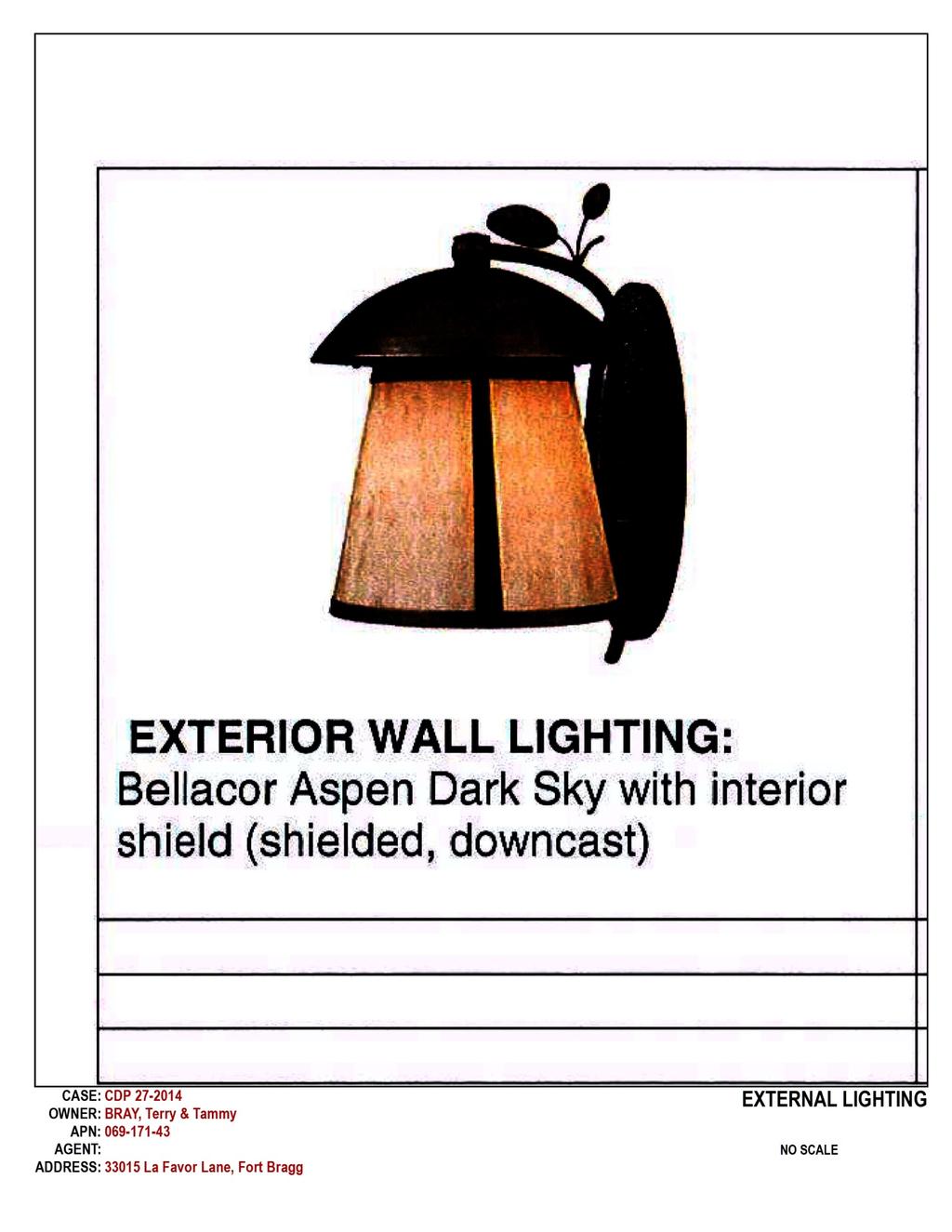
5 COASTAL PERMIT ADMINISTRATOR STAFF REPORT FOR CDP_ CDP_STANDARD PAGE 5 limiting views within the area. The applicant proposes muted, natural colors for the proposed residential structure that would be sited to limit impacts to the scenic nature of the area (and located beyond the edge of any recommended wetland buffer). The height of the proposed residence is below the maximum recommended height of eighteen-feet. Staff recommends a standard condition limiting the use of exterior lighting pursuant with MCC Section The proposed driveway would access to La Favor Lane and would have the shortest distance between the proposed garage and private road. Wetlands: The project is consistent with the MCC Chapter Environmentally Sensitive Habitats and Other Resource Areas. The purpose of this Chapter is to ensure that environmentally sensitive habitat and other designated resource areas, which constitute significant public resources and are protected for both the wildlife inhabiting them, as well as, the enjoyment of present and future populations. 7 Environmentally Sensitive Habitat Areas (ESHA's) include wetlands, riparian areas, habitats of rare and endangered plants and animals, and others. An assessment of potential jurisdictional wetlands, a Biological Scoping Survey Report, and two addendums to the survey were prepared by Spade Natural Resources Consulting between 2014 and , 9, 10, 11 ESHAs identified in the survey and addendums include Beach Pine Forest, and slough sedge. These are considered obligate wetland vegetation. A 1,750-square-foot wetland area situated in the eastern portion of the site meets the Coastal Act definition of wetlands. A delineation of potential jurisdictional wetlands was prepared in August 2016 (page 3). 12 The survey, and its two addendums, recommends a fifty-foot buffer from the wetland and beach pine areas, as well as, the incorporation of best management practices, removal of invasive species and a native landscaping plan. (For a list of recommended mitigation measures see Key Issue 3 that follows, or the Initial Study, Appendix A, or the recommended Resolution.) Pursuant with MCC Section (A)(1)(b), which states that the width of the buffer zone shall be based, in part, on the disturbance necessary to ensure the most sensitive species of plants and animals will not be disturbed significantly by the permitted development. Staff finds that direct access to the buffer may result in direct or direct impacts and recommends that no development shall occur within the delineated wetland fifty-foot buffer. With the concurrence of the Department of Fish and Wildlife, staff recommends that one-time trenching in existing disturbed areas of the Beach Pine Forest be allowed and that other development within the Beach Pine Forest buffer be prohibited. Pursuant with MCC Section (A)(1)(c), which states that The width of the buffer zone shall be based, in part, on an assessment of the slope, soils, impervious surface coverage, runoff characteristics and vegetative cover of the parcel and to what degree the development will change the potential for erosion, staff notes that 155-lineal feet of grading is proposed within the Beach Pine Forest buffer on previously disturbed lands. (The disturbed areas within the Beach Pine Forest include compacted gravel providing direct access to the existing vehicle access gate and La Favor Lane). The applicant proposes to retain all the graded material onsite (no material will be exported). Extra cut material would be spread on site and seeded as soon as possible. No soil would be left bare; mulch may be used to cover ground areas temporarily. The biologist recommends use of a temporary silt fence, approximately three feet in height and straw waddles along the entire length of the fifty-foot buffers to prevent sediment from entering established wetlands during construction. Staff finds incorporation of the aforementioned best management practices (BMPs) will be sufficient to prevent water run-off. 3. Environmental Protection: An initial study was prepared. Biological resources may be impacted by the proposed project. Mitigation measures are recommended to reduce the significance of their effect. Adoption of a Mitigated Negative Declaration is recommended. 7 Mendocino County Coastal Zoning Code, II (1995). 8 Biological Scoping Survey Report for La Favor Lane. November 20, Spade Natural Resources Consulting. 9 Delineation of Potential Jurisdictional Wetlands Under Section 404 of the Clean Water Act and California Coastal Act. August 23, Spade Natural Resources Consulting. 10 Botanical Addendum. November 22, Spade Natural Resources Consulting. 11 Botanical Addendum. December 26, Spade Natural Resources Consulting. 12 Delineation of Potential Jurisdictional Wetlands Under Section 404 of the Clean Water Act and California Coastal Act. August 23, Spade Natural Resources Consulting.
6 COASTAL PERMIT ADMINISTRATOR STAFF REPORT FOR CDP_ CDP_STANDARD PAGE 6 The following mitigation measures are recommended to prevent impacts to ESHA and biological resources. Potential Impact 1: Project activities have the potential to affect natural community ESHA of wetland and Beach Pine Forest, which has the potential to provide habitat for sensitive or special status species. Therefore, the Mitigated Negative Declaration identified the following mitigation measures to protect sensitive habitats and special status species: Mitigation Measure 1: Prior to ground disturbance, a 50-foot buffer shall be established from the Beach Pine Forest and slough sedge wetland area. The buffer shall be clearly and accurately identified on the building plans site plan, and shall be staked onsite prior to ground disturbance, to the satisfaction of Planning and Building Services. Mitigation Measure 2: Standard Best Management Practices (BMPs) shall be employed during construction to protect the wetland and prevent soil erosion during construction. BMPs shall be detailed on construction specifications, to the satisfaction of Planning and Building Services. Mitigation Measure 3: The contractor and construction manager shall limit ground disturbance to the minimum necessary. Disturbed soil areas shall be stabilized as soon as feasible, but not later than the end of the working day. Mitigation Measure 4: Prior to Building Permit Final, invasive species shall be removed from the project site including Spanish heather (Erica lusitanica), Himalaya-berry (Rubis armeniacus),cotoneaster (Cotoneaster franchetii), and Monterey pine (Pinus radiata). Mitigation Measure 5: During construction, any stockpiles shall be moved carefully by hand to avoid crushing or other damage to frogs. Mitigation Measure 6: Prior to ground disturbance, a landscaping plan shall be submitted to the Planning Department for approval. The plan shall consist of native plants compatible with adjacent plant communities. Potential Impact 2: Project activities have the potential to affect archeological resources present on the property. A Standard Condition advises the applicant of the County s discovery clause which establishes procedures to follow in the event that archaeological or cultural materials are unearthed during site preparation or construction activities. Approval of the staff report and adoption of the Mitigated Negative Declaration will ensure that indirect impacts to the archeological resources do not result from the project: The proposed project is subject to the provisions of California Environmental Quality Act (CEQA), pursuant to Public Resources Code (PRC) Section of Article 6 of the CEQA Guidelines. Public Resources Code Section states A public agency shall prepare or have prepared a proposed negative declaration or mitigated negative declaration for a project subject to CEQA when the initial study identifies potentially significant effects, but revisions in the project plans or proposals made by, or agreed to by the applicant before a proposed mitigated negative declaration and initial study are released for public review would avoid the effects or mitigate the effects to a point where clearly no significant effects would occur. The applicant is proposing to construct a single-family residence and appurtenant structures, which includes the removal of four (4) trees. Site development activities may affect the wetland and Beach Pine Forest, which has the potential to provide habitat for sensitive or special status species; therefore, the Mitigated Negative Declaration identified mitigation measures to protect sensitive habitats and special status species. The mitigation measures include appropriate buffers from the wetland and Beach Pine Forest, utilization of standard BMPs during construction, invasive species removal and hand removal of stockpiles.
7 COASTAL PERMIT ADMINISTRATOR STAFF REPORT FOR CDP_ CDP_STANDARD PAGE 7 RECOMMENDATION By resolution, adopt a Mitigated Negative Declaration and grant Coastal Development Standard Permit for the Project, as proposed by the applicant, based on the facts and findings and subject to the conditions of approval. DATE JULIANA CHERRY Appeal Period: 10 Days Appeal Fee: $ ATTACHMENTS: A. Revised Site Plan B. Topographic Map C. Google Earth Aerial Imagery D. Zoning Display Map E. General Plan Designations F. Local Coastal Plan Map 13 Fort Bragg G. Adjacent Parcels H. Fire Hazard Zones & Responsibility Areas I. Local Soils J. External Lighting K. Materials and color sample L. Revised elevations M. Fire Safe Plan N. Floor Plan RESOLUTION AND CONDITIONS OF APPROVAL (Exhibit A): MITIGATED NEGATIVE DECLARATION and Initial Study available online at:
8 APPENDIX A: COASTAL PERMIT APPROVAL CHECKLIST CDP_ (BRAY) APRIL 27, 2017 PROJECT TITLE: PROJECT LOCATION: LEAD AGENCY NAME, ADDRESS AND CONTACT PERSON: GENERAL PLAN DESIGNATION: ZONING DISTRICT CDP_ La Favor Lane Fort Bragg, CA APN: Juliana Cherry, Planner III Mendocino County Planning and Building Services 120 West Fir Street Fort Bragg, California Mendocino County General Plan Coastal Element Rural Residential, 5 acre min. lot sizes (RR5 [RR2]) Mendocino County Coastal Zoning Code Division II RR-5 (Rural Residential, 5-acre min. lot sizes) DESCRIPTION OF PROJECT: A request for a Coastal Development Standard Permit for the construction of a 1,109-square-foot single family residence, approximately 18-feet in height, a 399-square-foot attached garage, a 132-square-foot deck, a 50-foot gravel driveway, installation of a septic system and a 2,500-gallon water storage tank, and temporary use of a trailer during construction. The existing driveway would be used for alternative access upon completion of the new driveway. Four (4) pine trees will be removed and a fifty-foot buffer from wetlands and beach pine trees is recommended. The subject property is approximately 2.0-acres (or 87,120-square-feet) in area and located at the intersection of La Favor Lane and Highway 1, which is north of the City of Fort Bragg. The site is currently developed with a temporary camping trailer, a well house, utilities hook-ups and a portable toilet. February 1, 2010, CDP approved temporary camping at this location for sixty-days in any six-month period. SITE DESCRIPTION AND SETTING: The two-acre site is located on the southwest intersection of Highway 1 and La Favor Lane, which is approximately two miles north of the City of Fort Bragg at La Favor Lane (APN ).The site and surrounding lands are designated Rural Residential (RR). The location is within a Highly Scenic Area and visible from Highway 1. The land is relatively flat, fenced, and characterized as primarily non-native grassland with Beach Pine Forest to the west and beach pine and wax myrtle emerging within the grassland to the east. Environmentally Sensitive Habitat Areas (ESHAs) on the property include a 1,750-square-foot wetland and a Beach Pine Forest. No rare or endangered plant or wildlife species were identified in the project area by the biologist during the site surveys. A minimum fifty-foot buffer is recommended from the wetland and the Beach Pine Forest. Public access to the shore is provided west of the subject site, along the MacKerricher State Park shoreline. The site is located within a Marginal Water Resource Area and the on-site agricultural well provides access to a sufficient water supply. DETERMINATION: The proposed project can satisfy all required findings for approval of a Coastal Development Permit (CDP), pursuant to Sections and of the Mendocino County Code (MCC), as individually enumerated in this Coastal Permit Approval Checklist.
9 APPENDIX A: COASTAL PERMIT APPROVAL CHECKLIST Required Findings for All Coastal Development Permits (A) The granting or modification of any coastal development permit by the approving authority shall be supported by findings which establish the following: (1) The proposed development is in conformity with the certified local coastal program. (2) The proposed development will be provided with adequate utilities, access roads, drainage and other necessary facilities. (3) The proposed development is consistent with the purpose and intent of the zoning district applicable to the property, as well as the provisions of this Division and preserves the integrity of the zoning district. (4) The proposed development will not have any significant adverse impacts on the environment within the meaning of the California Environmental Quality Act. (5) The proposed development will not have any adverse impacts on any known archaeological or paleontological resource. (6) Other public services, including but not limited to, solid waste and public roadway capacity have been considered and are adequate to serve the proposed development. (B) If the proposed development is located between the first public road and the sea or the shoreline of any body of water, the following additional finding must be made: (1) The proposed development is in conformity with the public access and public recreation policies of Chapter 3 of the California Coastal Act and the Coastal Element of the General Plan. Inconsistent Consistent (With Conditions of Approval) Consistent (Without Conditions of Approval) CDP_ A - 2 Not Applicable (A)(1) The proposed development is in conformity with the certified local coastal program. Consistent (with conditions of approval) The LCP sets goals and policies for managing resource protection and development activity in the Coastal Zone of Mendocino County, an area that extends from the Humboldt County line to the Gualala River. The LCP addresses topics such as shoreline access and public trails; development in scenic areas; environmentally sensitive habitat areas; cultural resources; and more. The LCP serves as an element of the General Plan and includes the Mendocino County Code (MCC), and its policies are certified as consistent with the goals and policies of the California Coastal Act. Various aspects of the LCP are specifically addressed by separate Required and Supplemental Findings for Coastal
10 APPENDIX A: COASTAL PERMIT APPROVAL CHECKLIST CDP_ A - 3 Development Permits, including utilities, transportation, zoning, California Environmental Quality Act (CEQA) consistency, archaeological resources, public services, coastal access, and resource protection. The following is a discussion of elements of the LCP not specifically addressed elsewhere in this checklist. General Plan Land Use Rural Residential: The subject parcel is classified as Rural Residential (RR5[RR2]) by the Coastal Element of the Mendocino General Plan and LCP Map 13 Fort Bragg. 1 The RR classification is intended to "encourage local small scale food production (farming) in areas which area not well suited for large scale commercial agricultural, defined by present or potential use, location, mini-climate, slope, exposure, etc." 2 The designated principally permitted use type for this land use classification is residential and associated utilities, light agriculture, [and] home occupation. 3 The proposed land use is consistent with the intent of RR classified lands and is a principally permitted use type within this classification. Hazards: Mendocino County Coastal Element Chapter 3.4 Hazards Management addresses seismic, geologic and natural forces within the Coastal Zone. Mapping does not associate the following with the subject site: faults, bluffs, landslides, erosion, fire hazard or flood hazard. Seismic Activity: The property neither lies within, nor does it adjoin a mapped Alquist-Priolo Earthquake Fault Zone. 4 This project does not conflict with any state or local seismic hazard policy or plan. The San Andreas fault zone is mapped approximately five miles west of the project site. Flooding: There are no mapped 100-year flood zones on the subject parcel and no conditions are necessary to ensure consistency with flood policy. 5 Fire: The parcel is located in an area characterized by a Moderate Fire Hazard Severity Rating. 6 The project is within the Fort Bragg Rural Fire Protection District boundaries. The project application was referred to the California Department of Forestry and Fire Protection (CalFire) and Fort Bragg Rural Fire Protection District for input. CalFire File Number includes comments regarding address, driveway, and 30-foot defensible space and maintenance standards. Satisfying these requirements would be addressed by a standard condition: Standard condition: That this permit be subject to the securing of all necessary permits for the proposed development from County, State and Federal agencies having jurisdiction. Visual Resources: Protection of visual resources is a specific mandate of Section of the Coastal Act, and is subsequently addressed in Chapter 3.5 of General Plan s Coastal Element and implemented by MCC Chapter Local Coastal Plan Map 13 Fort Bragg designates the project site as a Highly Scenic Area. Pursuant with MCC Chapter Visual Resource and Special Treatment Areas, the 1 LCP Map 13 - Fort Bragg [map] County of Mendocino Coastal Zone. County of Mendocino Planning and Building. 2 Chapter 2.2. Mendocino County, Planning and Building Services, Planning Division. County of Mendocino General Plan Ukiah, CA. 3 ibid. 4 State of California Special Studies Zones, Department of Conservation, Division of Mines and Geology. 5 Mendocino County and Incorporated Areas [map] Flood Insurance Rate Map, Panel 1200F, Number 06045C1010F. Federal Emergency Management Agency. 6 Fire Hazard Severity Zones in SRA [map] :150,000. Fire and Resource Assessment Program, California Department of Forestry and Fire Protection.
11 APPENDIX A: COASTAL PERMIT APPROVAL CHECKLIST CDP_ A - 4 project is subject to development criteria established to ensure that permitted development is sited and designed to protect views to and along the ocean and scenic coastal areas, to minimize the alteration of natural land forms, to be visually compatible with the character of surrounding areas and, where feasible, to restore and enhance visual quality in visually degraded areas. Staff has observed during four visits to the project site that while the project site is west of and adjacent to Highway 1, the surrounding lands include established pine trees and other vegetation that obscure views of the shore. Staff has also observed that lands to the west of the project site are slightly elevated; this has the effect of further limiting views within the area. The applicant proposes muted, natural colors for the proposed residential structure that would be sited to limit impacts to the scenic nature of the area (and located beyond the edge of any recommended wetland buffer). The height of the proposed residence is below the maximum recommended height of eighteen-feet. Staff recommends a standard condition limiting the use of exterior lighting pursuant with MCC Section The proposed driveway would access to La Favor Lane and would have the shortest distance between the proposed garage and private road. Natural Resources: The certified Mendocino County LCP includes sections of both the MCC and the Coastal Element of the General Plan addressing Environmentally Sensitive Habitat Areas (ESHA). The MCC states that development having the potential to impact an ESHA shall be subject to a biological survey, prepared by a qualified biologist, to determine the extent of sensitive resources, to document potential negative impacts, and to recommend appropriate mitigation measures. A Biological Scoping Survey Report for La Favor Lane was prepared by Spade Natural Resources Consulting on November 20, Surveys were completed on September 15, 2014, January 21, February 25, March 19, July 17, and November 4, Additionally, the consulting biologist prepared a Delineation of Potential Jurisdictional Wetlands Under Section 404 of the Clean Water Act and California Coastal Act (dated August 23, 2016) and two Botanical Addendums (dated November 22, 2016 and December 29, 2016). Several occurrences of resources classified as ESHA were documented and protective measures are recommended to reduce the effect of trenching within the recommended beach pine buffer and to protect the wetlands. The Beach Pine Forest, wetland areas, and recommended mitigation measures are described in Appendix A Section (A)(4), which follows. Staff at the Department of Fish and Wildlife concur with the reports recommendations (A)(2) The proposed development will be provided with adequate utilities, access roads, drainage and other necessary facilities. Consistent (without conditions of approval) Utilities: The applicant proposes a two-bedroom, two-bathroom, single-family residence with associated septic, use of an existing well, propane storage tank, and water storage tank. Previously approved CDP permits temporary camping, installation of a well for agricultural use, and establishing electrical service. Mendocino County Department of Environmental Health (DEH) recommends approval of the proposed septic system having a maximum two-bedroom capacity. Given the capacity of the proposed septic system, PBS staff recommends prohibiting additional septic hook-ups (with the exception of the primary two-bedroom residence) and recommends that the on-site portable toilet be removed prior to occupancy of the proposed residence. Recommended condition: The property owner is prohibited from connecting to on-site septic, except for use by the primary residence. Recommended condition: No camping uses are permitted connections to on-site septic. Camping connections to on-site septic are prohibited. Recommended condition: Temporary and portable toilets shall be removed from the property prior to Planning and Building Services final inspection for the primary residential building permit.
12 APPENDIX A: COASTAL PERMIT APPROVAL CHECKLIST CDP_ A - 5 The parcel is located within a Marginal Water Resource Area. The Coastal Element of the Mendocino General Plan, Section 3.8 Transportation, Utilities and Public Services, , establishes the requirement to have a hydrological report prepared that addresses the adequacy of the proposed water supply (proof of water). Based on the requirements of Section 3.8, a Proof-Of-Water Test was prepared for the subject property. The study included the measurements and data required to determine the well's production, often referred to as a sustained yield test. DEH in their referral comment response dated September 29, 2016, recommends approval of the proposed two-bedroom residence. While the proposed residential development is outside of any ESHA buffer, the existing production well is located within the Beach Pine Forest. Trenching would disturb soil within the existing Beach Pine Forest and its recommended fifty-foot buffer. The applicant proposes to limit trenching to previously disturbed areas (see Bray Site Plan Sheet 1 dated ). Access Roads: The applicant proposes development of a fifty-foot long driveway (or 1,067-square-feet of compacted gravel) that would intersect with La Favor Lane. Mendocino County Department of Transportation (MCDOT) was invited to provide comment on the application in 2014 and in A response to Planning and Building Services from MCDOT dated October 27, 2014, and September 26, 2016, grants approval of the proposed project, which would not require any additional MCDOT permitting as the proposed project does not affect the County road. There is an existing vehicle access gate fronting La Favor Lane. The applicant proposes to retain the gate and associated driveway (compacted gravel) for intermittent access to the yard area (A)(3) The proposed development is consistent with the purpose and intent of the zoning district applicable to the property, as well as the provisions of this Division and preserves the integrity of the zoning district. Consistent (without conditions of approval) Intent: The intent of Rural Residential District is to encourage and preserve local small scale farming in the Coastal Zone on lands which are not well-suited for large scale commercial agriculture. Residential uses should be located as to create minimal impact on the agricultural viability. 7 The proposed project is the construction of a single-family residence located within an established, low-density residential area. The proposed single-family residence and accessory structures would satisfy the intent of MCC Chapter Rural Residential. Use: The site is currently developed with a camping trailer, well house, electrical utility hook-ups and a portable toilet. This use was approved in 2010 (see CDP ). The property owner proposes to construct a 1,640-square-foot home with attached garage. Single-family residences and accessory structures are principally permitted land uses in the RR District. The applicant requests temporary occupancy of a travel trailer during construction. PBS Staff recommends the following condition and limitations be set on use of a travel trailer: Recommended Condition: A Coastal Development Administrative Permit is hereby granted for temporary occupancy of the travel trailer while constructing the single-family residence, subject to the following conditions of approval: a) The term of this administrative permit is valid for the period required to complete construction of the primary dwelling, but shall not exceed two years unless renewed. The administrative permit shall be effective on the effective date of CDP # and shall expire two years henceforth. b) A valid building permit for a permanent dwelling on the premises must be in effect. 7 Mendocino County Coastal Zoning Code, II (1995).
13 APPENDIX A: COASTAL PERMIT APPROVAL CHECKLIST CDP_ A - 6 c) Building and Health permits must be obtained prior to the set up and occupancy of the travel trailer. d) All utility connections to the travel trailer shall be disconnected and the trailer shall be removed from the property or placed in dead storage per MCC Section (J) prior to the final building inspection or occupancy of the permanent dwelling, whichever comes first. Yards: The minimum required front, side and rear yards in the RR5 District are 30-feet; but pursuant to MCC Section a setback exception is applied to parcels that are less than five acres and zoned RR5. The site is four acres; therefore the front, side and rear yard requirement would be 20-feet. Fifty-foot buffers are recommended to protect two, on-site ESHAs (wetlands, forest). The proposed location of the residential structure is outside the boundaries of any required yard and recommended buffer. The existing portable toilet, well house and electric service panel are located within the Beach Pine Forest ESHA. Utility trenches are proposed within the ESHA and its buffer. Trenches would be located in previously disturbed areas. The location is recommended as the least impacting alternative for soil disturbance within an ESHA buffer. Mitigation measures are recommended to avoid significant impacts to the wetland and Beach Pine Forest. PBS Staff recommends that the portable toilet and storage of vehicles be prohibited within required yards and ESHA buffers. Mitigation Measure 1: Prior to ground disturbance, a 50-foot buffer shall be established from the Beach Pine Forest and slough sedge wetland area. The buffer shall be clearly and accurately identified on the building plans site plan, and shall be staked onsite prior to ground disturbance, to the satisfaction of Planning and Building Services. Mitigation Measure 2: Standard Best Management Practices (BMPs) shall be employed during construction to protect the wetland and prevent soil erosion during construction. BMPs shall be detailed on construction specifications, to the satisfaction of Planning and Building Services. Mitigation Measure 3: The contractor and construction manager shall limit ground disturbance to the minimum necessary. Disturbed soil areas shall be stabilized as soon as feasible, but not later than the end of the working day. Recommended condition: Temporary and portable toilets shall be removed from the property prior to Planning and Building Services final inspection for the primary residential building permit. Recommended condition: Pursuant with MCC Section (C)(11), power transmission lines shall be located along established corridors where possible and where the corridors are not visually intrusive. Recommended condition: Pursuant with MCC Section (C)(12), power distribution lines shall be placed underground in designated Highly Scenic Areas west of Highway. Recommended condition: Pursuant with MCC Section (C) No motor vehicle over three-quarter ton, boat, or recreational vehicle shall be stored or parked in any front yard setback nor any side or rear yard setback facing a street for a continuous period exceeding seventy-two hours. Recommended condition: No vehicle may be stored or parked within any ESHA or ESHA buffer. Height: The maximum permitted building height in the RR District that is designated a Highly Scenic Area is 18-feet above natural grade. The proposed single-family residence is 18-feet tall.
14 APPENDIX A: COASTAL PERMIT APPROVAL CHECKLIST CDP_ A - 7 Lot Coverage: The maximum permitted lot coverage in the RR District is fifteen percent for parcels twoacres to five-acres in size. The parcel is approximately two-acres, permitting maximum lot coverage of approximately 13,068-square-feet. The sum of the proposed development on the parcel is approximately 2,006-square-feet or less than three-percent (2.3%) of the lot area. The proposed development does not exceed the permitted lot coverage maximum for the RR District (A)(4) The proposed development will not have any significant adverse impacts on the environment within the meaning of the California Environmental Quality Act. Consistent (without conditions of approval) The proposed project is subject to the provisions of California Environmental Quality Act (CEQA), pursuant to Public Resources Code (PRC) Section of Article 6 of the CEQA Guidelines Public Resources Code Section states A public agency shall prepare or have prepared a proposed negative declaration or mitigated negative declaration for a project subject to CEQA when the initial study identifies potentially significant effects, but revisions in the project plans or proposals made by, or agreed to by the applicant before a proposed mitigated negative declaration and initial study are released for public review would avoid the effects or mitigate the effects to a point where clearly no significant effects would occur. The applicant is proposing to construct a single-family residence and appurtenant structures, which includes the removal of four (4) trees. Site development activities may affect the wetland and Beach Pine Forest, which has the potential to provide habitat for sensitive or special status species. Therefore, the Mitigated Negative Declaration identified the following mitigation measures to protect sensitive habitats and special status species: Mitigation Measure 1: Prior to ground disturbance, a 50-foot buffer shall be established from the Beach Pine Forest and slough sedge wetland area. The buffer shall be clearly and accurately identified on the building plans site plan, and shall be staked onsite prior to ground disturbance, to the satisfaction of Planning and Building Services. Mitigation Measure 2: Standard Best Management Practices (BMPs) shall be employed during construction to protect the wetland and prevent soil erosion during construction. BMPs shall be detailed on construction specifications, to the satisfaction of Planning and Building Services. Mitigation Measure 3: The contractor and construction manager shall limit ground disturbance to the minimum necessary. Disturbed soil areas shall be stabilized as soon as feasible, but not later than the end of the working day. Mitigation Measure 4: Prior to occupancy, invasive species shall be removed from the project site including Spanish heather (Erica lusitanica), Himalaya-berry (Rubisarmeniacus),cotoneaster (Cotoneaster franchetii), and Monterey pine (Pinusradiata). Mitigation Measure 5: During construction, any stockpiles shall be moved carefully by hand to avoid crushing or other damage to frogs. Mitigation Measure 6: Prior to ground disturbance, a landscaping plan shall be submitted to the Planning Department for approval. The plan shall consist of native plants compatible with adjacent plant communities. The proposed project would not have any significant adverse impacts on the environment within the meaning of the California Environmental Quality Act with the adoption and incorporation of recommended
15 APPENDIX A: COASTAL PERMIT APPROVAL CHECKLIST CDP_ A - 8 mitigation and avoidance measures. Staff recommends adoption of the Mitigated Negative Declaration prior to project approval (A)(5) The proposed development will not have any adverse impacts on any known archaeological or paleontological resource. Consistent (with conditions of approval) The Archaeological Commission accepted the archeological survey for the site during its October 12, 2016, meeting. The Archaeological Commission found that no cultural, historical, or archaeological sites were observed. A Standard Condition advises the applicant of the County s Discovery Clause, which establishes procedures to follow in the event that archaeological or cultural materials are unearthed during site preparation or construction activities. Standard Condition: If any archaeological sites or artifacts are discovered during site excavation or construction activities, the applicant shall cease and desist from all further excavation and disturbances within 100-feet of the discovery, and make notification of the discovery to the Director of the Department of Planning and Building Services. The Director will coordinate further actions for the protection of the archaeological resource(s) in accordance with Section of the Mendocino County Code (A)(6) Other public services, including but not limited to, solid waste and public roadway capacity have been considered and are adequate to serve the proposed development. Consistent (without conditions of approval) Solid Waste: The Caspar Transfer Station is located approximately 21-miles south of the project site, providing for the disposal of solid waste resulting from the residential use. Additionally, curbside pickup is available, should the owner choose to purchase the service. Solid waste disposal is adequate to serve the proposed development. Roadway Capacity: The subject property is located at La Favor Lane, at its intersection with Highway 1. Construction of a single-family residence would generate few additional vehicle trips per day. The State Route 1 Corridor Study Update provides traffic volume data for Highway 1. The subject property is located approximately 0.4-miles south of intersection of Odom Lane and Highway 1 where the existing peak hour Level of Service is reported as A. 8 No change in service levels is anticipated (B)(1) If the proposed Development is located between the first public road and the sea or the shoreline of any body of water, the following additional finding must be made: The proposed development is in conformity with the public access and public recreation policies of Chapter 3 of the California Coastal Act and the Coastal Element of the General Plan. Consistent (without conditions of approval) The project site is located east of MacKerricher State Park Road (formerly Georgia Pacific Haul Road) and does not provide direct coastal access as shown on the on the Fort Bragg LCP Map 13. The project site is not located along the shoreline and there is no evidence of prescriptive access. The project would have no effect on public access to the coast. 8 State Route 1 Corridor Study Update for the County of Mendocino. Rep. Santa Rosa: Whitlock & Weinberger Transportation, Available:
16 APPENDIX A: COASTAL PERMIT APPROVAL CHECKLIST (A) Resource Protection Impact Findings (1) Development in Environmentally Sensitive Habitat Areas. No development shall be allowed in an ESHA unless the following findings are made: (a) The resource as identified will not be significantly degraded by the proposed development. (b) There is no feasible less environmentally damaging alternative. (c) All feasible mitigation measures capable of reducing or eliminating project related impacts have been adopted. (2) Impact Finding For Resource Lands Designated AG, RL and FL. No permit shall be granted in these zoning districts until the following finding is made: (a) The proposed use is compatible with the long-term protection of resource lands. Inconsisten t Consistent (With Conditions of Approval) Consistent (Without Conditions of Approval) CDP_ A - 9 Not Applicable (A)(1), et. seq. No development shall be allowed in an ESHA unless the following findings are made. The Mendocino County LCP includes sections of both the MCC and the Coastal Element of the General Plan addressing Environmentally Sensitive Habitat Areas (ESHA). The MCC states that development having the potential to affect an ESHA shall be subject to a biological survey, prepared by a qualified biologist, to determine the extent of sensitive resources, to document potential negative impacts, and to recommend appropriate mitigation measures. A Biological Scoping Survey Report (Report) and Wetlands Delineation (Delineation) were prepared by Spade Natural Resources Consulting in November 2014 and August 2016, respectively. 9,10 Two Botanical Addendums were also prepared and dated November 22, 2016 and December 29, ,12 ESHAs identified in the Reports include beach pine (also known as shore pine) forest, and slough sedge, which is considered obligate wetland vegetation (i.e., it does not grow without soil and hydrological conditions that establish a wetland). The Delineation identified a 1,750-square-foot wetland in the eastern portion of the site. The Report recommends a fifty-foot buffer from the wetland and beach pine areas, as well as, the incorporation of best management practices, removal of invasive species and a native landscaping plan. (See Section (A)(4) for additional information and mitigation measures.) 9 Biological Scoping Survey Report for La Favor Lane. November 20, Spade Natural Resources Consulting. 10 Delineation of Potential Jurisdictional Wetlands Under Section 404 of the Clean Water Act and California Coastal Act. August 23, Spade Natural Resources Consulting. 11 Botanical Addendum for La Favor Lane. November 22, Spade Natural Resources Consulting. 12 Botanical Addendum for La Favor Lane. December 29, Spade Natural Resources Consulting.
17 ATTACHMENT A
18 ATTACHMENT B
19 ATTACHMENT C
20 ATTACHMENT D
21 ATTACHMENT E

22 ATTACHMENT F
23 ATTACHMENT G

24 ATTACHMENT H
25 ATTACHMENT I
26 ATTACHMENT J
27 ATTACHMENT K
28 ATTACHMENT L

29 ATTACHMENT M
STAFF REPORT FOR STANDARD COASTAL DEVELOPMENT PERMIT #CDP FEBRUARY 26, 2015 CPA - 1 PO BOX 238 APTOS, CA 94001
 STAFF REPORT FOR STANDARD COASTAL DEVELOPMENT PERMIT #CDP 2014-0030 FEBRUARY 26, 2015 CPA - 1 OWNER/APPLICANT: AGENT: REQUEST: HANS HEIM PO BOX 238 APTOS, CA 94001 JAMES HAY PO BOX 762 MENDOCINO, CA 95460
COASTAL PERMIT ADMINISTRATOR OCTOBER 27, 2016
 COASTAL PERMIT ADMINISTRATOR OCTOBER 27, 2016 STAFF REPORT- CDP_STANDARD CDP_2015-0033 SUMMARY OWNER/ APPLICANT: AGENT: REQUEST: PATRICK ELLIS AND LISA LAUER PO BOX 234 GUALALA, CA 95445 CARL RITTIMAN
COASTAL PERMIT ADMINISTRATOR DECEMBER 14, 2016
 COASTAL PERMIT ADMINISTRATOR DECEMBER 14, 2016 STAFF REPORT- CDP_STANDARD CDP_2016-0009 SUMMARY OWNERS: JOHN ARJAY RAFFETY 13214 FIJI WAY UNIT A MARINA DEL REY, CA 90292 KERRY HEISE, ADINA MERENLENDER
COASTAL PERMIT ADMINISTRATOR DECEMBER 16, 2015 STAFF REPORT/COASTAL DEVELOPMENT PERMIT
 COASTAL PERMIT ADMINISTRATOR DECEMBER 16, 2015 STAFF REPORT/COASTAL DEVELOPMENT PERMIT CDP_2013-0012 OWNER/APPLICANT: AGENT: REQUEST: LOCATION: APPEALABLE: PERMIT TYPE: SYDNEY MINTZ & JUSTINE SHAPIRO 336
STAFF REPORT JULY 26, 2017
 COASTAL PERMIT ADMINISTRATOR STAFF REPORT JULY 26, 2017 SUMMARY OWNER/APPLICANT: AGENT: REQUEST: DALE SPRING AND PATRICIA ARNETT 1121 BOONVILLE RD UKIAH, CA 95482 KELLY GRIMES PO BOX 598 LITTLE RIVER,
ADDENDUM TO BIOLOGICAL SCOPING SURVEY REPORT, BOTANICAL SURVEY AND WETLAND DELINEATION
 ADDENDUM TO BIOLOGICAL SCOPING SURVEY REPORT, BOTANICAL SURVEY AND WETLAND DELINEATION FOR AVALON INN (APN 069-241-27 & -04) 1201 & 1211 NORTH MAIN STREET FORT BRAGG, CA MENDOCINO COUNTY prepared for:
STAFF REPORT FOR COASTAL DEVELOPMENT CDP# ADMINISTRATIVE PERMIT SEPTEMBER 9, 2014 BOS PRESSLEY ROAD SANTA ROSA, CA 95404
 SEPTEMBER 9, 2014 BOS-1 OWNER/APPLICANT: REQUEST: DAVID DERUITER 4714 PRESSLEY ROAD SANTA ROSA, CA 95404 Coastal Development Permit for a single family residence, barn, guest cottage, driveway and related
-MENDOCINO COUNTY PLANNING AND BUILDING SERVICES- DIVISION II OF TITLE 20--COASTAL ZONING CODE
 CHAPTER 20.504 VISUAL RESOURCE AND SPECIAL TREATMENT AREAS Sec. 20.504.005 Applicability. Sec. 20.504.010 Purpose. Sec. 20.504.015 Highly Scenic Areas. Sec. 20.504.020 Special Communities and Neighborhoods.
TOWNSHIP OF LOGAN SOIL & FILL IMPORTATION AND PLACEMENT APPLICATION SUBMITTAL CHECKLIST
 TOWNSHIP OF LOGAN SOIL & FILL IMPORTATION AND PLACEMENT APPLICATION SUBMITTAL CHECKLIST Applications: 5 copies of application - Applicant will reproduce the copies at his/her costs. The Township Clerk
APPENDIX J PERFORMANCE STANDARDS FOR GRAVEL MINE, PIT MINE, OR QUARRY
 APPENDIX J PERFORMANCE STANDARDS FOR GRAVEL MINE, PIT MINE, OR QUARRY A. Purpose: 1. Regulatory Requirement and Use Mitigation: The purpose of this appendix is to provide a regulatory context (standards)
3.10 LAND USE SETTING PROJECT SITE EXISTING LAND USE DESIGNATIONS AND ZONING. General Plan Land Use Designations.
 This section of the Draft EIR addresses the existing land uses on and adjacent to the project site and discusses the potential impacts of the proposed project on existing land uses. Key issues addressed
CITY OF LAGUNA BEACH COMMUNITY DEVELOPMENT DEPARTMENT STAFF REPORT DESIGN REVIEW BOARD IBOARD OF ADJUSTMENT Coast Highway APN
 CITY OF LAGUNA BEACH COMMUNITY DEVELOPMENT DEPARTMENT STAFF REPORT HEARING DATE: October 13,2011 TO: DESIGN REVIEW BOARD IBOARD OF ADJUSTMENT CASE: Variance 7717 Design Review 11-163 Coastal Development
Venice Pumping Plant Dual Force Main Project Draft EIR
 City of Los Angeles 5.9 LAND USE PLANS 5.9.1 Environmental Setting Venice Pumping Plant Dual Force Main Project Draft EIR The Project lies within the bounds of Los Angeles County and the City of Los Angeles.
PARK CITY MUNICIPAL CODE TABLE OF CONTENTS TITLE 15 LAND MANAGEMENT CODE - CHAPTER 2.21
 PARK CITY MUNICIPAL CODE TABLE OF CONTENTS TITLE 15 LAND MANAGEMENT CODE - CHAPTER 2.21 TITLE 15 - LAND MANAGEMENT CODE CHAPTER 2.21 - SENSITIVE LAND OVERLAY ZONE (SLO) REGULATIONS 15-2.21-1. PURPOSE...1
DECISION CRITICAL AREAS ALTERATION AND DETERMINATION OF NONSIGNIFICANCE (DNS)
") DECISION CRITICAL AREAS ALTERATION AND DETERMINATION OF NONSIGNIFICANCE (DNS) Development Services Department 17301 133rd Avenue NE Woodinville, WA 98072 425-489-2754 www.ci.woodinville.wa.us Project Name:
DECISION CRITICAL AREAS ALTERATION AND DETERMINATION OF NONSIGNIFICANCE (DNS) Development Services Department 17301 133rd Avenue NE Woodinville, WA 98072 425-489-2754 www.ci.woodinville.wa.us Project Name:
ORDINANCE NO WHEREAS, the City of Kalama has many areas of timberland and open areas inside its City limits adjacent to residential areas;
 ORDINANCE NO. 1342 AN ORDINANCE OF THE CITY OF KALAMA, WASHINGTON ADOPTING A NEW KALAMA MUNICIPAL CODE CHAPTER 17.20 ESTATE LOT FLOATING ZONE TO PROVIDE TRANSITIONAL ZONING OPTIONS FOR RESIDENTIAL DEVELOPMENT
ARTICLE VI: SITE PLAN REVIEW
 Section 6.01 - Site Plan Review (All Districts) ARTICLE VI: SITE PLAN REVIEW Site plans give the Planning commission an opportunity to review development proposals in a concise and consistent manner. The
City of Lafayette Study Session Staff Report Design Review Commission
 ++ City of Lafayette Study Session Staff Report Design Review Commission Meeting Date: January 08, 2018 Staff: Subject: Chris Juram, Planning Technician SS12-17 Miramar Homebuilders, R-20 Zoning: Request
Project phasing plan (if applicable) 12 copies of site plan
 12 copies of site plan") SITE PLAN REVIEW PERMIT APPLICATION City of Grand Haven, 11 N. Sixth Street, Grand Haven, MI 49417 Phone: (616) 847-3490 Fax: (616) 844-2051 Website: www.grandhaven.org 1. Project Information Address/location
SITE PLAN REVIEW PERMIT APPLICATION City of Grand Haven, 11 N. Sixth Street, Grand Haven, MI 49417 Phone: (616) 847-3490 Fax: (616) 844-2051 Website: www.grandhaven.org 1. Project Information Address/location
PLANNED DEVELOPMENT (MASTER PLAN & UNIT PLAN)
") Central Permit Center 555 Santa Clara Street Vallejo CA 94590 Business License Building Fire Prevention Planning Public Works 707.648.4310 707.648.4374 707.648.4565 707.648.4326 707.651.7151 PLANNED DEVELOPMENT
Central Permit Center 555 Santa Clara Street Vallejo CA 94590 Business License Building Fire Prevention Planning Public Works 707.648.4310 707.648.4374 707.648.4565 707.648.4326 707.651.7151 PLANNED DEVELOPMENT
WASHINGTON COUNTY OREGON
 WASHINGTON COUNTY OREGON LONG RANGE PLANNING DIVISION North Bethany Subarea Stream Corridors: Existing Regulations In Oregon, there is a distinct difference between the land use rules that apply in rural
Article 6 Tree Protection
 Article 6 Tree Protection 8.1 Purpose 8.2 Applicability 8.2.1 General Provisions 8.2.2 Exemptions 8.3 Permitting Procedure 8.4 Planting Procedure 8.5 Performance Guarantee Required for Belated Planting
CLACKAMAS COUNTY ZONING AND DEVELOPMENT ORDINANCE
 704 RIVER AND STREAM CONSERVATION AREA (RSCA) 704.01 PURPOSE Section 704 is adopted to: A. Maintain the integrity of the rivers and streams in the County by minimizing erosion, promoting bank stability,
Environmental Protection Ordinances (Performance Zoning) Bedminster Township, Bucks County
 Bedminster Township, Bucks County") Environmental Protection Ordinances (Performance Zoning) Bedminster Township, Bucks County ARTICLE VI. PERFORMANCE STANDARDS Section 600 Compliance All uses, activities, subdivisions and/or land developments
Environmental Protection Ordinances (Performance Zoning) Bedminster Township, Bucks County ARTICLE VI. PERFORMANCE STANDARDS Section 600 Compliance All uses, activities, subdivisions and/or land developments
CONSERVATION ELEMENT GOALS, OBJECTIVES, AND POLICIES
 CONSERVATION ELEMENT GOALS, OBJECTIVES, AND POLICIES Goal 4 To conserve, manage, appropriately use and protect the natural resources of the City ensuring continued resource availability and environmental
COUNTY OF SANTA CRUZ MEMORANDUM. To: Don Bussey, Zoning Administrator From: Lawrence Kasparowitz, Project Planner
 1 - COUNTY OF SANTA CRUZ I MEMORANDUM Date: June 21,2006 To: Don Bussey, Zoning Administrator From: Lawrence Kasparowitz, Project Planner Re: 02-0432 Agenda Date: July 21, 2006 Agenda Item #: 0.1 Time:
Zoning Ordinance Article 3
 Article 3 Natural Resources Protection Section 301 Natural Resources Protection 301.1. Purpose - The following natural resources protection standards are established to protect the public health, safety
Community LID Workgroup Issue Paper #6
 Community LID Workgroup Issue Paper #6 Topic: Hard and Impervious Surface Coverage Limits Objective: Minimize the amount of hard and impervious surfaces in developments to allow more stormwater to infiltrate
City of Larkspur. Notice of Mitigated Negative Declaration for the 285
 Notice of Mitigated Negative Declaration for the 285 Magnolia Avenue Mixed-Use Project Date: December 2, 2013 Responsible Agency: Project Title: 285 Magnolia Avenue Mixed-Use Project Project Address: 285
Notice of Preparation of an Environmental Impact Report and Scoping Meeting for the Canyon Lane Roadway Improvements Development Project
 of an Environmental Impact Report and Scoping Meeting for the As the Lead Agency, the County of San Mateo (County) will prepare an Environmental Impact Report (EIR) for the (project), and would like your
Planned Development Review Revisions (Project No. PLNPCM )
") Planned Development Review Revisions (Project No. PLNPCM2014-00139) Standard residential development Planned Development Example: Smaller lot sizes than what is allowed to create open space amenity. What
Planned Development Review Revisions (Project No. PLNPCM2014-00139) Standard residential development Planned Development Example: Smaller lot sizes than what is allowed to create open space amenity. What
SECTION 1 CLEARING /GRADING PERMIT APPLICATION:
 PLEASE REFER TO THE CLEARING & GRADING PERMIT CHECKLIST BELOW FOR SUBMITTAL REQUIREMENTS. SECTION 1 CLEARING /GRADING PERMIT APPLICATION: PROJECT ADDRESS (Street, Suite #): Parcel(s) #: Total Site Area
Chesapeake Bay Critical Area Conservation Plan
 The Maryland-National Capital Park and Planning Commission Prince George s County Planning Department Development Review Division 301-952-3530 Note: Staff reports can be accessed at www.mncppc.org/pgco/planning/plan.htm.
17.18 SENSITIVE AREAS
 17.18 SENSITIVE AREAS 17.18.010 Purpose...1 17.18.020 Definitions...1 17.18.030 Review Process...1 17.18.040 Sensitive Areas Analysis...2 17.18.050 Standards and Development Plan...3 17.18.060 Geotechnical
SENSITIVE LANDS OVERLAY
 SENSITIVE LANDS OVERLAY Chapter 22 Sensitive Lands Overlay 22.1 PURPOSE 22.2 APPLICATION AND ANALYSIS REQUIREMENTS 22.3 SENSITIVE LAND REGULATIONS 22.4 ADMINISTRATIVE PROVISIONS 22.5 DESIGN STANDARDS 22.6
Memorandum Planning. Thursday, January 8, 2015
 Memorandum Planning Thursday, January 8, 2015 7.A. To: Coastal Advisory Committee From John Ciampa, Associate Planner Subject: Review Draft Local Coastal Program Copies: James Pechous, City Planner Purpose
Town of Windham. Planning Department 8 School Road Windham, ME voice fax
 Town of Windham Planning Department 8 School Road Windham, ME 04062 voice 207.864-5960 fax 207.892.1916 MEMO DATE: TO: Staff Review Committee FROM: Amanda Lessard, Planner Cc: Ellen Rathbone, St. Germain
STREAM BUFFERS
 88-415 STREAM BUFFERS 88-415-01 PURPOSE In the Kansas City region and throughout the nation, vegetated stream buffers have been clearly shown to protect stream stability and related infrastructure, improve
BUFFERS, TREE PROTECTION AND LANDSCAPING. Sec Purpose and Intent.
 ARTICLE 20 BUFFERS, TREE PROTECTION AND LANDSCAPING Sec. 20.1. Purpose and Intent. Trees improve air and water quality, reduce soil erosion, reduce noise and glare, provide habitat for desirable wildlife,
Baumgarten MPUD. Exhibit 3 Evaluation Criteria
 Pursuant to LDC subsections 10.02.13 B, 10.02.08 F and Chapter 3 G. of the Administrative Code, staff s analysis and recommendation to the Planning Commission, and the Planning Commission s recommendation
Major Subdivision Sketch Plan Checklist
 This checklist provides specific requirements that are apart of the Sketch process. The entire process is described by the Huntersville Subdivision Review Process which details all the submittal and resubmittal
7 May 9, 2012 Public Hearing APPLICANT AND PROPERTY OWNER: COASTAL ENTERPRISES, LLC
 7 May 9, 2012 Public Hearing APPLICANT AND PROPERTY OWNER: COASTAL ENTERPRISES, LLC REQUEST: Variance to Section 5B of the Site Plan Ordinance (Floodplain Regulations) ADDRESS / DESCRIPTION: 601 Sandbridge
Gadsden County Planning Commission Agenda Request
 Date of Meeting: November 16, 2017 To: From: Through: Subject: Gadsden County Planning Commission Agenda Request Honorable Chairperson and Members of the Board Jill A. Jeglie, AICP, Senior Planner Clyde
NOTICE OF PREPARATION
 NOTICE OF PREPARATION DATE: January 6, 2016 TO: LEAD AGENCY: Responsible Agencies, Organizations, and Interested Parties Contact: Tyler Barrington, Principal Planner Planning Department Community Development
GENERAL INFORMATIONaaaaaaaaaaaaaaaaaaaaaaaaaaaaaaaa
 To: Planning and Zoning Commission From: City Staff Date: November 15, 2016 Re: Case #16026 Raymore Activity Center Site Plan GENERAL INFORMATIONaaaaaaaaaaaaaaaaaaaaaaaaaaaaaaaa Applicant/ Property Owner:
CITY OF SCANDIA ORDINANCE NO. 174
 CITY OF SCANDIA ORDINANCE NO. 174 AN ORDINANCE AMENDING ORDINANCE NO. 122, THE SCANDIA DEVELOPMENT CODE, CHAPTER 2, SECTION 4.34, REGARDING SOLAR FARMS AND COMMUNITY SOLAR GARDENS The City Council of the
Erosion & Sediment Control Plan Application Form & Checklist
 Erosion & Sediment Control Plan Application Form & Checklist GENERAL INFORMATION Application Date: Project Address: Tax Map / Parcel Number(s): PROPERTY OWNER / DEVELOPER Firm Name: Contact Person: Title:
Decision Notice. Proposed Action
 Decision Notice Paving Weld County Road 105 USDA Forest Service Arapaho and Roosevelt National Forest and Pawnee National Grassland Pawnee National Grassland Ranger District Weld County, Colorado November
City of Lafayette Study Session Staff Report Design Review Commission
 City of Lafayette Study Session Staff Report Design Review Commission Meeting Date: April 24, 2017 Staff: Payal Bhagat, Senior Planner Subject: HDP18-15 & HDP31-15 Ramesh Patel & Melcor Development (Owners),
Appendix I. Checklists
 Appendix I Checklists Town of Greenwich Drainage Manual Department of Public Works - Engineering Division Town Hall - 101 Field Point Road, Greenwich, CT 06836-2540 Phone 203-622-7767 - Fax 203-622-7747
CITY OF MALIBU PLANNING COMMISSION RESOLUTION NO
 CITY OF MALIBU PLANNING COMMISSION RESOLUTION NO. 16-54 A RESOLUTION OF THE PLANNING COMMISSION OF THE CITY OF MALIBU, CONSIDERING AN ADDENDUM TO THE CERTIFIED CRUMMER SITE SUBDIVISION FINAL EIR AND MAKING
ELIGIBILITY CRITERIA CHECKLIST OPEN SPACE CLASSIFICATION
 THURSTON COUNTY DEVELOPMENT SERVICES OPEN SPACE TAX PROGRAM ELIGIBILITY CRITERIA CHECKLIST OPEN SPACE CLASSIFICATION Use this checklist to help you determine whether your property is eligible for open
CITY OF ZEELAND PLANNING COMMISSION
 APPLICATION FOR SITE PLAN REVIEW AND SPECIAL LAND USE Date City Official App. Filing Fee Rec'd ($350) NOTE TO APPLICANT: Please submit this application for Site Plan Review along with twenty (20) copies
CHAPTER 10 AESTHETICS
 CHAPTER 10 AESTHETICS CHAPTER 10 AESTHETICS This section identifies and evaluates key visual resources in the project area to determine the degree of visual impact that would be attributable to the project.
SUPPORTING DOCUMENT STORMWATER POLLUTION PREVENTION PLAN (SWPPP) NARRATIVE
 NARRATIVE") SUPPORTING DOCUMENT STORMWATER POLLUTION PREVENTION PLAN (SWPPP) NARRATIVE Please complete this narrative form and submit with your SWPPP drawings. Refer to Kitsap County Stormwater Design Manual Vol.
SUPPORTING DOCUMENT STORMWATER POLLUTION PREVENTION PLAN (SWPPP) NARRATIVE Please complete this narrative form and submit with your SWPPP drawings. Refer to Kitsap County Stormwater Design Manual Vol.
12 February 9, 2011 Public Hearing APPLICANT: WILDLIFE RESPONSE, INC.
 12 February 9, 2011 Public Hearing APPLICANT: WILDLIFE RESPONSE, INC. PROPERTY OWNER: CITY OF VIRGINIA BEACH REQUEST: Conditional Use Permit (Wildlife Rehabilitation Center) STAFF PLANNER: Karen Prochilo
SITE PLAN REVIEW ITEMS - REFERENCE CHECKLIST
 City of Seminole 9199 113 th Street N. Seminole, FL 33772 Ph: (727) 392-1966 Fx: (727) 319-6583 SITE PLAN REVIEW ITEMS - REFERENCE CHECKLIST Note: This checklist is designed to aid designers in the review
Note: Staff reports can be accessed at Zone: I-3. Tier:
 The Maryland-National Capital Park and Planning Commission Prince George s County Planning Department Development Review Division 301-952-3530 Note: Staff reports can be accessed at www.mncppc.org/pgco/planning/plan.htm.
ARTICLE IX SPECIAL PERMIT USES
 ARTICLE IX SPECIAL PERMIT USES All special permit uses cited in Article IX and Attachment A of this Ordinance or any other Section of this Ordinance shall be subject to Site Plan Review. The procedures
Nob Hill Pipeline Improvements Project EIR
 Section 3.1 Aesthetics This section addresses the visual aspects that may affect the views experienced by the public, including the potential to impact the existing character of each area that comprises
Minnesota Department of Natural Resource - Natural Resource Guidance Checklist Conserving Natural Resources through Density Bonuses
 Minnesota Department of Natural Resource - Natural Resource Guidance Checklist Conserving Natural Resources through Density Bonuses NRDB Why Use Density Bonuses & This Checklist Local units of government
SITE PLAN REVIEW APPLICATION AND CHECKLIST
 SITE PLAN REVIEW APPLICATION AND CHECKLIST PROJECT SUMMARY: Project Name: City/ETA Location: City ETA (Application fee & number of copies needed are based on location) Property Location (Legal Description
Exhibit A. 8:9 Scuffletown Rural Conservation District
 Exhibit A 8:9 Scuffletown Rural Conservation District 8:9.1 Intent and Purpose The Scuffletown Rural Conservation (SRC) District is intended to provide for residential development that supports the development
APPENDIX 1: SCOPED ENVIRONMENTAL IMPACT STATEMENT (EIS) FORM
 FORM") APPENDIX 1: SCOPED ENVIRONMENTAL IMPACT STATEMENT (EIS) FORM This form is intended for use by applicants (primarily private landowners) who need to conduct a Scoped EIS in support of minor development
APPENDIX 1: SCOPED ENVIRONMENTAL IMPACT STATEMENT (EIS) FORM This form is intended for use by applicants (primarily private landowners) who need to conduct a Scoped EIS in support of minor development
CITY OF CYPRESS 5275 Orange Avenue Cypress, California (714) DESIGN REVIEW COMMITTEE PERMIT PROCESS
 DESIGN REVIEW COMMITTEE PERMIT PROCESS") CITY OF CYPRESS 5275 Orange Avenue Cypress, California 90630 (714) 229-6720 DESIGN REVIEW COMMITTEE PERMIT PROCESS 1. Discuss project with Planning staff to determine zoning regulations, any unusual characteristics
CITY OF CYPRESS 5275 Orange Avenue Cypress, California 90630 (714) 229-6720 DESIGN REVIEW COMMITTEE PERMIT PROCESS 1. Discuss project with Planning staff to determine zoning regulations, any unusual characteristics
AWH REPORT OF THE PLANNING AND DEVELOPMENT DEPARTMENT FOR APPLICATION FOR REZONING ORDINANCE TO PLANNED UNIT DEVELOPMENT
 AWH REPORT OF THE PLANNING AND DEVELOPMENT DEPARTMENT FOR APPLICATION FOR REZONING ORDINANCE TO PLANNED UNIT DEVELOPMENT MAY 8, 2014 The Planning and Development Department hereby forwards to the Planning
PART 1: PROJECT SUMMARY. The application is Attachment A. The site plan is Attachment B.
 Belleterre Subdivision Sketch Plan Town Board 8.7.17 Belleterre Subdivision Sketch Plan PART 1: PROJECT SUMMARY Applicant: Bowman Development Project Size: +/- 20.85 acres Parcel Number: 01115104 and 01115121
DETERMINATION OF SIGNIFICANCE FOR THE LONGWOOD PUBLIC LIBRARY EXPANSION & RENOVATION; STATE ENVIRONMENTAL QUALITY REVIEW ACT (SEQRA) RESOLUTION
 RESOLUTION") Longwood Public Library Resolution Library Board of Trustees August 13, 2012 DETERMINATION OF SIGNIFICANCE FOR THE LONGWOOD PUBLIC LIBRARY EXPANSION & RENOVATION; STATE ENVIRONMENTAL QUALITY REVIEW ACT
Longwood Public Library Resolution Library Board of Trustees August 13, 2012 DETERMINATION OF SIGNIFICANCE FOR THE LONGWOOD PUBLIC LIBRARY EXPANSION & RENOVATION; STATE ENVIRONMENTAL QUALITY REVIEW ACT
Department of Community Development. Planning and Environmental Review Division Revised Notice of Preparation
 Department of Community Development Michael J. Penrose, Acting Director Divisions Building Permits & Inspection Code Enforcement County Engineering Economic Development & Marketing Planning & Environmental
4. CONSERVATION, OPEN SPACE, AND PARKS ELEMENT
 4. CONSERVATION, OPEN SPACE, AND PARKS ELEMENT A. Purpose The Conservation, Open Space, and Parks Element of the Inland General Plan combines two State-mandated elements, Conservation and Open Space. It
CITY OF PORTSMOUTH PLANNING DEPARTMENT. MEMORANDUM To: From:
 CITY OF PORTSMOUTH PLANNING DEPARTMENT MEMORANDUM To: From: Subject: Date: Planning Board Juliet T.H. Walker, Planning Director Jillian Harris, Planner 1 Staff Recommendations for the August 23, 2018 Planning
CHAPTER 4 - LAND USE CLASSIFICATIONS
 CHAPTER 4 - LAND USE CLASSIFICATIONS Four new land use classification categories are established in the Gualala Town Plan: Gualala Village Mixed Use; Gualala Highway Mixed Use; Gualala Planned Development
The Maryland-National Capital Park and Planning Commission Prince George's County Planning Department Development Review Division
 The Maryland-National Capital Park and Planning Commission Prince George's County Planning Department Development Review Division 301-952-3530 Note: Staff reports can be accessed at www.mncppc.org/pgco/planning/plan.htm.
St. Croix County Shoreland Overlay Zoning Districts. Public Hearing Community Development Committee December 19, 2013
 St. Croix County Shoreland Overlay Zoning Districts Public Hearing Community Development Committee December 19, 2013 Timeline CDC Review October 17 Public Information Meeting October 29 (6:00-8:00 pm)
Chair Leskinen and Planning Commission Members Jessica Loftus, City Administrator
 Agenda Item 3 Date Application Received: 10/21/15 Date Application Considered as Complete: 10/30/15 120-Day Review Period Expires: 02/27/16 To: From: Chair Leskinen and Planning Commission Members Jessica
2.1.8 Cultural Resources Regulatory Setting. Affected Environment, Environmental
 REVISED DRAFT ENVIRONMENTAL IMPACT REPORT/ Affected Environment, Environmental 2.1.8 Cultural Resources This section evaluates the potential for historical and archaeological resources within the proposed
Re: Application Type: Proposed Highlands Redevelopment Area Designation
 CHRIS CHRISTIE Governor KIM GUADAGNO Lt. Governor State of New Jersey Highlands Water Protection and Planning Council 100 North Road (Route 513) Chester, New Jersey 07930-2322 (908) 879-6737 (908) 879-4205
6 August 11, 2010 Public Hearing APPLICANT AND PROPERTY OWNER: CAVALIER GOLF AND YACHT CLUB
 6 August 11, 2010 Public Hearing APPLICANT AND PROPERTY OWNER: CAVALIER GOLF AND YACHT CLUB REQUEST: Conditional Use Permit (outdoor recreational facility) STAFF PLANNER: Faith Christie ADDRESS / DESCRIPTION:
DRAFT SCOPE FOR THE DRAFT ENVIRONMENTAL IMPACT STATEMENT FOR HUDSON HIGHLANDS RESERVE TOWN OF PHILIPSTOWN, NEW YORK June 5, 2018
 DRAFT SCOPE FOR THE DRAFT ENVIRONMENTAL IMPACT STATEMENT FOR HUDSON HIGHLANDS RESERVE TOWN OF PHILIPSTOWN, NEW YORK June 5, 2018 Project Name: Project Location SEQRA Classification of Project: Lead Agency:
1.0 REQUEST. MONTECITO PLANNING COMMISSION Staff Report for Danielson Vesting Tentative Parcel Map No. 14,686. Project Site
 MONTECITO PLANNING COMMISSION Staff Report for Danielson Vesting Tentative Parcel Map No. 14,686 Deputy Director: Dave Ward Staff Report Date: February 29, 2008 Division: Development Review Staff Contact:
City of Lafayette Staff Report
 City of Lafayette Staff Report For: By: Design Review Commission Greg Wolff, Senior Planner Meeting Date: April 27, 2015 Subject: SS03-15 Gundi & Peter Younger (Owners), R-40 Zoning: Request for a Study
Nick Sigmund, Sr. Zoning Officer
 Nick Sigmund, Sr. Zoning Officer Wisconsin Department of Natural Resources Administrative Code NR 115 under the authority of Wisconsin Statute 59.692, establishes and provides that shoreland zoning regulations
PC RESOLUTION NO
 PC RESOLUTION NO. 14-01-14-02 TENTATIVE TRACT MAP fttm) 17441. REZONE {RZ) 13-003, ARCHITECTURAL CONTROL (AC) 13-003, TREE REMOVAL PERMIT (TRP) 13-052. GRADING PLAN MODIFICATION (GPM) 13-002. CONDITIONAL
12 January 12, 2011 Public Hearing APPLICANT: TAILWIND DEVELOPMENT GROUP,LLC PROPERTY OWNER: CITY OF VIRGINIA BEACH
 12 January 12, 2011 Public Hearing APPLICANT: TAILWIND DEVELOPMENT GROUP,LLC PROPERTY OWNER: CITY OF VIRGINIA BEACH STAFF PLANNER: Faith Christie REQUEST: Conditional Change of Zoning (from PD-H1 Planned
2.4 FUTURE LAND USE ELEMENT Goals, Objectives and Policies
 GOAL 1: To create developmental patterns that direct future growth to appropriate areas on campus, in a manner that promotes the educational mission of the University, the protection of environmentally
PLANNED UNIT DEVELOPMENT & PLANNING APPROVAL STAFF REPORT Date: April 4, 2013
 PLANNED UNIT DEVELOPMENT & PLANNING APPROVAL STAFF REPORT Date: April 4, 2013 NAME LOCATION The North American Islamic Trust, Inc. 63 East Drive (East side of East Drive, 400 South of Old Shell Road, and
COUNTY COUNCIL OF PRINCE GEORGE'S COUNTY, MARYLAND SITTING AS THE DISTRICT COUNCIL 2010 Legislative Session. Council Members Dernoga and Olson
 DR- COUNTY COUNCIL OF PRINCE GEORGE'S COUNTY, MARYLAND SITTING AS THE DISTRICT COUNCIL 00 Legislative Session Bill No. CB--00 Chapter No. Proposed and Presented by Introduced by Co-Sponsors The Chairman
Part 5. Environmental Protection Overlay District Regulations
 Part 5 Environmental Protection Overlay District Regulations Section 501. Statement of Intent. As established through the goals, objectives and policies of the Amity Township Comprehensive Plan, it is
Chapter 1: General Program Information
 Chapter 1: General Program Information 1.1 Introduction The Montgomery County Stormwater Management Resolution (#03-1-5) was adopted by the County Board of Commissioners on January 22, 2003. The purpose
Rule D Wetland and Creek Buffers
 Rule D Wetland and Creek Buffers 1 Policy It is the policy of the Board of Managers to ensure the preservation of the natural resources, recreational, habitat, water treatment and water storage functions
Project: Developer/Designer: Reviewer: I. Narrative: 1. Project Description: Describes the nature and purpose of the land disturbing activity.
 City of Charlottesville, Virginia Erosion and Sediment Control Plan Review Checklist 610 East Market Street, Charlottesville, VA 22902 Telephone 434-970-3182; Fax 434-970-3359 Project: Developer/Designer:
OCEAN BOULEVARD PLANNED DEVELOPMENT DISTRICT (PD-5)
") OCEAN BOULEVARD PLANNED DEVELOPMENT DISTRICT (PD-5) Ordinance History: C-5562, 1982 The intent of the Planned Development Plan is to provide a framework to guide new development in a way that is sensitive
OCEAN BOULEVARD PLANNED DEVELOPMENT DISTRICT (PD-5) Ordinance History: C-5562, 1982 The intent of the Planned Development Plan is to provide a framework to guide new development in a way that is sensitive
Florence County Small Commercial Land Disturbance Permit Application
 Florence County Small Commercial Land Disturbance Permit Application Florence County Engineering Division 518 South Irby Street Florence, S.C. 29501 Phone (843) 676-8600 Fax (843) 676-8667 Tax Map Number:
R E S O L U T I O N. Designation: Section 2, Block 17, Lot 20.G-1 ( ) R-2A (1-Family, 2-acre Minimum Lot Size) 46 North Greenwich Road
 R-2A (1-Family, 2-acre Minimum Lot Size) 46 North Greenwich Road") PLANNING BOARD Arthur Adelman, Chair TOWN OF NORTH CASTLE WESTCHESTER COUNTY 17 Bedford Road Armonk, New York 10504-1898 R E S O L U T I O N Telephone: (914) 273-3542 Fax: (914) 273-3554 www.northcastleny.com
PLANNING BOARD Arthur Adelman, Chair TOWN OF NORTH CASTLE WESTCHESTER COUNTY 17 Bedford Road Armonk, New York 10504-1898 R E S O L U T I O N Telephone: (914) 273-3542 Fax: (914) 273-3554 www.northcastleny.com
Notice of Preparation and Notice of Public Scoping Meeting. At Dublin Project
 Notice of Preparation and Notice of Public Scoping Meeting Date January 17, 2018 To Project Title Project Application Number Project Location Project Applicant Contact For questions or submitting comments.
ARTICLE IV: DEVELOPMENT STANDARDS 404 MASTER PLANNING
 IV 13 404 MASTER PLANNING Master Planning through the Site Analysis (Master Planning Site Analysis) or Planned Development (Master Planning Planned Development) is provided to encourage development which
Riparian Buffer on the Bushkill Creek. Policies
 Riparian Buffer on the Bushkill Creek Riparian buffers provide numerous benefits to landowners and the community by protecting groundwater recharge areas, providing flood control, providing stormwater
Chapter 3 Affected Environment, Environmental
 Chapter 3 Affected Environment, Environmental Consequences, and Avoidance, Minimization, and/or Mitigation Measures As part of the scoping and environmental analysis conducted for the project, the following
INTRODUCTION. 1.1 What is a General Plan? 1.2 Requirements for a General Plan. 1.3 Introduction to Monterey County
 1.1 What is a General Plan? INTRODUCTION California state law requires each city and county to adopt a comprehensive, long-term general plan for the physical development of the county or city, and any
Chapter 131 GENERAL REFERENCES
 Chapter 131 STREAM CORRIDOR PROTECTION ZONE 131-1. Objectives. 131-2. Definitions. 131-3. Establishment of the Stream Corridor Protection Zone. 131-4. Uses permitted. 131-5. Uses expressly prohibited.