The Proposed Auckland Unitary Plan (notified 30 September 2013)
|
|
|
- Rhoda Byrd
- 6 years ago
- Views:
Transcription
1 6 Rural zones Introduction There are five rural zones:. Rural Production Mixed Rural Rural Coastal Rural Conservation Countryside Living They form the rural management framework of this Unitary Plan and are based on the, current and potential future land use, existing subdivision pattern and the type and extent of natural and physical values present. Many activities take place in more than one rural zone. Their management is addressed by the following general set of objectives and policies that are relevant across all the rural zones: Rural production Rural character Amenity values Rural industries and services and non residential activities Land subdivision. These general provisions are followed by objectives and policies relevant to individual zones and reflect the diversity between each. They provide the management framework for subdivision and activities in Auckland s rural areas and need to be considered together. Rural Production This is the main zone for a wide range of rural production activities and related rural services and industries. The focus is on maintaining the productive capacity of the land, its natural and amenity values and a rural character that is based on rural activities. Activities that have amenity expectations that cannot be met within, or are not compatible with a rural production environment are discouraged. This zone is a principal donor and receiver area for transferable rural site subdivision, which along with boundary relocation, are the only tools for rural subdivision in this zone. Mixed Rural This zone currently covers areas at Omaha, west of Orewa, around the Woodhill Forest, around the southern Manukau Harbour inland from the Rural Coastal zone, up the spine of the Awhitu Peninsula, to the north of Pukekohe, and in the Drury Ardmore Clevedon area. It provides for a mix of rural production and other ruralrelated activities. Sites in this zone are generally smaller than in the Rural Production zone, and many are used for rural lifestyle development, tourism as well as rural activities. The range of activities provided for in the zone and their activity status are very similar to the Rural Production zone, but more diversity of uses both rural production and rural related being appropriate. Rural Coastal This zone protects and manages the high amenity values of rural areas along Auckland's harbours, estuaries and coastline while enabling the development and operation of a range of rural and marine related activities. The
2 important recreational attributes of the coastal environment are supported, but further rural lifestyle subdivision is restricted. Much of this zone has high natural character, outstanding natural landscape and significant ecological area overlays that include both land and the adjacent coastal marine area. Rural Conservation The Rural Conservation zone enables established rural activities to continue, but has a conservative approach to new land uses, subdivision and development so that the natural values of the zone are maintained. This zone contains one precinct, the Waitākere Ranges and Bush Living, which reflects the special qualities of the area and their significance to greater Auckland. Countryside Living This zone provides for rural lifestyle development in identified areas of rural land which are generally close to urban Auckland or to rural and coastal towns. There is considerable diversity in topography, land quality and landscape character within the Countryside Living zone, which results in a diversity of minimum site sizes. Priority is given to the maintenance of a lifestyle level of amenity, and activities that adversely affect this high amenity expectation are discouraged. The Countryside Living zone is the principal receiver area for transferable rural site subdivision from other rural zones.
3 6.1 General objectives and policies Rural economy Objectives 1. Rural Auckland is recognised as a place where people live, work and play. A diverse range of activities that support these functions are enabled. Rural production activities are provided for throughout rural Auckland where they are compatible with the purpose of individual rural zones. Land with high productive potential continues to be used for rural production and not for other uses. Policies 1. Enable activities based on production from the land or use of the land resource and recognise them as a primary function of Auckland s rural areas. 5. Require rural production activities to contain and treat their adverse environmental effects on site to the fullest extent practicable to protect natural environmental values, avoid nuisance effects and maintain local amenity values and avoid sediment and discharges to freshwater and the CMA. Discourage land use activities and development not based on, or related to, rural production from locating on elite and prime land or prevent their use for that purpose. Recognise and maintain the productive potential of land of lesser soil quality, but with special growth characteristics, such as favourable microclimate, good drainage and availability of water, for rural production purposes, and prevent its use for urban development or countryside living. Enable a diverse range of rural production and non rural production activities to operate in rural areas by: a. directing incompatible activities such as rural production and rural lifestyle development into different zones controlling the type and scale of non residential activities in rural areas so they do not create expectations of urban and residential amenities and services, and impose reverse sensitivity demands on established rural production activities managing activities in rural zoned land to maintain the natural values, open space and recreational attributes of public reserves and parks, freshwater lakes and the CMA, as part of using and enjoying rural Auckland
4 6.1.2 Rural character and amenity values Objective 1. The character and amenity values of rural areas is recognised and maintained while accommodating the localised character of different parts of these areas. Policies 1. Require rural subdivision and rural activities to: a. be of a nature, scale, intensity and location that retains the rural character of the zone avoid, remedy or mitigate adverse effects, including adverse cumulative effects. Enable subdivision and activities in rural areas only when the followingcharacteristics are maintained: a. a predominance of rural working environments d. e. f. g. h. land in pastures, trees, crops or indigenous vegetation, and with a degree of naturalness a low density of buildings and structures land tenure with a diversity of site sizes and shapes few buildings and activities of an urban scale, nature and design, other than residential buildings, greenhouses and other approved rural production and rural commercial services a general absence of urban scale or type of infrastructure, such as roads with full kerb and channel, sealed footpaths and vehicle crossings, streetlights, bus shelters, sealed and demarcated car parking areas generally narrow roads with open drains, some unsealed, with low speed geometry and low traffic volumes, except for state highways and arterial roads the intensity of the activity, including the number of people using the site, hours of operation and number of vehicle trips generated, is compatible with the purpose of the zone in which it is located and avoids reverse sensitivity effects. Accept that in the Rural Production, Mixed Rural and Rural Coastal zones to accept the following aspects are a typical part of these zones: a. the presence of large numbers of farmed animals and extensive areas of plant or fruit crops, plantation forests and farm forests d. e. f. noise, odour, dust, traffic and visual effects associated with use of the land for farming, horticulture, forestry, mineral extraction, cleanfill and motorised sports the presence of existing mineral extraction activities identified on the planning maps accessory buildings which dot the landscape, particularly where farming activities are the dominant activity natural landforms and vegetation, coastal and freshwater bodies and open space. activities which provide for the relationship of Mana Whenua to their ancestral land and taonga.
5 6.1.3 Rural industries, services and non residential activities Objectives 1. Rural production activities in the Rural Production, Mixed Rural, Rural Coastal and Countryside Living zones are supported by rural industries and services, while avoiding reverse sensitivity conflicts and managing adverse environmental effects. 5. Rural industries and services inappropriate in the Rural Conservation zone are avoided. Rural industries and services are compatible in size, scale and function with the purpose and character of the rural zone where they are proposed to locate. The rural economy and the well being of people and local communities are maintained or enhanced by social, cultural and economic non residential activities, while the area s rural character is retained. Industries, services and non residential activities of an urban type and scale unrelated to rural production activities are directed away from rural zones. Policies 1. Enable rural industries and services in rural zones where: a. they support rural production activities, including the processing of minerals, agricultural, horticultural and aquaculture processing and packing, and the packing, processing and appropriate manufacturing of goods from primary production in the local area they provide rural services such as rural contracting, boarding of domestic animals, veterinary, and quarantine and research services relating to primary production. they provide rural services such as boarding of domestic animals provided that: i. animal breeding or boarding is designed and managed to be in accordance with best practice ii. iii. buildings and accessory buildings that accommodate dogs is in accordance with appropriate acoustic engineering practice and standards animal breeding or boarding have a minimal impact on adjoining dwellings. Matters considered will include visual impact, noise, odour, dust, traffic generation and vermin control. Intensive farming is enabled in the Rural Production, Mixed Rural and Rural Coastal areas only, provided that: a. intensive farming should establish and operate in accordance with the most relevant codes of practice buildings and effluent treatment ponds located on elite or prime land should employ measures such as application of nutrients to increase plant production on the productive land not covered by ponds/buildings. Enable non residential activities in rural areas where they have a clear and genuine connection with the resources, amenities, characteristics and communities of the areas, with a focus on: a. education, healthcare and community facilities that serve the local rural area and provide services not able to be met by similar facilities in rural towns and settlements d. e. marae and non residential activities associated with papakāinga outdoor recreation and pursuits, nature, rural and wilderness experiences, and relaxation activities tourist facilities and services with a clear operational connection to the natural and physical resources of rural and coastal areas festivals and events, including those connected with local food and beverage production
6 f. g. h. i. j. artisan industries, artistic endeavours and creative industries including handcrafts and goods produced from the site s resources, and film production wineries produce stalls and farmers markets plant nurseries, where produce is grown on site small scale retail activities, such as cafés that are accessory to the site s principle activity. 5. Require buildings and other significant structures to be in character with the surrounding rural area and, as far as practicable, to be of a similar scale and form to buildings required for non intensive rural production activities. Locate and size sites sufficiently to: a. avoid creating reverse sensitivity conflicts, particularly in relation to Countryside Living zones contain and manage adverse effects on site avoid, remedy or mitigate adverse effects on traffic movement and the road network Avoid non residential activities of a size, function, intensity or character typical of those in urban areas from locating in rural zones, and locate them within the urban area, including rural and coastal towns or serviced rural and coastal villages. Enable forestry where it: a. does not affect shading of dwellings, pasture growth or horticultural crops on adjoining sites; is established and managed in a way which does not adversely affect indigenous vegetation or riparian areas employs appropriate management techniques and is located to avoid adverse effects on neighbouring sites. 8. Direct cleanfills and managed fills away from Rural Conservation or Countryside Living zones. Where cleanfills are established in other rural zones: a. they will not adversely affect or inhibit the use of surrounding land for productive purposes or for carrying out any permitted, restricted discretionary or discretionary activity their completed state should be compatible in terms of appearance, form and location with the existing amenity values of the surrounding environment.
7 6.2 Rural Production zone Zone description The purpose of the Rural Production zone is to provide for the use and development of land for rural production activities, while maintaining the natural and amenity values and rural character of the rural and coastal environments. Farming activities generate various waste products and contaminants that have the potential to pollute rivers and streams and groundwater. Many of the activities which produce these contaminants are essential for the operation of rural production activities. However, these activities can give rise to increased levels of suspended sediment, chemical and nutrients and bacteria from faecal matter. Some of the most common discharges from rural production activities that need to be managed are the disposal of effluent from dairy sheds and other intensive livestock activities and leachate from offal holes, silage storage and composted materials. This is the largest rural zone on the Auckland mainland. Its physical, climatic and production characteristics vary across the region, including rolling to steep hill country distant from the RUB, and flat to rolling lowlands with highly productive soils close to the metropolitan area. In the north, the zone is characterised by: Auckland s highest number of remaining large rural properties low intensity settlement, significant natural areas and natural resources an environment less modified by humans than other zones in the north opportunities to conserve and enhance native vegetation and wildlife. In the south, the zone is characterised by: intensively subdivided land tenure pattern, particularly on lowland areas the largest horticultural production area in Auckland, centred on the highly productive soils of the Franklin lowlands mixed primary production including pastoral farming and forestry relating to topography, land tenure pattern and water availability on the west and east coasts the Hunua Ranges providing the backdrop to production land in the east. Objectives 1. A wide range and diversity of rural production activities take place in the Rural Production zone. Rural production activities largely manage their adverse environmental effects on site. Policies 1. Provide for a diverse range of existing and new rural production activities in the Rural Production zone and recognise their role in determining the zone s rural character. Encourage diverse forestry activities including: a. planting and management of new and existing forests in recognition of their production values, land stability and carbon sequestration functions, and multiple use for active recreation woodlots and farm scale forestry planting of indigenous species and amenity exotic species for long term production purposes and the eventual harvesting of these species. Enable the establishment of new and the expansion of existing greenhouses in specific locations where there are advantages for operational efficiencies, transport accessibility and the provision of energy
8 such as natural gas supplies and services, and manage the amenity expectations of other activities in these areas. 5. Provide for intensive farming, other than for mustelid species, while managing the adverse effects and require compliance with good industry practice. Require intensive farming of new species, including terrestrial, freshwater and marine species not currently farmed in the Rural Production zone to: a. be designed and operated to prevent the escape of any species of animal or plant that could have an adverse effect on the natural environment not include any mustelid species. 6. Provide for accessory farm and forestry buildings and other operational structures such as stockyards, pump houses and fences as part of the landscape character of this zone, but avoid buildings and structures, other than fences and pump houses, in coastal yards, riparian margins, wetlands and existing areas of indigenous vegetation.
9 6.3 Mixed Rural zone Zone description The purpose of the Mixed Rural zone is to provide for mixed rural production, generally on smaller rural sites, non residential activities of a scale compatible with smaller site sizes, and existing rural lifestyle development. These areas have a history of horticulture and viticulture, including greenhouse production of flowers, fruit and vegetables, wine production, intensive poultry farming, and equine related activities and services. This has given rise to associated buildings and other structures such as packhouses, coolstores, wineries, and equine training tracks and buildings for indoor rural production. These activities have in turn supported the establishment of produce stalls and retail services such as cafés and restaurants and tourist and visitor related facilities. Rural sites in the Mixed Rural zone are often larger than those in Countryside Living zones. This means they provide greater flexibility to accommodate a range of rural production activities and associated non residential activities while still ensuring good amenity levels for residents who use their land for rural lifestyle purposes. Objectives 1. The existing pattern of landholdings, and non residential activities that support them, is used by a diverse range of rural production activities. Land with high productive potential for rural production is retained. The continuation of rural production and associated non residential activities in the zone is not adversely effected by rural lifestyle activity. The rural character of the zone is maintained with good amenity values while continuing the mix of rural production, non residential and rural lifestyle activities. Policies 1. Enable land based production activities that are compatible with the existing subdivision pattern and recognise them as significant elements of, and the primary contributor to, rural character within the Mixed Rural zone. Avoid locating rural production and non residential activities that produce significant levels of odour, noise and traffic movement or significant discharges of contaminants to land or water that cannot be managed within the boundaries of the site in the zone. Enable on site processing and storage facilities for agricultural and horticultural produce where their scale and operation is compatible with the character and amenity values of the zone. Acknowledge the mixed activities occurring in the zone when managing reverse sensitivity conflicts by: a. limiting the size, scale and type of non rural production activities d. e. retaining the larger site sizes within this zone preventing further subdivision for new rural lifestyle sites requiring good on site management of rural production activities maintaining a level of amenity that reflects the presence of: i. rural production and processing activities that generate rural odours, noise from stock and the use of machinery, and the movement of commercial vehicles on the local road network ii. non residential activities which may generate noise, light and traffic levels greater than those found in areas of solely countryside living f. supporting the continued use of the local road network for horse riding.
10 6.4 Rural Coastal zone Zone description The purpose of the Rural Coastal zone is to retain the high amenity values of rural areas along Auckland s harbours, estuaries and coastline, while enabling rural production and local non residential activities, maintaining recreational opportunities, and managing the effects of scattered rural lifestyle development. The zone is generally more extensive than the coastal environment line identified by using New Zealand Coastal Policy Statement criteria. It recognises the significance of the coast to the character and identity of Auckland and its role as a favoured place to live and work and for recreational and leisure activities. The integrated management of the coastal environment, and in particular the coastal edge and margins of lakes and rivers is of utmost importance to Mana Whenua. The zone therefore includes areas beyond the immediate coastal environment that have landscape and amenity links to the coast. Much, but not all of the zone and the adjacent CMA are covered by environmental overlays that map areas of OHNC, ONL and SEA. The zone itself is the principal mechanism for managing land use activities. Rural production activities continue to operate throughout the zone, but it is under significant development pressure for coastal town and village settlement; further rural lifestyle opportunities; recreational, tourism and visitor activities; and diverse small home based enterprises. It also provides opportunities to access the CMA and support marine related activities. An integrated management approach is needed for land activities and the use and development of the CMA. There are significant differences in topography, landscape character, existing rural land uses, transport accessibility and intensity of rural lifestyle development between different parts of the zone. These factors influence the rural character, amenity values and the ability to accommodate land use changes and more intensive levels of development. The first set of objectives and policies apply to all parts of the Rural Coastal zone. The second set contains area specific objectives and policies covering: Pākiri coastal area Whangateau to Waiwera coastal area Kaipara South Head and Harbour coastal area Muriwai Te Henga coastal area Tasman coastal area Manukau Harbour coastal area Tāmaki Firth coastal area Objectives 1. Rural production activities are enabled while managing any adverse effects on the high natural character, landscape, biodiversity, ecological and amenity values, and Mana Whenua cultural heritage values of the Rural Coastal zone. The development and operation of other activities that provide recreational and local non residential services are enabled where they maintain and enhance the zone s high natural values, rural and coastal character and amenity values. Buildings do not dominate and are unobtrusive with the high natural character, landscape, biological and ecological values of the zone. Further rural lifestyle subdivision is prevented across the zone.
11 5. 6. The significant relationship between land, freshwater bodies and the CMA and their contribution to Auckland s rural coastal character is maintained and enhanced. The differences in coastal character in different parts of the zone are recognised and activities and development managed to maintain and enhance important local coastal character. Policies 1. Manage activities and development to maintain the distinctive character of the zone which is a combination of: a. a high degree of naturalness d. e. high biodiversity, ecological and amenity values based on particular physical and natural features such as beaches, ridgelines, estuaries, harbours, indigenous vegetation, wetlands, or similar unifying features physical and visual links between land, freshwater lakes and the CMA the traditional cultural relationships Mana Whenua has with the coastal environment a predominance of pastoral farming and forestry with a low density of buildings and other significant structures. 5. Enable the continuation of rural production activities and the construction of accessory buildings and structures, such as fences and stockyards, for farming purposes. Provide for the continued operation of forestry, including harvesting and replanting, in existing forest areas, but require evaluation of new forestry proposals in Natural Character, ONL and SEAs identified on the overlay maps. Manage the visual and coastal character effects of commercial greenhouses and buildings for intensive farming purposes. Avoid non rural production activities that: a. require significant areas of buildings d. e. f. g. have open areas of exposed ground require significant earthworks or changes to natural landforms generate noise and odour beyond the boundary of the site produce significant discharges that cannot be practicably contained and treated on site generate significant numbers of daily vehicle movements, particularly on scenic and tourist routes impact significantly on biodiversity and ecological values Protect the open space, recreational and natural environment experience provided by regional parks, other public open space and marine reserves by requiring subdivision and activities around these public areas to not adversely affect their character, values and use. Manage the zone as a donor and not a recipient area of transferrable rural site development. Maintain the rural coastal character and high amenity values by controlling the number, location, size and visual impact of dwellings and other non residential buildings and their curtilage and accessways. Manage the individual and cumulative adverse effects of buildings and other significant structures to maintain high quality natural landscapes, high levels of amenity and local rural coastal character by: a. requiring buildings and other significant structures to be of a scale, location, design and density that integrates them into the rural coastal landscape
12 d. avoiding locating buildings, other than those for farm utility purposes, on the top of ridgelines so that their profile does not protrude above the natural line of the ridge making building platforms and accessways the minimum size necessary to safely perform their function, and that earthworks required to establish these facilities are re vegetated as soon as possible to cover bare soil exposure, particular on side batten surfaces not locating buildings and other significant structures in coastal yards and riparian margins, except for fences and structures with a functional need for such a location. 10. Recognise the importance of individual major roads in the zone that: a. provide access to coastal settlements, public open space and the coast d. e. function as major transport routes for rural produce are major scenic and tourist routes are preferred locations for recreation, tourism, visitor facilities and services and the sale of produce and crafts act as gateways to Auckland. 11. Enable the development of appropriate activities, while ensuring that the transport function of the road and its scenic values are not compromised.
13 6.1 Pākiri coastal area Background The Pākiri coastal area includes the coastal land between Te Arai Point and J Greenwood Road to the south of Pākiri village. Being the backdrop to Pākiri Beach, it is the only lengthy, exposed, high energy beach on mainland Auckland s east coast. In contrast to other areas on this coastline, it has a distinctly remote and wild rural character. The area is characterised by hill country in the south and west which gives way to rolling rural land, sand dunes and flat pastoral land in the north and east. The sand dunes, along with historically planted exotic forests form a natural interface between the beach and the pastoral land further affield. The areas of indigenous and exotic forest on the hills lying to the west of the Pākiri coastal area form a physical and visual backdrop to the area, particularly in the southern part. The Pākiri coastal area is characterised by an existing rural lifestyle and beach settlement to the south of Mangawhai Forest, focussed on the Pākiri River area. Pākiri Regional Park is located to the south of the river. There are limited public road access points to Pākiri Beach. At Te Arai Point, located towards the northern end of the coastline, has a public reserve, regional park, scenic lookout and a golf course. Objectives 1. Low levels of built development in the Pākiri coastal area are maintained to retain its coastal character and the scenic and recreational values of Pākiri Beach. Development of Māori land is provided for in a way that retains the dominance of natural elements and scenic values over any built development. Policies 1. Avoid beachfront residential and rural lifestyle development in the Pākiri coastal area to retain the undeveloped character of Pākiri Beach. 5. Maintain existing public roads and other access ways to Pākiri Beach, but manage the type and intensity of development along these roads to protect their low key development character. Require buildings to locate outside the active dune system to protect the physical and ecological values of the dune system itself and to ensure its long term stability. Manage built development on existing rural titles and from title boundary realignments so that the size, location and density of buildings does not dominate over natural elements and the area retains a rural character rather than one of rural lifestyle domestication. Minimise the visual and landscape impacts of buildings, when implementing policy 4 above in areas where there are important public views to and from Pākiri Beach and the rural backdrop, including: a. views to and from the beach at the Pākiri River mouth views to and along Pākiri Beach and the southern coastal hills from Pākiri Regional Park views to and from the beach at Te Arāi Point Avoid activities and development that adversely affect the natural character, recreational use, and water quality of the catchment of the Cape Rodney to Ōkakari Point/Goat Island Marine Reserve, particularly on the coastal hills fronting the reserve. Provide for the ongoing operation of the Mangawhai Forest and its multiple purposes for timber production and sand dune stabilisation, and for its landscape and open space values as a backdrop to Pākiri Beach. Enable the use of Māori land in the area for papakāinga and other associated purposes, but recognise the high natural values of the area by:

14 a. d. concentrating built development in areas of lower visual prominence cluster development rather than expansion along the coastal edge maintaining existing vegetation and landform character as far as practicable managing the scale of development to reflect papakāinga and marae needs, rather than more intensive forms of development. Figure 1: Pākiri coastal area
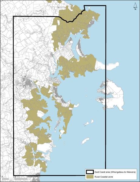
15 6.2 East Coast area Whangateau to Waiwera Background The East Coast area extends from Rodney Road (Pākiri Hill) south as far as the northern bank of Waiwera River. Its inland boundary generally follows State Highway 1 from Waiwera to Warkworth, before extending northeast to the east of Matakana Road and along Leigh Road. Public roads are located along the ridgelines and provide access to the coastal edge. This coastal area is typically characterised by an indented and variable coastline with steep headlands, small coves, sheltered beaches and harbours, interspersed with extensive, more exposed sandy beaches. A sequence of five major estuaries are distributed along the eastern coast area Whangateau, Matakana, Mahurangi, Pūhoi and Waiwera. Within these estuarine environments, inter fingering of land and water provides extensive nooks and crannies which brings the coastal environment some distance inland as it follows these inlets. Between Mahurangi and Waiwera, the land is characterised by steep to rolling rural land with extensive areas of indigenous vegetation and partially bush clad slopes. In general, there are few areas of flat land, the largest areas being at Omaha Beach and Omaha flats. Given the hilly topography, the areas have high view amenity from land out to sea, both nearshore across estuaries and to more distance islands in the Hauraki Gulf. Much of the coastal edge is identified as having areas of ONHC with further expanses of land identified as ONLs and SEAs. Five regional parks at Tāwharanui, Scandretts, Mahurangi East, Mahurangi West and Wenderholm provide public access and recreational opportunities, as well as being significant ecological areas. The East Coast area provides a favourite location for rural lifestyle development and coastal holiday homes. It also provides extensive opportunity for recreational use of the coastline and estuarine areas, with scattered boat launching facilities. The satellite town of Warkworth and the coastal settlements of Snells Beach, Leigh, Point Wells, Omaha, Matakana, Sandspit and Waiwera are all close to the East Coast area. Objectives 1. The open, high quality coastal landscape character and the natural environmental values of the East Coast area are retained. Recreational, home occupation, marine transport and tourism activities are supported where they are consistent the coastal landscape character and natural environmental values of the area. The management of activities and development is integrated with the management of growth in identified rural and coastal towns and settlements. The high natural values of the east coast estuaries are maintained by requiring high performance standards for activities and development on land. Policies 1. Require dwellings, their curtilage and access to be located sensitively in the landscape, with particular consideration of their size, location, scale and density, ability to tuck into the landscape and the desire for views against visual dominance in landscape. Assess the visual and landscape impacts of greenhouses and buildings for intensive farming in the rural area. Avoid locating dwellings and other significant buildings on ridgelines and the construction of urban type access ways up or across visually significant slopes. Recognise and support the high recreational values of the area, particularly accessibility to, and use of,
16 the CMA by enabling: a. the continued use of Sandspit as a transport terminal to Kawau Island the efficient operation of existing public boat launching facilities and the establishment of new public facilities in appropriate locations. 5. Avoid activities and development of a type, scale or location that adversely affects the public use and enjoyment of regional parks and other public open space for: a. active and passive recreation, both on land and in the adjoining CMA d. appreciation of open space, scenic and natural landscape values centres for biodiversity management and enhancement farmland management Enable the development and operation of local home occupations that support rural production, tourist trails, farmers markets and tourist facilities in centres such as Warkworth, Snells Beach Algies Bay and Matakana. Concentrate larger scale tourist facilities, including tourist accommodation, in rural and coastal towns. Figure 2: East Coast Area Whangateau to Waiwera
17
18 6.3 West Coast area Kaipara South Head and harbour Background The West Coast area includes significant areas of Kaipara South Head, the Ōkahukura (Tāpora) Peninsula and the eastern coastal margins of the Kaipara Harbour. The area is characterised by a predominance of rural production activity, particularly pastoral farming activities and forestry and its significance to Māori. Long, highenergy beaches backed by sand dunes are located along the coast, terminating in the significant high dune landforms and Papakanui spit at South Kaipara Head. Three main roads serve the area State Highway 16, South Head Road and Run Road Journey's End. There are high amenity views of the harbour from State Highway 16 in particular. Flat coastal alluvial plains are a special landscape feature in the Kaipara Harbour catchment. These are backed by a convoluted coastline with rolling hills. This harbour is highly tidal with extensive areas of exposed intertidal flats and defined low tidal channels and occasional mangrove communities. The remaining natural areas are important due to past vegetation clearance and wetland drainage. Activities such as sand extraction, marine farming and tidal energy generation occur in the Kaipara Harbour. Significant bird habitats are present along the coastal margins and in the harbour, particularly around the sand islands at Tāpora. Tāpora, Wharehine and Port Albert are sensitive to development due to the elevated nature of many of the surrounding roads, and due to the rolling and often open natural of the land which also connects to the low lying alluvial plains. Development has increased in particular along the west coast of the Kaipara Harbour and along South Head. A pattern of typically large properties and low density settlement provides a rural and semi remote character. Woodhill Forest along the western margins of South Kaipara peninsula provides production, recreation, sand stabilisation and landscape functions. It is a significant site for active sports such as mountain biking. Topography and private land ownership limits access to the coastal edge in many areas. However, Ātiu Creek Park provides public access to the Ōruawhero arm of Kaipara Harbour. Small bach communities are located at Shelly Beach, Journey's End and Port Albert, with Shelly Beach providing the main boat launching facility. South Head and the coast of the Kaipara Harbour while generally meeting the above description are noted as areas which are also recognised as being under pressure for development that is not directly related to rural production activity due to the coastal location and proximity to metropolitan Auckland. However, there are areas of significant landscape identified in the overlays as ONC, HNC, and ONL, which are considered to be at risk of degradation. Control over the built environment in these areas is considered prudent in order that the semi remote character and the rural/coastal landscape, environmental and amenity values present are retained. To recognise these qualities the whole area isincluded in the Rural Coastal zone with particular development and subdivision controls that enable normal rural activities such as farming and forestry to continue as permitted activities, albeit subject to more stringent environmental controls (relating to buildings, earthworks on sites 40 hectares and less in area (that are not already provided for as a Permitted Activity), tree and bush removal, and wetland/watercourse modification to ensure they respond sensitively to the landscape qualities present. Development controls to recognise these features and associated values include a slightly higher height allowed for dwellings, with slightly greater maximum height for farm and forestry rural accessory buildings within an identified ONL.
19 Objectives 1. The special and distinctive coastal and rural character of the West Coast area is retained. Land based activities and development are managed to protect the area s Outstanding and High Natural Character and landscape values, and its ecological, recreation and amenity values. The relationship between the land, the Tasman Coast and the Kaipara Harbour, and the physical, ecological, landscape, amenity and production connections between the two is recognised and maintained. Significant Māori associations with the Kaipara Harbour area recognised and provided for. Policies 1. Enable rural production activities, particularly pastoral farming and forestry, for their economic and social contribution to Auckland and for their role in retaining a remote rural and coastal character Maintain a low intensity of built development, where buildings are for farming and forestry purposes rather than for rural lifestyle purposes. Require buildings for intensive farming to be sited to minimise visual impacts on natural character and landscape values. Retain a range of land holding sizes, particularly those larger land holdings used for pastoral farming activities. Improve public access to the Kaipara Harbour, including boat launching facilities where this does not adversely affect important habitat areas, such as the Tāpora sand islands. This part of the Rural Coastal zone (Figure 3 below) reflects the special and distinctive coastal and rural character of parts of the Kaipara Harbour and South Head areas, these rural and semi remote areas are influenced by the Tasman Sea and Kaipara Harbour. This part of the zone encompasses the following: a. rural coastal character d. high amenity values high natural character high landscape values 7. Require subdivision and land use activities to enhance and protect the distinctive special character of the policy area and ensure that the landscapes and sensitive environments are protected.

20 Figure 3: West Coast area Kaipara South Head and harbour
21 6.4 Muriwai to Te Henga coastal area Background This coastal area of Muriwai to Te Henga consists of the rugged coastal strip between Muriwai and Bethells Beach/Te Henga and the area inland as far as the edge of the hill country west of Waitākere township. Although some parts of the area are more distant from the coast, they are included in the coastal area because of their open space and natural qualities. Typically this area is characterised by its predominance of natural qualities, including open space that is largely unmodified by the built environment, significant roads or other landscape modifications. Largely uninhabited steep, rugged indented coastal cliffs are present along the West Coast with small beaches amid high, rocky headlands. Rolling to steep hills extend inland from the coast. Areas of regenerating and significant indigenous vegetation are also present. Rural lifestyle development to the south of Muriwai settlement is focused on Ōaia and Constable Roads but set back from the coastal edge. An Open Space zone running the length of the Muriwai/Bethells Beach coastline separates the coastal area from the CMA. Part of the area to the south is included in the Waitākere Ranges Heritage Area. Objectives 1. The natural, coastal and non urban character of the Muriwai Bethells Beach coastal area is protected and retained. Activities are managed in this coastal area to maintain the values of the adjoining Open Space zone. Policies 1. Manage built development on existing rural titles and from title boundary realignments so that its size, location and density of buildings does not dominate natural elements and the area retains a rural character rather than one of rural lifestyle domestication. Avoid site dwellings and accessory buildings overlooking public walkways or locations such as headlands or ridgelines where they would be highly visible from the Open Space zone. Avoid built development requiring significant clearance of existing regenerating and established indigenous vegetation.

22 Figure 4: Muriwai to Te Henga coastal area
23 6.5 Tasman Coast area Āwhitu Peninsula Background The Tasman coastal area comprises the western margins of the Āwhitu Peninsula. This is a relatively straight section of coast extending from the Manukau Harbour south to the council boundary with Waikato District. The area is characterised by several distinctive landforms, including a narrow beach backed by a steep bluff that typically rises sharply to m above sea level and several dune lakes. Public roads are generally km inland with no direct access to the coast, apart from at Karioitahi Beach and Hamilton s Gap. The length of the sandy Tasman Coast is prone to coastal erosion and sand drift. Severe blowouts, migrating dunes and sand sheets can be exacerbated when vegetation is disturbed. The dune lakes of Pēhiākura and Pokorua are generally surrounded by privately owned land and lack public road access. The area as a whole is one of high natural character and outstanding natural landscapes. Steep hill country gives the area a wild, scenic and remote landscape character. Pastoral land comprises large farm holdings with pockets of indigenous vegetation and forestry. Settlement is typically sparse characterised by farm houses and accessory buildings and located adjacent to existing roads. A long history of Māori settlement has left a legacy of places and sites of significance to local iwi and strong cultural associations with the peninsula as a whole. Objectives 1. The high natural values, including natural character, landscapes and other resources are protected from inappropriate subdivision, use and development while providing for rural activities. Natural coastal processes are recognised and managed by avoiding activities that would create or exacerbate coastal erosion and sand blowouts along the Tasman coastline. The potential for this coastal area to support renewable wind energy generation facilities is acknowledged. Policies 1. Provide for limited subdivision, use and development that will enable coastal natural character and landscape values to be maintained and enhanced. 5. Avoid land modification and development along sandy coastal margins and seaward faces of the coastal escarpments or ridgelines. Encourage protection of stands of indigenous bush, and restoration and enhancement planting of indigenous trees, shrubs and other plants along the coastal escarpments and ridgelines. Promote public access to the coast in strategic locations, in conjunction with environmental protection, enhancement or restoration and in a way that does not adversely affect coastal processes and natural character and significant indigenous vegetation and habitats. Recognise the wild, scenic, and remote values of the Tasman Coast.

24 Figure 5: Tasman Coast area Āwhitu Peninsula
25 6.6 Manukau Harbour coastal area Background The Manukau Harbour coastal area encompasses the harbour fringe from Wattle Bay at the harbour entrance to the Whangamaire Stream arm of the Pāhurehure Inlet, west of Hingaia. This coastal margin is physically diverse with a wide variety of environments including beaches, headlands, cliffs and estuaries. It is characterised by low lying rural flatlands, low terraces and rolling topography deeply indented by the Waiuku and Taihiki rivers and various estuarine creeks and inlets. The coastal area forms part of the wider Franklin lowlands with highly productive soils, pastoral and horticultural land uses and an intensive pattern of land subdivision into small rural sites. The Waiuku River, indented toward the mainland, is associated with low coastal cliffs and rural land sloping down to a mangrove lined estuary, where views are available across land and water. The eastern margin of the Āwhitu Peninsula with coastal terraces and flats, is backed by higher and steeper areas, and a sequence of inlets and prominent coastal headlands from Matakawau south to Waiuku township. The small coastal settlements are located at Clarks, Waiau and Glenbrook beaches, with scattered, typically traditional bach areas at Wattle Bay, Ōrua Bay, Big Bay, Graham s Beach and Matakawau Point which are zoned as coastal settlements rather than rural coastal. Low elevation views out and across Manukau Harbour are afforded from the local headlands. Inter tidal banks and flats of the Manukau Harbour are visually prominent, and provide an area of international significance for roosting and feeding for migratory wading birds. The coastal margin pastoral land is utilised by birds as part of the wider southern Manukau Harbour wildlife habitat. There are larger holdings on the eastern Āwhitu coastline than along the southern Manukau coast, with a predominance of pastoral farming activities. Overall in this location there is a relative absence of dwellings in proximity to much of the coastline. Natural character is based on agricultural land uses and absence of built development rather than the presence of indigenous vegetation. The area also has important cultural significance. Āwhitu Regional Park provides important public recreational and access point to the coast to the Manukau Harbour. Objectives 1. Rural production activities are continued in the Manukau Harbour coastal area while maintaining its rural coastal character and visual amenity values. 5. Activities in the coastal area are managed to protect the ecological values of the Manukau Harbour, particularly identified wader bird habits, and the visual and landscape interconnections between land and sea. Identified special character areas are protected from inappropriate land use activities, built development and further subdivision. Coastal and riparian vegetation quality and quantity in the coastal area are improved. Built development and inappropriate land use activities are avoided within critical coastal margins at risk of coastal flooding or erosion. Policies 1. Recognise the significance of the coastal margin setback in maintaining the natural character of the coastal edge, providing a natural buffer to coastal erosion flooding and contributing to the visual amenity
26 values of the Manukau Harbour coastal edge. Require dwellings and other significant built development, other than fences, to locate outside the coastal margin setback. Protect the special character areas listed in policy 4 below by: a. controlling the location, scale and density of built development having vegetation cover and production land uses that are appropriate to the area in terms of use by wader birds. Recognise the following areas are identified as being of special character in the Manukau Harbour coastal area: a. Clarks Beach to Seagrove and Ellets Beach d. e. f. g. h. i. j. k. Pollok Spit Āwhitu Regional Park and Environs Waipipi Creek Roosts The Western Needles Promontory Kelly s Landing Headland Dickey s Landing Headland/Kauri Point Headland Kauri Road Headland Andrew Pye Road Headland Mako Point Headland Headland between Wattle Bay and Ōrua Bay Improve public access to, and along, the coastal edge, except in identified wader bird and wāhi tapu areas, by providing esplanade and other reserves. Avoid activities and development of a type or scale or location that adversely affects the public use and enjoyment of the Āwhitu Regional Park for: a. active and passive recreation, both on land and in the adjoining CMA appreciation of open space, scenic and natural landscape values farmland management. 7. Require enhancement of the coastal edge and riparian margins as part of any development for rural lifestyle purposes or non residential activities.

27 Figure 6: Manukau Harbour coastal area
28 6.7 Tāmaki Firth coastal area Background The Tāmaki Firth coastal area encompasses rural coastal land from Maraetai south east to the regional boundary south of Matingarahi on the Firth of Thames. It is a mixture of flat land around the lower reaches of the Wairoa River and at Kawakawa Bay, Ōrere Point and Waimangu Point, separated by rolling to steep hill country. This coastal area is predominantly pastoral land but backs onto steep forest covered hill country in the north and the Hunua Ranges in the south. There is no continuous coastal road connecting the area as a whole. It is typically characterised by a variable coastline with a rocky shoreline of small coves and headlands, cliffs, wider sandy beaches, prominent headlands, shallow beaches, separated by rolling land, which gives way to shallow gravel beaches in the south. Pastoral farming is predominant, interspersed with local areas of indigenous vegetation. There are four regional parks within the area Duder, Waitawa, Tawhitokino and Tāpapakanga. In terms of settlements, there is a rural town at Clevedon and coastal settlements at Kawakawa Bay and Ōrere Point. A new rural residential node at Matingarahi extends both sides of the main coastal road. The area is historically significant to Māori, including Umupuia. Important coastal pōhutukawa give the area its name the Pōhukutawa Coast. The southern part of this coastal area acts as the entry to coastal Firth of Thames and provides a significant bird habitat and many natural features. Objectives 1. The rural production, rural and open space character of the Tāmaki Firth coastal area is maintained. The creation of new settlements or rural lifestyle nodes near Matingarahi are avoided. The scenic values associated with the Pōhutukawa Coast highway are maintained. Coastal pōhutukawa trees are protected. Policies 1. Enable rural production activities for their economic and social contribution to Auckland and for their role in retaining the rural and coastal character of this area. 5. Avoid establishing new rural lifestyle settlement nodes along the coastal edge and contain Matingarahi within its existing boundaries. Avoid locating dwellings and other significant buildings on prominent headlands and ridgelines and the construction of urban type access ways up or across visually significant slopes. Manage the location, type and scale of non rural production activities along the Pōhutukawa Coast Highway to ensure that its rural character and scenic values are maintained. Avoid activities and development of a type or scale or location that adversely affect public use and enjoyment of regional parks and other public open space for: a. active and passive recreation, both on land and in the adjoining CMA d. appreciation of open space, scenic and natural landscape values centres for biodiversity management and enhancement farmland management.

29 6. Recognise and support the high recreational values of the area, particularly accessibility to and use of the CMA by enabling the efficient operation of existing public boat launching facilities and the establishment of new public facilities in appropriate locations. Figure 7: Tamaki Firth coastal area
H19.1 Background There are five rural zones covered in H19. Rural zones: Rural Rural Production Zone; Rural Mixed Rural Zone;
 H19. zones H19.1 Background There are five rural zones covered in H19. zones: Production ; Mixed ; Coastal ; Conservation ; and Countryside Living. These zones, and their provisions, provide the main framework
Tāhuhu whakaruruhau ā-taone The sheltering ridge pole
 B2. Tāhuhu whakaruruhau ā-taone - Urban growth and form B2.1. Issues Tāhuhu whakaruruhau ā-taone The sheltering ridge pole Auckland s growing population increases demand for housing, employment, business,
Plan Modification to Chapter B2 of the Auckland Unitary Plan(AUP) Operative in part (15 November 2016)
 Operative in part (15 November 2016)") UNITARY PLAN UPDATE REQUEST MEMORANDUM TO FROM Phill Reid Linley Wilkinson DATE 25 September 2018 SUBJECT Plan Modification to Chapter B2 of the Auckland Unitary Plan(AUP) Operative in part (15 November
UNITARY PLAN UPDATE REQUEST MEMORANDUM TO FROM Phill Reid Linley Wilkinson DATE 25 September 2018 SUBJECT Plan Modification to Chapter B2 of the Auckland Unitary Plan(AUP) Operative in part (15 November
H7 Open Space zones. (a) provide for the needs of the wider community as well as the needs of the community in which they are located;
 provide for the needs of the wider community as well as the needs of the community in which they are located;") H7. Open Space zones H7.1. Background The majority of land zoned as open space is vested in the Council or is owned by the Crown. However some areas zoned open space are privately owned. While the open
H7. Open Space zones H7.1. Background The majority of land zoned as open space is vested in the Council or is owned by the Crown. However some areas zoned open space are privately owned. While the open
Chapter 3: Natural Environment. Proposed Waikato District Plan Stage 1. (Notified version)
") Chapter 3: Natural Environment Proposed Waikato District Plan Stage 1 Page 2 of 7 Contents Chapter 3: Natural Environment... 3 3.1 Indigenous Vegetation and Habitats... 3 3.1.1 Objective Biodiversity and
Chapter 3: Natural Environment Proposed Waikato District Plan Stage 1 Page 2 of 7 Contents Chapter 3: Natural Environment... 3 3.1 Indigenous Vegetation and Habitats... 3 3.1.1 Objective Biodiversity and
CA.1 Coastal Area. Index. CA.1.1 Description and Expectations
 Index.1.2.3.4 CA.2 CA.2.1 CA.2.2 CA.2.3 CA.3 CA.3.1 CA.3.2 CA.3.1 CA.4 CA.4.1 CA.4.2 CA.4.3 CA.4.4 CA.5 CA.5.1 CA.5.2 Description and Expectations Objectives Policies Guidance Note Landuse Eligibility
LANDSCAPE GUIDELINES. Countryside & Coastal Countryside Environments. Landscape, Natural Character & Amenity Values Guide
 Landscape, Natural Character & Amenity Values Guide Copyright WDC 2009 Version A2 18May09 Environmental Services Group Publication Countryside & Coastal Countryside Environments START HERE Quality Land
B4. Te tiaki taonga tuku iho - Natural heritage
 B4. Te tiaki taonga tuku iho - Natural heritage Tuia I runga, tuia i raro, tuia ki te waonui a Tiriwa Bind the life forces of heaven and earth to the great realm of Tiriwa B4.1. Issues Auckland s distinctive
E15. Vegetation management and biodiversity
 E15. management and biodiversity E15.1. Background contributes to a range of ecosystem services such as erosion and sediment control, reducing stormwater flows, protecting or enhancing water quality, amenity
Section 3b: Objectives and Policies Rural Environment Updated 19 November 2010
 Page 1 of Section 3b 3b RURAL ENVIRONMENT 3b.1 Introduction The Rural Environment comprises all the land outside of the Residential, Town Centre and Industrial Environments. Most land within the District
I511. Hatfields Precinct
 I511. Hatfields Precinct I511.1. Precinct Description The Hatfields Precinct is a contiguous 183.8 hectare block of rural land held in 8 freehold titles, located immediately to the north of Hatfields Beach.
Proposed Southland District Plan 2012 Appeal Version October 2016
 S e c t i o n 3. 5 - F i o r d l a n d / R a k i u r a Z o n e The Fiordland/Rakiura Zone encompasses the Fiordland and Rakiura National Parks and part of Mt Aspiring National Park. It also includes areas
D10. Outstanding Natural Features Overlay and Outstanding Natural Landscapes Overlay
 D10. Outstanding Natural Features Overlay and Outstanding Natural Landscapes Overlay D10.1. Background These provisions give effect to Policy 15(a) of the New Zealand Coastal Policy Statement 2010, and
D10. Outstanding Natural Features Overlay and Outstanding Natural Landscapes Overlay
 D10. Outstanding Natural Features Overlay and Outstanding Natural Landscapes Overlay D10.1. Background These provisions give effect to Policy 15(a) of the New Zealand Coastal Policy Statement 2010, and
I542. Te Arai South Precinct
 I542. Te Arai South Precinct I542.1. Precinct Description The Te Arai South Precinct contains approximately 750ha of coastal land south of Te Arai Point, known as Mangawhai South Forest. The land within
GIBBSTON CHARACTER ZONE. QLDC PROPOSED DISTRICT PLAN [PART FOUR] AUGUST gibbston character zone
![GIBBSTON CHARACTER ZONE. QLDC PROPOSED DISTRICT PLAN [PART FOUR] AUGUST gibbston character zone](/thumbs/75/72573993.jpg "GIBBSTON CHARACTER ZONE. QLDC PROPOSED DISTRICT PLAN [PART FOUR] AUGUST gibbston character zone") 23 GIBBSTON CHARACTER ZONE QLDC PROPOSED DISTRICT PLAN [PART FOUR] AUGUST 2015 23 gibbston character zone QLDC PROPOSED DISTRICT PLAN [PART FOUR] AUGUST 2015 23 gibbston character zone 23.1 Zone Purpose
23 GIBBSTON CHARACTER ZONE QLDC PROPOSED DISTRICT PLAN [PART FOUR] AUGUST 2015 23 gibbston character zone QLDC PROPOSED DISTRICT PLAN [PART FOUR] AUGUST 2015 23 gibbston character zone 23.1 Zone Purpose
I611. Swanson North Precinct
 I611. Swanson North Precinct I611.1. Precinct Description Swanson North is located in the north eastern foothills of the Waitakere Ranges. It is outside the Waitakere Ranges Heritage Area Act and the Waitakere
AUCKLAND UNITARY PLAN
 AUCKLAND UNITARY PLAN Report To: Report Name: Executive summary Unitary Plan Political Working Party Issues and approaches for rural and coastal areas There are 12 key issues facing rural and coastal areas
RURAL ZONE - POLICY. Rural Zone Policy. Issue: Rural Environment. Ruapehu District Plan Page 1 of 8
 Rural Zone Policy RU2 RURAL ZONE - POLICY RU2.1 Introduction The natural resources of the rural environment in the Ruapehu District provide the basis for the existing and potential character, intensity
2A District-wide Policies
 2A Introduction This Chapter contains policies which are relevant to subdivision, use and development activities occurring across all zones and areas of the District. The policies in this Chapter implement
23B.1 ACTIVITY STATUS RULES COASTAL ZONE
 RULE 23B COASTAL ZONE 23B.1 ACTIVITY STATUS RULES COASTAL ZONE 23B.1.1 PERMITTED ACTIVITIES COASTAL ZONE The following activities are Permitted Activities in the Coastal Zone if they meet all the standards
D1. High-use Aquifer Management Areas Overlay
 D1. High-use Aquifer Management Areas Overlay D1.1. Background Aquifers are important as direct sources of water supply for domestic, industrial and rural use. They are the major contributors to the base
Section 6A 6A Purpose of the Natural Features and Landscapes Provisions
 Section 6A 6A Purpose of the Natural Features and Landscapes Provisions This Chapter addresses the protection and management of natural features and landscapes within the City. The City has a number of
I604. Hobsonville Marina Precinct
 I604. Hobsonville Marina Precinct I604.1. Precinct description Hobsonville Marina Precinct is located at Clearwater Cove, Hobsonville in Auckland s upper Waitemata Harbour. The precinct includes the coastal
I541. Te Arai North Precinct
 I541. Te Arai North Precinct I541.1. Precinct Description The Te Arai North Precinct contains approximately 616ha of coastal land north of Te Arai Point, generally known as Mangawhai North Forest. The
I539. Smales 2 Precinct
 I539. Smales 2 Precinct I539.1. Precinct Description The Smales 2 Precinct applies to a 4.8 hectare block of land located on the southern side of Northcote Road and fronting Lake Pupuke, Takapuna. The
The Proposed Auckland Unitary Plan (notified 30 September 2013)
") 8 Special Purpose zones 8.1 Airport zone The Airport zone applies to the Kaipara Flats Airfield, North Shore Airfield, Auckland International Airport and Ardmore Airport. Auckland International Airport
8 Special Purpose zones 8.1 Airport zone The Airport zone applies to the Kaipara Flats Airfield, North Shore Airfield, Auckland International Airport and Ardmore Airport. Auckland International Airport
I403 Beachlands 1 Precinct
 I403. Beachlands 1 I403.1. Precinct Description Beachlands is a rural and coastal village located on the eastern side of Auckland, adjoining the Tamaki Strait coastline. The original Beachlands village
4 OVERVIEW. Contents. 4.1 Introduction. 4.2 Profile of the Rodney District Location The People Function of Places
 4 OVERVIEW Contents 4.1 Introduction 4.2 Profile of the Rodney District 4.2.1 Location 4.2.2 The People 4.2.3 Function of Places 4.3 Rodney District in the Regional Context 4.3.1 Rodney District 4.3.2
6 HIGHLY VALUED NATURAL RESOURCES
 6 HIGHLY VALUED NATURAL RESOURCES Contents 6.1 Introduction 6.1.1 Highly Valued Natural Resources 6.1.2 Significant Natural Areas 6.1.3 Highly Valued Landscapes 6.1.4 Geologically Significant Sites 6.2
LANDSCAPE UNIT 10 Te Kawau, Turipeka & Otautu Point
 Location Map LANDSCAPE VALUES Landscape Unit No. 10 Description: Te Kawau, Turipeka, & Otautu Point KEY LANDSCAPE FACTORS / VARIABLES LANDSCAPE UNIT 10 Te Kawau, Turipeka & Otautu Point LEGEND Outstanding
I615. Westgate Precinct
 I615. Westgate Precinct I615.1. Precinct Description The Westgate Precinct is located approximately 18km west of the Auckland city centre. There are seven Sub-precincts in the Westgate Precinct: Sub-precinct
The Proposed Auckland Unitary Plan (notified 30 September 2013)
") 3 Business zones Introduction There are 10 business zones in the Unitary Plan: City Centre Metropolitan Centre Town Centre Local Centre Neighbourhood Centre Mixed Use General Business Business Park Light
3 Business zones Introduction There are 10 business zones in the Unitary Plan: City Centre Metropolitan Centre Town Centre Local Centre Neighbourhood Centre Mixed Use General Business Business Park Light
H10. Business Town Centre Zone
 H10. Business Town Centre Zone H10.1. Zone description The Business Town Centre Zone applies to suburban centres throughout Auckland, the satellite centres of Warkworth and Pukekohe, and the rural towns
4 Residential and Urban Living Zones
 4 Residential and Urban Living Zones Refer to Chapters 11 to 20 for additional rules that may apply to these zones. 4.1 OBJECTIVES AND POLICIES Objective Res1 Policy 1 Policy 2 Policy 3 Policy 4 Policy
1 INTRODUCTION TO NATURAL ENVIRONMENT
 Kāpiti Coast District Plan Review Section 32 Analysis Summary Report 1 INTRODUCTION TO NATURAL ENVIRONMENT Diverse landscapes, plants and animals make up the natural environment of the District. Much has
H1. Residential Large Lot Zone
 H1. Residential Large Lot Zone H1.1. Zone description The Residential Large Lot Zone provides for large lot residential development on the periphery of urban areas. Large lot development is managed to
3. STATEMENTS OF DESIRED CHARACTER FOR PLANNING AREAS AND PRECINCTS
 3.30 Planning Area No. 30 Mary River Valley 3.30.1 Location and Role This Planning Area encompasses rural lands in the western part of the Shire. These lands are located within the catchment area of the
For more information, go to
 For more information, go to www.shapeauckland.co.nz The draft Auckland Unitary Plan View the video: Shaping the world s most liveable city One simplified plan Where we live Where we work What we value
PART 5 - NATURAL AND PHYSICAL ENVIRONMENT
 CONTENTS...PAGE 5.1 INTRODUCTION...3 5.2 NATURAL RESOURCES...4 5.3 PHYSICAL RESOURCES...4 5.4 COASTAL ENVIRONMENT...4 5.5 HERITAGE FEATURES...4 5.6 HAZARDS...4 5.7 SUMMARY...4 ISTHMUS SECTION - OPERATIVE
Assessment of Landscape, Visual and Natural Character Effects
 Assessment of Landscape, Visual and Natural Character Effects Consent Footprint Amendments Mangamaunu Half Moon Bay Okiwi Bay South Report prepared for: New Zealand Transport Agency and KiwiRail Holdings
SECTION 2.4 URBAN DEVELOPMENT AND STRATEGIC URBAN DIRECTIONS
 SECTION 2.4 URBAN DEVELOPMENT AND STRATEGIC URBAN DIRECTIONS 2.4.1 INTRODUCTION In 1993/94 the Hastings District Council completed the Hastings Urban Development Strategy. The purpose of this study was:
I602. Birdwood Precinct
 I602. Birdwood Precinct I602.1. Precinct description The Birdwood Precinct applies to an area west of Don Buck Road and south of Red Hills Road in west Auckland. It incorporates subdivision and development
The Proposed Auckland Unitary Plan (notified 30 September 2013)
") 7 West 7.1 Avondale 1 The objectives and policies of the underlying Mixed Use zone apply in the following precinct unless otherwise specified. Refer to planning maps for the location and extent of the
7 West 7.1 Avondale 1 The objectives and policies of the underlying Mixed Use zone apply in the following precinct unless otherwise specified. Refer to planning maps for the location and extent of the
open space environment
 This section updated August 09 GUIDELINE TO THE RULES The Open Space Environment Rules apply to activities on sites within the Open Space Environment as shown on the Human Environments Maps. Most of the
RLE.1 Rural Living Environment
 Index.1 Description and Expectations.2 Objectives.3 Policies.4 Guidance RLE.2 Landuse RLE.2.1 Eligibility Rules RLE.2.2 Notification Rules RLE.2.3 Discretionary Activities RLE.3 Subdivision RLE.3.1 Eligibility
Rural Subdivision and Development
 Rural Subdivision and Development Design Guidelines MAY 2012 1 Rural Subdivision and Development Design Guidelines 2The open spaciousness of the rural environment in the foreground of Mount Taranaki from
REMARKABLES PARK ZONE
 .10 Remarkables Park Zone.10.1 Resources, Activities and Values The Remarkables Park Area comprises approximately 150 hectares of perimeter urban land in the vicinity of Frankton and occupies a strategic
STRATEGIC DIRECTION. QLDC PROPOSED DISTRICT PLAN [PART TWO] DECISIONS VERSION 3 strategic direction
![STRATEGIC DIRECTION. QLDC PROPOSED DISTRICT PLAN [PART TWO] DECISIONS VERSION 3 strategic direction](/thumbs/79/79711764.jpg "STRATEGIC DIRECTION. QLDC PROPOSED DISTRICT PLAN [PART TWO] DECISIONS VERSION 3 strategic direction") 3 STRATEGIC DIRECTION QLDC PROPOSED DISTRICT PLAN [PART TWO] DECISIONS VERSION 3 strategic direction QLDC DISTRICT PLAN [PART TWO] AUGUST 2015 3 strategic direction 3.1 Purpose This chapter sets out the
3 STRATEGIC DIRECTION QLDC PROPOSED DISTRICT PLAN [PART TWO] DECISIONS VERSION 3 strategic direction QLDC DISTRICT PLAN [PART TWO] AUGUST 2015 3 strategic direction 3.1 Purpose This chapter sets out the
PART II APPENDIX 3: COASTAL TASMAN AREA SUBDIVISION AND DEVELOPMENT DESIGN GUIDE
 Operative Part II, Appendix 3 Coastal Tasman Area Subdivision and Development Design Guide 26 September 2009 PART II APPENDIX 3: COASTAL TASMAN AREA SUBDIVISION AND DEVELOPMENT DESIGN GUIDE CHAPTER 1 -
I422. Māngere Gateway Precinct
 I422. Māngere Gateway Precinct I422.1. Precinct description The Māngere Gateway Precinct is comprised of land generally north of the Auckland International Airport and west of George Bolt Memorial Drive
H14. Business General Business Zone
 H14. Business General Business Zone H14.1. Zone description The Business General Business Zone provides for business activities from light industrial to limited office, large format retail and trade suppliers.
I326. Ōrākei 1 Precinct
 I326. Ōrākei 1 recinct I326.1. recinct Description The Ōrākei 1 recinct includes the land identified as hapu reservation (land held for the purposes of a marae, church, urupa and related hapu amenities)
QLDC PROPOSED DISTRICT PLAN [PART FOUR] NOVEMBER WAKATIPU BASIN WAKATIPU BASIN
![QLDC PROPOSED DISTRICT PLAN [PART FOUR] NOVEMBER WAKATIPU BASIN WAKATIPU BASIN](/thumbs/82/85315845.jpg "QLDC PROPOSED DISTRICT PLAN [PART FOUR] NOVEMBER WAKATIPU BASIN WAKATIPU BASIN") QLDC PROPOSED DISTRICT PLAN [PART FOUR] NOVEMBER 2017 24 WAKATIPU BASIN 24 WAKATIPU BASIN QLDC PROPOSED DISTRICT PLAN [PART FOUR] NOVEMBER 2017 24 WAKATIPU BASIN 24.1 Zone Purpose This chapter applies
QLDC PROPOSED DISTRICT PLAN [PART FOUR] NOVEMBER 2017 24 WAKATIPU BASIN 24 WAKATIPU BASIN QLDC PROPOSED DISTRICT PLAN [PART FOUR] NOVEMBER 2017 24 WAKATIPU BASIN 24.1 Zone Purpose This chapter applies
Rochford District Council Allocations Development Plan Document: Discussion and Consultation Document Sustainability Appraisal
 Option SWH1 Balanced Communities Option SWH1 1 To ensure the delivery of high quality sustainable communities where people want to live and work Will it ensure the phasing of infrastructure, including
Appendix 1 Structure plan guidelines
 Appendix 1 Structure plan guidelines This appendix forms part of the regional policy statement [rps]. 1.1. Introduction Structure plans are an important method for establishing the pattern of land use
6 Landsc apes and rur al char ac
 LANDSCAPES AND RURAL CHARACTER QLDC PROPOSED DISTRICT PLAN [PART TWO] DECISION VERSION ter 6 Landsc apes and rur al char ac 6.1 Purpose Appendix C QLDC DISTRICT PLAN [PART TWO] DECISION VERSION 6 Landsc
7. Landscape. Introduction
 Introduction Our landscapes provide us with a Marlborough identity and are an integral part of the Marlborough environment. Landscapes are distinct spatial areas influenced by location-specific processes
4 RESIDENTIAL ZONE. 4.1 Background
 4 RESIDENTIAL ZONE 4.1 Background The residential areas within the City are characterised by mainly lowrise dwellings sited on individual allotments. Past architectural styles, settlement patterns and
H13. Business Mixed Use Zone
 H13. Business Mixed Use Zone H13.1. Zone description The Business Mixed Use Zone is typically located around centres and along corridors served by public transport. It acts as a transition area, in terms
Huapai North. Variation 127 DECISIONS VERSION. Variation 127 Special 29 Zone
 Huapai North Variation 127 DECISIONS VERSION DECISIONS VERSION The amendments to the Variation that have been made as a result of decisions on submissions are shown as strikethrough or underlined. RESOURCE
Section 12C Subdivision in the Rural Residential Zone
 Section 12C 12C Subdivision in the Rural Residential Zone The Rural Residential Zone provides part of the range of residential opportunities within the City. Land zoned rural residential is considered
6.1 Introduction [In 2007, Proposed Change 8: Volcanic Features and Landscape was separated into two components, being
 Heritage: 6 1 6.1 Introduction [In 2007, Proposed Change 8: Volcanic Features and Landscape was separated into two components, being Volcanic Features and Landscape. Proposed Change 8: Volcanic Features
H9. Business Metropolitan Centre Zone
 H9. Business Metropolitan Centre Zone H9.1. Zone description The Business Metropolitan Centre Zone applies to centres located in different subregional catchments of Auckland. These centres are second only
Rural (Urban Expansion) Environment
 Environment") RUEE.1 Rural (Urban Expansion) Environment Subsequent to the receipt of appeals, a 'marked up' version of the Proposed District Plan was prepared. The provisions of the Proposed Version of the Plan subject
RUEE.1 Rural (Urban Expansion) Environment Subsequent to the receipt of appeals, a 'marked up' version of the Proposed District Plan was prepared. The provisions of the Proposed Version of the Plan subject
Appendix A. Planning Processes. Introduction
 1 Planning Processes Introduction This appendix outlines a number of planning processes which are used in the Auckland Region to support the effective management of development in the region s rural and
Northland Regional Landscape Assessment Worksheet
 Northland Regional Landscape Assessment Worksheet Unit name TE POUAHI HEADLAND DESCRIPTION AND CHARACTERISATION Component Land Types (refer to list overleaf) Dune complex Coastal cliffs / escarpment Reefs
The social effects assessment framework developed for this Project includes:
 26. Social This chapter presents a summary of our assessment of the Project s potential social effects (the full assessment is included in Appendix F to this AEE). The study area for the assessment of
Rural (Urban Expansion) Environment
 Environment") RUEE.1 Rural (Urban Expansion) Environment Index RUEE.1 RUEE.1.1 RUEE.1.2 RUEE.1.3 RUEE.1.4 RUEE.2 RUEE.2.1 RUEE.2.2 RUEE.2.3 RUEE.2.4 RUEE.3 Rural (Urban Expansion) Environment Description and Expectations
RUEE.1 Rural (Urban Expansion) Environment Index RUEE.1 RUEE.1.1 RUEE.1.2 RUEE.1.3 RUEE.1.4 RUEE.2 RUEE.2.1 RUEE.2.2 RUEE.2.3 RUEE.2.4 RUEE.3 Rural (Urban Expansion) Environment Description and Expectations
PART 5B - COASTAL CONTENTS...PAGE
 PART 5B - COASTAL CONTENTS...PAGE 5B.1 CONTENT AND STRUCTURE...3 5B.2 STATUTORY CONTEXT...3 5B.3 RESOURCE MANAGEMENT ISSUES...4 5B.4 RESOURCE MANAGEMENT OBJECTIVES AND POLICIES...6 5B.5 RESOURCE MANAGEMENT
Section 32 report: Natural heritage for the Proposed Natural Resources Plan for the Wellington Region
 Section 32 report: Natural heritage for the Proposed Natural Resources Plan for the Wellington Region Issues and Evaluation Report Section 32 report: Natural heritage for the Proposed Natural Resources
Site Option 3: Te Matai
 Site Option 3: Te Matai Location Napier Drain looking south east Description The Te Matai growth option is located between the existing residential boundary (Ruamahanga Crescent) Napier Road (State Highway
6.6.2 Emerging Community Zone Code Application Purpose and overall outcomes. s6 Zone Codes Emerging Community and Township Zone Codes
 6.6.2 Emerging Community Zone Code 6.6.2.1 Application This code applies to assessable development:- (1) within the Emerging Community Zone as identified on the zoning maps contained within Schedule 2
Types of Reserves. Recreational activities
 VALLEY FLOOR AND EASTERN HILLS Physical and ecological features Large, flat valley floor and river plain with intensive urban development Hutt River / Te Awa Kairangi and tributaries Waiwhetu Stream Eastern
8.0 Design and Form of Development 43/
 42/ 8.0 Design and Form of Development 43/ Rothwells Farm, Golborne/ Development Statement Figure 7. Site Constraints Key 44/ Site Boundary 360 Bus Route/Stops Existing Trees Underground Water Pipe Sensitive
4.3 Dudley Area Plan. Introduction. History and Existing Character. Desired Future Character for Dudley
 4.3 Dudley Area Plan Introduction The suburb of Dudley has developed as a result of various circumstances including its topography, history and mineral resources. Dudley development has been identified
PART 3 - RESOURCE MANAGEMENT
 CONTENTS... PAGE 3.1 INTRODUCTION... 3 3.2 NATURAL AND PHYSICAL ENVIRONMENT... 3 3.3 URBAN SUSTAINABLE MANAGEMENT... 5 3.4 RESOURCE MANAGEMENT ISSUES... 5 3.5 RESOURCE MANAGEMENT OBJECTIVES AND POLICIES...
HOROWHENUA DEVELOPMENT PLAN June create a safe crossing for children moving to and from the school and other areas. 7.8 Ohau
 7.8 Ohau create a safe crossing for children moving to and from the school and other areas. Ohau has a traditional village form with a collective of school, church and reserve at the main road intersection.
Oratia Local Area Plan. A Long Term Plan for the Character and Amenity of Oratia
 Oratia Local Area Plan A Long Term Plan for the Character and Amenity of Oratia Adopted 3 December 2009 2 The future of Oratia The Oratia Local Area Plan presents the outcome of a series of conversations,
AUCKLAND COUNCIL DISTRICT PLAN PAPAKURA SECTION
 AUCKLAND COUNCIL DISTRICT PLAN PAPAKURA SECTION OPERATIVE 16 JUNE 1999 D P Hawkins, Mayor T McLean, Chief Executive Officer Given under the Common Seal of the Papakura District Council this 16th day of
SUSTAINABLE MANAGEMENT
 . Sustainable Management.1 The Concept of Sustainable Management The concept of sustainable management recognises there are limits to the use of natural and physical resources and there is a need to balance
I412. Flat Bush Precinct
 I412. Flat Bush Precinct I412.1. Precinct description The Flat Bush precinct covers approximately 1730ha of land adjacent to the Rural Urban Boundary. The Flat Bush Precinct incorporates the provisions
64 Mineral Extraction Area Rules
 64 Mineral Extraction Area Rules 64.1 Introduction For the purposes of this Chapter: Active Area, in relation to a Mineral Extraction Area (MEA), is that part of the Mineral Extraction Area which is owned
Issue 1 Protection of the special environmental qualities of the Hanmer Basin.
 Environments of special concern Issue 19 Hanmer Basin The Hanmer Basin is a special area, being a popular retirement and holiday destination as well as having considerable environmental and conservation
 YES The clearance rules do not apply. Permitted activity YES NO NO NO Rule 33.5.6 YES Rules 33.3.3.1 33.3.3.4 YES Rules 33.5.7 33.5.9 YES Rule 33.5.10 NO YES NO NO Permitted Activity Rule 33.4.1 Permitted
CITY VIEW OBJECTIVES
 SECTION 2: CITY VIEW OBJECTIVES CONTENTS 2.1 Introduction 1 2.2 Strategic Direction 1 2.3 The City View Resource Management Issues for the City 1 2.4 The Goal 3 2.5 The City View Objectives 3 Palmerston
PART 05 VISUAL SETTING
 PART 05 VISUAL SETTING 5.1 How to use the Visual Settings 5.2 Views from the Headland 5.3 Creek Foreshore Park Looking North 5.4 Bridge looking North 5.5 Bridge looking West 5.6 Bridge looking South 5.7
Mollers Lane, Leopold, Victoria Significant Landscape Overlay Re-assessment
 XURBAN Mollers Lane, Leopold, Victoria Significant Landscape Overlay Re-assessment For: TGM Group November 2016 Final Mollers Lane, Leopold, Victoria Significant Landscape Overlay Re-assessment Client
RPS Structure
 RPS Structure 2015-03-09 Current New Legend Relocation: Section split and relocation: Indicates a change from the current structure: B1. Issues of regional significance B1. Issues of regional significance
RPE. Rural Production Environment. Index. RPE.1.1 Description and Expectations
 RPE.1 Rural Production Environment Index RPE.1 Rural Production Environment RCE.1.1 RCE.1.2 RCE.1.3 RCE.1.4 RPE.2 RCE.2.1 RCE.2.2 RCE.2.3 Landuse Description and Expectations Objectives Policies Guidance
Raewyn Peart. Policy Director Environmental Defence Society
 1 Raewyn Peart Policy Director Environmental Defence Society www.eds.org.nz Coastal Environment Where the sea impacts on the land and the land impacts on the sea 2 www.eds.org.nz Section 6 RMA matters
6 PORT SYDNEY SETTLEMENT AREA
 Section 6 Port Sydney Page 61 6 PORT SYDNEY SETTLEMENT AREA 6.1 Basis and Principles Village of Port Sydney Waterfront Community Existing Services 6.1.1 Port Sydney is an historic settlement that has developed
Section Three, Appendix 17C Multiple Unit Housing Design Assessment Criteria
 APPENDIX 17C MULTIPLE UNIT HOUSING DESIGN ASSESSMENT CRITERIA Purpose of Appendix 17C In the Residential 9 Zone the construction and use of multiple household units located within the Multiple Household
I309. Cornwall Park Precinct
 I309. Cornwall Park Precinct I309.1. Precinct Description Cornwall Park is a privately owned and managed landscaped park designed for public recreation and enjoyment and is a highly used and valued open
Subdivision and Development
 Subdivision and Development 8.0 Introduction - Subdivision and Development The principle purpose of subdivision is to provide a framework for land ownership so that development and activities can take
Water Sensitive Urban Design Site Development Guidelines and Practice Notes. Appendix
 Water Sensitive Urban Design Site Development Guidelines and Practice Notes Appendix 108 Appendix A Water sensitive developments involve simple design and management practices that take natural site features
10.0 Open Space and Public Realm
 10.0 Open Space and Public Realm 10.0 Open Space and Public Realm The Public Open Space System is comprised of: outdoor spaces available for public use that are either publicly owned (e.g., parks and
Toddington Central Bedfordshire Stage 3 Green Belt Study December 2017
 Toddington Central Bedfordshire Stage 3 Green Belt Study December 2017 Site: ALP086 - Middle Lakes, Toddington Site size (ha): 2.83 Site: ALP086 - Middle Lakes, Toddington Site size (ha): 2.83 Site description
13 FUTURE DEVELOPMENT AND STRUCTURE PLANS
 13 FUTURE DEVELOPMENT AND STRUCTURE PLANS Contents 13.1 Introduction 13.2 Resource Management Issues 13.3 Objectives 13.4 Policies 13.5 Strategy 13.6 Implementation 13.6.1 District Plan Regulatory Methods
I333 Three Kings Precinct
 I333. Three Kings I333.1. Precinct description The Three Kings Precinct provides for the development of a vibrant, sustainable urban village on the former quarries and the adjacent land at Three Kings.