Historic Bridge Foundation Facebook Archives
|
|
|
- Rosalind Riley
- 6 years ago
- Views:
Transcription

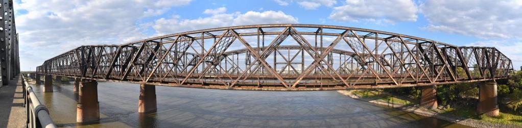
1 Historic Bridge Foundation Facebook Archives Focus Bridges: Harahan Bridge November 2016 In October 2016, Memphis Tennessee became home to one of the most impressive examples of adaptive reuse of a historic bridge in the country, when it completed conversion of a long-abandoned highway deck on the historic Harahan Bridge into a new pedestrian walkway. The location of this adaptive reuse is unique and has an interesting history as well. Crossing the Mississippi River between Memphis and the state of Arkansas are two historic railroad truss bridges of cantilever design. Sitting directly beside each other, these two bridges are immediately north of a third parallel cantilever truss bridge carrying highway traffic. Together these three bridges show a unique evolution of bridge design. The oldest bridge is the Frisco Bridge, designed by one of the most important 19th century bridge engineers, George S. Morison. This bridge was completed in 1892 and was noted for its size and design. In 1916, a second railroad bridge called the Harahan Bridge was completed immediately to the north. Designed by one of the most important 20th century bridge engineers, Ralph Modjeski, this bridge creates a unique opportunity to compare masterpiece works by two famous bridge engineers. It is also of interest to note that when the Frisco Bridge was built, Modjeski was in the earlier years of his career and was in fact working for Morison on the Frisco Bridge as an assistant engineer. The Harahan Bridge had an additional notable feature in that decks cantilevered out from the truss lines accommodated vehicular traffic in addition to the railroad tracks in between the truss lines. In 1949, immediately south of the Frisco Bridge, a new highway bridge was completed, making the vehicular decks of the Harahan Bridge obsolete, which were then abandoned. After sitting abandoned for many years, a special public/private partnership made possible the unique project to convert the northern vehicular deck of the Harahan Bridge into a pedestrian walkway. The walkway is known at the Big River Crossing and the official website is at Several challenges existed with this project. The simple fact that the bridge is nearly a mile long made for a costly project. The other major challenge is that the Harahan Bridge remains a very active, busy

2 railroad bridge. Typically railroad companies are, to put it mildly, hesitant to allow civilians anywhere near their trains, let alone share a bridge with them. However, the Big River Crossing includes a rather substantial fencing system that ensures that trains and people are kept away from each other on the bridge. Although this fencing system is high, the trusses of the bridge are even higher, which makes it possible for users of the walkway to still enjoy the impressive details of the trusses despite this barrier. Another challenge was to maintain the qualities of the bridge that have historical significance, while meeting project requirements as well. While modern railing/fencing was needed on the outer edge of the deck of the walkway, the original riveted lattice railing from the original construction of the vehicular deck was left in place behind the modern fencing. While some project stakeholders were initially opposed to retaining the original railing (perhaps thinking it would look cluttered), the completed product is very nicely composed from a visual standpoint. From a distance beside the bridge, a visitor continues to see the lattice railing design just as it has been seen since On the walkway itself, a visitor can easily see the details of the lattice railing (given that there is a gap between the original and new railings). At the same time, the lattice railing does not detract or obstruct the view of the Mississippi River from the walkway. A visit to this bridge in November 2016, several weeks after the grand opening, revealed that the walkway is a very popular attraction with the walkway being extremely crowded with people! The Big River Crossing is an impressive preservation and adaptive reuse success story. It offers visitors a unique view of the Mississippi River, and also offers a closer look at a significant historic bridge that for decades was not open to public use. Above: Harahan Bridge under construction.


3 A historical drawing showing the layout of the Harahan Bridge. Historical photo showing the Harahan Bridge when the vehicular roadways were still in use.


4 The Harahan Bridge. The Harahan Bridge's "Big River Crossing" crowded with people. Photo taken November 6, 2016.


5 The Harahan Bridge's "Big River Crossing" crowded with people. Photo taken November 6, Details of the Harahan Bridge as seen from the Big River Crossing.


6 Details of the Harahan Bridge as seen from the Big River Crossing. Sign for the Big River Crossing near the bridge.


7 Original plaques on the Harahan Bridge. Historical postcard showing the Harahan Bridge when the vehicular roadways were still in use.

8 View of the Frisco Bridge. Harahan Bridge is visible behind the Frisco Bridge. View of the Frisco Bridge. Harahan Bridge is visible behind the Frisco Bridge.

9 View of the Memphis and Arkansas Bridge.
Historic Bridge Foundation Facebook Archives
 Historic Bridge Foundation Facebook Archives Focus Bridges: Firth of Forth Bridges September 2017 The Firth of Forth in Scotland is a unique location perhaps one of the only locations in the world where
Visitor's Guide to Historic Bridge Park
 Visitor's Guide to Historic Bridge Park Located in Calhoun County, Michigan, southeast of Battle Creek, the park is open year-round from 8:00 AM to 8:00 PM. Entry to the park is free of charge. Guide produced
Preservation: Why Not In Pennsylvania? Presented By: Nathan Holth
 Preservation: Why Not In Pennsylvania? Presented By: Nathan Holth PA Preservation Barriers Why Not Pennsylvania? Pennsylvania has an unrivaled collection of historic bridges, particularly metal truss bridges,
Historic Bridge Adoption Information Packet
 Historic Bridge Adoption Information Packet Falls County CR 179 over Big Elm Creek Bridge October 2017 Table of Contents Announcement... 3 Bridge Location... 4 Bridge Information... 4 Bridge Condition
HISTORIC BRIDGES IN BENTON COUNTY. Bridges Listed on the National Register of Historic Places in Benton County
 Arkansas State Highway and Transportation Department HISTORIC BRIDGES IN BENTON COUNTY Bridges Listed on the National Register of Historic Places in Benton County 2004 Arkansas State Highway and Transportation
Bridge Mechanics By Lydia Lukidis
 Bridges are built over obstacles like roads, rivers, or railroad tracks. They allow people or vehicles to cross from one side to another. Without them, we would have a hard time moving aroun Bridges existed
Mississippi Skyway Preliminary Engineering Report
 EXECUTIVE SUMMARY Mississippi Skyway Preliminary Engineering Report CITY OF RAMSEY, MINNESOTA DECEMBER 2014 City of RAMSEY EXECUTIVE SUMMARY Project Need and Intent The Mississippi Skyway pedestrian bridge
Downtown Dubuque...it s a great time.
 Downtown Dubuque...it s a great time. Your timing could not be better to invest in Downtown. With hundreds of millions in public and private investment occurring on the City s downtown waterfront, millions
City of Farmington. Downtown Plan. Amendment to the 1998 Master Plan Adopted October 11, 2004
 City of Farmington Amendment to the 1998 Master Plan Adopted October 11, 2004 Introduction Planning Background 1 Scope and Components of the Plan Amendment 2 Concept Introduction 3 Plan Concepts 3 Conceptual
HISTORIC BRIDGES IN CONWAY COUNTY. Bridges Eligible for and Listed on the National Register of Historic Places in Conway County
 Arkansas State Highway and Transportation Department HISTORIC BRIDGES IN CONWAY COUNTY Bridges Eligible for and Listed on the National Register of Historic Places in Conway County 2004 Arkansas State Highway
WESTERN ILLINOIS UNIVERSITY
 WESTERN ILLINOIS UNIVERSITY Quad Cities Riverfront Campus Master Plan March 1, 2006 Preliminary Master Plan Total Site Build Out Western Illinois University Quad Cities Municipal Park Mississippi River
Corridor Enhancements
 Corridor Enhancements Safety is MoDOT s first priority in widening and rebuilding I-70 across the state of Missouri. MoDOT also understands that the interstate - and its interchanges and overpasses - are
APPENDIX D: Visual and Aesthetic Conditions for NCCU Station Refinement. Durham-Orange Light Rail Transit Project
 APPENDIX D: Visual and Aesthetic Conditions for NCCU Station Refinement Durham-Orange Light Rail Transit Project October 2016 1. Introduction The Combined FEIS/ROD summarizes the effects of the D-O LRT
WESTERN ILLINOIS UNIVERSITY
 WESTERN ILLINOIS UNIVERSITY Quad Cities Riverfront Campus Preliminary Master Plan Presentation 2 February 1, 2006 Achieving Future Flexibility 1. Monitor space needs as the new buildings come on line and
Overall Map. Chicago. St. Louis. Summit. Joliet. Dwight. Pontiac. Bloomington-Normal Lincoln. Springfield. Carlinville. Alton EXPERIENCE IT YOURSELF.
 Overall Map Summit Chicago Bloomington-Normal Lincoln New Station Planned New Station Planned Dwight Pontiac Joliet Pedestrian overpass and second platform planned Higher speed service began in this section
MINNESOTA HISTORIC PROPERTY RECORD PART I. PROPERTY IDENTIFICATION AND GENERAL INFORMATION
 MINNESOTA HISTORIC PROPERTY RECORD PART I. PROPERTY IDENTIFICATION AND GENERAL INFORMATION Common Name: Fort Snelling-Mendota Bridge Bridge Number: 4190 Identification Number: Location: Feature Carried:
Willamette River Bridges HAER Spanning Willamette River at various locations, Portland Muitnomah County Oregon
 Willamette River Bridges HAER Spanning Willamette River at various locations, Portland Muitnomah County Oregon 08 REDUCED COPIES OF MEASURED DRAWINGS WRITTEN HISTORICAL AND DESCRIPTIVE DATA Historic American
Landscape Design Guidelines
 Section 7: Landscape Design Guidelines seven section Landscape Design Guidelines Following are landscape guidelines specific to Milledgeville. This section provides guidance to property owners and the
16E. 24 th Street Corridor. A. Background
 A. Background The 24 th Street corridor plan includes both 24 th Street and 2550 South from 1900 West to Washington Boulevard, as shown in Map 1. 1. Development History The 24 th Street Corridor has been
A PPEARANCE REVIEW BOARD
 Staff Comments A PPEARANCE REVIEW BOARD NOVEMBER 19, 2015 Case Number A GENDA ITEM 1 455 N. GARLAND AVE. LYNX GERTRUDE S WALK EXTENSION ARB2015-00070 Applicant Laura Minns, AICP LYNX Property Location
Grand Rounds History
 Grand Rounds History 1883 Plan for Minneapolis Park System prepared by Landscape Architect Horace W. S. Cleveland. The system of connecting parks and parkways was first called the Grand Rounds by William
Hockessin Community Redevelopment Plan
 Hockessin Community Redevelopment Plan 3.1 Introduction The Community Redevelopment Plan for the Village of Hockessin is the result of the people s vision for a distinct village center that serves as the
North Commuter Parkway and Traffic Bridge Project Market Sounding
 North Commuter Parkway and Traffic Bridge Project Market Sounding Introduction KPMG LLP ( KPMG ) has been engaged by the City of Saskatoon ( the City ) to develop a P3 business case for the North Commuter
Creating Complete Roadway Corridors:
 Creating Complete Roadway Corridors: The AASHTO Guide to Transportation Landscape Architecture and Environmental Design NCHRP Project 15-33 Status Report AASHTO Standing Committee on Design Technical Committee
Ashburton Railway Footbridge
 Heritage Item 13 Ashburton Railway Footbridge Location Address: 549 East Street, Ashburton Co-ordinates: Northing 5700023, Easting 2409830 Legal Description: Pt Reserve 953 Owner: KiwiRail Purpose Current
I-70 Corridor Enhancement Plan
 i - Table of Contents Table of Contents Chapter I Overview Chapter II Bridge and Roadway Improvements Chapter III Landscape Enhancements Chapter IV Riparian Corridors Chapter V Showcase Missouri Plan Chapter
PROJECT STATEMENT LOCATION/DESIGN PUBLIC HEARING. 19 th AVENUE NORTH EXTENSION PROJECT FROM SPRINGDALE DRIVE TO NORTH 2 ND STREET/U.S.
 PROJECT STATEMENT LOCATION/DESIGN PUBLIC HEARING 19 th AVENUE NORTH EXTENSION PROJECT FROM SPRINGDALE DRIVE TO NORTH 2 ND STREET/U.S. 67 HEARING LOCATION: ERICKSEN COMMUNITY CENTER 1401 11 TH AVENUE NORTH
I-84 HARTFORD PROJECT HARTFORD, CONNECTICUT DRAFT PURPOSE AND NEED STATEMENT
 I-84 HARTFORD PROJECT HARTFORD, CONNECTICUT DRAFT PURPOSE AND NEED STATEMENT October 2016 I. PROJECT BACKGROUND AND HISTORY The City of Hartford is the capital of Connecticut, and the largest employment
SH 199 Corridor Master Plan. Community Meeting No. 2 May 31, 2017
 Community Meeting No. 2 May 31, 2017 Transportation Projects On or Near SH 199 SH 199 from 0.3 miles south of FM 1886 to south end of Lake Worth bridge Construct freeway mainlanes and frontage roads 10-Year
DRAFT SECTION 4(F) EVALUATION LIFT BRIDGE
 EVALUATION LIFT BRIDGE") DRAFT SECTION 4(F) EVALUATION I. DESCRIPTION OF SECTION 4(F) RESOURCE The Section 4(f) resource affected by the proposed action is the Lift Bridge, a property listed on the National Register of Historic
DRAFT SECTION 4(F) EVALUATION I. DESCRIPTION OF SECTION 4(F) RESOURCE The Section 4(f) resource affected by the proposed action is the Lift Bridge, a property listed on the National Register of Historic
Vision Plan for Downtown & Lakeside Improvements
 Vision Plan for Downtown & Lakeside Improvements Hightstown, New Jersey September 30, 2015 In your words: Recognize that Peddie Lake is Hightstown s Central Park treat it as such Design a plan that is
The Talk on 6 October 2010 was by Malcolm Tucker, on Movable Bridges in London's Docks.
 The Talk on 6 October 2010 was by Malcolm Tucker, on Movable Bridges in London's Docks. Edward Sargent introduced Malcolm Tucker, who, as well as being our present Treasurer, has been a member of the group
DESIGN PARAMETERS DESIGN OBJECTIVES. Design Focus and the Elements of the Corridor. Driver Confidence. Visual Organization.
 Design Focus and the Elements of the Corridor LBJ Corridor DESIGN PARAMETERS For any project to be successful, the project goals must be clear. Therefore, with the assistance of TxDOT, the Urban Design
COMMUNICATION URBAN DESIGN REVIEW BOARD CITY OF DES MOINES, IOWA MAY 16, 2017 MEETING
 COMMUNICATION URBAN DESIGN REVIEW BOARD CITY OF DES MOINES, IOWA MAY 16, 2017 MEETING Subject: Recommendation Prepared by: PRELIMINARY DESIGN REVIEW OF LOCUST STREET BRIDGE CONSTRUCTION & COURT AVENUE,
Mississippi Drive Corridor Revitalization. A DestinationTransportation Project...
 Mississippi Drive Corridor Revitalization A DestinationTransportation Project... Mississippi Drive Corridor Revitalization Welcome! Tonight s Agenda: Further define the Scope of the Project Discuss the
Midtown Greenway to lake street
 Making the connection: Midtown Greenway to lake street May 2016 Design experiment: site amenities, wayfinding, and activities at Cepro, near the Midtown Global Market Recent Greenway Development Highlights
PDA SUBMISSION: Queen s Wharf, Brisbane (DEV2017/846)
") PDA SUBMISSION: Queen s Wharf, Brisbane (DEV2017/846) Date:: 17 October 2017 Contact Officer: Jonathon Fisher Chief Executive Officer Email: heritage@nationaltrustqld.org Phone: 07 3223 6666 NATIONAL TRUST
PDA SUBMISSION: Queen s Wharf, Brisbane (DEV2017/846) Date:: 17 October 2017 Contact Officer: Jonathon Fisher Chief Executive Officer Email: heritage@nationaltrustqld.org Phone: 07 3223 6666 NATIONAL TRUST
Honorable Members of the Mobility Solutions, Infrastructure and Sustainability Committee
 Memorandum DATE January 23, 2019 CITY OF DALLAS TO Honorable Members of the Mobility Solutions, Infrastructure and Sustainability Committee SUBJECT I-30 East Project Update On Monday, January 28, 2019,
Downtown Redevelopment Project Update
 Downtown Redevelopment Project Update The redevelopment project will begin the week of September 4, 2017. It is anticipated that construction will be approximately 565 days, depending on weather. 7-6-18
How can landscape architects aide in transportation planning process? John Dempsey, PLA Toole Design Group July 24, 2015
 How can landscape architects aide in transportation planning process? John Dempsey, PLA Toole Design Group July 24, 2015 What is Landscape Architecture? Landscape Architecture 1863 What is Landscape Architecture?
ARLINGTON COUNTY, VIRGINIA. County Board Agenda Item Meeting of January 28, 2017 SUPPLEMENTAL REPORT
 ARLINGTON COUNTY, VIRGINIA County Board Agenda Item Meeting of January 28, 2017 SUPPLEMENTAL REPORT DATE: January 26, 2017 SUBJECT: The Virginia Department of Transportation s Transform I-66 Inside the
Welcome to our public exhibition
 About Our Scheme Welcome to our public exhibition This exhibition gives you the chance to view and comment upon our emerging proposals for a new residential development of 68 new homes on the site of the
Final Design Meeting. September 25, Creating Bridges As Art. Welcome & Introductions. Terry Ward - Project Manager
 Final Design Meeting September 25, 2014 Creating Bridges As Art 1 Welcome & Introductions Terry Ward - Project Manager 2 VQRC Final Design Meetings Meeting Date Items for Discussion Final Design Meeting
Great Rivers Greenway CLEAN GREEN CONNEC TED T RAILS
 Great Rivers CLEAN GREEN CONNEC TED T RAILS Great Rivers (GRG) was established in 2000 to create a clean, green, connected St. Louis region. Today, many new and exciting projects demonstrate the social,
Welcome. Northern Segment of Hwy 100 I-90 to South of Madison Street Meeting Goals:
 Welcome Northern Segment of Hwy 100 I-90 to South of Madison Street Meeting Goals: - Review Environmental Assessment - Share Preferred Alternative -Receive Public Comments 2003 EA Preferred Alternative
ARLINGTON COUNTY, VIRGINIA. County Board Agenda Item Meeting of January 28, 2017 SUPPLEMENTAL REPORT-2
 ARLINGTON COUNTY, VIRGINIA County Board Agenda Item Meeting of January 28, 2017 SUPPLEMENTAL REPORT-2 DATE: January 27, 2017 SUBJECT: The Virginia Department of Transportation s Transform I-66 Inside the
Windsor Locks Transit-Oriented Development Planning Grant Request. Project Background
 Windsor Locks Transit-Oriented Development Planning Grant Request Project Background Downtown Windsor Locks runs along Main Street in the vicinity of the intersection of Routes 159 and 140. The current
1.0 INTRODUCTION 1.1 TH 14 WEST STUDY AREA Project Description Functional Classification Purpose of the Project
 1.0 INTRODUCTION 1.1 TH 14 WEST STUDY AREA 1.1.1 Project Description The Trunk Highway (TH) 14 West Corridor is a two-lane roadway approximately 22 miles in length. Located in Nicollet County, the corridor
Poisoned Park? How Exide s Lead Contamination Risks Frisco s Grand Park
 Frisco City Hall has big plans to transform Stewart Creek into a Grand Park with lots of water features for kids to play in. Poisoned Park? How Exide s Lead Contamination Risks Frisco s Grand Park But
HISTORIC BRIDGES IN CRAWFORD COUNTY. Bridges Listed on the National Register of Historic Places in Crawford County
 Arkansas State Highway and Transportation Department HISTORIC BRIDGES IN CRAWFORD COUNTY Bridges Listed on the National Register of Historic Places in Crawford County 2004 Arkansas State Highway and Transportation
REHABILITATION FEASIBILITY STUDY ER#
 REHABILITATION FEASIBILITY STUDY MILLER FARM ROAD BRIDGE PROJECT VENANGO COUNTY BRIDGE NO. 34 CARRYING S.R. 7212, SECTION L00 OVER OIL CREEK OIL CREEK AND CHERRYTREE TOWNSHIPS VENANGO COUNTY, PENNSYLVANIA
North River Mills Bridge Hampshire County State Project # S314-45/ Federal Project # ARRA-4520(003)D FR#: HM-1
D FR#: HM-1") North River Mills Bridge Hampshire County State Project # S314-45/20-2.40 02 Federal Project # ARRA-4520(003)D FR#: 10-1463-HM-1 STATE LEVEL OF HISTORIC DOCUMENTATION November 2010 West Virginia Department
North River Mills Bridge Hampshire County State Project # S314-45/20-2.40 02 Federal Project # ARRA-4520(003)D FR#: 10-1463-HM-1 STATE LEVEL OF HISTORIC DOCUMENTATION November 2010 West Virginia Department
CHAPTER 8 ISSUES, CONCERNS, CONSTRAINTS AND OPPORTUNITIES
 CHAPTER 8 ISSUES, CONCERNS, CONSTRAINTS AND OPPORTUNITIES Introduction This River Conservation Plan was developed during a time of tremendous activity and effort in planning the transformation of the Delaware
City of Meriden Harbor Brook Flood Control Project Overview
 City of Meriden Harbor Brook Flood Control Project Overview Updated August 2013 OVERVIEW The center of Meriden, including the HUB site is the low point of the town which is ringed by basalt ridges. Running
(blank page) WestConnex New M Roads and Maritime Services Environmental impact statement
 WestConnex New M Roads and Maritime Services Environmental impact statement") (blank page) WestConnex New M5 5-42 (blank page) WestConnex New M5 5-44 5.5 Tunnels 5.5.1 Main alignment tunnels The main alignment tunnels would be about nine kilometres long, with the western tunnel
(blank page) WestConnex New M5 5-42 (blank page) WestConnex New M5 5-44 5.5 Tunnels 5.5.1 Main alignment tunnels The main alignment tunnels would be about nine kilometres long, with the western tunnel
1. Lenox Dale Community Character Strengths and Opportunities Identified by Residents: Strong neighborhood identity and sense of community.
 LENOX DALE ISSUES AND OPPORTUNITIES -- EIGHT CATEGORIES: Concerns and opportunities identified by Lenox residents and in previous Community Surveys, along with thought-starter suggestions on possible Town
ARLINGTON COUNTY, VIRGINIA
 ARLINGTON COUNTY, VIRGINIA County Board Agenda Item Meeting of October 23, 2004 DATE: October 6, 2004 SUBJECT: SP #106-3 Site Plan Amendment for changes to façade, plaza deck, landscaping, number of units,
WILLAMETTE FALLS LEGACY PROJECT
 OPPORTUNITIES & CONSTRAINTS There are here three falls on a line of rocks extending across the river, which forms the bed of the upper channel. The water is precipitated through deep abrazed gorges, and
GLEN ROAD PEDESTRIAN BRIDGE ENVIRONMENTAL ASSESSMENT STUDY PUBLIC INFORMATION CENTRE #2 OCTOBER 24, 2017
 GLEN ROAD PEDESTRIAN BRIDGE ENVIRONMENTAL ASSESSMENT STUDY PUBLIC INFORMATION CENTRE #2 OCTOBER 24, 2017 Glen Road Pedestrian Bridge Class Environmental Assessment 1 WELCOME! Welcome to the second Public
Kankakee River Bridge & Track Improvements Supplemental Environmental Assessment. May 5, 2016
 Kankakee River Bridge & Track Improvements Supplemental Environmental Assessment May 5, 2016 1 History: Chicago-St. Louis Corridor Since 1980 s IDOT has been looking at this corridor for high-speed service
Practices about Site:
 Practices about Site: Reflecting on the design of the Museum of Liverpool Fig 01. The Museum of Liverpool Picture from official website of the 3XN Yuan Chen 100202902 MAAD University of Sheffield 4th May,
DOMINION BOULEVARD CORRIDOR STUDY AND ECONOMIC DEVELOPMENT STRATEGIC PLAN A MODEL FOR CHESAPEAKE S FUTURE
 DOMINION BOULEVARD CORRIDOR STUDY AND ECONOMIC DEVELOPMENT STRATEGIC PLAN A MODEL FOR CHESAPEAKE S FUTURE Overview I. Draft Plan Process II. Draft Plan Overview a. Market Analysis b. Master Land Use Plan
PRELIMINARY PUBLIC NOTICE 1-161
 Commander (dpb) First Coast Guard District 1 South Street Battery Park Building New York, NY 10004-1466 March 9, 2018 PRELIMINARY PUBLIC NOTICE 1-161 The United States Coast Guard is soliciting public
historic name: STARR MILL ROAD BRIDGE other name/site number: Beverly Heights Bridge. Bridge No. 4541
 NFS Form 10-900 < (Rev. 8-86)! REGISTRATION FORM RECEIVED OCT 2 8 1993 NATIONAL REGISTER *! 0 2 4 0 0 1 8 =============================================$======================= === 1. Name of Property '
Welcome to the Sellwood Bridge Project Pre-Construction Open House
 Welcome to the Sellwood Bridge Project Pre-Construction Open House 5:30 7:30 p.m. Please sign in here Information stations and project staff are located throughout the room. Goals for Tonight s Meeting
 Health Sciences City The available land area, although limited, combined with the unique partnership between the primary institutions and the supporting partnerships of the development interests within
Public input has been an important part of the plan development process.
 Lakewood s Comprehensive Plan recognizes that transportation helps shape the community, and that the way the community provides for the safe and efficient movement of people affects the character of the
National Register of Historic Places Continuation Sheet
 NPS Form 10-900-a (Rev. 8/2002) OMB No. 1024-0018 (Expires 5-31-2012) United States Department of the Interior National Park Service National Register of Historic Places Continuation Sheet Bridge No. 5721
Derby-Shelton Bridge Pedestrian and Bicyclist Enhancements [1]
![Derby-Shelton Bridge Pedestrian and Bicyclist Enhancements [1]](/thumbs/96/128011958.jpg "Derby-Shelton Bridge Pedestrian and Bicyclist Enhancements [1]") nhancements [1] STATUS OF PROJECT: The project has recently moved from the Preliminary Design Phase to the Final Design Phase following the most recent Public Involvement Meeting held on January 9, 2019
nhancements [1] STATUS OF PROJECT: The project has recently moved from the Preliminary Design Phase to the Final Design Phase following the most recent Public Involvement Meeting held on January 9, 2019
The Bridges Of New York (New York City) PDF
 PDF") The Bridges Of New York (New York City) PDF New York City boasts more spectacular bridges than any other city in the world. From the Gothic stone arches and gossamer steel webbing of the Brooklyn Bridge
The Bridges Of New York (New York City) PDF New York City boasts more spectacular bridges than any other city in the world. From the Gothic stone arches and gossamer steel webbing of the Brooklyn Bridge
Midtown Greenway PROJECT REPORT CARD
 Midtown Greenway PROJECT REPORT CARD Project Overview and History The Midtown Greenway is a 5.5-mile multi-use trail that connects the Mississippi River to the Minneapolis Chain of Lakes. The corridor,
31 South Mardy. Exploring Abergavenny
 31 South Mardy Exploring Abergavenny Cover: St Teilo s Road 2 south mardy EXPLORING ABERGAVENNY For several years the Abergavenny and District Civic Society has been studying the streets, spaces and buildings
Revitalizing Urban Main Streets
 MIT OpenCourseWare http://ocw.mit.edu Spring 2009 For information about citing these materials or our Terms of Use, visit: http://ocw.mit.edu/terms. Team 1: Traffic/Pedestrian Activity/Public Transportation
MINNESOTA ARCHITECTURE - HISTORY INVENTORY FORM
 Identification Historic Name Dean Parkway Bridge Current Name Bridge 90661 Field # Address Midtown Greenway over Dean Parkway City/Twp Minneapolis County Hennepin Legal Desc. Twp 29N Range 24W Sec 32 QQ
City of Royalton Comprehensive Land Use Plan 2005 to Revision February 8, 2011
 City of Royalton Comprehensive Land Use Plan 2005 to 2015 2011 Revision February 8, 2011 PART ONE: INTRODUCTION TO THE COMPREHENSIVE PLAN 1.0 Purpose and Introduction The Comprehensive Land Use Plan provides
Fall 2017 Construction Update
 Fall 2017 Construction Update Ward 4 Southeast Engineering Department Riverwalk Red Multi-Use Trail Bridge Rehabilitation The Riverwalk Red Multi Use Trail Bridge was awarded to Cramer and Associates,
St. Anthony Parkway Bridge Over Northtown Yard Project S.P. No
 St. Anthony Parkway Bridge Over Northtown Yard Project S.P. No. 141-454-01 Questions & comments made by attendees during the Public Meeting held on April 9, 2013. How will the existing bridge be removed
Without leaps of imagination or dreaming, we lose the excitement of possibilities. Dreaming, after all, is a form of planning.
 City of Garden Grove A Publication for Garden Grove Residents and Businesses Fall 2014 Without leaps of imagination or dreaming, we lose the excitement of possibilities. Dreaming, after all, is a form
Transportation Committee
 Transportation Committee Business Item No. 2013-286SW Meeting date: October 14, 2013 For the Metropolitan Council meeting of October 16, 2013 Subject: Southwest Light Rail Transit (Green Line Extension):
Alternatives Development Three conceptual alternatives were developed for the Race Road/Jessup Village Planning Study and are described below:
 Race Road/Jessup Village Planning Study (H550601) Project Newsletter Spring 2015 Project Description The Study Team, consisting of staff from Anne Arundel County (Department of Public Works and Department
Woods Chapel Park. Park Amenities: Playground, basketball court, single table shelter, small pond and multi-use trail.
 Woods Chapel Park Park Location: 3925 NW Dogwood Park Land Established: 1979 Park Size: 10 acres Developed Acres: 6 acres Undeveloped Acres: 4 acres Park Type: Neighborhood Park Amenities: Playground,
Transforming Kennedy Plaza
 PROVIDENCE REVITALIZATION Transforming Kennedy Plaza Plan calls for moving bus stops, creating open space for multiple uses By ALISHA A. PINA JOURNAL STAFF WRITER PROVIDENCE A vision is emerging to turn
A Better City Request for Qualifications
 A Better City Request for Qualifications Urban design proposal for the pedestrianization of Birch Street in Roslindale December 13, 2018 Responses preferred by January 8, 2019 at 11:59pm Eastern Time Request
City of Nogales General Plan
 Open Space, Parks, Recreation and Trails City of Nogales General Plan Residents of Nogales place a high priority in the development of a comprehensive system of open space, parks, recreation and trails
Green Infrastructure The Indianapolis Greenways Connection
 Green Infrastructure The Indianapolis Greenways Connection Fewer things in the transportation industry today make better since than combining the needs for pedestrian and bike trails with the need to locate,
2014 PSPE Philadelphia Chapter Outstanding Engineering Achievement Award Nomination
 2014 PSPE Philadelphia Chapter Outstanding Engineering Achievement Award Nomination Route 29 Roadway Improvement Project SR 0029, Section AL2 Charlestown Township, Chester County, PA Nomination Form Route
Supporting our communities. Bridges
 Supporting our communities Bridges 1,000+ We ve partnered with thousands of owners/clients to inspect, analyze, design, and manage their bridges, providing lasting community connections. We design bridges
Mendota Heights 2040 Comprehensive Plan Draft Vers
 4 Parks and Trails The City of Mendota Heights boasts a variety of recreational and open space opportunities. Few cities can claim access to regional trails, riverside and lakeside parks, scenic bluffs
Kitchen. Triangle. New. How to accommodate more The. appliances, more cooks, and more activities WHAT GOES INTO THE TRIANGLE?
 How to accommodate more The appliances, more cooks, New and more activities Kitchen Triangle BY ANN M. MORRIS The work triangle has been a part of good kitchen design for nearly 50 years. The idea is to
MINNESOTA ARCHITECTURE - HISTORY INVENTORY FORM
 Identification Historic Name Nicollet Avenue Bridge Current Name Nicollet Avenue Bridge Field # Address Nicollet Avenue over Minnehaha Creek City/Twp Minneapolis SHPO Inventory Number Review and Compliance
TOD 101 CREATING LIVABLE COMMUNITIES WITH TRANSIT
 1 CREATING LIVABLE COMMUNITIES WITH TRANSIT What are transit Centered Communities? Benefits of Partnerships to Support and Implement What You Will Learn Portland s Pearl District Your Trainers Today Catherine
Bourne Downtown Site Planning
 Prepared for: The Town of Bourne, MA In Cooperation with: Bourne Financial Development Corporation Prepared by:, Inc. June 24, 2009 Table of Contents Introduction and Summary... 1 Site Existing Conditions...
To qualify for federal Transportation Enhancement (TE) funds a project must meet two basic federal requirements:
 funds a project must meet two basic federal requirements:") Eligibility Requirements To qualify for federal Transportation Enhancement (TE) funds a project must meet two basic federal requirements: 1) Relate to surface transportation and 2) Be one of the 12 designated
Eligibility Requirements To qualify for federal Transportation Enhancement (TE) funds a project must meet two basic federal requirements: 1) Relate to surface transportation and 2) Be one of the 12 designated
Planning and Design of a Suburban Neotraditional Neighborhood
 Planning and Design of a Suburban Neotraditional Neighborhood BRIAN WOLSHON Assistant Professor Department of Civil and Environmental Engineering Louisiana State University, Baton Rouge, LA 70803 brian@rsip.lsu.edu.
Mid-America Regional Council wishes to extend a special thank you to. each of the project participants. This document is the product of the
 ACKNOWLEDGEMENTS Mid-America Regional Council wishes to extend a special thank you to each of the project participants. This document is the product of the combined effort of interested citizens, local
Wildlife Food Plot Project
 South Carolina 4-H Youth Development September 2015 Issue 1 Wildlife Food Plot Project Sponsored by Clemson Cooperative Extension, Quality Deer Management Association, the Rack Pack, and Wannamaker Wildlife
CITY CLERK. Parkland Acquisition Strategic Directions Report (All Wards)
") CITY CLERK Clause embodied in Report No. 10 of the, as adopted by the Council of the City of Toronto at its meeting held on November 6, 7 and 8, 2001. 10 Parkland Acquisition Strategic Directions Report
CITY CLERK Clause embodied in Report No. 10 of the, as adopted by the Council of the City of Toronto at its meeting held on November 6, 7 and 8, 2001. 10 Parkland Acquisition Strategic Directions Report
Missing Link Study Grand Rounds Parkway Planning and Design Introduction
 Missing Link Study Grand Rounds Parkway Planning and Design Introduction June 19, 2007 Minneapolis Park and Recreation Board HNTB Hoisington Koegler Group Inc. Hess Roise 1 The Missing Link Study The Minneapolis
Temporary Bridging. Issue 2
 Temporary Bridging Issue 2 Welcome to Mabey Operating from 17 depot locations across England, Scotland and Wales, we combine full UK coverage with localised depot solutions. We have decades of extensive
Sikander Iqbal INTRODUCTION PRE-VISIT REFLECTION. Learning Places Spring 2016 SITE REPORT # 2 Field visit 2, Vinegar Hill
 Learning Places Spring 2016 SITE REPORT # 2 Field visit 2, Vinegar Hill Sikander Iqbal 02.29.2016 INTRODUCTION Second visit was really interesting learned about this area little more, Vinegar Hill Historic