Dauphin Island s East End Beach and Barrier Island Restoration Project. April 16, :00 PM Dauphin Island Sea Lab, Shelby Hall
|
|
|
- Michael Boyd
- 6 years ago
- Views:
Transcription

1 Dauphin Island s East End Beach and Barrier Island Restoration Project Town of Dauphin Island, Alabama April 16, :00 PM Dauphin Island Sea Lab, Shelby Hall
2 Team Introduction South Coast Engineers Coastal Tech Hutchinson Moore & Rauch
3 Purpose of Presentation Describe the proposed project:
4 Design Development: Overall Project Steps Research/Understand Site History & Coastal Processes Develop Working Project Goals Prepare Conceptual Design(s) Recon and Final Borrow Area Investigations Begin Regulatory Process Finalize Design Work Complete Permitting > Final Plans & Specifications Establish Mean High Tide Line & Conclude other Easements Bidding, Construction, Monitoring
5 Design Development: East End Coastal Processes Beach erosion on eastern mile of beaches is influenced by position/elevation of Pelican and Sand Island shoals

6 Design Development: Historic Erosion Rates From 2005 (Katrina)-2010 beach retreated at rate of 8.4 ft/yr (40+ feet). Equates to about 220,000 cu yds of erosion. From another ~50,000 cu yds Long-term land loss evidenced by position of old rock groins
7 Design Development: Project Goals Restore and protect wildlife habitats on the east end including Gulf-front foraging and nesting habitats for seabirds, shorebirds, neotropical migratory birds, and sea turtles Reduce risk of saltwater intrusion into the freshwater lake in bird sanctuary Introduce beach sands into the littoral drift of the Gulf barrier island Increase longevity of new sand by concurrent use of rock breakwaters
8 Design Development: Borrow Area Recon looked at western flank Mobile Bay ebb tidal delta Final investigation sought to identify a sub-area: (1) is most proximal to the fill Project Area, (2) avoids cultural resources to the maximum extent possible, and (3) contains sufficient sand quantities with a factor of safety of at least 2 (sub-area volume is 600,000 cubic yards).
9 Borrow sub-area as requested in permits No indication in any of field work of contaminants Laboratory testing of proposed Borrow Area sand compared to Native Beach Sample gint Granularmetrics Munsell Color Size Class (wt%) Descriptive Statistics USC Wet Dry Gravel Sand <#200 <#230 Mean (mm) Verbal Std. Dev.(phi) Value Chroma Value Chroma CTC Native F 0.76 SP CPE Native^ 1.09* F 0.82 SP CPE + CTC Native F 0.79 SP Sub-Area * F 0.65 SP
10 Project Description - Funding Funded through the State Lands Division of the Alabama Department of Conservation and Natural Resources Coastal Impact Assistance Program (AL-28: Dauphin Island Shoreline Stabilization Project)
11 Project Description Introduce New Sand by Beach Features: Nourishment ~300,000 cubic yards of beach fill concentrated behind renovated rock structures and extending west to near the west side of the bird sanctuary Beach nourishment: The placement of large quantities of good quality sand directly on the beaches to restore the beach.
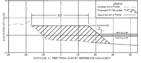
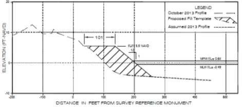
12 Project Description Beach Nourishment
13 Project Description Concurrent Use of Rock Structures Existing rock groins to be renovated as offshore segmented breakwaters Will include reinforcement with new, heavy armor stone Will increase the longevity of the sand near the road end
14 State Permitting State Regulatory Agencies Alabama Department of Environmental Management (ADEM) AL Department of Conservation & Natural Resources, State Lands Division (ADCNR) Alabama State Historical Preservation Commission (SHPO) Tribal Authorities
15 State Permitting State Permitting Process ADEM s Administrative Code requires that all permitted projects: Meet state water quality standards Utilize only quality fill material Are consistent with the AL Coastal Area Management Program Do not impact submerged cultural resources Include mitigation for project impacts, if warranted
16 State Permitting Pre-application meeting held October 30, 2013 ADEM-COE Joint Application submitted March 12, 2014 Responses to ADEM s requests for clarification and/or additional information ADEM permits issued on October 3, 2014 Coastal Consistency Certification Water Quality Certification
17 ADEM Required Monitoring/Submittals Implementation of Post Construction Monitoring Plan Project Completion Certification Turbidity monitoring during construction Topographic/bathymetric surveys of beach 90 days prior to construction 60 days following construction Annually for 3 years Bathymetric survey of borrow area 90 days prior to construction (or prior survey) 60 days following construction Engineering report with monitoring data within 90 days of each post construction and annual monitoring survey Aerial photography Immediate post construction Year 1 post construction Lighting surveys/report Year 1 post construction 2 surveys Sea turtle monitoring/reports 2 nesting seasons post construction Tilling/escarpment surveys Prior to May 1 for 3 years post construction
18 Federal Permitting Process The National Environmental Protection Act (NEPA) Requires federal agencies to integrate environmental issues into their decision making process Section 404 of the Clean Water Act Regulates the discharge of dredged or fill material into waters of the state Section 10 of the Rivers and Harbors Act of1899 Regulates construction of any structure in or over navigable waters of the United States Commenting agencies: Alabama Historical Commission, State Historic Preservation Officer (SHPO) Preservation of non-renewable cultural resources U.S. Fish & Wildlife Services (FWS) Protection of listed species under the Endangered Species Act National Marine Fisheries Service (NMFS) Implementation of Terms & Conditions for dredging offshore areas within the Gulf of Mexico Regional Biological Opinion (GRBO) Tribal Authorities Preservation of Tribal cultural resources
19 Federal Submittals Responses to requests for clarification and/or additional information USACE permit issued 12/4/2014 SHPO concurrence issued 8/11/2014
20 Federal Requirements/Submittals Construction may occur year round Pre-construction meeting with agencies, contractor monitors, surveyors, Town representatives Sea turtle monitoring/reports during construction (if construction occurs between May 1 and September 30) and 2 nesting seasons post construction Use of beach quality sand free of contaminants Installation of predator-proof trash receptacles Provide U.S. Coast Guard Notice to Mariner Compliance with National Flood Insurance Program Endangered species monitor during dredge operations Dredge Quality Management operational during all dredging Turbidity monitoring during construction Notify USACE and SHPO if cultural resources are found Immediate post construction summary report to USFWS Tilling/Escarpment Surveys immediate post construction and annually for 3 years Lighting surveys/report year 1 post construction
21 Required Easements and Conveyances Dauphin Island Park and Beach Board and Dauphin Island Sea Lab have signed easements United States Coast Guard has provided a construction staging area license and will be providing a conveyance agreement (equivalent to these easements for federal lands)
22 Mean High Tide Line Establishment of a line is required by state law before construction of a beach restoration project Established by a public hearing with associated map or documentation
23 Mean High Tide Line MHT line as surveyed as it existed in January 2010 Adopted by the Town Council at public hearing May 7, 2014 To be established only for the specified project area


24 Mean High Tide Line CCCL 2010 MHT Line Project Limits
25 Mean High Tide Line Title to filled land lying seaward of the designated MHT line is retained by the state Affected landowners retain all statutory and common-law riparian or littoral rights of access to the filled land, subject to reasonable regulation by the Town.
26 Next Steps ADCNR/ADEM receives public input (tonight!) Permit issuance decision by ADCNR Bids & Construction (this spring/summer)
Improvement of the Atlantic Coast of New York City,
 Improvement of the Atlantic Coast of New York City, Rockaway Inlet to Norton Point Project at Sea Gate Meeting Purpose The U.S. Army Corps of Engineers, the New York State Department of Environmental Conservation,
CHAPTER Committee Substitute for Senate Bill No. 1472
 CHAPTER 2007-99 Committee Substitute for Senate Bill No. 1472 An act relating to beaches and shores; amending s. 161.021, F.S.; amending a definition; amending s. 161.085, F.S.; restricting the use of
BEACH AND INLET PROJECTS UPDATE
 BEACH AND INLET PROJECTS UPDATE USACE DELTA PROJECT USACE Delta Project Project Extents Elevation Elevation (ft NAVD88) (ft NAVD88) USACE Delta Project Project Cross-Section 20 18 20 16 18 14 16 12 14
Sierra Club Comments on ACOE Public Notice NAE Re: Proposed Town Neck Beach Project at Sandwich, Massachusetts
 August 27, 2015 US Army Corps of Engineers New England District 696 Virginia Road Concord, MA 01742-2751 Attn: Phillip W. Nimeskern Dear Mr. Nimeskern, Sierra Club Comments on ACOE Public Notice NAE-2014-259
Monitoring and Maintenance Permit Process
 Karen A. Duhring Marine Advisory Scientist Center for Coastal Resources Management Virginia Institute of Marine Science College of William & Mary April 9, 2010 Living Shorelines for Contractors and Project
Broward County Shore Protection Project Segment II. Physical Monitoring Plan
 Broward County Shore Protection Project Segment II USACE File No. SAJ-1999-05545 Broward County Shore Protection Project -Segment II Submitted To: Florida Department of Environmental Protection Office
July 22, 2013 REQUEST FOR PROPOSALS TO PROVIDE ENGINEERING DESIGN SERVICES FOR A PROJECT ALONG THE WESTERN SHORE OF MOBILE BAY
 Mobile Bay National Estuary Program 4172 Commanders Drive Mobile, AL 36615 Phone: 251-431-6409 Fax: 251-431-6450 Contact: Tom Herder, Watershed Protection Coordinator Email: therder@mobilebaynep.com July
Coastal Erosion Protection Strategies Private Works on Public Land
 Coastal Erosion Protection Strategies Private Works on Public Land Arron Broom Coastal Policy Planner Coastal Management Branch, SA DEW Delegate for the Coast Protection Board 2016 Storm Events SA experienced
PURPOSE: The purpose is to provide commercial facilities in the Vancouver and Clark County vicinity.
 US Army Corps of Engineers Seattle District Joint Public Notice Application for a Department of the Army Permit and a Washington Department of Ecology Water Quality Certification and/or Coastal Zone Management
Shoreline Master Program Town of La Conner, Washington
 Shoreline Master Program Town of La Conner, Washington Department of Ecology approval effective Adopted September 24, 2013 by Town of La Conner Ordinance No.1106 Amended May 13, 2014 by Town of La Conner
The Napa River Flood Protection Project
 The Napa River Flood Protection Project Creating Flood Protection and Restoring Geomorphic and Biological Processes Jeremy Sarrow, Napa County Flood Control & Water Conservation District June 2, 2014.
There is an ongoing regulatory concern that
 FWRJ Alternatives for Beach Stormwater Outfalls: Preliminary Assessment for City of Naples Reshma Thummadi, Ronald Cavalieri, Andy Holland, and Gregg Strakaluse There is an ongoing regulatory concern that
State of the State New Jersey. Steve Jacobus NJDEP 06/10/15
 State of the State New Jersey Steve Jacobus NJDEP 06/10/15 1980s Living shorelines term coined in MD 2003 North Carolina passes Living Shoreline Law (HB 1028) early 2000s Delaware puts no bulkhead policy
Memorandum. AECOM Technical Services Inc. Page 1
 Memorandum To: Gregg R. Strakaluse, P.E. and Andy Holland, P.E. From: Ronald Cavalieri, P.E. Prepared By: Reshma Thummadi, P.E. Date: September 20, 2013 Subject: Permitting of Subaqueous Stormwater Outfalls
JOINT PUBLIC NOTICE. 26 June United States Army Corps of Engineers State of Louisiana
 JOINT PUBLIC NOTICE 26 June 2017 United States Army Corps of Engineers State of Louisiana New Orleans District Department of Environmental Quality Regulatory Branch Office of Environmental Services 7400
.MANAGED RETREAT. Need for managed retreat
 602 MANAGED RETREAT hazards. This strategy is based on a philosophy of moving out of harm's way, and is proactive in recognizing that the dynamics of the coastal zone should dictate the type of management
Kevin M. Rampe, President -- Lower Manhattan Development Corporation
 For Internal Use Only: Date Received: WRP no. DOS no. NEW YORK CITY WATERFRONT REVITALIZATION PROGRAM Consistency Assessment Form Proposed actions that are subject to CEQR, ULURP or other local, state
Cherry Beach Shoreline Protection Infrastructure Conceptual Design and Class EA
 Welcome Cherry Beach Shoreline Protection Infrastructure Conceptual Design and Class EA May 3, 2012 Study Area Cherry Beach neighbourhood is located in lower Stoney Creek on Lake Ontario, east of Millen
30% Design Technical Report
 NAPLES BEACH RESTORATION AND WATER QUALITY IMPROVEMENT PROJECT Outfalls 3, 4, 5 & 6 May 2016 Erickson Consulting Engineers, Inc. www.ericksonconsultingengineers.com Outfall 6 www.stantec.com Naples Beach
Empowering Local Action for Coastal Resilience in Massachusetts. Bruce K. Carlisle MA Office of Coastal Zone Management
 Empowering Local Action for Coastal Resilience in Massachusetts Bruce K. Carlisle MA Office of Coastal Zone Management Context Coastal communities continue to face both chronic and acute storm surge, erosion,
Joint Public Notice. Public Notice Date: February 9, 2015 Expiration Date: March 11, 2015
 US Army Corps of Engineers Seattle District Joint Public Notice Application for a Department of the Army Permit and a Washington Department of Ecology Water Quality Certification and/or Coastal Zone Management
NC Coastal Management Program Update. Mike Lopazanski Policy & Planning Section Chief April 3, 2015
 NC Coastal Management Program Update Mike Lopazanski Policy & Planning Section Chief April 3, 2015 NC Coastal Area Management Act (1974) Balances competing coastal pressures through development permitting
Rhode Island Shoreline Change Special Area Management Plan
 Rhode Island Shoreline Change Special Area Management Plan Draft Document Outline REVISED 10/12/2017 VOLUME 1 Executive Summary & How to Use this Document (Draft by Dec 2017) 1. Introduction (Revised draft
jmt.com MARINE Part of a diversified family of solutions
 jmt.com MARINE Part of a diversified family of solutions Services Marine & Coastal Engineering Modeling Coastal Initiatives & Techniques Port, Harbor, & Marine Consultancy Small Craft Design Permitting
Pontchartrain Coastal Lines of Defense Program Figure 1 Figure 2 Figure 1
 Pontchartrain Coastal Lines of Defense Program Coastal Sustainability Program February 2006 The Pontchartrain Coastal Lines of Defense Program consists of ten priority project areas within the Pontchartrain
City of Newburyport Plum Island Beach Management Plan. Presented by:
 City of Newburyport Plum Island Beach Management Plan Presented by: PLAN PURPOSE To establish appropriate public policy pertaining to the operation, maintenance and preservation of Plum Island including
Pine Flat Lake Master Plan Update FACT SHEET September 2014
 Pine Flat Lake Master Plan Update FACT SHEET September 2014 PURPOSE AND OBJECTIVE The U.S. Army Corps of Engineers Sacramento District is revising the 1976 Pine Flat Lake Master Plan and is seeking public
Appendix to Amicus Curiae Brief: Selected Provisions of the South Carolina Beachfront Management Act
 Loyola Marymount University and Loyola Law School Digital Commons at Loyola Marymount University and Loyola Law School Loyola of Los Angeles Law Review Law Reviews 6-1-1992 Appendix to Amicus Curiae Brief:
APPENDIX C NATURAL RESOURCES MANAGEMENT PLAN: ACTIONS AND PRIORITIES
 APPENDIX C NATURAL RESOURCES MANAGEMENT PLAN: ACTIONS AND PRIORITIES TABLE C-1: Resource Actions and Priorities GOAL NRM-4 Objective 4.1: Restore Natural floodplain functions. Objective 4.2: Define and
ALTERNATIVE SHORELINE MANAGEMENT IN COASTAL MISSISSIPPI
 ALTERNATIVE SHORELINE MANAGEMENT IN COASTAL MISSISSIPPI Project supported via financial assistance provided by the Coastal Zone Management Act of 1972, as amended, administered by the Office of the Ocean
Karen A. Duhring Marine Advisory Scientist Center for Coastal Resources Management Virginia Institute of Marine Science College of William & Mary
 Karen A. Duhring Marine Advisory Scientist Center for Coastal Resources Management Virginia Institute of Marine Science College of William & Mary March 20, 2009 Low-Impact Shoreline Stabilization Cumulative
APPENDIX F: EXTERNAL APPROVALS
 1.0 RESPONSIBILITIES When the City is constructing the Park or Open Space Development lands (OPTION I), after the subdivision construction process is completed by the Developer, Open Space Development
Commercial Launch Site Addendum to Wetland Mitigation Plan. Revision 2. April 25, SpaceX Proprietary
 Commercial Launch Site Addendum to Wetland Mitigation Plan Revision 2 April 25, 2017 SpaceX Proprietary Contents 1.0 Project Information... 1 1.1 Background... 1 2.0 Compensatory Mitigation... 2 2.1 Goals
HOLDEN BEACH EAST END SHORE PROTECTION PROJECT ENVIRONMENTAL IMPACT STATEMENT DRAFT
 HOLDEN BEACH EAST END SHORE PROTECTION PROJECT ENVIRONMENTAL IMPACT STATEMENT DRAFT August 2015 Prepared for: US Army Corps of Engineers, Wilmington District Wilmington, NC and Town of Holden Beach Prepared
Natural Resource Adaptation Action Area Addressing Sea Level Rise in Estuarine Ecosystems TO: TOWN OF YANKEETOWN MAY
 Natural Resource Adaptation Action Area Addressing Sea Level Rise in Estuarine Ecosystems TO: TOWN OF YANKEETOWN MAY 6 2013 University of Florida Conservation Clinic Vivek Babbar, Student Associate, J.D.
September 30, 2011 REQUEST FOR PROPOSAL TO PROVIDE ENGINEERING DESIGN SERVICES FOR A PROJECT ALONG THE WESTERN SHORE OF MOBILE BAY
 Mobile Bay National Estuary Program 4172 Commanders Drive Mobile, AL 36615 Phone: 251-431-6409 Fax: 251-431-6450 Email: mbnep@mobilebaynep.com September 30, 2011 REQUEST FOR PROPOSAL TO PROVIDE ENGINEERING
CHARLES COUNTY GOVERNMENT RFP NO POPES CREEK RAIL TRAIL DESIGN
 CHARLES COUNTY GOVERNMENT Department of Fiscal and Administrative Services Purchasing Division Telephone: 301-645-0656 July 7, 2015 RFP NO. 16-02 POPES CREEK RAIL TRAIL DESIGN ADDENDUM NUMBER ONE TO: All
Ashbridges Bay Erosion and Sediment Control Project
 Ashbridges Bay Erosion and Sediment Control Project Project Brief Overview Toronto and Region Conservation Authority, in partnership with the City of Toronto, intends to carry out remedial erosion control
Russ J. Joffrion, P.E. Whitney Thompson, P.E.
 A Case Study and Logistics Review on the Design and Construction of the Bayou Dupont Mississippi River Sediment Marsh Creation Project Jefferson and Plaquemines Parishes, LA Russ J. Joffrion, P.E. Whitney
MINUTES CHESAPEAKE BAY PRESERVATION AREA BOARD VIRGINIA BEACH, VIRGINIA APRIL 27, 2015
 MINUTES CHESAPEAKE BAY PRESERVATION AREA BOARD VIRGINIA BEACH, VIRGINIA APRIL 27, 2015 Vice Chair Mr. Jester, called to order the Chesapeake Bay Preservation Area Board meeting in the City Council Chambers,
Broward County Coastal Engineering Consultant Services For Segment III Shore Protection T P1 R. Harvey Sasso, P.E. Danielle Irwin, CFM
 Coastal Systems International, Inc. Broward County Coastal Engineering Consultant Services For Segment III Shore Protection T2112588P1 R. Harvey Sasso, P.E. Danielle Irwin, CFM Experts in Coastal Engineering,
Coastal Planning in Texas. Tony Williams Senior Director of Planning Coastal Resources Division Texas General Land Office
 Coastal Planning in Texas Tony Williams Senior Director of Planning Coastal Resources Division Texas General Land Office e The Texas General Land Office (GLO) and the Texas Coast Since 1836: Manager of
Burrowing Owl Habitat Project at the Albany Plateau. (a component project of the Gilman Street Playing Fields Project City of Berkeley) March 10, 2006
 March 10, 2006") Burrowing Owl Habitat Project at the Albany Plateau (a component project of the Gilman Street Playing Fields Project City of Berkeley) March 10, 2006 Submitted by The City of Berkeley Project history During
Burrowing Owl Habitat Project at the Albany Plateau (a component project of the Gilman Street Playing Fields Project City of Berkeley) March 10, 2006 Submitted by The City of Berkeley Project history During
Funding, Designing, and (eventually) Building Miles of Shoreline and Acres of Wetlands and Oyster Reefs on an Urbanized River!
 Building Miles of Shoreline and Acres of Wetlands and Oyster Reefs on an Urbanized River!") CW Gaskill City of Norfolk Funding, Designing, and (eventually) Building Miles of Shoreline and Acres of Wetlands and Oyster Reefs on an Urbanized River! Don Cole Brown and Caldwell C. W. Gaskill City
CW Gaskill City of Norfolk Funding, Designing, and (eventually) Building Miles of Shoreline and Acres of Wetlands and Oyster Reefs on an Urbanized River! Don Cole Brown and Caldwell C. W. Gaskill City
SUMMARY. Support the Southeast Arkansas Regional Intermodal Facility.
 SUMMARY THE I-69 LOCATION STUDY The proposed I-69 Location Study from El Dorado to McGehee, Arkansas, represents one section (Section of Independent Utility No. 13) of the nationally designated I-69 Corridor
CONSERVATION ELEMENT GOALS, OBJECTIVES, AND POLICIES
 CONSERVATION ELEMENT GOALS, OBJECTIVES, AND POLICIES Goal 4 To conserve, manage, appropriately use and protect the natural resources of the City ensuring continued resource availability and environmental
OLD BUSINESS NEW BUSINESS A. JIM CONWAY 2016-WTRA B. KENNETH CALISE 2016-WTRA C. SAGIE DORON 2016-WTRA-00060
 May 12, 2016 TO: Wetlands Board Members FROM: Richard W. Scarper RE: May, 2016 Wetlands Board Applications Attached are the Planning Department's administrative comments for the following wetlands/dunes
Yes Local NOAA Marine Fisheries (expertise and assistance)
") Proj # Bay PRP 2014-042 Project Name Restoration of St. Andrew Bay Submerged Grass Beds Project Proposer, affiliation, web site BEST Inc./Friends of St. Andrew Bay 501(c)3 not-for-profit organization Under
Proj # Bay PRP 2014-042 Project Name Restoration of St. Andrew Bay Submerged Grass Beds Project Proposer, affiliation, web site BEST Inc./Friends of St. Andrew Bay 501(c)3 not-for-profit organization Under
January 18, JOINT PUBLIC NOTICE Savannah District/State of Georgia
 DEPARTMENT OF THE ARMY SAVANNAH DISTRICT, CORPS OF ENGINEERS 100 WEST OGLETHORPE AVENUE SAVANNAH, GEORGIA 31401-3640 January 18, 2019 Regulatory Branch SAS-2009-00770 JOINT PUBLIC NOTICE Savannah District/State
COASTAL MANAGEMENT ELEMENT. Last amended December 6, 2016 as part of the 2016 EAR
 COASTAL MANAGEMENT ELEMENT Last amended December 6, 2016 as part of the 2016 EAR Table of Contents Objective Page 7.1 Development and redevelopment of waterfront properties...7-1 7.2 Agency coordination
Staff will be providing an overview of the project need, purpose and intent for consideration as part of the Amendment cycle.
 Agenda Item D-2 City of Tacoma Planning and Development Services To: Planning Commission From: Stephen Atkinson, Planning Services Division Subject: Open Space Corridors Project Meeting Date: March 1,
INTER-AGENCY COORDINATION MEETING
 Virginia Department of Transportation INTER-AGENCY COORDINATION MEETING Joint Permit Application DEQ COE VMRC I. VDOT PROJECT INFORMATION PERMIT #: PRE-APP#: Route: VDOT Project Number: City/County: Contract
PUBLIC NOTICE. us Anny Corps CENAE-R-A FILE NO. NAE
 CENAE-R-A FILE NO. NAE-2007-02926 PUBLIC NOTICE us Anny Corps of Engineers s. New England District 696 Virginia Road Concord, MA 01742-2751 Comment Period Begins: January 15, 2019 Comment Period Ends:
DRAFT MAP AMENDMENT FLU 04-4
 DRAFT MAP AMENDMENT FLU 04-4 SW 24 TH AVENUE ROADWAY CORRIDOR The University of Florida participates with the Metropolitan Transportation Planning Organization (MTPO) in its responsibilities for the continuing,
Beneficial Use at Deer Island A Decade of Design and Implementation. Mississippi Water Resources Conference Jackson, Mississippi April 3, 2012
 Beneficial Use at Deer Island A Decade of Design and Implementation Presented by Wendell Mears and William Roth Anchor QEA, LLC Mississippi Water Resources Conference Jackson, Mississippi April 3, 2012
Coast Protection, Development and Coastal Biodiversity. Brian Caton Member CEMAC, AMLR NRM Former Chair & Member, Coast Protection Board
 Coast Protection, Development and Coastal Biodiversity Brian Caton Member CEMAC, AMLR NRM Former Chair & Member, Coast Protection Board Saltmarsh: an extensive problem for Biodiversity and Planning Law
FISH RESTORATION PROGRAM AGREEMENT Implementing Habitat Restoration Requirements Of The Biological Opinions
 FISH RESTORATION PROGRAM AGREEMENT Implementing Habitat Restoration Requirements Of The Biological Opinions Dennis McEwan Department of Water Resources waterways tidal wetlands Whipple et al. 2012: Sacramento-San
Fact Sheet Regulating Oceanfront Accessory Structures Updated June 10, 2013
 What is being considered? Fact Sheet Regulating Oceanfront Accessory Structures Updated June 10, 2013 The Town of Duck is considering an ordinance that would limit how close pools, decks, and other accessory
Gadsden County Planning Commission Agenda Request
 Date of Meeting: November 16, 2017 To: From: Through: Subject: Gadsden County Planning Commission Agenda Request Honorable Chairperson and Members of the Board Jill A. Jeglie, AICP, Senior Planner Clyde
Hunts Point Landing, Bronx, New York
 Hunts Point Landing, Bronx, New York Sustainable Shorelines in an Urban Environment John Roebig, PhD. HDR Engineering, Inc. John.Roebig@hdrinc.com Promoting Resilient Shorelines along the Hudson River
April 11, 2016 Park Board Chair and Commissioners General Manager Vancouver Board of Parks and Recreation New Brighton Salt Marsh - Preferred Concept
 TO: FROM: SUBJECT: April 11, 2016 Park Board Chair and Commissioners General Manager Vancouver Board of Parks and Recreation New Brighton Salt Marsh - Preferred Concept RECOMMENDATION A. THAT the Vancouver
SHORE PROTECTION ACT STAFF S FINDINGS & RECOMMENDATIONS
 SHORE PROTECTION ACT STAFF S FINDINGS & RECOMMENDATIONS TO: FROM: APPLICANT: AGENT: Shore Protection Committee: Commissioner Mark Williams, Chairman Mr. Richard Gardner Mr. Henry Morgan Mr. Zach Harris
Welcome. Tannery and Waterworks Parks Shoreline Improvements Environmental Assessment. Public Information Centre #1 November 27, pm to 8 pm
 Welcome Tannery and Waterworks Parks Shoreline Improvements, Environmental Assessment Tannery and Waterworks Parks Shoreline Improvements Environmental Assessment #1 6 pm to 8 pm Why We Are Here Tannery
Living Shorelines in Virginia: What s Happened Since the 2006 Living Shorelines Summit?
 Living Shorelines in Virginia: What s Happened Since the 2006 Living Shorelines Summit? Karen Duhring Center for Coastal Resources Management Virginia Institute of Marine Science College of William & Mary
NJ Department of Environmental Protection
 NJ Department of Environmental Protection COASTAL AND LAND USE PLANNING New Jersey Coastal Management Program Covers NJ coastal waters to limit of tidal influence including 239 municipalities in 19 counties,
ROLE OF LANDSCAPE CONSERVATION COOPERATIVES IN EVERGLADES RESTORATION
 ROLE OF LANDSCAPE CONSERVATION COOPERATIVES IN EVERGLADES RESTORATION GEER April 2017 Steve Traxler 1, Todd Hopkins 1, Beth Stys 2 1 US Fish and Wildlife Service 2 Florida Fish & Wildlife Conservation
Baylands Segment J. Bay between the Golden Gate and Segment J. Coyote Point. of For managed ponds. included habitat enhancement.
 Baylands Segment J Crissy Field Alameda Naval Air Station Heron's Head Park COLMA CREEK SFO Millbrae San Mateo BAYLANDS 2009 SAN FRANCISCO AREA san francisco area Western side of central San Francisco
City of Shady Cove Riparian Ordinance Ordinance XXX
 1 Updated October 8, 2015 City of Shady Cove Riparian Ordinance Ordinance XXX This language is to be located in Chapter 155 of the Shady Cove Code of Ordinances. This will affect property inside city limits,
An Integrated Approach for Water Management Examples from The Netherlands. Addressing Climate Change and Sea Level Rise
 An Integrated Approach for Water Management Examples from The Netherlands Addressing Climate Change and Sea Level Rise Superstorm Sandy Forum College of Staten Island March 8 2013 Water: a challenge and
Habitat Improvements to the Motor Island Shoreline in the Upper Niagara River, NY: A Collaborative Approach
 Habitat Improvements to the Motor Island Shoreline in the Upper Niagara River, NY: A Collaborative Approach Edward Alkiewicz 1, Stephen Schoenwiesner 1, Jeff Gerlach 1, Morris Perot 2, Scott Ault 2, Mark
Legal implications of failing to
 Legal implications of failing to plan for sea level rise Gavin Leydon, Partner 30 April 2010 Outline Relevance to local l government & developers assessment & policy Developments in case law Climate change
Floodplain Management Plan 2016 Progress Report
 PREPARED FOR: Borough of Point Pleasant Beach 416 New Jersey Ave. Point Pleasant Beach, NJ 08742 (732) 892-1118 http://www.pointpleasantbeach.org/ PREPARED BY: T&M Associates 11 Tindall Road Middletown,
Preliminary Sea Level Rise Case Study: Navarre Beach, FL
 Preliminary Sea Level Rise Case Study: Navarre Beach, FL This publication was funded in part, through a grant agreement from the Florida Department of Environmental Protection, Florida Coastal Management
Sconset Geotextile Tube Update Sconset Bluff, Nantucket. Maria Hartnett, Associate
 Sconset Geotextile Tube Update Sconset Bluff, Nantucket Maria Hartnett, Associate www.epsilonassociates.com Presentation Outline Project Setting & Need for Erosion Control Project Components Geotubes Sand
The Moors at Arne Project, Managing Coastal Change
 General Questions What are we doing? The Environment Agency, RSPB and Natural England are working together to adapt approximately 150ha of The Moors at Arne into a diverse wetland habitat. With the sea
STAFF REPORT FOR STANDARD COASTAL DEVELOPMENT PERMIT #CDP FEBRUARY 26, 2015 CPA - 1 PO BOX 238 APTOS, CA 94001
 STAFF REPORT FOR STANDARD COASTAL DEVELOPMENT PERMIT #CDP 2014-0030 FEBRUARY 26, 2015 CPA - 1 OWNER/APPLICANT: AGENT: REQUEST: HANS HEIM PO BOX 238 APTOS, CA 94001 JAMES HAY PO BOX 762 MENDOCINO, CA 95460
Port of San Diego Sea Level Rise Ad Hoc Committee Meeting 1 of 3.. September 18, 2018
 Port of San Diego Sea Level Rise Ad Hoc Committee Meeting 1 of 3. September 18, 2018 Agenda Welcome Introductions Rules of the Ad-Hoc Presentation Background Vulnerability Assessment Results Non-Agenda
EXHIBIT A CITY OF FORT WALTON BEACH, FLORIDA COASTAL MANAGEMENT & CONSERVATION
 EXHIBIT A CITY OF FORT WALTON BEACH, FLORIDA INTRODUCTION The Coastal Management and the Conservation Elements required by Chapter 9J-5.012 and 5.013, F.A.C., respectively, have been combined into one
MUNICIPAL RESILIENCE PLANNING ASSISTANCE PROJECT
 MUNICIPAL RESILIENCE PLANNING ASSISTANCE PROJECT William R. Rath, Esq. Legal Research Fellow Center for Energy & Environmental law University of Connecticut School of Law 860-570-5058 William.Rath@ UConn.edu
An Update on the Air Force Pilot Project: Developing the Florida Strategic Plan for Sustaining Military Readiness through Conservation Partnerships
 An Update on the Air Force Pilot Project: Developing the Florida Strategic Plan for Sustaining Military Readiness through Conservation Partnerships 18 November 2015 Quick Overview Pilot Project Background
TOWNSHIP OF LOGAN SOIL & FILL IMPORTATION AND PLACEMENT APPLICATION SUBMITTAL CHECKLIST
 TOWNSHIP OF LOGAN SOIL & FILL IMPORTATION AND PLACEMENT APPLICATION SUBMITTAL CHECKLIST Applications: 5 copies of application - Applicant will reproduce the copies at his/her costs. The Township Clerk
NC Division of Coastal Management
 November 14, 2016 NC Division of Coastal Management NCBIWA Update NC Coastal Area Management Act (1974) Balances competing coastal pressures through development permitting and creation of a Coastal Resources
Adaptive Management Strategies for Resilient Coastlines: A Case Study on the Ft. Pierce, FL Breakwater Project
 Adaptive Management Strategies for Resilient Coastlines: A Case Study on the Ft. Pierce, FL Breakwater Project USACE Workshop November 21 st, 2013 By: Jenna Phillips Emphasis on Green or Nature-Based Engineering
Coastal Construction Setback Line Review
 City of New Smyrna Beach City Council Meeting January 23, 2018 Scope of Work Comparison of the City's Coastal Construction Setback Line (CCSL) to that of the Florida Department of Environmental Protection
Attachment 5 -- PowerPoint. Item 6C- Attach 5- PPT Presentation Page 1 of 15
 Attachment 5 -- PowerPoint Page 1 of 15 Sausalito Dunphy Park Status Update and Authorize Consulting Contract Amendments March 27, 2018 Page 2 of 15 Summary Current Status October 2017 bidders thanked,
Chesapeake Bay Critical Area Conservation Plan
 The Maryland-National Capital Park and Planning Commission Prince George s County Planning Department Development Review Division 301-952-3530 Note: Staff reports can be accessed at www.mncppc.org/pgco/planning/plan.htm.
Jack Creek Park Capital Improvement Project
 Jack Creek Park Capital Improvement Project Public Information Meeting October 2, 2017 Consultants & Designers, Inc. Integrating Engineering and Environment 7455 New Ridge Road, Suite T Phone: (410) 694-9401
OYSTER LAKE RESTORATION PROJECT
 Photo courtesy of Scott Jackson, PhotosFlorida. com Sarah Kalinoski, Choctawhatchee Basin Alliance OYSTER LAKE RESTORATION PROJECT OVERVIEW What? Where? Who? COASTAL DUNE LAKES Walton County, Florida Found
Saltmarsh Conference. 8 October in the Suffolk Coast & Heaths Area of Outstanding Natural Beauty
 Saltmarsh Conference 8 October 2015 in the Suffolk Coast & Heaths Area of Outstanding Natural Beauty Conference organised by Haidee Stephens, Suffolk Estuaries Officer Suffolk Coast & Heaths AONB t: 01394
Green or Grey Solutions? Why not both? Lessons from the Mid-Atlantic on Hybrid Living Shorelines
 Green or Grey Solutions? Why not both? Lessons from the Mid-Atlantic on Hybrid Living Shorelines Proactive By Design. Our Company Commitment Jesse Baldwin Coastal Geologist Project Manager GZA GeoEnvironmental,
Goals and Strategies. Goals. Strategies. Long-term Beach and Shoreline Management Program
 Goals and Strategies Goals Long-term Beach and Shoreline Management Program Qualify for and Maintain Static-line Exception Qualify for and Maintain FEMA Engineered Beach Lockwoods Folly Inlet Management
Understanding Drainage Options What s Feasible and Legal. February 2019
 Understanding Drainage Options What s Feasible and Legal February 2019 Outline for the Presentation Do you need a permit? Does common law apply? Does local government approve it? Will my neighbor allow
BASS PONDS, MARSH, & WETLAND HABITAT RESTORATION PROJECT
 FACT SHEET BASS PONDS, MARSH, & WETLAND HABITAT RESTORATION PROJECT MINNESOTA VALLEY NATIONAL WILDLIFE REFUGE, MINNESOTA ENVIRONMENTAL MANAGEMENT PROGRAM LOCATION Three areas located on the Minnesota Valley
Stone Soup Conservation Responding to Landscape Challenges in the Eastern Tallgrass Prairie & Big Rivers Landscape Conservation Cooperative (LCC)
") Stone Soup Conservation Responding to Landscape Challenges in the Eastern Tallgrass Prairie & Big Rivers Landscape Conservation Cooperative (LCC) Glen Salmon & Dr. Gwen White Eastern Tallgrass Prairie
Stone Soup Conservation Responding to Landscape Challenges in the Eastern Tallgrass Prairie & Big Rivers Landscape Conservation Cooperative (LCC) Glen Salmon & Dr. Gwen White Eastern Tallgrass Prairie
We provide exceptional solutions to help our clients achieve success.
 We provide exceptional solutions to help our clients achieve success. We began as a small, two-person surveying firm called M.E. Berry & Associates in Hollywood, Florida. Known today as Calvin, Giordano
TITLE 650 COASTAL RESOURCES MANAGEMENT COUNCIL
 650-RICR-20-00-6 TITLE 650 COASTAL RESOURCES MANAGEMENT COUNCIL CHAPTER 20 COASTAL MANAGEMENT PROGRAM SUBCHAPTER 00 N/A PART 6 Greenwich Bay Special Area Management Plan 6.1 Authority Pursuant to the federal
2013 Summer Recap. Rockaway Beach
 2013 Summer Recap and Discussion on Rockaway Beach Reconstruction Tonight s Agenda Summer Beach Update Phase 2 Assumptions, Constraints and Regulations Rebuilding the Boardwalk Coastal Protection Rockaway
ORDINANCE AN ORDINANCE OF THE TOWN COUNCIL OF THE TOWN OF LONG BEACH, LAPORTE COUNTY, INDIANA ESTABLISHING REGULATION GOVERNING:
 ORDINANCE 2018- AN ORDINANCE OF THE TOWN COUNCIL OF THE TOWN OF LONG BEACH, LAPORTE COUNTY, INDIANA ESTABLISHING REGULATION GOVERNING: LAKE MICHIGAN SHORELINE PRESERVATION AND ENHANCEMENT OVERLAY ZONING
WELCOME! 8 8:30 6: TH STREET IMPROVEMENTS. Open House. Presentation & Q&A
 WELCOME! 168 TH STREET IMPROVEMENTS 6:30 Open House 7 8 Presentation & Q&A 8 8:30 Open House WELCOME Todd Pfitzer City of Omaha Engineer Bob Stubbe City of Omaha Public Works Director Jon Meyer Project
[FWS R8 R 2015 N087; FXRS282108E8PD0 156 F ] South Bay Salt Pond Restoration Project, Phase 2; Don Edwards National Wildlife
![[FWS R8 R 2015 N087; FXRS282108E8PD0 156 F ] South Bay Salt Pond Restoration Project, Phase 2; Don Edwards National Wildlife](/thumbs/84/90602803.jpg "[FWS R8 R 2015 N087; FXRS282108E8PD0 156 F ] South Bay Salt Pond Restoration Project, Phase 2; Don Edwards National Wildlife") Surname Billing Code: 4310 55 Deputy RD ARD Refuges DEPARTMENT OF THE INTERIOR Fish and Wildlife Service Solicitor Refuge Supervisor Asst. Refuge Supervisor Ch. Natural Resources Project Leader [FWS R8
Surname Billing Code: 4310 55 Deputy RD ARD Refuges DEPARTMENT OF THE INTERIOR Fish and Wildlife Service Solicitor Refuge Supervisor Asst. Refuge Supervisor Ch. Natural Resources Project Leader [FWS R8