8 AMENDMENT NO. 183 AND 184 TO THE TOWN OF MARKHAM OFFICIAL PLAN (LANGSTAFF GATEWAY SECONDARY PLAN)
|
|
|
- Philip Fisher
- 6 years ago
- Views:
Transcription
1 Report No. 6 of the Planning and Economic Development Committee Regional Council Meeting of June 23, AMENDMENT NO. 183 AND 184 TO THE TOWN OF MARKHAM OFFICIAL PLAN (LANGSTAFF GATEWAY SECONDARY PLAN) The Planning and Economic Development Committee recommends: 1. Receipt of the following communications: (a) Ana Bassios, Commissioner of Planning and Regulatory Services, Town of Richmond Hill, dated June 15, 2011; and (b) Christine Hyde, Planner, York Catholic District School Board, dated June 15, 2011; and 2. Adoption of the recommendations contained in the following report, undated, from the Commissioner of Planning and Development Services. 1. RECOMMENDATIONS It is recommended that: 1. The Commissioner of Planning and Development Services be authorized to issue the Notice to approve Amendment No. 183 and 184 to the Official Plan of the Town of Markham, subject to the modifications set out in Attachment 1 to this report. 2. A request be sent to the Minister of Municipal Affairs by the Commissioner of Planning and Development Services to amend the Parkway Belt West Plan to either, delete lands from the Parkway Belt West Plan or to amend the Parkway Belt West Plan to clarify that the policies of the Growth Plan prevail. 2. PURPOSE The report recommends the approval of the Langstaff Gateway Secondary Plan that implements the Provincial Places to Grow Growth Plan and Regional Centre policies of the Regional Official Plan. The Town of Markham Official Plan amendments 184 and 183 create the new Langstaff Gateway Planning District and the new Secondary Plan to implement the vision of the Town of Markham s Langstaff Land Use & Built Form Master Plan and the Regional Centre policies in the York Region Official Plan.

2 Report No. 6 of the Planning and Economic Development Committee Regional Council Meeting of June 23, BACKGROUND Langstaff Gateway Secondary Plan forms the southern portion of the Richmond Hill/Langstaff Gateway Regional and Urban Growth Centre and provides a Community Structure dependant on transit The Langstaff Gateway Secondary Plan Area, in the Town of Markham, forms the southern portion of the Richmond Hill/Langstaff Gateway Regional and Urban Growth Centre (UGC) in the Yonge Street and Highway 7 area, as shown in the following map. The UGC is focal point where 5 major transportation modes are planned to intersect (Viva rapid transit, GO Rail, Highway 407, future Yonge Street Subway extension, and the future 407 Transitway). This context and the planning policies of the Langstaff Plan provide for a vibrant, high density, transitdependant, mixed use urban centre for living, working, shopping, entertainment, cultural identity and human services supporting the broader UGC. The community structure of the Langstaff Plan adopted by Markham Council provides for a particular focus on transit as shown on the map in Attachment 2. The Secondary Plan contemplates and allows for a variety of densities in keeping with the higher order densities set out in both the Regional Official Plan and the Provincial Urban Growth Centre Policies in a sustainable form connected to a central green spine that links existing open spaces (Pomona Mills Creek and the Langstaff Woodlot), transit, retail, employment, civic and residential uses. Langstaff Gateway is intended to be a complete, integrated, and transit dependant community with a mix of land uses, including: commercial, cultural, institutional, office, open space, recreational, residential and retail, designed to make the development most accessible to transit, pedestrian and other non-auto modes of transportation. Markham initiated studies for Langstaff in 2008 The process that led to the Langstaff Gateway Secondary Plan began in May of 2008, when the Town retained Calthorpe Associates (lead) and Ferris + Associates (landscape architecture & urban design) to create a new Master Plan for the Langstaff area. IBI was retained by the Town to provide professional advice regarding transportation, and the MMM Group was retained by landowners to provide input regarding servicing.
3 Report No. 6 of the Planning and Economic Development Committee Regional Council Meeting of June 23, 2011 The Calthorpe/Ferris Langstaff Land Use & Built Form Master Plan, dated October 2009 was received by Markham s Development Services Committee and endorsed as the basis for amendments to the Town s Official Plan and a new Secondary Plan for the Langstaff area of Thornhill by Development Services Committee and Council in December An extensive series of workshops, open houses and consultation sessions with the public, agencies and developers was an integral part of Markham s process over the 2 year period prior to adoption of the Secondary Plan by Markham Council. Markham adopted OPA 183 and 184 in June 2010 The Official Plan amendments that create the new Langstaff Gateway Planning District and the new Secondary Plan to implement the vision of the Langstaff Land Use & Built Form Master Plan which was adopted by Town of Markham Council on June 8, Official Plan Amendment 184 is the technical amendment that removes the Langstaff Gateway area from the existing Thornhill Planning District in the Markham Official Plan. Official Plan Amendment 183 provides the detailed Official Plan and new Secondary Plan policies for the new Langstaff Gateway Secondary Plan area. Markham is a partner with Richmond Hill, Vaughan and the Region in the Urban Growth Centre Process Since April of 2009, York Region has led a process examining opportunities to create a cohesive and integrated Urban Growth Centre with staff from Markham, Richmond Hill, Vaughan and public agencies. Four teams were brought together, from affected municipalities and agencies, of specialized staff to examine specific planning and implementation issues related to the development of the Urban Growth Centre. The focus areas of the four teams were: Physical Infrastructure Planning and Design Community Facilities and Services Financial Tools and Models A number of Urban Growth Centre-wide studies were commissioned as a result of the work done by the teams which are outlined in the concurrent report to Planning and Economic Development Committee regarding the Summary of Region-Led Studies and Regional Official Plan Amendment (ROPA) 4. The studies provided the basis to modify the proposed Secondary Plan by recommending specific transportation, servicing, and human service provisions. These provisions will be included as requirements for each phase of development.
4 Report No. 6 of the Planning and Economic Development Committee Regional Council Meeting of June 23, 2011 ROPA 4 will ensure future co-ordination of UGC as a whole A Regional Official Plan Amendment will ensure that co-ordination, phasing and connectivity of the Langstaff Gateway area with the Richmond Hill Centre area, to the north, occurs over the long term for the Urban Growth Centre as a whole. The ROPA provides complementary policies that strengthen the ROP (2010) policies in terms of the coordinated function of this Centre as a single Urban Growth Centre in two separate local municipalities. A final ROPA 4 is planned to be brought forward for consideration by Council in September It is intended to provide a strong level of support and clarity in planning implementation at the local municipal level through the Secondary Plans. The key components of the proposed ROPA 4 are included in the Langstaff Gateway Secondary Plan, as modified, with policies that ensure Regional interests are addressed. 4. ANALYSIS AND OPTIONS CONFORMITY WITH PROVINCIAL AND REGIONAL POLICIES The Langstaff Gateway Secondary Plan, as modified, is consistent with the Provincial Policy Statement (2005) The Langstaff Gateway Secondary Plan is consistent with the Provincial Policy Statement (PPS). The Plan is a progressive document with policies that reflect the intent and major policy directions of the PPS. The Provincial Policy Statement (PPS) provides direction on matters of provincial interest related to land use planning and development. The PPS provides for appropriate development while protecting resources of provincial interest, public health and safety and the quality of the natural environment. According to the Planning Act, decisions affecting planning matters shall be consistent with policy statements issued under the Act. Given the urban setting and role of the Langstaff Gateway Secondary Plan area, the most germane policies of the PPS are found within the building strong communities policies. The Secondary Plan provides for intensification lands to accommodate a mix of employment and residential land uses meeting and exceeding minimum intensification targets set out in the Provincial Growth Plan. The Plan sets out affordable housing percentage targets and promotes social housing as a community benefit. The Plan also has strong urban design guidelines to ensure public spaces, parks and opens spaces are well designed, and contribute to strong, vibrant
5 Report No. 6 of the Planning and Economic Development Committee Regional Council Meeting of June 23, 2011 walkable streets that are framed by human-scaled built forms and attractive people places. Sustainable development policies are a core element of the Langstaff Plan. These policies exceed Provincial requirements and provide for a high degree of energy and water conservation, green development standards, as well as provisions for district heating and cooling facilities. The coordination, promoted by the PPS through an integrated comprehensive approach to planning, has been paramount in the planning of this area with extensive coordination between the local municipalities, Region and Province. There has been a high degree of coordination of Centre-wide studies that have been undertaken, and resulting phasing policies incorporated in the Plan. The Langstaff Gateway Secondary Plan, as modified, is consistent with the Provincial Growth Plan for the Greater Golden Horseshoe (2006) Markham Council has been at the forefront of innovative growth and has developed policies for compact, efficient and connected growth within the Centres and Corridors. This has been demonstrated through the Markham Centre Plan and continues with this new Langstaff Gateway Plan. The Growth Plan supports and emphasizes the need to grow the urban centres with vibrant, compact development with a diversity of opportunities for living, working and enjoying culture. The Langstaff Gateway area is designated as the southern part of the Richmond Hill/Langstaff Gateway Urban Growth Centre (UGC) by the Growth Plan which has been planned to accommodate and support major transit infrastructure (Viva, GO, future subway and 407 transitway), and a significant share of population and employment growth. The Growth Plan provides the minimum targets but promotes higher densities in the UGCs that achieve vibrant communities with a high degree of transit use, pedestrian activity and bicycle use. Langstaff has been planned to achieve, prior to 2031, the minimum density target set out in the Growth Plan for this UGC. In the Growth Plan, a mix of both employment and residential is promoted to create complete communities, reduce trip length and provide a healthy work-live balance. Langstaff is designed as a complete community with both employment and residential uses which will be supported by planned community resources within the Secondary Plan area.
6 Report No. 6 of the Planning and Economic Development Committee Regional Council Meeting of June 23, 2011 The Provincial Mobility Hub Guidelines issued through Metrolinx are implemented through the Secondary Plan ensuring the Provincial interest is achieved Given the designation as a UGC and the level of higher order transit planned for the area, the Province has a significant interest in this area particularly regarding the future Yonge Subway Extension, the 407 Transitway, and GO Train expansion. Given the level of transit proposed, the Province has also identified the UGC as a Mobility Hub. A Mobility hub consists of major transit stations and the surrounding areas with significant levels of transit service planning for them and high development potential. The main themes set out in the Mobility Hub Guidelines, recently released by the Province, are seamless mobility, place making and successful implementation. Seamless integration of modes at the rapid transit station is a key objective of the Guidelines. The main transit station, accommodating the seamless connection of the Viva rapid transit buses, GO train service, future subway service, and future 407 transitway service, is located in the Richmond Hill portion of the UGC. The Langstaff Plan area supports the connectivity to the transit terminal with plans for a multi-use corridor linking transit from Langstaff to the Richmond Hill station as well as an enhanced pedestrian concourse connection to the station under Highway 407. The Langstaff Plan policies provide for a transit dependent community which meet, and exceed, the objectives set out for Mobility Hubs by the Province. To ensure the levels of development are phased in a manner that recognizes the transit capacity available and the transit dependent nature of the development, the Langstaff Plan identifies the Yonge Subway extension as the major trigger to move beyond Phase 1 of 5,000 residential units. Similarly, the 407 Transitway is identified as the major trigger to move beyond Phase 2 of the Plan. In keeping with the Mobility Hub Guidelines, the Langstaff Plan is proposed to be amended to include monitoring of modal splits, among other matters, to inform the release of development phases. Regular monitoring, especially monitoring of transit use and modal splits throughout the centre as development progresses, will provide Markham and Regional Council, as well as the Province, the data required to make decisions regarding the adjustment of any of the phasing if needed to achieve both the Municipal and Provincial goals for this UGC. Any adjustments of this nature will require Regional approval and Provincial input. The Langstaff Gateway Plan, as modified, conforms to the existing 1994 Regional Official Plan (ROPA), as amended by ROPA 43, and with the new ROP (2010) The Regional Official Plan in 1994 envisioned a series of Regional Centres connected by Regional Corridors supported by transit. A Regional Centre was identified in the Yonge and Highways 7/407 area at that time. Regional Centres are directed to be the focus of the most intensive and higher-order land uses in the Region optimizing the use of infrastructure and creating transportation choices. These policies included criteria for
7 Report No. 6 of the Planning and Economic Development Committee Regional Council Meeting of June 23, 2011 Secondary Plans directing built form and land use that promoted public transit ridership, fine grain street networks, a pedestrian-friendly environment, phasing plans, resident-toemployee balance, and enhanced urban design for both the public and private realms. The ROP (2010) enhances the vision for vibrant Centres and Corridors as the focal points for development, transit and economic activity in the Region. More specific density targets were established in the ROP (2010) for this Regional Centre with a minimum requirement of 3.5 Floor Space Index (FSI). In addition, more details were included in the ROP (2010) regarding sustainability and achieving transit supportive development, and specific affordable housing targets for the Centres were introduced. The Langstaff Plan meets and exceeds the minimum densities set out in the ROP (2010), and provided for sustainable development through policies that envision a sustainably designed, mixed use, transit dependent, walkable community at the forefront in sustainable practices for urban development. The Langstaff Plan also required the development of an affordable housing strategy through the preparation of the more detailed Precinct Plans to achieve the affordable housing target of 35% in Regional Centres for low to moderate income households. While the Langstaff Plan was adopted prior to the approval of the new Regional Official Plan in 2010, it contains policies consistent with the visions and objective of both the ROP (1994) and the ROP (2010). Minor modifications are proposed to ensure clarity and wording consistency with the Regional Official Plan (2010). Langstaff Secondary Plan provides an excellent approach for building a transit supportive sustainable Regional Centre with a long term vision The Langstaff Plan provides a bold vision for the future of city building with transit dependent development. This is a long term plan that recognizes the critical importance of phasing development and supporting infrastructure and human services in order to build a new Centre. The initial structure set out in Phase 1 provides a comprehensive foundation for implementing the plan over the long term with the introduction of a fine grain street network, and transit and road connections to the balance of the UGC. Policies for implementation of sustainable development are an integral part of the Secondary Plan. District energy, green development standards, reduced water consumption, and low impact development are all provided for within the Plan. A Sustainable Development Strategy is required prior to any development occurring and the policies set the stage for more innovative, sustainable urban development. Long term densities and mix of uses support vision for transit dependent Centre Key principles for the development of Regional Centres Plans include: achieving a balance of residential and employment, working towards a 1:1 resident-to-employee
8 Report No. 6 of the Planning and Economic Development Committee Regional Council Meeting of June 23, 2011 ratio, and providing for the highest densities in the Regional Centres within the broader hierarchy of Regional Centres and Corridors across the Region. The implementation of these principles in the Secondary Plan presents initial challenges and has been a focus of discussion by the Planning & Design team. In order to achieve these principles, the Langstaff Plan has provided for residential maximums and non-residential minimums requirement for each phase of development which are shown in Table 1. Based on the thresholds of the Plan, a minimum resident-toemployee ratio of 2:1 will be achieved with potential for a 1:1 ratio to be achieved over the longer term. A mix of residential and non-residential uses, at each phase is important to create a healthy live-work balance to reduce the need to travel outside the community. Phase Table 1 Development Phasing Thresholds Langstaff Gateway Maximum Residential (Units) Minimum Employment Office GFA(m 2 ) Minimum Employment Retail GFA(m 2 ) Minimum Civic Uses GFA(m 2 ) 1 - Pre-subway 5,000 33,600 21,600 6,100 2 Subway 3, ,700 20,300 5, Transitway 6, ,555 24,400 1,775 Totals 15, ,855 66,300 13,225 The densities proposed in the Plan and phased implementation concurrent with infrastructure and human service are appropriate for a Regional Centre over the long term. The densities proposed are in the range of 1000 people and jobs/ha which are similar to the densities being achieved in other UGCs such as North York Centre in Toronto and slightly lower than the some of the newly developing areas of downtown Toronto such as the Bathurst-Strachan District (between the Gardiner and Lakeshore Avenue west of Bathurst). These densities are not, however, in the range of those in the immediate core of Toronto in areas such as King Street and John Street which are at least double to those proposed in Langstaff. A brief summary of density comparisons is found in Attachment 3. The densities of this Secondary Plan have been examined through the Secondary Plan process and provide an appropriate level of development for this new Centre over the longer term, provided the required infrastructure and human services are implemented and ongoing monitoring takes place to inform Council.
9 Report No. 6 of the Planning and Economic Development Committee Regional Council Meeting of June 23, 2011 Phasing of development linked to the provision of Local, Regional and Provincial infrastructure and services The Secondary plan establishes an integrated program of planning approvals and infrastructure commitments to ensure that development is linked to the delivery of a mix of land uses (e.g. space for community facilities, employment, retail), as well as transportation and servicing infrastructure to ensure that the community is liveable during all phases of development. It is anticipated that the three phases will be constructed, and that full build out will extend well beyond the 2031 time horizon of the Town s Growth Management strategy/new Official Plan exercise. This requires the Secondary Plan policies to anticipate, as much as possible in the early phases, a complex policy regime to support the longer term growth. Key infrastructure has been identified for each phase of development based on the findings of the Centre-wide study completed for the Region by Genivar Consulting and the internal servicing study completed by Regional infrastructure planning staff. Improvements and implementation of transportation demand management measures, transit service levels, and pedestrian and cycling improvements detailed in the Genivar study will inform the more refined Mobility Plans required by the Secondary Plan through the Precinct Plan process. Precinct Plans will provide a high level of implementation detail to further guide development The Precinct Plans will provide a high level of implementation detail on matters such as transportation, phasing, housing mix, type and location, non-residential type and location, human services, and affordable housing. Precinct Plan are required for the West, East and Central development areas and will establish the specific details required to assess each individual development application and determine its conformity with the secondary plan policies. They are similar to the Block Plan process used in Vaughan. Of considerable significance are the policies in the Langstaff Gateway Secondary Plan that link development phasing to infrastructure delivery. Because of the importance of the success of both the phasing and infrastructure delivery, both Town Council and Regional Council approval will be required to change the minimum non-residential requirements, maximum residential caps or key infrastructure requirements in any of the phases. An amendment to the Secondary Plan for these any of these items would also only be considered with the provision of detailed monitoring data regarding land use mix, and transportation modes and modal splits that supports the integrity of the broader Regional Centre and its planned function as a transit dependent community. The phases and the precincts (outlined in table in Attachment 4 and shown on the map in Attachment 5) provide for key linkages to the broader UGC and improved transportation facilities including transit priority measures on Bayview Avenue in Phase 1 of the development (regardless of development starting on the west or east sides).
10 Report No. 6 of the Planning and Economic Development Committee Regional Council Meeting of June 23, 2011 A new Regional Trunk Sewer is required for Phase 1 development to occur in the Langstaff area In addition to the transportation improvements, a new Regional Trunk Sewer is required for any new development to occur in the Langstaff area. As per the concurrent Richmond Hill/Langstaff Gateway studies and ROPA report, this trunk sewer will need to be incorporated into the Regional capital plan, development charge by-law and Regions Water/Wastewater Master Plan. This will recognize the need for the project and also provide a framework for advancing the works by the developers should they wish to proceed in advance of the capital delivery schedule. Modifications are proposed to implement the findings of the Region-wide studies and ensure appropriate phasing and infrastructure delivery is achieved and to ensure any changes to these critical elements are subject to both local and Regional Council approval. Yonge Subway is a key piece of infrastructure needed to move beyond Phase 1 and achieve long term vision for Urban Growth Centre The extension of Yonge Subway is absolutely vital to the long term vision of the Langstaff Gateway and UGC as a whole. The Langstaff/Longbridge Station will be located adjacent to the Langstaff Gateway and the Multi-use Corridor and future covered concourse will provide a connection from Langstaff to the Richmond Hill Centre Terminal. In April 2009, the Ontario Ministry of the Environment unconditionally approved the Environmental Project Report for the Yonge subway extension. In the fall of 2009, a conceptual design contract was awarded to look at specific engineering elements. Funding has not yet been secured for this project which would provide a critical link to the regional transit system and respond to the increasingly important role the Yonge Street Corridor has in the GTA. Until the subway is funded and construction begins, a residential maximum of 5,000 units has been set for the Langstaff Plan. Langstaff Gateway Planning District should not be included in the Parkway Belt West Plan A small part of the Langstaff gateway area, at the south-east corner of Highway 407 and Yonge Street, and another small part at the south-west corner of Highway 407 and Bayview Avenue, are subject to the Parkway Belt West Plan. Markham staff have requested that lands associated with Langstaff Gateway Planning District portion of the Urban Growth Centre should either be removed from the Parkway Belt West Plan, or identified in the Parkway Belt West Plan as forming part of an Urban Growth Centre.
11 Report No. 6 of the Planning and Economic Development Committee Regional Council Meeting of June 23, 2011 Should these lands, within the Urban Growth Centre, remain in the Parkway Belt West Plan, a policy should be added to Parkway Belt West Plan to clarify that if there are any conflicts between the policies of the Parkway Belt West Plan and the Growth Plan, then the Growth Plan policies will prevail. As this is a Provincial matter, it is recommended that a request be sent to the Minister of Municipal Affairs to amend the Parkway Belt West Plan to either, delete lands from the Parkway Belt West Plan or to amend the Parkway Belt West Plan to clarify that the policies of the Growth Plan prevail. CONSULTATION Comprehensive, complete and transparent public engagement process undertaken in the preparation of the Secondary Plan An extensive series of workshops, open houses and consultation sessions with the public, agencies and developers was an integral part of Markham s process over the 2 year period prior to adoption of the Secondary Plan by Markham Council. This process is complemented by the broader Region-led consultation process and work of the specialized teams. In addition to this comprehensive public engagement process, the application was circulated to the Province, adjacent municipalities and agencies for comment. The Town of Markham held a public meeting on Tuesday March 2, 2010 which also provided an opportunity for input. The key issue that was raised at the Town public meeting was traffic generated by Phase 1 development, prior to the Yonge Street subway extension. Further work was needed to address this issue and Markham supported the undertaking of the Centre-wide transportation study by the Region. Both Richmond Hill and Vaughan raised the issue of density and traffic impacts early in the process through written comments on the preliminary studies, and the supporting transportation studies in addition to their ongoing input a part of the Centre-wide teams. Richmond Hill provided additional comments on the transportation study Richmond Hill has participated through the inter-municipal team work and has provided additional comments on the final Centre-wide Transportation Study consultant study reported on to Council in May. Richmond Hill has emphasized the importance of ensuring critical infrastructure is implemented in the appropriate phase based on traffic in the area and given the city-building densities. The study completed by the consultant had recommended additional infrastructure be moved forward to Phase 1 especially in terms of increasing east-west transportation capacity, with the inclusion of the CN Rail grade separated crossing at Langstaff Road and widening to 4 lanes and included in the Secondary Plan modifications. Richmond Hill staff have specifically suggested that the
12 Report No. 6 of the Planning and Economic Development Committee Regional Council Meeting of June 23, 2011 consultant recommendation for the timing of the Garden Avenue extension (on the Richmond Hill portion of the UGC) be re-examined and potentially advanced to Phase 1. Further work is required for the implementation of the detailed transportation improvements in terms of funding, ownership and timing within each phase in both the Langstaff Gateway secondary plan and the future Richmond Hill Centre Secondary Plan and the Garden Avenue extension timing and related monitoring of traffic will be a priority to be reviewed through this process. In regard to the density proposed in Langstaff, a review of densities has been undertaken for comparable centres to determine if the proposed level of density is appropriate for this area. The Langstaff densities are comparable to centres such North York which also has a high level of transit and transportation service, but is located outside the Toronto downtown core where densities are up to 3 times as high as those proposed in Langstaff. Ongoing monitoring of development and transit usage and modal splits, and strong links to phases, will also assist in determining if adjustments to either the development levels or provision of infrastructure are required over time. Province has been involved through the Provincial Facilitators Office, Metrolinx and the Ministry of Municipal Affairs and Housing The Province has been involved in the process through the Provincial Facilitator s Office, Metrolinx and the Ministry of Municipal Affairs and Housing (MMAH). Metrolinx indicated that the Secondary Plan supports mobility hub objectives through the planning and design of a pedestrian-, cycling-, and transit-friendly community ensuring connectivity between places and along corridors that support the urban structure and intensification objectives of the Growth Plan for the Greater Golden Horseshoe. In addition, the Province, through the Office of the Provincial Development Facilitator, initiated its own strategic study for the Centre, in connection with the Region s process, in recognition of the strategic importance of the Centre and associated range of issues. A draft of the Provincial study is anticipated in the summer The Province has expressed an interest in the Region-led studies and has been consulted throughout the process especially given the long term transit of a Provincial nature proposed in the UGC, as mentioned earlier in the report. Further input was provided by the Province through a letter received on June 3, 2011 (Attachment 6). The table found in Attachment 7 provides an overview of the Regional responses. The Province reiterated their interest in ensuring a comprehensive and coordinated approach to achieve the successful development of this UGC. Other external agencies have generally had no further comments Bell Canada has requested a further change to the adopted amendment to allow for utility and telecommunications services to be permitted in limited circumstances in the park and open space designations. Upon further discussion with the Town, it was determined that the parks and open space should not be further encumbered, as the road allowances
13 Report No. 6 of the Planning and Economic Development Committee Regional Council Meeting of June 23, 2011 provide for these services and the utilities may conflict with other proposed facilities such as cisterns. Therefore a modification to the utility section has not been included. As to the other external agencies circulated such as CN, TRCA, and the school boards, no further written comments were received. The external agencies will continue to be consulted through the implementation process, and further engaged as needed. Continued collaboration between the Region and the Towns of Markham and Richmond Hill is important to make the centre successful Partnerships and collaboration with the local municipalities are critical to the success of the Centre and the Secondary Plan areas. The Region and the Towns of Markham and Richmond Hill have the opportunity to continue the momentum and positive results from the planning coordination process, which has been ongoing since mid It is proposed that such collaboration continue, since the implementation of the Secondary Plans, once planning policies become approved, will rely heavily on detailed plan including those for phasing, mobility, urban design, sustainable development, and community energy. Furthermore, the development of the Centre will need to be monitored jointly by the Region and the local municipalities, with the participation of the developers, to ensure that the vision and related infrastructure requirements are being implemented as planned and required. Continued work through the Centre-wide teams, set-up with staff from Markham, Richmond Hill, Vaughan, and York, will assist in ensuring that the implementation details are well co-ordinated and all impacts are thoroughly assessed. MODIFICATIONS TO THE ADOPTED SECONDARY PLAN There are a number of recommended modifications arising from the Centre-wide studies and from local Planning staff to add further clarity to certain policies Council Attachment 1 contains the proposed modifications to the Town of Markham Official Plan Amendments No. 183 and 184 introducing a new Secondary Plan for the Langstaff Gateway area. These modifications include those discussed earlier in this report, and those originating from local and Regional staff. The key areas addressed by the modification are: Reinforcing transportation infrastructure delivery and phasing releases, Ensuring Servicing Infrastructure is in place prior to Phase 1 development completion, Directing the phased implementation of Human Services & Facilities to support population, Conformity with the Accessibility for Ontarians with Disabilities Act (AODA),
14 Report No. 6 of the Planning and Economic Development Committee Regional Council Meeting of June 23, 2011 Provision of Affordable Housing in keeping with the 35% target for Regional Centres, Enhancing the public realm with public art, Emphasizing the importance of achieving Sustainable Development, and Technical changes to provide clarity The modifications do not alter the intent of the policy direction, but provide for clarity for implementation and embed the finding of the Centre-wide studies undertaken. Many of the modifications are considered technical and minor in nature. Relationship to Vision 2026 The Langstaff Gateway Official Plan Amendment further enhances the Region s goals established through Vision It provides for quality communities for a diverse population, enhances the environment, promotes a vibrant economy, responds to the needs of residents, increases housing choices, manages and balances growth, and ensures timely provision of infrastructure and facilities. 5. FINANCIAL IMPLICATIONS Finance Study completed for UGC will provide a high level financial strategy in building the Centre over time for municipal partners A broad-based and strategic financial study of the Centre is underway in collaboration with Richmond Hill and Markham staff. The project is being conducted by the firm of UrbanMetrics Inc. The Study is being undertaken in order to obtain a broadly expressed understanding of the financial challenges of building such a Centre, overtime, from the perspective of both our local municipal partners, Richmond Hill and Markham, and the Region, and the mechanisms and tools that would assist in supporting the Centre s development. The Study has begun to incorporate the recent findings of the supplementary Studies related to transportation, community services, and water and wastewater facilities, and will also address alternative funding sources that should be pursued to promote and assist all the parties in achieving fiscally viable development. Initial work by the consultant suggests that the Richmond Hill/Langstaff Centre, due to its unique function and location, requires broader financial instruments, upper level government funding, and new innovative funding tools. The work is assessing how the traditional development model needs to be revised to reflect the longer timeline for build out and complexities of developing in the Richmond Hill Langstaff Centre. This work will assist in the comprehensive Development Charge Bylaw review currently being undertaken by the Region.
15 Report No. 6 of the Planning and Economic Development Committee Regional Council Meeting of June 23, LOCAL MUNICIPAL IMPACT The Langstaff Gateway Official Plan Amendments were adopted by Markham Council on June 8, The approval of the Plan is consistent with the Town s position and the proposed modifications have been reviewed and supported by Town staff. 7. CONCLUSION The Langstaff Gateway Secondary Plan represents a progressive policy document that is consistent with the Provincial Policy Statement, conforms to the Growth Plan for the Greater Golden Horseshoe and conforms to both the 1994 and 2010 York Region Official Plans. It represents good planning and achieves the city-building objectives set out by the Provincial, Region and Town. The long term vision for the UGC and Regional Centre is also supported by comprehensive infrastructure improvements in a phased and managed framework. The Langstaff Gateway Secondary Plan Amendment, through an extensive public consultation process and review, provides a bold vision to achieve a vibrant community as part of a unique urban growth centre area which is at the convergence of five major transportation facilities. The Secondary Plan provides for a complete, integrated, sustainable, vibrant and well designed high density urban centre to serve as a portion of the Regional Centre and the Richmond Hill/Langstaff Gateway Urban Growth Centre. For more information on this report, please contact Heather Konefat, Director, Community Planning Branch, at (905) , Ext. 1502, or Karen Whitney, Manager of Planning and Infrastructure Integration, at Ext The Senior Management Group has reviewed this report. (The seven attachments referred to in this clause are attached to this report.)
16
17
18
19
20
21
22
23
24
25
26
27
28
29
30
31
32
33
34
35
36
37
38
39
40
41
42
43
44
45
46
47
48
49
50
51
52
53
54
55
56
57
58
59
60
61
62
63
64
65
66
67
68
69
70
71
72
73
74 Council Attachment 1 Town of Markham Official Plan Amendments No. 183 and 184 YORK REGION MODIFICATIONS MODIFICATIONS TO OPA 184: Technical Amendment 1. Modify new section 15.2 g), formerly 15.2 f),to ensure cross reference to correct section of section by deleting the reference to i), ii), iii) and replacing it with the reference to a), b), c) to ensure reference is made in the Holy Cross Holding and Phasing policies in the implementation polices. MODIFICATIONS TO OPA 183: Secondary Plan for the Langstaff Gateway Planning District Modify Part II The Official Plan Amendment as follows: 2. Modify Section 1.13 by changing the second occurrence subsection numbering ii) to iii), and modifying the first Section 1.13 ii) by adding the reference (Multi use Corridor/ Pedestrian Concourse) after the words under Highway Modify Section 1.6 by deleting paragraph (b) and replacing it with the following: b) Conversion of lands subject to a Regional Centre employment designation may only be considered at the time of a Regional municipal comprehensive review through an Official Plan Amendment. 4. Modify Figure RC to expand the delineation of the Regional Centre and Urban Growth Centre Boundary Within the Town of Markham, shown by the black solid line, eastward to match the boundary of the Boundary of Area Covered By This Amendment, shown by the hashed red line. 5. Modify Schedule D Amendment to Schedule G Site Plan Control by adding all the rights of way noted in Section and of Part III The Secondary Plan to the Schedule. Further modifying Schedule D by showing Cedar Avenue north of Langstaff Road at 26 m rather than south of Langstaff Road. Modify Part III The Secondary Plan as follows: 6. Modify Section by adding the words active transportation after the words water and energy efficiency and conservation, in the third bulleted paragraph. 7. Modify Section a) by adding the words and public after the words accessible community, such that the paragraph reads: a) To provide visible locations for accessible community and public facilities that contribute to excellence in urban design to serve the needs of all residents and employees. 1
75 8. Modify Section c) by adding the word, restoration after the word preservation such that the paragraph reads: c) To ensure the preservation, restoration and enhancement of significant existing environmental features within the open space system. 9. Modify Section c) by deleting the words and archaeological resources and the end of the section such that the section reads: c) To preserve, enhance, and restore existing cultural heritage features including buildings and properties of cultural heritage value and interest. 10. Modify Section a) to add the words, as adjusted by the subsequent Richmond Hill/Langstaff Centre wide Transportation Study (2011) consultant reports prepared for York Region after the (2009). 11. Modify Section f) by adding the words providing transit services that include, after the words To encourage transit usage, by, such that the paragraph reads: To encourage transit usage, by providing transit services that include locating transit stops generally within a 5 10 minute walk of the majority of the population. 12. Modify Section j) by deleting the Section and replacing it with the following: j) To provide a Multi use Corridor under Highway 407 adjacent to the CN Rail Line with a separate busway and bicycle/pedestrian trail from Langstaff Road north to the Richmond Hill Centre Transit Terminal in the earliest phase of development, and subsequently providing a covered, weather protected Pedestrian Concourse for the safe and comfortable passage of pedestrians, cyclists and transit users between the Langstaff Gateway and Richmond Hill Centre area in the same general location. 13. Modify Section 4.5 c) by deleting the second paragraph and replacing it the following paragraph: Development will be based on a program of sustainable community and building design (i.e. through the use of LEED development standards or equivalent with appropriate certification) and will demonstrate the use of green infrastructure technologies and best practices in sustainable building and open space designs, the use of energy efficient materials, building facilities and design that maximizes the use of walking, cycling and transit in travelling to and from the building, and landscaping and district energy opportunities, with an emphasis on air and water quality, water and energy efficiency and conservation, and waste management practices. 14. Modify Section 4.5 e) by adding the phrase which incorporate art, culture and heritage creating a clear identity and sense of place. to the end of the second paragraph such that the paragraph reads: Building, structures and public spaces will be located and configured to enhance and define a safe, attractive and enjoyable public realm which incorporate art, culture and heritage creating a clear identity and sense of place. 2
76 15. Further modify Section 4.5 e) by adding the following sentence to the end of the third paragraph, Langstaff Gateway will be developed to include a way finding system that ties together verbal and visual cues to support a variety of navigation preferences including signage, online and mobile device tools. 16. Modify Section 4.5 f) by adding the words,pedestrian and cycling after the words prioritises transit in the last paragraph of the section, such that the paragraph reads: To apply a Transit Oriented Development approach through techniques such as, addressing transit through orienting building entrances to the street, creating human scale of development in proximity to transit stations, and providing built form that prioritises transit, pedestrian and cycling access and use. 17. Modify Section 4.5 g) by deleting the last paragraph and replacing it with the following: A comprehensive Travel Demand Management Plan will be developed to reduce trip distances and travel times, reduce reliance on single occupancy vehicle use and encourage and promote the use of transit, cycling and walking. 18. Modify Section 6.1 r) by deleting the words Schedule HH and replacing them with the words Schedule II to ensure the paragraph references the Schedule II Development Phasing and Precinct Plan. 19. Modify Section 6.1 s) by adding the words and the policies of Section of this Secondary Plan to the end of the first sentence, such that the sentence reads: The Langstaff Gateway Development Phasing Plan, shall be approved by Council and amended from time to time in accordance with the provisions thereof and the policies of Section of this Secondary Plan. 20. Modify Section p) by deleting and replacing with the following: p) banquet halls, retail, and day care centres unless integrated as part of a mixed use building. 21. Modify Section 6.1 General Policies All lands and Schedules by moving Sections m) through p) to follow Section 6.1 s) and renumber the Sections accordingly as 6.1 t), u), v), w) as these provisions are general policies applying to all lands and are not Schedules. 22. Modify Section d) by deleting the paragraph in its entirety and replacing it with the following new paragraph: d) The distribution of housing units throughout the Langstaff Gateway may be adjusted without amendment to this Secondary Plan, within the context of a Precinct Plan, provided the overall maximum residential unit projection for the Langstaff Gateway community is maintained, as set out in Section for each major phase, and any boundary adjustments to the specific phase are limited, contiguous and minor and do not exceed the residential unit maximums for the phase. 3
77 23. Modify Section by deleting paragraph Section f) in its entirety and renumbering the subsequent subsections accordingly. 24. Modify the new renumbered Section f), formerly g), by deleting the section and replacing it with the following: f) An affordable housing strategy will be developed through the preparation of Precinct Plans. The affordable housing strategy will provide details of the implementation mechanisms necessary to achieve the Regional affordable housing target of 35% for Regional Centres. The strategy will include policies to achieve a mix and range of housing types within each level of affordability, and consideration of locations for affordable, and special needs housing. Where required, recommendations forthcoming from the Town s Affordable and Special Needs Housing Strategy Study will be incorporated into the respective Precinct Plans. 25. Modify Section e) by deleting the section and replacing it with the following: e) The distribution of employment space throughout the Langstaff Gateway may be adjusted without amendment to this Secondary Plan, within the context of a Precinct Plan, provided the overall minimum employment opportunities projection for the Langstaff Gateway community is maintained, as set out in Section for each major phase, and any boundary adjustments to the specific phase are limited, contiguous, and minor and the non residential minimums are met for the phase. 26. Modify Section 6.1 by adding the following new subsection entitled Community Services and Facilities as follows: Community Services and Facilities a) It is the intent of this Secondary Plan to provide a broad range of human services needs, including educational, social, health, arts, culture, and recreational facilities, where permitted in accordance with the Langstaff Land Use and Built Form Master Plan. b) A Community Services and Facilities Implementation Strategy will be developed through the preparation of Precinct Plans to deliver the range of human services. The phasing and specific types of facilities and services will be guided by the criteria set out in Appendix III. The Precinct Plan will identify locations for human services facilities in accordance with the following: i) located in close proximity to pedestrian, cycling and transit systems ii) co location of human services with other uses 4
78 c) That community facilities and human services delivery are designed in a manner that ensures inclusivity and accessibility for residents, workers and visitors. 27. Modify Section 6.5 by adding a new subsection 6.5 c) as follows: c) The provision of community services and facilities will be set out in the Precinct Plans and will be guided by criteria set out in Appendix III. 28. Add Section to the end of Section 7.1 Public Realm as follows: Public Art i) encourage the inclusion of public art in all significant private sector developments and public spaces; and ii) require the dedication of 1% of the capital budget of all major Regional and local municipal buildings to public art. 29. Modify Section d) by adding the words as adjusted by the subsequent Richmond Hill/Langstaff Centre wide Transportation Study (2011) consultant reports prepared for York Region after the words Langstaff Gateway Land Use and Built Form Master Plan Transportation Report (2009). 30. Modify Section f) and g) by changing the words Transit Concourse to Pedestrian Concourse, as part of the Multi use Corridor. 31. Modify Section Transit, by adding a new subsection between j)v) and j)vi), as follows: vi) provision of cycling facilities such as covered and secured bicycle storage, lockers, and shower facilities; and renumbering the original j)vi) and j)vii) to j)vii) and j)viii) respectively. 32. Modify the renumbered subsection j)viii) by deleting and replacing the section as follows: viii) Review and comply with the following to create an accessible environment for individuals that are mobility impaired. design and placement of newspaper boxes, garbage containers and other street furniture at of transit stops; design of sidewalks, including curb cuts to provide a continuous barrierfree path to transit service Town s Accessibility Guidelines, as amended from time to time; The Accessibility for Ontarians with Disabilities Act (AODA). Modify Section Transportation Studies, by deleting and replacing the section as follows: Transportation Studies a) The Langstaff Gateway Land Use and Built Form Master Plan Transportation Study (2009) as adjusted by the subsequent Richmond Hill/Langstaff Centre wide Transportation Study (2011) 5
79 consultant reports prepared for York Region, identified specific improvements related to the internal and external transportation system during proposed phases of development as established in Section The transportation component of the Langstaff Gateway Development Phasing Plan, established in Section 11.3, shall identify required construction/delivery of roads, road widening, transit services or other infrastructure, in sufficient detail to support the advancement of development beyond a certain phase or sub phase. b) The Ministry of Transportation, 407ETR, York Region and/or the Town may require the preparation and approval of area/site specific Transportation Impact Studies in support of applications for draft plan of subdivision or condominium approval or site plan approval. Each study shall reflect the approved Langstaff Gateway Land Use and Built Form Master Plan Transportation Study (2009) and the Richmond Hill/Langstaff Centre wide Transportation Study (2011) consultant reports and Schedule FF Transportation Plan and Schedule GG Transit Plan, and shall be completed to the satisfaction of the Ministry of Transportation, 407ETR, York Region, and/or the Town in accordance with the approved Ministry of Transportation, York Region and Town standards and guidelines for Transportation Impact Studies. c) A comprehensive mobility plan to implement the transportation components, referred to in subsections a) and b) above, will be developed through the preparation of Precinct Plans. The mobility plan will be completed to ensure: i) communities are designed to have interconnected and accessible mobility systems with an emphasis on pedestrian movement, cycling and transit use; ii) iii) iv) the early integration of transit into the community; the implementation of parking management, travel demand management measures, and trip reduction strategies; and the provision of facilities necessary to support the mobility systems including the delivery of a weatherprotected system of pedestrian and cycling paths. 33. Modify Section a) by adding the following new paragraph to the end of the section: The Multi use Corridor with separate busway and bicycle/pedestrian trail from the Richmond Hill Centre Viva Terminal to Langstaff Road shall be opened to permit transit, bicycle and pedestrian access north to Richmond Hill., such that the subsection reads: a) The Official Plan Amendment provides for, and this Secondary Plan accommodates, the extension of certain streets to connect with the Town s existing road network. 6
80 The Cedar Avenue underpass shall be opened to permit automobile, transit, bicycle, and pedestrian access north to Richmond Hill. The Multi use Corridor with separate busway and bicycle/pedestrian trail from the Richmond Hill Centre Viva Terminal to Langstaff Road shall be opened to permit transit, bicycle and pedestrian access north to Richmond Hill. 34. Modify Section b) by deleting the word this after the words achievement of and add an s to the word extension, such that the paragraph reads: b) Development approvals will be phased and monitored to ensure that the transportation system is adequate to accommodate proposed development and will be phased in accordance with the provisions of Section 11.5, dependent on the achievement of these road extensions, amongst other matters. 35. Modify Section by adding the words and Richmond Hill/Langstaff Centrewide Transportation Study (2011) consultant reports at the end of the second paragraph and adding an additional subsection d) as follows: d) A bicycle station placed near the Langstaff/Longbridge subway station shall be implemented as part of the opening of the subway. 36. Modify Section a) by adding the words where appropriate to the end of the sentence. 37. Modify Section b) by adding the words Parking management strategies and standards should include policies that addresses shared parking requirements between complementary uses and preferential locations for carpooling and carsharing spaces.,such that the Section reads: b) Access locations, specific parking provisions and standards for the various land uses found within the Langstaff Gateway will be incorporated into the applicable Zoning By law consistent with the Langstaff Gateway Urban Design and Streetscape Guidelines and a transit dependent Regional Centre. Parking management strategies and standards should include policies that addresses shared parking requirements between complementary uses and preferential locations for carpooling and car sharing spaces. 38. Modify Section Travel Demand Management by adding the words,to the satisfaction of the Town and Region, after the words each development proponent, and adding the word,institutional, after the word residential, such that the paragraph reads: A comprehensive Travel Demand Management plan, will be prepared by each development proponent combined with the Transportation Studies outlined in Section 8.1.4, to the satisfaction of the Town and Region, and shall include initiatives, developed and implemented by the Langstaff Gateway residential, institutional, and business communities, that will 7
81 reduce the number of trips, trip length, and reliance on single occupancy vehicles and promote a shift from automobile use to other modes of transportation. 39. Modify Section by adding the following sentences: The York Durham Sewage System extension to service the Richmond Hill/Langstaff Gateway Urban Growth Centre will be provided through a new Regional trunk sewer flowing to the existing Richmond Hill Collector Trunk to the east of the area as determined through the Environmental Assessment process. 40. Modify Section by adding the following two new subsections as follows: b) Waste generated during demolition and/or construction within the Langstaff Gateway will be reduced and diverted from landfill. c) New multi unit residential buildings will incorporate three stream waste collection capabilities. 41. Modify Section 9.2 a)i) by adding the following to the end of the subsection: The Performance Measurement Targets will include: a minimum water conservation target of 10% greater than the current Ontario Building Code for all new buildings; grade related (3 storeys or less) residential buildings achieve a minimum performance level that is equal to an ENERGY STAR standard; mid and high rise (4 storeys and greater) residential and non residential buildings shall be designed to achieve 25% greater energy efficiency that the Model National Energy Code for Buildings. 42. Modify Section 9.3 c) by adding the words, on all residential buildings for uses such as outdoor irrigation and outdoor water use, after the words reuse of rainwater, such that the paragraph reads: c) rainwater harvesting and reuse of rainwater on all residential buildings for uses such as outdoor irrigation and outdoor water use, and, 43. Modify Section (e) by adding the following sentence to the end of the subsection: Any development on brownfield sites shall be remediated to an acceptable level as per the Environmental Protection Act that is suited to the proposed use and ensures that there will be no adverse effects. 44. Modify the title of Section 9.8 by deleting the word and and replacing it with a comma and adding the words,and Air Emission after Vibration, such that the title reads: 9.8 Noise, Vibration, and Air Emission Attenuation 45. Modify Section by adding a new subsection b) as follows: b) sensitive uses such as schools, daycares and senior s facilities will not be located adjacent to significant known air emissions sources such as controlled access 400 series highways and/or mitigation measures are included as needed. 8
82 46. Modify Section 10.0 Cultural Heritage Policies, by add 2 new subsections at the end of the Section as follows: j) Where burial sites are encountered during any archaeological work or land disturbing activity, all work must immediately cease and the site secured. The appropriate provincial and municipal authorities shall be notified by the proponent and the required provisions under the Cemeteries Act, Ontario Heritage Act, along with other applicable protocol or policy must be followed to provide for culturally appropriate and respectful treatment of the discovery. A licensed archaeologist(s) shall be required to assess and/or monitor the property, and recommend conservation strategies. k) If the archaeological resources pertain to First Nations and/or Métis heritage, a protection and/or management plan will be developed in consultation with appropriate First Nations and Métis communities. Where the appropriate cultural affiliation cannot be identified, the closest First Nation or Métis shall be consulted. In circumstances where archaeological resources are to be preserved on a site, the Town shall consider regulatory tools such as zoning restrictions and heritage easements. 47. Modify Section 11.1 c) by adding the following sentence to the end of the section, In particular, comprehensive monitoring of transportation system performance and usage is required as part of phasing implementation conditions. 48. Modify Section 11.3 e) by adding the following subsections: x) An Affordable and Special Needs Housing Implementation Strategy xi) Community Services and Facilities Implementation Strategy xii) Mobility Plan 49. Modify Section by deleting subsection d) in its entirety. 50. Modify Section by deleting the first words of the first sentence The Town has prepared a phasing strategy and replacing them with the words A Development Phasing Plan for the Langstaff Gateway shall be prepared. 51. Modify Section by deleting the word generally in the first sentence. 52. Further modify Section Development Phasing Plan, by deleting and replacing the second paragraph as follows: Given the lengthy build out expected, it is anticipated that the location and sequencing of development may be adjusted over time. Therefore the Langstaff Gateway Development Phasing Plan and Schedule II may be modified by Council to accommodate limited, contiguous, and minor boundary adjustments to specific phases, without amendment to this Secondary Plan, provided the overall residential unit maximums for each phase, as outlined in section b) c) and d) below are not exceeded, and the minimum retail and service, community services and facilities (civic uses), offices, and public parks and open space for each phase are met, and the corresponding infrastructure is 9
83 provided. If the minimums cannot be met, and/or the maximums are to be exceeded, and/or infrastructure cannot be provided as required, an amendment to the Secondary Plan is required and is subject to Town Council and Regional Council approval. 53. Further modify Section Development Phasing Plan, by adding the following new paragraph following the second paragraph and prior to a) as follows: Monitoring, to ensure consistency with the development phasing and sequencing requirements, land use mix including residential and employment, and transportation modes and modal splits, will be undertaken to the satisfaction of York Region and the Town of Markham throughout the planning and development approvals process, and which will inform the release of development phases. Further modify Section Development Phasing Plan, by deleting subsection b) and replacing it with the following: Based on these modifications Section b) will read: b) Phase 1 of the development of Langstaff Gateway shall be limited, as per the above noted paragraphs, to those areas depicted on Schedule II Development Phasing and Precinct Plan as Phase 1 for the Langstaff Gateway West and East lands delineated by CNR tracks. Phase 1 shall include the following: i) Up to 5,000 residential units; ii) A minimum of 21,600m2 of retail and service floor space; iii) A minimum of 6,100 m2 of community services and facilities (civic uses); iv) A minimum of 33,600 m2 of office; and v) 4.83 ha of public parks and open space. Phase 1 for the Langstaff Gateway West shall include the development and acquisition of Pomona Mills Creek Park, and transit circulator connection north to Richmond Hill Transit Station through the Highway 407 underpass (Multi use Corridor) adjacent to the CN Rail line, Langstaff Road as a 4 lane major collector with a grade separation at the CNR tracks, Cedar Avenue extension north from Langstaff Road in Markham to High Tech Road in Richmond Hill, and transit priority measures on Bayview Avenue, amongst other requirements established in the Langstaff Gateway Development Phasing Plan. Phase 1 for the Langstaff Gateway East shall include completion of the Langstaff Woodlot Management Plan, and development and acquisition of parklands associated with Woodland Park and Linear Park East, and completion of the Cedar Avenue extension north from Langstaff Road in Markham to High Tech Road in Richmond Hill, Langstaff Road as a 4 lane major collector east of the CNR tracks, and transit priority measures on Bayview Avenue, amongst other requirements established in the Langstaff Gateway Development Phasing Plan. 10
84 The transportation improvements may be implemented incrementally throughout Phase 1 in accordance with the Richmond Hill/Langstaff Centrewide Transportation Study (2011) consultant studies prepared for York Region and will include transit service improvements, active transportation, and Travel Demand Management Measures in addition to the specific requirements outlined above. 54. Modify Section c) to delete the word commercial in subsection ii), and delete the words the completion of the north boulevard (Langstaff Road) grade separated crossing of the CN Rail line, in both occurrences in the third and fourth paragraphs and replace with the completion of the south boulevard grade separated crossing of the CN Rail line,. 55. Modify Section d) by inserting a new paragraph after the first paragraph as follows: Phase 3 shall include the following: i) Up to 6,514 residential units, ii) A minimum of 24,400 m 2 of retail and service floor space; iii) A minimum of 1,775 m 2 of community services and facilities (civic uses); iv) A minimum of 126,555 m 2 of offices; and v) 0.5 ha of public parks and open space. Further modify Section d) by adding the words,the completion of the covered, weather protected Pedestrian Concourse enhancement to the Multi use Corridor, and CNR grade separation for Main Street after the words Highway 407 Transitway in the last and second last paragraphs of the Section. 56. Modify Section b) iv) by adding the word additional prior to the word affordable, such that the paragraph reads: iv) The provision of additional affordable and special needs housing including housing for senior citizens; 57. Modify Section b) by adding the words in consultations with the relevant Provincial Ministries, Regional Departments, and agencies after the words satisfactory to the Town. 58. Modify Section Land Dedication and Acquisition by adding the words at no cost and free of all encumbrances after the words The Town shall require land to be conveyed. 59. Modify Section by deleting the Section and replacing with the following: A financial strategy and plan will be developed for the Langstaff Gateway Planning District by the Town, in consultation with the Province and Region of York, to support the delivery of higher standards of infrastructure, transit, active transportation, travel demand management, and sustainable development practices in the Langstaff Gateway. 11
85 60. Add new policy to Section 12.0 INTREPRETATION as 12.3 Technical Changes 12.3 Technical Changes An amendment to this Plan is not required where a change to a policy, designation or Schedule is technical in nature and the intent of the Plan is maintained. Changes may be made during office consolidations for the purpose of: a) Altering the numbering, cross referencing and arrangement of policies, text, tables, figures, schedules and appendices in this Plan; b) Altering punctuation, and language to obtain a uniform mode of expression, grammar and/or correcting typographical, grammatical, mathematical or technical mapping errors; c) Updating the base mapping or adding technical information to the Schedules or Appendices to show existing and approved infrastructure; and/or d) Changing format or presentation. 61. Modify Schedule FF Transportation Plan by deleting the words Planned Link (Transit Pedestrian Concourse) and replacing them with Multi use Corridor. 62. Modify Schedule FF Transportation Plan by adding all of the trails and lanes within or connected to the Langstaff Gateway area that not already shown on the Schedule as shown on the attached Diagram 1 (Exhibit 39 Recommended UGC Cycling Network). 63. Modify Schedules FF Transportation Plan and GG Transit Plan by adding all the rights of way noted in Section and of the Secondary Plan to the Schedules. 64. Modify Schedule GG Transit Plan by deleting the word Transit Concourse and replacing it with Multi use Corridor. 65. Modify Schedule II Development Phasing and Precinct Plan by including all of Langstaff Road East from Bayview Avenue to Yonge Street in Phase 1 and adding the follow text to the Schedule The transportation, servicing, and community services and facilities, minimum non residential floor area and public park and open space requirements for each phase shall be met prior to approval of development in any subsequent phase. 66. Add Appendix III as a non operative section to the end of the Secondary Plan, Part IV The Appendices, as attached: 12
86 APPENDIX III Community Facilities and Human Services Needs The following is intended as a guide to determine and to implement the various community facilities and services needs at each phase, through the development review and approvals process, in consultation with the appropriate parties and agencies. Requirements are subject to change. Due to the long-term nature of the Centre, future facility and service requirements will be affected by evolving legislative requirements, and demographic market changes. Requirements by Development Phase Phase Services and Facilities Public Library Community library Additional library Full library space Comment Population growth triggers library space requirements. The delivery of library space is to be phased in with population growth. Recreation Facilities Multi-purpose space with capacity to host a variety of activities, including meeting, recreation and cultural programs. Dedicated space for seniors. Small pool and fitness center. This may be provided by the private sector Potential for co-location. A large amenity, such as an arena and aquatic facility, may be required in the surrounding area to service this location. A sportsfield should be considered through the school development. Potential for co-location. Culture Public Art Public Art Public Art Incorporation of artist s spaces, opportunity to live and work and support the creative economy. Cultural community spaces Cultural community spaces Potential for co-location. Cultural community spaces Office space for community and small business Office space for Office space for community and small business community and small business Outdoor performance and event space Outdoor performance and event space Outdoor performance and event space Fire Services As required As required As required Fire service requirements will be identified in the Master Fire Plan. Day Care/Child Care/After School Care Regional Services Hub Indoor and Outdoor Space as required Indoor and Outdoor Space as required Indoor and Outdoor Space as required Potential for co-location. Demographic makeup and the number of jobs will impact the requirement of day care space. Potential for co-location. Office space Office space Office space Flexible space to be shared and adapted to multiple purposes. Regional and Community Health Services Other Community Services Senior Housing Information kiosk/small office Office and Agency Space N/A Potential for co-location. Office Space Office Space Public Health Office, clinic space. Office and Agency Space Office and Agency Space Potential for co-location. Meeting Rooms for non-profit agencies and community groups. E.g. Settlement Services, emergency drop in centres. Potential for co-location. Potential for co-location. 13
87 School Requirements One One One School to accommodate 550 pupils Gym, Library, Flex space for future expansion, Hard Surface Play Area, Soft surface Play area, Parking and traffic circulation Parent and Bus Drop-off Potential for co-location. 14
88 Diagram 1 (Exhibit 39 Recommended UGC Cycling Network) 15
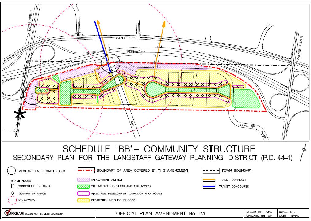
89 Council Attachment 2
90 Council Attachment 3 Density Comparison Analysis Summary Development Area Area (ha) Proposed Residential Units Residential Population Proposed Non Res GFA Employees Res/Emp per ha Langstaff Gateway 47 15,140 32, ,155 14, Richmond Hill Centre 70 7,900 15, ,000 15, North York Centre ,482 96,965 2,102,600 70, Bathurst Strachan 8.6 4,992 8,986 1, ,050 District (downtown Toronto) South Financial District 7.0 4,217 6, ,525 13,426 2,869 (downtown Toronto) TIFF Bell King & John (downtown Toronto) 1.4 1,435 2,251 17, ,990
91 Council Attachment 4 Key Hard Infrastructure Required by Phase Langstaff Gateway Precinct West Key Hard Infrastructure Requirements (in addition to fine grain road system, pedestrian and bike links and Travel Demand Management (TDM)) Phase 1 Phase 2 Phase 3 - Cedar Avenue Extension - Multi-use Corridor under Bayview Transit Priority Measures - Langstaff widening to 4 lanes & CN Railway overpass - new Regional Trunk Sewer - Yonge Subway Extension - CN Railway overpass at South Blvd Transitway East - Cedar Avenue Extension - Bayview Transit Priority Measures - Langstaff widening to 4 lanes to CN Railway - new Regional Trunk Sewer - local sewage pumping station - Yonge Subway Extension - CN Railway overpass at South Blvd. Build out complete in Phase 2 Central - No Phase 1 development - No Phase 2 development Transitway - Pedestrian Concourse (covered, weather protected concourse in Multi-use Corridor) - CN Railway overpass at Main St.

92 All of Langstaff Road to be included in Phase 1 through modification Council Attachment 5
Report No. 4 of the Planning and Economic Development Committee Regional Council Meeting of April 21, 2011
 Report No. 4 of the Planning and Economic Development Committee Regional Council Meeting of April 21, 2011 3 RICHMOND HILL/LANGSTAFF GATEWAY REGIONAL AND PROVINCIAL URBAN GROWTH CENTRE FRAMEWORK FOR PROPOSED
CONTENTS 2.0 A FRAMEWORK FOR SUSTAINABLE GROWTH 2.1 MANAGING SUSTAINABLE GROWTH THE VISION TO GOALS AND OBJECTIVES 2.3 MARKHAM STRUCTURE
 2 A Framework for Sustainable Growth 2.0 A FRAMEWORK FOR SUSTAINABLE GROWTH CONTENTS 2.1 MANAGING SUSTAINABLE GROWTH THE VISION TO 2031 2.2 GOALS AND OBJECTIVES 2.2.1 Protecting the Natural Environment
WITNESS STATEMENT Of. Ronald Blake. On behalf of the Intervenor The Corporation of the City of Markham
 Filed: 2013-06028 EB-2012-0451 Exhibit L.EGD.COM.2 Page 1 of 7 WITNESS STATEMENT Of Ronald Blake On behalf of the Intervenor The Corporation of the City of Markham In the matter of an application by Enbridge
2.0 A FRAMEWORK FOR SUSTAINABLE GROWTH CONTENTS
 2-2 A Framework for Sustainable Growth 2.0 A FRAMEWORK FOR SUSTAINABLE GROWTH CONTENTS 2.1 MANAGING SUSTAINABLE GROWTH THE VISION TO 2031 2.2 GOALS AND OBJECTIVES 2.2.1 Protecting the Natural Environment
12 AMENDMENT NO. 149, TOWN OF MARKHAM HIGHWAY 404 NORTH SECONDARY PLAN
 12 AMENDMENT NO. 149, TOWN OF MARKHAM HIGHWAY 404 NORTH SECONDARY PLAN The Planning and Economic Development Committee recommends the adoption of the recommendation contained in the following report August
9 CITY OF VAUGHAN OFFICIAL PLAN AMENDMENT NO BOCA EAST INVESTMENTS LIMITED
 9 CITY OF VAUGHAN OFFICIAL PLAN AMENDMENT NO. 631 - BOCA EAST INVESTMENTS LIMITED The Planning and Economic Development Committee recommends the adoption of the recommendations contained in the following
13 THORNHILL YONGE STREET STUDY IMPLEMENTATION CITY OF VAUGHAN OPA 669 AND TOWN OF MARKHAM OPA 154
 13 THORNHILL YONGE STREET STUDY IMPLEMENTATION CITY OF VAUGHAN OPA 669 AND TOWN OF MARKHAM OPA 154 The Planning and Economic Development Committee recommends the adoption of the recommendations contained
SCARBOROUGH SUBWAY EXTENSION. Scarborough Subway Extension. Final Terms of Reference
 Scarborough Subway Extension Final Terms of Reference 1 1.0 Introduction and Background 1.1 Introduction Toronto City Council recently confirmed support for an extension of the Bloor-Danforth Subway from
1.0 PLANNING MARKHAM S FUTURE CONTENTS
 1-1 Planning Markham s Future 1.0 PLANNING MARKHAM S FUTURE CONTENTS 1.1 THE PURPOSE OF THE OFFICIAL PLAN 1.2 THE MARKHAM CONTEXT 1.3 THE REGULATORY CONTEXT 1.3.1 Province of Ontario 1.3.2 York Region
Official Plan Review: Draft Built Form Policies
 PG.30.1 REPORT FOR ACTION Official Plan Review: Draft Built Form Policies Date: May 15, 2018 To: Planning and Growth Management Committee From: Chief Planner and Executive Director, City Planning Division
2.0 A FRAMEWORK FOR SUSTAINABLE GROWTH CONTENTS
 2-2 A Framework for Sustainable Growth 2.0 A FRAMEWORK FOR SUSTAINABLE GROWTH CONTENTS 2.1 MANAGING SUSTAINABLE GROWTH THE VISION TO 2031 2.2 GOALS AND OBJECTIVES 2.2.1 Protecting the Natural Environment
CITY OF VAUGHAN D R A F T YONGE STREET STUDY. June 2008 YOUNG + WRIGHT /IBI GROUP ARCHITECTS DILLON CONSULTING LTD.
 CITY OF VAUGHAN June 2008 YOUNG + WRIGHT /IBI GROUP ARCHITECTS GHK SUSTAINABILITY INTERNATIONAL + LIVABILITY (CANADA) LTD. = COMMUNITY VALUE DILLON CONSULTING LTD. Public Open House Tonight s Meeting WELCOME
5 TOWN OF MARKHAM OFFICIAL PLAN AMENDMENT NO. 144 MILLIKEN MAIN STREET SECONDARY PLAN
 5 TOWN OF MARKHAM OFFICIAL PLAN AMENDMENT NO. 144 MILLIKEN MAIN STREET SECONDARY PLAN The Planning and Economic Development Committee recommends the following: 1. The communication from Brendan O Callaghan,
2 STATUTORY PUBLIC MEETING AND INFORMATION REPORT FOR PUBLIC MEETING ON AMENDMENT NO. 62 TO THE YORK REGION OFFICIAL PLAN
 2 STATUTORY PUBLIC MEETING AND INFORMATION REPORT FOR PUBLIC MEETING ON AMENDMENT NO. 62 TO THE YORK REGION OFFICIAL PLAN Pursuant to Section 17(15) of the Planning Act, as amended, the Regional Planning
THAT the attached Terms of Reference for the Thornhill Centre Street Study be approved.
 COMMITTEE OF THE WHOLE AUGUST 18, 2003 THORNHILL CENTRE STREET STUDY PLANNING FILE: 15.92 Recommendation The Commissioner of Planning recommends: THAT the attached Terms of Reference for the Thornhill
CITY OF VAUGHAN EXTRACT FROM COUNCIL MEETING MINUTES OF NOVEMBER 15, 2016
 Item 11, Report No. 38, of the Committee of the Whole, which was adopted without amendment by the Council of the City of Vaughan on November 15, 2016. Regional Councillor Di Biase declared an interest
3 TOWN OF WHITCHURCH-STOUFFVILLE OFFICIAL PLAN AMENDMENT NOS. 116 & 117
 3 TOWN OF WHITCHURCH-STOUFFVILLE OFFICIAL PLAN AMENDMENT NOS. 116 & 117 The Planning and Economic Development Committee recommends the adoption of the recommendations contained in the following report,
Official Plan Review
 Official Plan Review Summary Report - The Built Environment August 2014 Part 1: Introduction Planning for a healthy, prosperous and sustainable community is an important goal for our municipality. From
CONSULTING SERVICES FOR THE WHITEBELT VISIONING EXERCISE ADDENDUM TO THE GTA WEST LAND USE STUDY WORK PROGRAM
 CONSULTING SERVICES FOR THE WHITEBELT VISIONING EXERCISE ADDENDUM TO THE GTA WEST LAND USE STUDY 1. Introduction WORK PROGRAM The Town of Caledon is a large, local municipality located in the Greater Toronto
John M. Fleming Managing Director, Planning and City Planner. Old East Village Dundas Street Corridor Secondary Plan Draft Terms of Reference
 Report to Planning and Environment Committee To: From: Subject: Chair and Members Planning & Environment Committee John M. Fleming Managing Director, Planning and City Planner Old East Village Dundas Street
YONGE STEELES CORRIDOR SECONDARY PLAN. Young + Wright / IBI Group Architects Dillon Consulting Ltd. GHK International (Canada) Ltd.
 Ltd.") PART A: PREAMBLE 1.0 PURPOSE The purpose of this Secondary Plan is to provide a development framework for intensification of the Yonge/ Steeles corridor including the north side of Steeles Avenue West
PART A: PREAMBLE 1.0 PURPOSE The purpose of this Secondary Plan is to provide a development framework for intensification of the Yonge/ Steeles corridor including the north side of Steeles Avenue West
Report to: Development Services Committee Report Date: April 24, 2017
 SUBJECT: Cornell Rouge National Urban Park Gateway - Report on Design Charrette and Next Steps PREPARED BY: Lilli Duoba, MES, MCIP, RPP, Manager, Natural Heritage (ext. 7925) REVIEWED BY: Marg Wouters,
Report to: Development Services Committee Report Date: September 11, 2017
 ~RKHAM Report to: Development Services Committee Report Date: September 11, 2017 SUBJECT: PREPARED BY: Conceptual Master Plan for the Future Urban Area - Community Structure Plan and Key Policy Direction
New Official Plan Quest November 2013
 City of Markham New Official Plan Quest November 2013 Building Markham s Future Together - 6 Key Strategic Priorities 1. Growth - Managing our Growth 2. Transportation/Transit - Improving transportation
SUBJECT: GO Station Mobility Hubs Preferred Concepts: Aldershot GO, Burlington GO and Appleby GO. Planning and Development Committee - Public Meeting
 Page 1 of Report PB-76-17 SUBJECT: GO Station Mobility Hubs Preferred Concepts: Aldershot GO, Burlington GO and Appleby GO TO: FROM: Planning and Development Committee - Public Meeting Planning and Building
~!VAUGHAN NOV Z November 21, Mr. Denis Kelly, Regional Clerk The Regional Municipality of York Yonge Street Newmarket, ON L3Y 6Z1
 ~!VAUGHAN NOV Z 5 2016 November 21, 2016 Mr. Denis Kelly, Regional Clerk The Regional Municipality of York 17250 Yonge Street Newmarket, ON L3Y 6Z1 Dear Mr. Kelly: RE: NEW KIRBY GO STATION IN BLOCK 27
1.0 Purpose of a Secondary Plan for the Masonville Transit Village
 Report to Planning and Environment Committee To: Chair and Members Planning & Environment Committee From: John M. Fleming Managing Director, Planning and City Planner Subject: Masonville Transit Village
1 Introduction. Chapter. In this chapter:
 Chapter 1 Introduction In this chapter: 1.1 A Snapshot of the Region 1.2 Towards a Sustainable Region 1.3 The Provincial Context 1.4 Purpose and Organization The Regional Municipality of York Official
THE CITY OF VAUGHAN BY-LAW BY-LAW NUMBER A By-law to adopt Amendment Number 1 to the Official Plan of the Vaughan Planning Area.
 THE CITY OF VAUGHAN BY-LAW BY-LAW NUMBER 015-2014 A By-law to adopt Amendment Number 1 to the Official Plan of the Vaughan Planning Area. NOW THEREFORE the Council of the Corporation of the City of Vaughan
Urban Design Manual PLANNING AROUND RAPID TRANSIT STATIONS (PARTS) Introduction. Station Study Areas
 Introduction. Station Study Areas") 111111 PLANNING AROUND RAPID TRANSIT STATIONS (PARTS) Introduction The ION rapid transit system will link Waterloo, Kitchener and Cambridge through a central transit corridor (CTC). There are a number
111111 PLANNING AROUND RAPID TRANSIT STATIONS (PARTS) Introduction The ION rapid transit system will link Waterloo, Kitchener and Cambridge through a central transit corridor (CTC). There are a number
SCHEDULE 'A' TO BY-LAW as Amended by AMENDMENT NO. 90 TO THE WHITBY OFFICIAL PLAN
 SCHEDULE 'A' TO BY-LAW 6413-10 as Amended by 6553-11 AMENDMENT NO. 90 TO THE WHITBY OFFICIAL PLAN SECTION A: GROWTH PLAN CONFORMITY PURPOSE: LOCATION: BASIS: The purpose of this Amendment is to: conform
Welcome. Walk Around. Talk to Us. Write Down Your Comments
 Welcome This is an information meeting introducing the applications for proposed redevelopment of the Yorkdale Shopping Centre site at 3401 Dufferin Street and 1 Yorkdale Road over the next 20+ years,
Town of Cobourg Heritage Master Plan. Statutory Public Meeting
 Town of Cobourg Heritage Master Plan Statutory Public Meeting April 25 th 2016 Presentation Overview 1. Introduction 2. Project background and schedule overview 3. Review of strategic direction content
The Corporation of the Town of Milton
 Report To: From: Council Barbara Koopmans, Commissioner, Planning and Development Date: May 7, 2018 Report No: Subject: Making it Possible Positioning the Town s Strategy for Growth and Economic Development
THE CORPORATION OF THE TOWN OF OAKVILLE BY-LAW NUMBER
 THE CORPORATION OF THE TOWN OF OAKVILLE BY-LAW NUMBER 2017-120 A by-law to adopt an amendment to the Livable Oakville Plan, Official Plan Amendment Number 20 (Downtown Oakville Growth Area) WHEREAS the
6 Growth Management Challenges and Opportunities
 6 Growth Management Challenges and Opportunities The Town has established a goal of attaining a 50% participation rate with respect to employment opportunities versus residential population. The Town s
Figure 1- Site Plan Concept
 Figure 1- Site Plan Concept Parking will be provided underground on three levels at rate of 1.0 space/ unit; this rate includes all visitors parking. MMM Group has prepared a parking assessment (April,
NEW REGIONAL OFFICIAL PLAN HIGH LEVEL PROCESS & FRAMEWORK
 NEW REGIONAL OFFICIAL PLAN HIGH LEVEL PROCESS & FRAMEWORK Why A New Official Plan Originally the role of Regionally Planning and content of Regional Official Plan (1970s) primarily focused on protecting
SUBJECT: Proposed Downtown Mobility Hub Precinct Plan and Proposed Official Plan Policies
 Page 1 of Report PB-81-17 SUBJECT: Proposed Downtown Mobility Hub Precinct Plan and Proposed Official Plan Policies TO: FROM: Committee of the Whole Planning and Building Department Report Number: PB-81-17
CITY OF VAUGHAN EXTRACT FROM COUNCIL MEETING MINUTES OF JUNE 7, 2016
 Item 5, Report No. 26, of the Committee of the Whole (Working Session), which was adopted without amendment by the Council of the City of Vaughan on June 7, 2016. 5 MUNICIPAL CLASS ENVIRONMENTAL ASSESSMENT
SUBJECT: Waterfront Hotel Planning Study Update TO: Planning and Development Committee FROM: Department of City Building. Recommendation: Purpose:
 Page 1 of Report PB-23-18 SUBJECT: Waterfront Hotel Planning Study Update TO: Planning and Development Committee FROM: Department of City Building Report Number: PB-23-18 Wards Affected: 2 File Numbers:
PUBLIC OPEN HOUSE HURONTARIO-MAIN CORRIDOR SECONDARY PLAN
 PUBLIC OPEN HOUSE HURONTARIO-MAIN CORRIDOR SECONDARY PLAN Tuesday, February 28, 2012 6pm 9pm 1 st Floor Atrium, City Hall 2 Wellington Street West, Brampton 1 POLICY FRAMEWORK The 2006 Provincial Growth
TORONTO COMPLETE STREETS GUIDELINES
 TORONTO COMPLETE STREETS GUIDELINES Presentation by Fiona Chapman, Manager, Pedestrian Projects Public Realm Section, Transportation Services, City of Toronto June 2017 PURPOSE OF THE PROJECT To develop
St. Lawrence Neighbourhood Focused Area - Official Plan Amendment Status Report
 STAFF REPORT ACTION REQUIRED St. Lawrence Neighbourhood Focused Area - Official Plan Amendment Status Report Date: May 21, 2015 To: From: Wards: Reference Number: Toronto and East York Community Council
Planning and Growth Management Committee. Chief Planner and Executive Director, City Planning Division. Pg12013 (File No NNY 34 OZ)
") 865 York Mills Road Official Plan Amendment Application Preliminary Report STAFF REPORT ACTION REQUIRED Date: February 28, 2012 To: From: Wards: Reference Number: Planning and Growth Management Committee
865 York Mills Road Official Plan Amendment Application Preliminary Report STAFF REPORT ACTION REQUIRED Date: February 28, 2012 To: From: Wards: Reference Number: Planning and Growth Management Committee
3. Endorse the LRT vision in transforming Surrey into Connected-Complete-Livable communities, and more specifically, the official vision statement:
 CORPORATE REPORT NO: R038 COUNCIL DATE: February 20, 2017 REGULAR COUNCIL TO: Mayor & Council DATE: February 16, 2017 FROM: General Manager, Engineering FILE: 8740-01 SUBJECT: Surrey Light Rail Transit
SUBJECT: Revised proposed new official plan recommended for adoption
 Page 1 of Report PB-04-18 SUBJECT: Revised proposed new official plan recommended for adoption TO: FROM: Planning and Development Committee Department of City Building Report Number: PB-04-18 Wards Affected:
11.4 Highway 400 North Employment Lands Secondary Plan APPROVED BY THE ONTARIO MUNICIPAL BOARD ON NOVEMBER 21, 2011
 11.4 Highway 400 North Employment Lands Secondary Plan APPROVED BY THE ONTARIO MUNICIPAL BOARD ON NOVEMBER 21, 2011 11.4.1 General 11.4.1.1. as approved by the Ontario Municipal Board on November 21, 2011,
SPECIAL COMMITTEE OF THE WHOLE DECEMBER 9, 2002 BLOCK 57/58 WEST BLOCK PLAN BLOCK PLAN FILE BL.57/58W.99 HUNTINGTON BUSINESS PARK LAND OWNERS
 SPECIAL COMMITTEE OF THE WHOLE DECEMBER 9, 2002 BLOCK 57/58 WEST BLOCK PLAN BLOCK PLAN FILE BL.57/58W.99 HUNTINGTON BUSINESS PARK LAND OWNERS Recommendation The Commissioner of Planning recommends: THAT
Macintosh HD:CURRENT WORK-(JRW):4026 Northumberland Trent River Crossings:4026_Mem- Pannu_Report(jm)Oct2510.docx
:4026 Northumberland Trent River Crossings:4026_Mem- Pannu_Report(jm)Oct2510.docx") MEMORANDUM To: Mobushar Pannu, County of Northumberland From: Nick McDonald Date: October 27, 2010 Re: First Draft of Report (Trent River Crossing) Our File No: 4026 Attached to this memorandum is a first
MEMORANDUM To: Mobushar Pannu, County of Northumberland From: Nick McDonald Date: October 27, 2010 Re: First Draft of Report (Trent River Crossing) Our File No: 4026 Attached to this memorandum is a first
McCowan Precinct Plan Study Background & Deliverables
 1 DRAFT & WITHOUT PREJUDICE McCowan Precinct Plan Study Background & Deliverables In September, 2011, City Planning (Scarborough District) began a study of an area within the Scarborough Centre, identified
CITY OF VAUGHAN EXTRACT FROM COUNCIL MEETING MINUTES OF OCTOBER 29, 2013
 CITY OF VAUGHAN EXTRACT FROM COUNCIL MEETING MINUTES OF OCTOBER 29, 2013 Item 18, Report No. 42, of the Committee of the Whole, which was adopted, as amended, by the Council of the City of Vaughan on October
implementation r expression in landscape
 6 ubc okanagan implementation campus plan r expression in landscape 68 6 implementation campus plan sections The Campus Plan supports the academic mission, values and commitments of the University by providing
The protection of the agricultural resources of the Province;
 PART II INTRODUCTION An Official Plan is a policy document, which is intended to serve as the basis for making land use decisions and managing change in any municipality in Ontario. According to the Planning
Welcome to the Oakridge Centre Open House
 Welcome to the Oakridge Centre Open House Why is the City hosting this event? This open house is to inform you of a rezoning application submitted to the City of Vancouver to amend the existing CD-1 (Comprehensive
CITY CLERK. Parkland Acquisition Strategic Directions Report (All Wards)
") CITY CLERK Clause embodied in Report No. 10 of the, as adopted by the Council of the City of Toronto at its meeting held on November 6, 7 and 8, 2001. 10 Parkland Acquisition Strategic Directions Report
CITY CLERK Clause embodied in Report No. 10 of the, as adopted by the Council of the City of Toronto at its meeting held on November 6, 7 and 8, 2001. 10 Parkland Acquisition Strategic Directions Report
TOcore: Downtown Plan Official Plan Amendment
 PG29.4 REPORT FOR ACTION TOcore: Downtown Plan Official Plan Amendment Date: April 17, 2018 To: Planning and Growth Management Committee From: Chief Planner and Executive Director, City Planning Wards:
Port Credit Local Advisory Panel October 20 th Meeting
 Port Credit Local Advisory Panel October 20 th Meeting Focus Of This Evening s Meeting: 1. Hurontario Main Street Higher Order Transit Study 2. Port Credit Mobility Hub & GO Station Parking Structure Study
150 Eighth Street Zoning By-law Amendment Application Preliminary Report
 REPORT FOR ACTION 150 Eighth Street Zoning By-law Amendment Application Preliminary Report Date: March 27, 2019 To: Etobicoke York Community Council From: Director, Community Planning, Etobicoke York District
Bloor St. W. Rezoning - Preliminary Report
 STAFF REPORT ACTION REQUIRED 1638-1644 Bloor St. W. Rezoning - Preliminary Report Date: April 1, 2008 To: From: Wards: Reference Number: Toronto and East York Community Council Acting Director, Community
6 AMENDMENT NO. 637 TO THE VAUGHAN OFFICIAL PLAN (VAUGHAN 400 NORTH EMPLOYMENT AREA SECONDARY PLAN)
") Report No. 3 of the Planning and Economic Development Committee Regional Council Meeting of March 24, 2011 6 AMENDMENT NO. 637 TO THE VAUGHAN OFFICIAL PLAN (VAUGHAN 400 NORTH EMPLOYMENT AREA SECONDARY
Report No. 3 of the Planning and Economic Development Committee Regional Council Meeting of March 24, 2011 6 AMENDMENT NO. 637 TO THE VAUGHAN OFFICIAL PLAN (VAUGHAN 400 NORTH EMPLOYMENT AREA SECONDARY
Summary of Changes for the Comprehensive Draft Proposed Official Plan Amendment
 Summary of Changes for the Comprehensive Draft Proposed Official Plan Amendment Note: Due to the broad scope of the Official Plan Review, this list is not exhaustive of the extent of changes in the comprehensive
THE CITY OF VAUGHAN BY-LAW BY-LAW NUMBER
 THE CITY OF VAUGHAN BY-LAW BY-LAW NUMBER 123-2013 A By-law to designate the whole of the City of Vaughan as a Site Plan Control Area, and to adopt site development guidelines and rules of procedure for
This page has been intentionally left blank.
 This page has been intentionally left blank. Chapter 3 3-2 3. Employment 3.A Niagara Economic Gateway 3.A.1 General The Niagara Economic Gateway comprises: a) The Gateway Economic Zone which includes all
Don Mills Crossing Study and Celestica Lands Development Application Community Meeting, Open House, and Breakout Discussions
 Consultation Summary Don Mills Crossing Study and Celestica Lands Development Application Community Meeting, Open House, and Breakout Discussions This report is not intended to provide a verbatim transcript
Edward R. Sajecki Commissioner of Planning and Building
 Corporate Report Clerk s Files Originator s Files CD.03.POR DATE: TO: FROM: SUBJECT: Chair and Members of Planning and Development Committee Meeting Date: February 27, 2012 Edward R. Sajecki Commissioner
MAYFIELD WEST SECONDARY PLAN PHASE 2
 MAYFIELD WEST SECONDARY PLAN PHASE 2 Public Open House #3 February 25, 2010 Draft Preferred Land Use Scenario TOWN OF CALEDON PLANNING & DEVELOPMENT DEPARTMENT Open House Agenda TOWN OF CALEDON 1. Welcome
CITY OF VAUGHAN EXTRACT FROM COUNCIL MEETING MINUTES OF MAY 6, 2014
 CITY OF VAUGHAN EXTRACT FROM COUNCIL MEETING MINUTES OF MAY 6, 2014 Item 35, Report No. 18, of the Committee of the Whole, which was adopted, as amended, by the Council of the City of Vaughan on May 6,
Cc~tporate Sers~ic:es
 tg * Cc~tporate Sers~ic:es Csrmcil and Adnrirristrativs Services April 26,201 1 ". RE(;lr?N (1;. 1q.1 i Town of Caledon Region of Peel ci E~iliS DEP? Attn: Karen Landry, Director of Attn: Carol Reig, Regional
6 CATHEDRAL COMMUNITY SECONDARY PLAN OFFICIAL PLAN AMENDMENT 123 TOWN OF MARKHAM
 6 CATHEDRAL COMMUNITY SECONDARY PLAN OFFICIAL PLAN AMENDMENT 123 TOWN OF MARKHAM The Planning and Economic Development Committee recommends the adoption of the recommendation contained in the following
and Richmond Street West - Official Plan Amendment Application - Preliminary Report
 STAFF REPORT ACTION REQUIRED 822-838 and 860-862 Richmond Street West - Official Plan Amendment Application - Preliminary Report Date: August 14, 2017 To: From: Wards: Reference Number: Toronto and East
EXISTING COMPREHENSIVE PLAN
 EXISTING COMPREHENSIVE PLAN Town Center Land Use Element: V. LAND USE POLICIES Town Center Mercer Island's business district vision as described in "Your Mercer Island Citizen-Designed Downtown" was an
The Commissioner of Engineering and Public Works recommends that this report be received for information purposes.
 COMMITTEE OF THE WHOLE FEBRUARY 1, 2011 407 TRANSITWAY - ENVIRONMENTAL PROJECT REPORT MINISTRY OF TRANSPORTATION CITY WIDE Recommendation The Commissioner of Engineering and Public Works recommends that
The West Vaughan Employment Area Secondary Plan Policies
 Part 2: The West Vaughan Employment Area Secondary Plan Policies 2.1 General Policies It is the policy of Council: 2.1.1. That the West Vaughan Employment Area (the WVEA), identified on Schedule 1, will
MAYFIELD WEST SECONDARY PLAN PHASE 2
 MAYFIELD WEST SECONDARY PLAN PHASE 2 Council Information Workshop February 16, 2010 Draft Preferred Land Use Plan TOWN OF CALEDON PLANNING & DEVELOPMENT DEPARTMENT Workshop Agenda TOWN OF CALEDON 1. Welcome
Mark-up of the effect of the proposed Bronte Village Growth Area OPA No.18 on the text of section 24, Bronte Village, of the Livable Oakville Plan
 Mark-up of the effect of the proposed Bronte Village Growth Area OPA No.18 on the text of section 24, Bronte Village, of the Livable Oakville Plan Notes: This document is provided for information purposes
178 Carruthers Properties Inc.
 178 Carruthers Properties Inc. Planning Rationale for 178 Carruthers Avenue Site Plan Control Application June 2014 Table of Contents 1.0 Introduction 2.0 Overview of Subject Property 3.0 Current Zoning
CITY OF PUYALLUP. Background. Development Services
 CITY OF PUYALLUP Development Services 333 South Meridian Puyallup WA 98371 To: City Council From: Katie Baker, AICP, Planning Division Re: South Hill Neighborhood Plan Adoption Date: (Meeting date: February
ONTARIO MUNICIPAL BOARD
 PL 120483 ONTARIO MUNICIPAL BOARD Applicant/Appellant: 2124123 Ontario Limited Subject: OPA, Rezoning and Draft Plan of Subdivision Municipal Address: 3940 Highway 7 East Municipality: City of Markham
SECTION E. Realizing the Plan
 SECTION E Realizing the Plan 60 DESIGN REGINA - OFFICIAL COMMUNITY PLAN SECTION E Realizing the Plan Design Regina has been an ambitious plan-making exercise, with a high level of community, stakeholder,
THE TOWN OF WASAGA BEACH
 THE TOWN OF WASAGA BEACH Downtown Development Master Plan Committee of the Whole Presentation January 26 th 2017 Uses within this designation should reflect a dependence on tourism as opposed to the permanent
Message from York Regional Council
 Tom Taylor Town of Newmarket Tim Jones Town of Aurora James Young Town of East Gwillimbury Robert Grossi Town of Georgina Danny Wheeler Town of Georgina Margaret Black Township of King A.J. (Tony) Van
Master Environmental Servicing Plan & Secondary Plan
 East Side Lands Stage 2 1 Master Environmental Servicing Plan & Secondary Plan Public Information Centre #1 June 16, 2016 Welcome! Today s Agenda Please sign in at the front desk. 5:30 pm 6:30 pm: Open
ELMVALE ACRES SHOPPING CENTRE MASTER PLAN
 ELMVALE ACRES SHOPPING CENTRE MASTER PLAN Contents 1.0 INTRODUCTION... 2 2.0 LOCATION... 2 3.0 EXISTING CONTEXT... 2 4.0 VISION & GUIDING PRINCIPLES... 2 5.0 LAND USE AND BUILT FORM... 4 5.1 St. Laurent
Rail Deck Park - City-initiated Official Plan Amendment Final Report
 STAFF REPORT ACTION REQUIRED Rail Deck Park - City-initiated Official Plan Amendment Final Report Date: October 30, 2017 To: From: Wards: Reference Number: Toronto and East York Community Council Acting
Portage Parkway Environmental Assessment Public Information Centre No. 1
 City of Vaughan Portage Parkway Environmental Assessment Public Information Centre No. 1 November 25, 2015 Welcome to the Public Information Centre This first Public Information Centre (PIC) introduces
Sustainable Growth. Sustainable Growth
 2 Sustainable Growth Sustainable Growth SUSTAINABLE GROWTH 2.1 COMMUNITY VISION... 2-5 2.2 THE CITY SYSTEM... 2-7 2.2.1 AREAS... 2-7 2.2.2 CITY-WIDE SYSTEMS... 2-8 2.2.3 PROVINCIAL PLAN BOUNDARIES AND
KANATA CENTRUM 255 KANATA AVENUE OFFICIAL PLAN AMENDMENT ZONING BY-LAW AMENDMENT
 KANATA CENTRUM 255 KANATA AVENUE OFFICIAL PLAN AMENDMENT ZONING BY-LAW AMENDMENT JUNE 2015 PREPARED BY: FOTENN Consultants Inc. 223 Mcleod Street Ottawa, ON K2P OZ8 (613) 730-5709 PREPARED FOR: Kanata
Town Center (part of the Comprehensive Plan)
") Town Center (part of the Comprehensive Plan) Mercer Island Town Center Looking North (2014) In 1994, a year-long process culminated in a set of design guidelines and code requirements for the Town Center
Town Center (part of the Comprehensive Plan) Mercer Island Town Center Looking North (2014) In 1994, a year-long process culminated in a set of design guidelines and code requirements for the Town Center
COMMUNITY SUSTAINABILITY AND ENVIRONMENTAL MASTER PLAN IMPLEMENTATION UPDATE
 Attachment 1 COMMUNITY SUSTAINABILITY AND ENVIRONMENTAL MASTER PLAN IMPLEMENTATION UPDATE Priorities and Key Initiatives Committee May 2013 Page E-1 How we grow Goal 2: To ensure sustainable development
CITY OF VAUGHAN EXTRACT FROM COUNCIL MEETING MINUTES OF JULY 13, 2010
 Item 1, Report No. 35, of the Committee of the Whole (Working Session), which was adopted without amendment by the Council of the City of Vaughan on July 13, 2010. 1 PRESENTATION REGIONAL MUNICIPALITY
Town of Oakville Streetscape Strategy
 Town of Oakville Streetscape Strategy Endorsed by PDC on February 10, 2014 (PD-011-14) Town of Oakville Streetscape Strategy [endorsed by PDC February 10, 2014] 0 Town of Oakville Streetscape Strategy
WELCOME and introduction
 1 WELCOME and introduction Mobility Hub Locations within Burlington STUDY OVERVIEW STUDY OBJECTIVES The City of Burlington is developing four Area Specific Plans, one for each of Burlington s Mobility
URBAN DESIGN POLICY DEVELOPMENT STEP 1: BACKGROUND RESEARCH
 URBAN DESIGN POLICY DEVELOPMENT STEP 1: BACKGROUND RESEARCH Final Report August 2016 P2. A. OVERVIEW, METHODOLOGY & ENGAGEMENT The City of Toronto s Urban Design Policy Development Background Research
3 MARKHAM NORTH-SOUTH LINK CORRIDOR PUBLIC TRANSIT IMPROVEMENTS ENVIRONMENTAL ASSESSMENT UPDATE
 3 MARKHAM NORTH-SOUTH LINK CORRIDOR PUBLIC TRANSIT IMPROVEMENTS ENVIRONMENTAL ASSESSMENT UPDATE The Rapid Transit Public/Private Partnership Steering Committee recommends the adoption of the recommendations
Tippett Road Area Regeneration Study Final Report. Planning and Growth Management Committee
 PG8.6 STAFF REPORT ACTION REQUIRED Tippett Road Area Regeneration Study Final Report Date: October 23, 2015 To: From: Wards: Reference Number: Planning and Growth Management Committee Chief Planner and
Official Plan Amendment to Further Protect Heritage Views of City Hall, Old City Hall and St. James Cathedral - Preliminary Report
 STAFF REPORT ACTION REQUIRED Official Plan Amendment to Further Protect Heritage Views of City Hall, Old City Hall and St. James Cathedral - Preliminary Report Date: June 6, 2017 To: From: Toronto and
Local Growth Planning in North Central Green Line Communities
 2018 April 30 Page 1 of 6 EXECUTIVE SUMMARY This report outlines a high-level scope for local growth planning for north central Green Line communities. The catalyst for this review is the significant investments
Eglinton Avenue East & 50 Thermos Road - Official Plan Amendment Application Preliminary Report
 STAFF REPORT ACTION REQUIRED 1966 2050 Eglinton Avenue East & 50 Thermos Road - Official Plan Amendment Application Preliminary Report Date: March 15, 2016 To: From: Wards: Reference Number: Scarborough
38 Queen s University Campus Master Plan Part 1
 38 Queen s University Campus Master Plan Part 1 46 The Campus at the City Scale Chapter 4 The Campus at the City Scale 39 Queen s is an urban University centrally located in Kingston. Decisions made by