Dome Industrial Park Project II Redevelopment Area
|
|
|
- Jocelyn Hood
- 6 years ago
- Views:
Transcription


1 CITY OF ST. PETERSBURG Dome Industrial Park Project II Redevelopment Area Historic Structures Study Submitted To: Prepared By: March 2008
2 Dome Industrial Park Project II - Redevelopment Area City of St. Petersburg Historic Structures Study March 2008 HISTORIC STRUCTURES STUDY DOME INDUSTRIAL PARK PROJECT II REDEVELOPMENT AREA CITY OF ST. PETERSBURG, PINELLAS COUNTY, FLORIDA The information in this report was obtained from sources deemed to be reliable. However, information of this nature is subject to change at any time without notice. The Urban Group, Inc.


3 Dome Industrial Park Project II - Redevelopment Area City of St. Petersburg Historic Structures Study March 2008 TABLE OF CONTENTS Dome Industrial Park II-Redevelopment Area Historic Structures Study PAGE Summary.1 Overview of Historic Structure Assessment...1 Description of Study Area...2 Historic Context...3 Conclusion... 5 Acquisition Target Map...Figure 1 Historical Structure Forms... Exhibit A Florida Master Site File Letter... Exhibit B Sanborn Map Reports... Exhibit C The Urban Group, Inc.


4 Dome Industrial Park Project II - Redevelopment Area City of St. Petersburg Historic Structures Study March 2008 SUMMARY Historic Structures Study Dome Industrial Park Project II - Redevelopment Area St. Petersburg, Florida Between 1912 and 1914 and again between 1921 and 1926 there were two large influxes of African-Americans into St. Petersburg. The subject study area is one of four parts of the City of St. Petersburg originally settled by African-Americans. Although the residential structures within the study area are indicative of a frame vernacular unique to their particular era, the evidence discovered as a result of preparing this report, these structures do not exhibit the characteristics required for historic designation. OVERVIEW OF HISTORIC STRUCTURE ASSESSMENT This evaluation overview resulting from the assessment of the Historical Structure Forms (Version 4.0 1/07), (See Exhibit A) have been prepared for the Section review of a specific portion of the Dome Industrial Park Project redevelopment area, (herein referred to as DIPP II) The study area is by and large located between 4 th Avenue South and 8 th Avenue South, and west of 22 nd Street as shown on the Acquisition Targets Map (Figure 1). This narrative representation does not presume to fully describe the subject area from the HSF s on individual properties. Figure 1 This study focuses on the structures on the parcels shown in Diagram 1 in light and dark gray shades. There are a total of 27 parcels and 30 structures which are described in the attached HSF s. Parcels 5, 19, and 25 contain two separate structures under a single ownership. This Section 106 review is part of an evaluation process underway to assist in the redevelopment program efforts being undertaken by the City of St. Petersburg. It is the City s desire to redevelop the area in order to expand the Dome Industrial Park Project. In this regard the 1 Section 106 of the national Historic Preservation Act of 1966 requires Federal agencies to take into account the effects of their undertakings on historic properties, and provides the criteria applied to evaluate properties for National Register of Historic Places. The Page 1 Urban Group, Inc.

5 Dome Industrial Park Project II - Redevelopment Area City of St. Petersburg Historic Structures Study March 2008 City is interested in acquiring the properties, which are the subject of this study, in a voluntary acquisition program. The completion of the HSF s is needed as part of the State of Florida environmental clearance procedures. Sources of information to complete the Historic Structures Form and prepare Project Overview include: Pinellas County Property Appraiser s parcel information. City of St. Petersburg Department of Development Services property cards. City of St. Petersburg website for Urban Design & Historic Preservation Division. on Local Historic Landmarks as well as Historic Districts. Personal interviews with Rick Smith, AICP, CRA Coordinator; Kimberly Hinder, Planner III; and Aimee Angel, Planner II. Designation Reports for Historic Sites near the study area. USGS Survey Quadrangle Map. Sanborn Fire Insurance Maps from 1923, 1952 and Florida Master Site File records search. Visual inspection of the various properties and photographic inventory. St. Petersburg s Historic 22 nd Street South, by Rosalie Peck and Jon Wilson, published in 2006 by The Historic Press. DESCRIPTION OF STUDY AREA According to Pinellas County Property Appraiser records the study area was platted for development in several different subdivisions over a period of time in the early part of the 20 th century. Those plats are as follows: St. Petersburg Investment Company Subdivision recorded in Highland Crest Subdivision also recorded in Prather s Second Royal Replat recorded in At one time it appears that the study area was the subject of an early effort to give the vicinity a community identity, as evidenced by several surrounding neighborhood signs. However those signs show a lack of regular attention and maintenance. The streets are laid out in a typical grid system with Avenues running east to west and Streets running north to south. Some of the streets are paved with brick, but most streets are asphalt covered. Sidewalks have been put in on some streets, but the majority of streets are without sidewalks. The south side of the study area is bordered by Interstate 295. Twenty-second Street South provides a connection under the Interstate to the remainder of the neighborhood to the south. However, the scale of this major The Page 2 Urban Group, Inc.

6 Dome Industrial Park Project II - Redevelopment Area City of St. Petersburg Historic Structures Study March 2008 thoroughfare in relationship to the small single-family homes is quite overpowering; and it poses a significant barrier to the south. The area is a mix of single-family, duplex and quadraplex residential along with heavy commercial (auto repair) and industrial uses (concrete batch plant). Within the study are the existing land uses include: Single-Family Residential 19; Duplex 1; Quad 2 House of Worship 1 Automotive Repair 3 Warehouse 4 According to records from the Pinellas County Property Appraiser, of the nineteen single-family homes, there are nine (9) homes with a Homestead exemption, suggesting that 47 percent of the residential properties have owner occupants. HISTORICAL CONTEXT Based on information obtained in Historic Designation Reports 2 for the Mercy Hospital, Melrose Clubhouse, Seaboard Coastline Railroad Station (shown below), Fannye Ayer Ponder Council House site, and the Tenth Street Church of God, as well as the St. Petersburg s Historic 22 nd Street South, the study area is one of four parts of the City of St. Petersburg originally settled by African-Americans. The Tenth Street Church of God Historic Designation Report states that one of the first areas to be settled called Pepper Town is located between 7 th and 9 th Streets along 2 nd Avenue South in the late 1880 s and 1890 s. Other areas included Coopers Quarters, Methodist Town between 9 th and 12 th Streets from 2 nd to 5 th Avenue North, and the 22 nd Street South neighborhood of which this study area is a part. The Designation Report goes on to say that between 1912 and 1914, and again between 1921 and 1926 there were two large influxes of African- Americans into St. Petersburg. As noted above, the study area was platted during both 2 The Historic Designation Reports are generated by City Staff for presentation to the Historic Preservation Committee and City Council for designation as historic landmarks. The Page 3 Urban Group, Inc.


7 Dome Industrial Park Project II - Redevelopment Area City of St. Petersburg Historic Structures Study March 2008 of these influxes and while the Sanborn Maps do not reflect a significant amount of construction up to 1924, by 1966 the area was substantially built out with residential, commercial and industrial uses. The St. Petersburg s Historic 22 nd Street South describes the 22 nd Street South area as being one of the nation s African American main streets and because of the segregation that existed in this and other communities throughout the country, 22 nd Street South was self-sustaining by offering residents places to buy groceries and clothing as well as becoming home to medical and law practices, funeral homes and beauty shops. Entertainment spots blossomed, as well. One of the centerpieces of the community was the Manhattan Casino (shown below). The building included a second story dance floor and stage for social activities. The hall was where many famous African American musical artists performed. The first floor had spaces for stores, restaurants and lounges. This Manhattan Casino and the Seaboard Coastline Railroad Station are both designated historic landmarks and within walking distance of the study area. Manhattan Casino The study area is bisected by the railroad tracks (which have been removed) that became a logical location for industrial and heavy commercial uses from very early on. As is typical these industrial and commercial uses transitioned to residential and less intense commercial uses. For the residential sections in the study area transition uses were less than smooth as currently seen by a concrete batch plant located across the street from single-family homes. However, according to St. Petersburg s Historic 22 nd Street South during the height of its prominence as an African American neighborhood these industrial uses offered walking-distance jobs for new arrivals who were gradually building a new black population center farther from downtown. Businesses included the Soft Water Laundry, Grounds Brothers Manufacturing and Littrell Lumber Company. The St. Petersburg s Historic 22 nd Street South also comments on the decline of this area. Despite the community s strength, it could not fight the inertia of social change. Integration, the coming of the Interstate Highway System and the reality of urban redevelopment fragmented the neighborhood and caused residents to scatter Beginning in the late 1960 s, a rougher, less family-oriented neighborhood began to emerge. For a time, the street s story was in danger of vanishing along with much of its community. People moved into neighborhoods previously off limits. Familiar old buildings were torn down. A sense of belonging evaporated. The Page 4 Urban Group, Inc.
8 Dome Industrial Park Project II - Redevelopment Area City of St. Petersburg Historic Structures Study March 2008 CONCLUSION Today the portion of the 22 nd Street South African-American neighborhood, which is a part of this evaluation, shows very little of its past residential vitality and almost none of the self-sustaining commercial uses that was so prevalent. Despite that 47 percent of study area s residential property owners are occupants, (as evidenced by information found in the Pinellas County Property Appraiser s Office website); the area appears to continue to decline. In addition, as described in the HSF s, although the residential structures are indicative of a frame vernacular unique to their particular era, they do not exhibit the characteristics required for historic designation 3. None of the commercial buildings exhibit the characteristics required for historic designation; however, the HSF for the Macedonia Free Will Baptist Church indicates that it is a historically significant resource and appears eligible for National Register of Historic Places listing. 3 National Register Evaluation Criteria include buildings or structures that 1) are associated with events that have made a significant contribution to the broad patterns of our history; or, 2) are associated with the lives of persons significant in our past; or, c) that embody distinctive characteristics of a type, period or method of construction, or that represent the work of a master, or that possesses high artistic values, or that represent a significant and distinguishable entity; or 3) have yielded, or may be likely to yield, information important in prehistory or history. The Page 5 Urban Group, Inc.
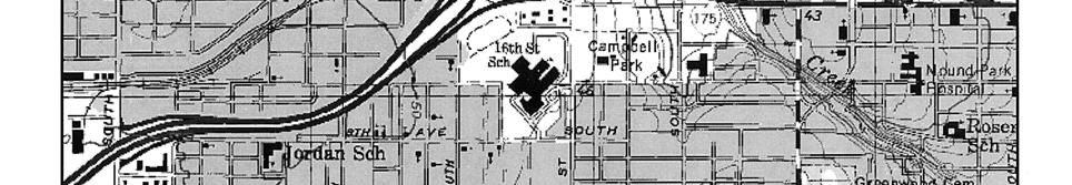
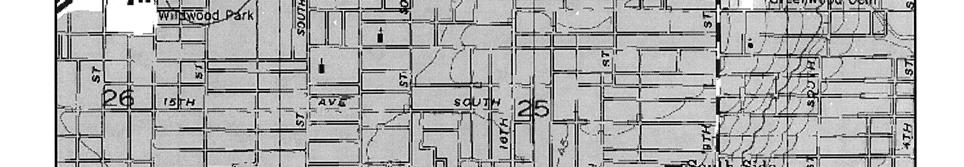
9 Dome Industrial Park Redevelopment Area City of St. Petersburg Historic Structures Study February 2008 FIGURE 1 Acquisition Target Map The Urban Group, Inc.

10 Dome Industrial Park Project II - Redevelopment Area City of St. Petersburg Historic Structures Study March 2008 Acquisition Target Map Source: City of St. Petersburg The Urban Group, Inc.
11 Dome Industrial Park Project II - Redevelopment Area City of St. Petersburg Historic Structures Study March 2008 EXHIBIT A Historical Structure Forms Florida Master Site File (Version 4.0 1/07) Attached: Site # 8 PI11625 and Site # 8 PI11637 through Pl11662 The Urban Group, Inc.
12 Page 1 Original Update HISTORICAL STRUCTURE FORM FLORIDA MASTER SITE FILE Version 4.0 1/07 Shaded Fields represent the minimum acceptable level of documentation. Consult the Guide to Historical Structure Forms for detailed instructions. Site #8 8PI11625 Field Date _8 /_15 /_07 Form Date _9 /_6 /_07 Recorder # 1/2 Site Name(s) (address if none) Macedonia Free Will Baptist Church Multiple Listing (DHR only) Survey Project Name Section 106 Review for the Dome Industrial Park Community Redevelopment Area Survey # (DHR only) National Register Category (please check one) building structure district site object Ownership: private-profit private-nonprofit private-individual private-nonspecific city county state federal Native American foreign unknown LOCATION & MAPPING Address (include N,S,E,W; #; St., Ave., etc.) th Avenue South Cross Streets (nearest / between) NE corner of 7 th Avenue S and 24 th Street S USGS 7.5' Map Name & Date St. Petersburg 1956 PR 1987 Plat or Other Map Plat Book 1, Page 20 City / Town (within 3 miles) St. Petersburg In City Limits? yes no unknown County Pinellas Township _31S Range 16E Section 23 ¼ section: NW SW SE NE Irregular-name: Tax Parcel # 23/31/16/38628/005/0040 Landgrant Subdivision Name Highland Crest Block 5 Lot 4-11 UTM: Zone Easting Northing Other Coordinates: X: Y: Coordinate System & Datum Name of Public Tract (e.g., park) HISTORY Construction Year: 1926 approximately year listed or earlier year listed or later Original Use* church From (year):_1926 To (year): 2007 Current Use* church From (year):_1926 To (year): 2007 Other Use* From (year): To (year): Moves: yes no unknown Dates 1939 Original address (if moved) SW corner of 10 th Ave & 24 th St S Alterations: yes no unknown Dates ca. 1951;63 Nature* brick veneer; replace windows & doors Additions: yes no unknown Dates ca Nature* rear addition Architect (last name first): _unknown Builder (last name first): unknown Ownership History (especially original owner, dates, profession, etc.) Macedonia Freewill Baptist Church ( ); Souls Harvest Fellowship Inc. (2001-Present) Is the Resource Affected by a Local Preservation Ordinance? yes no unknown Describe DESCRIPTION Style* Masonry Vernacular Exterior Plan* rectangular Number of Stories 1 Exterior Fabric(s) * brick veneer Roof Type(s) * gable Roof Material(s) * composition shingle Roof secondary strucs. (dormers etc.) * center steeple Windows (types, materials, etc.) * 4-light awning, metal, independent and paired set under triangular transom Distinguishing Architectural Features (exterior or interior ornaments) centrally located square steeple with entrance with louvered vent placed above_ Paired glass doors and triangular transom, buttresses, cornerstone on southeast corner of building Ancillary Features / Outbuildings (record outbuildings, major landscape features; use continuation sheet if needed.) ca Social Hall and ca Dining Room on NE attached by covered walkway ς Consult Guide to Historical Structure Forms for preferred descriptions (coded fields at the Site File). DHR USE ONLY OFFICIAL EVALUATION DHR USE ONLY NR List Date SHPO Appears to meet criteria for NR listing: yes no insufficient info Date / / Init. / / KEEPER Determined eligible: yes no Date / / Owner Objection NR Criteria for Evaluation: a b c d (see National Register Bulletin 15, p. 2) HR6E046R0107 Florida Master Site File / Division of Historical Resources / R. A. Gray Building / 500 South Bronough Street, Tallahassee, FL Phone (850) / Fax (850) / SiteFile@dos.state.fl.us
13 Page 2 HISTORICAL STRUCTURE FORM Site #8 PI DESCRIPTION (continued) Chimney: No._0 Material(s) * Structural System(s) * masonry Foundation: Type(s) * continuous Material(s) * masonry Main Entrance (stylistic details) paired glass doors set under six-light triangular transom placed in center steeple Porch Descriptions (types, locations, roof types, etc.) Condition (overall resource condition): excellent good fair deteriorated ruinous demolished Narrative Description of Resource Macedonia Free Will Baptist Church was constructed in 1926, but moved to its current location in 1939 when the Jordan Park public housing complex was constructed. The church was originally on the SW corner of 10 th Ave and 24 th St S. Archaeological Remains None observed. Check if Archaeological Form Completed ς Consult Guide to Historical Structure Forms for preferred descriptions (coded fields at the Site File). RESEARCH METHODS (check all that apply) FMSF record search (sites/surveys) library research building permits Sanborn maps FL State Archives/photo collection city directory occupant/owner interview plat maps property appraiser / tax records newspaper files neighbor interview Public Lands Survey (DEP) cultural resource survey historic photos interior inspection HABS/HAER record search other methods (describe) Bibliographic References (give FMSF manuscript # if relevant, use continuation sheet if needed) 2000 Architectural/Historic Survey of 22 nd Street South Corridor prepared by Stevenson Architects, Inc.; Property Card for th Avenue S, City of St. Petersburg, Development Services Department; Pinellas County Property Appraiser records; Sanborn Fire Insurance Maps, 1951 and 1952; Prather s Sixth Royal Subdivision, PB 6, Pg 93, Pinellas Clerk of Circuit Court OPINION OF RESOURCE SIGNIFICANCE Appears to meet the criteria for National Register listing individually? yes no insufficient information Appears to meet the criteria for National Register listing as part of a district? yes no insufficient information Explanation of Evaluation (required, whether significant or not; use separate sheet if needed) The Macedonia Free Will Baptist Church is one of the earliest remaining churches in the African-American community. In 1939, it was so important to the community that the church was relocated _ approximately five blocks north of its original location when the public housing complex was built on its original location. In spite of some alterations, it appears to be a historically significant resource and appears eligible for NRHP listing. Area(s) of Historical Significance (see National Register Bulletin 15, p. 8 for categories: e.g. architecture, ethnic heritage, community planning & development, etc.) Ethnic Heritage: African-American, Community Planning and Development DOCUMENTATION Accessible Documentation Not Filed with the Site File - including field & analysis notes, photos, plans, other important documents that are permanently accessible: For each separately maintained collection, describe (1) document type(s),* (2) maintaining organization,* (3) file or accession nos., and (4) descriptive information. City of St. Petersburg property card for th Avenue South; Pinellas County Clerk of Circuit Court, property records RECORDER INFORMATION Recorder Name Kimberly Hinder, Historic Preservation Planner Recorder Contact Information (address / phone / fax / ) City of St. Petersburg, P.O. Box 2842, St. Petersburg, FL Recorder Affiliation City of St. Petersburg Use a Supplement for Site Forms or other continuation sheet for descriptions that do not fit in the spaces provided. Required Attachments USGS 7.5 MAP WITH STRUCTURE LOCATION PINPOINTED IN RED LARGE SCALE STREET, PLAT OR PARCEL MAP (available from most property appraiser web sites) PHOTO OF MAIN FACADE, ARCHIVAL B&W PRINT OR DIGITAL IMAGE FILE If submitting an image file, it must be included on disk or CD AND in hard copy format (plain paper is acceptable). Digital image must be at least 1600 x 1200 pixels, 24-bit color, jpeg or tiff.
14 23RD ST S 25TH ST S 24TH ST S Page3 HISTORICAL STRUCTURE FORM Site #8 PI SANBORN FIRE INSURANCE MAP 1951 STREET MAP TERMINAL DR S 23RD ST S FAIRFIELD AVE S FAIRFIELD AVE S 24TH ST S 24TH ST S 23RD ST S 7TH AVE S 7TH AVE S 7TH AVE S 7TH AVE S 7TH AVE S 24TH ST S 25TH ST S 23RD ST S 8TH AVE S 8TH AVE S 8TH AVE S 8TH AVE S 24TH ST S 8PI11625 I-275

15 Page3 HISTORICAL STRUCTURE FORM Site #8 PI AERIAL Current Location of Church Original Location of Church


16 Page 4 HISTORICAL STRUCTURE FORM Site #8 PI PHOTOGRAPHS
17 Page 5 HISTORICAL STRUCTURE FORM Site #8 PI USGS MAP
18 Page 1 X Original Update HISTORICAL STRUCTURE FORM FLORIDA MASTER SITE FILE Version 4.0 1/07 Shaded Fields represent the minimum acceptable level of documentation. Consult the Guide to Historical Structure Forms for detailed instructions. Site #8 PI11637 Field Date _2_/ 8 /_2008 _ Form Date 2 / 29 / 2008 _ Recorder # Site Name(s) (address if none) th Avenue South, St Petersburg, Florida Multiple Listing (DHR only) Survey Project Name Section 106 Review for the Dome Industrial Park Community Redevelopment Area Survey # (DHR only) National Register Category (please check one) X building structure district site object Ownership: X private-profit private-nonprofit private-individual private-nonspecific city county state federal Native American foreign unknown LOCATION & MAPPING Address (include N,S,E,W; #; St., Ave., etc.) th Avenue South, St Petersburg, Florida Cross Streets (nearest / between) NE Corner of 23 rd Street South and 4 th Avenue South USGS 7.5' Map Name & Date St Petersburg Quadrangle, 1998 Plat or Other Map City / Town (within 3 miles) St Petersburg In City Limits? X yes no unknown County Pinellas Township 31S Range 16E Section 23 ¼ section: NW SW X SE NE Irregular-name: Tax Parcel # Landgrant Subdivision Name St Petersburg Investment Co Subdivision Block 31 Lot 9 & 10 UTM: Zone Easting 0 Northing 0 Other Coordinates: X: Y: Coordinate System & Datum Name of Public Tract (e.g., park) HISTORY Construction Year: 2002 approximately year listed or earlier X year listed or later Original Use* Storage building From (year): 2002 To (year): present Current Use* Storage building From (year): 2002 To (year): present Other Use* From (year): To (year): Moves: yes no X unknown Dates Original address (if moved) Alterations: yes X no unknown Dates Nature* Additions: yes X no unknown Dates Nature* Architect (last name first): Unknown Builder (last name first): Unknown Ownership History (especially original owner, dates, profession, etc.) current owner is Cashmere Enterprises, Inc. Is the Resource Affected by a Local Preservation Ordinance? yes X no unknown Describe DESCRIPTION Style* Industrial Exterior Plan* Rectangular Number of Stories 1 Exterior Fabric(s) * Aluminum Roof Type(s) * Shed Roof Material(s) * Aluminum Roof secondary strucs. (dormers etc.) * None Windows (types, materials, etc.) * None Distinguishing Architectural Features (exterior or interior ornaments) None Ancillary Features / Outbuildings (record outbuildings, major landscape features; use continuation sheet if needed.) None ς Consult Guide to Historical Structure Forms for preferred descriptions (coded fields at the Site File). DHR USE ONLY OFFICIAL EVALUATION DHR USE ONLY NR List Date SHPO Appears to meet criteria for NR listing: yes no insufficient info Date / / Init. / / KEEPER Determined eligible: yes no Date / / Owner Objection NR Criteria for Evaluation: a b c d (see National Register Bulletin 15, p. 2) HR6E046R0107 Florida Master Site File / Division of Historical Resources / R. A. Gray Building / 500 South Bronough Street, Tallahassee, FL Phone (850) / Fax (850) / SiteFile@dos.state.fl.us Page 2 HISTORICAL STRUCTURE FORM Site #8 PI11637
19 DESCRIPTION (continued) Chimney: No. 0 Material(s) * Structural System(s) * Metal Skeleton Foundation: Type(s) * Continuous Material(s) * Concrete Main Entrance (stylistic details) Driveway with metal overhead door and adjacent metal person door Porch Descriptions (types, locations, roof types, etc.) None Condition (overall resource condition): X excellent good fair deteriorated ruinous Narrative Description of Resource Structure is a large metal storage shed enclosed on the site by a chain link/barbed wire fence Archaeological Remains Check if Archaeological Form Completed ς Consult Guide to Historical Structure Forms for preferred descriptions (coded fields at the Site File). RESEARCH METHODS (check all that apply) X FMSF record search (sites/surveys) library research X building permits X Sanborn maps FL State Archives/photo collection city directory occupant/owner interview plat maps X property appraiser / tax records newspaper files neighbor interview Public Lands Survey (DEP) cultural resource survey historic photos interior inspection HABS/HAER record search X other methods (describe) Visual inspection Bibliographic References (give FMSF manuscript # if relevant, use continuation sheet if needed) Pinellas County Property Appraiser records; Sanborn Fire Insurance Map, 1952; City of St. Petersburg Development Services Department. OPINION OF RESOURCE SIGNIFICANCE Appears to meet the criteria for National Register listing individually? yes X no insufficient information Appears to meet the criteria for National Register listing as part of a district? yes X no insufficient information Explanation of Evaluation (required, whether significant or not; use separate sheet if needed) No information obtained indicates any association with Significant events or persons in history; the structure is relatively new and is not architecturally significant. Area(s) of Historical Significance (see National Register Bulletin 15, p. 8 for categories: e.g. architecture, ethnic heritage, community planning & development, etc.) African American History DOCUMENTATION Accessible Documentation Not Filed with the Site File - including field & analysis notes, photos, plans, other important documents that are permanently accessible: For each separately maintained collection, describe (1) document type(s),* (2) maintaining organization,* (3) file or accession nos., and (4) descriptive information. RECORDER INFORMATION Recorder Name Corey W. O Gorman, AICP Recorder Contact Information (address / phone / fax / ) 409 Gulf Road, North Palm Beach, FL 33408, , phone; fax; _ corey@placepnd.com ( ) Recorder Affiliation The Urban Group, Inc.; PLACE Planning & Design, Inc. Use a Supplement for Site Forms or other continuation sheet for descriptions that do not fit in the spaces provided. Required Attachments USGS 7.5 MAP WITH STRUCTURE LOCATION PINPOINTED IN RED LARGE SCALE STREET, PLAT OR PARCEL MAP (available from most property appraiser web sites) PHOTO OF MAIN FACADE, ARCHIVAL B&W PRINT OR DIGITAL IMAGE FILE If submitting an image file, it must be included on disk or CD AND in hard copy format (plain paper is acceptable). Digital image must be at least 1600 x 1200 pixels, 24-bit color, jpeg or tiff. Page 3 HISTORICAL STRUCTURE FORM Site #8 PI11637

20 SANBORN FIRE INSURANCE MAP 1952 STREET MAP
21 Page 4 HISTORICAL STRUCTURE FORM Site #8 PI11637 AERIAL PHOTOGRAPH

22 Page 5 HISTORICAL STRUCTURE FORM Site #8 PI11637 BUILDING PHOTOGRAPHS
23 Page 6 HISTORICAL STRUCTURE FORM Site #8 PI11637 USGS MAP
24 Page 1 X Original Update HISTORICAL STRUCTURE FORM FLORIDA MASTER SITE FILE Version 4.0 1/07 Shaded Fields represent the minimum acceptable level of documentation. Consult the Guide to Historical Structure Forms for detailed instructions. Site #8 PI11638 Field Date _2_/ 8 /_2008_ Form Date 2 / 29 / 2008 _ Recorder # Site Name(s) (address if none) th Avenue South, St Petersburg, Florida Multiple Listing (DHR only) Survey Project Name Section 106 Review for the Dome Industrial Park Community Redevelopment Area Survey # (DHR only) National Register Category (please check one) X building structure district site object Ownership: private-profit private-nonprofit X private-individual private-nonspecific city county state federal Native American foreign unknown LOCATION & MAPPING Address (include N,S,E,W; #; St., Ave., etc.) th Avenue South, St Petersburg, Florida Cross Streets (nearest / between) between 22 nd Street South and 23 rd Street South. USGS 7.5' Map Name & Date St Petersburg Quadrangle, 1998 Plat or Other Map City / Town (within 3 miles) St Petersburg In City Limits? X yes no unknown County Pinellas Township 31S Range 16E Section 23 ¼ section: NW SW SE NE Irregular-name: Tax Parcel # Landgrant Subdivision Name St Petersburg Investment Co Subdivision Block 31 Lot 11 UTM: Zone Easting 0 Northing 0 Other Coordinates: X: Y: Coordinate System & Datum Name of Public Tract (e.g., park) HISTORY Construction Year: 1949 X approximately year listed or earlier year listed or later Original Use* Warehouse From (year): To (year): Current Use* Warehouse From (year): To (year): Other Use* From (year): To (year): Moves: yes X no unknown Dates Original address (if moved) Alterations: yes no X unknown Dates Nature* Additions: X yes no unknown Dates Nature* In 1956 a 30 x 40 addition was constructed to the warehouse Architect (last name first): Builder (last name first): C.C. Beck, Contractor Ownership History (especially original owner, dates, profession, etc.) Thomas B. Williams, 1941; F. Claussen, 1947; LF Johnson, 1956; Current owner is_ Eric J. Higgs. Is the Resource Affected by a Local Preservation Ordinance? yes X no unknown Describe DESCRIPTION Style* Industrial Exterior Plan* Rectangular Number of Stories 1 Exterior Fabric(s) * Concrete block Roof Type(s) * Gable & hip Roof Material(s) * Rolled roofing Roof secondary strucs. (dormers etc.) * None Windows (types, materials, etc.) * One window facing the street is blocked in, the other is a single-hung window with an aluminum frame and it Appears to be blocked in from the interior. Distinguishing Architectural Features (exterior or interior ornaments) Roof parapet. Ancillary Features / Outbuildings (record outbuildings, major landscape features; use continuation sheet if needed.) None ς Consult Guide to Historical Structure Forms for preferred descriptions (coded fields at the Site File). DHR USE ONLY OFFICIAL EVALUATION DHR USE ONLY NR List Date SHPO Appears to meet criteria for NR listing: yes no insufficient info Date / / Init. / / KEEPER Determined eligible: yes no Date / / Owner Objection NR Criteria for Evaluation: a b c d (see National Register Bulletin 15, p. 2) HR6E046R0107 Florida Master Site File / Division of Historical Resources / R. A. Gray Building / 500 South Bronough Street, Tallahassee, FL Phone (850) / Fax (850) / SiteFile@dos.state.fl.us Page 2 HISTORICAL STRUCTURE FORM Site #8 PI11638
25 DESCRIPTION (continued) Chimney: No. 0 Material(s) * Structural System(s) * Concrete block Foundation: Type(s) * Continuous Material(s) * Concrete Main Entrance (stylistic details) Single door under a rectangular window and a decorative light. Porch Descriptions (types, locations, roof types, etc.) None Condition (overall resource condition): excellent good X fair deteriorated ruinous Narrative Description of Resource This warehouse building replaced a 3-room single family residence which had been constructed in 1941 by _ Thomas B. Williams at a cost of $1,400. In 1946 a rear porch and bedroom were added and then in 1947 the residence was moved by a new Owner, F. Claussen to st Street North. The warehouse was constructed in 1949 and a 30 x 40 addition completed in Archaeological Remains None observed Check if Archaeological Form Completed ς Consult Guide to Historical Structure Forms for preferred descriptions (coded fields at the Site File). RESEARCH METHODS (check all that apply) X FMSF record search (sites/surveys) library research X building permits X Sanborn maps FL State Archives/photo collection city directory occupant/owner interview plat maps X property appraiser / tax records newspaper files neighbor interview Public Lands Survey (DEP) cultural resource survey historic photos interior inspection HABS/HAER record search X other methods (describe) Visual inspection Bibliographic References (give FMSF manuscript # if relevant, use continuation sheet if needed) Property card for th Avenue South, City of St. Petersburg Development Services Department; Pinellas County Property Appraiser Records; Sanborn Fire Insurance Map, OPINION OF RESOURCE SIGNIFICANCE Appears to meet the criteria for National Register listing individually? yes X no insufficient information Appears to meet the criteria for National Register listing as part of a district? yes X no insufficient information Explanation of Evaluation (required, whether significant or not; use separate sheet if needed) No information obtained indicates any association with Significant events in history; the building reflects very simple design and construction methods and is not of a character representative of the Work of masters or possessing high artistic value; property is not likely to yield important historic information. Area(s) of Historical Significance (see National Register Bulletin 15, p. 8 for categories: e.g. architecture, ethnic heritage, community planning & development, etc.) African American DOCUMENTATION Accessible Documentation Not Filed with the Site File - including field & analysis notes, photos, plans, other important documents that are permanently accessible: For each separately maintained collection, describe (1) document type(s),* (2) maintaining organization,* (3) file or accession nos., and (4) descriptive information. Property card for th Avenue South, City of St. Petersburg Development Services Department RECORDER INFORMATION Recorder Name Corey W. O Gorman, AICP Recorder Contact Information (address / phone / fax / ) 409 Gulf Road, North Palm Beach, FL 33408, , phone; fax; _ corey@placepnd.com ( ) Recorder Affiliation The Urban Group, Inc.; PLACE Planning & Design, Inc. Use a Supplement for Site Forms or other continuation sheet for descriptions that do not fit in the spaces provided. Required Attachments USGS 7.5 MAP WITH STRUCTURE LOCATION PINPOINTED IN RED LARGE SCALE STREET, PLAT OR PARCEL MAP (available from most property appraiser web sites) PHOTO OF MAIN FACADE, ARCHIVAL B&W PRINT OR DIGITAL IMAGE FILE If submitting an image file, it must be included on disk or CD AND in hard copy format (plain paper is acceptable). Digital image must be at least 1600 x 1200 pixels, 24-bit color, jpeg or tiff. Page 3 HISTORICAL STRUCTURE FORM Site #8 PI11638 SANBORN FIRE INSURANCE MAP 1951

26 STREET MAP

27 Page 4 HISTORICAL STRUCTURE FORM Site #8 PI11638 AERIAL PHOTOGRAPH


28 Page 5 HISTORICAL STRUCTURE FORM Site #8 PI11638 BUILDING PHOTOGRAPHS
29 Page 6 HISTORICAL STRUCTURE FORM Site #8 PI11638 USGS MAP
30 Page 1 X Original Update HISTORICAL STRUCTURE FORM FLORIDA MASTER SITE FILE Version 4.0 1/07 Shaded Fields represent the minimum acceptable level of documentation. Consult the Guide to Historical Structure Forms for detailed instructions. Site #8 PI11640 Field Date _2_/ 8 /_2008_ Form Date 2 / 29 / 2008 _ Recorder # Site Name(s) (address if none) th Avenue South, St Petersburg, Florida Multiple Listing (DHR only) Survey Project Name Section 106 Review for the Dome Industrial Park Community Redevelopment Area Survey # (DHR only) National Register Category (please check one) X building structure district site object Ownership: private-profit private-nonprofit X private-individual private-nonspecific city county state federal Native American foreign unknown LOCATION & MAPPING Address (include N,S,E,W; #; St., Ave., etc.) th Avenue South, St Petersburg, Florida Cross Streets (nearest / between) between 22 nd Street South and 23 rd Street South. USGS 7.5' Map Name & Date St Petersburg Quadrangle, 1998 Plat or Other Map City / Town (within 3 miles) St Petersburg In City Limits? X yes no unknown County Pinellas Township 31S Range 16E Section 23 ¼ section: NW SW X SE NE Irregular-name: Tax Parcel # Landgrant Subdivision Name Highland Crest Subdivision Block 3 Lot 3 & 4 UTM: Zone Easting 0 Northing 0 Other Coordinates: X: Y: Coordinate System & Datum Name of Public Tract (e.g., park) HISTORY Construction Year: 1986 X approximately year listed or earlier year listed or later Original Use* Commercial Auto Repair From (year): 1986 To (year): Present Current Use* Commercial Auto Repair From (year): 1986 To (year): Present Other Use* Manufacture Wicker Furniture From (year): Unknown To (year): Moves: yes X no unknown Dates Original address (if moved) Alterations: yes no X unknown Dates Nature* Additions: yes no X unknown Dates Nature* Architect (last name first): Builder (last name first): Rick Myrick Ownership History (especially original owner, dates, profession, etc.) Coastal Management Inc. original owner; MT Auto Body owner in 1994; Current Owner is Luis & Paula Martinez Is the Resource Affected by a Local Preservation Ordinance? yes X no unknown Describe DESCRIPTION Style* Industrial Exterior Plan* Rectangular Number of Stories 1 Exterior Fabric(s) * Metal Roof Type(s) * Gable Roof Material(s) * Metal Roof secondary strucs. (dormers etc.) * None Windows (types, materials, etc.) * None Distinguishing Architectural Features (exterior or interior ornaments) None Ancillary Features / Outbuildings (record outbuildings, major landscape features; use continuation sheet if needed.)none ς Consult Guide to Historical Structure Forms for preferred descriptions (coded fields at the Site File). DHR USE ONLY OFFICIAL EVALUATION DHR USE ONLY NR List Date SHPO Appears to meet criteria for NR listing: yes no insufficient info Date / / Init. / / KEEPER Determined eligible: yes no Date / / Owner Objection NR Criteria for Evaluation: a b c d (see National Register Bulletin 15, p. 2) HR6E046R0107 Florida Master Site File / Division of Historical Resources / R. A. Gray Building / 500 South Bronough Street, Tallahassee, FL Phone (850) / Fax (850) / SiteFile@dos.state.fl.us Page 2 HISTORICAL STRUCTURE FORM Site #8 PI11640
31 DESCRIPTION (continued) Chimney: No. 0 Material(s) * Structural System(s) * Metal Foundation: Type(s) * Continuous Material(s) * Concrete Main Entrance (stylistic details) Standard commercial door Porch Descriptions (types, locations, roof types, etc.) None Condition (overall resource condition): excellent good X fair deteriorated ruinous Narrative Description of Resource Standard metal commercial building Archaeological Remains None observed Check if Archaeological Form Completed ς Consult Guide to Historical Structure Forms for preferred descriptions (coded fields at the Site File). RESEARCH METHODS (check all that apply) X FMSF record search (sites/surveys) library research X building permits X Sanborn maps FL State Archives/photo collection city directory occupant/owner interview plat maps X property appraiser / tax records newspaper files neighbor interview Public Lands Survey (DEP) cultural resource survey historic photos interior inspection HABS/HAER record search X other methods (describe) Visual inspection Bibliographic References (give FMSF manuscript # if relevant, use continuation sheet if needed) Property card for th Avenue South, City of St. Petersburg Development Services Department; Pinellas County Property Appraiser Records; Sanborn Fire Insurance Map, OPINION OF RESOURCE SIGNIFICANCE Appears to meet the criteria for National Register listing individually? yes X no insufficient information Appears to meet the criteria for National Register listing as part of a district? yes X no insufficient information Explanation of Evaluation (required, whether significant or not; use separate sheet if needed) No information obtained indicates any association with Significant events in history; the building reflects very simple design and construction methods and is not of a character representative of the Work of masters or possessing high artistic value; property is not likely to yield important historic information. Area(s) of Historical Significance (see National Register Bulletin 15, p. 8 for categories: e.g. architecture, ethnic heritage, community planning & development, etc.) African American DOCUMENTATION Accessible Documentation Not Filed with the Site File - including field & analysis notes, photos, plans, other important documents that are permanently accessible: For each separately maintained collection, describe (1) document type(s),* (2) maintaining organization,* (3) file or accession nos., and (4) descriptive information. Property card for th Avenue South, City of St. Petersburg Development Services Department RECORDER INFORMATION Recorder Name Corey W. O Gorman, AICP Recorder Contact Information (address / phone / fax / ) 409 Gulf Road, North Palm Beach, FL 33408, , phone; fax; _ corey@placepnd.com ( ) Recorder Affiliation The Urban Group, Inc.; PLACE Planning & Design, Inc. Use a Supplement for Site Forms or other continuation sheet for descriptions that do not fit in the spaces provided. Required Attachments USGS 7.5 MAP WITH STRUCTURE LOCATION PINPOINTED IN RED LARGE SCALE STREET, PLAT OR PARCEL MAP (available from most property appraiser web sites) PHOTO OF MAIN FACADE, ARCHIVAL B&W PRINT OR DIGITAL IMAGE FILE If submitting an image file, it must be included on disk or CD AND in hard copy format (plain paper is acceptable). Digital image must be at least 1600 x 1200 pixels, 24-bit color, jpeg or tiff. Page 3 HISTORICAL STRUCTURE FORM Site #8 PI11640
32 SANBORN FIRE INSURANCE MAP 1952 STREET MAP
33 Page 4 HISTORICAL STRUCTURE FORM Site #8 PI11640 AERIAL PHOTOGRAPH

34 Page 5 HISTORICAL STRUCTURE FORM Site #8 PI11640 BUILDING PHOTOGRAPHS
35 Page 6 HISTORICAL STRUCTURE FORM Site #8 PI11640 USGS MAP
36 Page 1 X Original Update HISTORICAL STRUCTURE FORM FLORIDA MASTER SITE FILE Version 4.0 1/07 Shaded Fields represent the minimum acceptable level of documentation. Consult the Guide to Historical Structure Forms for detailed instructions. Site #8 PI11641 Field Date _2_/ 8 /_2008_ Form Date 2 / 29 / 2008 _ Recorder # Site Name(s) (address if none) th Avenue South, St Petersburg, Florida Multiple Listing (DHR only) Survey Project Name Section 106 Review for the Dome Industrial Park Community Redevelopment Area Survey # (DHR only) National Register Category (please check one) X building structure district site object Ownership: X private-profit private-nonprofit private-individual private-nonspecific city county state federal Native American foreign unknown LOCATION & MAPPING Address (include N,S,E,W; #; St., Ave., etc.) th Avenue South, St Petersburg, Florida Cross Streets (nearest / between) between 22 nd Street South and 23 rd Street South. USGS 7.5' Map Name & Date St Petersburg Quadrangle, 1998 Plat or Other Map City / Town (within 3 miles) St Petersburg In City Limits? X yes no unknown County Pinellas Township 31S Range 16E Section 23 ¼ section: NW SW X SE NE Irregular-name: Tax Parcel # Landgrant Subdivision Name Highland Crest Subdivision Block 3 Lot 1 & 2 UTM: Zone Easting 0 Northing 0 Other Coordinates: X: Y: Coordinate System & Datum Name of Public Tract (e.g., park) HISTORY Construction Year: 1986 X approximately year listed or earlier year listed or later Original Use* Warehouse/office From (year): 1986 To (year): Unknown Current Use* Commercial Auto Repair From (year): Unknown To (year): Present Other Use* From (year): To (year): Moves: yes X no unknown Dates Original address (if moved) Alterations: yes no X unknown Dates Nature* Additions: yes no X unknown Dates Nature* Architect (last name first): Builder (last name first): Rick Myrick Ownership History (especially original owner, dates, profession, etc.) Original owner, Coastal Management Systems, Inc.; Current owner Southwest Investment Trust, Inc. Is the Resource Affected by a Local Preservation Ordinance? yes X no unknown Describe DESCRIPTION Style* Industrial Exterior Plan* Rectangular Number of Stories 1 Exterior Fabric(s) * Metal Roof Type(s) * Gable Roof Material(s) * Metal Roof secondary strucs. (dormers etc.) * None Windows (types, materials, etc.) * None Distinguishing Architectural Features (exterior or interior ornaments) None Ancillary Features / Outbuildings (record outbuildings, major landscape features; use continuation sheet if needed.)none ς Consult Guide to Historical Structure Forms for preferred descriptions (coded fields at the Site File). DHR USE ONLY OFFICIAL EVALUATION DHR USE ONLY NR List Date SHPO Appears to meet criteria for NR listing: yes no insufficient info Date / / Init. / / KEEPER Determined eligible: yes no Date / / Owner Objection NR Criteria for Evaluation: a b c d (see National Register Bulletin 15, p. 2) HR6E046R0107 Florida Master Site File / Division of Historical Resources / R. A. Gray Building / 500 South Bronough Street, Tallahassee, FL Phone (850) / Fax (850) / SiteFile@dos.state.fl.us Page 2 HISTORICAL STRUCTURE FORM Site #8 PI11640
37 DESCRIPTION (continued) Chimney: No. 0 Material(s) * Structural System(s) * Metal Foundation: Type(s) * Continuous Material(s) * Concrete Main Entrance (stylistic details) Standard commercial door Porch Descriptions (types, locations, roof types, etc.) None Condition (overall resource condition): excellent good X fair deteriorated ruinous Narrative Description of Resource Standard metal commercial building Archaeological Remains None observed Check if Archaeological Form Completed ς Consult Guide to Historical Structure Forms for preferred descriptions (coded fields at the Site File). RESEARCH METHODS (check all that apply) X FMSF record search (sites/surveys) library research X building permits X Sanborn maps FL State Archives/photo collection city directory occupant/owner interview plat maps X property appraiser / tax records newspaper files neighbor interview Public Lands Survey (DEP) cultural resource survey historic photos interior inspection HABS/HAER record search X other methods (describe) Visual inspection Bibliographic References (give FMSF manuscript # if relevant, use continuation sheet if needed) Property card for th Avenue South, City of St. Petersburg Development Services Department; Pinellas County Property Appraiser Records; Sanborn Fire Insurance Map, OPINION OF RESOURCE SIGNIFICANCE Appears to meet the criteria for National Register listing individually? yes X no insufficient information Appears to meet the criteria for National Register listing as part of a district? yes X no insufficient information Explanation of Evaluation (required, whether significant or not; use separate sheet if needed) No information obtained indicates any association with Significant events in history; the building reflects very simple design and construction methods and is not of a character representative of the Work of masters or possessing high artistic value; property is not likely to yield important historic information. Area(s) of Historical Significance (see National Register Bulletin 15, p. 8 for categories: e.g. architecture, ethnic heritage, community planning & development, etc.) African American DOCUMENTATION Accessible Documentation Not Filed with the Site File - including field & analysis notes, photos, plans, other important documents that are permanently accessible: For each separately maintained collection, describe (1) document type(s),* (2) maintaining organization,* (3) file or accession nos., and (4) descriptive information. Property card for th Avenue South, City of St. Petersburg Development Services Department RECORDER INFORMATION Recorder Name Corey W. O Gorman, AICP Recorder Contact Information (address / phone / fax / ) 409 Gulf Road, North Palm Beach, FL 33408, , phone; fax; _ corey@placepnd.com ( ) Recorder Affiliation The Urban Group, Inc.; PLACE Planning & Design, Inc. Use a Supplement for Site Forms or other continuation sheet for descriptions that do not fit in the spaces provided. Required Attachments USGS 7.5 MAP WITH STRUCTURE LOCATION PINPOINTED IN RED LARGE SCALE STREET, PLAT OR PARCEL MAP (available from most property appraiser web sites) PHOTO OF MAIN FACADE, ARCHIVAL B&W PRINT OR DIGITAL IMAGE FILE If submitting an image file, it must be included on disk or CD AND in hard copy format (plain paper is acceptable). Digital image must be at least 1600 x 1200 pixels, 24-bit color, jpeg or tiff. Page 3 HISTORICAL STRUCTURE FORM Site #8 PI11641

38 SANBORN FIRE INSURANCE MAP 1952 STREET MAP
39 Page 4 HISTORICAL STRUCTURE FORM Site #8 PI11641 AERIAL PHOTOGRAPH

40 Page 5 HISTORICAL STRUCTURE FORM Site #8 PI11641 BUILDING PHOTOGRAPHS
41
42 Page 6 HISTORICAL STRUCTURE FORM Site #8 PI11641 USGS MAP
43 Page 1 X Original Update HISTORICAL STRUCTURE FORM FLORIDA MASTER SITE FILE Version 4.0 1/07 Shaded Fields represent the minimum acceptable level of documentation. Consult the Guide to Historical Structure Forms for detailed instructions. Site #8 PI11641 Field Date _2_/ 8 /_2008_ Form Date 2 / 29 / 2008 _ Recorder # Site Name(s) (address if none) th Avenue South, St Petersburg, Florida Multiple Listing (DHR only) Survey Project Name Section 106 Review for the Dome Industrial Park Community Redevelopment Area Survey # (DHR only) National Register Category (please check one) X building structure district site object Ownership: X private-profit private-nonprofit private-individual private-nonspecific city county state federal Native American foreign unknown LOCATION & MAPPING Address (include N,S,E,W; #; St., Ave., etc.) th Avenue South, St Petersburg, Florida Cross Streets (nearest / between) between 22 nd Street South and 23 rd Street South. USGS 7.5' Map Name & Date St Petersburg Quadrangle, 1998 Plat or Other Map City / Town (within 3 miles) St Petersburg In City Limits? X yes no unknown County Pinellas Township 31S Range 16E Section 23 ¼ section: NW SW X SE NE Irregular-name: Tax Parcel # Landgrant Subdivision Name Highland Crest Subdivision Block 3 Lot 1 & 2 UTM: Zone Easting 0 Northing 0 Other Coordinates: X: Y: Coordinate System & Datum Name of Public Tract (e.g., park) HISTORY Construction Year: 1986 X approximately year listed or earlier year listed or later Original Use* Warehouse/office From (year): 1986 To (year): Unknown Current Use* Commercial Auto Repair From (year): Unknown To (year): Present Other Use* From (year): To (year): Moves: yes X no unknown Dates Original address (if moved) Alterations: yes no X unknown Dates Nature* Additions: yes no X unknown Dates Nature* Architect (last name first): Builder (last name first): Rick Myrick Ownership History (especially original owner, dates, profession, etc.) Original owner, Coastal Management Systems, Inc.; Current owner Southwest Investment Trust, Inc. Is the Resource Affected by a Local Preservation Ordinance? yes X no unknown Describe DESCRIPTION Style* Industrial Exterior Plan* Rectangular Number of Stories 1 Exterior Fabric(s) * Metal Roof Type(s) * Gable Roof Material(s) * Metal Roof secondary strucs. (dormers etc.) * None Windows (types, materials, etc.) * None Distinguishing Architectural Features (exterior or interior ornaments) None Ancillary Features / Outbuildings (record outbuildings, major landscape features; use continuation sheet if needed.)none ς Consult Guide to Historical Structure Forms for preferred descriptions (coded fields at the Site File). DHR USE ONLY OFFICIAL EVALUATION DHR USE ONLY NR List Date SHPO Appears to meet criteria for NR listing: yes no insufficient info Date / / Init. / / KEEPER Determined eligible: yes no Date / / Owner Objection NR Criteria for Evaluation: a b c d (see National Register Bulletin 15, p. 2) HR6E046R0107 Florida Master Site File / Division of Historical Resources / R. A. Gray Building / 500 South Bronough Street, Tallahassee, FL Phone (850) / Fax (850) / SiteFile@dos.state.fl.us Page 2 HISTORICAL STRUCTURE FORM Site #8 PI11640
44 DESCRIPTION (continued) Chimney: No. 0 Material(s) * Structural System(s) * Metal Foundation: Type(s) * Continuous Material(s) * Concrete Main Entrance (stylistic details) Standard commercial door Porch Descriptions (types, locations, roof types, etc.) None Condition (overall resource condition): excellent good X fair deteriorated ruinous Narrative Description of Resource Standard metal commercial building Archaeological Remains None observed Check if Archaeological Form Completed ς Consult Guide to Historical Structure Forms for preferred descriptions (coded fields at the Site File). RESEARCH METHODS (check all that apply) X FMSF record search (sites/surveys) library research X building permits X Sanborn maps FL State Archives/photo collection city directory occupant/owner interview plat maps X property appraiser / tax records newspaper files neighbor interview Public Lands Survey (DEP) cultural resource survey historic photos interior inspection HABS/HAER record search X other methods (describe) Visual inspection Bibliographic References (give FMSF manuscript # if relevant, use continuation sheet if needed) Property card for th Avenue South, City of St. Petersburg Development Services Department; Pinellas County Property Appraiser Records; Sanborn Fire Insurance Map, OPINION OF RESOURCE SIGNIFICANCE Appears to meet the criteria for National Register listing individually? yes X no insufficient information Appears to meet the criteria for National Register listing as part of a district? yes X no insufficient information Explanation of Evaluation (required, whether significant or not; use separate sheet if needed) No information obtained indicates any association with Significant events in history; the building reflects very simple design and construction methods and is not of a character representative of the Work of masters or possessing high artistic value; property is not likely to yield important historic information. Area(s) of Historical Significance (see National Register Bulletin 15, p. 8 for categories: e.g. architecture, ethnic heritage, community planning & development, etc.) African American DOCUMENTATION Accessible Documentation Not Filed with the Site File - including field & analysis notes, photos, plans, other important documents that are permanently accessible: For each separately maintained collection, describe (1) document type(s),* (2) maintaining organization,* (3) file or accession nos., and (4) descriptive information. Property card for th Avenue South, City of St. Petersburg Development Services Department RECORDER INFORMATION Recorder Name Corey W. O Gorman, AICP Recorder Contact Information (address / phone / fax / ) 409 Gulf Road, North Palm Beach, FL 33408, , phone; fax; _ corey@placepnd.com ( ) Recorder Affiliation The Urban Group, Inc.; PLACE Planning & Design, Inc. Use a Supplement for Site Forms or other continuation sheet for descriptions that do not fit in the spaces provided. Required Attachments USGS 7.5 MAP WITH STRUCTURE LOCATION PINPOINTED IN RED LARGE SCALE STREET, PLAT OR PARCEL MAP (available from most property appraiser web sites) PHOTO OF MAIN FACADE, ARCHIVAL B&W PRINT OR DIGITAL IMAGE FILE If submitting an image file, it must be included on disk or CD AND in hard copy format (plain paper is acceptable). Digital image must be at least 1600 x 1200 pixels, 24-bit color, jpeg or tiff. Page 3 HISTORICAL STRUCTURE FORM Site #8 PI11641

45 SANBORN FIRE INSURANCE MAP 1952 STREET MAP
46 Page 4 HISTORICAL STRUCTURE FORM Site #8 PI11641 AERIAL PHOTOGRAPH

47 Page 5 HISTORICAL STRUCTURE FORM Site #8 PI11641 BUILDING PHOTOGRAPHS
48 Page 6 HISTORICAL STRUCTURE FORM Site #8 PI11641 USGS MAP
49 Page 1 X Original Update HISTORICAL STRUCTURE FORM FLORIDA MASTER SITE FILE Version 4.0 1/07 Shaded Fields represent the minimum acceptable level of documentation. Consult the Guide to Historical Structure Forms for detailed instructions. Site #8 PI11642 Field Date _2_/ 8 /_2008_ Form Date 2 / 29 / 2008 _ Recorder # Site Name(s) (address if none) 2231 Fairfield Avenue South, St Petersburg, Florida Multiple Listing (DHR only) Survey Project Name Section 106 Review for the Dome Industrial Park Community Redevelopment Area Survey # (DHR only) National Register Category (please check one) X building structure district site object Ownership: private-profit private-nonprofit X private-individual private-nonspecific city county state federal Native American foreign unknown LOCATION & MAPPING Address (include N,S,E,W; #; St., Ave., etc.) 2231 Fairfield Avenue South, St Petersburg, Florida Cross Streets (nearest / between) between 22 nd Street South and 23 rd Street South. USGS 7.5' Map Name & Date St Petersburg Quadrangle, 1998 Plat or Other Map City / Town (within 3 miles) St Petersburg In City Limits? X yes no unknown County Pinellas Township 31S Range 16E Section 23 ¼ section: NW SW X SE NE Irregular-name: Tax Parcel # Landgrant Subdivision Name Highland Crest Subdivision Block 3 Lot 13 UTM: Zone Easting 0 Northing 0 Other Coordinates: X: Y: Coordinate System & Datum Name of Public Tract (e.g., park) HISTORY Construction Year: 1990 X approximately year listed or earlier year listed or later Original Use* Warehouse/Distribution From (year): 1990 To (year): Present Original Use* Warehouse/Distribution From (year): 1990 To (year): Present Other Use* From (year): To (year): Moves: yes X no unknown Dates Original address (if moved) Alterations: yes no X unknown Dates Nature* Additions: yes no X unknown Dates Nature* Architect (last name first): Unknown Builder (last name first): Unknown Ownership History (especially original owner, dates, profession, etc.) Original owner Sidney Harden; Current owners Suzanne Lipp & Russell Thompson_ Is the Resource Affected by a Local Preservation Ordinance? yes X no unknown Describe DESCRIPTION Style* Industrial Exterior Plan* Rectangular Number of Stories 1 Exterior Fabric(s) * Concrete Block Roof Type(s) * Gable Roof Material(s) * Composition shingle Roof secondary strucs. (dormers etc.) * None Windows (types, materials, etc.) * None Distinguishing Architectural Features (exterior or interior ornaments) None Ancillary Features / Outbuildings (record outbuildings, major landscape features; use continuation sheet if needed.) None ς Consult Guide to Historical Structure Forms for preferred descriptions (coded fields at the Site File). DHR USE ONLY OFFICIAL EVALUATION DHR USE ONLY NR List Date SHPO Appears to meet criteria for NR listing: yes no insufficient info Date / / Init. / / KEEPER Determined eligible: yes no Date / / Owner Objection NR Criteria for Evaluation: a b c d (see National Register Bulletin 15, p. 2) HR6E046R0107 Florida Master Site File / Division of Historical Resources / R. A. Gray Building / 500 South Bronough Street, Tallahassee, FL Phone (850) / Fax (850) / SiteFile@dos.state.fl.us Page 2 HISTORICAL STRUCTURE FORM Site #8 PI11642
50 DESCRIPTION (continued) Chimney: No. 0 Material(s) * Structural System(s) * Concrete block Foundation: Type(s) * Spread/monolithic footing Material(s) * Concrete Main Entrance (stylistic details) Porch Descriptions (types, locations, roof types, etc.) Condition (overall resource condition): excellent good X fair deteriorated ruinous Narrative Description of Resource: The building currently located on the property is a simple rectangular shaped, concrete block warehouse building with no distinguishing characteristics. According to the building department records the site used to be addressed as 2227 Fairfield and in 1947 a five room and bath residence was constructed here. The owner at the time was Sidney Harden. The building department record also indicates that repairs to the residence were made in 1963 for owner Bessie Harden, and in 1964 the use was for Brownies Tin Shop. Archaeological Remains Check if Archaeological Form Completed ς Consult Guide to Historical Structure Forms for preferred descriptions (coded fields at the Site File). RESEARCH METHODS (check all that apply) X FMSF record search (sites/surveys) library research X building permits X Sanborn maps FL State Archives/photo collection city directory occupant/owner interview plat maps X property appraiser / tax records newspaper files neighbor interview Public Lands Survey (DEP) cultural resource survey historic photos interior inspection HABS/HAER record search X other methods (describe) Visual inspection Bibliographic References (give FMSF manuscript # if relevant, use continuation sheet if needed) Property card for 2231 Fairfield Avenue South, City of St. Petersburg Development Services Department; Pinellas County Property Appraiser Records; Sanborn Fire Insurance Map, OPINION OF RESOURCE SIGNIFICANCE Appears to meet the criteria for National Register listing individually? yes X no insufficient information Appears to meet the criteria for National Register listing as part of a district? yes X no insufficient information Explanation of Evaluation (required, whether significant or not; use separate sheet if needed) No information obtained indicates any association with Significant events in history; the building reflects very simple design and construction methods and is not of a character representative of the Work of masters or possessing high artistic value; property is not likely to yield important historic information. Area(s) of Historical Significance (see National Register Bulletin 15, p. 8 for categories: e.g. architecture, ethnic heritage, community planning & development, etc.) African American DOCUMENTATION Accessible Documentation Not Filed with the Site File - including field & analysis notes, photos, plans, other important documents that are permanently accessible: For each separately maintained collection, describe (1) document type(s),* (2) maintaining organization,* (3) file or accession nos., and (4) descriptive information. Property card for 2231 Fairfield Avenue South, City of St. Petersburg Development Services Department RECORDER INFORMATION Recorder Name Corey W. O Gorman, AICP Recorder Contact Information (address / phone / fax / ) 409 Gulf Road, North Palm Beach, FL 33408, , phone; fax; _ corey@placepnd.com ( ) Recorder Affiliation The Urban Group, Inc.; PLACE Planning & Design, Inc. Use a Supplement for Site Forms or other continuation sheet for descriptions that do not fit in the spaces provided. Required Attachments USGS 7.5 MAP WITH STRUCTURE LOCATION PINPOINTED IN RED LARGE SCALE STREET, PLAT OR PARCEL MAP (available from most property appraiser web sites) PHOTO OF MAIN FACADE, ARCHIVAL B&W PRINT OR DIGITAL IMAGE FILE If submitting an image file, it must be included on disk or CD AND in hard copy format (plain paper is acceptable). Digital image must be at least 1600 x 1200 pixels, 24-bit color, jpeg or tiff. Page 3 HISTORICAL STRUCTURE FORM Site #8 PI11642
51 SANBORN FIRE INSURANCE MAP 1952 STREET MAP

52 Page 4 HISTORICAL STRUCTURE FORM Site #8 PI11642 AERIAL PHOTOGRAPH

53 Page 5 HISTORICAL STRUCTURE FORM Site #8 PI11642 BUILDING PHOTOGRAPHS
54 Page 6 HISTORICAL STRUCTURE FORM Site #8 PI11642 USGS MAP
55 Page 1 X Original Update HISTORICAL STRUCTURE FORM FLORIDA MASTER SITE FILE Version 4.0 1/07 Shaded Fields represent the minimum acceptable level of documentation. Consult the Guide to Historical Structure Forms for detailed instructions. Site #8 PI11643 Field Date _2_/ 8 /_2008_ Form Date 2 / 29 / 2008 _ Recorder # Site Name(s) (address if none) 2250 Fairfield Avenue South, St Petersburg, Florida Multiple Listing (DHR only) Survey Project Name Section 106 Review for the Dome Industrial Park Community Redevelopment Area Survey # (DHR only) National Register Category (please check one) X building structure district site object Ownership: private-profit private-nonprofit Xprivate-individual private-nonspecific city county state federal Native American foreign unknown LOCATION & MAPPING Address (include N,S,E,W; #; St., Ave., etc.) 2250 Fairfield Avenue South, St Petersburg, Florida Cross Streets (nearest / between) between 22 nd Street South and 23 rd Street South. USGS 7.5' Map Name & Date St Petersburg Quadrangle, 1998 Plat or Other Map City / Town (within 3 miles) St Petersburg In City Limits? X yes no unknown County Pinellas Township 31S Range 16E Section 23 ¼ section: NW SW X SE NE Irregular-name: Tax Parcel # Landgrant Subdivision Name Highland Crest Subdivision Block 4 Lot 4,5,6,7 & 8 UTM: Zone Easting 0 Northing 0 Other Coordinates: X: Y: Coordinate System & Datum Name of Public Tract (e.g., park) HISTORY Construction Year: 1985 X approximately year listed or earlier year listed or later Original Use* Warehouse/Distribution From (year): 1985 To (year): Present Original Use* Warehouse/Distribution From (year): 1985 To (year): Present Other Use* From (year): To (year): Moves: yes X no unknown Dates Original address (if moved) Alterations: yes no X unknown Dates Nature* Additions: yes no X unknown Dates Nature* Architect (last name first): Melody, Walter Builder (last name first): Bang, Larry Ownership History (especially original owner, dates, profession, etc.) Richard & Sandra Moreneault owners at time of construction of current building; Present owner Mary Ann Lynch; in 1956 property card indicates a previous structure (presumably demolished) owned by Cunningham Bros. Is the Resource Affected by a Local Preservation Ordinance? yes X no unknown Describe DESCRIPTION Style* Industrial Exterior Plan* Rectangular Number of Stories 1 Exterior Fabric(s) * Concrete Roof Type(s) * Gable Roof Material(s) * Composition shingle Roof secondary strucs. (dormers etc.) * None Windows (types, materials, etc.) * None Distinguishing Architectural Features (exterior or interior ornaments) None Ancillary Features / Outbuildings (record outbuildings, major landscape features; use continuation sheet if needed.) None ς Consult Guide to Historical Structure Forms for preferred descriptions (coded fields at the Site File). DHR USE ONLY OFFICIAL EVALUATION DHR USE ONLY NR List Date SHPO Appears to meet criteria for NR listing: yes no insufficient info Date / / Init. / / KEEPER Determined eligible: yes no Date / / Owner Objection NR Criteria for Evaluation: a b c d (see National Register Bulletin 15, p. 2) HR6E046R0107 Florida Master Site File / Division of Historical Resources / R. A. Gray Building / 500 South Bronough Street, Tallahassee, FL Phone (850) / Fax (850) / SiteFile@dos.state.fl.us Page 2 HISTORICAL STRUCTURE FORM Site #8 PI11643
56 DESCRIPTION (continued) Chimney: No. 0 Material(s) * Structural System(s) * Concrete block Foundation: Type(s) * Continuous Material(s) * Concrete Main Entrance (stylistic details) Overhead doors and person doors typical of warehouse design and construction Porch Descriptions (types, locations, roof types, etc.) None Condition (overall resource condition): excellent good X fair deteriorated ruinous Narrative Description of Resource: The building currently located on the property is a simple rectangular shaped, concrete block warehouse building with no distinguishing characteristics. Archaeological Remains None observed Check if Archaeological Form Completed ς Consult Guide to Historical Structure Forms for preferred descriptions (coded fields at the Site File). RESEARCH METHODS (check all that apply) X FMSF record search (sites/surveys) library research X building permits X Sanborn maps FL State Archives/photo collection city directory occupant/owner interview plat maps X property appraiser / tax records newspaper files neighbor interview Public Lands Survey (DEP) cultural resource survey historic photos interior inspection HABS/HAER record search X other methods (describe) Visual inspection Bibliographic References (give FMSF manuscript # if relevant, use continuation sheet if needed) Property card for 2250 Fairfield Avenue South, City of St. Petersburg Development Services Department; Pinellas County Property Appraiser Records; Sanborn Fire Insurance Map, OPINION OF RESOURCE SIGNIFICANCE Appears to meet the criteria for National Register listing individually? yes X no insufficient information Appears to meet the criteria for National Register listing as part of a district? yes X no insufficient information Explanation of Evaluation (required, whether significant or not; use separate sheet if needed) No information obtained indicates any association with Significant events in history; the building reflects very simple design and construction methods and is not of a character representative of the Work of masters or possessing high artistic value; property is not likely to yield important historic information. Area(s) of Historical Significance (see National Register Bulletin 15, p. 8 for categories: e.g. architecture, ethnic heritage, community planning & development, etc.) African American DOCUMENTATION Accessible Documentation Not Filed with the Site File - including field & analysis notes, photos, plans, other important documents that are permanently accessible: For each separately maintained collection, describe (1) document type(s),* (2) maintaining organization,* (3) file or accession nos., and (4) descriptive information. Property card for 2250 Fairfield Avenue South, City of St. Petersburg Development Services Department RECORDER INFORMATION Recorder Name Corey W. O Gorman, AICP Recorder Contact Information (address / phone / fax / ) 409 Gulf Road, North Palm Beach, FL 33408, , phone; fax; _ corey@placepnd.com ( ) Recorder Affiliation The Urban Group, Inc.; PLACE Planning & Design, Inc. Use a Supplement for Site Forms or other continuation sheet for descriptions that do not fit in the spaces provided. Required Attachments USGS 7.5 MAP WITH STRUCTURE LOCATION PINPOINTED IN RED LARGE SCALE STREET, PLAT OR PARCEL MAP (available from most property appraiser web sites) PHOTO OF MAIN FACADE, ARCHIVAL B&W PRINT OR DIGITAL IMAGE FILE If submitting an image file, it must be included on disk or CD AND in hard copy format (plain paper is acceptable). Digital image must be at least 1600 x 1200 pixels, 24-bit color, jpeg or tiff. Page 3 HISTORICAL STRUCTURE FORM Site #8 PI11643

57 SANBORN FIRE INSURANCE MAP 1952 STREET MAP
58 Page 4 HISTORICAL STRUCTURE FORM Site #8 PI11643 AERIAL PHOTOGRAPH

59 Page 5 HISTORICAL STRUCTURE FORM Site #8 PI11643 BUILDING PHOTOGRAPHS
60 Page 6 HISTORICAL STRUCTURE FORM Site #8 PI11643 USGS MAP
61 Page 1 X Original Update HISTORICAL STRUCTURE FORM FLORIDA MASTER SITE FILE Version 4.0 1/07 Shaded Fields represent the minimum acceptable level of documentation. Consult the Guide to Historical Structure Forms for detailed instructions. Site #8 PI11644 Field Date _2_/ 8 /_2008_ Form Date 2 / 29 / 2008 _ Recorder # Site Name(s) (address if none) th Avenue South, St Petersburg, Florida Multiple Listing (DHR only) Survey Project Name Section 106 Review for the Dome Industrial Park Community Redevelopment Area Survey # (DHR only) National Register Category (please check one) X building structure district site object Ownership: private-profit X private-nonprofit private-individual private-nonspecific city county state federal Native American foreign unknown LOCATION & MAPPING Address (include N,S,E,W; #; St., Ave., etc.) th Avenue South, St Petersburg, Florida Cross Streets (nearest / between) between 23 rd and 24 th Streets South USGS 7.5' Map Name & Date St Petersburg Quadrangle, 1998 Plat or Other Map City / Town (within 3 miles) St Petersburg In City Limits? X yes no unknown County Pinellas Township 31S Range 16E Section 23 ¼ section: NW SW X SE NE Irregular-name: Tax Parcel # Landgrant Subdivision Name Highland Crest Subdivision Block 5 Lot 12 UTM: Zone Easting 0 Northing 0 Other Coordinates: X: Y: Coordinate System & Datum Name of Public Tract (e.g., park) HISTORY Construction Year: 1939 X approximately year listed or earlier year listed or later Original Use* Residence-private From (year):1939 To (year):present Current Use* Residence-private / church From (year):1939 To (year):present Other Use* From (year): To (year): Moves: X yes no unknown Dates Feb 6, 1939 Original address (if moved) Lot 13 Tangerine Heights Alterations: yes no unknown Dates Nature* Additions: yes no unknown Dates Nature* Architect (last name first): Builder (last name first): Ownership History (especially original owner, dates, profession, etc.) Original owner in 1939 was Dorothy Lowe. Building department records show a new Owner in 1963, Dorothy Yopp. Current owner is The Souls Harvest Fellowship, Inc. Is the Resource Affected by a Local Preservation Ordinance? yes X no unknown Describe DESCRIPTION Style* Frame vernacular Exterior Plan* T-shaped Number of Stories 1 Exterior Fabric(s) * Wood Roof Type(s) * Gable Roof Material(s) * Composition roll Roof secondary strucs. (dormers etc.) * None Windows (types, materials, etc.) *Single hung, wood Distinguishing Architectural Features (exterior or interior ornaments)lap siding, exposed rafter tails; stemwall construction; covered front porch Ancillary Features / Outbuildings (record outbuildings, major landscape features; use continuation sheet if needed.) Storage shed in rear ς Consult Guide to Historical Structure Forms for preferred descriptions (coded fields at the Site File). DHR USE ONLY OFFICIAL EVALUATION DHR USE ONLY NR List Date SHPO Appears to meet criteria for NR listing: yes no insufficient info Date / / Init. / / KEEPER Determined eligible: yes no Date / / Owner Objection NR Criteria for Evaluation: a b c d (see National Register Bulletin 15, p. 2) HR6E046R0107 Florida Master Site File / Division of Historical Resources / R. A. Gray Building / 500 South Bronough Street, Tallahassee, FL Phone (850) / Fax (850) / SiteFile@dos.state.fl.us Page 2 HISTORICAL STRUCTURE FORM Site #8 PI11644
62 DESCRIPTION (continued) Chimney: No. 1 Material(s) * Concrete Structural System(s) * Wood frame Foundation: Type(s) * Stem wall / piers Material(s) * Main Entrance (stylistic details) Porch Descriptions (types, locations, roof types, etc.) Wood floor with gable roof facing south toward 7 th Avenue Condition (overall resource condition): excellent good X fair deteriorated ruinous Narrative Description of Resource: Frame vernacular residence with gable roof, front porch projecting from main structure, built on a stem wall _ Presumably with wood floors and a concrete chimney. Archaeological Remains None observed Check if Archaeological Form Completed ς Consult Guide to Historical Structure Forms for preferred descriptions (coded fields at the Site File). RESEARCH METHODS (check all that apply) X FMSF record search (sites/surveys) library research X building permits X Sanborn maps FL State Archives/photo collection city directory occupant/owner interview plat maps X property appraiser / tax records newspaper files neighbor interview Public Lands Survey (DEP) cultural resource survey historic photos interior inspection HABS/HAER record search X other methods (describe) Visual inspection Bibliographic References (give FMSF manuscript # if relevant, use continuation sheet if needed) Property card for th Avenue South, City of St. Petersburg Development Services Department; Pinellas County Property Appraiser Records; Sanborn Fire Insurance Map, OPINION OF RESOURCE SIGNIFICANCE Appears to meet the criteria for National Register listing individually? yes X no insufficient information Appears to meet the criteria for National Register listing as part of a district? yes X no insufficient information Explanation of Evaluation (required, whether significant or not; use separate sheet if needed) No information obtained indicates any association with Significant events in history; the building reflects very simple design and construction methods and is not of a character representative of the Work of masters or possessing high artistic value; property is not likely to yield important historic information. Area(s) of Historical Significance (see National Register Bulletin 15, p. 8 for categories: e.g. architecture, ethnic heritage, community planning & development, etc.) African American DOCUMENTATION Accessible Documentation Not Filed with the Site File - including field & analysis notes, photos, plans, other important documents that are permanently accessible: For each separately maintained collection, describe (1) document type(s),* (2) maintaining organization,* (3) file or accession nos., and (4) descriptive information. Property card for th Avenue South, City of St. Petersburg Development Services Department RECORDER INFORMATION Recorder Name Corey W. O Gorman, AICP Recorder Contact Information (address / phone / fax / ) 409 Gulf Road, North Palm Beach, FL 33408, , phone; fax; _ corey@placepnd.com ( ) Recorder Affiliation The Urban Group, Inc.; PLACE Planning & Design, Inc. Use a Supplement for Site Forms or other continuation sheet for descriptions that do not fit in the spaces provided. Required Attachments USGS 7.5 MAP WITH STRUCTURE LOCATION PINPOINTED IN RED LARGE SCALE STREET, PLAT OR PARCEL MAP (available from most property appraiser web sites) PHOTO OF MAIN FACADE, ARCHIVAL B&W PRINT OR DIGITAL IMAGE FILE If submitting an image file, it must be included on disk or CD AND in hard copy format (plain paper is acceptable). Digital image must be at least 1600 x 1200 pixels, 24-bit color, jpeg or tiff. Page 3 HISTORICAL STRUCTURE FORM Site #8 PI11644

63 SANBORN FIRE INSURANCE MAP 1952 STREET MAP
64 Page 4 HISTORICAL STRUCTURE FORM Site #8 PI11644 AERIAL PHOTOGRAPH


65 Page 5 HISTORICAL STRUCTURE FORM Site #8 PI11644 BUILDING PHOTOGRAPHS
66 Page 6 HISTORICAL STRUCTURE FORM Site #8 PI11644 USGS MAP
67 Page 1 X Original Update HISTORICAL STRUCTURE FORM FLORIDA MASTER SITE FILE Version 4.0 1/07 Shaded Fields represent the minimum acceptable level of documentation. Consult the Guide to Historical Structure Forms for detailed instructions. Site #8 PI11645 Field Date _2_/ 8 /_2008_ Form Date 2 / 29 / 2008 _ Recorder # Site Name(s) (address if none) th Avenue South, St Petersburg, Florida Multiple Listing (DHR only) Survey Project Name Section 106 Review for the Dome Industrial Park Community Redevelopment Area Survey # (DHR only) National Register Category (please check one) X building structure district site object Ownership: private-profit private-nonprofit X private-individual private-nonspecific city county state federal Native American foreign unknown LOCATION & MAPPING Address (include N,S,E,W; #; St., Ave., etc.) th Avenue South, St Petersburg, Florida Cross Streets (nearest / between) between 23 rd and 24 th Streets South USGS 7.5' Map Name & Date St Petersburg Quadrangle, 1998 Plat or Other Map City / Town (within 3 miles) St Petersburg In City Limits? X yes no unknown County Pinellas Township 31S Range 16E Section 23 ¼ section: NW SW X SE NE Irregular-name: Tax Parcel # Landgrant Subdivision Name Highland Crest Subdivision Block 5 Lot 14 UTM: Zone Easting 0 Northing 0 Other Coordinates: X: Y: Coordinate System & Datum Name of Public Tract (e.g., park) HISTORY Construction Year: 1968 X approximately year listed or earlier year listed or later Original Use* Residence - Private From (year): 1968 To (year): Present Current Use* Residence - Private From (year): 1968 To (year): Present Other Use* From (year): To (year): Moves: yes X no unknown Dates Original address (if moved) Alterations: yes no X unknown Dates Nature* Additions: yes no X unknown Dates Nature* Architect (last name first): Builder (last name first): Bryan, M.W. Ownership History (especially original owner, dates, profession, etc.) 1939 owner was L.A. Adams (structure demolished in 1968); Current owner Robert Chambers Is the Resource Affected by a Local Preservation Ordinance? yes X no unknown Describe DESCRIPTION Style* Masonry Vernacular Exterior Plan* Rectangular Number of Stories 1 Exterior Fabric(s) * Concrete block Roof Type(s) * Gable Roof Material(s) * Composite-shingle Roof secondary strucs. (dormers etc.) * None Windows (types, materials, etc.) * Aluminum single-hung Distinguishing Architectural Features (exterior or interior ornaments) None Ancillary Features / Outbuildings (record outbuildings, major landscape features; use continuation sheet if needed.) None ς Consult Guide to Historical Structure Forms for preferred descriptions (coded fields at the Site File). DHR USE ONLY OFFICIAL EVALUATION DHR USE ONLY NR List Date SHPO Appears to meet criteria for NR listing: yes no insufficient info Date / / Init. / / KEEPER Determined eligible: yes no Date / / Owner Objection NR Criteria for Evaluation: a b c d (see National Register Bulletin 15, p. 2) HR6E046R0107 Florida Master Site File / Division of Historical Resources / R. A. Gray Building / 500 South Bronough Street, Tallahassee, FL Phone (850) / Fax (850) / SiteFile@dos.state.fl.us Page 2 HISTORICAL STRUCTURE FORM Site #8 PI11645
68 DESCRIPTION (continued) Chimney: No. 0 Material(s) * Structural System(s) * Wood frame Foundation: Type(s) * Continuous Material(s) * Concrete Main Entrance (stylistic details) From driveway through porch to main door, no significant detailing. Porch Descriptions (types, locations, roof types, etc.) Open porch facing south with incised roof Condition (overall resource condition): excellent X good fair deteriorated ruinous Narrative Description of Resource: Masonry vernacular residence with gable roof extending over front concrete porch. Archaeological Remains None observed. Check if Archaeological Form Completed ς Consult Guide to Historical Structure Forms for preferred descriptions (coded fields at the Site File). RESEARCH METHODS (check all that apply) X FMSF record search (sites/surveys) library research X building permits X Sanborn maps FL State Archives/photo collection city directory occupant/owner interview plat maps X property appraiser / tax records newspaper files neighbor interview Public Lands Survey (DEP) cultural resource survey historic photos interior inspection HABS/HAER record search X other methods (describe) Visual inspection Bibliographic References (give FMSF manuscript # if relevant, use continuation sheet if needed) Property card for th Avenue South, City of St. Petersburg Development Services Department; Pinellas County Property Appraiser Records; Sanborn Fire Insurance Map, OPINION OF RESOURCE SIGNIFICANCE Appears to meet the criteria for National Register listing individually? yes X no insufficient information Appears to meet the criteria for National Register listing as part of a district? yes X no insufficient information Explanation of Evaluation (required, whether significant or not; use separate sheet if needed) No information obtained indicates any association with Significant events in history; the building reflects very simple design and construction methods and is not of a character representative of the Work of masters or possessing high artistic value; property is not likely to yield important historic information. Area(s) of Historical Significance (see National Register Bulletin 15, p. 8 for categories: e.g. architecture, ethnic heritage, community planning & development, etc.) African American DOCUMENTATION Accessible Documentation Not Filed with the Site File - including field & analysis notes, photos, plans, other important documents that are permanently accessible: For each separately maintained collection, describe (1) document type(s),* (2) maintaining organization,* (3) file or accession nos., and (4) descriptive information. Property card for th Avenue South, City of St. Petersburg Development Services Department RECORDER INFORMATION Recorder Name Corey W. O Gorman, AICP Recorder Contact Information (address / phone / fax / ) 409 Gulf Road, North Palm Beach, FL 33408, , phone; fax; _ corey@placepnd.com ( ) Recorder Affiliation The Urban Group, Inc.; PLACE Planning & Design, Inc. Use a Supplement for Site Forms or other continuation sheet for descriptions that do not fit in the spaces provided. Required Attachments USGS 7.5 MAP WITH STRUCTURE LOCATION PINPOINTED IN RED LARGE SCALE STREET, PLAT OR PARCEL MAP (available from most property appraiser web sites) PHOTO OF MAIN FACADE, ARCHIVAL B&W PRINT OR DIGITAL IMAGE FILE If submitting an image file, it must be included on disk or CD AND in hard copy format (plain paper is acceptable). Digital image must be at least 1600 x 1200 pixels, 24-bit color, jpeg or tiff. Page 3 HISTORICAL STRUCTURE FORM Site #8 PI11645

69 SANBORN FIRE INSURANCE MAP 1952 STREET MAP
70 Page 4 HISTORICAL STRUCTURE FORM Site #8 PI11645 AERIAL PHOTOGRAPH

71 Page 5 HISTORICAL STRUCTURE FORM Site #8 PI11645 BUILDING PHOTOGRAPHS
72 Page 6 HISTORICAL STRUCTURE FORM Site #8 PI11645 USGS MAP
73 Page 1 X Original Update HISTORICAL STRUCTURE FORM FLORIDA MASTER SITE FILE Version 4.0 1/07 Shaded Fields represent the minimum acceptable level of documentation. Consult the Guide to Historical Structure Forms for detailed instructions. Site #8 PI11646 Field Date _2_/ 8 /_2008_ Form Date 2 / 29 / 2008 _ Recorder # Site Name(s) (address if none) th Avenue South, St Petersburg, Florida Multiple Listing (DHR only) Survey Project Name Section 106 Review for the Dome Industrial Park Community Redevelopment Area Survey # (DHR only) National Register Category (please check one) X building structure district site object Ownership: private-profit private-nonprofit X private-individual private-nonspecific city county state federal Native American foreign unknown LOCATION & MAPPING Address (include N,S,E,W; #; St., Ave., etc.) th Avenue South, St Petersburg, Florida Cross Streets (nearest / between) Between 23 rd and 24 th Street South USGS 7.5' Map Name & Date St Petersburg Quadrangle, 1998 Plat or Other Map City / Town (within 3 miles) St Petersburg In City Limits? X yes no unknown County Pinellas Township 31S Range 16E Section 23 ¼ section: NW SW X SE NE Irregular-name: Tax Parcel # Landgrant Subdivision Name Highland Crest Subdivision Block 5 Lot 15 UTM: Zone Easting 0 Northing 0 Other Coordinates: X: Y: Coordinate System & Datum Name of Public Tract (e.g., park) HISTORY Construction Year: 1939 X approximately year listed or earlier year listed or later Original Use* Residence - Private From (year): 1939 To (year): Present Current Use* Residence - Private From (year): 1939 To (year): Present Other Use* From (year): To (year): Moves: yes X no unknown Dates Original address (if moved) Alterations: yes no X unknown Dates Nature* Additions: yes no X unknown Dates Nature* Architect (last name first): Builder (last name first): Bennett, M.J. Ownership History (especially original owner, dates, profession, etc.) 1939, Lee Smith; Current owner, Izaneth Sanchez Is the Resource Affected by a Local Preservation Ordinance? yes X no unknown Describe DESCRIPTION Style* Frame vernacular Exterior Plan* Rectangular Number of Stories 1 Exterior Fabric(s) * Wood Roof Type(s) * Gable Roof Material(s) * Shingle Roof secondary strucs. (dormers etc.) * None Windows (types, materials, etc.) * Single hung, wood Distinguishing Architectural Features (exterior or interior ornaments) Lap siding, exposed rafter tails; stemwall construction; covered front porch Ancillary Features / Outbuildings (record outbuildings, major landscape features; use continuation sheet if needed.) None ς Consult Guide to Historical Structure Forms for preferred descriptions (coded fields at the Site File). DHR USE ONLY OFFICIAL EVALUATION DHR USE ONLY NR List Date SHPO Appears to meet criteria for NR listing: yes no insufficient info Date / / Init. / / KEEPER Determined eligible: yes no Date / / Owner Objection NR Criteria for Evaluation: a b c d (see National Register Bulletin 15, p. 2) HR6E046R0107 Florida Master Site File / Division of Historical Resources / R. A. Gray Building / 500 South Bronough Street, Tallahassee, FL Phone (850) / Fax (850) / SiteFile@dos.state.fl.us Page 2 HISTORICAL STRUCTURE FORM Site #8 PI11646
74 DESCRIPTION (continued) Chimney: No. 0 Material(s) * Structural System(s) * Wood frame Foundation: Type(s) * Stem wall piers Material(s) * Concrete Main Entrance (stylistic details) Concrete path from sidewalk to porch and main entry door Porch Descriptions (types, locations, roof types, etc.) Open porch with wood columns and projecting roof. Condition (overall resource condition): excellent good X fair deteriorated ruinous Narrative Description of Resource: Frame vernacular residence with gable roof, lap siding and an open frame porch facing south. Archaeological Remains None observed Check if Archaeological Form Completed ς Consult Guide to Historical Structure Forms for preferred descriptions (coded fields at the Site File). RESEARCH METHODS (check all that apply) X FMSF record search (sites/surveys) library research X building permits X Sanborn maps FL State Archives/photo collection city directory occupant/owner interview plat maps X property appraiser / tax records newspaper files neighbor interview Public Lands Survey (DEP) cultural resource survey historic photos interior inspection HABS/HAER record search X other methods (describe) Visual inspection Bibliographic References (give FMSF manuscript # if relevant, use continuation sheet if needed) Property card for th Avenue South, City of St. Petersburg Development Services Department; Pinellas County Property Appraiser Records; Sanborn Fire Insurance Map, OPINION OF RESOURCE SIGNIFICANCE Appears to meet the criteria for National Register listing individually? yes X no insufficient information Appears to meet the criteria for National Register listing as part of a district? yes X no insufficient information Explanation of Evaluation (required, whether significant or not; use separate sheet if needed) No information obtained indicates any association with Significant events in history; the building reflects very simple design and construction methods and is not of a character representative of the Work of masters or possessing high artistic value; property is not likely to yield important historic information. Area(s) of Historical Significance (see National Register Bulletin 15, p. 8 for categories: e.g. architecture, ethnic heritage, community planning & development, etc.) African American DOCUMENTATION Accessible Documentation Not Filed with the Site File - including field & analysis notes, photos, plans, other important documents that are permanently accessible: For each separately maintained collection, describe (1) document type(s),* (2) maintaining organization,* (3) file or accession nos., and (4) descriptive information. Property card for th Avenue South, City of St. Petersburg Development Services Department RECORDER INFORMATION Recorder Name Corey W. O Gorman, AICP Recorder Contact Information (address / phone / fax / ) 409 Gulf Road, North Palm Beach, FL 33408, , phone; fax; _ corey@placepnd.com ( ) Recorder Affiliation The Urban Group, Inc.; PLACE Planning & Design, Inc. Use a Supplement for Site Forms or other continuation sheet for descriptions that do not fit in the spaces provided. Required Attachments USGS 7.5 MAP WITH STRUCTURE LOCATION PINPOINTED IN RED LARGE SCALE STREET, PLAT OR PARCEL MAP (available from most property appraiser web sites) PHOTO OF MAIN FACADE, ARCHIVAL B&W PRINT OR DIGITAL IMAGE FILE If submitting an image file, it must be included on disk or CD AND in hard copy format (plain paper is acceptable). Digital image must be at least 1600 x 1200 pixels, 24-bit color, jpeg or tiff. Page 3 HISTORICAL STRUCTURE FORM Site #8 PI11646

75 SANBORN FIRE INSURANCE MAP 1952 STREET MAP

76 Page 4 HISTORICAL STRUCTURE FORM Site #8 PI11646 AERIAL PHOTOGRAPH

77 Page 5 HISTORICAL STRUCTURE FORM Site #8 PI11646 BUILDING PHOTOGRAPHS
78 Page 6 HISTORICAL STRUCTURE FORM Site #8 PI11646 USGS MAP
79 Page 1 X Original Update HISTORICAL STRUCTURE FORM FLORIDA MASTER SITE FILE Version 4.0 1/07 Shaded Fields represent the minimum acceptable level of documentation. Consult the Guide to Historical Structure Forms for detailed instructions. Site #8 PI11647 Field Date _2_/ 8 /_2008_ Form Date 2 / 29 / 2008 _ Recorder # Site Name(s) (address if none) rd Street South, St Petersburg, Florida Multiple Listing (DHR only) Survey Project Name Section 106 Review for the Dome Industrial Park Community Redevelopment Area Survey # (DHR only) National Register Category (please check one) X building structure district site object Ownership: private-profit private-nonprofit Xprivate-individual private-nonspecific city county state federal Native American foreign unknown LOCATION & MAPPING Address (include N,S,E,W; #; St., Ave., etc.) rd Street South, St Petersburg, Florida Cross Streets (nearest / between) Between 6 th Avenue and 7 th Avenue South USGS 7.5' Map Name & Date St Petersburg Quadrangle, 1998 Plat or Other Map City / Town (within 3 miles) St Petersburg In City Limits? X yes no unknown County Pinellas Township 31S Range 16E Section 23 ¼ section: NW SW X SE NE Irregular-name: Tax Parcel # Landgrant Subdivision Name Highland Crest Subdivision Block 4 Lot 9 UTM: Zone Easting 0 Northing 0 Other Coordinates: X: Y: Coordinate System & Datum Name of Public Tract (e.g., park) HISTORY Construction Year: 1952 X approximately year listed or earlier year listed or later Original Use* Duplex From (year): 1952 To (year): 1953 Current Use* Quadraplex From (year): 1953 To (year): Present Other Use* From (year): To (year): Moves: yes X no unknown Dates Original address (if moved) Alterations: yes no X unknown Dates Nature* Additions: X yes no unknown Dates 1953 Nature* Add second floor 2 additional units Architect (last name first): Builder (last name first): Barrett, James (owner/builder) Ownership History (especially original owner, dates, profession, etc.) James Barrett was the original owner in 1952; current owner is Helene Hirvela Is the Resource Affected by a Local Preservation Ordinance? yes X no unknown Describe DESCRIPTION Style* Masonry vernacular Exterior Plan* Square Number of Stories 2 Exterior Fabric(s) * Concrete block Roof Type(s) * Hip Roof Material(s) * Composite-shingle Roof secondary strucs. (dormers etc.) * None Windows (types, materials, etc.) * Aluminum casement Distinguishing Architectural Features (exterior or interior ornaments) None Ancillary Features / Outbuildings (record outbuildings, major landscape features; use continuation sheet if needed.) None ς Consult Guide to Historical Structure Forms for preferred descriptions (coded fields at the Site File). DHR USE ONLY OFFICIAL EVALUATION DHR USE ONLY NR List Date SHPO Appears to meet criteria for NR listing: yes no insufficient info Date / / Init. / / KEEPER Determined eligible: yes no Date / / Owner Objection NR Criteria for Evaluation: a b c d (see National Register Bulletin 15, p. 2) HR6E046R0107 Florida Master Site File / Division of Historical Resources / R. A. Gray Building / 500 South Bronough Street, Tallahassee, FL Phone (850) / Fax (850) / SiteFile@dos.state.fl.us Page 2 HISTORICAL STRUCTURE FORM Site #8 PI11647
80 DESCRIPTION (continued) Chimney: No. 2 Material(s) * Metal Structural System(s) * Concrete block Foundation: Type(s) * Continuous Material(s) * concrete Main Entrance (stylistic details) Two per floor, both on the front of the building facing west; second floor entry is accessed by stairs on the side. Porch Descriptions (types, locations, roof types, etc.)open concrete pads on both floors. First floor accessed via sidewalk path and second by the Stairs. Second floor porch provides roof for first floor. Structure roof is extended over second floor porch to provide cover. Condition (overall resource condition): excellent good fair X deteriorated ruinous Narrative Description of Resource: Two story masonry vernacular quadraplex with open porches for each unit and a shingle hip roof. Archaeological Remains None observed Check if Archaeological Form Completed ς Consult Guide to Historical Structure Forms for preferred descriptions (coded fields at the Site File). RESEARCH METHODS (check all that apply) X FMSF record search (sites/surveys) library research X building permits X Sanborn maps FL State Archives/photo collection city directory occupant/owner interview plat maps X property appraiser / tax records newspaper files neighbor interview Public Lands Survey (DEP) cultural resource survey historic photos interior inspection HABS/HAER record search X other methods (describe) Visual inspection Bibliographic References (give FMSF manuscript # if relevant, use continuation sheet if needed) Property card for rd Street South, City of St. Petersburg Development Services Department; Pinellas County Property Appraiser Records; Sanborn Fire Insurance Map, OPINION OF RESOURCE SIGNIFICANCE Appears to meet the criteria for National Register listing individually? yes X no insufficient information Appears to meet the criteria for National Register listing as part of a district? yes X no insufficient information Explanation of Evaluation (required, whether significant or not; use separate sheet if needed) No information obtained indicates any association with Significant events in history; the building reflects very simple design and construction methods and is not of a character representative of the Work of masters or possessing high artistic value; property is not likely to yield important historic information. Area(s) of Historical Significance (see National Register Bulletin 15, p. 8 for categories: e.g. architecture, ethnic heritage, community planning & development, etc.) African American DOCUMENTATION Accessible Documentation Not Filed with the Site File - including field & analysis notes, photos, plans, other important documents that are permanently accessible: For each separately maintained collection, describe (1) document type(s),* (2) maintaining organization,* (3) file or accession nos., and (4) descriptive information. Property card for rd Street South, City of St. Petersburg Development Services Department RECORDER INFORMATION Recorder Name Corey W. O Gorman, AICP Recorder Contact Information (address / phone / fax / ) 409 Gulf Road, North Palm Beach, FL 33408, , phone; fax; _ corey@placepnd.com ( ) Recorder Affiliation The Urban Group, Inc.; PLACE Planning & Design, Inc. Use a Supplement for Site Forms or other continuation sheet for descriptions that do not fit in the spaces provided. Required Attachments USGS 7.5 MAP WITH STRUCTURE LOCATION PINPOINTED IN RED LARGE SCALE STREET, PLAT OR PARCEL MAP (available from most property appraiser web sites) PHOTO OF MAIN FACADE, ARCHIVAL B&W PRINT OR DIGITAL IMAGE FILE If submitting an image file, it must be included on disk or CD AND in hard copy format (plain paper is acceptable). Digital image must be at least 1600 x 1200 pixels, 24-bit color, jpeg or tiff. Page 3 HISTORICAL STRUCTURE FORM Site #8 PI11647
81 SANBORN FIRE INSURANCE MAP 1952 STREET MAP
82 Page 4 HISTORICAL STRUCTURE FORM Site #8 PI11647 AERIAL PHOTOGRAPH

83 Page 5 HISTORICAL STRUCTURE FORM Site #8 PI11647 BUILDING PHOTOGRAPHS
84 Page 6 HISTORICAL STRUCTURE FORM Site #8 PI11647 USGS MAP
85 Page 1 X Original Update HISTORICAL STRUCTURE FORM FLORIDA MASTER SITE FILE Version 4.0 1/07 Shaded Fields represent the minimum acceptable level of documentation. Consult the Guide to Historical Structure Forms for detailed instructions. Site #8 PI11647 Field Date _2_/ 8 /_2008_ Form Date 2 / 29 / 2008 _ Recorder # Site Name(s) (address if none) th Avenue South, St Petersburg, Florida Multiple Listing (DHR only) Survey Project Name Section 106 Review for the Dome Industrial Park Community Redevelopment Area Survey # (DHR only) National Register Category (please check one) X building structure district site object Ownership: private-profit private-nonprofit X private-individual private-nonspecific city county state federal Native American foreign unknown LOCATION & MAPPING Address (include N,S,E,W; #; St., Ave., etc.) th Avenue South, St Petersburg, Florida Cross Streets (nearest / between) Between 22 nd and 23 rd Street South USGS 7.5' Map Name & Date St Petersburg Quadrangle, 1998 Plat or Other Map City / Town (within 3 miles) St Petersburg In City Limits? X yes no unknown County Pinellas Township 31S Range 16E Section 23 ¼ section: NW SW X SE NE Irregular-name: Tax Parcel # Landgrant Subdivision Name Highland Crest Subdivision Block 4 Lot 9 UTM: Zone Easting 0 Northing 0 Other Coordinates: X: Y: Coordinate System & Datum Name of Public Tract (e.g., park) HISTORY Construction Year: 1945 X approximately year listed or earlier year listed or later Original Use* Residence-Private From (year): 1945 To (year): Present Current Use* Residence-Private From (year): 1945 To (year): Present Other Use* From (year): To (year): Moves: yes X no unknown Dates Original address (if moved) Alterations: yes no X unknown Dates Nature* Additions: yes no X unknown Dates Nature* Architect (last name first): Builder (last name first): Perry, C.L. Ownership History (especially original owner, dates, profession, etc.) James Barrett was the original owner in 1945; current owner is Helene Hirvela Is the Resource Affected by a Local Preservation Ordinance? yes X no unknown Describe DESCRIPTION Style* Masonry vernacular Exterior Plan* Rectangular Number of Stories 1 Exterior Fabric(s) * Concrete block Roof Type(s) * Cross gable Roof Material(s) * Asbestos/wood shingle Roof secondary strucs. (dormers etc.) * None Windows (types, materials, etc.) * Aluminum casement Distinguishing Architectural Features (exterior or interior ornaments) None Ancillary Features / Outbuildings (record outbuildings, major landscape features; use continuation sheet if needed.) Garage connected by covered walkway ς Consult Guide to Historical Structure Forms for preferred descriptions (coded fields at the Site File). DHR USE ONLY OFFICIAL EVALUATION DHR USE ONLY NR List Date SHPO Appears to meet criteria for NR listing: yes no insufficient info Date / / Init. / / KEEPER Determined eligible: yes no Date / / Owner Objection NR Criteria for Evaluation: a b c d (see National Register Bulletin 15, p. 2) HR6E046R0107 Florida Master Site File / Division of Historical Resources / R. A. Gray Building / 500 South Bronough Street, Tallahassee, FL Phone (850) / Fax (850) / SiteFile@dos.state.fl.us Page 2 HISTORICAL STRUCTURE FORM Site #8 PI11647
86 DESCRIPTION (continued) Chimney: No. 1 Material(s) * Metal Structural System(s) * Concrete block Foundation: Type(s) * Continuous Material(s) * concrete Main Entrance (stylistic details) Path from sidewalk to entry door Porch Descriptions (types, locations, roof types, etc.) Enclosed as part of the main house. Condition (overall resource condition): excellent good X fair deteriorated ruinous Narrative Description of Resource: One story masonry vernacular residence. Archaeological Remains None observed Check if Archaeological Form Completed ς Consult Guide to Historical Structure Forms for preferred descriptions (coded fields at the Site File). RESEARCH METHODS (check all that apply) X FMSF record search (sites/surveys) library research X building permits X Sanborn maps FL State Archives/photo collection city directory occupant/owner interview plat maps X property appraiser / tax records newspaper files neighbor interview Public Lands Survey (DEP) cultural resource survey historic photos interior inspection HABS/HAER record search X other methods (describe) Visual inspection Bibliographic References (give FMSF manuscript # if relevant, use continuation sheet if needed) Property card for th Avenue South, City of St. Petersburg Development Services Department; Pinellas County Property Appraiser Records; Sanborn Fire Insurance Map, OPINION OF RESOURCE SIGNIFICANCE Appears to meet the criteria for National Register listing individually? yes X no insufficient information Appears to meet the criteria for National Register listing as part of a district? yes X no insufficient information Explanation of Evaluation (required, whether significant or not; use separate sheet if needed) No information obtained indicates any association with Significant events in history; the building reflects very simple design and construction methods and is not of a character representative of the Work of masters or possessing high artistic value; property is not likely to yield important historic information. Area(s) of Historical Significance (see National Register Bulletin 15, p. 8 for categories: e.g. architecture, ethnic heritage, community planning & development, etc.) African American DOCUMENTATION Accessible Documentation Not Filed with the Site File - including field & analysis notes, photos, plans, other important documents that are permanently accessible: For each separately maintained collection, describe (1) document type(s),* (2) maintaining organization,* (3) file or accession nos., and (4) descriptive information. Property card for th Avenue South, City of St. Petersburg Development Services Department RECORDER INFORMATION Recorder Name Corey W. O Gorman, AICP Recorder Contact Information (address / phone / fax / ) 409 Gulf Road, North Palm Beach, FL 33408, , phone; fax; _ corey@placepnd.com ( ) Recorder Affiliation The Urban Group, Inc.; PLACE Planning & Design, Inc. Use a Supplement for Site Forms or other continuation sheet for descriptions that do not fit in the spaces provided. Required Attachments USGS 7.5 MAP WITH STRUCTURE LOCATION PINPOINTED IN RED LARGE SCALE STREET, PLAT OR PARCEL MAP (available from most property appraiser web sites) PHOTO OF MAIN FACADE, ARCHIVAL B&W PRINT OR DIGITAL IMAGE FILE If submitting an image file, it must be included on disk or CD AND in hard copy format (plain paper is acceptable). Digital image must be at least 1600 x 1200 pixels, 24-bit color, jpeg or tiff. Page 3 HISTORICAL STRUCTURE FORM Site #8 PI11647
87 SANBORN FIRE INSURANCE MAP 1952 STREET MAP
88 Page 4 HISTORICAL STRUCTURE FORM Site #8 PI11647 AERIAL PHOTOGRAPH

89 Page 5 HISTORICAL STRUCTURE FORM Site #8 PI11647 BUILDING PHOTOGRAPHS
90 Page 6 HISTORICAL STRUCTURE FORM Site #8 PI11647 USGS MAP
91 Page 1 X Original Update HISTORICAL STRUCTURE FORM FLORIDA MASTER SITE FILE Version 4.0 1/07 Shaded Fields represent the minimum acceptable level of documentation. Consult the Guide to Historical Structure Forms for detailed instructions. Site #8 PI11648 Field Date _2_/ 8 /_2008_ Form Date 2 / 29 / 2008 _ Recorder # Site Name(s) (address if none) th Avenue South, St Petersburg, Florida Multiple Listing (DHR only) Survey Project Name Section 106 Review for the Dome Industrial Park Community Redevelopment Area Survey # (DHR only) National Register Category (please check one) X building structure district site object Ownership: private-profit private-nonprofit X private-individual private-nonspecific city county state federal Native American foreign unknown LOCATION & MAPPING Address (include N,S,E,W; #; St., Ave., etc.) th Avenue South, St Petersburg, Florida Cross Streets (nearest / between) Between 22 nd and 23 rd Street South USGS 7.5' Map Name & Date St Petersburg Quadrangle, 1998 Plat or Other Map City / Town (within 3 miles) St Petersburg In City Limits? X yes no unknown County Pinellas Township 31S Range 16E Section 23 ¼ section: NW SW X SE NE Irregular-name: Tax Parcel # Landgrant Subdivision Name Highland Crest Subdivision Block 4 Lot 10 UTM: Zone Easting 0 Northing 0 Other Coordinates: X: Y: Coordinate System & Datum Name of Public Tract (e.g., park) HISTORY Construction Year: 1945 X approximately year listed or earlier year listed or later Original Use* Residence - Private From (year): 1945 To (year): Unknown Current Use* Duplex From (year): Unknown To (year): Present Other Use* From (year): To (year): Moves: yes X no unknown Dates Original address (if moved) Alterations: yes no X unknown Dates Nature* Additions: yes no X unknown Dates Nature* Architect (last name first): Builder (last name first): Ownership History (especially original owner, dates, profession, etc.)augie Reese original owner; James Williams owner 1968; current Joseph Laraia Is the Resource Affected by a Local Preservation Ordinance? yes X no unknown Describe DESCRIPTION Style* Masonry vernacular Exterior Plan* Rectangular Number of Stories 1 Exterior Fabric(s) * Stucco Roof Type(s) * Gable Roof Material(s) * Shingle Roof secondary strucs. (dormers etc.) * Windows (types, materials, etc.) * Casement / single-hung aluminum Distinguishing Architectural Features (exterior or interior ornaments) None Ancillary Features / Outbuildings (record outbuildings, major landscape features; use continuation sheet if needed.) None ς Consult Guide to Historical Structure Forms for preferred descriptions (coded fields at the Site File). DHR USE ONLY OFFICIAL EVALUATION DHR USE ONLY NR List Date SHPO Appears to meet criteria for NR listing: yes no insufficient info Date / / Init. / / KEEPER Determined eligible: yes no Date / / Owner Objection NR Criteria for Evaluation: a b c d (see National Register Bulletin 15, p. 2) HR6E046R0107 Florida Master Site File / Division of Historical Resources / R. A. Gray Building / 500 South Bronough Street, Tallahassee, FL Phone (850) / Fax (850) / SiteFile@dos.state.fl.us Page 2 HISTORICAL STRUCTURE FORM Site #8 PI11648
92 DESCRIPTION (continued) Chimney: No. 0 Material(s) * Structural System(s) * Concrete Block Foundation: Type(s) * Stemwall piers Material(s) * Concrete Main Entrance (stylistic details) Two entries accessed from sidewalk by a concrete path. Porch Descriptions (types, locations, roof types, etc.) Enclosed incised porches facing south. Condition (overall resource condition): excellent good X fair deteriorated ruinous Narrative Description of Resource: Masonry vernacular duplex residence with gable roof and enclosed front porches. Archaeological Remains None observed Check if Archaeological Form Completed ς Consult Guide to Historical Structure Forms for preferred descriptions (coded fields at the Site File). RESEARCH METHODS (check all that apply) X FMSF record search (sites/surveys) library research X building permits X Sanborn maps FL State Archives/photo collection city directory occupant/owner interview plat maps X property appraiser / tax records newspaper files neighbor interview Public Lands Survey (DEP) cultural resource survey historic photos interior inspection HABS/HAER record search X other methods (describe) Visual inspection Bibliographic References (give FMSF manuscript # if relevant, use continuation sheet if needed) Property card for th Avenue South, City of St. Petersburg Development Services Department; Pinellas County Property Appraiser Records; Sanborn Fire Insurance Map, OPINION OF RESOURCE SIGNIFICANCE Appears to meet the criteria for National Register listing individually? yes X no insufficient information Appears to meet the criteria for National Register listing as part of a district? yes X no insufficient information Explanation of Evaluation (required, whether significant or not; use separate sheet if needed) No information obtained indicates any association with Significant events in history; the building reflects very simple design and construction methods and is not of a character representative of the Work of masters or possessing high artistic value; property is not likely to yield important historic information. Area(s) of Historical Significance (see National Register Bulletin 15, p. 8 for categories: e.g. architecture, ethnic heritage, community planning & development, etc.) African American DOCUMENTATION Accessible Documentation Not Filed with the Site File - including field & analysis notes, photos, plans, other important documents that are permanently accessible: For each separately maintained collection, describe (1) document type(s),* (2) maintaining organization,* (3) file or accession nos., and (4) descriptive information. Property card for th Avenue South, City of St. Petersburg Development Services Department RECORDER INFORMATION Recorder Name Corey W. O Gorman, AICP Recorder Contact Information (address / phone / fax / ) 409 Gulf Road, North Palm Beach, FL 33408, , phone; fax; _ corey@placepnd.com ( ) Recorder Affiliation The Urban Group, Inc.; PLACE Planning & Design, Inc. Use a Supplement for Site Forms or other continuation sheet for descriptions that do not fit in the spaces provided. Required Attachments USGS 7.5 MAP WITH STRUCTURE LOCATION PINPOINTED IN RED LARGE SCALE STREET, PLAT OR PARCEL MAP (available from most property appraiser web sites) PHOTO OF MAIN FACADE, ARCHIVAL B&W PRINT OR DIGITAL IMAGE FILE If submitting an image file, it must be included on disk or CD AND in hard copy format (plain paper is acceptable). Digital image must be at least 1600 x 1200 pixels, 24-bit color, jpeg or tiff. Page 3 HISTORICAL STRUCTURE FORM Site #8 PI11648

93 SANBORN FIRE INSURANCE MAP 1952 STREET MAP

94 Page 4 HISTORICAL STRUCTURE FORM Site #8 PI11648 AERIAL PHOTOGRAPH


95 Page 5 HISTORICAL STRUCTURE FORM Site #8 PI11648 BUILDING PHOTOGRAPHS
96 Page 6 HISTORICAL STRUCTURE FORM Site #8 PI11648 USGS MAP
97 Page 1 X Original Update HISTORICAL STRUCTURE FORM FLORIDA MASTER SITE FILE Version 4.0 1/07 Shaded Fields represent the minimum acceptable level of documentation. Consult the Guide to Historical Structure Forms for detailed instructions. Site #8 PI11649 Field Date _2_/ 8 /_2008_ Form Date 2 / 29 / 2008 _ Recorder # Site Name(s) (address if none) th Avenue South, St Petersburg, Florida Multiple Listing (DHR only) Survey Project Name Section 106 Review for the Dome Industrial Park Community Redevelopment Area Survey # (DHR only) National Register Category (please check one) X building structure district site object Ownership:private- profit private-nonprofit X private-individual private-nonspecific city county state federal Native American foreign unknown LOCATION & MAPPING Address (include N,S,E,W; #; St., Ave., etc.) th Avenue South, St Petersburg, Florida Cross Streets (nearest / between) between 23 rd Street and 24 th Street South USGS 7.5' Map Name & Date St Petersburg Quadrangle, 1998 Plat or Other Map City / Town (within 3 miles) St Petersburg In City Limits? X yes no unknown County Pinellas Township 31S Range 16E Section 23 ¼ section: NW SW X SE NE Irregular-name: Tax Parcel # Landgrant Subdivision Name Prather s Second Royal Replat Block Lot 78 & 79 UTM: Zone Easting 0 Northing 0 Other Coordinates: X: Y: Coordinate System & Datum Name of Public Tract (e.g., park) HISTORY Construction Year: 1934 approximately X year listed or earlier year listed or later Original Use* Residence - Private From (year): 1934 To (year): Present Current Use* Residence - Private From (year): 1934 To (year): Present Other Use* From (year): To (year): Moves: yes X no unknown Dates Original address (if moved) Alterations: yes no X unknown Dates Nature* Additions: yes no X unknown Dates Nature* Architect (last name first): Builder (last name first): Ownership History (especially original owner, dates, profession, etc.) Is the Resource Affected by a Local Preservation Ordinance? yes X no unknown Describe DESCRIPTION Style* Frame vernacular Exterior Plan* Irregular Number of Stories 1 Exterior Fabric(s) * Wood lap siding Roof Type(s) * Gable-hip Roof Material(s) * Shingle Roof secondary strucs. (dormers etc.) * None Windows (types, materials, etc.) * Casement / single-hung / aluminum Distinguishing Architectural Features (exterior or interior ornaments) None Ancillary Features / Outbuildings (record outbuildings, major landscape features; use continuation sheet if needed.) Garage / carport ς Consult Guide to Historical Structure Forms for preferred descriptions (coded fields at the Site File). DHR USE ONLY OFFICIAL EVALUATION DHR USE ONLY NR List Date SHPO Appears to meet criteria for NR listing: yes no insufficient info Date / / Init. / / KEEPER Determined eligible: yes no Date / / Owner Objection NR Criteria for Evaluation: a b c d (see National Register Bulletin 15, p. 2) HR6E046R0107 Florida Master Site File / Division of Historical Resources / R. A. Gray Building / 500 South Bronough Street, Tallahassee, FL Phone (850) / Fax (850) / SiteFile@dos.state.fl.us Page 2 HISTORICAL STRUCTURE FORM Site #8 PI11649
98 DESCRIPTION (continued) Chimney: No. 1 Material(s) * Metal Structural System(s) * Wood frame Foundation: Type(s) * Piers Material(s) * Concrete Main Entrance (stylistic details) From sidewalk via concrete path to finished / enclosed porch Porch Descriptions (types, locations, roof types, etc.) Enclosed finished porch with projecting roof and jalousie windows facing north toward 7 th Ave Condition (overall resource condition): excellent good fair X deteriorated ruinous Narrative Description of Resource: Frame vernacular residence with wood lap siding, shingle hip/gable roof, and fully enclosed porch Archaeological Remains None observed Check if Archaeological Form Completed ς Consult Guide to Historical Structure Forms for preferred descriptions (coded fields at the Site File). RESEARCH METHODS (check all that apply) X FMSF record search (sites/surveys) library research X building permits X Sanborn maps FL State Archives/photo collection city directory occupant/owner interview plat maps X property appraiser / tax records newspaper files neighbor interview Public Lands Survey (DEP) cultural resource survey historic photos interior inspection HABS/HAER record search X other methods (describe) Visual inspection Bibliographic References (give FMSF manuscript # if relevant, use continuation sheet if needed) Property card for th Avenue South, City of St. Petersburg Development Services Department; Pinellas County Property Appraiser Records; Sanborn Fire Insurance Map, OPINION OF RESOURCE SIGNIFICANCE Appears to meet the criteria for National Register listing individually? yes X no insufficient information Appears to meet the criteria for National Register listing as part of a district? yes X no insufficient information Explanation of Evaluation (required, whether significant or not; use separate sheet if needed) No information obtained indicates any association with Significant events in history; the building reflects very simple design and construction methods and is not of a character representative of the Work of masters or possessing high artistic value; property is not likely to yield important historic information. Area(s) of Historical Significance (see National Register Bulletin 15, p. 8 for categories: e.g. architecture, ethnic heritage, community planning & development, etc.) African American DOCUMENTATION Accessible Documentation Not Filed with the Site File - including field & analysis notes, photos, plans, other important documents that are permanently accessible: For each separately maintained collection, describe (1) document type(s),* (2) maintaining organization,* (3) file or accession nos., and (4) descriptive information. Property card for th Avenue South, City of St. Petersburg Development Services Department RECORDER INFORMATION Recorder Name Corey W. O Gorman, AICP Recorder Contact Information (address / phone / fax / ) 409 Gulf Road, North Palm Beach, FL 33408, , phone; fax; _ corey@placepnd.com ( ) Recorder Affiliation The Urban Group, Inc.; PLACE Planning & Design, Inc. Use a Supplement for Site Forms or other continuation sheet for descriptions that do not fit in the spaces provided. Required Attachments USGS 7.5 MAP WITH STRUCTURE LOCATION PINPOINTED IN RED LARGE SCALE STREET, PLAT OR PARCEL MAP (available from most property appraiser web sites) PHOTO OF MAIN FACADE, ARCHIVAL B&W PRINT OR DIGITAL IMAGE FILE If submitting an image file, it must be included on disk or CD AND in hard copy format (plain paper is acceptable). Digital image must be at least 1600 x 1200 pixels, 24-bit color, jpeg or tiff. Page 3 HISTORICAL STRUCTURE FORM Site #8 PI11649

99 SANBORN FIRE INSURANCE MAP 1952 STREET MAP
100 Page 4 HISTORICAL STRUCTURE FORM Site #8 PI11649 AERIAL PHOTOGRAPH


101 Page 5 HISTORICAL STRUCTURE FORM Site #8 PI11649 BUILDING PHOTOGRAPHS
102 Page 6 HISTORICAL STRUCTURE FORM Site #8 PI11649 USGS MAP
103 Page 1 X Original Update HISTORICAL STRUCTURE FORM FLORIDA MASTER SITE FILE Version 4.0 1/07 Shaded Fields represent the minimum acceptable level of documentation. Consult the Guide to Historical Structure Forms for detailed instructions. Site #8 PI11650 Field Date _2_/ 8 /_2008_ Form Date 2 / 29 / 2008 _ Recorder # Site Name(s) (address if none) th Avenue South, St Petersburg, Florida Multiple Listing (DHR only) Survey Project Name Section 106 Review for the Dome Industrial Park Community Redevelopment Area Survey # (DHR only) National Register Category (please check one) X building structure district site object Ownership: private-profit private-nonprofit X private-individual private-nonspecific city county state federal Native American foreign unknown LOCATION & MAPPING Address (include N,S,E,W; #; St., Ave., etc.) th Avenue South, St Petersburg, Florida Cross Streets (nearest / between) Between 23 rd and 24 th Street South USGS 7.5' Map Name & Date St Petersburg Quadrangle, 1998 Plat or Other Map City / Town (within 3 miles) St Petersburg In City Limits? X yes no unknown County Pinellas Township 31S Range 16E Section 23 ¼ section: NW SW X SE NE Irregular-name: Tax Parcel # Landgrant Subdivision Name Prather s Second Royal Replat Block Lot 76 UTM: Zone Easting 0 Northing 0 Other Coordinates: X: Y: Coordinate System & Datum Name of Public Tract (e.g., park) HISTORY Construction Year: 1946 X approximately year listed or earlier year listed or later Original Use* Residence-Private From (year): 1946 To (year): Present Current Use* Residence-Private From (year): 1946 To (year): Present Other Use* From (year): To (year): Moves: yes X no unknown Dates Original address (if moved) Alterations: X yes no unknown Dates 1962 Nature* Enclose front porch Additions: yes no X unknown Dates Nature* Architect (last name first): Builder (last name first): Ownership History (especially original owner, dates, profession, etc.) Original owner Naomi Jones; Current owner Donna Miller Is the Resource Affected by a Local Preservation Ordinance? yes X no unknown Describe DESCRIPTION Style* Frame vernacular Exterior Plan* Rectangular Number of Stories 1 Exterior Fabric(s) * Vinyl lap siding Roof Type(s) * Gable-Hip Roof Material(s) * Composite Shingle Roof secondary strucs. (dormers etc.) * None Windows (types, materials, etc.) * Single hung aluminum Distinguishing Architectural Features (exterior or interior ornaments) None Ancillary Features / Outbuildings (record outbuildings, major landscape features; use continuation sheet if needed.) None ς Consult Guide to Historical Structure Forms for preferred descriptions (coded fields at the Site File). DHR USE ONLY OFFICIAL EVALUATION DHR USE ONLY NR List Date SHPO Appears to meet criteria for NR listing: yes no insufficient info Date / / Init. / / KEEPER Determined eligible: yes no Date / / Owner Objection NR Criteria for Evaluation: a b c d (see National Register Bulletin 15, p. 2) HR6E046R0107 Florida Master Site File / Division of Historical Resources / R. A. Gray Building / 500 South Bronough Street, Tallahassee, FL Phone (850) / Fax (850) / SiteFile@dos.state.fl.us Page 2 HISTORICAL STRUCTURE FORM Site #8 PI11650
104 DESCRIPTION (continued) Chimney: No. 0 Material(s) * Structural System(s) * Wood frame Foundation: Type(s) * Stem wall piers Material(s) * Concrete Main Entrance (stylistic details) Sidewalk to concrete path to main entry door on enclosed porch Porch Descriptions (types, locations, roof types, etc.) Fully enclosed porch with vinyl lap siding and aluminum single-hung windows to match the house Incised with roof as part of the main structure. Condition (overall resource condition): excellent X good fair deteriorated ruinous Narrative Description of Resource: Frame vernacular residence modified to enclose the front porch, as well as aluminum windows and vinyl Lap siding. Archaeological Remains Check if Archaeological Form Completed ς Consult Guide to Historical Structure Forms for preferred descriptions (coded fields at the Site File). RESEARCH METHODS (check all that apply) X FMSF record search (sites/surveys) library research X building permits X Sanborn maps FL State Archives/photo collection city directory occupant/owner interview plat maps X property appraiser / tax records newspaper files neighbor interview Public Lands Survey (DEP) cultural resource survey historic photos interior inspection HABS/HAER record search X other methods (describe) Visual inspection Bibliographic References (give FMSF manuscript # if relevant, use continuation sheet if needed) Property card for th Avenue South, City of St. Petersburg Development Services Department; Pinellas County Property Appraiser Records; Sanborn Fire Insurance Map, OPINION OF RESOURCE SIGNIFICANCE Appears to meet the criteria for National Register listing individually? yes X no insufficient information Appears to meet the criteria for National Register listing as part of a district? yes X no insufficient information Explanation of Evaluation (required, whether significant or not; use separate sheet if needed) No information obtained indicates any association with Significant events in history; the building reflects very simple design and construction methods and is not of a character representative of the Work of masters or possessing high artistic value; property is not likely to yield important historic information. Area(s) of Historical Significance (see National Register Bulletin 15, p. 8 for categories: e.g. architecture, ethnic heritage, community planning & development, etc.) African American DOCUMENTATION Accessible Documentation Not Filed with the Site File - including field & analysis notes, photos, plans, other important documents that are permanently accessible: For each separately maintained collection, describe (1) document type(s),* (2) maintaining organization,* (3) file or accession nos., and (4) descriptive information. Property card for th Avenue South, City of St. Petersburg Development Services Department RECORDER INFORMATION Recorder Name Corey W. O Gorman, AICP Recorder Contact Information (address / phone / fax / ) 409 Gulf Road, North Palm Beach, FL 33408, , phone; fax; _ corey@placepnd.com ( ) Recorder Affiliation The Urban Group, Inc.; PLACE Planning & Design, Inc. Use a Supplement for Site Forms or other continuation sheet for descriptions that do not fit in the spaces provided. Required Attachments USGS 7.5 MAP WITH STRUCTURE LOCATION PINPOINTED IN RED LARGE SCALE STREET, PLAT OR PARCEL MAP (available from most property appraiser web sites) PHOTO OF MAIN FACADE, ARCHIVAL B&W PRINT OR DIGITAL IMAGE FILE If submitting an image file, it must be included on disk or CD AND in hard copy format (plain paper is acceptable). Digital image must be at least 1600 x 1200 pixels, 24-bit color, jpeg or tiff. Page 3 HISTORICAL STRUCTURE FORM Site #8 PI11650

105 SANBORN FIRE INSURANCE MAP 1952 STREET MAP
106 Page 4 HISTORICAL STRUCTURE FORM Site #8 PI11650 AERIAL PHOTOGRAPH

107 Page 5 HISTORICAL STRUCTURE FORM Site #8 PI11650 BUILDING PHOTOGRAPHS
108 Page 6 HISTORICAL STRUCTURE FORM Site #8 PI11650 USGS MAP
109 Page 1 X Original Update HISTORICAL STRUCTURE FORM FLORIDA MASTER SITE FILE Version 4.0 1/07 Shaded Fields represent the minimum acceptable level of documentation. Consult the Guide to Historical Structure Forms for detailed instructions. Site #8 PI11651 Field Date _2_/ 8 /_2008_ Form Date 2 / 29 / 2008 _ Recorder # Site Name(s) (address if none) th Avenue South, St Petersburg, Florida Multiple Listing (DHR only) Survey Project Name Section 106 Review for the Dome Industrial Park Community Redevelopment Area Survey # (DHR only) National Register Category (please check one) X building structure district site object Ownership: private-profit private-nonprofit X private-individual private-nonspecific city county state federal Native American foreign unknown LOCATION & MAPPING Address (include N,S,E,W; #; St., Ave., etc.) th Avenue South, St Petersburg, Florida Cross Streets (nearest / between) Between 23 rd and 24 th Street South USGS 7.5' Map Name & Date St Petersburg Quadrangle, 1998 Plat or Other Map City / Town (within 3 miles) St Petersburg In City Limits? X yes no unknown County Pinellas Township 31S Range 16E Section 23 ¼ section: NW SW X SE NE Irregular-name: Tax Parcel # Landgrant Subdivision Name Prather s Second Royal Replat Block Lot 13 UTM: Zone Easting 0 Northing 0 Other Coordinates: X: Y: Coordinate System & Datum Name of Public Tract (e.g., park) HISTORY Construction Year: 1927 X approximately year listed or earlier year listed or later Original Use* Single Family Residential From (year): To (year): Current Use* Single Family Residential From (year): To (year): Other Use* From (year): To (year): Moves: yes X no unknown Dates Original address (if moved) Alterations: X yes no unknown Dates 1983 Nature* Enclose porch Additions: yes no X unknown Dates Nature* Architect (last name first): Builder (last name first): Ownership History (especially original owner, dates, profession, etc.) Original owner R.C. Calhoun; 1964, Treby Jackson; 1983, Zaun Marie Thomas; Current owner, James Morgan. Is the Resource Affected by a Local Preservation Ordinance? yes X no unknown Describe DESCRIPTION Style* Frame Vernacular Exterior Plan* Rectangular Number of Stories 1 Exterior Fabric(s) * Frame / reclad aluminum / vinyl siding Roof Type(s) * Gable-Hip Roof Material(s) * Composition Shingle Roof secondary strucs. (dormers etc.) * None Windows (types, materials, etc.) * Single hung aluminum Distinguishing Architectural Features (exterior or interior ornaments) Lap siding, gable-hip roof; truss tails exposed at porch. Ancillary Features / Outbuildings (record outbuildings, major landscape features; use continuation sheet if needed.) Detached open carport ς Consult Guide to Historical Structure Forms for preferred descriptions (coded fields at the Site File). DHR USE ONLY OFFICIAL EVALUATION DHR USE ONLY NR List Date SHPO Appears to meet criteria for NR listing: yes no insufficient info Date / / Init. / / KEEPER Determined eligible: yes no Date / / Owner Objection NR Criteria for Evaluation: a b c d (see National Register Bulletin 15, p. 2) HR6E046R0107 Florida Master Site File / Division of Historical Resources / R. A. Gray Building / 500 South Bronough Street, Tallahassee, FL Phone (850) / Fax (850) / SiteFile@dos.state.fl.us Page 2 HISTORICAL STRUCTURE FORM Site #8 PI11651
110 DESCRIPTION (continued) Chimney: No. 0 Material(s) * Structural System(s) * Wood frame Foundation: Type(s) * Stem wall piers Material(s) * Concrete Main Entrance (stylistic details) From sidewalk and concrete path to main entry on enclosed porch Porch Descriptions (types, locations, roof types, etc.) Fully enclosed with windows and siding to match main building. Condition (overall resource condition): excellent good X fair deteriorated ruinous Narrative Description of Resource: Frame vernacular residence modified by enclosing the front porch, installing vinyl siding and aluminum Windows. Archaeological Remains None observed Check if Archaeological Form Completed ς Consult Guide to Historical Structure Forms for preferred descriptions (coded fields at the Site File). RESEARCH METHODS (check all that apply) X FMSF record search (sites/surveys) library research X building permits X Sanborn maps FL State Archives/photo collection city directory occupant/owner interview plat maps X property appraiser / tax records newspaper files neighbor interview Public Lands Survey (DEP) cultural resource survey historic photos interior inspection HABS/HAER record search X other methods (describe) Visual inspection Bibliographic References (give FMSF manuscript # if relevant, use continuation sheet if needed) Property card for th Avenue South, City of St. Petersburg Development Services Department; Pinellas County Property Appraiser Records; Sanborn Fire Insurance Map, OPINION OF RESOURCE SIGNIFICANCE Appears to meet the criteria for National Register listing individually? yes X no insufficient information Appears to meet the criteria for National Register listing as part of a district? yes X no insufficient information Explanation of Evaluation (required, whether significant or not; use separate sheet if needed) No information obtained indicates any association with Significant events in history; the building reflects very simple design and construction methods and is not of a character representative of the Work of masters or possessing high artistic value; property is not likely to yield important historic information. Area(s) of Historical Significance (see National Register Bulletin 15, p. 8 for categories: e.g. architecture, ethnic heritage, community planning & development, etc.) African American DOCUMENTATION Accessible Documentation Not Filed with the Site File - including field & analysis notes, photos, plans, other important documents that are permanently accessible: For each separately maintained collection, describe (1) document type(s),* (2) maintaining organization,* (3) file or accession nos., and (4) descriptive information. Property card for th Avenue South, City of St. Petersburg Development Services Department RECORDER INFORMATION Recorder Name Corey W. O Gorman, AICP Recorder Contact Information (address / phone / fax / ) 409 Gulf Road, North Palm Beach, FL 33408, , phone; fax; _ corey@placepnd.com ( ) Recorder Affiliation The Urban Group, Inc.; PLACE Planning & Design, Inc. Use a Supplement for Site Forms or other continuation sheet for descriptions that do not fit in the spaces provided. Required Attachments USGS 7.5 MAP WITH STRUCTURE LOCATION PINPOINTED IN RED LARGE SCALE STREET, PLAT OR PARCEL MAP (available from most property appraiser web sites) PHOTO OF MAIN FACADE, ARCHIVAL B&W PRINT OR DIGITAL IMAGE FILE If submitting an image file, it must be included on disk or CD AND in hard copy format (plain paper is acceptable). Digital image must be at least 1600 x 1200 pixels, 24-bit color, jpeg or tiff. Page 3 HISTORICAL STRUCTURE FORM Site #8 PI11651

111 SANBORN FIRE INSURANCE MAP 1952 STREET MAP
112 Page 4 HISTORICAL STRUCTURE FORM Site #8 PI11651 AERIAL PHOTOGRAPH

113 Page 5 HISTORICAL STRUCTURE FORM Site #8 PI11651 BUILDING PHOTOGRAPHS
114 Page 6 HISTORICAL STRUCTURE FORM Site #8 PI11651 USGS MAP
115 Page 1 X Original Update HISTORICAL STRUCTURE FORM FLORIDA MASTER SITE FILE Version 4.0 1/07 Shaded Fields represent the minimum acceptable level of documentation. Consult the Guide to Historical Structure Forms for detailed instructions. Site #8 PI11652 Field Date _2_/ 8 /_2008_ Form Date 2 / 29 / 2008 _ Recorder # Site Name(s) (address if none) th Avenue South, St Petersburg, Florida Multiple Listing (DHR only) Survey Project Name Section 106 Review for the Dome Industrial Park Community Redevelopment Area Survey # (DHR only) National Register Category (please check one) X building structure district site object Ownership: private profit private-nonprofit X private--individual private-nonspecific city county state federal Native American foreign unknown LOCATION & MAPPING Address (include N,S,E,W; #; St., Ave., etc.) th Avenue South, St Petersburg, Florida Cross Streets (nearest / between) Between 23 rd and 24 th Street South USGS 7.5' Map Name & Date St Petersburg Quadrangle, 1998 Plat or Other Map City / Town (within 3 miles) St Petersburg In City Limits? X yes no unknown County Pinellas Township 31S Range 16E Section 23 ¼ section: NW SW X SE NE Irregular-name: Tax Parcel # Landgrant Subdivision Name Prather s Second Royal Replat Block Lot 9 UTM: Zone Easting 0 Northing 0 Other Coordinates: X: Y: Coordinate System & Datum Name of Public Tract (e.g., park) HISTORY Construction Year: 1925 X approximately year listed or earlier year listed or later Original Use* Residence - private From (year): 1925 To (year): Present Current Use* Residence - private From (year): 1925 To (year): Present Other Use* From (year): To (year): Moves: yes X no unknown Dates Original address (if moved) Alterations: yes no X unknown Dates Nature* Additions: X yes no unknown Dates 1940 Nature* Add room to rear of house Architect (last name first): Builder (last name first): Ownership History (especially original owner, dates, profession, etc.) Original Richard Green; 1952, Dennis Edwards; 1984, Freddie Dandy; Current Gloria Moore Is the Resource Affected by a Local Preservation Ordinance? yes X no unknown Describe DESCRIPTION Style* Frame vernacular Exterior Plan* Rectangular Number of Stories 1 Exterior Fabric(s) * Wood lap siding Roof Type(s) * Gable Roof Material(s) * Composite-shingle Roof secondary strucs. (dormers etc.) * None Windows (types, materials, etc.) * Single hung wood. Windows have been covered with 2x4 s spaced apart slightly and painted to match the main Building Distinguishing Architectural Features (exterior or interior ornaments) Lap wood siding, gable roof, truss tails exposed on porch, front porch with Projecting roof. Ancillary Features / Outbuildings (record outbuildings, major landscape features; use continuation sheet if needed.) None ς Consult Guide to Historical Structure Forms for preferred descriptions (coded fields at the Site File). DHR USE ONLY OFFICIAL EVALUATION DHR USE ONLY NR List Date SHPO Appears to meet criteria for NR listing: yes no insufficient info Date / / Init. / / KEEPER Determined eligible: yes no Date / / Owner Objection NR Criteria for Evaluation: a b c d (see National Register Bulletin 15, p. 2) HR6E046R0107 Florida Master Site File / Division of Historical Resources / R. A. Gray Building / 500 South Bronough Street, Tallahassee, FL Phone (850) / Fax (850) / SiteFile@dos.state.fl.us Page 2 HISTORICAL STRUCTURE FORM Site #8 PI11652
116 DESCRIPTION (continued) Chimney: No. 1 Material(s) * Metal Structural System(s) * Wood frame Foundation: Type(s) * Piers Material(s) * Concrete Main Entrance (stylistic details) From sidewalk and concrete path to main entry on porch. Porch Descriptions (types, locations, roof types, etc.) Projecting gable roof, open porch with brick and wood columns, and CBS half-wall around Perimeter, painted to match the main building. Condition (overall resource condition): excellent good X fair deteriorated ruinous Narrative Description of Resource: Frame vernacular residence with gable roof, wood lap siding and front porch finished to match the main Building Archaeological Remains None observed Check if Archaeological Form Completed ς Consult Guide to Historical Structure Forms for preferred descriptions (coded fields at the Site File). RESEARCH METHODS (check all that apply) X FMSF record search (sites/surveys) library research X building permits X Sanborn maps FL State Archives/photo collection city directory occupant/owner interview plat maps X property appraiser / tax records newspaper files neighbor interview Public Lands Survey (DEP) cultural resource survey historic photos interior inspection HABS/HAER record search X other methods (describe) Visual inspection Bibliographic References (give FMSF manuscript # if relevant, use continuation sheet if needed) Property card for th Avenue South, City of St. Petersburg Development Services Department; Pinellas County Property Appraiser Records; Sanborn Fire Insurance Map, OPINION OF RESOURCE SIGNIFICANCE Appears to meet the criteria for National Register listing individually? yes X no insufficient information Appears to meet the criteria for National Register listing as part of a district? yes X no insufficient information Explanation of Evaluation (required, whether significant or not; use separate sheet if needed) No information obtained indicates any association with Significant events in history; the building reflects very simple design and construction methods and is not of a character representative of the Work of masters or possessing high artistic value; property is not likely to yield important historic information. Area(s) of Historical Significance (see National Register Bulletin 15, p. 8 for categories: e.g. architecture, ethnic heritage, community planning & development, etc.) African American DOCUMENTATION Accessible Documentation Not Filed with the Site File - including field & analysis notes, photos, plans, other important documents that are permanently accessible: For each separately maintained collection, describe (1) document type(s),* (2) maintaining organization,* (3) file or accession nos., and (4) descriptive information. Property card for th Avenue South, City of St. Petersburg Development Services Department RECORDER INFORMATION Recorder Name Corey W. O Gorman, AICP Recorder Contact Information (address / phone / fax / ) 409 Gulf Road, North Palm Beach, FL 33408, , phone; fax; _ corey@placepnd.com ( ) Recorder Affiliation The Urban Group, Inc.; PLACE Planning & Design, Inc. Use a Supplement for Site Forms or other continuation sheet for descriptions that do not fit in the spaces provided. Required Attachments USGS 7.5 MAP WITH STRUCTURE LOCATION PINPOINTED IN RED LARGE SCALE STREET, PLAT OR PARCEL MAP (available from most property appraiser web sites) PHOTO OF MAIN FACADE, ARCHIVAL B&W PRINT OR DIGITAL IMAGE FILE If submitting an image file, it must be included on disk or CD AND in hard copy format (plain paper is acceptable). Digital image must be at least 1600 x 1200 pixels, 24-bit color, jpeg or tiff. Page 3 HISTORICAL STRUCTURE FORM Site #8 PI11652

117 SANBORN FIRE INSURANCE MAP 1952 STREET MAP
118 Page 4 HISTORICAL STRUCTURE FORM Site #8 PI11652 AERIAL PHOTOGRAPH

119 Page 5 HISTORICAL STRUCTURE FORM Site #8 PI11652 BUILDING PHOTOGRAPHS
120 Page 6 HISTORICAL STRUCTURE FORM Site #8 PI11652 USGS MAP
121 Page 1 X Original Update HISTORICAL STRUCTURE FORM FLORIDA MASTER SITE FILE Version 4.0 1/07 Shaded Fields represent the minimum acceptable level of documentation. Consult the Guide to Historical Structure Forms for detailed instructions. Site #8 PI11653 Field Date _2_/ 8 /_2008_ Form Date 2 / 29 / 2008 _ Recorder # Site Name(s) (address if none) th Avenue South, St Petersburg, Florida Multiple Listing (DHR only) Survey Project Name Section 106 Review for the Dome Industrial Park Community Redevelopment Area Survey # (DHR only) National Register Category (please check one) X building structure district site object Ownership: private profit private-nonprofit X private--individual private-nonspecific city county state federal Native American foreign unknown LOCATION & MAPPING Address (include N,S,E,W; #; St., Ave., etc.) th Avenue South, St Petersburg, Florida Cross Streets (nearest / between) Between 23 rd and 24 th Street South USGS 7.5' Map Name & Date St Petersburg Quadrangle, 1998 Plat or Other Map City / Town (within 3 miles) St Petersburg In City Limits? X yes no unknown County Pinellas Township 31S Range 16E Section 23 ¼ section: NW SW X SE NE Irregular-name: Tax Parcel # Landgrant Subdivision Name Prather s Second Royal Replat Block Lot 66 UTM: Zone Easting 0 Northing 0 Other Coordinates: X: Y: Coordinate System & Datum Name of Public Tract (e.g., park) HISTORY Construction Year: 1925 X approximately year listed or earlier year listed or later Original Use* Residence - Private From (year): 1925 To (year): Present Current Use* Residence - Private From (year): 1925 To (year): Present Other Use* From (year): To (year): Moves: yes X no unknown Dates Original address (if moved) Alterations: yes no X unknown Dates Nature* Additions: yes no X unknown Dates Nature* Architect (last name first): Builder (last name first): Seamon & Elston Ownership History (especially original owner, dates, profession, etc.) Original owner Ground Bros.; 1940, Pearl Mills; Current Amos Leonard. Is the Resource Affected by a Local Preservation Ordinance? yes X no unknown Describe DESCRIPTION Style* Frame vernacular Exterior Plan* Rectangular Number of Stories 1 Exterior Fabric(s) * Frame / stucco Roof Type(s) * Gable Roof Material(s) * Composite shingle Roof secondary strucs. (dormers etc.) * None Windows (types, materials, etc.) * Single Hung aluminum Distinguishing Architectural Features (exterior or interior ornaments) Gable roof. Ancillary Features / Outbuildings (record outbuildings, major landscape features; use continuation sheet if needed.) None ς Consult Guide to Historical Structure Forms for preferred descriptions (coded fields at the Site File). DHR USE ONLY OFFICIAL EVALUATION DHR USE ONLY NR List Date SHPO Appears to meet criteria for NR listing: yes no insufficient info Date / / Init. / / KEEPER Determined eligible: yes no Date / / Owner Objection NR Criteria for Evaluation: a b c d (see National Register Bulletin 15, p. 2) HR6E046R0107 Florida Master Site File / Division of Historical Resources / R. A. Gray Building / 500 South Bronough Street, Tallahassee, FL Phone (850) / Fax (850) / SiteFile@dos.state.fl.us Page 2 HISTORICAL STRUCTURE FORM Site #8 PI11653
122 DESCRIPTION (continued) Chimney: No. 0 Material(s) * Structural System(s) * Wood frame Foundation: Type(s) * Piers Material(s) * Concrete Main Entrance (stylistic details) From sidewalk across dirt front yard to concrete stoop to the main entry door. Porch Descriptions (types, locations, roof types, etc.) Front entry appears to have been a porch that was fully enclosed, but there is not documentation To that affect. Condition (overall resource condition): excellent good fair X deteriorated ruinous Narrative Description of Resource: Frame vernacular residence approximately 19 wide, with a gable roof. There appear to be renovations underway but there is no visible evidence that work is in progress. Archaeological Remains None observed Check if Archaeological Form Completed ς Consult Guide to Historical Structure Forms for preferred descriptions (coded fields at the Site File). RESEARCH METHODS (check all that apply) X FMSF record search (sites/surveys) library research building permits X Sanborn maps FL State Archives/photo collection city directory occupant/owner interview plat maps X property appraiser / tax records newspaper files neighbor interview Public Lands Survey (DEP) cultural resource survey historic photos interior inspection HABS/HAER record search X other methods (describe) Visual inspection Bibliographic References (give FMSF manuscript # if relevant, use continuation sheet if needed) Property card for th Avenue South, City of St. Petersburg Development Services Department; Pinellas County Property Appraiser Records; Sanborn Fire Insurance Map, OPINION OF RESOURCE SIGNIFICANCE Appears to meet the criteria for National Register listing individually? yes X no insufficient information Appears to meet the criteria for National Register listing as part of a district? yes X no insufficient information Explanation of Evaluation (required, whether significant or not; use separate sheet if needed) No information obtained indicates any association with Significant events in history; the building reflects very simple design and construction methods and is not of a character representative of the Work of masters or possessing high artistic value; property is not likely to yield important historic information. Area(s) of Historical Significance (see National Register Bulletin 15, p. 8 for categories: e.g. architecture, ethnic heritage, community planning & development, etc.) African American DOCUMENTATION Accessible Documentation Not Filed with the Site File - including field & analysis notes, photos, plans, other important documents that are permanently accessible: For each separately maintained collection, describe (1) document type(s),* (2) maintaining organization,* (3) file or accession nos., and (4) descriptive information. Property card for th Avenue South, City of St. Petersburg Development Services Department RECORDER INFORMATION Recorder Name Corey W. O Gorman, AICP Recorder Contact Information (address / phone / fax / ) 409 Gulf Road, North Palm Beach, FL 33408, , phone; fax; _ corey@placepnd.com ( ) Recorder Affiliation The Urban Group, Inc.; PLACE Planning & Design, Inc. Use a Supplement for Site Forms or other continuation sheet for descriptions that do not fit in the spaces provided. Required Attachments USGS 7.5 MAP WITH STRUCTURE LOCATION PINPOINTED IN RED LARGE SCALE STREET, PLAT OR PARCEL MAP (available from most property appraiser web sites) PHOTO OF MAIN FACADE, ARCHIVAL B&W PRINT OR DIGITAL IMAGE FILE If submitting an image file, it must be included on disk or CD AND in hard copy format (plain paper is acceptable). Digital image must be at least 1600 x 1200 pixels, 24-bit color, jpeg or tiff. Page 3 HISTORICAL STRUCTURE FORM Site #8 PI11653

123 SANBORN FIRE INSURANCE MAP 1952 STREET MAP
124 Page 4 HISTORICAL STRUCTURE FORM Site #8 PI11653 AERIAL PHOTOGRAPH

125 Page 5 HISTORICAL STRUCTURE FORM Site #8 PI11653 BUILDING PHOTOGRAPHS
126 Page 6 HISTORICAL STRUCTURE FORM Site #8 PI11653 USGS MAP
127 Page 1 X Original Update HISTORICAL STRUCTURE FORM FLORIDA MASTER SITE FILE Version 4.0 1/07 Shaded Fields represent the minimum acceptable level of documentation. Consult the Guide to Historical Structure Forms for detailed instructions. Site #8 PI11653 Field Date _2_/ 8 /_2008_ Form Date 2 / 29 / 2008 _ Recorder # Site Name(s) (address if none) th Avenue South, St Petersburg, Florida Multiple Listing (DHR only) Survey Project Name Section 106 Review for the Dome Industrial Park Community Redevelopment Area Survey # (DHR only) National Register Category (please check one) X building structure district site object Ownership: private profit private-nonprofit X private--individual private-nonspecific city county state federal Native American foreign unknown LOCATION & MAPPING Address (include N,S,E,W; #; St., Ave., etc.) th Avenue South, St Petersburg, Florida Cross Streets (nearest / between) Between 23 rd and 24 th Street South USGS 7.5' Map Name & Date St Petersburg Quadrangle, 1998 Plat or Other Map City / Town (within 3 miles) St Petersburg In City Limits? X yes no unknown County Pinellas Township 31S Range 16E Section 23 ¼ section: NW SW X SE NE Irregular-name: Tax Parcel # Landgrant Subdivision Name Prather s Second Royal Replat Block Lot 66 UTM: Zone Easting 0 Northing 0 Other Coordinates: X: Y: Coordinate System & Datum Name of Public Tract (e.g., park) HISTORY Construction Year: 1925 X approximately year listed or earlier year listed or later Original Use* Residence - Private From (year): 1925 To (year): Present Current Use* Residence - Private From (year): 1925 To (year): Present Other Use* From (year): To (year): Moves: yes X no unknown Dates Original address (if moved) Alterations: yes no X unknown Dates Nature* Additions: yes no X unknown Dates Nature* Architect (last name first): Builder (last name first): Seamon & Elston Ownership History (especially original owner, dates, profession, etc.) Original owner Ground Bros.; 1940, Pearl Mills; Current Amos Leonard. Is the Resource Affected by a Local Preservation Ordinance? yes X no unknown Describe DESCRIPTION Style* Frame vernacular Exterior Plan* Rectangular Number of Stories 1 Exterior Fabric(s) * Frame / stucco Roof Type(s) * Gable Roof Material(s) * Composite roll Roof secondary strucs. (dormers etc.) * None Windows (types, materials, etc.) * Single Hung aluminum Distinguishing Architectural Features (exterior or interior ornaments) Exposed truss tails; Gable roof. Ancillary Features / Outbuildings (record outbuildings, major landscape features; use continuation sheet if needed.) None ς Consult Guide to Historical Structure Forms for preferred descriptions (coded fields at the Site File). DHR USE ONLY OFFICIAL EVALUATION DHR USE ONLY NR List Date SHPO Appears to meet criteria for NR listing: yes no insufficient info Date / / Init. / / KEEPER Determined eligible: yes no Date / / Owner Objection NR Criteria for Evaluation: a b c d (see National Register Bulletin 15, p. 2) HR6E046R0107 Florida Master Site File / Division of Historical Resources / R. A. Gray Building / 500 South Bronough Street, Tallahassee, FL Phone (850) / Fax (850) / SiteFile@dos.state.fl.us Page 2 HISTORICAL STRUCTURE FORM Site #8 PI11653
128 DESCRIPTION (continued) Chimney: No. 0 Material(s) * Structural System(s) * Wood frame Foundation: Type(s) * Piers Material(s) * Concrete Main Entrance (stylistic details) From sidewalk across dirt front yard to concrete stoop to the main entry door. Porch Descriptions (types, locations, roof types, etc.) Front entry appears to have been a porch that was fully enclosed, but there is not documentation To that affect. Condition (overall resource condition): excellent good fair X deteriorated ruinous Narrative Description of Resource: Frame vernacular residence approximately 12 wide, with a gable roof. There appear to be renovations Underway but there is no visible evidence that work is in progress. Archaeological Remains None observed Check if Archaeological Form Completed ς Consult Guide to Historical Structure Forms for preferred descriptions (coded fields at the Site File). RESEARCH METHODS (check all that apply) X FMSF record search (sites/surveys) library research X building permits X Sanborn maps FL State Archives/photo collection city directory occupant/owner interview plat maps X property appraiser / tax records newspaper files neighbor interview Public Lands Survey (DEP) cultural resource survey historic photos interior inspection HABS/HAER record search X other methods (describe) Visual inspection Bibliographic References (give FMSF manuscript # if relevant, use continuation sheet if needed) Property card for th Avenue South, City of St. Petersburg Development Services Department; Pinellas County Property Appraiser Records; Sanborn Fire Insurance Map, OPINION OF RESOURCE SIGNIFICANCE Appears to meet the criteria for National Register listing individually? yes X no insufficient information Appears to meet the criteria for National Register listing as part of a district? yes X no insufficient information Explanation of Evaluation (required, whether significant or not; use separate sheet if needed) No information obtained indicates any association with Significant events in history; the building reflects very simple design and construction methods and is not of a character representative of the Work of masters or possessing high artistic value; property is not likely to yield important historic information. Area(s) of Historical Significance (see National Register Bulletin 15, p. 8 for categories: e.g. architecture, ethnic heritage, community planning & development, etc.) African American DOCUMENTATION Accessible Documentation Not Filed with the Site File - including field & analysis notes, photos, plans, other important documents that are permanently accessible: For each separately maintained collection, describe (1) document type(s),* (2) maintaining organization,* (3) file or accession nos., and (4) descriptive information. Property card for th Avenue South, City of St. Petersburg Development Services Department RECORDER INFORMATION Recorder Name Corey W. O Gorman, AICP Recorder Contact Information (address / phone / fax / ) 409 Gulf Road, North Palm Beach, FL 33408, , phone; fax; _ corey@placepnd.com ( ) Recorder Affiliation The Urban Group, Inc.; PLACE Planning & Design, Inc. Use a Supplement for Site Forms or other continuation sheet for descriptions that do not fit in the spaces provided. Required Attachments USGS 7.5 MAP WITH STRUCTURE LOCATION PINPOINTED IN RED LARGE SCALE STREET, PLAT OR PARCEL MAP (available from most property appraiser web sites) PHOTO OF MAIN FACADE, ARCHIVAL B&W PRINT OR DIGITAL IMAGE FILE If submitting an image file, it must be included on disk or CD AND in hard copy format (plain paper is acceptable). Digital image must be at least 1600 x 1200 pixels, 24-bit color, jpeg or tiff. Page 3 HISTORICAL STRUCTURE FORM Site #8 PI11653

129 SANBORN FIRE INSURANCE MAP 1952 STREET MAP
130 Page 4 HISTORICAL STRUCTURE FORM Site #8 PI11653 AERIAL PHOTOGRAPH

131 Page 5 HISTORICAL STRUCTURE FORM Site #8 PI11653 BUILDING PHOTOGRAPHS
132 Page 6 HISTORICAL STRUCTURE FORM Site #8 PI11653 USGS MAP
133 Page 1 X Original Update HISTORICAL STRUCTURE FORM FLORIDA MASTER SITE FILE Version 4.0 1/07 Shaded Fields represent the minimum acceptable level of documentation. Consult the Guide to Historical Structure Forms for detailed instructions. Site #8 PI11654 Field Date _2_/ 8 /_2008_ Form Date 2 / 29 / 2008 _ Recorder # Site Name(s) (address if none) th Avenue South, St Petersburg, Florida Multiple Listing (DHR only) Survey Project Name Section 106 Review for the Dome Industrial Park Community Redevelopment Area Survey # (DHR only) National Register Category (please check one) X building structure district site object Ownership: private-profit private-nonprofit X private-individual private-nonspecific city county state federal Native American foreign unknown LOCATION & MAPPING Address (include N,S,E,W; #; St., Ave., etc.) th Avenue South, St Petersburg, Florida Cross Streets (nearest / between) Between 23 rd and 24 th Street South USGS 7.5' Map Name & Date St Petersburg Quadrangle, 1998 Plat or Other Map City / Town (within 3 miles) St Petersburg In City Limits? X yes no unknown County Pinellas Township 31S Range 16E Section 23 ¼ section: NW SW X SE NE Irregular-name: Tax Parcel # Landgrant Subdivision Name Prather s Second Royal Replat Block Lot 67 UTM: Zone Easting 0 Northing 0 Other Coordinates: X: Y: Coordinate System & Datum Name of Public Tract (e.g., park) HISTORY Construction Year: 1939 X approximately year listed or earlier year listed or later Original Use* Residence - private From (year): 1939 To (year): Present Current Use* Residence - private From (year): 1939 To (year): Present Other Use* From (year): To (year): Moves: yes X no unknown Dates Original address (if moved) Alterations: yes no X unknown Dates Nature* Additions: yes no X unknown Dates Nature* Architect (last name first): Builder (last name first): Ownership History (especially original owner, dates, profession, etc.) 1963, Catherine Richardson; 1982, Evelyn Battle; Current, Evelyn Battle. Is the Resource Affected by a Local Preservation Ordinance? yes X no unknown Describe DESCRIPTION Style* Frame Vernacular Exterior Plan* Rectangular Number of Stories 1 Exterior Fabric(s) * Frame/stucco Roof Type(s) * Gable Roof Material(s) * Concrete tiles Roof secondary strucs. (dormers etc.) * None Windows (types, materials, etc.) * Aluminum single-hung Distinguishing Architectural Features (exterior or interior ornaments) None Ancillary Features / Outbuildings (record outbuildings, major landscape features; use continuation sheet if needed.) None ς Consult Guide to Historical Structure Forms for preferred descriptions (coded fields at the Site File). DHR USE ONLY OFFICIAL EVALUATION DHR USE ONLY NR List Date SHPO Appears to meet criteria for NR listing: yes no insufficient info Date / / Init. / / KEEPER Determined eligible: yes no Date / / Owner Objection NR Criteria for Evaluation: a b c d (see National Register Bulletin 15, p. 2) HR6E046R0107 Florida Master Site File / Division of Historical Resources / R. A. Gray Building / 500 South Bronough Street, Tallahassee, FL Phone (850) / Fax (850) / SiteFile@dos.state.fl.us Page 2 HISTORICAL STRUCTURE FORM Site #8 PI11654
134 DESCRIPTION (continued) Chimney: No. 0 Material(s) * Structural System(s) * Wood frame Foundation: Type(s) * Stem wall pier Material(s) * Concrete block Main Entrance (stylistic details) Concrete path from sidewalk to porch entry. Porch Descriptions (types, locations, roof types, etc.) Enclosed, gable roof facing south toward 8 th Avenue. Condition (overall resource condition): excellent good X fair deteriorated ruinous Narrative Description of Resource: Frame vernacular residence with gable roof, stucco exterior and partially enclosed screen porch. Archaeological Remains None observed Check if Archaeological Form Completed ς Consult Guide to Historical Structure Forms for preferred descriptions (coded fields at the Site File). RESEARCH METHODS (check all that apply) X FMSF record search (sites/surveys) library research X building permits X Sanborn maps FL State Archives/photo collection city directory occupant/owner interview plat maps X property appraiser / tax records newspaper files neighbor interview Public Lands Survey (DEP) cultural resource survey historic photos interior inspection HABS/HAER record search X other methods (describe) Visual inspection Bibliographic References (give FMSF manuscript # if relevant, use continuation sheet if needed) Property card for th Avenue South, City of St. Petersburg Development Services Department; Pinellas County Property Appraiser Records; Sanborn Fire Insurance Map, OPINION OF RESOURCE SIGNIFICANCE Appears to meet the criteria for National Register listing individually? yes X no insufficient information Appears to meet the criteria for National Register listing as part of a district? yes X no insufficient information Explanation of Evaluation (required, whether significant or not; use separate sheet if needed) No information obtained indicates any association with Significant events in history; the building reflects very simple design and construction methods and is not of a character representative of the Work of masters or possessing high artistic value; property is not likely to yield important historic information. Area(s) of Historical Significance (see National Register Bulletin 15, p. 8 for categories: e.g. architecture, ethnic heritage, community planning & development, etc.) African American DOCUMENTATION Accessible Documentation Not Filed with the Site File - including field & analysis notes, photos, plans, other important documents that are permanently accessible: For each separately maintained collection, describe (1) document type(s),* (2) maintaining organization,* (3) file or accession nos., and (4) descriptive information. Property card for th Avenue South, City of St. Petersburg Development Services Department RECORDER INFORMATION Recorder Name Corey W. O Gorman, AICP Recorder Contact Information (address / phone / fax / ) 409 Gulf Road, North Palm Beach, FL 33408, , phone; fax; _ corey@placepnd.com ( ) Recorder Affiliation The Urban Group, Inc.; PLACE Planning & Design, Inc. Use a Supplement for Site Forms or other continuation sheet for descriptions that do not fit in the spaces provided. Required Attachments USGS 7.5 MAP WITH STRUCTURE LOCATION PINPOINTED IN RED LARGE SCALE STREET, PLAT OR PARCEL MAP (available from most property appraiser web sites) PHOTO OF MAIN FACADE, ARCHIVAL B&W PRINT OR DIGITAL IMAGE FILE If submitting an image file, it must be included on disk or CD AND in hard copy format (plain paper is acceptable). Digital image must be at least 1600 x 1200 pixels, 24-bit color, jpeg or tiff. Page 3 HISTORICAL STRUCTURE FORM Site #8 PI11654

135 SANBORN FIRE INSURANCE MAP 1952 STREET MAP
136 Page 4 HISTORICAL STRUCTURE FORM Site #8 PI11654 AERIAL PHOTOGRAPH

137 Page 5 HISTORICAL STRUCTURE FORM Site #8 PI11654 BUILDING PHOTOGRAPHS
138 Page 6 HISTORICAL STRUCTURE FORM Site #8 PI11654 USGS MAP
139 Page 1 X Original Update HISTORICAL STRUCTURE FORM FLORIDA MASTER SITE FILE Version 4.0 1/07 Shaded Fields represent the minimum acceptable level of documentation. Consult the Guide to Historical Structure Forms for detailed instructions. Site #8 PI11655 Field Date _2_/ 8 /_2008_ Form Date 2 / 29 / 2008 _ Recorder # Site Name(s) (address if none) th Avenue South, St Petersburg, Florida Multiple Listing (DHR only) Survey Project Name Section 106 Review for the Dome Industrial Park Community Redevelopment Area Survey # (DHR only) National Register Category (please check one) X building structure district site object Ownership: private-profit private-nonprofit X private-individual private-nonspecific city county state federal Native American foreign unknown LOCATION & MAPPING Address (include N,S,E,W; #; St., Ave., etc.) th Avenue South, St Petersburg, Florida Cross Streets (nearest / between) Between 23 rd and 24 th Street South USGS 7.5' Map Name & Date St Petersburg Quadrangle, 1998 Plat or Other Map City / Town (within 3 miles) St Petersburg In City Limits? X yes no unknown County Pinellas Township 31S Range 16E Section 23 ¼ section: NW SW X SE NE Irregular-name: Tax Parcel # Landgrant Subdivision Name Prather s Second Royal Replat Block Lot 70 UTM: Zone Easting 0 Northing 0 Other Coordinates: X: Y: Coordinate System & Datum Name of Public Tract (e.g., park) HISTORY Construction Year: 1937 X approximately year listed or earlier year listed or later Original Use* Residence-Private From (year): 1937 To (year): Present Current Use* Residence-Private From (year): 1937 To (year): Present Other Use* From (year): To (year): Moves: yes X no unknown Dates Original address (if moved) Alterations: Xyes no unknown Dates 1955 Nature* Enclose front and rear porch Additions: yes no X unknown Dates Nature* Architect (last name first): Builder (last name first): Ownership History (especially original owner, dates, profession, etc.) Original owner Geo. Washington; 1955, Isaac Owens; 1960, Donaldson Current owner Alfredo Panier Is the Resource Affected by a Local Preservation Ordinance? yes X no unknown Describe DESCRIPTION Style* Frame vernacular Exterior Plan* Rectangular Number of Stories 1-2 (garage) Exterior Fabric(s) * Wood lap siding Roof Type(s) * Gable Roof Material(s) * Metal Roof secondary strucs. (dormers etc.) * None Windows (types, materials, etc.) * Single hung aluminum Distinguishing Architectural Features (exterior or interior ornaments) Truss tails exposed. Ancillary Features / Outbuildings (record outbuildings, major landscape features; use continuation sheet if needed.)attached two-story garage ς Consult Guide to Historical Structure Forms for preferred descriptions (coded fields at the Site File). DHR USE ONLY OFFICIAL EVALUATION DHR USE ONLY NR List Date SHPO Appears to meet criteria for NR listing: yes no insufficient info Date / / Init. / / KEEPER Determined eligible: yes no Date / / Owner Objection NR Criteria for Evaluation: a b c d (see National Register Bulletin 15, p. 2) HR6E046R0107 Florida Master Site File / Division of Historical Resources / R. A. Gray Building / 500 South Bronough Street, Tallahassee, FL Phone (850) / Fax (850) / SiteFile@dos.state.fl.us Page 2 HISTORICAL STRUCTURE FORM Site #8 PI11655
140 DESCRIPTION (continued) Chimney: No. 1 Material(s) * Brick Structural System(s) * Wood frame (main building); concrete (garage) Foundation: Type(s) * Continuous Wall Material(s) * Concrete Main Entrance (stylistic details) Entry to enclosed porch from concrete stoop. No sidewalk or concrete path. Porch Descriptions (types, locations, roof types, etc.) Fully enclosed with projecting roof facing south toward 8 th Avenue South Condition (overall resource condition): excellent good fair X deteriorated ruinous Narrative Description of Resource: A single story main structure, wood frame with aluminum windows and modified to enclose the front and rear Porches. Attached garage is two story of a masonry vernacular. Archaeological Remains Check if Archaeological Form Completed ς Consult Guide to Historical Structure Forms for preferred descriptions (coded fields at the Site File). RESEARCH METHODS (check all that apply) X FMSF record search (sites/surveys) library research X building permits X Sanborn maps FL State Archives/photo collection city directory occupant/owner interview plat maps X property appraiser / tax records newspaper files neighbor interview Public Lands Survey (DEP) cultural resource survey historic photos interior inspection HABS/HAER record search X other methods (describe) Visual inspection Bibliographic References (give FMSF manuscript # if relevant, use continuation sheet if needed) Property card for th Avenue South, City of St. Petersburg Development Services Department; Pinellas County Property Appraiser Records; Sanborn Fire Insurance Map, OPINION OF RESOURCE SIGNIFICANCE Appears to meet the criteria for National Register listing individually? yes X no insufficient information Appears to meet the criteria for National Register listing as part of a district? yes X no insufficient information Explanation of Evaluation (required, whether significant or not; use separate sheet if needed) No information obtained indicates any association with Significant events in history; the building reflects very simple design and construction methods and is not of a character representative of the Work of masters or possessing high artistic value; property is not likely to yield important historic information. Area(s) of Historical Significance (see National Register Bulletin 15, p. 8 for categories: e.g. architecture, ethnic heritage, community planning & development, etc.) African American DOCUMENTATION Accessible Documentation Not Filed with the Site File - including field & analysis notes, photos, plans, other important documents that are permanently accessible: For each separately maintained collection, describe (1) document type(s),* (2) maintaining organization,* (3) file or accession nos., and (4) descriptive information. Property card for th Avenue South, City of St. Petersburg Development Services Department RECORDER INFORMATION Recorder Name Corey W. O Gorman, AICP Recorder Contact Information (address / phone / fax / ) 409 Gulf Road, North Palm Beach, FL 33408, , phone; fax; _ corey@placepnd.com ( ) Recorder Affiliation The Urban Group, Inc.; PLACE Planning & Design, Inc. Use a Supplement for Site Forms or other continuation sheet for descriptions that do not fit in the spaces provided. Required Attachments USGS 7.5 MAP WITH STRUCTURE LOCATION PINPOINTED IN RED LARGE SCALE STREET, PLAT OR PARCEL MAP (available from most property appraiser web sites) PHOTO OF MAIN FACADE, ARCHIVAL B&W PRINT OR DIGITAL IMAGE FILE If submitting an image file, it must be included on disk or CD AND in hard copy format (plain paper is acceptable). Digital image must be at least 1600 x 1200 pixels, 24-bit color, jpeg or tiff. Page 3 HISTORICAL STRUCTURE FORM Site #8 PI11655

141 SANBORN FIRE INSURANCE MAP 1952 STREET MAP
142 Page 4 HISTORICAL STRUCTURE FORM Site #8 PI11655 AERIAL PHOTOGRAPH


143 Page 5 HISTORICAL STRUCTURE FORM Site #8 PI11655 BUILDING PHOTOGRAPHS
144 Page 6 HISTORICAL STRUCTURE FORM Site #8 PI11655 USGS MAP
145 Page 1 X Original Update HISTORICAL STRUCTURE FORM FLORIDA MASTER SITE FILE Version 4.0 1/07 Shaded Fields represent the minimum acceptable level of documentation. Consult the Guide to Historical Structure Forms for detailed instructions. Site #8 PI11656 Field Date _2_/ 8 /_2008_ Form Date 2 / 29 / 2008 _ Recorder # Site Name(s) (address if none) th Avenue South, St Petersburg, Florida Multiple Listing (DHR only) Survey Project Name Section 106 Review for the Dome Industrial Park Community Redevelopment Area Survey # (DHR only) National Register Category (please check one) X building structure district site object Ownership: private-profit private-nonprofit X private-individual private-nonspecific city county state federal Native American foreign unknown LOCATION & MAPPING Address (include N,S,E,W; #; St., Ave., etc.) th Avenue South, St Petersburg, Florida Cross Streets (nearest / between) Between 23 rd and 24 th Street South USGS 7.5' Map Name & Date St Petersburg Quadrangle, 1998 Plat or Other Map City / Town (within 3 miles) St Petersburg In City Limits? X yes no unknown County Pinellas Township 31S Range 16E Section 23 ¼ section: NW SW X SE NE Irregular-name: Tax Parcel # Landgrant Subdivision Name Prather s Second Royal Replat Block Lot 72 UTM: Zone Easting 0 Northing 0 Other Coordinates: X: Y: Coordinate System & Datum Name of Public Tract (e.g., park) HISTORY Construction Year: 1933 approximately X year listed or earlier year listed or later Original Use* Residence - Private From (year): 1933 To (year): Present Current Use* Residence - Private From (year): 1933 To (year): Present Other Use* From (year): To (year): Moves: yes X no unknown Dates Original address (if moved) Alterations: X yes no unknown Dates Unknown Nature* Enclose front porch Additions: X yes no unknown Dates 1940 & 1947_ Nature* 1940-Add 2 BR & 1 BA; 1947-Add Garage Architect (last name first): Builder (last name first): Ownership History (especially original owner, dates, profession, etc.)original C.R. Buchanan; 1940 C.L. Thompson; Current Molly Thompson George Is the Resource Affected by a Local Preservation Ordinance? yes X no unknown Describe DESCRIPTION Style* Frame Vernacular Exterior Plan* Rectangular Number of Stories 1 Exterior Fabric(s) * Wood siding Roof Type(s) * Gable Roof Material(s) * Composite-shingle Roof secondary strucs. (dormers etc.) * None Windows (types, materials, etc.) * Aluminum/single-hung Distinguishing Architectural Features (exterior or interior ornaments) None Ancillary Features / Outbuildings (record outbuildings, major landscape features; use continuation sheet if needed.) None ς Consult Guide to Historical Structure Forms for preferred descriptions (coded fields at the Site File). DHR USE ONLY OFFICIAL EVALUATION DHR USE ONLY NR List Date SHPO Appears to meet criteria for NR listing: yes no insufficient info Date / / Init. / / KEEPER Determined eligible: yes no Date / / Owner Objection NR Criteria for Evaluation: a b c d (see National Register Bulletin 15, p. 2) HR6E046R0107 Florida Master Site File / Division of Historical Resources / R. A. Gray Building / 500 South Bronough Street, Tallahassee, FL Phone (850) / Fax (850) / SiteFile@dos.state.fl.us Page 2 HISTORICAL STRUCTURE FORM Site #8 PI11656
146 DESCRIPTION (continued) Chimney: No. 0 Material(s) * Structural System(s) * Wood Frame Foundation: Type(s) * Piers Material(s) * Concrete Main Entrance (stylistic details) From driveway to east side of enclosed front porch Porch Descriptions (types, locations, roof types, etc.) Fully enclosed with windows and finish to match main building. Porch faces south with projecting roof. Condition (overall resource condition): excellent good X fair deteriorated ruinous Narrative Description of Resource: Frame vernacular residence modified to enclose front porch, add bedrooms & bath, and garage. Archaeological Remains None observed Check if Archaeological Form Completed ς Consult Guide to Historical Structure Forms for preferred descriptions (coded fields at the Site File). RESEARCH METHODS (check all that apply) X FMSF record search (sites/surveys) library research X building permits X Sanborn maps FL State Archives/photo collection city directory occupant/owner interview plat maps X property appraiser / tax records newspaper files neighbor interview Public Lands Survey (DEP) cultural resource survey historic photos interior inspection HABS/HAER record search X other methods (describe) Visual inspection Bibliographic References (give FMSF manuscript # if relevant, use continuation sheet if needed) Property card for th Avenue South, City of St. Petersburg Development Services Department; Pinellas County Property Appraiser Records; Sanborn Fire Insurance Map, OPINION OF RESOURCE SIGNIFICANCE Appears to meet the criteria for National Register listing individually? yes X no insufficient information Appears to meet the criteria for National Register listing as part of a district? yes X no insufficient information Explanation of Evaluation (required, whether significant or not; use separate sheet if needed) No information obtained indicates any association with Significant events in history; the building reflects very simple design and construction methods and is not of a character representative of the Work of masters or possessing high artistic value; property is not likely to yield important historic information. Area(s) of Historical Significance (see National Register Bulletin 15, p. 8 for categories: e.g. architecture, ethnic heritage, community planning & development, etc.) African American DOCUMENTATION Accessible Documentation Not Filed with the Site File - including field & analysis notes, photos, plans, other important documents that are permanently accessible: For each separately maintained collection, describe (1) document type(s),* (2) maintaining organization,* (3) file or accession nos., and (4) descriptive information. Property card for th Avenue South, City of St. Petersburg Development Services Department RECORDER INFORMATION Recorder Name Corey W. O Gorman, AICP Recorder Contact Information (address / phone / fax / ) 409 Gulf Road, North Palm Beach, FL 33408, , phone; fax; _ corey@placepnd.com ( ) Recorder Affiliation The Urban Group, Inc.; PLACE Planning & Design, Inc. Use a Supplement for Site Forms or other continuation sheet for descriptions that do not fit in the spaces provided. Required Attachments USGS 7.5 MAP WITH STRUCTURE LOCATION PINPOINTED IN RED LARGE SCALE STREET, PLAT OR PARCEL MAP (available from most property appraiser web sites) PHOTO OF MAIN FACADE, ARCHIVAL B&W PRINT OR DIGITAL IMAGE FILE If submitting an image file, it must be included on disk or CD AND in hard copy format (plain paper is acceptable). Digital image must be at least 1600 x 1200 pixels, 24-bit color, jpeg or tiff. Page 3 HISTORICAL STRUCTURE FORM Site #8 PI11656

147 SANBORN FIRE INSURANCE MAP 1952 STREET MAP
148 Page 4 HISTORICAL STRUCTURE FORM Site #8 PI11656 AERIAL PHOTOGRAPH

149 Page 5 HISTORICAL STRUCTURE FORM Site #8 PI11656 BUILDING PHOTOGRAPHS
150 Page 6 HISTORICAL STRUCTURE FORM Site #8 PI11656 USGS MAP
151 Page 1 X Original Update HISTORICAL STRUCTURE FORM FLORIDA MASTER SITE FILE Version 4.0 1/07 Shaded Fields represent the minimum acceptable level of documentation. Consult the Guide to Historical Structure Forms for detailed instructions. Site #8 PI11657 Field Date _2_/ 8 /_2008_ Form Date 2 / 29 / 2008 _ Recorder # Site Name(s) (address if none) th Avenue South, St Petersburg, Florida Multiple Listing (DHR only) Survey Project Name Section 106 Review for the Dome Industrial Park Community Redevelopment Area Survey # (DHR only) National Register Category (please check one) X building structure district site object Ownership: private-profit private-nonprofit X private-individual private-nonspecific city county state federal Native American foreign unknown LOCATION & MAPPING Address (include N,S,E,W; #; St., Ave., etc.) th Avenue South, St Petersburg, Florida Cross Streets (nearest / between) Between 23 rd Street and 24 th Street South USGS 7.5' Map Name & Date St Petersburg Quadrangle, 1998 Plat or Other Map City / Town (within 3 miles) St Petersburg In City Limits? X yes no unknown County Pinellas Township 31S Range 16E Section 23 ¼ section: NW SW X SE NE Irregular-name: Tax Parcel # Landgrant Subdivision Name Prather s Second Royal Replat Block Lot Portion of 16 & 17 UTM: Zone Easting 0 Northing 0 Other Coordinates: X: Y: Coordinate System & Datum Name of Public Tract (e.g., park) HISTORY Construction Year: 1949 X approximately year listed or earlier year listed or later Original Use* Residence - Private From (year): 1949 To (year): Present Current Use* Residence - Private From (year): 1949 To (year): Present Other Use* From (year): To (year): Moves: yes X no unknown Dates Original address (if moved) Alterations: yes no X unknown Dates Nature* Additions: X yes no unknown Dates 1950 Nature* Garage Architect (last name first): Builder (last name first): Ownership History (especially original owner, dates, profession, etc.) Original R.C. Calhoun; 1950, Carrel Williams; 1959 Alma Gillard; Current Marcus Everett Is the Resource Affected by a Local Preservation Ordinance? yes X no unknown Describe DESCRIPTION Style* Frame Vernacular Exterior Plan* Rectangular Number of Stories 1 Exterior Fabric(s) * Frame/siding Roof Type(s) * Hip Roof Material(s) * Composite-shingle Roof secondary strucs. (dormers etc.) * None Windows (types, materials, etc.) * Single-hung/wood Distinguishing Architectural Features (exterior or interior ornaments) None Ancillary Features / Outbuildings (record outbuildings, major landscape features; use continuation sheet if needed.) Aluminum shed and carport ς Consult Guide to Historical Structure Forms for preferred descriptions (coded fields at the Site File). DHR USE ONLY OFFICIAL EVALUATION DHR USE ONLY NR List Date SHPO Appears to meet criteria for NR listing: yes no insufficient info Date / / Init. / / KEEPER Determined eligible: yes no Date / / Owner Objection NR Criteria for Evaluation: a b c d (see National Register Bulletin 15, p. 2) HR6E046R0107 Florida Master Site File / Division of Historical Resources / R. A. Gray Building / 500 South Bronough Street, Tallahassee, FL Phone (850) / Fax (850) / SiteFile@dos.state.fl.us Page 2 HISTORICAL STRUCTURE FORM Site #8 PI11657
152 DESCRIPTION (continued) Chimney: No. 1 Material(s) * Brick Structural System(s) * Frame/siding Foundation: Type(s) * Continuous wall Material(s) * Concrete Main Entrance (stylistic details) From concrete path to covered entry at front of main building Porch Descriptions (types, locations, roof types, etc.) Small covered entry, no formal front porch. Condition (overall resource condition): excellent good X fair deteriorated ruinous Narrative Description of Resource: Frame vernacular residence with hip roof, lap siding and attached garage. Archaeological Remains None observed Check if Archaeological Form Completed ς Consult Guide to Historical Structure Forms for preferred descriptions (coded fields at the Site File). RESEARCH METHODS (check all that apply) X FMSF record search (sites/surveys) library research X building permits X Sanborn maps FL State Archives/photo collection city directory occupant/owner interview plat maps X property appraiser / tax records newspaper files neighbor interview Public Lands Survey (DEP) cultural resource survey historic photos interior inspection HABS/HAER record search X other methods (describe) Visual inspection Bibliographic References (give FMSF manuscript # if relevant, use continuation sheet if needed) Property card for th Avenue South, City of St. Petersburg Development Services Department; Pinellas County Property Appraiser Records; Sanborn Fire Insurance Map, OPINION OF RESOURCE SIGNIFICANCE Appears to meet the criteria for National Register listing individually? yes X no insufficient information Appears to meet the criteria for National Register listing as part of a district? yes X no insufficient information Explanation of Evaluation (required, whether significant or not; use separate sheet if needed) No information obtained indicates any association with Significant events in history; the building reflects very simple design and construction methods and is not of a character representative of the Work of masters or possessing high artistic value; property is not likely to yield important historic information. Area(s) of Historical Significance (see National Register Bulletin 15, p. 8 for categories: e.g. architecture, ethnic heritage, community planning & development, etc.) African American DOCUMENTATION Accessible Documentation Not Filed with the Site File - including field & analysis notes, photos, plans, other important documents that are permanently accessible: For each separately maintained collection, describe (1) document type(s),* (2) maintaining organization,* (3) file or accession nos., and (4) descriptive information. Property card for th Avenue South, City of St. Petersburg Development Services Department RECORDER INFORMATION Recorder Name Corey W. O Gorman, AICP Recorder Contact Information (address / phone / fax / ) 409 Gulf Road, North Palm Beach, FL 33408, , phone; fax; _ corey@placepnd.com ( ) Recorder Affiliation The Urban Group, Inc.; PLACE Planning & Design, Inc. Use a Supplement for Site Forms or other continuation sheet for descriptions that do not fit in the spaces provided. Required Attachments USGS 7.5 MAP WITH STRUCTURE LOCATION PINPOINTED IN RED LARGE SCALE STREET, PLAT OR PARCEL MAP (available from most property appraiser web sites) PHOTO OF MAIN FACADE, ARCHIVAL B&W PRINT OR DIGITAL IMAGE FILE If submitting an image file, it must be included on disk or CD AND in hard copy format (plain paper is acceptable). Digital image must be at least 1600 x 1200 pixels, 24-bit color, jpeg or tiff. Page 3 HISTORICAL STRUCTURE FORM Site #8 PI11657

153 SANBORN FIRE INSURANCE MAP 1952 STREET MAP
154 Page 4 HISTORICAL STRUCTURE FORM Site #8 PI11657 AERIAL PHOTOGRAPH


155 Page 5 HISTORICAL STRUCTURE FORM Site #8 PI11657 BUILDING PHOTOGRAPHS
156 Page 6 HISTORICAL STRUCTURE FORM Site #8 PI11657 USGS MAP
157 Page 1 X Original Update HISTORICAL STRUCTURE FORM FLORIDA MASTER SITE FILE Version 4.0 1/07 Shaded Fields represent the minimum acceptable level of documentation. Consult the Guide to Historical Structure Forms for detailed instructions. Site #8 PI11658 Field Date _2_/ 8 /_2008_ Form Date 2 / 29 / 2008 _ Recorder # Site Name(s) (address if none) th Avenue South, St Petersburg, Florida Multiple Listing (DHR only) Survey Project Name Section 106 Review for the Dome Industrial Park Community Redevelopment Area Survey # (DHR only) National Register Category (please check one) X building structure district site object Ownership: private-profit private-nonprofit X private-individual private-nonspecific city county state federal Native American foreign unknown LOCATION & MAPPING Address (include N,S,E,W; #; St., Ave., etc.) th Avenue South, St Petersburg, Florida Cross Streets (nearest / between) Between 23 rd and 24 th Street South USGS 7.5' Map Name & Date St Petersburg Quadrangle, 1998 Plat or Other Map City / Town (within 3 miles) St Petersburg In City Limits? X yes no unknown County Pinellas Township 31S Range 16E Section 23 ¼ section: NW SW X SE NE Irregular-name: Tax Parcel # Landgrant Subdivision Name Prather s Second Royal Replat Block Lot Portion of 17 & 18 UTM: Zone Easting 0 Northing 0 Other Coordinates: X: Y: Coordinate System & Datum Name of Public Tract (e.g., park) HISTORY Construction Year: 1949 X approximately year listed or earlier year listed or later Original Use* Residence - Private From (year): 1949 To (year): Present Current Use* Residence - Private From (year): 1949 To (year): Present Other Use* From (year): To (year): Moves: yes X no unknown Dates Original address (if moved) Alterations: yes no X unknown Dates Nature* Additions: X yes no unknown Dates 1950 Nature* Garage Architect (last name first): Builder (last name first): Ownership History (especially original owner, dates, profession, etc.) Original R.C. Calhoun; 1959 Eugene Griffin; Current Thelma Griffin, Marie Walker Is the Resource Affected by a Local Preservation Ordinance? yes X no unknown Describe DESCRIPTION Style* Frame Vernacular Exterior Plan* Rectangular Number of Stories 1 Exterior Fabric(s) * Frame/siding Roof Type(s) * Gable-hip Roof Material(s) * Composite-shingle Roof secondary strucs. (dormers etc.) * None Windows (types, materials, etc.) * Distinguishing Architectural Features (exterior or interior ornaments) None Ancillary Features / Outbuildings (record outbuildings, major landscape features; use continuation sheet if needed.) None ς Consult Guide to Historical Structure Forms for preferred descriptions (coded fields at the Site File). DHR USE ONLY OFFICIAL EVALUATION DHR USE ONLY NR List Date SHPO Appears to meet criteria for NR listing: yes no insufficient info Date / / Init. / / KEEPER Determined eligible: yes no Date / / Owner Objection NR Criteria for Evaluation: a b c d (see National Register Bulletin 15, p. 2) HR6E046R0107 Florida Master Site File / Division of Historical Resources / R. A. Gray Building / 500 South Bronough Street, Tallahassee, FL Phone (850) / Fax (850) / SiteFile@dos.state.fl.us Page 2 HISTORICAL STRUCTURE FORM Site #8 PI11658
158 DESCRIPTION (continued) Chimney: No. 1 Material(s) * Brick Structural System(s) * Wood Frame Foundation: Type(s) * Stem wall piers Material(s) * Concrete Main Entrance (stylistic details) From concrete path to covered entry at front of main building Porch Descriptions (types, locations, roof types, etc.) Small covered entry, no formal porch Condition (overall resource condition): excellent good X fair deteriorated ruinous Narrative Description of Resource: Frame vernacular residence, gable-hip roof with wood lap siding and casement windows. Archaeological Remains None observed Check if Archaeological Form Completed ς Consult Guide to Historical Structure Forms for preferred descriptions (coded fields at the Site File). RESEARCH METHODS (check all that apply) X FMSF record search (sites/surveys) library research X building permits X Sanborn maps FL State Archives/photo collection city directory occupant/owner interview plat maps X property appraiser / tax records newspaper files neighbor interview Public Lands Survey (DEP) cultural resource survey historic photos interior inspection HABS/HAER record search X other methods (describe) Visual inspection Bibliographic References (give FMSF manuscript # if relevant, use continuation sheet if needed) Property card for th Avenue South, City of St. Petersburg Development Services Department; Pinellas County Property Appraiser Records; Sanborn Fire Insurance Map, OPINION OF RESOURCE SIGNIFICANCE Appears to meet the criteria for National Register listing individually? yes X no insufficient information Appears to meet the criteria for National Register listing as part of a district? yes X no insufficient information Explanation of Evaluation (required, whether significant or not; use separate sheet if needed) No information obtained indicates any association with Significant events in history; the building reflects very simple design and construction methods and is not of a character representative of the Work of masters or possessing high artistic value; property is not likely to yield important historic information. Area(s) of Historical Significance (see National Register Bulletin 15, p. 8 for categories: e.g. architecture, ethnic heritage, community planning & development, etc.) African American DOCUMENTATION Accessible Documentation Not Filed with the Site File - including field & analysis notes, photos, plans, other important documents that are permanently accessible: For each separately maintained collection, describe (1) document type(s),* (2) maintaining organization,* (3) file or accession nos., and (4) descriptive information. Property card for th Avenue South, City of St. Petersburg Development Services Department RECORDER INFORMATION Recorder Name Corey W. O Gorman, AICP Recorder Contact Information (address / phone / fax / ) 409 Gulf Road, North Palm Beach, FL 33408, , phone; fax; _ corey@placepnd.com ( ) Recorder Affiliation The Urban Group, Inc.; PLACE Planning & Design, Inc. Use a Supplement for Site Forms or other continuation sheet for descriptions that do not fit in the spaces provided. Required Attachments USGS 7.5 MAP WITH STRUCTURE LOCATION PINPOINTED IN RED LARGE SCALE STREET, PLAT OR PARCEL MAP (available from most property appraiser web sites) PHOTO OF MAIN FACADE, ARCHIVAL B&W PRINT OR DIGITAL IMAGE FILE If submitting an image file, it must be included on disk or CD AND in hard copy format (plain paper is acceptable). Digital image must be at least 1600 x 1200 pixels, 24-bit color, jpeg or tiff. Page 3 HISTORICAL STRUCTURE FORM Site #8 PI11658

159 SANBORN FIRE INSURANCE MAP 1952 STREET MAP
160 Page 4 HISTORICAL STRUCTURE FORM Site #8 PI11658 AERIAL PHOTOGRAPH

161 Page 5 HISTORICAL STRUCTURE FORM Site #8 PI11658 BUILDING PHOTOGRAPHS
162 Page 6 HISTORICAL STRUCTURE FORM Site #8 PI11658 USGS MAP
163 Page 1 X Original Update HISTORICAL STRUCTURE FORM FLORIDA MASTER SITE FILE Version 4.0 1/07 Shaded Fields represent the minimum acceptable level of documentation. Consult the Guide to Historical Structure Forms for detailed instructions. Site #8 PI11659 Field Date _2_/ 8 /_2008_ Form Date 2 / 29 / 2008 _ Recorder # Site Name(s) (address if none) th Avenue South, St Petersburg, Florida Multiple Listing (DHR only) Survey Project Name Section 106 Review for the Dome Industrial Park Community Redevelopment Area Survey # (DHR only) National Register Category (please check one) X building structure district site object Ownership: private-profit private-nonprofit Xprivate-individual private-nonspecific city county state federal Native American foreign unknown LOCATION & MAPPING Address (include N,S,E,W; #; St., Ave., etc.) th Avenue South, St Petersburg, Florida Cross Streets (nearest / between) Between 23 rd and 24 th Street South USGS 7.5' Map Name & Date St Petersburg Quadrangle, 1998 Plat or Other Map City / Town (within 3 miles) St Petersburg In City Limits? X yes no unknown County Pinellas Township 31S Range 16E Section 23 ¼ section: NW SW X SE NE Irregular-name: Tax Parcel # Landgrant Subdivision Name Prather s Second Royal Replat Block Lot Portion of 18/19, all of 20_ UTM: Zone Easting 0 Northing 0 Other Coordinates: X: Y: Coordinate System & Datum Name of Public Tract (e.g., park) HISTORY Construction Year: 1949 X approximately year listed or earlier year listed or later Original Use* Residence - Private From (year): 1949 To (year): Present Current Use* Residence - Private From (year): 1949 To (year): Present Other Use* From (year): To (year): Moves: yes X no unknown Dates Original address (if moved) Alterations: yes no X unknown Dates Nature* Additions: X yes no unknown Dates 1950 Nature* Garage Architect (last name first): Builder (last name first): Ownership History (especially original owner, dates, profession, etc.) Original R.C. Calhoun; 1959, James Harvey; Current Joseph & Fannie Rumph Is the Resource Affected by a Local Preservation Ordinance? yes X no unknown Describe DESCRIPTION Style* Frame Vernacular Exterior Plan* Rectangular Number of Stories 1 Exterior Fabric(s) * Aluminum/vinyl siding Roof Type(s) * Gable-hip Roof Material(s) * Composite-shingle Roof secondary strucs. (dormers etc.) * None Windows (types, materials, etc.) *Single Hung / Aluminum Distinguishing Architectural Features (exterior or interior ornaments) None Ancillary Features / Outbuildings (record outbuildings, major landscape features; use continuation sheet if needed.) Garage ς Consult Guide to Historical Structure Forms for preferred descriptions (coded fields at the Site File). DHR USE ONLY OFFICIAL EVALUATION DHR USE ONLY NR List Date SHPO Appears to meet criteria for NR listing: yes no insufficient info Date / / Init. / / KEEPER Determined eligible: yes no Date / / Owner Objection NR Criteria for Evaluation: a b c d (see National Register Bulletin 15, p. 2) HR6E046R0107 Florida Master Site File / Division of Historical Resources / R. A. Gray Building / 500 South Bronough Street, Tallahassee, FL Phone (850) / Fax (850) / SiteFile@dos.state.fl.us Page 2 HISTORICAL STRUCTURE FORM Site #8 PI11659
164 DESCRIPTION (continued) Chimney: No. 1 Material(s) * Brick Structural System(s) * Frame Foundation: Type(s) * Continuous wall Material(s) * Concrete Main Entrance (stylistic details) From concrete path to covered stoop entry. Porch Descriptions (types, locations, roof types, etc.) Small covered stoop, no formal front porch. Condition (overall resource condition): excellent good X fair deteriorated ruinous Narrative Description of Resource: Frame vernacular residence, lap siding, gable/hip roof. Archaeological Remains None observed Check if Archaeological Form Completed ς Consult Guide to Historical Structure Forms for preferred descriptions (coded fields at the Site File). RESEARCH METHODS (check all that apply) X FMSF record search (sites/surveys) library research X building permits X Sanborn maps FL State Archives/photo collection city directory occupant/owner interview plat maps X property appraiser / tax records newspaper files neighbor interview Public Lands Survey (DEP) cultural resource survey historic photos interior inspection HABS/HAER record search X other methods (describe) Visual inspection Bibliographic References (give FMSF manuscript # if relevant, use continuation sheet if needed) Property card for th Avenue South, City of St. Petersburg Development Services Department; Pinellas County Property Appraiser Records; Sanborn Fire Insurance Map, OPINION OF RESOURCE SIGNIFICANCE Appears to meet the criteria for National Register listing individually? yes X no insufficient information Appears to meet the criteria for National Register listing as part of a district? yes X no insufficient information Explanation of Evaluation (required, whether significant or not; use separate sheet if needed) No information obtained indicates any association with Significant events in history; the building reflects very simple design and construction methods and is not of a character representative of the Work of masters or possessing high artistic value; property is not likely to yield important historic information. Area(s) of Historical Significance (see National Register Bulletin 15, p. 8 for categories: e.g. architecture, ethnic heritage, community planning & development, etc.) African American DOCUMENTATION Accessible Documentation Not Filed with the Site File - including field & analysis notes, photos, plans, other important documents that are permanently accessible: For each separately maintained collection, describe (1) document type(s),* (2) maintaining organization,* (3) file or accession nos., and (4) descriptive information. Property card for th Avenue South, City of St. Petersburg Development Services Department RECORDER INFORMATION Recorder Name Corey W. O Gorman, AICP Recorder Contact Information (address / phone / fax / ) 409 Gulf Road, North Palm Beach, FL 33408, , phone; fax; _ corey@placepnd.com ( ) Recorder Affiliation The Urban Group, Inc.; PLACE Planning & Design, Inc. Use a Supplement for Site Forms or other continuation sheet for descriptions that do not fit in the spaces provided. Required Attachments USGS 7.5 MAP WITH STRUCTURE LOCATION PINPOINTED IN RED LARGE SCALE STREET, PLAT OR PARCEL MAP (available from most property appraiser web sites) PHOTO OF MAIN FACADE, ARCHIVAL B&W PRINT OR DIGITAL IMAGE FILE If submitting an image file, it must be included on disk or CD AND in hard copy format (plain paper is acceptable). Digital image must be at least 1600 x 1200 pixels, 24-bit color, jpeg or tiff. Page 3 HISTORICAL STRUCTURE FORM Site #8 PI11659

165 SANBORN FIRE INSURANCE MAP 1952 STREET MAP

166 Page 4 HISTORICAL STRUCTURE FORM Site #8 PI11659 AERIAL PHOTOGRAPH

167 Page 5 HISTORICAL STRUCTURE FORM Site #8 PI11659 BUILDING PHOTOGRAPHS
168 Page 6 HISTORICAL STRUCTURE FORM Site #8 PI11659 USGS MAP
169 Page 1 X Original Update HISTORICAL STRUCTURE FORM FLORIDA MASTER SITE FILE Version 4.0 1/07 Shaded Fields represent the minimum acceptable level of documentation. Consult the Guide to Historical Structure Forms for detailed instructions. Site #8 PI11660 Field Date _2_/ 8 /_2008_ Form Date 2 / 29 / 2008 _ Recorder # Site Name(s) (address if none) th Avenue South, St Petersburg, Florida Multiple Listing (DHR only) Survey Project Name Section 106 Review for the Dome Industrial Park Community Redevelopment Area Survey # (DHR only) National Register Category (please check one) X building structure district site object Ownership: private-profit private-nonprofit Xprivate-individual private-nonspecific city county state federal Native American foreign unknown LOCATION & MAPPING Address (include N,S,E,W; #; St., Ave., etc.) th Avenue South, St Petersburg, Florida Cross Streets (nearest / between) At 8 th Avenue and 23 rd Street USGS 7.5' Map Name & Date St Petersburg Quadrangle, 1998 Plat or Other Map City / Town (within 3 miles) St Petersburg In City Limits? X yes no unknown County Pinellas Township 31S Range 16E Section 23 ¼ section: NW SW X SE NE Irregular-name: Tax Parcel # Landgrant Subdivision Name Prather s Second Royal Replat Block Lot 22 & 23 UTM: Zone Easting 0 Northing 0 Other Coordinates: X: Y: Coordinate System & Datum Name of Public Tract (e.g., park) HISTORY Construction Year: 1956 X approximately year listed or earlier year listed or later Original Use* Apartment From (year): 1956 To (year): Present Original Use* Apartment From (year): 1956 To (year): Present Other Use* From (year): To (year): Moves: yes X no unknown Dates Original address (if moved) Alterations: yes no X unknown Dates Nature* Additions: yes no X unknown Dates Nature* Architect (last name first): Builder (last name first): Ownership History (especially original owner, dates, profession, etc.) Original owner M.B. Bartlett; Current owner Kenneth Husuliak. Is the Resource Affected by a Local Preservation Ordinance? yes X no unknown Describe DESCRIPTION Style* Masonry vernacular Exterior Plan* Rectangular Number of Stories 2 Exterior Fabric(s) * Concrete block Roof Type(s) * Flat Roof Material(s) * Built-up tar & gravel Roof secondary strucs. (dormers etc.) * None Windows (types, materials, etc.) * Aluminum casement Distinguishing Architectural Features (exterior or interior ornaments) None Ancillary Features / Outbuildings (record outbuildings, major landscape features; use continuation sheet if needed.) None ς Consult Guide to Historical Structure Forms for preferred descriptions (coded fields at the Site File). DHR USE ONLY OFFICIAL EVALUATION DHR USE ONLY NR List Date SHPO Appears to meet criteria for NR listing: yes no insufficient info Date / / Init. / / KEEPER Determined eligible: yes no Date / / Owner Objection NR Criteria for Evaluation: a b c d (see National Register Bulletin 15, p. 2) HR6E046R0107 Florida Master Site File / Division of Historical Resources / R. A. Gray Building / 500 South Bronough Street, Tallahassee, FL Phone (850) / Fax (850) / SiteFile@dos.state.fl.us Page 2 HISTORICAL STRUCTURE FORM Site #8 PI11660
170 DESCRIPTION (continued) Chimney: No. 1 Material(s) * Concrete Structural System(s) * Concrete block Foundation: Type(s) * Continuous wall Material(s) * Concrete Main Entrance (stylistic details) Each unit is accessed from the south side of the building via small concrete patio, 2 nd floor includes stairs Porch Descriptions (types, locations, roof types, etc.) Small open porches on the north side of the building with concrete floors and roofs. Condition (overall resource condition): excellent good X fair deteriorated ruinous Narrative Description of Resource: Masonry vernacular 4-unit apartment building with a flat roof and small open concrete porches. Archaeological Remains None observed Check if Archaeological Form Completed ς Consult Guide to Historical Structure Forms for preferred descriptions (coded fields at the Site File). RESEARCH METHODS (check all that apply) X FMSF record search (sites/surveys) library research X building permits X Sanborn maps FL State Archives/photo collection city directory occupant/owner interview plat maps X property appraiser / tax records newspaper files neighbor interview Public Lands Survey (DEP) cultural resource survey historic photos interior inspection HABS/HAER record search X other methods (describe) Visual inspection Bibliographic References (give FMSF manuscript # if relevant, use continuation sheet if needed) Property card for th Avenue South, City of St. Petersburg Development Services Department; Pinellas County Property Appraiser Records; Sanborn Fire Insurance Map, OPINION OF RESOURCE SIGNIFICANCE Appears to meet the criteria for National Register listing individually? yes X no insufficient information Appears to meet the criteria for National Register listing as part of a district? yes X no insufficient information Explanation of Evaluation (required, whether significant or not; use separate sheet if needed) No information obtained indicates any association with Significant events in history; the building reflects very simple design and construction methods and is not of a character representative of the Work of masters or possessing high artistic value; property is not likely to yield important historic information. Area(s) of Historical Significance (see National Register Bulletin 15, p. 8 for categories: e.g. architecture, ethnic heritage, community planning & development, etc.) African American DOCUMENTATION Accessible Documentation Not Filed with the Site File - including field & analysis notes, photos, plans, other important documents that are permanently accessible: For each separately maintained collection, describe (1) document type(s),* (2) maintaining organization,* (3) file or accession nos., and (4) descriptive information. Property card for th Avenue South, City of St. Petersburg Development Services Department RECORDER INFORMATION Recorder Name Corey W. O Gorman, AICP Recorder Contact Information (address / phone / fax / ) 409 Gulf Road, North Palm Beach, FL 33408, , phone; fax; _ corey@placepnd.com ( ) Recorder Affiliation The Urban Group, Inc.; PLACE Planning & Design, Inc. Use a Supplement for Site Forms or other continuation sheet for descriptions that do not fit in the spaces provided. Required Attachments USGS 7.5 MAP WITH STRUCTURE LOCATION PINPOINTED IN RED LARGE SCALE STREET, PLAT OR PARCEL MAP (available from most property appraiser web sites) PHOTO OF MAIN FACADE, ARCHIVAL B&W PRINT OR DIGITAL IMAGE FILE If submitting an image file, it must be included on disk or CD AND in hard copy format (plain paper is acceptable). Digital image must be at least 1600 x 1200 pixels, 24-bit color, jpeg or tiff. Page 3 HISTORICAL STRUCTURE FORM Site #8 PI11660

171 SANBORN FIRE INSURANCE MAP 1952 STREET MAP

172 Page 4 HISTORICAL STRUCTURE FORM Site #8 PI11660 AERIAL PHOTOGRAPH

173 Page 5 HISTORICAL STRUCTURE FORM Site #8 PI11660 BUILDING PHOTOGRAPHS
174 Page 6 HISTORICAL STRUCTURE FORM Site #8 PI11660 USGS MAP
175 Page 1 X Original Update HISTORICAL STRUCTURE FORM FLORIDA MASTER SITE FILE Version 4.0 1/07 Shaded Fields represent the minimum acceptable level of documentation. Consult the Guide to Historical Structure Forms for detailed instructions. Site #8 PI11661 Field Date _2_/ 8 /_2008_ Form Date 2 / 29 / 2008 _ Recorder # Site Name(s) (address if none) th Avenue South, St Petersburg, Florida Multiple Listing (DHR only) Survey Project Name Section 106 Review for the Dome Industrial Park Community Redevelopment Area Survey # (DHR only) National Register Category (please check one) X building structure district site object Ownership: private-profit private-nonprofit Xprivate-individual private-nonspecific city county state federal Native American foreign unknown LOCATION & MAPPING Address (include N,S,E,W; #; St., Ave., etc.) th Avenue South, St Petersburg, Florida Cross Streets (nearest / between) Between 23 rd Street and 24 th Street South USGS 7.5' Map Name & Date St Petersburg Quadrangle, 1998 Plat or Other Map City / Town (within 3 miles) St Petersburg In City Limits? X yes no unknown County Pinellas Township 31S Range 16E Section 23 ¼ section: NW SW X SE NE Irregular-name: Tax Parcel # Landgrant Subdivision Name Prather s Second Royal Replat Block Lot 49 UTM: Zone Easting 0 Northing 0 Other Coordinates: X: Y: Coordinate System & Datum Name of Public Tract (e.g., park) HISTORY Construction Year: 1943 X approximately year listed or earlier year listed or later Original Use* Residence - Private From (year): 1943 To (year): Present Current Use* Residence - Private From (year): 1943 To (year): Present Other Use* From (year): To (year): Moves: X yes no unknown Dates 3/9/43 Original address (if moved) th Avenue South Alterations: yes no X unknown Dates Nature* Additions: yes no X unknown Dates Nature* Architect (last name first): Builder (last name first): Burnett & Beck Ownership History (especially original owner, dates, profession, etc.) Original Henry Hammond; current Herbert Berry Is the Resource Affected by a Local Preservation Ordinance? yes X no unknown Describe DESCRIPTION Style* Frame vernacular Exterior Plan* Irregular Number of Stories 1 Exterior Fabric(s) * Wood lap siding Roof Type(s) * Gable Roof Material(s) * Composition roll Roof secondary strucs. (dormers etc.) * None Windows (types, materials, etc.) * Aluminum casement Distinguishing Architectural Features (exterior or interior ornaments) None Ancillary Features / Outbuildings (record outbuildings, major landscape features; use continuation sheet if needed.) None ς Consult Guide to Historical Structure Forms for preferred descriptions (coded fields at the Site File). DHR USE ONLY OFFICIAL EVALUATION DHR USE ONLY NR List Date SHPO Appears to meet criteria for NR listing: yes no insufficient info Date / / Init. / / KEEPER Determined eligible: yes no Date / / Owner Objection NR Criteria for Evaluation: a b c d (see National Register Bulletin 15, p. 2) HR6E046R0107 Florida Master Site File / Division of Historical Resources / R. A. Gray Building / 500 South Bronough Street, Tallahassee, FL Phone (850) / Fax (850) / SiteFile@dos.state.fl.us Page 2 HISTORICAL STRUCTURE FORM Site #8 PI11661
176 DESCRIPTION (continued) Chimney: No. 1 Material(s) * Brick Structural System(s) * Wood Frame Foundation: Type(s) * Piers Material(s) * Concrete Main Entrance (stylistic details) Main entry is from a screen door access via small front porch area. Porch Descriptions (types, locations, roof types, etc.) Open porch / entry area at the north west portion of the building and covered by an extended roof Overhang. Condition (overall resource condition): excellent good X fair deteriorated ruinous Narrative Description of Resource: Frame vernacular residence with gable roof, wood lap siding and small porch entry. Archaeological Remains None observed Check if Archaeological Form Completed ς Consult Guide to Historical Structure Forms for preferred descriptions (coded fields at the Site File). RESEARCH METHODS (check all that apply) X FMSF record search (sites/surveys) library research X building permits X Sanborn maps FL State Archives/photo collection city directory occupant/owner interview plat maps X property appraiser / tax records newspaper files neighbor interview Public Lands Survey (DEP) cultural resource survey historic photos interior inspection HABS/HAER record search X other methods (describe) Visual inspection Bibliographic References (give FMSF manuscript # if relevant, use continuation sheet if needed) Property card for th Avenue South, City of St. Petersburg Development Services Department; Pinellas County Property Appraiser Records; Sanborn Fire Insurance Map, OPINION OF RESOURCE SIGNIFICANCE Appears to meet the criteria for National Register listing individually? yes X no insufficient information Appears to meet the criteria for National Register listing as part of a district? yes X no insufficient information Explanation of Evaluation (required, whether significant or not; use separate sheet if needed) No information obtained indicates any association with Significant events in history; the building reflects very simple design and construction methods and is not of a character representative of the Work of masters or possessing high artistic value; property is not likely to yield important historic information. Area(s) of Historical Significance (see National Register Bulletin 15, p. 8 for categories: e.g. architecture, ethnic heritage, community planning & development, etc.) African American DOCUMENTATION Accessible Documentation Not Filed with the Site File - including field & analysis notes, photos, plans, other important documents that are permanently accessible: For each separately maintained collection, describe (1) document type(s),* (2) maintaining organization,* (3) file or accession nos., and (4) descriptive information. Property card for th Avenue South, City of St. Petersburg Development Services Department RECORDER INFORMATION Recorder Name Corey W. O Gorman, AICP Recorder Contact Information (address / phone / fax / ) 409 Gulf Road, North Palm Beach, FL 33408, , phone; fax; _ corey@placepnd.com ( ) Recorder Affiliation The Urban Group, Inc.; PLACE Planning & Design, Inc. Use a Supplement for Site Forms or other continuation sheet for descriptions that do not fit in the spaces provided. Required Attachments USGS 7.5 MAP WITH STRUCTURE LOCATION PINPOINTED IN RED LARGE SCALE STREET, PLAT OR PARCEL MAP (available from most property appraiser web sites) PHOTO OF MAIN FACADE, ARCHIVAL B&W PRINT OR DIGITAL IMAGE FILE If submitting an image file, it must be included on disk or CD AND in hard copy format (plain paper is acceptable). Digital image must be at least 1600 x 1200 pixels, 24-bit color, jpeg or tiff. Page 3 HISTORICAL STRUCTURE FORM Site #8 PI11661

177 SANBORN FIRE INSURANCE MAP 1952 STREET MAP
178 Page 4 HISTORICAL STRUCTURE FORM Site #8 PI11661 AERIAL PHOTOGRAPH


179 Page 5 HISTORICAL STRUCTURE FORM Site #8 PI11661 BUILDING PHOTOGRAPHS
180 Page 6 HISTORICAL STRUCTURE FORM Site #8 PI11661 USGS MAP

181 Page 1 X Original Update HISTORICAL STRUCTURE FORM FLORIDA MASTER SITE FILE Version 4.0 1/07 Shaded Fields represent the minimum acceptable level of documentation. Consult the Guide to Historical Structure Forms for detailed instructions. Site #8 PI11662 Field Date _2_/ 8 /_2008_ Form Date 2 / 29 / 2008 _ Recorder # Site Name(s) (address if none) th Avenue South, St Petersburg, Florida Multiple Listing (DHR only) Survey Project Name Section 106 Review for the Dome Industrial Park Community Redevelopment Area Survey # (DHR only) National Register Category (please check one) X building structure district site object Ownership: private-profit private-nonprofit Xprivate-individual private-nonspecific city county state federal Native American foreign unknown LOCATION & MAPPING Address (include N,S,E,W; #; St., Ave., etc.) th Avenue South, St Petersburg, Florida Cross Streets (nearest / between) Between 23 rd Street and 24 th Street South USGS 7.5' Map Name & Date St Petersburg Quadrangle, 1998 Plat or Other Map City / Town (within 3 miles) St Petersburg In City Limits? X yes no unknown County Pinellas Township 31S Range 16E Section 23 ¼ section: NW SW X SE NE Irregular-name: Tax Parcel # Landgrant Subdivision Name Prather s Second Royal Replat Block Lot 47 UTM: Zone Easting 0 Northing 0 Other Coordinates: X: Y: Coordinate System & Datum Name of Public Tract (e.g., park) HISTORY Construction Year: 1958 X approximately year listed or earlier year listed or later Original Use* Residence - Private From (year): 1958 To (year): Present Current Use* Residence - Private From (year): 1958 To (year): Present Other Use* From (year): To (year): Moves: yes X no unknown Dates Original address (if moved) Alterations: yes no X unknown Dates Nature* Additions: yes no X unknown Dates Nature* Architect (last name first): Builder (last name first): Ownership History (especially original owner, dates, profession, etc.) Original Theo. Rosengarten Co.; 1983, Robert Hightower; Current Lucky Hambrick. Is the Resource Affected by a Local Preservation Ordinance? yes X no unknown Describe DESCRIPTION Style* Masonry Vernacular Exterior Plan* Rectangular Number of Stories 1 Exterior Fabric(s) * Concrete block stucco Roof Type(s) * Flat Roof Material(s) * Built-up tar & gravel Roof secondary strucs. (dormers etc.) * None Windows (types, materials, etc.) * Aluminum/single-hung Distinguishing Architectural Features (exterior or interior ornaments) None Ancillary Features / Outbuildings (record outbuildings, major landscape features; use continuation sheet if needed.) None ς Consult Guide to Historical Structure Forms for preferred descriptions (coded fields at the Site File). DHR USE ONLY OFFICIAL EVALUATION DHR USE ONLY NR List Date SHPO Appears to meet criteria for NR listing: yes no insufficient info Date / / Init. / / KEEPER Determined eligible: yes no Date / / Owner Objection NR Criteria for Evaluation: a b c d (see National Register Bulletin 15, p. 2) HR6E046R0107 Florida Master Site File / Division of Historical Resources / R. A. Gray Building / 500 South Bronough Street, Tallahassee, FL Phone (850) / Fax (850) / SiteFile@dos.state.fl.us Page 2 HISTORICAL STRUCTURE FORM Site #8 PI11662
182 DESCRIPTION (continued) Chimney: No. 0 Material(s) * Structural System(s) * Concrete block Foundation: Type(s) * Continuous Material(s) * Concrete Main Entrance (stylistic details) Covered concrete stoop at front entry Porch Descriptions (types, locations, roof types, etc.) Open covered porch on east side of main building. Condition (overall resource condition): excellent good X fair deteriorated ruinous Narrative Description of Resource: masonry vernacular residence with flat roof, covered entry and open porch. Archaeological Remains None observed Check if Archaeological Form Completed ς Consult Guide to Historical Structure Forms for preferred descriptions (coded fields at the Site File). RESEARCH METHODS (check all that apply) X FMSF record search (sites/surveys) library research X building permits X Sanborn maps FL State Archives/photo collection city directory occupant/owner interview plat maps X property appraiser / tax records newspaper files neighbor interview Public Lands Survey (DEP) cultural resource survey historic photos interior inspection HABS/HAER record search X other methods (describe) Visual inspection Bibliographic References (give FMSF manuscript # if relevant, use continuation sheet if needed) Property card for th Avenue South, City of St. Petersburg Development Services Department; Pinellas County Property Appraiser Records; Sanborn Fire Insurance Map, OPINION OF RESOURCE SIGNIFICANCE Appears to meet the criteria for National Register listing individually? yes X no insufficient information Appears to meet the criteria for National Register listing as part of a district? yes X no insufficient information Explanation of Evaluation (required, whether significant or not; use separate sheet if needed) No information obtained indicates any association with Significant events in history; the building reflects very simple design and construction methods and is not of a character representative of the Work of masters or possessing high artistic value; property is not likely to yield important historic information. Area(s) of Historical Significance (see National Register Bulletin 15, p. 8 for categories: e.g. architecture, ethnic heritage, community planning & development, etc.) African American DOCUMENTATION Accessible Documentation Not Filed with the Site File - including field & analysis notes, photos, plans, other important documents that are permanently accessible: For each separately maintained collection, describe (1) document type(s),* (2) maintaining organization,* (3) file or accession nos., and (4) descriptive information. Property card for th Avenue South, City of St. Petersburg Development Services Department RECORDER INFORMATION Recorder Name Corey W. O Gorman, AICP Recorder Contact Information (address / phone / fax / ) 409 Gulf Road, North Palm Beach, FL 33408, , phone; fax; _ corey@placepnd.com ( ) Recorder Affiliation The Urban Group, Inc.; PLACE Planning & Design, Inc. Use a Supplement for Site Forms or other continuation sheet for descriptions that do not fit in the spaces provided. Required Attachments USGS 7.5 MAP WITH STRUCTURE LOCATION PINPOINTED IN RED LARGE SCALE STREET, PLAT OR PARCEL MAP (available from most property appraiser web sites) PHOTO OF MAIN FACADE, ARCHIVAL B&W PRINT OR DIGITAL IMAGE FILE If submitting an image file, it must be included on disk or CD AND in hard copy format (plain paper is acceptable). Digital image must be at least 1600 x 1200 pixels, 24-bit color, jpeg or tiff. Page 3 HISTORICAL STRUCTURE FORM Site #8 PI11662

183 SANBORN FIRE INSURANCE MAP 1952 STREET MAP

184 Page 4 HISTORICAL STRUCTURE FORM Site #8 PI11662 AERIAL PHOTOGRAPH

185 Page 5 HISTORICAL STRUCTURE FORM Site #8 PI11662 BUILDING PHOTOGRAPHS

186 Page 6 HISTORICAL STRUCTURE FORM Site #8 PI11662 USGS MAP
187 Dome Industrial Park Project II - Redevelopment Area City of St. Petersburg Historic Structures Study March 2008 EXHIBIT B Florida Master Site File Letter The Urban Group, Inc.

188 This record search is for informational purposes only and does NOT constitute a project review. This search only identifies resources recorded at the Florida Master Site File and does NOT provide project approval from the Division of Historical Resources. Contact the Compliance and Review Section of the Division of Historical Resources at for project review information. March 6, 2008 Mr. Corey O Gorman, AICP PLACE Planning & Design, Inc. 409 Gulf Road North Palm Beach, Florida In response to your inquiry of February 14, 2008, the Florida Master Site File lists two archaeological sites, one historic resource group and six hundred and thirty one previously recorded historic structures in the following parcels of Pinellas County: Township 31 South, Range 16 East, Sections 23 and 26 When interpreting the results of our search, please consider the following information: This search area may contain unrecorded archaeological sites, historical structures or other resources even if previously surveyed for cultural resources. Because vandalism and looting are common at Florida sites, we ask that you limit the distribution of location information on archaeological sites. While many of our records document historically significant resources, the documentation of a resource at the Florida Master Site File does not necessarily mean the resource is historically significant. Federal, State and local laws require formal environmental review for most projects. This search DOES NOT constitute such a review. If your project falls under these laws, you should contact the Compliance and Review Section of the Division of Historical Resources at Please do not hesitate to contact us if you have any questions regarding the results of this search. Kind Regards, Lindsay Hafford Historical Data Analyst Florida Master Site File lbhafford@dos.state.fl.us 500 South Bronough Street Tallahassee, FL ph fax SiteFile@dos.state.fl.us
189 Dome Industrial Park Project II - Redevelopment Area City of St. Petersburg Historic Structures Study March 2008 EXHIBIT C Sanborn Map Reports The Urban Group, Inc.
190 Certified Sanborn Map Report EDR Environmental Data Resources Inc Sanborn Library search results Certification # FF87-41AE-8FAB Mr. Corey OGorman Dome Area Relocation St. Petersburg, FL Inquiry Number s The Standard in Environmental Risk Information January 22, Wheelers Farms Rd Milford, Connecticut Nationwide Customer Service Telephone: Fax: Internet:


191 Certified Sanborn Map Report 1/22/08 Site Name: Mr. Corey OGorman Dome Area Relocation St. Petersburg, FL Client Name: Place Planning & Design 409 Gulf Road North Palm Beach, FL EDR Inquiry # s Contact: Corey OGorman The complete Sanborn Library collection has been searched by EDR, and fire insurance maps covering the target property location provided by Place Planning & Design were identified for the years listed below. The certified Sanborn Library search results in this report can be authenticated by visiting and entering the certification number. Only Environmental Data Resources Inc. (EDR) is authorized to grant rights for commercial reproduction of maps by Sanborn Library LLC, the copyright holder for the collection. Certified Sanborn Results: Site Name: Mr. Corey OGorman Address: Dome Area Relocation City, State, Zip: St. Petersburg, FL Cross Street: P.O. # na Project: na Certification # FF87-41AE-8FAB Maps Identified - Number of maps indicated within ( ) 1966 (2) 1952 (2) 1951 (3) 1923 (2) Sanborn Library search results Certification # FF87-41AE-8FAB The Sanborn Library includes more than 1.2 million Sanborn fire insurance maps, which track historical property usage in approximately 12,000 American cities and towns. Collections searched: Library of Congress University Publications of America EDR Private Collection Total Maps: 9 Limited Permission To Make Copies Place Planning & Design (the client) is permitted to make up to THREE photocopies of this Sanborn Map transmittal and each fire insurance map accompanying this report solely for the limited use of its customer. No one other than the client is authorized to make copies. Upon request made directly to an EDR Account Executive, the client may be permitted to make a limited number of additional photocopies. This permission is conditioned upon compliance by the client, its customer and their agents with EDR's copyright policy; a copy of which is available upon request. Disclaimer - Copyright and Trademark notice This Report contains certain information obtained from a variety of public and other sources reasonably available to Environmental Data Resources, Inc. It cannot be concluded from this Report that coverage information for the target and surrounding properties does not exist from other sources. NO WARRANTY EXPRESSED OR IMPLIED, IS MADE WHATSOEVER IN CONNECTION WITH THIS REPORT. ENVIRONMENTAL DATA RESOURCES, INC. SPECIFICALLY DISCLAIMS THE MAKING OF ANY SUCH WARRANTIES, INCLUDING WITHOUT LIMITATION, MERCHANTABILITY OR FITNESS FOR A PARTICULAR USE OR PURPOSE. ALL RISK IS ASSUMED BY THE USER. IN NO EVENT SHALL ENVIRONMENTAL DATA RESOURCES, INC. BE LIABLE TO ANYONE, WHETHER ARISING OUT OF ERRORS OR OMISSIONS, NEGLIGENCE, ACCIDENT OR ANY OTHER CAUSE, FOR ANY LOSS OF DAMAGE, INCLUDING, WITHOUT LIMITATION, SPECIAL, INCIDENTAL CONSEQUENTIAL, OR EXEMPLARY DAMAGES. ANY LIABILITY ON THE PART OF ENVIRONMENTAL DATA RESOURCES, INC. IS STRICTLY LIMITED TO A REFUND OF THE AMOUNT PAID FOR THIS REPORT. Purchaser accepts this Report "AS IS". Any analyses, estimates, ratings, environmental risk levels or risk codes provided in this Report are provided for illustrative purposes only, and are not intended to provide, nor should they be interpreted as providing any facts regarding, or prediction or forecast of, any environmental risk for any property. Only a Phase I Environmental Site Assessment performed by an environmental professional can provide information regarding the environmental risk for any property. Additionally, the information provided in this Report is not to be construed as legal advice. Copyright 2008 by Environmental Data Resources, Inc. All rights reserved. Reproduction in any media or format, in whole or in part, of any report or map of Environmental Data Resources, Inc., or its affiliates, is prohibited without prior written permission. EDR and its logos (including Sanborn and Sanborn Map) are trademarks of Environmental Data Resources, Inc. or its affiliates. All other trademarks used herein are the property of their respective owners.
192 Site Name: Address: City, ST, ZIP: Client: EDR Inquiry: Order Date: Certification # Mr. Corey OGorman Dome Area Relocation St. Petersburg FL Place Planning & Design s 1/22/ :48:05 AM FF87-41AE-8FAB Copyright: 1966 FF87-41AE-8FAB
193 FF87-41AE-8FAB Site Name: Address: City, ST, ZIP: Client: EDR Inquiry: Order Date: Certification # Mr. Corey OGorman Dome Area Relocation St. Petersburg FL Place Planning & Design s 1/22/ :48:05 AM FF87-41AE-8FAB Copyright: 1966
194 FF87-41AE-8FAB Site Name: Address: City, ST, ZIP: Client: EDR Inquiry: Order Date: Certification # Mr. Corey OGorman Dome Area Relocation St. Petersburg FL Place Planning & Design s 1/22/ :48:05 AM FF87-41AE-8FAB Copyright: 1952
195 Site Name: Address: City, ST, ZIP: Client: EDR Inquiry: Order Date: Certification # Mr. Corey OGorman Dome Area Relocation St. Petersburg FL Place Planning & Design s 1/22/ :48:05 AM FF87-41AE-8FAB Copyright: 1952 FF87-41AE-8FAB

196 Site Name: Address: City, ST, ZIP: Client: EDR Inquiry: Order Date: Certification # Mr. Corey OGorman Dome Area Relocation St. Petersburg FL Place Planning & Design s 1/22/ :48:05 AM FF87-41AE-8FAB Copyright: 1951 FF87-41AE-8FAB

197 FF87-41AE-8FAB Site Name: Address: City, ST, ZIP: Client: EDR Inquiry: Order Date: Certification # Mr. Corey OGorman Dome Area Relocation St. Petersburg FL Place Planning & Design s 1/22/ :48:05 AM FF87-41AE-8FAB Copyright: 1951

198 FF87-41AE-8FAB Site Name: Address: City, ST, ZIP: Client: EDR Inquiry: Order Date: Certification # Mr. Corey OGorman Dome Area Relocation St. Petersburg FL Place Planning & Design s 1/22/ :48:05 AM FF87-41AE-8FAB Copyright: 1951
199 FF87-41AE-8FAB Site Name: Address: City, ST, ZIP: Client: EDR Inquiry: Order Date: Certification # Mr. Corey OGorman Dome Area Relocation St. Petersburg FL Place Planning & Design s 1/22/ :48:05 AM FF87-41AE-8FAB Copyright: 1923
200 Site Name: Address: City, ST, ZIP: Client: EDR Inquiry: Order Date: Certification # Mr. Corey OGorman Dome Area Relocation St. Petersburg FL Place Planning & Design s 1/22/ :48:05 AM FF87-41AE-8FAB Copyright: 1923 FF87-41AE-8FAB

201 the ur Inc. A Real Estate Consulting Firm Serving The Public Sector 1424 South Andrews Avenue Suite 200 Fort Lauderdale, Florida (954)
Architectural Inventory Form
 COLORADO CULTURAL RESOURCE SURVEY Page 1 of 8 Official Eligibility Determination (OAHP use only) Rev. 9/98 OAHP1403 Date Initials Determined Eligible National Register Determined Not Eligible National
Architectural Inventory Form
 COLORADO CULTURAL RESOURCE SURVEY Page 1 of 8 Official Eligibility Determination (OAHP use only) Rev. 9/98 OAHP1403 Date Initials Determined Eligible National Register Determined Not Eligible National
Architectural Inventory Form
 COLORADO CULTURAL RESOURCE SURVEY Page 1 of 8 Official Eligibility Determination (OAHP use only) Rev. 9/98 OAHP1403 Date Initials Determined Eligible National Register Determined Not Eligible National
IMPORTANT NOTICE. Architectural Inventory Form COLORADO CULTURAL RESOURCE SURVEY I. IDENTIFICATION th Street 5WL.5601
 IMPORTANT NOTICE OAHP1403 Rev. 9/98 COLORADO CULTURAL RESOURCE SURVEY Architectural Inventory Form Page 1 This survey form represents an UNOFFICIAL COPY and is provided for informational purposes only.
Architectural Inventory Form
 OAHP1403 Rev. 9/98 COLORADO CULTURAL RESOURCE SURVEY Architectural Inventory Form Official eligibility determination (OAHP use only) Date Initials Determined Eligible- NR Determined Not Eligible- NR Determined
Architectural Inventory Form (page 1 of 5)
") OAHP1403 Rev. 9/98 COLORADO CULTURAL RESOURCE SURVEY (page 1 of 5) Official eligibility determination (OAHP use only) Date Initials Determined Eligible- NR Determined Not Eligible- NR Determined Eligible-
OAHP1403 Rev. 9/98 COLORADO CULTURAL RESOURCE SURVEY (page 1 of 5) Official eligibility determination (OAHP use only) Date Initials Determined Eligible- NR Determined Not Eligible- NR Determined Eligible-
THE CITY OF LAKE FOREST HISTORIC PRESERVATION COMMISSION LOCAL LANDMARK NOMINATION INSTRUCTIONS
 THE CITY OF LAKE FOREST HISTORIC PRESERVATION COMMISSION LOCAL LANDMARK NOMINATION INSTRUCTIONS This application is for the nomination of individual properties as Local Historic Landmarks within the City
Architectural Inventory Form
 COLORADO CULTURAL RESOURCE SURVEY Page 1 of 7 Official Eligibility Determination (OAHP use only) Rev. 9/98 OAHP1403 Date Initials Determined Eligible National Register Determined Not Eligible National
Architectural Inventory Form
 COLORADO CULTURAL RESOURCE SURVEY Page 1 of 8 Official Eligibility Determination (OAHP use only) Rev. 9/98 OAHP1403 Date Initials Determined Eligible National Register Determined Not Eligible National
Architectural Inventory Form
 COLORADO CULTURAL RESOURCE SURVEY Page 1 of 3 Official Eligibility Determination (OAHP use only) Rev. 9/98 OAHP1403 Date Initials Determined Eligible National Register Determined Not Eligible National
Architectural Inventory Form (page 1 of 5)
") OAHP1403 Rev. 9/98 COLORADO CULTURAL RESOURCE SURVEY (page 1 of 5) I. IDENTIFICATION 1. Resource number 5RT-2050 2. Temporary resource number: 145008005 3. County: Routt County 4. City: Steamboat Springs
OAHP1403 Rev. 9/98 COLORADO CULTURAL RESOURCE SURVEY (page 1 of 5) I. IDENTIFICATION 1. Resource number 5RT-2050 2. Temporary resource number: 145008005 3. County: Routt County 4. City: Steamboat Springs
FIRST COCONUT GROVE SCHOOLHOUSE
 FIRST COCONUT GROVE SCHOOLHOUSE 3429 DEVON ROAD Designation Report City of Miami REPORT OF THE CITY OF MIAMI PLANNING DEPARTMENT TO THE HERITAGE CONSERVATION BOARD ON THE POTENTIAL DESIGNATION OF THE FIRST
Ottawa Historic Resources Inventory: Commercial Historic District Building Information. Significance and Potential Eligibility
 C 01 1 Address: address 1 PIN: 21 11 218 001 Plan: Rectangular Stories: 2 Original Owner: Roof Type: Flat Building Names: Marquette School Foundation: Important Dates: ca 1955 Walls: BRICK Architect /
M E M O R A N D U M PLANNING AND COMMUNITY DEVELOPMENT DEPARTMENT CITY OF SANTA MONICA PLANNING DIVISION
 M E M O R A N D U M 10-B PLANNING AND COMMUNITY DEVELOPMENT DEPARTMENT CITY OF SANTA MONICA PLANNING DIVISION DATE: April 9, 2018 TO: FROM: SUBJECT: The Honorable Landmarks Commission Planning Staff 133
Architectural Inventory Form
 OAHP1403 Rev. 9/98 COLORADO CULTURAL RESOURCE SURVEY Architectural Inventory Form Official eligibility determination (OAHP use only) Date Initials Determined Eligible- NR Determined Not Eligible- NR Determined
Architectural Inventory Form
 COLORADO CULTURAL RESOURCE SURVEY Page 1 Official eligibility determination (OAHP use only) Date Initials Determined Eligible- NR Determined Not Eligible- NR Determined Eligible- SR Determined Not Eligible-
CHAPTER 2: HISTORIC BACKGROUND
 CHAPTER 2: HISTORIC BACKGROUND The historic town of Eastlake was created on June 22, 1911 when the Eastlake Subdivision was recorded at the Adams County Clerk and Recorder s Office. The Eastlake Investment
Architectural Inventory Form
 IMPORTANT NOTICE OAHP1403 Rev. 9/98 COLORADO CULTURAL RESOURCE SURVEY Page 1 This survey form represents a only. All information, particularly determinations of eligibility for the National Register, the
Chapter 8: BEACH SOUTH OF ATLANTIC AVENUE NEIGHBORHOOD PLANNING AREA ANALYSIS
 Chapter 8: BEACH SOUTH OF ATLANTIC AVENUE NEIGHBORHOOD PLANNING AREA ANALYSIS The Beach South of Atlantic Avenue Neighborhood Planning Area includes the parcels adjacent to S Fletcher Avenue from Atlantic
Baker Historic District
 DISTRICT DESCRIPTION This is a historically middle-class neighborhood in the South Side, an area annexed by Denver in 1883, consisting of more than 20 tightly interwoven residential subdivisions. The earliest
HISTORIC SITE FORM - HISTORIC SITES INVENTORY PARK CITY MUNICIPAL CORPORATION (10-08) 1 IDENTIFICATION
 1 IDENTIFICATION") HISTORIC SITE FORM - HISTORIC SITES INVENTORY PARK CITY MUNICIPAL CORPORATION (10-08) 1 IDENTIFICATION Name of Property: Address: 158 Main Street City, County: Park City, Summit County, Utah AKA: Tax Number:
HISTORIC SITE FORM - HISTORIC SITES INVENTORY PARK CITY MUNICIPAL CORPORATION (10-08) 1 IDENTIFICATION Name of Property: Address: 158 Main Street City, County: Park City, Summit County, Utah AKA: Tax Number:
Architectural Inventory Form
 IMPORTANT NOTICE OAHP1403 Rev. 9/98 COLORADO CULTURAL RESOURCE SURVEY Page 1 This survey form represents a only. All information, particularly determinations of eligibility for the National Register, the
HISTORIC SITE FORM - HISTORIC SITES INVENTORY PARK CITY MUNICIPAL CORPORATION (10-08) 1 IDENTIFICATION
 1 IDENTIFICATION") HISTORIC SITE FORM - HISTORIC SITES INVENTORY PARK CITY MUNICIPAL CORPORATION (10-08) 1 IDENTIFICATION Name of Property: William Tretheway House Address: 335 Woodside Avenue AKA: City, County: Park City,
HISTORIC SITE FORM - HISTORIC SITES INVENTORY PARK CITY MUNICIPAL CORPORATION (10-08) 1 IDENTIFICATION Name of Property: William Tretheway House Address: 335 Woodside Avenue AKA: City, County: Park City,
HISTORIC SITE FORM - HISTORIC SITES INVENTORY PARK CITY MUNICIPAL CORPORATION (10-08) 1 IDENTIFICATION
 1 IDENTIFICATION") HISTORIC SITE FORM - HISTORIC SITES INVENTORY PARK CITY MUNICIPAL CORPORATION (10-08) 1 IDENTIFICATION Name of Property: Address: 164 Sandridge Road AKA: City, County: Park City, Summit County, Utah Tax
HISTORIC SITE FORM - HISTORIC SITES INVENTORY PARK CITY MUNICIPAL CORPORATION (10-08) 1 IDENTIFICATION Name of Property: Address: 164 Sandridge Road AKA: City, County: Park City, Summit County, Utah Tax
HISTORIC SITE FORM - HISTORIC SITES INVENTORY PARK CITY MUNICIPAL CORPORATION (10-08)
") 1 IDENTIFICATION HISTORIC SITE FORM - HISTORIC SITES INVENTORY PARK CITY MUNICIPAL CORPORATION (10-08) Name of Property: Address: 929 PARK AVE AKA: City, County: Park City, Summit County, Utah Tax Number:
1 IDENTIFICATION HISTORIC SITE FORM - HISTORIC SITES INVENTORY PARK CITY MUNICIPAL CORPORATION (10-08) Name of Property: Address: 929 PARK AVE AKA: City, County: Park City, Summit County, Utah Tax Number:
IMPORTANT NOTICE. Architectural Inventory Form COLORADO CULTURAL RESOURCE SURVEY I. IDENTIFICATION. 655 Bryan Avenue 5BL.10460
 IMPORTANT NOTICE OAHP1403 Rev. 9/98 COLORADO CULTURAL RESOURCE SURVEY Architectural Inventory Form Page 1 This survey form represents an UNOFFICIAL COPY and is provided for informational purposes only.
VIRGINIA BEACH HISTORICAL REGISTER NOMINATION/APPLICATION FORM
 VIRGINIA BEACH HISTORICAL REGISTER NOMINATION/APPLICATION FORM The completion and submittal of this form constitutes the formal nomination and application of a property to the Virginia Beach Historical
HISTORIC SITE FORM - HISTORIC SITES INVENTORY PARK CITY MUNICIPAL CORPORATION (10-08) 1 IDENTIFICATION
 1 IDENTIFICATION") HISTORIC SITE FORM - HISTORIC SITES INVENTORY PARK CITY MUNICIPAL CORPORATION (10-08) 1 IDENTIFICATION Name of Property: Wilson-Shields House Address: 139 Park Avenue City, County: Park City, Summit County,
HISTORIC SITE FORM - HISTORIC SITES INVENTORY PARK CITY MUNICIPAL CORPORATION (10-08) 1 IDENTIFICATION Name of Property: Wilson-Shields House Address: 139 Park Avenue City, County: Park City, Summit County,
NPS Form OMB No (Oct. 1990)
") NPS Form 10-900 OMB No. 10024-0018 (Oct. 1990) United States Department of the Interior National Park Service NATIONAL REGISTER OF HISTORIC PLACES REGISTRATION FORM 1. historic name: other name/site number:
NPS Form 10-900 OMB No. 10024-0018 (Oct. 1990) United States Department of the Interior National Park Service NATIONAL REGISTER OF HISTORIC PLACES REGISTRATION FORM 1. historic name: other name/site number:
Maryland Historical Trust Inventory No. PG: 85B-007 Maryland Inventory of Historic Properties Form
 Maryland Historical Trust Inventory No. PG: 85B-007 Maryland Inventory of 1. Name of Property (indicate preferred name) historic other 2. Location street and number Cedarville State Forest Road, Cedarville
HISTORIC RESOURCES INVENTORY - BUILDING AND STRUCTURES
 HISTORIC RESOURCES INVENTORY - BUILDING AND STRUCTURES * Note: Please attach any additional or expanded information on a separate sheet. GENERAL INFORMATION Building Name (Common) Neighborhood Music School
HISTORIC RESOURCES INVENTORY - BUILDING AND STRUCTURES. Please send completed form to: National Register and State Register Coordinator,
 HISTORIC RESOURCES INVENTORY - BUILDING AND STRUCTURES Please send completed form to: National Register and State Register Coordinator, Connecticut Commission State Historic on Culture Preservation & Tourism,
REPORT TO THE HISTORIC DISTRICT COMMISSION
 Agenda Number: HDC 14-15 MEETING DATE: August 21, 2014 REPORT TO THE HISTORIC DISTRICT COMMISSION SUBJECT: 196 E. Poplar Avenue - Certificate of Appropriateness for exterior alterations INTRODUCTION: Mike
Review of Demolitions and Certificates of Non-Historic Status
 Review of Demolitions and Certificates of Non-Historic Status -Adopted by the Landmark Preservation Commission 4/15/14 Community Planning & Development Policy Landmark Preservation 8/15/14 Per Section
HISTORIC SITE FORM - HISTORIC SITES INVENTORY PARK CITY MUNICIPAL CORPORATION (10-08) 1 IDENTIFICATION
 1 IDENTIFICATION") HISTORIC SITE FORM - HISTORIC SITES INVENTORY PARK CITY MUNICIPAL CORPORATION (10-08) 1 IDENTIFICATION Name of Property: The New Park Hotel Address: 573 MAIN ST AKA: City, County: Park City, Summit County,
HISTORIC SITE FORM - HISTORIC SITES INVENTORY PARK CITY MUNICIPAL CORPORATION (10-08) 1 IDENTIFICATION Name of Property: The New Park Hotel Address: 573 MAIN ST AKA: City, County: Park City, Summit County,
Trinomial NRHP Status Code Other Listings Review Code Reviewer Date
 PRIMARY RECORD Page 1 of 6 *Resource Name or #: (Assigned by recorder) Woolsey Building P1. Other Identifier: None NRHP Status Code Other Listings Review Code Reviewer Date *P2. Location: Not for Publication
HISTORIC SITE FORM - HISTORIC SITES INVENTORY PARK CITY MUNICIPAL CORPORATION (10-08) 1 IDENTIFICATION
 1 IDENTIFICATION") HISTORIC SITE FORM - HISTORIC SITES INVENTORY PARK CITY MUNICIPAL CORPORATION (10-08) 1 IDENTIFICATION Name of Property: Kimball's Garage Address: 638 Park Ave AKA: City, County: Park City, Summit County,
HISTORIC SITE FORM - HISTORIC SITES INVENTORY PARK CITY MUNICIPAL CORPORATION (10-08) 1 IDENTIFICATION Name of Property: Kimball's Garage Address: 638 Park Ave AKA: City, County: Park City, Summit County,
HISTORIC SITE FORM - HISTORIC SITES INVENTORY PARK CITY MUNICIPAL CORPORATION (10-08) 1 IDENTIFICATION
 1 IDENTIFICATION") HISTORIC SITE FORM - HISTORIC SITES INVENTORY PARK CITY MUNICIPAL CORPORATION (10-08) 1 IDENTIFICATION Name of Property: McPolin Farmstead Address: 3000 Highway 224 City, County: Park City, Summit County,
HISTORIC SITE FORM - HISTORIC SITES INVENTORY PARK CITY MUNICIPAL CORPORATION (10-08) 1 IDENTIFICATION Name of Property: McPolin Farmstead Address: 3000 Highway 224 City, County: Park City, Summit County,
Morgan s Subdivision Historic District Character-defining Features
 Morgan s Subdivision Historic District Character-defining Features DISTRICT DESCRIPTION This small addition, designed as a neighborhood for those wishing to move east from Capitol Hill, was predominantly
handling). The information will be reviewed and verified by the Commission at its next regular meeting, then forwarded to Ould Colony Artisans.
. The information will be reviewed and verified by the Commission at its next regular meeting, then forwarded to Ould Colony Artisans.") Thank you for your interest in the Historic Marker Program. The Hampton Heritage Commission has established this program to recognize buildings in Hampton that contribute in some positive way to the appreciation
Thank you for your interest in the Historic Marker Program. The Hampton Heritage Commission has established this program to recognize buildings in Hampton that contribute in some positive way to the appreciation
HISTORIC SITE FORM - HISTORIC SITES INVENTORY PARK CITY MUNICIPAL CORPORATION (10-08) 1 IDENTIFICATION
 1 IDENTIFICATION") HISTORIC SITE FORM - HISTORIC SITES INVENTORY PARK CITY MUNICIPAL CORPORATION (10-08) 1 IDENTIFICATION Name of Property: Marsac Elementary School Address: 445 MARSAC AVE AKA: 431 Marsac Avenue City, County:
HISTORIC SITE FORM - HISTORIC SITES INVENTORY PARK CITY MUNICIPAL CORPORATION (10-08) 1 IDENTIFICATION Name of Property: Marsac Elementary School Address: 445 MARSAC AVE AKA: 431 Marsac Avenue City, County:
buildings sites structures objects 0 Total Number of contributing resources previously listed in the National Register : 0
 NPS Form 10-900 (Rev. 8-86) OMB No. 1024-0018 United States Department of the Interior National Park Service NATIONAL REGISTER OF HISTORIC PLACES REGISTRATION FORM other name/site number: 2. Location street
Analysis of Environs of 1000 New York Street, German Methodist Episcopal Church
 Item No. 3: L-14-00028 p.1 Analysis of Environs of New York Street, German Methodist Episcopal Church Step One Historical Significance and Context According to the application for Historic Landmark Designation,
 CITY OF ST. PETERSBURG, FLORIDA PLANNING AND ECONOMIC DEVELOPMENT DEPARTMENT URBAN PLANNING AND HISTORIC PRESERVATION DIVISION STAFF REPORT COMMUNITY PLANNING AND PRESERVATION COMMISSION - CERTIFICATE
HISTORIC SITE FORM - HISTORIC SITES INVENTORY PARK CITY MUNICIPAL CORPORATION (10-08) 1 IDENTIFICATION
 1 IDENTIFICATION") HISTORIC SITE FORM - HISTORIC SITES INVENTORY PARK CITY MUNICIPAL CORPORATION (10-08) 1 IDENTIFICATION Name of Property: Egyptian Theater Address: 328 MAIN ST City, County: Park City, Summit County, Utah
HISTORIC SITE FORM - HISTORIC SITES INVENTORY PARK CITY MUNICIPAL CORPORATION (10-08) 1 IDENTIFICATION Name of Property: Egyptian Theater Address: 328 MAIN ST City, County: Park City, Summit County, Utah
CITY OF MIAMI CEMETERY 1800 N.E. 2 AVENUE
 CITY OF MIAMI CEMETERY 1800 N.E. 2 AVENUE Designation Report City of Miami REPORT OF THE CITY OF MIAMI PLANNING DEPARTMENT TO THE HERITAGE CONSERVATION BOARD ON THE POTENTIAL DESIGNATION OF CITY OF MIAMI
HISTORIC SITE FORM - HISTORIC SITES INVENTORY PARK CITY MUNICIPAL CORPORATION (10-08) 1 IDENTIFICATION
 1 IDENTIFICATION") HISTORIC SITE FORM - HISTORIC SITES INVENTORY PARK CITY MUNICIPAL CORPORATION (10-08) 1 IDENTIFICATION Name of Property: James M. Louder House Address: 170 MAIN ST City, County: Park City, Summit County,
HISTORIC SITE FORM - HISTORIC SITES INVENTORY PARK CITY MUNICIPAL CORPORATION (10-08) 1 IDENTIFICATION Name of Property: James M. Louder House Address: 170 MAIN ST City, County: Park City, Summit County,
Trinomial NRHP Status Code Other Listings Review Code Reviewer Date
 PRIMARY RECORD Page 1 of 6 *Resource Name or #: (Assigned by recorder) Nish & McNeill Men s Furnishings P1. Other Identifier: Cloud Building *P2. Location: Not for Publication Unrestricted *a. County Alameda
Architectural Inventory Form
 IMPORTANT NOTICE OAHP1403 Rev. 9/98 COLORADO CULTURAL RESOURCE SURVEY Page 1 This survey form represents a only. All information, particularly determinations of eligibility for the National Register, the
HISTORIC SITE FORM - HISTORIC SITES INVENTORY PARK CITY MUNICIPAL CORPORATION (10-08) 1 IDENTIFICATION
 1 IDENTIFICATION") HISTORIC SITE FORM - HISTORIC SITES INVENTORY PARK CITY MUNICIPAL CORPORATION (10-08) 1 IDENTIFICATION Name of Property: John W. Buck House Address: 1110 Woodside Avenue AKA: City, County: Park City, Summit
HISTORIC SITE FORM - HISTORIC SITES INVENTORY PARK CITY MUNICIPAL CORPORATION (10-08) 1 IDENTIFICATION Name of Property: John W. Buck House Address: 1110 Woodside Avenue AKA: City, County: Park City, Summit
CEQA and Historic Preservation: A 360 Degree Review
 CEQA and Historic Preservation: A 360 Degree Review California Preservation Foundation Workshop February 11, 2015 Presented by Chris McMorris Partner / Architectural Historian CEQA and Historic Preservation
Appendix 1: Site Inventory Form
 Appendix 1: Site Inventory Form Wapsi Valley Archaeology, Inc. Anamosa, IA 56 X Cemetery Washington 83 24 2 NE X 1 5 approx. 200 approx. 201 unknown unknown Historic Resources Evaluation: 07A: Cemetery
HISTORIC SITE FORM - HISTORIC SITES INVENTORY PARK CITY MUNICIPAL CORPORATION (10-08)
") 1 IDENTIFICATION HISTORIC SITE FORM - HISTORIC SITES INVENTORY PARK CITY MUNICIPAL CORPORATION (10-08) Name of Property: Address: 1114 PARK AVE AKA: City, County: Park City, Summit County, Utah Tax Number:
1 IDENTIFICATION HISTORIC SITE FORM - HISTORIC SITES INVENTORY PARK CITY MUNICIPAL CORPORATION (10-08) Name of Property: Address: 1114 PARK AVE AKA: City, County: Park City, Summit County, Utah Tax Number:
2.1.8 Cultural Resources Regulatory Setting. Affected Environment, Environmental
 REVISED DRAFT ENVIRONMENTAL IMPACT REPORT/ Affected Environment, Environmental 2.1.8 Cultural Resources This section evaluates the potential for historical and archaeological resources within the proposed
Architectural Inventory Form
 COLORADO CULTURAL RESOURCE SURVEY Page 1 Official eligibility determination (OAHP use only) Date Initials Determined Eligible- NR Determined Not Eligible- NR Determined Eligible- SR Determined Not Eligible-
IMPORTANT NOTICE. Architectural Inventory Form COLORADO CULTURAL RESOURCE SURVEY I. IDENTIFICATION Eldorado Avenue 5BL.10487
 IMPORTANT NOTICE OAHP1403 Rev. 9/98 COLORADO CULTURAL RESOURCE SURVEY Architectural Inventory Form Page 1 This survey form represents an UNOFFICIAL COPY and is provided for informational purposes only.
HISTORIC SITE FORM - HISTORIC SITES INVENTORY PARK CITY MUNICIPAL CORPORATION (10-08) 1 IDENTIFICATION
 1 IDENTIFICATION") HISTORIC SITE FORM - HISTORIC SITES INVENTORY PARK CITY MUNICIPAL CORPORATION (10-08) 1 IDENTIFICATION Name of Property: Lapage H. Raddon House Address: 817 Woodside Avenue AKA: City, County: Park City,
HISTORIC SITE FORM - HISTORIC SITES INVENTORY PARK CITY MUNICIPAL CORPORATION (10-08) 1 IDENTIFICATION Name of Property: Lapage H. Raddon House Address: 817 Woodside Avenue AKA: City, County: Park City,
PRIMARY RECORD Trinomial # NRHP Status Code 3S, 3CS, 5S3 Other Listings Review Code Reviewer Date
 PRIMARY RECORD # NRHP Status Code 3S, 3CS, 5S3 Other Listings Review Code Reviewer Date Page 1 of 6 1252 *Resource Name or # (Assigned by recorder) Old Topanga Canyon Road P1. Other Identifier: *P2. Location:
5.0 Historic Resource Survey
 5.0 Historic Resource Survey SECTION 5.1 INTRODUCTION The Historic Resources Survey is a document which identifies all Contributing and Non-contributing structures and all contributing landscaping, natural
Survey and Inventory of Resources in the Historic Core of Fairplay, Colorado. July November Excerpts from the Final Report
 Survey and Inventory of Resources in the Historic Core of Fairplay, Colorado July November 2012 Excerpts from the Final Report Prepared for: Park County Office of Historic Preservation 1246 CR 16 P.O.
Landmark Ordinance Task Force. Meeting 7 October 9, 2018
 Landmark Ordinance Task Force Meeting 7 October 9, 2018 Tools for Character Preservation National Register State Register Arts Districts Tools Summary Administration Easements (perpetuity) or Covenants
Los Angeles Department of City Planning RECOMMENDATION REPORT
 Los Angeles Department of City Planning RECOMMENDATION REPORT CULTURAL HERITAGE COMMISSION DATE: November 3, 2011 TIME: 10:00 AM PLACE: City Hall, Room 1010 200 N. Spring Street Los Angeles, CA 90012 CASE
ATTACHMENT 1 DPR 523A AND B REPORTS
 ATTACHMENT 1 DPR 523A AND B REPORTS 824 University Avenue, Berkeley, Alameda County PRIMARY RECORD Page 1 of 10 Other Listings Review Code NRHP Status Code: 6Z Reviewer Date Resource Name: 824 University
Building Plaque Program. Wheeling Historic Landmarks Commission. For Past, Present and Future Generations
 Wheeling Historic Landmarks Commission Building Plaque Program For Past, Present and Future Generations City of Wheeling 1500 Chapline Street Wheeling, West Virginia 26003 Building Plaque Program The purpose
HISTORIC RESOURCES INVENTORY - BUILDING AND STRUCTURES
 HISTORIC RESOURCES INVENTORY - BUILDING AND STRUCTURES Connecticut Commission on Culture & Tourism, One Constitution Plaza, 2nd Floor, Hartford, CT 06103 * Note: Please attach any additional or expanded
L 4-1. Heritage Report: Reasons for Heritage Designation. Kodors House. 35 Rosedale Avenue West
 L 4-1 Brampton Heritage Board Date: January 17, 2012 Heritage Report: Reasons for Heritage Designation Kodors House 35 Rosedale Avenue West December 2011 1 L 4-2 Profile of Subject Property Municipal Address
CHAIR AND MEMBERS PLANNING & ENVIRONMENT COMMITTEE MEETING ON MONDAY AUGUST 28, 2017 JOHN M. FLEMING MANAGING DIRECTOR, PLANNING AND CITY PLANNER
 TO: FROM: SUBJECT: CHAIR AND MEMBERS PLANNING & ENVIRONMENT COMMITTEE MEETING ON MONDAY AUGUST 28, 2017 JOHN M. FLEMING MANAGING DIRECTOR, PLANNING AND CITY PLANNER REQUEST FOR DEMOLITION OF HERITAGE LISTED
HISTORIC RESOURCE SURVEY FORM University of Oregon Cultural Resources Survey Eugene, Lane County, Oregon Summer 2006
 HISTORIC RESOURCE SURVEY FORM University of Oregon Cultural Resources Survey Eugene, Lane County, Oregon Summer 2006 RESOURCE IDENTIFICATION Current building name: Cascade Annex East Wing Historic building
DESIGN REVIEW COMMITTEE AGENDA ITEM
 DESIGN REVIEW COMMITTEE AGENDA ITEM AGENDA DATE: OCTOBER 3, 2012 TO: Chair Woollett and Members of the Design Review Committee THRU: FROM: SUBJECT: Leslie Aranda Roseberry, Planning Manager Daniel Ryan,
CITY OF MANHATTAN BEACH HISTORIC PRESERVATION CHAPTER MBMC PROCEDURES FOR HISTORIC LANDMARK DESIGNATION
 HISTORIC PRESERVATION CHAPTER 10.86 MBMC PROCEDURES FOR HISTORIC LANDMARK DESIGNATION The following is a summary of the code requirements related to Historic Preservation. See Chapter 10.86 for more detailed
Hendersonville Historic Preservation Commission Main Street Local Historic District Design Guidelines
 Hendersonville Historic Preservation Commission Main Street Local Historic District Design Guidelines Adopted May 16, 2007 Revised September 15, 2010 Drafted by the members of the Proposed Main Street
M E M O R A N D U M PLANNING AND COMMUNITY DEVELOPMENT DEPARTMENT CITY OF SANTA MONICA PLANNING DIVISION
 M E M O R A N D U M 10-A PLANNING AND COMMUNITY DEVELOPMENT DEPARTMENT CITY OF SANTA MONICA PLANNING DIVISION DATE: October 8, 2018 TO: FROM: SUBJECT: The Honorable Landmarks Commission Planning Staff
The Maryland-National Capital Park and Planning Commission Prince George's County Planning Department Development Review Division
 The Maryland-National Capital Park and Planning Commission Prince George's County Planning Department Development Review Division 301-952-3530 Note: Staff reports can be accessed at www.mncppc.org/pgco/planning/plan.htm.
Historical Assessment of Humphreys Elementary School Auditorium
 Humphreys Elementary School Auditorium Prepared for: Los Angeles Unified School District Office of Environmental Health & Safety 1055 West Seventh Street, 9 th Floor Los Angeles, CA 90017 Prepared by:
Chapter 2: PROJECT METHODS
 Chapter 2: PROJECT METHODS The primary goal of the reconnaissance level survey is to identify areas of the City which are potentially eligible for preservation as either historic or conservation districts,
MINNESOTA ARCHITECTURE - HISTORY INVENTORY FORM
 Identification Historic Name Nicollet Avenue Bridge Current Name Nicollet Avenue Bridge Field # Address Nicollet Avenue over Minnehaha Creek City/Twp Minneapolis SHPO Inventory Number Review and Compliance
APPENDIX M. Correspondence with the New York State Office of Parks, Recreation and Historic Preservation. Continued
 Draft Generic Environmental Impact Statement South Fourth Avenue East Third Street Urban Renewal Plan Plan Adoption, Zoning Code and Map Amendments APPENDIX M Correspondence with the New York State Office
Architectural Inventory Form
 COLORADO CULTURAL RESOURCE SURVEY Page 1 of 3 Official Eligibility Determination (OAHP use only) Rev. 9/98 OAHP1403 Date Initials Determined Eligible National Register Determined Not Eligible National
Cookstown Heritage Conservation District Study Public Consultation March 26, 2013
 Public Consultation March 26, 2013 Funded by the Government of Ontario MMM Group Darryl Bird Project Manager, Senior Planner, CAHP Intern Shannon Baker Senior Landscape Architect, CAHP AREA Architects
North River Mills Bridge Hampshire County State Project # S314-45/ Federal Project # ARRA-4520(003)D FR#: HM-1
D FR#: HM-1") North River Mills Bridge Hampshire County State Project # S314-45/20-2.40 02 Federal Project # ARRA-4520(003)D FR#: 10-1463-HM-1 STATE LEVEL OF HISTORIC DOCUMENTATION November 2010 West Virginia Department
North River Mills Bridge Hampshire County State Project # S314-45/20-2.40 02 Federal Project # ARRA-4520(003)D FR#: 10-1463-HM-1 STATE LEVEL OF HISTORIC DOCUMENTATION November 2010 West Virginia Department
Architectural Inventory Form
 COLORADO CULTURAL RESOURCE SURVEY Page 1 of 9 Official Eligibility Determination (OAHP use only) Rev. 9/98 OAHP1403 Date Initials Determined Eligible National Register Determined Not Eligible National
HAHN BUILDING 140 N.E. 1 ST AVENUE
 HAHN BUILDING 140 N.E. 1 ST AVENUE Designation Report City of Miami REPORT OF THE CITY OF MIAMI PLANNING DEPARTMENT TO THE HERITAGE CONSERVATION BOARD ON THE POTENTIAL DESIGNATION OF THE HAHN BUILDING
State of Mississippi Department of Archives and History P.O. Box 571 Jackson, MS HISTORIC RESOURCES INVENTORY
 State of Mississippi Department of Archives and History P.O. Box 571 Jackson, MS 39205 1. a. Property Name, Historic Stockton-Faulkner House 1. b. Property Name, Common Brandt Memory House 2. Property
DEPARTMENT OF COMMUNITY DEVELOPMENT SERVICES Planning Division m e m o r a n d u m
 DEPARTMENT OF COMMUNITY DEVELOPMENT SERVICES Planning Division m e m o r a n d u m TO: Urbana Plan Commission FROM: Kevin Garcia, Planner II DATE: October 6, 2017 SUBJECT: Plan Case Nos. 2314-PUD-17 and
National Register of Historic Places inventory Nomination Form
 NPS Form 10-900-a OMB No. 1024-0018 (3-82) Exp. 10-31-84 United States Department of the Interior National Park Service National Register of Historic Places inventory Nomination Form F
ARCHITECTURAL DESIGN REVIEW ORDINANCE DESIGN GUIDELINES DECEMBER 2000 PREPARED FOR THE MEREDITH PLANNING BOARD BY CHRISTOPHER P. WILLIAMS, ARCHITECTS
 DESIGN GUIDELINES DECEMBER 2000 PREPARED FOR THE BY CHRISTOPHER P. WILLIAMS, ARCHITECTS PURPOSE STATEMENT Architectural Design Review Design Guidelines provides architectural guidance intended to support
Designation Information
 Structure for Preservation Designation Information Preparing and Filing Your : Please complete each section of the application. The application must be typed. Use paper no larger than 11 X17 for supplemental
HISTORIC RESOURCES INVENTORY - BUILDING AND STRUCTURES
 HISTORIC RESOURCES INVENTORY - BUILDING AND STRUCTURES Connecticut Commission on Culture & Tourism, One Constitution Plaza, 2nd Floor, Hartford, CT 06103 * Note: Please attach any additional or expanded
CITY OF DES MOINES LANDMARK REVIEW BOARD STAFF REPORT AND RECOMMENDATION Tuesday, June 13, 2017
 CITY OF DES MOINES LANDMARK REVIEW BOARD STAFF REPORT AND RECOMMENDATION Tuesday, June 13, 2017 AGENDA ITEM #1 20-2017-4.03 Applicant: Des Moines Streetcar Friends represented by Earl Short. The subject
Standards Compliance Review 303 Baldwin Avenue, San Mateo, California
 303 Baldwin Avenue, San Mateo, California Prepared for City of San Mateo Prepared by 6 April 2018 SAN FRANCISCO Pier 9, The Embarcadero, Suite 107, San Francisco, California 94111 T: 415.421.1680 F: 415.421.0127
Commercial Development Standards. City of Homestead
 Commercial Development Standards City of Homestead Presentation Outline Introductions Purpose and Intent Objectives Administrative Process Established Districts Design Standards Purpose and Intent Supplement
SECTION TWO: Overall Design Guidelines
 SECTION TWO: Overall Design Guidelines This section provides overall design principles and guidelines for the Gardnerville Mixed-use Overlay. They provide criteria for mixed-use places consisting of residential,
Form for reference only. See individual survey forms (056, 057, 071, 074, 089, 090, 092, 093, and ).
.") PENNSYLVANIA HISTORIC RESOURCE SURVEY FORM PHOTO/SITE PLAN SHEET Pennsylvania Historic and Museum Commission Bureau of Historic Preservation Commonwealth Keystone Building, 2 nd Floor, 400 North Street,
PENNSYLVANIA HISTORIC RESOURCE SURVEY FORM PHOTO/SITE PLAN SHEET Pennsylvania Historic and Museum Commission Bureau of Historic Preservation Commonwealth Keystone Building, 2 nd Floor, 400 North Street,
National Register of Historic Places Inventory Nomination Form
 NPS Form 10.900-a OMB No. 1024-0018 (3.82) Exp. 10-31-84 United States Department of the Interior National Park Service National Register of Historic Places Inventory Nomination Form received date entered
1. Name of Property. historic name Lowe Building. other names/site number Iowa State Extension Office (current) 2. Location
 2. Location") Site Inventory Form State Inventory No. 61-03173 New Supplemental State Historical Society of Iowa Part of a district with known boundaries (enter inventory no.) 61-00001 (November 2005) Relationship:
Site Inventory Form State Inventory No. 61-03173 New Supplemental State Historical Society of Iowa Part of a district with known boundaries (enter inventory no.) 61-00001 (November 2005) Relationship:
Architectural Inventory Form
 COLORADO CULTURAL RESOURCE SURVEY Page 1 Official eligibility determination (OAHP use only) Date Initials Determined Eligible- NR Determined Not Eligible- NR Determined Eligible- SR Determined Not Eligible-
, C-MS I June 3, 2016 $1500 pd chk #216918
 , C-MS-8 LOTS 21 THROUGH 40, INCLUSIVE, BLOCK 299 CLEMENTS ADDITION TO THE CITY OF DENVER SOUTHEAST QUARTER OF SECTION 34, TOWNSHIP 3 SOUTH, RANGE 68 WEST, SIXTH PRINCIPAL MERIDIAN, CITY
CITY OF MERCER ISLAND DESIGN COMMISSION STAFF REPORT
 CITY OF MERCER ISLAND DESIGN COMMISSION STAFF REPORT Agenda Item: 2 March 9, 2011 Project: Description: Applicant: DSR11-004 The applicant is requesting approval to replace the existing exterior wood framed
2.1 Decision Making Matrix
 2.1 Decision Making Matrix The following decision-making matrix merges the elements of architectural and historical significance and current condition within the over-arching treatment recommendation of
ARLINGTON COUNTY, VIRGINIA
 ARLINGTON COUNTY, VIRGINIA County Board Agenda Item Meeting of April 12, 2014 DATE: April 2, 2014 SUBJECT: to the Arlington County Zoning Ordinance, Article 11.1 "CP-FBC" Columbia Pike Form Based Code