Atlanta BeltLine Master Plan SUBAREA 3. BOULEVARD CROSSING Executive Summary & Plan Recommendations Report
|
|
|
- Gordon Lee
- 6 years ago
- Views:
Transcription
1 Atlanta BeltLine Master Plan SUBAREA 3 BOULEVARD CROSSING Executive Summary & Plan Recommendations Report Prepared for Atlanta BeltLine, Inc. By Ecos Environmental Design Grice & Associates Smith Dalia Architects Dovetail Consulting Adopted by the Atlanta City Council on March 16, 2009


2 Atlanta BeltLine Master Plan SUBAREA 3 BOULEVARD CROSSING Executive Summary Prepared for Atlanta BeltLine, Inc. By Ecos Environmental Design Grice & Associates Smith Dalia Architects Dovetail Consulting Adopted by the Atlanta City Council on March 16, 2009
3 this page left intentially blank this report has been formatted to be printed double-sided in an effort to save paper
4 Executive Summary a. Study Overview Meeting the community s core values of green, diverse, and historic- this Boulevard Crossing subarea planning process integrates greenspaces, circulation, land use, and public arts to complete a comprehensive master plan and 5 year implementation strategy for one of ten subareas along the 22-mile BeltLine. Initiated by the City BeltLine Team (including Atlanta BeltLine, Inc., the City of Atlanta Department of Planning and Community Development, and the Department of Parks, Recreation, and Cultural Affairs) the integrated subarea master planning effort lays the foundation for overall BeltLine project implementation and strives to deliver Atlanta s wish list for the future including increased greenspace, enhanced mobility, economic development and vibrant, live-work-play communities. The Boulevard Crossing Subarea Plan builds on the foundation of previous BeltLine planning efforts; refining recommendations; identifying projects and programming related to parks, open space, mobility, circulation and land use; and providing the concept work to support future, more detailed design/engineering of near-term projects. The purpose of the Boulevard Crossing Subarea Plan includes the following: To update and refine BeltLine-related planning efforts, taking into account recent development activity and relevant planning studies; To review the land use plan and circulation plan included in the 2005 Atlanta BeltLine Redevelopment Plan in combination with other land use plans previously completed for the subareas and finalize the land use to be incorporated into the Atlanta Strategic Action Plan (former Comprehensive Development Plan); To review and refine the proposed street grid framework for areas within the BeltLine Tax Allocation District that do not currently have the street network to support anticipated urban development patterns; To complete a master plan for Boulevard Crossing Park including concepts, program development, concept generation, cost estimates and review of operational issues; and To better define streetscape, pedestrian and roadway projects and associated cost estimates for high priority corridors necessary to support future BeltLine development as identified in the BeltLine Redevelopment Plan and BeltLine Street Framework Plan. Figure 1 - Boulevard Crossing Subarea- 1,167 acres, Boulevard Crossing TAD- 529 acres b. Subarea Context Encompassing Grant Park, Chosewood Park, and the new Boulevard Crossing Park plus 1,000 surrounding acres within the southeast quadrant of the City, the subarea has the potential to enhance and interconnect greenspaces, as well as the seven Boulevard Crossing neighborhoods. The subarea includes Boulevard, McDonough, Atlanta, Cherokee, ATLANTA BELTLINE MASTER PLAN MARCH 16, 2009 SUBAREA 3 1


5 Englewood, and Hill Street. Historically the street grid has been disrupted and neighborhoods have been bisected by the railroad corridor. Specifically these constraints were addressed through this nine month planning process that focused on the redevelopment and rehabilitation of the industrial and vacant land dominating the Tax Allocation District. c. Methodology and Community Input The Boulevard Crossing Subarea Plan and Boulevard Crossing Park Master Plan were developed with input from the Southeast BeltLine Study Group, as well as a planning committee established exclusively to review and guide planning activities. Utilizing a series of planning committee meetings and five community/ study group meetings at key points in the process, community members established values, goals, and objectives, as well as explored placemaking to integrate land use and transportation at appropriate scales and design to support transit while respecting existing neighborhoods. Community feedback, in addition to detailed existing conditions, Figure 2- Study Group/ Community Meeting Courtesy of: Ecos identified opportunities and challenges, and, along with recommendations from previous studies led to the development of two alternative options. Merging these options, the final Subarea Plan represents further refinement based upon market and transportation analysis and expands upon the following key characteristics of the BeltLine Redevelopment Plan and Street Framework Plan: extension of a green network historic lot layout 2 SUBAREA 3 EXECUTIVE SUMMARY

6 strong relationship of new uses to the BeltLine emphasis on diverse new living options continuation of the historic street pattern connection between neighborhoods expansion of transportation alternatives The Subarea Plan provides recommendations for four elements- Land Use and Urban Design, Public and Cultural Arts, Circulation/ Mobility, and Greenspaces. To meet the community vision illustrated in the Boulevard Crossing Subarea Plan, a series of sustainable action strategies were also developed that outline policy and zoning amendments to implement the green, diverse, and historic values of the Boulevard Crossing community. d. Overview of Subarea Goals Determination of the Boulevard Crossing community values, goals, and objectives began with the very first subarea planning meeting, in which the community was asked a series of questions to discern what they wanted to retain, what where their key concerns, and what would benefit the entire study area. Pulling from the community feedback, as well as feedback from previous BeltLine Southeast Study Group meetings and public engagement from previous studies, the consultant team presented draft values and goals to the community. The community refined the values and goals and established a number of objectives to meet the goals. The Boulevard Crossing community values can be summarized as Green, Diverse, and Historic. The following are the established goals. Land Use and Urban Design Goals o Encourage development that is compatible with community values and future needs. o Facilitate mixed use centers (living, working and shopping) to promote economic development, serve the community neighborhoods and support alternative transportation modes. o Maintain a variety of residential opportunities, including mixed-income and workforce housing to strengthen the diverse community. o Expand civic facilities to support community growth. ATLANTA BELTLINE MASTER PLAN MARCH 16, 2009 SUBAREA 3 3
7 Public Art and Cultural Goals o Provide open, cultural, and civic spaces to promote social interaction and a thriving community. o Identify, interpret and protect community historic and cultural resources. Circulation Goals o Explore opportunities to incorporate innovative strategies into communitywide transportation solutions commensurate with future needs. o Provide connectivity, continuity and redundancy among various modes of transportation. e. Plan Summary The Boulevard Crossing Subarea Plan illustrates two centers and five districts focused on the BeltLine and existing neighborhoods to provide diverse employment and living opportunities. These centers provide the density, diversity, and design needed for transit supportive mixed use and walkability. A series of linear greenspaces and trails connect these development centers/ districts to BeltLine transit stops and existing neighborhoods. Comprising over fifty percent of the TAD, proposed and existing greenspaces are located at focal points within the community and encompass drainage ways and undeveloped forest land. The Subarea Plan also enhances o Allow transportation facilities to promote seamless neighborhood boundaries, while preserving and or enhancing community distinctions and character. o Ensure future usage by developing a sustainable financial structure for maintenance. Greenspace Goals o Reclaim/restore/create & expand community environmental resources. o Ensure the recreational needs of the City of Atlanta are compatible with Boulevard Crossing community needs. Figure 3 - Land Use Plan 4 SUBAREA 3 EXECUTIVE SUMMARY

8 east-west and north-south connectivity by locating BeltLine transit stops at approximately ¼ mile interval, providing an interconnected trail and bikeway network, and strengthening the street grid. Recommendations include utilizing transportation and greenspace facilities for public and cultural art installations, as well as gateways to welcome visitors into the Boulevard Crossing neighborhoods. Of high priority to the Boulevard Crossing community are the following components: Land Use and Design: In addition to the development centers and districts being appropriately scaled and located to serve and enhance both the local neighborhoods and the BeltLine, they support the community s desires for diverse, mixed income housing, employment, and convenient shopping opportunities. The market study shows that households and retail/ office are expected to more than double. Central to the Land Use and Design recommendations was integration of new development into the existing terrain and promoting the use of low impact development techniques into all redevelopment. The Subarea Plan also promotes living around greenspaces and incorporating opportunities for gateways, interpretation, and functional art into development- including the BeltLine arboretum, gateways, and interpretive trail opportunities highlighting the community s significant features. Mobility/ Circulation: The primary focus of the circulation component of the Subarea Plan is to follow complete street principles by providing multi-modal opportunities for all users (of all ages and abilities) whether pedestrians, bicyclists, transit users, or motorists. The Subarea Plan addresses the need for an interconnected network by establishing a hierarchy of circulation elements, in addition to enhancing the pedestrian and neighborhood environment through streetscape improvements. A detailed transportation analysis was completed, including trip generation, operational analysis, and intersection modeling to ensure future land uses are supported. Key mobility projects that will positively improve connections and accessibility include the extensions of Cherokee Street, Gault Street, Mead Street, and Grant Street. Figure 4 - Circulation Plan ATLANTA BELTLINE MASTER PLAN MARCH 16, 2009 SUBAREA 3 5

9 Parks and Open Spaces: The diversity and quantity of existing and proposed greenspaces within the Subarea Plan satisfies the projected future need of Boulevard Crossing residents and visitors into The Subarea Plan establishes three scales and multiple types of greenspaces encompassing 57% of the TAD properties and 27% of the entire subarea. This includes neighborhood park space for Ormewood and Boulevard Heights which are currently lacking greenspace, almost doubling Chosewood Park, and connecting multiple neighborhoods to the BeltLine via an extensive multi-use trail network. The subarea planning process also included the development of a master plan for Boulevard Crossing Park, which focused on the theme Urban Confluence : seeking to restore the existing highly-disturbed landscape by infusing it with active and passive recreation, art, and nature. Highlights of the Sustainable Action Strategies (policy and zoning recommendations) include involving artists in design development, promoting the BeltLine Arboretum, incorporating low impact and green development practices, and ensuring architectural step back at the street. The Boulevard Crossing Subarea Plan meets transit element requirements to ensure successful BeltLine implementation, updates and refines the Atlanta BeltLine Redevelopment and Street Framework Plans, and incorporates the Boulevard Crossing community values and goals. The Boulevard Crossing Subarea Plan document contains an Existing Conditions Report and Plan Recommendations Report. In addition, a full Transportation Impact Report and Boulevard Crossing Park Master Plan Report are located in the Appendix of the Plan Recommendations Report. Figure 5 - Greenspace Plan 6 SUBAREA 3 EXECUTIVE SUMMARY
10 Figure 6 - Final Boulevard Crossing Subarea Plan ATLANTA BELTLINE MASTER PLAN MARCH 16, 2009 SUBAREA 3 7
11 After the adoption of all subarea master plans, Atlanta BeltLine Inc. will develop a comprehensive Implementation Plan and budget for projects identified and prioritized in the individual subareas. This phased approach will help ensure a uniform approach to implementing projects and an equitable distribution of development opportunities across all geographies of the BeltLine over time regardless of the sequencing of subarea master plans. Master plans by their nature are subject to periodic review and at times changes to reflect changing conditions in the local area, refined neighborhood visions and city policies, demographic shifts and other factors. This plan has been developed for the Year 2030 based on a variety of data including projections of population and employment growth, economic conditions and travel patterns and behaviors; and physical constraints and opportunities that exist within the subarea at this time. Accordingly, from time to time with the appropriate community and technical inputs, this plan may be revisited and adjusted to reflect updated new data and policies. 8 SUBAREA 3 EXECUTIVE SUMMARY
12 Atlanta BeltLine Master Plan SUBAREA 3 BOULEVARD CROSSING Plan Recommendations Report Prepared for Atlanta BeltLine, Inc. By Ecos Environmental Design Grice & Associates Smith Dalia Architects Dovetail Consulting Adopted by the Atlanta City Council on March 16, 2009
13 this page left intentially blank this 2report has been formatted to be printed double-sided in an effort to save paper SUBAREA 3 PLAN RECOMMENDATIONS REPORT
14 CONTENTS I. OVERVIEW 1 a. Background 1 b. Acknowledgements 2 c. Guiding Principles 4 II. LAND USE & DESIGN 6 a. Land Use & Design Policies 6 b. Future Land Use & Circulation 8 c. Development Opportunities 10 d. Development Quantification 16 e. Historic Resources Strategies 19 f. Art & Culture Strategies 20 IV. PARKS & OPEN SPACE 52 a. Parks & Open Space Policies 52 b. Park Improvements 53 c. Greenway Trail Improvements 59 d. Other Open Space Improvements 62 e. Project Implementation Summary 63 V. PUBLIC INVOLVEMENT 68 a. Process Description 68 b. Major Themes & Issues 69 c. Ongoing Engagement Activities 69 IV. APPENDIX III. MOBILITY 23 a. Mobility Policies 23 b. Connectivity & Accessibility Improvements Overview 25 c. Street Framework Plan 27 d. Operational & Capacity Improvements 37 e. Pedestrian & Bicycle Improvements 40 f. Transit Improvements 43 g. Project Implementation Summary 44 ASAP Amendments & Zoning Recommendations Transportation Analysis Report Opportunity Bond Park Master Plan Meeting Summaries & Support Documents Resources A1 B1 C1 ATLANTA BELTLINE MASTER PLAN MARCH 16, 2009
15 this page left intentially blank this report has been formatted to be printed double-sided in an effort to save paper

16 I. Overview a. Background Meeting the community s core values of green, diverse, and historic- this Boulevard Crossing subarea planning process integrates greenspaces, circulation, land use, and public arts to complete a comprehensive master plan and 5 year implementation strategy for one of ten subareas along the 22-mile BeltLine. The Boulevard Crossing Subarea Plan builds on the foundation of previous BeltLine planning efforts; refining recommendations; identifying projects and programming related to parks, open space, mobility, circulation and land use; and providing the concept work to support future more detailed design/engineering of near-term projects. Encompassing Grant Park, Chosewood Park, and the new Boulevard Crossing Park plus 1,000 surrounding acres within the southeast quadrant of the City, the subarea has the potential to enhance and interconnect greenspaces, as well as the seven Boulevard Crossing neighborhoods. The subarea includes Boulevard, McDonough, Atlanta, Cherokee, Englewood, and Hill Streets. Historically the street grid has been disrupted and neighborhoods have been bisected by the railroad corridor. These constraints were addressed specifically through this nine month planning process that focused on the redevelopment and rehabilitation of the industrial and vacant land dominating the Tax Allocation District. Utilizing a series of planning committee meetings and five community/ study group meetings at key points in the process, community members established values, goals, and objectives, as well as explored placemaking to integrate land use and transportation at appropriate scales and design to support transit while respecting existing neighborhoods. The Subarea Plan provides recommendations for four elements- Land Use and Urban Design, Public and Cultural Arts, Circulation/ Mobility, and Greenspaces to implement the green, diverse, and historic values of the Boulevard Crossing community. Figure I.A.1 - Boulevard Crossing Subarea- 1,167 acres, Boulevard Crossing TAD- 529 acres ATLANTA BELTLINE MASTER PLAN MARCH 16, 2009 SUBAREA 3 1
17 b. Acknowledgements The Honorable Mayor Shirley Franklin ATLANTA CITY COUNCIL Lisa Borders, President Carla Smith, District 1 Kwanza Hall, District 2 Ivory Lee Young, Jr., District 3 Cleta Winslow, District 4 Natalyn Mosby Archibong, District 5 Anne Fauver, District 6 Howard Shook, District 7 Clair Muller, District 8 Felicia A. Moore, District 9 C.T. Martin, District 10 Jim Maddox, District 11 Joyce Sheperd, District 12 Ceasar C. Mitchell, Post 1 at Large Mary Norwood, Post 2 at Large H. Lamar Willis, Post 3 at Large ATLANTA BELTLINE BOARD Calvin Cal Darden Chair of the Board, Atlanta BeltLine, Inc. ; ADA Appointee The Honorable Shirley Franklin Vice Chair of the Board, Atlanta BeltLine, Inc.; Mayor, City of Atlanta The Honorable Jim Maddox Atlanta City Council District 11 Joseph A. Brown Director of Equity/Structured Finance, Centerline Capital Group; Board of Directors, ADA; ADA Appointee LaChandra Butler Atlanta Board of Education District 5; APS Appointee 2 SUBAREA 3 The Honorable Emma Darnell Fulton County Board of Commissioners District 5; Fulton County Appointee Clara Axam Director of Atlanta Office, Enterprise Community Partners, Inc.; Board of Directors, MARTA; BeltLine Partnership Appointee Ray Weeks Chair of the Board, BeltLine Partnership; CEO, Weeks Properties; BeltLine Partnership Appointee Elizabeth Liz Coyle Atlanta City Council Appointee; Community Representative SUBAREA 3 PLANNING COMMITTEE Adam Brackman, SAND Angie Laurie, Grant Park Resident Any Schneggenberger, East Atlanta Community Assn. Bakari Brooks, Atlanta Housing Authority Danielle Battle, Parkside Elementary School Dave Radlmann, Greenstreet Properties Ed Gilgor, NPU W Fred Smith, SAND Glenn Kurtz, Grant Park Resident Jeff Rogers, Grant Park Resident Jessica Toral, Chosewood Park Neighborhood Assn. SUBAREA 3 PLANNING COMMITTEE John Liebl, Grant Park Neighborhood Association Keith Lauer, Cyclorama Lisa Tuttle, Metropolitan Public Art Coalition Paul McMurray, NPU Y Paul Simo, Grant Park Resident Rick Hudson, Study Group Coordinator Simon Reynolds, NPU Y & Study Group Coordinator PLAN RECOMMENDATIONS REPORT
18 ATLANTA BELTLINE INC. STAFF Fred Yalouris, Director of Design Rukiya Eaddy, Citizen Participation Advocate CITY OF ATLANTA STAFF Jonathan S. Lewis, Senior Project Manager Matthew Dickison, Urban Planner, Senior Shawn Kendrick, Deputy Project Manager CONSULTANT TEAM Ecos Environmental Design Inc. Kerry Blind, FASLA, LEED AP, Principal-in-Charge Shannon G Kettering, ASLA, AICP, Project Supervisor Kelly Sanders, ASLA, AICP, Project Manager Matthew Wilder, ASLA, LEED AP, Project Manager Alison Smith, Project Designer Gretchen Gigley, Project Designer Grice & Associates John J Funny, Project Supervisor Carla W Holmes, PE PTOE Project Manager Megh R Govindu, Senior Traffic Engineer Sundaram Vedala, Transportation Planner SmithDalia Architects Markham Smith, AIA, Project Supervisor Ed Akins, AIA, LEED AP, Project Manager Dovetail Consulting Mignon Allen, Project Supervisor Dionna McClendon, Project Manager ATLANTA BELTLINE MASTER PLAN MARCH 16, 2009 SUBAREA 3 3
19 c. Guiding Principles Placemaking at Boulevard Crossing Central to the planning process was educating the community members on what makes a place and how to achieve placemaking at Boulevard Crossing. The four elements of the Subarea Plan are land use and urban design, circulation, greenspaces, and public and cultural arts; however, the key to placemaking for Boulevard Crossing is to ensure these elements are wellbalanced, at the appropriate scale (City, Center/ Community, or District/Neighborhood), and contain quality design that supports transit, as well as the community s values and goals. Appropriate Scale City Development pattern comprised of centers, communities, neighborhoods, and corridors and serve a city-wide population. Community Development pattern that serves a broader community, even regional. Neighborhood Development pattern that serves the immediate residents and businesses. The core values of the Boulevard Crossing community can be summarized as green, diverse, and historic. Therefore, the plan strives for equality by incorporating complete streets (modes of travel for all ages and abilities); for environmental awareness through protection of drainage ways and promoting low impact development techniques; and for economic viability by creating pedestrian oriented nodes with diverse living and working opportunities. Of primary concern for communities striving for greater sustainability is the relationship of land use and transportation, as well as how density, diversity, and design are woven into the urban development patterns of the community. Due to the values of the Boulevard Crossing community and the need to promote sustainability, the Subarea Plan recommends sustainable action 4 SUBAREA 3 Boulevard Crossing Values GREEN Incorporation of smart growth principles in all redevelopment Maintenance and restoration of urban tree canopy, namely hardwoods, old growth, open space Incorporation of quality of life elements: trails, parks, community amenities, multi-modal transit solutions, walkability, art DIVERSE Provisions for affordable living options for singles, couples, families, seniors Facilitation of a diverse demographic that is unique, has personality, and contains artistic flair Encouragement of community equity/ ownership Promotion of a safe and secure community for all ages HISTORIC Preservation and celebration of historic neighborhood character Maintenance and enhancement of architectural integrity Expansion of the heritage and history of the local neighborhoods strategies to implement each of the four plan elements. The following sections contain the four elements of the Boulevard Crossing Subarea Plan with corresponding goals and objectives, concept explanations, and sustainable action strategies for plan implementation. PLAN RECOMMENDATIONS REPORT
20 Figure I.C.1 - Boulevard Crossing Subarea Plan ATLANTA BELTLINE MASTER PLAN MARCH 16, 2009 SUBAREA 3 5
21 II. Land Use & Design a. Land Use & Design Policies Land Use and Urban Design Goals and Objectives Encourage development that is compatible with community values and future needs. o Plan for infrastructure improvements so that growth does not overwhelm existing facilities. o Develop design guidelines and standards that provide quality architecture, pedestrian scale, and wellbalanced uses. o Incorporate green building and site standards into developments to minimize negative environmental impacts, improve the quality and value, and emphasize the importance of stewardship. o Promote the importance of the community s environmental resources through interpretation / education, incorporation of LEED / Earthcraft or other green development principles, and prioritize energy / water management practices within developments. Facilitate mixed use centers (living, working and shopping) to promote economic development, serve the community/ neighborhoods and support alternative transportation modes. o Establish appropriate locations for density, ensuring uses are sited appropriately, services are compatible, and the development is pedestrian oriented. o Incorporate standards that facilitate a balance and relationship of uses to create a vibrant and viable center with employment and housing opportunities. o Promote uses that support and serve the needs of the neighborhood, such as day-to-day services, community facilities (post office, library, community centers), and institutions (schools, employment training facilities). o Locate gathering places/ community spaces for the encouragement of social interaction. Maintain a variety of residential opportunities, including mixed-income and workforce housing to strengthen the diverse community. o Establish partnerships with the residents, developers, the City, and others to provide a variety of housing types throughout the community. o Ensure appropriate transitions between residential densities by promoting buffers and step downs in stories and intensity. o Promote flexibility in zoning regulations and design guidelines for innovative solutions supported by the community. Expand civic facilities to support community growth. o Enhance existing and provide for future civic, educational, and medical institutions to adequately serve all 6 SUBAREA 3 PLAN RECOMMENDATIONS REPORT
22 ages. o Ensure integrated and interconnected community facilities and services within developments through incentives/ zoning regulations, public engagement, and provisions for an easily accessible transportation network. o Establish private-public partnerships to expand funding and implementation mechanisms for recreation and open space. Chosewood Park. o Promote recognition of the community s diverse, historically intact neighborhoods, such as, installation of new historic/ educational markers to commemorate sites or events that were integral to the community s development. o Enhance community identity by integrating public art, heritage, cultural and historic community assets. Public and Cultural Arts Goals and Objectives Provide open, cultural, and civic spaces to promote social interaction and a thriving community. o Provide indoor and outdoor programming/ spaces for family and community gatherings in future development. o Establish community specific events and programs, such as Celebrate Diversity to unite the community and showcase its cultural significance and unique history. o Provide multi-purpose civic and recreational facilities at various scales to serve the community, including plazas, markets, squares, amphitheater, library, skate park. Identify, interpret and protect community historic and cultural resources. o Provide interpretive opportunities to showcase the community s significant assets, such as Fort Walker and Intrenchment Creek. o Establish a seamless connection between the BeltLine and community features, such as Zoo Atlanta and ATLANTA BELTLINE MASTER PLAN MARCH 16, 2009 SUBAREA 3 7


23 b. Future Land Use & Circulation Key influences to land use decisions included community feedback, the market study, and projects already in process. Desiring a pedestrian-oriented environment and concerned for visibility, the community wants to ensure appropriate scale along streets and adjacent to neighborhoods by reducing building heights at the street. In addition, the existing landscape and topography played a significant role in determining appropriate building heights. The Subarea Plan supports the community desires for diverse, mixed income housing, employment, and convenient shopping opportunities. As listed below, the market forecasts for the Atlanta Beltline Study Area produced by Robert Charles Lesser & Co., shows that households and retail/office is expected to more than double. Existing Households: 4,515 Figure II.B.1 - Projects within Permitting or Rezoning Process (highlighted in yellow) 2030 Projected Household Growth: 5, Projected Households: 9,624 Existing Retail/ Office SF: 302, Projected Retail/ Office SF Growth: 404, Projected Retail/ Office SF: 707,660 To enhance existing community character, promote interconnectivity, and encourage walkability, the Subarea Plan creates land use centers and districts that are appropriately scaled and located to serve and enhance both the local neighborhoods and the BeltLine. The following section illustrates development opportunities within these centers and districts. Figure II.B.2 - Centers and Districts 8 SUBAREA 3 PLAN RECOMMENDATIONS REPORT
24 Figure II.B.3- Land Use and Urban Design Plan ATLANTA BELTLINE MASTER PLAN MARCH 16, 2009 SUBAREA 3 9

25 c. Development Opportunities The following are illustrations and descriptions for development opportunities within the 2 proposed centers and 5 proposed districts. Centers o Englewood Employment Cultural Center Employment opportunity focused on working and multi-family living oriented around community common Figure II.C.1 - Example of Englewood Employment Cultural Center scale/ character Courtesy of: Others Cultural opportunity focused on entertainment, art, and community facilities 1/4 mile core area with linear pedestrian greenways dividing blocks and connecting to the BeltLine Incorporate opportunity for BeltLine transit plaza on top of public parking structure Building Heights up to 10+ stories, mixed use oriented to greenspaces and transitioning in height with topography Figure II.C.2 - Example of Englewood Employment Cultural Center scale/ character Courtesy of: Others Figure II.C.3 - Boulevard Crossing Future- 3-D Model looking south toward Englewood Employment Cultural Center 10 SUBAREA 3 PLAN RECOMMENDATIONS REPORT


26 Figure II.C.4 - Boulevard Crossing Future- Transit Stop Perspective Figure II.C.5 - Boulevard Crossing Future- Boulevard Crossing Park Perspective ATLANTA BELTLINE MASTER PLAN MARCH 16, 2009 SUBAREA 3 11

27 o Boulevard Crossing Retail Center Community-oriented retail/services and multi-family living centered around the BeltLine, Community Park, and Boulevard 1/4 mile core area with central greenspace and linear pedestrian greenway across BeltLine and to transit stop Utilize existing unused right of way for neighborhood and greenspace connectivity Contains existing renovated office and institutional facilities Building Heights up to 10+ stories, Mixed use 1 to 4 stories along Boulevard and 10+ stories along park in low terrain Figure II.C.6 - Example of Boulevard Crossing Retail Center scale/ character Courtesy of: Others Figure II.C.7 - Boulevard Crossing Future- 3-D Model looking southwest from intersection of BeltLine and Boulevard 12 SUBAREA 3 PLAN RECOMMENDATIONS REPORT


28 Figure II.C.8 - Boulevard Crossing Present birds eye view from intersection of Englewood and Boulevard Courtesy of: Google Earth Figure II.C.9 - Boulevard Crossing Future- Birds eye view from intersection of Englewood and Boulevard ATLANTA BELTLINE MASTER PLAN MARCH 16, 2009 SUBAREA 3 13
29 Districts o Grant Loft District Neighborhood-oriented retail/ services and multi-family living focused on neighborhood commons and greenway 1/8 mile core area with central greenspace and linear pedestrian greenways at Grant Street Contains existing Georgia Power substation and Mounted Police Patrol, with allocations for expansion of community facilities Figure II.C.10 - Example of Grant Loft District scale/ character Courtesy of: Others Building heights up to 10+ stories, residential 10+ stories in low terrain and buffered by greenspace o East Confederate Retail District Neighborhood-oriented retail/ services and multi and single family living connected to greenways 1/8 mile core area centered at Confederate Court and East Confederate with linear pedestrian connections to the BeltLine and includes two neighborhood parks Building heights up to 9 stories, residential 5 to 9 stories in low terrain and buffered by greenspace transitioning to mixed use and residential 1 to 4 stories adjacent to existing neighborhood Figure II.C.11 - Example of East Confederate Retail District scale/ character Courtesy of: Others o Chosewood Retail District Neighborhood-oriented retail/ services and living focused on McDonough with trail connectivity to Chosewood Park 1/8 mile core area centered at McDonough Boulevard and Gault Street Building heights up to 4 stories, mixed use and residential currently in permitting process Figure II.C.12 - Example of Chosewood Retail District scale/ character Courtesy of: NewUrbanObserver.com 14 SUBAREA 3 PLAN RECOMMENDATIONS REPORT
30 o Chosewood Residential District Neighborhood multi and single family living focused on neighborhood park and linear pedestrian greenways 1/8 mile core area centered at Neighborhood Park Extends street grid to fit the terrain and integrates greenspace commons into residential areas Building heights up to 9 stories, mixed use and residential 5 to 9 stories along Boulevard and Englewood transitioning to 1 to 4 stories toward existing neighborhood Figure II.C.13 - Example of Chosewood Residential District scale/ character- (residential fronting onto greenspace) Courtesy of: Others o Ormewood Residential District Existing residential neighborhood focused on transit and Arboretum gateway at Historic Ormewood Bridge 1/8 mile core area with trail connectivity to Parkside Elementary and Neighborhood Park Figure II.C.14 - Existing Historic Ormewood Bridge Courtesy of: Grice Existing building heights to maintain residential character ATLANTA BELTLINE MASTER PLAN MARCH 16, 2009 SUBAREA 3 15

31 d. Development Quantification The following matrix describes the land uses comprising the proposed centers and districts, as well as corresponding non-residential and residential projections. Figure II.D.1-BeltLine Centers & Districts BOULEVARD CROSSING RETAIL CENTER Land Use Acres Square Feet Employment Factor Assumed Non- Residential FAR Assumed Residential Dwelling Units per Acre Boulevard Crossing TAD 2030 Projected Non-Residential (square feet) Boulevard Crossing TAD 2030 Projected Residential (dwelling units) Boulevard Crossing TAD 2030 Projected Employment (jobs) Mixed Use 10+ stories , job per 500 sq ft , Mixed Use 5-9 stories , job per 500 sq ft , Mixed Use 1-4 stories , job per 500 sq ft , Residential 5-9 stories , Residential 1-4 stories , Office/ Institutional , Transportation, Communication, Utilities , Existing Park Space , Proposed Park Space ,626, job per 300 sq ft Office/ 1 job per 400 sq ft Institutional , Totals ,856, , , , ENGLEWOOD EMPLOYMENT CULTURAL CENTER Land Use Acres Square Feet Employment Factor Assumed Non- Residential FAR Assumed Residential Dwelling Units per Acre Boulevard Crossing TAD 2030 Projected Non-Residential (square feet) Boulevard Crossing TAD 2030 Projected Residential (dwelling units) Boulevard Crossing TAD 2030 Projected Employment (jobs) Mixed Use 10+ stories , job per 500 sq ft , Mixed Use 5-9 stories , job per 500 sq ft , Residential 5-9 stories , Community Facilities , Proposed Park Space , Totals ,783, , , Table II.D.1-BeltLine Land Uses and accompanying Boulevard Crossing TAD Approximate Calculations 16 SUBAREA 3 PLAN RECOMMENDATIONS REPORT
32 Land Use Acres Square Feet Employment Factor Assumed Non- Residential FAR Assumed Residential Dwelling Units per Acre Boulevard Crossing TAD 2030 Projected Non-Residential (square feet) Boulevard Crossing TAD 2030 Projected Residential (dwelling units) Residential 5-9 stories , Residential 1-4 stories , Existing Park Space , Proposed Park Space , Boulevard Crossing TAD 2030 Projected Employment (jobs) Totals ,538, Land Use Acres Square Feet Employment Factor Assumed Non- Residential FAR Assumed Residential Dwelling Units per Acre Boulevard Crossing TAD 2030 Projected Non-Residential (square feet) Boulevard Crossing TAD 2030 Projected Residential (dwelling units) Boulevard Crossing TAD 2030 Projected Employment (jobs) Mixed Use 1-4 stories , job per 500 sq ft , Residential 1-4 stories , Totals , , Land Use Acres Square Feet Employment Factor Assumed Non- Residential FAR Assumed Residential Dwelling Units per Acre Boulevard Crossing TAD 2030 Projected Non-Residential (square feet) Boulevard Crossing TAD 2030 Projected Residential (dwelling units) Boulevard Crossing TAD 2030 Projected Employment (jobs) Mixed Use 1-4 stories , job per 500 sq ft , Residential 5-9 stories , Residential 1-4 stories ,143, Transportation, Communication, Utilities , Proposed Park Space ,548, Totals ,367, , , Land Use Acres Square Feet CHOSEWOOD RESIDENTIAL DISTRICT CHOSEWOOD RETAIL DISTRICT EAST CONFEDERATE RETAIL DISTRICT Employment Factor Assumed Non- Residential FAR Assumed Residential Dwelling Units per Acre Boulevard Crossing TAD 2030 Projected Non-Residential (square feet) Boulevard Crossing TAD 2030 Projected Residential (dwelling units) Boulevard Crossing TAD 2030 Projected Employment (jobs) Mixed Use 5-9 stories , job per 500 sq ft , Residential 10+ stories , Residential 5-9 stories , Residential 1-4 stories , Community Facilities , Transportation, Communication, Utilities , Proposed Park Space , GRANT LOFT DISTRICT Totals ,052, , ORMEWOOD RESIDENTIAL DISTRICT Land Use Acres Square Feet Employment Factor Assumed Non- Residential FAR Assumed Residential Dwelling Units per Acre Boulevard Crossing TAD 2030 Projected Non-Residential (square feet) Boulevard Crossing TAD 2030 Projected Residential (dwelling units) Boulevard Crossing TAD 2030 Projected Employment (jobs) Proposed Park Space , Totals , ATLANTA BELTLINE MASTER PLAN MARCH 16, 2009 SUBAREA 3 17
33 ALL OTHER TAD PROPERTIES Land Use Acres Square Feet Employment Factor Assumed Non- Residential FAR Assumed Residential Dwelling Units per Acre Boulevard Crossing TAD 2030 Projected Non-Residential (square feet) Boulevard Crossing TAD 2030 Projected Residential (dwelling units) Boulevard Crossing TAD 2030 Projected Employment (jobs) Transportation, Communication, Utilities ,288, Existing Park Space ,688, Totals ,976, GRAND TOTAL WITHIN TAD ,038, , , , MARKET FORECASTS: Existing Households: 4, Projected Household Growth: 5, Projected Households: 9,624 Existing Retail/ Office SF: 302, Projected Retail/ Office SF Growth: 404, Projected Retail/ Office SF: 707, SUBAREA 3 PLAN RECOMMENDATIONS REPORT
34 e. Historic Resources Strategies The Boulevard Crossing Subarea is rich with several cultural assets, including Zoo Atlanta, Cyclorama, Fort Walker, Burns Cottage, and neighborhoods with historic identity and distinct character. Some are already nationally or locally recognized for their historic significance, while still more are worth further study to determine their historic contribution. Many of these historic or community significant assets are outside the areas with redevelopment potential in the TAD. Those within the TAD include industrial structures along Boulevard that were recently rehabilitated and renovated into office lofts, the Grady Substation building, and the Ormewood underpass at the BeltLine. The Subarea Plan encourages the adaptive reuse of historic/ community significant structures with cultural programming, such as markets, museums, and galleries. In addition, historically significant railroad components, such as switchgears and relay boxes should be preserved. The extensive proposed trail network presents interpretive opportunities to showcase not only the community s historic assets, but also environmental features like Intrenchment Creek. The Subarea Plan specifically proposes an interpretive trail connecting from the proposed BeltLine transit stop at Boulevard Crossing Park to the art deco Grady substation, Fort Walker, and Cyclorama at Grant Park. Community specific events and programs, such as Celebrate Diversity, should also be established to unite the community and showcase its cultural significance and unique history. Figure II.E.1 - Historic and Cultural Resources Plan ATLANTA BELTLINE MASTER PLAN MARCH 16, 2009 SUBAREA 3 19
35 f. Art & Culture Strategies The Public and Cultural Arts element builds upon the BeltLine Cultural Planning Vision As exemplified by the community goals, the community felt strongly about enhancing its artistic character and incorporating opportunities for gateways, interpretation, and functional art into development. The Subarea Plan incorporates three scales of gateways and promotes the incorporation of the BeltLine Arboretum gateways at the proposed Cherokee and Ormewood transit stops. A series of art installations are proposed throughout the subarea, especially for functional art within transportation and landscape elements. Striving to highlight existing art and community significant features, the Subarea Plan proposes an interpretive trail from Boulevard Crossing Park to Grant Park- passing by the art deco Grady Substation in route to Fort Walker and Cyclorama. As illustrated in the Land Use section of this report, the Subarea Plan also proposes a cultural center focused on opportunities for entertainment, art, and community facilitiessuch as studios, galleries, and schools. The following is list of potential gateways and installations with corresponding examples. Gateways o Center Gateway (transit stations, arboretum) Figure II.F.1- Example of Center, Community, and Neighborhood Gateways Courtesy of: CR1, PATH Foundation o Community Gateway (centers, roundabout, parks) o Neighborhood Gateway (trails) 20 SUBAREA 3 PLAN RECOMMENDATIONS REPORT
 o Streetscape Installation (examples include: sidewalk pattern & patina designs, site furnishings,")
 o Landscape Installation (examples include: community garden, arboretum) o Infrastructure")

36 Installations (based upon BeltLine Cultural Planning Vision 2006) o Interpretive Installations (examples include: historical reclamation with cultural programming, interpretive trails) o Streetscape Installation (examples include: sidewalk pattern & patina designs, site furnishings, sewermanhole covers) o Facade Installations (examples include: murals, retaining walls, tunnels) o Environmental Installations (examples include: environmental arts, natural amphitheater, water works) o Landscape Installation (examples include: community garden, arboretum) o Infrastructure Installations (examples include: power easement) Figure II.F.2 - Example of Facade Installation- Mural along DeKalb Avenue, Atlanta Courtesy of: Ecos Figure II.F.3 - Example of Interpretive, Infrastructure, Streetscape, and Environmental Installations Courtesy of: CR1 ATLANTA BELTLINE MASTER PLAN MARCH 16, 2009 SUBAREA 3 21

37 Figure II.F.4 - Public and Cultural Arts Plan 22 SUBAREA 3 PLAN RECOMMENDATIONS REPORT
38 III. Mobility A Plan for Better Mobility The Atlanta BeltLine Boulevard Crossing Subarea Plan is developed around four main components: Land Use, Transportation Systems Development, Transportation System Management and Transportation Demand Management. Each component has a unique, yet interdependent role in improving mobility and travel in Boulevard Crossing through the year Land Use determines where our homes, schools, work, shopping, and other activities are located within Boulevard Crossing and can profoundly affect the way in which people move around and within the community. Transportation Systems Development provides needed transportation improvements, viable travel choices and connections to daily activities. Transportation Systems Management helps to maximize system operations so that we make the best use of the existing transportation resources and provide travelers with information to assist them in making informed travel choices. Finally, Transportation Demand Management focuses on reducing trips on the transportation system during peak periods and encouraging alternatives to driving alone (e.g., transit, carpooling, vanpooling, biking and walking). a. Mobility Policies The Atlanta BeltLine Boulevard Crossing subarea master plan is the product of collaboration between Atlanta BeltLine, Inc., City of Atlanta Planning, Public Works and Parks and Recreation Departments, Atlanta Regional Commission, Georgia Department of Transportation, the residents and businesses within the Boulevard Crossing community along with a wide range of interest groups. With this subarea plan, Atlanta Beltline has established better communication and cooperation with the community involved to gain consensus for the determination of the goals and objectives. The Boulevard Crossing subarea plan was developed through an active public involvement process in which the general public and private and public agencies were invited to participate in the development of the goals and objectives. The established goals and objectives included: Circulation Goals and Objectives Explore opportunities to incorporate innovative strategies into community-wide transportation solutions commensurate with future needs. o Provide transportation demand strategies based on existing density and the scale of planned developments that minimize singleoccupancy trips, limit contribution to peak-hour congestion, and encourage the use of alternative modes. o Implement state-of-the-practice traffic control strategies that are more responsive to fluctuating demand, serve multiple modes, and convey key traffic information to travelers in a dynamic framework. ATLANTA BELTLINE MASTER PLAN MARCH 16, 2009 SUBAREA 3 23
39 o Employ the City s existing traffic calming program s established criteria, street prioritization, public involvement, and a suite of traffic calming measures including bulbouts, traffic circles, pedestrian refuges, chicanes, etc. Provide connectivity, continuity and redundancy among various modes of transportation. Ensure future usage by developing a sustainable financial structure for maintenance. o Establish policies that promote improved street maintenance and provide communities a convenient method for reporting maintenance issues and learning the status of maintenance requests. o Incorporate strategies for a continuous network of pedestrian and bicycle facilities as part of planned streetscape and roadway improvements. o Improve drainage systems and provide methods for monitoring water levels for preemptive notification. o Ensure the community-wide accessibility to local activity centers though improving multi-modal connectivity (filling the gaps), including transit, bicycles, and pedestrians. Allow transportation facilities to promote seamless neighborhood boundaries, while preserving and or enhancing community distinctions and character. o Provide safe and efficient pedestrian and bicycle accessibility across major roadways. o Give high priority to pedestrian and bicycle safety improvements near schools, while helping local schools initiate Safe Routes to Schools programs. o Work with community groups and public safety officials to promote safe driver educational programs, implement appropriate traffic control strategies, and conduct routine traffic enforcement. 24 SUBAREA 3 PLAN RECOMMENDATIONS REPORT
40 b. Connectivity & Accessibility Improvements Overview New and better connections are planned to more efficiently move people on buses, trains, cars and trucks throughout Boulevard Crossing. When implemented, the projects will improve the Boulevard Crossing roadway network and transform it into a robust system with more connections that will alleviate congestion in areas with limited or no connections. Projects that would positively improve connections and accessibility within the Boulevard Crossing subarea include: Cherokee Street Extension (south of Mead) Gault Street Extension Mead Street Extension (west of Cherokee) Grant Street Extension (north of Englewood) to create, enhance and improve facilities for biking and walking. In our fast-paced, microwave world, saving time is a very real and powerful incentive for encouraging these more sustainable travel choices. Ultimately, as the systems are implemented as recommended above, it improves the movement through Boulevard Crossing. Growth auto travel will increase roadway preservation and capacity needs. While the Atlanta region population has consistently grown, vehicle and truck miles have grown at a faster rate. This trend is expected to continue. The Atlanta region population is projected to increase by 70% in the next 25 years. This will translate into increase traffic volumes, which ultimately creates congestion if the area doesn t implement new and better connections to handle the excess traffic volumes. This growth will significantly impact the needs of the Boulevard Crossing roadway system. The Boulevard Crossing Subarea Plan looks into the future to deliver a new transportation vision. It focuses on providing competitive travel choices during rush hours when most of our traffic congestion occurs. Since much of this demand is driven by the need to commute to and from work and school, the plan looks at the need for encouraging alternative commuter choices transit. Transit is a must and must make be convenient, fast and safe. Additionally, this plan reveals the need and identifies projects ATLANTA BELTLINE MASTER PLAN MARCH 16, 2009 SUBAREA 3 25
41 Figure III.B.1 - Circulation Plan 26 SUBAREA 3 PLAN RECOMMENDATIONS REPORT
42 c. Street Framework Plan The primary focus of the circulation component of the Boulevard Crossing Subarea Plan is to follow complete street principles by providing multi-modal opportunities for all users (of all ages and abilities) whether pedestrians, bicyclists, transit users, or motorists. The Boulevard Crossing Subarea Plan addresses the need for an interconnected network by establishing a hierarchy of circulation elements, which are outlined below with example imagery and explained in more detail in the Street Typology table. A Boulevard Crossing Street Typology has been developed for the following street types: Boulevard (BL) A long distance, moderate speed (25-35 MPH), free movement thoroughfare, flanked by parking and side parkways. Avenue (AV) A limited distance, low to moderate speed (25-30 MPH) thoroughfare, acting as a short distance connector, usually including a landscaped median. Street (ST) A small scale, slow or yield movement (under 30 MPH), local thoroughfare suitable for neighborhoods and centers. The New Street Typology table includes elements associated with each the above new thoroughfare types within the Boulevard Crossing subarea. The following new street cross sections illustrate the street typology that coincides with the classifications within the table. Street Single Family (ST/SF-50) Street Multi Family (ST/MF-60) Avenue Residential (AV/R-78) Avenue Mixed-Use (AV/MU-90) Boulevard Single Family (BL/SF-112) Boulevard Mixed-Use (BL/MU-112) Number of Lanes Width of Lanes Bike Lanes No No Sidewalk/Clear Zone Planting Strip/ Street Furniture Zone On-street Parking (from face of curb) 7-6 (only one side) Median No No No Yes Yes Yes Width of Median Right-of-Way Utility: To be located underground or in easement behind buildings. Table III.C.1 - New Street Typology ATLANTA BELTLINE MASTER PLAN MARCH 16, 2009 SUBAREA 3 27


43 Street/Single Family (ST/SF-50) Number of Lanes 2 Width of Lanes 10 Bike Lanes No Sidewalk/Clear Zone 6 Planting Strip/ 5 Street Furniture Zone On-street Parking (from face of curb) 7-6 only one side Median No Width of Median Right-of-Way 50 Utility: To be located underground or in easement behind buildings. 6 Curb 6 Curb Figure III.C.1 - New Street Single Family Street/Multi-Family (ST/MF-60) Number of Lanes 2 Width of Lanes 11 Bike Lanes No Sidewalk/Clear Zone 6 Planting Strip/ 5 Street Furniture Zone On-street Parking 7-6 (from face of curb) Median No Width of Median Right-of-Way 60 Utility: To be located underground or in easement behind buildings. 6 Curb 6 Curb Figure III.C.2 - New Street Multi-Family 28 SUBAREA 3 PLAN RECOMMENDATIONS REPORT


44 Avenue/Residential (AV/R-78) 6 Curb 6 Curb Number of Lanes 2 Width of Lanes 11 Bike Lanes 5 Sidewalk/Clear Zone 10 Planting Strip/ 5 Street Furniture Zone On-street Parking 7-6 (from face of curb) Median No Width of Median Right-of-Way 78 Utility: To be located underground or in easement behind buildings. Figure III.C.3 - New Avenue Residential Avenue/ Mixed-Use (AV/MU-90)* 6 Curb Figure III.C.4 - New Avenue Mixed Use 6 Curb Number of Lanes 2 Width of Lanes 11 Bike Lanes 5 Sidewalk/Clear Zone 10 Planting Strip/ 5 Street Furniture Zone On-street Parking 7-6 (from face of curb) Median Yes Width of Median 12 Right-of-Way 90 Utility: To be located underground or in easement behind buildings. * Coordination with emergency services will be required ATLANTA BELTLINE MASTER PLAN MARCH 16, 2009 SUBAREA 3 29


45 Boulevard/Single Family (BL/SF-112)* Number of Lanes 2 Width of Lanes 11 Bike Lanes 5 Sidewalk/Clear Zone 6 Planting Strip/ 5 Street Furniture Zone On-street Parking 7-6 (from face of curb) Median Yes Width of Median 42 Right-of-Way 112 Utility: To be located underground or in easement behind buildings. * Coordination with emergency services will be required 6 Curb Figure III.C.5 - New Boulevard Single Family 6 Curb Boulevard/Mixed Use (BL/MU-112) Number of Lanes 4 Width of Lanes 11 Bike Lanes 5 Sidewalk/Clear Zone 10 Planting Strip/ 5 Street Furniture Zone On-street Parking 7-6 (from face of curb) Median Yes Width of Median 12 Right-of-Way 112 Utility: To be located underground or in easement behind buildings. 6 Curb 6 Curb Figure III.C.6 - New Boulevard Mixed Use 30 SUBAREA 3 PLAN RECOMMENDATIONS REPORT

46 Alley (AL-20) Figure III.C.7 - New Street Alley Privately Owned R.O.W Number of Lanes 1 Width of Lanes 12 Bike Lanes No Sidewalk/Clear Zone No Planting Strip/ 4 Street Furniture Zone On-street Parking No (from face of curb) Median No Width of Median No Setback 5 Right-of-Way 20 (Privately Owned) Utility: To be located underground or in easement behind buildings. ATLANTA BELTLINE MASTER PLAN MARCH 16, 2009 SUBAREA 3 31
47 In addition to the new street typology, the Boulevard Crossing subarea also included retrofitting existing street to accommodate and achieve a successful outcome in satisfying the community s goals and objectives. The following streets were included as being retrofitted, followed by Retrofitted Street Typology table and corresponding cross sections: Retrofit Avenue without bike lanes o Berne, Ormewood, Ormond (Conversion to 2 way), Cherokee-south of Atlanta (extension South of Mead, tunnel), Grant (extension North of Englewood, tunnel), Mead (extension West of Cherokee), Englewood Extension, Avondale Retrofit Avenue with bike lanes o Cherokee-north of Atlanta, Atlanta (conversion to 2 way), Hill (conversion to 2 way), Englewood, East Confederate Retrofit Avenue with infiltration median o Gault Street Extension Englewood Avenue / Pershing Avenue Extension: The cross-section shown in Figure III.C.11 is typical only and variations are possible due to neighborhood tree preservation agreements. Hamilton Avenue: Residents on Hamilton Avenue have considered changing the cross section to have 6 sidewalk on north side and parallel parking with bulbouts on south side. These changes can be considered in the design stage. Figure III.C.12 shows the recommended cross-section for Hamilton Avenue which includes 6 sidewalks on both sides and no parallel parking. Boulevard SE North of BeltLine Boulevard SE South of BeltLine In general, sidewalk improvements in the Boulevard Heights neighborhood should strive to: 1) minimize impacts on significant trees; 2) minimize impacts on single-family residences that may have encroached on the public right-of-way. The Retrofitted Street Typology in Table III.C.2, summarizes the various elements of the retrofitted streets. In addition, Figures III.C.8 through III.C.14 show corresponding cross sections. Retrofit Avenue w/out bike lanes Retrofit Avenue w/ bike lanes Retrofit Avenue w/ median Englewood / Pershing Ave. Extension Hamilton Avenue Boulevard North of BeltLine Boulevard South of BeltLine Number of Lanes Width of Lanes Bike Lanes No 5 No No No No 5 Sidewalk/Clear Zone Planting Strip/ Street Furniture Zone On-street Parking (from face of curb) (only south side) 6 8 west side 4 east side No No 4 west side 2 6 east side (only one side) (only south side) No 7-6 (only east side) 6 west side 4 east side 4 west side 2 east side Median No No Yes No No Yes Yes Width of Median 6 Right-of-Way Utility: To be located underground or in easement behind buildings. Note: Variations may occur to parking and planting zones due to existing right-of-way. Table III.C.2 - Retrofitted Street Typology No 32 SUBAREA 3 PLAN RECOMMENDATIONS REPORT


48 Figure III.C.8 - Retrofit Avenue without Bike Lanes Figure III.C.9 - Retrofit Avenue with Bike Lanes ATLANTA BELTLINE MASTER PLAN MARCH 16, 2009 SUBAREA 3 33


49 Figure III.C.10 - Retrofit Avenue infiltration median Figure III.C.11 - Englewood Extension / Pershing Avenue 34 SUBAREA 3 PLAN RECOMMENDATIONS REPORT


50 Figure III.C.12 - Hamilton Avenue Figure III.C.13 - Boulevard SE - North of BeltLine ATLANTA BELTLINE MASTER PLAN MARCH 16, 2009 SUBAREA 3 35

51 Figure III.C.14 - Boulevard SE - South of BeltLine To ensure circulation elements also support future land uses, a detailed transportation analysis, including trip generation, operational analysis, and intersection modeling was completed. The results include a more walkable and connected street grid by extending and reclassifying the community s main avenues, as well as proposing new streets. Five proposed BeltLine transit stops at approximately ¼ mile intervals with trail connectivity to and through community greenspaces and centers. The Subarea Plan also recommends streetscape improvements to enhance the pedestrian and neighborhood environment by narrowing streets and widening sidewalks; moreover, it recommends integrating stormwater management into streetscapes and parking areas. To promote neighborhood identity, improve traffic operations and to increase safety with traffic measures, a round-a-bout is proposed at the intersection of Boulevard and Englewood. Sustainable action strategies were also outlined for plan implementation and 36 SUBAREA 3 to meet the community goals. The strategies include recommended policy amendments and zoning modifications, as well as, typical obstacles to overcome involving conventional thoughts and practices. Below are highlights of the strategies for circulation and full detailed list of sustainable action strategies can be found in Appendix A: Utilize complete streets principles to ensure network for all users of all ages and abilities Promote use of green street facilities to manage stormwater and enhance watershed health Initiate Safe Routes to Schools Program Incorporate stormwater function into both on and off street parking areas Promote shared parking, reduced street widths, and maximized sidewalks Incorporate recommended Streetscape Standards PLAN RECOMMENDATIONS REPORT
52 d. Operational & Capacity Improvements The Boulevard Crossing Subarea Plan evaluation process for arterials and local facilities begins once a traditional travel demand modeling and forecasting effort provides estimates of current and future travel demand based on the Future Land Use Map and Boulevard Crossing program of future development. The evaluation process identifies roadway needs and the corresponding improvement projects aimed at maintaining a reasonable level of service (LOS) standard. This is accomplished through three major processes, as described below. Process 1: State highways and city roadway network are screened by using modeled vehicular travel forecasts for 2030 to determine which roadways will experience LOS problems during either the AM or PM peak periods. State highways and city roadway network that present an adequate LOS in 2030 are identified as having no need for capacity improvement. If a LOS problem is identified for 2030, the facility is earmarked for an improvement that will enhance and improve LOS. Process 2: All roadway networks are additionally reviewed to determine if they need improvements that are critical to highway/arterial system continuity, connections and access to developing areas. Roadway networks that are not expected to have LOS problems and do not represent critical gaps in the roadway system, are not selected for a major capacity-related improvement, and are not subject to any further analysis. Examples of these streets include Cherokee, Mead, Grant and Gault. So, for continuity, extension projects were recommended. Process 3: For roadway networks that show a LOS problem or critical system need for 2030, improvement projects were identified that, as much as practical, would mitigate the identified problem. LOS analysis is performed for the AM and PM system peak hour periods for the 2008, 2020 and 2030 timeframe. One of the following types of improvement projects is then applied to address the problems. o Design and Safety Standards project improvements that allow a roadway to meet the geometric and structural design standards as defined in the most current version of AASHTO. An example of this improvement would be the McDonough Boulevard at Hill / Milton Street intersection project. o Operations project improvements that enhance traffic flow and/or safety on a city arterial by providing site-specific operational and safety improvements such as channelization, vehicle storage and turn-lane improvements, vertical and horizontal alignment, traffic control/signalization and other positive-guidance features. The primary intent of these improvements is to resolve more immediate LOS and safety problems. The Boulevard Road Diet operational improvement is an example of this project type. o Operations and Capacity project improvements that enhance effective capacity and traffic operations on a roadway by adding through and turn lanes, adding shoulders and sidewalks, introducing channelization and implementing traffic control and signalization. The primary intent of these improvements is to increase arterial lane capacity, enhance traffic safety and efficient traffic operations at key intersections, and have a positive effect on areawide traffic circulation and LOS. ATLANTA BELTLINE MASTER PLAN MARCH 16, 2009 SUBAREA 3 37
53 Several intersections are recommended for improvement under the operations and capacity project type: Boulevard at Confederate, Boulevard at Ormewood, Boulevard at Atlanta, Boulevard at McDonought and McDonough at Sawtell. o New Roadway Alignments project improvements that entail construction of a roadway or the extension of an existing roadway across a new alignment. The primary intent of these improvements is to increase arterial lane capacity, relieve congestion on existing arterials, serve developing areas of Boulevard Crossing, and have a positive effect on areawide traffic circulation and operations. These project types include, as shown on the Circulation Map: Cherokee Street Extension (South of Mead) Gault Street Extension Mead Street Extension (West of Cherokee) Grant Street Extension (North of Englewood) Table III.D.1 on the following page provides an overview of criteria and considerations for various project categories. 38 SUBAREA 3 PLAN RECOMMENDATIONS REPORT
54 Table III.D.1: Criteria and Considerations for Project Improvement Categories Criteria/Consideration Explanation Traffic and LOS Involves review and interpretation of existing and forecast traffic data and information such as ADT, peak hour traffic, LOS, intersection operations/los and traffic generation/ distributions. Projects get critical consideration for early staging if either existing or forecast LOS and operating conditions are below LOS standard. Safety Involves review of crash reports, vehicular accident rates and type, interaction with high crash corridors on the roadway network, arterial s design standard, unique geometric problems, and potential for vehicular/pedestrian conflict. Project gets critical consideration for early stage if accident rates are increasing. Arterial Connections and Involves denoting and testing where improved arterials Circulation and new arterials will reduce congestion and conflicts on other areawide roads and/or where new connections and circulation improvement can be achieved. Project gets critical consideration for early staging if it reduces traffic impact on other roads, eliminates circuitous routing, completes missing connections, improves potential for keeping traffic off local Transportation System Benefits Supports Comprehensive Plan roads, and cost are within a feasible range. Involves denoting where broader transportation system benefits can be achieved in terms of areawide LOS, reduced VMT, pedestrian/transit compatibility, transit vehicle circulation, and interaction between state highway,, county and city arterial system. Project gets critical consideration for early staging if it helps multiple modes of travel, has compatible design standards and staging as a state and city project, and provides operational improvement that helps multiple arterials and highways. Involves reviewing and interpreting land use inventories and forecast, as well as denoting planned densities, types, and character of land use, community and neighborhood centers, commercial areas, and other plan features. Project gets critical consideration for early stage if it helps to adequately serve or support a provision of the land use plan, particularly urban centers, high-density residential areas and business districts. ATLANTA BELTLINE MASTER PLAN MARCH 16, 2009 SUBAREA 3 39


55 e. Pedestrian & Bicycle Improvements The Boulevard Crossing Subarea Plan continues the development of the City s transportation system to expand walking and biking modes consistent with the goal of being an Active Living Community. This plan recommends programs and policies, and specific projects that address current and future pedestrian and bicycle needs of the Boulevard Crossing community. As Boulevard Crossing accommodates growth and change, it is increasingly crucial to develop strategies to increase walkability and bicycle use, to mitigate existing congestion and safety issues, and to promote quality of life by creating a framework that encourages smart growth and development. To support the smart growth initiative, it is recommended that all new streets/ roadways include sidewalks on both sides to accommodate pedestrians. In addition, sidewalk projects are being recommended along the following existing roadways: Berne Street Ormewood Avenue East Confederate Avenue Atlanta Avenue Boulevard Englewood Avenue Hill Street Cherokee Street Edie Avenue The Complete Streets diagram, as shown in Figure III.E.2, provides a comprehensive look at how the Boulevard Crossing Plan incorporates a network of bicycle and pedestrian facilities within the study area. Figures III.E.1 and III.E.3 show examples of sidewalk and multi-use trail respectively. Figure III.E.2- Complete Streets Diagram Figure III.E.1- Example of sidewalk with adjacent water quality/ stormwater infiltration 40 SUBAREA 3 Figure III.E.3- Example of multi-use trail PLAN RECOMMENDATIONS REPORT


56 Traffic has long been an issue in Boulevard Crossing how to manage vehicular traffic in combination with pedestrians and bicyclists without having vehicles become dominant and overtake the Boulevard Crossing s urban form and small town atmosphere. From the public involvement process during this subarea planning exercise, they clearly articulate the desire to promote alternative modes of transportation; particularly walking and biking, and the desire to establish a more balanced transportation system with less emphasis on accommodating cars. Hill Street West of Cherokee Avenue Boulevard Confederate Avenue Ormewood Avenue Within the Boulevard Crossing plan area, there is a new opportunity to link sidewalks to trails, and trails to on road bike lanes, connecting activity centers and open space as identified Pedestrian and Bicycle Map. This type of greenway system further emphasizes the role of non-auto transportation and helps create an environment of activity where walking and biking are seen as viable transportation modes and part of everyday life. The Boulevard Crossing Urban design creates streetscapes that integrate Figure III.E.4- Example at-grade railroad crossing. In order to achieve new development, maintain the character of the Boulevard Crossing, and promote an active living community, it is essential to provide new opportunities for walking and biking. Boulevard Crossing has a mixture of some good sidewalk network and some that needs repairs. This process identified where there are gaps in the system and places where sidewalks need to be improved. In addition, there are many locations where improved crosswalks or pedestrian refuge islands are needed to ensure safe and friendly pedestrian passage. At grade rail crossings present a particular challenge for both pedestrians and bicyclists. The identified at grade crossings are located along the BeltLine at the following intersecting roadways: Figure III.E.5- Example Intersection crosswalks buildings and development with pedestrian and bicycle infrastructure in a functional and aesthetically pleasing way, creating a quality urban environment that people enjoy. Figure III.E.5 shows an example of an intersection with crosswalks clearly marked. Pedestrian improvements are recommended based on improving pedestrian safety and pedestrian level of service (LOS). Pedestrian LOS is dependent on available space, flow rate, ability to maintain desired speed, and degree of saturation. An increase in the number of pedestrians per area will reduce the pedestrian LOS. The introduction of the BeltLine and its associated development will ATLANTA BELTLINE MASTER PLAN MARCH 16, 2009 SUBAREA 3 41
57 generate additional pedestrian trips. Quality of Service (QOS) is an additional measure of performance of pedestrian facilities. Some of the items considered in determining QOS include: freedom to choose desired speeds; freedom to pass slower pedestrians; ability to maneuver without conflicts; and delay at signalized intersections. Provision of acceptable LOS and QOS should be considered for all subarea sidewalk improvement projects. Although the benefits of bicycling are numerous, there are several issues that influence the decision to choose bicycling as a travel alternative. Some of the factors are: ease of bicycling; driver behavior; conflict with pedestrians and other bicyclists; roadway slope/grade; and availability of bicycle parking facilities. Bicycle level of service (LOS) is influenced by several factors, some of which are: roadway width and number of lanes; bicycle lane widths and striping combinations; traffic volumes; pavement surface condition; motor vehicle speed; and type of motor vehicles on the roadway. While bicycle trails are attractive to recreational bicyclists, presence of bicycle infrastructure along major roadways of the subarea would improve conditions for residents who ride bicycles for commuting. Bicycle improvements are being recommended along the following roadways: Atlanta Avenue Englewood Avenue Hill Street Cherokee Street Confederate Avenue McDonough Boulevard Boulevard 42 SUBAREA 3 PLAN RECOMMENDATIONS REPORT
58 f. Transit Improvements The Boulevard Crossing neighborhoods are generally characterized by lower to high-density residential development along streets (single family and two- or three-unit buildings), with scattered denser residential buildings primarily on in the southern portions. Some housing units exist on upper floors above commercial establishments, though this is not the rule throughout the commercial parcels. Most of the housing in Boulevard Crossing dates back as far as to the mid 50 s with a scattering of newer buildings throughout the subarea. Transit in itself without the Atlanta BeltLine Boulevard Crossing Development wouldn t be as successful. But, with the density that is being introduced in the Boulevard Crossing area would support and justify meaningful transit service to provide an alternate mode of transportation for those that live, work and play in the Boulevard Crossing community. The density in the Boulevard Crossing subarea was analyzed both for office and residential uses. The finding of this element recommends the need for BeltLine transit within Boulevard Crossing subarea to support the community goals and objectives and to provide another mode of transportation based on the density analysis performed. Residential Density within Boulevard Crossing Residential Units Assumed Residential Density (Units/Acre) Mixed Use (10+ Stories) 1, Mixed Use (5-9 Stories) 1, Mixed Use (1-4 Stories) Residential (10+ Stories) Residential (5-9 Stories) 1, Residential (1-4 Stories) 1, Office/Job Density within Boulevard Crossing Employment Factor Per Square Foot Assumed Office/Job Density (Units/Acre) Mixed Use (10+ Stories) 1 job per 500 sq ft 17.4 Mixed Use (5-9 Stories) 1 job per 500 sq ft 17.4 Mixed Use (1-4 Stories) 1 job per 500 sq ft 17.4 Office/Institutional 1 job per 300 sq ft 290 Table III.F.1 - Boulevard Crossing Residential and Office/Job Density ATLANTA BELTLINE MASTER PLAN MARCH 16, 2009 SUBAREA 3 43
59 g. Project Implementation Summary How do we implement the Plan? Implementing the Atlanta BeltLine Boulevard Crossing project recommendations require close coordination and cooperation among all transportation agencies, local jurisdictions, and the traveling public. The Plan relies on efficient and more cost-effective use of our traditional transportation funds and expanding sources of transportation revenues to fund higher levels of investment in proposed improvements. The Atlanta BeltLine Boulevard Crossing Implementation Plan identifies projects that need to be undertaken to support the goals and objectives of the planning efforts. The Implementation Plan focuses on five (5) types of projects: System Preservation Safety and Operational Capacity/Network Connections Transit Bicycle and Pedestrian Facilities Measuring the Plan s Success The Atlanta BeltLine Boulevard Crossing plan was developed by examining how different land use and transportation network scenarios meet community-wide measures of performance. The evaluation of performance measures is the first step in establishing performance standards that will enable us to benchmark our progress toward meeting the Plan s policy goals and objectives. The Boulevard Crossing Transportation Plan significantly reduces roadway congestion compared to a No Build scenario. Recommended Transportation Improvement Projects The Boulevard Crossing Plan presents a program of recommended transportation projects within the study area. The array of improvements recommended for Boulevard Crossing are described in terms of their type of improvement, location, programming category and the total cost. The transportation improvement recommendations presented here are consistent with the goals and objectives of the master plan, particularly those relating to both land use and transportation. These short, medium and long range recommendations should enhance the opportunity for an integrated, multimodal transportation system that will adequately serve Boulevard Crossing through the year How do we fund the Plan? The Boulevard Crossing plan provides a forecast of expenditures for the period The Plan relies on efficient and more cost-effective use of our traditional transportation funds and expanding sources of transportation revenues to fund higher level of investment in proposed improvements. The Boulevard Crossing Implementation Plan identifies project costs that need to be undertaken by the Atlanta BeltLine to support the goals and objectives of the community. Funding and Financial Scenarios In developing the Boulevard Crossing plan, we have estimated needs of the individual components of the Boulevard Crossing transportation system. Accumulating the needs provides a more comprehensive look at the system and overall funding requirement. This communitywide analysis will help inform discussions about the priorities for the Boulevard Crossing transportation system and allows for tradeoff discussions within and between the different modes. Cost Estimation Boulevard Crossing plan cost estimates were developed using ARC s 2006 Transportation Project Costing Tool (ARC TPCT). The needs for Boulevard Crossing transportation system over the next 12 years are estimated to be $ 44 SUBAREA 3 PLAN RECOMMENDATIONS REPORT
60 Million. This cost equates to $24 Million annually. This figure includes costs for the state highway system within Boulevard Crossing, local roads, and bicycle and pedestrian needs. Because the plan will be implemented over a 12 year period, projects were classified as either short, medium or long range. The associated total cost for the short range, medium range and long range projects are $??? Million, $??? Million and $??? Million, respectively. Implementation Responsible Agency Over the next 12 years, more importantly than ever, City of Atlanta and Atlanta BeltLine, Inc. would need to coordinate its transportation project effort to achieve a comprehensive, consistent and cohesive transportation system within the Boulevard Crossing community. The process of implementation requires a champion to achieve project success. For certain project within the program of projects that were developed for this plan, would require the City of Atlanta to be the project sponsor and the responsible agency. The larger projects that include state highways, GDOT would be expected to serve as the project sponsor and the responsible agency. Funding Strategies The ability to finance transportation system is critical to the implementation of this plan and the success of the future transportation system in Boulevard Crossing. Funding is needed to realize the capital improvements and maintenance activities outlined in this plan. The Implementation Cost Table includes the potential funding sources and funding mechanisms available to accomplish these improvements. Mobility- Project List Intersection Improvement I-1: Intersection Modification: Boulevard at I-20 Eastbound ramps. Improve intersection with turn lanes. I-2: Intersection Modification: Boulevard at Confederate Avenue Modify intersection to accommodate Road Diet plan along Boulevard to include one travel lane in each direction. Westbound lanes configuration change. Install bulbouts along the east side of Boulevard at the intersection. I-3: Intersection Modification: Boulevard at Ormewood Avenue Modify intersection to accommodate Road Diet plan along Boulevard to include one travel lane in each direction. Install bulbouts along the east side of Boulevard at the intersection. Install new traffic signal, if and when warranted based on a traffic study. I-4: Intersection Modification: Boulevard at Atlanta Avenue Modify intersection to accommodate Road Diet plan along Boulevard to include one travel lane in each direction. Realignment of the intersection to eliminate offset. Addition of turn lanes. Install bulbouts along the east side of Boulevard at the intersection. I-5: Intersection Modification: Boulevard at Englewood Avenue Modify intersection to accommodate Road Diet plan along Boulevard to include one travel lane in each direction. Install a roundabout. I-6: Intersection Modification: Boulevard at McDonough Boulevard Improve intersection with turn lanes. I-7: Intersection Modification: McDonough Boulevard at Gault Street Improve intersection with turn lanes. Install new traffic signal if and when warranted based on a traffic study. I-8: Intersection Modification: McDonough Boulevard at Hill Street / Milton Avenue Improve intersection with turn lanes. Reconfigure Hill Street to intersect with McDonough Boulevard. ATLANTA BELTLINE MASTER PLAN MARCH 16, 2009 SUBAREA 3 45

61 Figure III.G.1- Mobility Summary Implementation Plan 46 SUBAREA 3 PLAN RECOMMENDATIONS REPORT
62 I-9: Intersection Modification: Hill Street at Milton Avenue Realign Milton Avenue to intersection with Hill Street at the point at which Nolan exists on the east of Hill Street to form a four way approach intersection. New Streets / Connections NR-1: Street Framework Plan: The Street Framework Plan includes the following recommendations: o New streets within the development area north of the Beltline and just south of Mead Street. o New streets within the development area south of the Beltline and north of Englewood Avenue. o New streets within the redevelopment area south of Englewood Avenue. o New streets within the redevelopment area west of Gault Street and just north of McDonough Boulevard. o New streets within the redevelopment area east of Boulevard and just south of the Beltline. o New streets within the redevelopment area east of Boulevard, south of the Beltline and north of Hamilton Avenue. o New streets within the redevelopment area east of the Beltline and north of Confederate Avenue. NR-2: Cherokee Avenue Extension Extend Cherokee Avenue to connect to Englewood Avenue to provide continuous north-south connection. NR-3: Extend Mead Street to provide eastwest connection between Cherokee Avenue and Grant Street. NR-4: Extend Grant Street to provide northsouth connection between the Beltline and Englewood Avenue. NR-5: Extend Englewood Avenue / Pershing Avenue to provide east-west connection between Boulevard and Avondale Avenue. NR-6: Extend Gault Street to connect to Englewood Avenue to provide continuous north-south connection with Cherokee Avenue. Streetscape / Sidewalks / Bicycle Lanes R-1: Install sidewalk on Berne Street R-2: Install sidewalk on Ormewood Avenue R-3: Install sidewalk on East Confederate Avenue R-4: Install sidewalk on Atlanta Avenue R-5: Install sidewalk on Boulevard R-6: Install sidewalk on Englewood Avenue R-7: Install sidewalk on Hill Street R-8: Install sidewalk on Cherokee Avenue R-9: Install sidewalk on Edie Avenue R-10: Boulevard Streetscape Install street trees, transit amenities, pedestrian lighting, lighted streetname signs and bulbouts. R-11: McDonough Boulevard Streetscape Install street trees, transit amenities, pedestrian lighting and lighted streetname signs. R-12: Hill Street Streetscape Install street trees, transit amenities, pedestrian lighting, lighted streetname signs and bulbouts. R-13: Restripe Hill Street to provide bicycle lanes from Ormond Street to Milton Avenue. R-14: Improve/Restripe Confederate Avenue to provide bicycle lanes from Boulevard to Edie Avenue. R-15: Restripe Atlanta Avenue to provide bicycle lanes from Hill Street to Confederate Avenue. R-16: Restripe Englewood Avenue to provide bicycle lanes from Hill Street to Boulevard. R-17: Restripe Cherokee Avenue to provide bicycle lanes from I-20 to Atlanta Avenue. R-18: Restripe Boulevard to provide bicycle lanes from Beltline (near Hamilton Avenue) to McDonough Boulevard. R-19: Improve/Restripe McDonough Boulevard to provide bicycle lanes from Hill Street to Boulevard. Systemwide Projects: SW-1: Convert one-way streets to two-way streets One-way to two-way conversions: Hill Street, Ormond Street, Atlanta Avenue. SW-2: Traffic Calming Measures Traffic Calming Measures program. SW-3: Traffic / Pedestrian Signal Upgrade and Timing. ATLANTA BELTLINE MASTER PLAN MARCH 16, 2009 SUBAREA 3 47
63 Table III.G.1- Mobility Summary Implementation Table Project ID Project Name Project Type Project Length Project Description Year Potential Responsible Parties I-1 Intersection Modification: Boulevard at I-20 Eastbound Ramps Intersection Improvement N/A To include the addition of turn lanes COA, ABI I-2 Intersection Modification: Boulevard at Confederate Avenue Intersection Improvement N/A Modify intersection to accommodate Road Diet plan along Boulevard to include one travel lane in each direction. Westbound lanes configuration change. Install bulbouts along the east side of Boulevard at the intersection COA, ABI I-3 Intersection Modification: Boulevard at Ormewood Avenue Intersection Improvement N/A Modify intersection to accommodate Road Diet plan along Boulevard to include one travel lane in each direction. Install bulbouts along the east side of Boulevard at the intersection. Install new traffic signal if and when warranted based on a traffic study COA, ABI I-4 Intersection Modification: Boulevard at Atlanta Avenue Intersection Improvement N/A Modify intersection to accommodate Road Diet plan along Boulevard to include one travel lane in each direction. Realign intersection to eliminate offset. To include addition of turn lanes. Install Bulbouts along the east side of Boulevard at the intersection COA, ABI I-5 Intersection Modification: Boulevard at Englewood Intersection Improvement N/A Modify intersection to accommodate Road Diet plan along Boulevard to include one travel lane in each direction. Install a Roundabout COA, ABI I-6 Intersection Modification: Boulevard at McDonough Boulevard Intersection Improvement N/A To include the addition of turn lanes COA, ABI I-7 Intersection Modification: McDonough Boulevard at Gault Street Intersection Improvement N/A To include the addition of turn lanes. Install new traffic signal if and when warranted based on a traffic study COA, ABI I-8 Intersection Modification: McDonough Boulevard at Hill Street / Milton Avenue Intersection Improvement N/A To include the addition of turn lanes. Realign/reconfigure Hill Street to intersect with McDonough Boulevard COA, ABI I-9 Intersection Modification: Hill Street at Milton Avenue Intersection Improvement N/A Realign/reconfigure Milton Avenue to intersect with Hill Street at the existing intersection of Nolan to form a four way approach intersection COA, ABI Potential Funding Sources GDOT, QOL, TAD, CMAQ GDOT, QOL, TAD, CMAQ GDOT, QOL, TAD, CMAQ GDOT, QOL, TAD, CMAQ GDOT, QOL, TAD, CMAQ GDOT, QOL, TAD, CMAQ GDOT, QOL, TAD, CMAQ GDOT, QOL, TAD, CMAQ GDOT, QOL, TAD, CMAQ Engineering Costs ROW Costs Construction Costs Total Proect Costs $200,000 $500,000 $800,000 $1,500,000 $120,000 N/A $660,000 $780,000 $130,000 N/A $700,000 $830,000 $140,000 N/A $890,000 $1,030,000 $180,000 $150,000 $1,050,000 $1,380,000 $120,000 $150,000 $660,000 $930,000 $130,000 $150,000 $700,000 $980,000 $200,000 $1,100,000 $1,560,000 $2,860,000 $250,000 N/A $2,300,000 $2,550, SUBAREA 3 PLAN RECOMMENDATIONS REPORT
64 Project ID Project Name NR-1 Street Framework Plan NR-2 Retrofit Avenue: Cherokee Avenue Extension NR-3 Retrofit Avenue: Mead Street Extension NR-4 Retrofit Avenue: Grant Street Extension NR-5 Retrofit Avenue: Englewood / Pershing Extension NR-6 Retrofit Avenue: Gault Street Extension Project ID Project Name SW-1 Convert one-way streets to two-way streets SW-2 Traffic Calming Measures SW-3 Traffic/Pedestrian Signal Upgrade and Timing Project Type Project Length Project Description Year Potential Responsible Parties Potential Funding Sources Operations Engineering Costs ROW Costs Construction Costs Total Project Costs Street Network, Capacity N/A New roadways and extension of existing roadways based on the Street Framework Plan as shown on the Subarea 3 Master Plan map. These roadways will be implemented as redevelopment takes place, primarily using private funding Developers Private Funding N/A N/A N/A N/A Street Network, Capacity 2,000 Extend Cherokee Avenue to connect to Englewood Avenue to provide continuous northsouth connection COA, ABI QOL, TAD, CIP $205,000 $2,685,000 $2,050,000 $4,940,000 Street Network, Capacity 950 Extend Mead Street to provide east-west connection between Cherokee Avenue and Grant Street COA, ABI QOL, TAD, CIP $88,000 $1,275,000 $880,000 $2,243,000 Street Network, Capacity 550 Extend Grant Street to provide north-south connection between the BeltLine and Englewood Avenue COA, ABI QOL, TAD, CIP $51,000 $743,000 $510,000 $1,304,000 Street Network, Capacity 1,300 Extend Englewood Avenue / Pershing Avenue to provide east-west connection between Boulevard and Avondale COA, ABI QOL, TAD, CIP $120,000 $1,740,000 $1,200,000 $3,060,000 Street Network, Capacity 1,100 Extend Gault Street to connect to Englewood Avenue COA, ABI QOL, TAD, CIP $102,000 $1,477,000 $1,020,000 $2,599,000 Project Type Project Length Project Description Year Potential Responsible Parties Potential Funding Sources Engineering Costs ROW Costs Construction Costs Total Project Costs Capacity N/A One-way to two-way conversions: Hill Street, Ormond Street, Atlanta Avenue 2011 COA QOL, TAD $130,000 N/A $1,320,000 $1,450,000 Safety N/A Traffic Calming Measure Program 2012 COA QOL, TAD $100,000 N/A $400,000 $500,000 N/A Traffic Signal Upgrade / Timing 2012 COA QOL, TAD, CMAQ $84,000 N/A N/A $84,000 ATLANTA BELTLINE MASTER PLAN MARCH 16, 2009 SUBAREA 3 49
65 Project ID Project Name Project Type Project Length Project Description Year Potential Responsible Parties R-1 New Sidewalk: Berne Street New Sidewalk 5,800 Install sidewalk on Berne Street from Park Avenue to Woodland Avenue 2011 COA, ABI R-2 New Sidewalk: Ormewood Avenue New Sidewalk 5,350 Install sidewalk on Ormewood Avenue from Boulevard to Woodland Avenue 2011 COA, ABI R-3 New Sidewalk: East Confederate New Sidewalk 2,700 Install sidewalk on East Confederate Avenue from Edie Avenue to past Alloway Place 2011 COA, ABI R-4 New Sidewalk: Atlanta Avenue New Sidewalk 4,250 Install sidewalk on Atlanta Avenue from Hill Street to Confederate Avenue 2011 COA, ABI R-5 New Sidewalk: Boulevard New Sidewalk 8,500 Install sidewalk on Boulevard from Berne Street to McDonough Boulevard 2011 COA, ABI R-6 New Sidewalk: Englewood New Sidewalk 3,100 Install sidewalk on Englewood Avenue from Hill Street to Boulevard 2011 COA, ABI R-7 New Sidewalk: Hill Street New Sidewalk 5,200 Install sidewalk on Hill Street from Ormond Street to Milton Avenue 2011 COA, ABI R-8 New Sidewalk: Cherokee Avenue New Sidewalk 6,100 Install sidewalk on Cherokee Avenue from Interstate 20 to Mead Street 2011 COA, ABI R-9 New Sidewalk: Edie Avenue New Sidewalk 2,100 Install sidewalk on Edie Avenue from Pershing Avenue to East Confederate Avenue 2012 COA, ABI R-10 Streetscape: Boulevard Streetscape 10,850 Install street trees, transit amenities, pedestrian lighting and lighted streetname signs 2012 COA, ABI R-11 Streetscape: Mc- Donough Boulevard Streetscape 3,400 Install street trees, transit amenities, pedestrian lighting and lighted streetname signs 2012 COA, ABI R-12 Streetscape: Hill Street Streetscape 5,200 Install street trees, transit amenities, pedestrian lighting and lighted streetname signs 2012 COA, ABI R-13 Bicycle Lanes: Hill Street Bicycle Lanes 5,200 Restripe Hill Street to provide bike lanes rom Ormond Street to Milton Avenue 2012 COA, ABI R-14 Bicycle Lanes: Confederate Avenue Bicycle Lanes 3,750 Improve/Restripe Confederate Avenue to provide bike lanes from Boulevard to Edie Avenue 2012 COA, ABI R-15 Bicycle Lanes: Atlanta Avenue Bicycle Lanes 4,250 Restripe Atlanta Avenue to provide bike lanes from Hill Street to Confederate Avenue 2012 COA, ABI Potential Funding Sources QOL, TAD, TEA QOL, TAD, TEA QOL, TAD, TEA QOL, TAD, TEA QOL, TAD, TEA QOL, TAD, TEA QOL, TAD, TEA QOL, TAD, TEA QOL, TAD, TEA QOL, TAD, TEA QOL, TAD, TEA QOL, TAD, TEA QOL, TAD, TEA QOL, TAD, TEA QOL, TAD, TEA Engineering Costs ROW Costs Construction Costs Total Project Costs $32,000 N/A $210,000 $242,000 $29,000 N/A $193,000 $222,000 $15,000 N/A $97,000 $112,000 $23,000 N/A $153,000 $176,000 $46,000 N/A $306,000 $352,000 $17,000 N/A $116,000 $133,000 $28,000 N/A $187,000 $215,000 $33,000 N/A $220,000 $253,000 $11,000 N/A $76,000 $87,000 $401,000 N/A $2,670,000 $3,071,000 $126,000 N/A $837,000 $963,000 $192,000 N/A $1,280,000 $1,472,000 $10,000 N/A $104,000 $114,000 $328,000 N/A $1,732,000 $2,060,000 $9,000 N/A $85,000 $94, SUBAREA 3 PLAN RECOMMENDATIONS REPORT
66 Project ID Project Name R-16 Bicycle Lanes: Englewood Avenue R-17 Bicycle Lanes: Cherokee Avenue R-18 Bicycle Lanes: Boulevard R-19 Bicycle Lanes: Mc- Donough Boulevard Project Type Bicycle Lanes Bicycle Lanes Bicycle Lanes Bicycle Lanes Project Length Project Description Year Potential Responsible Parties Potential Funding Sources Engineering Costs ROW Costs Construction Costs Total Project Costs 3,100 Restripe Englewood Avenue to provide bike lanes from Hill Street to Boulevard 2012 COA, ABI QOL, TAD, TEA $6,000 N/A $62,000 $68,000 4,900 Restripe Cherokee Avenue to provide bike lanes from I-20 to Atlanta Avenue 2012 COA, ABI QOL, TAD, TEA $10,000 N/A $98,000 $108,000 4,500 Restripe Boulevard to provide bike lanes from BeltLine (Near Hamilton Avenue) to McDonough Boulevard 2012 COA, ABI QOL, TAD, TEA $9,000 N/A $90,000 $99,000 3,400 Improve/Restripe McDonough Boulevard to provide bike lanes from Hill Street to Boulevard 2012 COA, ABI QOL, TAD, TEA $273,000 N/A $1,562,000 $1,835,000 ATLANTA BELTLINE MASTER PLAN MARCH 16, 2009 SUBAREA 3 51

67 IV. Parks & Open Space a. Park & Open Space Policies Greenspace Goals and Objectives Reclaim/restore/create & expand community environmental resources. o Restore existing streams and incorporate new water features for recreational/ educational opportunities, stormwater management, and wildlife habitat. o Expand community sustainable opportunities, such as recycling, composting, and gardening and recommend infrastructure for these activities/ amenities be included in future development. o Enhance the urban forest by preserving and appropriately planting new trees via an expanded open space network, enhanced streetscapes, and neighborhood arboretum programs. Ensure the recreational needs of the City of Atlanta are compatible with Boulevard Crossing community needs. o Provide multi-use accessibility and connectivity to and through the community s significant parks- Grant, Boulevard Crossing, and Chosewood. o Ensure passive spaces for meditation and reflection, habitat preservation areas, trails, and picnic facilities. o Promote innovative programming within the community open space network, such as wireless technology. o Provide active adventure activities, such as climbing, play fields/facilities, and water play areas. o Encourage and maintain safe and secure environment in park design and utilization through lighting and visibility. o Promote the importance of the community s environmental resources through interpretation/ education, incorporation of LEED- green development principles, and habitat restoration. Figure IV.A.1 - Example of park elements integrated into topography and greenspace encompassing water quality features Figure IV.A.2 - Drainage and Elevation Map 52 SUBAREA 3 PLAN RECOMMENDATIONS REPORT


68 b. Park Improvements Striving for every subarea resident to have access to and be within walking distance of a greenspace, the Subarea Plan locates greenspaces as focal points and encompasses 3.5 miles of drainage ways to assist in enhancing both connectivity and water quality. Tree preservation is encouraged by protecting undeveloped forested land as community greenspace. Based upon national guidelines (National Park and Recreation Association) and population projections, the diversity and quantity of existing and proposed greenspaces satisfies the 2030 needs of the community. The Subarea Plan establishes three scales and multiple types of greenspaces encompassing 57% of the TAD properties and 27% of the entire subarea. This includes neighborhood park space for Ormewood and Boulevard Heights which are currently lacking greenspace, almost doubling Chosewood Park, and connecting multiple neighborhoods to the BeltLine. The following is a description of the scale and type of parks incorporated into the greenspace system of the Subarea Plan. Community Park o 15 to 100 acres, 1/2 mile service area for several neighborhoods Figure IV.B.2 - Community Park Example Courtesy of: Piedmont Park Conservancy Neighborhood Park o 1 to 15 acres, 1/4 mile service area for immediate residences and businesses City Park o Typically over 100 acres, serves the overall community and region Figure IV.B.3 - Neighborhood Park Example Courtesy of: Project for Public Spaces Figure IV.B.1 - City Park Example Courtesy of: Project for Public Spaces ATLANTA BELTLINE MASTER PLAN MARCH 16, 2009 SUBAREA 3 53
69 Scale Type and Description ID Existing and Proposed Greenspaces Units (approximate acres) City Park: Typically over 100 acres, serves the overall G-1 Existing Grant Park community and region BeltLine G-2 Proposed BeltLine Park: 15 to 100 acres, 1/2 mile service area for several G-3 Existing Boulevard Crossing Park neighborhoods Commons: up to 3 acres, plazas/greens/open spaces located at junctures primarily for civic gatherings where workers, shoppers, and/or residents interact; should reflect character of surrounding area G-4 Proposed Englewood Commons 0.43 G-5 Proposed Boulevard Crossing Commons 0.89 G-6 Proposed BeltLine Commons 1.29 G-7 Proposed Englewood Greenway 4.59 Community G-8 Proposed Boulevard Crossing Greenway 1.71 G-9 Proposed Grant Greenway Greenway: linear parks, open space corridors, and linkages typically including trails G-10 Proposed Chosewood Greenway 5.57 G-11 G-12 Proposed Chosewood Connector Greenway Proposed Boulevard Heights Greenway G-13 Proposed Boulevard Heights Connector Greenway 1.19 G-14 Proposed Ormewood Greenway G-15 Existing Ormond Park 1.30 Park: 1 to 15 acres, 1/4 mile service area for immediate residences and businesses G-16 Existing Chosewood Park Expansion 9.24 G-17 Proposed Chosewood Park 9.15 G-18 Proposed Boulevard Heights Park 8.51 Neighborhood G-19 Proposed Ormewood Park 1.60 Commons: up to 3 acres, plazas/greens/open spaces located at junctures primarily for civic gatherings where workers, shoppers, and/or residents interact; should reflect character of surrounding area G-20 Proposed Grant Commons 1.04 G-21 Proposed Chosewood Commons 2.89 G-22 Proposed Boulevard Heights Commons 0.38 Total Existing and Proposed Units (approximate acres) Ex: Prop: Ex: Prop: Ex: Prop: Recommended Enhanced Service Level for 2030 based on National Guidelines and Approximate Population Projections 8 Acres / 1000 population SATISFIED 3 Acres / 1000 population SATISFIED 1.5 Acres / 1000 population SATISFIED Percent % Subarea Percent % TAD 13% 28.7% 10.6% 23.5% 2.5% 5.4% Table IV.B.1 - Greenspaces 54 SUBAREA 3 PLAN RECOMMENDATIONS REPORT
70 The Subarea planning process also included the development of a master plan for Boulevard Crossing Park, a recently purchased 21.5 acre community park. The following is brief description of the Final Master Plan. Refer to the Appendix for full report of the Boulevard Crossing Park planning process and recommendations. FINAL MASTER PLAN: The final master plan addresses recreational programming needs expressed by community members, Study Group participants, Steering Committee members and the Atlanta Department of Parks, Recreation and Cultural Affairs (DPRCA). It incorporates amenities as appropriate to meet the goals and objectives for green space in Boulevard Crossing Park as well as the intentions of the Urban Confluence design concept. Feedback was consistently acquired, processed, and incorporated throughout the master planning process, resulting in the final Urban Confluence master plan. The Urban Confluence master plan seeks to restore the existing highly disturbed landscape through infusing it with active and passive recreation, art, and nature. It is a balance of urban elements and natural systems emphasizing public health, communitybuilding and environmental interpretation. As with all phases of the design process, the final master plan addresses circulation, active recreation, passive recreation, the arts, and the environment. Circulation: o Vehicular traffic is kept to the perimeter of the park in order to promote pedestrian circulation within the park as well as to maximize park land for recreational programming, rather than single use parking. With the implementation of proposed infrastructure in the surrounding community, the BeltLine and an emphasis on pedestrian connectivity, the park will have the density to support adequate pedestrian traffic, alleviating the need for parking within the park. Integrating parking within the park may necessitate a revised master plan. Nevertheless, parking should never displace anchoring or feature elements such as the Great Lawn, Earthen Spirals, plazas, playgrounds, skatepark, and wetland areas which are integral to the success of the Boulevard Crossing Park Master Plan. The Cherokee Avenue Extension extends along the Western edge of the property, connecting Englewood Avenue to Grant Park north of the BeltLine and Georgia Power substation, through a proposed vehicular and pedestrian tunnel. Parallel parking is proposed along both sides of the Cherokee Avenue Extension, as well as along Englewood Avenue. o A variety of footpaths, including paved walks, multi-use trails, and boardwalks, provide connections to restored natural areas and activity zones throughout the park and enhance the visitor experience. The paths within the earthen spirals lead pedestrians to a high point in the park for beautiful views of the park, surrounding neighborhoods, and city skyline in the distance. Gateways on Englewood, Boulevard, and Schuyler streets establish dramatic entryways to the park and create prominent connections to the community on all sides. The plan acknowledges and makes use of existing land forms, using the topography to separate activity zones, create entryways, and create views. Active Recreation: o The plan reflects a range of sports activities currently lacking in the city park system, with programmed activity zones organized into like groups. The skate park and two basketball courts are located in the same plaza space, which are separated from the boundless playground and sprayground both horizontally and vertically in order to ensure that skate park and basketball activities do not disrupt playground ATLANTA BELTLINE MASTER PLAN MARCH 16, 2009 SUBAREA 3 55
71 Figure IV.B.4 - Boulevard Crossing Park Master Plan 56 SUBAREA 3 PLAN RECOMMENDATIONS REPORT
72 patrons. A skate park about 20,000 sq. ft. in size incorporates the traditional bowls and ramps with urban plaza elements such as stairs, benches, railings and ledges that are legal to ride. The skate park is somewhat sunken into the earth and the perimeter of the park becomes a nearly 360 degree viewing terrace of the internal activities. The surrounding public plaza clearly defines the limits of the skate park activities. The boundless playground and sprayground contain features that promote cognitive, physical, social and behavioral development in a natural setting for ages 2-10, integrating earth art, water, and movable parts to impart a sense of place. The playground is intentionally large and multifaceted. It is important that the natural elements are integrated with proven constructed elements to provide a balance of play opportunities for children of all ages and abilities. The Great Lawn acts as an unprogrammed multi-use field for both individual and team activities. The lawn is over an acre in size allowing room for numerous activities or large gatherings of passive park goers. The perimeter trail around the Great Lawn is wide enough that a significant number of park visitors can comfortably share the loop for walking jogging, rollerblading, or the like, and it can be utilized as festival space for booths or similar setups. The rest of the park trail system winds its way through the 21 acres, varying in slope and surface and giving visitors a range of walking and running choices. Life-fitness stations are located along the trails and along the restored woodlands and meadow for a more private and quiet active experience. The trail and pedestrian circulation system throughout the park is meant to be clearly delineated. Passive Recreation: o The park design offers a variety of public spaces differing in size and degree of privacy and interlaced with broad sweeps of restored natural areas. Picnic shelters are located on the site for public gatherings. Overlooks and boardwalks placed along the extensive trail system provide spaces for quiet, passive activity such as reading, talking or reflection. A range of soft and hard surface trails meandering through the site gives visitors a choice of walking experience. The Great Lawn and City View Terrace are unprogrammed space which can be used for group or individual passive activity. Benches and game tables are located along the Central Promenade. A 2-acre, fenced-in, off-leash dog park is divided into two separate areas for large breed and small breed dogs and contains restored woodlands and picnic shelters. A community garden consists of 30, 10x10 plots, a work shelter, and orchard. It is located near the Englewood Promenade for ease of access and includes space for additional plots to be added in the future. The Arts: o There are abundant opportunities for outdoor art installations, the incorporation of artistic design in park elements, and performance art featured within the design. Gateways, promenades, plazas and park nodes are prominent locations where art can be showcased and art festivals, farmers markets, and small workshops can occur. Educational art can be integrated into restored habitat areas such as the constructed wetland and woodlands. The earthen spirals and grand staircase leading down to the Great Lawn create an amphitheatre-like setting for performance art, movies, or speaking engagements. The earthen spirals as well as the earthen modules within the boundless playground additionally serve as functional land art. An 18-foot paved path surrounds the Great Lawn for potential festival booth space to accommodate Class C and D festivals consisting of 251 to 49,999 people. Plaza spaces connecting the Great Lawn ATLANTA BELTLINE MASTER PLAN MARCH 16, 2009 SUBAREA 3 57
73 and skate park and surrounding the skate park act as secondary festival or event space or can host smaller public gatherings. The Environment: o Restored natural landscapes are interpreted and stylized for the urban environment throughout the park design using a decision-making hierarchy of preservation, conservation, and regeneration. As an important connection point along the proposed Atlanta BeltLine, Boulevard Crossing Park plantings align with the goals of the Atlanta BeltLine Arboretum conceptual plan to create a 22-mile long continuous tree museum. Plant collections within the park appropriately reflect the designated Natural Neighborhood theme established by Atlanta BeltLine, Inc. and Trees Atlanta. The Boulevard Crossing Park landscape is predominantly native, making it largely drought tolerant and low-maintenance while creating habitat for urban wildlife throughout. Existing woodlands are revitalized and reestablished along the Eastern edge. The onsite stormwater management system includes one centrally located half-acre pond surrounded by a ¾ acre constructed wetland, with an additional one-quarter acre stormwater pond at the lowest point on site. Water is collected not only from the park site, but also from adjacent sites and is used for flood control and reuse in on-site irrigation. The Meadow running along the constructed wetland, central pond, and restored woodland is water-wise and low-maintenance. Sustainable materials are used within the site including locally produced compost, locally grown plant material, and recycled mulch. Waste production is properly managed from recycling receptacles throughout the park to construction waste recycling. Trails and boardwalks make natural, restored areas of the park highly accessible to visitors and facilitate interaction with nature 58 SUBAREA 3 and environmental education. Through creating this connection with the natural landscape, the park positively impacts community and human health. Possible Additional Amenities: o A public restroom may be added contingent not only on available resources for ongoing custodial maintenance, but also on adequate pedestrian traffic flow for increased safety and to justify the expense. The facility will be located in a highly visible, easily accessible area of the park. Automatic lighting, sinks and toilets may be used to decrease maintenance requirements. PLAN RECOMMENDATIONS REPORT
74 c. Greenway Trail Improvements The multi-use trail network illustrated on the Subarea Plan (Fig.IV.C.1) interconnects the BeltLine transit, greenspaces, schools, proposed development centers and districts, and existing neighborhoods. In addition to the numerous economic, social, and environmental benefits, the trail system provides an opportunity for interpreting significant features and character of the Boulevard Crossing Community. The following are the four main trail systems with corresponding key connections. Beltline Trail (2.24 miles within subarea) o Part of 22 mile loop around the City Chosewood/ Grant Park Connector Trail (3.36 miles) o Connects three existing parks: Grant Park, Boulevard Crossing Park, and Chosewood Park o Connects three neighborhoods: Grant Park, Chosewood Park, and Englewood Manor o Connects to proposed Cherokee Avenue and Boulevard transit stops, Zoo Atlanta, Cyclorama, Fort Walker, Art Deco Grady Substation, two proposed development centers, and three proposed development districts Boulevard Crossing Connector Trail (1.88 miles) o Connects three existing parks: Boulevard Crossing Park, Chosewood Park, and Benteen Park o Connects six neighborhoods: Grant Park, Chosewood Park, Englewood Manor, Boulevard Heights, Benteen, and Custer/McDonough/Guice o Connects to proposed Boulevard transit stop, Benteen Elementary School, one proposed development center, and one proposed development district Intrenchment Creek Connector Trail (2.27 miles) o Connects two proposed park spaces o Connects three neighborhoods: Grant Park, Ormewood Park, and Boulevard Heights o Connects to proposed Confederate and Ormewood Avenue transit stops, Parkside Elementary School, historic Ormewood Bridge, and Intrenchment Creek. ATLANTA BELTLINE MASTER PLAN MARCH 16, 2009 SUBAREA 3 59

75 Figure IV.C.1 - Greenway Trail Plan 60 SUBAREA 3 PLAN RECOMMENDATIONS REPORT

76 Figure IV.E.1 - Greenspace Plan ATLANTA BELTLINE MASTER PLAN MARCH 16, 2009 SUBAREA 3 61


77 d. Other Open Space Improvements In addition to park space improvements, greenways provide linear connections and protect the most significant drainage ways, while greenspace commons provide social gathering spaces at the heart of many of the centers and districts illustrated on the Subarea Plan. The majority of the greenways and all of the commons should be implemented as new development and redevelopment occurs. Due to lack of connectivity and greenspace it will be important to acquire the Boulevard Heights and Ormewood greenways, much of which is riparian and utility corridors. Greenways provide unique opportunities for habitat protection, but also for community gardening initiatives and water quality/ stormwater management. The following is a description of the scale and types of greenways and commons incorporated into the greenspace system of the Subarea Plan. Figure IV.D.1 - Example of a Community Greenway Courtesy of: themurfreeborobuzz.com Community Greenway o linear parks, open space corridors, and linkages typically including trails Community and Neighborhood Commons o up to 3 acres, plazas/greens/open spaces located at junctures primarily for civic gatherings where workers, shoppers, and/or residents interact; should reflect character of surrounding area Figure IV.D.2 - Example of community commons located as focal point and promoting social interaction Courtesy of: Project for Public Spaces 62 SUBAREA 3 PLAN RECOMMENDATIONS REPORT
78 e. Project Implementation Summary After the adoption of all subarea master plans, Atlanta BeltLine Inc. will develop a comprehensive Implementation Plan and budget for projects identified and prioritized in the individual subareas. This phased approach will help ensure a uniform approach to implementing projects and an equitable distribution of development opportunities across all geographies of the BeltLine over time regardless of the sequencing of subarea master plans. Implementation of projects identified in individual subarea master plans is dependent upon the active involvement of numerous organizations. Many of the projects are spearheaded and managed by Atlanta BeltLine, Inc. However, there is a variety of other programs and activities that are important for supporting healthy growth, and require the involvement of outside partners and stakeholders. These additional activities will be achieved with the leadership, collaboration, and resources of organizations with specialized expertise in these specific areas. Key areas of implementation include the following: 1. Developing and planning core BeltLine amenities in a way that enhances quality of life and distributes economic development in an equitable manner 2. Recruiting economic development in a way that creates business and job opportunities throughout the BeltLine 3. Minimizing displacement and leveraging economic opportunity in a way that stabilizes neighborhoods 4. Incorporating community voice in project implementation 5. Preserving and enhancing the historic and cultural character of neighborhoods organizations will help to achieve BeltLine objectives. The extent of ABI s control, and therefore the extent of ABI s leadership and leverage during implementation, has been categorized into three classifications: ABI Control: Projects that ABI is responsible for based on legislative authority and the use of flexible TAD funds. ABI Influence: Projects that are primarily controlled by outside parties with some ABI involvement and/or nominal TAD funding or adherence to BeltLine design standards. External ownership: Projects that require external leadership and ownership in order to most effectively achieve equitable development. The Implementation Plan will assign each project from the subarea master plans to one of the classifications detailed above. ABI will then work with its various external partners to implement and promote the forward movement of the BeltLine vision. Of high priority to the Boulevard Crossing community for implementation are the following greenspaces and trails: Implementing Boulevard Crossing Park Master Plan Creating a revised Master Plan for Grant Park Acquiring or creating Ormewood Park Acquiring or creating Ormewood Greenway Acquiring or creating Boulevard Heights Greenway Implementing Chosewood/ Grant Park Connector Trail The Implementation Plan will distinguish between the activities within ABI s control and those outside ABI s control, in which other ATLANTA BELTLINE MASTER PLAN MARCH 16, 2009 SUBAREA 3 63
79 The following Project Summary Matrix outlines greenspace and greenway trail detailed descriptions, priorities, and costs. The cost estimates provided are macro-level planning estimates and will need to be revised and updated over time. Project Matrix Abbreviations COA: City of Atlanta CIP: Capital Improvement Projects QOL: Quality of Life Bonds LCI: Livable Centers Initiative GDOT: Georgia Department of Transportation TPL: Trust for Public Lands CMAQ: Congestion Management and Air Quality Funds TE: Transportation Enhancement Funds TIF: Transportation Impact Fees GO: General Obligation Bonds GaDNR: Recreation Trails Program Private Developers Priority 1: 0-5 years Priority 2: 5-10 years Priority 3: 10+ years 64 SUBAREA 3 PLAN RECOMMENDATIONS REPORT
80 Greens Greenway Trail Recommendations ID Description Location Type of Improvement G-1 Existing Grant Park ( acres) (updated Master Plan) Surrounding streets include: Boulevard, Atlanta Avenue SE, Cherokee Avenue, and Sydney Street Greenspace G-2 Proposed BeltLine (21.23 acres) From Berne Street to Hill Street Greenspace G-3 Existing Boulevard Crossing Park (21.50 acres) (Community Park Development $190,000 to $350,000 per acre) Bordering the south of the Beltline on the Northwest corner of Boulevard and Englewood Greenspace G-4 - G-6, G-20 - G- 22 Proposed Commons Commons are often the central location for their specified districts or centers Greenspace G-7 - G- 11, G-13 Proposed Greenways Connections to and from each park and commons, and BeltLine Greenspace G-12 Proposed Boulevard Heights Greenway (54.50 acres) (Acquisition Cost: $75,000 per acre) Linking Boulevard Crossing Park along utility right of way toward Intrenchment Creek as well as up Boulevard Height Park Greenspace G-14 Proposed Ormewood Greenway (12.93 acres) (Acquisition Cost: $75,000 per acre) Linking Boulevard Height Park to Ormewood Park and neighborhood Greenspace Table IV.E.1 - Greenspace Recommendations ATLANTA BELTLINE MASTER PLAN MARCH 16, 2009 SUBAREA 3 65
81 Description Location G-17 Proposed Chosewood Park Expansion (9.15 acres) (Acquisition Cost: $700,000 per acre; Neighborhood Park Development: $90,000 - $200,000 per acre) Expands existing park east to Gault Street G-18 Proposed Boulevard Heights Park (8.51 acres) (Acquisition Cost: $700,000 per acre; Neighborhood Park Development: $90,000 - $200,000 per acre) On the east side of Avondale Avenue, connects to Boulevard Heights Greenways and Ormewood Greenway G-19 Proposed Ormewood Park (1.60 acres) (Acquisition Cost: $700,000 per acre; Neighborhood Park Development: $90,000 - $200,000 per acre) Bordering Beltline, located between Delmar Court and Walker Avenue Type of Improvement Greenspace Greenspace Greenspace 66 SUBAREA 3 PLAN RECOMMENDATIONS REPORT
82 Greenway Trail RecommendationsGree Description Location Type of Improvement GT-1 Proposed BeltLine Trail (2.24 miles) (Trail Development: 17,725 linear $100 per linear foot not including acquisition) Extends east to west from Burn Street to Hill Street Greenspace GT-2 Chosewood / Grant Park Connector (3.36 miles) (Trail Development: 11,826 linear $100 per linear foot not including acquisition) Extends north to south from Grant Park/ Zoo Atlanta to Chosewood Park Greenspace GT-3 Boulevard Crossing Connector (1.88 miles) (Trail Development: 9,920 linear $100 per linear foot not including acquisition) Extends northwest to southeast from Boulevard Crossing Park to Intrenchment Creek Greenspace GT-4 Intrenchment Creek Connector (2.27 miles) (Trail Development: 11,981 linear $100 per linear foot not including acquisition) Extends north to south from Parkside Elementary School to Intrenchment Creek Greenspace ATLANTA BELTLINE MASTER PLAN MARCH 16, 2009 SUBAREA 3 67
83 V. Public Involvement a. Project Description The Boulevard Crossing Study Area and Boulevard Crossing Park Master Plans were developed with input from the Southeast BeltLine Study Group, as well as a Planning Committee established exclusively to review and guide Subarea 3 planning activities. The BeltLine planning area is divided into five Study Groups for public involvement activities: Northeast, Northside, Southeast, Southwest and Westside. These groups provide input on the planning and implementation of the project within a specific geographic area. Study Group boundaries are based on recognized neighborhood boundaries and major physical dividers such as interstate highways, and include neighborhoods and business districts. The BeltLine Study Groups are open to all members of the community. To ensure Neighborhood Planning Unit (NPU) participation in the activities of the BeltLine Study Groups, each NPU was asked to designate a liaison and alternate liaison to the BeltLine Study Group(s) in its area. To augment the Study Groups, a Planning Committee was created. Planning Committee representatives provided more detailed involvement and continual input throughout the subarea planning process. Membership included participants from the BeltLine Study Groups, but was augmented to draw from multiple stakeholder groups required to inform the planning and design process fully. The Subarea 3 Planning Committee included neighborhood residents, arts community representatives, development community interests and other key stakeholders. Consultants supported the overall Citizen Participation Framework outlined in the 5- year Work Plan and approved by Atlanta City Council on July Specifically, consultant team members, under the direction of project managers from Atlanta BeltLine, Inc. attended both Study Group and Planning Committee meetings and led discussions of land use and circulation, mobility and park master planning. There were seven Planning Committee meetings and five Study Group meetings held over the course of the Boulevard Crossing Study Area and Boulevard Crossing Park Master Planning Process. The agendas and meeting notes for each of these meetings are included within the Appendix. The following list includes the meeting dates and topics of all Southeast Study Group and Planning Committee meetings held during the planning process. July 26, 2007: Planning Committee Meeting, Kickoff Meeting August 16, 2007: Planning Committee Meeting, Boulevard Crossing Park Existing Conditions September 6, 2007: Study Group Meeting, Study Area Existing Conditions September 20, 2007: Study Group Meeting, Development of Goals and Objectives October 18, 2007: Planning Committee Meeting, Study Area Master Plan Concepts October 23, 2007: Planning Committee Meeting, Boulevard Crossing Park Plan Concepts November 15, 2007: Planning Committee Meeting, Study Area Master Plan Draft January 10, 2008: Study Group Meeting, Open House, Study Area Master Plan Draft & Boulevard Crossing Park Master Plan Draft January 17, 2008: Planning Committee Meeting, Boulevard Crossing Park Master Plan Final Draft February 21, 2008: Study Group Meeting, Boulevard Crossing Park Master Plan Final Draft March 25, 2008: Planning Committee Meeting, Study Area Master Plan Final Draft April 14, 2008: Study Group Meeting, Study Area Master Plan Final Draft 68 SUBAREA 3 PLAN RECOMMENDATIONS REPORT

84 b. Major Themes & Issues The planning process for the Boulevard Crossing Study Area Master Plan and the Boulevard Crossing Park Master Plan progressed with few major issues. The community has been actively involved throughout the process and agreeable to most recommendations produced by staff and the consultant team. This success may be attributed to the strong leadership provided by the Study Group Coordinators and Planning Committee members. However, a few major issues did develop. Early in the planning process, the community expressed concern about immediate plans to create a multi-use trail connection from Grant Park south to Choosewood Park. Concerns were mainly centered on the construction of a tunnel under the BeltLine. Atlanta Beltline, Inc., the Path Foundation and the City of Atlanta Department of Parks, Recreation and Cultural Affairs agreed to meet with residents to discuss the proposed trail and alternatives. The resolution agreed to by all parties was that the immediate construction of this trail would be postponed. The parties also agreed, with the support of the Planning Committee, that future plans would show the trail along the future Cherokee Street extension south to Englewood Avenue. c. Ongoing Engagement Activities Several proposed projects should include ongoing engagement activities as each progress from the planning stage to implementation. These projects include the following: Boulevard Crossing Park Cherokee Street Extension Grant Street Extension Englewood Avenue Extension Englewood Avenue/Boulevard Roundabout Englewood Housing Development Redevelopment Planning BeltLine Transit Planning Boulevard Transportation and Streetscape Enhancements Each of these proposed projects has generated considerable interest from Study Group participants and/or Planning Committee members. All projects were recommended for inclusion in the final plan by the Study Group and Planning Committee members, but might require additional public input as plans are more fully developed. Several residents of the Boulevard Heights neighborhood raised concerns related to proposed transportation improvements during the Draft Study Area Master Planning stage. The central issues included the extension of Englewood Avenue east across Boulevard to Avondale Avenue and the proposed use of a roundabout at the intersection of Boulevard and Englewood Avenue. Atlanta BeltLine, Inc. and the consultant team agreed to meet with residents to discuss their concerns and to further explain the need for these proposed improvements. In a meeting held in early May 2008, the group agreed to a compromise that is reflected in the final recommendations and plans. Essentially, both parties agreed to a customized street cross section for a portion of the street extension and a commitment to ensure safe pedestrian access through the proposed roundabout. Figure v.1 - Community Meeting for Subarea 3 Courtesy of: Ecos ATLANTA BELTLINE MASTER PLAN MARCH 16, 2009 SUBAREA 3 69
85 Atlanta BeltLine Master Plan SUBAREA 3 BOULEVARD CROSSING Park Master Plan Prepared for Atlanta BeltLine, Inc. By Ecos Environmental Design Grice & Associates Smith Dalia Architects Dovetail Consulting Adopted by the Atlanta City Council on March 16, 2009
86
87
88
89
90
91


92
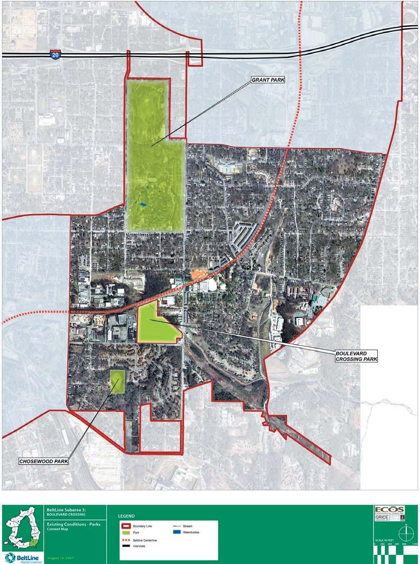
93

94
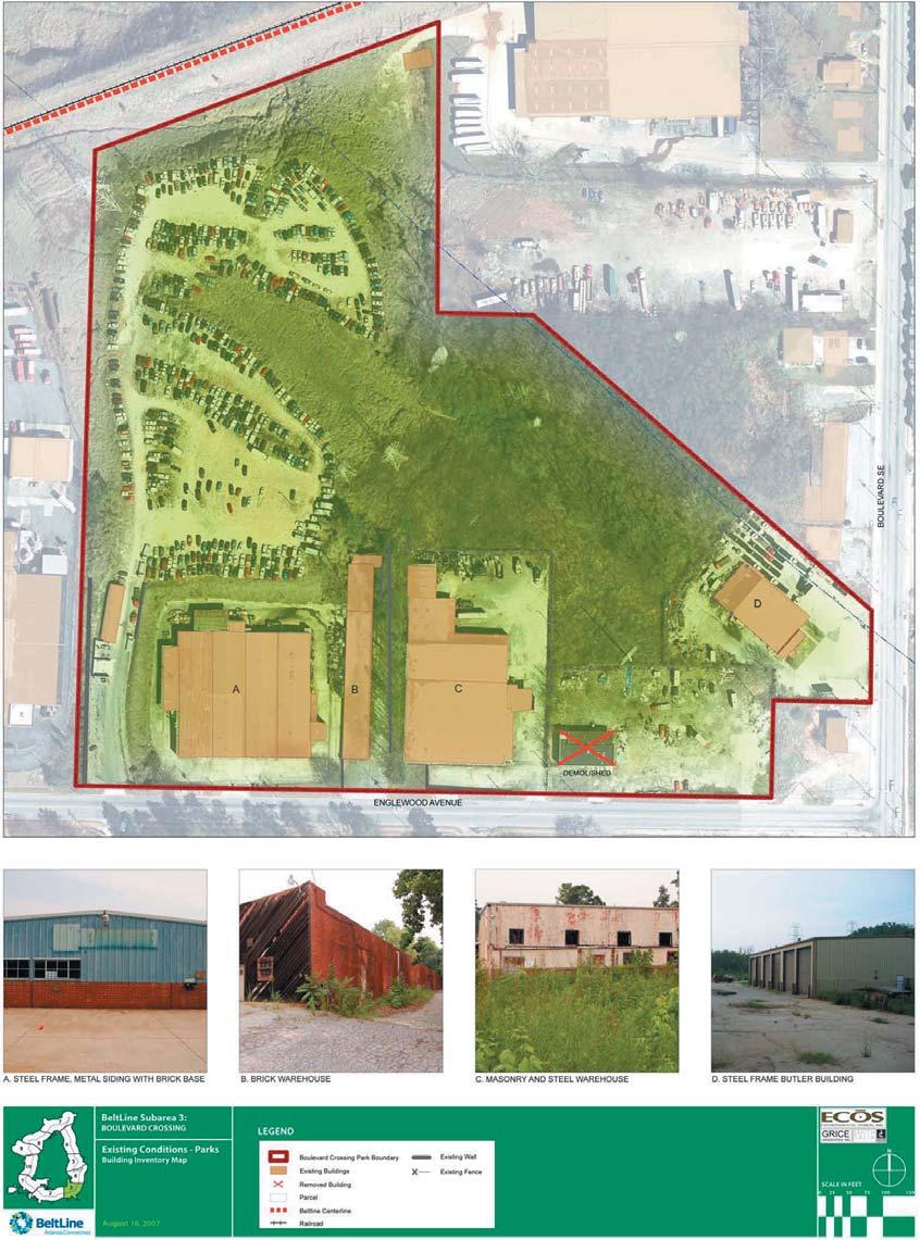
95

96

97


98

99

100

101


102
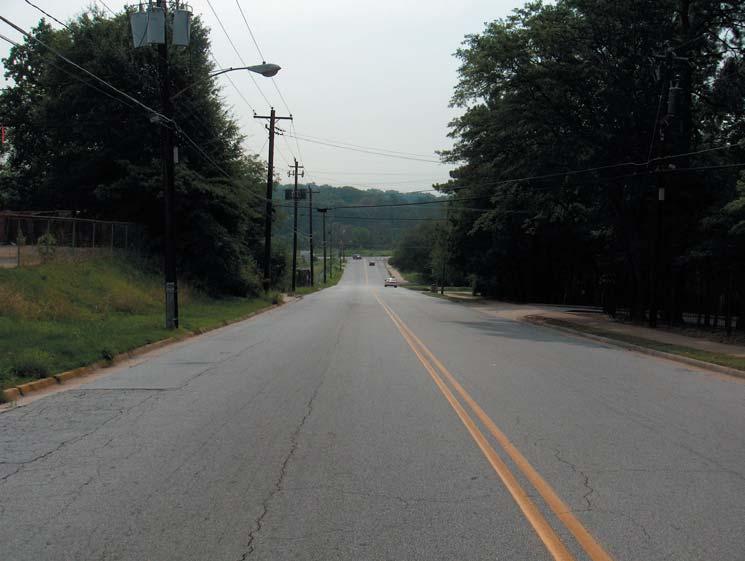

103
104 o
105 o o o o

106
107 o o o o

108
109 o o o

110
111 o o o
112
113


114
115 o o o
116
117 o o o
118 o

119
120
121

122
123
124
125
126
127

128
129
130
131
132

133

134
135

136 Park Master Plan Community Survey Comprising approximately 22 acres, Boulevard Crossing is the first new park completely assembled along the BeltLine s Emerald Necklace. Funding from the City of Atlanta s Opportunity Bond was utilized for acquisition of the land and will fund initial development. Park Master Planning is currently underway as part of the overall planning for this BeltLine segment ( Sub-Area ). A diverse range of active and passive recreational uses for a wide range of age groups will be considered in planning this park which must serve to meet both the needs of local neighborhoods as well as those of the greater city-wide BeltLine community. Multi-use trail connections with Chosewood Park and Grant Park are proposed components and are also in planning stages. Your response to this survey will help to assess needs for park facilities and amenities as we work towards developing a master plan for the future development and operation of Boulevard Crossing Park. Please forward your completed survey by Monday October 8 th 2007 to: Ecos Environmental Design 1. For Adults, check off the 3 most important facilities/uses you would like to see: 2. For Children (under 12), check off the 3 most important facilities/uses you would like to see:
137 3. For Teens/Youths, check off the 3 most important facilities/uses you would like to see: 4. Other Facilities check off the 3 most important needed at Boulevard Crossing Park: i) Leash-free Dog Park 5. Are there other facilities, uses, amenities or features would you like to see : 6. How desirable would the use of a portion of the park be for creation of a storm water pond that would assist in conserving water from both the park and other adjacent areas? Not Desirable Neutral Very Desirable 7. How desirable would be a naturalization zone which would be allowed to re-forest? Not Desirable Neutral Very Desirable 8. Efforts are being made to uncover streams that were put into sewer pipes years ago to daylight them - and recreate them as natural streams. How desirable would it be to pursue this Daylighting of Streams at Boulevard Crossing? Not Desirable Neutral Very Desirable 9. How important is it to provide large open spaces for random play? Not Important Neutral Very Important 10. How desirable would an on-site presence of City Parks staff in a maintenance facility be? Not Desirable Neutral Very Desirable 11. How important is it to integrate with new developments which will occur around the park: a) Pathways connecting the park and adjacent developments: Not Important Neutral Very Important b) Parking that would be shared: Not Desirable Neutral Very Desirable c) To have commercial businesses adjacent: Not Desirable Neutral Very Desirable Other comments on adjacent development:
138 12. Which of the following best describes your family? i) Single ii) Single with children younger than 12 age age 18+ iii) Couple iv) Couple with children younger than 12 age age 18+ v) Empty nester vi) Other 13. In what age group do you belong? i) <18 ii) iii) iv) v) I am i) Male ii) Female 15. How far of a walk will it be from your residence to Boulevard Crossing Park? i) Less than ¼ mile ii) ¼ to ½ mile iii) ½ mile to 1 mile iv) more than 1 mile 16. Which Neighborhood do you live in? i) Boulevard Heights ii) Chosewood Park iii) Grant Park iv) Ormewood Park v) Peoplestown vi) Other 17. Other Comments:
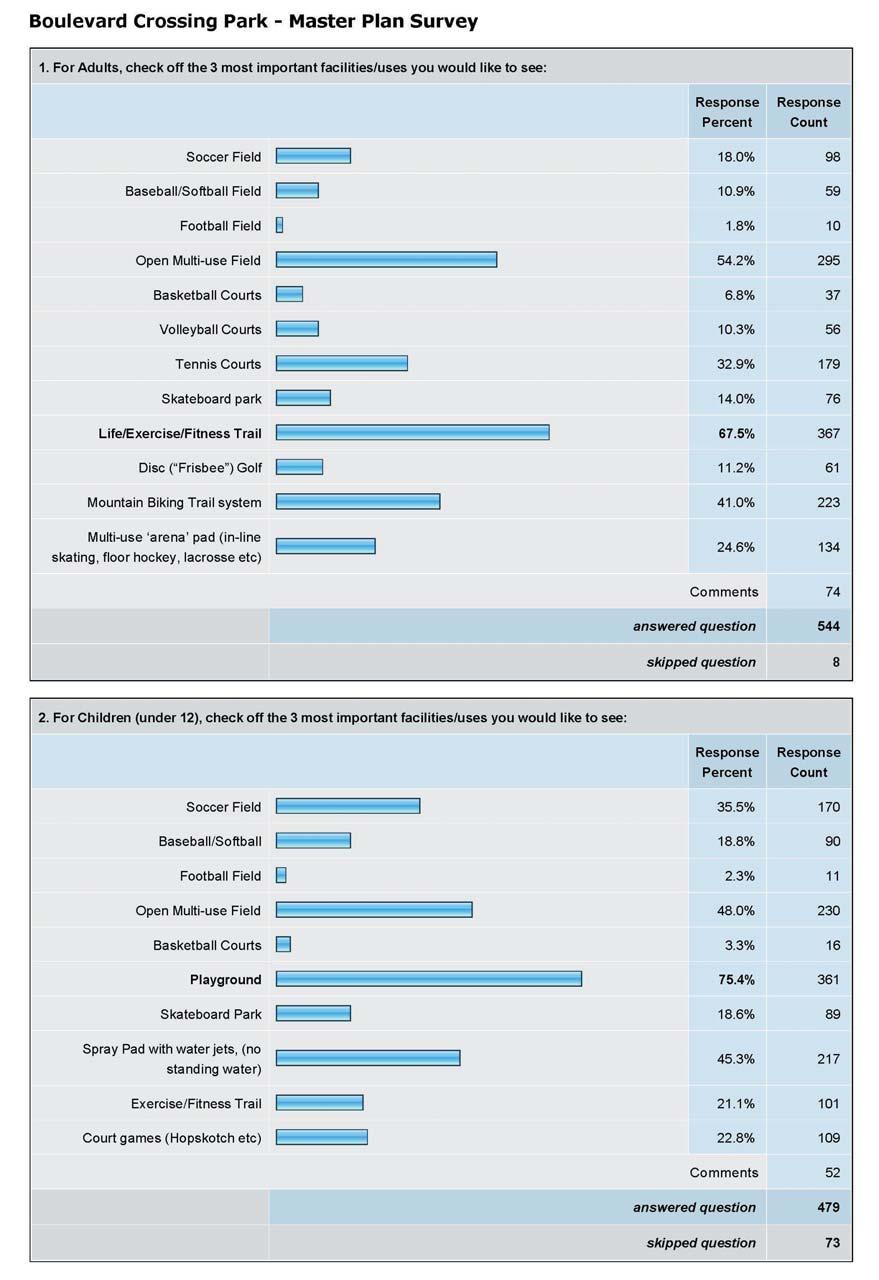
139

140

141

142

143
144 Staff Agenda BeltLine Master Plan Boulevard Crossing Study Group Meeting September 20, 2007; 6:30 8:30 pm Zoo Atlanta Action Resource Center 1. Welcome Matthew Dickison (5 minutes) a. Welcome b. Overview c. Parks Survey d. Additional Announcements e. Sign In Sheet f. Upcoming Meetings/Contact Information 2. BeltLine Update Nate Conable (10 minutes) 3. Master Planning Review Shannon Kettering & John Funny 4. Vision, Values, Goals and Objectives Shannon Kettering 5. Small Group Goals and Objectives Exercise - Shannon Kettering/Matthew Wilder/John Funny 6. Next Steps Shannon Kettering & Matthew Dickison (5 minutes) Supply List: 1. Agendas (Matthew) 2. Study Group Meeting Dates (Matthew) 3. BeltLine Tour Flyers (Matthew) 4. Sign-In Sheet (Matthew) 5. Surveys (Matthew) 6. Easels (ECOS) 7. Large Note Pads (ECOS) 8. Large Pens (ECOS) 9. Projector (ECOS) 10. Laptop (ECOS) 11. Posters (ECOS) 12. Sticky-notes for public comment regarding posters (ECOS) 13. Index Cards/Comment Cards (ECOS) 14. Directional Sign (Matthew)
145 Agenda BeltLine Master Plan Boulevard Crossing Park Steering Committee Meeting October 23, 2007; 6:00 8:00 pm Zoo Atlanta Action Resource Center Handouts available as attendees arrive: o Greenspace Goals and Objectives o Survey Results 1. Welcome Matthew Dickison (5 minutes) a. Welcome b. Overview of purpose of meeting c. Additional Announcements d. Sign In Sheet e. Upcoming Meetings/Contact Information 2. Recap of Site Analysis (5 minutes) 3. Presentation of 3 Park Master Plan Concepts Matthew Wilder 4. Concept Plans Discussion Matthew Wilder/Ed Akins/Gretchen Gigley 5. Next Steps Matthew Wilder & Matthew Dickison (5 minutes) Supply List: 1. Agendas (Matthew D) 2. Study Group Meeting Dates (Matthew D) 3. Sign-In Sheet (Matthew D) 4. Handouts (ECOS) 5. Easels (ECOS) 6. Large Note Pads (ECOS) 7. Large Pens (ECOS) 8. Posters (ECOS) 9. Index Cards/Comment Cards (ECOS) 10. Directional Sign (Matthew)
146 Boulevard Crossing Park Concept Themes Subarea 3 - Boulevard Crossing Park Concept Review Meeting II October 23, 2007
147 VALUES, GOALS AND OBJECTIVES Subarea 3 - Boulevard Crossing Park Concept Review Meeting II October 23, 2007 o o o o o o o o o o o o o o o o Ecos Environmental Design Grice & Associates Smith Dalia Architects Dovetail Consulting


148 Boulevard Crossing Sub-Area SOUTHEAST STUDY GROUP MEETING Zoo Atlanta ~ February 21, Welcome, Rukiya Eaddy, Citizen Participation Advocate Associate 2. BeltLine Update, Rukiya Eaddy, Citizen Participation Advocate Associate 3. Boulevard Crossing Park-Final Draft Master Plan, Matt Wilder, ECOS Environmental Design, Inc. Background and Context Concept Review Summary of Public Input Final Draft Park Master Plan Presentation 4. Questions and Comments 5. Phasing Prioritization Exercise Questions? Please direct all Master Planning questions and/or comments to: Matthew Dickison Senior Urban Planner mdickison@atlantaga.gov For general questions, contact: Rukiya Eaddy Citizen Participation Advocate Associate readdy@atlbeltline.org


149

150
151
152

153
154
155 Atlanta BeltLine Master Plan SUBAREA 3 BOULEVARD CROSSING Appendix Prepared for Atlanta BeltLine, Inc. By Ecos Environmental Design Grice & Associates Smith Dalia Architects Dovetail Consulting Adopted by the Atlanta City Council on March 16, 2009
156 this page left intentially blank this report has been formatted to be printed double-sided in an effort to save paper
157 VI. Appendix ASAP Amendments & Zoning Recommendations Sustainable Action Strategies The following matrices outline Sustainable Action Strategies for plan implementation and show how these strategies meet the community goals for each element of the Subarea Plan. The strategies include recommended policy amendments and zoning modifications as well as typical obstacles to overcome involving conventional thoughts and practices. Highlights of the strategies for each element of the Subarea Plan include: Land Use and Urban Design Sustainable Action Strategy Highlights: Promote low impact development sites and other green development principles Provide provisions for design, installation, and maintenance of water efficient landscapes Implement design standards to address architectural step back at the street Require minimum densities, mixture of housing types, minimum affordable housing component, and mixed use Provide density and parking incentives for open spaces, civic spaces, and recycling facilities Public and Cultural Arts Sustainable Action Strategy Highlights: Identify and promote gateways into the community Enhance artistic character through functional art installations in greenspaces and streetscapes Encourage design competition for tunnels and bridges Incorporate artists in design development and construction of public greenspaces and transportation solutions Establish community events and programs Circulation Sustainable Action Strategy Highlights: Utilize complete streets principles to ensure network for all users of all ages and abilities Promote use of green street facilities to manage stormwater and enhance watershed health Initiate Safe Routes to Schools Program Incorporate stormwater function into both on and off street parking areas Promote shared parking, reduced street widths, and maximized sidewalks Incorporate recommended Streetscape Standards Greenspace Sustainable Action Strategy Highlights: Orient greenways for water quality and stormwater management & encourage structural stormwater solutions to be multipurpose Incorporate diverse greenspaces located as community focal points Enhance the urban forest and promote the BeltLine Arboretum Develop community farming/ gardening initiative, including markets Establish dark sky compliant lighting standards ATLANTA BELTLINE MASTER PLAN MARCH 16, 2009 SUBAREA 3 A1
158 Boulevard Crossing Land Use and Urban Design Goals Sustainable Action Strategies for Land Use and Urban Design Encourage development that is compatible with community values and future needs. Facilitate mixed use centers (living, working and shopping) to promote economic development, serve the community neighborhoods and support alternative transportation modes. Maintain a variety of residential opportunities, including mixedincome and workforce housing to strengthen the diverse community. Seek Boulevard Crossing Subarea Plan approval by Atlanta City Council and incorporate into the Atlanta Strategic Action Plan and BeltLine Overlay, including plan recommendations and policies. Overcome the following OBSTACLES to conventional zoning and land development regulations and public works practices. Expand civic facilities to support community growth. Conventional approaches to zoning focused on single uses and maximum densities, verses allowing or requiring mixed use in particular zones and specifying minimum densities. Addressing the need to provide land uses and zoning codes that allow for better gradation of different heights and densities, as well as, clearly distinguising/ defining horizontal verses vertical mixed use including appropriate requirements for residential component. Barriers to water resource protection including the following: elevated landscape islands, elevated curbs that prevent water flowing into landscape areas, roof drains directly connected to under drain storm sewer system, minimum parking requirements. Detailed drainage regulations and drainage sizing criteria that lack guidance on low impact development techniques. Concerns for decentralized maintenance when utilizing low impact development techniques, which can be addressed with same observation and inspection of current stormwater facilities and with operations and maintenance manual. A2 SUBAREA 3 PLAN RECOMMENDATIONS REPORT APPENDIX A ASAP AMENDMENTS & ZONING RECOMMENDATIONS
159 Recommend the following POLICY AMENDMENTS for consideration by the City of Atlanta Bureau of Planning and incorporation into the Atlanta Strategic Action Plan. Propose a variety of residential and mixed use opportunities at varying densities to allow for housing and employment options by creation of walkable centers and districts per the Boulevard Crossing Subarea Plan. Ensure appropriate scale along streets and adjacent to neighborhoods by reducing the building heights at the street to be complimentary to existing development. Promote building placement to facilitate pedestrian access, hide parking in the rear, and allow more of the property for community greenspaces per the Boulevard Crossing Subarea Plan. Establish partnerships with the residents, developers, the City, and others to provide a variety of housing types throughout the community. Promote low impact development sites by integrating site planning, architecture, engineering and construction; minimizing directly connected impervious area; daylighting stormwater; utilizing split flow method to separate storm events; and recycling materials during redevelopment. Promote the importance of the community s environmental resources through interpretation / education, incorporation of LEED / Earthcraft or other green development principles, and prioritize energy / water management practices within developments. Establish private-public partnerships to expand funding and implementation mechanisms for recreation and open space. Recommend the following ZONING MODIFICATIONS to implement the values, goals, and objectives reflected in the Boulevard Crossing Subarea Plan. Incorporate green building and site standards into developments to minimize negative environmental impacts, improve the quality and value, and emphasize the importance of stewardship. Promote flexibility in zoning regulations and design guidelines for innovative solutions supported by the community. Implement design standards that address architectural step back (height) at street to ensure appropriate relationships and transitions to existing neighborhoods. Provide density and parking incentives for developments per the Boulevard Crossing Subarea Plan, such as public open spaces, civic spaces, multi-use trails, recycling facilities, and low impact and green development standards. Require minimum densities, mixture of housing types, minimum affordable housing component, and mixed use per the Boulevard Crossing Subarea Plan. Establish provisions for the design, installation and maintenance of water efficient landscapes in new projects as well as for management practices in established landscapes, including the following: eliminate use of potable water and utilize rain water harvesting for irrigation; group plants by water usage into hydrozones; utilize native plant material; reduce heat island effect. Establish guidelines for low impact development techniques (as supplement to Georgia Stormwater Management Manual) to mimic predevelopment hydrology by including runoff reduction practices, minimizing directly connected impervious areas, and incorporating stormwater function into landscape and parking areas. Include low impact development engineering details in the land development and/or drainage regulations, including calculations for multiple structure sizing for runoff reduction and detention capacity. Promote the use of stormwater utility fee as development incentive. ATLANTA BELTLINE MASTER PLAN MARCH 16, 2009 SUBAREA 3 A3
160 Prohibit gated residential developments. Structural stormwater controls should be implemented only after all site design and nonstructural options have been exhausted. Encourage structural stormwater solutions to be multi-purpose and be aesthetically integrated into a site's design- i.e. multi-purpose detention areas. Ensure integrated and interconnected community facilities and services within developments through incentives/ zoning regulations, public engagement, and provisions for an easily accessible transportation network. Table 1 - Sustainable Action Strategies for Land Use and Urban Design Figure 1 - Example of channeling water runoff into biretention or rain gardens for water quality and infiltration Courtesy of: Ecos Figure 2 - Example of distributing roof runoff into bioretention areas or rain gardens Courtesy of: Ecos Figure 3- Example of architectural step back at street Courtesy of: Others A4 SUBAREA 3 PLAN RECOMMENDATIONS REPORT APPENDIX A ASAP AMENDMENTS & ZONING RECOMMENDATIONS
161 Boulevard Crossing Public and Cultural Arts Goals Sustainable Action Strategies for Public and Cultural Arts Provide open, cultural, and civic spaces to promote social interaction and a thriving community. Seek Boulevard Crossing Subarea Plan approval by Atlanta City Council and incorporate into the Atlanta Strategic Action Plan and BeltLine Overlay, including plan recommendations and policies. Identify, interpret and protect community historic and cultural resources. Incorporate Boulevard Crossing Public and Cultural Arts Plan components and recommendations into the Atlanta Public Arts Master Plan. Overcome the following OBSTACLES to conventional zoning and land development regulations and public works practices. Art incorporated as separate element at end of design development and construction phases, instead of being incorporated into the functional and aesthetic fabric of elements/ spaces early in the concept development process. Recommend the following POLICY AMENDMENTS for consideration by the City of Atlanta Bureau of Planning and incorporation into the Atlanta Strategic Action Plan. Promote neighborhood identity by utilizing circulation elements as gateways and incorporating public art into transportation projects, including design of round-a-bouts, transit shelters, street signage, sidewalks, etc Encourage international design competitions for tunnels to promote creative, artistic design solutions that enhance safety by providing visibility throughout. Identify and promote gateways (at three levels or scales) into the community in the centers, at the BeltLine transit stops and along community streets and greenways per the Plan. Promote and integrate the proposed Natural Neighborhood Gateways and themes illustrated in the Atlanta BeltLine Arboretum Concept Plan into future gateways, landscape features, public art, and interpretive elements. Encourage adaptive reuse of historic/ community significant structures with cultural programming, such as markets, museums and galleries. Enhance artistic character of the community through functional art installations in public greenspaces and streetscapes, as well as, incorporating artists in design development and construction of public spaces/ transportation solutions. Encourage the use of environmental art and water works in future water quality/ stormwater features and drainage ways. Provide interpretive opportunities in collaboration with muli-use trail to showcase the community s significant assets, such as Fort Walker and Intrenchment Creek. Revitalize current art that promotes community identity. Promote preservation of historically significant railroad components, such as switchgears and relay boxes. Establish an art consortium, uniting the Metropolitan Public Art Coalition, City of Atlanta Office of Cultural Affairs, and the BetlLine Public Art Strategy Team in a joint effort to oversee and ensure the appropriate incorporation and implementation of public art per the Subarea Plan. ATLANTA BELTLINE MASTER PLAN MARCH 16, 2009 SUBAREA 3 A5


162 Recommend the following ZONING MODIFICATIONS to implement the values, goals, and objectives reflected in the Boulevard Crossing Subarea Plan. Require artists to be involved in design development and construction of major public works, such as greenspaces, tunnels/ bridges, and transit facilities. Work with community groups and artists to establish standards for gateway features illustrated in the Boulevard Crossing Subarea Plan. Provide incentives for new developments and redevelopments to incorporate public and cultural art components of the Boulevard Crossing Subarea Plan, including interpretive elements and gateways. Table2 - Sustainable Action Strategies for Public and Cultural Arts Figure 5 - Example of incorporating art into sidewalk paving Courtesy of: Seattle DOT Figure4 - Example of artistic cistern within pedestrian plaza Courtesy of: Seattle DOT Figure 6 - Example of community event within park space A6 SUBAREA 3 PLAN RECOMMENDATIONS REPORT APPENDIX A ASAP AMENDMENTS & ZONING RECOMMENDATIONS
163 Boulevard Crossing Circulation Goals Sustainable Action Strategies for Circulation Explore opportunities to incorporate innovative strategies into community-wide transportation solutions commensurate with future needs. Provide connectivity, continuity and redundancy among various modes of transportation. Allow transportation facilities to promote seamless neighborhood boundaries, while preserving and or enhancing community distinctions and character. Seek Boulevard Crossing Subarea Plan approval by Atlanta City Council and incorporate into the Atlanta Strategic Action Plan and BeltLine Overlay, including plan recommendations and policies. Incorporate Boulevard Crossing Circulation Plan components and recommendations into the Atlanta Comprehensive Transportation Plan including the following: Policy and zoning recommendations. Street classifications and reclassifications. Proposed streets, bike routes and trail connectivity. Prioritized 5-year list of mobility projects and programs, as well as, refined 25-year list of mobility projects. Ensure future usage by developing a sustainable financial structure for maintenance. Overcome the following OBSTACLES to conventional zoning and land development regulations and public works practices. Allowing only drainage and conveyance structures such as ditches, inlets and storm sewer in the right-of-way and not low impact development techniques that reduce runoff volume. Minimum parking requirements that create large expanses of impervious surface. Detailed drainage regulations and drainage sizing criteria that lack guidance on low impact development techniques. Concerns for decentralized maintenance when utilizing low impact development techniques, which can be addressed with same observation and inspection of current stormwater facilities and with operations and maintenance manual. Recommend the following POLICY AMENDMENTS for consideration by the City of Atlanta Bureau of Planning and incorporation into the Atlanta Strategic Action Plan. Enhance neighborhood interconnectivity and promote east-west and northsouth vehicular circulation by extending key community thoroughfares and reclassifying key community streets per the Plan. Provide pedestrian connectivity via trail network through and to greenspaces, neighborhood centers and transit facilities per the Plan. Enhance neighborhood and pedestrian environment through streetscape improvements, including traffic calming measures as illustrated in the Boulevard Crossing Subarea Plan Streetscape Sections. ATLANTA BELTLINE MASTER PLAN MARCH 16, 2009 SUBAREA 3 A7
164 Improve current and future parking conditions by locating public parking structures adjacent to the BeltLine per the Plan, promoting shared parking facilities, and ensuring interparcel connectivity. Give high priority to pedestrian and bicycle safety improvements near schools, while helping local schools initiate Safe Routes to Schools Programs. Establish policies that promote improved street maintenance and provide communities a convenient method for reporting maintenance issues and learning the status of maintenance requests. Enhance way-finding by consistently incorporating lit signs for overhead road names and directional signage along multi-use trail networks. Promote and incorporate the use of green street facilities in public and private development to manage stormwater, reduce flows, improve water quality and enhance watershed health. Utilize complete street principles to ensure that the entire public right of way is routinely designed and operated to create a comprehensive and connected network for all users including pedestrians, bicyclists, transit users, and motorists, of all ages and abilities, yet complimentary to historic neighborhood framework/ aesthetic. Encourage converting one way streets to two way streets to enhance vital neighborhood connections, especially Atlanta Avenue, Ormond Street, and Hill Street to join the Grant Park Neighborhood with Peoplestown and Chosewood. Protect water quality by orienting greenways for conservation of natural resources and to enhance the use of natural features for stormwater management and trails. Promote community initiated transportation alternatives for additional circulation throughout the subarea, such as trolleys or shuttles. Recommend the following ZONING MODIFICATIONS to implement the values, goals, and objectives reflected in the Boulevard Crossing Subarea Plan. Improve drainage systems and provide methods for monitoring water levels for preemptive notification. Require private developers to provide public pedestrian access to the BeltLine, especially when illustrated on the Boulevard Crossing Subarea Plan. Allow reduced parking to limit impervious cover and water runoff for all the properties within the subarea. Reduce street width requirements, maximize sidewalks and promote alleyways and pedestrian ways to shorten neighborhood blocks and create a more walkable pedestrian friendly environment for all new development. Revise sidewalk and supplemental zone requirements to incorporate Boulevard Crossing Streetscape Standards for each street classification, including provisions to eliminate or make variations to planting and parking zones due to existing right-of-way width and character. Encourage front yard tree plantings when tree planting zone is less than four feet. Provide requirements to incorporate stormwater functions into both on and off street parking areas via porous paving, sumped landscape islands, and curb cuts to reduce landscape watering needs and enhance water quality. Establish street tree standards and details to ensure healthy flourishing trees by optimizing soil volume, preventing compaction and requiring hardscape within the Tree Planting Zone be constructed to permit infiltration of air and water. A8 SUBAREA 3 PLAN RECOMMENDATIONS REPORT APPENDIX A ASAP AMENDMENTS & ZONING RECOMMENDATIONS
165 Incorporate design guidelines and standards for Green Street Program (swales, planters, curb extensions, alternative pavements) with accompanying incentives to: manage stormwater runoff both at the source and the surface; use plants and soil to slow, filter, cleanse, and infiltrate runoff; and design facilities that aesthetically enhance and compliment the historic integrity of the community. Require all new developments to provide for alternative transportation features and facilities (bikeways, trails, bike parking/storage), wherever appropriate, as a supplement to, or (in certain instances) replacements for automobile facilities (roads, parking areas). Adopt low impact development (planning and design approach to reduce runoff and mimic predevelopment hydrology) standards for right-of-ways, public road and parks projects. Table 3 - Sustainable Action Strategies for Circulation Figure 8 - Example of planting zone and curb extensions utilized for stormwater infiltration and storage Courtesy of: Greenworks, Portland Green Street Program Figure 7 - Example of multi-use trail, safe routes to schools, and stormwater infiltration/ storage within curb extensions Courtesy of: PATH Foundation, Portland Green Street Program Figure 9 - Example of incorporating stormwater function into on-street parking with porous paving Courtesy of: Portland Green Street Program ATLANTA BELTLINE MASTER PLAN MARCH 16, 2009 SUBAREA 3 A9
166 Boulevard Crossing Greenspace Goals Sustainable Action Strategies for Greenspaces Reclaim/restore/create & expand community environmental resources. Ensure the recreational needs of the City of Atlanta are compatible with Boulevard Crossing community needs. Seek Boulevard Crossing Subarea Plan approval by Atlanta City Council and incorporate into the Atlanta Strategic Action Plan and BeltLine Overlay, including plan recommendations and policies. Incorporate Boulevard Crossing Greenspace Plan components and recommendations into the Atlanta Greenspace Plan. Overcome the following OBSTACLES to conventional zoning and land development regulations and public works practices. Excessively restrictive regulations for farmers' markets and urban gardens. The notion of urban areas for food consumption and rural areas for food production. Density restrictions that fragment the landscape over large areas. Recommend the following POLICY AMENDMENTS for consideration by the City of Atlanta Bureau of Planning and incorporation into the Atlanta Strategic Action Plan. Protect water quality by orienting greenways for conservation of natural resources and to enhance the use of natural features for stormwater management. Promote an enhanced urban forest by preserving existing trees and forests, protecting undeveloped forested land as community greenspace, improving the quality of the tree-growing environment, selecting trees for diversity and suitability, and managing the urban forest as a continuous resource. Promote variety of users, opportunities for social interaction, and neighborhood identity by locating greenspaces as focal points in the community per the Plan. Promote outdoor flexible spaces to facilitate community gatherings and special events. Expand recreational opportunities by enhancing existing and proposed greenspaces to ensure every resident is within walking distance- 1/4 mile per the Plan. Promote the importance of the community s environmental resources through interpretation/ education, incorporation of LEED- green development principles, and habitat restoration. Promote innovative programming within the community open space network, such as wireless technology. Ensure diverse greenspace types, as illustrated in the Boulevard Crossing Subarea Plan, to serve the varying needs of the community, to protect wildlife and natural resources, and to enhance water quality. Promote economically sustainable open air markets as tool to build economy of the community, attract a broad diversity of people, and support locally grown products. Incorporate the recommendations of the Atlanta BeltLine Arboretum Concept Plan into public greenspaces, streetscapes, and community amenities (including Natural Neighborhood tree collections and species). A10 SUBAREA 3 PLAN RECOMMENDATIONS REPORT APPENDIX A ASAP AMENDMENTS & ZONING RECOMMENDATIONS
167 Manage utility corridors (including public utilities) to enhance their value as greenspace and to capture their potential, wherever possible, for linear recreational opportunities (i.e. multi-use trails). Encourage a Community-based Farming/Gardening initiative to provide technical assistance (via Atlanta Local Food Initiative, Georgia Cooperative Extension, or similar program) and small seed grants to community action programs, neighborhood groups, land trusts, food banks, and similar non-profit organizations for establishment of community gardening programs. Launch similar farms-to-school programs (gardens, cafeteria food, and curriculum). Assess unused public land (excess highway right-of-way, under-used portions of parks, etc.) for potentially suitable garden plots (e.g. Boulevard Crossing Park). Encourage backyard gardens, edible landscaping, and urban orchards in new developments. Develop a Greenspace Stewardship program giving recognition and incentives to cooperating private owners of undeveloped land with Greenspace value. Encourage the use of Crime Prevention Through Environmental Design or CPTED principles (natural surveillance, natural access control, territorial reinforcement, maintenance) in park design to ensure safe environments. Recommend the following ZONING MODIFICATIONS to implement the values, goals, and objectives reflected in the Boulevard Crossing Subarea Plan. Expand community sustainable opportunities, such as recycling, composting, and gardening and recommend/ provide incentives for these activities/ amenities be included in future development. Establish dark sky compliant practices and standards that permit nighttime lighting for safety, minimize glare and obtrusive light, conserve energy (promote solar lighting), and incorporate lighting curfews. Structural stormwater controls should be implemented only after all site design and nonstructural options have been exhausted. Encourage structural stormwater solutions to be multi-purpose and be aesthetically integrated into a site's design- e.g. multi-purpose detention areas. Permit multi-use trails in greenspaces as illustrated on the Plan. Encourage new developments and redevelopments along the BeltLine corridor to incorporate within their tree preservation/ replacement plans and proposed landscape plans where possible the tree species and specimen tree species identified in the Atlanta BeltLine Arboretum Concept Plan. These landscape plans should reflect the Natural Neighborhood tree collections identified in the Arboretum Concept Plan and strive to demonstrate the positive impacts of trees in the urban landscape through bioremediation, invasive species removal, water storage, and other eco-friendly methods. Incorporate definitions and standards for the hierarchy of greenspace types recommended in the Boulevard Crossing Subarea Plan and provide incentives for developers to implement. Require/ provide incentives for new developments and redevelopments to incorporate public greenspaces illustrated in the Boulevard Crossing Subarea Plan. Table 4 - Sustainable Action Strategies for Greenspaces Figure 10 - Example of community farming/gardening initiative Courtesy of: Others Figure 11 - Example of makets/ festivals and dark sky lighting within greenspaces Courtesy of: Others ATLANTA BELTLINE MASTER PLAN MARCH 16, 2009 SUBAREA 3 A11
168 ASAP Amendments- Project List The following recommended future land use changes for the Atlanta Strategic Action Plan describe changes that should be made from future land uses within the Comprehensive Development Plan to the BeltLine Land Uses. BeltLine Land Uses will need to be interpreted into the ASAP future land use categories. Existing and Proposed Park Space LU-1a: Future land use change from Single Family Residential and Low Density Residential to Proposed Park Space. LU-1b: Future land use change from Office/ Institutional to Proposed Park Space. LU-1c: Future land use change from Industrial/ TCU to Proposed Park Space. LU-1d: Future land use change from High Density Residential to Existing Park Space. LU-1e: Future land use change from Single Family Residential to Existing Park Space. Community Facilities LU-2a: Future land use change from High Density Residential to Community Facilities. LU-2b: Future land use change from Industrial/ TCU to Community Facilities. Residential 1-4 stories LU-3a: Future land use change from Single Family Residential to Residential 1-4 stories. LU-3b: Future land use change from Low Density Residential to Residential 1-4 stories. LU-3c: Future land use change from High Density Residential to Residential 1-4 stories. LU-3d: Future land use change from Low Density Commercial to Residential 1-4 stories. LU-3e: Future land use change from High Density Commercial to Residential 1-4 stories. LU-3f: Future land use change from Industrial/ TCU to Residential 1-4 stories. LU-3g: Future land use change from Office/ Institutional to Residential 1-4 stories. LU-3h: Future land use change from Mixed Use to Residential 1-4 stories. LU-3i: Future land use change from Medium Density Residential to Residential 1-4 stories Residential 5-9 stories LU-4a: Future land use change from Low Density Residential to Residential 5-9 stories. LU-4b: Future land use change from High Density Residential to Residential 5-9 stories. LU-4c: Future land use change from Low Density Commercial to Residential 5-9 stories. LU-4d: Future land use change from Industrial/ TCU to Residential 5-9 stories. Residential 10+ stories LU-5a: Future land use change from Industrial/ TCU to Residential 10+ stories. Mixed Use 1-4 stories LU-6a: Future land use change from Low Density Residential to Mixed Use 1-4 stories. LU-6b: Future land use change from High Density Residential to Mixed Use 1-4 stories. LU-6c: Future land use change from Low Density Commercial to Mixed Use 1-4 stories. LU-6d: Future land use change from High Density Commercial to Mixed Use 1-4 stories. LU-6e: Future land use change from Industrial/ TCU to Mixed Use 1-4 stories. Mixed Use 5-9 stories LU-7a: Future land use change from Low Density Residential to Mixed Use 5-9 stories. LU-7b: Future land use change from High Density Residential to Mixed Use 5-9 stories. LU-7c: Future land use change from Industrial/ TCU to Mixed Use 5-9 stories. Mixed Use 10+ stories LU-8a: Future land use change from High Density Residential to Mixed Use 10+ stories. Office/ Institutional LU-9a: Future land use change from High Density Residential to Office/ Institutional. Transportation, Communication, and Utilities (TCU) LU-10a: Future land use change from Single Family Residential and Office/ Institutional to TCU. A12 SUBAREA 3 PLAN RECOMMENDATIONS REPORT APPENDIX A ASAP AMENDMENTS & ZONING RECOMMENDATIONS

169 Figure 11 - ASAP Amendments - Land Use Recommendations ATLANTA BELTLINE MASTER PLAN MARCH 16, 2009 SUBAREA 3 A13
170 Zoning Recommendations- Project List The following recommended zoning changes are to assist the City of Atlanta; however, final determination of appropriate zoning change is to be made by City of Atlanta to meet the intent of the BeltLine Land Uses recommended in this Subarea Plan. Quality of Life Multi-Family Z-1a: Zoning change from Single Family or Duplex Residential to Quality of Life Multi- Family. Z- 1b: Zoning change from Multi-Family Residential to Quality of Life Multi-Family. Z- 1c: Zoning change from Commercial to Quality of Life Multi-Family. Z- 1d: Zoning change from Office Institutional to Quality of Life Multi-Family. Z- 1e: Zoning change from Industrial to Quality of Life Multi-Family. Quality of Life Multi-Family, Quality of Life Mixed Use, or Live Work Z-2a: Zoning change from Duplex Residential to Quality of Life Multi-Family, Quality of Life Mixed Use, or Live Work Z-2b: Zoning change from Multi-Family Residential to Quality of Life Multi-Family, Quality of Life Mixed Use, or Live Work Z-2c: Zoning change from Industrial to Quality of Life Multi-Family, Quality of Life Mixed Use, or Live Work Quality of Life Multi-Family or Quality of Life Mixed Use Z-3a: Zoning change from Multi-Family Residential to Quality of Life Multi-Family or Quality of Life Mixed Use Z-3b: Zoning change from Industrial to Quality of Life Multi-Family or Quality of Life Mixed Use Office Institutional Z-4a: Zoning change from Industrial to Office Institutional BeltLine Overlay District The following are recommended changes to the BeltLine Overlay District organized by sections. Sec Scope of regulations. NA Sec Findings, purpose and intent. Add reference to BeltLine Subarea Plans as adopted by the City of Atlanta. Sec Boundaries. NA Sec Procedures. NA Sec Provisions for administrative variations from regulations. NA Sec Demolition of existing structures and redevelopment requirements. NA Sec Definitions. Add provisions for the placement of low impact development techniques that reduce runoff volume and manage stormwater runoff both at the source and the surface within the street furniture and tree planting zone. Add provisions to ensure healthy flourishing street trees by optimizing soil volume, preventing compaction, and requiring hardscape within the Street Tree planting zone be constructed to permit infiltration of air and water. Sec Permitted and prohibited uses and structures. NA Sec Transitional uses and yards. Add provisions for transitional height planes to apply if less stringent than underlying zoning requirements to address architectural step back (height) at street and to ensure appropriate relationships and transitions to existing neighborhoods. A14 SUBAREA 3 PLAN RECOMMENDATIONS REPORT APPENDIX A ASAP AMENDMENTS & ZONING RECOMMENDATIONS

171 Figure 12 - ASAP Amendments - Zoning Recommendations ATLANTA BELTLINE MASTER PLAN MARCH 16, 2009 SUBAREA 3 A15
172 Add provisions for density incentives for developments per the BeltLine Subarea Plans, such as public open spaces, civic spaces, multi-use trails, recycling facilities, affordable housing, and low impact and green development standards. Sec Open space requirements and incentives. Add provisions for new developments and redevelopments to incorporate the following: o Public greenspaces and trails illustrated and defined in the BeltLine Subarea Plans. o Public and cultural art components of the BeltLine Subarea Plans, including interpretive elements and gateways. o Community sustainable opportunities, activities/ amenities, or initiatives, including recycling, composting, gardening, low impact development techniques within landscape and parking areas, and multi-purpose structural stormwater facilities providing recreational opportunities. Add provisions for publicly accessible rooftop plazas and green roofs may be counted toward UOSR. Add provisions for planted curb extensions or bulb outs to be provided at intersection and mid-block locations to criteria for onstreet parking incentives. Where appropriate, curb extensions should allow infiltration and storage of stormwater runoff. Add provisions to require artists to be involved in design development and construction of major public works, such as greenspaces, tunnels/ bridges, and transit facilities. Sec Site limitations. Add provisions to require developers to provide public pedestrian access for greenspaces, and greenway trails illustrated in BeltLine Subarea Plans. Add provisions to require developers to provide new public access street (or streets) in accordance with BeltLine Subarea Plans. Add provisions to encourage new developments and redevelopments along the BeltLine corridor to incorporate within their tree preservation/ replacement plans and proposed landscape plans where possible the tree species and specimen tree species identified in the Atlanta BeltLine Arboretum Concept Plan. These landscape plans should reflect the Natural Neighborhood tree collections identified in the Arboretum Concept Plan and strive to demonstrate the positive impacts of trees in the urban landscape through bioremediation, invasive species removal, water storage, and other ecofriendly methods. Add provisions for the design, installation and maintenance of water efficient landscapes in new projects as well as for management practices in established landscapes, including the following: eliminate use of potable water and utilize rain water harvesting for irrigation; group plants by water usage into hydrazones; utilize native plant material; reduce heat island effect. Add provisions for low impact development techniques (as supplement to Georgia Stormwater Management Manual) to mimic predevelopment hydrology by including runoff reduction practices, minimizing directly connected impervious areas, and incorporating stormwater function into landscape and parking areas. Sec Sidewalks. Add provisions for street typologies, both new and retrofit, and connect to on-street parking requirements, bike lane requirements, and sidewalk and supplemental zone requirements per the BeltLine Subarea Plans. (including table for new and retrofit street typologies) Add provisions to eliminate or make variations to street furniture and tree planting zone and parking zones due to existing right-of-way constraints, including width and character. If street furniture and tree planting zone is less than four feet, then require street tree plantings in supplemental zone or front yard. A16 SUBAREA 3 PLAN RECOMMENDATIONS REPORT APPENDIX A ASAP AMENDMENTS & ZONING RECOMMENDATIONS
173 Add provisions to incorporate stormwater functions into both on and off street parking areas via porous paving, sumped landscape islands, and curb cuts to reduce landscape watering needs and enhance water quality. Add provisions for paved areas between required street planting to be hardscape material constructed to permit infiltration of air and water. Add provisions for standards, requirements, and incentives for low impact or green street program (swales, planters, curb extensions, alternative pavements) to: manage stormwater runoff both at the source and the surface; use plants and soil to slow, filter, cleanse, and infiltrate runoff; and design facilities that aesthetically enhance and compliment the historic integrity of the community. Sec Supplemental zone. Add provisions for incorporating street tree plantings within supplemental zone, when adjacent street furniture and tree planting zone is less than four feet. Sec Relationship of building to street. NA Sec Loading areas, loading dock entrances and building mechanical and accessory features. NA Sec Driveway curb cuts, driveways, parking structures. NA Sec Lighting, security, and maintenance requirements. Add provisions for dark sky compliant practices and standards that permit nighttime lighting for safety, minimize glare and obtrusive light, conserve energy (promote solar lighting), and incorporate lighting curfews. Sec Minimum landscaping requirements for surface parking lots. Add provisions to encourage new developments and redevelopments along the BeltLine corridor to incorporate within their tree preservation/ replacement plans and proposed landscape plans where possible the tree species and specimen tree species identified in the Atlanta BeltLine Arboretum Concept Plan. These landscape plans should reflect the Natural Neighborhood tree collections identified in the Arboretum Concept Plan and strive to demonstrate the positive impacts of trees in the urban landscape through bioremediation, invasive species removal, water storage, and other ecofriendly methods. Add provisions for the design, installation and maintenance of water efficient landscapes in new projects as well as for management practices in established landscapes, including the following: eliminate use of potable water and utilize rain water harvesting for irrigation; group plants by water usage into hydrazones; utilize native plant material; reduce heat island effect. Add provisions for low impact development techniques (as supplement to Georgia Stormwater Management Manual) to mimic predevelopment hydrology by including runoff reduction practices, minimizing directly connected impervious areas, and incorporating stormwater function into landscape and parking areas. Sec Off street parking and loading requirements. Add provisions for parking incentives for developments per the BeltLine Subarea Plans, such as public open spaces, civic spaces, multi-use trails, recycling facilities, and low impact and green development standards. Add provisions to incorporate stormwater functions into both on and off street parking areas via porous paving, sumped landscape islands, and curb cuts to reduce landscape watering needs and enhance water quality. ATLANTA BELTLINE MASTER PLAN MARCH 16, 2009 SUBAREA 3 A17
174 Add provisions for reduced parking to limit impervious cover and water runoff for all the properties within the BeltLine subareas. Add provisions to require all new developments to provide for alternative transportation features and facilities (bikeways, trails, bike parking/storage), wherever appropriate, as a supplement to, or (in certain instances) replacements for automobile facilities (roads, parking areas). Sec Off-street bicycle parking. NA Sec Pedestrian bridges and tunnels. Add provisions to require artists to be involved in design development and construction of major public works, such as greenspaces, tunnels/ bridges, and transit facilities. Project Summary Matrix The following are summary projects for Land Use Recommendations, Zoning Recommendations, Mobility, Greenspace and Greenway Trails. The cost estimates provided in the Project Summary Matrix are macro-level planning estimates and will need to be revised and updated over time. Project Matrix Abbreviations COA: City of Atlanta CIP: Capital Improvement Projects QOL: Quality of Life Bonds LCI: Livable Centers Initiative GDOT: Georgia Department of Transportation TPL: Trust for Public Lands CMAQ: Congestion Management and Air Quality Funds TE: Transportation Enhancement Funds TIF: Transportation Impact Fees GO: General Obligation Bonds GaDNR: Recreation Trails Program Private Developers Priority 1: 0-5 years Priority 2: 5-10 years Priority 3: 10+ years A18 SUBAREA 3 PLAN RECOMMENDATIONS REPORT APPENDIX A ASAP AMENDMENTS & ZONING RECOMMENDATIONS
175 Land Use Recommendations ID Description locations Land Type of Improvement LU-1a Future land use change from Single Family Residential and Low Density Residential to Proposed Park Space. Three locations, one located within the East Confederate Retail District another in the Chosewood Park District and the last in the Boulevard Crossing Retail Center ASAP Amendments LU-1b Future land use change from Office/ Institutional to Proposed Park Space. South of the Beltline, within the East Confederate Retail District, bordering Avondale Avenue ASAP Amendments LU-1c Future land use change from Industrial/ TCU to Proposed Park Space. The proposed Beltline ASAP Amendments LU-1d Future land use change from High Density Residential to Existing Park Space. Boulevard Crossing Park ASAP Amendments LU-1e Future land use change from Single Family Residential to Existing Park Space. Chosewood Park ASAP Amendments LU-2a Future land use change from High Density Residential to Community Facilities. South of the Beltline, on Englewood Avenue within the Englewood Employment Cultural Center ASAP Amendments LU-2b Future land use change from Industrial/ TCU to Community Facilities. Two locations located north of the Beltline within the Grant Loft District. Includes existing Mounted Police Patrol ASAP Amendments ATLANTA BELTLINE MASTER PLAN MARCH 16, 2009 SUBAREA 3 A19
176 ID Description locations LU-3b Future land use change from Low Density Residential to Residential 1-4 stories. Three locations, Two located north of the Beltline in the Boulevard Crossing Retail District, and the other south of the Beltline in the Chosewood Residential District LU-3c Future land use change from High Density Residential to Residential 1-4 stories. LU-3d Future land use change from Low Density Commercial to Residential 1-4 stories. Bordering the south side of the Beltline within the East Confederate Retail District Bordering the north side of the Beltline within the East Confederate Retail District. Recently redeveloped. LU-3e Future land use change from High Density Commercial to Residential 1-4 stories. South of the Beltline in the Chosewood Retail District on Gault Street. In permitting/rezoning process. LU-3f Future land use change from Industrial/ TCU to Residential 1-4 stories. North of the Beltline on Grant Street LU-3g Future land use change from Office/ Institutional to Residential 1-4 stories. LU-3h Future land use change from Mixed Use to Residential 1-4 stories. South of the Beltline within the East Confederate Retail District on Avondale Avenue. In permitting/rezoning process Bordering the north of the Beltline on Gress Avenue. Recently redeveloped. LU-3i Future land use change from Medium Density Residential to Residential 1-4 stories. South of the Beltline in the Chosewood Retail District on Gault Street. In permitting/rezoning process. Type of Improvement ASAP Amendments ASAP Amendments ASAP Amendments ASAP Amendments ASAP Amendments ASAP Amendments ASAP Amendments ASAP Amendments A20 SUBAREA 3 PLAN RECOMMENDATIONS REPORT APPENDIX A ASAP AMENDMENTS & ZONING RECOMMENDATIONS
177 ID Description locations LU-4a Future land use change from Low Density Residential to Residential 5-9 stories. LU-4b Future land use change from High Density Residential to Residential 5-9 stories. Three locations, two within the Chosewood Residential District and the other just above in the Englewood Employment Cultural Center Bordering the south side of the Beltline within the East Confederate Retail District LU-4c Future land use change from Low Density Commercial to Residential 5-9 stories. Two locations located north of the Beltline within Grant Loft District and East Confederate Retail District and the other borders the south side of the Beltline in the East Confederate Retail District LU-4d Future land use change from Industrial/ TCU to Residential 5-9 stories. Two locations located north of the Beltline, one in the Grant Loft District and the other in the Boulevard Crossing Retail Center LU-5a Future land use change from Industrial/ TCU to Residential 10+ stories. Bordering the north side of the Beltline within the Grant Loft District LU-6a Future land use change from Low Density Residential to Mixed Use 1-4 stories. Bordering the north side of the Beltline on the east side of Boulevard LU-6b Future land use change from High Density Residential to Mixed Use 1-4 stories. Two locations located south of the beltline on the west side of Boulevard LU-6c Future land use change from Low Density Commercial to Mixed Use 1-4 stories. Bordering the south side of the Beltline within the East Confederate Retail District on East Confederate Avenue Type of Improvement ASAP Amendments ASAP Amendments ASAP Amendments ASAP Amendments ASAP Amendments ASAP Amendments ASAP Amendments ASAP Amendments ATLANTA BELTLINE MASTER PLAN MARCH 16, 2009 SUBAREA 3 A21
178 ID Description locations LU-6d Future land use change from High Density Commercial to Mixed Use 1-4 stories. LU-6e Future land use change from Industrial/ TCU to Mixed Use 1-4 stories. South of the Beltline in the Chosewood Retail District on McDonough Boulevard Bordering the north side of the Beltline on the west side of Boulevard LU-7a Future land use change from Low Density Residential to Mixed Use 5-9 stories. On the southwest corner of Boulevard and Englewood Avenue LU-7b Future land use change from High Density Residential to Mixed Use 5-9 stories. Bordering the southside of the beltline and north side of Englewood Avenue LU-7c Future land use change from Industrial/ TCU to Mixed Use 5-9 stories. Two locations, both bordering the north of the Beltline within the Grant Loft District LU-8a Future land use change from High Density Residential to Mixed Use 10+ stories. LU-9a Future land use change from High Density Residential to Office/ Institutional. LU-10a Future land use change from Single Family Residential and Office/ Institutional to TCU. Bordering the south of the Beltline the and northeast corner of Hill Street and Englewood Avenue Bordering the south of the Beltline the and east side of Boulevard. Recently retrofitted/renovated Two locations south of the beltline, and in the Boulevard Crossing Retail Center and the other in the East Confederate Retail District. Existing City of Atlanta CSO facility. Type of Improvement ASAP Amendments ASAP Amendments ASAP Amendments ASAP Amendments ASAP Amendments ASAP Amendments ASAP Amendments ASAP Amendments A22 SUBAREA 3 PLAN RECOMMENDATIONS REPORT APPENDIX A ASAP AMENDMENTS & ZONING RECOMMENDATIONS
179 Zoning Recommendations (Fina Zonin ade by City of Atlan ID Description Location Type of Improvement Z-1a Zoning change from Single Family or Duplex Residential to Quality of Life Multi-Family. Five locations, two border Chosewood Park, two boarder Boulevard, and the fifth is at the notheast section bordering the south side of the beltline Zoning Recommedations Z-1b Zoning change from Multi- Family Residential to Quality of Life Multi-Family. Two locations, one borders Chosewood Park and the other is at the northeast section bordering the south side of the BeltLine Zoning Recommedations Z-1c Zoning change from Commercial to Quality of Life Multi-Family. At the northeast section bordering the north side of the BeltLine Zoning Recommedations Z-1d Zoning change from Office Institutional to Quality of Life Multi-Family. Z-1e Zoning change from Industrial to Quality of Life Multi-Family. Located along Avondale Avenue Four locations, three bordering the BeltLine, one on Grant Street Zoning Recommedations Zoning Recommedations Z-2a Zoning change from Duplex Residential to Quality of Life Multi-Family, Quality of Life Mixed Use, or Live Work Bordering the north side of the BeltLine and the east side of Boulevard Zoning Recommedations ATLANTA BELTLINE MASTER PLAN MARCH 16, 2009 SUBAREA 3 A23
180 ID Description Location Z-2C Zoning change from Industrial to Quality of Life Multi-Family, Quality of Life Mixed Use, or Live Work Along the west side of Boulevard Z-3a Zoning change from Multi- Family Residential to Quality of Life Multi-Family or Quality of Life Mixed Use Z-3b Zoning change from Industrial to Quality of Life Multi-Family or Quality of Life Mixed Use Z-4a Zoning change from Industrial to Office Institutional Along the south side of Englewood Two locations bordering both sides of Boulevard Crossing Park Three locations, two at the far west and another bordering the east side of Boulevard and the south side of the BeltLine Type of Improvement Zoning Recommedations Zoning Recommedations Zoning Recommedations Zoning Recommedations A24 SUBAREA 3 PLAN RECOMMENDATIONS REPORT APPENDIX A ASAP AMENDMENTS & ZONING RECOMMENDATIONS
181 Mobility Summary Implementation Table Project ID Project Name Project Type I-1 Intersection Modification: Boulevard at I-20 Eastbound Ramps Intersection Improvement I-2 Intersection Modification: Boulevard at Confederate Avenue Intersection Improvement I-3 Intersection Modification: Boulevard at Ormewood Avenue Intersection Improvement I-4 Intersection Modification: Boulevard at Atlanta Avenue Intersection Improvement I-5 Intersection Modification: Boulevard at Englewood Intersection Improvement I-6 Intersection Modification: Boulevard at McDonough Boulevard Intersection Improvement I-7 Intersection Modification: McDonough Boulevard at Gault Street Intersection Improvement I-8 Intersection Modification: McDonough Boulevard at Hill Street / Milton Avenue Intersection Improvement I-9 Intersection Modification: Hill Street at Milton Avenue Intersection Improvement Project Length Project Description Year Potential Responsible Parties N/A To include the addition of turn lanes COA, ABI N/A Modify intersection to accommodate Road Diet plan along Boulevard to include one travel lane in each direction. Westbound lanes configuration change. Install bulbouts along the east side of Boulevard at the intersection COA, ABI N/A Modify intersection to accommodate Road Diet plan along Boulevard to include one travel lane in each direction. Install bulbouts along the east side of Boulevard at the intersection. Install new traffic signal if and when warranted based on a traffic study COA, ABI N/A Modify intersection to accommodate Road Diet plan along Boulevard to include one travel lane in each direction. Realign intersection to eliminate offset. To include addition of turn lanes. Install Bulbouts along the east side of Boulevard at the intersection COA, ABI N/A Modify intersection to accommodate Road Diet plan along Boulevard to include one travel lane in each direction. Install a Roundabout COA, ABI N/A To include the addition of turn lanes COA, ABI N/A To include the addition of turn lanes. Install new traffic signal if and when warranted based on a traffic study COA, ABI N/A To include the addition of turn lanes. Realign/reconfigure Hill Street to intersect with McDonough Boulevard COA, ABI N/A Realign/reconfigure Milton Avenue to intersect with Hill Street at the existing intersection of Nolan to form a four way approach intersection COA, ABI Potential Funding Sources GDOT, QOL, TAD, CMAQ GDOT, QOL, TAD, CMAQ GDOT, QOL, TAD, CMAQ GDOT, QOL, TAD, CMAQ GDOT, QOL, TAD, CMAQ GDOT, QOL, TAD, CMAQ GDOT, QOL, TAD, CMAQ GDOT, QOL, TAD, CMAQ GDOT, QOL, TAD, CMAQ Engineering Costs ROW Costs Construction Costs Total Proect Costs $200,000 $500,000 $800,000 $1,500,000 $120,000 N/A $660,000 $780,000 $130,000 N/A $700,000 $830,000 $140,000 N/A $890,000 $1,030,000 $180,000 $150,000 $1,050,000 $1,380,000 $120,000 $150,000 $660,000 $930,000 $130,000 $150,000 $700,000 $980,000 $200,000 $1,100,000 $1,560,000 $2,860,000 $250,000 N/A $2,300,000 $2,550,000 ATLANTA BELTLINE MASTER PLAN MARCH 16, 2009 SUBAREA 3 A25
182 Project ID Project Name NR-1 Street Framework Plan NR-2 Retrofit Avenue: Cherokee Avenue Extension NR-3 Retrofit Avenue: Mead Street Extension NR-4 Retrofit Avenue: Grant Street Extension NR-5 Retrofit Avenue: Englewood / Pershing Extension NR-6 Retrofit Avenue: Gault Street Extension Project ID Project Name SW-1 Convert one-way streets to two-way streets SW-2 Traffic Calming Measures SW-3 Traffic/Pedestrian Signal Upgrade and Timing Project Type Project Length Project Description Year Potential Responsible Parties Potential Funding Sources Operations Engineering Costs ROW Costs Construction Costs Total Project Costs Street Network, Capacity N/A New roadways and extension of existing roadways based on the Street Framework Plan as shown on the Subarea 3 Master Plan map. These roadways will be implemented as redevelopment takes place, primarily using private funding Developers Private Funding N/A N/A N/A N/A Street Network, Capacity 2,000 Extend Cherokee Avenue to connect to Englewood Avenue to provide continuous northsouth connection COA, ABI QOL, TAD, CIP $205,000 $2,685,000 $2,050,000 $4,940,000 Street Network, Capacity 950 Extend Mead Street to provide east-west connection between Cherokee Avenue and Grant Street COA, ABI QOL, TAD, CIP $88,000 $1,275,000 $880,000 $2,243,000 Street Network, Capacity 550 Extend Grant Street to provide north-south connection between the BeltLine and Englewood Avenue COA, ABI QOL, TAD, CIP $51,000 $743,000 $510,000 $1,304,000 Street Network, Capacity 1,300 Extend Englewood Avenue / Pershing Avenue to provide east-west connection between Boulevard and Avondale COA, ABI QOL, TAD, CIP $120,000 $1,740,000 $1,200,000 $3,060,000 Street Network, Capacity 1,100 Extend Gault Street to connect to Englewood Avenue COA, ABI QOL, TAD, CIP $102,000 $1,477,000 $1,020,000 $2,599,000 Project Type Project Length Project Description Year Potential Responsible Parties Potential Funding Sources Engineering Costs ROW Costs Construction Costs Total Project Costs Capacity N/A One-way to two-way conversions: Hill Street, Ormond Street, Atlanta Avenue 2011 COA QOL, TAD $130,000 N/A $1,320,000 $1,450,000 Safety N/A Traffic Calming Measure Program 2012 COA QOL, TAD $100,000 N/A $400,000 $500,000 N/A Traffic Signal Upgrade / Timing 2012 COA QOL, TAD, CMAQ $84,000 N/A N/A $84,000 A26 SUBAREA 3 PLAN RECOMMENDATIONS REPORT APPENDIX A ASAP AMENDMENTS & ZONING RECOMMENDATIONS
183 Project ID Project Name Project Type Project Length Project Description Year Potential Responsible Parties R-1 New Sidewalk: Berne Street New Sidewalk 5,800 Install sidewalk on Berne Street from Park Avenue to Woodland Avenue 2011 COA, ABI R-2 New Sidewalk: Ormewood Avenue New Sidewalk 5,350 Install sidewalk on Ormewood Avenue from Boulevard to Woodland Avenue 2011 COA, ABI R-3 New Sidewalk: East Confederate New Sidewalk 2,700 Install sidewalk on East Confederate Avenue from Edie Avenue to past Alloway Place 2011 COA, ABI R-4 New Sidewalk: Atlanta Avenue New Sidewalk 4,250 Install sidewalk on Atlanta Avenue from Hill Street to Confederate Avenue 2011 COA, ABI R-5 New Sidewalk: Boulevard New Sidewalk 8,500 Install sidewalk on Boulevard from Berne Street to McDonough Boulevard 2011 COA, ABI R-6 New Sidewalk: Englewood New Sidewalk 3,100 Install sidewalk on Englewood Avenue from Hill Street to Boulevard 2011 COA, ABI R-7 New Sidewalk: Hill Street New Sidewalk 5,200 Install sidewalk on Hill Street from Ormond Street to Milton Avenue 2011 COA, ABI R-8 New Sidewalk: Cherokee Avenue New Sidewalk 6,100 Install sidewalk on Cherokee Avenue from Interstate 20 to Mead Street 2011 COA, ABI R-9 New Sidewalk: Edie Avenue New Sidewalk 2,100 Install sidewalk on Edie Avenue from Pershing Avenue to East Confederate Avenue 2012 COA, ABI R-10 Streetscape: Boulevard Streetscape 10,850 Install street trees, transit amenities, pedestrian lighting and lighted streetname signs 2012 COA, ABI R-11 Streetscape: Mc- Donough Boulevard Streetscape 3,400 Install street trees, transit amenities, pedestrian lighting and lighted streetname signs 2012 COA, ABI R-12 Streetscape: Hill Street Streetscape 5,200 Install street trees, transit amenities, pedestrian lighting and lighted streetname signs 2012 COA, ABI R-13 Bicycle Lanes: Hill Street Bicycle Lanes 5,200 Restripe Hill Street to provide bike lanes rom Ormond Street to Milton Avenue 2012 COA, ABI R-14 Bicycle Lanes: Confederate Avenue Bicycle Lanes 3,750 Improve/Restripe Confederate Avenue to provide bike lanes from Boulevard to Edie Avenue 2012 COA, ABI R-15 Bicycle Lanes: Atlanta Avenue Bicycle Lanes 4,250 Restripe Atlanta Avenue to provide bike lanes from Hill Street to Confederate Avenue 2012 COA, ABI Potential Funding Sources QOL, TAD, TEA QOL, TAD, TEA QOL, TAD, TEA QOL, TAD, TEA QOL, TAD, TEA QOL, TAD, TEA QOL, TAD, TEA QOL, TAD, TEA QOL, TAD, TEA QOL, TAD, TEA QOL, TAD, TEA QOL, TAD, TEA QOL, TAD, TEA QOL, TAD, TEA QOL, TAD, TEA Engineering Costs ROW Costs Construction Costs Total Project Costs $32,000 N/A $210,000 $242,000 $29,000 N/A $193,000 $222,000 $15,000 N/A $97,000 $112,000 $23,000 N/A $153,000 $176,000 $46,000 N/A $306,000 $352,000 $17,000 N/A $116,000 $133,000 $28,000 N/A $187,000 $215,000 $33,000 N/A $220,000 $253,000 $11,000 N/A $76,000 $87,000 $401,000 N/A $2,670,000 $3,071,000 $126,000 N/A $837,000 $963,000 $192,000 N/A $1,280,000 $1,472,000 $10,000 N/A $104,000 $114,000 $328,000 N/A $1,732,000 $2,060,000 $9,000 N/A $85,000 $94,000 ATLANTA BELTLINE MASTER PLAN MARCH 16, 2009 SUBAREA 3 A27
184 Project ID Project Name R-16 Bicycle Lanes: Englewood Avenue R-17 Bicycle Lanes: Cherokee Avenue R-18 Bicycle Lanes: Boulevard R-19 Bicycle Lanes: Mc- Donough Boulevard Project Type Bicycle Lanes Bicycle Lanes Bicycle Lanes Bicycle Lanes Project Length Project Description Year Potential Responsible Parties Potential Funding Sources Engineering Costs ROW Costs Construction Costs Total Project Costs 3,100 Restripe Englewood Avenue to provide bike lanes from Hill Street to Boulevard 2012 COA, ABI QOL, TAD, TEA $6,000 N/A $62,000 $68,000 4,900 Restripe Cherokee Avenue to provide bike lanes from I-20 to Atlanta Avenue 2012 COA, ABI QOL, TAD, TEA $10,000 N/A $98,000 $108,000 4,500 Restripe Boulevard to provide bike lanes from BeltLine (Near Hamilton Avenue) to McDonough Boulevard 2012 COA, ABI QOL, TAD, TEA $9,000 N/A $90,000 $99,000 3,400 Improve/Restripe McDonough Boulevard to provide bike lanes from Hill Street to Boulevard 2012 COA, ABI QOL, TAD, TEA $273,000 N/A $1,562,000 $1,835,000 A28 SUBAREA 3 PLAN RECOMMENDATIONS REPORT APPENDIX A ASAP AMENDMENTS & ZONING RECOMMENDATIONS
185 Greens Greenway Trail Recommendations ID Description Location Type of Improvement G-1 Existing Grant Park ( acres) (updated Master Plan) Surrounding streets include: Boulevard, Atlanta Avenue SE, Cherokee Avenue, and Sydney Street Greenspace G-2 Proposed BeltLine (21.23 acres) From Berne Street to Hill Street Greenspace G-3 Existing Boulevard Crossing Park (21.50 acres) (Community Park Development $190,000 to $350,000 per acre) Bordering the south of the Beltline on the Northwest corner of Boulevard and Englewood Greenspace G-4 - G-6, G-20 - G- 22 Proposed Commons Commons are often the central location for their specified districts or centers Greenspace G-7 - G- 11, G-13 Proposed Greenways Connections to and from each park and commons, and BeltLine Greenspace G-12 Proposed Boulevard Heights Greenway (54.50 acres) (Acquisition Cost: $75,000 per acre) Linking Boulevard Crossing Park along utility right of way toward Intrenchment Creek as well as up Boulevard Height Park Greenspace G-14 Proposed Ormewood Greenway (12.93 acres) (Acquisition Cost: $75,000 per acre) Linking Boulevard Height Park to Ormewood Park and neighborhood Greenspace ATLANTA BELTLINE MASTER PLAN MARCH 16, 2009 SUBAREA 3 A29
186 Description Location G-17 Proposed Chosewood Park Expansion (9.15 acres) (Acquisition Cost: $700,000 per acre; Neighborhood Park Development: $90,000 - $200,000 per acre) Expands existing park east to Gault Street G-18 Proposed Boulevard Heights Park (8.51 acres) (Acquisition Cost: $700,000 per acre; Neighborhood Park Development: $90,000 - $200,000 per acre) On the east side of Avondale Avenue, connects to Boulevard Heights Greenways and Ormewood Greenway G-19 Proposed Ormewood Park (1.60 acres) (Acquisition Cost: $700,000 per acre; Neighborhood Park Development: $90,000 - $200,000 per acre) Bordering Beltline, located between Delmar Court and Walker Avenue Type of Improvement Greenspace Greenspace Greenspace A30 SUBAREA 3 PLAN RECOMMENDATIONS REPORT APPENDIX A ASAP AMENDMENTS & ZONING RECOMMENDATIONS
187 Greenway Trail RecommendationsGree Description Location Type of Improvement GT-1 Proposed BeltLine Trail (2.24 miles) (Trail Development: 17,725 linear $100 per linear foot not including acquisition) Extends east to west from Burn Street to Hill Street Greenspace GT-2 Chosewood / Grant Park Connector (3.36 miles) (Trail Development: 11,826 linear $100 per linear foot not including acquisition) Extends north to south from Grant Park/ Zoo Atlanta to Chosewood Park Greenspace GT-3 Boulevard Crossing Connector (1.88 miles) (Trail Development: 9,920 linear $100 per linear foot not including acquisition) Extends northwest to southeast from Boulevard Crossing Park to Intrenchment Creek Greenspace GT-4 Intrenchment Creek Connector (2.27 miles) (Trail Development: 11,981 linear $100 per linear foot not including acquisition) Extends north to south from Parkside Elementary School to Intrenchment Creek Greenspace Table 5 - Project Summary Matrix ATLANTA BELTLINE MASTER PLAN MARCH 16, 2009 SUBAREA 3 A31
188 Meeting Summaries & Support Documents Southeast Study Group Meeting - March 2007 Community Issues and Concerns: Preservation of history of the BeltLine and communities Protection of longtime residents Revitalization of Central Business District: City of Atlanta Affordability of housing Balanced gentrification Family friendly development Maximization of greenspace opportunities Improvement of the usability of public transit/transportation Environmental justice policies and law enforcement Quality of life improvements: public safety and law enforcement, park rangers, noise abatements Enhancement of trails and paths: both to and on the BeltLine New and renovated facilities for the homeless Quality of life: well designed, public space, public art Well defined access roads to the neighborhoods to the trails Good signage Responsible eminent domain usage Promote mass transit connectivity inside and outside the BeltLine Youth input Healthy grocery stores Guarantee of living wages for contractor and workers with the BeltLine Sanitary facilities and restrooms Green building principles First source hiring Promote destination development Buried utilities and stormwater retention Wifi Highest density close to stops and compatibility with existing homes and consistent in Character Engage children as to work and job opportunities for BeltLine Funding stream for maintenance and water features in design Disabled and senior accessibility and housing Art schools for children Rail completed in ten years or less More sporting facilities Improve roads and connectivity Adequate screening of maintenance facilities Short blocks to promote pedestrianism Kids ride free under 16 Revitalization of Brownfield s Park and ride lots Continuous and connected multi-use trails: well lit and safe Neighborhood identity through signage and themes for stops Revitalization Community centers Revitalize senior housing ATLANTA BELTLINE MASTER PLAN MARCH 16, 2009 SUBAREA 3 B1
189 Boulevard Crossing Subarea Steering Committee Meeting July 26, 2007 Agenda BeltLine Master Plan Boulevard Crossing Subarea Steering Committee July 26, 2007; 6:00 7:30 pm Zoo Atlanta - ARC 1. Welcome Jonathan Lewis 2. Master Planning Process Jonathan Lewis 3. BeltLine Redevelopment Plan Review Nate Conable 4. Steering Committee Issues Discussion/Identification Shannon Kettering B2 SUBAREA 3 PLAN RECOMMENDATIONS REPORT APPENDIX B MEETING SUMMARIES & SUPPORT DOCUMENTS
190 Boulevard Crossing Subarea Steering Committee Meeting August 16, 2007 Agenda BeltLine Master Plan Boulevard Crossing Subarea Steering Committee August 16, 2007; 6:00 7:30 pm Zoo Atlanta - ARC 1. Welcome Jonathan Lewis 2. Parks Department Overview and the Forthcoming Greenspace Plan Paul Taylor 3. Existing Conditions at the Boulevard Crossing Park Site Shannon Kettering ATLANTA BELTLINE MASTER PLAN MARCH 16, 2009 SUBAREA 3 B3
191 Southeast Study Group Meeting - September 6, 2007 Boulevard Crossing Study Area SOUTHEAST STUDY GROUP MEETING Zoo Atlanta ~ September 6, Welcome 2. Confirmation of Study Group Coordinators 3. Master Planning Overview and Schedule 4. Existing Conditions Presentation: Landuse Conditions Transportation Conditions Questions and Answers Existing Conditions Map Review 5. Group Exercise 6. Next Steps: September 20, 2007 (6:30 PM to 8:30 PM): Study Group Meeting to develop goals and objectives. January 10, 2007 (6:30 PM to 8:30 PM): Review draft study area Master Plan. Note: All meetings are located in the Action Resource Center at Zoo Atlanta Questions? Please direct all questions and/or comments to: Matthew Dickison Project Manager mdickison@atlantaga.gov B4 SUBAREA 3 PLAN RECOMMENDATIONS REPORT APPENDIX B MEETING SUMMARIES & SUPPORT DOCUMENTS
192 Boulevard Crossing Sub-Area Master Plan Study Group Meeting September 6, 2007 Zoo Atlanta The meeting commenced at approximately 6:30 pm with opening remarks given by Matthew Dickison, Project Manager. Roland Young, Atlanta BeltLine Inc., discussed the confirmation of Study Group Coordinators. The group confirmed the appointment of Rick Hudson as Study Group Coordinator and Simon Reynolds as Co-coordinator. Jonathon Lewis, Senior Project Manager, discussed the Master Planning process (see attached presentation): Questions from the public: How does the plan affect adjacent property? Response from staff: The plan will consider property adjacent to the BeltLine. Shannon Kettering, Consultant Project Manager, ECOS, presented and discussed Existing Conditions (see attached presentation): Explanation of Consultant Team Brief summary of process Use of Redevelopment Plan 2006 Aerial Explanation of TAD: School Board, City of Atlanta, Fulton County, Increment Tax Financing with a 25 year sunset Approximately 530 acres of TAD property in the study area Natural Features: elevation (highs and lows), low point is Entrenchment Creek Development patterns: 1911, 1940: Fill-in around Grant park, 1972: more development, Today: characteristics of the seven neighborhoods, industrial area character Zoning: 2 overlay districts: Grant Park and BeltLine Landuse: 20% is industrial, greater than 13% is vacant Historic and Cultural Resources will be available at the next meeting Previous Studies: Inconsistencies with BeltLine Redevelopment Plan, Will move through the visioning process, Need to have a unified plan, What has been proposed and where do we go from there? John Funny, Grice and Associates, presented and discussed Existing Conditions related to mobility (see attached presentation): Taking a smart growth approach Very unique area with good opportunities Must include truck traffic service Bridge Crossings: provide safety for crossing of transit types ATLANTA BELTLINE MASTER PLAN MARCH 16, 2009 SUBAREA 3 B5
193 Character of bridges One at-grade crossing: Boulevard and the BeltLine Bus routes: Several opportunities exist Crash Data: safety concerns, rank of dangerous intersections: Blvd and Confederate, Blvd and McDonough Rail Crossings: 4 Bridge crossings, 1 at-grade: requires additional features for safety Previous studies: Ask where past plans conflict with new ideas The formal presentation and question and answer period was followed by an opportunity for the public to view printed versions of all existing conditions maps. Post-it notes were made available to place comments on the maps. These comments were incorporated into the final version of all documents. The comments included: Natural Features Map o Dabney Hill with Fort Walker site located on top o Are you also taking gentrification into account and looking for ways to make sure hard working families can afford to continue living here? Example Dekalb s Homeownership Property Freeze Development Patterns Map o Professor Richard Laub s Graduate GSU preservation class already did a very comprehensive historic sites survey with UDC Contact Doug Young or Prof. Laub o Boulevard Heights is actually more transitional than Ormewood Park. Most of Ormewood in this are is well established with infill single family. o See the Beltline Historic Resources Survey, conducted through the AUDC and GSU. They have your resources study. Brandy Zoning Map o Grant Park currently has a sub committee of preservation professionals and developers reviewing and rewriting historic Preservation Ordinance and design guidelines in UDC s books. Check with Phil Cuthbertson GPNA president Environmental Conditions Map o What is the regulated substance? o What is the phase II grid layout? Existing Land Use Map o Intersection of Berne St and BeltLine: Pink should be gray, gray should be yellow. o Office? At north end of Chosewood Park? o (Chosewood Park Area)Open space east of residential strip zoned Single Family? Previous Studies Land Use, Parks, Urban Design Map o Change Grant Park Comprehensive Transportation Plan to Proposed Grant Park Comprehensive Transportation Plan o Show previous study boundaries where they go outside the BeltLine study group on this one (i.e. The DCA Quality Growth Study took in all of Grant Park Here it looks as if it matched the study group border) Can mislead public viewing map o Change Grant Park Master Plan to Proposed Trolley / Beltline Maintenance facility and streetcar tourist loop B6 SUBAREA 3 PLAN RECOMMENDATIONS REPORT APPENDIX B MEETING SUMMARIES & SUPPORT DOCUMENTS
194 o East Atlanta Village Study Connection to Glenwood Ave. across Moreland o Intersection of Gress Ave and Milton Ave: turn orange to gray o Planned Development Housing (PDH) in green area SE of Benteen Way. o Validate Park boundaries for Chosewood Park Previous Studies Transportation and Infrastructure Map o Change Grant Park Comprehensive Transportation Plan to Proposed Grant Park Comprehensive Transportation Plan o Change Grant Park Master Plan to Proposed Trolley / Beltline Maintenance facility and streetcar tourist loop o No bulb-outs! They are the worst! Think of some thing better! o Grave concern decreasing lanes of traffic on Boulevard from 4 lanes to 3 lanes. Traffic is horrific now o Boulevard 3 or 4 lanes? o Hill St. 3 lanes? o Modify Chosewood Park street grid for landscape o Make grid work! o Look at publication: Creative Transportation Design artists involved in designing bridges, pedestrian and streetscape. MARTA Bus Routes Map o Please list bus routes immediately outside map o Show where the bus route goes once it leaves this subarea. What is it connecting to? Show linkage bus routes streets (arterials) Moreland Ave. Crash Data Map o What is the distinction between the orange and green blocks? Note: Most crashes occur on McDonough (Chosewood) and Boulevard near rail crossing yet they were not identified as notable intersections or otherwise Roadway Classification o Please highlight Moreland Ave. Following the map review session, break-out groups were formed to discuss the following: Question 1: What Should Be Preserved? Response from breakout groups: Trees Old neighborhood character Architectural details Bridge design features Artistic inv. Diversity Historic resources (Brandy s List) Architectural integrity: through UDC and good neighborhood review process Historic railroad bridges Tree canopy On-street parking Industrial ATLANTA BELTLINE MASTER PLAN MARCH 16, 2009 SUBAREA 3 B7
195 Question 2: What are the biggest issues? Response from breakout groups: Affordable housing Access to social services Bike/ped accessibility Economic development Density Smart growth/best practices Alternative transportation/mode Environment Mixed-income/mixed-use Ensuring density and connectivity Sustainable development Displacement of residents (adjacent to TAD) Elderly/disabled residents Local business support Safety/code enforcement Support connections thru social interaction Pedestrian oriented public spaces Accessibility to BeltLine Jobs Unemployment Clean up industrial blight Edges of study area: impacts of redevelopment, connectivity Traffic Healthy mix of housing Coordinating with MARTA Crime: especially safety in parks Questions 3: What are the transportation safety and operational concerns? Response from breakout groups: I-20 Bulb-outs are concern for through traffic Connectivity across I-20 Moreland Avenue and Boulevard: Need more N-S access Pedestrian access throughout: especially Parkside Elementary Bike lanes On-street parking Using bike lanes as turn lanes Nighttime access to parks Lighting Landscaping Milton Avenue and Lakewood: odd geometry Hill and Milton: odd geometry Boulevard SB approaching Boulevard Crossing B8 SUBAREA 3 PLAN RECOMMENDATIONS REPORT APPENDIX B MEETING SUMMARIES & SUPPORT DOCUMENTS
196 Boulevard NB approaching Memorial Drive Boulevard South of BeltLine: Construct a Roundabout? Local preservation of Police within study area Safe routes to school Question 4: What would benefit the entire study area? Response from breakout groups: City services: Police, etc. S/W Relo. Zone 3/6 to study area Improve street surface: maintenance Commercial development in neighborhood: small/local scale Connecting places that are of interest to youth Cultural facilities Better resources for existing parks Targeted density with consideration of transition to adjacent areas Improve pedestrian access to the BeltLine Street signage/consistency of naming Safe parking: balance with development Address marker: 6 numbers Landscaping A/E: High quality design fro transit Transit stops to reflect neighborhood character Jobs Access to better transit Network of neighborhood commercial nodes Proximity of parking Walkability Not overcrowded, not regional bar-hopping scene Neighborhood retail Bicycle parking Retain population diversity Affordable housing: livable Ability to take amenities on transit: coolers, strollers, bikes, etc. BeltLine used for Intown trips Future connectivity Affordable transit Focus on freight movement Access for first responders Look at the whole area/city Architectural integrity: design over size, city needs to strengthen position, work with community, clear developer expectations Get information to everyone The next Study Group meeting will be held on September 20, ATLANTA BELTLINE MASTER PLAN MARCH 16, 2009 SUBAREA 3 B9
197 Southeast Study Group Meeting - September 20, 2007 Boulevard Crossing Study Area SOUTHEAST STUDY GROUP MEETING Zoo Atlanta ~ September 20, Welcome 2. BeltLine Update 3. Master Planning Review Master Planning Process Existing Conditions Map Review Opportunities and Challenges Review 4. Vision, Values, Goals and Objectives Presentation Group Discussion 5. Small Group Goals and Objectives Exercise 6. Map Review and Comment 7. Next Steps: January 10, 2008 (6:30 PM to 8:30 PM): Review draft study area Master Plan. January 17, 2008 (6:30 PM to 8:30 PM): Review draft Park Master Plan Note: All meetings are located in the Action Resource Center at Zoo Atlanta Questions? Please direct all questions and/or comments to: Matthew Dickison Project Manager mdickison@atlantaga.gov B10 SUBAREA 3 PLAN RECOMMENDATIONS REPORT APPENDIX B MEETING SUMMARIES & SUPPORT DOCUMENTS
198 Boulevard Crossing Sub-Area Master Plan Study Group Meeting September 20, 2007 Zoo Atlanta The meeting commenced at approximately 6:30 pm with opening remarks given by Matthew Dickison, Project Manager. Nate Conable, Atlanta BeltLine Inc., presented a brief update regarding major developments/issues impacting the entire BeltLine project. ABI is committed to restoring ARC funding for the Westside Discussions with the Georgia Department of Transportation (GDOT) about southwest portions of the rail right-of-way (ROW) According to CSX there are approximately 35 customers using the active freight lines in the southwest/southeast The Georgia Supreme Court will here oral arguments regarding Tax Allocation District (TAD) funding on Tuesday, September 25 th at 10:00 AM. ABI has entered into a public-private partnership to secure the northeast BeltLine ROW City Council has approved nearly $30 million in funding for the construction of a stormwater facility and park at the proposed North Avenue park site Questions from the public: Are you currently in negotiations for ROW regarding the southwest corridor? Response from staff: Yes, negotiations with GDOT have begun. Will the stormwater facility at North Avenue Park serve the entire area? Response from staff: The facility will be sized for a 100 year flood event and will have overflow capacity. Shannon Kettering, Consultant Project Manager, ECOS, presented and discussed Finalized Existing Conditions (see attached presentation): Landuse Nine major studies exist in the area o Will build upon, validate and refine the Redevelopment Plan o Consensus and Inconsistencies exist Cultural Resources: The Urban Design Commission conducted a windshield survey of potential historic sites Boulevard Crossing Park o Steep Slopes o Park Site Considerations o Existing: two major terraces, utility lines, etc. Transportation o Previous studies ATLANTA BELTLINE MASTER PLAN MARCH 16, 2009 SUBAREA 3 B11
199 o o Safety considerations Circulation patterns Questions from the public: Is the BeltLine Overlay Zoning District in place? Response from staff: Yes John Funny, Grice and Associates, presented and discussed Finalized Existing Conditions related to mobility (see attached presentation): Transportation o Previous studies o Safety considerations o Circulation patterns Shannon Kettering, Consultant Project Manager, ECOS, presented and discussed Opportunities and Challenges (see attached presentation): Landuse challenges Open and Civic Spaces: new park, Grant Park, Greenway connections Limited green space on east side of study area 1-20 connections Streets for biking, walking Shannon Kettering, Consultant Project Manager, ECOS, presented and discussed Vision, Values, Goals and Objectives (see attached presentation) During a short break, Post-it notes were made available to place comments on existing conditions maps. These comments were incorporated into the final version of all documents. The break was followed by break out groups to develop specific objectives to implement goals for Landuse, Open and Civic Spaces, and Mobility. The following goals and objectives were developed during this session: Boulevard Crossing VALUES Preservation and celebration of historic neighborhood character Incorporation of smart growth principles in all redevelopment Maintenance and restoration of urban tree canopy, namely hardwoods, old growth, open space Provisions for affordable living options for singles, couples, families, seniors Facilitation of a diverse demographic that is unique, has personality, and contains artistic flare Maintenance and enhancement of architectural integrity Expansion of the heritage and history of the local neighborhoods Encouragement of community equity/ ownership B12 SUBAREA 3 PLAN RECOMMENDATIONS REPORT APPENDIX B MEETING SUMMARIES & SUPPORT DOCUMENTS
200 Promotion of a safe and secure community for all ages Incorporation of quality of life elements: trails, parks, community amenities, multi-modal transit solutions, walkability, art GOALS with corresponding OBJECTIVES Land Use Encourage development that is compatible with community values and future needs. o Plan for infrastructure improvements so that growth does not overwhelm existing facilities. o Develop design guidelines and standards that provide quality architecture, pedestrian scale, and well-balanced uses. o Incorporate green building and site standards into developments to minimize environmental impacts, improve the quality and value, and emphasize the importance of stewardship. Facilitate mixed use centers (living, working and shopping) to promote economic development, serve the community neighborhoods and support alternative transportation modes. o Establish appropriate locations for density, ensuring uses are sited appropriately, services are compatible, and the development is pedestrian oriented. o Incorporate standards that facilitate a balance and relationship of uses to create a vibrant and viable center with employment and housing opportunities. o Promote uses that support and serve the needs of the neighborhood, such as day to day services, community facilities (post office, library, community centers), and institutions (schools, employment training facilities). o Locate gathering places/ community spaces for the encouragement of social interaction. Maintain a variety of residential opportunities, including mixed-income and workforce housing to strengthen the diverse community. o Establish partnerships with the residents, developers, the City, and others to provide a variety of housing types throughout the community. o Ensure appropriate transitions between residential intensities by promoting buffers and step downs in stories and intensity. o Promote flexibility in zoning regulations and design guidelines for innovative solutions supported by the community. Expand civic facilities to support community growth o Enhance existing and provide for future civic, educational, and medical institutions to adequately serve all ages. o Ensure integrated and interconnected community facilities and services within developments through incentives/ zoning regulations, public ATLANTA BELTLINE MASTER PLAN MARCH 16, 2009 SUBAREA 3 B13
201 o engagement, and provisions for an easily accessible transportation network. Establish private-public partnerships to expand funding and implementation mechanisms for recreation and open space. Circulation Explore opportunities to incorporate innovative strategies into community-wide transportation solutions commensurate with future needs. o Provide transportation demand strategies based on existing density and the scale of planned developments that minimize single-occupancy trips, limit contribution to peak-hour congestion, and encourage the use of alternative modes. o Implement state-of-the-practice traffic control strategies that are more responsive to fluctuating demand, serve multiple modes, and convey key traffic information to travelers in a dynamic framework. o Employ the City s existing traffic calming program s established criteria, street prioritization, public involvement, and a suite of traffic calming measures including bulb-outs, traffic circles, pedestrian refuges, chicanes, etc. Provide connectivity, continuity and redundancy among various modes of transportation o Incorporate strategies for a continuous network of pedestrian and bicycle facilities as part of planned streetscape and roadway improvements. o Improve drainage systems and provide methods for monitoring water levels for preemptive notification. o Ensure the community-wide accessibility to local activity centers though improving multi-modal connectivity (filling the gaps), including transit, bicycles, and pedestrians. Allow transportation facilities to promote seamless neighborhood boundaries, while preserving and or enhancing community distinctions and character. o Provide safe and efficient pedestrian and bicycle accessibility across major roadways. o Give high priority to pedestrian and bicycle safety improvements near schools, while helping local schools initiate Safe Routes to Schools Programs. o Work with community groups and public safety officials to promote safe driver educational programs, implement appropriate traffic control strategies, and conduct routine traffic enforcement. Ensure future usage by developing a sustainable financial structure for maintenance. o Establish policies that promote improved street maintenance and provide communities a convenient method for reporting maintenance issues and learning the status of maintenance requests. B14 SUBAREA 3 PLAN RECOMMENDATIONS REPORT APPENDIX B MEETING SUMMARIES & SUPPORT DOCUMENTS
202 Open & Civic Spaces Reclaim/restore/create & expand community environmental resources. o Restore existing streams and incorporate new water features for recreational opportunities, stormwater management, and wildlife habitat. o Expand community sustainable opportunities, such as recycling, composting, and gardening and recommend these activities/ amenities be included in future development. o Enhance the urban forest by preserving and appropriately planting new trees via an expanded open space network, enhanced streetscapes, and neighborhood arboretum programs. o Promote the importance of the community s environmental resources through interpretation/ education, incorporation of LEED- green development principles, and habitat restoration. Provide open, cultural, and civic spaces to promote social interaction and a thriving community. o Provide indoor and outdoor programming/ spaces for family and community gatherings for all development. o Establish community specific events and programs, such as Celebrate Diversity to unite the community and showcase its cultural significance and unique history. o Provide multi-purpose civic and recreational facilities at various scales to serve the community, including plazas, markets, squares, amphitheater, library, rink. Ensure the recreational needs of the City of Atlanta are compatible with Boulevard Crossing community needs. o Provide multi-use accessibility and connectivity to and through the community s significant parks- Grant, Boulevard Crossing, and Chosewood. o Ensure passive spaces for mediation and reflection, such as habitat preservation areas, trails, and picnic facilities. o Promote innovative programming within the community open space network, such as wireless technology. o Provide active adventure activities, such as climbing wall, play fields/facilities, and water play areas. o Encourage and maintain safe and secure environment in park design and utilization through lighting and visibility. Identify, interpret and protect community historic and cultural resources. o Provide interpretive opportunities to showcase the community s significant assets, such as Fort Walker and Intrenchment Creek. o Establish a seamless connection between the BeltLine and community features, such as Zoo Atlanta and Chosewood Park. o Promote recognition of the community s diverse, historically intact neighborhoods. ATLANTA BELTLINE MASTER PLAN MARCH 16, 2009 SUBAREA 3 B15

203 Boulevard Crossing Subarea Steering Committee Meeting October 18, 2007 Boulevard Crossing Study Area Steering Committee Meeting Zoo Atlanta ~ October 18, Consensus on Study Area Values 2. Presentation on Placemaking 3. Presentation of Two Concept Plan Options based upon prevalent characteristics in the BeltLine Redevelopment Plan and Street framework Plan 4. Steering Committee Charrette 5. Next Steps: October 23, 2007 (6:00 PM to 7:30 PM): Steering Committee Meeting to Review Park Concept Plan November 15, 2007 (6:00 PM to 7:30 PM): Steering Committee Meeting to Review Draft Study Area Master Plan Note: All meetings are located in the Action Resource Center at Zoo Atlanta Please visit the new BeltLine website at: Questions? Please direct all questions and/or comments to: Matthew Dickison Project Manager mdickison@atlantaga.gov B16 SUBAREA 3 PLAN RECOMMENDATIONS REPORT APPENDIX B MEETING SUMMARIES & SUPPORT DOCUMENTS
204 Boulevard Crossing Steering Committee Meeting Oct. 18, 2007 Master Planning Focus 1. Greenspace 2. Circulation 3. Land Use Matthew Dickison/Shannon Kettering Opening Statements I. Matthew Dickison greeted all of the members of the steering committee and due to the presence of a few new individuals the group went around and introduced themselves and their roles in the project. II. Shannon followed up the brief opening by introducing the three main priorities of the current land use planning focus. 1. Greenspace Which would be developed by using a hierarchy of central gathering spaces (Plazas, Civic Squares) 2. Circulation Which uses a hierarchy of mobility aids (New Streets, Streetscapes, Transit Options) 3. Land Use This would employ urban design to build identity and character unique to the subarea. III. Shannon then introduced the practice of place making that is used by ECOS, which consisted of proper scale (City, Center, and Neighborhood Scale Development). IV. ECOS area plans were developed based on the requirements that transit presents to the area, which includes critical mass, and transit supported uses. V. After Shannon went through her brief introduction she presented the group with two plans (Option A and Option B). Option A had noticeably fewer development nodes that were of higher intensity, while option B delivered lower scale development with a higher total number of nodes. Responses by the Steering Committee to the plans presented by ECOS I. Many of the committee members thought the scale was too intense for the area, particularly Option A. They liked the transitioning scale involved in Option B specifically the Loft District and the Neighborhood Employment Center. Steering Committee Recommended Areas for Higher Density Development: ATLANTA BELTLINE MASTER PLAN MARCH 16, 2009 SUBAREA 3 B17
205 1.) Trestletree 2.) N. of Boulevard Crossing Park 3.) E. Confederate at BeltLine 4.) Boulevard Heights Retail Center II. The group was also concerned about the street level pedestrian experience throughout the higher density area. The steering committee vocally called for some terracing of the buildings, with the lowest level focused on the street edge. III. The Englewood development node was of concern as redevelopment is currently taking place. The steering committee members were concerned about the area not being able to be permeated during redevelopment and wanted to gain some assurance that with the development of the park that the area adjacent to it would not be fenced off precluding neighborhood residents from jogging or walking their dog safely through the area. IV. Many of the groups concerns started with topography as they repeatedly discussed the topographical issues of many of the key development nodes throughout the ECOS plan options. Many were adamant about the need for vistas of the city that would be gained using development driven by the already existing topography of the area. V. Parking was also an issue as the citizens adamantly stated that it should be something that we all take into consideration as we look at development that will take place before transit begins. One of the popular ideas from the group was the use of shared parking near the park, in an effort to mitigate the problem that could arise if park patrons start parking on residential streets. Jonathan Lewis stated to the group that the Atlanta BeltLine Inc. will conduct a parking study in the near future to deal with these exact concerns throughout the BeltLine. VI. Traffic Calming was a key concern for many of the members as they addressed the mobility aspects of the plans. Areas such as Boulevard experience motorist traveling at high speeds near pedestrian focused uses such as Grant Park and the commercial node along Cherokee Avenue. The committee was enamored with the idea of pedestrian only streets through the western edge of the study area. There were some concerns over safety however as the consultants presented plans that called for tunnels that would cross beneath the BeltLine with the improved street framework. B18 SUBAREA 3 PLAN RECOMMENDATIONS REPORT APPENDIX B MEETING SUMMARIES & SUPPORT DOCUMENTS
206 B19 ATLANTA BELTLINE MASTER PLAN MARCH 16, 2009 SUBAREA 3

207 B20 SUBAREA 3 PLAN RECOMMENDATIONS REPORT APPENDIX B MEETING SUMMARIES & SUPPORT DOCUMENTS
208 Boulevard Crossing Subarea Steering Committee Meeting November 15, 2007 Boulevard Crossing Study Area Steering Committee Meeting Zoo Atlanta ~ November 15, Review of Previous Steering Committee Meeting 2. Key Influences from Existing Conditions/Resources 3. Presentation of Draft Plan Circulation Greenspace Land Use and Urban Design Public and Cultural Arts 4. Comments and Feedback 5. Next Steps: January 10, 2008 (6:30 PM to 8:30 PM): Study Group Meeting to present the Draft Study Area Master Plan January 17, 2008 (6:00 PM to 7:30 PM): Steering Committee Meeting to present and discuss the Draft Park Master Plan Note: All meetings are located in the Action Resource Center at Zoo Atlanta Please visit the new BeltLine website at: Questions? Please direct all questions and/or comments to: Matthew Dickison Project Manager mdickison@atlantaga.gov ATLANTA BELTLINE MASTER PLAN MARCH 16, 2009 SUBAREA 3 B21
209 Boulevard Crossing Steering Committee Meeting Nov. 15, 2007 Meeting Agenda 1. Ed McBrayer s Discussion of the Prospective PATH Connections 2. Review of Previous Steering Committee Meeting 3. Key Influences from existing Conditions 4. Presentation of Draft Plan 5. Comments and Feedback Ed McBrayer 1. Ed McBrayer was in attendance for an optional meeting prior to the steering committee meeting, to discuss the trail options for subarea The hot issue of the area was the inclusion of a tunnel trail under the BeltLine along Cherokee Ave. 3. The neighbors adamantly opposed this connection specifically due to the possible exacerbation of the current criminal issues in the area. The residents clearly preferred an at grade crossing. Committee members also invited McBrayer to a community meeting on Dec. 6 th to discuss the issue further with more members of the community. 4. McBrayer explained that the funding for this trail connection is coming from Park Opportunity Bonds that must be spent before they expire in the coming year. He also explained that CSX is not open to an at grade crossing on the rail track. McBrayer also explained that the tunnel would be about fifty yards long, and the tunnel will be a circular shape with eight foot width at grade and twelve foot with at your elbows. 5. With the statement of the opportunity bonds issue, many of the residents voiced their concern about the development of a trail when currently there is no active park, as well as the fact that the zoo is developing a new master plan which could alter the egress and ingress points of the zoo before the completion of the park. 6. Paul Taylor told the citizens that there would be no promise that the funds would be able to be returned to the area if they did not take advantage of the opportunity bonds that are focused on in this proposal. 7. Many of those in attendance agreed that funding should not be the driving force on whether something gets built or not, it should based on a greater vision. Matthew Dickison - Introduction 1. The next meeting is January 22 nd, Reviewed the Northeast Corridor Acquisition B22 SUBAREA 3 PLAN RECOMMENDATIONS REPORT APPENDIX B MEETING SUMMARIES & SUPPORT DOCUMENTS
210 Shannon Kettering - ECOS 1. Draft Material Introduction: I. Circulation II. Greenspace III. Land Use IV. Public Art 2. Establish Placemaking Placemaking consist of establishing the four elements above while using: I. Appropriate Scale II. Design Quality III. Transit Friendly Elements 3. Character Desired by the Boulevard Crossing Steering Committee I. Green II. Diverse (Economically, Racially, Ethnically, Housing Types, etc) III. Historic 4. What influenced ECOS Decision Making? I. Elevation and Drainage Wanted to make an effort to preserve the existing drainage ways II. Historic and Cultural Features Maximize the emphasis on these features throughout the subarea III. Current Projects in the permitting stages There were a total of about five projects IV. Street Classification Arterial, Collector and Local streets all serve different purposes 5. John Funny Grice and Associates I. Not Just a Volume Study Grice and Associates also looked at the pedestrian realm, specifically sidewalk conditions (Did landscaping overwhelm the sidewalk? Where are there gaps in terms of usable sidewalks?) II. Intersection Traffic Modeling Using the SYNCHRO format, which focuses on the short term projections III. Draft Transportation Key Features Round about at Boulevard and Englewood, Storm water Management Median, Tunnels from Grant, Cherokee, and Mead (Mead provides great E-W connectivity that only exists currently with McDonough) ATLANTA BELTLINE MASTER PLAN MARCH 16, 2009 SUBAREA 3 B23
211 6. Types of Greenspaces throughout the Subarea I. Parks (Has all three different levels of parks between Grant, Boulevard Crossing and Choosewood) II. Commons III. Greenways IV. Pedestrian Plazas 7. Land Use throughout the Subarea I. Centers Englewood Employment center sort of combines with the Boulevard Heights Center II. Other secondary centers include East Confederate, Choosewood Residential and Retail Center, Ormewood Center and Grant Loft Neighborhood III. Main Center Englewood Employment Center 10+ Stories a.) Extends greenspace from park b.) Parking is below grade c.) Cultural Focus (School or Community Center) Boulevard Heights Retail Center a.) Community-oriented Retail/Services and Multi- Family Living centered around the BeltLine,Community Park, and Boulevard b.) 1/4 mile core area centered at Schuyler Avenue extension and linear Community Greenway c.) Building Heights up to Community Concerns over Draft Materials Arts I. Can we work to Revtialize the current art in the area? II. A key corner for public art could be the Zone 3 precinct; it could provide a grand entrance into the park and also serve as a gateway into the Grant Park neighborhood. III. We would really like public art that is functional. Greenspace I. Leave parking/maintenance facility east of woods near Boulevard II. Greenway connection from Choosewood Park to McDonough Land Use I. The committee members would like to see more dense population along the Westside of the new park B24 SUBAREA 3 PLAN RECOMMENDATIONS REPORT APPENDIX B MEETING SUMMARIES & SUPPORT DOCUMENTS
212 II. The committee felt that medium density residential development near SE of Choosewood needs to focus on drainage issues. III. Change low density residential in Grant Park to medium mixed use IV. The committee loved all of the greenspace connections V. The committee also advised that 10+ stories will make the neighborhood nervous and to split the area north of the BeltLine to transition Circulation I. Mead, Cherokee, & Grant Tunnels They would be great, but logistically there was some concern on behalf of the committee members II. It would be great to make Atlanta Ave. a two way street all the way to Hank Aaron III. Traffic Calming along Hill and Boulevard and East Confederate The committee thought this problem could be solved with the use of more roundabouts to slow traffic down, also could these roundabouts be pedestrian friendly? IV. Could the pedestrian connections pay closer attention to schools and parks? Also there should be more buffering of pedestrians along Boulevard due to the high rate of speed the cars travel at. Next Meetings: Next Study Group Meeting for Subarea 3 Master Plan: January 10th, 6:30pm, ARC at Zoo Atlanta Next Committee Meeting for Park Master Plan: January 17th, 6:00pm, ARC at Zoo Atlanta ATLANTA BELTLINE MASTER PLAN MARCH 16, 2009 SUBAREA 3 B25
213 20 â! â! â! â! â!! â! â! â! â! â! â! â! â! â! â! â! â! â! â! â! â! â! â! â! â! â! â! â! â! â! â! â! â! â! â! â - BOULEVARD HEIGHTS RETAIL CENTER â! â! â! â! â! â! â! â!! â! â! â! â! â! â! â! â! â! â! â! â! â! â! â! â! â! â! â! â! â! â! â GRANT LOFT NEIGHBORHOOD â! â! â! â!â! â! â! â! â! â! â! â! â! â! â! â! â! â! â! â! â! â! â! â! â! â! â! â! â! â! â! â! â! â! â! â! â! â! â!! â! â! â! â! â!! â! â! â! â! â! â! â! â! â! â! â! â! â! â GRANT PARK ZOO ATLANTA P PARKSIDE ELEMENTARY SCHOOL P ORMEWOOD RESIDENTIAL NEIGHBORHOOD EAST CONFEDERATE RETAIL NEIGHBORHOOD ENGLEWOOD EMPLOYMENT CULTURAL CENTER P â! â! â! â! â! â! â! â! â! â â!! P Draft Plan P BeltLine Land Uses HMU - High Rise Mixed Use 10+ stories MMU - Mid-Rise Mixed Use 5-9 stories LMU - Low-Rise Mixed Use 1-4 stories HDR - High Density Residential 10+ stories MDR - Medium Density Residential 5-9 stories LDR - Low Density Residential 1-4 stories P â â! â! â! - â!â! â! â! â!! â! â! â! â! â! â! â! â! â! â! â! â! â! â! â! â! â! â! â! â! â! â! â! â! â â! â! â! â! â! â!! â! â! â! â! â! â! â! â! â! â! â! â! â! â! â! â! â! â! â! â! â! â! â! â! â BOULEVARD CROSSING PARK LDC - Low Density Commercial OI - Office/Institutional TCU - Transportation, Communication, and Utilities â! â! â! â! â! â! â! â!! â! â! â! â! â! â! â! â! â! â! â! â! â! â! â! â! â! â! â! â! â! â â! >! EPS - Existing Park Space PPS - Proposed Park Space Center (1/4 Mile) Neighborhood (1/8 Mile) Proposed Commercial Node Per Previous Studies (1/8 Mile) Intre CHOSEWOOD PARK NEIGHBORHOOD nchm ent C Circulation re e k - CHOSEWOOD PARK City - Proposed Light Rail Existing Arterial Street â! â! â! Proposed Trolley Route P! >! Proposed Roundabout Proposed Transit Stop Community Existing Collector Street Proposed Collector Street Proposed Collector Street with Median Proposed Trail Proposed Alternative Trail Proposed Tunnel CHOSEWOOD RETAIL NEIGHBORHOOD Neighborhood Existing Local Street Existing Local Street to be Removed Proposed Local Street Proposed Local Street with Median Boulevard Crossing Tax Allocation District Parcels Interstate Railroads B26 SUBAREA 3 Waterways PLAN RECOMMENDATIONS REPORT APPENDIX B MEETING SUMMARIES & SUPPORT DOCUMENTS

214 Southeast Study Group Meeting - January 10, 2008 B27 ATLANTA BELTLINE MASTER PLAN MARCH 16, 2009 SUBAREA 3

215 B28 SUBAREA 3 PLAN RECOMMENDATIONS REPORT APPENDIX B MEETING SUMMARIES & SUPPORT DOCUMENTS
216 Boulevard Crossing Subarea Steering Committee Meeting March 25, 2008 Boulevard Crossing Sub-Area PLANNING MEETING Zoo Atlanta ~ March 25, Welcome 2. Review Placemaking and Previous Draft Concept Plans 3. Review Draft Plan Elements (Public and Cultural Arts, Greenspaces, Land Use and Urban Design & Circulation) Concept Analysis Concept Solutions Sustainable Action Strategies 4. Questions and Comments Questions? Please direct all Master Planning questions and/or comments to: Matthew Dickison Senior Urban Planner mdickison@atlantaga.gov For general questions, contact: Rukiya Eaddy Citizen Participation Advocate Associate readdy@atlbeltline.org ATLANTA BELTLINE MASTER PLAN MARCH 16, 2009 SUBAREA 3 B29
217 Questions and Concerns Subarea 3 Planning Committee March 25, 2008: PUBLIC ART 1) Does it make sense to use an existing organization such as MPAC for implementation of BeltLine related Public Art? - Another member of the committee recommended that Atlanta BeltLine Inc. should look to form a consortium of artist to focus on the implementation of the art projects. - M. Dickison and Jonathan Lewis both responded that Atlanta BeltLine Inc. is in the midst of forming a Public Art strategy team to aid in dealing with this topic. Lewis also acknowledged the City s Bureau of Cultural Affairs will play a large role in the implementation of the public art projects GREENSPACE 2) If you take Entrenchment Creek out of the equation, are the numbers for Subarea 3 still exceeding the national standard of greenspace? - Yes, the national goal for 2030 is eight per 1000 residents. The goal will still be surpassed if the greenway was no longer part of this calculation. LAND USE/CIRCULATION 3) Does the level of the MR zoning category change the allowance of commercial space? - Yes, municode should be consulted for the exact densities allowable by each zoning code. - d=10 4) Several committee members had concerns about some of the land use and circulations ideas, they were as follows: - The plan shows Boulevard changing to a two-lane road with a turning lane. One of the community members voiced his concern B30 SUBAREA 3 PLAN RECOMMENDATIONS REPORT APPENDIX B MEETING SUMMARIES & SUPPORT DOCUMENTS
218 over this idea. However, after Mr. John Funny of Grice and Associates, who developed the circulation portion of the plan responded by illustrating the model to the community. - Another idea that was floated was the extension of the parallel parking spaces another 2 ft or so in width so not to affect cyclist passing by when the doors of the cars are opened. - There were also some ROW width concerns raised about the proposed parallel parking on Confederate Ave. - A couple of community members questioned the change of Hill St. from a one way to a two-way road. ATLANTA BELTLINE MASTER PLAN MARCH 16, 2009 SUBAREA 3 B31

219 Southeast Study Group Meeting - April 14, 2008 Agenda BeltLine Master Plan Southeast Study Group Meeting April 14, 2008 Zoo Atlanta ARC Meeting 1. Opening Remarks 2. Introductions 3. Final Draft Plan Review 4. Questions and Discussion 5. Prioritization Exercise For questions or additional information, please contact: Matthew Dickison Project Manager mdickison@atlantaga.gov Rukiya Eaddy Citizen Participation Advocate readdy@atlbeltline.org B32 SUBAREA 3 PLAN RECOMMENDATIONS REPORT APPENDIX B MEETING SUMMARIES & SUPPORT DOCUMENTS
220 Resources Atlanta Regional Commission, Transit Oriented Development Implementation (2003) City of Atlanta and Atlanta Beltline Inc. GIS Base Data Received July 24 th, 2007 City of Atlanta and ABI Previous and On-going Studies o An Analysis of the Fiscal Impacts of the Atlanta Beltline Tax Allocation District (2005) o Atlanta BeltLine Cultural Planning Vision (2006) o Atlanta BeltLine Five Year Work Plan (2005) o Atlanta BeltLine Health Impact Assessment (2007) o Atlanta BeltLine Redevelopment Plan- Future Circulation Plan- Traffic Impacts and Roadway Improvements (2005) o Atlanta BeltLine Redevelopment Plan (2005) o Atlanta BeltLine Street Framework Plan (2006) o Atlanta BeltLine TAD Feasibility Study (2005) o Atlanta Project Greenspace (on-going) o Atlanta Regional Commission Envision 6 Regional Transportation Plan (ongoing) o Atlanta Strategic Action Plan (ongoing) o Atlanta Quality Growth Task Force Recommendations (2004) o Chosewood Park Land Use Concept (2007) o Chosewood Park Neighborhood: Proposed Land Use Plan (2006) o City of Atlanta BeltLine Brownfield Survey o City of Atlanta BeltLine Overlay Zoning District (2007) o City of Atlanta Comprehensive Transportation Plan (on-going) o City of Atlanta Cultural Master Planning Activities (2004) o City of Atlanta Department of Parks, Recreation and Cultural Affairs Strategic Pan (2005) o City of Atlanta Department of Parks, Recreation and Cultural Affairs 2006 Annual Report (2006) o City of Atlanta Department of Public Works Programmed Projects (ongoing) o City of Atlanta Public Art Master Plan (2003) o DCA Quality Growth Resource Team Study for Grant Park Neighborhood (2003) o Jonesboro Road Corridor Redevelopment Plan Update (2006) o Memorial Drive LCI Study (2001) o Memorial Drive- Martin Luther King, Jr. Drive Area Revitalization Study (2001) o Moreland Avenue Corridor Master Plan (2005) o PATH Foundation: Chosewood/ Grant Park Connector Plan (2007) o Ponce De Leon/ Moreland Avenue Corridor LCI Study (2005) o Programmed Projects by the Department of Public Works (ongoing) o Project Greenspace (on-going) o Proposed Comprehensive Transportation Plan for Grant Park & affected Adjacent Neighborhoods (2007) o Proposed Trolley / BeltLine Maintenance Facility & Street Car Tourist Loop (2006) o Reconnecting Communities: Atlanta Rail Corridor Assessment (2004) o Southside Atlanta Redevelopment Plan (2000) o The Beltline Emerald Necklace: Atlanta s new Public Realm (2004) o Capital Improvement Program (2007) ATLANTA BELTLINE MASTER PLAN MARCH 16, 2009 SUBAREA 3 C1
221 Congress for New Urbanism Image Bank: Duany Plater-Zyberk & Company Research: Federal Transit Administration, Transit- Oriented Development and Joint Development in the United States: A Literature Review (2002) Pedestrian and Bicycle Information Center Image Library: org Project for Public Space Image Collection: Rocky Mountain Land Use Institute, Sustainable Community Development Code Reform Initiative Smart Growth Online: Transit Cooperative Research Program: Urban Land Institute Development Case Studies: C2 SUBAREA 3 PLAN RECOMMENDATIONS REPORT APPENDIX C RESOURCES
222 Atlanta BeltLine Master Plan SUBAREA 3 BOULEVARD CROSSING Existing Conditions Report Prepared for Atlanta BeltLine, Inc. By Ecos Environmental Design Grice & Associates Smith Dalia Architects Dovetail Consulting Adopted by the Atlanta City Council on March 16, 2009 ATLANTA BELTLINE MASTER PLAN MARCH 16, 2009 SUBAREA 3 1
223 this page left intentially blank this 2report has been formatted to be printed double-sided in an effort to save paper SUBAREA 3 EXISTING CONDITIONS
224 CONTENTS 1. Existing Conditions 1 A. Context B. History C. Historic & Cultural Resources D. Natural Features E. Environmental Conditions F. Development Patterns G. Population / Employment H. Zoning I. Existing Land Use J. Existing Roadway Facilities K. Previous Studies L. Opportunities and Challenges ATLANTA BELTLINE MASTER PLAN MARCH 16, 2009 SUBAREA 3 3
225 Acknowledgements The Honorable Mayor Shirley Franklin ATLANTA CITY COUNCIL Lisa Borders, President Carla Smith, District 1 Kwanza Hall, District 2 Ivory Lee Young, Jr., District 3 Cleta Winslow, District 4 Natalyn Mosby Archibong, District 5 Anne Fauver, District 6 Howard Shook, District 7 Clair Muller, District 8 Felicia A. Moore, District 9 C.T. Martin, District 10 Jim Maddox, District 11 Joyce Sheperd, District 12 Ceasar C. Mitchell, Post 1 at Large Mary Norwood, Post 2 at Large H. Lamar Willis, Post 3 at Large ATLANTA BELTLINE BOARD Calvin Cal Darden Chair of the Board, Atlanta BeltLine, Inc. ; ADA Appointee The Honorable Shirley Franklin Vice Chair of the Board, Atlanta BeltLine, Inc.; Mayor, City of Atlanta The Honorable Jim Maddox Atlanta City Council District 11 Joseph A. Brown Director of Equity/Structured Finance, Centerline Capital Group; Board of Directors, ADA; ADA Appointee LaChandra Butler Atlanta Board of Education District 5; APS Appointee 4 SUBAREA 3 The Honorable Emma Darnell Fulton County Board of Commissioners District 5; Fulton County Appointee Clara Axam Director of Atlanta Office, Enterprise Community Partners, Inc.; Board of Directors, MARTA; BeltLine Partnership Appointee Ray Weeks Chair of the Board, BeltLine Partnership; CEO, Weeks Properties; BeltLine Partnership Appointee Elizabeth Liz Coyle Atlanta City Council Appointee; Community Representative SUBAREA 3 PLANNING COMMITTEE Adam Brackman, SAND Angie Laurie, Grant Park Resident Any Schneggenberger, East Atlanta Community Assn. Bakari Brooks, Atlanta Housing Authority Danielle Battle, Parkside Elementary School Dave Radlmann, Greenstreet Properties Ed Gilgor, NPU W Fred Smith, SAND Glenn Kurtz, Grant Park Resident Jeff Rogers, Grant Park Resident Jessica Toral, Chosewood Park Neighborhood Assn. SUBAREA 3 PLANNING COMMITTEE John Liebl, Grant Park Neighborhood Association Keith Lauer, Cyclorama Lisa Tuttle, Metropolitan Public Art Coalition Paul McMurray, NPU Y Paul Simo, Grant Park Resident Rick Hudson, Study Group Coordinator Simon Reynolds, NPU Y & Study Group Coordinator EXISTING CONDITIONS
226 Acknowledgements ATLANTA BELTLINE INC. STAFF Fred Yalouris, Director of Design Rukiya Eaddy, Citizen Participation Advocate CITY OF ATLANTA STAFF Jonathan S. Lewis, Senior Project Manager Matthew Dickison, Urban Planner, Senior Shawn Kendrick, Deputy Project Manager CONSULTANT TEAM Ecos Environmental Design Inc. Kerry Blind, FASLA, LEED AP, Principal-in-Charge Shannon G Kettering, ASLA, AICP, Project Supervisor Kelly Sanders, ASLA, AICP, Project Manager Matthew Wilder, ASLA, LEED AP, Project Manager Alison Smith, Project Designer Gretchen Gigley, Project Designer Grice & Associates John J Funny, Project Supervisor Carla W Holmes, PE PTOE Project Manager Megh R Govindu, Senior Traffic Engineer Sundaram Vedala, Transportation Planner SmithDalia Architects Markham Smith, AIA, Project Supervisor Ed Akins, AIA, LEED AP, Project Manager Dovetail Consulting Mignon Allen, Project Supervisor Dionna McClendon, Project Manager ATLANTA BELTLINE MASTER PLAN MARCH 16, 2009 SUBAREA 3 5
227 Context The Boulevard Crossing subarea is located in the southeast portion of Atlanta, south of I-20 and east of I-75/I-85. It is bounded by Berne Street to the north, Hill Street to the west, and McDonough Boulevard to the south. The subarea is within the Southeast Study Group for the BeltLine and encompasses 1167 acres of land and 1.3 miles of the BeltLine Corridor. The Tax Allocation District within the subarea includes 529 acres of land proposed for redevelopment and rehabilitation. There are seven neighborhoods and two Neighborhood Planning Units within the Boulevard Crossing Subarea. All seven neighborhoods are within Council District 1. The Neighborhood Planning Units within the subarea include NPU-W and NPU-Y. The majority of the neighborhoods are within NPU-W, including: Benteen, Boulevard Heights, Custer/ McDonuogh/Guice, Grant Park and Ormewood Park. The neighborhoods of Chosewood Park and Englewood Manor are within NPU-Y. The Boulevard Crossing subarea has the largest amount of potential greenspace in the southeast study area and contains city assets like Zoo Atlanta and Grant Park. Figure A.1 - BeltLine Context 6 SUBAREA 3 EXISTING CONDITIONS

228 Figure A.2 - Subarea Context ATLANTA BELTLINE MASTER PLAN MARCH 16, 2009 SUBAREA 3 7


229 History The history of the Boulevard Crossing subarea speaks through the architecture, railroad corridor and street networks. The timeline below was based on information presented in A History of the Atlanta BeltLine and its Associated Historic Resources -Prepared By Georgia State University - Heritage Preservation - History Spring 2006, This timeline summarizes the development within the Boulevard Crossing Subarea from the 1800 s to present day. The historic communities of this subarea have a well established neighborhood character and have a unique opportunity for continued revitalization. As stated in A History of the Atlanta BeltLine and its Associated Historic Resources Together the green spaces, industrial structures, and residential neighborhoods provide a window into Atlanta s development patterns especially in the southeastern quadrant. The construction of the beltline aided in the development of industry, residential neighborhoods, and public amenities in the Boulevard Crossing area. The preservation and creation of green spaces and the preservation and rehabilitation of extant structures could create a wave of revitalization for the surrounding node areas that is much needed. Figure B.2 - Intersection of Georgia Ave. & Hill St Courtesy of: Figure B.1 - Subarea Timeline 8 SUBAREA 3 Figure B.3 - Intersection of Georgia Ave. & Hill St Courtesy of: EXISTING CONDITIONS

230 Historic & Cultural Resources Historic and cultural resources are a key component to connectivity and preservation along the BeltLine. They also provide educational opportunities on the history of Atlanta and more specifically, the Boulevard Crossing subarea. Boulevard Crossing has an exceptional amount of cultural resources, such as, historic neighborhoods, the proposed Boulevard Crossing Park, the mounted police station, schools, churches and historical structures such as the Burns Cottage and the Cyclorama. The lists below show the nationally and locally designated historic features within Boulevard Crossing. National Register of Historic Places: Buildings: Burns Cottage o A replica of poet Robert Burns birthplace in Alloway, Scotland that was constructed by the Burns Club of Atlanta in Cyclorama of the Battle of Atlanta o World s largest painting Districts: Grant Park Historic District Districts Currently Registered by City of Atlanta Grant Park Historic District The Atlanta Urban Design Commission(AUDC) in conjunction with the City of Atlanta Department of Planning & Community Development Figure C.1 - Cyclorama Courtesy of: conducted a survey of the entire BeltLine Corridor titled Historic Preservation & the BeltLine. The mission of the AUDC survey is to integrate historic preservation into the (BeltLine) planning process and to identify historic resources (as) a key component of the BeltLine s future. Preliminary Findings by AUDC Staff of Significant Historic Resources Along / Near the BeltLine TAD Buildings: Cyclorama of the Battle of Atlanta Fort Walker Georgia Power Substation o Noted for Architectural, Community Planning & Development significance Sites: Ormewood Underpass o Noted for Transportation and Engineering significance Districts: Grant Park o Listed to include areas of the neighborhood that are not currently designated under the National Historic District or Local Historic District that should still be taken into consideration for their contributing historical significance Ormewood Park o Noted for Architectural, Community Planning & Development significance The Cultural Resources Map (see fig C.2) displays the survey information by the AUDC (listed above) as well as the nationally and locally listed features. Other significant structures noted on the map were found during a windshield survey conducted by the consultant team during the course of the project to validate additional findings by AUDC staff. These structures include noted buildings of historic significance as well as community facilities such as churches within the area, the National Dust Control Service brick industrial warehouse next to Boulevard Crossing Park, and the Evander Holyfield Boxing Facility located north of Berne Street. ATLANTA BELTLINE MASTER PLAN MARCH 16, 2009 SUBAREA 3 9

231 Figure C.2 - Historic & Cultural Resources Map 10 SUBAREA 3 EXISTING CONDITIONS
.")

232 Natural Features Existing natural features are an important component in understanding the land and its potential for development. The findings from mapping the natural features which includes waterways, drainage ways, floodplain, and topography of the subarea, are listed below. (see fig D.3). Topography / Elevation The most severe elevation changes are predominately focused around the BeltLine creating a ridge in most locations causing challenges with street network connections. There is only one at grade crossing with the existing road network. There are additional challenges with street network connections in Chosewood Park along Boulevard. Elevation change is 175 feet within the subarea with the highest point at Fort Walker on Dabney s Hill in Grant Park and the lowest point at Intrenchment Creek. High points within the subarea present great views towards the city skyline. Hydrology / Drainage ways Intrenchment Creek is located in the southeast portion of the subarea with drainageways and tributaries extending from the Ormewood Park neighborhood, Boulevard Crossing Park and Chosewood Park. Some portions of Intrenchment Creek are piped or within a concrete channel and may provide an opportunity to daylight, where conditions permit, and restore the natural environment and flow of water. Tree Canopy As indicated from the 2006 aerial imagery of the subarea, there are many locations with an extensive tree canopy in the subarea Most residential neighborhoods have moderate to mature tree canopy Many undeveloped parcels, such as the parcel to the east of the GA Power substation and the parcel next to Chosewood Park, are heavily forested. Heavily treed areas should be preserved to maintain the benefits of the urban canopy. Benefits include reduced air and surface temperatures, improved air and water quality and promotion of smart growth practices. Figure D.1 - Displays elevation change of the BeltLine Corridor near Boulevard Crossing Park Figure D.2 - Concrete Channel - Boulevard Heights Neighborhood Courtesy of ATLANTA BELTLINE MASTER PLAN MARCH 16, 2009 SUBAREA 3 11

233 Figure D.3 - Natural Features Map 12 SUBAREA 3 EXISTING CONDITIONS

234 Environmental Conditions When examining the environmental condition of an urban area, brownfield sites have to be addressed. According to the EPA, the term `brownfield site is a property on which expansion, redevelopment, or reuse may be complicated by the presence, or perceived presence, of contamination. As stated in the EPA s Anatomy of a Brownfields Redevelopment, as part of the Brownfields Solution Series, cleaning up a brownfield requires: Conducting property and environmental assessments A Phase I environmental assessment should be performed to identify the presence, type, and extent of contamination that may exist onsite. If required, a Phase II assessment may be conducted to sample or test for specific hazards that may have been identified in Phase I and to help develop a remedial action plan. A cleanup may be considered complete when local, state, or federal regulatory closure (e.g., a No Further Action Letter) is issued. Current and past uses of a site provide clues to the environmental conditions. Due to the historically industrial oriented uses of the BeltLine TAD, several parcels are suspect to be brownfields. The January 2005 study by MACTEC classifies seven sites within the Boulevard Crossing subarea as potential brownfields (see fig E.2). Out of the seven sites identified in the subarea, two of these sites have already been remediated and redeveloped as medium and high density residential. Boulevard Crossing Park is shown on the map and a Phase I & Phase II Environmental Assessment has already been conducted. There was shown to be no contamination. The four remaining brownfield sites leave Subarea 3 with remediation and development opportunities in close proximity to the BeltLine. Remediation of brownfields within the TAD property would enhance protection of human health and the environment, revitalize neighborhoods, and improve quality of life. Figure E.1 - Existing Tree Canopy ATLANTA BELTLINE MASTER PLAN MARCH 16, 2009 SUBAREA 3 13

235 Figure E.2 - Environmental Conditions Map 14 SUBAREA 3 EXISTING CONDITIONS
236 Development Patterns The Boulevard Crossing subarea has seen an enormous amount of development in the past 100 years. The Development Patterns Map captures these patterns that have occurred over time from in and around the subarea (see fig F.1). The 1911 Sanborne map displays the railroad corridor and the beginnings of a street network and small patches of development within the Grant Park and Ormewood Park areas. Grant Park is currently on the National Register of Historic Districts and Ormewood Park has potential for historic designation status. The Cyclorama of the Battle of Atlanta and the Burn s Cottage which are both National Register Historic Buildings are shown on this map as well. The 1940 maps display the formations of street networks extending into Chosewood Park and Boulevard Heights along with more residential development throughout the subarea. By 1972, interstate 20 had been built and development was booming throughout. The 2006 map begins to distinguish neighborhood development types, streetscapes and current conditions. Each neighborhood within the subarea has its own unique character and style, described below. GRANT PARK Housing style: 1-2 story single family & duplexes- modified Queen Anne, Victorian era cottages, Craftsman bungalows, English vernacular revival, shotgun Streetscape: sidewalks, mature tree canopy, rolling terrain, on-street parking Lot size: approximately 1/8 to 1/4 acre Condition: well-established, developed in late 19th & early 20th century, renovations occurring over past 20 years ORMEWOOD PARK Housing style: 1-2 story single family- Craftsman Streetscape: sidewalks, moderate tree canopy, on and off street parking Lot size: approximately 1/8 to 1/2 acre Condition: Well established, some transitional, infill single family INDUSTRIAL/RAIL CORRIDOR Housing style: 1-2 story infill townhomes, contains the only higher density residential development in subarea along Confederate. Streetscape: sidewalks, lack of continuous or contiguous tree coverage, utility corridors, steep terrain Lot size: larger parcels, approximately 1 to 20 acres Condition: underutilized, mix of large expanses of impervious and underutilized greenspaces, prevalent chain link fencing, deteriorating commercial uses CHOSEWOOD PARK Housing style: 1-2 story single family Streetscape: sidewalks, mature tree canopy, on and off-street parking, undulating landscape terrain Lot size: approximately 1/6 to 1/4 acre, some close to 1 acre Condition: well-established, current renovations & rehabilitation, connectivity in and around park is limited, connectivity limited to eastern portion of neighborhood for what appears to be safety and maintenance reasons. ENGLEWOOD MANOR Housing style: 1-2 story multi-family Streetscape: sidewalks, minimal tree canopy, rolling terrain, on and off-street parking Lot size: na Condition: deteriorating, most homes lacking proper maintenance BOULEVARD HEIGHTS Housing style: 1-2 story single family Streetscape: no sidewalks, moderate tree canopy, on and off street parking Lot size: approximately 1/8 to 1/2 acre Condition: Some transitional and some established, new infill single family occurring. ATLANTA BELTLINE MASTER PLAN MARCH 16, 2009 SUBAREA 3 15
237 BENTEEN Housing style: 1-2 story single family Streetscape: no sidewalks, moderate tree canopy, off-street parking Lot size: approximately 1/4 to 1/2 acre Condition: 1970s residential development, minimal renovations 16 SUBAREA 3 EXISTING CONDITIONS

238 Figure F.1 - Development Patterns Map ATLANTA BELTLINE MASTER PLAN MARCH 16, 2009 SUBAREA 3 17

239 Population / Employment Population The Boulevard Crossing population is increasing at about the same annual rate as the City of Atlanta and per projections by the Atlanta Regional Commission and City of Atlanta may increase 1.5 times by The median age for Boulevard Crossing is approximately 31 and will modestly increase to almost 32 by The majority of the population is Black; however, there are a significant percentage of Hispanic origin residents. POPULATION Census Change Annual Rate City of Atlanta 416, , ,694 37, % Boulevard Crossing 7,471 8,537 9, % Table G.1 - Population Table G.2 - Population by Age 18 SUBAREA 3 EXISTING CONDITIONS


240 Table G.3 - Population by Race / Ethnicity Table G.4 - Population by Household ATLANTA BELTLINE MASTER PLAN MARCH 16, 2009 SUBAREA 3 19


241 Employment The daytime and nighttime ratio is relatively low with more people living in rather than being employed in Boulevard Crossing. The largest employer in Boulevard Crossing is the government sector with 44.9%. The majority of businesses are however in the service sector, with retail and government following in second and third. Table G.5 - Employment Table G.6 - Employment by Sector 20 SUBAREA 3 EXISTING CONDITIONS
242 Zoning As expressed in the Atlanta Strategic Action Plan (ASAP), the City s zoning districts include seventeen types of residential zoning districts, eleven quality of life zoning districts (eight mixed residential districts and three mixed commercial districts), a live work zoning district, an office and institutional zoning district, six commercial zoning districts, six neighborhood commercial zoning districts, two industrial zoning districts, eighteen special public interest districts (SPIs), three types of planned development zoning districts, nine landmark districts, and eight historic districts. The majority of the Boulevard Crossing subarea consists of single family and two family residential zoning districts with minimum lot sizes from.21 (R4) to.17 (R5) acres. Commercial, industrial, and multi-family residential zoning districts are concentrated within the Tax Allocation District along the BeltLine and extend along the only two arterial corridors within the subarea- Boulevard and McDonough. Currently, only a handful of parcels are zoned one of the quality of life zoning districts (Multi-family MR or Mixed Use MRC). This will likely need to change for redevelopment and revitalization to meet the requirements to support transit and to fulfill the goals of the Boulevard Crossing community. Two City of Atlanta overlay districts encompass a portion of the Boulevard Crossing subarea. The first is the Grant Park Historic District which is located north of the BeltLine and TAD properties. Development controls for residential, commercial, and transitional industrial properties include yards/ setbacks, heights, parking and driveways, screening, and architectural standards. The second overlay district and one that will be examined during this planning process to ensure that it assists in achieving the Boulevard Crossing community goals and desired neighborhood character, is the BeltLine Overlay District. Development controls for this district include transitional uses and yards, open space requirements and incentives, site limitations, sidewalk zones, relationship of building to street, loading areas, driveways and parking, lighting, landscaping for parking, bicycle parking, and pedestrian bridges/tunnels. The following are the intent of the two overlay districts: Intent of the Grant Park Historic District Regulations: To promote the educational, cultural, economic and general welfare of the city by preserving the district s architectural integrity, streetscape patterns, and cultural heritage. To preserve the district s historic pattern and distribution of building types that are characterized primarily by single-family residences, institutions, and neighborhood commercial buildings, many of which were constructed during the late 19th century and early 20th century. To ensure harmony and compatibility of visual qualities and spatial relationships that exist between buildings, and between buildings and the street, throughout the district. To preserve the residential character of all streets and thoroughfares in the district. To preserve the historic street and lot pattern, and design that are significant elements of the district. To encourage and ensure development that is complementary to and compatible with the existing historic structures in the district. To encourage the use of existing alleys, reinforcing the streetscape patterns and general physical character of the district. To encourage economic development and a variety of housing opportunities; foster neighborhood revitalization, and discourage displacement of residents. ATLANTA BELTLINE MASTER PLAN MARCH 16, 2009 SUBAREA 3 21
243 Intent of the BeltLine Overlay District Regulations: Implement certain recommendations contained in the comprehensive study known as the BeltLine Redevelopment Plan as adopted by the City of Atlanta; Preserve a continuous corridor along the BeltLine route of sufficient dimension for the implementation of transit, multi-use trails and green space; Promote and maximize opportunities for safe and accessible green spaces, plazas, public art, and cultural and institutional buildings; Preserve opportunities for connecting trails reaching beyond the BeltLine to create a broad network of trails throughout the city; Encourage a grid of smaller blocks and connected streets to improve access to the BeltLine, reduce congestion, and further the urban character of the area; Preserve the historic physical character of the industrial districts along the BeltLine by promoting adaptive re-use of historic structures and encouraging new construction to be consistent with the size, scale and/or character of those buildings; Ensure that new construction is compatible with the character of existing established adjacent single-family neighborhoods; Create new mixed-use and commercial nodes at BeltLine station areas that are pedestrian and transit-oriented; Create a diversified urban environment where people can live, work, shop, meet and play; Promote public health and safety by providing a pedestrian-oriented environment that includes active street-level uses, sufficient sidewalk widths, and primary pedestrian access from sidewalks to adjacent building entrances; Promote development of a wide range of housing types appropriate to meet various housing needs and income levels; Facilitate safe, pleasant and convenient pedestrian and bicycle circulation and minimize conflict between pedestrians and alternative transit modes; 22 SUBAREA 3 Provide accessible and sufficient parking in an unobtrusive manner by encouraging shared parking solutions and minimizing commercial parking in residential neighborhoods; Maximize air and water quality, including that which supports tree planting, greenspace and watershed protection, and bicycle parking; Improve the aesthetics of street and built environments. EXISTING CONDITIONS


244 Fig H.1 - Zoning Map ATLANTA BELTLINE MASTER PLAN MARCH 16, 2009 SUBAREA 3 23
245 Existing Land Use The existing land use for the Boulevard Crossing BeltLine TAD properties was verified and revised via a windshield survey. The following provided by ABI and Urban Collage, are land use categories with corresponding definitions utilized during the windshield survey and displayed on the Existing Land Use Map (Fig. I.1): Open Space: This category pertains to any piece of property that is intentionally being used for any open space uses (i.e., rather than a vacant lot or natural undeveloped property). It is important to remember that you are surveying the parcel, not portions of the parcel. Therefore, a parcel that contains an apartment complex that happens to have a small courtyard would not be considered open space. However, if the courtyard was a part of the apartment complex but on a parcel unto itself, that parcel would be considered open space. An open space does not have to be publicly-owned to be considered open space. Samples: Parks (active or passive), plazas, recreation fields, trails, golf courses, nature preserves, school yards, courtyards, gardens, etc. Single-Family Residential: This category pertains to any piece of property that is occupied by one, single-family housing unit (typically a house). This does not include houses that are subdivided into multiple units. This does not include a single parcel that contains more than one house. It does not matter whether the house is owner-occupied or a rental property as long as there is one dwelling unit per lot. Samples: Detached house, townhouse on a fee-simple lot (i.e., there is one unit per lot), mobile home (if the mobile home is on a lot by itself), etc. Low-Density Residential: This category pertains to situations in which multiple housing units are contained 24 SUBAREA 3 within a single lot, but at a low density (i.e., approximately less than 12 units per acre). Once again, it does not matter whether the housing units are owner-occupied (such as in a condominium arrangement) or rental as long as there are multiple units per lot at a low density. Samples: Several homes on a single lot, duplexes, triplexes, townhomes with ample spacing between buildings, 1 story assisted living facilities, etc. Medium-Density Residential: This category pertains to situations in which multiple housing units are contained within a single lot, but at a medium density (i.e., approximately units per acre). Once again, it does not matter whether the housing units are owner-occupied (such as in a condominium arrangement) or rental as long as there are multiple units per lot at a medium density. In practice, most apartment complexes fall in this category unless the buildings are one story and spaced far apart. Samples: 2-4 story apartment complexes, tightly-packed urban townhomes, 2-4 story assisted living facilities, etc. High-Density Residential: This category pertains to situations in which multiple housing units are contained within a single lot, but at a high density (i.e., approximately units per acre). Once again, it does not matter whether the housing units are owner-occupied (such as in a condominium arrangement) or rental as long as there are multiple units per lot at a high density. In practice, most mid-rise apartment complexes fall in this category. Samples: 5-12 story apartment/condo/ senior/assisted living residential towers, etc. Very High-Density Residential: This category pertains to situations in which multiple housing units are contained within a single lot, but at a very high density (i.e., above approximately 72 units per acre). Once again, it does not matter whether the housing units are EXISTING CONDITIONS
246 owner-occupied (such as in a condominium arrangement) or rental as long as there are multiple units per lot at a very high density. In practice, most high-rise apartment/condo complexes fall in this category. Samples: 13+ story apartment/condo/ senior/assisted living residential towers, etc. Low-Density Commercial: This category pertains to parcels that contain a commercial business typically a business that sells goods and/or services (that is not manufacturing or industrial) at a low density (i.e., approximately 3 stories or less). For the purposes of this survey, this also includes general office uses (unless specifically related to a civic or service-provider institution ). Samples: Retail establishments, restaurants/eating establishments, laundry, drug stores, offices, grocery stores, gas stations, automobile repair shops, florists, bakeries, coffee houses, repair shops, funeral homes, hotels, motels, spas, salons, bars, banks, lodges/clubs, commercial recreation facilities (eg., go-carts, miniature golf, driving range, workout club, batting cages, etc.), printing shops, leasing centers, strip centers, car washes, self-storage, movie theatres, etc. typically involves loading and unloading of heavy trucks. This category should also be used for areas that are designated for heavy storage of materials. For use in this survey, this should also include any utilities or communicationrelated uses. Samples: Trucking facilities, factories, power plants, recycling centers, junk yards, refuse processing centers, dumps, communication towers, power sub-stations, water treatment facilities, manufacturing facilities, distribution centers, etc. Office/Institutional: This category pertains to parcels that are used exclusively for civic use, or service-provider institutional uses (including offices for such uses). Institutional uses generally include any civic or service-related facility even if not publicly owned or operated. Samples: Healthcare providers, hospitals, schools (public or private), community centers, worship facilities, social service providers, police/fire stations, homeless shelters(non-residential), job training facilities, government offices, post offices, libraries, museums, correctional facilities, etc. High-Density Commercial: This category pertains to parcels that contain a commercial business - typically a business that sells goods and/or services (that is not manufacturing or industrial) at a high density (i.e., approximately 4 stories or more). In practice, this type of commercial intensity is only found in downtown urban locations. For the purposes of this survey, this also includes general office uses (unless specifically related to a civic or service-provider institution ). Samples: Malls, mid to high-rise office buildings (over 4 stories), mid to high-rise shopping centers (over 4 stories), etc. Industrial: This category pertains to parcels that contain a manufacturing, production or processing use. In general, this would include anything that requires the use of heavy machinery and Office/Institutional/Residential: This category pertains to parcels that contain a mix of the Office/Institutional uses described above and residential uses. Typically, this occurs where a specific service provider is also providing housing to its users. In practice, this condition will be rare. Samples: Residential homeless shelters, permanent care facilities, etc. Mixed-Use (20% residential): This category pertains to parcels that contain a mix of residential and non-residential uses, as long as the residential uses are approximately 20% or more of the development. In some instances this will include a mix of uses within a single building. In other cases, it will simply include separate buildings with separate uses but contained within a single property. ATLANTA BELTLINE MASTER PLAN MARCH 16, 2009 SUBAREA 3 25
247 26 SUBAREA 3 Apartment building with a drugstore on the bottom floor, an apartment complex on the same parcel as a strip center, etc. Parking: This category is confined to parcels that are solely used for parking, even if they are associated with an adjacent use on another parcel. If a lot is used for parking but is not paved, then it should be categorized as vacant land (see the next category). Samples: Paved parking lot, parking deck, etc. Vacant Land: This category pertains to parcels that do not contain a primary structure. In some instances, a lot will contain the ruins of a dilapidated structure; if the ruins are simply the remaining foundation walls, then the lot should be considered vacant. If part or all of a dilapidated structure remains, then the lot should be categorized as the use that was last present in the structure (to the extent that it can be determined). If a lot contains a very small appurtenance, such as a shed or outbuilding, it may be considered vacant land. Samples: Undeveloped lot, a lot that once contained a structure, a lot cleared for construction but with nothing on it, a gravel lot used for parking, etc The Boulevard Crossing subarea is predominately single family (32.3%), but also contains significant public open spaces with Grant Park, Boulevard Crossing Park, and Chosewood Park ac BeltLine TAD. However, these large open spaces lack pedestrian and greenspace connectivity to each other. The remaining TAD properties providing for redevelopment and rehabilitation opportunities consist of approximately 20% industrial uses, 15% medium density residential uses, and 13% vacant land. Industrial properties are focused at the BeltLine between Boulevard and Hill Street. The Georgia Power substation is located north of the BeltLine in this area with a power easement bisecting southeast from the station through the intersection of Boulevard and Englewood, limiting development at this intersection. The former industrial buildings located to the southeast of the intersection of Boulevard and BeltLine were recently renovated to low density commercial uses. The multi-family parcels within the TAD north of the BeltLine have also recently been redeveloped; moreover, those south of the BeltLine provide potential revitalization opportunities and the redevelopment planning process for the largest of these owned by Atlanta Housing Authority is already underway. Much of the vacant land within the TAD is undeveloped and contains significant tree stands that are worth preserving. A few office/institutional and community facilities are scattered throughout the subarea and include the Equestrian Mounted Police Patrol, Parkside Elementary School, Chosewood Park Community Center, State of Georgia Confederate Avenue Complex, and churches. During the land use windshield survey, building occupancy and building condition for the TAD properties was also verified and revised based upon external observations only. Overall the majority of buildings are in standard condition, with only a few substandard structures. No buildings were found to be either deteriorated or dilapidated. Approximately 70% of properties appeared to have occupied buildings, while the remaining properties appeared to be either partially occupied (this includes the Atlanta Housing Authority Property) or unoccupied. The City of Atlanta is currently updating their comprehensive plan to the Atlanta Strategic Action Plan. Due to the impacts of the proposed BeltLine corridor and requirement needed to support transit, the future land uses should change substantially in this update. Several projects in the Boulevard Crossing study area are already within the permitting process including the parcel at McDonough and Gault Street, parcel at Grant Street and BeltLine, and large parcels along Avondale Avenue. EXISTING CONDITIONS

248 Table I.1 - Existing Land Use Chart ATLANTA BELTLINE MASTER PLAN MARCH 16, 2009 SUBAREA 3 27

249 Figure I.1 - Existing Land Use 28 SUBAREA 3 EXISTING CONDITIONS
250 Existing Roadway Facilities Existing Roadway Network Subarea 3 consists of a diverse transportation infrastructure comprised of local streets, collectors, and principal arterials. These facilities must serve the multi-modal travel needs of those with trips originating and/or ending within the subarea, and of those who travel through it. In order to plan for future demand resulting from the implementation of the BeltLine, it is important to comprehensively assess the existing conditions of these facilities. In doing so, transportation deficiencies that may adversely affect safety, mobility, and quality of life - both now and in the future can be addressed. This report summarizes the findings from this assessment. The first step in evaluating transportation facilities in the subarea is to accurately characterize their intended function. The relationship between roadway functional classification, mobility, and access is depicted in Figure 1. The figure shows that as access increases, mobility decreases, and vice-versa. The functional classifications of key facilities are shown in Figure 2, Existing Roadway Classification. The following key facilities have been identified in Subarea 3: Boulevard is the major north-south minor arterial that bisects Subarea 3. This roadway includes a four-lane cross-section along rolling terrain. The adjacent development along Boulevard consists of residential, retail, and commercial; and includes Grant Park and Zoo Atlanta. The speed limit along this roadway is 35 mph. McDonough Boulevard runs along the southern border of Subarea 3 amidst a mix of residential, institutional (correctional facility), industrial, and retail developments. Between Milton Avenue and Sawtell Avenue the driveway concentration is relatively high. McDonough Boulevard is a minor arterial consisting of a blend of rolling and level terrain, with a speed limit of 35 mph. Figure 1 - Relationship of Functional Classification Highway Systems in Serving Traffic Mobility and Land Access. (Source: Safety Effectiveness of Roadway Design Features, Vol. 1, Access Control, FHWA, 1992) Cherokee Avenue is another north-south collector that runs along the west side of Grant Park and Zoo Atlanta. The surrounding development is primarily residential with some retail. The posted speed limit is 30 mph. Ormond Street is a relatively short east-west segment of roadway in Subarea 3, extending from Hill Street to Cherokee Avenue through a residential area. This segment of the collector is one-way with two lanes in the westbound direction. The posted speed limit for Ormond Street is 25 mph. Atlanta Avenue is an east-west collector that connects Hill Street and Boulevard, two primary northsouth facilities in Subarea 3. Atlanta Avenue extends through a residential area. This roadway has a two-lane cross-section, serving two-way traffic. The posted speed limit for this segment is 30 mph. Curbside parking exists throughout. Englewood Avenue is an east-west facility that connects Hill Street and Boulevard. It has a twolane cross section that accommodates two-way traffic. The posted speed limit for this roadway segment is 25 mph. The development adjacent to the facility consists of residential, commercial, and in- ATLANTA BELTLINE MASTER PLAN MARCH 16, 2009 SUBAREA 3 29
251 LOOMIS AVE ROSEDALE AV PONTIAC PL INTERSTATE 20 SYDNEY ST PARKAV BERNE ST GRANT PARK WALDO ST PARKSIDE ELEMENTARY SCHOOL ELOISE ST BERNE ST MARION ST MERCER ST ELOISE CT VERA ST VERNON AV BERNE ST MERCER ST SILOAM AV NAOMI AV HEMLOCK CR WOODLAND AV ORMEWOOD AV PALATINE AV CHEROKEE AV DELMAR AV MARION AV CONFEDERATE AV EMERSONAV EMERSON AV ORMOND ST SE ZOO ATLANTA DELMAR CT DELMAR AV ESSIE AV DELAWARE AV COGGINS DR HILL ST GRADY AV GRADY AVE SE KENDRICK AV GRANT ST ATLANTA AV SE GRANT CR RAWLINS ST CHEROKEE AVESE KENDRICK AV ROBINSON AV MEAD ST PARKAV ROBINSON AV MEAD ST PROSPECT ST ATLANTA AV SE HOME AV GRESS AV GRESS AV HAMILTON AV CONFEDERATE CT WALKER AV SE ORMEWOOD TE EAST CONFEDERATE AV VILLA CT UNDERWOOD AV FRANKLIN ST ALLOWAY PL AYR ST EDEN AV PROSPECT AV HILL ST GRANT ST DALTON ST GRANT ST MAILING AV ENGLEWOOD AV CLIMAX ST GREG AV GAULT ST BOULEVARD CROSSING PARK GAULT ST SCHUYLER AV SCHUYLER AV BOULEVARD SE PARK ROW SOUTH BENTEEN AV BENTEEN WY LONETIA AV FRANCIS AV MORLEY AV HOBARTAV PERSHING AV EDIE AV TURPIN AV AVONDALE AV TETON AV LESTER AVE SE GANATIONAL GUARD DOAS NOLAN ST PARK AV MILTON AV ELVIRA ST MILLER REED AV RESERVED STRIP GAULT ST BURROUGHS ST CUSTER AV CASANOVA ST CASANOVA ST MCDONOUGH BL FEDERAL TE 7 BeltLine Subarea 3: BOULEVARD CROSSING LEGEND Existing Roadway Classification BeltLine SubArea 3 - Boulevard Crossing Tax Allocation District Boundary Parcels Buildings Interstate Roads Railroads Waterways FUNCTIONAL CLASS Minor Arterial Collector Street BUS ROUTES SCALE IN FEET November 16, 2007 Figure 2 - Existing Roadway Classification 30 SUBAREA 3 EXISTING CONDITIONS
252 dustrial. Network Traffic Controls The review of the traffic controls for Subarea 3 included the gathering of detailed traffic signal timing and phasing parameters at each of the study intersections. This data served to develop an assessment of the traffic control make-up of the roadway network. Figure 3, Network Traffic Controls, shows the location of the study intersections throughout the subarea, as well as the type and mode of operation. The traffic controls at the study intersections in this subarea consist of 12 signalized and six unsignalized intersections. Eight of these intersections are along Boulevard. The signalized study intersections on Boulevard vary in operational parameters, including different cycle lengths and modes of operation. The cycle length is the time required for the traffic signal to complete one full sequence of serving all traffic movements. The study intersections that don t have assigned cycle lengths operate in free mode. This mode of operation indicates that the intersections have variable cycle lengths and are not coordinated with the surrounding traffic signals. On the southern end of Boulevard, at the intersections of McDonough Boulevard and Englewood Avenue, cycle lengths of 80 seconds are used for both the AM and PM peak periods. Having a series of traffic signals with the same cycle lengths provides the opportunity for green progression along the roadway, which helps to reduce traffic congestion in the peak direction of flow. Subarea 3 includes the intersections of Boulevard with the I-20 EB and WB ramps. These intersections operate under the control of one traffic controller. A single computer processor controls both intersections, allowing them to operate in a synchronized manner. The nearby intersection of Boulevard with Glenwood Avenue is unsignalized. This intersection has been integrated into the traffic control plan, by having the stop bar for the northbound movement at I-20 EB placed south of Glenwood Avenue. This provides a unique traffic control configuration that attempts to accommodate all three intersections. During the AM peak period, this traffic signal operates with a cycle length of 120 seconds. However, during the PM peak period, it operates in free mode. Further south of I-20 is the intersection of Boulevard & Confederate Avenue. This intersection operates with a cycle length of 90 seconds during both the AM and PM peak periods. Data was also collected at the intersection immediately to the north at Berne Street, which was found to have the same timing parameters, allowing for coordinated operations between these intersections. Although the AM cycle length of 90 seconds at Confederate Avenue is different from the AM cycle length of 120 seconds at I-20, there is still the opportunity for coordination among this series of intersections. Because 90 and 120 have least common multipliers of 360, and subsequent common multipliers of 720, 1080, 1440, and so forth, these signals can have optimal coordination once every four cycles, or 1/4th of the time. This is demonstrated in the following example. During the PM peak, there is no apparent coordination among this series of traffic signals. Along Atlanta Avenue, the study intersections at Cherokee Avenue and Boulevard all operate in free mode throughout the day. The remaining study intersections along McDonough Boulevard at Hill Street and Sawtell Avenue also consistently operate in this mode. Existing Rail & Bridge Infrastructure A field review of Subarea 3 rail and bridge infrastructure was conducted to obtain a general assessment of the condition of these facilities. As part of this process, the Georgia Department of Transportation s (GDOT) 2003 Bridge Inventory was provided by the City of Atlanta as part of the Review of Existing Information. The furthest reach of the rail facilities in the subarea is near Glenwood Avenue and Bill Kennedy Way. At this location, as pictured in Figure 4, large con- ATLANTA BELTLINE MASTER PLAN MARCH 16, 2009 SUBAREA 3 31

253 Figure 3 - Network Traffic Controls and Speed Limits 32 SUBAREA 3 EXISTING CONDITIONS

 in the 2003 GDOT Bridge Inventory notes the following: This all concrete bridge")

254 crete blocks have been placed to prevent the rail cars from moving beyond their current position. Figure 5 - Berne Street over CSX Rail Tracks Figure 4 - Railroad tracks near Glenwood Avenue and Bill Kennedy Way Berne Street crosses over the CSX rail tracks near the northern border of the subarea. The documentation of this bridge (STRUCTURE ID ) in the 2003 GDOT Bridge Inventory notes the following: This all concrete bridge structure is in good condition with no reported deficien cies. Figures 5 and 6 show the CSX rail tracks at Berne Street. As shown, these tracks are usually occupied by rail cars in a staged position. Figure 6 - CSX Rail Tracks under Berne Street A CSX Railroad bridge also crosses over Confederate Avenue (STRUCTURE ID ). There ATLANTA BELTLINE MASTER PLAN MARCH 16, 2009 SUBAREA 3 33


255 Figure 7 - CSX Rail Tracks over Confederate Avenue are several mobility characteristics that can be discerned from the photograph of this bridge in Figure 7. As Confederate Avenue travels under the bridge, it has sidewalks on both sides. The pedestrian facilities on the right side of the figure show an intruding overgrowth of foliage. It was also noted that on the warning signage related to the bridge clearance height, the measured height has been painted over in black. This may relate to the bridge inventory notes, which state: This non-roadway structure has been inspected for clearances only. The minimum vertical clearance is substandard and requires posting Our records indicate the minimum vertical clearance to be At the present time, the city should verify this clearance and post this structure in accordance with the Manual on Uniform Traffic Control. Figure 8 - Sidewalk under CSX Rail Tracks at Confederate Avenue road bridge (STRUCTURE ID ), it has a considerably wide, unmarked cross-section. As can be seen in Figure 9, the vehicle traveling under the bridge is close to the center of the roadway. Sidewalks are present on both sides of the roadway, but the sidewalk on the right side of the figure appears to be substandard, incomplete and overgrown with foliage. This sidewalk was under some construction activity at the time of the survey. Also, it should be noted that overhead utility lines span under the Devices (current edition) Low Clearance Sign Inspection of the structural components is the responsibility of the owner. Figure 8 provides a closer perspective of the bridge. As Ormewood Avenue passes under a CSX rail 34 SUBAREA 3 Figure 9 - CSX Rail Tracks over Ormewood Avenue EXISTING CONDITIONS


256 bridge. The bridge inventory notes for this location are as follows: This non-roadway structure was inspected for clearances only. The minimum vertical clearance does not require posting. Inspection of the structural components is the responsibility of the owner. As Hill Street passes under a CSX bridge (STRUC- TURE ID ) it has a relatively wide crosssection, with room for two lanes in one of the two directions, although it is not marked. Sidewalks are along both sides of the roadway under the bridge, but these sidewalks are in need of maintenance, as they are overgrown with foliage. These aspects of the crossings can be seen in Figure 10. This bridge has two separate inventory notations, which are apparently contradictory. The first note states that posting is not required, while the second states that the vertical clearance is substandard, requiring posting. These notes are as follows: This non-roadway structure was inspected for clearances only. The minimum vertical clearance does not require posting. Inspection of the structural components is the responsibility of the owner. Figure 10 - CSX Rail Tracks over Hill Street to prompt the merging of vehicles into a narrower, one-lane segment. A lane merge at a railroad crossing does not appear consistent with good traffic engineering design. The guardrail shown on the right side of the picture has significant damage, which may be related to vehicle crashes at this merge point. This non-roadway structure has been inspected for clearances only. The minimum vertical clearance is substandard and requires posting. Our records indicate the minimum vertical clearance to be At the present time, the city should verify this clearance and post this structure in accordance with the Manual on Uniform Traffic Control Devices (current edition) Low Clearance Sign. Inspection of the structural components is the responsibility of the owner. The CSX rail crossing at Boulevard is shown in Figure 11. The arrow shown in the roadway is placed Figure 11 - CSX Rail Crossing at Boulevard A location map of the subarea s rail and bridge infrastructure is shown in Figure 12. ATLANTA BELTLINE MASTER PLAN MARCH 16, 2009 SUBAREA 3 35


257 LOOMIS AVE ROSEDALE AV PONTIAC PL INTERSTATE 20 SYDNEY ST Berne Street over CSX Railroad Ormewood Avenue under CSX Railroad PARK AV This all concrete bridge structure is in good condition with no reported defi ciencies. GRANT PARK BERNE ST WALDO ST PARKSIDE ELEMENTARY SCHOOL ELOISE ST BERNE ST ELOISE CT MARION ST MERCER ST VERA ST VERNON AV BERNE ST MERCER ST SILOAM AV This non-roadway structure was inspected for clearances only. The minimum vertical clearance does not require posting. NAOMI AV HEMLOCK CR WOODLAND AV ORMEWOOD AV PALATINE AV CHEROKEE AV EMERSON AV EMERSON AV ORMOND ST SE ZOO ATLANTA DELMAR AV DELMAR CT DELMAR AV ESSIE AV MARION AV CONFEDERATE AV DELAWARE AV HILL ST HILLST GRADY AV GRADY AVE SE KENDRICK AV GRANT ST DALTON ST GRANT ST GRANT ST NOLAN ST ATLANTA AV SE GRANT CR MAILING AV RAWLINS ST Boulevard at CSX Railroad ENGLEWOOD AV CLIMAX ST CHEROKEE AVESE GREG AV GAULT ST KENDRICK AV MEAD ST ROBINSON AV GAULT ST PARK AV BOULEVARD CROSSING PARK PARK AV BOULEVARD SE BENTEEN AV HOME AV GRESS AV HAMILTON AV SCHUYLER AV SCHUYLER AV PARK ROW SOUTH ROBINSON AV MEAD ST PROSPECT ST BENTEEN WY ATLANTA AV SE LONETIA AV GRESS AV FRANCIS AV MORLEY AV HOBARTAV PERSHING AV COGGINS DR EDIE AV TURPIN AV AVONDALE AV TETON AV CONFEDERATE CT LESTER AVE SE WALKER AV SE ORMEWOOD TE EAST CONFEDERATE AV VILLA CT UNDERWOOD AV GA NATIONAL GUARD DOAS FRANKLIN ST ALLOWAY PL AYR ST EDEN AV Confederate Avenue under CSX Railroad This non-roadway structure was inspected for clearances only. The minimum vertical clearance is substandard and requires posting. PROSPECT AV MILTON AV ELVIRA ST MILLER REED AV RESERVED STRIP GAULT ST BURROUGHS ST Hill Street under CSX Railroad CUSTER AV CASANOVAST CASANOVA ST MCDONOUGH BL FEDERAL TE This non-roadway structure has been inspected for clearances only. The minimum vertical clearance is substandard and requires posting. BeltLine SubArea 3 - Boulevard Crossing Tax Allocation District Boundary Parcels Buildings Interstate Roadways Railroads Waterways Figure 12 - Rail and Bridge Infrastructure 36 SUBAREA 3 EXISTING CONDITIONS

258 Walkability and Bikability Assessment One of the most important aspects of the BeltLine Project is to strive for a multimodal transportation network that provides balanced capacity and safety for all travel modes, including pedestrians, bicycles, motor vehicles, buses and rail transit. Walking not only continues to be the most fundamental travel mode but also serves to connect all other travel modes in a modern transportation network. According to the 2001 National Household Transportation Survey data, trips made primarily by walking account for between 6 and 16 percent of all trips. The circled region, in the aerial view below, shows the end of the existing bike lane along Confederate Avenue. Bicycle Facilities There is a lack of dedicated bicycle facilities within the subarea. Confederate Avenue (NB side) through East Confederate Avenue (both directions) is the only roadway with designated bike lane facilities. The focus for this effort, therefore, is directed towards roadway facilities that may also be used by cyclists. Cyclists are assumed to use vehicular lanes and shoulders as bikeways. In certain areas, the lane widths are sufficient to accommodate bicycle traffic; but this width may at times be occupied by parked vehicles. In other instances, the stretch of roadway where there is sufficient width may be too short to be a practical route. A summary of the lane widths for key roadways follows: Confederate Avenue - Confederate Avenue runs from Boulevard, eastwards towards the BeltLine at Edie Ave, where it then changes to E. Confederate Ave. The roadway comprises of a two-lane cross-section that supports traffic in both direction throughout the residential area. From Boulevard to Edie Ave, the cross-section width is approximately 30 feet and from Edie Ave to Moreland Ave about 40 feet on average. Bike lanes are available along most of the roadway. The bike lane on the eastbound portion of the roadway starts at Edie Ave and ends at Woodland Ave. In the opposite direction (WB), the bike lane begins at Woodland Ave and ends at Ormewood Ave. Sidewalks are present on both sides of Confederate Avenue, except for the eastbound section at the BeltLine (from railroad crossing to Edie Ave). Figure 13 - Bike lane on Confederate Avenue Grant Park - The gated entrance to Grant Park intersects Boulevard at Confederate Ave. This is a signalized intersection. Although the roadway has a cross-section width of 34 feet that supports twoway traffic into and out of the park, there are no pavement markings to delineate traffic or pedestrian movements. There are no sidewalks or crosswalks to support pedestrian activity at this location. Boulevard Traveling north from McDonough Boulevard, Boulevard has a four-lane cross-section with relatively narrow lanes of 10 feet. As Boulevard crosses the proposed BeltLine, the northbound direction reduces from two through lanes to one through lane and curbside parking. This roadway returns to a cross-section with 10-foot lanes shortly after Confederate Avenue. McDonough Boulevard The segment of this roadway in Subarea 3 does not appear conducive to bicycle traffic. In the eastbound direction, leaving its intersection with Boulevard, the lane width is 17 feet. However, at the intersection with Gault Street, the roadway broadens to a four-lane cross-section with 11 to 12-foot lanes. Approaching the intersection with Hill Street, the lanes become more narrow at 9 to 10 feet. Hill Street Hill Street runs through a residential area, which is typically more supportive of bicycle ATLANTA BELTLINE MASTER PLAN MARCH 16, 2009 SUBAREA 3 37


259 and pedestrian traffic. The southbound direction has an approximate width of 19 feet throughout the residential area. As Hill Street reaches I-20, the lanes become much narrower (10 12 ). Cherokee Avenue This roadway has parking along both sides of the street for most of its length. The roadway has an unmarked cross-section width of 40 feet. The curb lanes are set aside for parking along most of the roadway, which leaves Cherokee functionally operating as a two-lane roadway with 10 to 12-foot lanes. Atlanta Avenue This facility travels through a residential area with relatively wide lanes in each direction. Approaching Cherokee Avenue from the west, the widths are 20 feet, but reduce to 14 feet as they cross the intersection. Further east, closer to Boulevard, these lanes are approximately 17 feet in width. There is parking on both sides of the street. For the field walkability survey, the transportation network throughout BeltLine Subarea 3 was categorized into the following four zones, each identified with the letters A through D, concerning pedestrian mobility, accessibility and safety: Zone A: Streets Zone B: Street Crossings Zone C: Parking Areas/Adjacent Developments Zone D: Transit Areas For each zone, three major topic areas and nine subtopic categories were carefully evaluated in the field, as displayed in Table 1 below: Table 1 Walkability Survey Methodology Ormond Street Ormond Street has a posted speed limit of 25 mph. This street, through primarily residential areas, also has relatively wide lanes. On the north side of Ormond Street, which is a oneway street, the westbound lane varies between 20 and 21 feet. Parking is on both sides of the street. Englewood Avenue - With a 40-foot cross-section, Englewood Avenue has a 20-foot lane in each direction. This area includes industrial development in a mix with residential and commercial. Pedestrian Facilities In order to obtain a better understanding of how the existing pedestrian network serves the needs of pedestrians with various abilities, potential safety and operations issues were identified, and necessary measures to improve pedestrian facilities were developed. As part of the survey, a formal walkability survey was conducted throughout Subarea 3. This field survey is based on the recently published Pedestrian Road Safety Audit Guidelines and Prompt Lists (Report No.: FHWA-SA ) by the Federal Highway Administration (FHWA) in July Source: FhWA, Pedestrian Road Safety Audit Guidelines and Prompt Lists Major roadways in the subarea were identified during the walkability survey. Survey results on each facility are discussed in the following section: 38 SUBAREA 3 EXISTING CONDITIONS


 In many cases, the walking surfaces along Hill Street are not adequate or well maintained. There are many obstructions (i.e. - utility poles, trees, and foliage) along Hill Street sidewalks.")
260 Hill Street (I-20 WB to McDonough Blvd) Hill Street has some pedestrian mobility and safety issues. Figure 14 shows one instance of driveways intersecting sidewalks, which may force pedestrians to travel on the streets. This may be very problematic for those in wheelchairs. This issue may also limit pedestrian visibility. safety concerns. The exit ramp terminates at Hill Street, with wide turning radii, as shown in Figure 15. Another major concern is the missing warning signs and/or stop signs to alert freeway motorists approaching the intersection. Also, due to the slope shown in Figure 16, it is difficult for oncoming motorists to see the crosswalk, creating safety concerns for this crossing point. Figure 14 Hill Street (between Englewood and Atlanta) In many cases, the walking surfaces along Hill Street are not adequate or well maintained. There are many obstructions (i.e. - utility poles, trees, and foliage) along Hill Street sidewalks. The sidewalks under the overhead railroad tracks, north of Englewood Ave, are in disrepair and require extensive maintenance. Figure 15 Hill Street at I 20 WB Ramp The BeltLine will connect 45 intown neighborhoods with parks, transit and trails for commuters, bicyclists and pedestrians. In some areas, ramps are not provided, and signs and pavement markings are not suitable. Pedestrian signal pushbuttons are either missing, damaged or not in conformance with the ADA standards in many cases. Below are examples of some locations reviewed for pedestrian walkability issues. Figure 16 Hill Street at I 20 WB Ramp Approach The intersection at the I-20 WB Ramp and Hill Street has pedestrian crossing facilities that pose ATLANTA BELTLINE MASTER PLAN MARCH 16, 2009 SUBAREA 3 39


261 The intersection of Ormond Street and Hill Street presents a different type of problem. This location has no stop bars or pedestrian signals. There are no curb ramps in some corners. Uneven surfaces and catch basins at the end of crosswalks create obstructions for pedestrians. Figures 17 and 18 show some the issues described. At some intersections, pedestrian signal pushbuttons are not ADA accessible. Stop bars and crossing pavement markings are either worn or missing at some locations. The landing areas at some bus stops are not adequately maintained. Figure 19 shows the only sidewalk stretch found with significant access issues. Figure 17 Hill Street at Ormond Street Figure 18 Crosswalk Alignment at Hill Street and Ormond Street Cherokee Avenue (I-20 to Mead Street) Cherokee Avenue is one of the more pedestrian friendly locations studied. Well-maintained sidewalks are provided on both sides of the street. A majority of the locations near Zoo Atlanta do have ramps, and only a few areas along the roadway are not ADA-compliant. There are, however, some issues related to pedestrian safety. In some areas, driveways are close to crossing points. There are a few locations where conflicts between bicycles and pedestrians are of concern. 40 SUBAREA 3 Figure 19 Bus Stop on Cherokee Avenue near Grant Park The intersections of Glenwood Avenue and Cherokee Avenue contain a few walkability issues. In some areas there are no curb ramps. Additionally, the wide curb radii may increase the speed of rightturning movements. Figures 20, 21, and 22 show some crossing points found along Cherokee Avenue, with obstructions and missing ramps. Pedestrian mobility concerns were observed at the Zoo Atlanta parking lot. Some areas have steep grades, which may pose a challenge for some pedestrians, particularly those with disabilities or mobility problems. EXISTING CONDITIONS


 Figure 22 Obstruction and Lack of Curb Ramps at Crossing on Cherokee Avenue and Glenwood Avenue The assessment of Englewood Avenue revealed many pedestrian")
262 Atlanta Avenue (Hill Street to Boulevard) An assessment of Atlanta Avenue revealed a variety of pedestrian and motorist issues. Some of these problems are described in previous sections of this document. The issues on Hill Street and Cherokee Avenue were discussed in previous sections. Figure 20 Crossing at Cherokee Avenue and Glenwood Avenue Sidewalks are provided along both sides of the Atlanta Avenue. Most of the sidewalks are in good condition. An overgrown tree trunk, partially blocking the sidewalk, is the only exception. Figure 23 illustrates the above mentioned condition. Figure 23 - Sidewalk on Atlanta Ave. near Boulevard Figure 21 Obstruction at Crossing at Cherokee Avenue and Glenwood Avenue In some areas, driveways are too close to crossing points. At some intersections, pedestrian signal pushbuttons are not provided or are placed in a manner that limits ADA accessibility. Stop bars and crossing pavement markings are degraded or absent at several locations. Englewood Avenue (Hill Street to Boulevard) Figure 22 Obstruction and Lack of Curb Ramps at Crossing on Cherokee Avenue and Glenwood Avenue The assessment of Englewood Avenue revealed many pedestrian mobility issues. Curb ramps, stop bars and crossing pavement markings are either worn or not provided along some sections. The walking surfaces along Englewood Avenue are steep and uneven in some areas. Transit stops are typically in a substandard state. Englewood Avenue also has many transit-related issues. Most bus stop areas do not appear to conform to acceptable standards of walkability. At some locations there are no designated pedestrian ATLANTA BELTLINE MASTER PLAN MARCH 16, 2009 SUBAREA 3 41


263 crossings to access the stops, transit waiting areas or adequate paved surfaces. The limited pedestrian crossings available do not appear to be convenient for transit users. This is depicted in Figure 24. constricts pedestrian access to bus stops and other areas. Visibility may become a significant issue for pedestrians, bicyclists and motorists for these segments. Figure 26 shows a bus shelter, along a sidewalk, that is almost completely overgrown with vegetation. Figure 24 - Bus Stop on Englewood Avenue near Boulevard The sidewalks along Englewood Avenue are in need of extensive maintenance. Figure 25 shows an example of a sidewalk location that requires extensive clearing and maintenance. Figure 26 - Englewood Avenue between Hill Street and Boulevard Some transit stop locations don t appear to be wellcoordinated. In most areas there are poor connections among pedestrian facilities. Figure 27 shows an example of one such bus stop on Englewood near Hill Street. This bus stop is located on a steep slope near a corner with a wide curb radius. Figure 25 - Sidewalk on Englewood Avenue between Hill Street and Boulevard Although sidewalks are provided along most of the roadway, one segment provides a sidewalk on only one side of the street. For the area with two sidewalks, one side is almost completely overgrown with foliage. This partially blocked segment 42 SUBAREA 3 Figure 27 - Bus Stop at Edgewood Avenue near Hill Street EXISTING CONDITIONS
 The pedestrian facilities in the study area along Mc- Donough Boulevard are primarily in a dilapidated state.")
 limit the walkway passage to an insufficient width.")


264 The bus stop sign is placed in a location lacking the following items: Sidewalk Proper walking path Adequate landing platform Wheelchair access Safe refuge ADA accommodations Crosswalk Homeowner property line boundary Level surface McDonough Boulevard (Milton Avenue to Boulevard) The pedestrian facilities in the study area along Mc- Donough Boulevard are primarily in a dilapidated state. Pedestrian signals are typically not properly oriented or timed at a number of locations. In some cases, pedestrian signs are worn to an illegible state. This is depicted in Figure 28. Figure 29 - Corner at McDonough Boulevard and Boulevard buffer zone. A considerable amount of obstructions (poles, posts, bushes and trees) limit the walkway passage to an insufficient width. Figure 30 and Figure 31 show some of the issues described. Figure 30 - Sidewalk on McDonough Boulevard near Milton Avenue Figure 28 - McDonough Boulevard near Boulevard Walking boundaries are not always discernible by pedestrians. Curb ramps, stop bars and crossing pavement markings are either worn or missing in some sections. Walking surfaces are degraded, partially blocked, and uneven in a number of segments, which can make the area impassable for wheelchairs. Figure 29 shows some of these issues. There is also discontinuity among the sidewalks along the roadway. Although sidewalks are located on both sides of the street, they are sometimes at the same elevation as the roadway or missing a landscaped Figure 31 - Crossing on McDonough Boulevard at Milton Avenue ATLANTA BELTLINE MASTER PLAN MARCH 16, 2009 SUBAREA 3 43

 Various pedestrian safety issues are")

265 Along McDonough Boulevard, bus stops located at stop bars may create visibility issues between pedestrians and motorists. Additionally, crosswalks are not located within a close proximity to some stop locations, limiting safe and efficient access. Water settlement is also an issue along this roadway. Figure 32 shows standing water at the bottom of a curb ramp. Figure 33 - Sidewalk on Bouldevard close to Railroad Crossing Figure 32 - Water Settlement on McDonough Boulevard Boulevard (I-20 to McDonough Boulevard) Various pedestrian safety issues are identified along this 2.1-mile stretch of Boulevard. Sidewalks are present on both sides of the street along the majority of Boulevard. However, abrupt discontinuity does occur at several intersections where there are no appropriate crossings provided. As Figure 33 shows, the sidewalk ends abruptly at the at-grade rail crossing, which presents difficulty and hazard for pedestrians in wheelchairs, pushing strollers or with visual impairments, especially under wet or icy surface conditions. Figure 34 shows a car partially blocks the sidewalk, which would force wheelchairs or groups of pedestrians to use the road. Compounded with the cross slope of the driveway crossing the sidewalk, the situation creates safety concerns for pedestrians. This photo also shows that there is no separation/buffer between travel lanes and sidewalks. Figure 34 - Sidewalk on Boulevard close to Atlanta Avenue At some locations, the widths of sidewalks along Boulevard are barely enough for two pedestrians walking in opposite directions to pass each other. Sidewalks are also frequently obstructed by permanent and/or temporary objects such as utility poles, sign posts, manholes, vegetation, parked vehicles, etc. Partially obstructed sidewalks present significant challenges to pedestrians with visual or mobility impairments. 44 SUBAREA 3 EXISTING CONDITIONS


266 As shown in Figure 35, the sidewalk is partially blocked by a trash can and overhanging tree limbs. As shown in Figure 36, the sidewalk along Boulevard is narrowed down to less than three feet due to obstructions by vegetation and parked vehicle. As displayed by the above figures, buffers that effectively separate pedestrians and motor vehicles are not consistently present along the entire length of Boulevard. Along a significant portion of Boulevard, no separation is provided between pedestrians on sidewalks and vehicles in curb lanes. This situation is frequently compounded with narrow sidewalks. Surface conditions of sidewalks vary along the roadway. At many sections pavement is not adequately maintained. Cracks, gaps and vegetation cause inconvenience and hazards to wheelchairs, the visually impaired, and elderly using walkers. Street crossings present much greater challenges to pedestrians. Various issues can be illustrated by photos taken at identified key intersections, described in the following sections. As shown below in Figure 37, crosswalk markings are significantly degraded. The grade slope shown in the figure is close to the maximum limit of ADA standards, making it difficult for wheelchairs to cross the street. Figure 35 - Boulevard East of Grant Park Figure 37 - Boulevard at I 20 Westbound Ramp Figure 36 - Sidewalk on Boulevard near Grant Park Overhead street lighting exists along the entire Boulevard, but are scarcely distributed along some sections. Street lights enhance the visibility of sidewalks, however at many locations they are blocked by trees along sidewalks. Trees also block lights from overhead street lighting, causing visibility issues of pedestrians during night or dark daytimes. ATLANTA BELTLINE MASTER PLAN MARCH 16, 2009 SUBAREA 3 45


267 As displayed in Figure 38, the crosswalk markings extending from the top-left to the bottom-right corner nearly fades, and is barely visible in this figure. The ladder marking from left to right is immediately adjacent to curb lane and overlaps the faded crosswalk at the corner. Figure 40 - Boulevard at Ormewood Avenue Figure 38 - Crossing and Curb Ramp on Boulevard at I 20 Westbound Ramp As shown below in Figure 39, a depressed grate is in the pedestrian desired line of crossing Boulevard. Confederate Avenue crosswalk markings and appropriate signs are missing at this location. signed. However, drivers turning left from Ormewood Avenue onto Boulevard may have difficulty finding acceptable gaps. The multiple skid marks evident at this location, shown in Figure 41, may be a indicator of a problem at this location which may affect pedestrian mobility and safety. Figure 41 - Crossing at Boulevard and Ormewood Avenue Figure 39 - Boulevard at Confederate Avenue The intersection of Boulevard and Ormewood Avenue is unsignalized. As Figure 40 shows, the pedestrian crossing across Boulevard is marked and 46 SUBAREA 3 EXISTING CONDITIONS


268 At the intersection of Boulevard & Atlanta Avenue, a pedestrian signal is non-operational, as shown in Figure 42. The barricaded driveway at the left side of Figure 44 intersects the sidewalk at the corner of the intersection, potentially creating conflicts between pedestrians and vehicles turning right from Boulevard to Atlanta Avenue. Figure 42 - Pedestrian Signal at Boulevard and Atlanta Avenue As shown in Figure 43. a curb ramp is missing to connect the sidewalk at the top and the marked crosswalk. Figure 44 - Barricaded Driveway at Corner of Boulevard and Atlanta Avenue Another malfunctioning pedestrian signal is shown above in Figure 45. The pushbutton is not correctly oriented and not accompanied by appropriate signs to indicate how to use it, possibly causing confusion for pedestrians. Figure 45 - Malfunctioning Pedestrian Signal on Boulevard Figure 43 - Crossing at Boulevard and Atlanta Avenue ATLANTA BELTLINE MASTER PLAN MARCH 16, 2009 SUBAREA 3 47


269 In the bottom left corner of Figure 46, another misplaced pushbutton is shown without appropriate accompanying signs at the same intersection. crosswalks share one narrow curb ramp causing inconvenience for pedestrians since the curb ramp does not align with the pedestrian desire lines and may divert wheelchairs into vehicular travel lanes. As shown in Figure 48, the curb ramp is missing for one of the crossings. Wheelchair users crossing the street may have to use travel lanes due to a disconnect between sidewalks and crosswalks. The pavement in the landing area is cracked. Grates in the crosswalk also create tripping hazards for wheelchair users, visually impaired and elderly using walkers or canes. Figure 46 - Pedestrian Button with Inappropriate Placement Figure 47 shows a completely disoriented pedestrian signal head, which may cause confusion and signal wrong information to pedestrians waiting to cross street. This photo also shows, as found in many other intersections, the two perpendicular Figure 48 - Intersection of Boulevard and Englewood Avenue Below, Figure 49 displays rough crosswalk surface and a disconnection between marked crosswalk and sidewalk without curb ramp. An inventory of sidewalks along the key roadways Figure 47 - Disoriented Pedestrian Signal Head 48 SUBAREA 3 Figure 49 - Crossing at Boulevard and Englewood Avenue EXISTING CONDITIONS
270 of Subarea 3 was conducted, which included the documentation of some of the sidewalk characteristics and gaps along the roadways. These characteristics varied greatly, but the Team focused on several variations of pedestrian pathways in an attempt to create a composite of the sidewalks in the subarea. Figure 50 shows the gaps in sidewalks, as indicated by directional arrows. This figure also shows several photographs of the varying sidewalk characteristics. As shown in these photographs, although sidewalks exist, some are substandard in design or condition. As shown in Figure 50, Englewood Avenue has the greatest gaps in pedestrian accommodations. This may be a reflection of the adjacent development in the area being primarily industrial. The residential areas of Subarea 3 have typically broad coverage. There are also relatively long segments of Berne Street and Ormewood Avenue without sidewalks on the western end of the subarea. This occurs in a low-density residential area. Conclusions from Walkability and Bikability Assessment In conclusion, the survey of Subarea 3 reveals some common problems throughout most of the facilities. Below is a list of typical issues. Lighting conditions for pedestrians require improvements at both sidewalks along streets and street crossings. Street crossings at intersections or mid-block crossings were frequently poorly designed, planned and maintained. Typical issues include: Crosswalks do not align with pedestrian de sired pathways, such as being offset between marked crosswalk and sidewalks they connect to. Countermeasures may include repainting crosswalks to line up with sidewalks. Worn crosswalk markings. Rough and cracked walking surfaces. Lack of ADA facilities, such as ADA standard pushbuttons and curb ramps. Sidewalks/street boundaries are often not discernible to people with visual impairments. Sidewalks are not adequate and properly maintained. Too many obstructions (utility poles, trees, shrubs) and damaged surfaces. Transit locations need significant maintenance and improvements Crosswalks terminate at catch basins and drainage opening areas Missing or faded stop bars and crosswalk pavement markings. Missing or damaged pedestrian signal push buttons. Pedestrian Volumes The pedestrian volumes at the subarea s key intersections were collected in concert with the collection of AM and PM peak period vehicular turning movements. These volumes, by approach, are summarized in Table 2 and Table 3. The highest volume of pedestrians during both peaks are found at the Boulevard intersections of Atlanta Avenue, Glenwood Avenue, I-20 EB ramp, McDonough Boulevard, and Ormewood Avenue. High pedestrian volumes were also found on Hill Street at the I-20 EB and WB ramps. Inadequate pedestrian signal design, installation, activation and timing. ATLANTA BELTLINE MASTER PLAN MARCH 16, 2009 SUBAREA 3 49

271 Figure 50 Subarea 3 Sidewalk Connectivity 50 SUBAREA 3 EXISTING CONDITIONS


272 Table 2 AM Peak Hour Pedestrian Volumes Table 3 PM Peak Hour Pedestrian Volumes ATLANTA BELTLINE MASTER PLAN MARCH 16, 2009 SUBAREA 3 51
273 Volume and AADT Information The AADT (Annual Average Daily Traffic) along Boulevard varies based on location. Near its intersection with McDonough Boulevard, the bi-directional AADT is 10,900 vehicles per day (vpd). Further north, near the intersection of Berne Street, the bidirectional AADT is approximately 19,500 vehicles per day. This is related to the facility being fed by its nearby intersecting collector routes, such as Atlanta Avenue, Confederate Avenue, Ormewood Avenue, and Berne Street. These trips mostly have the northern destination of I-20 and beyond. This is also reflected in an AADT of 31,400 vpd north of I-20. This is also due to traffic exiting I-20 onto Boulevard. AADT data was collected at two locations along Cherokee Avenue, north and south of Atlanta Avenue. To the north, which leads to Grant Park, the bi-directional AADT is approximately 3900 vpd. To the south, which terminates in an industrial area, the bi-directional AADT is 1800 vpd. Along Hill Avenue, AADT volumes were collected in three locations, two near I-20 and one near Mc- Donough Boulevard. Just north of I-20, the bi-directional AADT is approximately 23,000 vpd. Just south of I-20, the AADT is a much lower 5,200 vpd. This would support the fact that much of the traffic from I-20 has a northern destination. Near Mc- Donough Boulevard, within a residential area just south of an industrial area, the bi-directional AADT is 3300 vpd. McDonough Boulevard near its intersection with Sawtell Avenue has a bi-directional AADT of 11,800 vehicles per day. Englewood Avenue has a bi-directional AADT of approximately 2,200 vpd. The directional distribution of this traffic is nearly even, as this traffic seeks to access either Hill Street or Boulevard. The AADT and peak hour turning movement counts across the Subarea 3 traffic network are shown in Figure 51 and Figure 52 respectively. 52 SUBAREA 3 EXISTING CONDITIONS

274 Figure 51 Subarea 3 Average Daily Traffic ATLANTA BELTLINE MASTER PLAN MARCH 16, 2009 SUBAREA 3 53

275 Figure 52 - Subarea 3 Peak Hour Turning Movements Counts 54 SUBAREA 3 EXISTING CONDITIONS
276 Transit Service Transit is an important travel option in Subarea 3, and will continue to play an integral role in the future transportation system with implementation of the BeltLine. Currently, the subarea is served by the Metropolitan Atlanta Rapid Transit Authority (MAR- TA). There are five transit routes (4, 32, 49, 97 & 397) provided. Figure 53 shows the Marta Bus Routes in the subarea. Route 4 McDonough / Grady Hospital facilities appear to be diminishing, established single-family neighborhoods remain stable. There is also an increase in the amount of higher-density in-fill housing. The changing land use may result in changes in transit ridership. There are streetscape and intersection improvements proposed for the Boulevard, East Confederate Avenue, and Ormewood Avenue. The construction of these improvements may temporarily disrupt transit operations in those areas; however the improved pedestrian amenities should have a positive affect on transit usage in the long term. Route 4 serves the Chosewood Park Community, traveling along the southern boundary of the subarea along McDonough Boulevard and Milton Avenue. It has an average daily ridership of 2,493 passengers. The surrounding area is primarily made up of single-family and low-density development, with some industrial and vacant properties as well. Previous studies have proposed a pedestrian plaza and commercial node near the intersection of McDonough Boulevard. More mixed use development is also planned for the area. The McDonough Boulevard Streetscape Project will increase roadway capacity and enhance the environment for pedestrians, and may encourage more use of transit. This community is well-established as a single-family residential neighborhood, with several property renovations and rehabilitations underway. The proposed changes in land use may increase density in the area, with a corresponding increase in transit usage. Route 4 provides service to the Georgia State and Five Points Rail Stations. Route 32 - Eastland / Bouldercrest With connectivity to the King Memorial Transit Station, Route 32 has a ridership averaging 2449 passengers per day. The route serves the Ormewood Park and Grant Park Communities, as well as the small industrial portion of the study area via East Confederate, Underwood, Delaware, Woodland, and Ormewood Avenues, and Boulevard. It can be expected that workers traveling to and from businesses in the industrial zone and the State Government Complex on East Confederate Avenue comprise the users of this route. Although the industrial Route 49 McDonough Route 49 provides service to the Five Points MAR- TA Station. This route traverses several communities within Subarea 3, including Chosewood Park, Englewood Manor, Boulevard Heights, Custer/ McDonough/Guice, and Benteen, all single-family residential neighborhoods. This route also covers a small industrial sector. The route follows Custer Avenue, Boulevard, Englewood Avenue, and Hill Street. Future plans for this area forecast more medium- and high-density residential and mixed use development. This change in land use may increase ridership from its current level of 2422 passengers per average weekday. A future BeltLine Rail Station is planned along this route on Hill Street. Route 97 - Georgia Avenue/ Grant Park Route 97 buses operate along Boulevard, as well as Atlanta, Hamilton, and Cherokee Avenues. Current land use is predominantly single-family residential and park space. The route also intersects with a portion of the neighboring industrial area. Future land use plans indicate that the area will not undergo significant changes, except the portion near Hamilton Avenue and Boulevard, where more mixed use properties are forecast to develop near the future BeltLine. The proposed Grant Park Trolley line may operate along Boulevard. Streetscape projects are planned for Confederate, Atlanta, and Cherokee Avenues, and Boulevard. These transportation improvements will benefit pedestrian accessibility to transit along these thoroughfares, although construction activity may cause temporary disruptions. The route carries an average of 1,032 passengers ATLANTA BELTLINE MASTER PLAN MARCH 16, 2009 SUBAREA 3 55

277 Figure 53 - MARTA Bus Routes 56 SUBAREA 3 EXISTING CONDITIONS
278 per weekday. The route serves the Five Points Rail Station, Zoo Atlanta and the Georgia Aquarium. Route Cherokee Avenue Route 397 uses a small vehicle to provide service to the King Memorial Rail Station, Zoo Atlanta, Cyclorama, and Grant Park. Within the Sub-area Route 397 travels along Cherokee Avenue, Ormond Street and Atlanta Avenue. The Grant Park Community served by this route is characterized by well-established single-family residential neighborhoods. No changes in land use are proposed for this area. There is a pedestrian plaza planned for the intersection of Ormond Street and Cherokee Avenue, and an Atlanta Avenue streetscape project is also in the program. The improvements will enhance the transit user s overall environment. The proposed Grant Park Trolley line will follow the same path as Route 397 through the study area. The route presently carries an average of 97 passengers per weekday. Super Block Identification A super block is a street block that is typically larger than the traditional blocks found in the urban setting or context. These blocks are often formed by consolidating several smaller blocks and are often barred to through traffic. These super structures, although once popular, have over time lost their appeal since these large block sizes tend to limit pedestrian and vehicular circulation. Long blocks provide a barrier to pedestrian and bike traffic, and can contribute to safety concerns for pedestrians since it may encourage mid-block crossings and higher vehicular speeds along block lengths. The connectivity, walkability and economic environment of a community can be enhanced by introducing paths which break up super block structures since this increases the mobility of system users. The typical urban city block varies from one city to another. In Chicago the typical block size is approximately 330 ft x 660 ft, while in New York, the block sizes may be 200 ft x 600 ft. In some areas in New York the north-south block length can be roughly 1/20 of a mile or 260 ft, while the east-west length can be 1/5 of a mile or 1,056 ft. Typical street connectivity standards or goals as indicated in the Victoria Transport Policy Institute, recommend that maximum block sizes should be limited to 5-12 acres. Of course, these standards should be flexible enough to accommodate specific conditions that may arise, such as geographic barriers or special land use. For the purpose of this assessment, the typical block size would be defined as a block having an average land area of approximately 5 acres. Block sizes over 12 acres will be considered a super block. To determine the existence of super blocks within Subarea 3, a GIS map was produced with the relevant existing block information. As can be seen in Figure 54, the majority of Subarea 3 has block sizes that are 4 acres or less. Areas A, E and F were the only blocks identified as having land areas close to or exceeding the upper threshold used to determine a typical block size. Area A has a land area of 13 acres however; this site does not support the typical land use in an urban setting. This area is a special site since it houses the Zoo Atlanta site. Area F can be considered a super block with an area of 17.4 acres; however there are a number of streets with permeate the interior of this block which can increase its accessibility. ATLANTA BELTLINE MASTER PLAN MARCH 16, 2009 SUBAREA 3 57

279 Figure 54 - Super Block Identification 58 SUBAREA 3 EXISTING CONDITIONS
280 Street Connectivity The term street connectivity looks at how well a road or pedestrian system connects points of origins to points of destinations. This measure does not only look at the directness of links but also focuses on the density of connections within a system. A highly connected area typically: Possesses a dense system of parallel routes and cross-connections within an area which typically forms a grid-like pattern of arterial, collector and local streets Has few closed-end streets Has many points of access Has narrow streets with sidewalks or offstreet paths Has frequent intersections to create a pedestrian-scale block pattern Has traffic calming devices such as curb extensions, crosswalks or landscaping Has pedestrian and bicycle connections Where street connections are not possible due to barriers to connectivity (Source, CPW, University of Oregon, 2003). Street connectivity studies conducted in 1997 by Metro, the Portland Metropolitan Area s elected regional government, found that in general: High levels of local street connectivity re duce the amount of local traffic on major streets. There are overall reductions in vehicle hours of delay, vehicle miles of travel and average trip length in areas with high local street connectivity. Returns from greater street connectivity increases at a diminishing rate. Where the marginal benefit derived from increasing connectivity from a low level to a moderate level is higher than the marginal benefit received from moving from moderate to high connectivity levels. Providing a moderate level of connectivity (between 10 to 16 connections per mile) achieves the most cost effective method of improving regional street flow. Street connectivity ultimately improves livability in communities. This does not suggest that there are no negative externalities produced as a result of increased street connectivity in an area. Some potential drawbacks that may result include the diversion of traffic into residential neighborhoods, and diminished capacity on major streets due to new intersections. However, mitigation measures can be adopted to reduce these externalities. To determine the street connectivity of Subarea 3, this assessment made use of a connectivity index. A connectivity index can be used to determine, quantitatively, the level of an area s connectivity. There are several different methods which can be used to determine the level of street connectivity in an area; however, for this analysis a simple connectivity ratio will be utilized. The connectivity ratio looks at the number of roadway links divided by the number of roadway nodes that exists in the system: According to the Victoria Transport Policy Institute s report titled Roadway Connectivity, Creating More Connected Roadway and Pathway Networks, updated July 2008, a minimum connectivity index value of approximately 1.4 is required for a walkable community. To determine the street connectivity index and ultimate connectivity of Subarea 3, it was necessary to first produce a GIS-based map of the subarea and associated roadway or major street network centerlines. Using these maps, the areas links and nodes were ATLANTA BELTLINE MASTER PLAN MARCH 16, 2009 SUBAREA 3 59
281 Figure 55 - Street Connectivity 60 SUBAREA 3 EXISTING CONDITIONS
282 identified and recorded, as shown in the following Figure 55, entitled Street Connectivity. Roadway links are identified as segments between intersections while roadway nodes are the intersections. The following example from the Unified Development Ordinance for the Town of Mount Pleasant, NC, reflects a basic application of street connectivity. Below is an example of a network that does not meet the minimum ratio: There are approximately 218 nodes and 321 associated links identified in Subarea 3. The connectivity index produced in this subarea was 1.472, which is at the minimum connectivity value needed to support a walkable community. The index obtained for Subarea 3 gives a general indication of the street connectivity for the area. A higher index usually means that travelers have increased route choice, which allows for more direct connections for access between points of origins and destinations. While this index number serves as a general guide to the street connectivity, there exist several limitations to the process. These limitations include: Street connectivity ultimately improves livability in communities. Centerline or street information for the area may not be complete or may not include new road construction Connectivity levels for motorized and nonmotorized modes may differ, Paths or trails that may be used by pedes trian and bike traffic may not be represent ed in the GIS source data used in the street connectivity calculations, however, However, the example below from the same ordinance shows a modified network that meets the minimum threshold for connectivity: ATLANTA BELTLINE MASTER PLAN MARCH 16, 2009 SUBAREA 3 61
283 these paths do increase the overall connectivity of the system. Safety Analysis - Roadways Crash data was also collected for roadway segments in Subarea 3. This information was used to calculate the crash rate for key roadways. Crash rate total crashes per 100 million Vehicle Miles Traveled (VMT): The calculated rates were compared to average rates for the State of Georgia between 2003 and 2005 based on classification. The three applicable classifications are urban minor arterial, urban collector road, and urban local street. The crash rates for key roadways are shown in Table 10. As can be seen, the crash rates are significantly higher than the statewide averages. The highest is McDonough Boulevard, which has a rate that is nearly 3 times the statewide average. The most influential variable here is the short distance over which these crashes occur (0.64 miles). As mentioned above, the intersection of McDonough Boulevard and Boulevard has the highest number of crashes (67) and accident rate (2.97) of all the study intersections in the subarea. Hill Street and Boulevard have roadway crash rates of 8.81 and 8.28 per million vehicle miles (MVM) of travel, respectively. Boulevard has a total of 290 crashes over the four-year period. It should be noted that this is the longest segment and has the highest ADT. One notable aspect of the comparison of these two roadways that have similar rates is that this occurs over a shorter distance of Hill Street, with approximately 1/5th the volume. Also, these roadways have different functional classifications. A similar comparison can be made between Cherokee Avenue and Englewood Avenue which have different classifications, and section lengths. Although Englewood has significantly fewer accidents (14 versus 37), the shorter distance over which this occurs appears to be an equalizer. The Table 4. Roadway Crash Rates 62 SUBAREA 3 EXISTING CONDITIONS
, in comparison to Cherokee Avenue for collector roads (5.13 per MVM).")
284 statewide average for each of their classifications is another key distinction. Englewood further exceeds the Georgia statewide average for local roads (3.88 per MVM), in comparison to Cherokee Avenue for collector roads (5.13 per MVM). Safety Analysis - Intersections In the assessment of safety within Subarea 3, network crash data was extracted from the Georgia Department of Transportation s (GDOT) crash database for the years of 2002 through Crash data was gathered for several intersections and key roadway facilities for which traffic volume data was collected. This data was synthesized to determine the total number of crashes and crash rate occurring in each year, as well as the type. Results for intersection crashes is summarized in Table 5. In a review of the results for Subarea 3, the highest total number of crashes occurred at the intersection of Boulevard and McDonough Boulevard. The two predominate types of collisions are right angles and rear-ends. These two collision types are common at intersections, being a point of convergence for multiple movements and directions of flow. However, the rate at which these crashes occurred is nearly double the rate of the secondhighest intersection. The practice of calculating the crash rate creates an equalizer that factors the traffic volume into the assessment of crashes and creates a more equitable comparison among intersections. However, the functional classification is also a distinguishing factor for which consideration should be given. Typically, the volume of traffic on a roadway is indicative of the classification. These two roadways are both minor arterials. The crash totals for right-angle and rear-end collisions, may appear to diminish the relatively lower totals for other types of crashes. However, there are four reported head-on collisions reported over the four-year period. Three of these collisions occurred in solely in This intersection also had two sideswipe-opposite collisions. In comparison with head-on collisions, this type of collision may be seen as the lesser of the two outcomes of a common safety concern. This may be related to the skewed alignment of the westbound approach of Figure 56 - Boulevard and McDonough Boulevard McDonough Boulevard into one receiving lane. Additionally, the opposing eastbound left has considerable demand during peak conditions. The geometric alignment of this intersection is depicted below in Figure 56. The next tier of intersections also has a considerable number of crashes, but significantly fewer than the intersection of Boulevard and McDonough Boulevard. These intersections include the Boulevard intersections of Glenwood Avenue and Confederate Avenue, which are both intersections of a minor arterial and collector street. At the I-20 intersection of Boulevard & Glenwood Avenue there is a relatively balanced occurrence of right-angle, rear-end, and sideswipe-same direction crashes. As shown in Figure 57, this intersection is functionally within the intersection of the I-20 Eastbound ramp, which is conceivably a factor, given driver expectancy and anticipation and driver response to a complex traffic control configuration. One example of this is the location of the traffic signal heads for the northbound Boulevard movement. Because the Glenwood Avenue ap- ATLANTA BELTLINE MASTER PLAN MARCH 16, 2009 SUBAREA 3 63
285 Table 5. Intersection Crash Summary 64 SUBAREA 3 EXISTING CONDITIONS

 and rate (1.18).")

286 Figure 57 - Boulevard & Glenwood Avenue proach does not have any signal indications, drivers are left to judge or anticipate the movements of conflicting traffic. The intersection of Boulevard and Confederate Avenue has slightly fewer crashes, but a higher crash rate of 1.54 versus 1.20 at Glenwood Avenue. The third tier of intersections, in terms of the total number of crashes, includes the intersections of Boulevard and Atlanta Avenue, Boulevard and Englewood Avenue, and McDonough Boulevard and Sawtell Road. Of these three intersections, the intersection of McDonough Boulevard and Sawtell Road has the highest crash total (21) and rate (1.18). One notable aspect of the crash statistics at this intersection is the two head-on collisions that have taken place. This is one of only two study intersection in the entire subarea, where this type of collision occurs. It should also be noted that there were two (2) sideswipe-opposite collisions at this intersection. The differentiation between these two types of collisions is often matter of angular degrees. A similar case is noted above for the intersection of Boulevard and McDonough Boulevard. This may be related to the positioning of this intersection within a horizontal curve as shown in Figure 58. Figure 58 - McDonough Boulevard and Sawtell Road The Boulevard intersections of Atlanta Avenue and Englewood Avenue have similar statistics, in terms of crashes. The intersection at Englewood has a slightly higher rate. The offset side-street configuration of Atlanta Avenue may have some relationship with the consistent occurrence of rear-end collisions at this intersection. While this intersection is controlled by a traffic signal, the width of the intersection (approximately 180 feet) may necessitate Figure 59 - Boulevard and Atlanta Avenue longer clearance times. The offset configuration of 65 ATLANTA BELTLINE MASTER PLAN MARCH 16, 2009 SUBAREA 3

287 Figure 60 - Crash Rates 66 SUBAREA 3 EXISTING CONDITIONS
 crashes over the four-year period from 2002 through 2005.")
288 this intersection is shown in Figure 59. Table 6. Atlanta Commuter On-Street Bike Plan Recommendations The final tier of intersections included a far lower number of crashes. Of these remaining intersection, only the intersection of Hill Street and Englewood Avenue has more than ten (10) crashes over the four-year period from 2002 through With only 11 total crashes, this intersections still has a crash rate of 1.42, which is comparable to the intersection of Boulevard and Confederate, which has 33 total crashes. The other intersections in this group with a four-year total of crashes of less than ten include: Boulevard and Ormewood Avenue (6) Cherokee Avenue and Glenwood Avenue (0) Cherokee Avenue and Ormond Street (1) Cherokee Avenue and Atlanta Avenue (3) Hill Street and Ormond Street (0) Hill Street and McDonough Boulevard (0) McDonough Boulevard and Gault Street (7) Figure 60 on the previous page shows crash rates for the study intersections. Recommendations from Previous Plans There have been various transportation improvement projects for Subarea 3 recommended in previous studies and plans. While none of these are programmed in the current RTP, they have been considered for their relevance and possible incorporation in the BeltLine Subarea 3 Plan. Atlanta Commuter On-Street Bike Plan (1995) In the development of this plan, the Mayor s Bicycle Planning Committee recommended three (3) tiers of on-street bicycle planning projects. These include 1-Year, 5-Year, and 15-Year projects. The bike lane projects that fall within the limits of Subarea 3 are included in the following table. Livable Centers Initiative - City Center (2001) Although this initiative encompasses an area that lies mostly outside Subarea 3, there are several recommendations that are within the subarea or have potential impacts that extend from the Center City area. The specific associated recommendation related to Boulevard, for which is recommended less extensive streetscape improvements but should still have wide sidewalks and street lighting. Atlanta BeltLine Redevelopment Plan, Future Circulation Plan, Traffic Impacts & Roadway Improvements (2005) This document, compiled by Grice & Associates in 2005, summarized proposed improvements based on an assessment of transportation mobility that contributed to an overall circulation plan. The resulting recommendations, generally described, are as follows: Glenwood Avenue o Intersection improvements Glenwood Avenue at Boulevard o Capacity Improvements Glenwood Avenue from Boulevard to Boulevard o Intersection Improvements ATLANTA BELTLINE MASTER PLAN MARCH 16, 2009 SUBAREA 3 67


289 o o 68 SUBAREA 3 Glenwood Avenue at Boulevard and Boulevard at Englewood Avenue Signal Improvements Atlanta Avenue at Boulevard Streetscape Improvements Atlanta Avenue to Englewood Avenue Figure 61- Cherokee Avenue at Atlanta Avenue Cherokee Avenue o Intersection Improvements Cherokee Avenue at Atlanta Avenue o Capacity Improvements Widen from Mead Street to Atlanta Avenue Upgrade southern portion from Mead Street to Atlanta Avenue to accommodate increased traffic from new extension Extend Cherokee 2000 from southern terminus to Englewood Avenue, 4 Lanes Construct new underpass at Cherokee under BeltLine Englewood Avenue o Intersection improvements: Englewood Boulevard Englewood Cherokee Englewood Hill Street o Streetscape Improvements: From Hill Street to Boulevard Hill Street o Intersection Improvement Hill Street at Milton Avenue o Streetscape Improvement from Englewood Avenue to Atlanta Avenue Draft Comprehensive Transportation Plan for Grant Park and Affected adjoining neighborhoods (2007) This report makes specific recommendations for the Grant Park area, including Boulevard, Cherokee Avenue, Confederate Avenue, Glenwood Avenue. These recommendations, that include great detail, are summarized below. Boulevard o Install landscaped curb bulb-outs from CSX rail tracks north to Confederate Ave. o Reduce incorrect four-lane configu ration of Boulevard to three lanes, starting from CSX tracks north to Confederate Ave. o Maintain one through north/south lane on each side, install a two way left turn lane in the center all the way from the CSX (BeltLine) tracks north to Confederate Ave. o Accommodate bicycle lanes on each side of Boulevard south of CSX rail crossing to McDonough Blvd. o Add left turn arrows on Boulevard at Atlanta Ave. in both directions. Left turn arrow for southbound Boulevard traffic would facilitate eastbound access to Beazer development (300 Units) as well as to Ormewood Figure 62 - Boulevard at Atlanta Avenue o Park. Left turn arrow for northbound Boulevard would facilitate westbound traffic onto Atlanta Ave. before I-20 and Memorial Dr. Add left turn arrow to traffic light on Boule- EXISTING CONDITIONS

290 vard southbound at Confederate Ave. to facilitate left turn into Ormewood Park neighborhood (east bound). o Make traffic lights on Berne St. activated ONLY by pedestrians and by approaching traffic. Berne St. is no longer a through street. If and when activated, maintain current green wave sequence on Boulevard with light at Confederate. This would facilitate left turn onto Berne east-bound, from Boulevard southbound when light is red at Confederate Ave. (one block away). o Add stop sign to Parkside Elementary School crosswalk on Waldo at Mercer St. to provide students with a safe route to school. o Provide and maintain safe pedestrian routes across Boulevard. o Install directional signage at the Glenwood/ Memorial Bridge on Glenwood Ave. to indicate access to I-20 (BEFORE reaching Boulevard). o Install/create Traffic Calming Devices for all feeder traffic onto Boulevard from: Atlanta Avenue, Confederate Avenue, Berne Street o and Glenwood Avenue. GDOT has agreed to post directional sig nage on I-75/85 north/south indicating Fulton St. as off-ramp to Zoo/Cyclorama. City is prepared to post directional signage from Fulton St. to Zoo/Cyclorama via Hank Aaron Dr. / Georgia Ave / Atlanta Ave. o Move northbound traffic light 100 ft. south on Boulevard to avoid congestion/ blockage of retail driveways (BP /Fire Stations, 465 Blvd.). Replace small Do not block driveway sign with large Stop here on red. o o Repaint north and southbound through lanes on Boulevard just north of the I-20 bridge to clearly indicate the existing and dangerous jog to the left lane shift. Install overhead signs (bent arrows) as well as eyelevel warning arrows, also in each direction, to alert drivers of existing lane shifts. Southbound on Boulevard., prior to /at I-20 west bound on-ramp, add additional right turn only lane as well as an additional right turn only overhead sign to facilitate southbound traffic flow from Blvd. onto I- 20 westbound. Add painted mini-strips to continuing ( through ) southbound lanes to Figure 63 - Boulevard indicate lane shift to the right on the bridge itself. Add overhead signs, also, to indicate lane shift to the right. Pedestrian Related Recommendations Reduce four-lane configuration of Boulevard from Confederate Ave. south to CSX rail tracks (McDonough Blvd.) Increase visibility of all pedestrian crosswalks especially those to/from Grant Park proper. Install pedestrian in-road upright signs in all crosswalks. Install additional pedestrian crosswalk at Berne St., south of dog-leg. Install Pedestrian / traffic activated light to facilitate access to Grant Park. (Especially for Parkside Elementary School). Repair pedestrian traffic control buttons at all traffic lights. (Atlanta, Confederate Ave., Berne St.) Create Pedestrian Corridor, along Boulevard, between Grant Park and Cabbagetown Mill. Place concrete planters along the sidewalks on the I-20 overpass bridge for noise abatement, new urban streetscape and to increase pedestrian safety. Move current crosswalk on Boulevard at I-20 to a safer location, in line with current Glenwood Ave. ATLANTA BELTLINE MASTER PLAN MARCH 16, 2009 SUBAREA 3 o o Quality of Life Enhancements Post No freight trucks on Boulevard 69
291 o 70 SUBAREA 3 in much more visible locations, BEFORE trucks actually proceed down/turn onto Blvd. at I-20 and also on McDonough Blvd to prevent trucks from turning north onto Boulevard from the south. Streetscape the I-20 overpass with concrete planters. Landscape with trees and shrubs the bulb-outs used to protect the resident parking between CSX rail tracks and Confederate Ave. Cherokee Avenue o Strategies to Address Increased Commuter Traffic North/southbound on Cherokee Ave., at Georgia Ave., install a dedicated left turn lane with dedicated left turn arrows. Calm traffic/protect west side resident parking by installing landscaped curb bump-outs. Pedestrian Related Recommendations Increase visibility of all pedestrian cross walks - especially those to/from Grant Park Proper. Install additional crosswalks at new stop sign on Cherokee Ave. and Sidney westbound. Paint stop line in northbound lane at stop sign at Glenwood Ave. Create Pedestrian/Bicycle Corridor along Cherokee Ave. between Zoo/Cyclorama and Oakland Cemetery/M. L. King Marta Station. Install curb bump-outs in front of both (Milledge, Ormond) fountains on Cherokee Ave. to 1) calm traffic; 2) create extra public space for fountain enjoyment. Enhance with landscaped planers for added pedestrian safety and enjoyment. Consider a traffic-calming curve at Milledge Avenue to create pedestrian plaza and focal point at the Milledge Fountain and Ormond St. Fountain, both currently slated for renovation. Storm drainage may be an issue for this design at Milledge. o Consider a pedestrian-focused plaza at Grant Central Pizza area, perhaps with stamped or colored asphalt. Quality of Life Enhancements Maintain all in-road pedestrian crosswalk upright signs. Maintain all pedestrian flag stations. Glenwood Avenue o Mobility Recommendations Replace destroyed No Left Turn sign on Glenwood at Boulevard. Replace uprights south of Boulevard traffic island to prevent illegal left turns from southbound Boulevard onto eastbound Glenwood. Replace the destroyed No Left Turn sign onto Glenwood. Move crosswalk on Boulevard at Glen wood to just south of the traffic island, in line with former intersection. Provide a refuge island for pedestrians crossing Boulevard. Install I-20 directional signage on Glenwood at Kennedy Memorial Drive (Glenwood Park intersection). Existing Conditions Summary The assessment of existing conditions in Subarea 3 suggests that there are many transportation infrastructure challenges, affecting all modes of travel, which must be remedied. The subarea has adequate north-south and eastwest connectivity. The north-south connectivity is supported almost exclusively by Boulevard, highlighting the need to encourage uses of alternate routes. An assessment of the subarea s traffic control network finds that many signals are not well-coordinated, suggesting that vehicular mobility in the area may be hindered. Pedestrian mobility was also evaluated by means of a comprehensive review of the pedestrian accommodations throughout the subarea. This review found that pedestrian accessibility is significantly limited. The majority of pedestrian facilities are not EXISTING CONDITIONS
292 in conformance with current standards. Transit mobility throughout the subarea was also reviewed, revealing that transit service in some instances lacks coverage and connectivity. A cursory review of rail and bridge infrastructure was also conducted to gain a sense of the condition of these facilities. Much of the rail in this subarea appears to be abandoned and at times detrimental to pedestrian mobility. All of the bridge structures examined were found to meet minimum vertical clearances. This assessment of existing conditions also evaluated the occurrence of crashes on key roadways and at study intersections. The crash rates in this subarea are considerably higher than the statewide average for similar facilities. A review of previous transportation recommendations reflects extensive past efforts to promote transportation improvements in the area. These recommendations largely focused on streetscape projects, which may take various forms. Improvements that focus on pedestrian mobility are a noted priority. These findings will be used to ascertain the transportation improvements which will be needed in this subarea to support the redevelopment of the BeltLine. ATLANTA BELTLINE MASTER PLAN MARCH 16, 2009 SUBAREA 3 71
293 Previous Studies A significant part of the initial planning effort for the Boulevard Crossing Study involved the development and analysis of a comprehensive inventory of existing plans, projects, studies, conditions and agreements that may influence or impact the planning process. The purpose of the inventory and analysis was to review the goals, objectives and recommendations for land use, transportation, parks, infrastructure, urban design and other key planning elements to determine the points of consensus and identify inconsistencies among the plans. In addition, the analysis ensured that the recommendations developed for the Boulevard Crossing Study would continue to build upon and refine the community values, principles and recommendations expressed in previous planning initiatives. In total, thirty-eight plans were reviewed for the inventory process, including several noteworthy plans: Atlanta BeltLine Redevelopment Plan (2005) Atlanta BeltLine Street Framework Plan (2006) Atlanta BeltLine Redevelopment Plan- Circulation Plan- Traffic Impacts & Roadway Improvements (2005) Atlanta Project Greenspace (on-going) COA Department of Public Works Programmed Projects (on-going) Chosewood Park Land Use Concept (2007) PATH Foundation: Chosewood/ Grant Park Connector Plan (2007) Proposed Comprehensive Transportation Plan for Grant Park and Affected Adjoining Neighborhood (2007) Chosewood Park Neighborhood Proposed Land Use Plan (2006) Proposed Trolley/ BeltLine Maintenance Facility & Street Car Tourist Loop (2006) Moreland Avenue Corridor Master Plan (2005) DCA Quality Growth Resource Team Study for Grant Park Neigborhood (2003) Memorial Drive- Martin Luther King, Jr. Drive Area Revitalization Study (2001) Southside Atlanta Redevelopment Plan (2000) 72 SUBAREA 3 The key recommendations from the above plans have been grouped into two categories and are displayed on the Previous Studies Maps (Figures K.1 and K.2). The first previous studies map- Land Use, Urban Design, and Parks utilizes the Atlanta Redevelopment Plan as a base to compare and note consensus with other planning study recommendations. Concerning land use recommendations most overlap is in the Chosewood and Englewood area- south of the BeltLine and west of Boulevard. The Comprehensive Development Plan for City of Atlanta is currently being updated; however, the current future land use map is inconsistent with all recommendations of the BeltLine Redevelopment Plan. Other proposed features noted on the plan from previous studies include Chosewood Park Community Center, Pedestrian Plazas at Grant Park and McDonough Boulevard, Commercial Nodes throughout the Grant Park neighborhood, and BeltLine/ Streetcar Maintenance Facility along Cherokee Avenue. The second previous studies map- Transportation and Infrastructure displays that most plans tended to build upon one another or addressed different aspects of the subarea s transportation network. Recommendations included proposed streetscape improvements for the major roadways focused on neighborhood connectivity, traffic calming, and the pedestrian environment. Proposed bike routes, multi-use trails, and Grant Park Trolley Line are also displayed on the previous studies map. The proposed street network from the Atlanta BeltLine Street Framework Plan is of particular importance as it strives to connect the neighborhoods via an enhanced street grid. A more detailed explanation of the key previous transportation recommendations can be found in the Existing Roadway Network section of this report. EXISTING CONDITIONS

294 Figure K.1 - Previous Studies - Land Use ATLANTA BELTLINE MASTER PLAN MARCH 16, 2009 SUBAREA 3 73

295 Figure K.2 - Previous Studies - Transportation 74 SUBAREA 3 EXISTING CONDITIONS
296 Several hundred program, project and policy recommendations are represented within the existing plans studies. The majority of the recommendations are more at the program and policy level and could not be mapped. Equally as important to consider through the planning process are the following highlights of the program and policy level recommendations organized into general plan element categories: Transportation and Infrastructure Require access management with new development, which may include right-in/ right-out islands and shared driveways. Employ Context Sensitive Solutions (CSS) approaches for transportation projects to include all stakeholders in the visioning and design process and to implement designs that reflect the environmental, social, and historical environment in which they are situated. Ensure that all traffic controls, including signage, striping, and pavement markings are consistent with current MUTCD (Manual of Uniform Traffic Control Devices) standards. Prohibit street abandonment or closure as part of new development, unless new streets are created with equal or greater connectivity to the existing grid. Enhance access both within the redevelopment area and to nearby destinations and neighborhoods through a series of new streets, trails, and streetscapes Establish standards for on-street angled parking citywide. Consider back-in angled parking as an option in commercial areas. This type of parking accommodates both drivers and cyclists who use the on-street bicycle network. New Development and Parking: Any major new development in the area should also provide parking internal to its own site Parking Requirements: Adequate to provide for residents, visitors and users of retail and commercial space. Encourage rear service lanes to provide connectivity and reduce turning movements. Smart Corridors Focus on Intelligent Transportation System (ITS) strategies that support effective management and operations of the transportation system. Reduce speed limits on the internal residential streets from 35 to 25. Create supportive streetscape environments for mixed-use and New Urbanist-style development. Install sidewalks and encourage traffic calming measures throughout all NPU's. Eliminate the one-way streets and provide traffic calming measures on two-way streets. Maintain, rather than reduce, vehicular capacity along main streets using elegant traffic calming measures. Upgrade Signal System, Controls, and Communications Ensure that all traffic signals within the corridor are installed, maintained, timed and coordinated in accordance with the latest standards. Upgrade span-wire traffic signals to mast arm signals. Reduce impacts of trucks on local streets. Improve traffic problems associated with industrial traffic. To maintain accessibility along sidewalks and ensure vehicular safety, utilities and other impediments including utility poles, sign posts, and fire-hydrants, within sidewalk and in roadway clear-zones should be removed or relocated in accordance with GDOT and ADA standards. Greater use of alternate transportation should be encouraged. Study the addition of traffic signals on Boulevard Avenue. Improved basic amenities and pedestrian facilities at all bus stops. Provide a protected pedestrian walk phase or leading phase at signalized intersections. Establish engineering guidelines and crosssections for trail and transit that encourage a pedestrian-friendly environment. Provide better pedestrian access to mass transit and parks. Use alleyways as pedestrian walkways connecting with sidewalks. ATLANTA BELTLINE MASTER PLAN MARCH 16, 2009 SUBAREA 3 75
297 Accommodate cyclists and pedestrians on bridges and tunnels that cross freeways, rivers, creeks, railroads, and other major barriers. Improve crosswalks; make them more visible (street lights and or pavers at intersections). Adopt the Georgia Department of Transportation Pedestrian and Streetscape Guide and Traffic Signal Design Guidelines as the design guides for the City of Atlanta. Improve street lighting along main pedestrian areas and around the park; alleyways could have a light at each end and one or two along the interior. Enforce current requirements for owners to maintain the sidewalks in front of their property. Require all portions of public street-serving sidewalks, even when their width extends onto private property, to be held to the same design and accessibility standards as the portion within the public right-of-way. Utilize two sidewalk ramps at intersection corners. Ramps should direct pedestrians to crosswalks. When only one ramp is provided pedestrians are pointed towards the middle of the intersection. Provide a knee wall, fence, hedge or curb at the back of the required sidewalk in residential areas to provide a boundary between the public and private realms. Widen and sign sidewalks for trail users. Utilize pedestrian countdown signals at all new signalized crossings. Require new development to bury utilities, unless economically prohibitive. Make trail access points as frequent as possible. Where feasible, provide access points every 1/4 mile. Create trail spurs to increase access to the Beltline loop from nearby, and especially underserved, neighborhoods. Develop trail design standards and operational guidelines to make sure that Beltline trails can be used for recreation, exercise, and transportation. This may require additional lighting to allow bicycle and walking commuters to use the trails for evening commutes. 76 SUBAREA 3 Consistently incorporate bicycle facilities into the City's transportation planning process. Review, revise, and develop policies regarding road maintenance, improvements, signing, and striping to accommodate bike facilities. Link bicycle projects with other transportation systems to facilitate commuting and other trips by bicycle. Design and construct all street improvements to accommodate appropriate bicycle facilities, based on the street and traffic conditions. Provide a smooth surface and transition over all below-grade utility access covers, utility covers, and at-grade railroad crossings. (Coordinate with the railroad companies to provide needed improvements on crossings.) Provide efficient and effective maintenance on all on-street bike facilities, thereby providing optimal commuting and recreational opportunities. Upgrade loop detectors to be sensitive to bicycle presence and/or upgrade crosswalk signals so the crosswalk button is accessible to cyclists from the street. Place/replace all drainage grates on all streets so they are perpendicular to the direction of the traffic and flush with the pavement surface. Discourage street patterns that include culde-sacs and dead ends, which cause long, indirect routes. Assure that road repairs and patching on all streets are uniform, smooth and free of dips and bumps. Require bike racks in new multifamily residential developments. Enforce current requirements for bicycle racks in commercial developments. Increase bicycle ridership as viable mode of transportation by providing a network of on-street bikeways that is accessible to all neighborhoods and serves both residents and visitors. In conjunction with the pedestrian lead times at signalized intersections, allow cyclists to also use this lead time. Reduce motor vehicle travel speeds in EXISTING CONDITIONS
298 neighborhoods, as necessary, by providing traffic calming devices or other methods to slow motorists' speeds. Link on-street bikeways with transit stations and work with MARTA to place bike racks on the transit buses. Segments of the population do not have access to transit and must use automobiles to travel. Expanding travel options for residents improves both the quality of life and increases economic opportunity. Critically review development plans located within ½ mile of transit stations to ensure safe and convenient walking and biking opportunities. Encourage the creation of transportation infrastructure (including streets, sidewalks, and bike lanes) that is well connected to new and existing transit stops and major destinations. Design transit stops along the Beltline that are accessible via the trail and/or a wellconnected sidewalk system to enable transit riders to gain their 30 minutes of daily physical activity. Enhanced transit amenities at schools, activity centers and all recommended nodes, includes shelters, lighting, seating, trash receptacles, maps & schedules. Develop a comprehensive transit and pedestrian-bike plan, which achieves connectivity with existing local and area community assets (Carter Center, Grant Park, MARTA Stations, etc.) even if that means using shared surface streets or additional right-of-way acquisition. Strong pedestrian and bus links should be developed. Bus services should link the area s vital tourist and historical resources. Require new bus shelters to be located in the street furniture and tree planting zone of the sidewalk, rather than blocking the clear zone. Work with MARTA to modify bus routes for focused service between parks, commercial zones. Encourage MARTA to establish corridor-wide bus service. Establish a "park and neighborhood" shuttle/trolley linking existing tourist sites, commercial centers, transit station(s), and parking facilities. The shuttle might also connect with tourist sites in other parts of the city. Integrate trail and transit design. Preserve Historic Rail Infrastructure and incorporate into the greenway/transit landscape design. Transportation systems should be enhanced to ensure safe and functional circulation for pedestrians and automobiles. Provide adequate lighting along the trails, within parks, around transit stops, and along sidewalks and walkways that access these features of the Beltline. Provide appropriate infrastructure for biking. Implement interventions for pedestrian and cyclist safety that focuses on separation by time and space, increasing pedestrian/cyclist visibility, and reducing motor vehicle speeds. Provide safe rail crossings. Encourage safe separation of pedestrian and vehicular traffic. Accommodate safe and effective bicycle traffic. Study the creation of railroad quiet zones that silence freight train horns near residential areas according to regulation by the Federal Railroad Administration. Connect the Beltline to existing schools in the area through Safe Routes to Schools programs, which include education, outreach, and infrastructure improvements. Through the partnership of the Atlanta Public Schools, the Fulton and DeKalb County Health Departments, Beltline, Inc., the City of Atlanta, the Georgia Department of Transportation, and others, SRTS can provide mutual benefit by encouraging children to be physically active and reducing school-related traffic congestion. Empower Grant Park residents to effectively participate in decision-making processes that determine the manner in which local streets are used instead of acquiescing to increasing demands from drive-through commuters. ATLANTA BELTLINE MASTER PLAN MARCH 16, 2009 SUBAREA 3 77
299 Increase bicycle ridership as viable mode of transportation by providing a network of on-street bikeways that is accessible to all neighborhoods and serves both residents and visitors. Support the Atlanta Regional Commission's goals for reducing air and noise pollution as well as traffic congestion. Increase Transportation Infrastructure Investments. Provide for the efficient and economical use of public infrastructure. Re-evaluate existing off-street parking space requirements for new commercial development, and encourage use of shared parking wherever possible. Implement the parking proposals identified in the Grant Part Master Plan (paid parking) and negotiate an arrangement to dedicate parking revenues for improvements of the park. Set-up metered parking in the primarily commercial areas of the neighborhood; negotiate an arrangement to keep these parking revenues in Grant Park community, perhaps as a funding source for the GPRC (example: Downtown Athens, Georgia). Develop a neighborhood parking program (i.e., decals for residents, passes for resident guests); investigate programs in other communities. (Example: French Quarter in New Orleans). Evaluate potential parking solutions for Grant Park, including alternate, attended, paid parking locations such as industrial areas (off hrs. and weekends), church lots, school lots, NFL facility. Manage traffic congestion. Ensure equitable access for all citizens to range of options for education, transportation, housing, employment, human services, culture, and recreation. The region should also seek greater coordination of regional scale water/ sewer, transportation, land use plans and infrastructure spending toward achieving common objectives, with State actions, plans and permits consistent with, and supportive of these objectives. 78 SUBAREA 3 Greenspaces Provide a variety of park types, including passive parks and active parks. Upgrade park infrastructure and facilities. Partner with organizations to create a park system that is the best it can be. Link with existing parks and attractions, making each space more accessible. Provide ADA access to new facilities and add access where needed to existing facilities. Provide opportunities that allow people with disabilities to participate in a nonthreatening environment. Rehabilitate and in some cases expand existing neighborhood parks. Historic Sites - Historic Sites Inventory - Atlanta's Lasting Landmarks inventory should be expanded to include sites of important historical events. Historic Sites - Park Master Plans - All park master plans should include the preservation, enhancement, maintenance and management of historic sites and features. Create the sense among motorist that they are driving through parks and neighborhoods, rather than the sense they are driving on arterials bordered by parks and neighborhoods. Encourage the building of trails and walking paths to promote healthy exercise and create programs to teach about nature and the environment. Complete key street, intersection, and connectivity improvements simultaneously with the parks and trails development. Encourage connected greenspaces all around the corridor to capitalize on existing natural amenities and to frame new residential opportunities. Encourage the creation of at least 20% greenspace in new development. Maintain current and future greenspace at "best-of-class" standards. Improve green space and tree canopy along main streets. Increase greenspace and assure all facilities and playgrounds comply with life safety codes. EXISTING CONDITIONS
300 Create standards for greenspace to be included in all major capital projects, both public and private. Protect Historic and Cultural Assets - Greenways will secure the City's historic heritage and cultural life by increasing the accessibility and inter-relationships of significant historic and cultural facilities. Install police or 911 call boxes at periodic intervals to boost people s sense of personal safety. Incorporate injury prevention messages in parks, trails, and transit stations to decrease risk of injury. Design parks, trails, and transit to promote 24-hour formal and informal surveillance and increase feelings of personal safety. Budget for maintenance of park facilities, trails, and the transit system including transit cars. Consider creating a neighborhood watch program, "Adopt a park/trail," or Beltline patrol or police force to monitor activities on the Beltline (neighborhood groups can also assist with park and trail clean-up activities). Educate users about ways to maintain personal safety through signage, newsletters, and neighborhood meetings. This Beltline focused effort can be an expansion of the Atlanta police force's current activities. Develop a specific public safety plan for newly developed parks and trails. Crime will be reduced by increasing visibility and activity levels in greenways and parks and by providing new routes for police patrols. Study daylighting previously buried streams and restoring other natural functions to manage stormwater runoff. Air quality, water quality, and biodiversity will be improved through the reduction of automobile emissions, conservation of urban forest, protection of floodplains and erodible soils, and provision of wildlife habitat corridors. Protect and enhance existing wetlands and urban forests. Need to adopt long range management plans for all park sites. Plan for future upgrades by monitoring population trends. Implement educational interventions both onsite, in parks and along trails, and in the broader Atlanta community to encourage physical activity. The City Parks and Recreation Department can partner with the Fulton County Department of Health and Wellbeing to develop educational signage, handouts, programs, and other interventions. Increased public open space and protected landscaped greenways will improve the City s visual quality. Increase public open spaces - The abundance, quality and accessibility of parks and open space Citywide will be increased by the parks and greenways system. Preserve the required 75-foot stream buffers as open space, especially in undeveloped areas. Design environments that promote formal and informal social interaction by embracing an expanded definition of public space that includes sidewalks, parking lots, and streets. Strengthen communities - Increased opportunities will be provided for neighborhood residents to interact with one another, strengthening the sense of community. All parts of the community should be connected through a series of open green spaces, streetscapes, bike routes, and trails. Encourage the creation of green roofs (which provide water resources benefits, as well as serving as additional green/public space) by educating developers and builders and by offering incentives. Land Use and Urban Design Adopt land use regulations that prioritize the needs of pedestrians, bikers, and transit users. Preserve institutional, civic, religious and residential land uses. Limit commercial and mixed-use development to existing or planned centers. Concentrate industrial uses in areas with best highway and rail access. ATLANTA BELTLINE MASTER PLAN MARCH 16, 2009 SUBAREA 3 79
301 Convert marginal industrial, underused and underutilized industrial properties, commercial, and residential uses to mixeduse and residential uses. Rehabilitate many existing industrial uses including improved landscape buffering and property maintenance. Participate in citywide efforts to establish infill development standards. Continue development of vacant infill lots in the neighborhood as single-family and duplex residences in the Grant Park neighborhood. Provide opportunities to live close to jobs and other amenities. Create an active mix of uses along Memorial Drive, Boulevard and Hill Streets. Encourage high-density, mixed-use development around transit stations so that neighborhood-oriented commercial uses will be close to the residential uses, thereby improving accessibility for pedestrians and cyclists. Neighborhood Commercial - Conduct collaborative marketing efforts to ensure healthy tenant mixes. Change development regulations to accommodate existing non-conforming uses and to promote creation of the neighborhood commercial nodes recommended. Require new development to utilize the basic urban design standards contained in the City of Atlanta Urban Design Policy and codified in the Quality of Life Zoning Districts. Use community focal points (churches, schools, etc.) as anchors for future nodes. Locate residential units, schools, senior centers, day care centers, and hospitals away from high-volume road segments. Encourage nodal development Encourage medium-, high-, or very highdensity residential development, particularly in areas that are designated for nodal development, and other selected areas. Each region should promote and preserve a regional identity, or regional sense of place, defined in terms of traditional architecture, common economic linkages that bind the 80 SUBAREA 3 region together, or shared characteristics. Traditional downtown areas should be maintained as the focal point of the community. For newer areas where this is not possible, the development of activity centers that serve as community focal points should be encouraged. These focal points should be attractive, mixed-use, pedestrianfriendly places where people choose to gather for shopping, dining, socializing, and entertainment. Traditional neighborhood development patterns should be encouraged, including use of more human scale development, compact development, mixing of uses within easy walking distance of one another, and facilitating pedestrian activity. Shape appealing physical environments that enhance walkability and positive social interaction. Establish enforceable and workable land use and urban design guidelines focusing on pedestrian-and transit-oriented mixed use development, potential reuse of historic structures and giving consideration to sustainable building practices. Form partnerships with organizations like the Atlanta Neighborhood Development Partnership, the Atlanta Housing Authority, the Atlanta Housing Association of Neighborhood-Based Developers, and others. Provide incentives for building new affordable infill housing on vacant sites in the neighborhood. Require new development to reserve ten percent of proposed units for affordable housing. Make the City of Atlanta more livable by increasing the availability of affordable workforce housing with city incentives, making Atlanta one of America's safest cities, and collaborating to improve the public schools, and growing parks and protected greenspace. Require a diversity of housing types and prices within the Beltline TAD. Provide a range of size, cost, and density in each community to make it possible for all who work in the community to also EXISTING CONDITIONS
302 live in the community (thereby reducing commuting distances), to promote a mixture of income and age groups in each community, and a range of housing choice to meet market needs. Adopt design guidelines for appropriate (but affordable) infill housing, including multifamily developments that blend into the neighborhood (not detectable from the street). Establish policies and programs to prevent displacement in areas surrounding the Beltline TAD. Efforts like property tax freezes, assistance to make housing improvements, and other programs can reduce displacement of residents from neighborhoods where property values are rapidly increasing. Encourage high density housing within walking distance of retail and transit to reduce the need to drive. The south side of the Beltline represents the greatest prospect for development of large quantities of new housing in village center settings. In particular, the intersection of Boulevard and the Beltline provides a unique opportunity for a new mixed-use village center with storefront retail and loft housing ( Boulevard Crossing ). This type of development would bring neighborhood retail services to an area of town where such services are in high demand, but currently scarce, as well as linking visitors to Grant Park. Increase variety of housing choices (location, type, price-point) by both promoting removal of barriers that restrict the market, and creating incentives to encourage more development options. Allow "granny flats (accessory housing units) for new and existing housing development as a practical way to provide housing choice. Develop transit station areas and plan transit land use areas. Focus new housing and job growth near transit stops and locate new transit stops near existing neighborhoods. Use nodal land use patterns to support transit. Recognize and preserve 1950s early autorelated uses. Emphasize and highlight existing historical and other cultural amenities. Encourage property owners to retain the original facade and integrity of historic structures, when possible. Support variations of zoning open space requirements for buildings over 50 years old to permit their reuse. Preserve historic structures as much as possible and encourage them to be reused or incorporated into new development. New development should refer to the Atlanta Urban Design Commission historic resources survey and report for identification of preservation targets. Support the preservation and rehabilitation of significant historic buildings. Inventory historic buildings eligible for the National Register of Historic Places. Pursue opportunities for economic development and job creation. Employ the principles of sustainability and balance to ensure the economic viability of all communities and to enhance the state's economic competitiveness. Establish business incentives to attract new commercial opportunities, including: revolving loan fund and façade grant program. Build the foundation for sustainable job growth by supporting the growth of target industries, creating and growing business recruitment, retention and expansion capabilities, and increasing the capital available for development and business growth. Prepare for the influx of residents and development by championing major projects, increasing the economic vitality of underdeveloped areas; make it easier to develop in Atlanta. Enhance economic development by increasing property values, attracting commercial development and encouraging visitors and tourists. Provide Small Business Assistant Programs for local business owners and entrepreneurs. ATLANTA BELTLINE MASTER PLAN MARCH 16, 2009 SUBAREA 3 81
303 Stabilize adjacent neighborhoods through enhanced public safety and existing building code enforcement. Support and grow existing neighborhood watch programs. Adopt a stormwater ordinance to reduce impervious surfaces and hence stormwater runoff. Such an ordinance should call for compact development that uses narrower streets, reduced parking requirements, and vegetated buffers along large swaths of pervious surfaces. Give special attention to large abandoned structures or sites, including those that may be environmentally contaminated; Ensure that buildings in commercial and mixed-use areas provide roofs that appear primarily horizontal from the street; provide continuous storefronts along the sidewalk; and prohibit parking lots between building and the street. Maximum Heights: on Memorial Drive (limit to be 66-0") Height limit is 76 at Hill Street and Boulevard intersections at areas adjacent to commercial or mixed-use structures. At side streets height limit is 45 feet. Interior block height requirements are to be determined by transitional height plane. Building Set-backs: Build to street line, from curb at major streets, 15 or less to match existing patterns at interior streets. Provide buildings that create a pleasant scale by requiring buildings to define the public street, like walls define a room and ensuring that balconies, porches, etc. provide articulation but do not destroy the delineation of the street. Building Conditions - Support homeowners who want to make improvements that reduce occurrences of substandard, deteriorated, and dilapidated structures. Building Conditions - Utilize renovation or redevelopment to reduce occurrences of substandard, deteriorated, and dilapidated industrial or commercial structures. Building Pattern Policies - Use the residential building disposition in historic neighborhoods as models for new buildings 82 SUBAREA 3 in proposed multifamily areas. Multifamily buildings not in nodes should be built to within 15 feet of the sidewalk. Building Pattern Policies - Use residential building disposition in historic neighborhood as a model for new buildings in proposed single-family areas. Building Pattern Policies - Use the sidewalkoriented pre-world War II building disposition in historic neighborhood centers as models for new commercial or mixed-use buildings. Buildings in centers should be built up to the sidewalk and should be connected to form a continuous wall. The establishment of an architecturally similar arcade element (series of arches, roofed, with areas/shops in the spaces between the arches) at the base of all new buildings along Memorial Drive, MLK Drive, Hill Street and Boulevard. Preserve and protect neighborhoods by requiring that new development complement the existing neighborhood, by creating transitions between single family housing/low-rise development and taller buildings and commercial properties, and by offering programs and assistance to help at-risk households remain in the community. Preserve single-family detached residential neighborhoods against encroachment by nonresidential or incompatibly scaled residential development. Promote and emphasize neighborhood conservation. Provide neighborhood scaled development. Revise zoning; implement overlay zoning; or create parallel zoning. Allow densities and/or mixes of uses that are sufficient to promote economically viable development and existing housing development is a practical way to provide housing choice. Protect existing single family residential land uses from conversion or redevelopment through supportive zoning. Educational and training opportunities should be readily available in each community to permit community residents to improve their job skills, adapt to technical EXISTING CONDITIONS
304 advances, or to pursue entrepreneurial ambitions. Create opportunities for citizens to learn more about community planning and actively encourage their involvement in public decision making. Encourage the clean up and redevelopment of brownfield sites. Assess environmental conditions of potential brownfield sites to determine appropriate clean up and redevelopment. Form alliances between residential interest and adjacent businesses and institutions. Discourage strip commercial development. Develop long-range plan for revitalizing existing commercial structures and creating future neighborhood commercial districts. Promote residential density near available infrastructure. Require the density of proposed redevelopment to decrease away from the corridor to ensure suitable transitions to nearby single family neighborhoods. Encourage the dispersal of social service agencies throughout the City, including residential facilities for elderly persons, mentally-and physically -disabled persons, and persons who are undergoing rehabilitation. Enhance the international cultural reputation of Atlanta. Promote local artists involve citizens of all economic and social levels in arts and cultural planning and programming. Foster and support local artists and grassroots arts groups such as theater, dance, music, literary, and visual arts organizations. Heighten Atlanta's image as one of America's cultural leaders. Provide technical assistance to artists and organizations for the purpose of enhancing their impact on the community. Fully implement the Public Art Master Plan. Establish gateways and entry features within the urban landscape. Re-design entrance bridges into Grant Park. Establish a historic marker program in the study area s historic neighborhoods. Public and Cultural Arts Encourage the use of cultural activities and art in all parks and civic projects. Collaborate, educate, and advocate with agencies, community groups and corporations to provide all residents of Atlanta with every opportunity to be touched and inspired by the arts and cultural experiences. Foster public interest and participation in the arts. Educate citizens and public officials as to the value and contribution that arts and cultural events have made and can make to the community. ATLANTA BELTLINE MASTER PLAN MARCH 16, 2009 SUBAREA 3 83

305 Table K.1. Summary of Recommendations for Existing Plans and Studies 84 SUBAREA 3 EXISTING CONDITIONS
306 Opportunities & Challenges Based upon the detailed existing conditions inventory and analysis covered in the proceeding sections, the following are opportunities and challenges identified for the Boulevard Crossing Subarea organized by Circulation, Greenspaces, and Land Use and Urban Design: Challenges: o Utility easement& topography at Boulevard Crossing Park o Lack of greenspace opportunities in the Ormewood Park Neighborhood Circulation Opportunities: o Proximity to I-20 and downtown o Arterial street connectivity beneath / under rail line & alternative street routing schemes across at Grant St. and Cherokee Ave. at the BeltLine to relieve Boulevard congestion o Bus / Transit corridor along Boulevard o Re-establish street grid in Englewood Manor to improve connectivity o At grade road crossing at Boulevard with BeltLine & bus / rail. Transfer Point via MARTA Bus Route 97 o Bus / rail transfer point at Ormewood and BeltLine intersection via MARTA Bus Route 32 o Bridge improvement projects at Berne Street that include transit stops accessible from the surface street Challenges: o Topography between Hill St. & Boulevard o Rail line disrupts street grid / connectivity & limited accessibility by adjacent residential neighborhoods o Collector street accessibility to Boulevard & no bus route continuity along Boulevard o Active rail line for part of the BeltLine o BeltLine bridge crossing above East Confederate & distance between grade. Will need separated crossings o Narrow right-of-way within single family neighborhoods Land Use and Urban Design Opportunities: o Potential for mixed use due to proximity to BeltLine o Redevelopment of Englewood Manor o Redevelopment / rehabilitation of industrial & vacant land Challenges: o Existing Georgia Power Substation o Redevelopment of Englewood Manor area consistent with community values and needs o Utility easement bisects vacant land south of Boulevard Crossing Park Greenspaces Opportunities: o Intensification of Zoo Atlanta at Grant Park o Connectivity & direct access with Zoo Atlanta, BeltLine and Grant Park o Greenspace connectivity along Grant Street via open industrial frontage due to existing tree canopy o Proposed Boulevard Crossing Park o Chosewood Park Improvements o Existing Chosewood Park expansion into undeveloped adjacent land & greenspace connectivity o Greenspace connectivity & park expansion via Intrenchment Creek & utility easement ATLANTA BELTLINE MASTER PLAN MARCH 16, 2009 SUBAREA 3 85

307 Figure L.1 - Opportunities and Challenges 86 SUBAREA 3 EXISTING CONDITIONS
Atlanta BeltLine Subarea 3 Master Plan Update
 Atlanta BeltLine Subarea 3 Master Plan Update April 14, 2018 Workshop Meeting 1 22 miles, connecting 45 neighborhoods 22 MILES of transit 46 MILES of streetscapes and complete streets 33 MILES of urban
The Five Components of the McLoughlin Area Plan
 The Five Components of the McLoughlin Area Plan This documents contains the complete language of the five components of the McLoughlin Area Plan: The Vision Statement The Values The Guiding Principles
Implementation Guide Comprehensive Plan City of Allen
 Implementation Guide 2030 Comprehensive Plan City of Allen DRAFT 2015 Implementation Guide Allen 2030 Comprehensive Plan INTRODUCTION The Comprehensive Plan serves as a guide for the growth and development
Gold Line Bus Rapid Transit Transit Oriented Development (BRTOD) Helmo Station Area Plan
 Helmo Station Area Plan") Appendix F Gold Line Bus Rapid Transit Transit Oriented Development (BRTOD) Helmo Station Area Plan Introduction and Purpose of the Plan The Gold Line Bus Rapid Transit facility is an eleven-mile dedicated
Appendix F Gold Line Bus Rapid Transit Transit Oriented Development (BRTOD) Helmo Station Area Plan Introduction and Purpose of the Plan The Gold Line Bus Rapid Transit facility is an eleven-mile dedicated
Living in Albemarle County s Urban Places
 Living in Albemarle County s Urban Places ALBEMARLE COUNTY, VIRGINIA A Closer Look at Albemarle s Approach to Managing Growth and Creating Quality Urban Environments www.albemarle.org Page 2 Living in
SECTION ONE: INTRODUCTION. introduction
 introduction 1 INTRODUCTION Since it was first established in 1843 as a trading post for the Hudson s Bay Company, Victoria has evolved into a Provincial capital city that is recognized across Canada and
A BLUEPRINT FOR BROCKTON A CITY-WIDE COMPREHENSIVE PLAN
 A BLUEPRINT FOR BROCKTON A CITY-WIDE COMPREHENSIVE PLAN Public Meeting October 2016 1 Plan Summary and Discussion Public Meeting May 4 2017 City of Brockton Bill Carpenter, Mayor Department of Planning
Plano Tomorrow Vision and Policies
 Plano Tomorrow Vision and Policies PLANO TOMORROW PILLARS The Built Environment The Social Environment The Natural Environment The Economic Environment Land Use and Urban Design Transportation Housing
DRAFT Subject to Modifications
 TREASURE COAST REGIONAL PLANNING COUNCIL M E M O R A N D U M To: Council Members AGENDA ITEM 8 From: Date: Subject: Staff May 19, 2017 Council Meeting Florida Department of Transportation Complete Streets
Atlanta BeltLine. Subareas 9 & 10. Master Plan Updates. March 26, Washington Park Jamboree 1
 Atlanta BeltLine Subareas 9 & 10 Master Plan Updates March 26, 2018 Washington Park Jamboree 1 22 miles, connecting 45 neighborhoods 22 MILES of transit 46 MILES of streetscapes and complete streets 33
3. VISION AND GOALS. Vision Statement. Goals, Objectives and Policies
 Vision Statement Queen Creek s interconnected network of parks, trails, open spaces and recreation opportunities provide safe and diverse activities and programs that sustain its unique, small town, equestrian
The transportation system in a community is an
 7 TRANSPORTATION The transportation system in a community is an important factor contributing to the quality of life of the residents. Without a sound transportation system to bring both goods and patrons
CHAPTER 7: Transportation, Mobility and Circulation
 AGLE AREA COMMUNITY Plan CHAPTER 7 CHAPTER 7: Transportation, Mobility and Circulation Transportation, Mobility and Circulation The purpose of the Transportation, Mobility and Circulation Chapter is to
FUNDING CORRIDOR REVITALIZATION
 FUNDING CORRIDOR REVITALIZATION Integrated corridor planning for the 21 st Century America Planning Association Annual Conference Atlanta, GA April 27, 2014 Mariia Zimmerman, MZ Strategies, LLC mariia@mzstrategies.com
Executive Summary. NY 7 / NY 2 Corridor
 Executive Summary NY 7 / NY 2 Corridor Transportation and Land Use Study December 2005 Prepared for: Town of Colonie Capital District Transportation Committee Prepared by: Introduction: Land use decisions
Comprehensive Plan ADOPTED APRIL 2014
 Comprehensive Plan ADOPTED APRIL 2014 8 8. Outstanding Recreational & Cultural Opportunities We are proud of our community s parks and recreation system. Our community will ensure that the legacy of our
BeltLine Corridor Environmental Study
 BeltLine Corridor Environmental Study Citywide Conversation on Transit and Trails April 2, 2009 Agenda & Introductions Introductions Environmental Study Process Overview of the BeltLine Project BeltLine
greenprint midtown SUSTAINABILITY ACTION PLAN 2012
 greenprint midtown SUSTAINABILITY ACTION PLAN 2012 MIDTOWN ALLIANCE SOUTHFACE ENERGY INSTITUTE RENAISSANCE PLANNING GROUP SUSTAINABLE ATLANTA PERKINS+WILL 2 GREENPRINT MIDTOWN 1. Introduction Sustainability
EXISTING COMPREHENSIVE PLAN
 EXISTING COMPREHENSIVE PLAN Town Center Land Use Element: V. LAND USE POLICIES Town Center Mercer Island's business district vision as described in "Your Mercer Island Citizen-Designed Downtown" was an
REGIONAL ACTIVITY CENTER
 DRAFT REGIONAL ACTIVITY CENTER 70 EAST BENCH MASTER PLAN DRAFT 06 Introduction The East Bench Regional Activity center is comprised of large educational, research, medical, and employment centers. These
CHAPTER 1. Ms. Guajardo s Class - Central Elementary CH 1 1
 INTRODUCTION CHAPTER 1 Ms. Guajardo s Class - Central Elementary CH 1 1 1.1 SETTING South Centre City is a linear corridor south of Downtown Escondido paralleling Centre City Parkway and South Escondido
Phase I Redevelopment Plan. First Community Meeting
 Hoboken Terminal and Yard Phase I Redevelopment Plan First Community Meeting May 31, 2011 One Hudson Place Phase I Redevelopment Plan Redevelopment Plan First Community Meeting Agenda 1. Redevelopment
Town Center (part of the Comprehensive Plan)
") Town Center (part of the Comprehensive Plan) Mercer Island Town Center Looking North (2014) In 1994, a year-long process culminated in a set of design guidelines and code requirements for the Town Center
Town Center (part of the Comprehensive Plan) Mercer Island Town Center Looking North (2014) In 1994, a year-long process culminated in a set of design guidelines and code requirements for the Town Center
ELK GROVE GENERAL PLAN VISION
 2-1 CHAPTER 2: 2-2 CREATING OUR The Community Vision for Elk Grove, expressed through a Vision Statement and a series of Supporting Principles, is a declaration of the kind of community that Elk Grove
City of Farmington. Downtown Plan. Amendment to the 1998 Master Plan Adopted October 11, 2004
 City of Farmington Amendment to the 1998 Master Plan Adopted October 11, 2004 Introduction Planning Background 1 Scope and Components of the Plan Amendment 2 Concept Introduction 3 Plan Concepts 3 Conceptual
S A C R A M E N T O C O U N T Y JACKSON HIGHWAY & GRANT LINE EAST VISIONING STUDY
 JACKSON HIGHWAY & GRANT LINE EAST S A C R A M E N T O C O U N T Y P L A N N I N G D E P A R T M E N T SUMMARY AND WORKBOOK November 19, 2008 History of the Visioning Study Sacramento County has two growth
The University District envisions, in its neighborhood
 Envisioning the University District Link Light Rail in Seattle s neighborhoods CIY OF SEALE CONCEP-LEVEL SAION AREA PLANNING RECOMMENDAION RESOLUION # 30165 EXHIBI L Vision 08.2000 he University District
City of Hermosa Beach Administrative Policy #
 City of Hermosa Beach Administrative Policy # SUBJECT: Living Streets Policy Date: Approved by: City Council Authority: Public Works Department & Community Development Department Mayor, PURPOSE The City
4- PA - LD - LIVELY DOWNTOWN. LD - Background
 4- PA - LD - LIVELY DOWNTOWN LD - Background The downtown has been the service centre for the community since the city s inception and the area continues to supply people with their personal services,
 I. Executive Summary The recommendations of the Atlanta BeltLine Master Plan for Subarea 4 are summarized in the following pages. The recommendations include brief sections on land use, design, mobility,
Create Policy Options Draft Plan Plan Approval. Public Consultation Events. Phase 2
 Background Grandview-Woodland Community Plan In the spring of 2012, the City of Vancouver embarked on a comprehensive community planning program in the Grandview-Woodland neighbourhood. The process has
Welcome. Comprehensive Plan & Transportation Plan Open House November 7, 2012
 Welcome Comprehensive Plan & Transportation Plan Open House November 7, 2012 Agenda Proposed future land use plan Comprehensive Plan strategies Traffic forecasts Future traffic operations Possible future
In surveys, Dallas residents say what they want to change most
 NEIGHBORHOODS ELEMENT In surveys, Dallas residents say what they want to change most in the city is its appearance they want it to look beautiful, with trees and pedestrian-friendly neighborhoods. The
Concord Community Reuse Project Goals and Guiding Principles. Overarching Goals (OG)
") Concord Community Reuse Project Goals and Guiding Principles Overarching Goals (OG) No priority is implied by the order of presentation of the goals and guiding principles. Overarching goals for the Concord
Concord Community Reuse Project Goals and Guiding Principles Overarching Goals (OG) No priority is implied by the order of presentation of the goals and guiding principles. Overarching goals for the Concord
1.0 Purpose of a Secondary Plan for the Masonville Transit Village
 Report to Planning and Environment Committee To: Chair and Members Planning & Environment Committee From: John M. Fleming Managing Director, Planning and City Planner Subject: Masonville Transit Village
Atlanta BeltLine, Inc. Pathways to Urban Sustainability
 Atlanta BeltLine, Inc. Pathways to Urban Sustainability September 30, 2010 WHAT IS THE ATLANTA BELTLINE? Transit 22-mile loop Parks 1300 + new acres Trails 33 miles Jobs & Economic Development 20 areas,
Sahuarita District & Phase 1 Master Plan. Town Council December 11, 2017
 Sahuarita District & Phase 1 Master Plan Town Council December 11, 2017 Visioning Study Visioning Process Advisory Group Meetings Community Questionnaire Town Center Case Studies Community Analysis The
Lehigh Acres Land Development Regulations Community Planning Project
 Lehigh Acres Land Development Regulations Planning Effort Summary In July, 2010 Commissioner Frank Mann invited the Lehigh Acres community to start discussing how to achieve their recently adopted community
Policies and Code Intent Sections Related to Town Center
 Policies and Code Intent Sections Related to Town Center The Town Center Vision is scattered throughout the Comprehensive Plan, development code and the 1994 Town Center Plan. What follows are sections
Robbinsdale LRT Station. CDI Development Guidelines. August Overview
 Robbinsdale LRT Station August 2018 Overview The City of Robbinsdale may have the coolest opportunity site along the 13 mile stretch of the Bottineau LRT corridor / Blue Line extension. Located a block
A larger version of this map is located on the last page of this PDF.
 MAP Committee Input McLoughlin Area Draft Vision Map A larger version of this map is located on the last page of this PDF. 1. The map above is intended to portray a vision for the McLoughlin area. It highlights
City of Long Beach. creating vibrant and exciting places
 City of Long Beach creating vibrant and exciting places Land Use Element Urban Design Element Overview of the two draft General Plan elements Discuss areas of change Economic goals of the plans Case study
Study Area. Capitol Way. Greening America s Capitals 11/13/2014. A Greening America s Capitals Project
 Olympia, WA: Greening Capitol Way Supporting Communities move towards sustainability is a priority for the federal government. A Greening America s Capitals Project Office of Sustainable Communities U.S.
The Private Role in a Public-Private Partnership. Ask Me Anything Conference May 30, 2018
 The Private Role in a Public-Private Partnership Ask Me Anything Conference May 30, 2018 1 Thoughts to Share Today Schmit+Associates Essential Elements of a P3 Community Vision Market Demand Economic Viability
RE-Imagining the Downtown Colorado Springs Master Plan
 RE-Imagining the Downtown Colorado Springs Master Plan 2016 APA Colorado State Conference October 25, 2016 Overview 8:00 Welcome, Introductions, and Overview 8:15 Downtown s Planning History 8:30 A Market
Review of Opportunity Area C Draft Comprehensive Plan and Draft BOS Follow-On Motions. Special Working Group Meeting March 4, 2015
 Review of Opportunity Area C Draft Comprehensive Plan and Draft BOS Follow-On Motions Special Working Group Meeting March 4, 2015 The slides that follow identify where the draft Comprehensive Plan has
Ivywild On The Creek PRELIMINARY CREEK DISTRICT MASTER PLAN
 Ivywild On The Creek PRELIMINARY CREEK DISTRICT MASTER PLAN Introduction: Rejuvenating an extraordinary Creekside neighborhood THE CREEKSIDE DISTRICT The Ivywild On The Creek Neighborhood District Master
Ten Mile Creek Planning Area
 PLANNING AREA POLICIES TEN MILE CREEK Ten Mile Creek Planning Area Location and Context The Ten Mile Creek Planning Area ( Ten Mile Creek area ) is located south of the current Boise AOCI, generally south
PLAN ELEMENTS WORKSHOP. April 5, 2016
 PLAN ELEMENTS WORKSHOP April 5, 2016 needs more housing. But there is no one-size fits-all solution. Every neighborhood has its own character. In some places, density is not only appropriate it is badly
DALY CITY VISIONING PROCESS COMMUNITY WORKSHOP 3 MAY 8, 2008
 DALY CITY VISIONING PROCESS COMMUNITY WORKSHOP 3 MAY 8, 2008 PROCESS General Plan - a statement of the community s values, vision and aspirations for now and into the future... Timeframe LONG TERM - 2030
Planning Districts INTRODUCTION
 INTRODUCTION To facilitate detailed examination of development prospects for all areas of the community, Delano has been divided into 14 planning districts. The location of these planning districts is
The Vision. Photo provided by The Minervini Group. 46 Vision, Objectives & Strategies
 Vision, Objectives & Strategies The is the public framework and guide for future development of the Grand Traverse Commons. The establishes public polices for infrastructure, the preservation of natural
City of Tacoma Planning and Development Services
 Agenda Item E-1 City of Tacoma Planning and Development Services To: Planning Commission From: Elliott Barnett, Planning Services Division Subject: Tacoma Mall Regional Center Subarea Plan and EIS Meeting
Making Transit Oriented Development Work For Boonton, NJ
 Making Transit Oriented Development Work For Boonton, NJ Bloustein School of Planning and Public Policy Studio Dan Burton Loannie Dao Webster Slater Brandon Williams Ian Watson Maria Laham Nicola Mammes
A. WHAT IS A GENERAL PLAN?
 I. Introduction A. WHAT IS A GENERAL PLAN? A general plan is the planning guideline for the future of a city. It contains goals and policies which regulate urban development, the protection of the natural
Corridor Vision. 1Pursue Minnehaha-Hiawatha Community Works Project. Mission of Hennepin County Community Works Program
 1Pursue Minnehaha-Hiawatha Community Works Project Minnehaha-Hiawatha Community Works is a project within the Hennepin Community Works (HCW) program. The mission of the HCW program is to enhance how the
ITEM #8. Regional Smart Growth Program. Regional Smart Growth Program. Presentation Overview. Coast Highway Vision and Stategic Plan.
 Regional Smart Growth Program Economic Development Commission What is Smart Growth? Adopted as part of the Regional Comprehensive Plan (RCP) RCP provides vision for region based on Smart Growth and sustainability
4.1.3 LAND USE CATEGORIES
 4.1.3 LAND USE CATEGORIES a. City Center District The City Center District incorporates the existing character and mix of uses in downtown Belmont to encourage redevelopment and new development in keeping
BROOKHILL NEIGHBORHOOD MODEL ZONING MAP AMENDMENT PREFACE TO APPLICATION
 BROOKHILL NEIGHBORHOOD MODEL ZONING MAP AMENDMENT PREFACE TO APPLICATION June 15, 2015 Revised: August 1, 2016 I. VISION Brookhill is a proposed community based upon the principles of Albemarle County
CHAPTER 3 VISION, GOALS, & PLANNING PRINCIPLES. City of Greensburg Comprehensive Plan. Introduction. Vision Statement. Growth Management Goals.
 CHAPTER 3 VISION, GOALS, & PLANNING PRINCIPLES Introduction The Greensburg Comprehensive Plan is intended as a working community document. A combination of long and short-term goals, this document is intended
This page intentionally blank.
 This page intentionally blank. Parks, Recreation, and Open Space Chapter Relationship to Vision Vision Parks, Recreation and Open Space Chapter Concepts County Government. County government that is accountable
Making TOD Work in the Heart of Suburban Sprawl
 Making TOD Work in the Heart of Suburban Sprawl Rocky Mountain Land Use Institute March 6, 2009 Speakers Ben Herman, FAICP, Principal Clarion Associates Darcie White, AICP, Principal Clarion Associates
This Review Is Divided Into Two Phases:
 Semiahmoo Town Centre Review The purpose of this review: To review the Semiahmoo Town Centre Concept Plan, originally approved in 1993, to ensure that this centre will continue to serve the needs of South
Silverdale Regional Center
 Silverdale Regional Center Vision for Silverdale Regional Center The Silverdale Regional Center Plan (Plan) will guide the evolution of the Silverdale Regional Center from a collection of strip malls and
V. Vision and Guiding Principles
 V. Vision and Guiding Principles The Master Plan for the Powers Ferry Corridor seeks a foundation in the desires of the community. At times, various elements of the community offered opposing viewpoints,
University of the District of Columbia Van Ness Campus Master Plan Community Open House 3. December 8, 2010
 University of the District of Columbia Van Ness Campus Master Plan Open House 3 December 8, 2010 Introductions Sequence of Work: Campus Master Plan BEGIN: INTRODUCE AND START WORK Project Initiation Team
2040 LUP is a part of the Comprehensive Plan and carries the same legal authority. Economic Challenges
 1.1. Guiding Anchorage s Growth Where will new residents settle over the next two decades? Where will people work, shop, and play? Will there be enough room to grow? How will Anchorage look? Will growth
East Central Area Plan
 East Central Area Plan Steering Committee Meeting March 8 th, 2018 CHUN Tears McFarlane House Vision Statement Development Opportunities Analysis Vision Elements 1. Equitable, Affordable and Inclusive
ANC 2A Presentation. November 9, 2006
 ANC 2A Presentation November 9, 2006 Introduction & Overview Applicants Boston Properties and KSI Services (project developers) The George Washington University (land owner) 2.66 acre site (former GW hospital
SAN RAFAEL GENERAL PLAN 2040 INTRODUCTION AND OVERVIEW
 SAN RAFAEL GENERAL PLAN 2040 INTRODUCTION AND OVERVIEW Steering Committee Presentation February 14, 2018 Purpose of General Plan Guide land use and development decisions Coordinate transportation, infrastructure,
ELMVALE ACRES SHOPPING CENTRE MASTER PLAN
 ELMVALE ACRES SHOPPING CENTRE MASTER PLAN Contents 1.0 INTRODUCTION... 2 2.0 LOCATION... 2 3.0 EXISTING CONTEXT... 2 4.0 VISION & GUIDING PRINCIPLES... 2 5.0 LAND USE AND BUILT FORM... 4 5.1 St. Laurent
Land Use. Hardware Street Vendor Mixed-Use
 Land Use Definition Land Use is the way a piece of real estate is utilized. Existing, proposed, and adopted land uses all play a role in the planning process. Once a land use plan is adopted, the next
7Page 91 CLEMMONS COMMUNITY COMPASS 7 COMMUNITY CHARACTER
 7 Community Character The beauty of Clemmons won t necessarily be a reflection of our past, but our future. This quote from Comprehensive Plan Steering Committee member Wayne Dodson captures the essence
Plan Overview. Manhattan Area 2035 Reflections and Progress. Chapter 1: Introduction. Background
 Plan Overview The Manhattan Urban Area Comprehensive Plan (the Comprehensive Plan) is a joint planning initiative of the City of Manhattan, Pottawatomie County, and Riley County. The 2014 Comprehensive
TOD 101 CREATING LIVABLE COMMUNITIES WITH TRANSIT
 1 CREATING LIVABLE COMMUNITIES WITH TRANSIT What are transit Centered Communities? Benefits of Partnerships to Support and Implement What You Will Learn Portland s Pearl District Your Trainers Today Catherine
6. DOWNTOWN. The Downtown Element focuses on supporting and expanding the vitality and enhancement of Downtown Chico as the City s central core.
 VISION In 2030, Downtown Chico is the heart of the community and the center of cultural activity. Engaging and active at the street level, it is a multi-story, mixed-use hub, with specialty retail, restaurants,
3.1 community vision. 3.3 required plan elements
 Chapter 3 Community Form 3.1 community vision 3.2 Parks & landscaping concepts 3.3 required plan elements D R A F T 20 Community Form Chapter 3 3.0 Community form 3.1 community vision The Specific Plan
City of Heath. Town Center Concept
 In the give-and-take of getting projects designed, financed, and approved, the famous refrain from the film Field of Dreams is heard often: if you build it, they will come. From the perspective of the
Preliminary Plan Framework: Vision and Goals
 Preliminary Plan Framework: Vision and Goals Draft: May 2015 Introduction Since the Town of Milliken s comprehensive plan was last updated in 2010, the community was heavily impacted by the 2013 flood,
Subareas 9 & 10 Master Plan Updates
 Atlanta BeltLine Subareas 9 & 10 Master Plan Updates Study Group Meeting 4 September 17, 2018 Washington Park Jamboree 1 22 miles, connecting 45 neighborhoods 22 MILES of transit 46 MILES of streetscapes
Chapter 2: Vision, Goals and Strategies
 Chapter 2: Vision, Goals and Lake Elmo Today & Tomorrow Comprehensive Plan 2040 2 VISION, GOALS & STRATEGIES - DRAFT 4-6-2018 INTRODUCTION Comprehensive Plan Purpose Perhapse the most important objective
Chapter 1: Introduction
 Chapter 1: Introduction The Penn Avenue Community Works Corridor Vision and Implementation Framework presents an integrated communitybased vision and a coordinated, long-term implementation framework for
WATERFORD Plan of Preservation, Conservation and Development Supplement Part 1 - Policy Element
 WATERFORD 2012 Plan of Preservation, Conservation and Development 2015 Supplement Part 1 - Policy Element Effective June 11, 2015 2015 Plan Update GOAL To respond to the evolving land use needs and continually
THAT the attached Terms of Reference for the Thornhill Centre Street Study be approved.
 COMMITTEE OF THE WHOLE AUGUST 18, 2003 THORNHILL CENTRE STREET STUDY PLANNING FILE: 15.92 Recommendation The Commissioner of Planning recommends: THAT the attached Terms of Reference for the Thornhill
Transportation. Strategies for Action
 Transportation A major priority for the Overlake Neighborhood is to develop a multimodal transportation system. To achieve this system, a balance has to be found among travel, circulation and access needs;
A. Background Summary of Existing Challenges and Potential Possibilities. 1. Summary of Existing Assets and Potential Opportunities
 A. Background 1 A Main Street Master Plan Study was performed and completed in October of 2007. The study was initiated to review current land uses and development patterns along Main Street, from Parrish
Today Land & People. Northeast Nampa Gateway District. Employment. Land Use Characteristics. Demographics. Current Zoning
 Today Land & People Employment Major employers include Saint Alphonsus, the College of Western Idaho, the Auto Mall, Sorrento Lactalis and Walmart. 3,004 jobs in 2010 (COMPASS-CIM 2040 TAZ data) 4,345
40 Years of Smart Growth Arlington County s Experience with Transit Oriented Development in the Rosslyn-Ballston Metro Corridor
 40 Years of Smart Growth Arlington County s Experience with Transit Oriented Development in the Rosslyn-Ballston Metro Corridor A presentation by the Arlington County Department of Community Planning,
FUTURE LAND USE ELEMENT
 FUTURE LAND USE ELEMENT GOAL I: To create and sustain a great place to live, play, and prosper Objective 1: The City of Ocala shall incorporate the principles and strategies of the Ocala 2035 Vision into
Staff Report and Recommendation
 Community Planning and Development Planning Services 201 W. Colfax Ave., Dept. 205 Denver, CO 80202 p: 720.865.2915 f: 720.865.3052 www.denvergov.org/cpd TO: City Council Neighborhoods and Planning Committee
ARLINGTON COUNTY, VIRGINIA
 ARLINGTON COUNTY, VIRGINIA County Board Agenda Item Meeting October 15, 2005 DATE: September 28, 2005 SUBJECT: Request to Advertise the adoption of the 2005 Clarendon Sector Plan C. M. RECOMMENDATION:
The Master Plan Framework
 The Master Plan Framework The East Harbour Master Plan advances the development of 60 acres of former industrial lands east of the Don River. The Master Plan outlines a vision for a vibrant, transit-oriented
IMPLEMENTING SOMERSET COUNTY S INVESTMENT FRAMEWORK
 IMPLEMENTING SOMERSET COUNTY S INVESTMENT FRAMEWORK SMART CONSERVATION THROUGH SMART GROWTH NJ LAND CONSERVATION RALLY March 22, 2014 Laurette Kratina, PP, AICP, Supervising Planner Somerset County Planning
Blueprint Denver A BLUEPRINT FOR AN INCLUSIVE CITY. Executive Summary
 Blueprint Denver A BLUEPRINT FOR AN INCLUSIVE CITY Executive Summary PUBLIC REVIEW DRAFT 2 1/7/2019 DENVERIGHT BLUEPRINTDENVER Blueprint Denver: A Blueprint for an Inclusive City An Equitable City Planning
1 October Dear Citizens of Charlotte and Mecklenburg County,
 1 October 2011 Dear Citizens of Charlotte and Mecklenburg County, As co-chairs of the Center City 2020 Vision Plan Steering Committee, we are proud to present the Center City 2020 Vision Plan, which sets
Horizon 2035 Land Use and Transportation Element
 CITY OF SUNNYVALE Horizon 2035 Land Use and Transportation Element City Council Study Session March 7, 2017 Overview General Plan Context Mixed Use Villages Transportation Mode & Parking General Plan Policy
Guiding Principles, Objectives, Strategies and Policies
 Guiding Principles, Objectives, Strategies and Policies Section 1 Introduction These Guiding Principles were adopted as part of the 1999 Athens-Clarke County Comprehensive Plan and are carried over, in
Midtown Greenway Land Use and Development Plan Executive Summary
 Midtown Greenway Land Use and Development Plan Executive Summary Introduction The Midtown Greenway Land Use and Development Plan sets policy direction for land use and development in the Midtown Greenway
ESTABLISH AN EFFICIENT TOWN CENTER
 ESTABLISH AN EFFICIENT TOWN CENTER 4 Overview Lisbon residents are proud of the history of Newent and at the same time recognize its current importance as a centralized location for a variety of municipal
East Central Area Plan
 East Central Area Plan Steering Committee Meeting January 10 th, 2019 Tears-McFarlane House Community Room East Central Area Plan Steering Committee Meeting January 10 th, 2019 CHUN Tears-McFarlane House