URBAN SMS Soil Management Strategy
|
|
|
- Angela Martin
- 5 years ago
- Views:
Transcription

1 URBAN SMS Soil Management Strategy Baseline scenario analysis Modeling future urban sprawl in pilot cities A. Łopatka, G. Siebielec, A. Żurek, M.Głuszynska, H. van Delden & T. Stuczynski December, 2010


2 Deliverable report Deliverable number: BASELINE SCENARIO ANALYSIS - MODELING FUTURE URBAN SPRAWL IN PILOT CITIES Responsible for the deliverable: PP8 Institute of Soil Science and Plant Cultivation State Research Institute Research Institute for Knowledge Systems BV Authors: Artur Łopatka Grzegorz Siebielec Anna Żurek Magdalena Głuszynska Hedwig van Delden Tomasz Stuczynski Partners Involved: LP: City of Stuttgart PP2: City of Vienna PP3: Umweltbundesamt, Environment Agency Austria, Vienna/ Austria PP4: City of Milan, Executive Plans and Programs for Buildings Department- Office for Reclamation Plans, Italy PP9: Czech University of Life Sciences, Prague PP10: Soil Science and Conservation Research Institute, Bratislava, Slovakia PP11: District Authority Stuttgart, Germany December, 2010
3 CONTENT: 1. INTRODUCTION MATERIALS AND METHODS Data sources Approach for urban sprawl simulation cellular automata (CA) Land Suitability RESULTS FOR SIMULATION OF BASELINE SCENARIO SUMMARY REFERENCES
4 1. INTRODUCTION During the last decade more emphasis was given to functions of landscapes and their sustainability as a response to a need to minimize the depletion of land resources and to reduce environmental and social impacts caused by land use changes. Changes are not limited to land cover only, but potentially lead to disturbance of landscape functions. Land use change-related pressures on ecosystems are inherent consequences of economic and social growth, and as such cannot be entirely avoided. However, it is an unavoidable necessity to balance between an increasing demand for goods and services and environmental quality. The soil framework strategy presented by the European Commission (COM 231, 2006) identifies number of threats to maintaining soil functions in Europe: erosion, decline of organic matter, local and diffuse contamination, sealing, compaction, decline in biodiversity, salinisation, floods and landslides. Sealing is one of main threats itself, additionally urbanization of agricultural land may accelerate the other degradation processes (Stuczynski, 2007). Modeling is becoming an important tool in context of conflicts between urbanization and landscape or soil protection, since urbanization driven degradation processes are often irreversible. Even if the prediction power of models is sometime limited, they can provide valuable insights into the development of trends caused by different policy scenarios or soil protection regulations. The idea of using models lies in their ability to detect possible conflicts which may arise as a result of existing or implementing given new policies affecting land use (Hilferink & Rietveld, 1999; Westhoek et al., 2006). Cellular Automata are a family of models that can be suitable for the simulation of urban growth and land use changes. We used Metronamica software, developed by Research Institute for Knowledge Systems (RIKS), which is an unique tool for planners and researchers to simulate future land use change, especially urbanization, in a spatial manner. The tool takes socioeconomic and biophysical aspects into account in modeling process. It allows also to test various scenarios, relative to different EU or national policies, when the quantitative description of the scenario is incorporated into a model. Our goal was to forecast urbanization sprawl in the URBAN SMS pilot cities up to year 2030 for the baseline scenario that assumes that there are no limitations for soil consumption as related to soil quality. 3
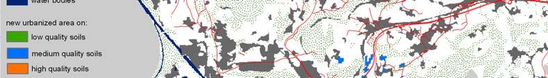
5 Furthermore, it was assessed how the predicted changes would affect the soil resources in the cities. The analysis was performed for Stuttgart, Milan, Prague, Bratislava, Vienna, Salzburg and Wroclaw. 2. MATERIALS AND METHODS 2.1. Data sources Two main spatial databases were applied for urban spread simulation within the pilot urban areas: land use classification and soil maps. Land use information layers were prepared through classification of satellite images as it was in detail described in the Urban SMS deliverable report: Assessment of soil protection efficiency and land use change. Land use information was gathered for two periods: the initial status map for and the current status map for The land use change maps representing two periods enabled assessment of time-dependent land transformation rates under the as is soil management system. Land use maps contained 13 different land use classes. For the modeling purposes the original 13-class classification was reclassified to 4 classes representing 4 groups of urban land utilization: 0) agricultural and semi-natural 1) residential continuous and discontinuous, commercial and industrial, dump and mineral extraction sites, airports, transport facilities, sport and leisure facilities 2) forests, green recreation areas 3) water bodies. In the simulation process it was assumed that urbanization may take place only on agricultural and semi-natural areas (class 0), thus this group of land uses served as land pool available for the potential sealing. Generally use of forest areas is restricted in all cities, thus this class was excluded from allocation of new urban fabrics. Class 2 (forests and green recreation areas) and class 3 (water bodies) remained unchanged in the modeling their areas did not increase nor were not reduced. Soil maps were provided by the project partners responsible for the respective test cities. Due to diverse soil quality assessment systems, present in different Central European countries, and content of the soil maps the polygons on each map were grouped into 3 classes. They represented high, medium and low quality soils (either from perspective of production function, ecosystem function, buffering, retention etc.). In some cities the available soil maps did not cover the whole city area. In such cases it was assumed that unsealed areas without 4
6 soil information are represented by medium soil quality class. This enabled full coverage of city areas with simulated future urban sprawls. The land use maps and the soil maps were converted to raster data with grid resolution of 50 meters. It has been observed that new residential areas were rather clustered and did not exhibit elements smaller that 50 meters Approach for urban sprawl simulation cellular automata (CA) In the analysis we used the Cellular Automata-based Metronamica model. The software was developed and provided by the Research Institute from Knowledge Systems (RIKS) from Maastricht, The Netherlands. The software utilizes cellular automata model to spatially distribute areas of particular land use classes. Cellular automata is a discrete model which uses regular grid of cells, each classified within finite number of states. In case of Metronamica land use change modeling, these states refer to land use classes. Land use types are classified in the model according to their behavior into the following categories: feature states (fixed land uses that do not change dynamically), function states (they change dynamically as the result of the local and the regional dynamics) and vacant states (they change dynamically due to the local dynamics only). In our simulations: Class 0) agricultural and semi-natural uses are vacant states Class 1) residential continuous and discontinuous fabrics, commercial and industrial, dump and mineral extraction sites, airports, transport facilities, sport and leisure facilities are function states Class 2) forests, green recreation areas are feature states Class 3) water bodies are feature states. The neighborhood of a cell (surrounding cells) influences the transition of this cell into other class in the next time step. The cells located further away have a smaller effect than cells closer to the centre cell. The transition rules are the core of the CA and determine if, and how, the state of each cell in the next time step changes. The neighborhood effect in this analysis is defined as: the attraction or repulsion effect of surrounding cells which eventually causes a change in cell status (type of land use) of the centre cell. For each land use function, a set of rules determines the degree to which it is attracted to, or repelled by, the other functions present in the neighborhood. In our simulation, based on the neighborhood land use interaction and land suitability, described in the subsequent sub-section, the model calculates the value of transition potential 5
7 (Pk) for each cell and land use function and for every simulation time step. All cells are ranked according to their transition potential, and cell transitions begin with the highest ranked cell and the transition process proceeds downward. The number of cells required for urban function in the subsequent years is determined by simple linear relationship between historical data (land use map for 1990/92) and current data (land use map 2006/2007) (Figure 1) residential area [km2] year Figure 1. Exemplary linear trend for prediction of residential area in 2030 Areas converted to urban land use class for all test cities from Urban SMS project are collected in Table 1. In the second column the yearly area converted is expressed as % of existing urbanized area. This enables comparison of urban growth rate between cities of different size. Table 1. Statistics for conversion of agricultural and semi-natural areas (class 0) into urban functions based on historivcal data and predicted consumption based on the observed trend City yearly urbanization of agricultural and seminatural areas area converted to 2030 [ha] [ha] [% urbanized area] Bratislava Milan Prague Salzburg Stuttgart Vienna Wroclaw
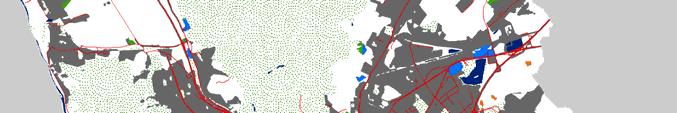
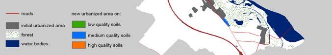
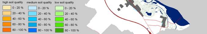
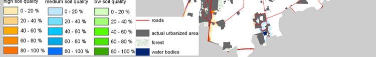
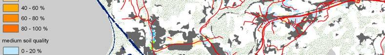
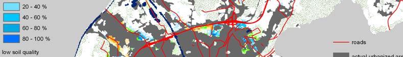
8 2.3. Land Suitability The term suitability is used here to describe the degree to which a cell is able to support a particular land use function. It is a composite measure, prepared in a Geographical Information System (GIS), on the basis of factor maps determining the physical, ecological and environmental appropriateness of cells. For transition into residential areas the Land Suitability (LS) includes four factors: terrain suitability S (slope), road accessibility S (distance to road), urban potential S (density of urbanized cells) and soil suitability S (soil). It is also assumed that these factors work independently so that the final land suitability (LS) is a product of them: LS = S( slope) S( dist. to road ) S( urban potential ) S( soil) Values for first three factors were derived from share of new urbanized cells that appeared in the selected groups (percent slope or distance to road or density of residential area in a neighborhood of cell) between 1990/92 and 2006/2007 (Figure 2) > > 20 2a) suitability for distance to road classes 2b) suitability for slope classes Scenario 1 Scenario 2 Scenario ,2 0,2-0,4 0,4-0,6 0,6-0,8 0,8-1 0 low quality soil medium quality soil high quality soil 2c) suitability for urban potential classes 2d) suitability for soil quality classes Figure 2. Suitability values for four components of the Land Suitability (LS). 7
9 All three partial suitability layers were normalized to reach values within range from 0 to 100 (0 means that a given cell is not useful for residential area, 100 means that there are no limitations to allocate urban function in this cell). Soil suitability values for urban function were established according to soil quality maps and were dependent on the analyzed soil protection scenario. In the baseline scenario, covered by this report, it is assumed that all three soil quality classes have the same soil suitability value, equal 100. Exemplary maps of suitability components and the final Land Suitability for Bratislava are presented on Figure 3. 3a) Road accessibility. 3b) Terrain suitability. 3c) Urban potential suitability. 3d) Soil suitability. 8

 and final Land Suitability (3e) for")


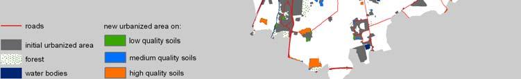
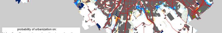
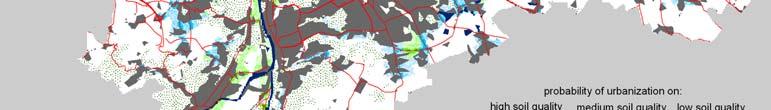
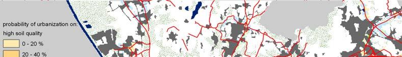
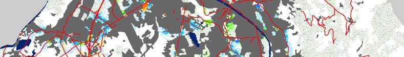
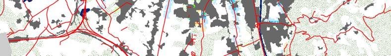
10 3e) Land suitability for urban land use function. Figure 3. Maps of suitability land suitability components (3a-3d) and final Land Suitability (3e) for Bratislava 3. RESULTS FOR SIMULATION OF BASELINE SCENARIO Maps generated by Monte Carlo method (100 runs) display probabilities for transformation of a given cell of agricultural or semi-natural area into urban function. In order to forecast the impact of the baseline scenario on soil cover, the probabilities are combined with soil quality information. 9


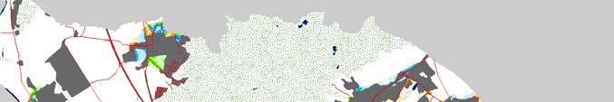

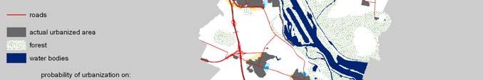
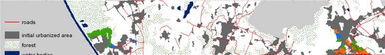
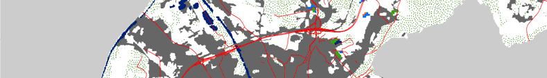
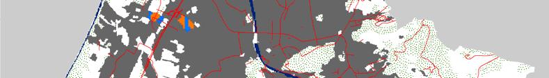
11 Figure 4. Historical urban sprawl in Bratislava between1992 and Figure 5. Simulated probability of urbanization in Bratislava between 2007 and


12 Figure 6. Historical urban sprawl in Milan between1991 and Figure 7. Simulated probability of urbanization in Milan between 2006 and


13 Figure 8. Historical urban sprawl in Prague between1990 and Figure 9. Simulated probability of urbanization in Prague between 2006 and
14 Figure 10. Historical urban sprawl in Salzburg between1991 and Figure 11. Simulated probability of urbanization in Salzburg between 2007 and


15 Figure 12. Historical urban sprawl in Stuttgart between1992 and Figure 13. Simulated probability of urbanization in Stuttgart between 2006 and


16 Figure 14. Historical urban sprawl in Wroclaw between1991 and Figure 15. Simulated probability of urbanization in Wroclaw between 2006 and


17 Figure 16. Historical urban sprawl in Vienna between1991 and Figure 17. Simulated probability of urbanization in Vienna between 2007 and
18 4. SUMMARY The baseline scenario forecast of urbanization was performed for 7 urban pilot areas by using Cellular Automata Metronamica model. The forecast utilizes, so called, transition potential of a given piece of land (cell in spatial information layer) which combines effect of surrounding land uses and land suitability for the urbanization. Land suitability combines such factors as slope, road density, urban fabrics density and soil suitability. Baseline scenario assumed no limitations, related to soil quality, for transformation of agricultural or seminatural lands into urban functions. For some countries, with no clear urban soil protection system, this scenario would be approximate to the as is scenario. Under the analyzed scenario the transformation of land into urban purposes is driven only by socio-economic factors and some physical conditions such as slope or distance to transport network. For each pilot city the potential spatial distribution of new urban objects was produced up to year This information was superimposed on soil quality maps in order to learn what would be quality of soils lost under the baseline scenario. The baseline scenario will be in detail compared to alternative soil protection scenarios in the subsequent Deliverable report ( Urban sprawl under alternative soil protection scenarios ). 5. REFERENCES COM Communication from the Commission to The Council and European Parliament, The European Economic and Social Committee of The Regions. Thematic Strategy for Soil Protection Hilferink M., P. Rietveld LAND USE SCANNER: An integrated GIS based model for long of land use in urban and rural areas. Journal of Geographical Systems, 1: RIKS BV Metronamica - A Dynamic Spatial Land Use Model, RIKS, Maastricht, The Netherlands Stuczynski T Assessment an modeling of land use change in Europe in the context of soil protection. Pulawy, Poland Westhoek H.J, M. van den Berg, J.A. Bakkes Scenario development to explore the future of Europe s rural areas. Agriculture, Ecosystems and Environment 114:
19 URBAN SMS Soil Management Strategy This paper belongs to the following section of URBAN SMS work plan: WP6 Acceptance and awareness / 6.2 Protection scenario modelling / Baseline scenario analysis Contact details of project partner commissioning / responsible for this paper: Mr Grzegorz Siebielec, Institute of Soil Science and Plant Cultivation, ul. Czartoryskich 8, Pulawy, PL, gs@iung.pulawy.pl Other URBAN SMS Partners contributing to this paper: Petra Blümlein, City of Stuttgart, Department for Environmental Protection, DE Isabel Wieshofer, City of Vienna, Environmental Protection, AT Sigbert Huber, Umweltbundesamt, Environment Agency Austria, Vienna, AT Marco Parolin, City of Milan, Executive Plans and Programs for Buildings Department- Office for Reclamation Plans, I Petra Vokurková, Czech University of Life Sciences Prague, CZ Jaroslava Sobocká, Soil Science and Conservation Research Institute, Bratislava, SK Siegmar Jaensch, District Authority Stuttgart, DE This project is implemented through the CENTRAL EUROPE Programme co-financed by the ERDF. The paper in hand reflects the author s views and the Managing Authority of the INTERREG IV B CENTRAL Programme is not liable for any use that may be made of the information contained therein.
URBAN SMS Soil Management Strategy
 URBAN SMS Soil Management Strategy Anforderungen und Möglichkeiten zum Bodenmanagement in der Stadtplanung Sigbert Huber, Umweltbundesamt Who we are 1. City of Stuttgart (Lead partner) 2. City of Vienna
Urban and peri-urban changes across Central and Eastern Europe and their socio-economic consequences
 Urban and peri-urban changes across Central and Eastern Europe and their socio-economic consequences Premysl Stych, Jan Feranec, Tomas Soukup, Gregory N. Taff, Ivan Bicik, Lucie Kupková stych@natur.cuni.cz
User Awareness & Training: Use of Copernicus data for land monitoring and environmental reporting in Italy Lisbon, Portugal 14 th February 2014 ISPRA
 User Awareness & Training: Use of Copernicus data for land monitoring and environmental reporting in Italy Lisbon, Portugal 14 th February 2014 ISPRA Contents Introduction to land take, urban sprawl and
5. Land use database applications
 48 Towards an urban atlas 5. Land use database applications The Murbandy/Moland project is a continuously evolving activity. To date, the territorial data sets have been completed and validated for 25
 Provided by the author(s) and University College Dublin Library in accordance with publisher policies. Please cite the published version when available. Title Encroachment upon protected areas within the
Approximations of Landscape
 Approximations of Landscape Geodesign. Approximations of a catchphrase 1. Geodesign Approaches and a typologies 2. Spatial Scenario Design Models for Geodesign 3. Collaboration as a challenge 4. Conclusions
Vu Kim Chi Nguyen Thi Thuy Hang
 Vu Kim Chi Nguyen Thi Thuy Hang Tokyo, Dec 7, 2015 Introduction Data and methods Results and discussions Conclusion The city of Quy Nhon Urban planning in Quy Nhon Climate change and sea level rise Natural
patterns of contemporary suburbanization methods of analysis kiril stanilov Urban form contrasts Managing suburban growth in Seattle
 patterns of contemporary suburbanization case studies patterns of contemporary suburbanization methods of analysis Urban form contrasts Managing suburban growth in Seattle land uses 1960 commercial Question
Methods to Simulate the Impact of BMPs
 LA221 Project Ortega Watershed Demonstration Area, Quito Ecuador Ricardo da Cruz e Sousa Master of Landscape Architecture & Environmental Planning University of California, Berkeley December 2011 Ortega
Smart City Governance URBIS Solutions. David Ludlow, Assoc. Professor European Smart Cities University of the West of England, Bristol
 Smart City Governance URBIS Solutions David Ludlow, Assoc. Professor European Smart Cities University of the West of England, Bristol Integrated smart city model Smart Mobility Services focused on decreasing
GREEN NETWORK APPLICATIONS IN ESTONIA
 GREEN NETWORK APPLICATIONS IN ESTONIA Kalev Sepp, Tuuli Veersalu, Martk Külvik Estonian University of Life Sciences 1 WHY? BACKGROUND - POLITICAL By adopting the Pan-European Biological and Landscape Diversity
New forms of territorial governance for the promotion of landscape policies in the field of water resources management at water
 New forms of territorial governance for the promotion of landscape policies in the field of water resources management at water territories i EU Community Initiative Interreg III B ArchiMed KEPEMEP-MedRegio
for Biosphere Reserves
 Sustainable Tourism in Biosphere Reserves in Central and Eastern Europe Tourism Management Plans for Biosphere Reserves Ecological Tourism in Europe - E.T.E. e.v. Page 1 What is a Tourism Management Plan?
GCM (~100 km) UCM (~100 m) RCM (~10 km)
 UCM (~100 m) RCM (~10 km)") Urban climate projections for Central European cities and modelling tools for urban planning Maja Žuvela-Aloise NWP Applications, ZAMG, Vienna, Austria GCM (~100 km) UCM (~100 m) RCM (~10 km) Regional
Urban climate projections for Central European cities and modelling tools for urban planning Maja Žuvela-Aloise NWP Applications, ZAMG, Vienna, Austria GCM (~100 km) UCM (~100 m) RCM (~10 km) Regional
Christof Schremmer (ÖIR), Vienna, Austria Dominic Stead (OTB), Delft, Netherlands
, Vienna, Austria Dominic Stead (OTB), Delft, Netherlands") 5 th Urban Research Symposium Cities and Climate Change: Responding to an Urgent Agenda Sunday, June 28, 2009 Towards Energy Efficient Cities: Gaining Traction on the Ground FP 7 Research Project: SUME
5 th Urban Research Symposium Cities and Climate Change: Responding to an Urgent Agenda Sunday, June 28, 2009 Towards Energy Efficient Cities: Gaining Traction on the Ground FP 7 Research Project: SUME
Green Infrastructure. IENE 2012 International Conference
 Green Infrastructure IENE 2012 International Conference Marco Fritz, DG Environment Potsdam, 22/10/2012 Content 1) Green Infrastructure why does it matter? 2) Added value 3) Policy development framework
Running head: LAND USE CHANGE IN EDMONTON Land Use Change in Edmonton Chelsey-Ann Cu GEOB 479 L2A
 Running head: LAND USE CHANGE IN EDMONTON 1966-1976 1 Land Use Change in Edmonton 1966-1976 Chelsey-Ann Cu 32482135 GEOB 479 L2A University of British Columbia Dr. Brian Klinkenberg 26 January 2018 LAND
THE LANDSCAPE ECOLOGICAL ASSESSMENT MODEL AND ITS APPLICATIONS
 The 5 th International Conference of the International Forum on Urbanism (IFoU) 2011 National University of Singapore, Department of Architecture Global Visions: Risks and Opportunities for the Urban Planet
Analyzing of Reduction Process of Urban Open Spaces in Process of Cities Development with Emphasis on Crisis Management in Tehran Metropolis
 Journal of Sustainable Development; Vol. 5, No. 9; 2012 ISSN 1913-9063 E-ISSN 1913-9071 Published by Canadian Center of Science and Education Analyzing of Reduction Process of Urban Open Spaces in Process
ANALYSIS ON EFFECTS OF SEOUL METROPOLITAN SUBWAY STATION BY USING GIS AND RS
 ANALYSIS ON EFFECTS OF SEOUL METROPOLITAN SUBWAY STATION BY USING GIS AND RS I.T. Yang, S.Y. Lee, S.I. Baek & J.H. Park E-Mail :intae@kangwon.ac.kr Lab. Of Surveying & Geospatial Information Department
Automated Fire and Flood Hazard Protection System
 De la Riva, J., Pérez-Cabello, F. & Chuvieco, E. (Eds) 2005 Proceedings of the 5 th International Workshop on Remote Sensing and GIS Applications to Forest Fire Management: Fire Effects Assessment: 167-172
Urban challenges opportunities for cities in Europe. Peter Austin Urban Development dept
 Urban challenges opportunities for cities in Europe Peter Austin Urban Development dept. 25.11.2014 Urban engagement: building knowledge, ideas and policy in a European context Outline International working
Chapter 5 Standards and Methodologies to Measure E-waste
 Chapter 5 Standards and Methodologies to Measure E-waste Illustration 5.1: Life cycle of EEE into e-waste, and the most common e-waste management scenarios Delivery NEW SALES! Sales Business use Private
Soil in EEA s Multi-annual work programme (MAWP)
") EIONET NRC SOIL Ispra, ITALY 23 May 2014 Soil in EEA s Multi-annual work programme (MAWP) 2014-2018 Geertrui Louwagie Ecosystems assessment group Natural systems and vulnerability programme 1 EEA Multi-annual
EIONET NRC SOIL Ispra, ITALY 23 May 2014 Soil in EEA s Multi-annual work programme (MAWP) 2014-2018 Geertrui Louwagie Ecosystems assessment group Natural systems and vulnerability programme 1 EEA Multi-annual
Marion Bogers and Bas Pedroli
 Alterra Lead Partner DLO Wageningen UR The Netherlands UEDIN Edinburgh University United Kingdom UNIKLU Institute of Social Ecology Austria VUA VU University Amsterdam The Netherlands PIK Potsdam Institute
GIS to Estimate Archaeological Site Loss and Develop Conservation Strategies
 GIS to Estimate Archaeological Site Loss and Develop Conservation Strategies Terry Jackson Office of Decision Support Systems Planning and Environmental Management Division Georgia Department of Community
Lecture: Landscape Ecology
 Borderland: Border Landscapes Across Europe 2013 Lecture: Landscape Ecology Dr Iwona Markuszewska Department of Landscape Ecology iwmark@amu.edu.pl Presentation schedule: Landscape ecology as a scientific
Development of green infrastructure in EU regions Nature-based solutions delivering multiple benefits
 Development of green infrastructure in EU regions Nature-based solutions delivering multiple benefits A Policy Brief from the Policy Learning Platform on Environment Introduction What is green infrastructure?
Integrated urban policies and land management The URBACT Experience Didier Vancutsem
 Integrated urban policies and land management The URBACT Experience Didier Vancutsem Didier Vancutsem URBACT Expert Prof Urban Planner ISOCARP Contents Integrated urban policies and land management: a
Dynamic Lights Towards Dynamic, Intelligent and Energy Efficient Urban Lighting
 Newsletter Edition 02 July 2017 Dynamic Lights Towards Dynamic, Intelligent and Energy Efficient Urban Lighting THE 8 PILOT PROJECTS The main focus of the Dynamic Light project is on how to improve quality
Alpine Green Infrastructure Joining forces for nature, people and the economy
 Alpine Green Infrastructure Joining forces for nature, people and the economy Joint declaration of Alpine States and Regions Munich, October 2, 2017 The project is co-financed by the European Regional
European Green Belt Initiative Example for cross border cooperation
 GreenNet Conference Grad, Slovenia, 11 th September 2013 European Green Belt Initiative Example for cross border cooperation BUND-Project office Green Belt, Regional Coordinator Central Europe, Daniela
Stochastic Model of Appliances Energy Consumption 3.1 A SMART, ENERGY-SAVING TENANTS SOLUTION
 FACTSHEET Stochastic Model of Appliances Energy Consumption 3.1 A SMART, ENERGY-SAVING TENANTS SOLUTION Enables designers and engineers to accurately generate appliances load profiles according to building
Project title: ALPCITY Local endogenous development and urban regeneration of small alpine towns
 ALPCITY PROJECT www.alpcity.it KEY DATA AND DATES Project title: ALPCITY Local endogenous development and urban regeneration of small alpine towns Project web site: www.alpcity.it Programme: Interreg III
EUROSOIL Soil Society Environment August 2008 Vienna, Austria
 EUROSOIL 2008 Soil Society Environment 23-31 August 2008 Vienna, Austria http://www.ecsss.net EUROSOIL 2008 In co-operation between the soil science societies of Austria, Croatia, the Czech Republic, Hungary,
Draft Resolution XII.10
 12 th Meeting of the Conference of the Parties to the Convention on Wetlands (Ramsar, Iran, 1971) Punta del Este, Uruguay, 1-9 June 2015 Ramsar COP12 DR10, Rev. 2 21:45, 8 June Draft Resolution XII.10
Preserving Soils How can fertile soil be protected?
 Activitydevelop Preserving Soils How can fertile soil be protected? Overview Students explore a map showing cropland density around the world. They discover how soil is formed and explore how plants get
Fingal Development Plan & Green Infrastructure. Nicholas O Kane Senior Executive Planner Fingal County Council
 Fingal Development Plan 2011-2017 & Green Infrastructure Nicholas O Kane Senior Executive Planner Fingal County Council 2011 Fingal Development Plan Must be in compliance with National Spatial Strategy
Urban Sprawl Risk Assessment Based on Ecological Infrastructure:
 Urban Sprawl Risk Assessment Based on Ecological Infrastructure: An Approach to Smart Conservation 1 Introduction 1.1 Characteristics of urban sprawl in China Urban sprawl is a global problem, but more
Environmental Hazards and Risk Management
 Terms of Reference for ESPON-INTERACT Thematic Study Environmental Hazards and Risk Management Environmental hazards and risk management/preventions are important elements in the discussion of future Structural
Carpathian Convention as a governance mechanism in the mountainous region
 THE MOUNTAIN DIMENSION OF COOPERATION Carpathian Biosphere Reserve, Transcarpathia, Ukraine Photo: Vian / Wikimedia Commons Carpathian Convention as a governance mechanism in the mountainous region Klaudia
Using AutoCAD Civil 3D and ESRI ArcGIS to meet LEED-ND (Neighborhood Development) Requirements NDIA O Brien & Gere. All Rights Reserved.
 Requirements NDIA O Brien & Gere. All Rights Reserved.") Using AutoCAD Civil 3D and ESRI ArcGIS to meet LEED-ND (Neighborhood Development) Requirements NDIA 12457 1 Using AutoCAD Civil 3D and ESRI ArcGIS to meet LEED-ND (Neighborhood Development) Requirements
Using AutoCAD Civil 3D and ESRI ArcGIS to meet LEED-ND (Neighborhood Development) Requirements NDIA 12457 1 Using AutoCAD Civil 3D and ESRI ArcGIS to meet LEED-ND (Neighborhood Development) Requirements
How keep.eu can be used? Baiba Liepa, Interact Programme
 How keep.eu can be used? Baiba Liepa, Interact Programme What is keep.eu Knowledge management tool including database, website, search engine Available on www.keep.eu The only source of aggregated information
LANDSCAPE HETEROGENEITY AS A TOOL FOR ENHANCING BIODIVERSITY
 Landscape and Landscape ecology / 17th International Symposium 27 29 May, 2015. Nitra, Slovakia University of Ljubljana, Biotechnical faculty, Agricultural institute of Slovenia, Aquarius d.o.o. LANDSCAPE
Resolution XII NOTING also that with the increasingly rapid urbanization, wetlands are being threatened in two principle ways:
 12 th Meeting of the Conference of the Parties to the Convention on Wetlands (Ramsar, Iran, 1971) Punta del Este, Uruguay, 1-9 June 2015 Resolution XII.10 Wetland City 1 Accreditation of the Ramsar Convention
Land Take and Soil Sealing: An overview of the EU situation
 Land Take and Soil Sealing: An overview of the EU situation Soil remediation and soil sealing conference Brussels, May 10 and 11 2012, organised by DG ENV, European Commission 1 Background In April 2012
Announcement of upcoming activities / events on the protection of large carnivores
 Announcement of upcoming activities / events on the protection of large carnivores Carpathian Convention Presidency of the Czech Republic UNEP Vienna - Interim Secretariat of the Carpathian Convention
City of Surrey Ecosystem Management Study. Integration of ecological processes with land use
 City of Surrey Ecosystem Management Study Integration of ecological processes with land use Natural areas in Surrey are changing as the City grows and evolves. Many important natural areas remain or may
Building a green infrastructure concept and process in the Gauteng City Region, South Africa. Kerry Bobbins Researcher GCRO
 Building a green infrastructure concept and process in the Gauteng City Region, South Africa Kerry Bobbins Researcher GCRO kerry.bobbins@gcro.ac.za IGU Regional Conference Krakow, Poland 1 18 22 August
Informaciaó de sòls. situciaó actual i perspectives. Nicola Filippi, D.G.Ambiente, Regione Emilia-Romagna Barcelona, 4 June 2009
 Informaciaó de sòls à la Regió Emilia-Romagna: situciaó actual i perspectives Nicola Filippi, D.G.Ambiente, Regione Emilia-Romagna Barcelona, 4 June 2009 EL MAPA DE SÒLS DE CATALUNIA 1 Informaciaó de sòls
What is green Infrastructure (GI)?
?") GreenNet Workshop green Infrastructure, Goričko Nature Park (Slovenia), 11.09.2013 What is green Infrastructure (GI)? Mike Cattell Leidorf DEGES Frankenwaldtourismus Hofrichter Melanie Kreutz PP02, BUND-Project
GreenNet Workshop green Infrastructure, Goričko Nature Park (Slovenia), 11.09.2013 What is green Infrastructure (GI)? Mike Cattell Leidorf DEGES Frankenwaldtourismus Hofrichter Melanie Kreutz PP02, BUND-Project
Economic valuation of green urban spaces: a meta-analysis
 Economic valuation of green urban spaces: a meta-analysis Natasha Nikodinoska 1, Gianni Guastella 1,2, Stefano Pareglio 1,2 1 Fondazione Eni Enrico Mattei (FEEM) - Milan, Italy 2 Università Cattolica,
Mosaic of patches Agents of patch formation: Environmental constraints (Abiotic) Biotic processes Disturbances (natural and human induced)
 Biotic processes Disturbances (natural and human induced)") Landscape: Mosaic of patches Agents of patch formation: Environmental constraints (Abiotic) Biotic processes Disturbances (natural and human induced) Concepts for Quantification of a Landscape Landscape
Landscape: Mosaic of patches Agents of patch formation: Environmental constraints (Abiotic) Biotic processes Disturbances (natural and human induced) Concepts for Quantification of a Landscape Landscape
Growth Management Planning in the Central Puget Sound Region. Today s Presentation. Puget Sound Region. New Partners for Smart Growth
 Growth Management Planning in the Central Puget Sound Region New Partners for Smart Growth Denver, CO January 2006 Today s Presentation Regional growth management in central Puget Sound, WA Regional geographies
Evaluating the Potential for Green Roof Retrofit in Urban Fabric
 Full Paper 43 Evaluating the Potential for Green Roof Retrofit in Urban Fabric Dor Schreier 1, Tal Alon-Mozes 2 1 Haifa/Israel dor.schreier@gmail.com 2 Technion, Haifa/Israel Abstract: Green roof benefits
A global view of integrated closure and legacy planning
 18 September 2013 A global view of integrated closure and legacy planning Mine Closure 2013, Eden Project, Cornwall Dr. William Adams General manager, Legacy and Closure A changing business climate The
Local pilot fact sheet: Via Rizzoli
 Local pilot fact sheet: Via Rizzoli Project partner organisation name: Comune di Milano Name of contact person: Marco Parolin E-Mail of contact person: marco.parolin@comune.milano.it, marco.parolin@tiscali.it
The Mitigation of UHI Intensity through an Improved Land-Use Plan in the Urban Central Area: Application to Osaka City, Japan
 Academic Article Journal of Heat Island Institute International Vol.7-2 (2012) The Mitigation of UHI Intensity through an Improved Land-Use Plan in the Urban Central Area: Application to Osaka City, Japan
Cumberland Comprehensive Plan Town Council adopted August 2003, State adopted June 2004 TABLE OF CONTENTS
 TABLE OF CONTENTS I. Executive Summary A. Scope of the Comprehensive Plan I-2 B. Plan Development Process I-3 C. Plan Format I-3 D. Acknowledgements I-4 II. Demographic Analysis A. Introduction II-1 B.
Miami Valley Regional Planning Commission Regional Land Use Planning
 Miami Valley Regional Planning Commission Regional Land Use Planning This document provides an overall approach on the region-based land use planning process, outlining the major tasks and work elements
Wageningen Environmental Research
 Wageningen Environmental Research Monitoring the touristic values of European landscape 10-2-2017, Martin Goossen Overview - Introduction - Application - Results - Conclusion Introduction Mires and bogs
Regional Context Statement
 Regional Context Statement REGIONAL CONTEXT STATEMENT 3. REGIONAL CONTEXT STATEMENT In 1995, the Provincial Government passed into law the Growth Strategies Act. The purpose of this provincial initiative
3. VISION AND GOALS. Vision Statement. Goals, Objectives and Policies
 Vision Statement Queen Creek s interconnected network of parks, trails, open spaces and recreation opportunities provide safe and diverse activities and programs that sustain its unique, small town, equestrian
Form Syntax as a contribution to geodesign: a method to measure urban form quantitatively and assist urban design
 Form Syntax as a contribution to geodesign: a method to measure urban form quantitatively and assist urban design YU YE Anthony G. O. Yeh Jianzheng Liu; Tian Lan Akkelies van Nes Henrik Harder introduction:
CIRCUSE the project, not a circus
 Circular Flow Land Use Management (CircUse) CIRCUSE the project, not a circus Anna Starzewska-Sikorska, CircUse Project Coordinator CircUse Forum at the TerraTec in Leipzig on 31st January 2013 CircUse
Submitted to Northern Coalfields Limited. Singrauli Coalfield 2015
 Land Restoration / Reclamation Monitoring of more than 5 million cu. m (Coal+OB) Capacity Open Cast Coal Mines of Northern Coalfields Limited based on Satellite Data for the Year 2015 Singrauli Coalfield
The Salt Marsh Advancement Zone Assessment of Connecticut
 The Salt Marsh Advancement Zone Assessment of Connecticut Front cover image: Salt marsh advancement zones in Stratford, CT from the Comprehensive Map Book of Stratford, CT. Table of Contents Introduction...
Jianguo (Jingle) Wu School of Life Sciences & School of Sustainability Arizona State University, Tempe, AZ 85287
 Wu School of Life Sciences & School of Sustainability Arizona State University, Tempe, AZ 85287") Jianguo (Jingle) Wu School of Life Sciences & School of Sustainability Arizona State University, Tempe, AZ 85287 What Is Landscape Ecology?! Wu and Hobbs (2007):! The science and art of studying and influencing
Jianguo (Jingle) Wu School of Life Sciences & School of Sustainability Arizona State University, Tempe, AZ 85287 What Is Landscape Ecology?! Wu and Hobbs (2007):! The science and art of studying and influencing
Suitability analysis of heritage corridor based on GIS and Remote Sensing Case study of region along the Zhangzhou ancient post road
 289-Paper Suitability analysis of heritage corridor based on GIS and Remote Sensing Case study of region along the Zhangzhou ancient post road 1 Huagui Guo and *Qingming Zhan Abstract It s insufficient
Landscape management for leisure and recreation - integrated water management at the example of the River Mur
 Landscape management for leisure and recreation - integrated water management at the example of the River Mur DI Oliver Rathschueler DI Hans-Jörg Raderbauer - freiland Overview Landscape management in
Site Assessment Technical Document Appendix A: Glossary
 Central Bedfordshire Council www.centralbedfordshire.gov.uk Site Assessment Technical Document Appendix A: Glossary July 2017 1.1.11-1 - ii Appendix A: Glossary Term Agricultural Land Classification AONB
Semi-Automatic Mapping of Landscape Features within the framework of GAEC. A selected case study from the Czech Republic.
 1 Semi-Automatic Mapping of Landscape Features within the framework of GAEC. A selected case study from the Czech Republic. R. de Kok MarS Unit, IPSC, JRC Ispra Main Topics The 6 mayor Landscape Feature
Living with World Heritage in Africa
 INTERNATIONAL CONFERENCE Living with World Heritage in Africa [26 26-29 September 2012] South Africa BACKGROUND DOCUMENT The Government of the Republic of South Africa, in collaboration with the African
URBan land recycling Information systems for Sustainable cities. Special Session CABERNET Conference Frankfurt, Germany
 URBan land recycling Information systems for Sustainable cities Special Session CABERNET Conference Frankfurt, Germany 16.10.2014 1 Overview Issue of Urban Sprawl in the EU URBIS Project Specific project
The MAES implementation at European and national scale - guidance and case studies
 The MAES implementation at European and national scale - guidance and case studies Joachim Maes European Commission, DG Joint Research Centre, Ispra Anne Teller European Commission DG Environment, Brussels
Special Report. Green Infrastructure: Nature-Based Solutions for Sustainable and Resilient Cities
 26 Green Infrastructure: Nature-Based Solutions for Sustainable and Resilient Cities European collaboration focusing on urban forests culminates in worldwide spring gathering By Naomi Zürcher Urban Forester/Consulting
Presented by: Remy Norbert DUHUZE Director/ER&PC REMA
 Presented by: Remy Norbert DUHUZE Director/ER&PC REMA 1 Presentation Outline What is Environment, Social and Economic Impact Assessment? Objectives and Principles of EIA EIA background & regulations Stakeholders
The Charter of European Planning BARCELONA 2013
 The Charter of European Planning BARCELONA 2013 The Vision for Cities and Regions Territoires of Europe in the 21st Century ECTP-CEU (The European Council of Spatial Planners Le Conseil Européen des Urbanistes)
Green Infrastructure Policies and Ordinances
 Green Infrastructure Policies and Ordinances October 23, 2013 By Karen Firehock, Green Infrastructure Center 2013 Georgia Urban Forest Council s 23 rd Annual Conference The mission of the nonprofit Green
Nature without barriers
 Nature without barriers Natura2000 sites as Green Infrastructure in the Austrian-Hungarian transborder region Fertö-Hansag-Neusiedlersee Thomas Wrbka Michael Kuttner Univ. Vienna - Department of Biodiversity
4. What are the goals of the Kawarthas, Naturally Connected project? 7. What are watersheds and why are they being used as the project boundaries?
 Frequently Asked Questions (FAQs) 1. What are Natural Heritage Systems (NHS)? 2. Why are they important? 3. Which areas of the province have undertaken NHS projects? 4. What are the goals of the Kawarthas,
The urbanization process through urban ecology: which definitions
 Addis Abeba, 1 st November 2014 PhD thesis: The urbanization process through urban ecology: which definitions & which resilience among ecosystems? André M. Introduction: a growing urban population 2 ONU,
Promoting compact urban design for cities in developing countries
 THE WORLD BANK www.worldbank.org/eco2 Promoting compact urban design for cities in developing countries Issues and opportunities for sustainable urban development Montreal 2011 EcocityWorld Summit Kanako
Transnational Ecological Networks in Central Europe
 Transnational Ecological Networks in Central Europe Investigating landscapes without borders Overview 1 Introduction to the project 2.1 Project activities and outputs 2.2 Transnational cooperation in challenges
T H E I N T E R R E L A T I O N S H I P OF L A N D S C A P E E C O L O G Y & L A N D S C A P E A R C H I T E C T U R E:
 T H E I N T E R R E L A T I O N S H I P OF L A N D S C A P E E C O L O G Y & L A N D S C A P E A R C H I T E C T U R E: A P P L I C A T I O N S F O R T R E N D S I N U R B A N I Z A T I O N Prepared by
DEFINITION, SPECIFICATION AND GIS LAYER CREATION OF LANDSCAPE FEATURES IN SLOVAKIA INCLUDING POSSIBLE SAPS CONSEQUENCES
 DEFINITION, SPECIFICATION AND GIS LAYER CREATION OF LANDSCAPE FEATURES IN SLOVAKIA INCLUDING POSSIBLE SAPS CONSEQUENCES Michal Sviček ek,, Kristína Gasiorková,, Martin Granec Soil Science and Conservation
Sharing experiences in landscape Approaches. Yogyakarta, December 2009) Cora van Oosten,
 Cora van Oosten,") Sharing experiences in landscape Approaches Yogyakarta, December 2009) Cora van Oosten, Cora.vanoosten@wur.nl What is a landscape? Imagine a landscape... Reading landscapes Reading landscapes Reading landscapes
Sharing experiences in landscape Approaches Yogyakarta, December 2009) Cora van Oosten, Cora.vanoosten@wur.nl What is a landscape? Imagine a landscape... Reading landscapes Reading landscapes Reading landscapes
A Network Theory Framework for Urban Cultural Heritage Conservation. Manal Ginzarly LEMA, Université de Liège
 A Network Theory Framework for Urban Cultural Heritage Conservation Manal Ginzarly LEMA, Université de Liège Objective Develop an ecological approach to the integration of heritage conservation and urban
English version. Railway applications Systematic allocation of safety integrity requirements
 TECHNICAL REPORT CLC/TR 50451 RAPPORT TECHNIQUE TECHNISCHER BERICHT May 2007 ICS 45.020;93.100 Supersedes R009-004:2001 English version Railway applications Systematic allocation of safety integrity requirements
LANDMAP Methodology Overview
 LANDMAP Methodology Overview June 2017 Jill Bullen, Senior Landscape Specialist jill.bullen@cyfoethnaturiolcymru.gov.uk 0300 065 4706 (Please note this is an information document and not a training presentation)
Biodiversity Action Plan Background Information for discussion purposes
 Biodiversity Action Plan Background Information for discussion purposes Our commitment As directed by Council, The City of Calgary has agreed to sign the Durban Commitment, an international agreement on
EnRoute. 1 st update. Joint Research Centre the European Commission's in-house science service. Grazia Zulian Joachim Maes Martijn Thijssen
 EnRoute 1 st update Grazia Zulian Joachim Maes Martijn Thijssen Joint Research Centre the European Commission's in-house science service EnRoute Enhancing Resilience of Urban Ecosystems through Green Infrastructure
Ecological Landscape Planning and Design of an Urban Landscape Fringe Area: A Case Study of Yang an District of Jiande City
 Available online at www.sciencedirect.com Procedia Engineering 21 (2011) 414 420 2011 International Conference on Green Buildings and Sustainable Cities Ecological Landscape Planning and Design of an Urban
Research on Decision Tree Application in Data of Fire Alarm Receipt and Disposal
 Research Journal of Applied Sciences, Engineering and Technology 5(22): 5217-5222, 2013 ISSN: 2040-7459; e-issn: 2040-7467 Maxwell Scientific Organization, 2013 Submitted: October 09, 2012 Accepted: December
Re N e w Tow n. Newsletter NEW POST-SOCIALIST CITY: COMPETITIVE AND ATTRACTIVE. No. 2 September ReNewTown. ReNewTown. Warsaw.
 No. 2 September 2011 Re N e w Tow n Warsaw Ústí nad Labem Cracow Praha Hnúšta Karlsruhe Velenje Ljubljana Contact: Adam Bierzyñski, Project Communication Manager Newsletter Dear Reader, we are very pleased
Scottish Natural Heritage. Better places for people and nature
 Scottish Natural Heritage Better places for people and nature Contents Summary... 3 SNH approach... 5 Place-making in policy and practice... 6 Developing the contribution of the natural heritage to place-making...
Policy for management and protection of the coast
 Policy for management and protection of the coast Policy for management and protection of the coast Mona Ohlsson Samhällsbyggnadsförvaltningen Ystads kommun, 2008 3 THE MUNICIPALITY GUIDELINES REGARDING
Negative Space Positive Environment
 Negative Space Positive Environment Mapping Opportunities for Urban Resilience M. Kowalik Dr. M. Guaralda Queensland University of Technology Outline Background Understanding Cities Approaches to Urban
A Comparative Study on the Utilization Configuration and Characters of Urban Comprehensive Park in China and Korea
 International Conference on Management Science and Innovative Education (MSIE 5) A Comparative Study on the Utilization Configuration and Characters of Urban Comprehensive Park in China and Korea Xiaoyan
WWF Danube-Carpathian Programme Romania is seeking to subcontract services related to
 WWF Danube-Carpathian Programme Romania is seeking to subcontract services related to Data collection and analysis of micro-corridors in the Lugoj-Deva pilot area, mitigation measures of threats to the